Corporate Report. Report from Planning and Building Services, Planning Services. Date of Report: March 17, 2015 Date of Meeting: April 13, 2015
|
|
|
- Shannon Ray
- 5 years ago
- Views:
Transcription

1 Corporate Report Report from Planning and Building Services, Planning Services Date of Report: March 17, 2015 Date of Meeting: April 13, 2015 Report Number: PBS File: & Vol. 2 Subject: Application to Amend the Official Plan ( Garden City Plan ) and Zoning Bylaw ( ) to Permit an Apartment Building; 1024, 1032, 1034, 1036 Vansickle Road North; Rocco Strazzella, Linda Strazzella, Julian Strazzella, Alphonse Schalbroeck, Rufina Schalbroeck, Owners, Quartek Group Inc., Agent Recommendation Garden City Plan Amendment That Council approve an amendment to the City of St. Catharines Official Plan (the Garden City Plan) for the lands described as Part of Lot 23, Concession 4, Geographic Township of Grantham, St. Catharines, municipally known as 1024, 1032, 1034 and 1036 Vansickle Road North, as follows: a) That Schedule E6, West Planning District, be amended by: i) changing the land use designation of a portion of 1024 Vansickle Road North from Low Density Residential to Medium Density Residential, as identified in Appendix 3 of this report; and ii) changing the land use designation of 1032, 1034, and 1036 Vansickle Road North from Low Density Residential to Medium Density Residential, as identified in Appendix 3 of this report. Zoning By-law Amendment That Council approve an amendment to Zoning By-law , as amended, for the lands described as Part of Lot 23, Concession 4, Geographic Township of Grantham, St. Catharines, municipally known as 1024, 1032, 1034 and 1036 Vansickle Road North, as follows: a) That Schedule A, Zone Maps, be amended by changing the zoning of the subject lands from Low Density Residential Suburban Neighbourhood (R1) to Medium Density Residential (R3), as identified in Appendix 4 of this report; b) That Section 13.1, List of Special Provisions, be amended to add an additional special provision, as follows: Report Page 1 of 24
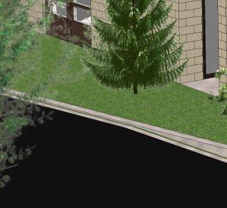
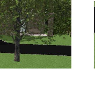
2 Special Provision Zone Schedule Location By-law A B C 129 R , 1032, 1034, 1036 Vansickle Road North Apartment Buildings/Long Term Care Facilities on a Local or Collector Road shall be subject to the following requirements: 1. Minimum Rear Yard 20 metres 2. Minimum Northerly Interior Side Yard 9.5 metres 3. Minimum Southerly Interior Side Yard 12 metres 4. Maximum Building Height in Area A Area A: 11 metres Area B: 14 metres Area C: 16 metres 5. Minimum Landscape Buffer Strip Width along the Westerly Lot Line 6 metres 6. Density Per Hectare Minimum 25 Units Maximum 88 Units 7. Maximum Encroachment of a Platform Structure into the Required Front or Interior Side Yard 1 metre c) That Schedule B, Lot Specific Maps for Special Provisions, be amended by inserting an additional lot specific map, as illustrated in Schedule 8 attached to this report. That Council direct staff to pay particular attention to the following site and building design matters through the site plan approval process: a significant landscape buffer strip is to be provided along the westerly lot line to ensure compatibility with existing homes along Huntington Lane, which buffer strip incorporates as many existing, healthy trees as possible (in accordance with the recommendations of a tree preservation and protection plan acceptable to the City), plus wood-board fencing and a variety of new deciduous and coniferous rapid-growth trees. balconies along the north, west and south facades of the apartment building are to be oriented to ensure overlook onto adjacent properties is mitigated; the grading design for the development must demonstrate that proposed grades are no greater than 0.6 metres higher than existing grades (staff estimates the Report Page 2 of 24
3 existing grade to be 97.6 metres at the top of the curb in front of 1032 Vansickle Road, based on a 0.15 metre high curb and City construction drawings showing an existing grade of metres at the top of the catch basin in front of the same property) architectural and landscape design techniques are to be used to break up the bulk and massing of the building, particularly the front façade, as shown on Appendices 6 and 7. That the Mayor and City Clerk be authorized to execute the necessary By-laws to give effect to Council s decisions; and That the Notice of Decision required by the Planning Act, R.S.O. 1990, c.p. 13, as amended, be processed by staff; and That upon expiration of the appeal period, staff be directed to forward any appeals to the Ontario Municipal Board for consideration and final decision; and Further, that the Clerk be directed to make all necessary notifications. FORTHWITH Summary The application proposes a 70-unit, apartment building on the subject lands, with height ranging from three to five storeys. A concept site plan and elevations are attached as Appendices 5, 6 and 7. An Official Plan amendment is required to change the current split land use designation of Medium Density Residential and Low Density Residential to entirely Medium Density Residential to permit the apartment building at a maximum proposed density of 88 units per hectare (Appendix 3). A Zoning By-law amendment is required to re-zone the entire property from Low Density Residential Suburban Neighbourhood (R1) to Medium Density Residential (R3) to permit the apartment building (Appendix 4) with site specific regulations. Background In 1988, an amendment to the previous Zoning By-law (64-270) rezoned approximately two-thirds of the northerly property (1024 Vansickle Road North) to Third Density Residential (R3) to permit a metre high apartment building. The remainder of the lands at 1024 Vansickle Road North continued to be zoned Second Density Residential (R2B), permitting the existing detached dwelling. That apartment building was never constructed. At the time, the Official Plan designation of 1024 Vansickle Road North was Neighbourhood Residential. The West St. Catharines Secondary Plan provided further direction on land use, designating the lands Low Density Residential. The proposed apartment building was permitted and therefore no Official Plan amendment was required. Report Page 3 of 24
4 The City s current Official Plan, the Garden City Plan, was approved by the Regional Municipality of Niagara on July 31, The Plan designates part of the site as Low Density Residential and part as Medium Density Residential, which permits an apartment building. The City s Zoning By-law ( ) was approved by Council on December 16, In many cases, existing land uses were used to establish new zone classifications. In the case of 1024 Vansickle Road North, the lands have been zoned Low Density Residential Suburban Neighbourhood (R1) to reflect the existing detached dwelling. The new By-law rescinded the previous apartment building permission for the abandoned 1988 project. As part of this application, the Applicant initially submitted a proposal for a six-storey, 75-unit apartment building. The proposed building was oriented to the front of the property, with access to the site from a drive aisle along the south side of the building. The majority of parking was provided below the building, with additional surface parking to the rear. Planning and Building Services hosted a public open house on September 16, The purpose of the open house was to present the proposal to the approximately 45 interested citizens in attendance, provide an opportunity for attendees to ask questions, and to receive comments on the proposal. Several concerns were expressed by those in attendance: primarily relating to compatibility, built form (height and massing), parking and traffic, site design (grading and drainage, lighting, etc.) and property value perceptions. Following the public open house, the Applicant revised the proposal to attempt to address the concerns raised at the meeting. A revised proposal, a 70-unit apartment building that is stepped in height from five storeys at the north end of the property to three storeys at the south end, is now proposed. This revised proposal, which was presented to the public at a second public open house on February 3, 2015, is the subject of this report and recommendation. Report Location and Site Description The subject lands are located in City s West Planning District, as outlined on Schedule E6 of the Garden City Plan. More specifically, the property is situated on the west side of Vansickle Road North, between Martindale Road and Tuscany Court. A location map is attached as Appendix 1. The site is comprised of four contiguous properties: 1024, 1032, 1034, and 1036 Vansickle Road North. Each lot contains one detached dwelling. Combined, the properties have a total lot area of 8,301 square metres (0.8 ha), with metres of frontage along Vansickle Road North and an irregular depth ranging from metres for 1024 Vansickle Road North and metres for the remaining three properties. The lands are relatively flat, sloping slightly toward the west. Report Page 4 of 24
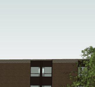
5 Surrounding land uses, as indicated on Appendix 2, include: North: A mix of detached and semi-detached dwellings, a three-storey apartment building to the immediate north, a ten-storey apartment building further north (Granadier Place at Martindale Road and Willow Bank Common) South: A mix of detached and semi-detached dwellings, townhouses, quadruplexes, three 3-storey apartment buildings East: A mix of detached and semi-detached dwellings, townhouses, quadruplexes, St. Catharines Fire Station No. 5, Armenian Community Centre West: Detached dwellings Proposed Development The applicant proposes to merge all four existing lots, demolish the four detached dwellings, and construct a 70-unit apartment building (Appendix 5) with condominium tenure. Height is proposed at five storeys (15.8 metres) at the north end of the site, reducing to four-storeys (12.8 metres) and then to three-storeys (9.8 metres) at the south end (Appendices 6 and 7). The building is oriented to the front of the property, in line with existing detached dwellings to the south, with a setback of 5.0 metres. Northerly and southerly interior side yards are proposed at 9.5 metres and metres respectively. The rear yard is proposed at metres. Access to parking areas is provided by a drive aisle along the south side of the building. The majority of parking is provided below the building (approximately 73 spaces), with some surface parking located to the rear (approximately 19 spaces). Official Plan Designation The Garden City Plan designates the lands as Neighbourhood Residential on Schedule D1, General Land Use Plan, providing for a range of housing opportunities, types, forms, and densities. Schedule E6 (Appendix 3) provides additional direction for the West Planning District and designates the lands as follows: a) Low Density Residential (applies to approximately one-third of the most northerly parcel, 1024 Vansickle Road North, plus all of 1032, 1034 and 1036 Vansickle Road North), permitting detached, semi-detached, duplex, triplex, quadruplex, fourplex and townhouse dwellings at a density range generally between 20 and 32 units per hectare of land. Height of buildings will generally not exceed 11 metres (three storeys). b) Medium Density Residential (applies to approximately two-thirds of the most northerly parcel, 1024 Vansickle Road North), permitting detached, semidetached, duplex, triplex, quadruplex, fourplex, townhouse and apartment dwellings at a density range generally between 25 and 99 units per hectare of land. Height of buildings will generally not exceed 20 metres (six storeys). Report Page 5 of 24
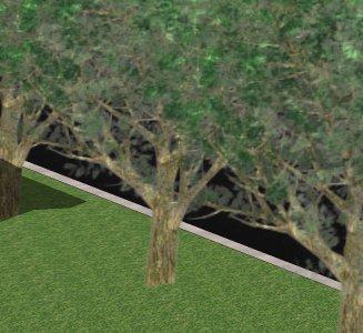
6 While permitted in the Medium Density Residential designation, the proposed apartment building is not permitted in the Low Density Residential designation. Further, the proposal constitutes a density of 88 units per hectare of land (across all four properties), greater than the maximum 32 units per hectare permitted in the Low Density Residential designation. An Official Plan amendment is, therefore, required to permit the proposed apartment building use and the proposed density. The Applicant has requested that Low Density Residential designation applicable to a portion of the entire site be changed to Medium Density Residential. The requested amendment and land use policies are addressed further in the Planning Considerations section of this report. Zoning By-law zones all of the lands Low Density Residential Suburban Neighbourhood (R1) (Appendix 4). The R1 zone permits a range of residential uses, including detached, semi-detached, quadruplex and townhouse units, and private road developments comprising any of the preceding housing forms. The proposed apartment building use is not permitted in the R1 zone and therefore a zoning by-law amendment is required. The Applicant has requested that the entire property be rezoned to Medium Density Residential (R3). The requested amendment and specific zoning requirements are addressed in the Planning Considerations section of this report. Circulation Comments The applications for an Official Plan and Zoning By-law amendment were circulated to all appropriate departments and outside agencies for their comments and requirements. There were no objections received, however, several comments were offered, as follows: Niagara Region Planning and Development Services Given the diverse mix of land uses in the neighborhood, the proposed apartment building is an appropriate use that supports a desired range of housing types. The increased density will aid the City in meeting intensification targets and ensure the most efficient use of urban, serviced land and existing infrastructure. Regional staff is satisfied that the proposal is appropriate from a Regional and Provincial planning perspective. Parks, Recreation and Culture Services A number of mature trees exist along the rear lot line of the subject lands. A tree preservation and protection plan will be required through the site plan approval process to ensure the survival of as many existing, healthy trees as possible. Transportation and Environmental Services Traffic Section A traffic count on Vansickle Road North was completed by staff in October of At that time 1,600 vehicles per day were observed. Previous to this (June, 2014) 1,500 vehicles per day were observed. Report Page 6 of 24
7 The road, while classified as a local road in the Garden City Plan, functions as a neighbourhood collector road as it connects the neighbourhood to an arterial road (Martindale Road) and a collector road (Grapeview Drive). As such, the volume of traffic observed on Vansickle Road North is not unexpected. Traffic volumes are generally higher on these types of streets. The Institute of Transportation Engineers Trip Generation Manual estimates the peak hour traffic generation for a 70-unit medium to high rise residential development to be 25 to 35 trips. Based on the current traffic volumes, there is more than sufficient capacity to accommodate the existing traffic plus the new traffic generated by the proposed development. Furthermore, if the Region of Niagara s plan is to restrict access from Vansickle Road North to Martindale Road to right-in/right-out only, there should be a decrease in traffic in the section of Vansickle Road North between Grapeview Drive and Martindale Road. Planning and Building Services Development Section The Garden City Plan designates Vansickle Road North as a local road with an ultimate right-of-way width of 20.0 metres. As a condition of site plan approval, the applicant will be required to convey gratuitously to the City a 5.5 metre road widening along the frontage of 1032, 1034 and 1036 Vansickle Road North. A 5.5 metre road widening along 1024 Vansickle Road was dedicated to the City through a previous planning application. Through the site plan approval process, the Applicant will be required to update the functional servicing report submitted to reflect the revised development proposal of a 70-unit apartment building. Further revisions are required to ensure the design of the sanitary and storm services meet City and Ministry of the Environment standards. Bell Canada An easement may be required to service the subject lands, depending on a review of more detailed plans. Bell Canada will be circulated the detailed design of the proposal through the site plan approval process. Enbridge Gas Distribution Inc. In the event that easement(s) are required to service this development, the Applicant will be required to provide the easement(s) to Enbridge Gas Distribution at no cost. Open House Planning and Building Services have hosted two public open houses pertaining to this application. The first, held on September 16, 2014, presented the initial proposal for a 75-unit, six-storey apartment building. In attendance were the Applicants and their agents, and approximately 42 interested citizens. Several questions were expressed, including the following: Report Page 7 of 24
8 Built Form -The building is too large and will not fit in with the existing neighbourhood -The building is too high, will block existing views and will impact the privacy of abutting properties Site Design -Lighting from the parking areas will spill onto neighbouring properties and cause sky glow - Exterior storage of waste will be unsightly -The development will cause flooding on neighbouring properties Parking -Parking will spill onto Vansickle Road North, causing obstacles and site line issues Traffic -The development will increase traffic along Vansickle Road North -The development will contribute to congestion along Martindale Road Nuisance - Headlights from vehicles entering and exiting the site will shine into abutting properties Construction Activities -Excavation may impact the foundations of existing homes in the neighbourhood Ownership -Property values will decrease A second open house, held on February 3, 2015, presented a revised proposal for a 70-unit apartment building, stepped down in height from five storeys at the north end of the site to four storeys and then again to three storeys at the south end of the site. In attendance were the Applicants and their agents, and 31 interested citizens. Additional concerns were expressed, including the following general items: Site Design -The drive aisle should be relocated to the north end of the site Buffering -Mature trees at the rear of the property may be impacted -It will take too long for new trees to grow and provide an adequate buffer Nuisance -Heating and cooling equipment for the building will be unsightly and noisy -Excavation and moving machinery will cause dust in the neighbourhood during construction Ownership -An apartment building will cause the neighbourhood to deteriorate In addition to the two public open houses, six letters and s of comment were received by staff at the time of writing this report. Staff were also notified of an online petition. Report Page 8 of 24
9 Additional concerns were expressed in this correspondence, including: Buffering -A 1.8 metre solid wood board fence should be constructed around the perimeter of the site -A row of trees should be planted around the perimeter of the site Nuisance -There will be noise from cars entering and exiting the parking areas Infrastructure -The building will place additional load on existing infrastructure (hydro, water, sewers) Other Land Uses -If the property is rezoned to R3 and this development is never built, then all other uses permitted in the R3 zone may be built here Policy -The City should not be amending the relatively new Official Plan and Zoning By-law -Policy amendments will set a precedent that supports further amendments and land use changes These concerns are addressed in the Planning Considerations section of this report. Planning Considerations Provincial Policy Context The subject lands are located within a settlement area under the Provincial Policy Statement (2014) and within the Built-up Area as identified by the Province s Growth Plan for the Greater Golden Horseshoe (2006). These documents contain policies that support all forms of residential intensification and urban area regeneration, directing growth to Built-up Areas. The Provincial Policy Statement requires that land use patterns within settlement areas be based on densities and a mix of land uses which support active transportation, are transit-supportive, and which efficiently use land, resources, infrastructure and public service facilities which may be planned or are already available. This development provides for the efficient use of underutilized lands with access to existing infrastructure and services. Local commercial and community uses as well as parks and trails are located in close proximity to the site. Public transit is available within walking distance, at the intersection of Vansickle Road North and Grapeview Drive. The proposed apartment building use contributes to the range of available housing types in the neighbourhood. The proposal meets the spirit and intent of the applicable Provincial policies. Report Page 9 of 24
10 Regional Official Plan According to the Regional Official Plan, the subject lands are located within the Urban Area for the City of St. Catharines and within a Built-up Area under Amendment (Niagara 2031/conformity amendment), which will be the focus of residential and employment intensification and redevelopment, including the redevelopment of underutilized sites, within the Region over the long term. Municipalities are encouraged to provide a full range of housing types to serve a variety of people as they age through the life cycle. The Regional Official Plan reiterates the land use pattern policies and objectives of the Provincial Policy Statement for residential intensification and sustainable communities outlined above. Further, the Plan requires that municipalities achieve a minimum 40 per cent residential intensification target for Built-up Areas by 2015 and for each year thereafter. The Region s Sustainable Community Policies establish a residential intensification target of 95 per cent for the St. Catharines Built-up Area. The proposed development contributes to the mix of housing types available in the area to meet the needs of existing and future residents of the community. At a density of 88 units per hectare, redevelopment of these underutilized properties makes more efficient use of the lands and existing infrastructure. The site is in close proximity to public transit, commercial and community facilities, and parks and active transportation opportunities such as the Merritt Trail, which forms part of the Region of Niagara Bicycle Network. The proposal complies with the policies of the Regional Official Plan. Official Plan Amendment to the Plan Schedule D1 of The Garden City Plan designates the lands as Neighbourhood Residential (Appendix 3). Schedule E6 (Appendix 4) provides additional direction for the West Planning District and designates the lands as follows: a) Low Density Residential (applies to approximately one-third of the most northerly parcel, 1024 Vansickle Road North, plus all of 1032, 1034 and 1036 Vansickle Road North), with a density range generally between units per hectare of land and height of buildings generally not exceeding 11 metres; and b) Medium Density Residential (applies to approximately two-thirds of the most northerly parcel, 1024 Vansickle Road North), with a density range generally between 25 and 99 units per hectare of land and height of buildings generally not exceeding 20 metres. The Applicant has requested an amendment to the City s Official Plan, the Garden City Plan, to re-designate a portion of the entire site from Low Density Residential to Medium Density Residential in order to permit the apartment building at a density of 88 units per hectare of land and maximum height of 16 metres. The current Low Density Residential designation does not permit an apartment building and caps density at 32 units per hectare of land and height of buildings at 20 metres. Report Page 10 of 24
11 The Garden City Plan provides opportunities to further refine the Plan by way of an amendment, subject to certain criteria being met (Section 16, Implementation). In some instances, changes in land use can be appropriate. This application for amendment to the Plan has been evaluated on the basis of those prescribed general considerations, as follows: Garden City Plan Policy (16.1) i) The degree of conformity of the proposed amendment to the general intent, purpose and philosophy of this Plan, particularly the vision, planning principles and general policies of the Plan ii) Consistency with Provincial and upper tier government plans, policies and legislation iii) The availability and suitability of land already designated for the proposed use, and the need for, and the feasibility of the proposed use iv) The compatibility of the proposal, or the adequacy of proposed mechanisms for achieving compatibility, with adjacent and planned uses Planning Comment Part B, Vision and Guiding Principles, describes the general intent of the Plan and the basis for which the land use policies of the Plan have been prepared. It establishes priorities including the accommodation of growth and change, housing, and achieving a sustainable community. Part D of the Plan, Land Use Policies, emphasizes more compact, innovative and alternative design to manage development. With its compact built form, the proposed 70-unit apartment building makes efficient use of both underutilized lands within the built-up area and existing public infrastructure and services, including transit. Commercial and community uses as well as parks and trails are in close proximity. As is required of the municipality, Provincial and Regional policies are entrenched in the Garden City Plan, as outlined above and throughout this report. The proposal complies with Provincial and Regional land use policies. While designated Intensification Areas are the primary emphasis for housing intensification, The Garden City Plan supports appropriate and compatible infill and intensification in neighbourhoods to meet housing needs and manage growth. The proposed apartment building will add to the range of housing types available in the neighbourhood. The applicant has provided a design that is compatible with neighbouring lower and medium density residential uses in the immediate vicinity (refer to Appendices 5, 6 and 7). A gradation in building height, generous setbacks, façade treatments, Report Page 11 of 24
12 v) The potential of the proposal to cause instability within an area intended to remain stable vi) The ability of the City s infrastructure and public service facilities to accommodate the proposal without costly expansion, upgrading, or required deferral of other planned infrastructure and public service facility improvements in other areas of the City vii) The financial implications, both cost and revenues, to the City viii) The degree to which approval of the amendment would establish an undesirable precedent and underground parking are proposed. To ensure compatibility with the established neighbourhood, the development will be subject to site plan control. As part of this process, staff will review detailed designs for various site elements, including generous landscape buffers and fencing, grading and drainage, storm water management, lighting, etc. The Applicant s concept designs (Appendices 5, 6 and 7) demonstrate a compatible fit with the neighbourhood. In addition to the site specific zoning provisions recommended in this report, the development would be subject to site plan control. As outlined above, there is opportunity to further refine the site and building designs through that process. Once site plan approval is issued, a legal agreement is registered against the title of the property, binding any current or future owner of the lands to the specific terms of the agreement, and helping to ensure continued compatibility with surrounding land uses. The subject lands are serviced by water, sanitary and storm sewer services. Through the site plan approval process, the Applicant will be required to submit detailed site servicing and storm water management designs which meet City and Ministry of the Environment standards. Although not anticipated, any required upgrades to municipal services will be at the sole cost of the Applicant. The proposed development presents no cost implications to the City. Any improvements to municipal infrastructure which may be necessary to accommodate the development will be at the sole cost of the Applicant. The addition of 70 apartment units will provide an increase in property tax revenues. Approximately two-thirds of the most northerly portion of the subject lands is already designated Medium Density Report Page 12 of 24
13 Residential by the Garden City Plan. The proposed amendment represents a rounding-out and extension of this existing designation, which is appropriate given there are several pockets of land designated Medium Density Residential along both sides of this stretch of Vansickle Road North. It is also noted that the four properties in question are quite deep and underdeveloped, much more so than the majority of the properties in the neighbourhood which contain detached or semi-detached homes. This lot depth presents a greater potential for assembly and redevelopment than other typically smaller lots in the neighbourhood and the proposed land use amendments would not, therefore, establish an undesirable precedent. Based on the matters outlined above, staff is satisfied that the proposed Official Plan amendment meets the general intent of the Plan and all other prescribed general considerations. Intensification Section of the Garden City Plan permits density bump-ups in the Neighbourhood Residential Designation, including from Low Density Residential to Medium Density Residential, by way of a zoning amendment provided the following criteria are met: Criteria (8.2.2 (b)) The subject lands are located on arterial or collector roads The subject lands are located in close walkable proximity and accessibility to commercial centres, community facilities and parks Planning Comment Vansickle Road North is designated a Local Road pursuant to Schedule C of the Garden City Plan and therefore the proposal does not meet the intent of this policy. However, Transportation and Environmental Services notes that this section of Vansickle Road North functions as a neighbourhood collector, connecting the neighbourhood to both an Arterial Road (Martindale Road) and a Collector Road (Grapeview Drive). The subject lands are located within walking distance of Huntington Plaza to the north (Martindale and Erion Roads) as well as a community commercial node to the south (Martindale Road and Report Page 13 of 24
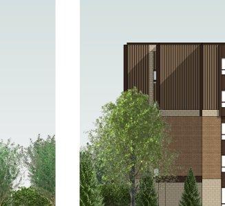
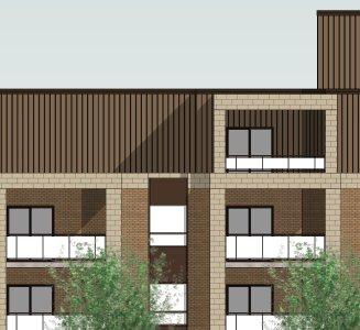
14 The subject lands are well served by public transit The subject lands should most appropriately be located adjacent to or in close proximity to existing medium or high density residential sites Grapeview Drive). Twelve Mile Creek and the Merritt Trail, which forms part of the Region of Niagara Bicycle Network, are located east of Martindale Road. Grapeview Park is located to the west (First Street Louth and Grapeview Drive). The proposal meets this criteria. Public transit runs along both Grapeview Drive and Martindale Road, providing connections to the St. Catharines Hospital, Fourth Avenue commercial centres, and the Downtown. The proposal meets this criteria. As illustrated in Appendix 2, the subject lands are abutted by a three-storey apartment building to the immediate north and a ten-storey apartment building further north at Martindale Road and Willow Bank Common. Two additional three-storey apartment buildings are located to the south along Vansickle Road North, north of Grapeview Drive. Several quadruplexes are located east of the subject lands along Martindale Road and Flynn Court. All properties along Tuscany Court are designated Medium Density Residential. The proposal meets this criteria. Although not located on an arterial or collector road, consideration should be given to the function of Vansickle Road North as a neighbourhood collector road, as advised by Transportation and Environmental Services staff. Based on this functional reality of Vansickle Road North, and the balance of the criteria being met, staff is recommending that some increase in height and density is appropriate in this location, subject to the required Official Plan and Zoning By-law amendments. The Medium Density Residential designation requires a general density of 25 to 99 units per hectare and restricts building height to 20 metres. Given the site s proximity to lower density residential uses, a maximum density of 88 units per hectare is recommended for the subject lands. In order to ensure compatibility, staff also recommends that building height be limited to 11 metres and not more than three storeys at the south end of the property (within 36 metres of the southerly property line) in line with the permissions of the Low Density Residential Designation; 14 metres and not more than four storeys around the mid-point of the property (between 36 and 53 metres of the southerly property line); and 16 metres and not more than five storeys at the north end of the property (beyond 53 metres of the southerly lot line). Report Page 14 of 24
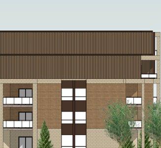
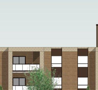
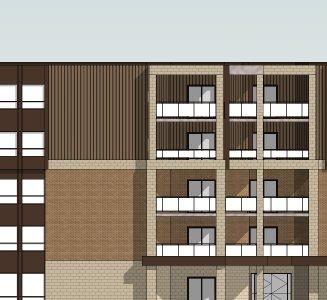
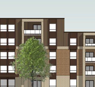
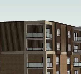
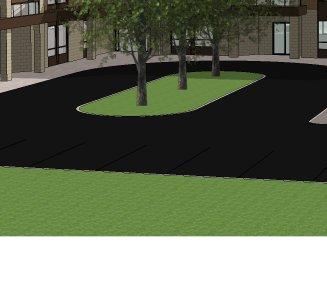
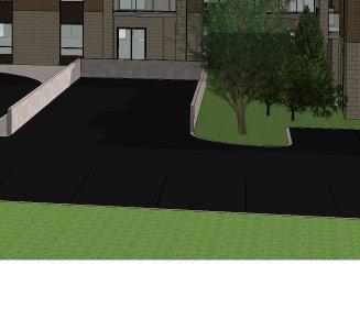
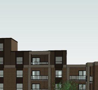
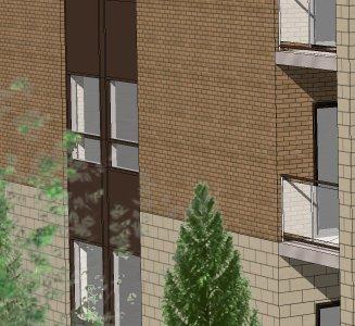
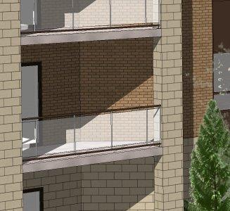
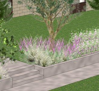
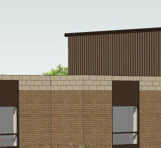
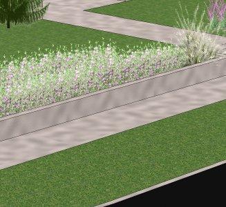
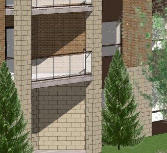
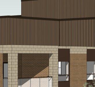
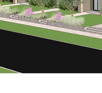
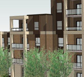
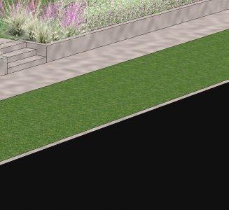
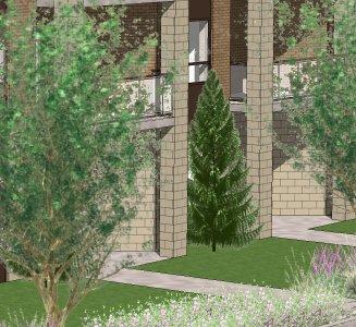
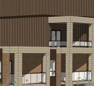
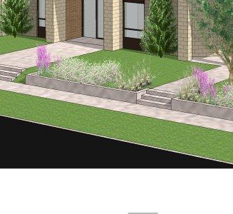
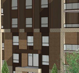
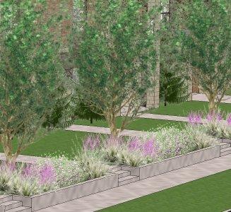
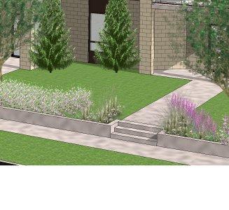
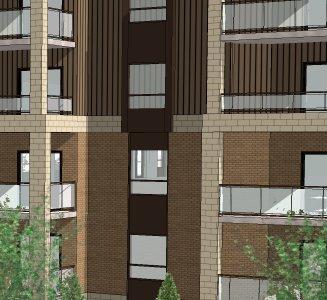
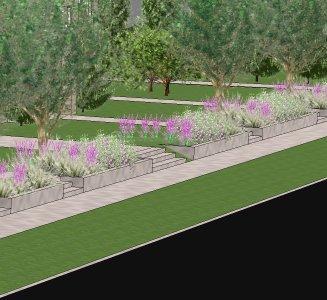
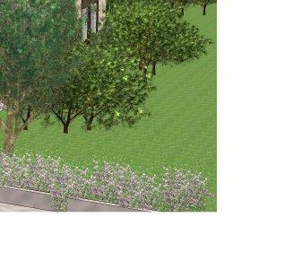
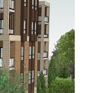
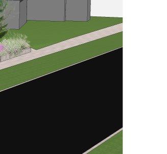
15 Evaluation of Compatibility and Impacts Section of the Garden City Plan also provides that any proposal for new medium or high density residential development will be evaluated having regard for urban design principles and policies set out in the Garden City Plan to ensure building, site and streetscape design will support compatible and context sensitive development with adjacent properties and those in close proximity to the subject lands. Staff rely on various policies and guidelines outlined in the Plan, including policies addressing built form (Section 4.5) and general land use policies (Section 7.1). The following analysis pertaining to the proposed apartment building are set out as follows (refer to Appendices 5, 6 and 7): A five-storey building (15.8 metres), which steps-down in a southerly direction to four storeys (12.8 metres) and then to three storeys (9.8 metres) is proposed. This gradation in height provides an appropriate transition from the existing three-storey apartment building to the north and the existing detached dwellings to the south. Staff notes that the proposed height within the three storey section of the building is within the maximum 11.0 metres permitted in the existing R1 zone. A flat roof is proposed, minimizing building height. Façade treatments, including horizontal bands of differing colours and finishes, will break up the bulkiness of the façade. Through the site plan approval process, staff will recommend the applicant use a darker finish at the ground level and a lighter finish for the upper floors in order to diminish the appearance of height. Vertical alignment of windows and balconies as well as vertical columns of differing colours and finishes provide horizontal relief and help break up the length and bulk of the building. Boulevard trees, raised garden bed terracing, and multiple sidewalk connections from ground floor units also reduce the appearance of an expansive façade. Generous interior side yard and rear yard setbacks are provided (12.01 metre southerly side yard; 9.5 metres northerly side yard; metre rear yard), mitigating privacy, overlook and shadow impacts. Cross-sections and shadow studies submitted by the applicant demonstrate minimal overlook and shadow impacts from the building. The location and orientation of balconies may be further refined through the site plan approval process to further mitigate these impacts. The street-oriented building is set back in line with existing detached dwellings to the south. This allows parking to be tucked behind the building, reserving the area in front of the building for landscaping and achieving a more pleasant streetscape. Access to the site from Vansickle Road North is provided by one driveway along the south side of the building, further separating the proposed building from the more sensitive detached homes to the south. The Zoning By-law requires that a 3.0 metre landscape buffer strip be provided between the edge of the parking area (including driveways and driving aisles), and the abutting southerly lot line. The site plan accommodates this landscape buffer strip to the south of the proposed driveway. Report Page 15 of 24
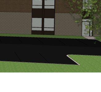
16 The proposal eliminates three existing driveway curb cuts, improving the appearance of the streetscape. The majority of parking is provided under the building (approximately 73 spaces), maximizing the amount of landscaped area that can be accommodated on site and ensuring adequate space for buffering. The rear parking area (approximately 19 spaces) is connected to the municipal sidewalk by a pedestrian connection along the north side of the building. At minimum, 3.0 metres of space along the north and south property lines and 6.0 metres of space along the west property line has been provided to buffer the apartment building from neighbouring properties. Wood board fencing and landscaping around the north, west and south property lines will be a requirement of site plan approval. A row of existing trees along the westerly lot line are proposed to be preserved and integrated into a landscape buffer strip. A tree preservation and protection plan will be required through the site plan approval process to ensure that the design of the rear parking area will not harm the existing trees. Based on the merits outlined above, staff is satisfied that the proposed apartment building will be compatible with the surrounding neighbourhood. Potential impacts can be mitigated through the recommended zoning provisions and site plan approval process, both of which are discussed further below. Zoning By-law Amendment to By-law By-law zones the lands Low Density Residential Suburban Neighbourhood (R1) (Appendix 4). The R1 zone permits a range of ground-oriented residential uses, including detached, semi-detached, quadruplex and townhouse units, and private road developments comprising any of the preceding. The proposed apartment building is not permitted use in the R1 zone and therefore a zoning by-law amendment is required. The Applicant has requested that the zoning be changed to Medium Density Residential (R3). The R3 zone permits detached, semi-detached, duplex, triplex, fourplex, quadruplex, townhouse and apartment dwelling units, long term care facilities and private road developments comprising any of the preceding. The following table compares the standard requirements of the R3 zone with the development proposal. Minimum Lot Frontage R3 Zone Requirements for Apartment Buildings On Local Roads Proposed 5-Storey, 70-Unit Apartment Building Does the Proposal Comply? 30.0 metres metres Yes - exceeds minimum requirement Report Page 16 of 24
17 Minimum Front Yard 5.0 metres 5.0 metres Yes meets minimum requirement Minimum Rear Yard Minimum Interior Side Yard Minimum Exterior Side Yard Maximum Building Height Density Per Hectare Minimum Landscaped Open Space Height of Building (15.8 metres) ½ Height of Building (4.9 metres south) (7.9 metres north) metres Yes - exceeds minimum requirement 12.0 metres - south 9.5 metres - north Yes - exceeds minimum requirement 5.0 metres N/A N/A 16.0 metres 15.8 metres Yes Minimum 32 Units Maximum 99 Units 88 Units Yes 25% 38.1% Yes - exceeds minimum requirement Minimum Rear Yard The Applicant is proposing a rear yard setback of metres as opposed to the 15.8 metres (height of the building) required by the By-law. This setback is sensitive to existing detached homes to the west of the subject lands, mitigating overlook and privacy concerns. The metre setback will keep the building close to the street, maximizing landscaping and amenity space to the rear, including a minimum 6.0 metre landscape buffer strip along the westerly lot line. The setback also ensures parking areas are located to the rear of the building. Staff is satisfied that a rear yard setback of 20.0 metres will ensure compatibility. Minimum Interior Side Yards The applicant proposes a northerly side yard of 9.5 metres, greater than the 7.9 metres (½ height of the five-storey section of the building [15.8 metres]) required by the By-law. The southerly side yard is proposed at metres, also greater than the 4.9 metres (½ height of the three-storey section of the building [9.8 metres]) required by the By-law. Both the northerly and southerly side yards proposed are sensitive to abutting residential uses, helping to mitigate overlook and privacy concerns with increased buffering between the proposed and existing buildings. Staff notes that the existing semi-detached dwelling at 1018 Vansickle Road North is set back approximately 19 metres from the northerly lot line of the subject lands. Report Page 17 of 24
18 The existing dwelling will also be separated from the five-storey section of the apartment building by the existing driveway and parking area associated with the existing three-storey apartment building at 1022 Vansickle Road North. Staff is satisfied that a 9.5 metre northerly and a 12.0 metre southerly interior side yard are appropriate. Maximum Building Height The applicant is proposing a five-storey building (15.8 metres), which reduces in height to four storeys (12.8 metres) around the mid-point of the property, and then to three storeys (9.8 metres) at the south end of the property. The proposed building height is within the maximum 16.0 metres permitted by the By-law (R3 zone). The proposed gradation in height provides an appropriate transition from the existing three-storey apartment to the north to the existing detached dwellings to the south. Staff is recommending the following with respect to maximum building height (refer to Appendix 8): For that portion of the lands within 36 metres of the southerly lot line (Area A as illustrated on Appendix 8), maximum building height shall be 11.0 metres and not more than three storeys, in line with the existing maximum height permissions of the R1 zone; For that portion of the lands between 36 and 53 metres of the southerly lot line (Area B as illustrated on Appendix 8), maximum building height shall be 14.0 metres and not more than four storeys; For that portion of the lands beyond 53 metres of the southerly lot line (Area C as illustrated on Appendix 8), maximum building height shall be 16.0 metres and not more than five storeys, as required in the R3 zone. Where Height is Measured Zoning By-law defines height as the vertical distance of a building or structure from grade. Further, Section provides that height is measured from the grade at the principal entrance of the building. Staff notes that the subject lands could potentially be filled and re-graded prior to construction, resulting in a higher building than that which was originally envisioned and yet still comply with the provisions of the Zoning By-law. In order to avoid this situation, staff should be directed to pay particular attention to the difference between the existing and proposed grades in the area and limit the amount of fill to be placed to not more than 0.6 metres. Staff estimates the existing grade to be 97.6 metres at the top of the curb in front of 1032 Vansickle Road, based on a 0.15 metre high curb and City construction drawings showing an existing grade of metres at the top of the catch basin in front of the same property. Density The Applicant is proposing a 70-unit apartment building on the subject lands, which constitutes a density of 88 units per hectare of land. The R3 provisions of the Zoning By-law would permit a maximum of 99 units per hectare of land. Based on this site specific situation, it is appropriate to cap the density at 88 units per hectare. Report Page 18 of 24
19 This limit will help to ensure that the actual development of the site does not deviate from what has been presented in this report. Platform Structures (Decks, Porches, Balconies) The Zoning By-law provides that platform structures, which are elevated 1.2 metres or more above grade, must be located outside of the required front and interior side yards of the principal building. The applicant is proposing that balconies along east side of the building, facing Vansickle Road North, encroach 1.0 metre into the required front yard (5.0 metres). Balconies on the north and south sides of the building also encroach (varying depths). Staff notes that the Applicant will be required to dedicate an approximate 5.5 metre wide road widening to the City (a widening of the road allowance) as a condition of site plan approval and that the setback of the balconies will be deficient by 1.0 metre as a direct result of this road widening. Also, generous interior side yards are proposed, larger than are required by the Zoning By-law. Staff is satisfied that the proposed 1.0 metre encroachment into the required front and interior side yards is appropriate. Additional Permitted Uses in the Medium Density Residential (R3) Zone In addition to apartment buildings, the R3 zone permits detached, semi-detached, duplex, triplex, fourplex, quadruplex, townhouse and apartment units, long term care facilities and private road developments comprising any of the preceding. Staff is satisfied that these uses are also appropriate on the property, however, staff is recommending that long term care facilities be subject to the same special provisions as the proposed apartment building. Any future development proposal of four of more residential units would be subject to site plan control. Site Plan Control The process of site plan control is mentioned throughout this report. In accordance with the City s site plan control by-law, the applicant will be required to enter into a site plan agreement with the City prior to the issuance of a building permit for the apartment building. The site plan agreement will address issues related to access and parking, lighting, buffering, servicing, storm water management, tree preservation, façade finishes and treatments, among other matters. The applicant will be required to post securities to ensure the terms of the agreement are carried out. Upon approval, the site plan agreement will be registered against the title of the lands and legally binding upon the existing and future property owners. Open House Comments With regard to the comments expressed at the public open houses and through correspondence, the following is offered: Built Form Comment: The building is too large and will not fit in with the existing neighbourhood. Response: The proposal includes generous setbacks and a gradation in heights, which are sensitive to abutting residential uses. Staff are satisfied that the apartment building will be a compatible fit in the neighbourhood. Report Page 19 of 24
20 Comment: The building is too high, will block existing views and will impact the privacy of abutting properties. Response: While property ownership does not include the right to a view, the City endevours to be respectful of significant views and vistas through the establishment of minimum building setbacks and height restrictions in the Zoning By-law. For this development proposal, staff is recommending site specific zoning provisions for landscape buffer strips, building height and setbacks to ensure the building is sensitive to abutting residential uses. It is noted that the proposed height of the three storey section of the building is within the maximum 11.0 metres permitted in the existing R1 zone. The Applicant has submitted cross sections and a shadow impact study which demonstrate minimal impact on abutting properties. Site Design Comment: Lighting from the parking areas will spill onto neighbouring properties and cause sky glow. Response: This development will be subject to site plan approval to ensure certain site elements, including lighting, are designed to City standards. The Applicant will be required to submit a lighting design to ensure that sky glow is mitigated and lighting will not trespass onto adjacent properties. Comment: Exterior storage of waste will be unsightly. Response: Where waste generated by this development is to be stored has yet to be determined. The Applicant may either store waste internally or externally, provided waste enclosures are properly screened. The storage of waste is one of many matters addressed through site plan approval. Comment: The development will cause flooding on neighbouring properties. Response: Through review of the application for site plan approval, the Applicant will be required to submit detailed grading and drainage and storm water management designs. The City s normal standards will be applied, including the requirement that storm water will not be permitted to flow onto adjacent properties. Buffering Comment: Mature trees at the rear of the property may be impacted. Response: As part of the site plan approval process, the Applicant will be required to submit a tree preservation and protection plan to ensure the preservation of as many existing, healthy trees as possible. Comment: A 1.8 metre solid wood board fence should be constructed around the perimeter of the site. Response: Wood board-on-board privacy fencing is a typical requirement of site plan approval. The applicant will be required to construct a 1.8 metre high fence along the north, south and west property lines. Report Page 20 of 24
21 Comment: A row of trees should be planted around the perimeter of the site. Response: The provision of significant landscape buffering will be a requirement of site plan approval. Landscape buffer strips of 3.0 metre minimum (north and south lot lines) and 6.0 metre minimum (west lot line) widths will include a combination of deciduous and coniferous trees. Comment: It will take too long for new trees to grow and provide an adequate buffer. Response: Through the site plan approval process, the Applicant will be required to select trees of a fast-growing variety. Parking Comment: Parking will spill onto Vansickle Road North, causing obstacles and site line issues. Response: The applicant is proposing to provide approximately 92 parking spaces at a ratio of 1.31 parking spaces per dwelling unit. This ratio is greater than the 1.25 parking spaces per unit required by the Zoning By-law and is sufficient to accommodate both resident and visitor parking on-site. Staff acknowledge that on-street parking is currently permitted on both sides of Vansickle Road North. Transportation and Environmental Services staff advise that if the quality of traffic flows along Vansickle Road North is of concern to residents, either now or after occupancy of the apartment building, residents may contact the Traffic Division directly. Staff can restrict on-street parking, if deemed necessary. Traffic Comment: The development will increase traffic along Vansickle Road North. Response: Transportation and Environmental Services staff have no concern with the increase in traffic generated by this development. The Institute of Transportation Engineers Trip Generation Manual estimates the peak hour traffic generation for a 70-unit medium to high rise residential development to be 25 to 35 trips. Based on the current traffic volumes, there is more than sufficient capacity to accommodate the existing traffic plus the new traffic generated by the proposed development. Comment: The development will contribute to congestion along Martindale Road. Response: The Region of Niagara has advised that an Environmental Study Report (May 2013) has been completed for the reconstruction and widening of Martindale Road from Elderwood Drive to the QEW. Through the public consultation process for the Environmental Assessment (EA), difficulty turning onto Martindale Road from Willow Bank Common was raised by area residents. The preferred solution identified by the EA was to widen Martindale Road and make certain improvements, including the construction of a raised median at the Vansickle Road North and Martindale Road intersection to restrict movements to right-in/right-out only, and the installation of a traffic light at the Willow Bank Common and Martindale Road intersection. Preliminary drawings have been completed for these improvements. Construction along this section of Martindale Road is targeted for Report Page 21 of 24
22 Nuisance Comment: Headlights from vehicles entering and exiting the site will shine into abutting properties. Response: As a condition of site plan approval, the Applicant will be required to construct a 1.8 metre high wood board-on-board privacy fence along the north, south and west property lines, mitigating impacts from vehicle headlights. The driveway entrance for the apartment building is proposed along the south side of the building, in line with the existing driveways of two semi-detached homes across the street on Vansickle Road North. It has been oriented to avoid impacts on the more sensitive living areas (e.g. bedrooms) of those existing semi-detached homes. Comment: Heating and cooling equipment for the building will be unsightly and noisy. Response: As a condition of site plan approval, any rooftop equipment will be required to be screened from view. This screening will also help to mitigate noise generated by the equipment. Comment: Excavation and moving machinery will cause dust in the neighbourhood during construction. Response: City staff will communicate any complaints to the developer/building in a timely matter so that concerns can be quickly addressed. Comment: There will be noise from cars entering and exiting the parking areas. Response: The Institute of Transportation Engineers Trip Generation Manual estimates the peak hour traffic generation for a 70-unit medium to high rise residential development to be 25 to 35 trips. While greater than what exists, this traffic generation is still considered low and therefore minimal noise impacts are anticipated. Construction Activities Comment: Excavation may impact the foundations of existing homes in the neighbourhood. Response: The Applicant will be required to address excavation and protection measures for neighbouring properties through the building permit process. Infrastructure Comment: The building will place additional load on existing infrastructure (hydro, water, sewers). Response: Detailed designs for servicing will be reviewed through the site plan approval process. Although not anticipated, any upgrades to existing infrastructure which may be required as a result of this development will be at the sole cost of the Applicant. Ownership Comment: Property values will decrease. Response: There is no evidence that the development will decrease property values. Report Page 22 of 24
23 Comment: An apartment building will cause the neighbourhood to deteriorate. Response: The Applicant has submitted concept designs which demonstrate a compatible fit with the neighbourhood. In addition to the site specific zoning provisions recommended in this report, the development would be subject to site plan control, wherein there is opportunity to further refine the site and building designs through that process. A site plan agreement, a legal document, will be registered against the title of the property, binding any current or future owner of the lands to the specific terms of the agreement, and helping to ensure continued stability in the neighbourhood and compatibility with surrounding land uses. Other Land Uses Comment: If the property is rezoned to R3 and this development is never built, then all other uses permitted in the R3 zone may be built here. Response: Staff is satisfied that all of the uses permitted in the R3 zone, including detached, semi-detached, duplex, triplex, fourplex, quadruplex, townhouse and apartment dwelling units, long term care facilities and private road developments comprising any of the preceding, would be compatible with the existing neighbourhood, subject to the recommended zone provisions for apartment buildings and long term care facilities. Policy Comment: The City should not be amending the relatively new Official Plan and Zoning By-law. Response: The policies of both the Official Plan and Zoning By-law provide opportunities to further refine those documents by way of an amendment, subject to certain criteria being met. Staff are satisfied that the proposed amendments to the Official Plan and Zoning By-law meet these criteria, as outlined in this report. Comment: Policy amendments will set a precedent that supports further amendments and land use changes. Response: Staff are obligated to deal with every application to amend the Official Plan and/or Zoning By-law and must review each of these on an application-by-application basis, subject to the merits of the proposal and the site itself. Public Notice In accordance with established procedures, notices for the public meeting have been circulated. Second Planning Opinion Advisory Should Council consider not supporting the staff Recommendation provided in this report, Council is advised to defer its decision until such time as a second planning opinion from an outside consultant can be obtained. In the event the second planning opinion is supported by Council, and Council makes a decision based on that second planning opinion, and if and when the matter should be heard before the Ontario Municipal Board, then the planner who has provided the second opinion shall be retained for the purpose of a hearing before the Ontario Municipal Board. Report Page 23 of 24
24 Financial Implications The proposed development presents no cost implications to the City. Any upgrades to municipal services which may be necessary to accommodate the development will be at the sole cost of the Applicant. The addition of 70 apartment units will provide an increase in tax revenues. Conclusion In summary, staff is supportive of the applications for an Official Plan amendment and Zoning By-law amendment to permit a five storey apartment building on the subject lands. The design of the site is sensitive to abutting residential uses and the recommended zone provisions for yards, height and density will ensure a compatible fit within the neighbourhood. Site plan control will ensure the implementation of appropriate designs for landscape buffering, lighting, servicing and storm water management. The development provides for the efficient and appropriate use of underutilized lands within the urban area with access to existing infrastructure and services. The proposed apartment building contributes to the range of available housing types in the neighbourhood, meeting the spirit and intent of the applicable Provincial, Regional and local policies. A gradation in building height provides a good transition from lower density uses to the south and medium density uses to the north. Notification It is in order to advise Quartek Group Inc., the applicant s agent. Prepared by: Amanda Knutson, Planner I Submitted by: Judy Pihach, M.C.I.P., R.P.P., Manager Planning Services Approved by: James N. Riddell, M.Pl., M.C.I.P., R.P.P., Director Planning and Building Services Report Page 24 of 24
25 1 Location Map Subject Lands 1024 to 1036 Vansickle Road North File: & V 2
26 2
27 3
28 Proposed Amendment to Zoning By-Law R4 R3 4 R1 R3 R I1 R1 I2 R2 R 1036 R3 G2 R1 R3-98 G Vansickle Road North Lands to be re-zoned from Low Density Residential - Suburban Neighbourhood (R1) to Medium Density Residential (R3) Zones Low Density Residential - Suburban Neighbourhood Low Density Residential - Traditional Neighbourhood Medium Density Residential High Density Residential Minor Green Space Local Neighbourhood Institutional Community Institutional
29 SITE STATISTICS DESCRIPTION AREA (m²) PERCENT (%) BUILDING AREA (70 UNITS) 2, PARKING LOT / DRIVEWAY 1, PROVIDED SPACES 92 SURFACE 19 UNDERGROUND 73 REQUIRED SPACES 88 BICYCLE PARKING (6 IN GARAGE) 12 CONCRETE WALKWAY / CURB LANDSCAPING 3, R.O.W. WIDENING SITE TOTAL 1 7, N N 02 43'25" W N 02 12'30" W NOTES: 1. SITE TOTAL DOES NOT INCLUDE AREA REMOVED FOR R.O.W. WIDENING. 2. EXISTING TOPOGRAPHIC INFORMATION HAS BEEN TRACED FROM AERIAL IMAGERY AND HAS NOT BEEN SURVEYED TYP TYP SURFACE PARKING SPACES GARBAGE DEPRESSEDROLL-OUT CURB LOADING SPACE 4.00 PATIO #1022 B ZBL/OP APPLICATION A ZBL/OP APPLICATION JAN 29/2015 JW AUG 08/2014 JW issue issued for date init. EXIT 9.50 seal RAMP DOWN TO UNDERGROUND PARKING GARAGE EXIT PROPOSED 2.0m CONCRETE SIDEWALK DEPRESSED CURB 6 BIKE RACK DEPRESSED CURB MAIN ENTRANCE N 78 36'00" E 3.00 Do not scale drawings. Report any discrepancies to Quartek Group Inc. before proceeding. Drawings must be sealed by the Architect and / or Engineer prior to the use for any building permit applications and / or government approval. Seals must be signed by the Architect and / or Engineer before drawings are used for any construction. All construction to be in accordance with the current Ontario Building Code and all applicable Ontario regulations. All drawings and related documents remain the property of Quartek Group Inc., all drawings are protected under copyright and under contract STOREY BUILDING 4 STOREY BUILDING 5 STOREY BUILDING #1018 uartek Group Inc. Architects Engineers Planners Project Managers N 78 32'40" E # T F St. Paul St. Suite 100 St. Catharines, ON L2R 3M3 project title R.O.W. WIDENING EXIT N 78 32'40" E FIRE ENTRANCE N 02 32'00" W 5.00 drawing title 1024 VANSICKLE CONDOMINIUMS ST. CATHARINES, ONTARIO PROPOSED 1.5m CONCRETE SIDEWALK CONCEPTUAL SITE PLAN HYD N 02 32'00 " W drawn by designed by V A N S I C K L E R O A D JW scale MG date 1:200 25MAR Jan 2015 PRELIMINARY job number issue drawing number B SP1 plotted by: JWarren on Jan 30, :50am


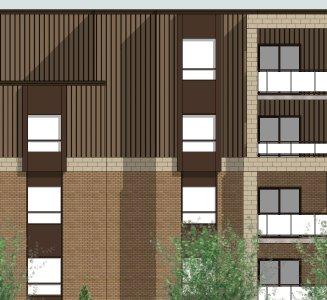
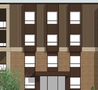
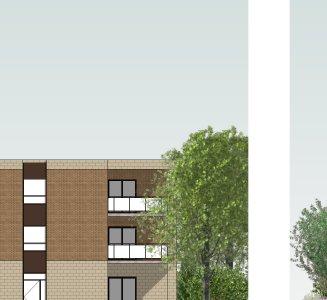

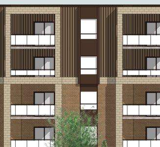

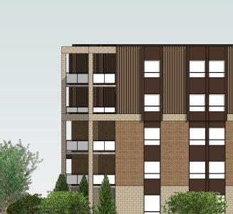
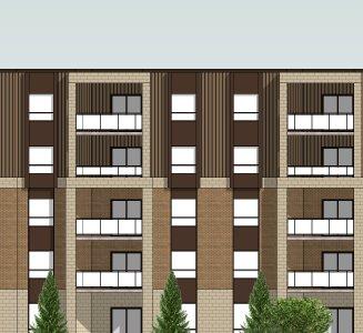

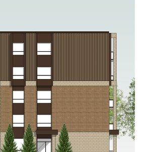


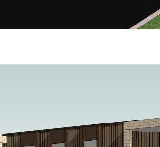
30 t/o parapet t/o parapet 9800 t/o parapet EAST ELEVATION SOUTH ELEVATION NORTH ELEVATION WEST ELEVATION ELEVATIONS 1024 VANSICKLE CONDOMINIUM DEVELOPMENT


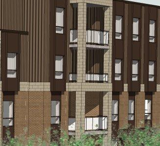

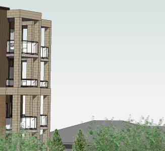


31 7 PERSPECTIVES 1024 VANSICKLE CONDOMINIUM DEVELOPMENT
PLANNING REPORT Gordon Street City of Guelph. Prepared on behalf of Ontario Inc. March 17, Project No. 1507
 PLANNING REPORT 1131 Gordon Street City of Guelph Prepared on behalf of 1876698 Ontario Inc. March 17, 2016 Project No. 1507 423 Woolwich Street, Suite 201, Guelph, Ontario, N1H 3X3 Phone (519) 836-7526
P. H. Robinson Consulting Urban Planning, Consulting and Project Management
 PLANNING RATIONALE REPORT FOR SITE PLAN AND DRAFT PLAN OF CONDOMINIUM APPLICATIONS 73-75 HARVEY STREET CITY OF OTTAWA PREPARED BY: P H ROBINSON CONSULTING AUGUST 2012 1 This report has been prepared on
3.1. OBJECTIVES FOR RESIDENTIAL LAND USE DESIGNATIONS GENERAL OBJECTIVES FOR ALL RESIDENTIAL DESIGNATIONS
 3. RESIDENTIAL LAND USE DESIGNATIONS INTRODUCTION The Residential land use designations provide for housing and other land uses that are integral to, and supportive of, a residential environment. Housing
PIN , Part 1, Plan SR-713 in Lot 2, Concession 5, Township of McKim (1096 Dublin Street, Sudbury)
") STAFF REPORT Applicant: Dalron Construction Limited Location: PIN 02124-0103, Part 1, Plan SR-713 in Lot 2, Concession 5, Township of McKim (1096 Dublin Street, Sudbury) Official Plan and Zoning By-law:
STAFF REPORT Applicant: Dalron Construction Limited Location: PIN 02124-0103, Part 1, Plan SR-713 in Lot 2, Concession 5, Township of McKim (1096 Dublin Street, Sudbury) Official Plan and Zoning By-law:
Planning Justification Report
 Planning Justification Report 101 Kozlov Street, Barrie, Ont. Destaron Property Management Ltd. November 2015 Revised February 2017 TABLE OF CONTENTS Page 1.0 INTRODUCTION... 1 2.0 DESCRIPTION OF SUBJECT
3390, 3392, 3394, 3396 and 3398 Bayview Avenue - Official Plan Amendment, Zoning By-law Amendment Application - Preliminary Report
 STAFF REPORT ACTION REQUIRED 3390, 3392, 3394, 3396 and 3398 Bayview Avenue - Official Plan Amendment, Zoning By-law Amendment Application - Preliminary Report Date: March 14, 2016 To: From: Wards: Reference
For Vintages of Four Mile Creek Town of Niagara on the Lake, Ontario
 Planning Impact Analysis For Vintages of Four Mile Creek Town of Niagara on the Lake, Ontario Prepared by: Upper Canada Consultants 261 Martindale Road Unit #1 St. Catharines, Ontario L2W 1A1 Prepared
LOT AREA AND FRONTAGE
 LOT AREA AND FRONTAGE Lot Area & Frontage for the R2.1 Zone Lot Area & Frontage for the R2.4 Zone Minimum Lot Minimum Lot Zone Area Width R2.1 700 sq m 18 m R2.4 600 sq m 16 m Lot Area means the total
Appendix1,Page1. Urban Design Guidelines. Back to Back and Stacked Townhouses. DRAFT September 2017
 Appendix1,Page1 Urban Design Guidelines DRAFT September 2017 Back to Back and Stacked Townhouses Appendix1,Page2 Table of Contents 1 Introduction 1 1.1 Purpose 1 1.2 Urban Design Objectives 1 1.3 Building
SUBJECT: Official Plan and Zoning By-law Amendment Applications for 4853 Thomas Alton Boulevard
 Page 1 of Report PB-100-16 SUBJECT: Official Plan and Zoning By-law Amendment Applications for 4853 Thomas Alton Boulevard TO: FROM: Development and Infrastructure Committee Planning and Building Department
1202 & 1204 Avenue Road Zoning By-law Amendment Application - Preliminary Report
 STAFF REPORT ACTION REQUIRED 1202 & 1204 Avenue Road Zoning By-law Amendment Application - Preliminary Report Date: March 17, 2017 To: From: Wards: Reference Number: North York Community Council Director,
8.5.1 R1, Single Detached Residential District
 8.5.1 R1, Single Detached Residential District The purpose of this district is to provide for residential development in the form of single detached dwellings. Dwelling, Single Detached Home Business,
12, 14, 16 and 18 Marquette Avenue and 7 Carhartt Street Zoning By-law Amendment Application - Preliminary Report
 STAFF REPORT ACTION REQUIRED 12, 14, 16 and 18 Marquette Avenue and 7 Carhartt Street Zoning By-law Amendment Application - Preliminary Report Date: July 17, 2014 To: From: Wards: Reference Number: North
PLANNING REPORT. 33 Arkell Road City of Guelph. Prepared on behalf of OHM Arkell Inc. August 4, Project No. 1327
 PLANNING REPORT 33 Arkell Road City of Guelph Prepared on behalf of OHM Arkell Inc. August 4, 2015 Project No. 1327 423 Woolwich Street, Suite 201, Guelph, Ontario, N1H 3X3 Phone (519) 836-7526 Fax (519)
Islington Avenue - Official Plan and Zoning By-law Amendment Application - Preliminary Report
 STAFF REPORT ACTION REQUIRED 3002-3014 Islington Avenue - Official Plan and Zoning By-law Amendment Application - Preliminary Report Date: Febuary 2, 2016 To: From: Wards: Reference Number: Etobicoke York
1417, , 1427 & 1429 Yonge Street - Official Plan Amendment and Zoning Amendment Applications - Preliminary Report
 STAFF REPORT ACTION REQUIRED 1417, 1421-1425, 1427 & 1429 Yonge Street - Official Plan Amendment and Zoning Amendment Applications - Preliminary Report Date: March 24, 2015 To: From: Wards: Reference Number:
STAFF REPORT PLN September 11, 2017
 Page: 1 TO: SUBJECT: GENERAL COMMITTEE APPLICATIONS FOR OFFICIAL PLAN AMENDMENT AND ZONING BY-LAW AMENDMENT 37 JOHNSON STREET WARD: WARD 1 PREPARED BY AND KEY CONTACT: SUBMITTED BY: GENERAL MANAGER APPROVAL:
39 Thora Avenue Zoning Amendment Application Preliminary Report
 STAFF REPORT ACTION REQUIRED 39 Thora Avenue Zoning Amendment Application Preliminary Report Date: January 28, 2014 To: From: Wards: Reference Number: Scarborough Community Council Director, Community
Infrastructure, Development and Enterprise Services
 Staff Report To Service Area City Council Infrastructure, Development and Enterprise Services Date Monday, April 9, 2018 Subject Report Number Statutory Public Meeting 671 Victoria Road North Proposed
Staff Report for Council Public Meeting
 Agenda Item 3.3 Staff Report for Council Public Meeting Date of Meeting: September 27, 2017 Report Number: SRPRS.17.134 Department: Division: Subject: Planning and Regulatory Services Development Planning
45 & 77 Dunfield Avenue - Zoning Amendment Application - Preliminary Report
 STAFF REPORT ACTION REQUIRED 45 & 77 Dunfield Avenue - Zoning Amendment Application - Preliminary Report Date: January 22, 2014 To: From: Wards: Reference Number: Toronto and East York Community Council
PLANNING RATIONALE REPORT
 PLANNING RATIONALE REPORT Zoning By-law Amendment Application 2920 Danbury Way Prepared for: Bravar Custom Builders Inc. and Village View Estates Ltd. by: 6393 Roslyn Street Ottawa (Orleans), Ontario K1C
25 Leonard Avenue - Official Plan Amendment and Zoning Amendment Applications - Preliminary Report
 STAFF REPORT ACTION REQUIRED 25 Leonard Avenue - Official Plan Amendment and Zoning Amendment Applications - Preliminary Report Date: March 8, 2017 To: From: Wards: Reference Number: Toronto and East York
1555 Midland Avenue - Zoning Amendment & Subdivision Applications - Preliminary Report
 STAFF REPORT ACTION REQUIRED 1555 Midland Avenue - Zoning Amendment & Subdivision Applications - Preliminary Report Date: October 24, 2013 To: From: Wards: Reference Number: Scarborough Community Council
Members of the City of Brantford Committee of Adjustment. 1.0 TYPE OF REPORT Committee of Adjustment Decision Regarding an Application for Consent
 DATE: October 18 th 2017 REPORT NO. CD2017-168 TO: Members of the City of Brantford Committee of Adjustment FROM: Brandon Kashin, Current Development Planner 1.0 TYPE OF REPORT Committee of Adjustment
Richmond Street West - Zoning Amendment Application Final Report
 STAFF REPORT ACTION REQUIRED 842-856 Richmond Street West - Zoning Amendment Application Final Report Date: May 24, 2012 To: From: Wards: Reference Number: Toronto and East York Community Council Director,
Policy and Standards for Public Local Residential Streets And Private Streets
 Appendix A City of Toronto Development Infrastructure Policy & Standards Policy and Standards for Public Local Residential Streets And Private Streets November 2005 Policy and Standards For Public Local
Director, Community Planning, North York District NNY 10 OZ and NNY 10 RH
 STAFF REPORT ACTION REQUIRED 847 873 Sheppard Avenue West - Official Plan Amendment and Zoning By-law Amendment and Rental Housing Demolition and Conversion Applications - Preliminary Report Date: April
Paul D. Ralph, BES, RPP, MCIP, Commissioner, Development Services Department
 Public Report To: From: Report Number: Development Services Committee Paul D. Ralph, BES, RPP, MCIP, Commissioner, Development Services Department DS-16-50 Date of Report: April 14, 2016 Date of Meeting:
Financial Impact Statement There are no immediate financial impacts associated with the adoption of this report.
 STAFF REPORT Planning and Development Department Subject: Application by RYC Property to rezone a portion of lands on John Murray Dr. and Megan Lynn Dr. from R2 to R3 and to enter into a Development Agreement
111 Plunkett Road (formerly part of 135 Plunkett Road) - Zoning By-law Amendment Application and Plan of Subdivision Application - Preliminary Report
 - Zoning By-law Amendment Application and Plan of Subdivision Application - Preliminary Report") STAFF REPORT ACTION REQUIRED 111 Plunkett Road (formerly part of 135 Plunkett Road) - Zoning By-law Amendment Application and Plan of Subdivision Application - Preliminary Report Date: May 27, 2013 To:
STAFF REPORT ACTION REQUIRED 111 Plunkett Road (formerly part of 135 Plunkett Road) - Zoning By-law Amendment Application and Plan of Subdivision Application - Preliminary Report Date: May 27, 2013 To:
Staff Report for Council Public Meeting
 Agenda Item 3.3 a Staff Report for Council Public Meeting Date of Meeting: February 7, 2018 Report Number: SRPRS.18.022 Department: Division: Subject: Planning and Regulatory Services Development Planning
Housing & Residential Intensification Study Discussion Paper Township of King
 Housing & Residential Intensification Study Discussion Paper Prepared by Planning Department January 2011 1.0 Background 1.1 Provincial Policies (Greenbelt and Growth Plan) Since 2001, the Province of
6. RESIDENTIAL ZONE REGULATIONS
 6. RESIDENTIAL ZONE REGULATIONS PART 6A PURPOSE OF CHAPTER (1) The purpose of this Chapter is to provide detailed regulations and requirements that are relevant only to residential zones and specific residential
Zoning Amendment. Public Meeting: February 7, 2018
 Zoning Amendment Public Meeting: February 7, 2018 Application: Applicant: D14-01/18 HMAT Homes Inc Location of Subject Lands Lot 108 and Part of Lots 107 and 109, Plan 30, Bracebridge Ward of the Town
Date to Committee: October 13, 2015 Date to Council: November 2, 2015
 Page 1 of Report PB-76-15 TO: FROM: Development and Infrastructure Committee Planning and Building SUBJECT: Statutory public meeting and information report regarding 1371975 Ontario Inc. (Markay Homes)
Planning and Building Department
 Page 1 of Report PB-83-13 TO: Development and Infrastructure Committee Planning and Building Department SUBJECT: OP & Rezoning 5001 Corporate Drive Appleby Gardens LJM Developers Report Number: PB-83-13
507, 509 and 511 Kingston Road - Official Plan and Zoning By-law Amendment Applications - Preliminary Report
 STAFF REPORT ACTION REQUIRED 507, 509 and 511 Kingston Road - Official Plan and Zoning By-law Amendment Applications - Preliminary Report Date: March 9, 2017 To: From: Wards: Reference Number: Toronto
Director, Community Planning, Scarborough District ESC 44 OZ & ESC 44 SB
 STAFF REPORT ACTION REQUIRED 6175, 6183 Kingston Road and 1, 2, 4, 5, 7,10 & 11 Franklin Avenue - Official Plan Amendment, Zoning Amendment and Draft Plan of Subdivision Applications Preliminary Report
Bylaw No , being "Official Community Plan Bylaw, 2016" Schedule "A" DRAFT
 Bylaw No. 2600-2016, being "Official Community Plan Bylaw, 2016" Schedule "A" Urban Structure + Growth Plan Urban Structure Land use and growth management are among the most powerful policy tools at the
111 Wenderly Drive Official Plan and Zoning By-law Amendment Applications - Preliminary Report
 STAFF REPORT ACTION REQUIRED 111 Wenderly Drive Official Plan and Zoning By-law Amendment Applications - Preliminary Report Date: August 17, 2015 To: From: Wards: Reference Number: North York Community
MINTO COMMUNITIES INC. AVALON WEST STAGE 4 PLANNING RATIONALE. July Prepared for:
 MINTO COMMUNITIES INC. AVALON WEST STAGE 4 PLANNING RATIONALE July 2015 Prepared for: MINTO COMMUNITIES INC. 200 180 Kent Street Ottawa, Ontario K1P 0B6 Prepared by: J.L. RICHARDS & ASSOCIATES LIMITED
Kingston Road - Zoning Amendment and Draft Plan of Subdivision Applications - Preliminary Report
 STAFF REPORT ACTION REQUIRED 6480-6484 Kingston Road - Zoning Amendment and Draft Plan of Subdivision Applications - Preliminary Report Date: April 19, 2016 To: From: Wards: Reference Number: Scarborough
Residential. Infill / Intensification Development Review
 Residential Infill / Intensification Development Review How Best to Manage The Compatible Integration of New Housing Within Established Residential Neighbourhoods Identification of Issues Privacy/overlook/height
SUBJECT: Character Area Studies and Site Plan Approval for Low Density Residential Areas. Community and Corporate Services Committee
 Page 1 of Report PB-70-16 SUBJECT: Character Area Studies and Site Plan Approval for Low Density Residential Areas TO: FROM: Community and Corporate Services Committee Planning and Building Department
THE CORPORATION OF THE TOWNSHIP OF KING THE CERTIFICATE PAGE FOR AMENDMENT NO. 89 TO THE OFFICIAL PLAN OF THE TOWNSHIP OF KING
 THE CORPORATION OF THE TOWNSHIP OF KING THE CERTIFICATE PAGE FOR AMENDMENT NO. 89 TO THE OFFICIAL PLAN OF THE TOWNSHIP OF KING (KING CITY COMMUNITY PLAN) The attached text and schedules constituting Amendment
Urban Design Brief. Proposed Medical / Dental Office 1444 Adelaide Street North. Vireo Health Facility Ltd.
 Urban Design Brief Proposed Medical / Dental Office Vireo Health Facility Ltd. November 27, 2013 TABLE OF CONTENTS Page No. INTRODUCTION... 1 SECTION 1 LAND USE PLANNING CONTEXT... 1 1.1 The Subject Lands...
PLANNING RATIONALE REPORT CODEAU BUILDING LTD RIDEAU STREET OTTAWA DECEMBER 2013
 PLANNING RATIONALE REPORT CODEAU BUILDING LTD 541-545 RIDEAU STREET OTTAWA DECEMBER 2013 1 This report has been prepared on behalf of Codeau Building Ltd. in support of a Zoning By-law Amendment Application
Sheppard Ave East and 6, 8 and 10 Greenbriar Road - Official Plan Amendment and Zoning Amendment Applications - Preliminary Report
 STAFF REPORT ACTION REQUIRED 625-627 Sheppard Ave East and 6, 8 and 10 Greenbriar Road - Official Plan Amendment and Zoning Amendment Applications - Preliminary Report Date: April 15, 2016 To: From: Wards:
STAFF REPORT. September 25, City Council. Chief Planner and Executive Director, City Planning Division
 STAFF REPORT September 25, 2006 To: From: Subject: City Council Chief Planner and Executive Director, City Planning Division Request for Directions Report Toronto & East York Community Council, Report
i. The only permitted uses shall be a maximum of two (2) multiple dwellings and related accessory uses;
 multiple dwellings and related accessory uses;") Presented To: Planning Committee Request for Decision Application for rezoning in order to permit 80 dwelling units, comprising two (2) six-storey multiple dwellings with 40 units, Paris Street, Sudbury
Presented To: Planning Committee Request for Decision Application for rezoning in order to permit 80 dwelling units, comprising two (2) six-storey multiple dwellings with 40 units, Paris Street, Sudbury
Keele Street - Official Plan and Zoning By-law Amendment Application - Preliminary Report
 STAFF REPORT ACTION REQUIRED 406-410 Keele Street - Official Plan and Zoning By-law Amendment Application - Preliminary Report Date: September 20, 2017 To: From: Wards: Reference Number: Etobicoke York
566 Hilson Ave & 148 Clare St., Ottawa Planning Rationale June 20 th, 2014 Prepared by Rosaline J. Hill, B.E.S., B.Arch., O.A.A.
 1 566 Hilson Ave & 148 Clare St., Ottawa Planning Rationale June 20 th, 2014 Prepared by Rosaline J. Hill, B.E.S., B.Arch., O.A.A. Site, Context and Zoning The proposed development is located on a 13,600
Control % of fourplex additions on a particular street. Should locate to a site where there are other large buildings
 Fourplex Ensure privacy of adjacent back yards window Location on the edge of neighbourhood is more Consistent design to blend in with existing street placement: minimal overlook Closer to arterial road
AMENDMENT NUMBER 38 TO THE OFFICIAL PLAN OF THE TOWNSHIP OF WEST LINCOLN (COMPLIANCE)
") AMENDMENT NUMBER 38 TO THE OFFICIAL PLAN OF THE TOWNSHIP OF WEST LINCOLN (COMPLIANCE) 2013 AMENDMENT NUMBER 38 TO THE OFFICIAL PLAN OF THE TOWNSHIP OF WEST LINCOLN PART 1 - THE PREAMBLE 1.1 TITLE This
AMENDMENT NUMBER 38 TO THE OFFICIAL PLAN OF THE TOWNSHIP OF WEST LINCOLN (COMPLIANCE) 2013 AMENDMENT NUMBER 38 TO THE OFFICIAL PLAN OF THE TOWNSHIP OF WEST LINCOLN PART 1 - THE PREAMBLE 1.1 TITLE This
PLANNING PRIMER. Elective: Understanding Residential Intensification and Infill. Planning and Growth Management Department.
 PLANNING PRIMER Elective: Understanding Residential Intensification and Infill Planning and Growth Management Department Amended 2015 Agenda Information re: Infill and Intensification Initiatives Residential
2800 Bloor Street West Zoning By-law Amendment and Rental Housing Demolition and Conversion Applications Refusal Report
 STAFF REPORT ACTION REQUIRED 2800 Bloor Street West Zoning By-law Amendment and Rental Housing Demolition and Conversion Applications Refusal Report Date: January 22, 2009 To: From: Wards: Reference Number:
250, 252, 254 and 256 Royal York Road and 8 and 10 Drummond Street - Zoning By-law Amendment Application - Preliminary Report
 STAFF REPORT ACTION REQUIRED 250, 252, 254 and 256 Royal York Road and 8 and 10 Drummond Street - Zoning By-law Amendment Application - Preliminary Report Date: May 28, 2013 To: From: Wards: Reference
250 Lawrence Avenue West - Official Plan and Zoning By-law Amendment Applications Preliminary Report
 STAFF REPORT ACTION REQUIRED 250 Lawrence Avenue West - Official Plan and Zoning By-law Amendment Applications Preliminary Report Date: April 22, 2015 To: From: Wards: Reference Number: North York Community
50 and 52 Finch Avenue East - Official Plan and Zoning By-law Amendment Applications - Preliminary Report
 STAFF REPORT ACTION REQUIRED 50 and 52 Finch Avenue East - Official Plan and Zoning By-law Amendment Applications - Preliminary Report Date: August 16, 2016 To: From: Wards: Reference Number: North York
DRAFT FOR DISCUSSION PURPOSES ONLY. Port Credit Local Area Plan Built Form Guidelines and Standards DRAFT For Discussion Purposes
 Port Credit Local Area Plan Built Form Guidelines and Standards DRAFT For Discussion Purposes 1 Local Area Plan - Project Alignment Overview Directions Report, October 2008 (General Summary Of Selected
4027 and 4031 Ellesmere Road Zoning Amendment and Draft Plan of Subdivision Applications - Request for Direction Report
 STAFF REPORT ACTION REQUIRED 4027 and 4031 Ellesmere Road Zoning Amendment and Draft Plan of Subdivision Applications - Request for Direction Report Date: August 22, 2013 To: From: Wards: Reference Number:
100 Ranleigh Ave - Zoning Amendment Application - Request for Direction Report
 STAFF REPORT ACTION REQUIRED 100 Ranleigh Ave - Zoning Amendment Application - Request for Direction Report Date: May 27, 2016 To: From: Wards: Reference Number: North York Community Council Director,
Frequently Asked Questions
 Frequently Asked Questions Cambridge West Land Use Planning Matters January 10, 2018 Q1 What is proposed for the undeveloped lands within the Cambridge West area? A. Four separate landowners each own part
Corporate Report. Planning & Development Services, Implementation. Date of Report: January 7, 2013 Date of Meeting: January 21, 2013
 Corporate Report Report from Planning & Development Services, Implementation Date of Report: January 7, 2013 Date of Meeting: January 21, 2013 Report Number: PDS-019-2013 File: 60.46.394 Subject: Application
40-58 Widmer Street - Zoning Amendment Application - Preliminary Report
 STAFF REPORT ACTION REQUIRED 40-58 Widmer Street - Zoning Amendment Application - Preliminary Report Date: April 19, 2013 To: From: Wards: Reference Number: Toronto and East York Community Council Director,
Requirements for accepted development and assessment benchmarks for assessable development
 9.3.10 Small Lot Housing Design Code 9.3.10.1 Application (1) This code applies to development identified as requiring assessment against the Small Lot Housing Design Code by the categories of development
66 Isabella Street Rezoning Application - Preliminary Report
 STAFF REPORT ACTION REQUIRED 66 Isabella Street Rezoning Application - Preliminary Report Date: November 15, 2010 To: From: Wards: Reference Number: Toronto and East York Community Council Director, Community
Urban Design Brief 6233, 6237, 6241 and 6245 Main Street, Stouffville Pace Savings and Credit Union June 15, 2012
 Pace Savings and Credit Union June 15, 2012 1.0 Introduction 3 2.0 The Proposal 4 3.0 Site and Development Context 5 4.0 Planning Background 7 5.0 Design Rationale 8 5.1 Limited Opportunities 5.2 Overall
49 51 Lawrence Avenue East and 84 Weybourne Crescent Official Plan Amendment and Zoning By-law Amendment Application Request for Direction Report
 STAFF REPORT ACTION REQUIRED 49 51 Lawrence Avenue East and 84 Weybourne Crescent Official Plan Amendment and Zoning By-law Amendment Application Request for Direction Report Date: June 8, 2016 To: From:
200 St. Clair Ave W - Official Plan Amendment and Zoning Amendment Applications - Preliminary Report
 STAFF REPORT ACTION REQUIRED 200 St. Clair Ave W - Official Plan Amendment and Zoning Amendment Applications - Preliminary Report Date: December 15, 2014 To: From: Wards: Reference Number: Toronto and
Montreal Road District Secondary Plan [Amendment #127, October 9, 2013]
![Montreal Road District Secondary Plan [Amendment #127, October 9, 2013]](/thumbs/72/66783104.jpg "Montreal Road District Secondary Plan [Amendment #127, October 9, 2013]") [Amendment #127, October 9, 2013] 1.0 General The following policies are applicable to the Montreal Road District as set out in Schedule 1. 1.1 District Objectives The objective of this Plan is to guide
[Amendment #127, October 9, 2013] 1.0 General The following policies are applicable to the Montreal Road District as set out in Schedule 1. 1.1 District Objectives The objective of this Plan is to guide
2. Rezone a portion of the lot from R2 (Small Lot Residential) to RD2 (Duplex: Housing Lane).
 to RD2 (Duplex: Housing Lane).") Public Notice September 6, 2018 Subject Property Subject Property: 337 Hastings Ave Lot 24, District Lot 1, Group 7, Similkameen Division Yale (Formerly Yale-Lytton) District, Plan 932 Application: The
Public Notice September 6, 2018 Subject Property Subject Property: 337 Hastings Ave Lot 24, District Lot 1, Group 7, Similkameen Division Yale (Formerly Yale-Lytton) District, Plan 932 Application: The
Toronto and East York Community Council. Director, Community Planning, Toronto and East York District
 STAFF REPORT ACTION REQUIRED 1481, 1491, 1501 Yonge Street, 25 & 27 Heath Street East and 30 Alvin Avenue Official Plan and Zoning Amendment Application 06 199698 STE 22 OZ Preliminary Report Date: March
Urban Design Brief Dundas Street. London Affordable Housing Foundation. November Zelinka Priamo Ltd.
 Urban Design Brief 1039-1047 Dundas Street London Affordable Housing Foundation November 2017 Zelinka Priamo Ltd. TABLE OF CONTENTS Page No. INTRODUCTION... 3 SECTION 1 LAND USE PLANNING CONTEXT... 3 1.1
Council Public Meeting
 Agenda 3.1 a Council Public Meeting Department: Division: Subject: Planning and Regulatory Services Development Planning Request for Comments Zoning By-law Amendment and Draft Plan of Subdivision Applications
Yonge Street and 3 Gerrard Street East - Zoning Amendment Application - Preliminary Report
 STAFF REPORT ACTION REQUIRED 363-391 Yonge Street and 3 Gerrard Street East - Zoning Amendment Application - Preliminary Report Date: May 22, 2015 To: From: Wards: Reference Number: Toronto and East York
6040 Bathurst Street and 5 Fisherville Road Zoning Bylaw Amendment Application Preliminary Report
 STAFF REPORT ACTION REQUIRED 6040 Bathurst Street and 5 Fisherville Road Zoning Bylaw Amendment Application Preliminary Report Date: January 24, 2017 To: From: Wards: Reference Number: North York Community
150 Eglinton Avenue East - Zoning Amendment Application - Preliminary Report
 STAFF REPORT ACTION REQUIRED 150 Eglinton Avenue East - Zoning Amendment Application - Preliminary Report Date: May 15, 2015 To: From: Wards: Reference Number: Toronto and East York Community Council Director,
31, 33 and 35 Wilmington Avenue, Rezoning Application - Final Report
 STAFF REPORT ACTION REQUIRED 31, 33 and 35 Wilmington Avenue, Rezoning Application - Final Report Date: October 15, 2009 To: From: Wards: Reference Number: North York Community Council Director, Community
INNOVATIVE PLANNING SOLUTIONS
 Reference Document 2 Committee of the Whole Item CCW 16-190 1 of 13 INNOVATIVE PLANNING SOLUTIONS Township of Springwater Planning Department 2231 Nursery Road Minesing, ON L0L 1Y2 Tuesday February 24
4650 Eglinton Avenue West - Zoning By-law Amendment Application - Preliminary Report
 STAFF REPORT ACTION REQUIRED 4650 Eglinton Avenue West - Zoning By-law Amendment Application - Preliminary Report Date: August 14, 2015 To: From: Wards: Reference Number: Etobicoke York Community Council
Bathurst Street Zoning Amendment Application and Rental Housing Demolition Application under Municipal Code Chapter 667 Final Report
 STAFF REPORT ACTION REQUIRED 1996-2000 Bathurst Street Zoning Amendment Application and Rental Housing Demolition Application under Municipal Code Chapter 667 Final Report Date: January 26, 2017 To: Toronto
Urban Design Brief (Richmond) Corp. 1631, 1635, 1639, 1643 and 1649 Richmond Street City of London
 Corp. 1631, 1635, 1639, 1643 and 1649 Richmond Street City of London") Urban Design Brief 1635 (Richmond) Corp. 1631, 1635, 1639, 1643 and 1649 Richmond Street City of London Site Plan Control Application Holding Provision Application April 1, 2015 Prepared for: Rise Real
Urban Design Brief 1635 (Richmond) Corp. 1631, 1635, 1639, 1643 and 1649 Richmond Street City of London Site Plan Control Application Holding Provision Application April 1, 2015 Prepared for: Rise Real
Director, Community Planning, North York District
 STAFF REPORT ACTION REQUIRED 3, 5, 11, 17, 21 Allenbury Gardens & 3, 5 Kingslake Road Official Plan and Zoning By-law Amendment and Rental Housing Demolition Applications Final Report Date: February 6,
Corporate Report. 2. That the Interim Control By-law prohibit within the Low Density Residential Suburban Neighbourhood (R1) zone, the following:
 zone, the following:") Corporate Report Report from Planning and Building Services, Planning Services Date of Report: November 23,2016 Date of Meeting: December 5, 2016 Report Number: PBS-330-2016 File: 60.35.2.1 Subject: Interim
Corporate Report Report from Planning and Building Services, Planning Services Date of Report: November 23,2016 Date of Meeting: December 5, 2016 Report Number: PBS-330-2016 File: 60.35.2.1 Subject: Interim
50 and 52 Neptune Drive Rezoning Preliminary Report
 STAFF REPORT ACTION REQUIRED 50 and 52 Neptune Drive Rezoning Preliminary Report Date: February 11, 2010 To: From: Wards: Reference Number: North York Community Council Director, Community Planning, North
LITTLE MOUNTAIN ADJACENT AREA REZONING POLICY
 LITTLE MOUNTAIN ADJACENT AREA REZONING POLICY JANUARY 2013 CONTENTS 1.0 INTENT & PRINCIPLES...1 2.0 APPLICATION...2 3.0 HOUSING TYPES, HEIGHT & DENSITY POLICIES...3 3.1 LOW TO MID-RISE APARTMENT POLICIES...4
Planning Justification Report - Update Castlegrove Subdivision, Gananoque Draft Plan of Subdivision and Class III Development Permit
 Planning Justification Report - Update Castlegrove Subdivision, Gananoque Draft Plan of Subdivision and Class III Development Permit by IBI Group Table of Contents Executive Summary... 1 1 Introduction...
STAFF REPORT. December 18, Etobicoke Community Council. Director, Community Planning, West District
 STAFF REPORT December 18, 2002 To: From: Subject: Etobicoke Community Council Director, Community Planning, West District Final Report Application to Amend the Etobicoke Zoning Code 1137-1141 Royal York
STAFF REPORT. January 25, North York Community Council. Director, Community Planning, North District
 STAFF REPORT January 25, 2005 To: From: Subject: Purpose: North York Community Council Director, Community Planning, North District Refusal Report OPA & Rezoning Application 04 194214 NNY 33 OZ Applicant:
Director, Community Planning, North York District NNY 15 OZ & NNY 15 RH
 STAFF REPORT ACTION REQUIRED 12-18 Marquette Avenue and 7 Carhartt Street - Official Plan Amendment and Zoning By-law Amendment Applications Final Report Date: September 18, 2015 To: From: Wards: Reference
3.1 Existing Built Form
 3.1 Existing Built Form There is a wide variety of built form in the study area, generally comprising 2 and 3 storey buildings. This stretch of Queen Street East is somewhat atypical of Toronto's main
ZONING AMENDMENT & SUBDIVISION STAFF REPORT Date: November 3, 2016
 ZONING AMENDMENT & SUBDIVISION STAFF REPORT Date: November 3, 2016 APPLICANT NAME SUBDIVISION NAME David Shumer 5955 Airport Subdivision CITY COUNCIL DISTRICT District 6 5955 Airport Boulevard, 754 Linlen
3005 Bloor Street West and 14 Humbervale Boulevard - Official Plan and Zoning Amendment Applications - Preliminary Report
 STAFF REPORT ACTION REQUIRED 3005 Bloor Street West and 14 Humbervale Boulevard - Official Plan and Zoning Amendment Applications - Preliminary Report Date: March 10, 2018 To: From: Wards: Reference Number:
PREPARED FOR: ADI DEVELOPMENT GROUP INC.
 Acronym Urban Design and Planning/Mark Sterling Consulting Inc. 111 Clendenan Avenue, Toronto, Ontario M6P 2W7 URBAN DESIGN BRIEF PROPOSED DEVELOPMENT 4880 VALERA ROAD, CITY OF BURLINGTON PREPARED FOR:
5, 7 and 9 Dale Avenue - Official Plan Amendment and Zoning Amendment Applications - Preliminary Report
 STAFF REPORT ACTION REQUIRED 5, 7 and 9 Dale Avenue - Official Plan Amendment and Zoning Amendment Applications - Preliminary Report Date: September 15, 2016 To: From: Wards: Reference Number: Toronto
20 Edward Street Zoning Amendment Application - Preliminary Report
 STAFF REPORT ACTION REQUIRED 20 Edward Street Zoning Amendment Application - Preliminary Report Date: January 20, 2015 To: From: Wards: Reference Number: Toronto and East York Community Council Director,
40 Moccasin Trail and 50 Green Belt Drive - OMB
 REPORT FOR ACTION 40 Moccasin Trail and 50 Green Belt Drive - OMB Date: March 21, 2017 To: City Council From: City Solicitor Wards: Ward 34 SUMMARY The purpose of this report is to request further direction
BYLAW NO. 15/026 A BYLAW OF THE REGIONAL MUNICIPALITY OF WOOD BUFFALO TO AMEND THE LAND USE BYLAW NO. 99/059
 Attachment 2 BYLAW NO. 15/026 A BYLAW OF THE REGIONAL MUNICIPALITY OF WOOD BUFFALO TO AMEND THE LAND USE BYLAW NO. 99/059 WHEREAS Section 639 of the Municipal Government Act requires every municipality