N o v e m b e r 9, Concept Alternatives. J o i n t C i t y C o u n c i l a n d P l a n n i n g C o m m i s s i o n W o r k s h o p
|
|
|
- Dina Marian Walker
- 5 years ago
- Views:
Transcription


1 N o v e m b e r 9, 2016 Concept Alternatives J o i n t C i t y C o u n c i l a n d P l a n n i n g C o m m i s s i o n W o r k s h o p
2 Agenda Introduction October 19 Workshop Summary La Puente Road/Grand Avenue Focus Area West Valley Specific Plan Focus Area Affirm Preferred Land Use Plan for Study Purposes Adjourn Joint Public Workshop 2

3 Current/ Existing Land Use Plan (1978 General Plan) INDUSTRIAL COMMERCIAL GENERAL RESIDENTIAL HILLSIDE RESIDENTIAL SCHOOL 3

4 Overview Focus Areas Walnut Hills Plaza Mount San Antonio Shopping Center Focus Areas Discussion Areas West Valley Specific Plan La Puente Road/ Grand Avenue City Maintenance Facility 4
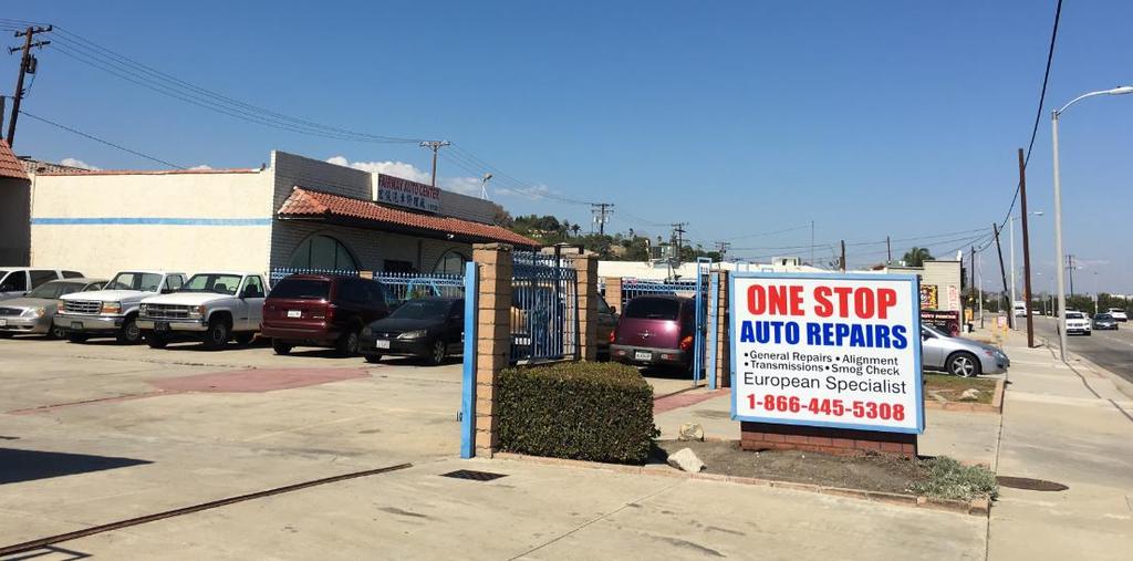
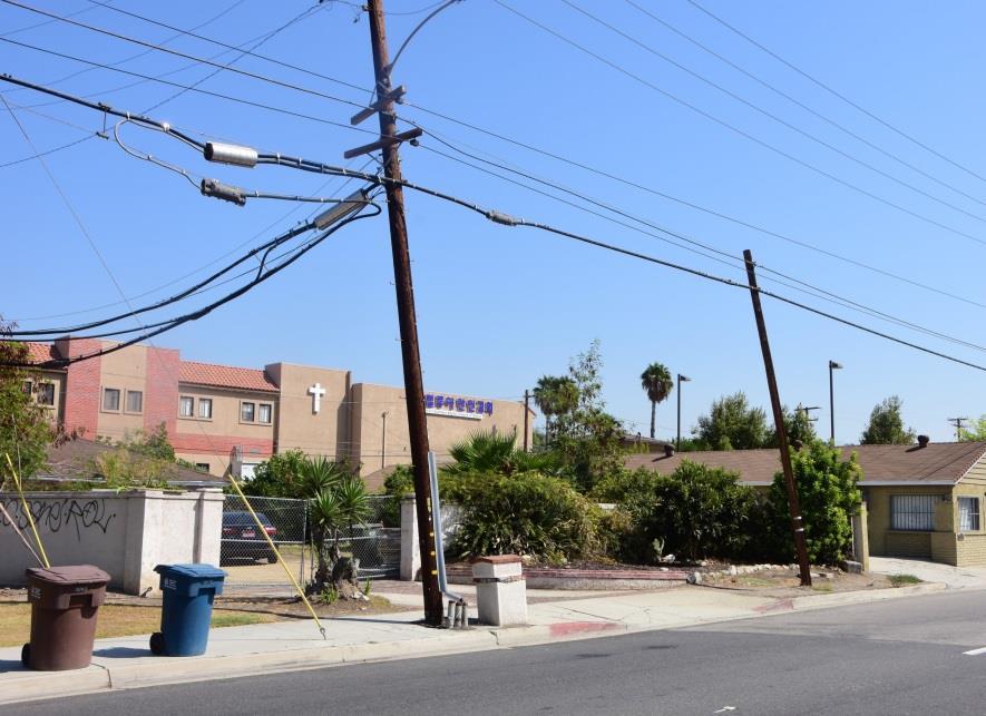
5 Grand Avenue and La Puente Road Site What s Working Key commercial corner High visibility site near Grand Avenue and Valley Boulevard Adjacent to thriving commercial and restaurant uses to the west and south Located near Civic Center What s Not Working Existing storm drainage easements restricts building development Vacant, unmaintained property abutting Snow Creek neighborhood Current Specific Plan limits land use to Assisted Care Facility 5


6 Grand/La Puente Alternative A: Current/Existing General Plan Land Uses Residential Existing Land Uses Commercial Assisted Living Commercial 6


7 Grand/La Puente Alternative B: Institutional Use Allow commercial uses such as retail and restaurants with public gathering spaces. Allow child care center to remain. Expand institutional uses. Proposed Photos 7


8 Grand/La Puente Alternative C: Expanded Commercial Allow commercial uses such as retail and restaurants with public gathering spaces. Allow education center to remain, but accommodate future transition to commercial uses. 8
9 West Valley Specific Plan Area What s Working Gateway into Walnut Local businesses serving neighborhoods High visibility along Valley Boulevard What s Not Working Underutilized commercial services and uses Fragmented ownership Narrow and shallow lots Alley restricts property consolidation Lack of investment and poor building maintenance 9


10 West Valley Specific Plan Area 10


11 West Valley Specific Plan Area 11
")
12 West Valley Specific Plan Boundary Area (Part 1 of 4) 12
")
13 West Valley Specific Plan Boundary Area (Part 2 of 4) 13
")
14 West Valley Specific Plan Boundary Area (Part 3 of 4) 14
")
15 West Valley Specific Plan Boundary Area (Part 4 of 4) 15


16 West Valley Alternative A: Current/Existing General Plan Land Uses Existing Land Uses Walnut Esplanade Specific Plan Zoning Allows Mixed Use Existing Photos Existing Photos Existing Photos 16
. Public gathering spaces required.")
17 West Valley Alternative B: Residential Mixed Use Commercial nodes at intersections. Commercial required on first floor with residential an option on upper floors. Create a mixed use corridor (residential uses allowed on any floor or as stand-alone residential buildings). Public gathering spaces required. Residential, live/work and office uses allowed along Camino de Rosa, with two-story height limit. 17
18 West Valley Alternative C: Commercial Mixed Use Create a mixed use corridor with residential uses on upper floors. Commercial uses would be required on the ground floor. Maximum height would be 35 feet or three stories. Public gathering spaces required. Residential, office, and live/work uses allowed along Camino de Rosa, with a two-story height limit; buffers existing residential zones to the north. 18


19 West Valley Alternatives B and C Photos Alternative B Three-story vertical mixed use on Valley Boulevard Stand-alone three-story residential on Valley Boulevard Two-story residential on Camino De Rosa Alternative C Three-story vertical mixed use on Valley Boulevard Three-story vertical mixed use on Valley Boulevard Two-story residential on Camino De Rosa 19

20 Walnut Hills Plaza Alternative A: Current/Existing General Plan Land Uses Existing Land Uses Existing Photos Existing Photos 20


21 Walnut Hills Plaza Alternative B: Mixed Use Commercial Nodes Allow up to three stories or 35 feet residential and office uses along Nogales Street and Amar Road. Amar Rd Reinvigorate commercial core while retaining the existing anchor (24-Hour Fitness) with neighborhood retail, restaurants, and public gathering spaces. Create pedestrian-friendly streetscapes along Nogales Street and Amar Road. 21

 with neighborhood retail,")

22 Walnut Hills Plaza Alternative C: Mixed Use Boundary Expansion Mixed uses along Amar Road, Nogales Street, and Francesca Drive Reinvigorate commercial core while retaining the existing anchor (24-Hour Fitness) with neighborhood retail, restaurants, and public gathering spaces. Create pedestrian-friendly streetscapes along Francesca Drive, Nogales Street, and Amar Road. 22

23 Overview Existing General Plan Land Use Designation: Schools = Schools 23
24 N o v e m b e r 9, 2016 Concept Alternatives J o i n t C i t y C o u n c i l a n d P l a n n i n g C o m m i s s i o n W o r k s h o p
U r b a n D e s i g n a n d t h e P u b l i c R e a l m
 U r b a n D e s i g n a n d t h e P u b l i c R e a l m Urban Design Goals 1. Enhance public access to and use of the town core s amenities. 2. Improve pedestrian access and circulation throughout the
ARTICLE 887. PD 887. Valley View - Galleria Area Special Purpose District
 ARTICLE 887. PD 887. Valley View - Galleria Area Special Purpose District SEC. 51P-887.101. LEGISLATIVE HISTORY. PD 887 was established by Ordinance No. 29032, passed by the Dallas City Council on June
320 Maple Mixed Use PDR Narrative Fort Collins, CO Project # 1525
 320 Maple Mixed Use PDR Narrative Fort Collins, CO Project # 1525 July 28, 2015 (a) What are you proposing/use? A 47,00 S.F., 3-story, mixed used project with 30 for-sale condo residential units and 2
City of South San Francisco Page 1 of 5
 City of South San Francisco P.O. Box 711 (City Hall, 400 Grand Avenue) South San Francisco, CA Legislation Text Report regarding the Housing Standing Committee recommendation to consider selecting either
When the Plan is not Enough
 When the Plan is not Enough Christine Maguire, AICP, EDFP Redevelopment Manager Planning & Community Development 1 Rail~Volution 2012 When the Plan is Not Enough: Garland, TX 16 October 2012 About the
REQUEST STAFF RECOMMENDATION. On April 26, 2012, Signature Books Inc., represented by Dave Richards, submitted petitions for the following amendments:
 PLANNING COMMISSION STAFF REPORT Signature Books Zoning Map Amendment and an Amendment to the North Temple Area Plan Petitions PLNPCM2012-00254 PLNPCM2012-00255 July 11, 2012 Planning Division Department
Community Advisory Committee (CAC) Meeting #7 West Anaheim Youth Center May 26, 2016
 Meeting #7 West Anaheim Youth Center May 26, 2016") Community Advisory Committee (CAC) Meeting #7 West Anaheim Youth Center May 26, 2016 1 Project Team City: David Belmer Planning and Building Director Jonathan Borrego, AICP Planning Services Manager Gustavo
Community Advisory Committee (CAC) Meeting #7 West Anaheim Youth Center May 26, 2016 1 Project Team City: David Belmer Planning and Building Director Jonathan Borrego, AICP Planning Services Manager Gustavo
APPENDIX D: DEFINITIONS
 D APPENDIX D: DEFINITIONS Terms used throughout the 2040 Comprehensive Plan should be interpreted using the definitions provided in this appendix. For interpretation of any term not defined, defer to the
ANASTASI DEVELOPMENT COMPANY. Building trust home by home.
 ANASTASI DEVELOPMENT COMPANY Building trust home by home. ANASTASI DEVELOPMENT COMPANY Established by the Anastasi family in 1962 Building trust home by home. ANASTASI DEVELOPMENT COMPANY Committed to
VERTICAL MIXED USE DEVELOPMENT (Urban Village)
") VERTICAL MIXED USE DEVELOPMENT (Urban Village) Overall Goal Statement Vertical Mixed Use (Urban Villages) have similar goals to Horizontal Mixed Use except densities are usually higher and projects frequently
VERTICAL MIXED USE DEVELOPMENT (Urban Village) Overall Goal Statement Vertical Mixed Use (Urban Villages) have similar goals to Horizontal Mixed Use except densities are usually higher and projects frequently
WESTMINSTER PARK SUBDIVISION
 WESTMINSTER PARK SUBDIVISION Engineering Comments: FINAL PLAT COMMENTS (should be addressed prior to submitting the FINAL PLAT for review and/or signature by the City Engineer): A. Provide all of the required
Appendix B: Housing Element Sites Inventory and Detailed Analysis
 Appendix B: 2015-2023 Housing Element Sites Inventory and Detailed Analysis Redwood City General This page intentionally left blank. Redwood City General Site Identifier Assessor Parcel Number General
Inwood NYC Update. CB 12 Land Use Committee May 3, 2017
 Inwood NYC Update CB 12 Land Use Committee May 3, 2017 Overview 1. Inwood NYC Recap 2. Community Engagement 3. Early City Investments - Investing in the people of Inwood - Improving neighborhood infrastructure
Appendix D - Manheim Township Zoning Ordinance
 T-3 Zone: Weatherstone West Vincent Township - Chester County, PA Total Acres: 300.0 Residential: 273 Single-Family Units Neighborhood Core: 240,000 SF Open Space: 195.0 Acres Residential Lot Area: 7,200-11,700
Sub-Areas Development Review
 Sub-Areas Development Review Sub-Area 1: 14 th Street Corridor Sub-Area 2: East Lake Gateway Sub-Area 3: Peralta/Laney College Sub-Area 4: I-880 Sub Area 5: Chinatown 5A BART Sites and Madison Park 5B
Poughkeepsie City Center Revitalization Plan
 Purpose and Need Purpose Increase job and educational opportunities for all residents Maximize fiscal productivity of downtown land uses Diversify retail mix Eliminate surface and building vacancies Create
Abandonment Procedures and Fees. Economic Development Committee September 2, 2008
 Abandonment Procedures and Fees Economic Development Committee September 2, 2008 1 Purpose Discuss current regulations and fees Review impacts Consider next steps 2 Background Real Estate Task Force formed
THE REDEVELOPMENT PLAN
 PAGE 37 THE REDEVELOPMENT PLAN FUTURE LAND USE The Silver Terrace Redevelopment Area is currently designated as Redevelopment Area #4 on the City of Delray Beach Future Land Use Map (FLUM). This designation
Bylaw No , being "Official Community Plan Bylaw, 2016" Schedule "A" DRAFT
 Bylaw No. 2600-2016, being "Official Community Plan Bylaw, 2016" Schedule "A" Urban Structure + Growth Plan Urban Structure Land use and growth management are among the most powerful policy tools at the
COMMUNITY BENEFIT REQUIREMENTS & IMPACT FEES FOR DEVELOPMENTS IN VARIOUS CITIES
 COMMUNITY BENEFIT REQUIREMENTS & IMPACT FEES FOR DEVELOPMENTS IN VARIOUS CITIES Prepared by Office of Mayor Tom Bates Current Requirements for Projects in Berkeley Downtown* Under Consideration for Projects
MEMORANDUM. C3A District Shoreland Overlay District 32,055 square feet / 0.74 acres. West Calhoun, adjacent to Cedar-Isles-Dean
 Department of Community Planning & Economic Development 250 South 4th Street, Room 300 Minneapolis, MN 55415-1385 MEMORANDUM To: City Planning Commission, Committee of the Whole Prepared By: Peter Crandall,
Triangle Special Planning Area Update. Community Workshop #5 September 17, 2018
 Triangle Special Planning Area Update Community Workshop #5 September 17, 2018 Welcome and Introductions Recap of the Project and Discussion to Date Meeting Agenda Review Draft SPA Revisions Discuss Outstanding
Ohlone College Mission Blvd Mixed-Use Project OFFERING MEMORANDUM
 Mission Blvd Mixed-Use Project OFFERING MEMORANDUM TABLE OF CONTENTS TABLE OF CONTENTS THE DEVELOPMENT OFFERING THE PROPERTY DEVELOPMENT CONCEPT DEVELOPMENT APPROACH FREMONT OVERVIEW MAPS AND PHOTOS P.
City Avenue District Rezoning. Regional Center Area & Bala Cynwyd Retail District December 14, 2011 Public Hearing
 City Avenue District Rezoning Regional Center Area & Bala Cynwyd Retail District December 14, 2011 Public Hearing Board of Commissioners Agenda Public Hearings An Ordinance to create The City Avenue District,
Montreal Road District Secondary Plan [Amendment #127, October 9, 2013]
![Montreal Road District Secondary Plan [Amendment #127, October 9, 2013]](/thumbs/72/66783104.jpg "Montreal Road District Secondary Plan [Amendment #127, October 9, 2013]") [Amendment #127, October 9, 2013] 1.0 General The following policies are applicable to the Montreal Road District as set out in Schedule 1. 1.1 District Objectives The objective of this Plan is to guide
[Amendment #127, October 9, 2013] 1.0 General The following policies are applicable to the Montreal Road District as set out in Schedule 1. 1.1 District Objectives The objective of this Plan is to guide
Plan Area and Current Facilities
 Plan Area and Current Facilities The Plan Area is bounded by South Delaware Street to the east and Concar Drive to the south (Figure 2.01). Parallel to Concar Drive on the south, SR 92 rises above grade
2.0 LAND USE FRAMEWORK
 Land Use Framework 2.0 LAND USE FRAMEWORK FOLSOM BOULEVARD 2.1 LAND USE OVERVIEW The proposed land uses for Easton Place offer local and regional employment, shopping, and entertainment, highlighting the
Village of Port Jefferson Urban Renewal Plan
 Urban Renewal Plan Village of Port Jefferson Urban Renewal Plan Port Jefferson, New York PREPARED FOR Village of Port Jefferson Village Board 121 West Broadway Port Jefferson, NY 11777 631.473.4724 PREPARED
Ventura Boulevard Old Town Camarillo, California Available Space
 New Development ± Old Town Camarillo Ventura Boulevard Old Town Camarillo, California 93010 Available Space Unit A - 1,600 SF Corner Unit Unit B - 1,500 SF In-line Space Unit C - 1,000 SF Corner Unit Unit
PUBLIC REVIEW DRAFT OF OFF-STREET PARKING PROPOSAL CITY OF OAKLAND PLANNING DEPARTMENT OCTOBER 2015
 PUBLIC REVIEW DRAFT OF OFF-STREET PARKING PROPOSAL CITY OF OAKLAND PLANNING DEPARTMENT OCTOBER 2015 1. Downtown Parking Minimums Problem: The current regulations do not prescribe a minimum amount of required
TASK 2 INITIAL REVIEW AND ANALYSIS U.S. 301/GALL BOULEVARD CORRIDOR FORM-BASED CODE
 TASK 2 INITIAL REVIEW AND ANALYSIS U.S. 301/GALL BOULEVARD CORRIDOR FORM-BASED CODE INTRODUCTION Using the framework established by the U.S. 301/Gall Boulevard Corridor Regulating Plan (Regulating Plan),
ARLINGTON COUNTY, VIRGINIA. County Board Agenda Item Meeting of September 19, 2015
 ARLINGTON COUNTY, VIRGINIA County Board Agenda Item Meeting of September 19, 2015 DATE: August 28, 2015 SUBJECT: Request to authorize advertisement of public hearings by the Planning Commission and the
WESTMINSTER PARK PLACE SUBDIVISION
 WESTMINSTER PARK PLACE SUBDIVISION Engineering Comments: FINAL PLAT COMMENTS (should be addressed prior to submitting the FINAL PLAT for review and/or signature by the City Engineer): A. Provide all of
LONG-RANGE LAND USE PLAN
 LONG-RANGE LAND USE PLAN INTENT Completion of the I-66/Route 29 interchange and future expansion of improved telecommunication networks will substantially improve the desirability of the Gainesville area
2.2 Understanding Centretown: Character Areas
 Character Areas The broad mix of uses which have found a home in Centretown as the area has grown and changed has resulted in a neighbourhood rich in character and diversity. Today, Centretown continues
G. HRA Member Area Surveys a. Area 1 Survey Sample b. Area 1-10 descriptions for surveys
 G. HRA Member Area Surveys a. Area 1 Survey Sample b. Area 1-10 descriptions for surveys CENTER CITY URBAN REVITALIZATION PLAN RANKING OF URBAN RENEWAL ACTIONS Area 1 Dwight Street Gateway This area includes
Project Team. Community Workshop Draft Specific Plan Review West Anaheim Youth Center September 4, /6/2018.
 Community Workshop Draft Specific Plan Review West Anaheim Youth Center September 4, 2018 Project Team City: David Belmer Planning and Building Director Susan Kim, AICP Principal Planner Gustavo Gonzalez,
COUNTY OF ALBEMARLE PLANNING STAFF REPORT SUMMARY
 COUNTY OF ALBEMARLE PLANNING STAFF REPORT SUMMARY Project Name: ZMA 2010-00015, Cedar Hill Planning Commission Worksession: February 15, 2011 Public Hearing: Not scheduled Staff: Judith C. Wiegand, AICP
43 Acres. Presented by: COMMERCIAL MIXED USE LAND OFFERING LAKE ELSINORE, CALIFORNIA
 COMMERCIAL MIXED USE LAND OFFERING 43 Acres Presented by: Investment Overview Lee & Associates Commercial Real Estate Services, is pleased to exclusively present for sale the +/-43.5 acre (1,895,000 SF)
1102 SOUTH THIRD STREET SAN JOSE, CA.
 SOUTHERN GATEWAY TO DOWNTOWN SAN JOSE ±7.96 ACRES FOR SALE SALE-LEASEBACK DEVELOPER:, [ Big Box Retail ], Potential Residential [ Study in Process ] INVESTOR: Seller Lease Back OWNER-USER: Flexible Occupancy
CONCEPTUAL DOWNTOWN REDEVELOPMENT PLAN PROPOSED CONCEPTUAL PLAN
 6 Focus Study Area Vandalia Trail Franklin Park Lincoln St Elm St. LEGEND: Main Street District Neighborhood District Village District Parks / Open Space District N. West Street N Mill St Picket St Eastern
Re: Item No THE WILLOW TREE TOWER Landmark Building. Landmark Site.
 Re: Item No. 11.1 THE WILLOW TREE TOWER Landmark Building. Landmark Site. REQUEST FROM COUNCIL Give first reading and schedule a public hearing to consider a height of 78 meters (25 stories) In consideration
DAYLIGHTING / COURTYARD
 SITE / CONTEXT MASS / MODULAR DAYLIGHTING / COURTYARD VIEWS /VENTILATION CIRCULATION / PARKING The building is located in the San Fernando Valley. On the West Side of the site is the main access road;
LAKE MERRITT STATION AREA PLAN
 LAKE MERRITT STATION AREA PLAN Emerging Plan Open House Summary October 2011 2 1 Introduction The City of Oakland, Bay Area Rapid Transit (BART), and the Peralta Community College District, through a grant
ARLINGTON COUNTY, VIRGINIA
 ARLINGTON COUNTY, VIRGINIA County Board Agenda Item Meeting December 9, 2006 DATE: November 20, 2006 SUBJECT: GP-302-05-2 Adoption of General Land Use Plan Amendments for the Clarendon Metro Station Area:
J U N I O N. The. Bothell, Washington. For Leasing Info Maria Royer
 The J U N CT I O N Downtown Bothell, Washington Bothell A District of Neighborhoods known areas such as Canyon Park, Thrasher s Corner and North Creek. As new development occurs, the city s downtown district,
AGENDA. Next Board Meeting: March 23, 2017
 March 3, 2017 To: Columbia Association Board of Directors Advisory Committee Chairpersons Village Board Chairs Village Managers Members of the Press CA Management From: Andrew C. Stack, Board Chair The
MEMORANDUM Main Concepts
 MEMORANDUM DATE February 5, 2016 TO FROM SUBJECT David Bischoff City of Gilroy Bruce Brubaker and Seung Hong, PlaceWorks Draft Alternative Land Use and Circulation Scenarios This memorandum summarizes
DEVELOPMENT STANDARDS FOR RESIDENTIAL PROJECTS RESIDENTIAL BUILDING TYPES: APPROPRIATE ZONES AND DENSITIES 2-1
 2 DEVELOPMENT STANDARDS FOR RESIDENTIAL PROJECTS RESIDENTIAL BUILDING TYPES: APPROPRIATE ZONES AND DENSITIES 2-1 This Chapter presents the development standards for residential projects. Section 2.1 discusses
TABLE OF CONTENTS. Chapters and Sections
 TABLE OF CONTENTS Chapters and Sections Chapter 9.02 Permits and Approvals [Addition]... 1 9.02.090 Administrative variances.... 1 Chapter [New]... 1 9.07.091 Purpose and Intent... 1 9.07.092 Applicability...
Goal 1 - Retain and enhance Cherry Creek North s unique physical character.
 Introduction This document summarizes the proposed new zoning for the area of roughly bordered by University Boulevard, Steele Street, 3rd Avenue, and 1st Avenue. It provides a high-level review of the
ARLINGTON COUNTY, VIRGINIA
 ARLINGTON COUNTY, VIRGINIA County Board Agenda Item Meeting of February 22, 2014 DATE: January 28, 2014 SUBJECT: Deed of Easement for a Department of Environmental Services Project Located on a Portion
Richardson s TOD Experience From ULI Panel Report to Breaking Ground. September 8, 2011
 Richardson s TOD Experience From ULI Panel Report to Breaking Ground Presented to ULI Minnesota District Council Presented By: Gary Slagel President and CEO CapitalSoft Former Mayor, City of Richardson,
Washington Boulevard + Kirkwood Road Special General Land Use Plan (GLUP) Study "Plus"
 Study Plus") Washington Boulevard + Kirkwood Road Special General Land Use Plan (GLUP) Study "Plus" Long Range Committee of the Planning Commission Meeting #4 May 18, 2017 Department of Community Planning, Housing
Washington Boulevard + Kirkwood Road Special General Land Use Plan (GLUP) Study "Plus" Long Range Committee of the Planning Commission Meeting #4 May 18, 2017 Department of Community Planning, Housing
1. ADOPTION OF THE AGENDA THAT the Commission adopts the agenda for the January 17, 2018 meeting of the Advisory Planning Commission.
 Agenda for the 2:00 pm Wednesday, January 17, 2018 Town of Qualicum Beach Advisory Planning Commission Special Meeting to be held in the Council Chambers, Municipal Office, 660 Primrose Street, Qualicum
TREASURE COAST REGIONAL PLANNING COUNCIL M E M O R A N D U M
 TREASURE COAST REGIONAL PLANNING COUNCIL M E M O R A N D U M To: Council Members AGENDA ITEM 6A From: Date: Subject: Staff May 20, 2011 Council Meeting Local Government Comprehensive Plan Review Draft
ARTICLE 5. COMMERCIAL AND OFFICE DISTRICTS 5.1 PURPOSE STATEMENTS 5.2 USES 5.3 DIMENSIONAL STANDARDS 5.4 DESIGN STANDARDS 5.5 DK DISTRICT STANDARDS 5
 ARTICLE 5. COMMERCIAL AND OFFICE DISTRICTS 5.1 PURPOSE STATEMENTS 5.2 USES 5.3 DIMENSIONAL STANDARDS 5.4 DESIGN STANDARDS 5.5 DK DISTRICT STANDARDS 5.6 CU DISTRICT STANDARDS 5.7 SW DISTRICT STANDARDS THE
Long Range Development Plan (LRDP) Mission Bay Community Workshop #2
 Mission Bay Community Workshop #2") Long Range Development Plan (LRDP) Mission Bay Community Workshop #2 Campus Planning February 28, 2013 2 Agenda 1. Welcome 2. Agenda Overview 3. Near-Term Mission Bay Space Needs Discussion 4. LRDP Planning
Long Range Development Plan (LRDP) Mission Bay Community Workshop #2 Campus Planning February 28, 2013 2 Agenda 1. Welcome 2. Agenda Overview 3. Near-Term Mission Bay Space Needs Discussion 4. LRDP Planning
THE AREA PLAN COMMISSION OF ST. JOSEPH COUNTY, IN AGENDA
 THE AREA PLAN COMMISSION OF ST. JOSEPH COUNTY, IN AGENDA Tuesday, January 17, 2017 Fourth-Floor Council Chambers 3:30 p.m. County-City Building, South Bend, IN EXECUTIVE SESSION: A. Election of Officers
ARDEN PARK NEIGHBORHOOD PRESERVATION AREA (5-31-3)
") ARDEN PARK NEIGHBORHOOD PRESERVATION AREA (5-31-3) 531-30. INTENT. It is the intent of the Board of Supervisors in adopting this Neighborhood Preservation Ordinance to preserve and protect the existing
ARDEN PARK NEIGHBORHOOD PRESERVATION AREA (5-31-3) 531-30. INTENT. It is the intent of the Board of Supervisors in adopting this Neighborhood Preservation Ordinance to preserve and protect the existing
3.0 Project Description
 3.0 Project Description City of Long Beach Shoreline Gateway Project Environmental Impact Report 3.0 PROJECT DESCRIPTION 3.1 PROJECT LOCATION AND SETTING PROJECT LOCATION The proposed Shoreline Gateway
1111 N 13th St Omaha, Nebraska 68102
 1111 N 13th St Omaha, Nebraska 68102 Information furnished is from sources deemed reliable, but is not guaranteed by P.J. Morgan Real Estate, or its agents and is subject to change, corrections, errors,
RTKL ADDISON, TEXAS. A successful Suburb. Activity Center. Employment Center. Addison. Service Center
 ADDISON CIRCLE Sustainable Development Sustainable Environmental Excellence Ron Whitehead Town of Addison Paris Rutherford RTKL Associates Inc. RTKL ADDISON, TEXAS A successful Suburb Activity Center Addison
Overview. Central Street Master Plan. Appendix B: Zoning
 Central Street Master Plan Overview The City of Evanston has 36 zoning districts, of which 11 are found in the Central Street Corridor Study Area (See Figures B.1 and B.2). They include: R1: Single-Family
North Campus Master Plan
 North Campus Master Plan November 29, 2011 Concept Plan Respect the site s natural features Reinforce vibrant campus anchors Connect campus destinations 2 Sketch Plan: core shifts east 3 Sketch Plan: core
AGENDA SLOT HOME EVALUATION & TEXT AMENDMENT. 5:30 - Welcome
 AGENDA 5:30 - Welcome Please sign-in, put a sticker on the map, grab snacks, materials and a seat 5:45 - Staff Presentation 6:15 - Open House Stations Background Information Mixed Use Districts Multi Unit
Planning Justification Report
 Planning Justification Report 101 Kozlov Street, Barrie, Ont. Destaron Property Management Ltd. November 2015 Revised February 2017 TABLE OF CONTENTS Page 1.0 INTRODUCTION... 1 2.0 DESCRIPTION OF SUBJECT
APPENDIX B RESIDENTIAL DENSITY
 APPENDIX B RESIDENTIAL DENSITY RESIDENTIAL DENSITY - SPECIFIC AREAS OF THE CITY Policy Issue Examine specific areas of the City to determine appropriate residential densities. Public comments have expressed
Table of Contents ARTICLE 5A CHARACTER-BASED ZONING 1
 Table of Contents ARTICLE 5A CHARACTER-BASED ZONING 1 SECTION 10.5A10 GENERAL... 1 10.5A11 Purpose and Intent... 1 10.5A12 Applicability... 1 10.5A13 Compliance with Regulating Plan... 1 10.5A14 Relationship
City of North Richland Hills Transit Oriented Development Code
 Section 118-561. Purpose and Intent: City of North Richland Hills Transit Oriented Development Code The purpose of the Transit Oriented Development (TOD) Code is to support the development of the community
$2,500,000 DOWNTOWN WALNUT CREEK MULTI-TENANT RETAIL PROPERTY SHAWN WILLIS S. MAIN STREET WALNUT CREEK, CA 94596
 1500-1530 S. MAIN STREET WALNUT CREEK, CA 94596 $2,500,000 DOWNTOWN WALNUT CREEK MULTI-TENANT RETAIL PROPERTY SHAWN WILLIS INCOME PROPERTY SERVICES 1343 Locust Street, Suite 204, CA 94596 Dre # 00947718
ORDINANCE NO. 615-C.S.
 ORDINANCE NO. 615-C.S. AN ORDINANCE OF THE CITY COUNCIL OF THE CITY OF SAN GABRIEL AMENDING THE VALLEY BOULEVARD SPECIFIC PLAN AND CHANGING THE ZONE FROM SINGLE FAMILY RESIDENTIAL (R-1) FOR THE PROPERTY
TREASURE COAST REGIONAL PLANNING COUNCIL M E M O R A N D U M. February 19, 2010 Regional Planning Council Meeting
 TREASURE COAST REGIONAL PLANNING COUNCIL M E M O R A N D U M To: Council Members AGENDA ITEM 5G From: Date: Subject: Staff February 19, 2010 Regional Planning Council Meeting Local Government Comprehensive
THE AREA PLAN COMMISSION OF ST. JOSEPH COUNTY, IN AGENDA
 THE AREA PLAN COMMISSION OF ST. JOSEPH COUNTY, IN AGENDA Tuesday, June 20, 2017 Fourth-Floor Council Chambers 3:30 p.m. County-City Building, South Bend, IN PUBLIC HEARINGS: 1. Rezonings: A. A combined
SAGINAW CHARTER TOWNSHIP PLANNING COMMISSION SAGINAW CHARTER TOWNSHIP HALL DECEMBER 2, Members Present Members Absent Others Present
 SAGINAW CHARTER TOWNSHIP PLANNING COMMISSION SAGINAW CHARTER TOWNSHIP HALL DECEMBER 2, 2015 Members Present Members Absent Others Present S. McGraw J. (excused) B. Smith, Planner B. Gombar C. Edlinger,
Staff Report PLANNING DIVISION COMMUNITY & ECONOMIC DEVELOPMENT. Alley Closure
 Staff Report PLANNING DIVISION COMMUNITY & ECONOMIC DEVELOPMENT To: From: Salt Lake City Planning Commission Doug Dansie, 801-535-6182, doug.dansie@slcgov.com Date: March 23, 2016 Re: PLNPCM2015-00941
Composition of traditional residential corridors.
 Page 1 of 7 St. Petersburg, Florida, Code of Ordinances >> PART II - ST. PETERSBURG CITY CODE >> Chapter 16 - LAND DEVELOPMENT REGULATIONS >> SECTION 16.20.060. CORRIDOR RESIDENTIAL TRADITIONAL DISTRICTS
Table of Contents ARTICLE 5A CHARACTER-BASED ZONING 1
 Table of Contents ARTICLE 5A CHARACTER-BASED ZONING 1 SECTION 10.5A10 GENERAL... 1 10.5A11 Purpose and Intent... 1 10.5A12 Applicability... 1 10.5A13 Compliance with Regulating Plan... 1 10.5A14 Relationship
Route 6 Corridor Study Bristol Planning Commission Meeting #1. May 25, 2016 FITZGERALD & HALLIDAY, INC. Innovative Planning, Better Communities
 Route 6 Corridor Study Bristol Planning Commission Meeting #1 May 25, 2016 FITZGERALD & HALLIDAY, INC. Innovative Planning, Better Communities Today s Agenda 1. Introductions 2. Study overview Scope Schedule
ARLINGTON COUNTY, VIRGINIA
 ARLINGTON COUNTY, VIRGINIA County Board Agenda Item Meeting of April 19, 2008 DATE: April 2, 2008 SUBJECT: ORDINANCE TO AMEND, REENACT, AND RECODIFY Section 20 CP- FBC, Columbia Pike Form Based Code Districts
3.1. OBJECTIVES FOR RESIDENTIAL LAND USE DESIGNATIONS GENERAL OBJECTIVES FOR ALL RESIDENTIAL DESIGNATIONS
 3. RESIDENTIAL LAND USE DESIGNATIONS INTRODUCTION The Residential land use designations provide for housing and other land uses that are integral to, and supportive of, a residential environment. Housing
Introduction. General Development Standards
 Introduction The development standards will set the zoning regulations for the East Park development. This section will illustrate lot standards, approximate open space locations and road standards. The
PLANNING RATIONALE 680 BRONSON AVENUE OTTAWA, ONTARIO PROPOSED ZONING BY-LAW AMENDMENT
 PLANNING RATIONALE 680 BRONSON AVENUE OTTAWA, ONTARIO PROPOSED ZONING BY-LAW AMENDMENT FRANK PARAVAN APRIL 2014 Planning Rationale Introduction FOTENN Consultants Inc. has been engaged by Frank and Michael
College Avenue. Sowers Street. Calder Way. Beaver Avenue
 K L M Illustrative Master Plan: Collegiate District Calder Way Beaver Avenue High Street ner 16 Sowers Street Stre et 17 Hetzel Street 18 Gar Heister Street 15 Collegiate District 183 4-C: East End Collegiate
B. BACKGROUND The Town does not currently regulate minimum levels of density for new projects. In the past, projects have generally been at the higher
 Town of Mammoth Lakes Planning & Economic Development Commission Recommendation Report Date: March 11, 2015 Case/File No.: NA Place: Council Chambers, 2 nd Floor Minaret Village Shopping Center Mammoth
Northwest Quadrant. Aerial Photographs. I th Ave Atlantic Ave 1 st St. SW 10 th /Atlantic SW 8 th /Atlantic
 Northwest Quadrant Aerial Photographs 12 th Ave Atlantic Ave 1 st St SW 10 th /Atlantic SW 8 th /Atlantic 12 th Ave 10 th Ave SW 10 th Ave SW 8 th Ave 2 nd St 3 rd St 36 Northwest Quadrant Neighborhood
Official Plan & Zoning By-law Amendment Application Preliminary Report
 STAFF REPORT ACTION REQUIRED 847 873 Sheppard Avenue West Official Plan & Zoning By-law Amendment Application Preliminary Report Date: January 13, 2010 To: From: Wards: Reference Number: North York Community
City of North Richland Hills Transit Oriented Development Code
 City of North Richland Hills Transit Oriented Development Code Section 118-561. Purpose and Intent: The purpose of the Transit Oriented Development (TOD) Code is to support the development of the community
Chapter URBAN VILLAGE ZONING DISTRICTS
 Chapter 20.16 Sections: 20.16.010 Purpose of the Urban Village Zoning Districts 20.16.020 Land Use Regulations for the Urban Village Zoning Districts 20.16.030 Development Standards & Guidelines for the
Washington-Hillside Small Area Study
 Washington-Hillside Small Area Study City of Naperville Planning Services Team March 1, 2004 PRELIMINARY REPORT Executive Summary The Downtown Plan, adopted by City Council in August 2000, strives to articulate
The 12.1-net acre property is the premier development site in the western United States, sitting at the gateway of San Diego s Broadway office
 The 12.1-net acre property is the premier development site in the western United States, sitting at the gateway of San Diego s Broadway office corridor with over one-quarter mile of water-frontage on the
Section 1. Appendix A, "Zoning" of the Code of the City of Charlotte is hereby amended as follows:
 Petition No. 2009-078 Petitioner: Charlotte-Mecklenburg Planning Commission ORDINANCE NO. AN ORDINANCE AMENDING APPENDIX A OF THE CITY CODE ZONING ORDINANCE Revised 12-10-09 BE IT ORDAINED BY THE CITY
Rule of corner may need to be flexible i.e. context school, park. With a clustered approach. Should row housing go where fourplexes are?
 Fourplex Privacy Traffic issues by school (don t locate next to school) Highest density is furthest from park and school. Is this best? Family friendly (i.e. private green space, nicely designed, etc.)
Creative Approaches to Land Acquisition
 2007 Legislative Session Review CALIFORNIA TRANSIT ASSOCIATION JANUARY/FEBRUARY 2008 Creative Approaches to Land Acquisition Result From Creative Approaches to Land Acquisition It should not surprise anyone
Request for Recommendation
 Request for Recommendation Application for site specific rezoning in order to permit a four-storey multiple dwelling with 55 units in a C2, General Commercial zone, 6150, 6160, 6166 Highway 69 North &
Rezoning Petition Zoning Committee Recommendation June 29, 2017
 Rezoning Petition 2017-076 Zoning Committee Recommendation June 29, 2017 REQUEST Current Zoning: MUDD-O (mixed use development, optional) and R-4 (single family residential) Proposed Zoning: UR-2(CD) (urban
Plan Santa Paula Workshop III: Evaluating the Proposed Housing Plans. Summary of Participant Comments
 Plan Santa Paula Workshop III: Evaluating the Proposed Housing Plans Summary of Participant Comments Following a presentation and panel discussion regarding potential impacts to water, fiscal resources,
MARKET & OCTAVIA AREA PLAN FUNDAMENTAL DESIGN PRINCIPLES
 SAN FRANCISCO PLANNING DEPARTMENT FOR BUILDING MASSING AND ARTICULATION The way we experience a building is determined largely by its massing and articulation. Buildings in most San Francisco neighborhoods
4.2.8 Westwood/VA Hospital Station Area
 4.2.8 Westwood/VA Hospital Station Area The Westwood/VA Hospital Station area is north of the VA Hospital and surrounded by large, open landscaped areas and several parking lots. I-405 is a prominent visual
GENERAL PLAN UPDATE. Joint Study Session March 29, 2017
 GENERAL PLAN UPDATE Joint Study Session March 29, 2017 Interrelated Issues and Topics Property Owner Requests Mobility: Efficiency and Safety Land Use Plan (in the City) Light Rail/ Transit Jobs/ Housing