Site & Architectural Design Study for the Conversion of Parking Lots
|
|
|
- Darrell Barker
- 5 years ago
- Views:
Transcription
 647-5235 Issued: April 18,")
1 Site & Architectural Design Study for the Conversion of Parking Lots Town of Manchester, Connecticut 41 Center Street (860) Issued: April 18, 2008
2 Table of Contents Preface Introduction Part 1 Conditions Analysis & Concept Options Part 2 Building Schemes Part 3 Conceptual Building Design Conclusion
3 Preface The Town government and administration have been active partners with the Downtown Manchester Special Services District (SSD) since the SSD s inception in Both partners have worked to improve the physical appearance and business climate of this historic central business district. We have pursued the longterm goal of increasing investment, development, and activity in the downtown to ensure it remains a vibrant and successful center of the community. The Town and the SSD recognize there are two obvious ways to encourage development. One is to encourage reinvestment and adaptive reuse of the existing buildings. While most of the ground floor spaces on Main Street are occupied, significant upper floors and some lower floors are not occupied or are under occupied. The Town has offered property tax assessment agreements and façade improvement grants to help stimulate physical improvements to these buildings, but ultimately the property owner must be willing to make the substantial investment necessary for renovation and seek tenants to fill them. Some owners are unable, or unwilling, to pursue this kind of investment for personal or economic reasons. Both the Town and the SSD stand ready to help these property owners or investors in any way we can. Another strategy is to encourage new development, and the Town as a property owner can use its real estate assets for that purpose. Manchester owns several parking lots in the downtown area. Three of those lots represent underused assets (see attachment A), and perhaps provide an opportunity to secure development partners to build new buildings and bring new uses to the downtown. Given the desire to increase development and investment in the Downtown and the fact that these municipal parking lots are underused, the Town commissioned this Site and Architectural Design Study for the Conversion of Parking Lots to explore what types and sizes of buildings and parking would be possible given the Town s existing zoning regulations. The consultants, Crosskey Architects, LLC with Ferrero Hixon Associates, landscape architects, were asked to provide three different scenarios for each lot: one with as much building as possible, one with a building and all of its required (by the zoning regulations) parking on the lot, and one with a mix of building and some parking. A steering committee was formed to provide guidance and feedback to the consultants. We believe the results of the study indicate there are exciting opportunities to develop each of these lots in a way that would enhance Downtown architecturally and economically, adding people and activity to create a more vibrant place. Some of the development options can be built within our current zoning regulations, while others may require regulation amendments. This report recommends preferred site development options and uses. We caution this was not a market or real estate analysis, but a design and zoning analysis. If there is support for developing these municipal properties, the Board of Directors must decide whether to solicit proposals for a preferred developer or for a specific development project for any or all of these lots. We recognize that soliciting successful proposals depends on the economic climate, but we also recognize one way to gauge the feasibility of a project is to solicit proposals and make a decision based on the responses received.
4 Preface continued The Town should not consider selling these real estate assets as a way to generate cash, but instead as a longer-term investment in the downtown and the community. Selling these properties at nominal cost, or through a long-term land lease, and providing real estate and personal property tax incentives could provide significant financial incentives to help secure the type of development the Town would like to see. New development may encourage owners of other downtown properties to invest in improvements, or encourage new investors to buy existing buildings, further revitalizing the district. One final observation: One of the reasons the parking lots are currently underused, with the notable exception of the Purnell Place parking lot, is that there are considerable vacancies on the upper floors of buildings. If the Town is successful over the next several years in developing its municipal parking lots and attracting more businesses and people to the downtown, and if current or future property owners are successful in filling their vacant upper floors, we may have a real parking shortage in the district. The 1991 Downtown Strategic Plan envisioned that, in such an event, the Town could build a one-level parking deck over the Purnell Place lot with improved connections to Main Street. None of us can be certain how soon development and redevelopment in the downtown would occur, and thus, this is not an immediate need. However, if we begin to see significant success in the revitalization of Downtown, there are possibilities to increase parking to accommodate this success without the need for property acquisition or any disruption to either Main Street or the historic East Side or West Side neighborhoods. Steering Committee Tana Parseliti, Downtown Manager Bernie Apter, Economic Development Commission John B. Sayre, Economic Development Commission Marty Fins, Special Services District Don Dubaldo, Special Services District Mark Pellegrini, Director of Neighborhood Services and Economic Development James Williams, Public Works Project Manager James Mayer, Traffic Engineer Mark Carlino, Director of Public Works Gary Anderson, Senior Planner
5 Introduction Crosskey Architects LLC and Ferrero Hixon Associates were hired by the Town of Manchester to provide a planning study for three Town owned sites, 1050 Main Street, 19 Birch Street and 53 Cottage Street. All three sites are currently used as surface parking lots and it is the Town s desire to evaluate possible development options and determine preferred solutions to encourage and stimulate the highest and best use of these parcels. Our approach was divided into the three parts. First we gathered information on existing conditions and developed alternative concept plans for each site. Next, a preferred concept plan was chosen and more specific plans developed. The final part of the study produced a rendering of a building for each site to illustrate potential development.
6 Part One The first part of the project involved a review of the area encompassed by each of the three sites. We gathered all available information and diagrammatically illustrated current uses of each of the three subject parcels, the number of parking spaces provided, the size and zone of each parcel, and on-street and surface parking available within a two minute walking distance. We then studied the surrounding urban fabric relative to each site s relationship to downtown land uses, pedestrian circulation paths from parking to services, available parking, and way finding, linkages, access points and other similar factors. A further evaluation of parking included anticipated absorption and zoning requirements based on specific uses. Individual site plans were created from available information showing existing site conditions, boundaries and topography. Photographs of adjacent building exteriors were taken to illustrate height, materials, use, style, scale, etc. Following the compilation and analysis of the above information, each site was studied for conceptual highest and best use site development options. The consultant team and the steering committee reached an early consensus that the highest and best uses, and those most desirable for the Downtown, would be a mix of retail, service, and restaurant uses on the ground floors and market rate or mixed-income housing on upper floors. The former uses are preferred because they would add business activity and put feet on the street. The latter is preferred because adding new market rate residences would create a more 24-hour Downtown, take most advantage of the existing public infrastructure, put eyes on the street, and create more pedestrian activity and support Main Street businesses. We also recognize there are significant challenges, both construction and financial, to converting formerly commercial spaces on the upper floors of historic buildings to residential use. We believe the owners of those buildings may find it more financially feasible to convert upper floors to uses that do not change use classifications, and thus avoid the sometimes significant expenses of meeting building and fire codes for the mixed-uses that may result. Parking was discussed relative to the practical needs of the proposed uses compared to the parking required by the zoning regulations. Based on Town and consultant generated downtown public parking analysis, it was concluded required parking for residential uses should be provided on-site if possible, but for commercial uses the parking requirement could be met through a combination of on-site and public spaces on the street and in nearby surface lots.
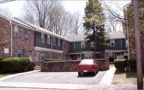
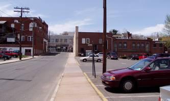
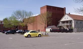
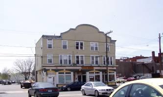
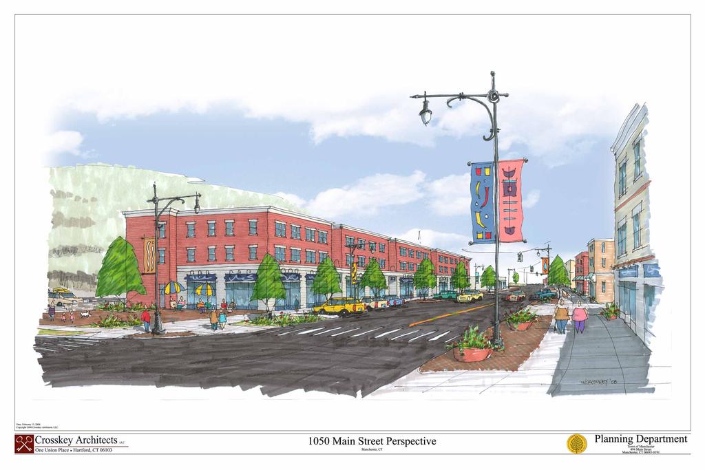
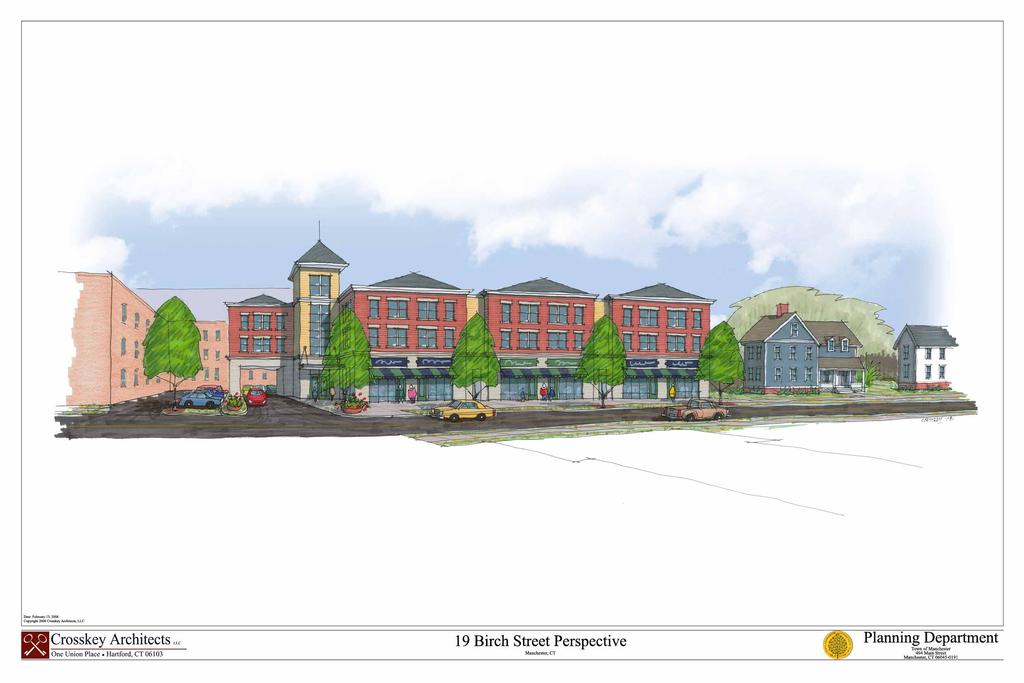
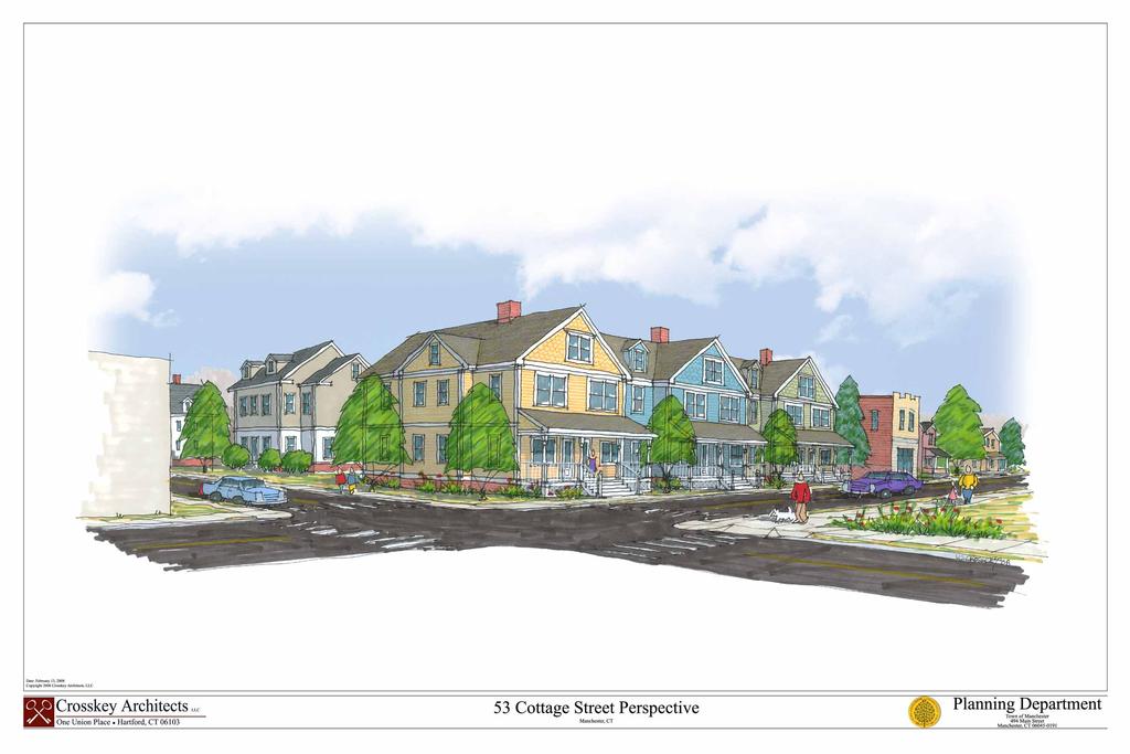
7 Part One continued Three concept schemes for each site were presented. Each scheme illustrates a general building size, use and location, parking and open space. From these diagrams a preferred option was chosen for further development. In general the options chosen maximize the highest and best use of the parcels and promote uses, scale and density of development which compliment the surrounding context Main Street This site is characterized by its frontage on Main Street which, based on the analysis of its context, may support ground floor commercial space with housing above. The three concept options are shown on the Main Street Diagram plans. Option C was determined to be the most desirable because of its corner plaza, on street parking, building length stretched along Main Street to maintain the pedestrian streetscape, ground floor commercial with residential above, and limited parking at the rear of the site. Additional investigation will be required to determine the viability of having parking in the basement of the building if that is desirable. The option of providing parking above the first floor commercial space for residential units was also explored. 19 Birch Street The Birch Street site is located one lot east of Main Street. Although not directly fronting Main Street, it was determined that commercial land uses may be successful in this location. Residential use on the ground floor in this location would be more challenging. Increased noise and traffic from Main Street makes this area less desirable for living space. However, raising the residential space above the street by raising the first floor three feet above grade, or locating all of the residential space on upper floors with commercial below, would make residential uses more attractive here. Of the three options shown on the Birch Street Diagram Option B was preferred. This option maximizes the use of the site with a building that is three stories at the street, but two stories over surface parking at the rear. The required parking for the residential uses on the upper floors is provided at ground level but behind street-front commercial space. Commercial parking can be provided in the seldom-used northern portion of the Purnell lot across the street. 53 Cottage Street This site is the quietest of the three and based on its distance from the downtown and the surrounding residential uses, should be developed as residential. A number of residential development scenarios were presented and Option B chosen (see Cottage Street Diagram) because it most closely fit the neighborhood context with respect to building size, scale and site use. The residential building would be located along the Oak Street edge of the site with vehicle access from both Cottage Street and Oak Street. Parking is located to the rear of the building.
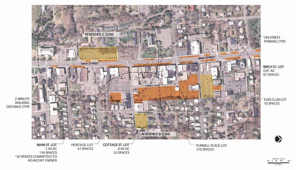
 ELKS CLUB LOT 10 SPACES RESIDENCE B ZONE LEGEND SUBJECT PARCEL MUNICIPAL LOT/ ON STREET PARKING HERITAGE LOT 47")
8 Key Plan ST. JAMES ST. LOT 91 SPACES MAIN ST. LOT 1.59 AC 116 SPACES *25 SPACES DEEDED FOR CUSTOMER RESIDENCE C ZONE ON-STREET PARKING (TYP) BIRCH ST. LOT 0.81 AC 87 SPACES *16 SPACES RESERVED FOR CUSTOMERS 2 MINUTE WALKING DISTANCE (TYP) ELKS CLUB LOT 10 SPACES RESIDENCE B ZONE LEGEND SUBJECT PARCEL MUNICIPAL LOT/ ON STREET PARKING HERITAGE LOT 47 SPACES COTTAGE ST. LOT 0.48 AC 53 SPACES PURNELL PLACE LOT 317 SPACES *109 SPACES RESERVED FOR CUSTOMER
 ON-STREET PARKING (TYP) 2 MINUTE WALKING DISTANCE (TYP) LEGEND SUBJECT PARCEL PUBLIC PARKING SUBSTANTIAL PRIVATE")
9 NARROW BUILDING FOOTPRINT PROVIDE RESIDENTIAL ACCESS TO MAIN ST. Key Plan - Uses CONTINUE COORDINATED SERVICE ACCESS CROSSING (TYP) ON-STREET PARKING (TYP) 2 MINUTE WALKING DISTANCE (TYP) LEGEND SUBJECT PARCEL PUBLIC PARKING SUBSTANTIAL PRIVATE PARKING MIXED COMMERCIAL USES PROVIDE CLEAR PEDESTRIAN LINKAGES AND WAYFINDING BETWEEN LOTS AND MAIN ST. REORGANIZE ACCESS POINTS


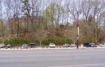
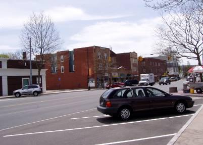
10 Main Street Views


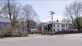
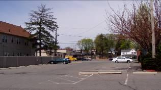
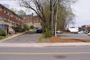
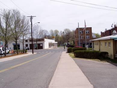
11 BIRCH STREET VIEWS COTTAGE STREET VIEWS
 PARKING REQUIRED +/- 100 PARKING")
 PARKING REQUIRED +/- 150 PARKING PROVIDED +/-")
 PARKING REQUIRED +/- 260 PARKING")
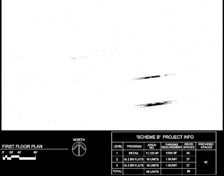
12 A Main Street Diagram B OPTION A BUILDING USES +/- 30,000 SF (2 FLOORS) PARKING REQUIRED +/- 100 PARKING PROVIDED +/- 100 OPTION B BUILDING USES +/- 29,000 SF (1 FLOOR) PARKING REQUIRED +/- 150 PARKING PROVIDED +/- 150 (INCLUDES ROOFTOP) C OPTION C BUILDING USES +/- 52,000 SF (2 FLOORS) PARKING REQUIRED +/- 260 PARKING PROVIDED +/- 60
 PARKING REQUIRED +/- 55")
 PARKING REQUIRED +/- 120")
 PARKING REQUIRED +/- 195")
13 Birch Street Diagram A B OPTION A BUILDING USES +/- 16,000 SF (2 FLOORS) PARKING REQUIRED +/- 55 PARKING PROVIDED +/- 40 C OPTION B BUILDING USES +/- 60,000 SF (3 FLOORS) PARKING REQUIRED +/- 120 PARKING PROVIDED +/- 45 OPTION C BUILDING USES +/- 78,000 SF (3 FLOORS) PARKING REQUIRED +/- 195 PARKING PROVIDED 0
 PARKING REQUIRED +/- 28 PARKING PROVIDED +/- 28 OPTION B")

 PARKING REQUIRED +/- 70")
14 Cottage Street Diagram A B OPTION A BUILDING USES +/- 11,000 SF (2 FLOORS) PARKING REQUIRED +/- 28 PARKING PROVIDED +/- 28 OPTION B BUILDING USES +/- 10,500 SF (3 FLOORS) PARKING REQUIRED +/- 30 PARKING PROVIDED +/- 34 C D OPTION C BUILDING USES +/- 21,000 SF (3 FLOORS) PARKING REQUIRED +/- 40 PARKING PROVIDED +/- 35 OPTION D BUILDING USES +/- 14,000 SF (2 FLOORS) PARKING REQUIRED +/- 70 PARKING PROVIDED +/- 20
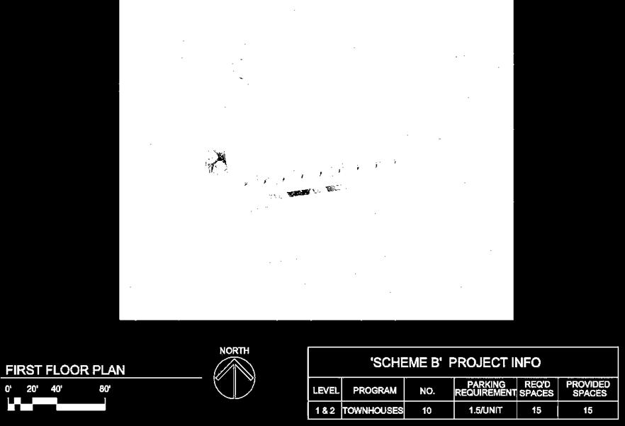
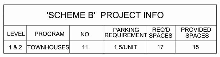
15 Part Two Our next task involved taking the chosen concept from Part I for each site and developing three building schemes with proposed uses Main Street All three schemes for this site have a corner plaza, parking at the rear of the site, and ground floor commercial with residential above. Scheme A utilizes the slope of the hill at the rear of the property to access additional parking for residents on the roof above the ground floor commercial space. The 17 residential units are two story townhouses located on the second and third floors. Access is provided to these units from the rooftop parking or by exterior stairs leading to the rooftop parking lot. There is no interior common space, since each townhouse has a private entry. The Scheme B plan is similar, except access is provided to the basement for additional parking. The ramp in this scheme slopes down as it goes to the north, requiring a retaining wall and significant excavation. The building has a common hallway, elevator and stairways for 34 apartments. One-half of the units have views to Main Street. Scheme C has only ground floor commercial with parking on the roof. Schemes A and B were determined to be the most desirable, with Scheme A believed to be marketable for homeownership condominiums and Scheme B as rental apartments. Of the two, Scheme A was preferred because it provided downtown homeownership opportunities, something new to Main Street and different than the rental units in the Cheney district. The development as proposed could be built under the Town s current zoning regulations in the central business district. However, there are deed restrictions on the property that must be addressed. When the Town purchased the parking lot it agreed to provide a maximum of 25 parking spaces for employees of the building at Main Street, and agreed the parking area or the number of spaces would not be reduced for 50 years from the date of the closing (the deed was recorded in July of 1985). The proposed plan would provide the minimum number of parking spaces on that lot. The deed also states the property would be used solely for vehicle parking for a period of 50 years from the date of the closing, unless the owners of Main Street agree otherwise. The concept plans have been discussed with the owners of that adjacent parcel. If the Town wished to proceed with the development of this lot we must secure the agreement of the adjacent owner. It is also possible, and the idea has been raised, to combine the adjacent property with the Town parcel. This would provide further options for development on both properties. These matters must be negotiated if the Board wished to proceed with this project.
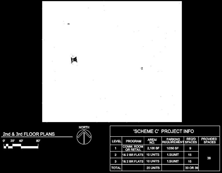
16 Part Two continued 19 Birch Street Scheme A has no on-site parking and was explored with the assumption that the large Purnell Place lot across the street could fulfill the parking need. A corner entry plaza creates a visual connection with Main Street making it clear where the lobby entrance to the upper floor residences is located. At the first floor, retail/commercial space fronts Birch Street with residential common spaces located behind. Above are two levels of residential apartments, most with views of Birch Street or internal courtyards. Scheme B, identical to Scheme A on the second and third floor, has ground floor retail/commercial facing Birch Street backed by surface parking behind it underneath the upper two floors of residential. Scheme C explores another option: two story townhouses with the first floor three feet above the street and parking in the rear. This option could allow for live/work units or commercial on the first floor and residences above. Scheme B was selected as the most desirable for this site, and could be constructed as proposed under the existing CBD regulations. If Scheme B were the selected and preferred option, further detailed study would be necessary to ensure the commercial buildings on the adjacent lots on Main Street will continue to have suitable access to the parking lots behind their buildings. We also recognize that the lot would need to be designed and engineered to take into account the subsurface drainage issues in the dry brook. 53 Cottage Street The Cottage Street site is located on a corner lot on a residential block. Scheme A shows six two-bedroom townhouses with surface parking behind, accessed from both Cottage Street and Oak Street. Scheme B has 11 two-bedroom townhouses with parking on the first level, living on the second and bedrooms on the third floor. Thirteen units face Oak Street, with the remaining two facing Cottage Street. The higher density of this scheme is achieved because the parking is garaged under the building. Scheme C is an even higher density scenario. It is a three-story building with a small common room for residents and a small amount of retail on the first floor at the corner. Surface parking is partially under the building at the first floor. The second and third floors are double loaded hallways with apartments on each side. Scheme A was selected for this site due to its fit with the adjacent neighborhood regarding use, and density. The units could be owned or rented. The preferred plan would not be permitted under the current zoning regulations. A change to PRD would only allow four units on this.48-acre parcel. A new regulation, such as a housing overlay zone, or revisions to the PRD regulation would be needed to achieve this plan.
17 Key Plan

18 Main Street - Existing

19 Main Street Diagram

20 Main Street Scheme A
21 Main Street Scheme B
22 Main Street Scheme C

23 Birch Street - Existing

24 Birch Street - Diagram

25 Birch Street Scheme A (1 st Floor)
")
26 Birch Street - Scheme A (2 nd & 3 rd Floor)

27 Birch Street - Scheme B

28 Birch Street - Scheme C

29 Cottage Street - Existing

30 Cottage Street - Diagram


31 Cottage Street - Scheme A

32 Cottage Street - Scheme B

33 Cottage Street - Scheme C
34 Part Three After one development scheme for each site was chosen as the most compatible and desirable, a building was then designed and a color perspective rendering created depicting the character, mass, and scale desired in a new building.
35
36
37
38 Conclusion This report and site analysis should be used by the Town Planning and Zoning Commission to provide direction for revisions to the zoning regulations to achieve the desired mix of uses and physical form. It should also provide the preferred use and development options to be included in any request for proposals or development solicitation by the Town Board of Directors. There may be variations on the design and site plans and other uses that the Town or a developer may find equally acceptable. While some flexibility is helpful, the Town should agree on and express its preferences in any development solicitation, and only depart from the preferences if the alternatives are equal to or better than the schemes proposed here. Hopefully this analysis will be helpful in that regard.
39 Attachment A The parking lot at the corner of Main Street and Forest Street has 116 spaces; the Cottage Street lot has 53; and the Birch Street lot has 87. Casual observation indicates these lots are not fully used either during the week or on weekends. In January 2007 planning department staff, over a period of three days, surveyed the parking lots to determine their actual use. The heaviest use of the Main Street lot was 35 cars of the 116 spaces in mid-morning on a weekday. On street spaces in front of the Main Street lot were also underused. Nine of the 21 available spaces were the maximum number occupied during our count. On Birch Street there were never more than 12 cars in the 87-space lot, and the most cars observed in the Cottage Street lot was five of those 53 spaces. Because over a year had gone by while the study was in progress, the planning staff conducted similar counts in March of The heaviest use of the Main Street lot was 25 cars (with nine cars parked in the on-street spaces) during a weekday and 32 on a Saturday (with three cars on Main Street). On Birch Street the highest use was 22 cars on a weekday afternoon while at Cottage Street there were at the most eight cars. The following tables compare the parking lot counts conducted in 2007 and It is worth noting that the March 2008 counts were conducted after the Café on Main closed and Samadhi Yoga relocated from Main Street. These two establishments probably accounted for the higher parking levels in 2007 in the Main Street lot and on Main Street in that vicinity. The Army Navy Club occasionally uses the parking lot for special events or for their meetings. If the Main Street parking lot is developed, the Town might consider requiring that portions of the surface parking be available to the Army Navy Club or general business customers, in addition to the nearby on-street and municipal parking spaces in the vicinity.
40 Attachment A PARKING LOT THURSDAY 10 AM 12 PM 2 PM 4 PM PARKING LOT SATURDAY 9 AM 10 AM Birch Street Cottage Street Main/Forest Street North Main/Forest Street South Birch Street Cottage Street Main/Forest Street North Main/Forest Street South PARKING LOT FRIDAY 10 AM 12 PM 2 PM 4 PM Birch Street Cottage Street Main/Forest Street North Main/Forest Street South * North or South of driveway entrance at Main and Maple Street.
MONTGOMERY COUNTY PLANNING DEPARTMENT THE MARYLAND-NATIONAL CAPITAL PARK AND PLANNING COMMISSION
 MONTGOMERY COUNTY PLANNING DEPARTMENT THE MARYLAND-NATIONAL CAPITAL PARK AND PLANNING COMMISSION MCPB Item Date: 06/01/17 900 Thayer Avenue: Project Plan Amendment No. 92005003B and Site Plan Amendment
Poughkeepsie City Center Revitalization Plan
 Purpose and Need Purpose Increase job and educational opportunities for all residents Maximize fiscal productivity of downtown land uses Diversify retail mix Eliminate surface and building vacancies Create
Town of Clinton, Connecticut Action Plan for the Historic Unilever Property and Area. Steering Committee Meeting #5 Implementation Strategies
 Town of Clinton, Connecticut Action Plan for the Historic Unilever Property and Area Steering Committee Meeting #5 Implementation Strategies Wednesday, March 19, 2014 6:30pm Steering Committee Meeting
2015 Downtown Parking Study
 2015 Downtown Parking Study City of Linden Genesee County, Michigan November 2015 Prepared by: City of Linden Downtown Development Authority 132 E. Broad Street Linden, MI 48451 www.lindenmi.us Table of
UPDATE Board of Selectmen June 20, 2017
 MAPLE STREET I-1 AREA DRAFT ZONING BYLAW & DEVELOPMENT STANDARDS Town of Danvers, MA UPDATE Board of Selectmen June 20, 2017 The Danvers Team: Brovitz Community Planning & Design Dodson & Flinker Danvers
70 Parker Hill Avenue Development. 70 Parker Hill Avenue Mission Hill. Application for Small Project Review Submitted to the
 70 Parker Hill Avenue Development 70 Parker Hill Avenue Mission Hill Application for Small Project Review Submitted to the Boston Redevelopment Authority 1 70 Parker Hill Avenue, Mission Hill Application
General Manager of Planning, Urban Design, and Sustainability in consultation with the Director of Legal Services
 POLICY REPORT DEVELOPMENT AND BUILDING Report Date: August 31, 2016 Contact: Anita Molaro Contact No.: 604.871.6489 RTS No.: 11651 VanRIMS No.: 08-2000-20 Meeting Date: October 18, 2016 TO: FROM: SUBJECT:
General Manager of Planning, Urban Design, and Sustainability in consultation with the Director of Legal Services
 POLICY REPORT DEVELOPMENT AND BUILDING Report Date: October 26, 2016 Contact: Anita Molaro Contact No.: 604.871.6479 RTS No.: 11689 VanRIMS No.: 08-2000-20 Meeting Date: November 15, 2016 TO: FROM: SUBJECT:
College Avenue. Sowers Street. Calder Way. Beaver Avenue
 K L M Illustrative Master Plan: Collegiate District Calder Way Beaver Avenue High Street ner 16 Sowers Street Stre et 17 Hetzel Street 18 Gar Heister Street 15 Collegiate District 183 4-C: East End Collegiate
CITY OF VACAVILLE PLANNING COMMISSION Agenda Item No. G.2 STAFF REPORT August 5, Staff Contact: Fred Buderi (707)
") CITY OF VACAVILLE PLANNING COMMISSION Agenda Item No. G.2 STAFF REPORT August 5, 2008 Staff Contact: Fred Buderi (707) 449-5307 TITLE: REQUEST: RECOMMENDED ACTION: OPPORTUNITY HOUSE EMERGENCY SHELTER RELOCATION
CITY OF VACAVILLE PLANNING COMMISSION Agenda Item No. G.2 STAFF REPORT August 5, 2008 Staff Contact: Fred Buderi (707) 449-5307 TITLE: REQUEST: RECOMMENDED ACTION: OPPORTUNITY HOUSE EMERGENCY SHELTER RELOCATION
A APPENDIX A: FORM-BASED BUILDING PROTOTYPES
 A : A.1 Introduction Form-based prototypes are specific building types that are either encouraged or discouraged in historic multi-family residential or mixed-use neighborhoods. Their intent is to ensure
City of Stockton. Legislation Text AUTHORIZE ACQUISITION OF REAL PROPERTY LOCATED AT 501 AND 509 WEST WEBER AVENUE
 City of Stockton Legislation Text File #: 17-3966, Version: 1 AUTHORIZE ACQUISITION OF REAL PROPERTY LOCATED AT 501 AND 509 WEST WEBER AVENUE RECOMMENDATION It is recommended that the City Council adopt
Truax Park Apartments
 Truax Park Apartments Master Planning and Site Development Study Prepared by The Community Development Authority of the City of Madison In association with SMITH & SMITH ASSOCIATES, Inc CONSTRUCTION COST
Bike/Pedestrian Connection at Street Level. Project Underway. Illustrative Master Plan: Traditional Downtown VISION DOWNTOWN STATE COLLEGE MASTER PLAN
 Significant Redevelopment Opportunities 16 West Campus Square Academic, Residential and Commercial 3 Atherton East 4 Atherton West Retail, Student Housing Residential, Commercial and Other 5 Beaver Ave.
Draft University of Kentucky College Town Study Update
 Draft COLLEGE TOWN STUDY UPDATE July 30th, 2009 Overview of Study Area W 3rd St Newton Pike S Jefferson St W 2nd St W Main St W Vine St W High St S Broadway St S Limestone W Maxwell St E Euclid Ave 0 250
AGENDA SLOT HOME EVALUATION & TEXT AMENDMENT. 5:30 - Welcome
 AGENDA 5:30 - Welcome Please sign-in, put a sticker on the map, grab snacks, materials and a seat 5:45 - Staff Presentation 6:15 - Open House Stations Background Information Mixed Use Districts Multi Unit
LITTLE MOUNTAIN ADJACENT AREA REZONING POLICY
 LITTLE MOUNTAIN ADJACENT AREA REZONING POLICY JANUARY 2013 CONTENTS 1.0 INTENT & PRINCIPLES...1 2.0 APPLICATION...2 3.0 HOUSING TYPES, HEIGHT & DENSITY POLICIES...3 3.1 LOW TO MID-RISE APARTMENT POLICIES...4
General Manager of Planning, Urban Design, and Sustainability, in consultation with the Director of Legal Services
 POLICY REPORT DEVELOPMENT AND BUILDING Report Date: September 27, 2016 Contact: Anita Molaro Contact No.: 604.871.6479 RTS No.: 11685 VanRIMS No.: 08-2000-20 Meeting Date: October 18, 2016 TO: FROM: SUBJECT:
Cherokee Webster Development, LP. City of Webster, Texas Planned Development No. 3. Proposed Revision No. 4
 Cherokee Webster Development, LP. City of Webster, Texas Planned Development No. 3 Proposed Revision No. 4 October 2013 1 Statement of Intent This Revision No. 4 of the Statement of Intent is written in
2014 Plan of Conservation and Development. Development Plan & Policies
 The Town of Hebron Section 3 2014 Plan of Conservation and Development Development Plan & Policies C. Residential Districts I. Residential Land Analysis This section of the plan uses the land use and vacant
Urban Design Brief Dundas Street. London Affordable Housing Foundation. November Zelinka Priamo Ltd.
 Urban Design Brief 1039-1047 Dundas Street London Affordable Housing Foundation November 2017 Zelinka Priamo Ltd. TABLE OF CONTENTS Page No. INTRODUCTION... 3 SECTION 1 LAND USE PLANNING CONTEXT... 3 1.1
170 West Broadway. South Boston, MA Application for Article 80 Small Project Review Boston Redevelopment Authority April 28, 2014
 South Boston, MA 02127 Application for Article 80 Small Project Review Boston Redevelopment Authority April 28, 2014 Owner/Developer:, LLC. Legal Consultant: McDermott, Quilty & Miller, LLP Architect:
UNDERSTANDING THE TAX BASE CONSEQUENCES OF LOCAL ECONOMIC DEVELOPMENT PROGRAMS
 UNDERSTANDING THE TAX BASE CONSEQUENCES OF LOCAL ECONOMIC DEVELOPMENT PROGRAMS Richard K. Gsottschneider, CRE President RKG Associates, Inc. 277 Mast Rd. Durham, NH 03824 603-868-5513 It is generally accepted
January 7, Sarah Smith Community Development Director City of Mound 5341 Maywood Road Mound, MN Dear Ms. Smith,
 January 7, 2019 Sarah Smith Community Development Director City of Mound 5341 Maywood Road Mound, MN 55364 Dear Ms. Smith, We are pleased to present the enclosed concept plan and requisite attachments
MARKET & REAL ESTATE RESEARCH STUDIES
 MARKET & REAL ESTATE RESEARCH STUDIES MARKET ASSESSMENT AND ANALYSIS FOR HISTORIC ARCADE BUILDING RETAIL MALL AND VACANT DEPARTMENT STORE Bridgeport Economic Development Corporation AMS analyzed the market
III. PROJECT DESCRIPTION
 III. PROJECT DESCRIPTION A. PROJECT APPLICANT The project applicant for the 2055 Avenue of the Stars on the Site of the Former St. Regis Hotel project is Avenue of the Stars Associates, LLC (c/o The Related
DRAFT FOR DISCUSSION PURPOSES ONLY. Port Credit Local Area Plan Built Form Guidelines and Standards DRAFT For Discussion Purposes
 Port Credit Local Area Plan Built Form Guidelines and Standards DRAFT For Discussion Purposes 1 Local Area Plan - Project Alignment Overview Directions Report, October 2008 (General Summary Of Selected
PLANNING COMMISSION MAY 3, 2018 PUBLIC HEARING
 PLANNING COMMISSION MAY 3, 2018 PUBLIC HEARING SUBJECT: REQUEST TO DEMOLISH TWO SINGLE-FAMILY DWELLINGS ON TWO ADJOINING LOTS AND CONSTRUCT TEN RESIDENTIAL CONDOMINIUM UNITS AT 947 GENESEE AVENUE AND 944
TOWNHOUSE. TYPICAL UNIT SIZE 1,200 to 1,600 square foot average unit (two to three stories) DENSITY dwelling units/acre without cottages
 DENSITY dwelling units/acre without cottages") TOWNHOUSE Townhouses are typically two to three stories in height. Some townhouses include separate rental units, either on the top or bottom floor of a three-story townhouse unit, or in a cottage above
TOWNHOUSE Townhouses are typically two to three stories in height. Some townhouses include separate rental units, either on the top or bottom floor of a three-story townhouse unit, or in a cottage above
Infill Housing Analysis
 City of Victoria Proposed Fairfield and Gonzales Neighbourhood Infill Housing Analysis Urbanics Consultants Ltd. Proposed Fairfield and Gonzales Neighbourhood Infill Housing Analysis Victoria, B.C. Prepared
TRANSIT-ORIENTED DEVELOPMENT PLAN EXISTING CONDITIONS REPORT LAWRENCE TO BRYN MAWR MODERNIZATION
 TRANSIT-ORIENTED DEVELOPMENT PLAN EXISTING CONDITIONS REPORT LAWRENCE TO BRYN MAWR MODERNIZATION March 2018- FINAL DRAFT SITE SPECIFIC DEVELOPMENT CONCEPTS SITE SPECIFIC DEVELOPMENT CONCEPTS This report
Missing Middle Housing Types Showcasing examples in Springfield, Oregon
 Missing Middle Housing Types Showcasing examples in Springfield, Oregon MissingMiddleHousing.com is powered by Opticos Design Illustration 2015 Opticos Design, Inc. Missing Middle Housing Study Prepared
3.0 Project Description
 3.0 Project Description City of Long Beach Shoreline Gateway Project Environmental Impact Report 3.0 PROJECT DESCRIPTION 3.1 PROJECT LOCATION AND SETTING PROJECT LOCATION The proposed Shoreline Gateway
Director, Community Planning, Toronto and East York District
 STAFF REPORT September 1, 2005 To: From: Subject: Toronto and East York Community Council Director, Community Planning, Toronto and East York District Further Report Applications to amend Official Plan
FIRST AMENDMENT TO THE AMENDED AND RESTATED DEVELOPMENT PLAN FOR THE OFFICE BUILDINGS / SPORTS PROJECT WITHIN PLANNED DEVELOPMENT AREA NO.
 FIRST AMENDMENT TO THE AMENDED AND RESTATED DEVELOPMENT PLAN FOR THE OFFICE BUILDINGS / SPORTS PROJECT WITHIN PLANNED DEVELOPMENT AREA NO. 87 BOSTON LANDING GUEST STREET, LIFE STREET AND ARTHUR STREET
Sedro woolley, WA 720 MURDOCK ST. FOR sale. 14,500 +/- sf office building with 8,500 +/- sf unfinished basement space on 0.
 720 MURDOCK ST Sedro woolley, WA FOR sale 14,500 +/- sf office building with 8,500 +/- sf unfinished basement space on 0.27 +/- AC Former City Hall built in 1930 Located in the Downtown Sedro Woolley core
When the Plan is not Enough
 When the Plan is not Enough Christine Maguire, AICP, EDFP Redevelopment Manager Planning & Community Development 1 Rail~Volution 2012 When the Plan is Not Enough: Garland, TX 16 October 2012 About the
City of Coral Gables Planning and Zoning Staff Report
 City of Coral Gables Planning and Zoning Staff Report Applicant: Application: Public Hearing: Date & Time: Location: City of Coral Gables Giralda Restaurant Row Overlay Zoning Code Text Amendment Planning
ARLINGTON COUNTY, VIRGINIA
 ARLINGTON COUNTY, VIRGINIA County Board Agenda Item Meeting of June 16, 2012 DATE: June 7, 2012 SUBJECT: SP #397 SITE PLAN AMENDMENT to revise condition #31 to modify the retail transparency requirement
Request for Expansion of Target Investment Zone Boundaries in Hagerstown December 7, 2006
 Request for Expansion of Target Investment Zone Boundaries in Hagerstown December 7, 2006 1. Hagerstown Target Investment Zone Boundaries: The Target Investment Zone in Downtown Hagerstown, which is outlined
Adaptive Reuse Ordinance Effective 12/20/01
 Adaptive Reuse Ordinance Effective 12/20/01 The following excerpts of the Planning and Zoning Code are related to the Adaptive Reuse Projects in the Los Angeles downtown areas. The Planning and Zoning
CHAUTAUQUA COUNTY LAND BANK CORPORATION
 EXHIBIT H CHAUTAUQUA COUNTY LAND BANK CORPORATION LAND ACQUISITION AND DISPOSITION POLICIES AND PRIORITIES November 14, 2012 *This document is intended to provide guidance to the Chautauqua County Land
Planning Rationale. 224 Cooper Street
 Submitted by: Robertson Martin Architects Tel 613.567.1361 Fax 613.567.9462 216 Pretoria Ave, Ottawa, Ontario, K1S 1X2 Planning Rationale 224 Cooper Street Planning Rationale Application to City of Ottawa
PART ONE - GENERAL INFORMATION
 Corrected Date: Page 7 Date of Submittal Changed to Coincide with Submittal Date on Page 5 PART ONE - GENERAL INFORMATION A. INTRODUCTION B. Background Miami Shores Village is soliciting responses to this
City of Coral Gables Planning and Zoning Staff Report
 City of Coral Gables Planning and Zoning Staff Report Applicant: Application: Public Hearing: Date & Time: Location: City of Coral Gables Zoning Code Text Amendment Giralda Plaza Overlay District Planning
County Lot C Redevelopment
 County Lot C Redevelopment La Crosse County La Crosse, WISCONSIN 03.20.14 Orientation What is the purpose of this process? La Crosse County is exploring ways to maximize the value of Lot C by completing
AFFORDABLE HOUSING DISCUSSION PAPER POTENTIAL PROPERTIES REPORT VILLAGE OF RYE BROOK, NEW YORK
 AFFORDABLE HOUSING DISCUSSION PAPER POTENTIAL PROPERTIES REPORT VILLAGE OF RYE BROOK, NEW YORK PREPARED FOR: THE VILLAGE OF RYE BROOK VILLAGE BOARD PREPARED BY: MARILYN TIMPONE-MOHAMED, FREDERICK P. CLARK
Pentagon Centre (SP#297) PDSP & Phase I Site Plan Amendments SPRC #1
 PDSP & Phase I Site Plan Amendments SPRC #1") Pentagon Centre (SP#297) PDSP & Phase I Site Plan Amendments SPRC #1 CPHD February 23, 2015 Meeting Agenda Background on relevant planning context, guidance, and County policy Brief update on original
Pentagon Centre (SP#297) PDSP & Phase I Site Plan Amendments SPRC #1 CPHD February 23, 2015 Meeting Agenda Background on relevant planning context, guidance, and County policy Brief update on original
Update on the Avenues and Mid-Rise Buildings Action Plan
 STAFF REPORT INFORMATION ONLY Update on the Avenues and Mid-Rise Buildings Action Plan Date: May 15, 2009 To: From: Wards: Reference Number: Planning and Growth Management Committee Chief Planner and Executive
LEASE AND OPERATION OF THE HISTORIC EAGLE TAVERN
 CITY OF TRENTON DEPARTMENT OF HOUSING & DEVELOPMENT REQUEST FOR PROPOSALS LEASE AND OPERATION OF THE HISTORIC EAGLE TAVERN The City of Trenton invites proposals from qualified entities to lease and operate
71 RUSSELL AVENUE. PLANNING RATIONALE FOR SITE PLAN CONTROL APPLICATION (Design Brief)
") ` 71 RUSSELL AVENUE Ottawa September 14, 2018 PLANNING RATIONALE FOR SITE PLAN CONTROL APPLICATION (Design Brief) Introduction The intent of this Planning Rationale and Design Brief is to provide planning
` 71 RUSSELL AVENUE Ottawa September 14, 2018 PLANNING RATIONALE FOR SITE PLAN CONTROL APPLICATION (Design Brief) Introduction The intent of this Planning Rationale and Design Brief is to provide planning
WRT. October 16, Arthur Collins President Collins Enterprises, LLC 2001 West Main Street, Suite 175 Stamford, CT 06902
 Planning & Design October 16, 2010 Arthur Collins President Collins Enterprises, LLC 2001 West Main Street, Suite 175 Stamford, CT 06902 Re: Review of The Landmark at Talbot Park Philadelphia Dallas Lake
Zoning Options. Key Questions:
 Zoning Options This section explores zoning options to encourage Character Home retention and improve size and compatibility of new homes in the study areas. Options being explored include: A Floor Area
PLANNING COMMISSION REPORT Regular Agenda -Public Hearing Item
 PDP-13-00518 Item No. 3B- 1 PLANNING COMMISSION REPORT Regular Agenda -Public Hearing Item PC Staff Report 2/24/14 ITEM NO. 3B PRELIMINARY DEVELOPMENT PLAN FOR HERE @ KANSAS; 1101 INDIANA ST (SLD) PDP-13-00518:
HOUSING TYPES AND CHARACTERISTICS
 HOUSING TYPES AND CHARACTERISTICS Market Study Housing Type Classification Single-Family Detached Townhouse Projected Dwelling Unit Demand 2010-2040 65.7 percent of total 9.1 percent of total Housing Variants
DEVELOPMENT DEPARTMENT STAFF REPORT STAFF REPORT EASTSIDE CHAMBLEE LINK DCI
 DEVELOPMENT DEPARTMENT STAFF REPORT Public Hearing Date: April 12, 2018 Item #: PZ-2018-248 STAFF REPORT EASTSIDE CHAMBLEE LINK DCI Request: Development of Community Compact (DCI), ten concurrent variances,
General Manager of Planning and Development Services in consultation with the Director of Legal Services
 POLICY REPORT DEVELOPMENT AND BUILDING Report Date: February 5, 2015 Contact: Anita Molaro Contact No.: 604.871.6479 RTS No.: 10821 VanRIMS No.: 08-2000-20 Meeting Date: February 17, 2015 TO: FROM: SUBJECT:
DRAFT. Amendment to the Master Plan Land Use Element for Block 5002, Lot Township of Teaneck, Bergen County, New Jersey.
 DRAFT Amendment to the Master Plan Land Use Element for Block 5002, Lot 18.01 Township of Teaneck, Bergen County, New Jersey Prepared for: Township of Teaneck Planning Board Prepared by: Janice Talley,
BUILDING HEIGHTS. The following diagram depicts the maximum allowable building height in a +3 zone.
 BUILDING HEIGHTS The following diagram depicts the allowable building height in a +1 zone in an area with substantial topography. As the diagram demonstrates, the building has 4 floors (and would have
Ashland Transit Triangle:
 Ashland Transit Triangle: Strategic Approach to Implementation Fregonese Associates Inc. 12/19/16 Phase I of the Transit Triangle Study Conducted in the Fall of 2015 Tasks Completed: Market analysis Initial
4 LAND USE 4.1 OBJECTIVES
 4 LAND USE The Land Use Element of the Specific Plan establishes objectives, policies, and standards for the distribution, location and extent of land uses to be permitted in the Central Larkspur Specific
Main Street Parking Area Strategy. Borough of South River Middlesex County, New Jersey
 Main Street Parking Area Strategy Borough of South River Middlesex County, New Jersey Draft: May 29, 2018 DRAFT 5/29/2018 Page 1 Bignell Planning Consultants, Inc. 424 AMBOY AVENUE SUITE 202 WOODBRIDGE,
Summary and Minutes of the Community Land Use Meeting Wednesday Aug. 2, 2018, 7pm
 Summary and Minutes of the Community Land Use Meeting Wednesday Aug. 2, 2018, 7pm RE: 1050 Pandora Ave and 1518 Cook Street, Redevelopment Proposal Mayor, Council and City Staff Please find attached a
Table of Contents ARTICLE 5A CHARACTER-BASED ZONING 1
 Table of Contents ARTICLE 5A CHARACTER-BASED ZONING 1 SECTION 10.5A10 GENERAL... 1 10.5A11 Purpose and Intent... 1 10.5A12 Applicability... 1 10.5A13 Compliance with Regulating Plan... 1 10.5A14 Relationship
TOWN OF LOS ALTOS HILLS January 11, 2018 Staff Report to the Planning Commission
 ITEM #3.2 TOWN OF LOS ALTOS HILLS Staff Report to the Planning Commission SUBJECT: FROM: REQUEST FOR APPROVAL OF A CONDITIONAL DEVELOPMENT AND SITE DEVELOPMENT PERMITS FOR A NEW 2,831 SQUARE FOOT, TWO
PROPOSED DEVELOPMENT: 2 & 50 SHEPPARD AVE. EAST, YONGE ST., 2-6 FOREST LANEWAY (YONGE-SHEPPARD CENTRE) TRUSTEE WARD 5
 TRUSTEE WARD 5") PUBLIC REPORT TO REGULAR BOARD PROPOSED DEVELOPMENT: 2 & 50 SHEPPARD AVE. EAST, 4841-4881 YONGE ST., 2-6 FOREST LANEWAY (YONGE-SHEPPARD CENTRE) TRUSTEE WARD 5 You need to persevere so that when you have
PUBLIC REPORT TO REGULAR BOARD PROPOSED DEVELOPMENT: 2 & 50 SHEPPARD AVE. EAST, 4841-4881 YONGE ST., 2-6 FOREST LANEWAY (YONGE-SHEPPARD CENTRE) TRUSTEE WARD 5 You need to persevere so that when you have
Evolution of the Vision for NE 181st Street Study Area
 City Council Action on NE 181 St Street Study Area Evolution of the Vision for NE 181st Street Study Area such uses to ensure neighborhood compatibility. More intense uses may be allowed through a conditional
STAFF REPORT. March 14, Toronto and East York Community Council. Director, Community Planning, South District
 STAFF REPORT March 14, 2005 To: From: Subject: Toronto and East York Community Council Director, Community Planning, South District Preliminary Report Official Plan Amendment and Rezoning Application 05
Montreal Road District Secondary Plan [Amendment #127, October 9, 2013]
![Montreal Road District Secondary Plan [Amendment #127, October 9, 2013]](/thumbs/72/66783104.jpg "Montreal Road District Secondary Plan [Amendment #127, October 9, 2013]") [Amendment #127, October 9, 2013] 1.0 General The following policies are applicable to the Montreal Road District as set out in Schedule 1. 1.1 District Objectives The objective of this Plan is to guide
[Amendment #127, October 9, 2013] 1.0 General The following policies are applicable to the Montreal Road District as set out in Schedule 1. 1.1 District Objectives The objective of this Plan is to guide
MEMORANDUM. I1 District Industrial Living Overlay District 110,703 square feet / 2.54 acres
 Department of Community Planning & Economic Development 250 South 4th Street, Room 300 Minneapolis, MN 55415-1385 MEMORANDUM To: City Planning Commission, Committee of the Whole Prepared By: Peter Crandall,
MEMORANDUM. Bunge Elevator Complex Bunge Midway grain elevator th Ave SE. Grain Elevators (1935) and Headhouse (1936)
 and Headhouse (1936)") Department of Community Planning & Economic Development 250 South 4 th Street, Room 300 Minneapolis, MN 55415-1385 MEMORANDUM TO: Heritage Preservation Commission FROM: Shanna Sether, Senior City Planner,
Department of Community Planning & Economic Development 250 South 4 th Street, Room 300 Minneapolis, MN 55415-1385 MEMORANDUM TO: Heritage Preservation Commission FROM: Shanna Sether, Senior City Planner,
Composition of traditional residential corridors.
 Page 1 of 7 St. Petersburg, Florida, Code of Ordinances >> PART II - ST. PETERSBURG CITY CODE >> Chapter 16 - LAND DEVELOPMENT REGULATIONS >> SECTION 16.20.060. CORRIDOR RESIDENTIAL TRADITIONAL DISTRICTS
Ann Arbor Downtown Zoning Evaluation
 Ann Arbor Downtown Zoning Evaluation Options Workbook ENP & Associates in cooperation with the City of Ann Arbor September, 2013 Photo Courtesy of Andrew Horne, February 9, 2013 Introduction Thank you
PLANNING RATIONALE 680 BRONSON AVENUE OTTAWA, ONTARIO PROPOSED ZONING BY-LAW AMENDMENT
 PLANNING RATIONALE 680 BRONSON AVENUE OTTAWA, ONTARIO PROPOSED ZONING BY-LAW AMENDMENT FRANK PARAVAN APRIL 2014 Planning Rationale Introduction FOTENN Consultants Inc. has been engaged by Frank and Michael
Urban Design Brief. Italian Seniors Project 1090, 1092, 1096 Hamilton Road City of London
 Urban Design Brief Italian Seniors Project City of London October 1, 2017 TABLE OF CONTENTS Page No. INTRODUCTION... 2 1.0 LAND USE PLANNING CONCEPT... 2 1.1 Subject Lands... 2 1.2 Official Plan and Zoning
SAMOA MASTER PLAN PROJECT DESCRIPTION (8-4-05)
") SAMOA MASTER PLAN PROJECT DESCRIPTION (8-4-05) In June 2000, a lot line adjustment approved by the Humboldt County Planning Commission created a 59-acre town site parcel. According to the approved Humboldt
SAMOA MASTER PLAN PROJECT DESCRIPTION (8-4-05) In June 2000, a lot line adjustment approved by the Humboldt County Planning Commission created a 59-acre town site parcel. According to the approved Humboldt
Director, Community Planning, North York District NNY 23 OZ and NNY 23 RH
 STAFF REPORT ACTION REQUIRED 2 & 50 Sheppard Avenue East 4841 to 4881 Yonge Street and 2 to 6 Forest Laneway Official Plan Amendment, Zoning By-law Amendment and Rental Housing Demolition Applications
CITY OF LEBANON RUSSELL DRIVE AREA MIXED USE NEIGHBORHOOD CENTER FINAL IMPLEMENTATION PLAN
 CITY OF LEBANON RUSSELL DRIVE AREA MIXED USE NEIGHBORHOOD CENTER FINAL IMPLEMENTATION PLAN TGM Contract 2G-01 #22425 Deliverable 15.5 Prepared by: Satre Associates, P.C. Planners, Landscape Architects,
Village of Perry Zoning Ordinance Update Draft Diagnostic Report
 Village of Perry Zoning Ordinance Update Draft Diagnostic Report Background The Village of Perry began work on a new comprehensive plan in 2014. After a year of committee meetings and public outreach,
Planning Justification Report
 Planning Justification Report Kellogg s Lands City of London E&E McLaughlin Ltd. June 14, 2017 Zelinka Priamo Ltd. Page i TABLE OF CONTENTS Page No. 1.0 2.0 2.1 2.2 3.0 4.0 5.0 5.1 5.2 5.3 5.4 5.5 5.6
Anacortes, WA. 718 commercial ave. FOR lease. 2,320 +/- sf retail space in a 10,820 +/- sf building. Located in historic downtown Anacortes
 718 commercial ave Anacortes, WA FOR lease 2,320 +/- sf retail space in a 10,820 +/- sf building Located in historic downtown Anacortes Frontage on Commercial Ave alongside four other retail spaces Zoned
General Manager of Planning, Urban Design, and Sustainability in consultation with the Director of Legal Services
 POLICY REPORT DEVELOPMENT AND BUILDING Report Date: August 16, 2018 Contact: Anita Molaro Contact No.: 604.871.6489 RTS No.: 12299 VanRIMS No.: 08-2000-20 Meeting Date: September 5, 2018 TO: FROM: SUBJECT:
R E S O L U T I O N. Residential 384,918 sq. ft. To be demolished Floor Area Ratio (FAR) 0 0.7
 0 0.7") R E S O L U T I O N WHEREAS, the Prince George s County Planning Board has reviewed DPLS-417, Kiplinger Property, Phase I, Expedited Transit-Oriented Development Project, requesting a reduction in the
R E S O L U T I O N WHEREAS, the Prince George s County Planning Board has reviewed DPLS-417, Kiplinger Property, Phase I, Expedited Transit-Oriented Development Project, requesting a reduction in the
Church Street and Gloucester Street - Rezoning Application - Preliminary Report
 STAFF REPORT ACTION REQUIRED - Rezoning Application - Preliminary Report Date: May 25, 2010 To: From: Wards: Reference Number: Toronto and East York Community Council Director, Community Planning, Toronto
2.2 72ND STREET STATION ENTRANCE ALTERNATIVES
 Chapter 2: Entrance Alternatives 2.1 INTRODUCTION This chapter describes the alternatives that are evaluated in this Supplemental Environmental Assessment (EA) for the 72nd Street Station and 86th Street
7. IMPLEMENTATION STRATEGIES
 7. IMPLEMENTATION STRATEGIES A. GENERAL APPROACH FOR IMPLEMENTATION Implementing the plan will engage many players, including the Municipality of Anchorage (MOA), the Government Hill Community Council,
Sherwood Forest (Trinity) Housing Corporation. Urban Design Brief
 Housing Corporation. Urban Design Brief") Sherwood Forest (Trinity) Housing Corporation Sherwood Place Affordable Housing Apartments Trinity Presbyterian Church Orchard Park Nursery School 590 Gainsborough Road, London Urban Design Brief REVISED
Sherwood Forest (Trinity) Housing Corporation Sherwood Place Affordable Housing Apartments Trinity Presbyterian Church Orchard Park Nursery School 590 Gainsborough Road, London Urban Design Brief REVISED
Staff Report PLANNING DIVISION COMMUNITY & ECONOMIC DEVELOPMENT. Alley Closure
 Staff Report PLANNING DIVISION COMMUNITY & ECONOMIC DEVELOPMENT To: From: Salt Lake City Planning Commission Doug Dansie, 801-535-6182, doug.dansie@slcgov.com Date: March 23, 2016 Re: PLNPCM2015-00941
1999 Town Center West Proposal
 Crescent Square June 10, 2014 Page 2 1999 Town Center West Proposal Food-4- Less Retail Not a Part On June 10, 2004, the City Council and Planning Commission conducted a joint workshop to review conceptual
The Cannery Marketplace Narrative. Purpose: Site Design Approach: Cannery Commerce District 10/18/2017
 The Cannery Marketplace Narrative Cannery Commerce District 10/18/2017 Purpose: A number of entitlements are being requested for the Cannery Marketplace inclusive of a Master Conditional Use Permit (Master
Downtown Development Focus Area: I. Existing Conditions
 Downtown Development Focus Area: I. Existing Conditions The Downtown Development Focus Area is situated along Route 1, south of the train tracks, except for the existing Unilever property. It extends west
Bowie Marketplace Residential Detailed Site Plan Statement of Justification January 13, 2017 Revised February 2, 1017
 Bowie Marketplace Residential Detailed Site Plan Statement of Justification January 13, 2017 Revised February 2, 1017 Submitted on behalf of: BE Bowie LLC 5410 Edson Lane, Suite 220 Rockville, MD 20852
CITY OF CHARLOTTESVILLE DEPARTMENT OF NEIGHBORHOOD DEVELOPMENT SERVICES PLANNING COMMISSION
 CITY OF CHARLOTTESVILLE DEPARTMENT OF NEIGHBORHOOD DEVELOPMENT SERVICES PLANNING COMMISSION PRELIMINARY DISCUSSION: SPECIAL USE PERMIT Author of Memo: Brian Haluska, Neighborhood Planner Date of Meeting:
ORDINANCE NO
 ORDINANCE NO. 20050519-008 AN ORDINANCE AMENDING CHAPTERS 25-2 AND 25-6 OF THE CITY CODE TO ADD A NEW ZONING DISTRICT RELATING TO TRANSIT ORIENTED DEVELOPMENT. BE IT ORDAINED BY THE CITY COUNCIL OF THE
Appendix1,Page1. Urban Design Guidelines. Back to Back and Stacked Townhouses. DRAFT September 2017
 Appendix1,Page1 Urban Design Guidelines DRAFT September 2017 Back to Back and Stacked Townhouses Appendix1,Page2 Table of Contents 1 Introduction 1 1.1 Purpose 1 1.2 Urban Design Objectives 1 1.3 Building
Ashcroft Homes Trim Road Development Planning Rationale
 18 Antares Drive Ottawa, ON K2E 1A9 Ashcroft Homes Trim Road Development Planning Rationale Proposed Site Plan & Zoning Amendment Applications File No: D02-02-17-0129 & D07-12-17-0175 August 2018 Planning
Government Management Committee. P:\2011\Internal Services\Fac\Gm11008Fac- (AFS 10838)
") STAFF REPORT ACTION REQUIRED Old City Hall Future Uses Date: April 14, 2011 To: From: Wards: Reference Number: Government Management Committee Chief Corporate Officer Ward 27, Toronto Centre Rosedale P:\2011\Internal
STAFF REPORT ACTION REQUIRED Old City Hall Future Uses Date: April 14, 2011 To: From: Wards: Reference Number: Government Management Committee Chief Corporate Officer Ward 27, Toronto Centre Rosedale P:\2011\Internal
Planning Justification Report for 324 York Street
 Planning Justification Report for 324 York Street June 1 2018 This Planning Justification Report demonstrates how the continued use of the subject lands as a commercial surface area parking lot accords
PLANNING AND REGULATING HOUSING OPTIONS FOR CHANGING DEMOGRAPHICS
 PLANNING AND REGULATING HOUSING OPTIONS FOR CHANGING DEMOGRAPHICS New Partners for Smart Growth Conference February 2017 HOUSING MARKETS Significant increase in rental housing Offset robust single-family
Chapter 5: Testing the Vision. Where is residential growth most likely to occur in the District? Chapter 5: Testing the Vision
 Chapter 5: Testing the Vision The East Anchorage Vision, and the subsequent strategies and actions set forth by the Plan are not merely conceptual. They are based on critical analyses that considered how