RC ; Reclassification - The Courtyards of Colonial Forge
|
|
|
- Asher Johnson
- 5 years ago
- Views:
Transcription


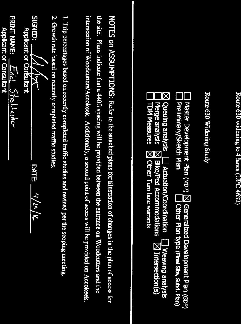
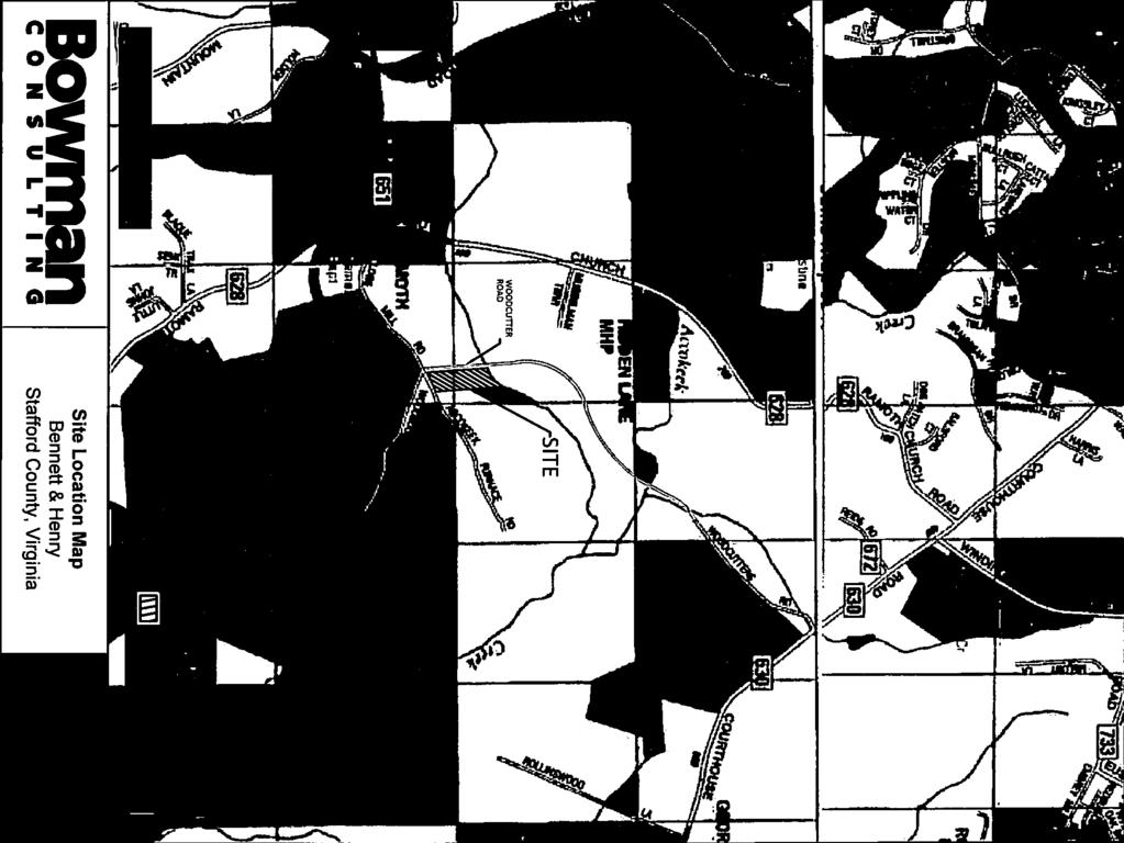
1 3 Board of Supervisors Robert Bob Thomas, Jr., Chairman Laura A. Sellers, Vice Chairman Meg Bohmke Jack R. Cavalier Wendy E. Maurer Paul V. Milde, III Gary F. Snellings November 9, 2016 C. Douglas Barnes Interim County Administrator MEMORANDUM TO: FROM: Stafford County Planning Commission J SUBJECT: RC ; Reclassification - The Courtyards of Colonial Forge ATTACHMENTS: 1. Impact Statement 2. Proposed Ordinance and Resolution 3. Proposed Proffer Statement, dtd 10/11/16 4. Generalized Development Plan, dtd 9/9/16 5. Architectural Renderings 6. Traffic Impact Analysis 7. VDOT Comments, dtd 10/31/16 8. Application and Related Materials Staff Project Manager: Will Sugg ISSUE: The Planning Commission is to consider a request for a Reclassification from the A-1, Agricultural Zoning District to the R-3, Urban Residential High Density Zoning District on Tax Map Parcel Nos B and 28-94C. BACKGROUND: Location: Election District: Applicant/Property Owner: East side of Woodcutters Road, and north side of Kellogg Mill Road and Accokeek Furnace Road Hartwood John Snyder CF Land Investments, LLC 150 Riverside Parkway, Suite 101 Fredericksburg, VA Courthouse Road, P. O. Box 339, Stafford, VA Phone: (540) Fax: (540)
 September 9, 2016 (Complete Application) Advertisement Dates: October 25,")
2 Memorandum to: Stafford County Planning Commission November 9, 2016 Page 2 of 12 Agent: Current Use: Proposed Use: Application Date: Charles W. Payne, Jr. Hirschler Fleischer 725 Jackson Street, Suite 200 Fredericksburg, VA Undeveloped Townhouse May 20, 2016 (Submission) September 9, 2016 (Complete Application) Advertisement Dates: October 25, 2016 and November 1, 2016 Time Limit: February 17, 2017 Area: Comprehensive Plan: Zoning Classification: 7.7 acres Suburban (Future Land Use) A-1, Agricultural Comprehensive Plan
 Protection South A-1, Agricultural Single-family residential Urban Development Area East R-3, Urban Residential Undeveloped")
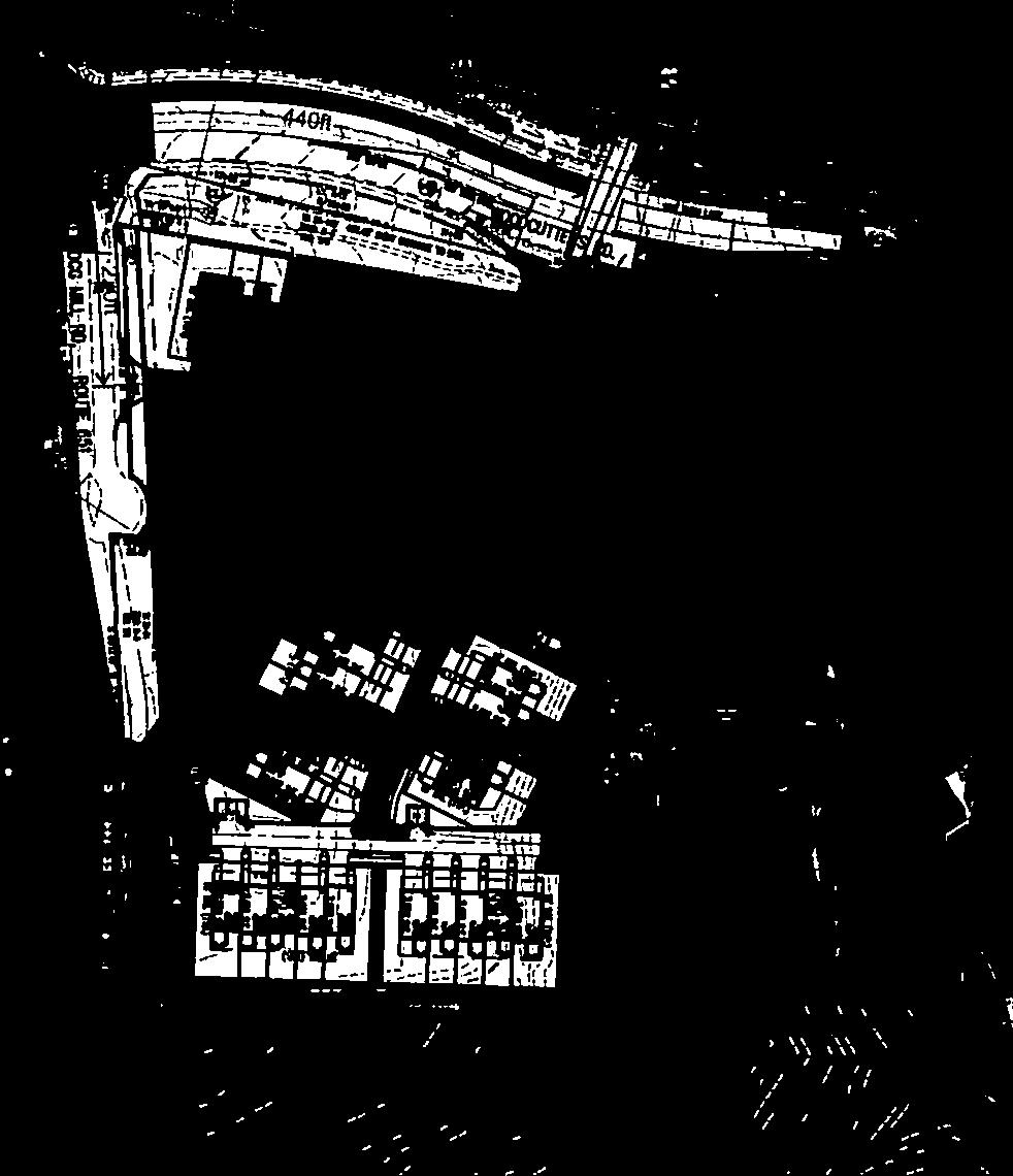
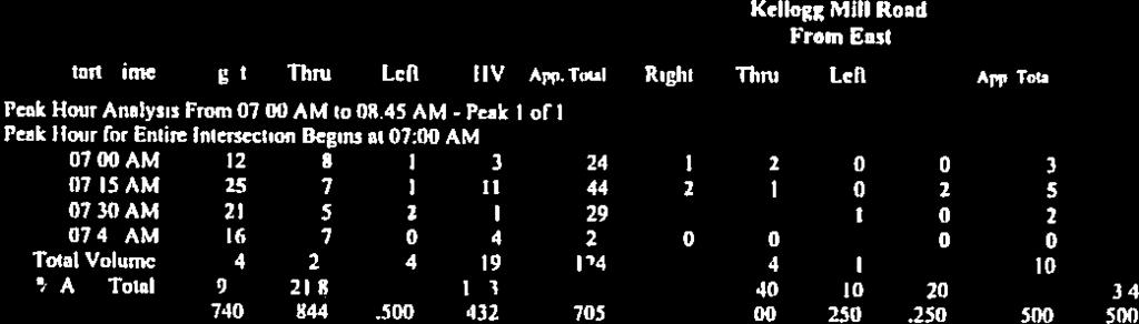
3 Memorandum to: Stafford County Planning Commission November 9, 2016 Page 3 of 12 Abutting Properties: Zoning Location Zoning Existing Use Comprehensive Plan North R-3, Urban Residential Single-family attached residential Suburban/Resource High Density (Colonial Forge) Protection South A-1, Agricultural Single-family residential Urban Development Area East R-3, Urban Residential Undeveloped Suburban High Density West R-3, Urban Residential High Density Undeveloped Suburban Utilities: The proposed rezoning is located within the County s Urban Service Area and has access to public water and sewer. The proposed project will have minimal impact on utility demands. Existing 12-inch water and 8-inch sewer mains are available on Woodcutters Road and appear to have available capacity, or the reasonable ability to be upgraded by the developer to provide adequate capacity. The applicant will extend utility lines to serve the development. Transportation: Kellogg Mill is an urban collector roadway with an estimated traffic volume of 150 vehicle trips per day (VPD) according to Virginia Department of Transportation (VDOT) 2015 Daily Traffic Volume Estimates. The subject parcels are currently zoned A-1, which in relevant part permits one (1) residential unit per three (3) acres or a yield of two (2) lots. Thus, the by-right use would generate daily 20 trips. The proposed development of 49 units would yield 346 VPD. Schools: The proposed development would generate approximately school aged children according to the County school system s analysis. Students generated by this development would attend Winding Creek Elementary School (design capacity of 925 students/current attendance is 855), Rodney Thompson Middle School (design capacity of 1,100 students/current attendance is 938), and Colonial Forge High School (design capacity of 2,175 students/current attendance is 2,099). The
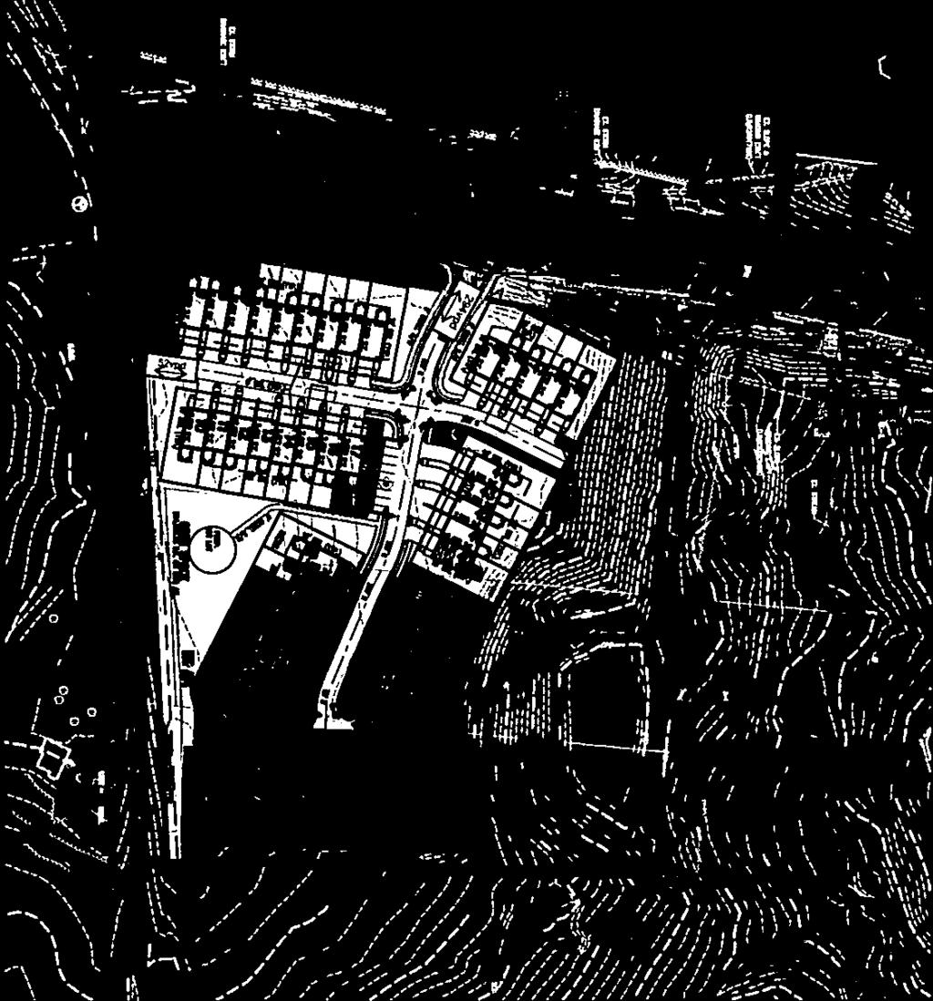
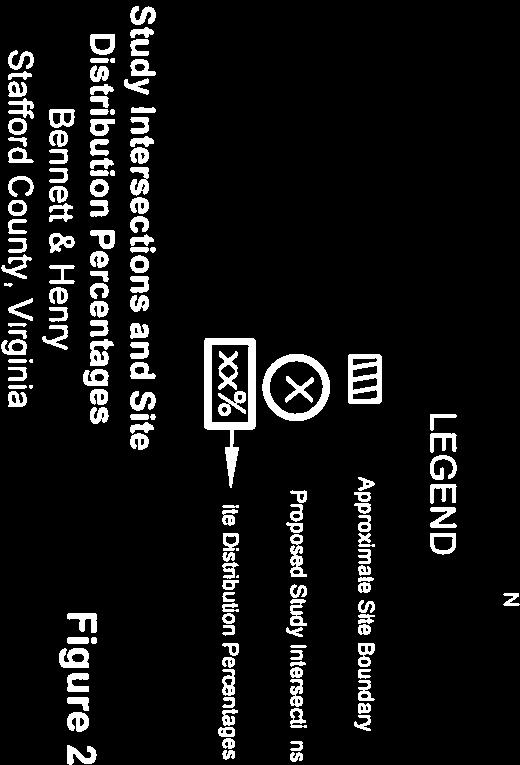
4 Memorandum to: Stafford County Planning Commission November 9, 2016 Page 4 of 12 applicant has identified a cash proffer amount of $12, per unit for schools to offset any school capital facility impacts in the relevant school attendance zone area of the property. Parks and Recreation: Proffer Valuation: The applicant believes there are adequate park facilities in the nearby area of this site, including without limitation Embrey Mill, to address park and recreation impacts. The Applicant will also provide cash proffers in the amount of $8, per unit for purpose of contributing to new park facilities. A proffer statement has been submitted with this application. Monetary proffers include the per unit contribution of $12, for Schools, $8, for Parks and Recreation, $3, for Transportation, and $1, for Fire and Rescue. The monetary cash proffers for the 39 new units will total $952, COMMENTS: CF Land Investments, LLC (Applicant) is requesting a reclassification from the A-1, Agricultural zoning district to the R-3, Urban Residential High Density Zoning District to allow for the development of 39 townhouse residential units (the development includes a total of 49 residential units) on Tax Map Parcel Nos B and 28-94C, on 7.7 acres, located on the east side of Woodcutters Road, and north side of Kellogg Mill Road and Accokeek Furnace Road, adjacent to the Colonial Forge neighborhood. Existing Conditions The Property is surrounded by single-family residential and urban residential high density uses. The parcels to be developed are currently vacant. A Resource Protection Area encroaches to the north of the property, which will be in the open space portion of the development. The current site conditions were previously graded so the area of development is on a generally level plateau. Generalized Development Plan The GDP depicts the proposed design of the site to include 49 lots located on approximately acres. The Property is located adjacent to the Colonial Forge development which is also zoned R-3. The GDP reflects 6.46 acres of open space accounting for approximately 47% of the Property. This exceeds the 25% minimum required by the R-3 district. The open space will be used for stormwater management facilities, passive recreation, and natural areas. For the passive recreation use in the open space, a tot lot will be constructed. This tot lot will include a play structure with safety surface, plastic timber border, bench and trash can, all shown on the GDP. A 10-foot buffer, board-on-board fence, and a 10-foot double row of evergreen trees will be present along the property line adjacent to Kellogg Mill Road/Accokeek Furnace Road. There will be two access points, one off of Kellogg Mill Rd and one off of Woodcutters Road. Additionally, approximately 1.52 acres of wetlands will not be disturbed. The applicant is proposing a pedestrian walkway which will connect to the southwest of Woodcutters Road.

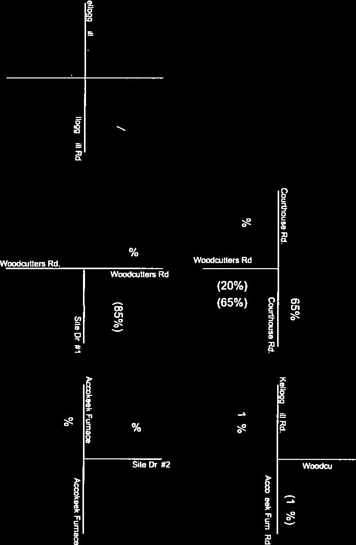
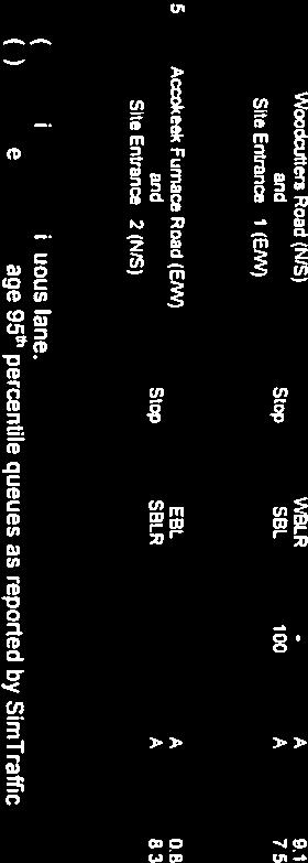
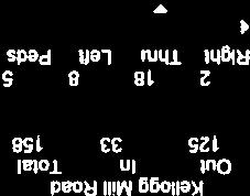
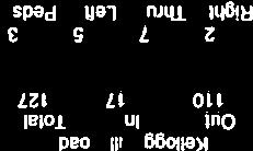
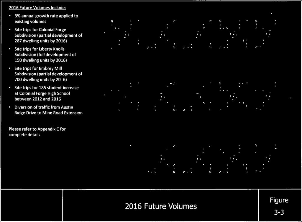
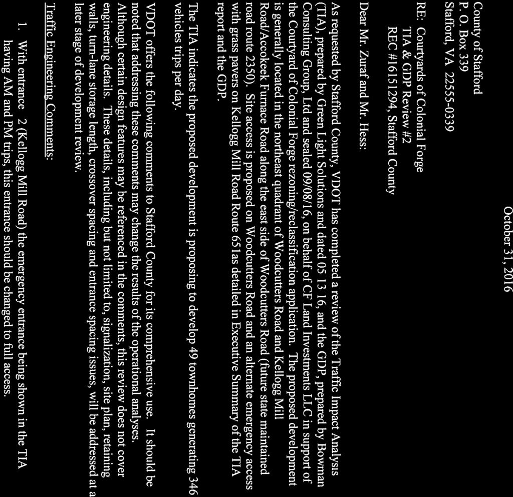
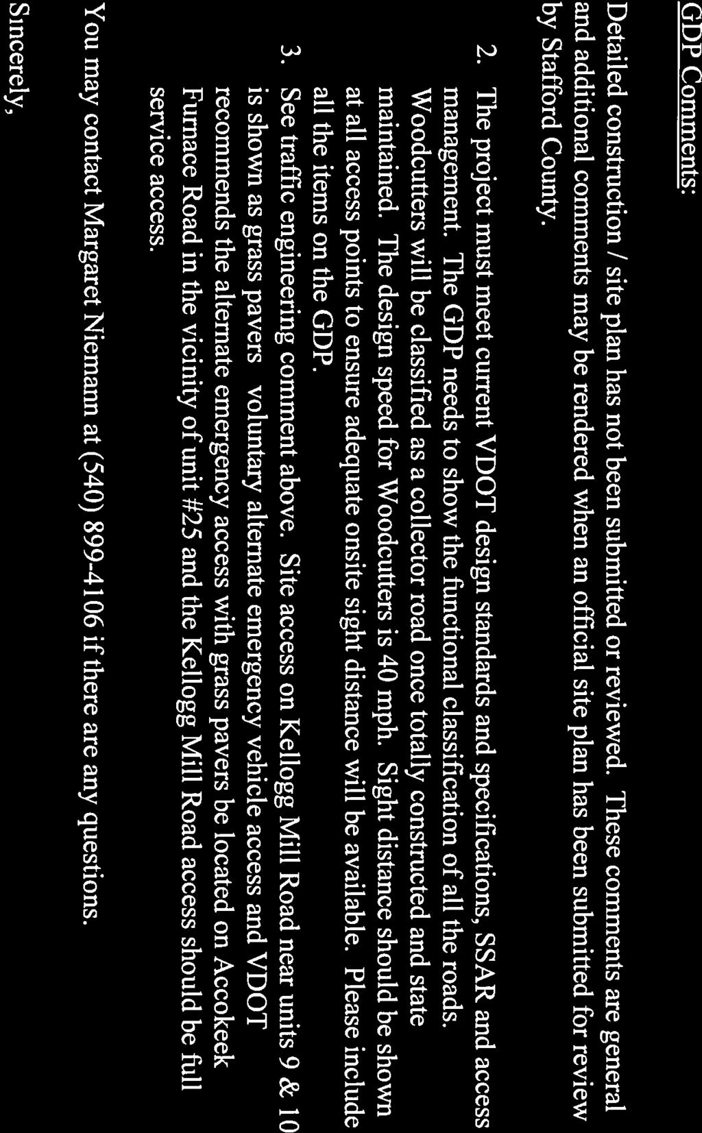
5 Memorandum to: Stafford County Planning Commission November 9, 2016 Page 5 of 12 Transportation Generalized Development Plan The Applicant performed a transportation impact analysis (TIA), which is included in. Results of the TIA indicate that the site is expected to have a minimal impact to the surrounding roadway infrastructure at buildout of the proposed site. It is proposed that the site will have two full movement site drives such that both entrances will provide sufficient intersection spacing to meet current VDOT standards. A break in the existing median and a southbound left turn lane will need to be constructed at the intersection of Woodcutters Road and Site Drive #1. No additional offsite or site drive improvements are proposed at this time. Based on a comparative analysis between background (2021) and buildout (2021) traffic conditions, all offsite intersections are expected to maintain acceptable levels of service. All site drive intersections are expected to operate at acceptable levels of service for all movements. A break in the median and a southbound left turn lane is recommended at the intersection of Woodcutters Road and Site Drive #1. It is proposed that this site drive provide full movement for all approaches as the proposed site drive location provides the minimum spacing per VDOT standards for intersection spacing. The Applicant has also proffered the dedication of 0.39 acres of right-of-way along Accokeek Furnace Road for purposes of extending the public maintenance of the road in the areas generally shown on the GDP. VDOT has reviewed the TIA and their comments are included in Attachment 7. The applicant has addressed the comments pertinent to the TIA. Additional comments would be addressed during site plan review.
6 Memorandum to: Stafford County Planning Commission November 9, 2016 Page 6 of 12 Comprehensive Plan Suburban Land Use The Comp Plan s Future Land Use Map classifies the Property as part of the Suburban designation. This designation encourages residential and in-fill development, as well as limited commercial development. Development is expected to occur on quarter to half acre lots, with densities of up to three dwelling units per acre. For purposes of in-fill development under the Suburban land use district, townhouses and apartments are allowed at a density up to 7 and 15 units per acre respectively, so long as the following criteria, in relevant part, is satisfied (see page 3-43): A. As infill development in Suburban land use district if: 1) it is located on land where 60 percent or more of the linear footage of the property perimeter physically abuts property that has been or is currently approved for the same type of dwelling unit (e.g. townhomes next to townhomes, and condominiums next to condominiums) or a higher density dwelling unit type (e.g. proposed townhomes next to existing or planned condominiums); The Suburban designation supports the Applicants proposed development consisting of condominiums. The density is 3.41 units per acre, which is in accordance with the density recommendations under the Comp Plan. The subject site is an in-fill development and abuts to its immediate north, east, and west R-3 zoned parcels (meeting the above 60% criterion, which covers about 88% linear footage) and surrounding uses include those similar to the Applicant s proposal. Ten of the lots are on land already zoned R-3(as shown in the GDP to the eastern border of the development). The conditions are in accordance with the above relevant section of the Comp Plan located on page Airport Land Use Compatibility The proposed development lies within the Airport Land Use Compatibility Zones (Airport Zone), as identified in the recently amended Comprehensive Plan. The Airport Zones are divided into sub-zones. The subject site is within the Zone H-3, Horizontal Turning Zone. This is an area where planes conduct turning movements when circling the airport. The plan identifies use compatibility in each zone. In the H-3 zone, townhomes are identified as a use that is not compatible. As an attempt to address this issue, the applicant is proffering to incorporate soundproofing construction materials and provide real estate marketing disclosure notices. The site would have significant open space areas. Staff notes that these are recommended mitigation measures if the proposal is identified as needing Additional Review. Staff notes that although this project was submitted prior to the Airport Zone being adopted as part of the new Comp Plan, there is no grandfathering with Comp Plan changes, so the Airport Zone recommendations apply.

7 Memorandum to: Stafford County Planning Commission November 9, 2016 Page 7 of 12 Fiscal Impacts Airport Impact Zones Staff notes that the County-wide average annual fiscal impact is -$1, per single-family attached dwelling unit, based on a study prepared for the 2010 Comprehensive Plan. Applied to all 39 new dwellings, this equals a negative impact of -$53, That impact is based on the average sales price of single-family attached dwelling units in the County and is not reflective of the sales prices of homes within the proposed development. Monetary Proffers A proffer statement was submitted with this application (Attachment 4). Monetary proffers include perunit contributions of $24, for the 39 new lots. This amount is below the recommended county proffer guideline of $41,557 for townhomes/$26,718 for multi-family. The applicant states these dwellings would be structured as condominiums. Condominiums are considered to be multi-family dwellings. Staff notes that the size and design of the dwellings are most similar to a townhouse and that should be the comparable dwelling type. The following table shows a comparison of the proposed proffers to the current guidelines; considering by-right credits: Total Units 39 By-Right Units 2 New Development Units 37 Proposed Proffers Per Unit $24, Proffers per Unit for New Development Units $25, Current Guidelines Recommendation $41,557.00
8 Memorandum to: Stafford County Planning Commission November 9, 2016 Page 8 of 12 Staff notes that this application was submitted on May 20, 2016, prior to the effective date of July 1, 2016, when residential proffer legislation was amended pursuant to Virginia Code The new legislation impacts the County s ability to negotiate proffers when considering a zoning reclassification or a proffer amendment. On June 7, the Board of Supervisors repealed the County s monetary proffer guidelines, last dated December 15, 2015, for any new application submitted on or after July 1, The new legislation does not apply to any zoning reclassification or proffer amendment application filed before that date. Therefore, the December 15, 2015 proffer guidelines remain in effect for those applications filed before July 1, 2016, including this application. Proffer Summary The Applicant submitted the following proffers: property will be generally developed in accordance with that certain generalized development plan entitled Generalized Development Plan, The Courtyards of Colonial Forge, dated May 2016; the development shall include a total of 49 residential condominium uses of which 39 units are subject to this rezoning (Lots 1-24 and 35-49) and 10 units previously rezoned to R-3 (Lots 25-34), which are not subject to this rezoning but are inclusive within the development; the architectural design of the buildings shall be in general accordance with the attached architectural renderings marked as Exhibit B (the Renderings ). The Renderings are illustrative only and do not depict the final elevations for this project. In this regard, the Renderings depict (i) a commitment to a general type, character, and quality of architectural design, details and materials; and (ii) the general types of architectural and decorative elements and features; the applicant will provide the following in-kind transportation proffers, all as generally shown on the GDP: applicant agrees to dedicate 0.39 acres of right of way along Accokeek Furnace Road for purposes of extending said road, all in the areas generally shown on the GDP. This dedication is without compensation and is an in kind proffer with a value of $54, The aforesaid transportation dedication will be conveyed upon the recordation of the first section of the record subdivision plat; applicant agrees to construct a sidewalk to Woodcutters Road, all in the areas generally shown on the GDP; and the monetary value of all transportation improvements (not otherwise required for the development) and/or dedications of right of way, as provided above under this Section 3, are in kind transportation proffers for purposes of this rezoning with an aggregate value of $54, These in-kind proffers may qualify as a credit toward and offset any transportation impact fees assessed against the Property for purposes of this rezoning, all as may be applicable under state code and County ordinance; applicant agrees to provide as part of the development a tot lot/community area, to include a play structure with safety surface, plastic timber border, bench and trash can, all as shown on the GDP applicant agrees to pay, in the aggregate, $952, in cash proffers, all as described in more detail below; these cash proffer contributions, paid from the Applicants to the County, will include an aggregate payment of $24, per unit (for each of the 39 units subject to this rezoning known as Lots 1-24 and on the GDP) upon final County certificate of occupancy for each unit, and allocated on a per units basis as follows: Fire & Rescue: $1, per unit
9 Memorandum to: Stafford County Planning Commission November 9, 2016 Page 9 of 12 Parks & Recreation: $8, per unit Transportation: $3, per unit Libraries: $0.00 per unit Schools: $12, per unit General Government: $0.00 per unit cash proffers are also subject to annual increases or decreases to be calculated on a yearly basis commencing three (3) years after the date of final County approval of this proffer statement; such increases or decreases shall be calculated by multiplication of the Marshall-Swift Index for the current year by the original per unit cash proffer amount; all cash proffers shall be paid per unit upon issuance of a final certificate of occupancy by the County; applicant, prior to developing the Property, shall encumber the Property with a declaration of conditions, covenants, restrictions, and easements for the purpose of (a) protecting the value and desirability of the property; (b) facilitating the planning and development of the development in a unified and consistent manner; and (c) providing for the installation, maintenance, and repair for all landscaping, on-site amenities, open space, and other common areas; applicant will also create a property owner s association as a non-stock corporation under the laws of Virginia that will provide and ensure oversight and structure for services provided, quality standards, and common area maintenance; for purposes of mitigating any airport land use compatibility issues, the Applicant agrees to the following mitigating measures: utilize sound proofing construction materials to reasonably mitigate noise generated from airplane turning patterns within the H-3 airport compatibility zone; to provide purchasers of the subject units real estate disclosure notices regarding the airport and its proximity to the project on initial deed of transfers; and provide notification statements about the airport on all plans of development and marketing materials; require a 20-foot buffer consisting of a double row of evergreen trees between residential lots and the Winding Creek Road right-of-way on Open Space Parcels A and D; require a variable width buffer between residential parcels and the Winding Creek Road right-ofway on Open Space Parcel C; require foundation landscaping and at least one tree in the rear yard of each lot; require the construction of a tot lot and picnic/pavilion area; and require a landscape buffer between Lots 43 and 44 and the adjacent property owner, consisting of a double row of evergreen trees. Architectural Design For purposes of this rezoning, the architectural design of the buildings shall be in general accordance with the attached architectural renderings marked as Exhibit B (the Renderings ). The Renderings are illustrative only and do not depict the final elevations for this project. In this regard, the Renderings depict (i) a commitment to a general type, character, and quality of architectural design, details and materials; and (ii) the general types of architectural and decorative elements and features.


10 Memorandum to: Stafford County Planning Commission November 9, 2016 Page 10 of 12 EVALUATION CRITERIA: Architectural Elevations County Code Sec lists 12 criteria to be considered at each public hearing for reclassification. 1. Compliance of the request with the stated requirements of the district or districts involved - The request is in compliance with the stated requirements of the R-3 Zoning District. 2. The existing use and character of the property and the surrounding property - The Property is currently vacant and indicates wetlands and CRPA on the northern border. Land surrounding the site to the south is developed with lower density residential uses. Higher density residential is located to the north in the Colonial Forge project. 3. The suitability of the property for various uses - The conditions of the site make it suitable for residential uses with an open level area; the sensitive natural resources that are present on the site are being preserved in accordance with the Comprehensive Plan. 4. The trend of growth and development in the surrounding area - Higher density single-family residential uses are developing southward from Courthouse Road. South of this site rural residential uses exist.
11 Memorandum to: Stafford County Planning Commission November 9, 2016 Page 11 of The current and future requirements of the County for land - The proposed residential development takes into account the future extension of Accokeek Furnace Road by dedicating 0.39 acres of right-of-way. No other public land is needed in this area. 6. The transportation requirements of the project and the County, and the impact of the proposed land-use on the County s transportation network - The site has access to a newly developed 4-lane road. The TIA determined the project would maintain acceptable levels of service. 7. Requirements for schools, parks, recreational lands and facilities, and other public services, potentially generated by the proposed classification - The proposal would increase the impacts on parks, recreational lands, schools, and other public facilities. The monetary proffers include a per-unit contribution for Fire and Rescue, Schools, Parks and Recreation, and Transportation. 8. The conservation of property values in the surrounding area - The proposed development should not have a negative effect on any property values in the surrounding area. The development is compatible with the higher density residential uses. Screening and buffers should minimize impacts to lower density residential uses. 9. The preservation of natural resources and the impact of the proposed uses on the natural environment - The site contains sensitive natural resources including forested area, wetlands, and CRPA, which this development is avoiding. 10. The most appropriate use of land -The Land Use Plan recommends this as a suburban area. The proposed uses and development pattern meet the intent in the Comprehensive Plan for suburban areas, including the types of dwellings, density, proximity to major existing or planned transportation network and the amount of open space. 11. The timing of the development of utilities and public facilities, and the overall public costs of the development - The area is served by existing water and sewer utilities. The Applicant would install any required transportation and utility improvements for the project at their expense. The development will generate a need for additional public services, which are partially mitigated through monetary proffers. 12. The consistency, or lack thereof, of the proposed rezoning with the Stafford County Comprehensive Plan as in effect at that time - The proposal is consistent with the Comprehensive Plan recommendations regarding the Suburban land-use recommendations and future transportation needs. However, the proposed use is inconsistent with the Airport Land Use Compatibility recommendations. SUMMARY OF POSITIVE AND NEGATIVE FEATURES: POSITIVE: 1. The proposal is consistent with the established development pattern in the vicinity.
12 Memorandum to: Stafford County Planning Commission November 9, 2016 Page 12 of The proposed uses and development pattern meet the intent of the Comprehensive Plan, including Suburban land use, transportation, building design, pedestrian connectivity, and environmental recommendations. 3. Proffers would work to mitigate impacts to surrounding properties and transportation. NEGATIVE: 1. Monetary proffers are below the per-unit amount recommended in the Proffer Guidelines to offset development impacts. 2. The proposed use is inconsistent with the Airport Land Use Compatibility recommendations in the Comprehensive Plan. RECOMMENDATION: Staff notes that the Comprehensive Plan has conflicting recommendations for development of this property. Townhomes are considered to be an incompatible use with the airport compatibility guidelines. Townhomes are consistent with the Suburban Area recommendations for this property. Other suburban types of uses recommended in the Comprehensive Plan are single-family detached homes, general commercial and office uses, passive and active recreation, or community related uses such as a fire and rescue station or community center. Except for residential uses, the other suburban uses may not be reasonable given the location and configuration of the property. Staff does not support the application at this time because impacts to libraries and other government services have not been mitigated. JAH:ws Attachments (8)
13 Attachment 1 Page 1 of 10 STAFFORD COUNTY, VIRGINIA ZONING RECLASSIFICATION APPLICATION IMPACT STATEMENT Applicant: CF Land Investments LLC Property: Tax Map Parcels 28-94B & 28-94C, 3 Accokeek Furnace Road and 1183 Kellogg Mill Road, containing a total of acres subject to rezoning Owner: Project Name: CF Land Investments LLC The Courtyards of Colonial Forge Rezoning Request: From A-1 to R-3 Date: May 18, 2016 File No.: RC 16 Rezoning Application Request The Applicants hereby request a rezoning of the following parcels from Agricultural (A-1) to Urban Residential - High Density (R-3) in accordance with the Stafford County, Virginia (the County ) zoning ordinance, including without limitation Article III, Section 28-35, Article X, Section , et seq., and Article XII Section , et seq.: Tax Parcels 28-94B (of record by Instrument No ) and 28-94C (of record by Instrument No ) (collectively, the Property ), known as 3 Accokeek Furnace Road and 1183 Kellogg Mill Road, consisting of approximately acres total, and generally located along Woodcutters Road, South of Courthouse Road and East of Ramoth Church Road, within the Rockhill Magisterial District, all as more particularly described on the generalized development plan entitled Generalized Development Plan The Courtyards of Colonial Forge, dated May 2016, as last revised, and attached hereto as Exhibit A (the GDP ), which plan is incorporated as a material part of this application by this reference. 1 1 The GDP is a general overview of the proposed development and improvements to the Property in accordance with Article XIII, Section , et seq., of the County zoning ordinance. The Applicant reserves the right to make modifications or amendments to the GDP in order to address final site engineering, architectural, and design issues internal road placements and entry areas, RPA requirements, and to ensure compliance with applicable federal, state and county regulations, laws and ordinances. A final site plan for the Property will supersede the GDP. 1
14 Attachment 1 Page 2 of 10 Attached as Exhibit B are several illustrative elevations and renderings depicting the proposed architectural design and building material features, which only include general type, character, and quality of architectural design, details, and materials (collectively, the Renderings ). This application provides the following key development features: Overview (1) No more than 39 rezoned (49 total within development with 10 units previously zoned R-3) condominium units; (2) Density of 3.41 dwelling units per acre as compared to 7 units to the acre allowed under the County zoning ordinance; (3) Open space of 6.76 acres or 47% of the development, exceeding the R-3 district s minimum requirement of 25%; (4) Proffered architectural and design features as generally provided on the Renderings referenced above; (5) Construction and dedication of roads lined with sidewalks within the project, as shown on the GDP; (6) Dedication of 0.39 acres of right of way along Accokeek Furnace Road and Kellogg Mill Road, as shown on GDP; (7) Total of $952, in monetary cash proffers for 39 rezoned units or $24, per unit, all as provided more particularly in the attached proffer statement; (8) Project is located within Stafford County s (the County ) Urban Service Area, and will connect to public water and sewer; and (9) Project is consistent with County s Comprehensive Plan, as described below. (10) A passive community recreational area has been proffered as well, which can be utilized as a tot lot or outside community area. As noted above, the Property is currently zoned A-1. The Applicant proposes changing the zoning of the Property from A-1 to R-3 and to allow for 39 condominium units (note the total project includes 49 units whereby 10 units were previously approved as R-3 under prior approvals O90-93, O01-65, O04-40 & O16-03). Section of the County s Zoning Ordinance states the following concerning the R-3 district: The purpose of the R-3 district is to provide areas of high-intensity residential uses designed and intended to be primarily characterized by multifamily dwellings and townhouses. Such districts are to be located at centers of urban concentrations, only where approved water and sewerage are available and where transportation systems are adequate. The Applicant s proposed subdivision includes 49 lots located on approximately acres. The GDP reflects 6.46 acres of open space accounting for approximately 47% of the Property. This exceeds the 25 percent minimum required by the R-3 district. The open space will be used for stormwater management facilities, passive recreation (e.g. tot lot), and natural areas. Additionally, approximately 1.52 acres of wetlands which will not be disturbed. 2
15 Attachment 1 Page 3 of 10 The Property is located north of Kellogg Mill Road and east of Woodcutters Road and adjacent south to the Colonial Forge development also zoned R-3 in this area and. As described below, the Applicants proposal conforms to the policies established by the County s Comprehensive Plan (the Comp Plan ) as it is within the suburban land use district and complies with the in fill development goals of the plan located on page 3-43 of the Comp Plan. Adjacent properties will experience minimal impacts as the project is similar to the development pattern within Colonial Forge and future land use planning to the south of the site is also within the Suburban land use district. Comprehensive Plan Future Land Use Map The Comp Plan s Future Land Use Map classifies the Property as part of the Suburban designation. This designation encourages residential and in-fill development, as well as limited commercial development. Development is expected to occur on quarter to half acre lots, with densities of up to three dwelling units per acre. For purposes of in-fill development under the Suburban land use district, townhouses and apartments are allowed so long as the following criteria, in relevant part, is satisfied (see page 3-43): A. As infill development in Suburban land use district if: 1) it is located on land where 60 percent or more of the linear footage of the property perimeter physically abuts property that has been or is currently approved for the same type of dwelling unit (e.g. townhomes next to townhomes, and condominiums next to condominiums) or a higher density dwelling unit type (e.g. proposed townhomes next to existing or planned condominiums); The Suburban designation supports the Applicants proposed development consisting of condominiums. The density is 3.41 units per acre, which is in accordance with the underlying R- 3 zoning ordinance and allowable under the Comp Plan. The subject site is an in-fill development and abuts to its immediate north, east and west R-3 zoned parcels (meeting the above 60% criteria, which covers about 88% linear footage) and surrounding uses are similar to the Applicant s proposal, all of which is in accordance with the above relevant section of the Comp Plan located on page Urban Service Area The Comp Plan includes the Property in the Urban Service Area ( USA ). The goal under the Comp Plan is to locate 80% of future cumulative residential growth within the County s USA. This designation attempts to funnel new development in the County to the land around I-95 and other major transportation corridors in order to take advantage of existing public utilities in the 3
16 Attachment 1 Page 4 of 10 area. The Urban Service Area supports any new development which is compatible with the Property s Future Land Use Map designation. The Property s location in the USA supports the project s utilization of existing public utilities. The Applicants will extend water and sewer lines from nearby rights of way as necessary in order to serve the Property. Transportation The Applicant performed a transportation impact analysis, which we have enclosed with this application. The analysis was prepared by our consultant Green Light Solutions and the report is titled Courtyards of Colonial Forge Traffic Impact Analysis, dated May 13, The report includes the following: Results of the TIA Report indicate that the site is expected to have a minimal impact to the surrounding roadway infrastructure at buildout of the proposed site. It is proposed that the site will have two full movement site drives such that both entrances will provide sufficient intersection spacing to meet current VDOT standards. A break in the existing median and a southbound left turn lane will need to be constructed at the intersection of Woodcutters Road and Site Drive #1. No additional offsite or site drive improvements are proposed at this time. Impact Analysis 1. Current capacity of and anticipated demands on highways, utilities, storm drainage, schools and recreational facilities. A. Roads. Based on the analysis results presented in the TIA Report, impacts expected as a result of the proposed site are minimal at all offsite study intersections. Based on a comparative analysis between background (2021) and buildout (2021) traffic conditions, all offsite intersection are expected to maintain acceptable levels of service. All site drive intersections are expected to operate at acceptable levels of service for all movements. A break in the median and a southbound left turn lane is recommended at the intersection of Woodcutters Road and Site Drive #1. It is proposed that this site drive provide full movement for all approaches as the proposed site drive location provides the minimum spacing per VDOT standards for intersection spacing. The Applicant has also proffered the dedication of 0.39 acres of right of way along Accokeek Furnace Road for purposes of extending said road, all in the areas generally shown on the GDP. This dedication is an in kind 4
17 Attachment 1 Page 5 of 10 proffer with a value of $54, Further, the Applicant is proffering $152, in cash for transportation capital facilities. By Right Impacts: The subject parcels are currently zoned A-1, which in relevant part permits three (3) residential units to the acre or a yield of two (2) lots. Thus, the by-right use would generate daily 20 trips. B. Utilities. As noted above, the proposed rezoning is located within the County s Urban Service Area and has access to public water and sewer. The proposed project will have minimal impact on utility demands. Existing 12 water and 8 sewer mains are available along Woodcutters Road and appear to have available capacity, or the reasonable ability to be upgraded by the developer to provide adequate capacity. The Applicant will extend utility lines to serve the development. Public Water: This project is located in the 433 Pressure Zone. There is an existing 12 water line along Woodcutters Road. Onsite water lines will generally be constructed along the proposed roads within the development creating loops and networks throughout the Property. The anticipated daily demand for water is as follows: 49lots x 200 gpd/lot = 9800 gpd Sewer: This project is located in the Accokeek sewer service area. An existing 8 sewer line is located along Woodcutters Road. Onsite sewer lines will generally be constructed along the proposed roads within the development creating loops and networks throughout the Property. The anticipated daily demand for sewer is as follows: 49 lots x 250 gpd/lot = 12,250 gpd By-Right Impact: If developed by right, the applicant would likely have to connect to public water and sewer (300 feet away). C. Storm Drainage. The proposed development will utilize the existing stormwater management facility that was previously designed and approved under SUB By Right Impact: Same as above. D. Schools. It is estimated that the project will generate approximately (39 units x 0.32 student per unit) school aged children according to the County school system s analysis. The Applicant will also provide cash proffers in the amount of $495, to offset any school capital facility impacts in the relevant school attendance zone area of the Property. Please review additional details in the attached proffer statement. 5
18 Attachment 1 Page 6 of 10 By Right Impact: A by-right development would result in approximately 2 dwelling units or approximately 0.64 school aged students without the benefit of any proffers for school improvements. E. Recreational Facilities. We believe there are adequate park facilities in the nearby area of this site, including without limitation Embrey Mill, to address park and recreation impacts. The Applicant will also provide cash proffers in the amount of $250, for purpose of contributing to new park facilities. Please review additional details in the attached proffer statement. By-Right Impact: A by-right development would generate approximately 2 dwelling units without the benefit of any proffers for park improvements as provided in the attached proffer statement. 2. Environmental Impact. The wetland and stream boundaries on the subject property were delineated as part of the Colonial Forge project and approved by the U.S. Army Corps of Engineers under Jurisdictional Determination No. 03- C0029 dated October 15, An unnamed tributary to Accokeek Creek extends through the northern portion of the Project. In response to comments received from Stafford County during review of the Project s Early Grading Plan (SUB ), this stream was re-flagged and surveyed by Bowman on January 27, Based on County GIS and the results of the Perennial Flow Evaluation conducted for the Colonial Forge project and approved by Stafford County in 2005, this unnamed tributary is considered perennial, and a site-specific Critical Resource Protection Area (CRPA) boundary is mapped along it and within the Project boundaries, as approved by Stafford County during review of the Project s Early Grading Plan. No impacts to streams, wetlands, or CRPA are proposed with this Project. Based on Bowman s review of threatened and endangered species information obtained from the U.S. Fish and Wildlife Service (F&WS), the Virginia Department of Conservation and Recreation (DCR), and the Virginia Department of Game and Inland Fishers (DGIF) and current site conditions, no suitable habitat for listed species is present within the Project s proposed development area. Therefore, no adverse impacts to threatened and endangered species or critical habitat are anticipated. The Project was previously cleared and graded in accordance with the approved Early Grading Plan (SUB ); therefore, no additional tree removal activities are anticipated. By-Right Impact: Any development utilizing the same developable area will have the same impacts on environmentally sensitive features. 6
19 Attachment 1 Page 7 of Impact on Adjacent Properties. The proposed development is compatible with and similar to development on surrounding properties and is a positive in-fill residential development plan in accordance with the Comp Plan policies relevant to this area. 4. Historical Sites. This Property has no known archeological or architecturally significant sites. Accordingly, there is no impact to historical sites under the proposed development. 5. Exhibits: The following exhibits are enclosed herewith and are a material part of this application: (a): Generalized Development Plan The Courtyards of Colonial Forge, dated May 2016, as last revised. (b) Elevations and Renderings prepared by Pinnacle Design & Consulting Inc. (c) Transportation impact analysis prepared by Green Light Solutions, titled Traffic Impact Analysis Courtyards of Colonial Forge dated May 13,
20 Attachment 1 Page 8 of 10 EXHIBIT A GDP See attached Generalized Development Plan The Courtyards of Colonial Forge, prepared by Bowman Consulting, dated May 2016, as last revised. 8
21 Attachment 1 Page 9 of 10 EXHIBIT B Renderings 9
22 Attachment 1 Page 10 of 10 EXHIBIT C See attached TIA dated May 13,
23 Attachment 2 Page 1 of 4 O16-45 PROPOSED BOARD OF SUPERVISORS COUNTY OF STAFFORD STAFFORD, VIRGINIA ORDINANCE At a regular meeting of the Stafford County Board of Supervisors (the Board) held in the Board Chambers, George L. Gordon, Jr., Government Center, Stafford, Virginia, on the day of, 2016: MEMBERS: VOTE: Robert Bob Thomas, Jr., Chairman Laura A. Sellers, Vice Chairman M. G. Meg Bohmke Jack R. Cavalier Wendy E. Maurer Paul V. Milde, III Gary F. Snellings On motion of, seconded by, which carried by a vote of, the following was adopted: AN ORDINANCE TO AMEND AND REORDAIN THE STAFFORD COUNTY ZONING ORDINANCE BY AMENDING THE ZONING DISTRICT MAP TO RECLASSIFY FROM THE A-1, AGRICULTURAL ZONING DISTRICT TO THE R-3, URBAN RESIDENTIAL HIGH DENSITY ZONING DISTRICT, TAX MAP PARCEL NOS B & 28-94C, LOCATED WITHIN THE HARTWOOD ELECTION DISTRICT WHEREAS, CF Land Investments, LLC (Applicant), submitted application RC , requesting a reclassification from the A-1, Agricultural Zoning District to the R-3, Urban Residential High Density Zoning, Tax Map Parcel Nos B & 28-94C, located in the Hartwood Election District; and WHEREAS, the Board carefully considered the recommendations of the Planning Commission and staff, and the public testimony, if any, received at the public hearing; and WHEREAS, the Board finds that the requested zoning amendment is compatible with the surrounding land uses and meets the criteria for a rezoning in Stafford County Code Sec ; and WHEREAS, the Board finds that public necessity, convenience, general welfare, and good zoning practice require adoption of this Ordinance to reclassify the subject property;
24 Attachment 2 Page 2 of 4 O16-41 Page 2 NOW, THEREFORE, BE IT ORDAINED by the Stafford County Board of Supervisors on this the day of, 2016, that the Stafford County Zoning Ordinance be and it hereby is amended and reordained by amending the Zoning District Map to reclassify from the A-1, Agricultural Zoning District to the R-3, Urban Residential High Density Zoning District, Tax Map Parcel Nos B & 28-94C. CDB:JAH:ws
25 Attachment 2 Page 3 of 4 R PROPOSED BOARD OF SUPERVISORS COUNTY OF STAFFORD STAFFORD, VIRGINIA RESOLUTION At a regular meeting of the Stafford County Board of Supervisors (the Board) held in the Board Chambers, George L. Gordon, Jr., Government Center, Stafford, Virginia, on the day of, 2016: MEMBERS: VOTE: Robert Bob Thomas, Jr., Chairman Laura A. Sellers, Vice Chairman M. G. Meg Bohmke Jack R. Cavalier Wendy E. Maurer Paul V. Milde, III Gary F. Snellings On motion of, seconded by, which carried by a vote of, the following was adopted: A RESOLUTION TO DENY THE REQUEST TO AMEND AND REORDAIN THE STAFFORD COUNTY ZONING ORDINANCE BY AMENDING THE ZONING DISTRICT MAP TO RECLASSIFY FROM THE A-1, AGRICULTURAL ZONING DISTRICT TO THE R-3, URBAN RESIDENTIAL HIGH DENSITY ZONING DISTRICT, TAX MAP PARCEL NOS B & 28-94C, LOCATED WITHIN THE HARTWOOD ELECTION DISTRICT WHEREAS, CF Land Investments, LLC (Applicant), submitted application RC , requesting a reclassification from the A-1, Agricultural Zoning District to the R-3, Urban Residential High Density Zoning, Tax Map Parcel Nos B & 28-94C, located in the Hartwood Election District; and WHEREAS, the Board carefully considered the recommendations of the Planning Commission and staff, and the public testimony, if any, received at the public hearing; and WHEREAS, the Board finds that the requested zoning amendment is incompatible with the surrounding land uses and does not meet the criteria for a rezoning in Stafford County Code Sec ; and
26 Attachment 2 Page 4 of 4 R Page 2 NOW, THEREFORE, BE IT RESOLVED by the Stafford County Board of Supervisors on this the day of, 2016, that application RC be and it hereby is denied. CDB:JAH:ws
27 Attachment 3 Page 1 of 7 D R A F T For Discussion Purposes Only VOLUNTARY PROFFER STATEMENT Applicant: Property: Owner: Project Name: CF Land Investments LLC Tax Map Parcels 28-94B & 28-94C, known as 3 Accokeek Furnace Road and 1183 Kellogg Mill Road, containing a total of acres subject to the rezoning CF Land Investments LLC The Courtyards of Colonial Forge Rezoning Request: From A-1 to R-3 Date: October 11, 2016 File No.: RC General Requirements. (a) The following proffers are being made pursuant to Sections and , et seq. of the Code of Virginia (1950), as amended, and Section , et seq. of the Stafford County Zoning Ordinance. The proffers provided herein are the only proffered conditions offered in this rezoning application, and any prior proffers in which the Property may be subject to or previously offered with the Applicant s application or otherwise previously proffered are hereby superseded by these proffers, and further said prior proffers are hereby void and of no further force and effect. In addition and notwithstanding the foregoing, the proffers provided hereunder are conditioned upon and become effective only in the event the Applicant s above referenced Application file number is approved (including through applicable appeal periods) by the Stafford County Board of Supervisors (the County ). (b) Subject to the terms hereunder, the Property will be generally developed in accordance with that certain generalized development plan entitled Generalized Development Plan, The Courtyards of Colonial Forge, dated May 2016, as last revised, and prepared by Bowman Consulting, which plan is attached hereto and marked as Exhibit A (the GDP ). The development shall include a total of 49 residential condominium uses of which 39 units are subject to this underlying rezoning (Lots 1-24 and 35-49) and 10 units previously rezoned to R-3 (Lots 25-34), which are not subject to this rezoning but are inclusive within the development (all as shown on the GDP). 1
28 Attachment 3 Page 2 of 7 (c) For purposes of the final site plan (which will supersede the GDP after County approval), proposed parcel lines, parcel sizes, building envelopes and footprints, access points, building sizes, building locations, public road locations, private driveway, road and travel way locations, interparcel connectors, RPAs and wetland areas, utility locations, storm water management facilities, and dimensions of undeveloped areas shown on the GDP may be relocated and/or amended from time-to-time by the Applicant to address final development, engineering, and design requirements and/or compliance with federal or state agency regulations including, but not limited to, VDOT, DEQ, Army Corps of Engineers, etc., and compliance with the requirements of the County s development regulations and design standards manual. (d) These proffers shall run with the parcels described herein and are binding upon all future assignees, successors, grantees, or lessees thereof. 2. Architecture & Materials. For purposes of this rezoning, the architectural design of the buildings shall be in general accordance with the attached architectural renderings marked as Exhibit B (the Renderings ). The Renderings are illustrative only and do not depict the final elevations for this project. In this regard, the Renderings depict (i) a commitment to a general type, character, and quality of architectural design, details and materials; and (ii) the general types of architectural and decorative elements and features. 3. Transportation. The Applicant, subject to necessary County and VDOT approvals for the development of the project, agrees to provide the following in-kind transportation proffers, all as generally shown on the GDP: (a) The Applicant agrees to dedicate 0.39 acres of right of way along Accokeek Furnace Road for purposes of extending said road, all in the areas generally shown on the GDP. This dedication is without compensation and is an in kind proffer with a value of $54, The aforesaid transportation dedication will be conveyed upon the recordation of the first section of the record subdivision plat. (b) The Applicant agrees to construct a sidewalk to Woodcutters Road, all in the areas generally shown on the GDP. (c) The monetary value of all transportation improvements (not otherwise required for the development) and/or dedications of right of way, as provided above under this Section 3, are in kind transportation proffers for purposes of this rezoning with an aggregate value of $54, These in-kind proffers may qualify as a credit toward and offset any transportation impact fees assessed against the Property for purposes of this rezoning, all as may be applicable under state code and County ordinance. 4. Tot Lot/Community Area. The Applicant agrees to provide as part of the development a tot lot/community area, to include a play structure with safety surface, plastic timber border, bench and trash can, all as shown on the GDP. 2
29 Attachment 3 Page 3 of 7 5. Cash Contribution. For purposes of this rezoning and in addition to other proffers described hereunder, the Applicant agrees to pay, in the aggregate, $952, in cash proffers, all as described in more detail below. These cash proffers are also subject to annual increases or decreases to be calculated on a yearly basis commencing three (3) years after the date of final County approval of this proffer statement. Such increases or decreases shall be calculated by multiplication of the Marshall-Swift Index and not the Consumer Price Index of the Department of Labor Statistics for the current year by the original per unit cash proffer amount. All cash proffers shall be paid per unit upon issuance of a final certificate of occupancy by the County for each said unit. These cash proffer contributions, paid from the Applicants to the County, will include an aggregate payment of $24, per unit (for each of the 39 units subject to this rezoning known as Lots 1-24 and on the GDP) upon final County certificate of occupancy for each unit, and allocated on a per units basis as follows: (a) (b) (c) (d) (e) (f) Fire & Rescue: $1, per unit Parks & Recreation: $8, per unit Transportation: $3, per unit Libraries: $0.00 per Unit Schools: $12, per unit General Government: $0.00 per Unit 6. Covenants. The Applicant, prior to developing the Property, shall encumber the Property with a declaration of conditions, covenants, restrictions, and easements for the purpose of (a) protecting the value and desirability of the property; (b) facilitating the planning and development of the development in a unified and consistent manner; and (c) providing for the installation, maintenance, and repair for all landscaping, on-site amenities, open space, and other common areas. The Applicant will also create a property owner s association as a non-stock corporation under the laws of Virginia that will provide and ensure oversight and structure for services provided, quality standards, and common area maintenance. 7. Airport Compatibility Mitigation Measures. For purposes of mitigating any airport land use compatibility issues, the Applicant agrees to the following mitigating measures: (a) to utilize sound proofing construction materials to reasonably mitigate noise generated from airplane turning patterns within the H-3 airport compatibility zone; (b) to provide purchasers of the subject units real estate disclosure notices regarding the airport and its proximity to the project on initial deed of transfers; and 3
30 Attachment 3 Page 4 of 7 (c) to provide notification statements about the airport on all plans of development and marketing materials. [AUTHORIZED SIGNATURES TO FOLLOW] 4
31 Attachment 3 Page 5 of 7 APPLICANT/OWNER ACKNOWLEDGMENT & CONSENT CF LAND INVESTMENTS LLC, a Virginia limited liability company By: STAFFORD ASSOCIATES LIMITED PARTNERSHIP NO. 2, a Virginia limited partnership, its Sole Member By: Augustine Land & Development, Inc. a Maryland corporation, its General Partner By: Name: Title: STATE OF CITY/COUNTY OF, to-wit: The foregoing instrument was acknowledged on this the day of, 2016, by, as of Augustine Land & Development, Inc., a Maryland corporation, as General Partner of STAFFORD ASSOCIATES LIMITED PARTNERSHIP NO. 2, a Virginia limited partnership, as Sole Member of CF Land Investments LLC, a Virginia limited liability company, on behalf of the company. My Commission expires: Notary Registration Number: Notary Public 5
32 Attachment 3 Page 6 of 7 EXHIBIT A Generalized Development Plan Generalized Development Plan The Courtyards of Colonial Forge, dated May 2016, as last revised and prepared by Bowman Consulting. 6
33 Attachment 3 Page 7 of 7 EXHIBIT B RENDERINGS
34 Attachment 4 Page 1 of 7

35 Attachment 4 Page 2 of 7

36 Attachment 4 Page 3 of 7

37 Attachment 4 Page 4 of 7

38 Attachment 4 Page 5 of 7

39 Attachment 4 Page 6 of 7
40 Attachment 4 Page 7 of 7

41 Attachment 5 Page 1 of 7
42 Attachment 5 Page 2 of 7
43 Attachment 5 Page 3 of 7
44 Attachment 5 Page 4 of 7
45 Attachment 5 Page 5 of 7
46 Attachment 5 Page 6 of 7
47 Attachment 5 Page 7 of 7

48 Page 1 of 93


49 Page 2 of 93

50 Page 3 of 93

51 Page 4 of 93

52 Page 5 of 93

53 Page 6 of 93

54 Page 7 of 93


55 Page 8 of 93


56 Page 9 of 93


57 Page 10 of 93


58 Page 11 of 93

59 Page 12 of 93

60 Page 13 of 93

61 Page 14 of 93
62 Page 15 of 93

63 Page 16 of 93

64 Page 17 of 93

65 Page 18 of 93

66 Page 19 of 93
67 Page 20 of 93

68 Page 21 of 93

69 Page 22 of 93
70 Page 23 of 93

71 Page 24 of 93


72 Page 25 of 93

73 Page 26 of 93

74 Page 27 of 93

75 Page 28 of 93
76 Page 29 of 93
77 Page 30 of 93


78 Page 31 of 93
79 Page 32 of 93

80 Page 33 of 93
81 Page 34 of 93

82 Page 35 of 93

83 Page 36 of 93

84 Page 37 of 93

85 Page 38 of 93

86 Page 39 of 93

87 Page 40 of 93


88 Page 41 of 93


89 Page 42 of 93

90 Page 43 of 93

91 Page 44 of 93


92 Page 45 of 93

93 Page 46 of 93

94 Page 47 of 93


95 Page 48 of 93


96 Page 49 of 93

97 Page 50 of 93

98 Page 51 of 93


99 Page 52 of 93

100 Page 53 of 93


101 Page 54 of 93

102 Page 55 of 93


103 Page 56 of 93
104 Page 57 of 93


105 Page 58 of 93
106 Page 59 of 93

107 Page 60 of 93
108 Page 61 of 93


109 Page 62 of 93

110 Page 63 of 93
111 Page 64 of 93
112 Page 65 of 93

113 Page 66 of 93

114 Page 67 of 93

115 Page 68 of 93

116 Page 69 of 93

117 Page 70 of 93

118 Page 71 of 93
119 Page 72 of 93
120 Page 73 of 93


121 Page 74 of 93

122 Page 75 of 93

123 Page 76 of 93
124 Page 77 of 93


125 Page 78 of 93
126 Page 79 of 93
127 Page 80 of 93
128 Page 81 of 93

129 Page 82 of 93


130 Page 83 of 93
131 Page 84 of 93


132 Page 85 of 93


133 Page 86 of 93

134 Page 87 of 93
135 Page 88 of 93
136 Page 89 of 93
137 Page 90 of 93

138 Page 91 of 93


139 Page 92 of 93


140 Page 93 of 93


141 Attachment 7 Page 1 of 2


142 Attachment 7 Page 2 of 2
143 Attachment 8 Page 1 of 38

144 Attachment 8 Page 2 of 38

145 Attachment 8 Page 3 of 38

146 Attachment 8 Page 4 of 38

147 Attachment 8 Page 5 of 38

148 Attachment 8 Page 6 of 38

149 Attachment 8 Page 7 of 38

150 Attachment 8 Page 8 of 38

151 Attachment 8 Page 9 of 38

152 Attachment 8 Page 10 of 38

153 Attachment 8 Page 11 of 38

154 Attachment 8 Page 12 of 38
155 Attachment 8 Page 13 of 38

156 Attachment 8 Page 14 of 38

157 Attachment 8 Page 15 of 38

158 Attachment 8 Page 16 of 38

159 Attachment 8 Page 17 of 38

160 Attachment 8 Page 18 of 38

161 Attachment 8 Page 19 of 38

162 Attachment 8 Page 20 of 38

163 Attachment 8 Page 21 of 38

164 Attachment 8 Page 22 of 38

165 Attachment 8 Page 23 of 38

166 Attachment 8 Page 24 of 38
167 Attachment 8 Page 25 of 38

168 Attachment 8 Page 26 of 38

169 Attachment 8 Page 27 of 38

170 Attachment 8 Page 28 of 38
171 Attachment 8 Page 29 of 38

172 Attachment 8 Page 30 of 38

173 Attachment 8 Page 31 of 38

174 Attachment 8 Page 32 of 38

175 Attachment 8 Page 33 of 38

176 Attachment 8 Page 34 of 38

177 Attachment 8 Page 35 of 38

178 Attachment 8 Page 36 of 38

179 Attachment 8 Page 37 of 38


180 Attachment 8 Page 38 of 38
RC ; Reclassification The Garrison at Stafford Proffer Amendment (formerly Stafford Village Center)
") Board of Supervisors Robert Bob Thomas, Jr., Chairman Laura A. Sellers, Vice Chairman Meg Bohmke Jack R. Cavalier Wendy E. Maurer Paul V. Milde, III Gary F. Snellings Anthony J. Romanello, ICMA CM County
Board of Supervisors Robert Bob Thomas, Jr., Chairman Laura A. Sellers, Vice Chairman Meg Bohmke Jack R. Cavalier Wendy E. Maurer Paul V. Milde, III Gary F. Snellings Anthony J. Romanello, ICMA CM County
SUBJECT: CUP ; Conditional Use Permit - Telegraph Road Vehicle Sales / Storage
 2 Board of Supervisors Robert Bob Thomas, Jr., Chairman Laura A. Sellers, Vice Chairman Meg Bohmke Jack R. Cavalier Wendy E. Maurer Paul V. Milde, III Gary F. Snellings August 24, 2016 Anthony J. Romanello,
Amendment to the Zoning and Subdivision Ordinances; Consider Repeal Cluster Development Standards
 2 Board of Supervisors Meg Bohmke, Chairman Gary F. Snellings, Vice Chairman Jack R. Cavalier Thomas C. Coen L. Mark Dudenhefer Wendy E. Maurer Cindy C. Shelton February 28, 2018 Thomas C. Foley County
1101 Washington Avenue Fredericksburg, VA 22401
 1 Board of Supervisors Robert Bob Thomas, Jr., Chairman Laura A. Sellers, Vice Chairman Meg Bohmke Jack R. Cavalier Wendy E. Maurer Paul V. Milde, III Gary F. Snellings December 14, 2016 C. Douglas Barnes
RC ; Reclassification - Falmouth Village Commercial
 Board of Supervisors Paul V. Milde, III, Chairman Meg Bohmke, Vice Chairman Jack R. Cavalier Wendy E. Maurer Gary F. Snellings Laura A. Sellers Robert Bob Thomas, Jr. Thomas C. Foley County Administrator
Amendments to the Subdivision and Zoning Ordinances Regarding Open Space Land in Cluster Subdivisions
 Board of Supervisors Gary F. Snellings, Chairman Laura A. Sellers, Vice Chairman Meg Bohmke Jack R. Cavalier Paul V. Milde, III Cord A. Sterling Robert Bob Thomas, Jr. 10 May 13, 2015 Anthony J. Romanello,
Zoning Text Amendment to Allow Hotels and Public Parking Lots as By- Right Uses in the M-1 Zoning District
 5 Board of Supervisors Robert Bob Thomas, Jr., Chairman Laura A. Sellers, Vice Chairman Meg Bohmke Jack R. Cavalier Wendy E. Maurer Paul V. Milde, III Gary F. Snellings September 28, 2016 C. Douglas Barnes
CUP ; Conditional Use Permit - 5 Twelve Convenience Store Expansion
 Board of Supervisors Meg Bohmke, Chairman Gary F. Snellings, Vice Chairman Jack R. Cavalier Thomas C. Coen L. Mark Dudenhefer Wendy E. Maurer Cindy C. Shelton 2 March 28, 2018 Thomas C. Foley County Administrator
North side of Garrisonville Road, approximately 275 feet east of Center Street
 2 Board of Supervisors Gary F. Snellings, Chairman Laura A. Sellers, Vice Chairman Meg Bohmke Jack R. Cavalier Paul V. Milde, III Cord A. Sterling Robert Bob Thomas, Jr. December 9, 2015 Anthony J. Romanello,
SUB ; Courthouse Manor, Preliminary Subdivision Plan
 5 Board of Supervisors Gary F. Snellings, Chairman Laura A. Sellers, Vice Chairman Meg Bohmke Jack R. Cavalier Paul V. Milde, III Cord A. Sterling Robert Bob Thomas, Jr. October 14, 2015 Anthony J. Romanello,
Habitat for Humanity is a non-profit organization that provides affordable housing for low income families.
 Attachment 1 R16-31 BACKGROUND REPORT On March 11, 2011, the Board authorized the conveyance of two parcels in Lake Arrowhead Subdivision (Tax Map Parcel Nos. 8B-G-18 and -19), to Greater Fredericksburg
Attachment 1. O17-17 Page 2
 Attachment 1 O17-17 Page 2 BACKGROUND REPORT LCT and JSC, LLC (Applicant) is requesting a zoning reclassification from the R-1, Suburban Residential Zoning District to the B-1, Convenience Commercial Zoning
Amendments to Transfer of Development Rights Program
 Board of Supervisors Jack R. Cavalier, Chairman Gary F. Snellings, Vice Chairman Meg Bohmke Paul V. Milde, III Laura A. Sellers Cord A. Sterling Robert Bob Thomas, Jr. Anthony J. Romanello, ICMA CM County
Attachment 1 R BACKGROUND REPORT
 BACKGROUND REPORT Attachment 1 R16-310 The Board is asked to consider authorizing the Interim County Administrator to execute deeds of conveyance for the acquisition of Tax Map Parcel Nos. 47-39, 47-39B,
Intersection of Winding Creek Road and Embrey Mill Road. 200 Chatham Heights Road Fredericksburg, Virginia 22405
 November 12, 2014 MEMORANDUM TO: FROM: Stafford County Planning Commission J Board of Supervisors Jack R. Cavalier, Chairman Gary F. Snellings, Vice Chairman Meg Bohmke Paul V. Milde, III Laura A. Sellers
Attachment 1 O Zoning Map. Zoning History
 Attachment 1 O17-10 BACKGROUND REPORT Quantico Village, LLC (Applicant) is requesting a reclassification from the B-1, Convenience Commercial and B-2, Urban Commercial Zoning Districts to the R-3, Urban
PROPOSED BOARD OF SUPERVISORS COUNTY OF STAFFORD STAFFORD, VIRGINIA RESOLUTION
 Attachment 2 R16-348 PROPOSED BOARD OF SUPERVISORS COUNTY OF STAFFORD STAFFORD, VIRGINIA RESOLUTION At a regular meeting of the Stafford County Board of Supervisors (the Board) held in the Board Chambers,
North of the intersection of Courthouse Road and Dent Road, south of Hope Road and approximately 2,000 feet east of Jefferson Davis Highway
 1 Board of Supervisors Jack R. Cavalier, Chairman Gary F. Snellings, Vice Chairman Meg Bohmke Paul V. Milde, III Laura A. Sellers Cord A. Sterling Robert Bob Thomas, Jr. November 12, 2014 Anthony J. Romanello,
Town of Cary, North Carolina Rezoning Staff Report 14-REZ-31 Cary Park PDD Amendment (Waterford II) Town Council Meeting January 15, 2015
 Town Council Meeting January 15, 2015") Town of Cary, North Carolina Rezoning Staff Report 14-REZ-31 Cary Park PDD Amendment (Waterford II) Town Council Meeting January 15, 2015 REQUEST To amend the Town of Cary Official Zoning Map by amending
Town of Cary, North Carolina Rezoning Staff Report 14-REZ-31 Cary Park PDD Amendment (Waterford II) Town Council Meeting January 15, 2015 REQUEST To amend the Town of Cary Official Zoning Map by amending
9. REZONING NO Vicinity of the northwest corner of 143 rd Street and Metcalf Avenue
 9. REZONING NO. 2002-15 Vicinity of the northwest corner of 143 rd Street and Metcalf Avenue 1. APPLICANT: Andrew Schlagel is the applicant for this request. 2. REQUESTED ACTION: The applicant is requesting
Cover Letter with Narrative Statement
 Cover Letter with Narrative Statement March 31, 2017 rev July 27, 2017 RE: Rushton Pointe Residential Planned Unit Development Application for Public Hearing for RPUD Rezone PL2015 000 0306 Mr. Eric Johnson,
Town of Cary, North Carolina Rezoning Staff Report 14-REZ-20 Habitat for Humanity Evans Road Town Council Meeting October 16, 2014
 Town of Cary, North Carolina Rezoning Staff Report 14-REZ-20 Habitat for Humanity Evans Road Town Council Meeting October 16, 2014 REQUEST To amend the Town of Cary Official Zoning Map by rezoning 0.53
Attachment 1 R Page 1
 Attachment 1 R15-101 Page 1 BACKGROUND REPORT The Board identified the completion of road improvements on Truslow Road (SR-652), between Berea Church Road (SR-654) and Plantation Drive (SR-1706), as a
ARTICLE FIVE FINAL DRAFT
 ARTICLE FIVE 021218 FINAL DRAFT Sec. 503.6 Open Space Preservation Option Open Space Preservation Option Open Space Preservation developments may be approved in the AR, R-1, R-2 and R-3 zoning districts,
O-I (Office-Institutional) and AG-1(Agricultural)
 and AG-1(Agricultural)") PROPERTY INFORMATION ADDRESS 3503 and 3505 Bethany Bend DISTRICT, LAND LOTS 2/1 973 and 974 OVERLAY DISTRICT State Route 9 PETITION NUMBERS EXISTING ZONING O-I (Office-Institutional) and AG-1(Agricultural)
PROPERTY INFORMATION ADDRESS 3503 and 3505 Bethany Bend DISTRICT, LAND LOTS 2/1 973 and 974 OVERLAY DISTRICT State Route 9 PETITION NUMBERS EXISTING ZONING O-I (Office-Institutional) and AG-1(Agricultural)
Town of Cary, North Carolina Rezoning Staff Report 12-REZ-27 Morris Branch Town Council Public Hearing January 24, 2013
 Town of Cary, North Carolina Rezoning Staff Report 12-REZ-27 Morris Branch Town Council Public Hearing January 24, 2013 REQUEST To amend the Town of Cary Official Zoning Map to rezone approximately 9.0
Staff Report: Date: Applicant: Property Identification: Acreage of Request: Current Zoning of Requested Area: Requested Action: Attached:
 Staff Report: Completed by Jeff Palmer Director of Planning & Zoning Date: November 7, 2018, Updated November 20, 2018 Applicant: Greg Smith, Oberer Land Developer agent for Ronald Montgomery ET AL Property
Request Conditional Rezoning (R-7.5 Residential to Conditional A-18 Apartment) Staff Recommendation Approval. Staff Planner Jimmy McNamara
 Staff Recommendation Approval. Staff Planner Jimmy McNamara") Applicants Property Owners Baker Villas, LLC; Ocean Rental Properties, LLC; James Edward Sollner; & Linda Susan Sollner Public Hearing November 8, 2017 City Council Election District Kempsville Agenda
Applicants Property Owners Baker Villas, LLC; Ocean Rental Properties, LLC; James Edward Sollner; & Linda Susan Sollner Public Hearing November 8, 2017 City Council Election District Kempsville Agenda
Staff Report. Planning Commission Public Hearing: October 17, 2007 Staff Recommendation: Denial
 COUNTY OF PRINCE WILLIAM 5 County Complex Court, Prince William, Virginia 22192-9201 PLANNING (703) 792-6830 Metro 631-1703, Ext. 6830 FAX (703) 792-4401 OFFICE Internet www.pwcgov.org Stephen K. Griffin,
Cobb County Community Development Agency Zoning Division 1150 Powder Springs St. Marietta, Georgia 30064
 Cobb County Community Development Agency Zoning Division 1150 Powder Springs St. Marietta, Georgia 30064 Case # Z-63 Public Hearing Dates: PC: 11-06-18 BOC: 11-20-18 SITE BACKGROUND Applicant: Loyd Development
ZRTD , Glenn Drive. M. Tyler Klein, AICP, Project Manager, Planning and Zoning John Merrithew, Acting Director, Planning and Zoning
 DEPARTMENT OF PLANNING Date of Hearing: AND ZONING STAFF REPORT # 4 BOARD OF SUPERVISORS PUBLIC HEARING SUBJECT: ELECTION DISTRICT: ZRTD-2014-0003, 22675 Glenn Drive Broad Run CRITICAL ACTION DATE: September
2 November 9, 2011 Public Hearing APPLICANT: ASHVILLE PARK, L.L.C.
 2 November 9, 2011 Public Hearing APPLICANT: ASHVILLE PARK, L.L.C. PROPERTY OWNER: ATC REALTY SIXTEEN, INC. STAFF PLANNER: Faith Christie REQUEST: Modification of Conditional Change of Zoning approved
Midwest City, Oklahoma Zoning Ordinance
 2010 Midwest City, Oklahoma Zoning Ordinance 9/2/2010 Table of Contents Section 1. General Provisions... 5 1.1. Citation... 5 1.2. Authority... 5 1.3. Purpose... 5 1.4. Nature and Application... 5 1.5.
DRAFT FOR PUBLIC HEARING (rev. March, 2016)
") Chapter 200. ZONING Article VI. Conservation/Cluster Subdivisions 200-45. Intent and Purpose These provisions are intended to: A. Guide the future growth and development of the community consistent with
Chapter 200. ZONING Article VI. Conservation/Cluster Subdivisions 200-45. Intent and Purpose These provisions are intended to: A. Guide the future growth and development of the community consistent with
REPORT TO THE SHELBY COUNTY PLANNING COMMISSION From the Department of Development Services Planning Services. February 4, 2019
 REPORT TO THE SHELBY COUNTY PLANNING COMMISSION From the Department of Development Services Planning Services February 4, 2019 Case No. Request for Rezoning Approval From E-1 to E-2 SD This is a request
4 June 11, 2014 Public Hearing
 4 June 11, 2014 Public Hearing APPLICANT: FRANKLIN JOHNSTON MANAGEMENT DEVELOPMENT, L.L.C. PROPERTY OWNER: TRUSTEES OF FIRST LYNNHAVEN BAPTIST CHURCH STAFF PLANNER: Stephen J. White REQUEST: Change of
HERON LANDING SUBDIVISION
 HERON LANDING SUBDIVISION Engineering Comments: Per FEMA guidelines, any development greater than 5 acres in size or subdivision 50 lots in size, requires a flood study. Width of drainage easement to be
Planning Department Oconee County, Georgia STAFF REPORT
 Planning Department Oconee County, Georgia STAFF REPORT REZONE CASE #: 7332 DATE: November 28, 2017 STAFF REPORT BY: Gabriel Quintas, Planner APPLICANT NAME: Smith Planning Group PROPERTY OWNER: John Hadden
GWINNETT COUNTY CSO CONSERVATION SUBDIVISION OVERLAY DISTRICT REQUIREMENTS
 GWINNETT COUNTY CSO CONSERVATION SUBDIVISION OVERLAY DISTRICT REQUIREMENTS Section 1316. CSO Conservation Subdivision Overlay District. 1. Purposes. The purposes of this overlay district are as follows:
CONDITIONAL USE PERMIT APPLICATION FOR AN EXCAVATION/BORROW PIT INSTRUCTIONS
 City of Chesapeake Department of Planning Post Office Box 15225 Chesapeake, Virginia 23328-5225 (757) 382-6176 FAX (757) 382-6406 CONDITIONAL USE PERMIT APPLICATION FOR AN EXCAVATION/BORROW PIT INSTRUCTIONS
Community Development
 Land Use Petition RZ-16-002 Date of Staff Recommendation Preparation: April 15, 2016 (CEL) Date of Planning Commission Recommendation: May 3, 2016 PROJECT LOCATION: DISTRICT/SECTION/LANDLOT(S): ACREAGE
BEFORE THE GALLATIN COUNTY COMMISSION GALLATIN COUNTY, MONTANA
 BEFORE THE GALLATIN COUNTY COMMISSION GALLATIN COUNTY, MONTANA IN THE MATTER OF THE APPLICATION OF TOM MURPHY, MANAGING MEMBER OF THE BRIDGER CENTER, LLC, FOR A ZONE MAP AMENDMENT TO THE GALLATIN COUNTY/BOZEMAN
D1 August 12, 2015 Public Hearing APPLICANT: CCW DEVELOPMENT ASSOCIATES, LLC PROPERTY OWNER: WAYNE DUPREE
 D1 August 12, 2015 Public Hearing APPLICANT: CCW DEVELOPMENT ASSOCIATES, LLC PROPERTY OWNER: WAYNE DUPREE REQUEST: Change of Zoning (A-12 Apartment District to Conditional A-12 Apartment District) STAFF
Town of Cary, North Carolina Rezoning Staff Report 13-REZ-13 An Zou Property Town Council Meeting November 21, 2013
 Town of Cary, North Carolina Rezoning Staff Report 13-REZ-13 An Zou Property Town Council Meeting November 21, 2013 REQUEST To amend the Town of Cary Official Zoning Map by rezoning 0.63 acres located
STAFF SUMMARY FOR Z18-09 CONDITIONAL ZONING DISTRICT APPLICATION
 STAFF SUMMARY FOR Z18-09 CONDITIONAL ZONING DISTRICT APPLICATION APPLICATION SUMMARY Case Number: Z18-09 Request: Conditional R-10 Zoning District in order to develop a performance residential development
Existing Land Use and Zoning District Single-family development under construction, woods / Conditional R-10 Residential, AG-1 Agricultural
 Applicant Property Owners, & William Snowden and James Snowden Public Hearing September 12, 2018 City Council Election District Princess Anne Agenda Items 8 & 9 Request Conditional Rezoning (AG-1 Agricultural
TOTTENHAM SECONDARY PLAN
 TOTTENHAM SECONDARY PLAN AMENDMENT NO. 11 TO THE OFFICIAL PLAN OF THE TOWN OF NEW TECUMSETH The following text and schedules to the Official Plan of the Town of New Tecumseth constitute Amendment No. 11
Rezone property from RR(T)D3, D1(T)D3, and RR(T)D15 to D3 and D15 along North Douglas Highway.
D3, D1(T)D3, and RR(T)D15 to D3 and D15 along North Douglas Highway.") DATE: TO: FROM: Planning Commission Chrissy McNally, Planner Community Development Department FILE NO.: AME2013 0016 PROPOSAL: Rezone property from RR(T)D3, D1(T)D3, and RR(T)D15 to D3 and D15 along North
DATE: TO: FROM: Planning Commission Chrissy McNally, Planner Community Development Department FILE NO.: AME2013 0016 PROPOSAL: Rezone property from RR(T)D3, D1(T)D3, and RR(T)D15 to D3 and D15 along North
Special Use Permit #SUP , Youssef Home Fitness Studio Occoquan Magisterial District
 COUNTY OF PRINCE WILLIAM 5 County Complex Court, Prince William, Virginia 22192-9201 PLANNING (703) 792-7615 FAX (703) 792-4401 OFFICE Internet www.pwcgov.org Christopher M. Price, AICP Acting Director
Staff Report: Date: Applicant: Property Identification: Acreage of Request: Current Zoning of Requested Area: Requested Action: Attached:
 Staff Report: Completed by Jeff Palmer Director of Planning & Zoning Date: November 7, 2018 Applicant: Greg Smith, Oberer Land Developer agent for Ronald Montgomery ET AL Property Identification: Frontage
Article 7: Residential Land Use and Development Requirements
 Article 7: Residential Land Use and Section 701: Statement of Intent (A) (B) (C) The intent of Article 7 is to develop certain land use and development requirements for the residential uses within Cumru
3 July 13, 2011 Public Hearing APPLICANT / PROPERTY OWNER: MARQUETTE & ASSOCIATES, L.L.C. /G.S. DEVELOPERS, L.L.C.
 3 July 13, 2011 Public Hearing APPLICANT / PROPERTY OWNER: MARQUETTE & ASSOCIATES, L.L.C. /G.S. DEVELOPERS, L.L.C. STAFF PLANNER: Faith Christie REQUEST: Conditional Change of Zoning (AG-2 Agricultural
REZONING APPLICATION INSTRUCTIONS
 REZONING APPLICATION INSTRUCTIONS All required information, as stated on the Rezoning Application Checklist, must be included to qualify as a complete application. Upon receipt, staff will review the application
4. If any perennial surface water passes through or along the property lines of the acreage, a minimum of 200 feet or frontage should be required.
 b. Provide adequate acreage for appropriate productive use of rural residential land, such as small numbers of livestock, large gardens, etc. 3. Minimum of 200 feet of frontage on an improved county or
BY BOARD OF COUNTY COMMISSIONERS AN ACT TO BE ENTITLED
 BY BOARD OF COUNTY COMMISSIONERS ORDINANCE NO. AN ACT TO BE ENTITLED AN ORDINANCE AMENDING THE PASCO COUNTY LAND DEVELOPMENT CODE, ARTICLE 700, BY REPEALING EXISTING SECTION 702, ENVIRONMENTALLY SENSITIVE
RC ; Reclassification - Winding Creek CUP ; Conditional Use Permit - Winding Creek
 Board of Supervisors Gary F. Snellings, Chairman Laura A. Sellers, Vice Chairman Meg Bohmke Jack R. Cavalier Paul V. Milde, III Cord A. Sterling Robert Bob Thomas, Jr. Anthony J. Romanello, ICMA CM County
ARTICLE 14 PLANNED UNIT DEVELOPMENT (PUD) DISTRICT
 DISTRICT") ARTICLE 14 PLANNED UNIT DEVELOPMENT (PUD) DISTRICT Section 14.01 Intent. It is the intent of this Article to allow the use of the planned unit development (PUD) process, as authorized by the Michigan Zoning
ARTICLE 14 PLANNED UNIT DEVELOPMENT (PUD) DISTRICT Section 14.01 Intent. It is the intent of this Article to allow the use of the planned unit development (PUD) process, as authorized by the Michigan Zoning
4.2 LAND USE INTRODUCTION
 4.2 LAND USE INTRODUCTION This section of the EIR addresses potential impacts from the Fresno County General Plan Update on land use in two general areas: land use compatibility and plan consistency. Under
TOWN OF ORO VALLEY PLANNING & ZONING COMMISSION MEETING DATE: December 6, 2011
 PLANNING & ZONING COMMISSION MEETING DATE: December 6, 2011 TO: FROM: SUBJECT: PLANNING & ZONING COMMISSION Matt Michels, Senior Planner mmichels@orovalleyaz.gov; tel. 229-4822 Public Hearing: Rancho de
Project: Address: MAJOR CERTIFICATE OF APPROPRIATENESS FOR THE BOARD OF ARCHITECTURAL REVIEW
 The BAR recommended approval of the major COA with the following 10 conditions at the special meeting on March 28, 2018. Project: Address: Case Number: Applicant: ATTACHMENT 9e Paul VI Redevelopment 10675
CHARTER TOWNSHIP OF CALEDONIA COUNTY OF KENT, MICHIGAN. at the Township and Village Hall, 8196 Broadmoor Avenue, Caledonia, Michigan on the
 First Reading CHARTER TOWNSHIP OF CALEDONIA COUNTY OF KENT, MICHIGAN At a regular meeting of the Township Board of the Charter Township of Caledonia, held at the Township and Village Hall, 8196 Broadmoor
Request Conditional Rezoning (AG-1 & AG-2 Agricultural to Conditional R-10 Residential & P- 1 Preservation District) Staff Recommendation Approval
 Staff Recommendation Approval") Applicant & Property Owner Public Hearing February 14, 2018 City Council Election District Princess Anne Agenda Item 7 Request Conditional Rezoning (AG-1 & AG-2 Agricultural to Conditional R-10 Residential
Applicant & Property Owner Public Hearing February 14, 2018 City Council Election District Princess Anne Agenda Item 7 Request Conditional Rezoning (AG-1 & AG-2 Agricultural to Conditional R-10 Residential
City of Fayetteville, Arkansas Page 1 of 3
 City of Fayetteville, Arkansas 113 West Mountain Street Fayetteville, AR 72701 (479) 575-8323 Legislation Text File #: 2018-0144, Version: 1 ADM 18-6094 (AMEND UDC 164.19/ACCESSORY DWELLING UNITS): AN
RESOLUTION NO CITY OF MAPLE GROVE
 RESOLUTION NO. 18-122 CITY OF MAPLE GROVE RESOLUTION GRANTING PLANNED UNIT DEVELOPMENT CONCEPT STAGE PLAN, PLANNED UNIT DEVELOPMENT - DEVELOPMENT STAGE PLAN, AND PRELIMINARY PLAT FOR TERRITORIAL GREENS
County of Loudoun. Department of Planning MEMORANDUM
 County of Loudoun Department of Planning MEMORANDUM DATE: September 3, 2013 TO: FROM: Marchant Schneider, Project Manager Land Use Review Marie Genovese, AICP, Planner III, Community Planning SUBJECT:
ZONING AMENDMENT, PLANNED UNIT DEVELOPMENT & SUBDIVISION STAFF REPORT Date: August 8, 2013
 ZONING AMENDMENT, PLANNED UNIT DEVELOPMENT & SUBDIVISION STAFF REPORT Date: August 8, 2013 NAME SUBDIVISION NAME PV-Magnolia, LLC Twelve Trees Subdivision LOCATION 2860, 2862 and 2866 Pleasant Valley Road
Request Conditional Rezoning (R-5D Residential Duplex District and I-1 Light Industrial District to Conditional A-36 Apartment District)
") Request Conditional Rezoning (R-5D Residential Duplex District and I-1 Light Industrial District to Conditional A-36 Apartment District) Staff Planner Ashby Moss Location 5833 Sandpit Road & Nearby Parcels
Request Conditional Rezoning (R-5D Residential Duplex District and I-1 Light Industrial District to Conditional A-36 Apartment District) Staff Planner Ashby Moss Location 5833 Sandpit Road & Nearby Parcels
3 NOVEMBER 9, 2011 Public Hearing APPLICANT:
 REQUEST: Conditional Change of Zoning (B-2 & I-1 to Conditional A-18) 3 NOVEMBER 9, 2011 Public Hearing APPLICANT: S.L. NUSBAUM REALTY COMPANY PROPERTY OWNER: USF PROPCO II, LLC STAFF PLANNER: Leslie Bonilla
TOOELE COUNTY LAND USE ORDINANCE CHAPTER 31 Page 1
 CHAPTER 31 PLANNED COMMUNITY ZONE (P-C) Section 31-1 Definitions. 31-2 Purpose. 31-3 Land use districts. 31-4 P-C zone area minimum requirements. 31-5 Permitted uses. 31-6 Conditional uses. 31-7 Planning
PLANNING COMMISSION PUBLIC HEARING STAFF REPORT ZRTD FAIRFAX MARBLE & GRANITE
 Date of Hearing: PLANNING COMMISSION PUBLIC HEARING STAFF REPORT SUBJECT: ELECTION DISTRICT: ZRTD-2016-0009 FAIRFAX MARBLE & GRANITE Broad Run CRITICAL ACTION DATE: September 27, 2017 STAFF CONTACTS: APPLICANT:
Town of Cary, North Carolina Rezoning Staff Report 14-REZ-24 Indian Wells Road Properties Town Council Meeting November 20, 2014
 Town of Cary, North Carolina Rezoning Staff Report 14-REZ-24 Indian Wells Road Properties Town Council Meeting November 20, 2014 REQUEST To amend the Town of Cary Official Zoning Map by revising a condition
CUP95-02 & CUP990433; Conditional Use Permits FREDERICKSBURG PUBLIC AUTO AUCTION
 Attachment 1 R15-279 BACKGROUND REPORT The property in question consists of three parcels, Tax Map Parcel Nos. 45-78A, 53-5 and 53-5C (Property). The Board is asked to consider revoking a conditional use
Implementation. Approved Master Plan and SMA for Henson Creek-South Potomac 103
 Implementation Approved Master Plan and SMA for Henson Creek-South Potomac 103 104 Approved Master Plan and SMA for Henson Creek-South Potomac Sectional Map Amendment The land use recommendations in the
MONTGOMERY COUNTY PLANNING BOARD
 MONTGOMERY COUNTYPLANNING BOARD T H E MARYLAND-NATIONAL CAPITAL PARK A N D P L A N N I N G C O M M I S S I O N MCPB NO. 10-100 Preliminary Plan No. 120100210 Date of Hearing: July 1, 2010 MONTGOMERY COUNTY
PLAINFIELD CHARTER TOWNSHIP COMMUNITY DEVELOPMENT DEPARTMENT PLANNING, ZONING & BUILDING SERVICES MEMORANDUM
 PLAINFIELD CHARTER TOWNSHIP COMMUNITY DEVELOPMENT DEPARTMENT PLANNING, ZONING & BUILDING SERVICES 6161 BELMONT AVENUE N.E. BELMONT, MI 49306 PHONE 616-364-1190 FAX: 616-364-1170 www.plainfieldchartertwp.org
COUNTY OF ALBEMARLE PLANNING STAFF REPORT SUMMARY
 COUNTY OF ALBEMARLE PLANNING STAFF REPORT SUMMARY Project Name: ZMA 2011-00006, Albemarle Health and Rehab Center and SP 2011-00014, Albemarle Health and Rehab Center Planning Commission Public Hearing:
Article Optional Method Requirements
 Article 59-6. Optional Method Requirements [DIV. 6.1. MPDU DEVELOPMENT IN RURAL RESIDENTIAL AND RESIDENTIAL ZONES Sec. 6.1.1. General Requirements... 6 2 Sec. 6.1.2. General Site and Building Type Mix...
19 June 9, 2010 Public Hearing APPLICANT AND PROPERTY OWNER: KEMP ENTERPRISES, INC.
 19 June 9, 2010 Public Hearing APPLICANT AND PROPERTY OWNER: KEMP ENTERPRISES, INC. STAFF PLANNER: Karen Prochilo REQUEST: Change of Zoning District Classification, Conditional A-24 Apartment District
1 November 13, 2013 Public Hearing APPLICANT & PROPERTY OWNER: HOME ASSOCIATES OF VIRGINIA, INC.
 1 November 13, 2013 Public Hearing APPLICANT & PROPERTY OWNER: HOME ASSOCIATES OF VIRGINIA, INC. STAFF PLANNER: Carolyn A.K. Smith REQUEST: Conditional Change of Zoning (AG-1 & AG-2 Agricultural Districts
R(C) Johnstown Estates CITY COUNCIL PACKAGE FOR MAY 21, 2013
 Johnstown Estates CITY COUNCIL PACKAGE FOR MAY 21, 2013") Docket Item "E" R(C)-13-04 Johnstown Estates CITY COUNCIL PACKAGE FOR MAY 21, 2013 Page 1 2 Application Summary 3 6 Planning Commission Minutes 7 13 Proffer Statement 14 18 Staff Reports: April 10, 2013
Docket Item "E" R(C)-13-04 Johnstown Estates CITY COUNCIL PACKAGE FOR MAY 21, 2013 Page 1 2 Application Summary 3 6 Planning Commission Minutes 7 13 Proffer Statement 14 18 Staff Reports: April 10, 2013
United States Post Office and Multi-Family Residential; and, Single- Family Residence with an Apartment
 Planning Commission File No.: AME2013 0009 January 9, 2014 Page 2 of 9 Existing Land Use: United States Post Office and Multi-Family Residential; and, Single- Family Residence with an Apartment Surrounding
COUNCIL COMMUNICATION
 Meeting Date: October 24, 2017 COUNCIL COMMUNICATION Agenda Item: Agenda Location: Public Hearings Work Plan # Legal Review: X 1 st Reading 2 nd Reading Subject: A public hearing regarding Zoning and a
ZONING AMENDMENT & SUBDIVISION STAFF REPORT Date: November 3, 2016
 ZONING AMENDMENT & SUBDIVISION STAFF REPORT Date: November 3, 2016 APPLICANT NAME SUBDIVISION NAME David Shumer 5955 Airport Subdivision CITY COUNCIL DISTRICT District 6 5955 Airport Boulevard, 754 Linlen
Appendix J - Planned Unit Development (PUD)
") Appendix J - Planned Unit Development (PUD) Intent and Purpose The purpose of the PUD is: 1. To provide development that is consistent with the Comprehensive Land Use Plan and promote the goals and objectives
Appendix J - Planned Unit Development (PUD) Intent and Purpose The purpose of the PUD is: 1. To provide development that is consistent with the Comprehensive Land Use Plan and promote the goals and objectives
ARTICLE 2: General Provisions
 ARTICLE 2: General Provisions 2-10 Intent The basic intent of the Town of Orange s Zoning Ordinance is to implement the goals and objectives of the adopted Town of Orange Comprehensive Plan, hereafter
PLANNING COMMISSION REPORT Regular Agenda -Public Hearing Item
 PDP-13-00518 Item No. 3B- 1 PLANNING COMMISSION REPORT Regular Agenda -Public Hearing Item PC Staff Report 2/24/14 ITEM NO. 3B PRELIMINARY DEVELOPMENT PLAN FOR HERE @ KANSAS; 1101 INDIANA ST (SLD) PDP-13-00518:
WHEREAS, the staff of The Maryland-National Capital Park and Planning Commission recommended APPROVAL of the application with conditions; and
 R E S O L U T I O N WHEREAS, Redeemed Christian Church of God is the owner of a 2.83-acre parcel of land known as Lot 9, Lot 19, P/O Lot 1 and P/O Lot 18, Block B, Plat Book A, Plat 5, said property being
ADDRESS / DESCRIPTION: Northeast corner of Sandbridge Road and Atwoodtown Road ELECTION DISTRICT: PRINCESS ANNE
 10 & 11 March 14, 2012 Public Hearing APPLICANT: MARLYN DEVELOPMENT CORPORATION PROPERTY OWNER: CORAL DEVELOPMENT, LLC STAFF PLANNER: Faith Christie REQUEST: Modification of Conditional Change of Zoning
TOWN OF WHITBY REPORT RECOMMENDATION REPORT
 TOWN OF WHITBY REPORT RECOMMENDATION REPORT REPORT TO: Planning and Development Committee REPORT NO: PL 4-08 DATE OF MEETING: January 21, 2008 FILE NO(S): MI-01-07 (SW- 2002-03) PREPARED BY: Planning Department
PLANNED DEVELOPMENT DISTRICT STANDARDS. Cadence Site
 PLANNED DEVELOPMENT DISTRICT STANDARDS Cadence Site A Planned Development District 1. Statement of General Facts, Conditions and Objectives Property Size: Approximately 57.51 Acres York County Tax Map
VILLAGE OF LAKE ZURICH ORDINANCE NO
 VILLAGE OF LAKE ZURICH ORDINANCE NO. 2018-05-257 AN ORDINANCE GRANTING APPROVAL FOR A PLANNED UNIT DEVELOPMENT, DEVELOPMENT CONCEPT PLAN, SPECIAL USE PERMITS, AND MODIFICATIONS TO THE ZONING AND LAND DEVELOPMENT
RESOLUTION NO. B. The proposed amendment would not be detrimental to the public interest, health, safety, convenience, or welfare of the City; and
 RESOLUTION NO. RESOLUTION OF THE PLANNING COMMISSION OF THE CITY OF SANTA ROSA RECOMMENDING TO CITY COUNCIL REZONING TO MODIFY THE EXISTING POLICY STATEMENT AND ADOPT THE BAY VILLAGE HOMES DEVELOPMENT
31, Township 29 South, Range 25 East, Polk County, Florida, as depicted by the Land Use Plan attached
 ORDINANCE NO. 2013-04 AN ORDINANCE AMENDING THE ZONING MAP OF THE CITY OF BARTOW, FLORIDA, REZONING APPROXIMATELY 2. 2 ACRES OF LAND OWNED BY BALA3I OF POLK COUNTY, LLC AND LOCATED IN SECTION 31, TOWNSHIP
Plans shall be drawn at a readable scale, signed, and sealed by a Florida Registered Engineer. The application package shall include:
 CHAPTER 400. SECTION 403. PERMIT TYPES AND APPLICATIONS SITE DEVELOPMENT 403.3. Preliminary Site Plans (PSP) A. Intent and Purpose PSPs are used to identify existing site conditions and demonstrate general
This is a conditional use permit request to establish a commercial wind energy conversion system.
 Public Works 600 Scott Boulevard South Hutchinson, Kansas 67505 620-694-2976 Road & Bridge Planning & Zoning Noxious Weed Utilities Date: March 28, 2019 To: From: Reno County Planning Commission Russ Ewy,
CITY OF TYLER CITY COUNCIL COMMUNICATION
 CITY OF TYLER CITY COUNCIL COMMUNICATION Agenda Number: Z-2 Date: January 23, 2019 Subject: PD18-035 FAIR NANCY WOOD (2801 AND 2835 SOUTH BROADWAY AVENUE) Request that the City Council consider approving
ORDINANCE NO. 875 (AS AMENDED THROUGH 875
 ORDINANCE NO. 875 (AS AMENDED THROUGH 875.1) AN ORDINANCE OF THE COUNTY OF RIVERSIDE TO ESTABLISH A LOCAL DEVELOPMENT MITIGATION FEE FOR FUNDING THE PRESERVATION OF NATURAL ECOSYSTEMS IN ACCORDANCE WITH
FOR OFFICE USE ONLY Date Submitted Received By Fees Paid $ Receipt No. Received By Application No. Application Complete Final Action Date
 COMMERCIAL, INDUSTRIAL, & MANUFACTURING SITE PLAN (CIM) APPLICATION Mariposa County Planning Department 5100 Bullion Street, P.O. Box 2039 Mariposa, CA 95338 Telephone (209) 966-5151 FAX (209) 742-5024
MONTGOMERY COUNTY PLANNING DEPARTMENT THE MARYLAND-NATIONAL CAPITAL PARK AND PLANNING COMMISSION
 MONTGOMERY COUNTY PLANNING DEPARTMENT THE MARYLAND-NATIONAL CAPITAL PARK AND PLANNING COMMISSION MCPB Item No. 8 Date: 03-07-13 Sonoma, Preliminary Plan, 120130040 Melissa Williams, Senior Planner, Melissa.williams@montgomeryplanning.org,
City of Placerville Planning Commission STAFF REPORT
 Placerville, a Unique Historical Past Forging into a Golden Future City of Placerville STAFF REPORT SUBJECT: Consideration of a request to operate the automobile brokerage business in the Highway Commercial