Retail Building For Lease
|
|
|
- Kevin Murphy
- 5 years ago
- Views:
Transcription


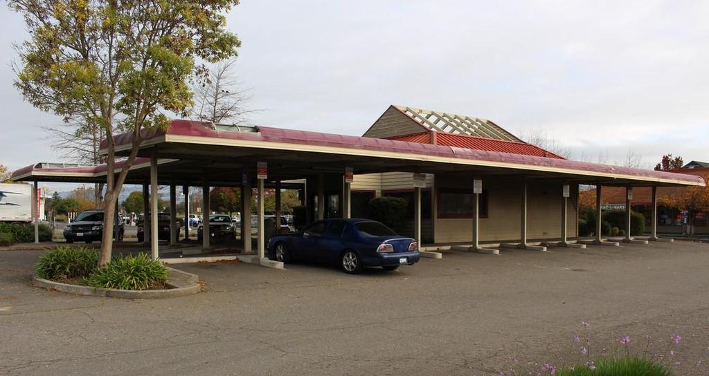
1 Retail Building For Lease 890 Petaluma Blvd N, Petaluma CA Built Out Restaurant / Retail Building ± 1,148 Sq.ft. Two ADA Bathrooms ± 1,200 Sq.ft. of Outdoor Seating Area.38ac Corner Lot Hard-Corner Signalized Intersection Phenomenal Location Over 45,000 Car Per Day Traffic Count All Equipment Included With Lease $4,200/mo NNN ($3.66/sf/mo) Rami Batarseh Tel: (707) Fax: (707) ramibatarseh1@gmail.com License #: TI ALLOWANCE AVAILABLE Alex Tannous Tel: (707) Fax: (707) alextannousre@gmail.com License #: The above information, while not guaranteed, has been secured from sources we believe to be reliable. This is not an offer to sell or lease and is subject to change or withdrawal. An interested party should verify the status of the property and the information herein. Maps provided by Google Inc. & Microsoft Corp., respectively.


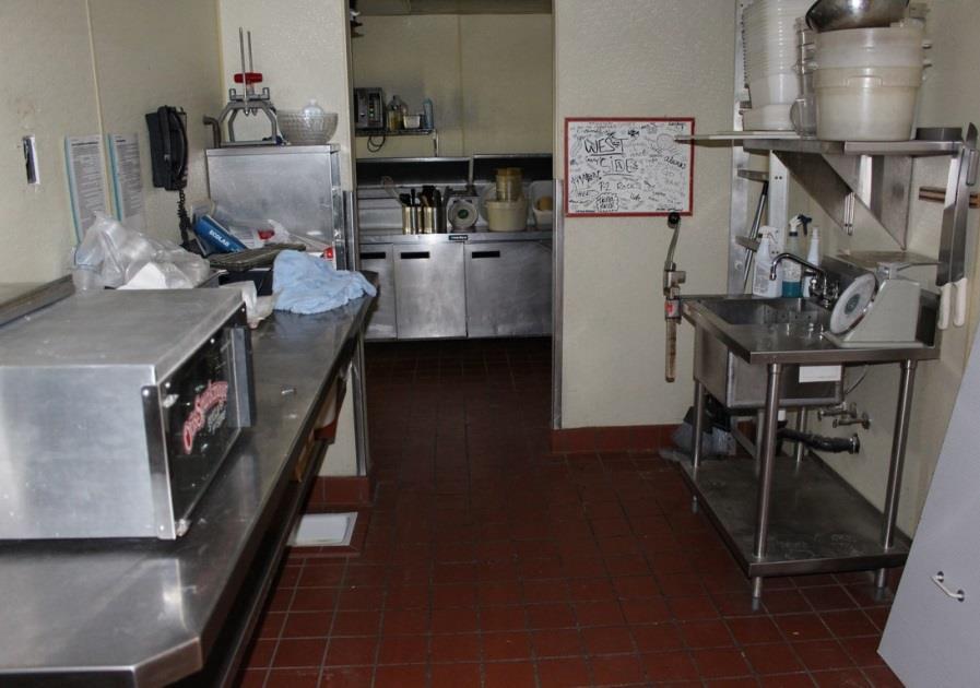
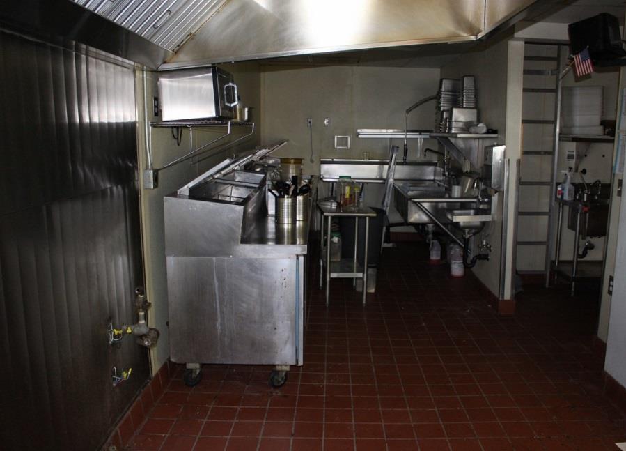
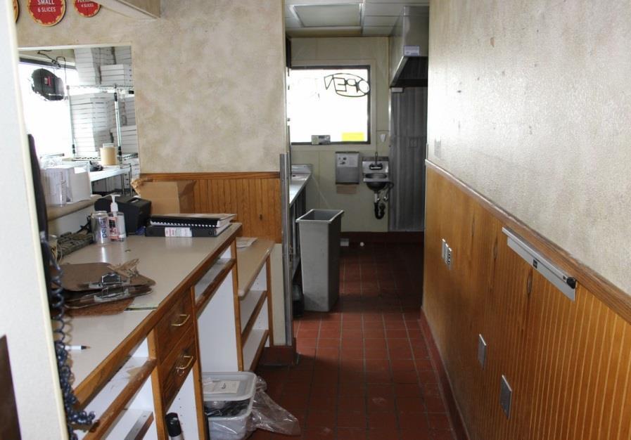
2 O v e r v i e w 890 Petaluma Blvd N. is a 1,148 sq.ft single story, stand-alone retail building currently built out as a restaurant with equipment in place. Kitchen includes hood, sandwich/pizza prep coolers, large walk in fridge, hand and dish wash stations, and multiple prep areas. Lease includes the use of all existing equipment and improvements. Ideal for a pizza establishment as building was formerly operated by Round Table and Terra Vino. Tenant improvement allowance available. Property sits on a.38acre lot and has over 20 dedicated parking spaces. Building is ideally located on Petaluma Blvd N, a major artery and among the busiest signalized corner intersections in Petaluma. Adjacent users include Lucky' s supermarket, restaurants, retail stores, gas station, car wash and office space. Highway 101 and downtown within close proximity. Approximately 125 of frontage on the east side of Petaluma Blvd and 150 on the south side of Payran St. There is direct corner access from Petaluma Blvd N. and Payran St. Current traffic counts boasts a daily average count near the intersection of Magnolia Avenue and Payran Street is 26,252 and 22,146 north and south respectively. Under MU1A zoning, a 2.5 FAR (floor area ratio) is allowed, permitting greater than 32,000 gross area feet of potential development with a 30 max height, restricted only by the parking space requirements. There are no setbacks to either the front, back or sides of the parcel.


3
4 32 miles


5 Snapshot of Petaluma Picture yourself in Petaluma shopping for funky to fabulous treasures in antique galleries in historic downtown, sampling artisan cheese at the source, savoring farm-to-table Wine Country cuisine, or sipping Sonoma County wine during a sunset cruise on the Petaluma River. Petaluma is easy to find, straight up Highway 101, 32 miles north of San Francisco. We are the portal to Sonoma County, making Petaluma an ideal base for excursions to the Wine Country, the dramatic Sonoma Coast and the majestic redwood groves. Or stay in affordable accommodations in Petaluma and drive south across the Golden Gate Bridge for sightseeing in San Francisco. If you are more of a waterway than highway type of traveler, it s smooth sailing getting to Petaluma. Cruise up the gentle Petaluma River, dock at the Turning Basin, and be just steps away from award-winning restaurants, boutique shopping, live music and movies. In addition to our great location, Petaluma is a city that knows how to have a good time. Our Events Calendar is loaded with fairs and festivals that are sometimes described as quirky. Call it what you will, the community thrives on coming together for events that celebrate our heritage and history. No wonder Travel & Leisure Magazine named Petaluma one of the "Nation's Top Ten Getaways Near a Major City. So whether you are already in Petaluma or on the other side of the world, we hope you will take a few minutes exploring the plethora of possibilities that our small town with the huge personality offers visitors.
6 Chapter 4 Zone Districts and Allowable Land Uses Purpose This Chapter lists the land uses that may be allowed by Section (Zoning Map and Zones), determines the type of planning permit approval required for each use, and provides basic standards for site layout and building size Purpose of Established Zones A. OSP (Open Space and Park) zone. The OSP zone is applied to undeveloped areas and sites that are appropriate for the preservation of natural resources, outdoor recreation, to be maintained in open space for the protection of public health and safety, and existing City public parks. City parks located in this zone may include buildings, structures, and uses that serve the community (e.g. Luchessi Community Center, Novak Center, Cavanaugh Center, Library, Water Resources building, etc.). The OSP zone is consistent with and implements the Urban Separator, Open Space, and City Park land use classifications of the General Plan. B. AG (Agriculture) zone. The AG zone is applied to areas that are actively and primarily used for grazing, or the production for sale of food and fiber. Areas subject to seasonal or historic flooding and identified by FEMA as areas warranting special consideration are included. The AG zone is consistent with and implements the Agriculture land use classification of the General Plan. C. RR (Rural Residential) zone. The RR zone is applied to areas of single dwelling development with a minimum lot size of 2 acres. This zone would be applied primarily to areas at the western perimeter of the City along the Urban Growth Boundary that are developed with single dwellings at densities ranging from 0.1 to 0.6 units per acre. This zone is intended to maintain a rural character and provide a transition to unincorporated rural and agricultural lands. The RR zone is consistent with and implements the Rural Residential land use classification of the General Plan. D. R1 (Residential 1) zone. The R1 zone is applied to areas of single dwelling development, primarily the western hillsides, with densities ranging from 0.6 to 2.5 units per acre, and larger lots required for sloped sites. The R1 zone is consistent with and implements the Very Low Density Residential land use classification of the General Plan. E. R2 (Residential 2) zone. The R2 zone is applied to areas previously developed and intended for detached single dwellings on individual lots, at densities ranging from 2.6 to 8.0 units per acre. The R2 zone is consistent with and implements the Low Density Residential land use classification of the General Plan. F. R3 (Residential 3) zone. The R3 zone is applied to the older neighborhoods surrounding the downtown that are characterized by a variety of housing types and densities in a walkable context. Densities range from 6.1 to 12.0 units per acre. The R3 zone is consistent with and implements the Diverse Low Density Residential land use classification of the General Plan. G. R4 (Residential 4) zone. The R4 zone is applied to areas intended for a variety of housing types ranging from single dwellings to multi-unit structures. Densities range from 8.1 to 18.0 units per acre. The R4 zone is consistent with and implements the Medium Density Residential land use classifications of the General Plan. H. R5 (Residential 5) zone. The R5 zone is applied to areas intended for the most urban housing types at densities ranging from 18.1 to 30.0 units per acre, but where existing lower density housing is considered conforming. The R5 zone is consistent with and implements the High Density Residential land use classification of the General Plan. I. MH (Mobile Home) zone. The MH zone is applied to existing mobile home parks throughout the City. The MH zone is consistent with the Mobile Home land use classification of the General Plan. J. C1 (Commercial 1) zone. The C1 zone is applied to existing smaller-scale shopping centers with off-street parking, or clusters of street-front stores that serve the surrounding neighborhood. The C1 zone is consistent with Ordinance No N.C.S. 4-1
7 and implements the Neighborhood Commercial land use classification of the General Plan, which establishes a maximum floor area ratio of 0.8 for the classification. K. C2 (Commercial 2) zone. The C2 zone is applied to existing community and regional shopping center sites. The C2 district is consistent with and implements the Community Commercial land use classification of the General Plan, which establishes a maximum floor area ratio of 1.2 for the classification. L. MU1A, MI1B, MU1C (Mixed Use 1) zone. The MU1 zone is applied to areas intended for pedestrian-oriented, mixed-use development with ground-floor retail or office uses adjacent to the Downtown Core, and in other areas of the city where existing auto-oriented commercial areas are intended for improvement into pedestrian-oriented mixed use development. The MU1 zone is consistent with and implements the Mixed Use land use classification of the General Plan, which establishes a maximum floor area ratio of 2.5 for both residential and non-residential uses within the classification, and a maximum density of 30 units per acre for residential. Note: Mixed Use 1A zone. This zone is applied to parcels located along corridors such as East Washington Street, Petaluma Boulevard North, Bodega Avenue and Lakeville Street. The parcels in these zones vary in size and are typically located adjacent to residential zones. Mixed Use 1B zone. This zone is applied to larger parcels located primarily along major arterial roadways. The larger parcel size should allow for a mix of uses on the site. Mixed Use 1C zone. This zone is applied to smaller parcels located in West Petaluma. Most of these parcels are located in residential areas and the intensity of the uses permitted in this zone is limited. M. MU2 (Mixed Use 2) zone. The MU2 zone is applied to the Petaluma Downtown and adjacent areas that are intended to evolve into the same physical form and character of development as that in the historic downtown area. The MU2 zone is consistent with and implements the Mixed Use land use classification of the General Plan, which establishes a maximum floor area ratio of 2.5 for both residential and non-residential uses within the classification, and a maximum density of 30 units per acre for residential. N. BP (Business Park) zone. The BP zone is intended for business and professional offices, technology park clusters, research and development, light industrial operations, and visitor service establishments, with retail as a secondary use only. The BP zone is consistent with and implements the Business Park land use classification of the General Plan, which establishes a maximum floor area ratio of 1.5 for the classification, although an FAR of 3.0 is allowed if all required parking is structured. O. I (Industrial) zone. The I zone is applied to areas that are appropriate for a full range of manufacturing, industrial processing, general service, warehousing, storage and distribution operations. Small restaurants and service commercial are allowed as ancillary uses. The I zone is consistent with and implements the Industrial land use classification of the General Plan, which establishes a maximum floor area ratio of 0.6 for the classification. P. CF (Civic Facility) district. The CF zone is applied to sites for proposed public utility facilities, government offices, community service uses and lands, and significant sites owned and operated by the elementary, secondary, or community college districts, as well as private and/or parochial schools. The zone implements and is consistent with the Public/Semi-Public, and Education classifications of the General Plan. Q. FW (Floodway) zone. The FW zone is applied to sites within the boundaries of the Areas of Special Flood Hazard and identified as Floodway areas. See Chapter 6 for the requirements of the Floodway zone. R. Planned Unit Districts and Planned Community Districts. The historic use of P.U.D.s and P.C.D.s for the development of residential, industrial, and commercial properties in various zones in which the underlying P.U.D. and/or P.C.D. uses are permitted is hereby recognized. Non-residential P.C.D.s in existence as of May 19, 2008, and residential P.U.D.s are recognized to be consistent with the intent of these regulations by the establishment of their individual and respective P.U.D. and P.C.D. standards. Development and redevelopment of lands within P.U.D.s and P.C.D.s, including modification of P.C.D.s and/or addition of land to P.C.D.s, shall be in accordance with the individual adopted standards for said P.U.D. or P.C.D. and other applicable zoning standards not Ordinance No N.C.S. 4-2
8 otherwise modified by the P.U.D. or P.C.D. adopted standards. The creation and modification of P.U.D.s, and the modification and/or addition of land to P.C.D.s existing as of May 19, 2008, is regulated by Chapter 19 herein. The creation of wholly new P.C.D.s, or the addition of land to a P.C.D. where the expansion area is not immediately adjacent, is not permitted by this Ordinance Allowable Land Uses and Permit Requirements A. General permit requirements. Tables 4.1 through 4.5 identify the land uses allowed by this Zoning Ordinance in each zone, and the planning permit required to establish each use, in compliance with Section (Allowable Land Uses and Planning Permit Requirements). B. Requirements for certain specific land uses. Where the last column in Tables 4.1 through 4.5 ("Specific Use Regulations") includes a section number, the referenced section may affect whether the use requires a Conditional Use Permit, and/or may establish other requirements and standards applicable to the use Site Planning and Building Standards Subdivisions, new land uses and structures, and alterations to existing land uses and structures, shall be designed, constructed, and established in compliance with the requirements in Tables 4.6 through 4.13, in addition to the applicable standards (e.g., landscaping, parking and loading, etc.) in Chapters 11, 13, Dedication Required and Exceptions A. Dedication required. The developer shall dedicate any necessary right-of-way to the City to the alignment established by plan lines established in Chapter of the Petaluma Municipal Code, or to an alignment consistent with applicable City right-of-way standards across the entire frontage or frontages and shall construct public improvements (including, but not limited to curbs, gutters, sidewalk, half street, water mains, storm drains and sanitary sewers) across such frontage to current city standards, whenever a development project is located, or which is proposed to be located: 1. Upon one or more streets or roads where future right-of-way plan lines have been established pursuant to Chapter of the Petaluma Municipal Code, or 2. Upon one or more streets or roads which are not improved with existing curbs, gutters, sidewalks and other contiguous street improvements across the frontage or frontages of the property upon which said development project is located, or 3. Upon a parcel of real property which has frontage on a dedicated street right-of-way where no such improvements have been constructed contiguous to the parcel upon which the development project is located. Nothing in this section shall be construed to prevent the City from requiring construction of frontage improvements pursuant to any other ordinance or regulation of the city. B. Exceptions. Section 4.050(A) shall not apply when any one or more of the following conditions exist: 1. Where a condition of any subdivision or parcel map requires dedication and construction or public improvements as a condition of approval of the same development project. 2. Where the value of the construction is less than $10,000. This valuation may be raised by resolution of the City Council to compensate for inflation and increased building costs. 3. Where the proposed development project is clearly accessory as determined by standards in the Zoning Ordinance, to an existing use upon the property. 4. Where the development project consists primarily of the rehabilitation of an existing structure, when no change of use will occur. Ordinance No N.C.S. 4-3
9 5. Where the developer establishes that the required dedication would render the real property upon which the development project is to be constructed substantially valueless for any private use, but final determination of such fact shall be made only by the City Council upon petition of the developer or owner. Ordinance No N.C.S. 4-4
10 Natural and Rural Zones TABLE 4.1 Allowed Land Uses and Permit Requirements for Natural and Rural Zones LAND USE TYPE (1) AGRICULTURAL & RESOURCE USES LODGING Crop production, horticulture, orchard, vineyard Farm animal keeping Lodging - Short-Term Vacation Rentals Lodging - Bed & Breakfast Inn RECREATION, EDUCATION & PUBLIC ASSEMBLY Park RESIDENTIAL Community Meeting Facility Commercial recreation - Indoor Commercial recreation - Outdoor Golf course, country club School - Elementary, secondary, or college, private Dwelling, Accessory/Second Unit Dwelling, Caretaker Dwelling, Group Dwelling, Multiple Dwelling, Single Household Home Occupation Residential, Accessory Structure Residential Care, 6 or fewer clients, in a home Residential Care, 7 or more clients Swimming Pool, Hot Tub, Spa Work/Live SERVICES - GENERAL Day care - Large family day care home Day care - Small family day care home Public safety facility TRANSPORTATION, COMMUNICATIONS, INFRASTRUCTURE City Water & Sewer Facility Telecommunications Facility P(16) CUP S A Permitted Use Conditional Use Permit Required Permit Requirement in Specific Use Regulations Accessory Use Use Not Allowed Permit Required by Zone Specific Use OSP AG RR R1 Regulations P(17) P(17) Section CUP Section CUP CUP CUP CUP CUP CUP CUP A,S A,S A,S Section S(5) S(5) Section P P P A,S(2) A,S(2) A,S(2) Section A A A P P A,S A,S A(4) A(4) Section A(3) A(3) P P CU S S S S Section & Muni Code Key to zone symbols OS - Open Space AG - Agriculture RR - Rural Residential R1 - Residential 1 Ordinance No N.C.S. 4-5
11 Notes: (1) See Glossary for land use definitions. (2) Home Occupation Permit and Business License Required (3) Business License Required (4) Business License & Compliance with Section Required (5) Site Plan and Architectural Review Required & Compliance with Section Required (6) Permitted use on an upper floor or behind ground floor street fronting use; use in other locations allowed subject to a CUP (7) Permitted use (P) if limited to a maximum of 5,000 square feet on the ground floor (8) A CUP is required for overnight board and care (9) Neighborhood serving and open at lunch (10) Allowed only on floors above the ground floor (11) CUP required if part of the facility is outdoor and adjacent to a sensitive receptor (12) Urgent care facilities may be located on the ground floor as a street fronting use (13) Allowed only in a shopping center (14) Permitted only on APN & APN (Corona Rd. at North McDowell Blvd.) (15) Use permitted only on Lakeville Highway between Baywood Drive and Casa Grande Road (16) See section (Residential Uses Abutting Non-Residential Uses) (17) Short-term vacation rental permit, business license and transient occupancy tax certificate required (see section of Implementing Zoning Ordinance) Ordinance No N.C.S. 4-6
12 Residential Zones TABLE 4.2 Allowed Land Uses and Permit Requirements for Residential Uses LAND USE TYPE (1) LODGING Lodging - Short-Term Vacation Rentals Lodging -Bed & breakfast inn (B & B) RECREATION, EDUCATION & PUBLIC ASSEMBLY Community Meeting Facility Golf course, country club Park School - Elementary, secondary, or college, private RESIDENTIAL Dwelling, Accessory/Second Unit Dwelling, Group Dwelling, Multiple Dwelling, Single Household Home Occupation Residential, Accessory Structure Residential Care, 6 or fewer clients, in a home Residential Care, 7 or more clients Swimming Pool, Hot Tub, Spa Work/Live SERVICES - BUSINESS, FINANCIAL, PROFESSIONAL Medical services -Major Medical Services-Minor SERVICES - GENERAL Adult day program Child care center Day care - Large Family Day care - Small Family Public safety facility TRANSPORTATION, COMMUNICATIONS, INFRASTRUCTURE City Water & Sewer Facility Telecommunications facility Utility facility Key to zone symbols R2 - Residential 2 R3 - Residential 3 P(16) CUP S A Permitted Use Conditional Use Permit Required Permit Requirement in Specific Use Regulations Accessory Use Use Not Allowed Permit Required by Zone Specific Use R2 R3 R4 R5 Regulations P(17) P(17) P(17) P(17) Section CUP CUP Section CUP CUP CUP CUP CUP CUP CUP CUP A,S A,S A,S Section S(5) S(5) Section P P P A,S(2) A,S(2) A,S(2) A,S(2) Section A A A A A,S A,S A,S A,S Section A (4) A (4) A (4) A (4) Section A(3) A(3) A(3) A(3) S S S S R4 - Residential 4 R5 - Residential 5 Section & Muni Code Ordinance No N.C.S. 4-7
13 Notes: (1) See Glossary for land use definitions. (2) Home Occupation Permit and Business License Required (3) Business License Required (4) Business License & Compliance with Section Required (5) Site Plan and Architectural Review Required & Compliance with Section Required (6) Permitted use on an upper floor or behind a ground floor street fronting use; use in other locations allowed subject to a CUP. (7) Permitted use (P) if limited to a maximum of 5,000 square feet on the ground floor (8) A CUP is required for overnight board and care (9) Neighborhood serving and open at lunch (10) Allowed only on floors above the ground floor (11) CUP required if part of the facility is outdoor and adjacent to a sensitive receptor (12) Urgent care facilities may be located on the ground floor as a street fronting use (13) Allowed only in a shopping center (14) Permitted only on APN & APN (Corona Rd. at North McDowell Blvd.) (15) Use permitted only on Lakeville Highway between Baywood Drive and Casa Grande Road (16) See section (Residential Uses Abutting Non-Residential Uses) (17) Short-term vacation rental permit, business license and transient occupancy tax certificate required (see section of Implementing Zoning Ordinance) Ordinance No N.C.S. 4-8
14 Mixed Use Zones TABLE 4.3 Allowed Land Uses and Permit Requirements for Mixed Use Zones LAND USE TYPE (1) INDUSTRY, MANUFACTURING & PROCESSING LODGING Artisan/craft product manufacturing Catering service, as a primary use Furniture and fixture manufacturing, cabinet making Laboratory - Medical, analytical Manufacturing, light Media production Printing and publishing Research and development Lodging - Short-Term Vacation Rentals Lodging - Bed & breakfast inn (B&B) Lodging - Hotel/Motel RECREATION, EDUCATION & PUBLIC ASSEMBLY Cardroom Library, museum, art gallery Park RESIDENTIAL Community Meeting Facility Commercial recreation - Indoor Fitness/health facility School - Elementary, secondary, or college, private School - Specialized Education and Training Studio - Art, dance, martial arts, music, etc. Theater, cinema or performing arts Dwelling, Multiple Dwelling, Accessory/second unit Dwelling, Single Home Occupation Residential care, 7 or more clients Residential care facility, adult Residential care facility, for the chronically ill Residential care facility, for the elderly Residential in mixed use building Work/Live P(16) CUP S A Permitted Use Conditional Use Permit Required Permit Requirement in Specific Use Regulations Accessory Use Use Not Allowed Permit Required by Zone MU1A MU1B MU1C MU2 P P CUP(6) P(6) P P(6) P P P(15) P(6) P P(6) P(6) P P(6) P P(17) P(17) P(17) P(17) Section P CUP CUP CUP Chapter 9 CUP CUP CUP CUP CUP CUP P(6) CUP CUP CUP CUP CUP CUP CUP CUP CUP CUP CUP P P P Theater District Ord A,S(2) A,S(2) A,S(2) A,S(2) Section P(10) P(10) P CUP(10) P(6) P(6) CUP(10) P(6) P(6) CUP(10) P(6) P(6) CUP(10) P(10) P(14) P(10) P(10) P(6) P(6) P P(6) Specific Use Regulations Ordinance No N.C.S. 4-9
15 TABLE 4.3 Allowed Land Uses and Permit Requirements for Mixed Use Zones LAND USE TYPE (1) RETAIL Adult oriented business Artisan Shop Auto parts sales Bar, tavern, night club Building and landscape materials sales - Indoor Gas station General retail Groceries/specialty foods - 25,000 sf or less Groceries/specialty foods - More than 25,000 sf Plant nursery Restaurant, café, coffee shop SERVICES - BUSINESS, FINANCIAL, PROFESSIONAL ATM Bank, financial services Business support service Medical services - Health Care Facility Medical services - Major Medical services - Minor Office - Business, service, or government Office - Headquarters, or processing Office - Professional, administrative SERVICES - GENERAL Adult Day Program Child Care Center Child day care - Large Family Child day care - Small Family Kennel, animal boarding Meals Assembly Business Mortuary, funeral home Personal services Personal services - Restricted Public safety facility Vehicle services - Minor maintenance/repair Veterinary clinic, animal hospital TRANSPORTATION, COMMUNICATIONS, INFRASTRUCTURE City water & sewer facility Parking facility, public or commercial Telecommunications facility Utility facility P(16) CUP S A Permitted Use Conditional Use Permit Required Permit Requirement in Specific Use Regulations Accessory Use Use Not Allowed Permit Required by Zone MU1A MU1B MU1C MU2 CUP CUP CUP Chapter 10 P P CUP CUP CUP Chapter 8 CUP CUP P P P P P P CUP P P(6) P(6) P(6) P(6), (12) P(6), (12) P P(6), (12) (6) P(6) P P(6) (6) CUP CUP CUP P P(6) P(6) P(6) A(4) Section A(3) A(3) A(3) A(3) CUP P(13) CUP P CUP P(8) P(8) P(8) CUP CUP S S S S CUP CUP CUP Specific Use Regulations Section & Muni Code Ordinance No N.C.S. 4-10
16 Key to zone symbols MU1A - Mixed Use 1A MU1B - Mixed Use 1B MU1C - Mixed Use 1C MU2 - Mixed Use 2 Notes: (1) See Glossary for land use definitions. (2) Home Occupation Permit and Business License Required (3) Business License Required (4) Business License & Compliance with Section Required (5) Site Plan and Architectural Review Required & Compliance with Section Required (6) Permitted use on an upper floor or behind a ground floor street fronting use; use in other locations allowed subject to a CUP (7) Permitted use (P) if limited to a maximum of 5,000 square feet on the ground floor (8) A CUP is required for overnight board and care (9) Neighborhood serving and open at lunch (10) Allowed only on floors above the ground floor (11) CUP required if part of the facility is outdoor and adjacent to a sensitive receptor (12) Urgent care facilities may be located on the ground floor as a street fronting use (13) Allowed only in a shopping center (14) Permitted only on APN & APN (Corona Rd. at North McDowell Blvd.) (15) Use permitted only on Lakeville Highway between Baywood Drive and Casa Grande Road (16) See section (Residential Uses Abutting Non-Residential Uses) (17) Short-term vacation rental permit, business license and transient occupancy tax certificate required (see section of Implementing Zoning Ordinance) Ordinance No N.C.S. 4-11
IMPLEMENTING ZONING ORDINANCE
 CITY OF PETALUMA COMMUNITY DEVELOPMENT DEPARTMENT IMPLEMENTING ZONING ORDINANCE June 2008 Revision Date: July 10, 2014 IMPLEMENTING ZONING ORDINANCE REVISIONS ORDINANCE NO. 2468 ADOPTED JUNE 31, 2013 ORDINANCE
CHAPTER COMMERCIAL AND INDUSTRIAL ZONING DISTRICTS
 Commercial and Industrial Zoning Districts 106.26.010 CHAPTER 106.26 - COMMERCIAL AND INDUSTRIAL ZONING DISTRICTS COMMERCIAL AND INDUSTRIAL ZONING DISTRICTS Sections: 106.26.010 - Purpose 106.26.020 -
CHAPTER RESIDENTIAL AND OPEN SPACE ZONING DISTRICTS
 Residential and Open Space Zoning Districts 106.24.010 CHAPTER 106.24 - RESIDENTIAL AND OPEN SPACE ZONING DISTRICTS RESIDENTIAL AND OPEN SPACE ZONING DISTRICTS Sections: 106.24.010 - Purpose 106.24.020
CHAPTER COMMERCIAL ZONING DISTRICTS
 CHAPTER 27.10 - COMMERCIAL ZONING DISTRICTS 27.10.010 - Purpose of Chapter This Chapter lists the land uses that may be allowed within the commercial zoning districts established by Section 27.04.020 (Zoning
Honorable Mayor and Members of the City Council through City Manager
 i p' Lr, 2858 DATE: May 21, 2018 TO: Honorable Mayor and Members of the City Council through City Manager FROM: Heather Hines, lanning Manager"- SUBJECT: Introduction ( first reading) of an Ordinance Amending
Division D2. Allowable Land Uses and Zoning Standards
 UU................................. City of San Ramon Zoning Ordinance Division Allowable Land Uses and Zoning Standards TChapter I - Development and Land Use Approval RequirementsUT... 2-3 TU-1 - PurposeUT...
Subchapter 5 Zoning Districts and Limitations
 Subchapter 5 Zoning Districts and Limitations 35.5.1 Rural Districts Sections: 35.5.1.1 Purpose. 35.5.1.2 Permitted Uses. 35.5.1.3 General Regulations. 35.5.1.1 Purpose. The purpose of a Rural District
Commercial and Manufacturing Districts TABLE ALLOWED USES AND PERMIT REQUIREMENTS FOR COMMERCIAL AND MANUFACTURING DISTRICTS
 TRUCKEE MUNICIAL CODE - TITLE 18, DEVELOMENT CODE TABLE 2-6 - ALLOWED USES AND ERMIT REQUIREMENTS FOR COMMERCIAL AND MANUFACTURING DISTRICTS ERMIT REQUIREMENT BY DISTRICT LAND USE (1) CN (2) CG CH CS M
CITY OF SARATOGA SPRINGS ZONING ORDINANCE TABLE 1: 2.0 BASE ZONING DISTRICTS
 2.0 BASE S 2.1 INTENT To fulfill the intent and purpose of this Chapter, the following tables identify zoning districts and district intents (Table 1), districts use schedule (Table 2), and districts area
2.110 COMMERICAL MIXED USE (CM)
") CITY OF KEIZER DEVELOPMENT BULLETIN 2.110.01 Purpose 2.110 COMMERICAL MIXED USE (CM) The Commercial Mixed Use (CM) zone is the primary commercial zone within the City. The zone is specifically designed
CITY OF KEIZER DEVELOPMENT BULLETIN 2.110.01 Purpose 2.110 COMMERICAL MIXED USE (CM) The Commercial Mixed Use (CM) zone is the primary commercial zone within the City. The zone is specifically designed
Industrial Space For Sale or Lease
 Industrial Space For Sale or Lease Paterson, NJ Ÿ Location: Ÿ Building: Ÿ Available: Ÿ Purchase Price: Ÿ Rental Rate: 188 Lafayette Avenue Paterson, NJ Block 3202, Lots 7, 8, and 68 Single story industrial
Bylaw No , being "Official Community Plan Bylaw, 2016" Schedule "A" DRAFT
 Bylaw No. 2600-2016, being "Official Community Plan Bylaw, 2016" Schedule "A" Urban Structure + Growth Plan Urban Structure Land use and growth management are among the most powerful policy tools at the
Sec HC - Highway commercial district.
 Sec. 36-422. - HC - Highway commercial district. (1) Purpose. This district is intended for commercial uses which depend upon high visibility, generate high traffic volumes, or cater to the traveling public.
SECTION CLASSIFICATION OF ZONES For the purpose of this Code the following primary land use zoning districts are hereby established:
 ARTICLE 4 ZONING DISTRICTS SECTION 4.010 CLASSIFICATION OF ZONES For the purpose of this Code the following primary land use zoning districts are hereby established: Primary Zones Abbreviated Designation
RM- 59 CATEGORY RM- 20 MU- DC MU-NB MU-SB. A (Airport) MU-D MU-SA MU-SC MU-N IA IL IH IP NR GCI LC P PK OS
 MU-D MU-SA MU-SC MU-N IA IL IH IP NR GCI LC P PK OS") M Minor Use Permit (Zoning dministrator CTEGORY RS-3 RS-6 20 59 MU- DC MU-D MU-S MU-SC MU-N I IL IH IP NR GCI LC P PK OS (irport) dditional Regulations RESIDENTIL USE CLSSIFICTIONS Single-Unit Dwelling
M Minor Use Permit (Zoning dministrator CTEGORY RS-3 RS-6 20 59 MU- DC MU-D MU-S MU-SC MU-N I IL IH IP NR GCI LC P PK OS (irport) dditional Regulations RESIDENTIL USE CLSSIFICTIONS Single-Unit Dwelling
THE CITY OF RAYMORE, MISSOURI Single-Family Residential Zoning Districts
 THE CITY OF RAYMORE, MISSOURI Single-Family Residential Zoning Districts REGULATIONS COMMON TO ALL DISTRICTS: Uses permitted in each district include detached single-family dwellings, manufactured homes
DEVELOPMENT STANDARDS
 Chapter 5 DEVELOPMENT STANDARDS 501 Residential Development Standards 502 Neighborhood Commercial Standards 503 Mixed Use Standards 504 Industrial Development Standards 505 Public Use Standards 506 Open
Article 04 Single Family Residential Districts
 Article 04 Article 04 Section 04.01 Intent (a) R1A Residence District. The R1A Single Family Residential District is established to include areas of low density single-family residences and limited agricultural
East Cesar Chavez, Austin TX 78702
 2714-2730 East Cesar Chavez, Austin TX 78702 Size:.3880 acres= 16,901 sf Price: $125/sf = $2,112,625 Zoning: CS-CO-MU-NP Buyer s Agent Fee= 2% Food Trailer Income As Well: Provided Upon Request Materials
4.2 RESIDENTIAL ZONING DISTRICTS
 4.2 RESIDENTIAL ZONING DISTRICTS A. Purpose: To define regulations and standards for each residential zoning district in the City. The following sections identify uses, regulations, and performance standards
BYLAW NUMBER 159D2016
 CPC2016-164 ATTACHMENT 1 BEING A BYLAW OF THE CITY OF CALGARY TO AMEND THE LAND USE BYLAW 1P2007 (LAND USE ) * * * * * * * * * * * * * * * * * * * * * * * * * * * * * * * * WHEREAS it is desirable to amend
Parking Challenges and Trade-Offs
 Parking Challenges and Trade-Offs What is the best way to balance competing interests and priorities while updating the City s off street parking regulations? Updating off street parking regulations can
Chapter 9.10 Downtown Districts
 Division 2: Base and Overlay Districts Chapter 9.10 Downtown Districts 9.10.001 Incorporation of Downtown Community lan Standards and Development standards and land use designations, for the Downtown Community
Road frontage 287 Sewer and Well Propane Central Air
 FOR SALE/LEASE FOR SALE $149,900 FOR LEASE $13.75/sf Modified Net 1027 Voluntown Rd., Griswold 1,440sf+/- commercial bldg. with full basement (total 2,880sf) 0.96 acre Zone C-1 15 parking spaces John Jensen,
TC- Districts TC-1 TC-2 Standards Key: = Permitted = Subject to Special Use Review RESIDENTIAL USES Single-family detached, semi-detached or endrow,
 Sec. 8-3216. Traditional Commercial Districts (TC-). (1) Purpose. (a) Traditional Commercial Neighborhood (TC-1). The TC-1 District is intended to ensure the vibrancy of historic mixed use neighborhoods
COMMERCIAL ZONING DISTRICTS (Amended 11/13/14) Part I. C-1 Restricted Commercial District
 Part I. C-1 Restricted Commercial District") ARTICLE XI. COMMERCIAL ZONING DISTRICTS (Amended 11/13/14) Part I. C-1 Restricted Commercial District Section 152: Purpose This district is designed to accommodate commercial uses which act as a transition
ARTICLE XI. COMMERCIAL ZONING DISTRICTS (Amended 11/13/14) Part I. C-1 Restricted Commercial District Section 152: Purpose This district is designed to accommodate commercial uses which act as a transition
Chapter CN NEIGHBORHOOD CENTER COMMERCIAL ZONES REGULATIONS
 Chapter 17.33 - CN NEIGHBORHOOD CENTER COMMERCIAL ZONES REGULATIONS Sections: 17.33.010 - Title, intent, and description. 17.33.020 - Required design review process. 17.33.030 - Permitted and conditionally
Coding For Places People Love Main Street Corridor District
 Coding For Places People Love Main Street Corridor District 1) Scope a) District boundaries are assigned according to the District Boundary Map. b) The Primary Retail Corridor is assigned according to
Sec Temporary Uses. Secs Reserved
 subject to any referenced use-specific standards and all other applicable regulations of this Ordinance: 1. Accessory dwelling unit (detached) 2. Kennel, private (for parcels less than 2 acres in size;
Suburban Commercial Center ( CE-S ) Permitted Principal Uses and Structures
 Permitted Principal Uses and Structures") Division 12. Suburban Commercial Center ( CE-S ) 2.9.1 Purpose Suburban commercial centers provide regional commercial destinations with design and site elements compatible with suburban character. Dimensional
Division 12. Suburban Commercial Center ( CE-S ) 2.9.1 Purpose Suburban commercial centers provide regional commercial destinations with design and site elements compatible with suburban character. Dimensional
ARTICLE 6 RU, RURAL ZONING DISTRICTS. RU (Rural) Zoning Districts are established to achieve the following purposes:
 Zoning Districts are established to achieve the following purposes:") ARTICLE 6 RU, RURAL ZONING DISTRICTS 601 Purpose RU (Rural) Zoning Districts are established to achieve the following purposes: 601.01 To preserve the character of areas designated as "Rural" in the Cochise
ARTICLE 6 RU, RURAL ZONING DISTRICTS 601 Purpose RU (Rural) Zoning Districts are established to achieve the following purposes: 601.01 To preserve the character of areas designated as "Rural" in the Cochise
EDBB- Other streets. MIXED USE [subject to section ] OPEN SPACE [subject to article 312] Accessory uses P P P P P P P P. Parks P P P P P P P P
![EDBB- Other streets. MIXED USE [subject to section ] OPEN SPACE [subject to article 312] Accessory uses P P P P P P P P. Parks P P P P P P P P](/thumbs/89/99587674.jpg "EDBB- Other streets. MIXED USE [subject to section ] OPEN SPACE [subject to article 312] Accessory uses P P P P P P P P. Parks P P P P P P P P") Sec. 302-10. - Permitted, special exception and prohibited uses. Legend: P = Permitted = Special Exception use (#) = Permitted subject to the restriction in section 302-20 having the same number that is
Sec. 302-10. - Permitted, special exception and prohibited uses. Legend: P = Permitted = Special Exception use (#) = Permitted subject to the restriction in section 302-20 having the same number that is
Farming & Livestock related activities Y Y Y Y Y Y. Commercial Type Animal Facility Y Y Y
 ( = Permitted) TABLE A PERMITTED USES B DISTRICT MU MU2 CC MH/ RV Agricultural Uses (Light) Agricultural Uses (Heavy) Residential Uses Recreational and Institutional Uses RM R C LI MI HI A Farming & Livestock
ARTICLE 3: Zone Districts
 ARTICLE 3: Zone Districts... 3-1 17.3.1: General...3-1 17.3.1.1: Purpose and Intent... 3-1 17.3.2: Districts and Maps...3-1 17.3.2.1: Applicability... 3-1 17.3.2.2: Creation of Districts... 3-1 17.3.2.3:
4531 FRANKLIN BLVD Springfield, Oregon
 FOR SALE SHAMROCK VILLAGE RV & MANUFACTURED HOME PARK & 3.74 ACRE VACANT PARCEL 4531 FRANKLIN BLVD Springfield, Oregon (Glenwood Area) OPPORTUNITY ZONE PROPERTY Manufacture Home/RV Park & Vacant Land 46
Bufferyard shall mean a landscaped setback area at the boundary of a development.
 For the purposes of this Specific Plan, certain terms shall be defined as set forth in this Section. Terms not listed herein shall be defined per the City s Zoning Ordinance, or if not listed in said Zoning
Residential-1 District
 Residential-1 District City of Barnum, Minnesota Zoning District Information Sheet It is the purpose of the R-1 District to encourage the establishment and the preservation of residential neighborhoods
Sec Tier 2 principal uses and structures. The principal uses of land and structures allowed in Tier 2 are provided below subject to the
 Sec. 27-730.4.9. Tier 2 principal uses and structures. The principal uses of land and structures allowed in Tier 2 are provided below subject to the standards and limitations contained within this division.
Division 4: Commercial Community 1 (C-C1) District
 District") Division 4: Commercial Community 1 (C-C1) District 738 Purpose 738 (1) The Commercial Community 1 District is intended to be characterized by: (e) (f) (g) small to mid-scale commercial developments; developments
Division 4: Commercial Community 1 (C-C1) District 738 Purpose 738 (1) The Commercial Community 1 District is intended to be characterized by: (e) (f) (g) small to mid-scale commercial developments; developments
RE: 6. GILL/GREEN COMPREHENSIVE PLAN AMENDMENT, REZONING AND PRELIMINARY PLAT
 commission memo DATE: Thursday - August 9, 2018 TO: Marion Planning & Zoning Commission FROM: David N. Hockett, AICP Principal Planner RE: 6. GILL/GREEN COMPREHENSIVE PLAN AMENDMENT, REZONING AND PRELIMINARY
CHAPTER 5 ZONING DISTRICTS AND REGULATIONS
 CHAPTER 5 ZONING DISTRICTS AND REGULATIONS Section 500.00 Section 500.01 Zoning Districts and Regulations Purpose The purpose of this Chapter is to establish Zoning Districts in order to carry out the
5 ft. When adjacent to MF 9 and MF 18: 20 ft. MAXIMUM SETBACKS Frontage Ground Floor Above Ground Floor State Road 7 30 ft. N/A MINIMUM ACTIVE USES
 7 8 9 0 7 8 9 0 (ii) C MU Central Mixed Use District Development Regulations Table. C MU SR7 Central Mixed Use District Development Regulations MAXIMUM DENSITY Vertical Mixed Use Building Bonus Dwelling
ARTICLE 383. PD 383.
 ARTICLE 383. PD 383. SEC. 51P-383.101. LEGISLATIVE HISTORY. PD 383 was established by Ordinance No. 21928, passed by the Dallas City Council on December 8, 1993. Ordinance No. 21928 amended Ordinance No.
Chapter MIXED USE ZONING DISTRICTS
 Page 1 of 12 Page 1/12 Chapter 17.18 MIXED USE ZONING DISTRICTS Sections: 17.18.010 Purposes. 17.18.020 Permitted, conditional and prohibited uses. 17.18.030 Bulk, 17.18.010 Purposes. A. Mixed Use Districts.
Appendix A: Guide to Zoning Categories Prince George's County, Maryland
 Appendix A: Guide to Zoning Categories Prince George's County, Maryland RESIDENTIAL ZONES 1 Updated November 2010 R-O-S: Reserved Open Space - Provides for permanent maintenance of certain areas of land
FREEWAY-ADJACENT COMMERCIAL BUILDING + LAND + BILLBOARD FOR SALE N HWY 99 ACAMPO, CA LODI S EMERGING COMMERCIAL CORRIDOR
 FREEWAY-ADJACENT COMMERCIAL BUILDING + LAND + BILLBOARD FOR SALE 18691 N HWY 99 ACAMPO, CA LODI S EMERGING COMMERCIAL CORRIDOR Section One: The Property PRIME LODI COMMERCIAL PROPERTY WITH FREEWAY FRONTAGE
TOD - Transition Subdistrict Summary of Allowable Uses
 TOD - Transition Subdistrict Summary of Allowable Uses (Please refer to Section 18-160 for the most up-to-date list: Section 18-160) Accessory Uses Accessory community center private Accessory dwelling
EXHIBIT D (Ordinance Number ) BREVARD PLACE PLANNED DEVELOPMENT DISTRICT: LIST OF CONDITIONS
 BREVARD PLACE PLANNED DEVELOPMENT DISTRICT: LIST OF CONDITIONS") EXHIBIT D (Ordinance Number 2014- ) BREVARD LACE LANNED DEVELOMENT DISTRICT: LIST OF CONDITIONS 1. Definitions. Within this List of Conditions, the following terms shall have the meanings articulated:
EXHIBIT D (Ordinance Number 2014- ) BREVARD LACE LANNED DEVELOMENT DISTRICT: LIST OF CONDITIONS 1. Definitions. Within this List of Conditions, the following terms shall have the meanings articulated:
Marcel Williams, MPC Project Planner
 TO: FROM: The Planning Commission MPC Staff DATE: SUBJECT: Petition to Rezone Property Heath Shelton, Owner Jay Maupin, Agent 2026 Habersham Street Aldermanic District: 2, Bill Durrence County Commission
Attachment 5 - Ordinance 3154 Exhibit D (Revised for 9/15 Council Meeting) Page 1 of 7 Port Townsend Municipal Code. Chapter 17.18
 Page 1 of 7 Port Townsend Municipal Code. Chapter 17.18") Page 1 of 7 Page 1/7 Chapter 17.18 MIXED USE ZONING DISTRICTS Sections: 17.18.010 Purposes. 17.18.020 Permitted, conditional and prohibited uses. 17.18.030 Bulk, 17.18.010 Purposes. A. Mixed Use Districts.
Page 1 of 7 Page 1/7 Chapter 17.18 MIXED USE ZONING DISTRICTS Sections: 17.18.010 Purposes. 17.18.020 Permitted, conditional and prohibited uses. 17.18.030 Bulk, 17.18.010 Purposes. A. Mixed Use Districts.
Chapter CC COMMUNITY COMMERCIAL ZONES REGULATIONS
 Effective April 14, 2011 Chapter 17.35 CC COMMUNITY COMMERCIAL ZONES REGULATIONS SECTIONS: 17.35.010 Title, Intent, and Description 17.35.020 Required Design Review Process 17.35.030 Permitted and Conditionally
Table 1: Table of Uses by District
 Table 1: Table of Uses by District P = Permitted Use with No Planning Commission Review Required. A Building Permit may be required. = Site Plan Review and Approval by the Planning Commission required.
Montrose, Colorado. Commercial Property Information Packet. John Renfrow * Joey Huskey Renfrow Realty
 1595 E Oak Grove Rd. Commercial Property Information Packet John Renfrow * Joey Huskey Renfrow Realty Member of: www.rmcbrokers.com Page 1 Executive Summary LOCATION! LOCATION! 1595 E Oak Grove Rd. $499,888
Part 4, C-D Conservation District
 The Township is divided into the districts set forth by this chapter and as shown by the district boundaries on the Official Zoning District Map. The zoning districts are: C-D Conservation District A-1
PINELLAS COUNTY COMPREHENSIVE PLAN
 PINELLAS COUNTY COMPREHENSIVE PLAN Future Land Use Map (FLUM) Category Descriptions and Rules Amended March 17, 2009 (Ordinance 09-17) Amended March 16, 2010 (Ordinance 10-18) Amended October 26, 2010
Town of Windham Land Use Ordinance Sec. 400 Zoning Districts SECTION 400 ZONING DISTRICTS
 Town of Windham Land Use Ordinance Sec. 400 Zoning Districts Sections SECTION 400 ZONING DISTRICTS SECTION 400 ZONING DISTRICTS 4-1 401 Districts Enumerated 4-2 402 Location of districts; Zoning Map 4-2
Attachment I Land Use Designations
 Attachment I 1997 Land Use Designations Various Building Configurations Representing a Floor-Area Ratio of 1.00 on the Same Lot $ jj 4 Stories 7 X
East Side Community Meeting
 East Side Community Meeting November 29, 2017 Pam Thompson, Senior Planner Sustainable Development and Construction City of Dallas Authorized Hearing Process City Plan Commission authorized a hearing to
RESIDENTIAL DISTRICTS
 RESIDENTIAL DISTRICTS RESIDENTIAL DISTRICTS The residential district standards have been revised to reflect on-the-ground development conditions, while continuing to respect the use patterns established
The following rules shall apply in the interpretation of district boundaries and the location of centers shown on the zoning map:
 Article 2. District Provisions 2.1 Establishment of a Zoning Map A zoning map entitled the Official Zoning Map of the Town of Fletcher setting forth all approved use districts and their respective boundaries
2. The following Greenbelt Zones are established:
 Subdivision 1 - General 9.7.1. Purpose 1. The purposes for establishing Greenbelt Zones are listed below: a. to concentrate intensive commercial, industrial, and residential development in the Kitimat
Restaurant w/ Drive-Thru
 FOR LEASE $75,000/yr. NNN Property Details LEASE RATE BUILDING SIZE BUILDING TYPE ACREAGE $75,000/yr. NNN 1,690 SF Restaurant / Franchise 0.55 AC Exceptional leasing opportunity for ideal for a quick service
ARTICLE 830. PD 830. PD 830 was established by Ordinance No , passed by the Dallas City Council on August 11, (Ord.
 ARTICLE 830. PD 830. SEC. 51P-830.101. LEGISLATIVE HISTORY. PD 830 was established by Ordinance No. 27944, passed by the Dallas City Council on August 11, 2010. (Ord. 27944) SEC. 51P-830.102. PROPERTY
Camp Washington Zoning Proposed Changes 11/30/2018
 Camp Washington Zoning Proposed Changes 11/30/2018 The Camp Washington Community Board was established in 1975 to help save houses in distress, build homeownership, and generally improve the quality of
TABLE OF CONTENTS. Article / Section. Article 1 Administration and Enforcement
 TABLE OF CONTENTS Preamble How To Use This Ordinance Article / Section Page Article 1 Administration and Enforcement... 1-1 Sec. 1.01 Short Title... 1-1 Sec. 1.02 Intent... 1-1 Sec. 1.03 Scope... 1-1 Sec.
TOWN OF HERNDON, VIRGINIA ORDINANCE, 2016
 TOWN OF HERNDON, VIRGINIA ORDINANCE, 2016 Ordinance- to amend and reenact Chapter 78 of the Code of the Town of Herndon entitled Zoning, Sections 78-204, 78-400, and 78-403 to make changes for internal
95 Merchant Drive Unit B1, D&E Montrose, Colorado 81401
 95 Merchant Drive Unit B1, D&E 81401 COMMERCIAL LEASE INFORMATION PACKET John Renfrow * Joey Huskey Renfrow Realty Member of: www.rmcbrokers.com Page 1 Executive Summary Large Upstairs Office Space or
17.13 RH HILLSIDE RESIDENTIAL ZONES REGULATIONS SECTIONS:
 Effective April 14, 2011 Chapter 17.13 RH HILLSIDE RESIDENTIAL ZONES REGULATIONS SECTIONS: 17.13.010 Title, Intent, and Description 17.13.020 Required Design Review Process 17.13.030 Permitted and Conditionally
City of Valdosta Land Development Regulations
 Chapter 206 Section 206-1 Base Zoning Districts Standards for Uses, Structures, and Property Development (B) (C) Principal Uses and Structures. Principal uses and structures permitted in each base zoning
SECTION SIX PERMITTED USES
 70 SECTION SI PERMITTED S 6.1 S Uses which are permitted in the following Zones are identified on the following Permitted Use Tables: CATEGORY TABLE SECTION Zones Table One Section 6.2 Zones Table Two
!( 22 !( 115 !( 168. Zoning Districts Map. City of Frankfort. City of Frankfort. Zoning Ordinance. Lake Michigan. Lake Betsie
 4th St \\dtdata\projects\frk2002\01d\gis-data\projects\zoning Map Rev Apr 2017.mxd George St Crystal Lake Twp. City of Frankfort Denton Ave Beech St Bellows Ave Day Ave Lake Michigan Michigan Ave Winnebago
May 12, Chapter RH HILLSIDE RESIDENTIAL ZONES REGULATIONS Sections:
 May 12, 2017 Chapter 17.13 RH HILLSIDE RESIDENTIAL ZONES REGULATIONS Sections: 17.13.010 Title, intent, and description. 17.13.020 Required design review process. 17.13.030 Permitted and conditionally
PLANNING COMMISSION REPORT Regular Agenda Public Hearing Item
 PC Staff Report 11/12/12 Item No. 2B- 1 PLANNING COMMISSION REPORT Regular Agenda Public Hearing Item ITEM NO. 2B: A TO GPI; 110 ACRES; E OF K-10 & N OF W 6 TH ST (MKM) : Consider a request to rezone approximately
Article 3: Zoning Districts
 Chapter 3-3 Residential & Multiple Residential Districts Sections. 3-3-010. Purpose. 3-3-020. Scope. 3-3-030. Definitions. 3-3-040. Uses Allowed. 3-3-050. Use Regulations. 3-3-00. Regulations of General
RAE EXCLUSIVE RESIDENTIAL ZONE A residential district exclusively for low density single family housing and accessory uses.
 KNOX COUNTY ZONING ORDINANCE DISTRICT SUMMARY REQUIREMENTS 2/11/2009 RAE EXCLUSIVE RESIDENTIAL ZONE A residential district exclusively for low density single family housing and accessory uses. 10,000 sq.
DEVELOPMENT LAND PARCEL FOR SALE IN POWHATAN
 LAND FOR SALE DEVELOPMENT LAND PARCEL FOR SALE IN POWHATAN 3400 Anderson Hwy, Powhatan, VA 23139 OFFERING SUMMARY PROPERTY OVERVIEW SALE PRICE: $350,000 LOT SIZE: 1.235 acre lot (2) 1.235 Acre Pad Commercial
ORDINANCE NO. 7,394 N.S.
 ORDINANCE NO. 7,394 N.S. ZONING ORDINANCE AMENDMENT TO TITLE 23 OF THE BERKELEY MUNICIPAL CODE TO AMEND THE EXISTING REQUIREMENTS FOR OFFICE USES IN THE TELEGRAPH AVENUE COMMERCIAL (C-T) DISTRICT BE IT
Ensure that the rural economy uses are compatible with any existing permitted residential development.
 ection 2-100 Agricultural Rural-1 The provisions of this ection apply only to the areas now zoned Agricultural Rural-1 that were added to the corporate limits of the Town of Round Hill by the Boundary
Chapter COMMERCIAL ZONING DISTRICTS
 Chapter 20.10 Sections: 20.10.010 Purpose of the Commercial Zoning Districts 20.10.020 Land Use Regulations for Commercial Zoning Districts 20.10.030 Development Standards and Guidelines for Commercial
1060 EAST MAIN STREET BLUE BALL, PA 17506
 For Sale/Lease 717.293.4477 1060 EAST MAIN STREET BLUE BALL, PA 17506 William Boben, CCIM, SIOR Michael Bowser 717.209.4012 direct line 717.293.4553 direct line bboben@high.net mbowser@high.net Table of
Law and Legislation Committee Report 915 I Street, 1 st Floor
 Meeting Date: 5/12/2015 Report Type: Staff/Discussion Report ID: 2015-00442 07 Law and Legislation Committee Report 915 I Street, 1 st Floor www.cityofsacramento.org Title: Update on Short-term Vacation
CITY OF MARATHON, FLORIDA
 Sunset Beach House Inc. 57642 Overseas Highway Marathon, FL 33050 CITY OF MARATHON, FLORIDA 1 November 2016 RE Amended Letter of Current Site Condition RE No 00373870-000000. Dear applicant: At your request,
The minimum useable open space required for multi-family dwellings in this district shall be twenty-five (25) percent.
 percent.") Sec. 9.10. Minimum useable open space. The minimum useable open space required for multi-family dwellings in this district shall be twenty-five (25) percent. Sec. 9.11. Finish. All structures, including
Sec. 9.10. Minimum useable open space. The minimum useable open space required for multi-family dwellings in this district shall be twenty-five (25) percent. Sec. 9.11. Finish. All structures, including
Commercial Property with Great Visibility for Sale or Lease. For Sale at $1,500, or For Lease at $12.00/SF NNN
 EXECUTIVE SUMMARY Commercial Property with Great Visibility for Sale or Lease Monroe, Connecticut 06468 For Sale at $1,500,000.00 or For Lease at $12.00/SF NNN u 8,064 SF freestanding building on 0.95
FOR SALE. +/- 2,400 Sq Ft Professional Office Condo Willoughby Business Centre SE Willoughby Boulevard, Stuart, Florida 34994
 FOR SALE +/- 2,400 Sq Ft Professional Office Condo Willoughby Business Centre 2686 SE Willoughby Boulevard, Stuart, Florida 34994 For Further Information Contact: www.tccommercialre.com Kyle St. John (772)
acres total $3,500,000
 Development Land Pequot Commercial F O R Lisbon Landing shopping LISBON GRISWOLD S A L E 134.77 acres total 29 & 31 Barber Rd., Griswold CT Zone C-1 Village Commercial District Only 0.45 miles to I-395
ZONING. 145 Attachment 1
 ZOIG 145 Attachment 1 Town of Belchertown Schedule of Use Regulations [Amended 3-20-1995 STM by Art. 15; 3-3-1997 STM by Art. 25; 11-17-1997 STM by Art. 19; 11-17-1997 STM by Art. 21; 3-16-1998 STM by
PLANNING COMMISSION REPORT Regular Agenda - Public Hearing Item
 Z-15-00469 Item No. 6A- 1 PLANNING COMMISSION REPORT Regular Agenda - Public Hearing Item PC Staff Report 11/16/15 ITEM NO. 6A GPI, RM12, & RS40 TO RM12; 14.756 ACRES; 5200 & 5300 CLINTON PKWY (SLD) Z-15-00469:
Land use regulations (4SRC, CSMU, HO, 2/3 MUE, 2/3 MUW, WEV, 5/M R/O). Type of Land Use 4SRC HO CSMU
. Type of Land Use 4SRC HO CSMU") 14.05.022 - Land use regulations (4SR, SMU, HO, 2/3 MUE, 2/3 MUW, WEV, 5/M R/O). P: Permitted by right; : onditional permit/planning commission; Z: onditional use permit/zoning administrator; A: Administrative
14.05.022 - Land use regulations (4SR, SMU, HO, 2/3 MUE, 2/3 MUW, WEV, 5/M R/O). P: Permitted by right; : onditional permit/planning commission; Z: onditional use permit/zoning administrator; A: Administrative
Permitted Uses and Conditional Uses Key: P Permitted Use C Conditional Use
 Table 1153.01 ermitted Uses and onditional Uses Key: ermitted Use onditional Use RESIDENTIAL USES R1 R2 R3 R4 R5 D T1 1 2 3 O1 I1 MU One-family dwelling Two-family dwelling Multi-family dwelling Renting
3.92 Acres Chesterfield County, VA
 3.92 Acres Chesterfield County, VA ASKING PRICE - $154,500 Represented By: William G. Grant ALC. VLS (804) 754-3476 JEFFREY S. HUFF ALC, FORESTER (804) 750-1207 Table of Contents I. Property Description
Chapter RESIDENTIAL ZONING DISTRICTS
 Chapter 18.16 RESIDENTIAL ZONING DISTRICTS Sections: 18.16.010 Purpose of Chapter 18.16.020 Purpose of Residential Zoning Districts 18.16.030 Regulations for Residential Zoning Districts 18.16.040 Residential
2 November 9, 2011 Public Hearing APPLICANT: ASHVILLE PARK, L.L.C.
 2 November 9, 2011 Public Hearing APPLICANT: ASHVILLE PARK, L.L.C. PROPERTY OWNER: ATC REALTY SIXTEEN, INC. STAFF PLANNER: Faith Christie REQUEST: Modification of Conditional Change of Zoning approved
SECTION 6. RESIDENTIAL DISTRICTS
 SECTION 6. RESIDENTIAL DISTRICTS 6.1 RESIDENTIAL DISTRICTS PURPOSE 6.2 PERMITTED AND CONDITIONAL USES 6.3 LOT AND BUILDING BULK REGULATIONS 6.4 GENERAL STANDARDS OF APPLICABILITY 6.1 RESIDENTIAL DISTRICTS
Commercial Zoning Districts
 Article 4 Commercial Zoning Districts Section 4.1 Section 4.2 Section 4.3 C-D Downtown Commercial District C-1 General Commercial District C-2 Heavy Service Commercial District 4.1 C-D, Downtown Commercial
DATE: September 27, Property Owner. City of Petaluma Planning Division. Lomas Annexation 2016, FREQUENTLY ASKED QUESTIONS
 DATE: September 27, 2016 TO: FROM: SUBJECT: Property Owner City of Petaluma Planning Division Lomas Annexation 2016, FREQUENTLY ASKED QUESTIONS Why am I receiving this? The Lomas Annexation is follow-up
CLASS A OFFICE SPACE AVAILABLE 3 Boston Post Rd., Waterford, CT 06385
 CLASS A OFFICE SPACE AVAILABLE 3 Boston Post Rd., Waterford, CT 06385 Above Charter Oak Federal Credit Union For Lease: $6/SF NNN 6,311 Usable SF (6,804 SF Rentable) Second Floor Open Area 7 Private Offices
2303 & 2305 S. Townsend Ave. Montrose, Colorado 81401
 2303 & 2305 S. Townsend Ave. 81401 Commercial Information Sale Packet John Renfrow * Joey Huskey Renfrow Realty Member of: www.rmcbrokers.com Page 1 Executive Summary FULLY LEASED S TOWNSEND SHOPPING CENTER!
New Construction Retail Spaces
 FOR LEASE $22.50/psf New Construction Retail Spaces 1,680 SF - 5,040 SF Available 1,680 SF - 6,720 SF Available Property Details New Construction Retail Spaces LEASE RATE $22.50/psf CAM $8.00/psf (Bldg.1)
CHAPTER ZONING DISTRICTS. For the purposes of this title, the city is divided into districts designated as follows:
 CHAPTER 17.30 ZONING DISTRICTS 17.30.00 ZONING DISTRICT DESIGNATIONS For the purposes of this title, the city is divided into districts designated as follows: DISTRICT SYMBOL Parks and Open Space POS Residential