D-Downtown District Analysis
|
|
|
- Lisa Norton
- 5 years ago
- Views:
Transcription
1 D-Downtown District Analysis

2 Overview 2 I. Project Background II. Framework for Recommendations III. Final Recommendations

3 Purpose 3 1. Analyze the previous studies, existing regulations and current market conditions, and recommend changes to the zoning regulations that will incentivize redevelopment and achieve the stated purpose of the CRA. 2. Provide a list of recommendations for changes to the district regulations. 3. Not to preconceive the outcome and assure that staff has a participatory role along with (but not preemptory of) stakeholders. The primary goal of the City of Naples is to provide a tool through the CRA that will guide private and public initiatives for creating economic development, improved physical characteristics, encourage investment in Downtown Naples, improve the quality of life for residents, and establish a framework for the proper evolution of the CRA District.

4 Components 4 1. Review and analysis of current and future market conditions locally and regionally, with specific reference to the identification of redevelopment opportunities and the economic and regulatory impediments to redevelopment within the Community Redevelopment Area. 2. Analysis of the perimeter of the district to provide suggestions regarding district boundaries and the interaction between all zoning districts within the CRA. 3. Analysis of the parking requirements, parking supply and parking fees throughout the district to determine if changes to the parking program are advisable.
5 Components 5 4. Collaborative meetings with primary stakeholders within and adjacent to the study area including property owners, business owners, elected and appointed public officials, community and business leaders, local design and development professionals and citizens at large, to confirm that there is a unified vision for the area and to identify impediments to redevelopment that may be corrected in the regulations and procedures. Confirm that there is a unified vision for the area.
6 Recommendation Framework 6 1. Community Meetings/Input 08/25/2016 Stakeholder Meetings 08/26/2016 Focus Group (Development Community) 08/31/ Old Naples Association (unable to meet) telephone call 09/02/ MAI Investment Properties Corporation of Naples 10/14/ The Brookline Companies 11/28/2016 CRA Advisory/Community Meeting 01/17/2017 CRA Board/Community Meeting 03/03/2017 PAB & DRB Joint/Community Meeting 03/03/2017 Focus Group (Development Community)
7 Recommendation Framework 7 Economic & Market Analysis 1. City of Naples forecasts limited population growth; however, surrounding PTA shows measurable growth 2. Multi-family housing is the key driver to the CRA/D-Downtown growth Represents combination of for-sale and rental Market rate rental housing should be met with near term demand; financial viability needs to be tested Considerable pent-up demand for Workforce housing 3. Opportunity for select service hotel within 3 to 5 years Market supports quality brand 4. Moderate level of demand for retail near term, but can be expanded over time as housing increases and broader revitalization efforts take hold Encourage local/regional businesses
8 Recommendation Framework 8 Economic & Market Analysis (cont.) 5. Limited demand for office Medical office in connection with hospital 6. Support redevelopment of critical mass requires relaxation of regulatory constraints Increase height to encourage housing 7. Mixed use should not be required district wide Mixed use (including retail) oriented to main thoroughfares 8. Parking is a critical element to redevelopment planning, particularly as it relates to revitalizing smaller parcels. Identifying optimal location of centralized parking is crucial to maximize utilization and impact within D-Downtown Centralized parking garage can be a joint public/private effort; but, will require at least some level public subsidy
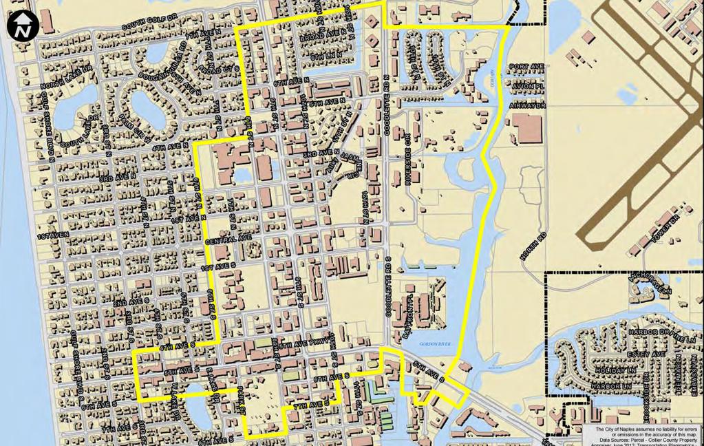
9 Preliminary Recommendations PAB/DRB (3/3/2017) 9 1. Change name to Midtown Design District. 2. Front Setbacks: Build-to-line 10 feet. 3. Establish Priority Streets and revise Standards for Building Design. 4. Use: Residential only on 10th Street N/S permitted instead of conditional among others. 5. Unit Sizes: Efficiency at 500 square feet but limit total amount allowed and create square footage for units with 3 or more bedrooms. 6. Expand Boundaries to the North, West and South and add additional units to the residential unit pool. 7. Create New Parking Pool for South Expansion. 8. Create a Workforce Housing Floating Zone. 9. Building Height - allow mezzanine 10. Parking: Standards and Surface Parking 11. Midtown Expedited Infill Development
10 Final Recommendations (4/5/2017) 10 Final Recommendations (16 total): 1. Create a Workforce Housing Floating Zone 2. Use: Residential only on 10th Street N/S permitted instead of conditional among others. 3. Clarify maximum density 4. Unit Sizes: Efficiency at 500 square feet but limit total amount allowed and create square footage for units with 3 or more bedrooms. 5. Front Setbacks: Minimum 10 feet maximum will vary. 6. Building Height 7. Update Site Design Standards 8. Update Building Design Standards
11 Final Recommendations (4/5/2017) 11 Final Recommendations (16 total): 9. Reduce auto repair access locations 10. Expand Boundaries to the North, West Central and South and add additional units to the residential unit pool 11. Create New Parking Pool for South Expansion 12. On-site Parking Standards 13. On-street Parking Standards 14. Public/Private Partnerships 15. Unity of Tile and Declaration in Lieu 16. Change district name to DN-Downtown Neighborhood District.


12 1. Workforce Housing Floating Zone 12 Floating Zones are Zoning Districts that are not pre-determined or fixed in advance on the Zoning Map. The zone floats over a specified area until the application is approved at which time the mapped district would be changed. Floating zones allow the City Council to enact new or different uses under certain circumstances and in certain geographic areas. While the boundaries of a floating zone are not fixed in advance, the uses authorized in the floating zone are defined in the zoning text of the zone. Provides flexibility for developers, who can use the zone to obtain density bonuses, height extensions, etc., in exchange for meeting other requirements or goals in the floating zone, such as workforce housing, complete streets, green building, etc. Floating zones can be used to plan for future land uses that are anticipated or desired in the community, but are not confirmed, including workforce housing.

13 1. Workforce Housing Floating Zone 13 Eligible Area: Core Area North: 6 th Avenue N South: US41/5 th Avenue East: Goodlette-Frank Road West: US41/9 th Avenue No minimum lot size Limited to residential use only Minimum unit size: efficiency, 500 square feet; one-bedroom, 700 square feet; two-bedroom, 900 square. feet; three bedrooms or greater, 200 SF per additional bedroom. Efficiency units may not exceed 33% of the total units.
14 1. Workforce Housing Floating Zone 14 Workforce Housing Targeted income 80%-140% of County Median (HUD 2016 Family Median): 1 Person Household 80% - $36, % - $55, % - 64,400
15 1. Workforce Housing Floating Zone 15 Density: o Up to 50 units/acre. Allocation Base density of 12 units per acre from Downtown pool. Additional units from Workforce Housing Unit Pool. oinitial allocation of 425 unit or 30% of original density pool. ono payment to open space fund for additional units. Of the additional units 30% shall be Workforce units. Workforce Efficiency Units shall count as.75 units
16 1. Workforce Housing Floating Zone 16 Height bonus (maximum of 2 floors) 1 floor if 20% of workforce units allocated to 80% median incomes. 2 floors if 50% of workforce units allocated to 80% median incomes. 2 floors if employer located ¼ mile from the site participates. 1 floors if employer located ½ mile from the site participates. Workforce units must be for those employed full-time within Collier County and would require income verification and annual certification. Units would reset upon moving out or at the time of sale Affordability requirement would be in perpetuity.
17 1. Workforce Housing Floating Zone 17 Example: Rezone to WHFZ 1 acre 50 units/acre 12 units (base) from Downtown Pool 38 units from Workforce Pool 30% of 38 units dedicated to 80%-140% = 12 units Development: 50 units; 38 Market Rate Units and 12 Workforce Units Up to 17 units (33%) may be efficiency units; no limitation on assignment of units. If 6 of the 12 workforce units are for 80% and below, 2 additional floors granted.
18 1. Workforce Housing Floating Zone 18 Potential Development Program 50 units on 1 Acre with height of 5 Floors Market Rate (38+2, see note below) 140% (Eff 1 person ($1,610/month or $3.22/SF) 80% (Eff 1 person $920/month or $1.84/SF) NOTE: Efficiency units for density count as.75 units. 12 workforce units required *.75 density count 9 units of the 50 permitted; 2 additional units may be allocated as market rate units.
19 2. Uses 19 Permitted Uses (Line 54) Plant nursery, as an accessory use Multifamily Residential-only building not fronting a Priority street, except 10 th Street. U.S. 41, Central Ave, 10th Street, or Goodlette-Frank Road. Outdoor Dining, see section Conditional Uses (Line 91) Auto rental (office only; no lots). Live/Work units Multifamily Residential-only building fronting a Primary street, except 10th Street. U.S. 41, Central Ave, 10th Street, or Goodlette-Frank Road. Townhome units. Veterinarians, no animal boarding.

.")
20 2. Uses: Residential Only on 10 th Street 20 Current Conditional Uses Residential only buildings fronting US 41, Central, 10th Street or Goodlette Frank Road Proposed Permitted Uses Residential only buildings not fronting a primary street, except 10 th Street. 10th Street from 6th Avenue North to US 41 Approx. 3,600 liner feet (less out ROW of cross avenues). Assuming 30 foot depths of commercial, both sides of the street - Approximately 216,000 SF of commercial space.
21 3. Density (Lines ) 21 Sec Maximum residential density (a) Generally Maximum density, residential. The maximum residential density in the downtown DN district is 12 dwelling units per acre, except as provided below. (1)(b) Core Area. The core area contains those parcels bounded by 5th Avenue South, 8th Street, 7th Avenue north, and Goodlette-Frank Road. (2) Outside the Core. Areas in the Downtown Mixed Use Land Use Category, but outside the boundaries of the Core shall not to exceed 12 units per acre from the downtown unit pool. (b) Maximum density, transient lodging. There is no maximum density for transient lodging facilities.
22 4. Unit Sizes (Lines ) 22 Sec Minimum dwelling unit size; multifamily a. Minimum size: efficiency, 500 square feet; one-bedroom, 700 square feet; two-bedroom, 900 square feet; three bedrooms or greater, 200 SF per additional bedroom. b. Efficiency units may not exceed 25% of the total units
 Proposed Front ROW Width (feet) Min. (feet) 60 10 15 70 10 20 80 10 20 100 10 25 Max.")
23 5. Building Setbacks (Lines ) 23 Current Front Setbacks (Min/Max) Zone A: Zone B: 10 Zone C: Zone D: Zone G: 50 (Goodlette-Frank Road Corridor Management Overlay) Proposed Front ROW Width (feet) Min. (feet) Max. (feet)
24 5. Building Setbacks 24 (2) Side yard. a. If adjacent to an alley, a ten 5-foot setback is required; otherwise, buildings may be placed on the side yard line or a minimum of ten feet from it 0. b. If adjacent to single family zoned property, a minimum ten-foot setback, is required inclusive of a five-foot landscaped strip. c. If adjacent to existing ROW, see subsection (1) above.
25 5. Building Setbacks 25 (3) Rear yard. a. If adjacent to an alley, a 5-foot setback is required. b. If adjacent to single family zoned property, a minimum ten-foot setback, i.e. not a build to line is required with inclusive of a five-foot landscaped strip; otherwise 0. c. If adjacent to existing ROW, see subsection (1) above.
26 5. Building Setbacks 26 (b) Setback Zones(Lines ) 1. Circulation Zone: If the existing sidewalk is less than 8 feet or the established width as part of an approved streetscape plan/design, the appropriate amount of area shall be established through an easement to extend the width of the sidewalk necessary. The area dedicated may be eligible for an open space credit. 2. Amenity Zone: The Amenity Zone is located between the back-of-sidewalk to the edge of the Activity Zone. The Amenity Zone is the section that is reserved for typical streetscape elements, such as street trees, benches, pedestrian lighting, furnishings, and bike racks. The minimum width of any Amenity Zone shall be 5 feet. Ninety percent (90%) of this zone shall contain landscape materials including those trees specified in subsection (b)(8). Street trees planted in landscaped areas, tree wells, or tree planters shall be located adjacent to the sidewalk and shall be a minimum of 5 feet in width.
27 5. Building Setbacks 27 (b) Setback Zones (Lines ) 3. Activity Zone: The Activity Zone shall be the area between the building facade to the edge of the amenity zone. The Activity Zone is typically reserved for activities that commonly occurring immediately adjacent to the building façade, such as outdoor seating, outdoor dining, window shopping, and outdoor sales. The minimum width of any Activity Zone shall be 3 feet. Where features such as arcades or entryways are part of the façade, the minimum width of the amenity zone may be reduced provided the arcade or gallery has a minimum depth of 8 feet. 4. Standards for paving materials shall be recommended by Design Review Board and approved by city council. (c) An increase in the setbacks may be required for pedestrian amenities, such as public plazas, pedestrian entries, outdoor dining areas and similar public use areas, or landscaping.
28 6. Maximum Building Height 28 Sec Maximum building height (Lines ) 1. Throughout the downtown DN district, the maximum height for any building, including residential, shall be limited to 3 stories floors and building heights of and 42 feet, measured from the 1stfloor FEMA elevation to the peak of the roof, measured from the first floor, FEMA elevation or the highest point of any appurtenance attached to the roof. 2. Mezzanines shall not be counted as a floor provided they do not exceed 30% of the ground floor, regardless if open or closed.
29 6. Maximum Building Height 29 Sec Maximum building height (Lines ) 3. Whenre a new commercial property or mixed use building is adjacent to, or across the street or alley from, property zoned residential, buildings at the street setback line to a depth of 50 feet cannot be higher than the height permitted in the residential zoninge district. 4. Exceptions, See section
30 7. Site Design Standards (Lines ) 30 (1) Establishes Primary and Secondary Streets Primary streets US 41 (9 th Street and 5 th Avenue) Goodlette-Frank Road Central Avenue 10 th Street
31 7. Site Design Standards (Lines ) Uses along frontage lines b. On corner p Propertiesy with a frontage line along one of the 4 commercial corridors (U.S. 41, Central Ave, 10th Street or Goodlette-Frank Road)a primary or secondary street, residential 1st floors are permitted beyond a depth of 50 feet from the building setback that frontage line. On corner property fronting 2 or more commercial corridors, residential 1st floors fronting the road require conditional use approval.
32 7. Site Design Standards (Lines ) Buildings shall have a principal pedestrian entrance on a primary frontage line. For residential only properties abutting an alley, vehicular access egress shall be provided from the alley rather than a frontage line.
33 7. Site Design Standards (Lines ) Underground and above-ground utilities. The following are applicable to all multi-dwelling and non-residential properties. a. All utilities including telephone, cable, and electrical systems shall be installed underground. b. All exterior facilities, including but not limited to electrical raceways and transformers, permitted above ground shall be fully concealed and screened.
34 7. Site Design Standards (Lines ) Service bays, mechanical equipment, garbage and delivery areas, shall be fully enclosed, screened or located within the interior of the building. These areas shall not be visible from the right-of-way and shall not be visible from properties with adjacent residential or hotel uses. Air conditioning shall be required for trash rooms.
35 8. Building Design Standards (Lines ) Building frontage requirement. a. Primary Streets. 100 percent of the lot frontage at the 1stfloor level, except for the required setback areas and building entry or access conditions, must be addressed either by building facade or referenced by use of porticos, arcades, or decorative walls to a minimum height of the 1st story. A minimum of 1/3 of the length must be building façade. Support columns may be located in the ground floor setback, provided their combined width does not exceed twenty-five percent (25%) of the linear dimension of the front building wall.
36 8. Building Design Standards (Lines ) Building frontage requirement. b. Secondary Streets. A minimum of seventy-five percent (75%) of the lot frontage at the 1st-floor level, except for the required setback areas and building entry or access conditions, must be addressed either by building facade or referenced by use of porticos, arcades, or decorative walls to a minimum height of the 1st story. A minimum of 1/3 of the length must be building façade. Support columns may be located in the ground floor setback, provided their combined width does not exceed twenty-five percent (25%) of the linear dimension of the front building wall. c. The requirements of this subsection shall not apply to automotive service stations where allowed, but the requirements of Sec shall apply.
37 8. Building Design Standards (Lines ) First floor uses. a. Primary and Secondary Streets. A minimum of seventy-five percent (75%) of the building front along a primary street for a depth of at least twenty (20) feet from the building front shall be occupied by an approved use. 3. Awnings, canopies, arcades. Awnings, canopies or arcades shall be required over all doors, windows and other transparent elements. The height of the awnings, canopies or arcades shall be between eight (8) feet and twelve (12) feet. The minimum depth of an awning or canopy shall be four (4) feet in depth. The minimum depth of an arcade shall be four (4) feet in depth. Such elements shall not be subject to the setback requirement.
38 8. Building Design Standards (Lines ) New materials. Additional materials may be permitted by review of the building official Design Review Board. 3. Maximum uninterrupted building length requirements. Where a building or a series of buildings form a continuous street wall that exceeds 150 feet in length, a via shall be provided at the ground floor if it connects to public parking, open space or plaza. The via shall be not less than 6 feet in width and not less than 10 feet in height. A via may be roofed and shall. A via shall be open to the public. A via qualifies as public open space if it is unroofed and open to the sky, at least 1,000 square feet in contiguous area and dedicated to the city.
39 8. Building Design Standards (Lines ) Minimum Parking Garage Standards a. Screening of ramps b. Screening of vehicles c. Pedestrian connection d. Architectural guidelines: 1. When a parking garage is provided for a principal structure on the same plot, the design of the parking garage shall complement and contain architectural features consistent with the principal structure, or 2. When a parking garage is the principal use on a plot, it shall be designed so that the uppermost parapet or roof of the parking garage contains elevational changes averaging at least three (3) feet in height and ten (10) feet in length every fifty (50) horizontal feet or less.
40 8. Building Design Standards (Lines ) Alternate Design. In lieu of strict application of this section, an applicant may propose an alternative design which satisfies the intent of providing air and light at the street level, subject to review and recommendation of the Design Review Board and approval by the City Council. 13. The provisions of this section shall not apply to structures in existence on the effective date (2017) unless such structures are voluntarily demolished by more than fifty percent (50%) of the total gross floor area of the building or more than fifty percent (50%) of its replacement value.
41 9. Auto Repair (Line 559) 41 Sec Specific requirements for auto repair shops. 4. No access to auto repair shops from 10th Street or U.S. 41 a primary street is permitted
 42 C2 C2-A Land")

42 10. Boundary Expansion (South) 42 C2 C2-A Land Use: Downtown Mixed Use Zoning: C2 & C2-A to Naples Midtown C2
 43 Land Use:")

43 10. Boundary Expansion (North) 43 Land Use: Commercial Highway to Downtown Mixed Use Zoning: C2 to Naples Midtown

44 10. Boundary Expansion (West) 44 Land Use: Residential Medium to Downtown Mixed Use Zoning: R3-12 to Naples Midtown Address Acreage Units Density 682 8th St. N th St. N th St. N th St. N th St. N TTL Source: Collier Property Appraiser
45 10. Boundary Expansion (West) 45 MF Housing SF Housing Address Acreage Improved Land Total 682 8th St. N th St. N 0.67 $ 1,048,722 $ 1,000,000 $ 2,048, th St. N 0.29 $ 128,886 $ 375,000 $ 503, th St. N 0.66 $ 943,734 $ 1,000,000 $ 1,943, th St. N 0.7 $ 904,057 $ 1,000,000 $ 1,904,057 TTL 2.69 $ 3,357,724 $ 3,875,000 $ 7,232,724 $ 1,440, Value per Acre 788 7th Ave N 0.22 $ 27,736 $ 1,013,040 $ 1,040, th St. N 0.22 $ 301,162 $ 1,013,040 $ 1,314, Broad Ct 0.25 $ 609,330 $ 1,069,320 $ 1,678, Broad Ct 0.25 $ 1,165,735 $ 1,069,320 $ 2,235, th St. N 0.22 $ 37,593 $ 1,013,040 $ 1,050, th St. N 0.22 $ 341,133 $ 1,013,040 $ 1,354,173 TTL 1.38 $ 2,482,689 $ 6,190,800 $ 8,673,489 $ 4,486, Value per Acre Source: Collier Property Appraiser


46 10. Boundary Expansion (Central) 46 Land Use: Residential Medium & Institutional to Downtown Mixed Use Zoning: R3T-12 to Naples Midtown

47 11. South Expansion Parking Pool 47 Create a separate pool for parking. Allow allocations from the 6th Avenue South parking garage. - Furthest point ¼ mile. Prohibit the purchase of on streets parking spaces to satisfy the on-site parking requirement.
48 12. On-site Parking (Lines ) 48 d. Transient lodging units: One and one quarter space per unit. g. Parking reduction: Any minimum required amount of parking may be reduced only upon issuance of a special permit from the City Council after review and recommendation by the Planning Advisory Board. For a project seeking a reduction in required off-street parking, a Parking Analysis shall be required as set forth in subsection (h).
49 12. On-site Parking (Lines ) 49 g. Parking reduction: Any minimum required amount of parking may be reduced only upon issuance of a special permit from the City Council after review and recommendation by the Planning Advisory Board. City Council determines that the lesser amount of parking will not cause excessive congestion, endanger public safety, substantially reduce parking availability for other uses or otherwise adversely impact the neighborhood, or that such lesser amount of parking will provide positive environmental or other benefits to the users of the lot and the neighborhood.
50 12. On-site Parking (Lines ) 50 g. Parking reduction: In making determination the City Council shall also consider whether or not less off street parking is reasonable in light of the following: 1. The availability of surplus off-street parking in the vicinity of the use being served. 2. Shared use of off street parking spaces serving other uses having peak user demands at different times, provided that no more than seventy-five (75) percent of the lesser minimum parking requirements for each use shall be satisfied with such shared spaces. The use of Shared Off Site Parking may be permitted.
51 12. On-site Parking (Lines ) 51 In making determination cont 3. Age or other occupancy restrictions which are likely to result in a lower level of auto usage. 4. Impact of the parking requirement on the physical environment of the affected lot or the adjacent lots including reduction in green space, destruction of significant existing trees and other vegetation, destruction of existing dwelling units, significant negative impact on the historic resources on the lot, impairment of the urban design objectives of the city, or loss of pedestrian amenities along public ways.
52 12. On-site Parking (Lines ) 52 In making determination cont 5. The provision of required parking for developments containing workforce/affordable housing units, and especially for developments employing the increased density for workforce housing, will increase the cost of the development, will require variance relief from other zoning requirements applicable to the development because of limitations of space on the lot, or will significantly diminish the environmental quality for all residents of the development. 6. The Institute of Transportation Engineers (ITE) Reference Manual entitled Parking Generation allows a lesser number of parking spaces for the proposed use or a use of similar characteristics.
53 12. On-site Parking (Lines ) 53 h. Parking Analysis: 1. The purpose of a Parking Analysis is to provide quantitative data to assist a special permit granting authority in considering certain projects. If the Institute of Transportation Engineers (ITE) Reference Manual entitled Parking Generation allows a lesser number of parking spaces for the proposed use or a use of similar characteristics, then the number of parking spaces required for a development may be reduced, including the use of a the ULI Shared Parking methodology.
54 12. On-site Parking (Lines ) 54 h. Parking Analysis: 5. With the intent of protecting the residential neighborhoods by lessening the impact of commercial parking into the neighborhoods, a Parking Management Program would be required to reduce demand for private automobile use, inclusive of car-sharing programs and/or incentives for residents or employees to walk, bicycle, or use alternative modes of transportation, and estimates of the anticipated impact of those measures on parking demand.
55 12. On-site Parking (Lines ) 55 Surface Parking (Lines ) Surface parking shall not be located within fifty (50) feet of Priority Streets except as provided in subsection (b)(5). Curbcuts providing access to parking areas shall be located on streets other than Priority streets or on alleys, except where a property only has access from a priority street, or it is determined based on a traffic study that access from a priority street is necessary for safe and efficient vehicular and pedestrian circulation.
 square feet in area; or c. Is located along 10th Street; need only provide a minimum of a twenty (20) foot setback from priority streets.")
56 12. On-site Parking (Lines ) 56 Surface Parking (Lines ) (5) Surface parking that is either: a. Less than one hundred twenty-five (125) feet in depth; or b. Less than ten thousand (10,000) square feet in area; or c. Is located along 10th Street; need only provide a minimum of a twenty (20) foot setback from priority streets. (6) Head-in Parking Prohibited


57 13. On-street Parking (Lines ) 57 Prohibit any new Perpendicular on-street parking. Incorporate standards instead for angled on-street parking
58 14. Public Private Partnerships 58 Public/Private Partnerships No consensus could be established for a public parking garage location. Rather that identify a site that may not be optimal, recommended that the CRA remain open to a public private partnership including a public parking garage. Market Study Conclusion 8. Parking is a critical element to redevelopment planning, particularly as it relates to revitalizing smaller parcels. Centralized parking garage can be a joint public/private effort; but, will require at least some level public subsidy Establish policies and procedures for Public/Private Partnerships in accordance with Florida Statutes, Section o Request for Proposals o Unsolicited Proposals Establish fee for review/cost recovery
59 15. Unity of Tile and Declaration in Lieu 59 Purpose When it is necessary that two (2) or more lots, parcels or portions thereof are added or joined, in whole or in part, a Unity of Title or Declaration of Restrictive Covenant in lieu of a Unity of Title shall be filed to ensure the properties are planned, developed and maintained as an integral development and/or project and are consistent with and satisfy the requirements of these regulations and the City Code of Ordinances.
60 15. Unity of Tile and Declaration in Lieu 60 Unity of Title As a prerequisite to the issuance of a building permit, the owner(s) in fee simple title shall submit a Unity of Title in recordable form to the Planning Department providing that all of the property encompassing the parcel proposed for development upon which the building and appurtenances are to be located shall be held together as one (1) tract of land and providing that no part or parcel shall be conveyed or mortgaged separate and apart from the parcel proposed for development.
61 15. Unity of Tile and Declaration in Lieu 61 Declaration of restrictive covenant in lieu of a Unity of Title In the case of separate but contiguous and abutting parcels proposed for development located in Commercial, Mixed-Use or Industrial Districts owned by one (1) separate or multiple owners wishing to use said property as one (1) parcel, the Planning Director may approve a Declaration of Restrictive Covenant in Lieu of a Unity of Title together with a Reciprocal Easement and Operating Agreement approved for legal form and sufficiency by the City Attorney.
62 16. District Name Change 62 D-Downton District be changed to Downtown Neighborhood District (DN). Given the success of the 5th Avenue South Overlay and that area serving as more of the downtown it is recommended that Downtown Zoning be changed. Initial recommendation to Naples Midtown District. Preliminary recommendation of Midtown Design District. PAB/DRB recommendation of Downtown Neighborhood District


63 Questions & Comments D-Downtown District Analysis 63
DT Downtown. a) Intent. The "downtown (DT) district" is designed for the commercial core of Lake Worth, primarily along Lake and Lucerne Avenues from
 Intent. The downtown (DT) district is designed for the commercial core of Lake Worth, primarily along Lake and Lucerne Avenues from") DT Downtown. a) Intent. The "downtown (DT) district" is designed for the commercial core of Lake Worth, primarily along Lake and Lucerne Avenues from Golfview to the Florida East Coast Railroad right-of-way.
DT Downtown. a) Intent. The "downtown (DT) district" is designed for the commercial core of Lake Worth, primarily along Lake and Lucerne Avenues from Golfview to the Florida East Coast Railroad right-of-way.
ARTICLE 4: SCHEDULE OF DISTRICT, USE AND SETBACK REGULATIONS
 Page 1 of 48 City of Hollywood Zoning and Land Development Regulations 4.6.I Beach Community Redevelopment Districts. 1. Purpose. To establish development standards for the Beach Community Redevelopment
City of Fraser Residential Zoning District
 City of Fraser Residential Zoning District The one-family districts are established to provide principally for one-family dwellings at varying densities. The specific interest of these districts is to
PD No. 15 Authorized Hearing
 PD No. 15 Authorized Hearing Community Meeting No. 2 February 19, 2019 6:30 p.m. Hyer Elementary School Cafetorium 8385 Durham St Andrew Ruegg Senior Planner PD No. 15 Authorized Hearing On September 7,
FOR SALE > MULTIFAMILY/COMMERCIAL REDEVELOPMENT OPPORTUNITY
 FOR SALE > MULTIFAMILY/COMMERCIAL REDEVELOPMENT OPPORTUNITY 2220 W. Cary Street RICHMOND, VA 23220 CURRENT PROPERTY ILLUSTRATION CONCEPTUAL ONLY (NOT PROPOSED) Property Information Zoning: R-63, Multifamily
Composition of traditional residential corridors.
 Page 1 of 7 St. Petersburg, Florida, Code of Ordinances >> PART II - ST. PETERSBURG CITY CODE >> Chapter 16 - LAND DEVELOPMENT REGULATIONS >> SECTION 16.20.060. CORRIDOR RESIDENTIAL TRADITIONAL DISTRICTS
The Philadelphia Code. In order to be eligible for any floor area bonuses pursuant to this section:
 1 of 16 2/17/2015 2:47 PM The Philadelphia Code 14-702. Floor Area and Height Bonuses. 225.1 (1) Purpose. The intent of the floor area bonus provisions is to encourage certain types of development and
Technology Park Planned Unit Development Technology Park PUD-IP
 Technology Park Planned Unit Development Technology Park PUD-IP Rob Anderson Community Development Director Planned Unit Development Background 2 Planned Unit Development (PUD) means a mixed use redevelopment
CAN TRADITIONAL ZONING ACHIEVE OUR GOALS FOR DOWNTOWN ANN ARBOR?
 TRADITIONAL ZONING TRADITIONAL ZONING CAN TRADITIONAL ZONING ACHIEVE OUR GOALS FOR DOWNTOWN ANN ARBOR? A dense, mixed use core with flexible land uses A range of housing types and costs A walkable, pedestrian-oriented
DEVELOPMENT STANDARDS FOR RESIDENTIAL PROJECTS RESIDENTIAL BUILDING TYPES: APPROPRIATE ZONES AND DENSITIES 2-1
 2 DEVELOPMENT STANDARDS FOR RESIDENTIAL PROJECTS RESIDENTIAL BUILDING TYPES: APPROPRIATE ZONES AND DENSITIES 2-1 This Chapter presents the development standards for residential projects. Section 2.1 discusses
R3 (MULTIPLE-FAMILY RESIDENCE)
") Planning and Building Agency Planning Division 20 Civic Center Plaza P.O. Box 1988 (M-20) Santa Ana, CA 92702 (714) 647-5804 R3 (MULTIPLE-FAMILY RESIDENCE) Sec. 41-258. Sec. 41-258.5. Sec. 41-259. Purpose.
Planning and Building Agency Planning Division 20 Civic Center Plaza P.O. Box 1988 (M-20) Santa Ana, CA 92702 (714) 647-5804 R3 (MULTIPLE-FAMILY RESIDENCE) Sec. 41-258. Sec. 41-258.5. Sec. 41-259. Purpose.
Goal 1 - Retain and enhance Cherry Creek North s unique physical character.
 Introduction This document summarizes the proposed new zoning for the area of roughly bordered by University Boulevard, Steele Street, 3rd Avenue, and 1st Avenue. It provides a high-level review of the
4 DEVELOPMENT STANDARDS FOR
 4 DEVELOPMENT STANDARDS FOR RESIDENTIAL MIXED-USE PROJECTS This chapter presents standards for residential mixed-use projects in the Ashland-Cherryland Business District and the Castro Valley Central Business
DRAFT -- PROPOSED EXPANSION AND REVISIONS TO DIVISION 24. SPECIAL DISTRICT--COLLEGE AND UNIVERSITY NEIGHBORHOODS DISTRICT
 DRAFT -- PROPOSED EXPANSION AND REVISIONS TO DIVISION 24. SPECIAL DISTRICT--COLLEGE AND UNIVERSITY NEIGHBORHOODS DISTRICT Sec. 28-831. Purpose. The college and university neighborhoods district purposes
a. To insure compatible relationships between land use activities;
 PART B SECTION VIII INSTITUTIONAL DISTRICTS Article 1 Planned Institutional District 1. Purpose and Intent: It is the purpose and intent of this district to permit and encourage the orderly, cooperative
Coding For Places People Love Main Street Corridor District
 Coding For Places People Love Main Street Corridor District 1) Scope a) District boundaries are assigned according to the District Boundary Map. b) The Primary Retail Corridor is assigned according to
PD No. 15 Authorized Hearing Steering Committee Meeting #11
 PD No. 15 Authorized Hearing Steering Committee Meeting #11 January 7, 2019 Andrew Ruegg, Senior Planner Sustainable Development and Construction City of Dallas Staff Recommendation Steering committee
The Philadelphia Code. Table : Commercial and Commercial Mixed-Use Districts {For a printable PDF version, click HERE}
 1 of 19 2/17/2015 2:48 PM The Philadelphia Code 14-402. Commercial and Commercial Mixed-Use Districts. (1) General. (a) Districts. (.1) List. The City s Commercial and Commercial Mixed-Use zoning districts
HOUSING ELEMENT I. GOALS, OBJECTIVES AND POLICIES
 HOUSING ELEMENT I. GOALS, OBJECTIVES AND POLICIES GOAL 1: IN ORDER TO ACHIEVE A BALANCED HOUSING SUPPLY (AND A BALANCED POPULATION AND ECONOMIC BASE), EVERY EFFORT SHOULD BE MADE TO PROVIDE A BROAD RANGE
City of Coral Gables Planning and Zoning Staff Report
 City of Coral Gables Planning and Zoning Staff Report Applicant: Application: Public Hearing: Date & Time: Location: City of Coral Gables Zoning Code Text Amendment Giralda Plaza Overlay District Planning
THE CITY COUNCIL OF NORTH ROYALTON, OHIO
 THE CITY COUNCIL OF NORTH ROYALTON, OHIO ORDINANCE NO. 16-113 INTRODUCED BY: Nickell, Kasaris, Antoskiewicz AN ORDINANCE AMENDING THE CODIFIED ORDINANCES OF THE CITY OF NORTH ROYALTON, PART 12 PLANNING
DEVELOPMENT DEPARTMENT STAFF REPORT THE PARK AT 5 TH
 DEVELOPMENT DEPARTMENT STAFF REPORT ARB Meeting Date: July 3, 2018 Item #: _PZ2018-293_ THE PARK AT 5 TH Request: Site Address: Project Name: Parcel Number: Applicant: Proposed Development: Current Zoning:
COMMISSION ACTION FORM SUBJECT: ZONING TEXT AMENDMENT FOR LINCOLN WAY CORRIDOR PLAN DOWNTOWN GATEWAY COMMERCIAL ZONING DISTRICT STANDARDS
 ITEM #: 7 DATE: _02-07-18 COMMISSION ACTION FORM SUBJECT: ZONING TEXT AMENDMENT FOR LINCOLN WAY CORRIDOR PLAN DOWNTOWN GATEWAY COMMERCIAL ZONING DISTRICT STANDARDS BACKGROUND: The Downtown Gateway area
Article 7: Residential Land Use and Development Requirements
 Article 7: Residential Land Use and Section 701: Statement of Intent (A) (B) (C) The intent of Article 7 is to develop certain land use and development requirements for the residential uses within Cumru
Chapter DOWNTOWN ZONING DISTRICTS
 Chapter 20.14 Sections: 20.14.010 Purpose of the Downtown Zoning Districts 20.14.020 Land Use Regulations for Downtown Zoning Districts 20.14.030 Development Standards for Downtown Zoning Districts 20.14.010
Anacortes, WA. 718 commercial ave. FOR lease. 2,320 +/- sf retail space in a 10,820 +/- sf building. Located in historic downtown Anacortes
 718 commercial ave Anacortes, WA FOR lease 2,320 +/- sf retail space in a 10,820 +/- sf building Located in historic downtown Anacortes Frontage on Commercial Ave alongside four other retail spaces Zoned
SECTION 822 "R-1-A" AND "R-1-AH" - SINGLE FAMILY RESIDENTIAL DISTRICTS
 SECTION 822 "R-1-A" AND "R-1-AH" - SINGLE FAMILY RESIDENTIAL DISTRICTS The "R-1-A" and "R-1-AH" Districts are intended to provide for the development of single family residential homes at urban standards
Article Optional Method Requirements
 Article 59-6. Optional Method Requirements [DIV. 6.1. MPDU DEVELOPMENT IN RURAL RESIDENTIAL AND RESIDENTIAL ZONES Sec. 6.1.1. General Requirements... 6 2 Sec. 6.1.2. General Site and Building Type Mix...
Sedro woolley, WA 720 MURDOCK ST. FOR sale. 14,500 +/- sf office building with 8,500 +/- sf unfinished basement space on 0.
 720 MURDOCK ST Sedro woolley, WA FOR sale 14,500 +/- sf office building with 8,500 +/- sf unfinished basement space on 0.27 +/- AC Former City Hall built in 1930 Located in the Downtown Sedro Woolley core
Chapter CC COMMUNITY COMMERCIAL ZONES REGULATIONS
 Effective April 14, 2011 Chapter 17.35 CC COMMUNITY COMMERCIAL ZONES REGULATIONS SECTIONS: 17.35.010 Title, Intent, and Description 17.35.020 Required Design Review Process 17.35.030 Permitted and Conditionally
Bunker Hill Part II Urban Design. Specific Plan. Case No. CPC SP TABLE OF CONTENTS
 Bunker Hill Part II Urban Design Specific Plan Case No. CPC-2011-684-SP TABLE OF CONTENTS Section 1. Section 2. Section 3. Section 4. Section 5. Section 6. Section 7. Section 8. Section 9. Section 10.
AMENDED ZONING BY-LAW ARTICLE SENIOR LIVING COMMUNITY
 AMENDED ZONING BY-LAW ARTICLE 13.5 - SENIOR LIVING COMMUNITY ARTICLE : To see if the Town will vote to amend the Zoning Bylaw as follows: 2. By deleting existing Section 13.5, Senior Living Community,
CHAPTER 40R LOCAL ZONING BYLAW GUIDANCE DOCUMENT
 CHAPTER 40R LOCAL ZONING BYLAW GUIDANCE DOCUMENT OVERVIEW This document has been developed by the Department of Housing and Community Development (DHCD, or the Department) to assist communities in drafting
Permitted uses. Adult congregate living facility. Ambulance service. Animal clinics (outpatient care only and no overnight boarding)
") B-3, HIGHWAY SERVICE BUSINESS DISTRICT Intent. The B-3, Highway Service Business District is intended for application along highways carrying large volumes of traffic where establishments may locate to
B-3, HIGHWAY SERVICE BUSINESS DISTRICT Intent. The B-3, Highway Service Business District is intended for application along highways carrying large volumes of traffic where establishments may locate to
ARTICLE 887. PD 887. Valley View - Galleria Area Special Purpose District
 ARTICLE 887. PD 887. Valley View - Galleria Area Special Purpose District SEC. 51P-887.101. LEGISLATIVE HISTORY. PD 887 was established by Ordinance No. 29032, passed by the Dallas City Council on June
Parking Challenges and Trade-Offs
 Parking Challenges and Trade-Offs What is the best way to balance competing interests and priorities while updating the City s off street parking regulations? Updating off street parking regulations can
DIVISION 7. R-6 AND R-6A RESIDENTIAL ZONES* The purpose of the R-6 residential zone is:
 Date of Draft: March 6, 2015 DIVISION 7. R-6 AND R-6A RESIDENTIAL ZONES* Sec. 14-135. Purpose. The purpose of the R-6 residential zone is: (a) To set aside areas on the peninsula for housing characterized
DEVELOPMENT DEPARTMENT STAFF REPORT STAFF REPORT DRESDEN DRIVE TOWNHOMES DCI
 DEVELOPMENT DEPARTMENT STAFF REPORT Meeting Date: September 13, 2018 Item #: PZ2018-319 STAFF REPORT DRESDEN DRIVE TOWNHOMES DCI Request: Project Name: Development of Community Compact (DCI) and six concurrent
PERMITTED USES: Within the MX-1 Mixed Use Neighborhood District the following uses are permitted:
 6.25 MX-1 - MIXED USE NEIGHBORHOOD 6.25.1 INTENT: The purpose of the MX-1 Mixed Use Neighborhood District is to accommodate the development of a wide-range of residential and compatible non-residential
CITY OF NAPLES STAFF REPORT
 Meeting of 05/13/15 Conditional Use Petition 15-CU3 CITY OF NAPLES STAFF REPORT To: Planning Advisory Board From: Planning Department Subject: Conditional Use Petition 15-CU3 Petitioner: Hazelden Betty
Cluster Development Princeton Township, Mercer County
 Cluster Development Princeton Township, Mercer County Division 9 Residential Clusters Section 10B-189 Statement of purposes. The township committee to implement the goals and objectives of the Princeton
ORDINANCE NO. O-5-10
 ORDINANCE NO. O-5-10 AN ORDINANCE OF THE TOWN COMMISSION OF THE TOWN OF PALM BEACH SHORES, FLORIDA, AMENDING THE TOWN CODE OF ORDINANCES AT APPENDIX A. ZONING. SECTION VI. DISTRICT B REGULATIONS BY AMENDING
Article 50: Business Zones
 ARTICLE 50, Use Regulations Controlling Business Zones [Added effective 7-25-1955] 118-500. East Avenue Village District. [Amended effective 7-25-1955; 9-13-1955; 11-10-1966; 12-11-1975; 7-15-1976; 5-16-1980;
THE PEOPLE OF THE CITY OF LOS ANGELES DO HEREBY ORDAIN AS FOLLOWS:
 ORDINANCE NO. 184271 An ordinance amending Ordinance No. 173,749, the Vermont/Western Transit Oriented District Specific Plan (Station Neighborhood Area Plan) to create a new Subarea F. THE PEOPLE OF THE
Article 80 Small Project Review Application
 Article 80 Small Project Review Application 233 Hancock Street Dorchester, MA 02125 01 Contents Project Summary Project Team 04 Project Summary 05 Community Benefits 05 Detailed Project Information Project
. \. structure. portion of a. yard setback. in height. for that. above 45 ft. structure above. 20-ft. front. 2, additional.
 Z089-254(RB) E-1 REGULATIONS Front Yard YARD, LOT, AND SPACE 00. \.,, Max.-6Oft. Mm. 15 ft. maximum front yard right-of-ways other way is dedicated existing Ft. Worth ft. from Ft. Worth Ave. or rights
ARTICLE SCHEDULE OF REGULATIONS
 ARTICLE 21.00 SCHEDULE OF REGULATIONS FOOTNOTES TO ARTICLE 21.00 SCHEDULE OF REGULATIONS a. If one or both public sanitary sewers and/or public water supply are not available minimum lot size shall be
UPPER DUBLIN TOWNSHIP MONTGOMERY COUNTY, PENNSYLVANIA ORDINANCE NO. -J3.7 6
 UPPER DUBLIN TOWNSHIP MONTGOMERY COUNTY, PENNSYLVANIA ORDINANCE NO. -J3.7 6 AN ORDINANCE AMENDING CHAPTER 255 (ZONING) OF THE UPPER DUBLIN TOWNSHIP CODE OF ORDINANCES TO ALLOW A MIXED USE DEVELOPMENT AS
May 12, Chapter RH HILLSIDE RESIDENTIAL ZONES REGULATIONS Sections:
 May 12, 2017 Chapter 17.13 RH HILLSIDE RESIDENTIAL ZONES REGULATIONS Sections: 17.13.010 Title, intent, and description. 17.13.020 Required design review process. 17.13.030 Permitted and conditionally
Section 1: US 19 Overlay District
 Section 1: US 19 Overlay District Section 1.1 Intent and Purpose The purpose of the US Highway 19 Overlay District is to manage access to land development along US Highway 19 in a manner that preserves
Part 4.0 DEVELOPMENT REGULATIONS
 M A I N S T R E E T N O R T H Part 4.0 DEVELOPMENT REGULATIONS 4.1 Districts 4.2 Permitted and Prohibited Uses, Standards and Standard Specific Criteria and Other General Provisions 4.3 DPS REGULATIONS
ORDINANCE NO
 AN ORDINANCE OF THE CITY OF SANTA CRUZ AMENDING TITLE 24 OF THE SANTA CRUZ MUNICIPAL CODE, THE ZONING ORDINANCE, BY AMENDING CHAPTER 24.16 PART 3, DENSITY BONUS PROVISIONS FOR RESIDENTIAL UNITS BE IT ORDAINED
DEVELOPMENT DEPARTMENT STAFF REPORT STAFF REPORT MCDONALD S ZONING MAP AMENDMENT AND CONCURRENT VARIANCES
 DEVELOPMENT DEPARTMENT STAFF REPORT Meeting Date: October 12, 2017 Item #: _PZ2017-172_ STAFF REPORT MCDONALD S ZONING MAP AMENDMENT AND CONCURRENT VARIANCES Request: Rezone property from MU-BC to CC,
TRANSIT-ORIENTED DEVELOPMENT PLAN EXISTING CONDITIONS REPORT LAWRENCE TO BRYN MAWR MODERNIZATION
 TRANSIT-ORIENTED DEVELOPMENT PLAN EXISTING CONDITIONS REPORT LAWRENCE TO BRYN MAWR MODERNIZATION March 2018- FINAL DRAFT SITE SPECIFIC DEVELOPMENT CONCEPTS SITE SPECIFIC DEVELOPMENT CONCEPTS This report
PEDESTRIAN OVERLAY DISTRICT. November 6, 2013 Charlotte-Mecklenburg Planning Department
 Midtown Morehead Cherry PEDESTRIAN OVERLAY DISTRICT November 6, 2013 Charlotte-Mecklenburg Planning Department Meeting Purpose To provide a background on the Pedestrian Overlay District Zoning text amendment
Chapter CN NEIGHBORHOOD CENTER COMMERCIAL ZONES REGULATIONS
 Chapter 17.33 - CN NEIGHBORHOOD CENTER COMMERCIAL ZONES REGULATIONS Sections: 17.33.010 - Title, intent, and description. 17.33.020 - Required design review process. 17.33.030 - Permitted and conditionally
Indicates Council-recommended changes Introduced by: Mr. Tackett Date of introduction: June 14, 2016 SUBSTITUTE NO. 1 TO ORDINANCE NO.
 Indicates Council-recommended changes Introduced by: Mr. Tackett Date of introduction: June 14, 2016 SUBSTITUTE NO. 1 TO ORDINANCE NO. 16-067 TO AMEND NEW CASTLE COUNTY CODE CHAPTER 40 (ALSO KNOWN AS THE
Development Standards
 Chapter 8.0 Development Standards provides detailed regulations for new residential development within the specific plan area. The standards are intended to ensure that new residential development will
PARRAMORE OAKS FRAMEWORK PLANNED DEVELOPMENT
 PARRAMORE OAKS FRAMEWORK PLANNED DEVELOPMENT Presented by Mark Cechman, AICP Paul S. Lewis, FAICP Review Process Pre- Application meeting August 11, 2016 Attended by representatives of: City Planning Transportation
Industrial Warehouse Space
 FOR LEASE $6.50/psf Property Details PRICE $6.50/sf PARCEL ID 2410-344-0003-000-3 BUILDING SIZE 8,190 sf A great opportunity to lease an 8,190 sf industrial warehouse property located on the corner of
ARTICLE ZONING DISTRICTS AND OFFICIAL MAP SEC SUPPLEMENTAL AREA, YARD AND HEIGHT RESTRICTIONS.
 SEC. 27-310. SUPPLEMENTAL AREA, YARD AND HEIGHT RESTRICTIONS. The following requirements provide exceptions or qualify and supplement the specific district regulations set forth in this part. Planned developments
DEVELOPMENT DEPARTMENT STAFF REPORT STAFF REPORT VARIANCE AND WAIVER THE ROSALYNN APARTMENTS
 DEVELOPMENT DEPARTMENT STAFF REPORT Meeting Date: September 14, 2017 Item #: _PZ-2017-153_ STAFF REPORT VARIANCE AND WAIVER THE ROSALYNN APARTMENTS Request: Variance and Waiver Project Name: The Rosalynn
DAVIDSON PLANNING ORDINANCE AMENDMENTS AFTER SEPTEMBER 2009 SECTION 9
 AMENDMENT ADOPTED 6/12/2012 Section 9.1.3.3.1 Wall Murals Entire Section Added: 9.1.3.3.1 Wall Murals DAVIDSON PLANNING ORDINANCE AMENDMENTS AFTER SEPTEMBER 2009 SECTION 9 Exterior wall murals are only
ARTICLE OPTIONAL METHOD REGULATIONS
 ARTICLE 59-6. OPTIONAL METHOD REGULATIONS DIV. 6.1. MPDU DEVELOPMENT IN RURAL RESIDENTIAL AND RESIDENTIAL ZONES SEC. 6.1.1. GENERAL REQUIREMENTS... 6 2 SEC. 6.1.2. GENERAL SITE AND BUILDING T PE MIX...
a. provide for the continuation of collector streets and thoroughfare streets between adjacent subdivisions;
 Section 7.07. Intent The requirements of this Section are intended to provide for the orderly growth of the Town of Holly Springs and its extra-territorial jurisdiction by establishing guidelines for:
Montreal Road District Secondary Plan [Amendment #127, October 9, 2013]
![Montreal Road District Secondary Plan [Amendment #127, October 9, 2013]](/thumbs/72/66783104.jpg "Montreal Road District Secondary Plan [Amendment #127, October 9, 2013]") [Amendment #127, October 9, 2013] 1.0 General The following policies are applicable to the Montreal Road District as set out in Schedule 1. 1.1 District Objectives The objective of this Plan is to guide
[Amendment #127, October 9, 2013] 1.0 General The following policies are applicable to the Montreal Road District as set out in Schedule 1. 1.1 District Objectives The objective of this Plan is to guide
Cover Letter with Narrative Statement
 Cover Letter with Narrative Statement March 31, 2017 rev July 27, 2017 RE: Rushton Pointe Residential Planned Unit Development Application for Public Hearing for RPUD Rezone PL2015 000 0306 Mr. Eric Johnson,
ARTICLE 12 PLANNED UNIT DEVELOPMENT DISTRICTS (PUDS) Sec Intent CHARTER TOWNSHIP OF BRIGHTON ZONING ORDINANCE
 Sec Intent CHARTER TOWNSHIP OF BRIGHTON ZONING ORDINANCE") ARTICLE 12 PLANNED UNIT DEVELOPMENT DISTRICTS (PUDS) Sec. 12-01 Intent 1 2 (a) The intent of this Article is to permit the coordinated development on larger sites, protect significant natural features
ARTICLE 12 PLANNED UNIT DEVELOPMENT DISTRICTS (PUDS) Sec. 12-01 Intent 1 2 (a) The intent of this Article is to permit the coordinated development on larger sites, protect significant natural features
LITTLE MOUNTAIN ADJACENT AREA REZONING POLICY
 LITTLE MOUNTAIN ADJACENT AREA REZONING POLICY JANUARY 2013 CONTENTS 1.0 INTENT & PRINCIPLES...1 2.0 APPLICATION...2 3.0 HOUSING TYPES, HEIGHT & DENSITY POLICIES...3 3.1 LOW TO MID-RISE APARTMENT POLICIES...4
RM-3 District Schedule
 District Schedule 1 Intent The intent of this Schedule is to permit medium density residential development, including high-rise apartment buildings, and to secure a higher quality of parking, open space
RM-5, RM-5A, RM-5B, RM-5C and RM-5D Districts Schedule
 Districts Schedule 1 Intent The intent of this Schedule is to permit a variety of residential developments and some compatible retail, office, service and institutional uses. Emphasis is placed on achieving
ARTICLE III: LAND USE DISTRICTS 304 R 9 DISTRICT
 ARTICLE III: LAND USE DISTRICTS III 23 304 R 9 DISTRICT (RESIDENTIAL 9 UNITS PER ACRE) 304 1 Intent and Purpose The R 9 District is intended to implement the policies of the Comprehensive Plan for areas
PUD Zoning Framework
 PUD Zoning Framework PUD Zoning Framework Purpose Development Review Process Site Plan Review Process Planned Unit Developments (PUD) are tools for dealing with special situations or accomplishing certain
4.2 RESIDENTIAL ZONING DISTRICTS
 4.2 RESIDENTIAL ZONING DISTRICTS A. Purpose: To define regulations and standards for each residential zoning district in the City. The following sections identify uses, regulations, and performance standards
BOROUGH OF HOPATCONG ORDINANCE No
 BOROUGH OF HOPATCONG ORDINANCE No. 10-2014 AN ORDINANCE OF THE BOROUGH OF HOPATCONG, SUSSEX COUNTY, NEW JERSEY TO ADOPT A FORM BASED CODE AS AN OVERLAY DISTRICT AFFECTING PORTIONS OF THE B-1 AND R-1 ZONING
DEVELOPMENT DEPARTMENT STAFF REPORT STAFF REPORT EASTSIDE CHAMBLEE LINK DCI
 DEVELOPMENT DEPARTMENT STAFF REPORT Public Hearing Date: April 12, 2018 Item #: PZ-2018-248 STAFF REPORT EASTSIDE CHAMBLEE LINK DCI Request: Development of Community Compact (DCI), ten concurrent variances,
INCENTIVE POLICY FOR AFFORDABLE HOUSING
 INCENTIVE POLICY FOR AFFORDABLE HOUSING PREPARED BY: CITY OF FLAGSTAFF S HOUSING SECTION COMMUNITY DEVELOPMENT DIVISION OCTOBER 2009 2 1 1 W e s t A s p e n A v e. t e l e p h o n e : 9 2 8. 7 7 9. 7 6
PLANNED UNIT DEVELOPMENTS (Ordinance No.: 3036, 12/3/07; Repealed & Replaced by Ordinance No.: 4166, 10/15/12)
") 159.62 PLANNED UNIT DEVELOPMENTS (Ordinance No.: 3036, 12/3/07; Repealed & Replaced by Ordinance No.: 4166, 10/15/12) A. PURPOSE 1. General. The Planned Unit Development (PUD) approach provides the flexibility
159.62 PLANNED UNIT DEVELOPMENTS (Ordinance No.: 3036, 12/3/07; Repealed & Replaced by Ordinance No.: 4166, 10/15/12) A. PURPOSE 1. General. The Planned Unit Development (PUD) approach provides the flexibility
ARTICLE 878. PD 878.
 ARTICLE 878. PD 878. SEC. 51P-878.101. LEGISLATIVE HISTORY. PD 878 was established by Ordinance No. 28924, passed by the Dallas City Council on February 27, 2013. SEC. 51P-878.102. PROPERTY LOCATION AND
Section 1. Appendix A, "Zoning" of the Code of the City of Charlotte is hereby amended as follows:
 Petition No. 2009-078 Petitioner: Charlotte-Mecklenburg Planning Commission ORDINANCE NO. AN ORDINANCE AMENDING APPENDIX A OF THE CITY CODE ZONING ORDINANCE Revised 12-10-09 BE IT ORDAINED BY THE CITY
Oak Cliff Gateway District PD 468
 Oak Cliff Gateway District PD 468 August 21, 2014 2013 Authorized Hearing Authorized Hearing September, 2013 September 12, 2013 City Plan Commission expanded boundaries to represent current Oak Cliff Gateway
ARTICLE 909. PD 909. PD 909 was established by Ordinance No , passed by the Dallas City Council on April 23, (Ord.
 ARTICLE 909. PD 909. SEC. 51P-909.101. LEGISLATIVE HISTORY. PD 909 was established by Ordinance No. 29330, passed by the Dallas City Council on April 23, 2014. (Ord. SEC. 51P-909.102. PROPERTY LOCATION
Transit Oriented Communities Affordable Housing Incentive Program Guidelines (TOC Guidelines)
") Transit Oriented Communities Affordable Housing Incentive Program Guidelines (TOC Guidelines) Implementing Section 6 of Measure JJJ, approved by the voters in November 2016, and added to Los Angeles Municipal
Transit Oriented Communities Affordable Housing Incentive Program Guidelines (TOC Guidelines) Implementing Section 6 of Measure JJJ, approved by the voters in November 2016, and added to Los Angeles Municipal
8.5.1 R1, Single Detached Residential District
 8.5.1 R1, Single Detached Residential District The purpose of this district is to provide for residential development in the form of single detached dwellings. Dwelling, Single Detached Home Business,
PLANNING COMMISSION REPORT Regular Agenda -Public Hearing Item
 PDP-13-00518 Item No. 3B- 1 PLANNING COMMISSION REPORT Regular Agenda -Public Hearing Item PC Staff Report 2/24/14 ITEM NO. 3B PRELIMINARY DEVELOPMENT PLAN FOR HERE @ KANSAS; 1101 INDIANA ST (SLD) PDP-13-00518:
Chair to close public hearing. Review Deadline: 60 Days: 8/18/ Days: 10/17/2017
 Planning Commission Meeting Date: July 19, 2017 Agenda Item 3A 3A The Elmwood Major Amendment to Section 36-268-PUD 8 Case No.: Location: Applicant: Owner: Recommended Action: 17-21-PUD 5605 West 36 th
City Avenue District Rezoning. Regional Center Area & Bala Cynwyd Retail District December 14, 2011 Public Hearing
 City Avenue District Rezoning Regional Center Area & Bala Cynwyd Retail District December 14, 2011 Public Hearing Board of Commissioners Agenda Public Hearings An Ordinance to create The City Avenue District,
From Policy to Reality
 From Policy to Reality Updated ^ Model Ordinances for Sustainable Development 2000 Environmental Quality Board 2008 Minnesota Pollution Control Agency Funded by a Minnesota Pollution Control Agency Sustainable
ORDINANCE NO The Town Council of the Town of Yucca Valley does ordain as follows:
 ORDINANCE NO. 141 AN ORDINANCE OF THE TOWN COUNCIL OF THE TOWN OF YUCCA VALLEY, CALIFORNIA, AMENDING TITLE 8, DIVISION 12, CHAPTER 1 RELATING TO DEFINITIONS AND TITLE 8, DIVISION 8, CHAPTER 3, RELATING
2015 Downtown Parking Study
 2015 Downtown Parking Study City of Linden Genesee County, Michigan November 2015 Prepared by: City of Linden Downtown Development Authority 132 E. Broad Street Linden, MI 48451 www.lindenmi.us Table of
** If your lot does not meet the requirements above, please read Sec below
 Sec. 13-1-60 Zoning District Dimensional Requirements. For the Zoning Dept To Issue a Land Use Permit The Following Dimensions are Required. Minimum Side and Rear Yards s Lakes Classification Minimum Class
ARTICLE C. ZONING TEXT, DISTRICT CLASSIFICATIONS AND BOUNDARIES
 ARTICLE C. ZONING TEXT, DISTRICT CLASSIFICATIONS AND BOUNDARIES Sec. 10-2054. ZONING TEXT, DISTRICT CLASSIFICATIONS AND BOUNDARIES. In order to regulate the location of structures, the height and bulk
Bylaw No , being "Official Community Plan Bylaw, 2016" Schedule "A" DRAFT
 Bylaw No. 2600-2016, being "Official Community Plan Bylaw, 2016" Schedule "A" Urban Structure + Growth Plan Urban Structure Land use and growth management are among the most powerful policy tools at the
density framework ILLUSTRATION 3: DENSITY (4:1 FSR) EXPRESSED THROUGH BUILT FORM Example 1
 EXPRESSED THROUGH BUILT FORM Example 1") density framework 4 ILLUSTRATION 3: DENSITY (4:1 FSR) EXPRESSED THROUGH BUILT FORM INTRODUCTION The Downtown Core Area contains a broad range of building forms within its relatively compact area. These
density framework 4 ILLUSTRATION 3: DENSITY (4:1 FSR) EXPRESSED THROUGH BUILT FORM INTRODUCTION The Downtown Core Area contains a broad range of building forms within its relatively compact area. These
PLANNED UNIT DEVELOPMENT (PUD)
") SECTION 38.01. ARTICLE 38 PLANNED UNIT DEVELOPMENT (PUD) Purpose The purpose of this Article is to implement the provisions of the Michigan Zoning Enabling Act, Public Act 110 of 2006, as amended, authorizing
SECTION 38.01. ARTICLE 38 PLANNED UNIT DEVELOPMENT (PUD) Purpose The purpose of this Article is to implement the provisions of the Michigan Zoning Enabling Act, Public Act 110 of 2006, as amended, authorizing
PLANNED DEVELOPMENT DISTRICT STANDARDS. Cadence Site
 PLANNED DEVELOPMENT DISTRICT STANDARDS Cadence Site A Planned Development District 1. Statement of General Facts, Conditions and Objectives Property Size: Approximately 57.51 Acres York County Tax Map
ATLANTA ZONING ORDINANCE UPDATE
 CITY OF ATLANTA ZONING ORDINANCE QUICK FIXES In 2015 the City of Atlanta selected a team of consultants to conduct a comprehensive assessment of the City s Zoning Ordinance, including a review of the ability
8 OVERLAY DISTRICTS 8.1 BOYNTON YARDS (BY)...405
...405") 8 OVERLAY DISTRICTS 8.1 BOYNTON YARDS (BY)...405 Intent 405 Purpose 405 Applicability 405 Regulating Maps 405 Development Review 405 Build Out 409 Building Standards 411 Vehicular Parking 411 8.2 UNION
8 OVERLAY DISTRICTS 8.1 BOYNTON YARDS (BY)...405 Intent 405 Purpose 405 Applicability 405 Regulating Maps 405 Development Review 405 Build Out 409 Building Standards 411 Vehicular Parking 411 8.2 UNION
CITY OF NAPLES STAFF REPORT
 Meeting of 11/9/16 Subdivision/Replat Petition 16-SD3 CITY OF NAPLES STAFF REPORT To: Planning Advisory Board From: Planning Department Subject: Subdivison/Replat Petition 16-SD3 Petitioner: Matthew Grabinski,
City of Tacoma Planning and Development Services
 Agenda Item D-3 City of Tacoma Planning and Development Services To: Planning Commission From: Elliott Barnett, Planning Services Division Subject: Affordable Housing Planning Work Program (Phase 3) Meeting