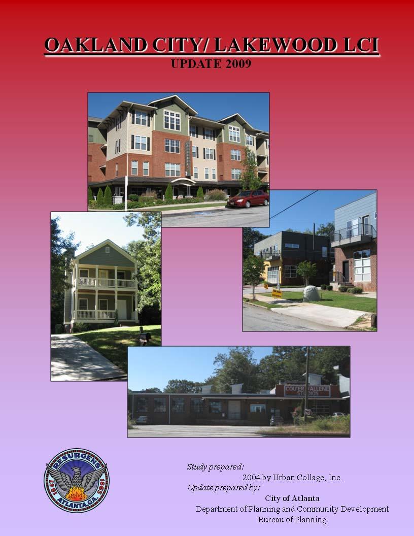
2009 Oakland City / Lakewood LCI Five Year Update
|
|
|
- Maud Chandler
- 5 years ago
- Views:
Transcription
1
2 ii

3 Mayor The Honorable Shirley Franklin City Council Lisa Borders, Council President Carla Smith, Council District 1 Kwanza Hall, Council District 2 Ivory Lee Young, Jr., Council District 3 Cleta Winslow, Council District 4 Natalyn Mosby Archibong, Council District 5 Anne Fauver, Council District 6 Howard Shook, Council District 7 Clair Muller, Council District 8 Felicia A. Moore, Council District 9 C.T. Martin, Council District 10 Jim Maddox, Council District 11 Joyce Sheperd, Council District 12 Ceasar C. Mitchell, Post 1 At Large Mary Norwood, Post 2 At Large H. Lamar Willis, Post 3 At Large Project Staff Department of Planning and Community Development James E. Shelby, Commissioner Charletta Wilson Jacks, Director, Bureau of Planning Garnett Brown, Assistant Director Jessica Lavandier City of Atlanta Bureau of Planning 55 Trinity Avenue SW, Suite 3350 Atlanta GA
4 2009 Oakland City / Lakewood LCI 5 Year Plan Update Table of Contents Page I. Introduction 1 a. Study Area Overview and Plan Summary 1 II. Evaluation and Appraisal Report 3 a. Completed Actions 3 i. Land Use 3 ii. Zoning 3 iii. Tax Allocation Districts 4 iv. Ft. McPherson BRAC 6 v. NPU and NPU S Comprehensive Plan 7 vi. BeltlLine Plan Subarea 2 & BeltLine Overlay 8 vii. Comprehensive Transportation Plan 8 viii. Cleveland Avenue Corridor Plan 8 ix. Atlanta s Project Greenspace 9 x. MARTA Transit Oriented Development Guidelines 10 b. New Developments 10 i. Residential Development 10 ii. Non Residential Development 10 c. Infrastructure Upgrades 10 i. Transportation 10 ii. Water/Sewer 10 iii. Parks & Open Space 11 d. Status of projects in 5 year action plan 11 III. Implementation Plan with updated 5 Year Action Plan 11 a. Affordable Housing Strategies 12 Appendix 15 ii
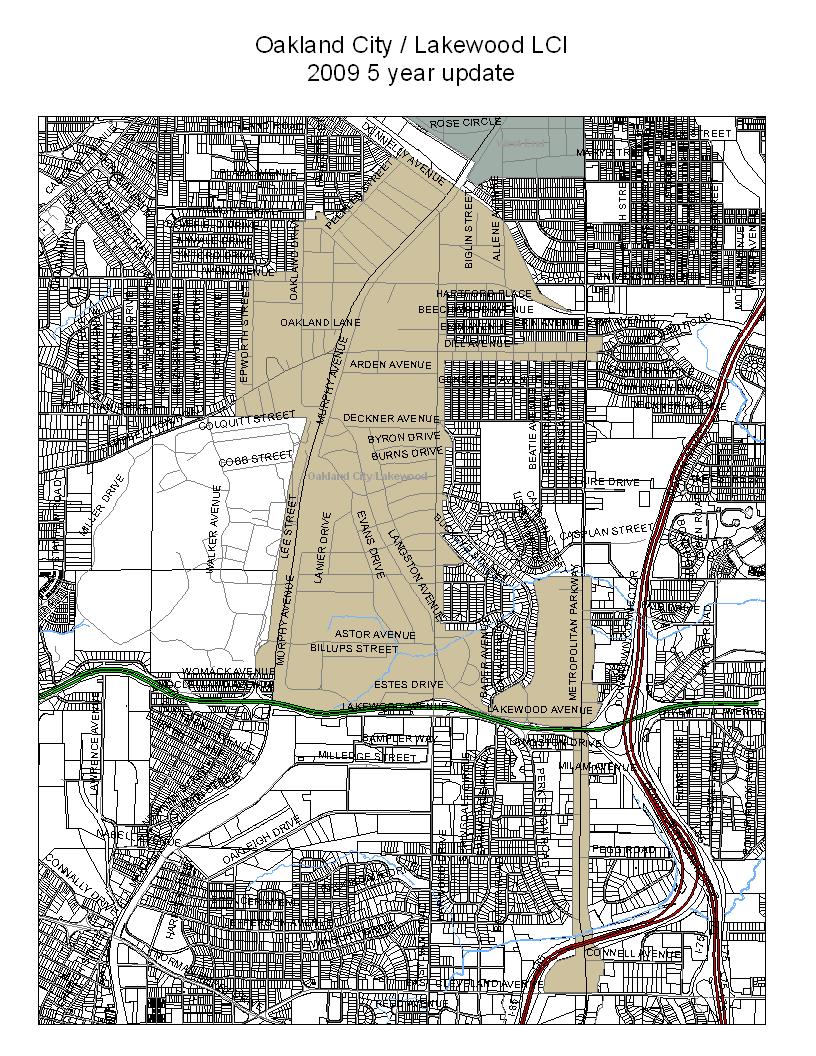
5 I. Introduction In 2004, The City of Atlanta s Bureau of Planning in the Department of Planning, Community Development and MARTA prepared the Oakland City / Lakewood LCI (OCL LCI). The OCL LCI was funded by the Federal Transit Administration thru MARTA. The study was grandfathered by the Atlanta Regional Commission as a Livable Center s Initiative Community in As part of the Atlanta Regional Commission s Livable Centers Initiative Program, sponsoring agencies are required to revisit LCI plans after five years have elapsed to access, evaluate, and update the plans and initiatives that emerged from the plan. The document, along with its maps and attachments, constitutes the 2009 year five year update of the 2004 Oakland City Lakewood LCI. The first part of the update is the Evaluation and Appraisal Report. This has plans completed in the past five years, rezoning and land use changes, new developments, infrastructure upgrades and the status of each item in the 5 year action plan. The second part is the Implementation Plan with an updated 5 year action plan as well as programs to promote affordable housing. a. Study Area Overview & Plan Summary The Oakland City / Lakewood LCI was adopted by City Council and the Mayor in November 2004 (per 04 R 1752). The plan identifies long term development/ re development strategies and shortterm recommendations for public and private investment in an approximate one half mile study area within the southwest quadrant of the City of Atlanta and just north of the City of East Point. The study area surrounds the Oakland City and Lakewood/Ft. McPherson MARTA stations.. Part of the western boundary is Lee Street and Murphy Avenue and the Oakland City neighborhood to the northwest. The northern boundary is the proposed BeltLine corridor. The eastern boundary is Metropolitan Parkway and the southern boundary is Langford Parkway. This is an area of slightly over 1,000 acres. The study area is in Council Districts 4 and 12 and in Neighborhood Planning Units S and (see map in the following page). The plan recommended long range development plans for the areas around the Oakland City and Lakewood Fort McPherson MARTA transit stations. A series of redevelopment areas that pose a unique character and vision were highlighted to revitalize the Study Area. These areas are: Oakland City Transit Station Area, Lakewood Transit Station Area, Murphy Triangle/Lee Street, Oakland City Neighborhood Improvement District, Sylvan Hills Neighborhood Improvement District, Dill Avenue Corridor, Crossroads Village, Cleveland Avenue Gateway. In addition, the plan recommended mixeduse economic development opportunities for Transit Oriented Development (TOD) which promotes densified residential, retail and office uses around transit stations; maintaining single family neighborhoods; and reinvigorating neighborhood commercial nodes and major retail centers. Implementation strategies were identified by the plan to guide the Oakland City/Lakewood development.
6 2
7 II. Evaluation and Appraisal Report a. Completed Actions i. Land Use The Land Use goals of the OCL LCI plan are to: provide appropriate buffers between more intensive and less intensive uses, increase the mix of uses and density, as appropriate, throughout the community, increase density around the transit stations, provide more opportunities for recreation and entertainment and encourage a live work community. The Plan includes a Development Plan for 9 key areas: the Oakland City Transit Station, The Lakewood Transit Station, Murphy/Triangle/Lee Street, Oakland City neighborhood, Sylvan Hills neighborhood, Dill Avenue Corridor, Crossroads Village, Cleveland Avenue Gateway As a first step to implement the plan recommendations, changes to the land use map were recommended. Land Use changes in the OCL LCI study area were incorporated in the Comprehensive Development Plan Land Use Map in December 2004 per 04 O Most of the parcels along Murphy Avenue and in the Murphy Triangle were changed from Industrial to Mixed Use land use designation. While there are many vacant and underutilized industrial buildings along the corridor, there are many long term and viable industrial uses. Kraft Foods and Unilever have operated and provided good paying jobs in the area for decades. While they retain their industrial land use, uses in compatible to their operation can encroach with the change of land uses. Other active industrial uses, like Cute Rate Box, don t have an industrial land use. This endangers the continued operation of these businesses. Atlanta Development Authority and the Bureau of Planning are concerned over the loss of industrial business, jobs and the loss of parcels designated as industrial in the land use map. A Georgia Tech MCP studio class will be evaluating active industrial uses with industrial zoning that do not have an industrial land use designation. They will make recommendations to change the land uses to industrial. The City of Atlanta Bureau of Planning obtained a Brownfields Assessment Grant from EPA. Potential brownfields in the BeltLine were evaluated with the grant. Last year, EPA awarded the City of Atlanta a $1M revolving loan fund to clean up brownfield sites. ii. Zoning The Oakland City / Lakewood LCI plan made recommended zoning categories for parcels throughout the study area. For many of the parcels, the plan recommended the Quality of Life zoning categories. These zoning recommendations are taken into consideration when an application for rezoning is made. The Table 1 shows the rezoning applications in the Oakland City / Lakewood LCI study area over the past five years. Many of the applications requested one of the quality of life zoning categories. Most of the cases requesting multi family residential development are located 3
8 along Murphy Avenue. These rezoning allowed for a total of 654 multi family units. Except for the units on Allene Street, none of these have been built. Table 1: Approved Zoning in Oakland City/Lakewood LCI since 2004 Zoning Number Change Address Request Status Z I 1 to LW 1225 & 1229 Allene To convert warehouses to 12 residential units Approved 8 units completed Z R5 to R4A Oakland City historic To rezone parcels with Approved district R 5 zoning to R 4A Z I2 to MR4AC 1246 Allene Avenue To build 240 multifamily Approved residential units Z I2 tomr4ac 1374 Murphy Avenue To build 152 units Approved Z I2 to LW 1116 Murphy Avenue To build 55 residential units and 6,000 sq ft of non residential space Withdrawn Z I2 & R4 to MRC3C Z Z C1, I1 & R4 to NC8 C1, R4 & RLC to NC Arden Ave SW To build 195 residential units & 28 Live/work units Dill Ave and Sylvan Rd To create a new neighborhood commercial district Dill Ave and Metropolitan Ave To create a new neighborhood commercial district Approved Approved Approved The parcels at the intersection of Dill Ave and Sylvan Road (NC 8) and Dill Ave and Metropolitan (NC 9) were rezoned to the Neighborhood Commercial zoning category. The purpose of the Neighborhood Commercial zoning district is to ensure pedestrian oriented development that is compatible with existing, and often historic commercial nodes, as well as the surrounding residential neighborhood, to require certain streetscape elements and to prohibit certain incompatible uses. iii. Tax Allocation Districts Three Tax Allocation District partially overlap the Oakland City /Lakewood LCI study boundaries: The Campbellton Road TAD, the Metropolitan Avenue TAD and the BeltLine TAD (see map in following page). The Atlanta Development Authority is designated as the Redevelopment Agency and is responsible for administering the TADs. ADA can issue bonds or other obligations to fund the provisions to the Redevelopment Plans associated with the TADs. BeltLine TAD: The BeltLine Tax Allocation District, Tax Allocation District Number 6, was adopted (05 O 1733) in November 2005 and it is to be in existence for 25 years. The purpose of the TAD is to implement the Redevelopment Plan for the BeltLine Redevelopment Area. The TAD legislation specifies that 15% of the net proceeds of each TAD bond issuance shall be placed in the BeltLine 4

9 Affordable Trust Fund and shall be used for creating affordable housing. Moreover, a portion of the TAD bond proceeds will be placed in an Economic Incentives Fund to provide incentives to private development in areas that qualify as Community Development Investment Areas (CDIA). The BeltLine 5 year work plan identifies several projects in the Oakland City / Lakewood LCI. These include acquisition and development of a park at Murphy Crossing, a trail connecting Allene Ave to Lena Street and economic development incentives in the Murphy Triangle and University/Metropolitan Parkway. 5
10 Campbellton Road TAD: The Campbellton Road Tax Allocation District, (aka Tax Allocation District Number 7), was created on December 2006 (06 O 2292) and it is to be in place for 25 years. The purpose of the TAD is to improve the social and economic conditions of the area designated in the TAD and to implement the recommendations of the Redevelopment Plan. The Redevelopment Plan is the framework for the implementation of redevelopment activities contemplated in the Campbellton Road TAD. The TAD can provide incentives and initial funding that would be catalyst for redevelopment and rehabilitation. In addition, 20% of the TAD bond issues will be committed to funding specified public infrastructure needs in the corridor. Portions of the Oakland City/Lakewood LCI are in the Ft. McPherson Sub Area. To date, no projects have been funded with TAD funding. The Atlanta Development Authority is examining the increment available for TAD purposes. Metropolitan Parkway TAD: The Metropolitan Parkway Tax Allocation District, (aka Tax Allocation District Number 9), was created on December 2006 (06 O 2290) and it is to be in place for 25 years. The Metropolitan Parkway Redevelopment Plan and Tax Allocation District (TAD), created in 2006, encompasses the area along Metropolitan Parkway, as well as much of the commercial portion of Cleveland Avenue between Sylvan Road and Interstate 75. The goal of the Redevelopment Plan is to promote mixed use, commercial, and residential redevelopment along Metropolitan Parkway that is in line with both the redevelopment trends within the City, and with the goals of the surrounding neighborhoods. By utilizing the economic incentives created by the TAD, the City will be able to target and encourage balanced economic growth. The TAD program is managed by the Atlanta Development Authority. The Metropolitan Parkway Redevelopment Plan, prepared by Atlanta Development Authority, is the tool to implement the TAD. The TAD project lists includes intersection improvements, bicycle and pedestrian facilities, park and greenways improvements, drainage and gateways that are also included in the 5 year implementation plan of the Oakland City / Lakewood LCI. To date, no projects have been funded with TAD funding. However, ADA is evaluating the increment in property value to determine if projects can be funded with TAD monies. iv. Fort McPherson BRAC Fort McPherson, a 488 acre military facility located in Southwest Atlanta, is home to Headquarters U.S. Army Forces Command, Third U.S. Army and the U.S. Army Reserve Command. Fort McPherson is being closed under the Base Realignment and Closure Act (BRAC) of The U. S. Army must cease operations and vacate the base by September The McPherson Planning Local Redevelopment Authority (LRA), a non profit corporation, serves as the primary link between the Department of Defense, the installation, the community, and Federal and State agencies for all base closure matters. The LRA submitted a Reuse and Redevelopment Plan for the base in The Plan s vision it to transform Fort McPherson and the surrounding neighborhoods into a nationally acclaimed, world class, thriving community, where people work, live, learn and play. The Redevelopment Plan will be: guided by market realities and adaptable to changing conditions, target knowledge based industries, generate a variety of jobs and mixed income neighborhoods, 6
11 economically uplift surrounding communities and the region, enabling existing residents to benefit from the growth, enhance community services and promote lifelong learning, honor the history of the site, promote sound environmental and energy efficient concepts, promote green space, and coordinate closely with other regional developments to complement rather than compete. The overall proposed development program for the re use of Fort McPherson includes the following: 4 million square feet of office and research space, 400,000 square feet of commercial / retail space, and 4,600 housing units. The overall uses for the different homeless providers will total approximately 314 units of housing serving approximately 547 households and approximately 10,000 square feet of space to address the Health Care and Community Service needs. Fort McPherson has the potential to be a catalyst for redevelopment in this area. In total, the project is expected to generate 15,261 jobs and $7.3 billion annually in direct employment. The site should also create between $7.4 million and $16.2 million annually in property taxes. All of this impact is assuming a Bioscience Research Center will be located at this site and that public investment will be a significant catalyst to making this project happen. v. NPU and NPU S Comprehensive Plan NPU S Comprehensive Plan: The NPU S Comprehensive Plan, adopted June R 0905 (CDP 05 20) includes the Oakland City neighborhood. Since the plan was approved shortly after the Oakland City / Lakewood LCI, the NPU S plan did not duplicate the LCI analysis and recommendations. The plan studied housing (to include personal care homes and rooming houses), housing conditions, land use, parks and greenspace, environmental hazards, illegal dumping, stormwater and tax delinquency. The plan made recommendations for parks and open space, zoning changes, transportation improvements (sidewalks, streetscapes, traffic calming, intersection improvements and street paving), stormwater, land use and housing. NPU Comprehensive Plan: The Neighborhood Planning Unit (NPU) Comprehensive Plan, adopted in 2005 per 05 R 0509, is a comprehensive planning and development tool for NPU. The plan covers the Capitol View, Sylvan Hills and Pekerson Park neighborhoods that are also included in the Oakland City Lakewood LCI. The goals of the plan include addressing deficiencies in commercial service quality and neighborhood retail availability, to be inclusive and promote smart growth, public transportation, affordable single family and multi family housing, human services, clean and safe environment, and to advocate expansion and improvements to open space, infrastructure and parks in each of the five neighborhoods. Community residents want to promote the conservation of single family housing, to improve and conserve multifamily housing, to support mixed use development and to promote mixed income affordable housing. The plan examined land use, housing conditions, tax delinquency and the housing market. In addition, the plan made recommendations for land use, housing, parks, transportation, environmental hazards, stormwater and zoning. 7
12 vi. BeltLine Plan Subarea 2 Heritage Communities of South Atlanta : The 22 mile BeltLine corridor has been divided into 10 subareas for more detailed planning and evaluation. The BeltLine Subarea 2 Plan Heritage Communities of South Atlanta runs from Murphy Ave. on the west to Hill St. on the east, including ½ mile on either side of the BeltLine proposed right of way. The Murphy Triangle and the area along Murphy Avenue from the BeltLine to Arden are in the Oakland City LCI and the BeltLine Subarea Plan 2 The key guiding principles of the plan are the following: encourage the economic development of the Heritage Communities, Identify and preserve historic resources and a local sense of place, utilize redevelopment to mend the urban fabric, provide a safe and balanced transportation system, provide connectivity, continuity, and redundancy among various modes of transport, provide a balanced mix of compatible land uses, expand housing options, provide a range of safe parks and open space. The Plan makes recommendations for land use and design, mobility and parks and open space. The recommended transportation projects that are in the OCL LCI area are in Table 2 in the Appendix. The general land use policies are: to establish a series of centers along the BeltLine, to establish a new street pattern that supports these centers, to connect streets with parks and open space, to promote smaller block size in new developments, to increase density of mixed use development near transit stations and other areas as appropriate. In addition, the plan recommends two redevelopment areas: Murphy Triangle and Peoplestown/Pryor Road. The Plan and land use changes were adopted in March Upon completion of all Subarea Master Plans, Atlanta BeltLine Inc. (ABI) will develop a comprehensive Implementation Plan for the projects identified in the individual subareas. This phased approach will ensure equitable development across all geographies of the BeltLine regardless of the sequencing of Subarea Master Plans. BeltLine Overlay: The BeltLine Overlay District, adopted in 2007, is intended to ensure that the orientation and character of new development encourages pedestrian and transit oriented uses and is designed to support an urban character. Some of the policies of the overlay are to encourage a grid of smaller blocks and connected streets, to provide a pedestrian oriented environment that includes active street level uses, sufficient sidewalk widths, and primary pedestrian access from sidewalks to adjacent building entrances; to create mixed use and commercial nodes at BeltLine station areas that are pedestrian and transit oriented; and to preserve the Beltline corridor. All nonsingle family developments must apply for a Special Administrative Permit to ensure compliance with the BeltLine Overlay standards. vii. Comprehensive Transportation Plan In December 2008, the City of Atlanta completed a year long process to develop a Comprehensive Transportation Plan, the Connect Atlanta Plan, to guide the next 25 years of transportation policy and investment in ways that advance Atlanta s larger vision of creating a more modern, vibrant and 8
13 sustainable city. The Plan includes recommended projects within the Oakland City/Lakewood LCI area. These are listed in Table 3 in the Appendix viii. Cleveland Avenue Corridor Plan The Cleveland Avenue Corridor Plan, conducted by the City of Atlanta Bureau of Planning, was adopted by City Council on September 21, 2009 (per 09 O 1416). The intersection of Cleveland Avenue and Metropolitan Avenue and the NE and NW portions of the intersection are in both plans. The plan recommendations are similar: addition of pedestrian oriented retail space at the Kroger Citi Center and redevelopment of the NE quadrant to a mix of residential and commercial uses in a pedestrian oriented pattern. ix. Atlanta s Project Greenspace Project Greenspace is a framework and action to plan for a citywide system of high quality open spaces consisting on parks, natural areas, civic spaces, connecting greenways, streetscapes and trails. The plan proposes 12 major initiatives to grow, manage and build capacity for greenspace. The plan has three greenspace focus areas: the urban core, the lower density area and the beltline. Each has a different greenspace strategy. In the urban area, the strategy is to integrate greenspace in to existing and new developments, to link existing greenspace and to connect to the BeltLine. In the lower density area, the focus is to acquire and preserve land along greenways, to establish new parks in underserved area (as identified in the needs analysis) and to connect to the BeltLine. In the BeltLine area, the plan recommends developing a multi use trail system that connects existing and new greenspaces. Project Greenspace will be adopted in late 2009/early Future plans should use the plan as a reference for the policies and strategies aimed at increasing greenspace throughout the City. x. MARTA Transit Oriented Development Guidelines MARTA has adopted Transit Oriented Development (TOD) Guidelines. These guidelines examine density and mix of uses, the public space, parking and a model zoning overlay district around transit stations. As part of the process to prepare the TOD guidelines, a station typology was developed. The typology characterizes the stations by density, scale, and mix of uses within a ¼ and ½ mile. The six station typologies are: Urban Core, Town Centers, Neighborhood Centers, Special Regional Destinations, Commuter Town Centers and Collectors. The Oakland City MARTA station is designated as a Neighborhood Center and the Lakewood Ft. McPherson Station is station is designated as a Town Center. The second document is the Community TOD Assessments for local governments with MARTA stations. The document reviews adopted plans around MARTA rail stations, as well as existing land use and zoning standards. The guidelines translate TOD principles into standards and policies. 9
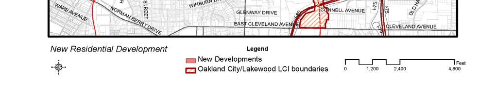
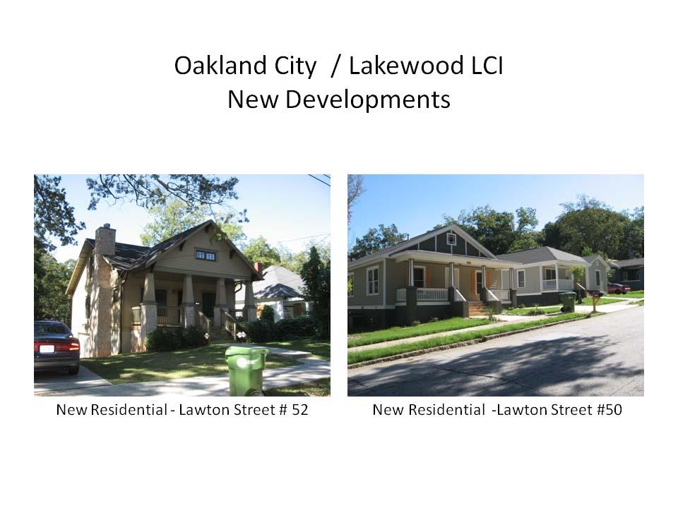
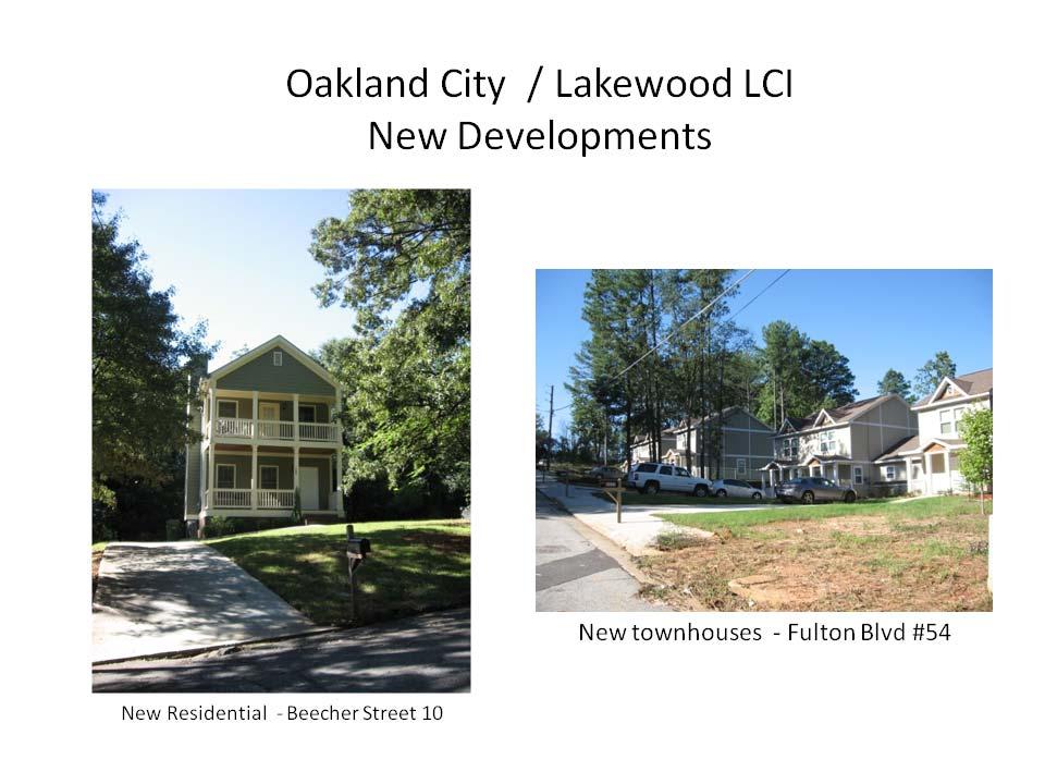
14 b. New Developments The permits issued since the adoption of the Oakland City Lakewood LCI are indicated in the Table 4 in the Appendix. The locations of new developments are shown in maps in the Appendix as well. i. Residential Development New developments in the Oakland City / Lakewood LCI consist primarily of residential development. A total of 406 new residential units were permitted and 13 units were demolished. The majority, 81% or 332, of the new units are multi family residential. The two largest multifamily developments are Columbia at Sylvan Hills next to the Lakewood MARTA station and City Central Condominiums on Metropolitan Avenue. Sixty two new single family residential units permitted. Many of them are located in the Oakland City and in Sylvan Hills neighborhood. In addition, a couple of industrial buildings were converted to residential loft units on Allene Street. ii. Non Residential Development The only non residential development is a 6,000 sq ft strip shopping center on Lakewood Avenue near the intersection with Metropolitan Parkway. c. Infrastructure Upgrades i. Transportation Projects Completed: With the passage of the Quality of Life bonds, the Department of Public Works has been able to implement a large number of transportation projects throughout the City. In the Oakland City/Lakewood LCI study area, an intersection improvement, sidewalk improvements, streetscapes, street resurfacing, unpaved street paving, traffic signal communication projects have been completed. The list of completed projects is Table 5 in the Appendix. Some of these are in the OCL Implementation Plan. Projects Underway or in Design: The Department of Public Works has many transportation projects underway in the OCL study area. These are listed in Table 6 in the Appendix. Some of these are included in the 5 and 15 year Implementation Action Plan. Pre qualified List of Transportation Projects: Two projects from this LCI are included in the LCI Prequalified List of Transportation projects. These projects are: Lee Street Multi use Facility from Donnelly Avenue/BeltLine to Langford Parkway/City Limit and a MARTA parking deck consisting of 400 spaces. ii. Water/Sewer Clean Water Atlanta is a comprehensive, multi program initiative to improve water quality in Atlanta through capital construction programs and enhanced operation of the City's drinking and wastewater systems. Clean Water Atlanta includes all project required to comply with two federal consent decrees and a state consent order, to improve water quality throughout metro Atlanta, to 10
15 secure drinking water facilities in accordance with national homeland security guidelines and provide holistic management of the City's resource operation. The Department of Watershed Management has completed all of the work required in the two federal consent decrees. Required repairs for all sewer lines in Sewer Groups 1 (SG1) have been completed. Portions of SG1 are along the SE section of the Oakland City / Lakewood LCI. iii. Parks & Open Space Using Quality of Life bond funding, the City of Atlanta acquired 1092 Allene Street for a park. In addition, Atlanta BeltLine Inc acquired 1150 Allene in December This parcel included part of the proposed BeltLine right of way. These two parcels will become Allene Avenue Park. In addition, using Opportunity Bonds funding, renovations were made to the ball fields, pool bath house and tennis basketball courts at the Oakland City Parks. d. Status of projects in 5 year action plan The status of the projects listed in the 5 year Implementation Action Plan is in Table 7 in the Appendix. The OCL implementation plan is very ambitious. Even though, the plan laid out a strategic course of action, many factors, including the market, the economy and lack of funding has impeded the implementation of many of the recommended projects in the 5 year action plan. Many of the transportation projects have not started. Even with the Quality of Life bond, the City of Atlanta has limited resources to complete needed transportation projects that have been identified. III. Implementation Plan with updated 5 Year Action Plan A new 5 year Implementation Plan is included in Table 8 in the Appendix. Implementation of the original 5 year Action Plan has been challenging due to lack of funds, particularly for transportation projects. The new 5 Year Plan also includes projects planned or underway by the Department of Public Works as well as projects identified in both the OCL LCI and the BeltLine Subarea 2 Plan. Implementation of transportation projects will continue to be a challenge for the City of Atlanta due to the limited availability of funds. Some possible sources of funding include bond funds and TAD funding. The Atlanta City Council recently approved placing a maintenance bond on the ballot in Pedestrian crossings and sidewalks could be included in the list of projects to be funded with future bond funds. Transportation projects were identified in the BeltLine Subarea 2 Plan. Once all of the Subarea Plans are completed, an implementation list of select projects from all of the subarea plans will be created. BeltLine TAD funds have been identified to implement many of these projects. Campbellton Road TAD and Metropolitan TAD funding can also be used to implement priority transportation projects. Finally, federal funds could be used to implement the two pre qualified projects. 11
16 a. Affordable Housing Strategies Much of the housing built in the Oakland City / Lakewood LCI over the past 5 year has been affordable. Habitat for Humanity built the townhomes on Fulton Boulevard as well as many single family homes. In addition, Columbia Residential, a developer and manager of affordable mixed income multi family developments and senior housing built Columbia at Sylvan Hills near the Lakewood MARTA station. The City of Atlanta in partnership with the Atlanta Development Authority has a wide range of programs to promote affordable housing citywide and in specific locations within the city limits. A brief description of each is located below. Opportunity Downpayment Assistance Program (ODAP): The Opportunity Downpayment Assistance Program (ODAP) provides homebuyers with downpayment assistance of 10% of the sales price (up to $25,289) at 0% interest rate as a soft second mortgage. Eligible properties include existing or new construction single family homes, townhouses, condominiums and manufactured housing with a maximum purchase price of $252,890. Properties must be located within the city limits of Atlanta. The following income limits are set depending on a household size: $71, 200 for 1 2 person households, $81,880 for 3 or more person households. Atlanta Affordable Home Ownership Program (AAHOP): The Atlanta Affordable Homeownership Program (AAHOP) provides $10,000 mortgage assistance in form of a 0% interest rate soft second mortgage and covers up to 50% of the settlement costs. Eligible properties must be located within the city limits of Atlanta and are limited to the existing or new construction single family homes, townhouses, condominiums and manufactured housing. Maximum purchase price limit is $253,890. The income limits include $40,150 for 1 person household, $45,900 for 2 person household and $51,600 for 3 person household. Home Owner Occupied Rehabilitation Program: The City of Atlanta s Owner Occupied Rehabilitation Program is designed to assist low moderate income individuals, who need repairs to their home. The Program aims to prevent moderately declining neighborhoods in the City of Atlanta from further deterioration by providing rehabilitation funding and technical assistance, stimulate broad interest in neighborhood preservation and partner with other programs for maximum impact. The Program assists individuals who are disabled and/or have attained sixty two (62) years of age or older. The individuals must reside in and own the property within the appropriate target areas to qualify for assistance. Housing Rehabilitation Program s basic goal is to create homes that are in substantial compliance with the Local Housing Code governing the condition and maintenance of dwelling. Eligible items include health and safety, lead hazard reduction and handicap accessibility. Urban Residential Finance Authority (URFA) Tax Exempt Bonds: URFA Tax Exempt Bonds is a first mortgage financing program which provides 30 year fixed rate loan, below market interest rate and grant for downpayment assistance. Eligible properties must have the maximum purchase price of $299,475 (non target) and $366,025 (in target area). The program also provides tax exempt bond financing to acquire, construct or rehab multifamily affordable housing: 20% of units must be set 12
17 aside or below 50% of AMI; or 40% of units must be set aside at or below 60% of AMI., 25% of the units for market rate tenants. It requires a minimum 15 year affordability period. Urban Residential Finance Authority (URFA) Housing Opportunity Bond (HOB): The program provides single family downpayment assistance in the form of the second mortgage deferred loans with 0% interest, 10 year deferred loan with equity sharing provision, 10% of the sales price. The program also provides second mortgage loans to non profit and for profit developers for construction/rehabilitation of affordable rental housing units. At least 20% of units must be set aside for population at or below 60% of AMI. Loan amount cannot exceed $25,000 per affordable unit and requires a minimum 15 year affordability period. Funds are also available to CHDOs for acquisition, rehabilitation or new construction of single family and multi family units. Units have to be affordable for 10 years for owner occupied units and 15 years for rental units. This program also provides assistance with land acquisition. Community Housing Development Organizations: Community Housing Development Organizations (CHDO s) are established to address the housing needs of a particular geographical area. The CHDO is required to have legitimate community representation; therefore these organizations must develop a process in which low income residents of the designated area can participate. CHDO s must also establish a mechanism by which they can be govern, consequently they must have a Board of Directors consisting of a minimum of one third representation from the community to be served and a maximum of one third from the public sector, consisting of public officials and employees. The Bureau of Housing ensures that CHDO s provide affordable housing for low income persons of that community as a developer or a sponsor. Through the CHDO s assistance communities are being enhanced and the promotion of creating safe and sanitary neighborhoods while stimulating economical growth for these communities can be achieved. Mortgage Assistance Program: The Mortgage Assistance Program (MAP) is a City of Atlanta program to assist low to middle income homebuyers to purchase a home located in the City of Atlanta former Atlanta Empowerment Zone (AEZ) census tracts. Up to $50,000 may be used for down payment assistance, closing costs, gap financing, principal reduction or interest rate reduction. Purchase price cannot exceed FHA limit of $252,890. Applicant s annual household income cannot exceed 100% of the HUD Area Median Income (AMI) MAP funds. A small portion of the UWS LCI is located in the Empowerment Zone area. BeltLine Affordable Housing Trust Fund (BAHTF): Affordable housing is a vital component of the BeltLine. Fifteen percent of BeltLine Tax Allocation District (TAD) net bond proceeds must be set aside in an affordable housing trust fund to be used for affordable workforce housing within the TAD boundaries. Over the 25 year life of the project, this amount is estimated to be $120 million and is expected to generate approximately 2,800 workforce housing units. The BeltLine Affordable Housing Trust Fund was capitalized with $8.8 million through the 2008 Series BeltLine TAD Bonds, with more funding anticipated with each subsequent bond issuance. Grants are available to multifamily, single family and CHDO developers from the Beltline Affordable Housing Trust Fund to finance multifamily and single family developments along the Beltline. Grant 13
18 funds may be used to finance acquisition, construction or renovation of multifamily and single family housing for families at or below 60% of Area Median Income (Multifamily Rental) and % (Single Family Homeownership). These grants to developers are enforced by a Land Use Restriction Agreement (LURA). The total amount of the grant dollars may not exceed 20% (25% for CHDOs) of the total development costs. In addition, thru the Downpayment Assistance Program, the Trust Fund provides up to 20% of home purchase price or up to $50,578 subsidy. Eligible properties include existing or new construction single family homes, townhouses, condominiums and manufactured housing. Maximum purchase price is $252,890. Eligible properties must be located within the BeltLine Tax Allocation District boundaries. Households consisting of 1 or 2 persons with the income of $57,350 and below get 20%, households of 3 or more persons with the income of $57,351 and above get 10%. The Beltline Affordable Housing Advisory Board responsibilities are primarily to make recommendations with respect to the goals and policies related to the use of the Beltline Affordable Housing Trust Fund (15% of TAD revenues over the 25 year life of the TAD; monitoring the location and availability of affordable housing throughout the BeltLine; and coordinating with other affordable housing activities throughout the City of Atlanta. American Recovery and Investment Act: The Bureau of Planning and its partners will be targeting NSP 2 funds to the Sylvan Hills neighborhood to mitigate negative impacts to the neighborhood from foreclosed homes. 14
19 APPENDI 15
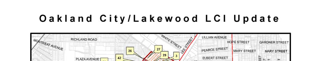
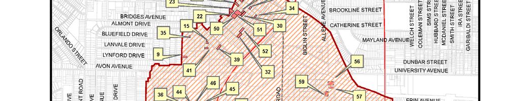
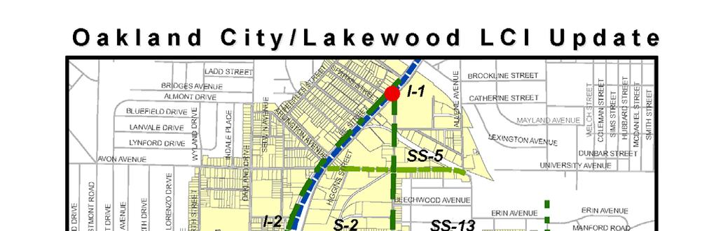
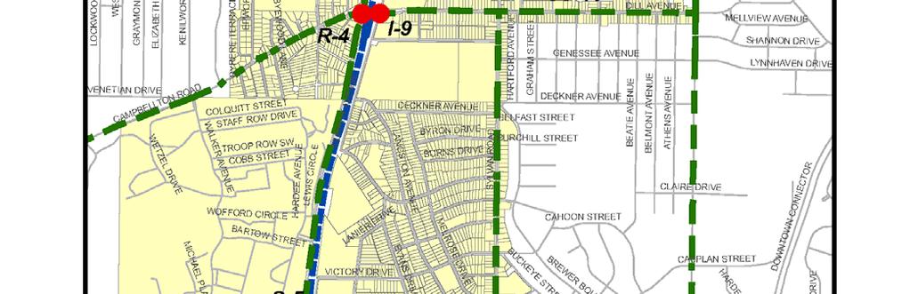
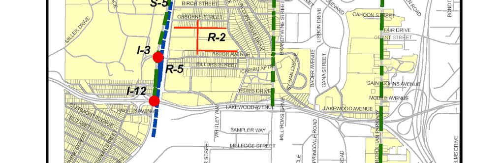
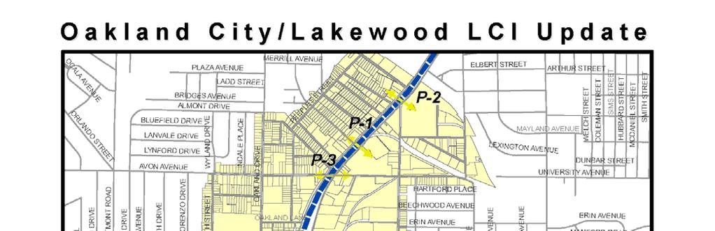
20 BeltLine Subarea 2 Proposed Transportation and Greenway Projects OCL LCI Name Description Project Type Number # Dill and Murphy Avenue Sylvan and Murphy Ave University Ave Extension Avon Avenue Sylvan Road Capitol View Trail Allene Ave Trail Murphy Triangle trail spur South Murphy Triangle trail spur South Signalize intersection Signalize intersection New Street Sidewalks Sidewalks greenway trail greenway trail greenway trail greenway trail Intersection Improvement I 4 I 9 Intersection Improvement I 5 I 1 Extend street across the BeltLine N 2 R 7 from Murphy Ave to E of Sparta Street S 1 SS 5 From Murphy Ave to Deckner Street S 2 S 1 Metropolitan ave to Oakland City MARTA M 6 Pekerson Park to BeltLine M 7 Oakland City MARTA to BeltLine M8 Allene to Murphy Ave M9 G3 16
21 Table 3: Connect Atlanta Projects in OCL LCI OCL LCI # Pedestrian Amenity/Complete Street PS PA 009 SS 3 Pedestrian Amenity/Complete Street PS PA 010 SS 4 Pedestrian Amenity/Complete Street PS PA 011 SS 5 Name Description Project Type Number Victory Dr Claire Drive Avon Ave Sylvan Road to Evans Drive Metropolitan Pkwy to Beatie Ave Lee Street to Allene Oakland Drive Campbellton Road to Avon Ave Pedestrian Amenity/ Complete Street PS PA 012 SS 6 Avon Ave Perkerson Rd Allene Ave Lee/ Sylvan Rd/Murphy Ave Lee/Murphy Ave/Dill Ave Dill / Sylvan Rd Intersection Sylvan Road Langston Intersection Dill Ave & Metropolitan Intersection Metropolitan Pkwy SW/Cleveland Ave SW Estes Extension Avon Extension Oakland Drive to Lee Street From Sylvan Road to Metropolitan Pkwy Deckner Ave to Warner Street Pedestrian Amenity/ Complete Street PS PA 013 SS 5 Pedestrian Amenity/Complete Street PS PA 014 SS 9 Pedestrian Amenity/Complete Street PS PA 015 SS 10 Vehicle Sightlines/Pedestrian Safety PS PA 026 I 1 and P 1 Vehicle Sightlines/Pedestrian Safety PS PA 027 I 2 Vehicle Sightlines/Pedestrian Safety PS PA 030 I 4 Vehicle sightline/pedestrian Safety PS PA 028 I 6 Vehicle Sightlines/Pedestrian Safety PS PA 029 I 8 Vehicle Sightlines/Pedestrian Safety PS PA 031 I 11 Street extension to Murphy Ave New Street PS NS 13 R 6 Extend University Street to Avon Ave across the BeltLine New Street PS NS 014 R 7 17
22 Table 3: Connect Atlanta Projects in OCL LCI Name Description Project Type Number New Streets/Oakland City MARTA Sylvan Road Extension Crossroads Village Peachtree Street car / Lee Street Murphy Ave bike route Campbellton Rd bike route Sylvan Rd Allene Ave bike route Cleveland Ave bike route Dill Ave bike route Avon Ave bike route Oakland Drive OCL LCI # New Street Grid New Streets New Street PS NS 020 R 4 Extend Sylvan Road north of Lee Street, crossing BeltLine and connecting to Joseph Lowery Boulevard New Street NS 013 Metropolitan Pkwy at Crossroads Village New Streets NS 34 R 3 New Rapid Transit Corridor Downtown to Fr McPherson Transit TR 009 Dill Ave to Ralph David Core Bicycle Abernathy Blvd Connection Murphy Ave to Core Bicycle Childress Dr Connection Arthur Langford Pw to Core Bicycle Murphy Ave Connection Decker Av to Lillian Secondary Bicycle Ave Connection Metropolitan Pkwy SW to Jonesboro Rd Secondary Bicycle SE Connection Metropolitan Pkwy Secondary Bicycle SW to Oakland Dr Connection Cascade Road to Secondary Bicycle Allene connection Campbellton Road to Beecher Street Secondary Bicycle connection 18
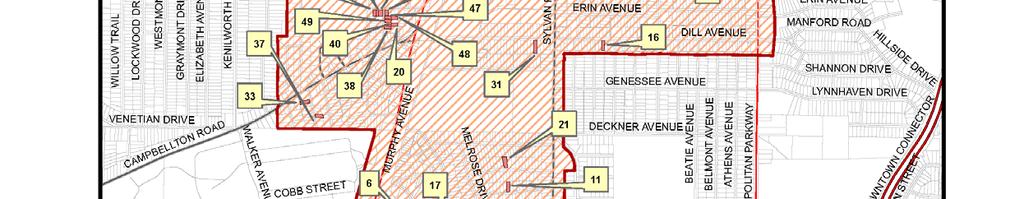
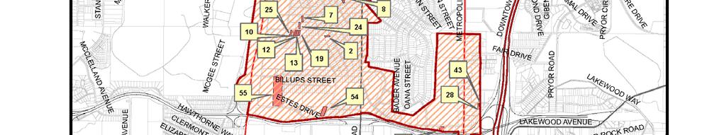
23 Table 4: Oakland City Lakewood LCI Sept 2004 June 2009 Permitted Development No. of Residential Units # on Map Permit Date Pin Number Project Name Project Location Census Tract Building sq ft Residential Development 1 1/10/ Single Family Residence 1681 LANIER DR SW /14/ Single Family Residence 847 BEECHWOOD AV SW /8/ Single Family Residence 1829 SYLVAN RIDGE DR SW /11/ Single Family Residence 1018 DIMMOCK ST SW /14/ Single Family Residence 1685 LANGSTON AV SW /15/ Single Family Residence 1093 REGENT ST SW /5/ Single Family Residence 1669 EVANS DR SW /8/ Single Family Residence 1098 VICTORY DR SW /8/ Single Family Residence 967 VICTORY DR SW /19/ Single Family Residence 1151 OAKLAND DR SW /7/ Single Family Residence 1116 BIRCH ST SW /17/ Single Family Residence 817 ERIN AV SW /20/ Single Family Residence 983 BURNS DR SW /3/ Single Family Residence 1108 BIRCH ST SW /3/ Single Family Residence 1112 BIRCH ST SW /30/ Single Family Residence 847 HARTFORD PL SW /13/ Single Family Residence 1027 LAWTON ST SW /23/ Single Family Residence 1673 LANGSTON AV SW /6/ Single Family Residence 1142 ARLINGTON AV SW /10/ Single Family Residence 784 BEECHWOOD AV SW /10/ Single Family Residence 778 BEECHWOOD AV SW /7/ Single Family Residence 1320 ALLENE AV SW /17/ Single Family Residence 844 DILL AV SW /15/ Single Family Residence 1688 EVANS DR SW /15/ Single Family Residence 1684 EVANS DR SW /18/ Single Family Residence 1104 BIRCH ST SW /26/ Single Family Residence 1319 DORSEY ST SW /28/ Single Family Residence 732 ERIN AV SW No. of Hotel Units Commercial sq ft Office sq ft 19
24 Table 4: Oakland City Lakewood LCI Sept 2004 June 2009 Permitted Development No. of Residential Units # on Map Permit Date Pin Number Project Name Project Location Census Tract Building sq ft 21 8/15/ Single Family Residence 981 BYRON DR SW /12/ Single Family Residence 1016 LAWTON ST SW /12/ Single Family Residence 1020 LAWTON ST SW /22/ Single Family Residence 1103 BIRCH ST SW /25/ Single Family Residence 1128 BIRCH ST SW /3/ Single Family Residence 983 PEEPLES ST SW /3/ Single Family Residence 985 PEEPLES ST SW /21/ Single Family Residence 550 ST JOHNS AV SW /1/ Single Family Residence 790 ERIN AV SW /1/ Single Family Residence 1040 SPARKS ST SW /9/ Single Family Residence 1036 SPARKS ST SW /9/ Single Family Residence 1123 CORDOVA ST SW /16/ Single Family Residence 944 DILL AV SW /19/ Single Family Residence 1057 WHITE OAK AV SW /28/ Single Family Residence 1445 RYAN ST SW /2/ Single Family Residence 1009 SPARKS ST SW /6/ Single Family Residence 1200 ARLINGTON AV SW No. of Hotel Units 36 4/19/ SINGLE FAMILY RESIDENCE 1194 OAKLAND LA SW /30/ Single Family Residence 1466 RYAN ST SW /6/ Single Family Residence 1328 BREWSTER ST SW /17/ Single Family Residence 1115 ARLINGTON AV SW /24/ Single Family Residence 1324 BREWSTER ST SW /27/ Single Family Residence 1123 PRINCESS AV SW /29/ Single Family Residence 999 PEEPLES ST SW /10/ Single Family Residence 546 ST JOHNS AV SW /27/ Single Family Residence 1188 OAKLAND LA SW /27/ Single Family Residence 1182 OAKLAND LA SW /27/ Single Family Residence 1176 OAKLAND LA SW /10/ Single Family Residence 1311 DORSEY ST SW /10/ Single Family Residence 1314 BREWSTER ST SW Commercial sq ft Office sq ft 20
25 Table 4: Oakland City Lakewood LCI Sept 2004 June 2009 Permitted Development No. of Residential Units # on Map Permit Date Pin Number Project Name Project Location Census Tract Building sq ft 49 7/30/ Single Family Residence 1318 BREWSTER ST SW /29/ Single Family Residence 1075 LAWTON AV SW /16/ Single Family Residence 1008 PEEPLES ST SW /29/ Single Family Residence 1361 ATHENS AV SW No. of Hotel Units Commercial sq ft 59 10/1/ Conversion of warehouse to residential phase Allene Avenue 12 18, /13/ DUPLE 1038 LAWTON AV SW /5/ SAFE HARBOR CONDOMINIUMS 2285 METROPOLITAN PY SW /1/ Conversion of warehouse to residential 1229 Allene /1/ Conversion of warehouse to residential 1239 Allene /31/ LL012 ATLANTA HABITAT FOR HUMANITY TOWNHOMES 2069 FULTON BV SW /4/ SYLVAN HILLS Multi family 1150 ASTOR AV SW Total Residential 406 Non Residential Development New Commercial 58 Jan building 2808 Lakewood Ave SW 6,000 6,000 Office sq ft 21

26 22
27 23
28 Table 5: DPW Transportation Quality of Life Projects Completed in the Oakland City /Lakewood LCI Project Name Description Project Type CD GO Number OCL Number Metropolitan Parkway and Manford Road/Dill Intersection of Metropolitan Intersection Ave Parkway and Manford Road Improvements 12 00GO 0635 I 8 Dill Avenue From Metropolitan Parkway to Sylvan Road Sidewalk Improvements 12 00GO 0292 SS 13 Portion Langston Avenue From Birch Street to Sylvan Road Sidewalk Improvements 12 00GO 0544 Lee Street From Donnelly to White Street Sidewalk Improvements 4 00GO 0552 Oakland Lane Langston Drive From Lee Street to Oakland Drive From Perkerson Road to Metropolitan Parkway Street Resurfacing and Reconstruction 4 00GO 0721 Street Resurfacing and Reconstruction 12 00GO 0545 SS 2 portion S 5 small portion Sylvan Ridge Drive From Astor Avenue to Birch Street Street Resurfacing and Reconstruction 12 00GO 0955 Byron Drive From Melrose Drive to Sylvan Road Street Resurfacing and Reconstruction 12 00GO 1768 Melrose Drive Regent Street From Buckeye to Sylvan From Arrow to Billups Street Street Resurfacing and Reconstruction 12 00GO 1780 Street Resurfacing and Reconstruction 12 00GO 0852 Woodburne Sylvan to Fairbanks St Street Resurfacing and Reconstruction 00GO 1769 Rayan Street Ingram to Campbellton Road Street Resurfacing and Reconstruction 00GO 1758 Metropolitan Parkway From RDA to City Limits Streetscape Projects 12 00GO 2356 S 7 Metropolitan Parkway (Phase II) Streetscape Improvements from University Ave. to Casplan St. (west side) and from Casplan St. to Fair Drive (east side); Streetscape Projects 12 00GO 0633 S 7 24
29 Table 5: DPW Transportation Quality of Life Projects Completed in the Oakland City /Lakewood LCI Project Name Description Project Type CD GO Number OCL Number Metropolitan parkway From University Ave to Deckner Road Streetscape 12 00GO 0633 S 7 (portion) Avon Avenue and Oakland Drive Sylvan Road and Aston Avenue Intersection of Oakland Drive and Avon Avenue, complete Rewiring with Cable/Span Wire, new Controller/Cabinet; Add Additional Heads Intersection of Sylvan Road and Aston Avenue, Complete Rewiring with Cable/Span Wire, new Controller/Cabinet; Add Additional Heads Traffic Signals and Communications 4 00GO 3228 Traffic Signals and Communications 12 00GO 3227 Beatie Avenue Metropolitan parkway and Dill Avenue/Manford Road From Dill Avenue to Erin Avenue Unpaved Street Pavings 12 00GO 1505 Intersection improvements 12 00GO 0635 I 8 25
30 Table 6: DPW Transportation Projects Underway Name Description Type of Improvement Dill Avenue Lee Street Campbellton Road Tucker Avenue Crosswalks Campbellton to Sylvan Road Whitehall Street to City Limit Venetian Drive to Dill Avenue Bike lane pavement marking and signage Bike lane pavement marking and signage Bike lane pavement marking and signage Project Number OCL # 00GO GO GO 0855 Peeples street to Lee Street Unpaved street pavings 00GO 1001 Sylvan and Arden Replace existing crosswalks with international crosswalks at arterial and collector streets 00 GO 0261 Sylvan and Deckner I 5 Sylvan and Pekerson I 7 Perkerson and Brewer Place Langston and Victory Drive Brewer BL and Oana St Metropolitan and Dill I 8 Metropolitan and St. Johns Metropolitan and Lakewood Ave Metropolitan and Langston Drive Metropolitan and Pegg Road Metropolitan and Cleveland Avenue I 10 Lee and Donnely 26
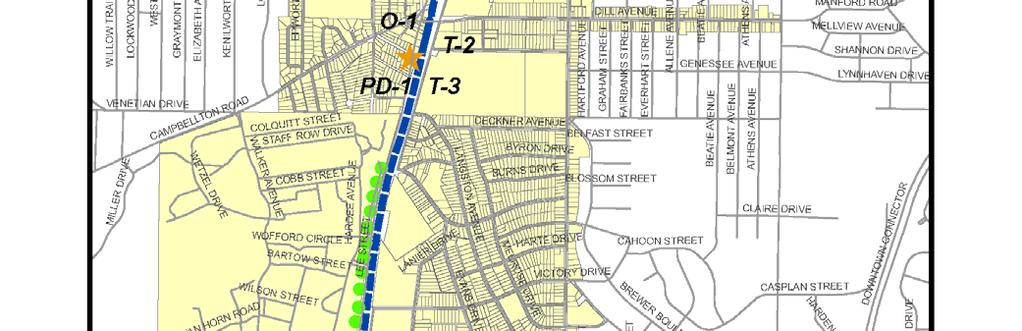
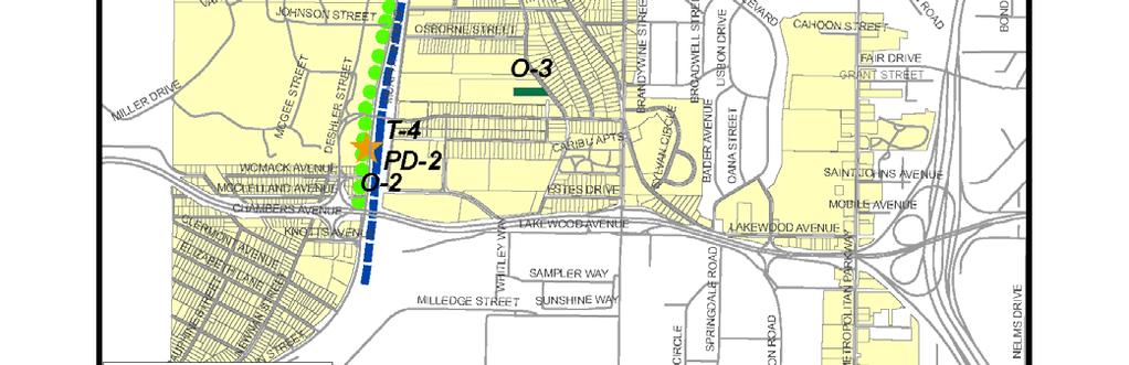
31 Project ID Project Name Description Table 7: Oakland City / Lakewood LCI 5 Year Implementation Plan Status Pedestrian Crossings/ Pedestrian Bridges PE Year Construction Year Complete Underway Status Not Started Not Relevant Notes P 1 P 2 Lee & Sylvan Pedestrian Crossing Lee & White Pedestrian Crossing Construct pedestrian crossing at Lee & Sylvan to include striping, ramps, signalization Construct pedestrian crossing at Lee & White Oak to include striping, ramps, signalization P 3 P 4 S 2 S 5 S 7 Lee & Avon Pedestrian Crossing Lakewood Pedestrian Bridge Improvements Dill/ Campbellton Streetscape Lee Streetscape Metropolitan Streetscape Construct pedestrian crossing at Lee & Avon to include striping, ramps, signalization Reconfigure turnstiles and access at Lakewood MARTA Station for access to the TOD Primary streetscape improvements to include sidewalk, curb, and ramp Dill// Campbellton from Kenilworth to Metropolitan Parkway Lee from Donnelly to Langford Parkway on west side of Lee Street Metropolitan from White to Cleveland Secondary Streetscape improvements including sidewalk installations Concept Plan complete. Small portion of sidewalks built Large portion of Streetscape completed 27
32 Project ID SS 11 SS 12 SS 13 O 1 O 2 Project Name Oakland City TOD Sidewalks Lakewood Station TOD Sidewalks Dill Ave. Onstreet Parking Oakland City Station Transit Plaza Lakewood Station Transit Plaza Description Table 7: Oakland City / Lakewood LCI 5 Year Implementation Plan Status Install sidewalk within the Oakland City TOD development to improve pedestrian access and circulation Install sidewalk within the Lakewood Station TOD development to improve pedestrian access and circulation Dill Avenue On street parking & bulb outs Transit Plazas/ Open space Oakland City Station Transit Plaza Lakewood Fort McPherson Station Transit Plaza partially partially portion Status Station and parking lot lighting complete ADA access improvements made Sidewalks from Metropolitan to Sylvan Road O 3 G 2 I 1 I 2 Sylvan Hills Park Lee Street Greenway Lee & Sylvan Intersection Lee & Dill/ Campbellton Intersection Construct new neighborhood park in the Sylvan Hills neighborhood Greenway Trails Construct a greenway system to include multi purpose trails, pedestrian lighting (Loop B: Lee Street) Intersection/ Interchange Improvements Intersection project at Lee (US 29/SR 139) & Sylvan to include geometric, safety and operational improvement and pedestrian crossing. Intersection project at Lee (US 29/ SR 139) & Campbellton/Dill to include geometric, safety and operational Project on pre qualified list 28
33 Project ID Project Name Description improvement. Table 7: Oakland City / Lakewood LCI 5 Year Implementation Plan Status Status I 3 I 12 Astor & Lee Intersection Langford Parkway Interchange Justification Report (See also R 6) Intersection project at Astor & Fort McPherson gate (Lee US 29/SR 139) to geometric, safety, pedestrian accessibility and operational improvement Study to examine the transportation network in proximity to the Lakewood Station including the Estes Drive Extension and other routes New roadways/ extensions R 2 R 4 R 5 D 1 T 2 T 3 Sylvan Hills New Roadways Oakland City Transit Station Area New Roadways Lakewood Transit Station Area New Roadways Drainage Improvements Oakland City Bus Bays Oakland City Master Plan New roadways to support the Sylva Hills park and residential development Oakland City TOD street Network on MARTA site and North of Campbellton Road Estimate for 5 miles urban new roadways Lakewood Station TOD street network Estimate for 5 miles urban new roadways Drainage GDOT District 7 has agreed to address drainage issues as routine maintenance; drainage at intersection improvements will be considered during the geometric design Transit Relocate Turn Around/ Bus Intermodal Develop a detailed Master Plan for the development site Status unknown 29
34 Project ID T 4 PD 1A PD 1B PD 2A PD 2B GW 1 Project Name Lakewood Master Plan Oakland City Parking Deck Oakland City Parking Deck Lakewood Parking Deck Lakewood Parking Deck Gateways Land Use Zoning Property Acquisition Residential Rehab SF Infill Description Table 7: Oakland City / Lakewood LCI 5 Year Implementation Plan Status Develop a detailed Master Plan for the development site Others Construct parking deck at Oakland City Station TOD: development spaces (not MARTA patron spaces (300 spaces)) Construct parking deck at Oakland City Station TOD: MARTA patron spaces (350spaces) Construct parking deck at Lakewood Station TOD: development spaces (not MARTA patron spaces (500 spaces)) Construct parking deck at Lakewood Station TOD: MARTA patron spaces (550 spaces) Install gateways including signage and identity markers (Metropolitan & Dill, Metropolitan & Perkerson, Sylvan & Langston, Sylvan and Lee) Implement Study Area Wide Land Use Changes Implement Study Area Wide Zoning Changes Acquire targeted residential properties for rehabilitation, renovation, and resale Continue Residential Rehabilitation in all neighborhoods of the study area Continue targeted Single Family Infill Development in Oakland City and Sylvan Hills Neighborhoods On going On going On going On going Status Rezoning made as applications are submitted Sylvan Hills in NSP 2 30
35 Project ID Project Name CDC Sylvan Hills Greenspace Acquisition Brownfield Assessments Description Table 7: Oakland City / Lakewood LCI 5 Year Implementation Plan Status Establish Community Development Corporation (CDC) for western part of study area. Acquire greenspace for Sylvan Hills Park, or work with property owners/developers to create conservation easement. Conduct brownfield assessment on key properties in Murphy Triangle area. Status EPA grant awarded for assessment 31
36 Project ID Project Name Description Pedestrian Crossings/ Pedestrian Bridges P 1 P 2 P 3 S 1 S 2 S 5 Lee & Sylvan Pedestrian Crossing Lee & White Pedestrian Crossing Lee & Avon Pedestrian Crossing Sylvan Streetscape Dill/ Campbellton Streetscape Lee Streetscape Construct pedestrian crossing at Lee & Sylvan to include striping, ramps, signalization Construct pedestrian crossing at Lee & White Oak to include striping, ramps, signalization Construct pedestrian crossing at Lee & Avon to include striping, ramps, signalization Primary streetscape improvements to include sidewalk, curb, and ramp From Murphy to Deckner. Included BeltLine Subarea 2 plan as S 2. Type of Improvement Table 8: Oakland City / Lakewood LCI 5 Year Implementation Plan Eng Year Eng Costs ROW Year ROW Costs Cons t Year Const Costs Total Project Costs Pedestrian Crossing $13,750 $37,000 $50,750 Pedestrian Crossing $13,750 $37,125 $50,875 Pedestrian Crossing $20,625 $55,625 $76,250 Streetscapes Dill// Campbellton from Kenilworth to Metropolitan Parkway Streetscapes $539,625 Lee from Donnelly to Langford Parkway on west side of Lee Street Streetscapes $405,375 $1,458,5 00 $1,095,5 00 Responsible Party BOP/ DPW/ GDOT BOP/ DPW/ GDOT BOP/ DPW/ GDOT $1,998,12 5 BOP/ DPW $1,500,87 5 BOP/ DPW Funding Source Match Amount COA/Bonds/GDOT/ property owners/ LCI $10,150 COA/Bonds/ GDOT/ property owners/ LCI $10,175 COA/ Bonds/ GDOT/ property owners/ LCI $15,250 COA/ Bonds/GDOT/LCI $399,625 COA/Bonds/GDOT/LC I $300,175 S 7 SS 5 SS 11 Metropolitan Streetscape Avon Streetscape Oakland City TOD Sidewalks Metropolitan from White to Cleveland $1,858,8 $2,546,62 Streetscapes $687, BOP/ DPW Secondary Streetscape improvements including sidewalk installations From Murphy to E of Sparta. Included in BeltLine Subarea 2 Plan as S 1. Streetscapes Install sidewalk within the Oakland City TOD development to improve pedestrian access and circulation Streetscapes $143,000 $386,375 $529,375 MARTA/Private COA/Bonds/GDOT/ property owners/ LCI $509,325 COA/Bonds/GDOT/ property owners/ LCI $105,875 32
37 Project ID Project Name Description Lakewood SS 12 Station TOD Sidewalks SS 13 O 1 O 2 O 3 G 2 I 1 I 2 Dill Ave. Onstreet Parking Oakland City Station Transit Plaza Lakewood Station Transit Plaza Sylvan Hills Park Lee Street Greenway Lee & Sylvan Intersection Lee & Dill/ Campbellton Intersection Type of Improvement Table 8: Oakland City / Lakewood LCI 5 Year Implementation Plan Eng Year ROW Year Install sidewalk within the Lakewood Station TOD development to improve pedestrian access and circulation Streetscapes $351,625 $950,500 Dill Avenue On street parking & bulbouts Transit Plazas/ Open space Oakland City Station Transit Plaza Lakewood Fort McPherson Station Transit Plaza Eng Costs ROW Costs Cons t Year Const Costs Total Project Costs Responsible Party $1,302,12 5 MARTA/Private Streetscapes $41,750 $112,875 $154,625 BOP/ DPW Open space $384,125 $1,038,2 50 Funding Source Match Amount COA/Bonds/GDOT/ property owners/ LCI $260,425 COA/Bonds/GDOT/ property owners/ LCI $30,925 $1,422,37 5 MARTA/ Private MARTA/Private/LCI $284,475 Open space $145,000 $391,750 $536,750 MARTA/ Private MARTA/Private/LCI $107,350 Construct new neighborhood park in the Sylvan Hills neighborhood Open space $183,125 $495,000 $678,125 BOP Greenway Trails Construct a greenway system to include multi purpose trails, pedestrian lighting $2,694,6 $3,691,62 (Loop B: Lee Street) Greenway $997, BOP/ COA Intersection/ Interchange Improvements Intersection project at Lee (US 29/SR 139) & Sylvan to include geometric, safety and operational improvement and pedestrian crossing. Included in BeltLine Intersection/ $1,112,5 Subarea Plan as I 5. Interchange $100, Intersection project at Lee (US 29/ SR 139) & Campbellton/Dill to include geometric, safety and operational improvement. LWCF/TPL/ Blank Foundation/ LCI $135,625 TEA/PATH/LWCF/GD OT/TAD/ LCI $738,325 $1,212,50 0 COA, GDOT STP/CMAQ/ LCI $242,500 Intersection/ Interchange $100,000 $600,000 $700,000 COA, GDOT STP/CMAQ/ LCI $140,000 33
38 Project ID Project Name Description I 3 I 9 I 12 R 2 R 4 R 5 D 1 Astor & Lee Intersection Dill and Murphy Intersection Langford Parkway Interchange Justification Report (See also R 6) Sylvan Hills New Roadways Oakland City Transit Station Area New Roadways Lakewood Transit Station Area New Roadways Drainage Improvements Intersection project at Astor & Fort McPherson gate (Lee US 29/SR 139) to geometric, safety, pedestrian accessibility and operational improvement Signalize intersection. Included in BeltLine Subarea Plan as I 4. Study to examine the transportation network in proximity to the Lakewood Station including the Estes Drive Extension and other routes New roadways/ extensions New roadways to support the Sylva Hills park and residential development Type of Improvement Table 8: Oakland City / Lakewood LCI 5 Year Implementation Plan Eng Year Eng Costs ROW Year ROW Costs Cons t Year Const Costs Total Project Costs Responsible Party Funding Source Match Amount Intersection/ Interchange $100,000 $600,000 $700,000 COA, GDOT STP/CMAQ/ LCI $140,000 Intersection/ Interchange Intersection/ Interchange $250,000 $250,000 COA, GDOT Federal/ GDOT/ LCI $50,000 $1,350,0 00 $1,485,00 0 BOP/ DPW Local/Private/LCI $297,000 Roadways $135,000 Oakland City TOD street Network on MARTA site and North of Campbellton Road Estimate for 5 miles urban new roadways Roadways $90,000 $900,000 $990,000 Private/ MARTA MARTA/Private/LCI $198,000 Lakewood Station TOD street network Estimate for 5 miles urban new roadways Roadways $90,000 $900,000 $990,000 Private/ MARTA Local/ LCI $198,000 Drainage GDOT District 7 has agreed to address drainage issues as routine maintenance; drainage at intersection improvements will be considered during the geometric design Drainage GDOT State 34
39 Table 8: Oakland City / Lakewood LCI 5 Year Implementation Plan Project ID Project Name Description Type of Improvement Eng Year Eng Costs ROW Year ROW Costs Cons t Year Const Costs Total Project Costs Responsible Party Funding Source Transit T 2 Oakland City $1,750,0 $1,875,00 Relocate Turn Around/ Bus Intermodal Bus Bays Transit $125, Private/ MARTA LCI T 3 Oakland City Develop a detailed Master Plan for the Master Plan development site Transit $187,500 $187,500 Private LCI T 4 PD 1A PD 1B PD 2A PD 2B Lakewood Master Plan Oakland City Parking Deck Oakland City Parking Deck Lakewood Parking Deck Lakewood Parking Deck Develop a detailed Master Plan for the development site Transit $187,500 $187,500 Private LCI Others Construct parking deck at Oakland City Station TOD: development spaces (not MARTA patron spaces (300 spaces)) Parking Deck $262,500 Construct parking deck at Oakland City Station TOD: MARTA patron spaces (350spaces) Parking Deck $306,250 Construct parking deck at Lakewood Station TOD: development spaces (not MARTA patron spaces (500 spaces)) Parking Deck $437,500 Construct parking deck at Lakewood Station TOD: MARTA patron spaces (550 spaces) Parking Deck $481,250 Cost Year Responsible Party Funding Source $5,250,0 00 $6,125,0 00 $8,750,0 00 $9,625,0 00 Match Amount $5,512,50 0 Private/ MARTA LCI/Private $1,050,000 $6,431,25 0 Private/ MARTA LCI/Private $9,187,50 0 Private/ MARTA LCI/Private $1,750,000 $10,106,2 50 Private/ MARTA LCI/Private Zoning Property Acquisition Residential Rehab Implement Study Area Wide Zoning Changes Zoning On going as applicati on as made DPCD BOP Acquire foreclosed residential properties in Sylvan Hills for rehabilitation, 2010 renovation, and resale Housing Continue Residential Rehabilitation in all neighborhoods of the study area Housing On going DPCD BOH 2012 DCPD BOH NSP HUD funding 35
40 Project ID Project Name Description Affordable Housing Programs Brownfield Remediation Implement Affordable Housing Programs as listed in the 5 year update report Work with property owners to clean up brownfields, particularly in Murphy Triangle area. Totals Type of Improvement Table 8: Oakland City / Lakewood LCI 5 Year Implementation Plan Eng Year Eng Costs ROW Year Housing On going BOH/ADA Economic Development $1,000,000 ROW Costs See Affordab le Housing section Cons t Year Const Costs Total Project Costs Responsible Party Funding Source Match Amount $54,353,5 00 $0 $6,973,200 36
41 37
42 38
43 39
44 40
45 41
46 42
47 43
48 44
49 45
Atlanta BeltLine REGIONAL SYMPOISUM ON IMPLEMENTING TRANSIT PLANS
 Atlanta BeltLine REGIONAL SYMPOISUM ON IMPLEMENTING TRANSIT PLANS October 26, 2012 Historic Fourth Ward Park ATLANTA RAILROAD LEGACY ATLANTA BELTLINE TRANSIT I 20 Westside Reservoir Park Enota Park Maddox
Glendale Housing Development Project Plan
 Glendale Housing Development Project Plan Draft for Public Review May 29, 2015 Table of Contents I. Introduction... 1 II. Description of Project... 1 A. Boundary of Housing Development Project... 1 B.
AFFORDABLE ATLANTA. Presented By: Presented For: ULI Atlanta: LCC Working Group on Affordable Housing 1/16/18
 AFFORDABLE ATLANTA DEFINING THE NEED, STRATEGY, AND COLLECTIVE ACTION FOR AFFORDABLE HOUSING IN THE ATLANTA REGION Presented By: Presented For: 1/16/18 ULI Atlanta: LCC Working Group on Affordable Housing
Downtown Development Focus Area: I. Existing Conditions
 Downtown Development Focus Area: I. Existing Conditions The Downtown Development Focus Area is situated along Route 1, south of the train tracks, except for the existing Unilever property. It extends west
Chapter 10: Implementation
 Chapter 10: Introduction Once the Comprehensive Plan has been adopted by the City of Oakdale, the City can begin to implement the goals and strategies to make this vision a reality. This chapter will set
CITY OF AURORA. and Neighborhood Stabilization Program
 CITY OF AURORA Community Development Division and Neighborhood Stabilization Program (NSP) City of Aurora Community Development NATIONAL PRIORITIES LOCAL OBJECTIVES HUD PRIORITIES PROVIDE DECENT HOUSING
HOUSING ELEMENT I. GOALS, OBJECTIVES AND POLICIES
 HOUSING ELEMENT I. GOALS, OBJECTIVES AND POLICIES GOAL 1: IN ORDER TO ACHIEVE A BALANCED HOUSING SUPPLY (AND A BALANCED POPULATION AND ECONOMIC BASE), EVERY EFFORT SHOULD BE MADE TO PROVIDE A BROAD RANGE
When the Plan is not Enough
 When the Plan is not Enough Christine Maguire, AICP, EDFP Redevelopment Manager Planning & Community Development 1 Rail~Volution 2012 When the Plan is Not Enough: Garland, TX 16 October 2012 About the
Hood River Comprehensive Plan and Zoning Code Updates. March 19 th, 2018 Planning and Zoning Commission
 Hood River Comprehensive Plan and Zoning Code Updates March 19 th, 2018 Planning and Zoning Commission Hood River Comprehensive Plan and Zoning Code Updates Background Overview and Forecast of Legislative
LCI PLAN SEPTEMBER 2016 TURNER FIELD STADIUM NEIGHBORHOODS LCI. TIM KEANE, COMMISSIONER Department of Planning and Community Development
 TURNER FIELD STADIUM NEIGHBORHOODS LCI PLAN SEPTEMBER 2016 TIM KEANE, COMMISSIONER Department of Planning and Community Development CHARLETTA WILSON JACKS, DIRECTOR Office of Planning PLAN SPONSORS II
HOUSING ELEMENT GOALS, OBJECTIVES, AND POLICIES
 HOUSING ELEMENT GOALS, OBJECTIVES, AND POLICIES GOAL 1: To promote the preservation and development of high-quality, balanced, and diverse housing options for persons of all income levels throughout the
APPENDIX D: DEFINITIONS
 D APPENDIX D: DEFINITIONS Terms used throughout the 2040 Comprehensive Plan should be interpreted using the definitions provided in this appendix. For interpretation of any term not defined, defer to the
STAFF SUMMARY OF Z17-10 CONDITIONAL ZONING DISTRICT APPLICATION
 STAFF SUMMARY OF Z17-10 CONDITIONAL ZONING DISTRICT APPLICATION APPLICATION SUMMARY Case Number: Z17-10 Request: Conditional B-2 Zoning District in order to expand an existing retail and warehousing business
PLANNING AND IMPLEMENTING TOD: KEY FACTORS FOR SUCCESS. Sujata Srivastava Knowledge Corridor TOD Workshop June 5, 2013
 PLANNING AND IMPLEMENTING TOD: KEY FACTORS FOR SUCCESS Sujata Srivastava Knowledge Corridor TOD Workshop June 5, 2013 6-year old partnership dedicated to improving practice through technical assistance,
January 1, 2015 thru March 31, 2015 Performance Report
 Grantee: Grant: Broward County, FL B-08-UN-12-0002 January 1, 2015 thru March 31, 2015 Performance Report 1 Grant Number: B-08-UN-12-0002 Grantee Name: Broward County, FL Grant Award Amount: $17,767,589.00
Generic Environmental Impact Statement. Build-Out Analysis. City of Buffalo, New York. Prepared by:
 Generic Environmental Impact Statement Build-Out Analysis City of Buffalo, New York 2015 Prepared by: TABLE OF CONTENTS 1.0 INTRODUCTION 1 2.0 METHODOLOGY 2 3.0 EXISTING LAND USE 3 4.0 EXISTING ZONING
LILLIAN WEBB PARK DEVELOPMENT PROPOSAL. City of Norcross, Georgia 2034 Comprehensive Plan
 LILLIAN WEBB PARK DEVELOPMENT PROPOSAL City of Norcross, Georgia 2034 Comprehensive Plan AGENDA Overview: Zoning/Process: Market Studies: Design: Benefits: Bucky Johnson, Mayor John Bemis, DDA Chair Matt
July 1, 2013 thru September 30, 2013 Performance Report
 Grantee: Broward County, FL Grant: B-08-UN-12-0002 July 1, 2013 thru September 30, 2013 Performance Report 1 Grant Number: B-08-UN-12-0002 Grantee Name: Broward County, FL LOCCS Authorized Amount: $17,767,589.00
Grantee: Broward County, FL Grant: B-08-UN April 1, 2012 thru June 30, 2012 Performance Report
 Grantee: Broward County, FL Grant: B-08-UN-12-0002 April 1, 2012 thru June 30, 2012 Performance Report 1 Grant Number: Obligation Date: Award Date: B-08-UN-12-0002 Grantee Name: Contract End Date: Review
Charlottesville Planning Commission, Neighborhood Associations & News Media
 CITY OF CHARLOTTESVILLE A World Class City Department of Neighborhood Development Services City Hall Post Office Box 911 Charlottesville, Virginia 22902 Telephone 434-970-3182 Fax 434-970-3359 www.charlottesville.org
Provide a diversity of housing types, responsive to household size, income and age needs.
 8 The City of San Mateo is a highly desirable place to live. Housing costs are comparably high. For these reasons, there is a strong and growing need for affordable housing. This chapter addresses the
Chosewood Park Neighborhood Association (CPNA)
") Chosewood Park Neighborhood Association (CP) Monday, October 10, 2016 Office of Planning 55 Trinity Avenue Suite 3350 Atlanta, Georgia ATTN: Jessica Lavandier, 0.865.8522, jlavandier@atlantaga.gov RE:
Chosewood Park Neighborhood Association (CP) Monday, October 10, 2016 Office of Planning 55 Trinity Avenue Suite 3350 Atlanta, Georgia ATTN: Jessica Lavandier, 0.865.8522, jlavandier@atlantaga.gov RE:
AN ORDINANCE BY COUNCILMEMBERS ANDRE DICKENS, KWANZA HALL, AND CLETA WINSLOW
 AN ORDINANCE BY COUNCILMEMBERS ANDRE DICKENS, KWANZA HALL, AND CLETA WINSLOW AN ORDINANCE TO AMEND THE 1982 ATLANTA ZONING ORDINANCE, AS AMENDED, CITY OF ATLANTA CODE OF ORDINANCES PART 16, SO AS TO ADD
BeltLine Affordable Housing Advisory Board (BAHAB)
") BeltLine Affordable Housing Advisory Board (BAHAB) 2010 ANNUAL BRIEFING April 14, 2011 Georgia Hill Community Center WHAT IS BAHAB? BAHAB = BeltLine Affordable Housing Advisory Board Responsibilities:
BeltLine Affordable Housing Advisory Board (BAHAB) 2010 ANNUAL BRIEFING April 14, 2011 Georgia Hill Community Center WHAT IS BAHAB? BAHAB = BeltLine Affordable Housing Advisory Board Responsibilities:
CITY OF SASKATOON COUNCIL POLICY
 ORIGIN/AUTHORITY Planning and Development Committee Report No. 26-1990; Legislation and Finance Committee Report No. 42-1990; City Commissioner s Report No. 29-1990, and further amendments up to and including
H-POLICY 1: Preserve and improve existing neighborhoods. Ensure that Prince William County achieves new neighborhoods with a high quality of life.
 HOUSING Intent The intent of the Housing Plan is to provide a framework for providing for the housing needs of all residents of Prince William County. These needs are expressed in terms of quality, affordability,
HOUSING ELEMENT Inventory Analysis
 HOUSING ELEMENT Inventory Analysis 2.100 INVENTORY Age of Housing Stock Table 2.25 shows when Plantation's housing stock was constructed. The latest available data with this kind of breakdown is 2010.
Grantee: Broward County, FL Grant: B-08-UN April 1, 2011 thru June 30, 2011 Performance Report
 Grantee: Broward County, FL Grant: B-08-UN-12-0002 April 1, 2011 thru June 30, 2011 Performance Report 1 Grant Number: B-08-UN-12-0002 Grantee Name: Broward County, FL Grant Amount: $17,767,589.00 Grant
PLANNING AND REGULATING HOUSING OPTIONS FOR CHANGING DEMOGRAPHICS
 PLANNING AND REGULATING HOUSING OPTIONS FOR CHANGING DEMOGRAPHICS New Partners for Smart Growth Conference February 2017 HOUSING MARKETS Significant increase in rental housing Offset robust single-family
Salem HNA and EOA Advisory Committee Meeting #6
 Salem HNA and EOA Advisory Committee Meeting #6 Residential Land Policies Employment Land Policies Policy Discussions with the Committee Outcome of today s meeting Direction from this Committee on proposed
TOD and Equity. TOD Working Group. James Carras Carras Community Investment, Inc. August 7, 2015
 TOD and Equity TOD Working Group James Carras Carras Community Investment, Inc. August 7, 2015 What is Equitable TOD? Equity is fair and just inclusion. Equitable TOD is the precept that investments in
HOUSING ELEMENT GOALS, OBJECTIVES, & POLICIES
 HOUSING ELEMENT GOALS, OBJECTIVES, & POLICIES GOAL H-1: ENSURE THE PROVISION OF SAFE, AFFORDABLE, AND ADEQUATE HOUSING FOR ALL CURRENT AND FUTURE RESIDENTS OF WALTON COUNTY. Objective H-1.1: Develop a
CITY CLERK. Consolidated Clause in Policy and Finance Committee Report 7, which was considered by City Council on July 19, 20, 21 and 26, 2005.
 CITY CLERK Consolidated Clause in Report 7, which was considered by City Council on July 19, 20, 21 and 26, 2005. 3 Regent Park Revitalization - Financial Strategy (Ward 28) City Council on July 19, 20,
City of Oakland Programs, Policies and New Initiatives for Housing
 City of Oakland Programs, Policies and New Initiatives for Housing Land Use Policies General Plan Update In the late 1990s, the City revised its general plan land use and transportation element. This included
From Policy to Reality
 From Policy to Reality Updated ^ Model Ordinances for Sustainable Development 2000 Environmental Quality Board 2008 Minnesota Pollution Control Agency Funded by a Minnesota Pollution Control Agency Sustainable
City of Exeter Housing Element
 E. Identification and Analysis of Developments At-Risk of Conversion Pursuant to Government Code Section 65583, subdivision (a), paragraph (8), this sub-section should include an analysis of existing assisted
Town of Yucca Valley GENERAL PLAN 1
 Town of Yucca Valley GENERAL PLAN 1 This page intentionally left blank. 3 HOUSING ELEMENT The Housing Element is intended to guide residential development and preservation consistent with the overall values
2012 PHARE Project Summaries
 New Brighton Gateway Revitalization, Beaver County Funding Reserved: $300,000 The New Brighton Gateway Revitalization proposal calls for the demolition of four vacant single family homes located within
Jasper 115 Street DC2 Urban Design Brief
 Jasper 115 Street DC2 Urban Design Brief Greenlong Construction Ltd. Stantec Consulting Ltd. 2017 Overview The proposed rezoning application supports the development of two mixed-use high-rise buildings
Housing. Approved and Adopted by City Council November 13, City Council Resolution City Council Resolution
 5 Housing Approved and Adopted by City Council November 13, 2018 Chapter 5 Housing 5.1 City Council Resolution 2018-096 5.2 Fontana General Plan CHAPTER 5 Housing This chapter of the General Plan Update
10/22/2012. Growing Transit Communities. Growing Transit Communities Partnership. Partnership for Sustainable Communities
 Growing Transit Communities Growing Transit Communities Partnership APA Washington Conference October 11, 01 Three year effort funded by HUD s Partnership for Sustainable Communities Implementation of
Village of Port Jefferson Urban Renewal Plan
 Urban Renewal Plan Village of Port Jefferson Urban Renewal Plan Port Jefferson, New York PREPARED FOR Village of Port Jefferson Village Board 121 West Broadway Port Jefferson, NY 11777 631.473.4724 PREPARED
4 LAND USE 4.1 OBJECTIVES
 4 LAND USE The Land Use Element of the Specific Plan establishes objectives, policies, and standards for the distribution, location and extent of land uses to be permitted in the Central Larkspur Specific
PLANNING COMMISSION WILLIAMSBURG, VIRGINIA WORK SESSION AGENDA Wednesday, May 23, 2012
 PLANNING COMMISSION WILLIAMSBURG, VIRGINIA WORK SESSION AGENDA Wednesday, May 23, 2012 The meeting will be called to order in the third floor Conference Room (Room 310), Williamsburg Municipal Building,
The Corporation of the District of Central Saanich
 The Corporation of the District of Central Saanich COMMITTEE OF THE WHOLE REPORT For the Committee of the Whole meeting on November 28, 2016 To: Patrick Robins Chief Administrative Officer File: From:
CITY OF PORTSMOUTH. CITY COUNCIL POLICY No HOUSING POLICY
 CITY OF PORTSMOUTH CITY COUNCIL POLICY No. 2016-03 HOUSING POLICY WHEREAS, the goals of the City of Portsmouth, as expressed in its 2025 Master Plan, include encouraging walkable mixed-use development,
CHAPTER V: IMPLEMENTING THE PLAN
 CHAPTER V: IMPLEMENTING THE PLAN A range of resources is available to fund the improvements included in the Action Plan. These resources include existing commitments of County funding, redevelopment-related
APPENDIX J PROGRAM EVALUATION OF PREVIOUS HOUSING ELEMENT
 APPENDIX J PROGRAM EVALUATION OF PREVIOUS HOUSING ELEMENT Policy Programs Accomplishments 1980-1990 1A. Establish residential development guidelines. R3, R4, R5 zoning changes Reduce residential parking
THE NSP SUBSTANTIAL AMENDMENT
 THE NSP SUBSTANTIAL AMENDMENT Jurisdiction(s): Town of Babylon (located in Suffolk County New York) Jurisdiction Web Address: www.townofbabylon.com NSP Contact Person: Theresa Sabatino, Director Town of
Downtown Plano. Creating a Transit Village
 Downtown Plano Creating a Transit Village Residential Growth Pattern Downtown Plano Plano 1891 Plano 1971 Downtown Plano Downtown Plano Avenue J Avenue J Summary of Problems Eroding economic position Physical
BeltLine Affordable Housing Advisory Board 2014 Annual Briefing. April 29, 2015 Georgia Hill Library
 BeltLine Affordable Housing Advisory Board 2014 Annual Briefing April 29, 2015 Georgia Hill Library BeltLine Affordable Housing Advisory Board (BAHAB) BAHAB shall be comprised of a maximum of 19 members.
ULI Washington. Land Use Leadership Institute. mini Technical Assistance Panel. Langley Park Prince George s County, MD.
 ULI Washington Land Use Leadership Institute mini Technical Assistance Panel Langley Park Prince George s County, MD May 14, 2013 Langley Park Urban Land Institute Regional Land Use Leadership Institute
Town of Cary, North Carolina Rezoning Staff Report 14-REZ-31 Cary Park PDD Amendment (Waterford II) Town Council Meeting January 15, 2015
 Town Council Meeting January 15, 2015") Town of Cary, North Carolina Rezoning Staff Report 14-REZ-31 Cary Park PDD Amendment (Waterford II) Town Council Meeting January 15, 2015 REQUEST To amend the Town of Cary Official Zoning Map by amending
Town of Cary, North Carolina Rezoning Staff Report 14-REZ-31 Cary Park PDD Amendment (Waterford II) Town Council Meeting January 15, 2015 REQUEST To amend the Town of Cary Official Zoning Map by amending
April 1, 2016 thru June 30, 2016 Performance Report
 Grantee: Grant: Orange County, FL B-11-UN-12-0012 April 1, 2016 thru June 30, 2016 Performance Report 1 Grant Number: B-11-UN-12-0012 Grantee Name: Orange County, FL Grant Award Amount: $11,551,158.00
Housing and Economic Development Strategic Plan for Takoma Park OCTOBER 18, 2017
 Housing and Economic Development Strategic Plan for Takoma Park OCTOBER 18, 2017 1 Three Part Process Housing and Economic Data Analysis SWOT Analysis: Strengths, Weaknesses, Opportunities and Threats
SECTION 7000 LAND DEVELOPMENT REQUIREMENTS
 SECTION 7000 LAND DEVELOPMENT REQUIREMENTS 7000 LAND DEVELOPMENT REQUIREMENTS... 1 7001 LEGISLATIVE AUTHORITY... 1 7001.1 LAND DEVELOPMENT... 1 7001.1.1 Title 40, Idaho Code... 1 7001.1.2 Idaho Code 40-1415
Bylaw No , being "Official Community Plan Bylaw, 2016" Schedule "A" DRAFT
 Bylaw No. 2600-2016, being "Official Community Plan Bylaw, 2016" Schedule "A" Urban Structure + Growth Plan Urban Structure Land use and growth management are among the most powerful policy tools at the
Director, Community Planning, Toronto and East York District
 STAFF REPORT September 1, 2005 To: From: Subject: Toronto and East York Community Council Director, Community Planning, Toronto and East York District Further Report Applications to amend Official Plan
HOME FACTS NEW JERSEY DEPARTMENT OF COMMUNITY AFFAIRS HOME PRODUCTION PROGRAM
 HOME FACTS NEW JERSEY DEPARTMENT OF COMMUNITY AFFAIRS HOME PRODUCTION PROGRAM This fact sheet will provide you with some basic information about federal HOME funds, which the New Jersey Department of Community
UPDATE Board of Selectmen June 20, 2017
 MAPLE STREET I-1 AREA DRAFT ZONING BYLAW & DEVELOPMENT STANDARDS Town of Danvers, MA UPDATE Board of Selectmen June 20, 2017 The Danvers Team: Brovitz Community Planning & Design Dodson & Flinker Danvers
Appendix A: Guide to Zoning Categories Prince George's County, Maryland
 Appendix A: Guide to Zoning Categories Prince George's County, Maryland RESIDENTIAL ZONES 1 Updated November 2010 R-O-S: Reserved Open Space - Provides for permanent maintenance of certain areas of land
Detroit Neighborhood Housing Markets
 Detroit Neighborhood Housing Markets Market Study 2016 In 2016, Capital Impact s Detroit Program worked with local and national experts to determine the residential market demand across income levels for
housing element of the general plan Approved and Adopted April 2011
 1 public hearing draft housing element of the general plan Approved and Adopted April 2011 ABSTRACT This report contains text that amends the Housing Element of the 1993 General Plan Refinement. It also
Downtown & East Town CRA Expansion Plan City of Eustis
 Downtown & East Town CRA Expansion Plan City of Eustis May 2018 Contents 1 Introduction... 1 CRA Overview/History... 1 2 Existing Conditions... 2 Downtown & East Town Community Redevelopment Area Expansion...
Planning Justification Report
 Planning Justification Report Kellogg s Lands City of London E&E McLaughlin Ltd. June 14, 2017 Zelinka Priamo Ltd. Page i TABLE OF CONTENTS Page No. 1.0 2.0 2.1 2.2 3.0 4.0 5.0 5.1 5.2 5.3 5.4 5.5 5.6
TOTTENHAM SECONDARY PLAN
 TOTTENHAM SECONDARY PLAN AMENDMENT NO. 11 TO THE OFFICIAL PLAN OF THE TOWN OF NEW TECUMSETH The following text and schedules to the Official Plan of the Town of New Tecumseth constitute Amendment No. 11
THE NSP SUBSTANTIAL AMENDMENT
 THE NSP SUBSTANTIAL AMENDMENT AMENDED DRAFT AUGUST 29, 2009 Jurisdiction(s): Town of Babylon (located in Suffolk County New York) Jurisdiction Web Address: www.townofbabylon.com NSP Contact Person: Theresa
Summary. Draft Redevelopment Plan Summary Flowery Branch Tax Allocation District # 1:
 Summary Draft Redevelopment Plan Summary Flowery Branch Tax Allocation District # 1: Flowery Branch Tax Allocation District Old Town and Commercial Gateways 1 Public Hearing Presentation November 21, 2007
4.0 Implementation & Phasing Strategies
 VISION MANDATE: To ensure that the City Centre Area Plan (CCAP) develops in an orderly, sustainable and fi nancially sound manner: Build Community : Ensure that the necessary infrastructure and community
SERVICE & IMPROVEMENT PLAN AND ASSESSMENT PLAN:
 DOWNTOWN MIDLAND MANAGEMENT DISTRICT SERVICE & IMPROVEMENT PLAN AND ASSESSMENT PLAN: 2010-2019 August 25, 2009 Table of Contents 1. Introduction...1 2. Background: The First Five Years...2 3. Service &
Downtown & Midtown Density Study
 Downtown & Midtown Density Study LaRue Planning & Management Services, Inc. 1 1/10/2017 Smart Growth America leads the only national coalition of state and local organizations engaged in smart growth,
Rapid City Planning Commission Rezoning Project Report
 Rapid City Planning Commission Rezoning Project Report August 4, 2016 Case # 16RZ027 Associated Case #16RZ028 Associated Case #16RZ029 Item 2 Applicant Request(s) A request to rezone property from High
City of St. Petersburg, Florida Consolidated Plan. Priority Needs
 City of St. Petersburg, Florida 2000-2005 Consolidated Plan Priority Needs Permanent supportive housing and services for homeless and special needs populations. The Pinellas County Continuum of Care 2000
HOUSING ELEMENT OF THE CITY OF PEMBROKE PINES COMPREHENSIVE PLAN ADOPTION DOCUMENT
 HOUSING ELEMENT OF THE CITY OF PEMBROKE PINES COMPREHENSIVE PLAN RULES 9J-5.010, FAC City of Pembroke Pines, Florida ADOPTION DOCUMENT HOUSING ELEMENT HOUSING ELEMENT ADOPTION DOCUMENT VI. GOALS, OBJECTIVES
Building Livable Communities with Transit. Introduction to Financing Livable Communities. Portland Lindbergh City Center Case Study
 Portland 2010 Introduction to Financing Livable Communities Lindbergh City Center Case Study A Livable Community Is A pedestrian oriented neighborhood with good sidewalks and street trees and outdoor furnishings
Housing Assistance Incentives Program
 Housing Assistance Incentives Program Adopted on March 28, 2016 Resolution No. 84-16 Table of Content Overview. 2 Definitions.. 2 Housing Assistance Incentives 5 Housing Trust Fund.. 7 City Owned Properties
b. providing adequate sites for new residential development
 DIVISION 2.200 SECTION 2.201 INTRODUCTION A. Purpose The purpose of the Housing Element is to establish the goal, objectives, and policies to guide housing development within Polk County over the next
Chapter 5: Testing the Vision. Where is residential growth most likely to occur in the District? Chapter 5: Testing the Vision
 Chapter 5: Testing the Vision The East Anchorage Vision, and the subsequent strategies and actions set forth by the Plan are not merely conceptual. They are based on critical analyses that considered how
Wheaton Sector Plan. Preliminary. Recommendations. Montgomery County Planning Board
 Sector Plan Preliminary Recommendations Montgomery County Planning Board 12-03-09 Scope of Work September 2008 Status Report June 2009 Preliminary Recommendations December 2009 1952 Process Today Community
CHAPTER 7 HOUSING. Housing May
 CHAPTER 7 HOUSING Housing has been identified as an important or very important topic to be discussed within the master plan by 74% of the survey respondents in Shelburne and 65% of the respondents in
Chapter 4: Housing and Neighborhoods
 Chapter 4: Housing and Neighborhoods Introduction Medina is a growing community that provides a variety of housing types and neighborhood styles while protecting and enhancing the City s open spaces and
TASK 2 INITIAL REVIEW AND ANALYSIS U.S. 301/GALL BOULEVARD CORRIDOR FORM-BASED CODE
 TASK 2 INITIAL REVIEW AND ANALYSIS U.S. 301/GALL BOULEVARD CORRIDOR FORM-BASED CODE INTRODUCTION Using the framework established by the U.S. 301/Gall Boulevard Corridor Regulating Plan (Regulating Plan),
Goals, Objectives and Policies
 Goals, Objectives and Policies 1. GOAL SUPPORT THE PROVISION OF DECENT, SAFE AND SOUND HOUSING IN A VARIETY OF TYPES, SIZES, LOCATIONS AND COSTS TO MEET THE NEEDS OF CURRENT AND FUTURE RESIDENTS OF UNINCORPORATED
San Francisco HOUSING INVENTORY
 2008 San Francisco HOUSING INVENTORY San Francisco Planning Department April 2009 1 2 3 4 1 888 Seventh Street - 227 units including 170 off-site inclusionary affordable housing units; new construction
CITY OF ALBUQUERQUE SIXTEENTH COUNCIL
 City of Albuquerque Albuquerque/Bernalillo County Government Center One Civic Plaza Albuquerque, NM 87102 Legislation Text File #: R-04-159, Version: 3 CITY OF ALBUQUERQUE SIXTEENTH COUNCIL COUNCIL BILL
City of Winnipeg Housing Policy Implementation Plan
 The City of Winnipeg s updated housing policy is aligned around four major priorities. These priorities are highlighted below: 1. Targeted Development - Encourage new housing development that: a. Creates
PLANNED UNIT DEVELOPMENT & SUBDIVISION STAFF REPORT Date: April 18, 2019
 PLANNED UNIT DEVELOPMENT & SUBDIVISION STAFF REPORT Date: April 18, 2019 DEVELOPMENT NAME SUBDIVISION NAME Springhill Village Subdivision Springhill Village Subdivision LOCATION 4350, 4354, 4356, 4358,
FEASIBILITY REPORT. 1486, 1490 and 1494 Clementine. Prepared by: Lloyd Phillips & Associates Ltd. For: Ottawa Salus
 DRAFT FEASIBILITY REPORT 1486, 1490 and 1494 Clementine Prepared by: Lloyd Phillips & Associates Ltd. For: Ottawa Salus LPA File No. 1008 Lloyd Phillips & Associates June 9, 2010 Feasibility Report Page
UPPER ALBANY NEIGHBORHOOD PLAN. Sheldon Oak Central, Inc.
 UPPER ALBANY NEIGHBORHOOD PLAN Sheldon Oak Central, Inc. Sheldon Oak Central is a mission-driven nonprofit dedicated to the development of low-income housing for at-risk populations. Founded in 1968 Developed
January 1, 2013 thru March 31, 2013 Performance Report
 Grantee: Pinellas County, FL Grant: B-11-UN-12-0015 January 1, 2013 thru March 31, 2013 Performance Report 1 Grant Number: B-11-UN-12-0015 Grantee Name: Pinellas County, FL Grant Amount: $4,697,519.00
Demographics Review Multi-family Housing Data & Characteristics. Triplexes, quadplexes, and apartments. Development Potential Future Considerations
 Horizon Discussion: Arlington 2012 Multi-Family Housing Profile City Council Meeting September 17, 2013 6 Overview Demographics Review Multi-family Housing Data & Characteristics Triplexes, quadplexes,
U r b a n D e s i g n a n d t h e P u b l i c R e a l m
 U r b a n D e s i g n a n d t h e P u b l i c R e a l m Urban Design Goals 1. Enhance public access to and use of the town core s amenities. 2. Improve pedestrian access and circulation throughout the
Affordable Rental Housing in Chapel Hill Challenges and Opportunities. Presented to Mayor s Affordable Housing Task Force June 6, 2013
 Affordable Rental Housing in Chapel Hill Challenges and Opportunities Presented to Mayor s Affordable Housing Task Force June 6, 2013 1 Challenges High Barriers to Entry Land costs Entitlement costs Development
Proposed Development at Ajax Plaza Windcorp Grand Harwood Place Ltd.
 Proposed Development at Ajax Plaza Windcorp Grand Harwood Place Ltd. Presentation to Ajax Council July 4, 2013 Introduction 1. Background 2. Planning Policies and Regulations 3. Downtown Community Improvement
Reviewed and Approved
 Action Plan Grantee: Grant: Orange County, FL B-11-UN-12-0012 LOCCS Authorized Amount: Grant Award Amount: $ 11,551,158.00 $ 11,551,158.00 Status: Reviewed and Approved Estimated PI/RL Funds: $ 11,700,000.00
Town of Cary, North Carolina Rezoning Staff Report 12-REZ-27 Morris Branch Town Council Public Hearing January 24, 2013
 Town of Cary, North Carolina Rezoning Staff Report 12-REZ-27 Morris Branch Town Council Public Hearing January 24, 2013 REQUEST To amend the Town of Cary Official Zoning Map to rezone approximately 9.0
NORTHWEST QUADRANT NEIGHBORHOOD STUDY
 City of Novato General Plan 2035 Focus Area NORTHWEST QUADRANT NEIGHBORHOOD STUDY May, 2015 Why a Neighborhood Study? The Northwest Quadrant Neighborhood, north of the Grant Avenue business district,
Poughkeepsie City Center Revitalization Plan
 Purpose and Need Purpose Increase job and educational opportunities for all residents Maximize fiscal productivity of downtown land uses Diversify retail mix Eliminate surface and building vacancies Create
January 1, 2016 thru March 31, 2016 Performance Report
 Grantee: Grant: Rialto, CA B-08-MN-06-0518 January 1, 2016 thru March 31, 2016 Performance Report 1 Grant Number: B-08-MN-06-0518 Grantee Name: Rialto, CA Grant Award Amount: $5,461,574.00 LOCCS Authorized
1.0 INTRODUCTION PURPOSE OF THE CIP VISION LEGISLATIVE AUTHORITY Municipal Act Planning Act...
 April 2017 TABLE OF CONTENTS 1.0 INTRODUCTION... 1 2.0 PURPOSE OF THE CIP... 1 3.0 VISION... 1 4.0 COMMUNITY IMPROVEMENT PROJECT AREA..3 5.0 LEGISLATIVE AUTHORITY... 3 5.1 Municipal Act... 3 5.2 Planning