ELEVATION CERTIFICATE
|
|
|
- Gerald Hodge
- 5 years ago
- Views:
Transcription
1
2
3 ELEVATION CERTIFICATE IMPORTANT: In these spaces, copy the corresponding information from Section A. FOR INSURANCE COMPANY USE Building Street Address (including Apt., Unit, Suite, and/or Bldg. No.) or P.O. Route and Box No. Policy Number: 750 Taylors Island Road City Taylors Island State ZIP Code Maryland Company NAIC Number SECTION E BUILDING ELEVATION INFORMATION (SURVEY NOT REQUIRED) FOR ZONE AO AND ZONE A (WITHOUT BFE) For Zones AO and A (without BFE), complete Items E1 E5. If the Certificate is intended to support a LOMA or LOMR-F request, complete Sections A, B,and C. For Items E1 E4, use natural grade, if available. Check the measurement used. In Puerto Rico only, enter meters. E1. Provide elevation information for the following and check the appropriate boxes to show whether the elevation is above or below the highest adjacent grade (HAG) and the lowest adjacent grade (LAG). a) Top of bottom floor (including basement, crawlspace, or enclosure) is. above or below the HAG. b) Top of bottom floor (including basement, crawlspace, or enclosure) is. above or below the LAG. E2. For Building Diagrams 6 9 with permanent flood openings provided in Section A Items 8 and/or 9 (see pages 1 2 of Instructions), the next higher floor (elevation C2.b in the diagrams) of the building is. above or below the HAG. E3. Attached garage (top of slab) is. above or below the HAG. E4. Top of platform of machinery and/or equipment servicing the building is. above or below the HAG. E5. Zone AO only: If no flood depth number is available, is the top of the bottom floor elevated in accordance with the community's floodplain management ordinance? Yes No Unknown. The local official must certify this information in Section G. SECTION F PROPERTY OWNER (OR OWNER'S REPRESENTATIVE) CERTIFICATION The property owner or owner's authorized representative who completes Sections A, B, and E for Zone A (without a FEMA-issued or community-issued BFE) or Zone AO must sign here. The statements in Sections A, B, and E are correct to the best of my knowledge. Property Owner or Owner's Authorized Representative's Name Address City State ZIP Code Signature Date Telephone Comments FEMA Form (7/15) Replaces all previous editions. Check here if attachments. Form Page 3 of 6
4 ELEVATION CERTIFICATE IMPORTANT: In these spaces, copy the corresponding information from Section A. FOR INSURANCE COMPANY USE Building Street Address (including Apt., Unit, Suite, and/or Bldg. No.) or P.O. Route and Box No. Policy Number: 750 Taylors Island Road City Taylors Island State Maryland ZIP Code SECTION G COMMUNITY INFORMATION (OPTIONAL) Company NAIC Number The local official who is authorized by law or ordinance to administer the community's floodplain management ordinance can complete Sections A, B, C (or E), and G of this Elevation Certificate. Complete the applicable item(s) and sign below. Check the measurement used in Items G8 G10. In Puerto Rico only, enter meters. G1. The information in Section C was taken from other documentation that has been signed and sealed by a licensed surveyor, engineer, or architect who is authorized by law to certify elevation information. (Indicate the source and date of the elevation data in the Comments area below.) G2. A community official completed Section E for a building located in Zone A (without a FEMA-issued or community-issued BFE) or Zone AO. G3. The following information (Items G4 G10) is provided for community floodplain management purposes. G4. Permit Number G5. Date Permit Issued G6. Date Certificate of Compliance/Occupancy Issued G7. This permit has been issued for: New Construction Substantial Improvement G8. Elevation of as-built lowest floor (including basement) of the building:. Datum G9. BFE or (in Zone AO) depth of flooding at the building site:. Datum G10. Community's design flood elevation:. Datum Local Official's Name Title Community Name Telephone Signature Date Comments (including type of equipment and location, per C2(e), if applicable) FEMA Form (7/15) Replaces all previous editions. Check here if attachments. Form Page 4 of 6
5

6
7 ELEVATION CERTIFICATE IMPORTANT: In these spaces, copy the corresponding information from Section A. FOR INSURANCE COMPANY USE Building Street Address (including Apt., Unit, Suite, and/or Bldg. No.) or P.O. Route and Box No. Policy Number: 750 Taylors Island Road City Taylors Island State ZIP Code Maryland Company NAIC Number SECTION E BUILDING ELEVATION INFORMATION (SURVEY NOT REQUIRED) FOR ZONE AO AND ZONE A (WITHOUT BFE) For Zones AO and A (without BFE), complete Items E1 E5. If the Certificate is intended to support a LOMA or LOMR-F request, complete Sections A, B,and C. For Items E1 E4, use natural grade, if available. Check the measurement used. In Puerto Rico only, enter meters. E1. Provide elevation information for the following and check the appropriate boxes to show whether the elevation is above or below the highest adjacent grade (HAG) and the lowest adjacent grade (LAG). a) Top of bottom floor (including basement, crawlspace, or enclosure) is. above or below the HAG. b) Top of bottom floor (including basement, crawlspace, or enclosure) is. above or below the LAG. E2. For Building Diagrams 6 9 with permanent flood openings provided in Section A Items 8 and/or 9 (see pages 1 2 of Instructions), the next higher floor (elevation C2.b in the diagrams) of the building is. above or below the HAG. E3. Attached garage (top of slab) is. above or below the HAG. E4. Top of platform of machinery and/or equipment servicing the building is. above or below the HAG. E5. Zone AO only: If no flood depth number is available, is the top of the bottom floor elevated in accordance with the community's floodplain management ordinance? Yes No Unknown. The local official must certify this information in Section G. SECTION F PROPERTY OWNER (OR OWNER'S REPRESENTATIVE) CERTIFICATION The property owner or owner's authorized representative who completes Sections A, B, and E for Zone A (without a FEMA-issued or community-issued BFE) or Zone AO must sign here. The statements in Sections A, B, and E are correct to the best of my knowledge. Property Owner or Owner's Authorized Representative's Name Address City State ZIP Code Signature Date Telephone Comments FEMA Form (7/15) Replaces all previous editions. Check here if attachments. Form Page 3 of 6
8 ELEVATION CERTIFICATE IMPORTANT: In these spaces, copy the corresponding information from Section A. FOR INSURANCE COMPANY USE Building Street Address (including Apt., Unit, Suite, and/or Bldg. No.) or P.O. Route and Box No. Policy Number: 750 Taylors Island Road City Taylors Island State Maryland ZIP Code SECTION G COMMUNITY INFORMATION (OPTIONAL) Company NAIC Number The local official who is authorized by law or ordinance to administer the community's floodplain management ordinance can complete Sections A, B, C (or E), and G of this Elevation Certificate. Complete the applicable item(s) and sign below. Check the measurement used in Items G8 G10. In Puerto Rico only, enter meters. G1. The information in Section C was taken from other documentation that has been signed and sealed by a licensed surveyor, engineer, or architect who is authorized by law to certify elevation information. (Indicate the source and date of the elevation data in the Comments area below.) G2. A community official completed Section E for a building located in Zone A (without a FEMA-issued or community-issued BFE) or Zone AO. G3. The following information (Items G4 G10) is provided for community floodplain management purposes. G4. Permit Number G5. Date Permit Issued G6. Date Certificate of Compliance/Occupancy Issued G7. This permit has been issued for: New Construction Substantial Improvement G8. Elevation of as-built lowest floor (including basement) of the building:. Datum G9. BFE or (in Zone AO) depth of flooding at the building site:. Datum G10. Community's design flood elevation:. Datum Local Official's Name Title Community Name Telephone Signature Date Comments (including type of equipment and location, per C2(e), if applicable) FEMA Form (7/15) Replaces all previous editions. Check here if attachments. Form Page 4 of 6

9
10

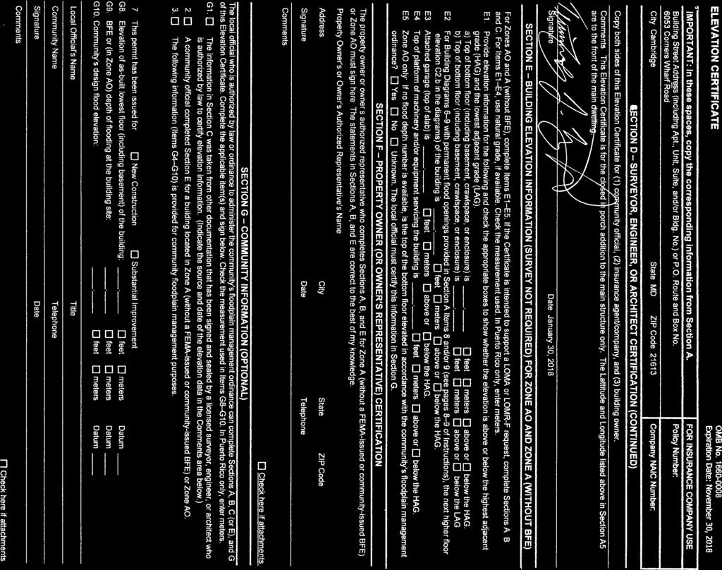
11 DORCHESTER COUNTY PLANNING & ZONING OFFICE Steve Dodd, Director 501 Court Lane, Room 111 Rodney Banks, Asst. Director P.O. Box office Cambridge, Maryland facsimile MEMO To: From: File Brian Soper Copy: Date: February 6, 2018 RE: 6053 Corners Wharf Rd, Elevation Certificate for Addition This Elevation Certificate is for enclosing the existing deck attached to the Single Family Dwelling (SFD) that was constructed Post-FIRM in The Base Flood Elevation for the SFD was 6 NGVD The enclosure meets/exceeds the elevation requirement of the SFD.
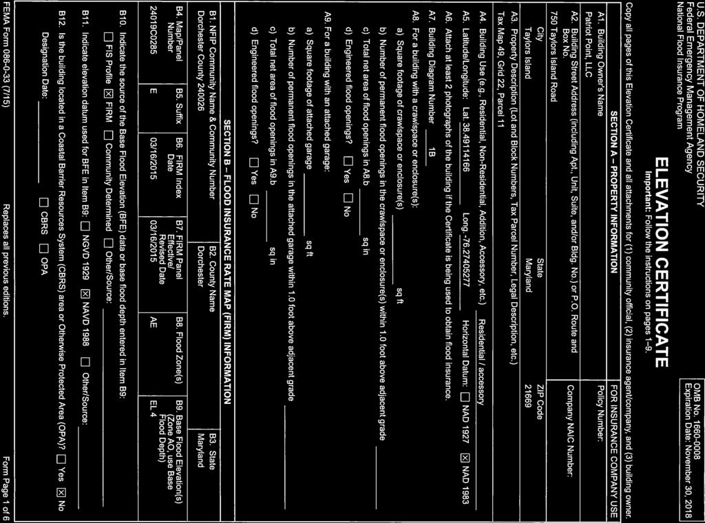
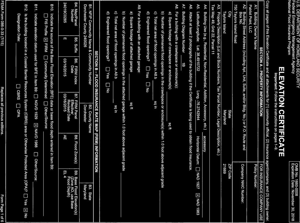
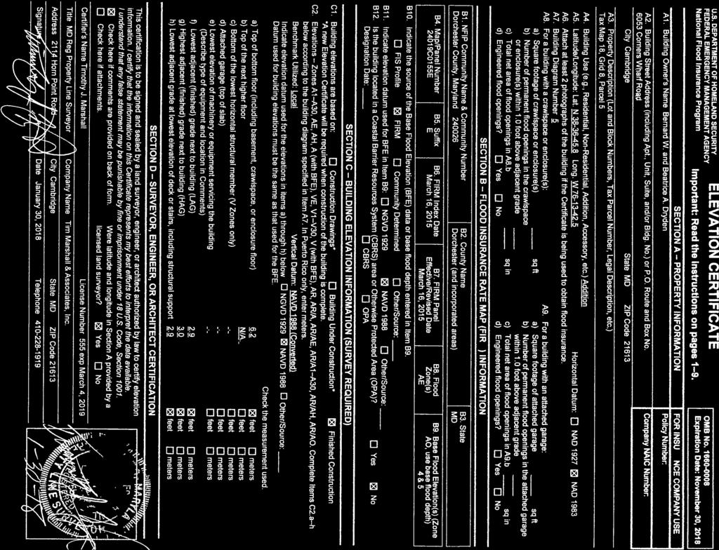
12 U.S. DEPARTMENT OF HOMELAND SECURITY Federal Emergency Management Agency National Flood Insurance Program ELEVATION CERTIFICATE Important: Follow the instructions on pages 1 9. Copy all pages of this Elevation Certificate and all attachments for (1) community official, (2) insurance agent/company, and (3) building owner. SECTION A PROPERTY INFORMATION FOR INSURANCE COMPANY USE A1. Building Owner's Name Policy Number: Samuel J. Frucht and Phyllis B. Frucht A2. Building Street Address (including Apt., Unit, Suite, and/or Bldg. No.) or P.O. Route and Box No. Company NAIC Number: 4504 Bay Shore Road City State ZIP Code Taylors Island Maryland A3. Property Description (Lot and Block Numbers, Tax Parcel Number, Legal Description, etc.) Tax Map: 58, Parcel: 42, a parcel of land described in Deed: Liber 366, Folio 34 A4. Building Use (e.g., Residential, Non-Residential, Addition, Accessory, etc.) Residential A5. Latitude/Longitude: Lat '55.2" Long '27.5" Horizontal Datum: NAD 1927 NAD 1983 A6. Attach at least 2 photographs of the building if the Certificate is being used to obtain flood insurance. A7. Building Diagram Number 7 A8. For a building with a crawlspace or enclosure(s): a) Square footage of crawlspace or enclosure(s) 1,852 sq ft b) Number of permanent flood openings in the crawlspace or enclosure(s) within 1.0 foot above adjacent grade c) Total net area of flood openings in A8.b *0 sq in 10 d) Engineered flood openings? Yes No A9. For a building with an attached garage: a) Square footage of attached garage N/A sq ft b) Number of permanent flood openings in the attached garage within 1.0 foot above adjacent grade c) Total net area of flood openings in A9.b sq in d) Engineered flood openings? Yes No SECTION B FLOOD INSURANCE RATE MAP (FIRM) INFORMATION B1. NFIP Community Name & Community Number B2. County Name B3. State Dorchester County unincorporated area Dorchester Maryland B4. Map/Panel Number B5. Suffix B6. FIRM Index Date B7. FIRM Panel Effective/ Revised Date B8. Flood Zone(s) B9. Base Flood Elevation(s) (Zone AO, use Base Flood Depth) 24019C0280 D 03/16/ /16/2015 AE 4.0 B10. Indicate the source of the Base Flood Elevation (BFE) data or base flood depth entered in Item B9: FIS Profile FIRM Community Determined Other/Source: B11. Indicate elevation datum used for BFE in Item B9: NGVD 1929 NAVD 1988 Other/ Source: B12. Is the building located in a Coastal Barrier Resources System (CBRS) area or Otherwise Protected Area (OPA)? Yes No Designation Date: CBRS OPA FEMA Form (7/15) Replaces all previous editions. Form Page 1 of 6
 or P.O. Route and Box No. Policy Number: 4504 Bay Shore Road City State ZIP Code Company NAIC Number Taylors Island Maryland 21669 SECTION C BUILDING ELEVATION INFORMATION (SURVEY REQUIRED) C1.")
, VE, V1 V30, V (with BFE), AR, AR/A, AR/AE, AR/A1 A30, AR/AH, AR/AO. Complete Items C2.")
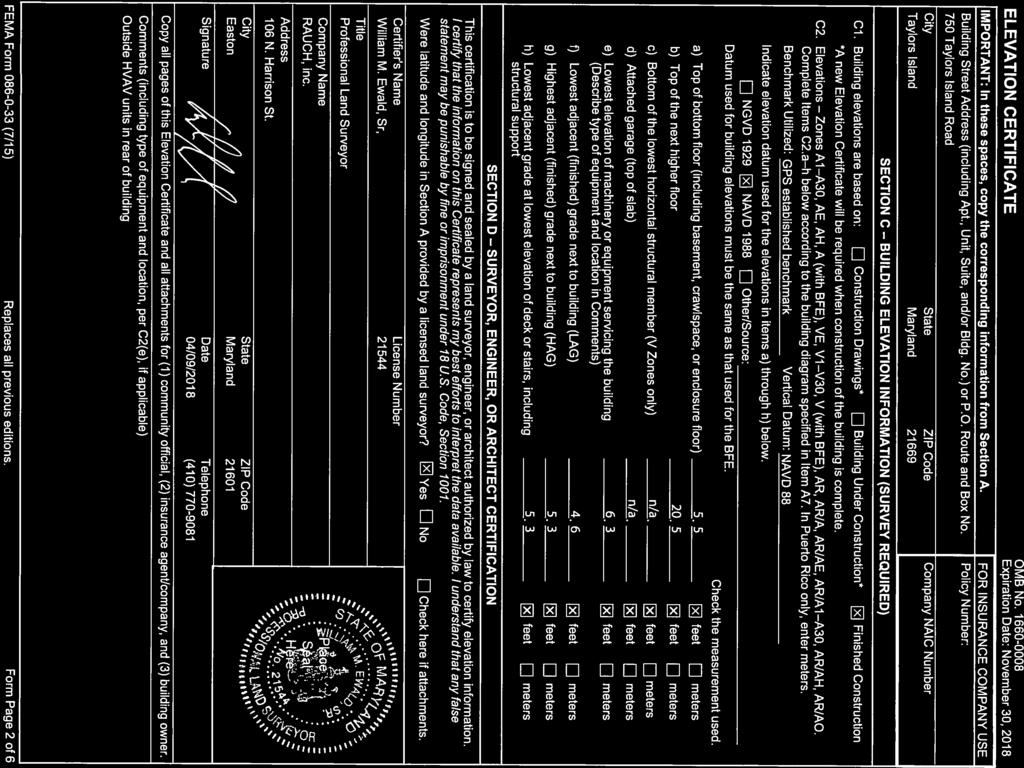
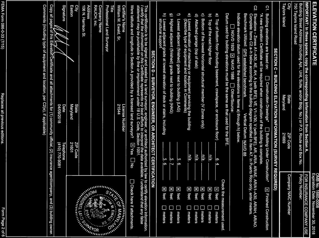
13 ELEVATION CERTIFICATE IMPORTANT: In these spaces, copy the corresponding information from Section A. FOR INSURANCE COMPANY USE Building Street Address (including Apt., Unit, Suite, and/or Bldg. No.) or P.O. Route and Box No. Policy Number: 4504 Bay Shore Road City State ZIP Code Company NAIC Number Taylors Island Maryland SECTION C BUILDING ELEVATION INFORMATION (SURVEY REQUIRED) C1. Building elevations are based on: Construction Drawings* Building Under Construction* Finished Construction *A new Elevation Certificate will be required when construction of the building is complete. C2. Elevations Zones A1 A30, AE, AH, A (with BFE), VE, V1 V30, V (with BFE), AR, AR/A, AR/AE, AR/A1 A30, AR/AH, AR/AO. Complete Items C2.a h below according to the building diagram specified in Item A7. In Puerto Rico only, enter meters. Benchmark Utilized: CORS Stations LOYG & LOYF Vertical Datum: NAVD 1988 Indicate elevation datum used for the elevations in items a) through h) below. NGVD 1929 NAVD 1988 Other/Source: Datum used for building elevations must be the same as that used for the BFE. Check the measurement used. a) Top of bottom floor (including basement, crawlspace, or enclosure floor) 3. 1 b) Top of the next higher floor 9. 8 c) Bottom of the lowest horizontal structural member (V Zones only) N/A. d) Attached garage (top of slab) N/A. e) Lowest elevation of machinery or equipment servicing the building 8. 1 (Describe type of equipment and location in Comments) f) Lowest adjacent (finished) grade next to building (LAG) 2. 8 g) Highest adjacent (finished) grade next to building (HAG) 5. 3 h) Lowest adjacent grade at lowest elevation of deck or stairs, including structural support 2. 2 SECTION D SURVEYOR, ENGINEER, OR ARCHITECT CERTIFICATION This certification is to be signed and sealed by a land surveyor, engineer, or architect authorized by law to certify elevation information. I certify that the information on this Certificate represents my best efforts to interpret the data available. I understand that any false statement may be punishable by fine or imprisonment under 18 U.S. Code, Section Were latitude and longitude in Section A provided by a licensed land surveyor? Yes No Check here if attachments. Certifier's Name License Number Jefferson Ewell Hubbard 363 Title Registered Property Line Surveyor Company Name Lane Engineering, LLC Address 117 Bay Street City State ZIP Code Easton Maryland Signature Date Telephone 01/12/2018 (410) Copy all pages of this Elevation Certificate and all attachments for (1) community official, (2) insurance agent/company, and (3) building owner. Comments (including type of equipment and location, per C2(e), if applicable) *10 SmartVENT model installed providing 200 square feet of flood protection each for a total of 2000 square feet of flood protection. The elevation of machinery listed in item C2 (e) is duct work in the crawlspace. FIS Transect 75 BFE is 3.7. Real-Time GPS corrections provided by Leica SmartNet North America. Latitude & Longitude from Google Earth. I hereby certify that these documents were prepared by me or under my responsible charge and complies with requirements as set forth in regulation , my current expiration date is 8/03/19 FEMA Form (7/15) Replaces all previous editions. Form Page 2 of 6
14 ELEVATION CERTIFICATE IMPORTANT: In these spaces, copy the corresponding information from Section A. FOR INSURANCE COMPANY USE Building Street Address (including Apt., Unit, Suite, and/or Bldg. No.) or P.O. Route and Box No. Policy Number: 4504 Bay Shore Road City Taylors Island State ZIP Code Maryland Company NAIC Number SECTION E BUILDING ELEVATION INFORMATION (SURVEY NOT REQUIRED) FOR ZONE AO AND ZONE A (WITHOUT BFE) For Zones AO and A (without BFE), complete Items E1 E5. If the Certificate is intended to support a LOMA or LOMR-F request, complete Sections A, B,and C. For Items E1 E4, use natural grade, if available. Check the measurement used. In Puerto Rico only, enter meters. E1. Provide elevation information for the following and check the appropriate boxes to show whether the elevation is above or below the highest adjacent grade (HAG) and the lowest adjacent grade (LAG). a) Top of bottom floor (including basement, crawlspace, or enclosure) is. above or below the HAG. b) Top of bottom floor (including basement, crawlspace, or enclosure) is. above or below the LAG. E2. For Building Diagrams 6 9 with permanent flood openings provided in Section A Items 8 and/or 9 (see pages 1 2 of Instructions), the next higher floor (elevation C2.b in the diagrams) of the building is. above or below the HAG. E3. Attached garage (top of slab) is. above or below the HAG. E4. Top of platform of machinery and/or equipment servicing the building is. above or below the HAG. E5. Zone AO only: If no flood depth number is available, is the top of the bottom floor elevated in accordance with the community's floodplain management ordinance? Yes No Unknown. The local official must certify this information in Section G. SECTION F PROPERTY OWNER (OR OWNER'S REPRESENTATIVE) CERTIFICATION The property owner or owner's authorized representative who completes Sections A, B, and E for Zone A (without a FEMA-issued or community-issued BFE) or Zone AO must sign here. The statements in Sections A, B, and E are correct to the best of my knowledge. Property Owner or Owner's Authorized Representative's Name Address City State ZIP Code Signature Date Telephone Comments FEMA Form (7/15) Replaces all previous editions. Check here if attachments. Form Page 3 of 6
15 ELEVATION CERTIFICATE IMPORTANT: In these spaces, copy the corresponding information from Section A. FOR INSURANCE COMPANY USE Building Street Address (including Apt., Unit, Suite, and/or Bldg. No.) or P.O. Route and Box No. Policy Number: 4504 Bay Shore Road City Taylors Island State Maryland ZIP Code SECTION G COMMUNITY INFORMATION (OPTIONAL) Company NAIC Number The local official who is authorized by law or ordinance to administer the community's floodplain management ordinance can complete Sections A, B, C (or E), and G of this Elevation Certificate. Complete the applicable item(s) and sign below. Check the measurement used in Items G8 G10. In Puerto Rico only, enter meters. G1. The information in Section C was taken from other documentation that has been signed and sealed by a licensed surveyor, engineer, or architect who is authorized by law to certify elevation information. (Indicate the source and date of the elevation data in the Comments area below.) G2. A community official completed Section E for a building located in Zone A (without a FEMA-issued or community-issued BFE) or Zone AO. G3. The following information (Items G4 G10) is provided for community floodplain management purposes. G4. Permit Number G5. Date Permit Issued G6. Date Certificate of Compliance/Occupancy Issued G7. This permit has been issued for: New Construction Substantial Improvement G8. Elevation of as-built lowest floor (including basement) of the building:. Datum G9. BFE or (in Zone AO) depth of flooding at the building site:. Datum G10. Community's design flood elevation:. Datum Local Official's Name Title Community Name Telephone Signature Date Comments (including type of equipment and location, per C2(e), if applicable) FEMA Form (7/15) Replaces all previous editions. Check here if attachments. Form Page 4 of 6
Letters of Map Amendment- Out as Shown
 Letters of Map Amendment- Out as Shown While digital Flood Insurance Rate Maps (DFIRM s) have made it easier to determine if a structure (or building site) is in the special flood hazard area (SFHA), many
October 2011 Flood Insurance Manual
 FEMA NFIP C h a n g e s October 2011 Flood Insurance Manual 1 Significant Revisions The Changes Where to find the Change Building Occupancy Classification Updates Improvements and Betterments Coverage
BOARD OF COUNTY COMMISSIONERS SARPY COUNTY, NEBRASKA. RESOLUTION FLOOD PLAIN DEVELOPMENT Alan Hans Sandy Point Springfield, NE
 BOARD OF COUNTY COMMISSIONERS SARPY COUNTY, NEBRASKA 2011-158 RESOLUTION FLOOD PLAIN DEVELOPMENT Alan Hans 18215 Sandy Point Springfield, NE WHEREAS, pursuant to Neb. Rev. Stat. 23-104 (Reissue 2007),
Federal Emergency Management Agency
 Page 1 of 3 Date: July 21, 2016 Case No.: 16-05-5203A LOMA COMMUNITY AND MAP PANEL INFORMATION COMMUNITY KEWAUNEE COUNTY, WISCONSIN (Unincorporated Areas) Federal Emergency Management Agency Washington,
BOARD OF COUNTY COMMISSIONERS SARPY COUNTY, NEBRASKA. RESOLUTION FLOOD PLAIN DEVELOPMENT Louis Riha, South Highway 50, Springfield, NE
 2011-380 BOARD OF COUNTY COMMISSIONERS SARPY COUNTY, NEBRASKA RESOLUTION FLOOD PLAIN DEVELOPMENT Louis Riha, 20404 South Highway 50, Springfield, NE WHEREAS, pursuant to Neb. Rev. Stat. 23-104 (Reissue
FEDERAL EMERGENCY MANAGEMENT AGENCY MITIGATION DIRECTORATE TECHNICAL SERVICES DIVISION AMENDMENTS AND REVISIONS TO
 FEDERAL EMERGENCY MANAGEMENT AGENCY MITIGATION DIRECTORATE TECHNICAL SERVICES DIVISION AMENDMENTS AND REVISIONS TO NATIONAL FLOOD INSURANCE PROGRAM MAPS Application/Certification Forms and Instructions
Criteria for Appeals of Flood Insurance Rate Maps. November 30, 201 1
 Criteria for Appeals of Flood Insurance Rate Maps November 30, 201 1 This document outlines the criteria for appealing proposed changes in flood hazard information on Flood Insurance Rate Maps (FIRMS)
National Flood Insurance Program (NFIP) MT-1 Presentation. David Mummert, Michael Baker Jr., Inc.
 MT-1 Presentation. David Mummert, Michael Baker Jr., Inc.") National Flood Insurance Program (NFIP) MT-1 Presentation David Mummert, Michael Baker Jr., Inc. MT-1 Letters of Map Change (LOMCs) LOMC Review By FEMA FEMA required to notify the applicant in writing
National Flood Insurance Program (NFIP) MT-1 Presentation David Mummert, Michael Baker Jr., Inc. MT-1 Letters of Map Change (LOMCs) LOMC Review By FEMA FEMA required to notify the applicant in writing
Flood Hazard Development Permit Application & Permit Forms. For Communities with Coastal Velocity Zones [60.3(e)] CONTENTS
![Flood Hazard Development Permit Application & Permit Forms. For Communities with Coastal Velocity Zones [60.3(e)] CONTENTS](/thumbs/76/74346075.jpg "Flood Hazard Development Permit Application & Permit Forms. For Communities with Coastal Velocity Zones [60.3(e)] CONTENTS") Flood Hazard Development Permit Application & Permit Forms For Communities with Coastal Velocity Zones [60.3(e)] CONTENTS 1. Decision Tree 2. Flood Hazard Development Permit Application 3. Flood Hazard
Flood Hazard Development Permit Application & Permit Forms For Communities with Coastal Velocity Zones [60.3(e)] CONTENTS 1. Decision Tree 2. Flood Hazard Development Permit Application 3. Flood Hazard
Date of Review: 11/6/2015 Reviewer: RCQ/LMC STATE
 FINAL Florida Review Checklist: NFIP & FBC & Revised Model Ordinance (January 15, 2013d) Ordinance Citation: Model FPM regulations and 5 th Edition FBC : All Zones Date of Review: 11/6/2015 Reviewer: RCQ/LMC
Project Name: (Name as it appears in ESNAPS.) Spring Care Association
 Spring Care Association") Page 1 of 4 U.S. Department of Housing and Urban Development 451 Seventh Street, SW Washington, DC 20410 www.hud.gov espanol.hud.gov Environmental Review for Continuum of Care (CoC) Rental Assistance Project
Page 1 of 4 U.S. Department of Housing and Urban Development 451 Seventh Street, SW Washington, DC 20410 www.hud.gov espanol.hud.gov Environmental Review for Continuum of Care (CoC) Rental Assistance Project
MT 1, MT 2, Elevation Certificates & the Role of Surveyors
 MT 1, MT 2, Elevation Certificates & the Role of Surveyors Rocky Mountain Surveyors Summit March 3, 2016 Floods are acts of God, but flood losses are largely acts of man. - Dr. Gilbert White the father
National Flood Insurance Program
 National Flood Insurance Program Base Flood Elevations in Zone A Streams Surveyor Training Presented by Thomas F. Smith, PE, PLS January 22, 2018 1 FEMA Region III Mitigation Division Floodplain Management
CONDITIONAL USE PEMIT
 WALLOWA COUNTY PLANNING DEPARTMENT Wallowa County Courthouse Permit Number 101 S. River St., Room B-1 Date Filed Enterprise, OR 97828 Total Fee 541-426-4543 ext 170 plansec@co.wallowa.or.us Check Number
Zoning Permit Application Cover Page
 Zoning Permit Application Cover Page The City of Belmont performs an initial site inspection prior to issuance of a zoning permit for new construction. Upon receipt of a full and complete application submittal
RD:VMT:NGA ORD. NO /3/09 ORDINANCE NO
 ORDINANCE NO. 28512 AN ORDINANCE OF THE CITY OF SAN JOSE AMENDING CHAPTER 17.08 OF TITLE 17 OF THE SAN JOSE MUNICIPAL CODE TO UPDATE THE CITY S SPECIAL FLOOD HAZARD REGULATIONS WHEREAS, the Council of
ORDINANCE NO (1123)
") ORDINANCE NO. 2013-08 (1123) ORDINANCE OF THE BOROUGH OF LAVALLLETTE, COUNTY OF OCEAN, STATE OF NEW JERSEY, AMENDING AND SUPPLEMENTING CHAPTER 31, ENTITLED FLOOD HAZARD AREAS, OF THE REVISED GENERAL ORDINANCES
ORDINANCE NO. 2013-08 (1123) ORDINANCE OF THE BOROUGH OF LAVALLLETTE, COUNTY OF OCEAN, STATE OF NEW JERSEY, AMENDING AND SUPPLEMENTING CHAPTER 31, ENTITLED FLOOD HAZARD AREAS, OF THE REVISED GENERAL ORDINANCES
Pier, Dock or Wharf Registration Form
 Document Number Pier, Dock or Wharf Registration Form State of Wisconsin Form 3500-114 (R 05/08) Page 1 of 5 Department of Natural Resources Bureau of Watershed Management Attn: Roberta Lund - WT/4 PO
Letter of Map Change Fundamentals
 Letter of Map Change Fundamentals FEMA Region III National Flood Insurance Program Essentials and Best Practices Jana Green, CFM, RAMPP Topics of Discussion Why Apply for a Letter of Map Change (LOMC)?
BOARD OF COUNTY COMMISSIONERS SARPY COUNTY, NEBRASKA. RESOLUTION FLOOD PLAIN DEVELOPMENT Frank Sladek, Buffalo Road Springfield, NE
 BOARD OF COUNTY COMMSSONERS SARPY COUNTY, NEBRASKA RESOLUTON FLOOD PLAN DEVELOPMENT Frank Sladek, 11303 Buffalo Road Springfield, NE WHEREAS, pursuant to Neb. Rev. Stat. 23-104 (Reissue 2007), the County
Grand Forks Growth Fund, A Jobs Development Authority Staff Report
 Grand Forks Growth Fund, A Jobs Development Authority Staff Report Growth Fund Committee March 20, 2017 JDA March 20, 2017 Agenda Item: Business Park Infrastructure Submitted by: Ryan Brooks, Deputy City
Square feet of Lot: State Parcel: Subdivision. Name: Subd. Sec:
 Permit # Floodplain Development Permit Application Hendricks County Planning & Building 355 S. Washington Street Suite 212, Danville IN 46122 Office: 317-745-9255 / Fax: 317-745-9347 Owner Information
BAY COUNTY BUILDERS SERVICES DIVISION RESIDENTIAL. MANUFACTURER/MOBILE HOME PLAN REVIEW SUBMITTAL FORM (For HUD approved structures only)
") Form B24 BAY COUNTY BUILDERS SERVICES DIVISION RESIDENTIAL MANUFACTURER/MOBILE HOME PLAN REVIEW SUBMITTAL FORM (For HUD approved structures only) AVOID PROCESSING DELAYS Please provide all applicable items
Form B24 BAY COUNTY BUILDERS SERVICES DIVISION RESIDENTIAL MANUFACTURER/MOBILE HOME PLAN REVIEW SUBMITTAL FORM (For HUD approved structures only) AVOID PROCESSING DELAYS Please provide all applicable items
Cibola County Floodplain Development Permit Application
 Cibola County Floodplain Development Permit Application Application # FP Use Permit Variance Appeal Permit Fee $25.00 Date SECTION I: GENERAL PROVISIONS (APPLICANT to read and sign) 1. No work of any kind
ORDINANCE NO
 ORDINANCE NO. 11-311 AN ORDINANCE OF THE CITY OF MONTROSE, SD, AMENDING THE REVISED MUNICIPAL ORDINANCES OF THE CITY BY AMENDING CHAPTER 9.04, FLOOD INSURANCE. BE IT ORDAINED BY THE CITY OF MONTROSE, SD:
Floodplain Development Land Use Review
 PUBLIC WORKS - COMMUNITY DEVELOPMENT 333 Broadalbin Street SW, PO Box 490, Albany, Oregon 97321-0144 BUILDING 541-917-7553 PLANNING 541-917-7550 Floodplain Development Land Use Review Application Information
FLOOD DAMAGE PREVENTION ORDINANCE FOR THE TOWN OF FRANKLIN
 FLOOD DAMAGE PREVENTION ORDINANCE FOR THE TOWN OF FRANKLIN ARTICLE 1. SECTION A. STATUTORY AUTHORIZATION, FINDINGS OF FACT, PURPOSE AND OBJECTIVES. STATUTORY AUTHORIZATION. The Legislature of the State
On motion by, and seconded by, All Council Members present, the following ordinance was introduced: ORDINANCE 1552
 On motion by, and seconded by, All Council Members present, the following ordinance was introduced: ORDINANCE 1552 An ordinance repealing Chapter 10 BUILDING AND CONSTRUCTION REGULATIONS - Article II Special
MAP INDEX CHECKLIST NOTES:
 REVIEWING YOUR PRELIMINARY DFIRM PANELS AND FIS REPORT A GUIDE FOR COMMUNITY OFFICIALS When a Georgia community is presented with new Digital Flood Insurance Rate Map (DFIRM) panels, the State of Georgia,
Oxford Floodplain Management Ordinance
 Table of Contents SECTION 1.0 GENERAL PROVISIONS...1 1.1 Findings...1 1.2 Statutory Authorization...1 1.3 Statement of Purpose...1 1.4 Areas to Which These Regulations Apply...2 1.5 Basis for Establishing
FENCE and or POOL BARRIER CHECKLIST
 TOWN OF SEWALL S POINT BUILDING DEPARTMENT One S. Sewall s Point Road Sewall s Point, Florida 34996 Tel 772-287-2455 Fax 772-2204765 FENCE and or POOL BARRIER CHECKLIST A document review will be performed
BOARD OF COUNTY COMMISSIONERS SARPY COUNTY, NEBRASKA
 2015-440 BOARD OF COUNTY COMMISSIONERS SARPY COUNTY, NEBRASKA RESOLUTION FLOOD PLAIN DEVELOPMENT Kenneth & Sharon Meyer, 9900 S 252"d ST, Unit 39, Vencils Island, Tax Lot 12 Sec 28- T14N-R10E, Sarpy County,
HARRISON COUNTY FLOOD DAMAGE PREVENTION ORDINANCE
 HARRISON COUNTY FLOOD DAMAGE PREVENTION ORDINANCE Harrison County Board Of Supervisors December 21, 2017 FLOOD DAMAGE PREVENTION TABLE OF CONTENTS ARTICLE 1. STATUTORY AUTHORIZATION, FINDINGS OF FACT,
CITY OF CAMBRIDGE FLOODPLAIN MANAGEMENT CHAPTER 7 (GRADING, EROSION AND SEDIMENT CONTROL)
") CITY OF CAMBRIDGE FLOODPLAIN MANAGEMENT CHAPTER 7 (GRADING, EROSION AND SEDIMENT CONTROL) City of Cambridge, MD Floodplain Management Ordinance (Tidal): May, 2011 1 City of Cambridge, Maryland Floodplain
CITY OF CAMBRIDGE FLOODPLAIN MANAGEMENT CHAPTER 7 (GRADING, EROSION AND SEDIMENT CONTROL) City of Cambridge, MD Floodplain Management Ordinance (Tidal): May, 2011 1 City of Cambridge, Maryland Floodplain
ORDINANCE NO. 990 CITY OF OCEAN SHORES, WASHINGTON. NOW, THEREFORE, the City Council of the Ocean Shores does hereby ordain as follows:
 CITY OF OCEAN SHORES, WASHINGTON ORDINANCE NO. 990 AN ORDINANCE OF THE CITY COUNCIL OF THE CITY OF OCEAN SHORES, WASHINGTON, AMENDING OCEAN SHORES MUNICIPAL CODE CHAPTER 15.36 FLOOD DAMAGE PREVENTION WHEREAS,
FLOOD DAMAGE PREVENTION ORDINANCE. Non-Coastal Regular Phase
 FLOOD DAMAGE PREVENTION ORDINANCE Non-Coastal Regular Phase ARTICLE 1. SECTION A. STATUTORY AUTHORIZATION, FINDINGS OF FACT, PURPOSE AND OBJECTIVES. STATUTORY AUTHORIZATION. Municipal: The Legislature
ORDINANCE NO. 641-C BE IT ORDAINED BY THE CITY COUNCIL OF THE CITY OF SOUTHLAKE, TEXAS: ARTICLE I
 ORDINANCE NO. 641-C AN ORDINANCE PROVIDING FOR THE CITY OF SOUTHLAKE, TEXAS ADOPTING REGULATIONS DESIGNED TO MINIMIZE FLOOD LOSSES; ESTABLISHING PROVISIONS FOR FLOOD HAZARD REDUCTION; ADOPTING THE FLOOD
Restrict or prohibit uses which are dangerous to health, safety and property due to water or erosion or in flood heights or velocities;
 CODE OF ORDINANCES, CITY OF BRISTOL, CONNECTICUT APPENDIX D, FLOOD DAMAGE PREVENTION (adopted on August 12, 2008) SECTION 1 - STATUTORY AUTHORIZATION, FINDING OF FACT, PURPOSE AND OBJECTIVES 1.1. Statutory
Adopted by the Vance County Board of Commissioners April 2, Amended April 8, 2013.
 Ordinance: #29 VANCE COUNTY ORDINANCE #29 ------------------------------------------------------------------------------------------------------------------------------ FLOOD DAMAGE PREVENTION ORDINANCE
2412 E. 26TH ST E 26th St, Minneapolis, MN 55406
 SALE PRICE: $425,000 LOT SIZE:.17 Acres BUILDING SIZE: +/-2,400 SF DRIVE-IN DOORS 1 CEILING HEIGHT: 14' YEAR BUILT: 1970 ZONING: I2 Medium Industrial District PROPERTY OVERVIEW Small shop, flexible office
Florida CRS Initiative CRS CAV Pilot Program
 Florida CRS Initiative CRS CAV Pilot Program Enrolling Communities in the Community Rating System SEVEN PERFORMANCE MEASURES 2015-2017 Bureau of Mitigation Florida Division of Emergency Management STATE
DLCD ACKNOWLEDGMENT or DEADLINE TO APPEAL: Friday, April 22, 2011
 Department of Land Conservation and Development 635 Capitol Street, Suite 150 Salem, O R 9730 1-2540 (503) 373-0050 Fax (503) 378-5518 w w w. lc d. s tat e. or. us NOTICE OF ADOPTED AMENDMENT fita 04/11/2011
ORDINANCE NO. 992 CITY OF OCEAN SHORES, WASHINGTON
 CITY OF OCEAN SHORES, WASHINGTON ORDINANCE NO. 992 AN EMERGENCY ORDINANCE OF THE CITY COUNCIL OF THE CITY OF OCEAN SHORES, WASHINGTON, AMENDING ORDINANCE NO. 990 AND OCEAN SHORES MUNICIPAL CODE CHAPTER
Athens Township Zoning Permit
 Athens Township Zoning Permit 1.) Work authorized by the zoning permit must begin within six (6) months And must be completed within24 months of the date of issuance 2.) Contractor/Builder must comply
Chatham County Flood Damage Prevention Ordinance
 CHATHAM COUNTY FLOOD DAMAGE PREVENTION ORDINANCE ARTICLE 1 STATUTORY AUTHORIZATION, FINDINGS OF FACT, PURPOSE AND OBJECTIVES SECTION A STATUTORY AUTHORIZATION The Legislature of the State of North Carolina
DIVISION 1. - GENERAL PROVISIONS
 Sec. 90-708. - Statutory authorization and purpose. Sec. 90-709. - Applicability. Sec. 90-710. - Compliance and liability. Sec. 90-711. - Records. Sec. 90-712. - Abrogation and greater restrictions. Sec.
THE FUNDAMENTALS OF MANUFACTURED LENDING
 THE FUNDAMENTALS OF MANUFACTURED LENDING Last Revised: 06/07/17 DISCLAIMER These materials are intended for AFR internal use and client training procedures only. This is neither legal advice nor a substitute
ADDITION/REMODEL APPLICATION CHECKLIST 2017 FBC. Please make sure you have ALL required copies before submitting permit application
 ADDITION/REMODEL APPLICATION CHECKLIST 2017 FBC A document review will be performed on the following items prior to the submittal of a permit application. Failure to submit these items will result in the
Flood Hazard Zone. [Amended effective ; ; ; ; ; ]
![Flood Hazard Zone. [Amended effective ; ; ; ; ; ]](/thumbs/82/86423647.jpg "Flood Hazard Zone. [Amended effective ; ; ; ; ; ]") ARTICLE 110, Flood Hazard Zone [Added effective 4-24-1978] 118-1100. Flood Hazard Zone. [Amended effective 8-19-1986; 2-26-1993; 6-18-2010; 12-24- 2010; 7-8-2013; 7-25-2014] A. Purpose and intent. (1)
ARTICLE 110, Flood Hazard Zone [Added effective 4-24-1978] 118-1100. Flood Hazard Zone. [Amended effective 8-19-1986; 2-26-1993; 6-18-2010; 12-24- 2010; 7-8-2013; 7-25-2014] A. Purpose and intent. (1)
SWIMMING POOL GUIDELINES
 SWIMMING POOL GUIDELINES Zoning Review Fee: $15.00 Building Permit Fees: Above Ground $75.00 / In-Ground $100.00 +1% OBBS Fee Ordinance 1262.08 Engineering and other fees may apply. *Check with Homeowners
CHATHAM COUNTY FLOOD DAMAGE PREVENTION ORDINANCE ARTICLE 1 STATUTORY AUTHORIZATION, FINDINGS OF FACT, PURPOSE AND OBJECTIVES
 CHATHAM COUNTY FLOOD DAMAGE PREVENTION ORDINANCE ARTICLE 1 STATUTORY AUTHORIZATION, FINDINGS OF FACT, PURPOSE AND OBJECTIVES SECTION A STATUTORY AUTHORIZATION The Legislature of the State of North Carolina
Overview of Federal and State Floodplain Management Programs
 Overview of Federal and State Floodplain Management Programs Peter DeMeo, PE Supervising Environmental Engineer New Jersey Department of Environmental Protection Division of Land Use Regulation October
ORDINANCE NO
 ORDINANCE NO. 1715.08 AN ORDINANCE ADOPTING A FLOOD DAMAGE PREVENTION ORDINANCE FOR THE CITY OF SAN ELIZARIO; ESTABLISHING FLOOD CONTROL REGULATIONS; CREATING A MISDEMEANOR OFFENSE PUNISHABLE BY A FINE
ORDINANCE # ARTICLE I STATUTORY AUTHORIZATION, FINDINGS OF FACT, PURPOSE AND METHODS
 60.3 (b) FLOOD DAMAGE PREVENTION ORDINANCE ORDINANCE #2009-07 ARTICLE I STATUTORY AUTHORIZATION, FINDINGS OF FACT, PURPOSE AND METHODS SECTION A. STATUTORY AUTHORIZATION The Legislature of the State of
STATUTORY AUTHORIZATION
 TABLE OF CONTENTS SECTION NUMBER NAME STARTS AT PAGE 16.1 Statutory Authorization, Findings of Fact, 16-1 Purpose and Objectives 16.2 Definitions 16-3 16.3 General Provisions 16-13 16.4 Administration
Caldwell County. Flood Damage Prevention Ordinance
 Caldwell County Flood Damage Prevention Ordinance Adopted June 15, 2009 Effective July 7, 2009 Caldwell County Flood Ordinance 2 FLOOD DAMAGE PREVENTION ORDINANCE FOR CALDWELL COUNTY ARTICLE 1. STATUTORY
MIAMI SHORES VILLAGE
 MIAMI SHORES VILLAGE 10050 Northeast Second Avenue Miami Shores, Florida 33138 Telephone (305)795-2207 Fax (305)756-8972 www.miamishoresvillage.com PLANNING & ZONING BOARD APPLICATION SUBDIVISION FINAL
CITY OF OAK RIDGE KAUFMAN COUNTY, TEXAS ORDINANCE FLOODPLAIN MANAGEMENT
 CITY OF OAK RIDGE KAUFMAN COUNTY, TEXAS ORDINANCE 32-10 FLOODPLAIN MANAGEMENT ARTICLE I STATUTORY AUTHORIZATION, FINDINGS OF FACT, PURPOSE AND METHODS SECTION A. STATUTORY AUTHORIZATION The Legislature
Dear Sir/Madam. RE: Billboard Sign Control Program
 Dear Sir/Madam RE: Enclosed is an application for a State Permit and our regulation booklet. Please review the regulations and if the sign complies, submit a signed, completed application and W9 with the
An Ordinance of the City of Shady Cove, Oregon An Oregon Municipal Corporation
 An Ordinance of the City of Shady Cove, Oregon An Oregon Municipal Corporation ORDINANCE NO. 259 Establishing Regulations To Prevent Flood Damage Within The City Of Shady Cove, Oregon, Adopting Related
SHAWNEE COUNTY, KANSAS
 SHAWNEE COUNTY, KANSAS Instructions for SIGN PERMIT APPLICATION READ THOROUGHLY BEFORE SUBMITTING APPLICATION These instructions are provided to aid applicants of unincorporated Shawnee County in completing
COMMERCIAL SITE DEVELOPMENT GUIDE FOR UNINCORPORATED ST. CHARLES COUNTY
 COMMERCIAL SITE DEVELOPMENT GUIDE FOR UNINCORPORATED ST. CHARLES COUNTY GENERAL INFORMATION: This brochure is to be used as a guide and is not intended to amend or supersede the corresponding County ordinances
TITLE XV: LAND USAGE 151. SUBDIVISIONS
 TITLE XV: LAND USAGE Chapter 150. FLOOD 151. SUBDIVISIONS 152. ZONING 1 2 Parkston - Land Usage CHAPTER 150: FLOOD Section General Provisions 150.01 Statutory authorization 150.02 Findings of fact 150.03
Article 18 FLOOD DAMAGE PREVENTION ORDINANCE (amended November 13, 2018)
") Article 18 FLOOD DAMAGE PREVENTION ORDINANCE (amended November 13, 2018) ARTICLE 18.1. SECTION A. STATUTORY AUTHORIZATION, FINDINGS OF FACT, PURPOSE AND OBJECTIVES. STATUTORY AUTHORIZATION. The Legislature
Article 18 FLOOD DAMAGE PREVENTION ORDINANCE (amended November 13, 2018) ARTICLE 18.1. SECTION A. STATUTORY AUTHORIZATION, FINDINGS OF FACT, PURPOSE AND OBJECTIVES. STATUTORY AUTHORIZATION. The Legislature
ORDINANCE NO
 ORDINANCE NO. 2001-2 AN ORDINANCE OF THE TOWN COUNCIL OF THE TOWN OF SOUTHWEST RANCHES, FLORIDA, CREATING A PLAN FOR FLOOD DAMAGE PREVENTION TO MINIMIZE PUBLIC AND PRIVATE LOSSES DUE TO FLOOD CONDITIONS
Map Modernization Modernization Program
 FEMA Map Modernization Program Presented to Maryland Association of Floodplain and Stormwater Managers October 27, 2005 Map Modernization Program Autorun.exe 2 Map Modernization Program Outline Map Mod
SUBDIVISION APPLICATION: RECOMBINATION PLAT or EXEMPT PLAT
 SUBDIVISION APPLICATION: RECOMBINATION PLAT or EXEMPT PLAT Pursuant to Article 7, Section 155.706 of the Unified Development Code, an owner of land within the jurisdiction of the Town (or a duly authorized
11. FLOODPLAIN MANAGEMENT REGULATIONS
 11. FLOODPLAIN MANAGEMENT REGULATIONS 11.1 STATUTORY AUTHORIZATION AND PURPOSE A. STATUTORY AUTHORIZATION The Legislature of the State of Connecticut has delegated in Title 7, Chapter 98, Section 7-148(c)(7)(A),
NEW SINGLE FAMILY RESIDENTIAL
 Community Development Building & Permitting Development 38 Hill Street, Suite G-30 Roswell, GA 30075 770-641-3780 www.roswellgov.com NEW SINGLE FAMILY RESIDENTIAL BUILDING PERMIT APPLICATION This packet
How to find your home s required finished floor elevation according to City s proposed new Floodplain Ordinance
 City of Mexico Beach New Floodplain Ordinance How to find your home s required finished floor elevation according to City s proposed new Floodplain Ordinance This Ordinance only affects the following property
ORDINANCE NO SECTION 1. RECITALS. The foregoing whereas clauses are incorporated herein by reference and made a part hereof.
 ORDINANCE NO. 13-10 AN ORDINANCE BY THE TREASURE ISLAND CITY COMMISSION AMENDING THE TREASURE ISLAND CODE OF ORDINANCES TO REPEAL CHAPTER 66, FLOOD CONTROL TO ADOPT A NEW CHAPTER 66, FLOODPLAIN MANAGEMENT
FLOOD ORDINANCE OF MACON COUNTY
 FLOOD ORDINANCE OF MACON COUNTY ARTICLE 1. SECTION A. STATUTORY AUTHORIZATION, FINDINGS OF FACT, PURPOSE AND OBJECTIVES. STATUTORY AUTHORIZATION. The Legislature of the State of North Carolina has in Part
ARTICLE 13. FLOOD HAZARD AREA REGULATIONS
 SANFORD-BROADWAY-LEE COUNTY UNIFIED DEVELOPMENT ORDINANCE ARTICLE 13. FLOOD HAZARD AREA REGULATIONS Summary: This Article contains comprehensive standards and procedures for the purpose of regulating development
COMMERCIAL/ INDUSTRIAL PERMIT APPLICATION
 APPLICANT INFORMATION: COMMERCIAL/ INDUSTRIAL Permit No: Requested: Receipt No: Council District/At Large: Zoning District: Parcel No: Lot, Sq., Subdivision: Historic Dist. / Landmark: Yes / No Hearing
Chapter 8.01 FLOOD DAMAGE PREVENTION
 8.01.010 Chapter 8.01 FLOOD DAMAGE PREVENTION Sections: 8.01.010 Statutory authorization. 8.01.011 Findings of fact. 8.01.012 Statement of purpose. 8.01.013 Methods of reducing flood losses. 8.01.020 Definitions.
(Ord. No , 5(Exh. C), )
, )") Chapter 34 - FLOOD DAMAGE PREVENTION [1] Footnotes: --- (1) --- Editor's note The flood damage prevention ordinance, as set out herein by Ord. No. 20-09, 5(Exh. C), adopted Sept. 21, 2009, shall become
Chapter 34 - FLOOD DAMAGE PREVENTION [1] Footnotes: --- (1) --- Editor's note The flood damage prevention ordinance, as set out herein by Ord. No. 20-09, 5(Exh. C), adopted Sept. 21, 2009, shall become
Title 15. Buildings, Construction, Addressing and Land Use
 Chapters: 15.05 Land Use Fees 15.10 Flood Damage Prevention 15.15 Building Numbering Title 15 Buildings, Construction, Addressing and Land Use 15-1 Lyons Municipal Code 15.05.040 Chapter 15.05 Land Use
TUSCARAWAS COUNTY FLOOD DAMAGE REDUCTION REGULATIONS
 TUSCARAWAS COUNTY FLOOD DAMAGE REDUCTION REGULATIONS 2010 Approved for adoption by ODNR 5/11/07 Adopted by the Board of Tuscarawas County Commissioners Date: October 1, 2007 Resolution No: 736-2007 Revised
Secondary Dwelling Unit
 Secondary Dwelling Unit Review of Special Use Regulations (City Code Section 17.228.105) The purpose of this application is to determine whether or not your project meets the Planning and Development Code
TOWN OF SPAFFORD LOCAL LAW 3 OF THE YEAR 2016
 TOWN OF SPAFFORD LOCAL LAW 3 OF THE YEAR 2016 A Local Law Amending Local Law No. 2 of the Year 1990 to repeal the existing language and replace it with the following language relating to Flood Damage Prevention
Chapter FLOOD DAMAGE PREVENTION
 Lake Elsinore Municipal Code Chapter 15.64 FLOOD DAMAGE PREVENTION Page 1 of 29 Sections: 15.64.100 Statutory authorization. 15.64.110 Findings of fact. 15.64.120 Statement of purpose. 15.64.130 Methods
6. Help maintain a stable tax base by providing for the sound use and development of flood hazard areas;
 CHAPTER 9 FLOODPLAIN MANAGEMENT SECTION 101 GENERAL 101.1 Title. These regulations shall be known as the Floodplain Management Ordinance of Yankeetown, hereinafter referred to as this ordinance. 101.2
CHAPTER 5 FLOOD DAMAGE PREVENTION. (Amended 10/4/2004; 6/4/2007)
") CHAPTER 5 FLOOD DAMAGE PREVENTION (Amended 10/4/2004; 6/4/2007) 6-5-2007-255 - FLOOD DAMAGE PREVENTION ORDINANCE ARTICLE I SECTION A. STATUTORY AUTHORIZATION, FINDINGS OF FACT, PURPOSE AND OBJECTIVES.
CHAPTER 5 FLOOD DAMAGE PREVENTION (Amended 10/4/2004; 6/4/2007) 6-5-2007-255 - FLOOD DAMAGE PREVENTION ORDINANCE ARTICLE I SECTION A. STATUTORY AUTHORIZATION, FINDINGS OF FACT, PURPOSE AND OBJECTIVES.
Town of Alexandria. Floodplain Management Ordinance
 1 of 7 8/8/2009 4:56 PM Town of Alexandria Floodplain Management Ordinance SECTION 1 PURPOSE Certain areas of the Town of Alexandria, New Hampshire are subject to periodic flooding, causing serious damages
CITY OF MUSKEGO CHAPTER 14 - FLOODPLAIN ZONING ORDINANCE (Ord. # )
") CITY OF MUSKEGO CHAPTER 14 - FLOODPLAIN ZONING ORDINANCE (Ord. #1340 2-20-2014) 1.0 STATUTORY AUTHORIZATION, FINDING OF FACT, STATEMENT OF PURPOSE, TITLE AND GENERAL PROVISIONS.... 1 1.1 STATUTORY AUTHORIZATION...
CITY OF MUSKEGO CHAPTER 14 - FLOODPLAIN ZONING ORDINANCE (Ord. #1340 2-20-2014) 1.0 STATUTORY AUTHORIZATION, FINDING OF FACT, STATEMENT OF PURPOSE, TITLE AND GENERAL PROVISIONS.... 1 1.1 STATUTORY AUTHORIZATION...
ORDINANCE NO. 14 C2-) AN ORDINANCE OF THE COUNTY OF VENTURA REPEALING AND REENACTING THE VENTURA COUNTY FLOODPLAIN MANAGEMENT ORDINANCE SECTION 1
 AN ORDINANCE OF THE COUNTY OF VENTURA REPEALING AND REENACTING THE VENTURA COUNTY FLOODPLAIN MANAGEMENT ORDINANCE SECTION 1") ORDINANCE NO. 14 C2-) AN ORDINANCE OF THE COUNTY OF VENTURA REPEALING AND REENACTING THE VENTURA COUNTY FLOODPLAIN MANAGEMENT ORDINANCE The Board of Supervisors of the County of Ventura ordains as follows:
ORDINANCE NO. 14 C2-) AN ORDINANCE OF THE COUNTY OF VENTURA REPEALING AND REENACTING THE VENTURA COUNTY FLOODPLAIN MANAGEMENT ORDINANCE The Board of Supervisors of the County of Ventura ordains as follows:
FLOOD DAMAGE REDUCTION RESOLUTION GREENE COUNTY, OHIO
 FLOOD DAMAGE REDUCTION RESOLUTION GREENE COUNTY, OHIO SECTION 101.01: GENERAL PROVISIONS 101.01.1 Statutory Authorization This resolution is adopted pursuant to authorization contained in Sections 307.37
SPECIAL PURPOSE FLOOD DAMAGE REDUCTION RESOLUTION FOR PICKAWAY COUNTY, OHIO
 SPECIAL PURPOSE FLOOD DAMAGE REDUCTION RESOLUTION FOR PICKAWAY COUNTY, OHIO Effective December 7, 2012 Pickaway County Board of Commissioners Glenn D. Reeser Jay H. Wippel Ula Jean Metzler Terry L. Frazier,
FLOOD DAMAGE PREVENTION COURT ORDER ARTICLE I STATUTORY AUTHORIZATION, FINDINGS OF FACT, PURPOSE AND METHODS
 FLOOD DAMAGE PREVENTION COURT ORDER ARTICLE I STATUTORY AUTHORIZATION, FINDINGS OF FACT, PURPOSE AND METHODS SECTION A. STATUTORY AUTHORIZATION The Legislature of the State of Texas has in the Flood Control
INDIAN RIVER COUNTY/CITY OF VERO BEACH ALTERATIONS AND ADDITIONS Generator INFORMATION/CHECKLIST BUILDING DIVISION
 INDIAN RIVER COUNTY/CITY OF VERO BEACH ALTERATIONS AND ADDITIONS Generator INFORMATION/CHECKLIST BUILDING DIVISION Complete Building Permit Application including value of the work including the cost of
A/C PERMIT APPLICATION 2017 FLORIDA BUILDING CODE
 TOWN OF SEWALL S POINT BUILDING DEPARTMENT Tel 772-287-2455 Fax 772-2204765 A/C PERMIT APPLICATION 2017 FLORIDA BUILDING CODE A document review will be performed on the following items prior to the submittal
TOWN OF ROXBURY INSTRUCTIONS FOR FILING A BUILDING PERMIT. Phone/Fax/Message(607) Phone/Fax (607) REVISED 6/2/17
 Phone/Fax (607) REVISED 6/2/17") TOWN OF ROXBURY INSTRUCTIONS FOR FILING A BUILDING PERMIT Tomi Tompkins, Building Inspector/CEO Diane Pickett, Town Clerk Phone/Fax/Message(607) 326-7643 Phone/Fax (607) 326-7641 buildinginspector@roxburyny.com
TOWN OF ROXBURY INSTRUCTIONS FOR FILING A BUILDING PERMIT Tomi Tompkins, Building Inspector/CEO Diane Pickett, Town Clerk Phone/Fax/Message(607) 326-7643 Phone/Fax (607) 326-7641 buildinginspector@roxburyny.com
TOWN OF PINE LEVEL 2018 FLOOD DAMAGE PREVENTION ORDINANCE
 1 TOWN OF PINE LEVEL 2018 FLOOD DAMAGE PREVENTION ORDINANCE ARTICLE 1. SECTION A. STATUTORY AUTHORIZATION, FINDINGS OF FACT, PURPOSE AND OBJECTIVES. STATUTORY AUTHORIZATION. The Legislature of the State
Land Use Permit Application Hubbard County Environmental Services Application Fees After-the-fact permits FAQs When is a land use permit required?
 Application Fees (Fees on denied applications are non-refundable): a. Dwelling unit, including attached garage, and/or deck. $100.00 b. All other structures (non dwelling units)... $ 50.00 c. Legal addition
DUPLIN COUNTY FLOOD DAMAGE PREVENTION ORDINANCE
 DUPLIN COUNTY FLOOD DAMAGE PREVENTION ORDINANCE Non-Coastal Regular Phase ARTICLE 1. SECTION A. STATUTORY AUTHORIZATION, FINDINGS OF FACT, PURPOSE AND OBJECTIVES. STATUTORY AUTHORIZATION. The Legislature
[Docket ID FEMA ; Internal Agency Docket No. FEMA-B-1809] AGENCY: Federal Emergency Management Agency, DHS.
![[Docket ID FEMA ; Internal Agency Docket No. FEMA-B-1809] AGENCY: Federal Emergency Management Agency, DHS.](/thumbs/96/128473675.jpg "[Docket ID FEMA ; Internal Agency Docket No. FEMA-B-1809] AGENCY: Federal Emergency Management Agency, DHS.") This document is scheduled to be published in the Federal Register on 03/09/2018 and available online at https://federalregister.gov/d/2018-04780, and on FDsys.gov 1 Billing Code 9110-12-P DEPARTMENT OF
This document is scheduled to be published in the Federal Register on 03/09/2018 and available online at https://federalregister.gov/d/2018-04780, and on FDsys.gov 1 Billing Code 9110-12-P DEPARTMENT OF
ORDINANCE NO. Section 1. That Berkeley Municipal Code Chapter is hereby repealed and reenacted to read as follows: Section 17.
 ORDINANCE NO. N.S. REPEALING AND REENACTING CHAPTER 17.12 OF THE BERKELEY MUNICIPAL CODE REGULATING FLOOD ZONE DEVELOPMENT, TO COMPLY WITH CURRENT NATIONAL FLOOD INSURANCE PROGRAM REQUIREMENTS BE IT ORDAINED
DEPARTMENT. A Current Contractor Listing: If the contractor is pulling the permit, they must be listed with the County
 REQUIRED MATERIALS FOR RESIDENTIAL BUILDING PERMITS The following materals shall be submitted and reviewed by the Johnson County Planning & Zoning Department PRIOR to the approval of a residential building
MODEL FLOODPLAIN MANAGEMENT / FLOOD DAMAGE PREVENTION ORDINANCE
 MODEL FLOODPLAIN MANAGEMENT / FLOOD DAMAGE PREVENTION ORDINANCE Description: Floodplain management involves the designation of flood-prone areas and the managing of their uses. It is also aimed at minimizing
City of Ferndale Floodplain Management Ordinance Page 1 of 18 ORDINANCE 08-02
 City of Ferndale Floodplain Management Ordinance 08-02 Page 1 of 18 ORDINANCE 08-02 AN ORDINANCE OF THE CITY COUNCIL OF THE CITY OF FERNDALE ESTABLISHING THE MINIMUM REQUIREMENTS OF THE NATIONAL FLOOD