COMMUNITY DEVELOPMENT DEPARTMENT 333 Broadalbin Street SW, P.O. Box 490 Albany OR 97321
|
|
|
- Aleesha Mitchell
- 5 years ago
- Views:
Transcription
 for a 169-lot clustered residential")
1 COMMUNITY DEVELOPMENT DEPARTMENT 333 Broadalbin Street SW, P.O. Box 490 Albany OR NOTICE OF DECISION Ph: Fax: DATE OF NOTICE: April 20, 2018 FILES: TYPE OF APPLICATION: REVIEW BODY: SD-01-18, FP-01-18, and NR Land Division (Tentative Subdivision Plat) for a 169-lot clustered residential subdivision; Review for Land Division and Fill/Grading/Excavating in the Floodplain; and Natural Resource Impact Review with Mitigation Plan Planning Commission (Type III process) PROPERTY OWNER: Judith A. Brandis Trustee, et al, P.O. Box 1087, Corvallis, OR PROSPECTIVE PROPERTY OWNER: APPLICANT/ENGINEER: AUTHORIZED AGENT: ADDRESS/LOCATION: Tanya Durkee Urbach; Timberhill Corporation; SW Stonehaven Street; Sherwood, OR Ben Williams, DOWL, 720 SW Washington Street, #750, Portland, OR Peter Ettro; Ettro Capital; 340 Oswego Point Drive, Ste. 280; Lake Oswego, OR Unaddressed Parcel, located south of Dogwood Avenue & Goldfish Farm Rd. MAP/TAX LOTS: Linn County Assessor s Map No. 11S-03W-03C Tax Lots 102 and 105 ZONING: RS-5 (Residential Single Family); OS (Open Space); /FP (Floodplain Overlay) and /RC (Riparian Corridor Overlay) and Significant Wetland Overlay (/SW) Districts On April 16, 2018, the City of Albany Planning Commission granted APPROVAL WITH CONDITIONS the application referenced above. The Planning Commission based its decision upon consideration of applicable standards and review criteria listed in the Albany Development Code and consideration of public testimony. The supporting documentation relied upon by the City in making this decision is available for review at City Hall, 333 Broadalbin Street SW. For more information, please contact Project Planner Melissa Anderson, at melissa.anderson@cityofalbany.net, , or Planning Manager Bob Richardson, at The City s decision may be appealed to the City Council, if a person with standing files a completed Notice to Appeal application and the associated filing fee no later than 10 days from the date the City mails the Notice of Decision. The applicants may proceed, at their own risk, prior to the end of the appeal period, provided they sign a Release and Indemnity Agreement with the City. Appeal Deadline: April 30, 2018 Approval Expiration Date (If not appealed): April 20, 2023 Signature on file Planning Commission Chair Attachments: Kinder Morgan Comments, Location Map, Plan Set Cover Sheet, Tentative Plat Set, & Phasing Plan Notice of Decision / SD-01-18, FP-01-18, and NR-01-18, Page 1
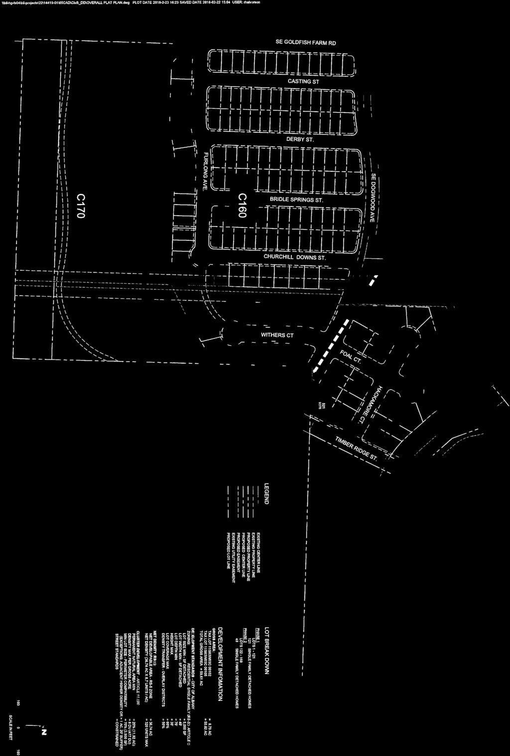
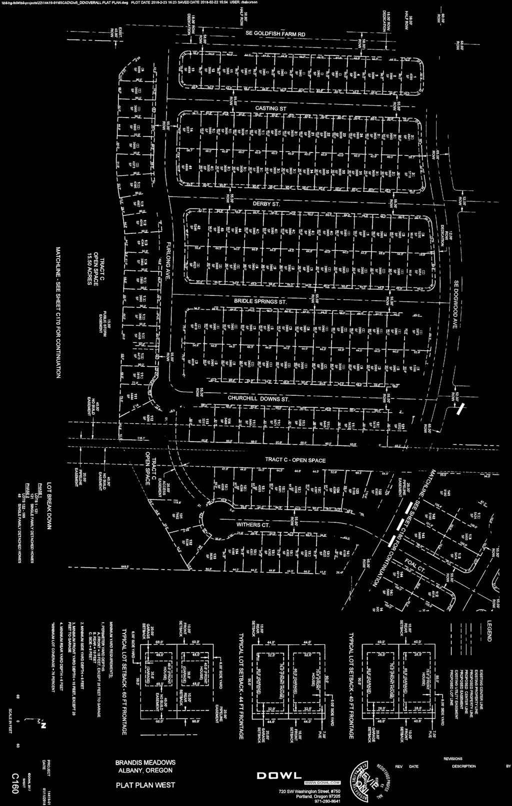
2 CONDITIONS OF APPROVAL Lot and Block Standards 1. Prior to Phase I final plat approval, the applicant shall establish a Homeowners Association (HOA) and submit a Declaration of Covenants, Conditions, and Restrictions (CC&R) to the Community Development for review and approval. The CC&Rs shall specify that the HOA shall own and maintain the fencing and landscaped park strip along Goldfish Farm Road. 2. Prior to issuance of a certificate of occupancy for any of the new residences on Lots 1 through 13 abutting Goldfish Farm Road, a six-foot fence made of uniform material shall be constructed by the developer along the rear yards of theses lots. Transportation: All Phases: 3. Prior to final plat approval of each phase, the applicant shall construct or provide financial assurance in a form acceptable to the City Attorney for the following: Phase One: a. Construct to city standards all public streets interior to the development. Interior local streets shall have a right-of-way width of 55-feet and a curb to curb width of 30-feet. b. Install public sidewalk with the construction of street improvements along the public street frontage of all lots and tracts of land created with the development. c. Install street lighting and street name signs to city standards on all public streets within and adjacent to the development. Prior to final plat approval of phase one, the applicant shall construct or provide financial assurance in a form acceptable to the City Attorney for the following: 4. The land owner shall provide a Petition for Improvement/Waiver of Remonstrance for participation in an assessment district for the construction of the Timber Ridge Street crossing of Burkhart Creek immediately north of this site. 5. The applicant shall obtain all required permits and approvals from Linn County prior to performing any work within Goldfish Farm Road right of way. 6. The applicant shall dedicate 18 feet of right of way along the site s frontage along Goldfish Farm Road and 12 feet of right of way along the site s frontage on Dogwood Avenue. Dedication shall include property line radii at intersections to allow for installation of curb returns. 7. The applicant shall dedicate a 20-foot access easement across Tract C as shown on the approved preliminary plat plan. 8. The applicant shall construct public street improvements to city standards along the site s full frontage on Goldfish Farm Road. Improvements shall include: a. Construction of curb and gutter along the east side of the road. The face of curb shall be aligned for an ultimate curb-to-curb width of 48 feet. b. Construction of a six-foot-wide sidewalk along the east side of the road. The back of sidewalk shall be placed six inches from the right of way line. c. Installation of a 6.5-foot-wide landscape strip or water quality swale. d. Installation of new pavement to city standards from the edge of the new curb and gutter to the existing west edge of pavement. e. Installation of pavement striping to include a centerline skip strip and bike lane along the east side of the road. The striping plan shall be approved by the City Engineer. Notice of Decision / SD-01-18, FP-01-18, and NR-01-18, Page 2
3 9. The applicant shall construct a six-foot-wide sidewalk along the development s frontage on the south side of Dogwood Avenue. The back of sidewalk shall be placed six inches from the right of way line. 10. The applicant shall install stop signs and stop bars on local street approaches to Dogwood Avenue. 11. The applicant shall install a stop sign and crosswalk for the Furlong Avenue approach to Goldfish Farm Road. 12. The applicant shall install a crosswalk and pedestrian activated rapid rectangular flashing beacon (RRFB) flashing light system across the south leg of the Goldfish Farm Road/Dogwood Avenue intersection. Phase Two: Prior to final plat approval of phase two, the applicant shall construct or provide financial assurance in a form acceptable to the City Attorney for the following: 13. The applicant shall extend and construct Dogwood Avenue as shown on the approved preliminary plat plan. Improvements shall include: a. A right-of-way width of 65 feet. b. A curb-to-curb width of 38 feet. c. Installation of 6.5-foot-wide landscape strip or water quality swales. d. Six-foot-wide sidewalk along both sides of the road. The back of the sidewalk shall be six inches from the right of way line. e. Pavement striping that provides for: a six-foot-wide bike lane on the north side of the road, a 20- foot vehicle travel way (no centerline stripe), a five-foot-wide eastbound bike lane, and a sevenfoot-wide on-street parking area along the south side of the road. 14. The applicant shall extend and construct Timber Ridge Street as shown on the approved preliminary plat plan. Street improvements shall end at the north boundary of lot 169. Improvements shall include: a. A right-of-way width of 60 feet. Right of way shall extend across Tract D. b. A curb-to-curb width of 34 feet. c. Installation of six-foot-wide landscape strips or water quality swales. d. Six-foot-wide sidewalk along both sides of the road. The back of sidewalk shall be six inches from the right of way line. e. Pavement striping that provides for: six-foot-wide bike lanes along each side of the road and 11- foot vehicle travel lanes. 15. Construction of a 20-foot wide concrete emergency vehicle access as shown on the approved site plan between the end of Withers Court and Churchill Downs street. The access shall be designed to allow for bicycle and pedestrian access, and with the approval of the Fire Department may use devices such as bollards to restrict access by non-emergency vehicles. 16. Construction of a 10-foot-wide concrete pedestrian path north of Dogwood Avenue (behind lots 141, 156 & 157), to connect with the existing pedestrian pathway at the southern edge of the Bridal Springs subdivision (south of the Canterbury Street cul-de-sac), unless otherwise approved by the City Engineer. Prior to construction, the applicant shall submit plans for this pathway to the City of Albany Community Development Department and Kinder Morgan Energy Partners for their review and approval. Utilities: 17. Prior to final plat approval for each phase of the proposed development, the applicant must construct public utilities (water, sanitary sewer, and storm drainage) within the proposed streets for the development and for future extensions. The applicant must have individual sanitary sewer and water services installed for each of the proposed new lots. In addition, the applicant must construct a public sanitary sewer main in Goldfish Farm Road from Dogwood Avenue to a point near the south boundary of Notice of Decision / SD-01-18, FP-01-18, and NR-01-18, Page 3
4 Phase I to the south end of the future Furlong Avenue right-of-way of the proposed subdivision. Alternatively, the applicant may provide financial assurances for this work, in a form acceptable to the City Attorney. 18. Prior to final plat approval for each phase of the proposed development, the applicant must construct storm water quality facilities for the proposed development. The facilities must be designed and constructed according to City Standards. Alternatively, the applicant may provide financial assurances for this work, in a form acceptable to the City Attorney. 19. Prior to final plat approval for each phase of the proposed development, the applicant shall submit plans to the Albany Fire Department for review and approval. These plans must demonstrate standards of the Oregon Fire Code are met by providing adequate water supply, water capacity, and emergency accesses to and within the subdivision, including access turnarounds. Information for the Applicant: Connection charges will be due for public sanitary sewer, water, streets, and storm drainage before the final plat will be approved by the City. These charges are based on the length of the property s frontages and will be calculated based on the most recent connection charge Resolution. Overlay Districts: 20. Prior to issuance of an Erosion Prevention and Sediment Control (EPSC) permit for each phase of the development, the applicant shall provide the Community Development Department with a copy of the approved permits by state and federal agencies (e.g. NPDES permit, DSL permit, ACOE permit) for that phase of the development. 21. The final plat of each phase shall include a declaration regarding the presence of the Kinder Morgan petroleum pipeline easement. Each final plat shall show the location of the pipeline easement and nobuild area and shall identify the lots that contain or adjoin the easement. The final plat shall also include a restrictive covenant that prohibits buildings or structures within a 100-foot-wide, no-build buffer centered on the Kinder Morgan pipeline easement. 22. The Phase II final plat shall show a 75-foot, no-build buffer, measured from the top of the bank of Burkhart Creek. The final plat shall also include a restrictive covenant that prohibits buildings or structures within the 75-foot-wide, no-build buffer. Development in this buffer area is not permitted except as necessary to protect and maintain the riparian corridor (per Section of the annexation agreement). 23. The final plat of each phase shall label Tracts C and D for the purpose of open space natural areas, pedestrian pathway and park. The final plat for each phase shall also include a declaration stating that development of these tracts is not permitted except as necessary to maintain the riparian and wetland areas, promote the growth of native vegetation, and use for trails or for recreation purposes. 24. Prior to Phase I final plat approval, the applicant shall establish a Homeowners Association and submit a Declaration of Covenants, Conditions, and Restrictions (CC&R) to the Community Development for review and approval. The CC&Rs shall include, but not be limited to: a. Tracts C and D shall be owned and maintained by the homeowners association. b. A restrictive covenant to preserve Tracts C and D for the purpose of open space natural areas, pedestrian pathway and park. The final plat for each phase shall also include a declaration stating that development of these tracts is not permitted except as necessary to maintain the riparian and wetland areas, promote the growth of native vegetation, and use for trails or for recreation purposes c. A restrictive covenant to prohibit any buildings or structures, except pathways and emergency access, within the 100-foot-wide, no-build buffer centered on the Kinder Morgan pipeline easement. d. A restrictive covenant that prohibits buildings or structures within the 75-foot-wide, no-build buffer, measured from the top of the bank of Burkhart Creek. Development in this buffer area is not Notice of Decision / SD-01-18, FP-01-18, and NR-01-18, Page 4
5 permitted except as necessary to protect and maintain the riparian corridor (per Section of the annexation agreement). 25. Prior to issuance of a Site Improvement (SI) permit for phase one, the applicant shall submit a plan to the Community Development Department for review and approval to restore the riparian buffer along Burkhart Creek (per Section of the annexation agreement). The restoration plan shall document existing conditions of the resource, location and presence of invasive species, a detailed planting plan of restoration areas with species and density, a narrative describing how the resource will be restored, and how debris and invasive species will be removed. Cluster Development 26. Prior to Phase II final plat, pedestrian pathways and a park in Tract C will be constructed consistent with the proposed subdivision plans. Prior to construction, the applicant shall submit plans for the pedestrian pathway and park to the City of Albany Community Development Department and Kinder Morgan Energy Partners for their review and approval. Floodplain Review: 27. Prior to final plat approval of each phase, a declaration shall be included on the plat and be recorded as follows: Development of property within the Special Flood Hazard Area as most currently established by the Federal Emergency Management Agency or City of Albany may be restricted and subject to special regulations by the City. 28. At the conclusion of grading and filling the project area and prior to final plat for each phase, the following documentation shall be submitted to the Community Development Department: a) As-built drawings with elevations provided; and b) Letter from the Engineer of Record who is licensed in the state of Oregon, stating that the fill was placed in accordance with the signed plans. 29. If the applicant proposes to replace or modify the culvert in Goldfish Farm Road, the applicant must submit a no-rise analysis with associated land use permit application to the Albany Community Development Department for review and processing. 30. Prior to the issuance of a Site Improvement (SI) permit for each phase, the grading plan shall be submitted for review and approval to ensure building pads have a drainage gradient of two percent toward approved drainage facilities, unless waived by the Building Official or designee. Natural Resource Impact Review: 31. The applicant shall implement the natural resource mitigation plan prior to any ground disturbance within the natural resource overlay. The mitigation plan is presented in Attachment Q of the staff report. 32. Prior to any ground disturbance within the natural resource overlay, the applicant shall provide assurance of completion in the form of a surety or performance bond, cash, negotiable security deposit, letter of credit, or other guarantees approved by the City Attorney that is equal to 120 percent of the value of the improvements installed pursuant to the plan for a two-year period. The financial assurance shall be in place to ensure the success of mitigation improvements and the survival of the plants. The financial assurance will be released by the City upon receiving satisfactory proof that the mitigation measures have been successfully implemented in accordance with the provisions of ADC Section The natural resource mitigation area shall be maintained for a two-year period to provide optimum plant growth. Maintenance shall be performed by a qualified professional at the expense of the applicant, and a report must be provided to the Community Development Department between 18 and 24 months from the initial planting which describes the health of all vegetation and shows pictures of the vegetation. The City may arrange an on-site inspection to verify information contained in the report. Notice of Decision / SD-01-18, FP-01-18, and NR-01-18, Page 5
6 34. If the survival rate for tree and shrub species is below 80 percent, a replanting strategy shall be prepared, approved, and executed within six months of the report, with a subsequent report on survival provided to the Department between 12 and 18 months from the time of the second planting. The issuance of this permit by the City of Albany does not eliminate the need for compliance with other federal, state, or local regulations. It is the applicant s responsibility to contact other federal, state, or local agencies or departments to assure compliance with all applicable regulations. Notice of Decision / SD-01-18, FP-01-18, and NR-01-18, Page 6
7 INFORMATION FOR THE APPLICANT Please read through the following requirements. This list is not meant to be all-inclusive; we have tried to compile requirements that relate to your specific type of development. These requirements are not conditions of the land use decision. They are Albany Municipal Code (AMC) or Albany Development Code (ADC) regulations or administrative policies of the Planning, Public Works, Fire, or Building Departments that you must meet as part of the development process. You must also comply with state, federal, and local law. PLANNING 1. Land use approval does not constitute Building or Public Works permit approvals. 2. To complete the land division process and create the new parcels: a. Satisfy the conditions of approval and submit a final partition plat to the City Planning Division for review and approval. The final plat must be accompanied by a completed Final Plat application and final plat review fee. A paper draft copy of the plat may be submitted with the application. The final plat application is available on the City s website. Note: The Linn County Surveyor also needs to review the final plat. These reviews should be done concurrently. Contact the County Surveyor s to learn about their current processes, fees, and possible other expenses (property taxes must be current, for example). b. The survey and final plat must be prepared by a registered professional land surveyor (Oregon Revised Statutes). c. If applicable, pay or segregate any existing City liens on the property and pay or finance any other fees due as a result of the land division. Contact the Finance Department ( ) to make these arrangements. d. After the City signs the final plats, they will be returned to the applicant for recording. e. After recording, and before the City will accept a permit application to develop either parcel, the property owner must: (i) (ii) Return one copy of the recorded final plat to the Albany Planning Division; and Provide the Building Division with a copy of Linn County s Tax Assessor paperwork that assigns the new map and tax lot identification numbers to each new parcel. Albany Development Code (ADC) 1.080, Expiration of Land Use Approvals states: (1) All land use approvals, except Type IV approvals, shall expire three years from the date of approval, unless: (a) (b) (c) The applicant has installed all of the required public infrastructure related to the development and the infrastructure has been accepted by the city, or the applicant has provided financial assurance for all required public infrastructure per Section or the first phase, if the development was approved for phased construction; or If the development did not require public infrastructure, a valid approved building permit exists for new construction or improvements, and work has commenced; or Phased Subdivisions or Planned Developments. When an applicant desires to develop and record final subdivision plats covering portions of an approved tentative plat in phases, the City Notice of Decision / SD-01-18, FP-01-18, and NR-01-18, Page 7
8 (d) may authorize a time schedule for platting and otherwise developing the various phases not to exceed five years for all phases. Each phase that is platted and developed shall conform to the applicable requirements of this title; or An extension has been filed before the expiration date, and subsequently granted approval pursuant to Section PUBLIC WORKS ENGINEERING The City of Albany s infrastructure records, drawings, and other documents have been gathered over many decades, using differing standards for quality control, documentation, and verification. All information provided represents the current information we have in a readily available format. While the information we provide is generally believed to be accurate, occasionally this information proves to be incorrect, and thus we do not warrant its accuracy. Prior to making any property purchases or other investments based, in full or in part, upon the information provided, we specifically advise that you independently field verify the information contained within our records. A Connection Charge shall be due and payable when accessing the City s sanitary sewer, water, storm drainage, and/or improved streets from or for the benefit of any real property against which no assessment has previously been levied or for which the cost of constructing the public improvements has not been paid by the property owner or predecessor thereof. If the sanitary sewer, water distribution facility, storm drain, and/or improved street is to be utilized pursuant to any activity involving a land division, the amount of the applicable connection charge shall be paid, in full, prior to the signing of the final plat. The applicant must pay connection charges for sewer, water, and storm drainage improvements in Dogwood Avenue, and for water improvements in Goldfish Farm Road. These charges are calculated based on the amount of frontage a property has along the public right-of-way. PUBLIC WORKS BUILDING Building Division Comments have been provided by Gary Stutzman Building Official PERMITS 1. Obtain Building Permits prior to any construction. 2. Erosion Sediment Control Permits are required by Public Works prior to any excavations. PLAN REVIEW FOR PERMITS 3. All plans submitted for review for building permits will need to be submitted electronically. Contact the Building Division front counter at eplans@cityofalbany.net for details and instructions prior to submittal. CODES 4. The current residential building codes are: a. The 2017Oregon Residential Specialty Code (ORSC) b. The 2014 Oregon Energy Efficiency Specialty Code (OEESC), c. The 2017 Oregon Plumbing Specialty Code (OPSC) based on the 2011 OPSC. d. The 2017 National Electrical Code (NEC) with Oregon amendments. SOILS 5. At the time of or prior to application for a building permit or prior to setback and footing inspections, a letter of approval from a qualified engineer registered in Oregon shall be submitted to the Building Notice of Decision / SD-01-18, FP-01-18, and NR-01-18, Page 8
9 Division which stipulates the "excavated site" meets all of the building design requirements to support the proposed structure as required by State Building Code. ORSC R401.4 UTILITIES 6. Each parcel must be served by its own sewer, water, and other utilities. Easements or covenants that run with the land must be provided between the parcels where utility lines cross property lines, for vehicle parking and access, and to allow Fire Department access. DRAINAGE 7. At the time of construction, provide a complete drainage plan for all hard surface drainage areas. Shape all lots to facilitate surface, gutter, and under-floor drainage to the street or a pre-approved drainage area. INADEQUATE FIRE APPROACH & ACCESS TO WATER SUPPLY 8. If the Fire Official determines that there is an inadequate fire apparatus access condition or an inadequate fire water supply for one or more parcels of the proposed division, in Lieu of providing adequate fire apparatus access or supply and acting in conformance to the standards set forth in OAR , the Uniform Alternate Construction Standard for One and Two Family Dwellings, the Building Official, will select one or more of the following standard(s) to address the inadequacies pertaining to structures built on the affected parcels. The first choice is to have the buildings on the lots affected, protected by a NFPA 13D fire suppression system. a. Installation of an NFPA Standard 13D fire suppression system; b. Installation of a partial NFPA Standard 13D fire suppression system; c. Installation of additional layers of 5/8 inch, Type-X gypsum wallboard; d. Installation of fire-resistive compartmentalization of dwellings to limit the spread of fire by use of fire-resistant building elements, components or assemblies. Fire resistance ratings shall be determined in accordance with the Oregon Structural Specialty Code; e. Installation of fire-resistive exterior wall covering and roofing components; or f. Provide fire separation containment in accordance with the default standards as set forth in the Wildland-Urban Interface rules adopted by the Oregon Department of Forestry (See OAR ). WETLANDS 9. In the event of wetlands are on the property, the City will require Notice of Land Use and Future Development to be made to any State and Federal agency with jurisdiction, such as DSL. Additional delineation, mitigation and permits will be required and proof submitted, before building permits can be issued. FIRE Lora Ratcliff, Senior Deputy Fire Marshal ( ) of the Albany Fire Department has reviewed the above project for conformance to the 2014 Oregon Fire Code (OFC) and has the following comments: 1. Street names need to be approved at the time of the Final Plat. The new street names have been approved as follows: Foal (Pl or Ln) Hackamore (Pl or Ln) Withers Ct Furlong Ave Notice of Decision / SD-01-18, FP-01-18, and NR-01-18, Page 9
10 2. Residential developments/projects of one- or two-family dwellings where the number of dwellings exceeds 30 shall be provided with at least 2 means of fire apparatus access. These access points shall be remotely separated by at least ½ the length of the maximum overall diagonal dimension of the property/area served. (OFC Appendix D107.1) 3. Dead-end fire apparatus roads in excess of 150 feet in length shall be provided with an approved area for turning around fire apparatus (OFC and D103.4). 4. Turning radii for all fire apparatus access roads shall be provided and maintained at no less than 30 feet inner and 50 feet outer (OFC & Appendix D 103.3) 5. This proposed project is located within a Protected Area as defined by Oregon Fire Code (OFC) Appendix B, Section B102 and this area will be required to be served by a public water system. The Fire Flow required for shall be as specified in Appendix B of the fire code. (OFC 507.3) 6. The location and spacing requirements for fire hydrants are based on four project-specific criteria: The distance from the most remote exterior point of the building(s) to the closest available fire hydrant. The calculated fire flow of the proposed building(s) The spacing of the existing fire hydrants along the public and private fire apparatus roads serving the properties. The location of new required public or private fire apparatus access roads located adjacent to the proposed building(s) to be constructed. The maximum spacing for fire hydrants for this project shall be 500 feet designed so that no portion along any of the circulating access roads is greater than 250 feet from a fire hydrant. Each public fire hydrant shall be capable of supplying a minimum of 1,500 gpm at a minimum of 20 psi as a single point flow. Notice of Decision / SD-01-18, FP-01-18, and NR-01-18, Page 10
11 April 2, 2018 ENG ( ) File Reference # Melissa Anderson, AICP, PMP, CFM Floodplain Manager and Senior Planner City of Albany- Planning Division 333 Broadalbin Street SW PO Box 490 Albany, Oregon Melissa.anderson@cityofalbany.net Sent via RE: Brandis Meadows Proposed Subdivision, Planning File SD Dear Ms. Anderson, This is in response to your request for comments on Project # SD located at 373 NE Timber Ridge St. Albany, Oregon. Kinder Morgan (KM) operates and maintains an 8-inch high pressure refined petroleum products pipeline within the project limits. The applicant has identified the approximate location on their plan submittal. In the interest of public safety and for pipeline protection the following provisions must be considered in the design and subsequent improvements near KM facilities. 1. Adherence to applicable provisions enumerated in the enclosed copy of (a) L-OM Guidelines for Design and Construction relating to proposed projects affecting KM pipelines. 2. Exact pipeline location and depth can only be determined by pothole at a maximum of 50 feet intervals (or as required by the on-site KM representative). The pothole work must be performed by hand excavation in the presence of a KM representative. 3. KM shall approve the design of all permanent road crossings. In accordance with 49 CFR 195 the roadway and fire access crossings (3) must be designed with consideration for the dynamic forces exerted by traffic loads. 4. Heavy construction equipment will not be allowed to operate directly over KM pipelines or in KM ROW unless written approval is obtained from Kinder Morgan. 5. Planting of shrubs and trees is not permitted on the KM pipeline easement. Furthermore shrubs and trees planted adjacent to the easement must have limited canopy so as to not inhibit the surface inspection of the easement by overflight. 6. Please note that costs associated with construction inspection, ROW inspection, damage prevention and code compliance will be incurred. Depending on the specific conditions of the work, Kinder Morgan may seek reimbursement of this cost NW St. Helens Road * Portland, Oregon
12 City of Albany Planning Division April 2, 2018 Page 2 of 2 I will continue to be KM s engineering contact as this project moves forward. I can be reached via at Gregg_lies@kindermorgan.com or by phone at (503) Kinder Morgan looks forward to working with you to comply with all state and federal safety regulations. However, please note we cannot make any representation about potential conflicts between our pipeline and your proposed work without exact details of the location, scope, timing and method of your proposed work. Also please note that we need to receive your exact information sufficiently in advance of your work to make any comment on the possible impact. To avoid delays in response to future correspondence, please refer to File Reference # Sincerely, Gregg A. Lies Gregg Lies Sr. Project Manager Pipeline Engineering T:\...\03-Personnel\Current Personnel\Lies, Gregg\Inquiries-1\ docx cc: L. Karabaic K. Payne J. Brothers Cc w/o attachments: S. Manley M. Dexter A. Holbrook A. Landry 5880 NW St. Helens Road * Portland, Oregon
13 Guidelines for Design and Construction near Kinder Morgan Hazardous Liquid Operated Facilities Name of Company: The list of design, construction and contractor requirements, including but not limited to the following, for the design and installation of foreign utilities or improvements on KM right-of-way (ROW) are not intended nor do they waive or modify any rights KM may have under existing easements or ROW agreements. Reference existing easements and amendments for additional requirements. This list of requirements is applicable for KM facilities on easements only. Encroachments on fee property should be referred to the ROW Department. Design KM shall be provided sufficient prior notice of planned activities involving excavation, blasting, or any type of construction on KM s ROW to determine and resolve any location, grade or encroachment problems and provide protection of our facilities and the public before the actual work is to take place. Encroaching entity shall provide KM with a set of drawings for review and a set of final construction drawings showing all aspects of the proposed facilities in the vicinity of KM s ROW. The encroaching entity shall also provide a set of as-built drawings showing the proposed facilities in the vicinity of KM s ROW. Only facilities shown on drawings reviewed by (Company) will be approved for installation on KM s ROW. All drawing revisions that effect facilities proposed to be placed on KM s ROW must be approved by KM in writing. KM shall approve the design of all permanent road crossings. Any repair to surface facilities following future pipeline maintenance or repair work by KM will be at the expense of the developer or landowner. The depth of cover over the KM pipelines shall not be reduced nor drainage altered without KM s written approval. Construction of any permanent structure, building(s) or obstructions within KM pipeline easement is not permitted. Planting of shrubs and trees is not permitted on KM pipeline easement. Irrigation equipment i.e. backflow prevent devices, meters, valves, valve boxes, etc. shall not be located on KM easement. Foreign line, gas, water, electric and sewer lines, etc., may cross perpendicular to KM s pipeline within the ROW, provided that a minimum of two (2) feet of vertical clearance is maintained between KM pipeline(s) and the foreign pipeline. Constant line elevations must be maintained across KM s entire ROW width, gravity drain lines are the only exception. Foreign line crossings below the KM pipeline must be evaluated by KM to ensure that a significant length of the KM line is not exposed and unsupported during construction. When installing underground utilities, the last line should be placed beneath all existing lines unless it is impractical or unreasonable to do so. Foreign line crossings above the KM pipeline with less than 2 feet of clearance must be evaluated by KM to ensure that additional support is not necessary to prevent settling on top of the KM hazardous liquids pipeline. A foreign pipeline shall cross KM facilities at as near a ninety-degree angle as possible. A foreign pipeline shall not run parallel to KM pipeline within KM easement without written permission of KM. The foreign utility should be advised that KM maintains cathodic protection on their pipelines. The foreign utility must coordinate their cathodic protection system with KM s. At the request of KM, foreign utilities shall install (or allow to be installed) cathodic protection test leads at all crossings for the purposes of monitoring cathodic protection. The KM Cathodic Protection (CP) technician and the foreign utility CP technician shall perform post construction CP interference testing. Interference issues shall be resolved by mutual agreement between foreign utility and KM. All costs associated with the correction of cathodic protection problems on KM pipeline as a result of the foreign utility crossing shall be borne by the foreign utility for a period of one year from date the foreign utility is put in service. The metallic foreign line shall be coated with a suitable pipe coating for a distance of at least 10 feet on either side of the crossing unless otherwise requested by the KM CP Technician. Reference: L-O&M Procedure 204 Page 1 of 3 L-OM Distribution: Local Files 11/07 Engineering
14 Guidelines for Design and Construction near Kinder Morgan Hazardous Liquid Operated Facilities AC Electrical lines must be installed in conduit and properly insulated. DOT approved pipeline markers shall be installed so as to indicate the route of the foreign pipeline across the KM ROW. No power poles, light standards, etc. shall be installed on KM easement No pipeline may be located within 50 feet (15 meters) of any private dwelling, or any industrial building or place of public assembly in which persons work, congregate, or assemble. Construction Contractors shall be advised of KM s requirements and be contractually obligated to comply. The continued integrity of KM's pipelines and the safety of all individuals in the area of proposed work near KM s facilities are of the utmost importance. Therefore, contractor must meet with KM representatives prior to construction to provide and receive notification listings for appropriate area operations and emergency personnel. KM's on-site representative will require discontinuation of any work that, in his opinion, endangers the operations or safety of personnel, pipelines or facilities. The Contractor must expose all KM pipelines prior to crossing to determine the exact alignment and depth of the lines. A KM representative must be present. In the event of parallel lines, only one pipeline can be exposed at a time. KM will not allow pipelines to remain exposed overnight without consent of KM designated representative. Contractor may be required to backfill pipelines at the end of each day. A KM representative shall do all line locating. A KM representative shall be present for hydraulic excavation. The use of probing rods for pipeline locating shall be performed by KM representatives only, to prevent unnecessary damage to the pipeline coating. Notification shall be given to KM at least 72 hours before start of construction. A schedule of activities for the duration of the project must be made available at that time to facilitate the scheduling of Kinder Morgan, Inc. s work site representative. Any Contractor schedule changes shall be provided to Kinder Morgan, Inc. immediately. Heavy equipment will not be allowed to operate directly over KM pipelines or in KM ROW unless written approval is obtained from (Company). Heavy equipment shall only be allowed to cross KM pipelines at locations designated by Kinder Morgan, Inc. Contractor shall comply with all precautionary measures required by KM to protect its pipelines. When inclement weather exists, provisions must be made to compensate for soil displacement due to subsidence of tires. Equipment excavating within ten (10) feet of KM Pipelines will have a plate guard installed over the teeth to protect the pipeline. Excavating or grading which might result in erosion or which could render the KM ROW inaccessible shall not be permitted unless the contractor/developer/owner agrees to restore the area to its original condition and provide protection to KM s facility. A KM representative shall be on-site to observe any construction activities within ten (10) feet of a KM pipeline or aboveground appurtenance. The contractor shall not work within this distance without a KM representative being on site. Only hand excavation shall be permitted within two (2) feet of KM pipelines, valves and fittings unless State requirements are more stringent. However, proceed with extreme caution when within three (3) feet of the pipe. A KM representative will monitor construction activity within 25 feet of KM facilities during and after the activities to verify the integrity of the pipeline and to ensure the scope and conditions agreed to have not changed. Monitoring means to conduct site inspections on a pre-determined frequency based on items such as: scope of work, duration of expected excavator work, type of equipment, potential impact on pipeline, complexity of work and/or number of excavators involved. Ripping is only allowed when the position of the pipe is known and not within ten (10) feet of KM facility unless company representative is present. Temporary support of any exposed KM pipeline by Contractor may be necessary if required by KM s on-site representative. Backfill below the exposed lines and 12 above the lines shall be replaced with sand or other selected material as approved by KM s on-site representative and thoroughly compacted in 12 lifts to 95% of standard proctor dry density minimum or as approved by KM s on-site representative. This is to adequately protect against stresses that may be caused by the settling of the pipeline. Reference: L-O&M Procedure 204 Page 2 of 3 L-OM Distribution: Local Files 11/07 Engineering
15 Guidelines for Design and Construction near Kinder Morgan Hazardous Liquid Operated Facilities No blasting shall be allowed within 1000 feet of KM s facilities unless blasting notification is given to KM including complete Blasting Plan Data. A pre-blast meeting shall be conducted by the organization responsible for blasting. KM shall be indemnified and held harmless from any loss, cost of liability for personal injuries received, death caused or property damage suffered or sustained by any person resulting from any blasting operations undertaken within 500 feet of its facilities. The organization responsible for blasting shall be liable for any and all damages caused to KM s facilities as a result of their activities whether or not KM representatives are present. KM shall have a signed and executed Blasting Indemnification Agreement before authorized permission to blast can be given. No blasting shall be allowed within 300 feet of KM s facilities unless blasting notification is given to KM a minimum of one week before blasting. (note: covered above) KM shall review and analyze the blasting methods. A written blasting plan shall be provided by the organization responsible for blasting and agreed to in writing by KM in addition to meeting requirements for 500 and 1000 being met above. A written emergency plan shall be provided by the organization responsible for blasting. (note: covered above) Any contact with any KM facility, pipeline, valve set, etc. shall be reported immediately to KM. If repairs to the pipe are necessary, they will be made and inspected before the section is re-coated and the line is back-filled. KM personnel shall install all test leads on KM facilities. Burning of trash, brush, etc. is not permitted within the KM ROW. Insurance Requirements All contractors, and their subcontractors, working on Company easements shall maintain the following types of insurance policies and minimum limits of coverage. All insurance certificates carried by Contractor and Grantee shall include the following statement: Kinder Morgan and its affiliated or subsidiary companies are named as additional insured on all above policies (except Worker s Compensation) and waiver of subrogation in favor of Kinder Morgan and its affiliated or subsidiary companies, their respective directors, officers, agents and employees applies as required by written contract. Contractor shall furnish Certificates of Insurance evidencing insurance coverage prior to commencement of work and shall provide thirty (30) days notice prior to the termination or cancellation of any policy. 1. Statutory Coverage Workers Compensation Insurance in accordance with the laws of the states where the work is to be performed. If Contractor performs work on the adjacent on navigable waterways Contractor shall furnish a certificate of insurance showing compliance with the provisions of the Federal Longshoreman s and Harbor Workers Compensation Law. 2. Employer's Liability Insurance, with limits of not less than $1,000,000 per occurrence and $1,000,000 disease each employee. 3. Commercial General Liability Insurance with a combined single limit of not less than $2,000,000 per occurrence and in the aggregate. All policies shall include coverage for blanket contractual liability assumed. 4. Comprehensive Automobile Liability Insurance with a combined single limit of not less than $1,000,000. If necessary, the policy shall be endorsed to provide contractual liability coverage. 5. If necessary Comprehensive Aircraft Liability Insurance with combined bodily injury, including passengers, and property damage liability single limits of not less than $5,000,000 each occurrence. 6. Contractor s Pollution Liability Insurance this coverage shall be maintained in force for the full period of this agreement with available limits of not less then $2,000,000 per occurrence. 7. Pollution Legal Liability Insurance this coverage must be maintained in a minimum amount of $5,000,000 per occurrence. Reference: L-O&M Procedure 204 Page 3 of 3 L-OM Distribution: Local Files 11/07 Engineering
16 Pitt St. Linn Ave. Empire Ct. Thoroughbred Ave. Derby St. Canterbury St. Rosehill Ave. Meadowlark Ct. Casting St. Cowboy Ave. Derby St. Azalea Ave. Churchill Downs St. SubjectProperty Dogwood Ave. SubjectProperty Christopher Ave. Location Map:UnaddressedParcel;SoutheastofDog w oodav enue& GoldfishFarm Roadintersection;Linn County Assessor smapno.11s-03w-03c; TaxLot102&105 The City of Albany's Infrastructure records, drawings, and other documents have been gathered over many decades, using differing standards for quality control, documentation, and verification. All of the data provided represents current information in a readily available format. While the data provided is generally believed to be accurate, occasionally it proves to be incorrect; thus its accuracy is not warranted. Prior to making any property purchases or other investments based in full or in part upon the material provided, it is specifically advised that you independently field verify the November Feet 21, 2017 Planning Division City of Albany Broadalbin St. SW, Albany, Oregon (541)


17

18
19


20

21


22
COMMUNITY DEVELOPMENT DEPARTMENT 333 Broadalbin Street SW, P.O. Box 490 Albany OR 97321
 COMMUNITY DEVELOPMENT DEPARTMENT 333 Broadalbin Street SW, P.O. Box 490 Albany OR 97321 NOTICE OF DECISION DATE OF NOTICE: August 16, 2016 FILE: TYPE OF APPLICATION: REVIEW BODY: SD-01-16 Ph: 541-917-7550
COMMUNITY DEVELOPMENT. Staff Report. Site Plan Review. SP June 19, 2018
 COMMUNITY DEVELOPMENT 333 Broadalbin Street SW, PO Box 490, Albany, Oregon 97321-0144 BUILDING 541-917-7553 PLANNING 541-917-7550 Staff Report Site Plan Review SP-18-18 June 19, 2018 Summary On May 1,
Community Development Department 333 Broadalbin Street SW, P.O. Box 490 Albany, OR 97321
 SUMMARY Community Development Department 333 Broadalbin Street SW, P.O. Box 490 Albany, OR 97321 STAFF REPORT Application for Tentative Partition Plat Review Planning File PA-06-17 Phone: 541-917-7550
BYRON TOWNSHIP ZONING APPLICATION
 BYRON TOWNSHIP ZONING APPLICATION Phone: (616) 878-9104 * Fax: (616) 878-3980 * Website: www.byrontownship.org This application will not be accepted if incomplete. APPLICATION FOR & REQUIRED COPIES Private
COMMUNITY DEVELOPMENT DEPARTMENT 333 Broadalbin Street SW, P.O. Box 490 Albany, OR 97321
 COMMUNITY DEVELOPMENT DEPARTMENT 333 Broadalbin Street SW, P.O. Box 490 Albany, OR 97321 STAFF REPORT Application for Site Plan Review (SP-02-18) Residential Accessory Building Ph: 541-917-7550 Fax: 541-917-7598
Chapter 100 Planned Unit Development in Corvallis Urban Fringe
 100.100 Scope and Purpose. Chapter 100 Planned Unit Development in Corvallis Urban Fringe (1) All applications for land divisions in the Urban Residential (UR) and Flood Plain Agriculture (FPA) zones within
PUBLIC WORKS - COMMUNITY DEVELOPMENT. Staff Report. Land Division (Tentative Partition Plat) PA October 23, 2018
 PA October 23, 2018") PUBLIC WORKS - COMMUNITY DEVELOPMENT 333 Broadalbin Street SW, PO Box 490, Albany, Oregon 97321-0144 BUILDING 541-917-7553 PLANNING 541-917-7550 Staff Report Land Division (Tentative Partition Plat) PA-08-18
PUBLIC WORKS - COMMUNITY DEVELOPMENT 333 Broadalbin Street SW, PO Box 490, Albany, Oregon 97321-0144 BUILDING 541-917-7553 PLANNING 541-917-7550 Staff Report Land Division (Tentative Partition Plat) PA-08-18
ARTICLE IV: DEVELOPMENT STANDARDS
 ARTICLE IV: DEVELOPMENT STANDARDS IV-53 409 PRIVATE STREETS A private street means any way that provides ingress to, or egress from, property by means of vehicles or other means, or that provides travel
SUBDIVISION APPLICATION CHECKLIST SKETCH PLAN PRELIMINARY PLAT FINAL PLAT
 RECEIVED STAMP SUBDIVISION APPLICATION CHECKLIST SKETCH PLAN PRELIMINARY PLAT FINAL PLAT A checklist of background information and submission requirements for processing of a sketch plan, preliminary plat
APPLICATION PROCEDURE
 ANTRIM PLANNING BOARD P. O. Box 517 Antrim, New Hampshire 03440 Phone: 603-588-6785 FAX: 603-588-2969 APPLICATION FORM AND CHECKLIST FOR MINOR OR MAJOR SITE PLAN REVIEW File Date Received By APPLICATION
ELK RAPIDS TOWNSHIP ANTRIM COUNTY, MICHIGAN ORDINANCE NO
 ELK RAPIDS TOWNSHIP ANTRIM COUNTY, MICHIGAN ORDINANCE NO. 3-2011 AN ORDINANCE TO REPLACE THE SUBDIVISION CONTROL ORDINANCE WITH A NEW SUBDIVISION DEVELOPMENT ORDINANCE, IN ACCORD WITH THE LAND DIVISION
COMMUNITY DEVELOPMENT DEPARTMENT 333 Broadalbin Street SW, P.O. Box 490 Albany, OR 97321
 COMMUNITY DEVELOPMENT DEPARTMENT 333 Broadalbin Street SW, P.O. Box 490 Albany, OR 97321 NOTICE OF FILING Ph: 541-917-7550 Fax: 541-917-7598 www.cityofalbany.net DATE OF NOTICE: April 4, 2016 FILE: TYPE
Residential Major Subdivision Review Checklist
 Residential Major Subdivision Review Checklist Plan Submittal Requirements: 2 full sets of stamped plans Electric submittal - all plans contained in a single PDF 3 full sets if commercial kitchen or dining
géãç Éy VtÇtÇwt zât 5440 Routes 5 & 20 West Canandaigua, NY Phone: (585) / Fax: (585)
 / Fax: (585)") géãç Éy VtÇtÇwt zât 5440 Routes 5 & 20 West Canandaigua, NY 14424 Phone: (585) 394-1120 / Fax: (585) 394-9476 APPLICATION FOR LOT-LINE ADJUSTMENT The applicant is responsible for the completeness of all
géãç Éy VtÇtÇwt zât 5440 Routes 5 & 20 West Canandaigua, NY 14424 Phone: (585) 394-1120 / Fax: (585) 394-9476 APPLICATION FOR LOT-LINE ADJUSTMENT The applicant is responsible for the completeness of all
CITY OF FAYETTEVILLE, ARKANSAS FINAL PLAT FOR STAFF USE ONLY FINAL PLAT FEE: $ $ Date Application Submitted: Date Accepted as Complete:
 CITY OF FAYETTEVILLE, ARKANSAS FINAL PLAT FOR STAFF USE ONLY FINAL PLAT FEE: $200.00-$800.00 Date Application Submitted: Date Accepted as Complete: Project Number: Public Hearing S-T-R: PP#: Zone: Please
LAND USE APPLICATION
 LAND USE APPLICATION File Name: File No(s).: Receipt No.: Receipt Date: Received By: Amount.: $ Instructions for Applicants Please read and follow all instructions on your application carefully. If you
TOWN OF LEWISTON PLANNING BOARD APPLICATION
 TOWN OF LEWISTON PLANNING BOARD APPLICATION DESCRIPTION OF PROPOSED REQUEST: Name of Property Owner: Phone #: Name of Applicant:Phone #: Address or Location of Proposal:_SBL# Size of Parcel or Structure:Existing
Condominium Unit Requirements.
 ARTICLE 19 CONDOMINIUM REGULATIONS Section 19.01 Purpose. The purpose of this Article is to regulate projects that divide real property under a contractual arrangement known as a condominium. New and conversion
Floodplain Development Land Use Review
 PUBLIC WORKS - COMMUNITY DEVELOPMENT 333 Broadalbin Street SW, PO Box 490, Albany, Oregon 97321-0144 BUILDING 541-917-7553 PLANNING 541-917-7550 Floodplain Development Land Use Review Application Information
COMMUNITY DEVELOPMENT DEPARTMENT 333 Broadalbin Street SW, P.O. Box 490 Albany, OR 97321
 COMMUNITY DEVELOPMENT DEPARTMENT 333 Broadalbin Street SW, P.O. Box 490 Albany, OR 97321 Ph: 541-917-7550 Fax: 541-917-7598 www.cityofalbany.net STAFF REPORT Application for Site Plan Review SP-07-18 and
ARTICLE 3 DEFINITIONS
 Sections: 3-1 Rules of Construction 3-2 Definitions ARTICLE 3 DEFINITIONS SECTION 3-1 RULES OF CONSTRUCTION 3-101. a. The language set forth in these regulations shall be interpreted in accordance with
SUBDIVISION DESIGN PRINCIPLES AND STANDARDS
 SECTION 15-200 SUBDIVISION DESIGN PRINCIPLES AND STANDARDS 15-201 STREET DESIGN PRINCIPLES 15-201.01 Streets shall generally conform to the collector and major street plan adopted by the Planning Commission
COMMUNITY DEVELOPMENT DEPARTMENT 333 Broadalbin Street SW, P.O. Box 490 Albany, OR 97321
 HEARING BODY COMMUNITY DEVELOPMENT DEPARTMENT 333 Broadalbin Street SW, P.O. Box 490 Albany, OR 97321 NOTICE OF PUBLIC HEARING Planning Commission HEARING DATE Monday, December 3, 2018 HEARING TIME HEARING
-MENDOCINO COUNTY PLANNING AND BUILDING SERVICES- DIVISION OF LAND REGULATIONS TITLE 17
 ARTICLE VI -- GENERAL REGULATIONS AND PROVISIONS Sec. 17-50. Sec. 17-51 General Plan. Sec. 17-52 Lot and Block Design and Configuration. Sec. 17-53 Lot Access. Sec. 17-54 Private Roads. Sec. 17-55 Water
SECTION 4: PRELIMINARY PLAT
 SECTION 4: PRELIMINARY PLAT After the completion of the sketch plan process, if submitted, the owner or developer shall file with the City an application for preliminary plat. The preliminary plat stage
COMMUNITY DEVELOPMENT DEPARTMENT 333 Broadalbin Street SW, P.O. Box 490 Albany, OR 97321
 COMMUNITY DEVELOPMENT DEPARTMENT 333 Broadalbin Street SW, P.O. Box 490 Albany, OR 97321 NOTICE OF PUBLIC HEARING Phone: 541-917-7550 Fax: 541-917-7598 www.cityofalbany.net HEARING BODY PLANNING COMMISSION
SUBMITTAL REQUIREMENTS: The number indicates the number of copies for submittal (if applicable).
.") Office Use Only Preliminary Long Plat Long Subdivision Applicant Checklist PLANNING, COMMUNITY, & ECONOMIC DEVELOPMENT DEPARTMENT PRELIMINARY LONG PLAT LONG SUBDIVISION CHECKLIST Mailing Address: P.O.
Office Use Only Preliminary Long Plat Long Subdivision Applicant Checklist PLANNING, COMMUNITY, & ECONOMIC DEVELOPMENT DEPARTMENT PRELIMINARY LONG PLAT LONG SUBDIVISION CHECKLIST Mailing Address: P.O.
Time Extension Staff Report
 Time Extension Staff Report Subdivision Name Lunara Subdivision File Number SUB07-00019 Approval Time Extension for Lead Agency Boise City Certification Signature of Boise City Engineer Annexation Date
DEVELOPMENT POLICY INFRASTRUCTURE GUIDELINES FOR NEW DEVELOPMENT
 CITY OF HAYS SUBJECT DEVELOPMENT POLICY INFRASTRUCTURE GUIDELINES FOR NEW DEVELOPMENT ISSUED BY LAST REVISION DATE POLICY MANUAL REVISION DATE City Commission 3-13-08 10-22-09 POLICY STATEMENT: The City
APPENDIX B. SUBMISSION REQUIREMENTS
 Master Major Site Minor Site Landscape Section B.1 Table of /Plat Requirements Proposed or approved name of development, project, subdivision, and/or phase. Location, including township, county, and state.
Residential Minor Subdivision Review Checklist
 Residential Minor Subdivision Review Checklist Plan Submittal Requirements: 2 full sets of stamped plans Electric submittal - all plans contained in a single PDF 3 full sets if commercial kitchen or dining
FINAL PLAT APPLICATION
 FINAL PLAT APPLICATION (Page 1 of 3) LEGAL OWNER(s): NAME: STREET ADDRESS OWNER(s): CITY, STATE, ZIP CODE: PHONE NUMBER: BILLING ADDRESS: NAME OF ENGINEER/SURVEYOR: Engineer/Surveyor Address, Phone: PROPERTY
CITY OF SARALAND FINAL SUBDIVISION PLAT REVIEW
 CITY OF SARALAND FINAL SUBDIVISION PLAT REVIEW Application Number: Date Plat Submitted: Name of Subdivision: Name of Owner: Owner Address: (Street or P.O. Box) Telephone #: (City) (State) (Zip) E-mail:
Section Preliminary Plat Checklist and Application Forms
 Section 201 - Preliminary Plat Checklist and Application Forms PRELIMINARY SUBDIVISION PLAT REVIEW PROCESS CHART PRELIMINARY SUBDIVISION PLAT APPLICATION PRELIMINARY PLAT REVIEW CHECKLIST CITY OF NAMPA
géãç Éy VtÇtÇwt zât 5440 Routes 5 & 20 West Canandaigua, NY Phone: (585) / Fax: (585)
 / Fax: (585)") géãç Éy VtÇtÇwt zât 5440 Routes 5 & 20 West Canandaigua, NY 14424 Phone: (585) 394-1120 / Fax: (585) 394-9476 NOTICE TO ALL PLANNING BOARD APPLICANTS FOR PRELIMINARY SUBDIVISION PHASED PROJECTS The applicant
géãç Éy VtÇtÇwt zât 5440 Routes 5 & 20 West Canandaigua, NY 14424 Phone: (585) 394-1120 / Fax: (585) 394-9476 NOTICE TO ALL PLANNING BOARD APPLICANTS FOR PRELIMINARY SUBDIVISION PHASED PROJECTS The applicant
Town of Canandaigua 5440 Routes 5 & 20 West Canandaigua, NY Phone: (585) / Fax: (585)
 / Fax: (585)") Town of Canandaigua 5440 Routes 5 & 20 West Canandaigua, NY 14424 Phone: (585) 394-1120 / Fax: (585) 394-9476 NOTICE TO ALL PLANNING BOARD APPLICANTS FOR SINGLE STAGE PRELIMINARY/FINAL SUBDIVISION PLAT
Town of Canandaigua 5440 Routes 5 & 20 West Canandaigua, NY 14424 Phone: (585) 394-1120 / Fax: (585) 394-9476 NOTICE TO ALL PLANNING BOARD APPLICANTS FOR SINGLE STAGE PRELIMINARY/FINAL SUBDIVISION PLAT
New Private Way Ordinance Westbrook Planning Board Workshop , Planning Board Public Hearing Definitions
 201 Definitions Private Right of Way; Private way A strip of land at least fifty feet wide, meeting the minimum standards for the construction of a gravel base for a public road, over which abutters may
TENTATIVE PARCEL MAP APPLICATION GUIDE TENTATIVE PARCEL MAP APPLICATION REQUIREMENTS
 TENTATIVE PARCEL MAP APPLICATION GUIDE SISKIYOU COUNTY PLANNING DIVISION 806 South Main Street, Yreka CA 96097 Phone: (530) 841-2100 / Fax: (530) 841-4076 TENTATIVE PARCEL MAP APPLICATION REQUIREMENTS
ARTICLE 900 PLAT AND PLAN REQUIREMENTS
 ARTICLE 900 PLAT AND PLAN REQUIREMENTS SEC. 900.1 ITEMS TO BE SHOWN ON PLAT OR PLAN General (1) Property lines of all property owners adjacent to the exterior boundaries of the project shall be located
SUBDIVISION AND LAND DEVELOPMENT. 185 Attachment 20
 185 Attachment 20 APPENDIX S Plat No. Date of Submission Twp. Fee $ Dauphin Co. Fee $ TOWNSHIP OF DERRY SUBDIVISION OR LAND DEVELOPMENT PLAN SUBMISSION APPLICATION This block for Twp. use only 1. Title
ARTICLE 13 CONDOMINIUM REGULATIONS
 ARTICLE 13 CONDOMINIUM REGULATIONS Section 13.01 Purpose. The purpose of this Article is to regulate projects that divide real property under a contractual arrangement known as a condominium. New and conversion
COMMUNITY DEVELOPMENT DEPARTMENT 333 Broadalbin Street SW, P.O. Box 490 Albany, OR 97321
 COMMUNITY DEVELOPMENT DEPARTMENT 333 Broadalbin Street SW, P.O. Box 490 Albany, OR 97321 NOTICE OF FILING Ph: 541-917-7550 Fax: 541-917-7598 www.cityofalbany.net DATE OF NOTICE: May 8, 2018 FILES: SP-20-18
Guide to Combined Preliminary and Final Plats
 Guide to Combined Preliminary and Final Plats Introduction The Douglas County is committed to providing open, transparent application processes to the public. This Guide is provided to assist anyone interested
TENTATIVE MAP APPLICATION GUIDE (BCC 20-1)( 20-2 to )( to 20-91)( to )
( 20-2 to )( to 20-91)( to )") Butte County Department of Development Services PERMIT CENTER 7 County Center Drive, Oroville, CA 95965 Planning Division Phone 530.552.3701 Fax 530.538.7785 Email dsplanning@buttecounty.net FORM NO PLG-05
Butte County Department of Development Services PERMIT CENTER 7 County Center Drive, Oroville, CA 95965 Planning Division Phone 530.552.3701 Fax 530.538.7785 Email dsplanning@buttecounty.net FORM NO PLG-05
DIVISION 2 - CONSTRUCTION PLAN AND MISCELLANEOUS REQUIREMENTS
 DIVISION 2 - CONSTRUCTION PLAN AND MISCELLANEOUS REQUIREMENTS 2.1 Required Plan Sheets 2.2 Drawing Requirements 2.3 Graphic Standards 2.4 Easements 2.5 Utility Locations 2.6 Private Facility Locations
ARTICLE 24 PRIVATE ROAD, SHARED PRIVATE DRIVEWAY AND ACCESS EASEMENT STANDARDS
 ARTICLE 24 PRIVATE ROAD, SHARED PRIVATE DRIVEWAY AND ACCESS EASEMENT STANDARDS SECTION 24.00 INTENT AND PURPOSE The standards of this Article provide for the design, construction and maintenance of private
GWINNETT COUNTY CSO CONSERVATION SUBDIVISION OVERLAY DISTRICT REQUIREMENTS
 GWINNETT COUNTY CSO CONSERVATION SUBDIVISION OVERLAY DISTRICT REQUIREMENTS Section 1316. CSO Conservation Subdivision Overlay District. 1. Purposes. The purposes of this overlay district are as follows:
WASCO COUNTY PRELIMINARY SUBDIVISION APPLICATION
 WASCO COUNTY PRELIMINARY SUBDIVISION APPLICATION DETAILED SPECIFIC WRITTEN REQUEST File Number: SDV- Number of Proposed Lots & their Dimensions: PRELIMINARY SUBDIVISION PLAN REQUIREMENTS The approval of
To provide for the review of the final engineering plans, the subdivision improvement agreement, public dedications, and other legal agreements.
 ARTICLE 5 FINAL PLAT 501 Intent DOUGLAS COUNTY SUBDIVISION RESOLUTION To provide for the review of the final engineering plans, the subdivision improvement agreement, public dedications, and other legal
APPLICATION for MINOR SUBDIVISION REVIEW for CONCEPT and FINAL PLAT within COALVILLE CITY. Project Name: Project Address or Area: Name of Owner:
 APPLICATION for MINOR SUBDIVISION REVIEW for CONCEPT and FINAL PLAT within COALVILLE CITY For Office Use Only: Application #: Application Date: PC Approval Date: CC Approval Date: Community Development
HERON LANDING SUBDIVISION
 HERON LANDING SUBDIVISION Engineering Comments: Per FEMA guidelines, any development greater than 5 acres in size or subdivision 50 lots in size, requires a flood study. Width of drainage easement to be
JEFFERSON COUNTY, ALABAMA
 JEFFERSON COUNTY, ALABAMA Major Development Checklist, Notes and Information A Major Development is any proposed new structure or addition to an existing structure which will cause a change in the topography
SPRING BROOK TOWNSHIP 966 STATE ROUTE 307 SPRING BROOK TOWNSHIP, PA PHONE (570) FAX (570)
 FAX (570)") PERMIT # - D SPRING BROOK TOWNSHIP 966 STATE ROUTE 307 SPRING BROOK TOWNSHIP, PA 18444 PHONE (570) 842-7028 FAX (570) 842-0633 Date: PART I APPLICATION DRIVEWAY INSTALLATION APPLICATION AND PERMIT Name:
PERMIT # - D SPRING BROOK TOWNSHIP 966 STATE ROUTE 307 SPRING BROOK TOWNSHIP, PA 18444 PHONE (570) 842-7028 FAX (570) 842-0633 Date: PART I APPLICATION DRIVEWAY INSTALLATION APPLICATION AND PERMIT Name:
CITY OF GROVER BEACH COMMUNITY DEVELOPMENT DEPARTMENT Tentative Map Checklist
 CITY OF GROVER BEACH COMMUNITY DEVELOPMENT DEPARTMENT Tentative Map Checklist The following list includes all of the items you must submit for a complete application. Some specific types of information
MINOR SUBDIVISION PLAT CHECKLIST
 MINOR SUBDIVISION PLAT CHECKLIST Project Name: Tax ID #: Project Number: Date: _ Reviewed By: Telephone: NOTES: All lots on septic systems must comply with the Fulton County Health Department requirements
RESIDENTIAL CLUSTER DEVELOPMENT DISTRICT SPECIAL PERMIT RULES AND REGULATIONS OF THE PLANNING BOARD OF THE TOWN OF COHASSET, MASSACHUSETTS
 RESIDENTIAL CLUSTER DEVELOPMENT DISTRICT SPECIAL PERMIT RULES AND REGULATIONS OF THE PLANNING BOARD OF THE TOWN OF COHASSET, MASSACHUSETTS Attached: Residential Cluster Development District Special Permit
WRITTEN DECISION OF THE HAYDEN CITY COUNCIL REGARDING MAPLE GROVE PRELIMINARY SUBDIVISION APPLICATION (SUB-0013) HAYDEN SIGNATURE, LLC
 HAYDEN SIGNATURE, LLC") WRITTEN DECISION OF THE HAYDEN CITY COUNCIL REGARDING MAPLE GROVE PRELIMINARY SUBDIVISION APPLICATION (SUB-0013) HAYDEN SIGNATURE, LLC Application of Hayden Signature, LLC, an Idaho limited liability company,
WRITTEN DECISION OF THE HAYDEN CITY COUNCIL REGARDING MAPLE GROVE PRELIMINARY SUBDIVISION APPLICATION (SUB-0013) HAYDEN SIGNATURE, LLC Application of Hayden Signature, LLC, an Idaho limited liability company,
Appendix 4 Agency Approval Letters
 Appendix 4 Agency Approval Letters 55 Appendix4.a. Appendix 4.b. Appendix 4.c. Appendix 4.d. 3/10/2016 Clarksburg Mews, LLC c/o Michael Fisher 4938 Hampden Lane Bethesda, MD 20814 Re: Phase
PRELMINARY PLAT CHECKLIST
 PRELMINARY PLAT CHECKLIST A. All preliminary plat submitted for approval shall be prepared by a Registered Professional Land Surveyor. B. Preliminary plats must be drawn to a scale of XXX with such accuracy
TOWN OF WATERVILLE VALLEY NEW HAMPSHIRE SITE PLAN REVIEW REGULATIONS
 TOWN OF WATERVILLE VALLEY NEW HAMPSHIRE Effective date March 17, 1981 Revised March 16, 1982 Revised March 13, 1986 Revised March 10, 1987 Revised March 14, 2013 Revised March 8, 2016 TOWN OF WATERVILLE
City of Prior Lake APPLICATION FOR COMBINED PRELIMINARY AND FINAL PLAT
 Case File No. Property Identification No. City of Prior Lake APPLICATION FOR COMBINED PRELIMINARY AND FINAL PLAT Requested Action Brief description of proposed project (Please describe the proposed amendment,
MINOR SUBDIVISION INFORMATION
 A. POINTS OF CONTACT: MINOR SUBDIVISION INFORMATION Surveyor: Address: Phone #: Fax # E-Mail Address: Representative (If different from applicant): Address: Phone #: Fax # E-Mail Address: B. GENERAL INFORMATION:
CHAPTER 14 SPECIAL DEVELOPMENTS
 10-14-1 10-14-1 CHAPTER 14 SPECIAL DEVELOPMENTS SECTION: 10-14-1: Cluster and Inner Block Development 10-14-2: Planned Unit Development 10-14-1: CLUSTER AND INNER BLOCK DEVELOPMENT: A. Land Use: Cluster
M-43 CORRIDOR OVERLAY ZONE
 ARTICLE 26.00 M-43 CORRIDOR OVERLAY ZONE Section 26.01 Findings A primary function of the M-43 state highway is to move traffic through the Township and to points beyond. As the primary east-west arterial
13-2 SUBDIVISION PLANS AND PLATS REQUIRED EXCEPTIONS Subdivision Plats Required To be Recorded
 ARTICLE XIII SUBDIVISIONS 13-1 INTENT AND PURPOSE 13-1-1 Intent: It is the intent of the County Commission through the adoption of this Article to more fully avail itself of the power granted under 17-27-601
CITY OF OCOEE LAND DEVELOPMENT CODE SUFFICIENCY TABLE WITH NOTES
 CITY OF OCOEE LAND DEVELOPMENT CODE SUFFICIENCY TABLE WITH NOTES The Sufficiency Table is a checklist to help identify the types of information and documentation needed for various types of projects. The
ARTICLE 100 SUBDIVISION APPLICATION PROCEDURE AND APPROVAL PROCESS
 ARTICLE 100 SUBDIVISION APPLICATION PROCEDURE AND APPROVAL PROCESS 100.01 General Procedure 100.02 Exempt Subdivision 100.03 Administrative Subdivision 100.04 Major Subdivision 100.05 Signing and Recording
ARTICLE V PRELIMINARY PLAN SUBMISSION
 ARTICLE V PRELIMINARY PLAN SUBMISSION 501. Plan Requirements a. On or before the 25 th day of the month prior to a regularly scheduled meeting of the Planning Commission, the applicant shall submit two
Larimer County Planning Dept. Procedural Guide for 1041 PERMITS
 - Larimer County Planning Dept. Procedural Guide for 1041 PERMITS PLEASE NOTE: A PRE-APPLICATION CONFERENCE IS REQUIRED PRIOR TO SUBMITTING THIS APPLICATION. PURPOSE: State Statutes allow local governments
Time Extension Staff Report
 Time Extension Staff Report Subdivision Name Therrin Subdivision File Number SUB06-00020 Approval Time Extension for Lead Agency Boise City Certification Signature of Boise City Engineer Annexation Date
CHECKLIST FOR DEVELOPMENT REVIEW
 CHECKLIST FOR DEVELOPMENT REVIEW Petitions and related documents and plans for land development or other proposals regulated by Title 16 of the Municipal Code (Development Ordinance) and Title 17 of the
DAUPHIN CREEK ESTATES SUBDIVISION
 # 12 SUB-000076-2017 DAUPHIN CREEK ESTATES SUBDIVISION Engineering Comments: FINAL PLAT COMMENTS (should be addressed prior to submitting the FINAL PLAT for review and/or signature by the City Engineer):
Sagamore Hills Township Valley View Rd. Sagamore Hills, OH (330) Phone (330) Fax
 Phone (330) Fax") Right-of-Way Excavation Rules & Regulations 1. PERMIT REQUIRED: A right-of-way excavation permit is required when placing, extending, or repairing any pipes, cables, wires, roadway structure or appurtenances,
Right-of-Way Excavation Rules & Regulations 1. PERMIT REQUIRED: A right-of-way excavation permit is required when placing, extending, or repairing any pipes, cables, wires, roadway structure or appurtenances,
ZONING AMENDMENT, PLANNED UNIT DEVELOPMENT & SUBDIVISION STAFF REPORT Date: September 15, 2011
 ZONING AMENDMENT, PLANNED UNIT DEVELOPMENT & SUBDIVISION STAFF REPORT Date: September 15, 2011 NAME SUBDIVISION NAME LOCATION Stratford, L.L.C. Grelot Office Park Subdivision North side of Grelot Road,
CHAPTER 154 RIGHTS OF WAY
 CHAPTER 154 RIGHTS OF WAY 154.01 Purpose and Rule of Interpretation 154.09 City Construction and Paving 154.02 Franchise, License or Lease Required 154.10 Design Notice to City 154.03 Fees Required 154.11
PLANNED UNIT DEVELOPMENT & SUBDIVISION STAFF REPORT Date: November 17, 2016
 PLANNED UNIT DEVELOPMENT & SUBDIVISION STAFF REPORT Date: November 17, 2016 DEVELOPMENT NAME SUBDIVISION NAME LOCATION Autonation Ford of Mobile Autonation Ford of Mobile Subdivision 901, 909, and 925
CITY OFFICE USE ONLY
 RIGHT-OF-WAY ENCROACHMENT PERMIT Public Works Department 213 North 900 East Saratoga Springs, UT 84045 Phone: (801) 766-6506 Fax: (801) 766-9872 Name of Grantee: Billing Address: City/State: Zip: Office
Site Plan Application
 Site Plan Application City of St. Pete Beach Community Development Department 155 Corey Avenue St. Pete Beach, Florida 33706 (727) 367-2735 www.stpetebeach.org Case Number: PROPERTY OWNER: Name: Address:
May 21, ACHD Board of Commissioners Stacey Yarrington, Planner II DRH /DRH
 Development Services Department May 21, 2013 TO: FROM: SUBJECT: ACHD Board of Commissioners Stacey Yarrington, Planner II DRH13-00106/DRH13-00108 Executive Summary: This is a design review application
SUBMITTAL REQUIREMENTS
 PRELIMINARY PLAT APPLICATION ***A PRE-APPLICATION MEETING WITH CITY STAFF IS REQUIRED FOR THIS APPLICATION*** DATE STAMP FOR CITY USE ONLY PROJECT NAME (if any): TO BE FILLED OUT BY APPLICANT PROJECT STREET
UPPER MOUNT BETHEL TOWNSHIP NORTHAMPTON COUNTY, PENNSYLVANIA
 UPPER MOUNT BETHEL TOWNSHIP NORTHAMPTON COUNTY, PENNSYLVANIA JOINDER DEED / LOT CONSOLIDATION TOWNSHIP REVIEW PROCESS When accepting proposed Joinder Deeds / Lot Consolidations, review the Joinder Deed
Preliminary Subdivision Application (Minor) (Three (3) lots or less)
 (Three (3) lots or less)") Gunnison City Offices www.gunnisoncity.org 38 West Center Gunnison, Utah 84634 (435) 528 7969 Date of Application: Preliminary Subdivision Application (Minor) (Three (3) lots or less) APPLICANT INFORMATION
Gunnison City Offices www.gunnisoncity.org 38 West Center Gunnison, Utah 84634 (435) 528 7969 Date of Application: Preliminary Subdivision Application (Minor) (Three (3) lots or less) APPLICANT INFORMATION
SITE PLAN REVIEW PROCEDURES SECTION DEVELOPMENTS REQUIRING SITE PLAN APPROVAL
 SECTION 22.01 PURPOSE ARTICLE XXII PROCEDURES The purpose of this Article is to establish uniform requirements of procedure for all developments in the Township. Certain specific types of minor development
CITY OF SARALAND PRELIMINARY SUBDIVISION PLAT REVIEW
 PRELIMINARY SUBDIVISION PLAT REVIEW Application Number: Date Plat Submitted: Name of Subdivision: Name of Owner: Owner Address: (Street or P.O. Box) Telephone #: (City) (State) (Zip) E-mail: Name of Authorized
New Electronic Planning Commission Submittal Process
 New Electronic Planning Commission Submittal Process STANDARD OPERATING PROCEDURE Purpose: To outline the electronic submittal process for applications to the Planning Commission. Background: Procedure:
APPLICATION FOR SUBDIVISION APPROVAL OF A SKETCH PLAN with checklist
 Prior to filing any application for SUBDIVISION approval, the applicant shall request in writing that the zoning administrator schedule a pre-submission conference. APPLICATION TO THE PLANNING BOARD TOWN
Preliminary Subdivision Application (Major) (Four (4) lots or more)
 (Four (4) lots or more)") Gunnison City Offices www.gunnisoncity.org 38 West Center Gunnison, Utah 84634 (435) 528 7969 Date of Application: Preliminary Subdivision Application (Major) (Four (4) lots or more) APPLICANT INFORMATION
Gunnison City Offices www.gunnisoncity.org 38 West Center Gunnison, Utah 84634 (435) 528 7969 Date of Application: Preliminary Subdivision Application (Major) (Four (4) lots or more) APPLICANT INFORMATION
ORANGE TOWNSHIP SIDEWALK CONSTRUCTION, REPAIR AND MAINTENANCE POLICY
 RES. 09-214 ADOPT SIDEWALK CONSTRUCTION, REPAIR AND MAINTENANCE POLICY Agan moved the adoption of the following Resolution: WHEREAS, the Township has previously, by Res. 06-382, adopted a sidewalk, repair
CITY OF FERNDALE HEARING EXAMINER
 CITY OF FERNDALE HEARING EXAMINER RE: Planned Unit Development ) 16001-PUD Preliminary Plat ) 16018-SE Plat Variance ) 16002-VAR Application by ) ) MD General, L.L.C. ) FINDINGS OF FACT, Malloy Heights
ACCESS AND OPTION AGREEMENT TEMPLATE FOR REAL PROPERTY PARTNERSHIP PROJECTS
 ACCESS AND OPTION AGREEMENT TEMPLATE FOR REAL PROPERTY PARTNERSHIP PROJECTS Appendix 3 This ACCESS AND OPTION AGREEMENT (this Agreement ) is entered into as of, 201 (the Execution Date ), by and between
CHAPTER SUBDIVISION MAPS
 CHAPTER 19.66 SUBDIVISION MAPS SUBDIVISION MAPS 19.66 Section Page 19.66.010 Purpose... IV-56 19.66.020 Application... IV-57 19.66.030 Exclusions... IV-57 19.66.040 Effect of Annexation... IV-57 19.66.050
CONDOMINIUM REGULATIONS
 ARTICLE 37 CONDOMINIUM REGULATIONS SECTION 37.01. Purpose The purpose of this Article is to regulate projects that divide real property under a contractual arrangement known as a condominium. New and conversion
DEVELOPER S AGREEMENT BETWEEN THE TOWN OF CLIFTON AND
 DEVELOPER S AGREEMENT BETWEEN THE TOWN OF CLIFTON AND THIS AGREEMENT, made and entered into this day of, by and between the Town of Clifton, a municipal corporation organized under the laws of the State
ARTICLE III GENERAL PROCEDURES, MINOR PLANS AND FEE SCHEDULES
 ARTICLE III GENERAL PROCEDURES, MINOR PLANS AND FEE SCHEDULES 301. Prior to Submission a. Copies of this Ordinance shall be available on request, at cost, for the use of any person who desires information
PRELIMINARY PLATS. The following documents are provided as required by the City of Conroe for use in the above titled platting submittals:
 Public Works Engineering Division CITY OF CONROE PRELIMINARY PLATS The following documents are provided as required by the City of Conroe for use in the above titled platting submittals: Submittal Questionnaire
COMMUNITY DEVELOPMENT DEPARTMENT 333 Broadalbin Street SW, P.O. Box 490 Albany, OR 97321
 COMMUNITY DEVELOPMENT DEPARTMENT 333 Broadalbin Street SW, P.O. Box 490 Albany, OR 97321 Ph: 541-917-7550 Fax: 541-917-7598 www.cityofalbany.net STAFF REPORT Adjustment (AD-01-16) Reduction of a 25-foot
ZONING COMMISSION 125 EAST AVENUE - CITY HALL P.O. BOX 5125 NORWALK, CONNECTICUT Revised Januar y 1, 2018
 ZONING COMMISSION 125 EAST AVENUE - CITY HALL P.O. BOX 5125 NORWALK, CONNECTICUT 06856-5125 Revised Januar y 1, 2018 SECTION 118-1450 SPECIAL PERMIT APPLICATION INSTRUCTIONS A. APPLICATION INFORMATION
I. Requirements for All Applications. C D W
 108-16.1. Application checklists. Checklist for Required Submissions to the Planning Board or Zoning Board of Adjustment of Monroe Township All required submissions are to be made to the Administrative
a. provide for the continuation of collector streets and thoroughfare streets between adjacent subdivisions;
 Section 7.07. Intent The requirements of this Section are intended to provide for the orderly growth of the Town of Holly Springs and its extra-territorial jurisdiction by establishing guidelines for:
Chapter 22 LAND USE* Article III. Subdivisions
 Chapter 22 LAND USE* Article III. Subdivisions Sec. 22-256. Authority to Regulate. Sec. 22-257. Scope; plat required. Sec. 22-258. Definitions. Sec. 22-259. Interpretations and Meanings. Sec. 22-260. Procedure