Planning Commission Hearing Date: 3/6/2018 Board of County Commissioners Hearing Date 3/27/2018
|
|
|
- Sharlene Alannah Underwood
- 5 years ago
- Views:
Transcription


1 COMMISSIONERS: DARRYL GLENN (PRESIDENT) MARK WALLER (PRESIDENT PRO TEMPORE) STAN VANDERWERF LONGINOS GONZALEZ PEGGY LITTLETON PLANNING AND COMMUNITY DEVELOPMENT DEPARTMENT CRAIG DOSSEY, EXECUTIVE DIRECTOR TO: FROM: El Paso County Planning Commission Jim Egbert, Chair Kari Parsons, PM/Planner II Jeff Rice, PE Engineer III Craig Dossey, Executive Director RE: Project File #: PUD Project Name: The Retreat at TimberRidge Parcel Nos.: , , , , , , , and OWNER: REPRESENTATIVE: Arroya Investments, LLC Kelly Johnson Boulevard Colorado Springs, CO Jacob Decoto Vollmer Road Colorado Springs, CO N.E.S. Inc. John Maynard 619 N. Cascade Avenue, Suite 200 Colorado Springs, CO Robert Scott General Contractors 2760 Brogans Bluff Colorado Springs, CO Commissioner District: 2 Planning Commission Hearing Date: 3/6/2018 Board of County Commissioners Hearing Date 3/27/ INTERNATIONAL CIRCLE, SUITE 110 COLORADO SPRINGS, CO PHONE: (719) FAX: (719)
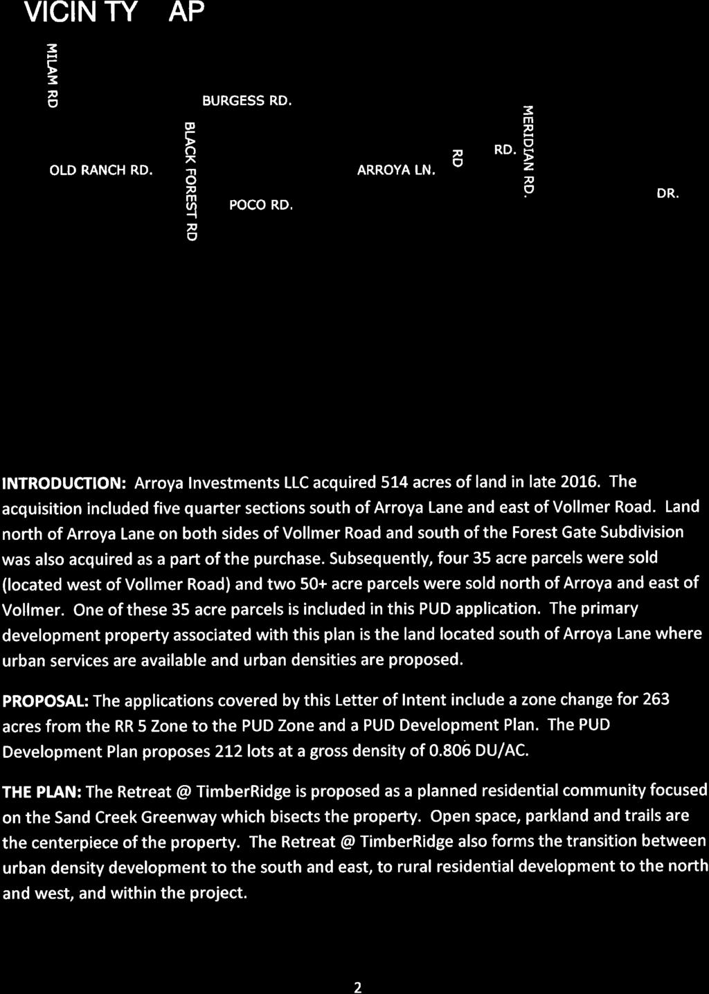
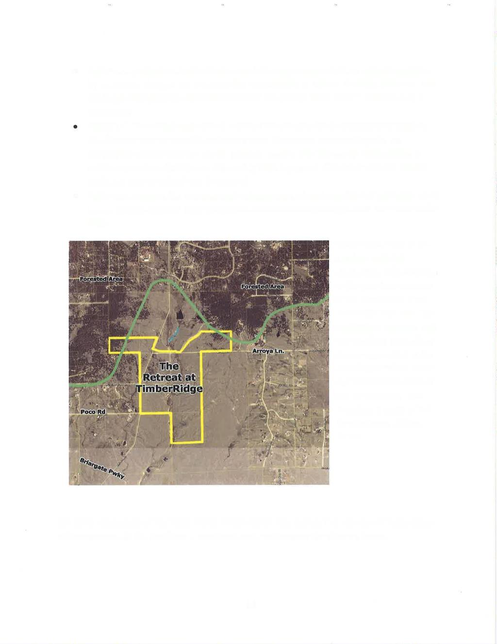
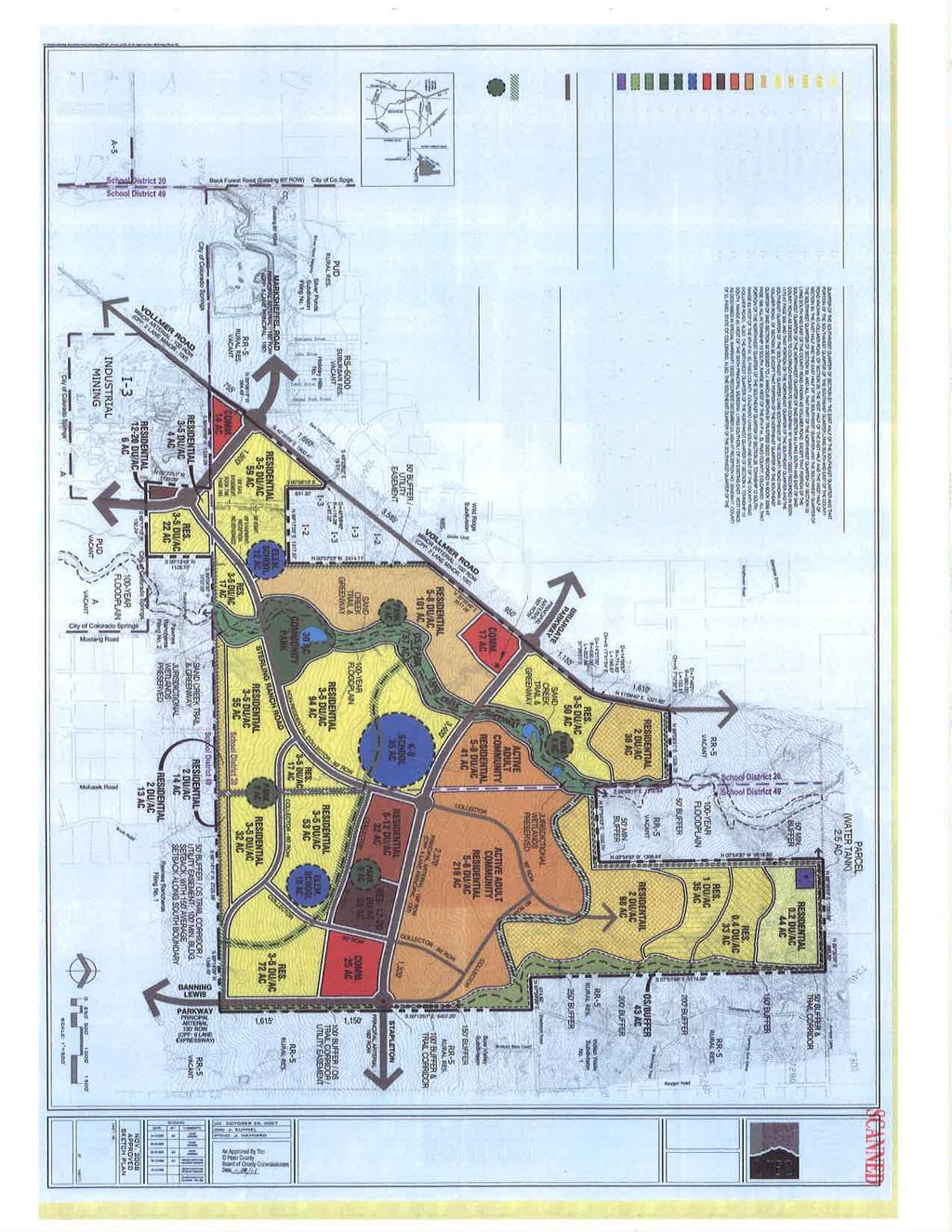
2 EXECUTIVE SUMMARY A request by Arroya Investments, LLC, Robert Scott General Contractors, and Jacob Decoto for approval of a map amendment (rezoning) from RR-5 (Residential Rural) to PUD (Planned Unit Development). The applicants are proposing 212 single-family lots; rights of way; and 11 open-space, trail corridor, detention, and utilities tracts that are anticipated to be owned by the proposed TimberRidge Metropolitan District. Phasing of the development is anticipated as depicted on the PUD development plan; however, the chronology of the phasing is not binding. The eight (8) parcels, totaling acres, are located north of the proposed extension of Stapleton Road/Briargate Parkway, bisected by Vollmer Road, and are within Sections 21 and 28, Township 12 South, Range 65 West of the 6 th P.M.. The parcels are included within the boundaries of the Black Forest Preservation Plan (1987) area. The applicants are proposing a modification to standards within the El Paso County Engineering Criteria Manual (ECM) (2016). The modification proposes to reduce the minimum intersection spacing between the future intersections of Arroya Lane and Nature Refuge Road and Arroya Lane and Hawks Hill Court. This modification is addressed in Section A.1, Request/Waivers/Modifications/Authorization of this staff report below. The ECM Administrator recommends approval of the proposed modification. Opposition to this rezoning request has been received by staff from residents living in the vicinity of the property, both to the east and the west. The opposition requests a density transition along the western and eastern PUD development plan boundaries similar to the approved Sterling Ranch Sketch Plan in order to be more compatible with the Black Forest Preservation Plan (1987) and existing RR-5 zoned properties. Comments received from the Black Forest Land Use Committee did not indicate an objection to the proposal; however, a request was made for a 200 foot setback for all the lots adjacent to Vollmer Road. The applicants have provided a 100 foot setback for Lots 20 through 26 adjacent to Vollmer Road where there are no existing evergreen trees. The remaining lots along Vollmer Road are proposed to have a 50 foot setback; the applicants propose to keep the existing evergreen trees as a visual buffer on these lots. A detailed evaluation of the compatibility of the PUD rezoning request, including discussions regarding transitions and setbacks, has been provided in the Analysis section of this report below. Lots within the PUD zoning district at less than 2.5 acres in size are proposed to receive water and wastewater service from the proposed Sterling Ranch Metropolitan District. Individual wells and onsite wastewater treatment systems (OWTS) are proposed for the lots greater than 2.5 acres in size. A finding of water sufficiency is not applicable with rezoning requests. Such findings will need to be made at the subsequent preliminary plan or final plat stages of development. Concerns regarding water supply quantity have been raised by those neighbors expressing opposition to the rezoning request. 2
3 A. REQUEST/WAIVERS/MODIFICATIONS/AUTHORIZATION Request: A request for approval of a map amendment (rezoning) for eight (8) parcels totaling acres from RR-5 (Residential Rural) to PUD (Planned Unit Development) to allow for the development of 212 single-family lots, rights of way, and 11 open-space, trail corridors, detention and utilities tracts. Modification of Existing Land Development Code (LDC) or Engineering Criteria Manual (ECM) Standard: For approval of a modification of a general development standard in the Land Development Code or standard of the Engineering Criteria Manual, the BoCC shall find that the proposal provides for the general health, safety, and welfare of the citizens and at least one of the following benefits: Preservation of natural features; Provision of a more livable environment, such as the installment of street furniture, decorative street lighting or decorative paving materials; Provision of a more efficient pedestrian system; Provision of additional open space; Provision of other public amenities not otherwise required by the Code; or The proposed modification is granted in exchange for the open space and/or amenity designs provided in the PUD development plan and/or development guide The applicants are requesting the following modification to Section D of the Engineering Criteria Manual: Modification of Section D, Collector Access Spacing, and the accompanying modification of Section 2.3.2, Design Standards by Functional Classification. This modification allows for intersection spacing of 487 feet where 660 feet is required on Arroya Lane between Nature Refuge Road and Hawks Hill Court. The applicants have provided justifications in support of the proposed modification in the traffic study and the deviation request. The Planning and Community Development Executive Director and the ECM Administrator have no objection to the modification as requested, and recommend approval. Authorization to Sign: PUD Development Plan and any other documents required to finalize the approval. 3
4 B. PLANNING COMMISSION SUMMARY Request Heard: Recommendation: Waiver Recommendation: Vote: Vote Rationale: Summary of Hearing: Legal Notice: C. APPROVAL CRITERIA The Planning Commission and BOCC shall determine that the following criteria, as identified in Section D of the Land Development Code (2017), have been met to approve a PUD zoning district: The proposed PUD district zoning advances the stated purposes set forth in this section; The application is in general conformity with the Master Plan; The proposed development is in compliance with the requirements of this Code and all applicable statutory provisions and will not otherwise be detrimental to the health, safety, or welfare of the present or future inhabitants of El Paso County; The subject property is suitable for the intended uses and the use is compatible with both the existing and allowed land uses on the neighboring properties, will be in harmony and responsive with the character of the surrounding area and natural environment, and will not have a negative impact upon the existing and future development of the surrounding area; The proposed development provides adequate consideration for any potentially detrimental use to use relationships (e.g. commercial use adjacent to single family use) and provides an appropriate transition or buffering between uses of differing intensities both on-site and off-site which may include innovative treatments of use to use relationships; The allowed uses, bulk requirements and landscaping and buffering are appropriate to and compatible with the type of development, the surrounding neighborhood or area and the community; Areas with unique or significant historical, cultural, recreational, aesthetic or natural features are preserved and incorporated into the design of the project; 4
5 Open spaces and trails are integrated into the development plan to serve as amenities to residents and provide reasonable walking and biking opportunities; The proposed development will not overburden the capacities of existing or planned roads, utilities and other public facilities (e.g. fire protection, police protection, emergency services, and water and sanitation), and the required public services and facilities will be provided to support the development when needed; The proposed development would be a benefit through the provision of interconnected open space, conservation of environmental features, aesthetic features and harmonious design, and energy efficient site design; The proposed land use does not permit the use of any area containing a commercial mineral deposit in a manner which would unreasonably interfere with the present or future extraction of such deposit unless acknowledged by the mineral rights owner; Any proposed exception or deviation from the requirements if the zoning resolution or the subdivision regulation is warranted by virtue of the design and amenities incorporated in the development plan and development guide; and The owner(s) have authorized the application. D. LOCATION North: RR-5 (Residential Rural) South: RR-5 (Residential Rural) East: RR-5 (Residential Rural) West: RR-5 (Residential Rural) / PUD Vacant Vacant / (Sterling Ranch Sketch Plan undeveloped) Single-family north of Arroya Lane/ (Sterling Ranch Sketch Plan undeveloped) Vacant / Single-family E. BACKGROUND This area of the County was zoned A-1 (Rural) on September 21, 1965 by Board Resolution Subsequent nomenclature changes have renamed the zoning district to RR-5 (Rural Residential). The parcels have remained undeveloped. The applicants have held three (3) neighborhood meetings. County staff attended each of the meetings. The applicants significantly revised their PUD development plan in response to the neighbors concerns regarding density, traffic and water supply. The revisions included reducing the number of proposed single-family lots 5
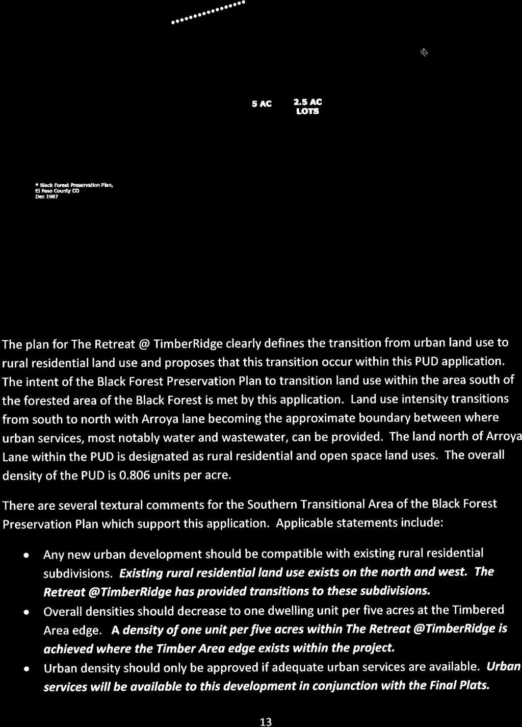
6 from 460 to 212, which represented a reduction of the proposed overall density from 1.64 du/acre to 0.81 du/acre. The applicants are proposing to develop 2.5 acre lots adjacent to Vollmer Road as a transition to the RR-5 zoned properties to the west. The applicants are also proposing a transition from the RR-5 zoned properties northeast of the property by tapering the lot sizes east to west from 5 acres to 2.5 acres for the portion of the property located north of Arroyo Lane. The applicants are proposing to taper the lot sizes from approximately 2.5 acres in the northern portions of the development to under one-third (1/3) of an acre in the southernmost portion of the development. The applicants summarize in their letter of intent that the approval of the adjacent Sterling Ranch Sketch Plan (SKP07007) by the Board of County Commissioners on November 13, 2008 changed the character of the area; thereby nullifying the recommendations of the Black Forest Preservation Plan (1987). F. ANALYSIS 1. Land Development Code Analysis The PUD development plan and development guidelines comply with Section D of the Code, except as otherwise altered by the requested PUD modification. This application meets the Planned Unit Development submittal requirements and the standards for Planned Unit Development in Chapter 4 of the Code. Section D of the Code, Criteria for Approval for a PUD, includes a requirement for compatibility by stating, the proposed development provides adequate consideration for any potentially detrimental use to use relationships and provides an appropriate transition or buffering between uses of differing intensities both on site and off site which may include innovative treatments of use to use relationships. Additional requirements cited in Section D of the Code state, the subject property is suitable for the intended uses and the use is compatible with both the existing and allowed land uses on neighboring properties The applicants are proposing to taper the density in a general pattern from five (5) acre lots at the northeastern portion of the plan to 2.5 acre average lots on the western boundary adjacent to Vollmer Road and south of Arroya lane to a more urban lot size under one-third (1/3) of an acre. Further discussion regarding compatibility of the proposed densities is included in Sections 3 and 4 below of this report. 6
7 2. Zoning Compliance The PUD development plan provides allowed and permitted uses; use, density, and dimensional standards such as setbacks, maximum lot coverage, and maximum building height; and it establishes landscaping requirements. 3. Policy Plan Analysis The El Paso County Policy Plan (1998) has a dual purpose; it serves as a guiding document concerning broader land use planning issues, and provides a framework to tie together the more detailed sub-area elements of the County master plan. Relevant policies are as follows: Policy Encourage new development which is contiguous and compatible with previously developed areas in terms of factors such as density, land use, and access. Policy Encourage incorporation of buffers or transitions between areas of varying use or density where possible. Policy Encourage the use of carefully planned and implemented clustering concepts in order to promote efficient land use, conservation of open space and reduction of infrastructure costs. Policy Support development which complements the unique environmental conditions and established land use character of each sub-area of the County. Goal 6.1 A- Encourage patterns of growth and development which complement the regions unique natural environments and which reinforce community character. The applicants are proposing five (5) acre lots in the northeastern area of the proposed PUD Plan north of Arroya Lane, which will be adjacent to properties zoned RR-5 (Residential Rural). Staff has no concerns with compatibility, density transitions, or patterns of growth in the northeastern-most area of the PUD plan. The applicants are proposing 2.5 acre lots along the western perimeter of the PUD, nearest to Vollmer Road. The applicants are also proposing a 100 foot building setback for Lots 20 through 26 adjacent to Vollmer Road where no mature evergreen trees exist (generally those lots that are proposed to be located along Vollmer Road south of the intersection with Wildflower Road). The increased setback will effectively serve as a 100 foot rear setback for the 7
8 proposed lots. By comparison, single family residential lots within the RR-2.5 (Residential Rural) zoning district are required to comply with a 25 foot rear setback. Staff recommends that the increased setback is intended to provide a buffer (e.g., distance separation) and single family residential density transition from properties west of Vollmer Road, which are required to be a minimum of five (5) acres pursuant to the RR-5 (Residential Rural) zoning district. The applicants letter of intent states that the density tapering proposed with this application is consistent with the approved Sterling Ranch Sketch Plan. The Sterling Ranch Sketch Plan includes lot sizes tapering from five (5) acre lots (in the area immediately south of Arroya Lane) down to one-half (1/2) acre lots along with a 50 foot buffer depicted on the western edge of the Sterling Ranch Sketch Plan, which is the common boundary with the proposed Retreat at TimberRidge PUD development plan. By comparison, the applicants are proposing to taper single family residential densities from 2.5 acre lots (in the area south of Arroya Lane) to under one-third (1/3) of an acre (15,890 sq. ft.) average size lots as the PUD plan extends southward. The PUD plan, as designed, will help preserve many of the natural features and unique environments located on the property by placing drainage ways in open space tracts, which is in accordance with Policy and Goal 6.1A, identified above, of the Policy Plan. The applicants are also providing a 25 foot trail easement to allow for the future extension of Sand Creek Regional Trail, which is anticipated to connect to the Sterling Ranch development to the south. The exact location and the entity responsible for construction of the trail will be determined at later stages of the development approval process. 4. Small Area Plan Analysis The property is within the Black Forest Preservation Plan (1987) area and, more specifically, within Planning Unit 10, The Southern Transitional Sub- Area. The Concept Plan Map, which is an enclosure of the Black Forest Preservation Plan, identifies the area as being appropriate for single family residential densities decreasing from one dwelling unit per acre to one dwelling unit per five acres toward the forest edge. The Map also includes two additional policies applicable to the Planning Unit 10, Southern Transitional Area, that state as follows: Any new urban development should be compatible with existing rural residential subdivisions. Urban density development should only be approved if adequate urban services are available. The urban lots under one-third (1/3) of an acre are proposed to be served by the proposed (in review) Retreat at TimberRidge Special District. The proposed permitted principle and accessory uses that are outlined in the PUD development 8
9 guidelines are generally compatible with the existing rural residential subdivisions and adjacent RR-5 zoning with following exceptions: 1. The applicants propose to allow accessory storage and repair of vehicles and machines (2.5 acres or larger) and wildlife rehabilitation, construction equipment storage and field offices, and commercial stables on lots with a minimum of 20 acres located west of Vollmer Road. Staff recommends these allowances be modified to require approval of a special use so that potential impacts can be further analyzed. Recommended Condition of Approval No. 14 requires a special use application to be submitted and approved prior to implementing these uses. 2. The applicants also propose to allow two-family dwellings (duplex) residential development west of Vollmer Road. Siting a two-family dwelling on a 2.5 acre or larger lot would inherently double the density, and is not compatible with the surrounding single-family developments. A duplex is intended for two (2) families and is a long-term use. A guest house is an allowed accessory use and does not increase the density as it is temporarily occupied and is not eligible as an income property. Staff recommends removing the two-family dwelling use from the permitted uses in the development guidelines. Recommended Condition of Approval No. 15 requires revision of the PUD plan to remove Dwelling, Two Family as an available land use. Additional textual descriptions of the Southern Transitional Sub-Area include: A key element in this unit is a low density residential buffer area. This buffer would originate along a line one-quarter mile north of a major corridor (Briargate Parkway / Stapleton), if such a roadway is constructed and if it is located within two (2) miles of Woodmen Road. Only open space and single-family residential development is appropriate north of this line. Overall densities are expected to decrease rapidly from approved densities at the line to one dwelling per five acres at the Timbered Area edge. Large lot clusters should be used to maximize open space, and structural profiles should be kept low to conform to the open topography and to preserve panoramic views. Regardless of what configuration of major transportation corridors ultimately develops, no urban density uses should be approved unless development is properly phased and can be provided with adequate and cost effective urban services. In addition, any urban density development must be compatible with existing uses, must not detract from the integrity of the ground water supply and must not overload, impede or otherwise limit the development of an efficient arterial road system. 9
10 The Retreat at TimberRidge PUD is located approximately one-half mile north of the future alignment of the Briargate Parkway/Stapleton corridor. The forested edge lies in the northwestern corner of the proposed PUD plan. The remaining land within the PUD is not forested. As stated above, the Plan s recommended densities are rural in nature north of the corridor. The Plan is 30 years old and was adopted prior to the Sterling Ranch Sketch Plan which established the alignment of the Briargate Parkway/Stapleton corridor. The City has annexed land previously depicted as being within the Plan. Urban development has occurred within the City west and east of Vollmer Road and north of Woodmen Road. The approval of the Sterling Ranch sketch plan, availability of central services to the area, and the encroachment of urban development within the City have modified the character of the area. The text recommends rapidly decreasing density from the buffer moving toward the forest edge. As recommended, the proposed PUD depicts 2.5 acre lots clustered on the western edge and lots clustered north of Arroya Lane. Contradictory to the Plan, the majority of the proposed lots are sized at under one-third (1/3) of an acre in the area that is recommended to rapidly decrease in density to one (1) dwelling unit per five (5) acres towards the forest edge. The approved Sterling Ranch sketch plan includes urban densities beyond the quarter mile point, with a transition from one (1) unit per five (5) acres at the northern boundary adjacent to the east boundary of the requested PUD development plan to one-half (1/2) acre lot sizes at the southern boundary. The approval of the Sterling Ranch sketch plan could be interpreted as a modification of the residential density policies applicable to this area of the Black Forest Preservation Plan; however, the densities proposed in the Retreat at TimberRidge PUD development plan are still higher by comparison than those depicted on the approved Sterling Ranch sketch plan. Encroachment of urban development within the City may also be interpreted as a modification of the Black Forest Preservation Plan further modifying the residential density policies. The Trails addendum to the Black Forest Preservation Plan shows a regional trail corridor through the property. The Sand Creek Regional trail is depicted on the PUD development plan. The El Paso County Parks Department will continue to work with the applicants on the specific alignment of the trail through the Sand Creek Channel at the time of preliminary plan and final plat(s) review. 5. Other Master Plan Elements The proposed Retreat at TimberRidge PUD development plan is consistent with or does not create negative impacts to elements depicted on the El Paso County Wildlife Habitat Descriptors Map (1996), the El Paso County Community Services Parks Master Plan (2014), the Master Plan for Mineral Extraction (1996), and the 10
11 El Paso County 2016 Major Transportation Corridors Plan Update, which is further addressed below. G. PHYSICAL SITE CHARACTERISTICS 1. Hazards A Soil, Geology, and Geologic Hazard Study for the Retreat at TimberRidge prepared on April 12, 2017, by Entech Engineering was reviewed with this request. The report identifies constraints and hazards which the applicants have proposed to be within the open space areas in the PUD development plan. Recommended Condition of Approval No. 9 requires the applicants to submit a detailed Geology and Soils Standards Report with all subsequent preliminary plans. Constraints and hazards shall be identified on the subsequent preliminary plans to ensure hazards are avoided or mitigated. 2. Wildlife Potential impacts to wildlife are generally low as depicted in the El Paso County Wildlife Descriptors Map (1996). 3. Floodplain A designated Federal Emergency Management Agency (FEMA) Special Flood Hazard Area (SFHA / Zone AE 100-year floodplain) lies within Sand Creek running through the site from north to south as shown on Flood Insurance Rate Map (FIRM) panel No C0535F, as modified by Letter of Map Revision (LOMR). The developer will be required to comply with floodplain development regulations and wetland mitigation requirements, as applicable, for development of this property with any subsequent platting actions. 4. Drainage and Erosion The site is located within the Sand Creek Drainage Basin. This basin has been studied and drainage and bridge fees apply at the time of subdivision. The site drains generally to the Sand Creek channel, flowing to the south. A Master Development Drainage Plan (MDDP) was provided with this PUD development plan. Per the MDDP, the applicants propose adequate water quality and detention facilities to maintain runoff at or below historic rates using full-spectrum detention facilities. Per the Sand Creek Drainage Basin Planning Study (DBPS), improvements to the Sand Creek channel, including grade control, bank stabilization, and detention, will be required through the proposed development. The MDDP describes the types of channel improvements that will be evaluated and 11
12 designed. Coordination between the TimberRidge project and the Sterling Ranch development downstream will be necessary prior to construction of channel improvements. Conditions of approval at the time of preliminary and final plat approvals, in accordance with preliminary and final drainage studies to be submitted, will address construction responsibilities and associated timelines for completion of the necessary channel stabilization improvements. 5. Transportation The proposed development includes access to Vollmer Road which is a 2-lane Rural Minor Arterial road per the El Paso County 2016 Major Transportation Corridors Plan Update, 2040 Major Transportation Corridors Plan. (MTCP). Access is proposed to Vollmer Road at Arroya Lane and Poco Road, both of which are existing local gravel roads located in prescriptive rights-of-way. Access points to the future Sterling Ranch road network to the south and east are also proposed. With anticipated future Sterling Ranch development, Briargate Parkway will be extended to the future Stapleton Drive alignment, both of these roads being future 4-lane Principal Arterials. A traffic impact analysis (TIS) dated January 2018 was provided with the PUD rezoning submittal. Table 3 of the TIS identifies required and potentially necessary offsite roadway improvements and developer responsibilities toward the improvements. Widening and turn lane improvements to Vollmer Road adjacent to the site and offsite will be required with final plats of the TimberRidge development as identified in the conditions of approval. The specific offsite construction responsibilities of the development will be identified with future TimberRidge preliminary plan and final plat approvals. Coordination with the Sterling Ranch development s construction plans for Vollmer Road and shared internal road connections will be required. The El Paso County Road Impact Fee will be applicable to final plats within the TimberRidge development. As discussed in Section A.1, Request/Waivers/Modifications/Authorization above, the applicants are proposing a modification to ECM Section D to allow for intersection spacing of 487 feet where 660 feet is required on Arroya Lane between proposed Nature Refuge Road and proposed Hawks Hill Court. 12
13 H. SERVICES 1. Water Sufficiency: Quality: Quantity Dependability: Summary: A finding for water sufficiency is not required with PUD requests. The applicants have stated that central water services are feasible for the urban lots. The applicants have also proposed that an intergovernmental agreement between Sterling Ranch Metropolitan District and the proposed TimberRidge Metropolitan District (in review) will be completed in order to provide central water services to the proposed urban lots. Individual wells are anticipated to serve the 2.5 acre and larger proposed rural lots. 2. Sanitation The applicants anticipate establishing an intergovernmental agreement between Sterling Ranch Metropolitan District and the proposed TimberRidge Metropolitan District to provide wastewater services to the proposed urban lots. Individual onsite wastewater treatment systems are anticipated to serve the 2.5 acre and larger rural lots. 3. Emergency Services The requested PUD development plan is within the Black Forest Fire Protection District. The District received a referral to review the application and did not respond with any objections. The District has committed to serve the development. 4. Utilities The requested PUD development plan is within the electrical service area of Mountain View Electric Association, and the natural gas service area of Black Hills Energy. Both agencies have committed to serve the development. 5. Metropolitan Districts and Other Special Districts The applicants are in the process of submitting a request to create The Retreat at TimberRidge special district, that is anticipated to provide water and wastewater services through an intergovernmental agreement with Sterling Ranch Metropolitan District. The Retreat at TimberRidge special district is anticipated to own and maintain the open space, drainage, non-regional trail corridors and utility tracts. 13
14 6. Parks/Trails The El Paso County Community Services Department, Parks Division, has requested the applicants provide a 25-foot trail corridor easement for the Sand Creek Regional Trail which has been depicted on the PUD development plan. The County is anticipated to maintain the regional trail. The regional trail is anticipated to connect to the Sterling Ranch open space to the south via the Sand Creek Channel Greenway. A trail easement has also been depicted along the south side of Arroya Lane. As depicted on the plan, internal trails are anticipated to provide connections from areas planned for urban lots to the regional trail corridor. 7. Schools The requested PUD development plan is within both Falcon School District No. 49 and Academy School District No. 20. The Districts received the application for review and did not have any comments regarding the plan. Fees will be required to be paid to the appropriate District at the time of future plat recordings. I. APPLICABLE RESOLUTIONS Approval Page 29 Disapproval Page 30 J. STATUS OF MAJOR ISSUES The Black Forest Preservation Plan includes residential density policies which are recommendations for development; they are not criteria for approval. Changes to the character of the area may be interpreted as a modification to polices in the Plan. Staff has discussed the policies and the densities of the development above in Sections E.3 and E.4 of this staff report. K. RECOMMENDED CONDITIONS OF APPROVAL Should the Planning Commission and the Board of County Commissioners find that the request meets the criteria for approval outlined in Section of the El Paso County Land Development Code (2016), staff recommends the following conditions and notations: CONDITIONS 1. Development of the property shall be in accordance with the PUD development plan. Minor changes in the PUD development plan, including a reduction in residential density, may be approved administratively by the Director of the Planning and Community Development Department consistent with the Land 14
15 Development Code. Any substantial change will require submittal of a formal PUD development plan amendment application. 2. Approved land uses are those defined in the PUD development plan and development guide. 3. All owners of record must sign the PUD development plan. 4. The PUD development plan shall be recorded in the office of the El Paso County Clerk & Recorder prior to scheduling any final plats for hearing by the Planning Commission. The development guide shall be recorded in conjunction with the PUD development plan. 5. Developer shall comply with federal and state laws, regulations, ordinances, review and permit requirements, and other agency requirements, if any, of applicable agencies including, but not limited to, the Colorado Parks and Wildlife, Colorado Department of Transportation, U.S. Army Corps of Engineers and the U.S. Fish and Wildlife Service regarding the Endangered Species Act, particularly as it relates to the Preble's Meadow Jumping Mouse as a listed threatened species. 6. The building setback along Vollmer Road for Lots 20 through 26 shall be 100 feet, as depicted on the PUD development plan. 7. Landscape plantings along Arroya Lane shall be planted by the developer at the ratio of one (1) tree per 30 feet, and a minimum of one-third (1/3) of those trees shall be evergreen trees. 8. Landscape plantings along Vollmer Road are to be planted by the developer at the ratio of one (1) tree per 25 feet, and a minimum of one-third (1/3) of those trees shall be evergreen trees. 9. Applicants shall provide a Geology and Soils Standards Report with all subsequent preliminary plans. Constraints and hazards shall be identified on the subsequent preliminary plans (Note: not all lots depicted on the PUD development plan may be developable). 10. The label shared access drive on Sheet 2 and General Note No. 2 on Sheet 3 of the PUD development plan do not guarantee approval of the access. Access will be determined at the time of the preliminary plan for Phase A. Phase E may modify access to Phase A lots. Further analysis shall be required at the time of the preliminary plan submittal. 15
16 11. Access to Parcel No west of Vollmer Road shall be finalized at the time of the preliminary plan for that parcel to determine access from Vollmer Road. A deviation may be required at that time. 12. The applicants shall be responsible for constructing or providing escrow toward offsite improvements to Vollmer Road with the appropriate final plat as identified in the traffic impact study. 13. The applicants shall be responsible for constructing the necessary improvements in the Sand Creek channel, as identified in the required preliminary and final drainage reports to be submitted, with the appropriate final plat(s). 14. Accessory storage and repair of vehicles and machines as well as wildlife rehabilitation, construction equipment storage and field offices, and commercial stables on lots located West of Vollmer shall require approval of a special use. These uses are not allowed east of Vollmer Road. 15. The applicants shall revise of the PUD plan to remove Dwelling, Two Family as an available land use prior to recordation of the plan. NOTATIONS 1. If a zone or rezone petition has been disapproved by the Board of County Commissioners, resubmittal of the previously denied petition will not be accepted for a period of one (1) year if it pertains to the same parcel of land and is a petition for a change to the same zone that was previously denied. However, if evidence is presented showing that there has been a substantial change in physical conditions or circumstances, the Planning Commission may reconsider said petition. The time limitation of one (1) year shall be computed from the date of final determination by the Board of County Commissioners or, in the event of court litigation, from the date of the entry of final judgment of any court of record. 2. Rezoning requests not forwarded to the Board of County Commissioners for consideration within 180 days of Planning Commission action will be deemed withdrawn and will have to be resubmitted in their entirety. 3. Approval of the PUD as submitted does not guarantee approval of deviations from any engineering criteria that have not been specifically addressed in either an approved deviation request or PUD modification. 4. Documentation of separate vacation/termination documents will need to be provided, which remove encumbrances on proposed rights-of-way, specifically Arroya Lane, prior to platting and County acceptance of the proposed roads. 16
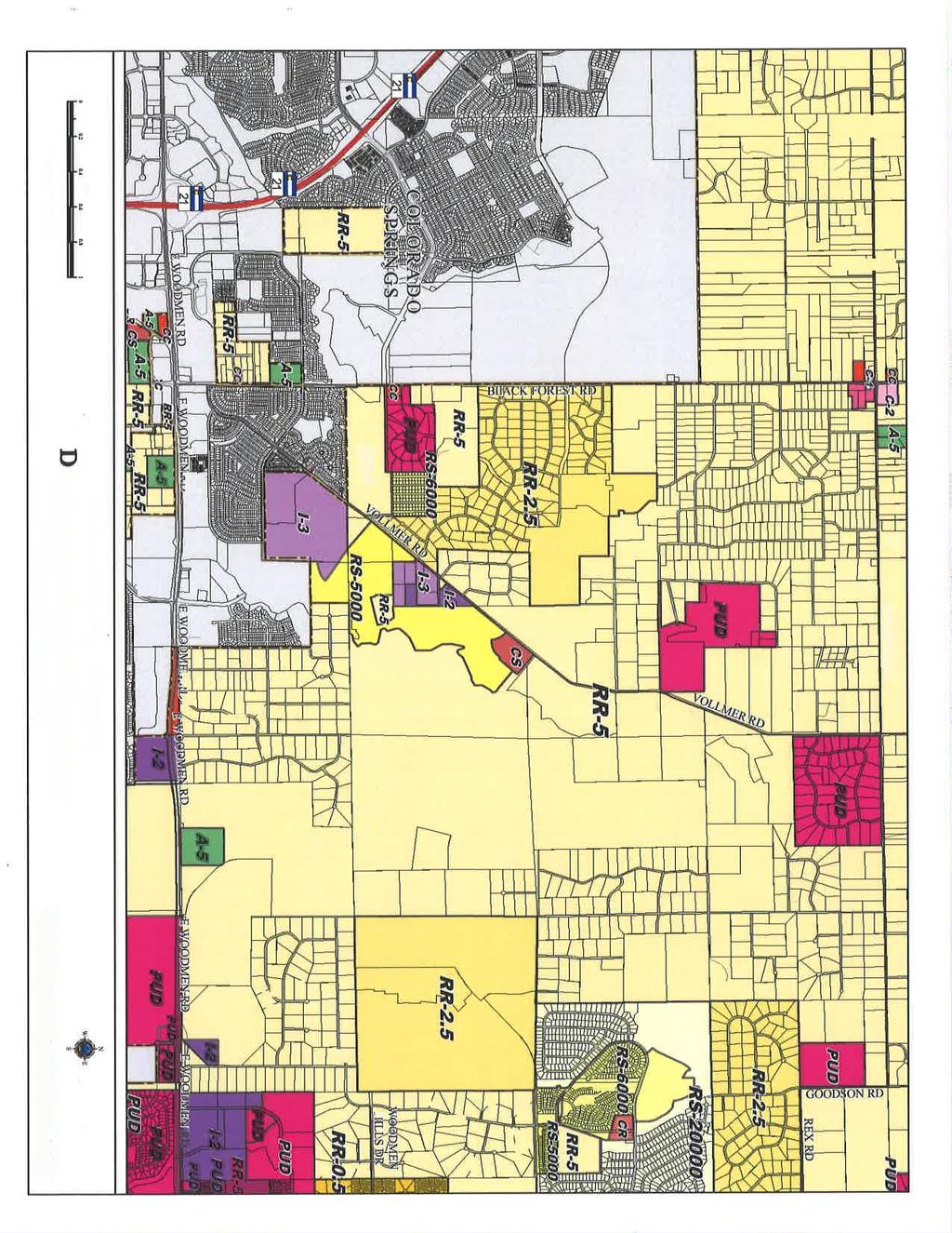
17 5. All outstanding review comments will need to be addressed, to the satisfaction of the PCD Director, prior to scheduling the request for a Board of County Commissioners hearing. L. PUBLIC COMMENT AND NOTICE The Planning and Community Development Department notified 30 adjoining property owners on February 14, 2017, for the Planning Commission and Board of County Commissioners hearings. Responses will be provided at the hearing. M. ATTACHMENTS Vicinity Map Letter of Intent PUD Development Plan Sterling Ranch Sketch Plan Zoning Map 17
18 18
19 19
20 20
21 21
22 22
23 23
24 24
25 25
26 26
27 27
28 28
29 29
30 30
31 31
32 32
33 33

34 34
35 35


36 36
37 37
38 38
39 39
Project File #: SF Project Name: Jackson Ranch Filing No. 4 Parcel Nos.: , and
 COMMISSIONERS: DARRYL GLENN (PRESIDENT) MARK WALLER (PRESIDENT PRO TEMPORE) STAN VANDERWERF LONGINOS GONZALEZ PEGGY LITTLETON PLANNING AND COMMUNITY DEVELOPMENT DEPARTMENT CRAIG DOSSEY, EXECUTIVE DIRECTOR
Planning Commission Hearing Date: 1/2/2018 Board of County Commissioners Hearing Date 1/23/2018
 COMMISSIONERS: DARRYL GLENN (PRESIDENT) MARK WALLER (PRESIDENT PRO TEMPORE) STAN VANDERWERF LONGINOS GONZALEZ PEGGY LITTLETON PLANNING AND COMMUNITY DEVELOPMENT DEPARTMENT CRAIG DOSSEY, EXECUTIVE DIRECTOR
Project File #: VA Project Name: Beauperthuy Variance Parcel Nos.: , , , ,
 COMMISSIONERS: DARRYL GLENN (PRESIDENT) MARK WALLER (PRESIDENT PRO TEMPORE) STAN VANDERWERF LONGINOS GONZALEZ PEGGY LITTLETON PLANNING AND COMMUNITY DEVELOPMENT DEPARTMENT CRAIG DOSSEY, EXECUTIVE DIRECTOR
REPRESENTATIVE: NES, Inc. 619 North Cascade Avenue, Suite 200 Colorado Springs, CO 80903
 COMMISSIONERS: MARK WALLER (CHAIR) LONGINOS GONZALEZ, JR. (VICE-CHAIR) HOLLY WILLIAMS STAN VANDERWERF CAMI BREMER PLANNING AND COMMUNITY DEVELOPMENT DEPARTMENT CRAIG DOSSEY, EXECUTIVE DIRECTOR TO: FROM:
Planning Commission Hearing Date: 2/21/2017 Board of County Commissioners Hearing Date: 3/8/2017
 COMMISSIONERS: DARRYL GLENN (PRESIDENT) MARK WALLER (PRESIDENT PRO TEMPORE) STAN VANDERWERF LONGINOS GONZALEZ PEGGY LITTLETON PLANNING AND COMMUNITY DEVELOPMENT DEPARTMENT CRAIG DOSSEY, EXECUTIVE DIRECTOR
REPRESENTATIVE: Julie & Brad Nicodemus Black Squirrel Road Colorado Springs, CO 80809
 COMMISSIONERS: DARRYL GLENN (PRESIDENT) MARK WALLER (PRESIDENT PRO TEMPORE) STAN VANDERWERF LONGINOS GONZALEZ PEGGY LITTLETON PLANNING AND COMMUNITY DEVELOPMENT DEPARTMENT CRAIG DOSSEY, EXECUTIVE DIRECTOR
REPRESENTATIVE: Centerline Solutions Table Mountain Parkway Golden, CO 80403
 COMMISSIONERS: DARRYL GLENN (PRESIDENT) MARK WALLER (PRESIDENT PRO TEMPORE) STAN VANDERWERF LONGINOS GONZALEZ PEGGY LITTLETON PLANNING AND COMMUNITY DEVELOPMENT DEPARTMENT CRAIG DOSSEY, EXECUTIVE DIRECTOR
Project File #: SF Project Name: Meadowbrook Crossing Filing No. 1 Final Plat Parcel No.:
 COMMISSIONERS: DARRYL GLENN (PRESIDENT) MARK WALLER (PRESIDENT PRO TEMPORE) STAN VANDERWERF LONGINOS GONZALEZ PEGGY LITTLETON PLANNING AND COMMUNITY DEVELOPMENT DEPARTMENT CRAIG DOSSEY, EXECUTIVE DIRECTOR
Planning Commission Hearing Date: 5/2/2017 Board of County Commissioners Hearing Date 5/23/2017
 COMMISSIONERS: DARRYL GLENN (PRESIDENT) MARK WALLER (PRESIDENT PRO TEMPORE) STAN VANDERWERF LONGINOS GONZALEZ PEGGY LITTLETON PLANNING AND COMMUNITY DEVELOPMENT DEPARTMENT CRAIG DOSSEY, EXECUTIVE DIRECTOR
Project File #: SP Project Name: Springs at Waterview Preliminary Plan Parcel No.:
 COMMISSIONERS: DARRYL GLENN (PRESIDENT) MARK WALLER (PRESIDENT PRO TEMPORE) STAN VANDERWERF LONGINOS GONZALEZ PEGGY LITTLETON PLANNING AND COMMUNITY DEVELOPMENT DEPARTMENT CRAIG DOSSEY, EXECUTIVE DIRECTOR
Letter of Intent May 2017 (Revised November 2017)
") THE BEACH AT WOODMOOR LETTER OF INTENT MAY 2017 (REVISED NOVEMBER 2017) OWNER/APPLICANT: CONSULTANT: Lake Woodmoor Holdings LLC N.E.S. Inc. 1755 Telstar Drive, Suite 211 619 North Cascade Avenue Colorado
THE BEACH AT WOODMOOR LETTER OF INTENT MAY 2017 (REVISED NOVEMBER 2017) OWNER/APPLICANT: CONSULTANT: Lake Woodmoor Holdings LLC N.E.S. Inc. 1755 Telstar Drive, Suite 211 619 North Cascade Avenue Colorado
Nina Ruiz, PM/Planner II Mike Hrebenar, Project Management Group Manager Elizabeth Nijkamp, PE Engineering Manager Craig Dossey, Executive Director
 COMMISSIONERS: DARRYL GLENN (PRESIDENT) MARK WALLER (PRESIDENT PRO TEMPORE) STAN VANDERWERF LONGINOS GONZALEZ PEGGY LITTLETON PLANNING AND COMMUNITY DEVELOPMENT DEPARTMENT CRAIG DOSSEY, EXECUTIVE DIRECTOR
Gabe Sevigney, Project Manager/Planner I Gilbert LaForce, Engineer II Craig Dossey, Executive Director Planning & Community Development
 COMMISSIONERS: DARRYL GLENN (PRESIDENT) MARK WALLER (PRESIDENT PRO TEMPORE) STAN VANDERWERF LONGINOS GONZALEZ PEGGY LITTLETON PLANNING AND COMMUNITY DEVELOPMENT DEPARTMENT CRAIG DOSSEY, EXECUTIVE DIRECTOR
Project File #: P Project Name: Springs at Waterview Residential Rezone Parcel No.:
 COMMISSIONERS: DARRYL GLENN (PRESIDENT) MARK WALLER (PRESIDENT PRO TEMPORE) STAN VANDERWERF LONGINOS GONZALEZ PEGGY LITTLETON PLANNING AND COMMUNITY DEVELOPMENT DEPARTMENT CRAIG DOSSEY, EXECUTIVE DIRECTOR
Nina Ruiz, Project Manager/Planner II Gilbert LaForce, Engineer II Craig Dossey, Executive Director Planning & Community Development
 COMMISSIONERS: DARRYL GLENN (PRESIDENT) MARK WALLER (PRESIDENT PRO TEMPORE) STAN VANDERWERF LONGINOS GONZALEZ PEGGY LITTLETON PLANNING AND COMMUNITY DEVELOPMENT DEPARTMENT CRAIG DOSSEY, EXECUTIVE DIRECTOR
REPRESENTATIVE: Kesti Suggs Holmes Rd Colorado Springs, CO 80908
 COMMISSIONERS: DARRYL GLENN (PRESIDENT) MARK WALLER (PRESIDENT PRO TEMPORE) STAN VANDERWERF LONGINOS GONZALEZ PEGGY LITTLETON PLANNING AND COMMUNITY DEVELOPMENT DEPARTMENT CRAIG DOSSEY, EXECUTIVE DIRECTOR
PLANNED UNIT DEVELOPMENTS (Ordinance No.: 3036, 12/3/07; Repealed & Replaced by Ordinance No.: 4166, 10/15/12)
") 159.62 PLANNED UNIT DEVELOPMENTS (Ordinance No.: 3036, 12/3/07; Repealed & Replaced by Ordinance No.: 4166, 10/15/12) A. PURPOSE 1. General. The Planned Unit Development (PUD) approach provides the flexibility
159.62 PLANNED UNIT DEVELOPMENTS (Ordinance No.: 3036, 12/3/07; Repealed & Replaced by Ordinance No.: 4166, 10/15/12) A. PURPOSE 1. General. The Planned Unit Development (PUD) approach provides the flexibility
Project File #: SF Project Name: Redtail Ranch Subdivision Parcel Nos.: , , ,
 COMMISSIONERS: MARK WALLER (CHAIR) LONGINOS GONZALEZ, JR. (VICE-CHAIR) HOLLY WILLIAMS STAN VANDERWERF CAMI BREMER PLANNING AND COMMUNITY DEVELOPMENT DEPARTMENT CRAIG DOSSEY, EXECUTIVE DIRECTOR TO: FROM:
Staff Report: Date: Applicant: Property Identification: Acreage of Request: Current Zoning of Requested Area: Requested Action: Attached:
 Staff Report: Completed by Jeff Palmer Director of Planning & Zoning Date: November 7, 2018, Updated November 20, 2018 Applicant: Greg Smith, Oberer Land Developer agent for Ronald Montgomery ET AL Property
Article 6: Planned Unit Developments
 LUDC 2013 GARFIELD COUNTY, COLORADO Article 6: Planned Unit Developments ARTICLE 6 PLANNED UNIT DEVELOPMENTS TABLE OF CONTENTS DIVISION 1. GENERAL.... 1 6-101. GENERAL PROVISIONS.... 1 A. Purpose....
Cover Letter with Narrative Statement
 Cover Letter with Narrative Statement March 31, 2017 rev July 27, 2017 RE: Rushton Pointe Residential Planned Unit Development Application for Public Hearing for RPUD Rezone PL2015 000 0306 Mr. Eric Johnson,
CHAPTER 14 PLANNED UNIT DEVELOPMENTS
 9-14-1 9-14-1 CHAPTER 14 PLANNED UNIT DEVELOPMENTS SECTION: 9-14-1: Purpose 9-14-2: Governing Provisions 9-14-3: Minimum Area 9-14-4: Uses Permitted 9-14-5: Common Open Space 9-14-6: Utility Requirements
MIDWAY CITY Municipal Code
 MIDWAY CITY Municipal Code TITLE 9 ANNEXATION CHAPTER 9.01 PURPOSE CHAPTER 9.02 GENERAL REQUIREMENTS CHAPTER 9.03 PROPERTY OWNER INITIATION OF ANNEXATION CHAPTER 9.04 PROCEDURES FOR CONSIDERATION OF PETITION
Town of Cary, North Carolina Rezoning Staff Report 14-REZ-31 Cary Park PDD Amendment (Waterford II) Town Council Meeting January 15, 2015
 Town Council Meeting January 15, 2015") Town of Cary, North Carolina Rezoning Staff Report 14-REZ-31 Cary Park PDD Amendment (Waterford II) Town Council Meeting January 15, 2015 REQUEST To amend the Town of Cary Official Zoning Map by amending
Town of Cary, North Carolina Rezoning Staff Report 14-REZ-31 Cary Park PDD Amendment (Waterford II) Town Council Meeting January 15, 2015 REQUEST To amend the Town of Cary Official Zoning Map by amending
ARTICLE 15 - PLANNED UNIT DEVELOPMENT
 Section 15.1 - Intent. ARTICLE 15 - PLANNED UNIT DEVELOPMENT A PUD, or Planned Unit Development, is not a District per se, but rather a set of standards that may be applied to a development type. The Planned
ARTICLE 14 PLANNED UNIT DEVELOPMENT (PUD) DISTRICT
 DISTRICT") ARTICLE 14 PLANNED UNIT DEVELOPMENT (PUD) DISTRICT Section 14.01 Intent. It is the intent of this Article to allow the use of the planned unit development (PUD) process, as authorized by the Michigan Zoning
ARTICLE 14 PLANNED UNIT DEVELOPMENT (PUD) DISTRICT Section 14.01 Intent. It is the intent of this Article to allow the use of the planned unit development (PUD) process, as authorized by the Michigan Zoning
Guide to Preliminary Plans
 Guide to Preliminary Plans Introduction The Douglas County is committed to providing open, transparent application processes to the public. This Guide is provided to assist anyone interested in the procedures
Guide to Minor Developments
 Guide to Minor Developments Introduction The Douglas County (DCD) is committed to providing open, transparent application processes to the public. This Guide is provided to assist anyone interested in
Staff Report: Date: Applicant: Property Identification: Acreage of Request: Current Zoning of Requested Area: Requested Action: Attached:
 Staff Report: Completed by Jeff Palmer Director of Planning & Zoning Date: November 7, 2018 Applicant: Greg Smith, Oberer Land Developer agent for Ronald Montgomery ET AL Property Identification: Frontage
Community Development
 Land Use Petition RZ-16-002 Date of Staff Recommendation Preparation: April 15, 2016 (CEL) Date of Planning Commission Recommendation: May 3, 2016 PROJECT LOCATION: DISTRICT/SECTION/LANDLOT(S): ACREAGE
MS MINOR SUBDIVISION TREVITHICK
 MS-02-015 341.12 MINOR SUBDIVISION TREVITHICK A request by Danny Trevithick for a one-lot Minor Subdivision on five acres. The property is zoned A-35 (Agricultural) District and is located ¼ mile south
SUBJECT PARCEL(S) Property Owner(s) TMS Number Approximate Acreage Carolina Park Development, LLC
 Property Owner(s) TMS Number Approximate Acreage Carolina Park Development, LLC") Staff Report Special Planning Commission Meeting November 19, 2014 For reference, the Zoning Code and Land Development Regulations are available online. AGENDA ITEM 5c. SKETCH PLAN APPROVAL REQUEST: Request
Staff Report Special Planning Commission Meeting November 19, 2014 For reference, the Zoning Code and Land Development Regulations are available online. AGENDA ITEM 5c. SKETCH PLAN APPROVAL REQUEST: Request
SECTION 16. "PUD" PLANNED UNIT DEVELOPMENT OVERLAY DISTRICT
 SECTION 6. "PUD" PLANNED UNIT DEVELOPMENT OVERLAY DISTRICT Subsection. Purpose. This district is established to achieve the coordinated integration of land parcels and large commercial and retail establishments
In order to permit maximum applicability of the PUD District, PUD-1 and PUD-2 Districts are hereby created.
 ARTICLE III. PUD ned Unit Development Overlay District 205-128. Purpose. The PUD ned Unit Development Overlay District is intended to provide flexibility in the design of planned projects; to encourage
Guide to Combined Preliminary and Final Plats
 Guide to Combined Preliminary and Final Plats Introduction The Douglas County is committed to providing open, transparent application processes to the public. This Guide is provided to assist anyone interested
REPORT TO THE SHELBY COUNTY PLANNING COMMISSION From the Department of Development Services Planning Services. February 4, 2019
 REPORT TO THE SHELBY COUNTY PLANNING COMMISSION From the Department of Development Services Planning Services February 4, 2019 Case No. Request for Rezoning Approval From E-1 to E-2 SD This is a request
Project File #: VR Project Name: Claremont Ranch Filing 9C Vacate Replat Parcel No.:
 COMMISSIONERS: DARRYL GLENN (PRESIDENT) MARK WALLER (PRESIDENT PRO TEMPORE) STAN VANDERWERF LONGINOS GONZALEZ PEGGY LITTLETON PLANNING AND COMMUNITY DEVELOPMENT DEPARTMENT CRAIG DOSSEY, EXECUTIVE DIRECTOR
ZONING ORDINANCE: OPEN SPACE COMMUNITY. Hamburg Township, MI
 ZONING ORDINANCE: OPEN SPACE COMMUNITY Hamburg Township, MI ARTICLE 14.00 OPEN SPACE COMMUNITY (Adopted 1/16/92) Section 14.1. Intent It is the intent of this Article to offer an alternative to traditional
Plan nt Plan Filing and
 PARISH OF ASCENSION OFFICE OF PLANNING AND DEVELOPMENT PLANNING DEPARTMENT APPENDIX VI PLANNED UNIT DEVELOPMENT (PUD) CODE Contents: 17-601. General Purpose: Procedures... 3 17-602. General Character:...
DOUGLAS COUNTY SUBDIVISION RESOLUTION Article 4 Preliminary Plan 10/13/2015
 ARTICLE 4 PRELIMINARY PLAN 401 Intent An in-depth analysis of the proposed subdivision, including a review of the design considering the ability to obtain water and sanitation, identified geologic hazards,
Medical Marijuana Special Exception Use Information
 Medical Marijuana Special Exception Use Information The Special Exception Use information below is a modified version of the Unified Development Code. It clarifies the current section 5:104 Special Exceptions
MINOR BOUNDARY LINE ADJUSTMENT PROCESS GUIDE
 MINOR BOUNDARY LINE ADJUSTMENT PROCESS GUIDE Clear Creek County Planning Department P.O. Box 2000 Georgetown, Colorado 80444 (303) 679-2436 phone (303) 569-1103 fax 1 PURPOSE To establish criteria and
Public Notice U.S. ARMY CORPS OF ENGINEERS, GALVESTON DISTRICT AND TEXAS COMMISSION ON ENVIRONMENTAL QUALITY
 Public Notice U.S. Army Corps Permit Application No: SWG-2016-00384 Of Engineers Date Issued: 27 December 2018 Galveston District Comments Due: 29 January 2019 U.S. ARMY CORPS OF ENGINEERS, GALVESTON DISTRICT
The following regulations shall apply in the R-E District:
 "R-E" RESIDENTIAL ESTATE DISTRICT (8/06) The following regulations shall apply in the R-E District: 1. Uses Permitted: The following uses are permitted. A Zoning Certificate may be required as provided
ARTICLE FIVE FINAL DRAFT
 ARTICLE FIVE 021218 FINAL DRAFT Sec. 503.6 Open Space Preservation Option Open Space Preservation Option Open Space Preservation developments may be approved in the AR, R-1, R-2 and R-3 zoning districts,
Chapter 100 Planned Unit Development in Corvallis Urban Fringe
 100.100 Scope and Purpose. Chapter 100 Planned Unit Development in Corvallis Urban Fringe (1) All applications for land divisions in the Urban Residential (UR) and Flood Plain Agriculture (FPA) zones within
Marion County Board of County Commissioners
 Marion County Board of County Commissioners Date: 12/29/2015 P&Z: 12/28/2015 BCC: 1/12/2016 Item Number 160113Z Type of Application Rezoning Request From: A-1 (General Agriculture) To: PUD (Planned Unit
PLANNED UNIT DEVELOPMENT & SUBDIVISION STAFF REPORT Date: April 18, 2019
 PLANNED UNIT DEVELOPMENT & SUBDIVISION STAFF REPORT Date: April 18, 2019 DEVELOPMENT NAME SUBDIVISION NAME Springhill Village Subdivision Springhill Village Subdivision LOCATION 4350, 4354, 4356, 4358,
Planning Commission Hearing Date 7/24/2018 Board of County Commissioners Hearing Date 8/14/2018
 COMMISSIONERS: DARRYL GLENN (PRESIDENT) MARK WALLER (PRESIDENT PRO TEMPORE) STAN VANDERWERF LONGINOS GONZALEZ PEGGY LITTLETON PLANNING AND COMMUNITY DEVELOPMENT DEPARTMENT CRAIG DOSSEY, EXECUTIVE DIRECTOR
CHAPTER 5. PLANNED UNIT DEVELOPMENT REGULATIONS
 Section 5.1. Purpose CHAPTER 5. PLANNED UNIT DEVELOPMENT REGULATIONS 5.1. PURPOSE The purpose for Planned Unit Developments (PUDs) is established in Section 4.5 Zoning District Purpose Statements. 5.2.
Appendix J - Planned Unit Development (PUD)
") Appendix J - Planned Unit Development (PUD) Intent and Purpose The purpose of the PUD is: 1. To provide development that is consistent with the Comprehensive Land Use Plan and promote the goals and objectives
Appendix J - Planned Unit Development (PUD) Intent and Purpose The purpose of the PUD is: 1. To provide development that is consistent with the Comprehensive Land Use Plan and promote the goals and objectives
Operating Standards Attachment to Development Application
 Planning & Development Services 2255 W Berry Ave. Littleton, CO 80120 Phone: 303-795-3748 Mon-Fri: 8am-5pm www.littletongov.org Operating Standards Attachment to Development Application 1 PLANNED DEVELOPMENT
CHAPTER 10 Planned Unit Development Zoning Districts
 CHAPTER 10 Planned Unit Development Zoning Districts Section 10.1 Intent and Purpose The Planned Unit Development (PUD) districts are intended to offer design flexibility for projects that further the
TOWN OF ORO VALLEY PLANNING & ZONING COMMISSION MEETING DATE: December 6, 2011
 PLANNING & ZONING COMMISSION MEETING DATE: December 6, 2011 TO: FROM: SUBJECT: PLANNING & ZONING COMMISSION Matt Michels, Senior Planner mmichels@orovalleyaz.gov; tel. 229-4822 Public Hearing: Rancho de
Chapter 210 CONDITIONAL USES
 Chapter 210 CONDITIONAL USES 210.01 Purpose 210.02 Authorization 210.03 Process Type 210.04 Determination of Major or Minor Conditional Use Review 210.05 Approval Criteria 210.06 Conditions of Approval
Group Sewer Only** 80 Ft Frontage* 20,000 Sq. Ft. (.46 acre) Minimum** 120 Ft Frontage* 20,000 Sq. Ft. (.46acre) Minimum** 150 Ft Frontage*
 Minimum** 120 Ft Frontage* 20,000 Sq. Ft. (.46acre) Minimum** 150 Ft Frontage*") Residential Lots Minimum Chart The minimum lot size of any minor subdivision where there is no public sewers shall be as shown below or as required by township zoning and/or the Tuscarawas General Health
Residential Lots Minimum Chart The minimum lot size of any minor subdivision where there is no public sewers shall be as shown below or as required by township zoning and/or the Tuscarawas General Health
CITY PLANNING COMMISSION AGENDA ITEM NOS: 15,16,17,18,19 STAFF: PATRICIA PARISH
 Page 185 CITY PLANNING COMMISSION AGENDA ITEM NOS: 15,16,17,18,19 STAFF: PATRICIA PARISH FILE NOS: CPC A 05-00193 LEGISLATIVE CPC ZC 05-00194 LEGISLATIVE CPC ZC 05-00195 LEGISLATIVE CPC CP 05-00196 QUASI-JUDICIAL
MAJOR BOUNDARY LINE ADJUSTMENT PROCESS GUIDE
 MAJOR BOUNDARY LINE ADJUSTMENT PROCESS GUIDE Clear Creek County Planning Department P.O. Box 2000 Georgetown, Colorado 80444 (303) 679-2436 - phone (303) 569-1103 - fax PURPOSE To establish criteria and
SUBDIVISION REGULATIONS
 CHAPTER 14 SUBDIVISION REGULATIONS 14-100 Provisions 14-200 Preliminary Plat 14-300 Final Plat 14-400 Replat 14-500 Minor Subdivision 14-600 Administrative Replat 14-700 Vacation of Roadways, Public Easements,
PLANNING AND ZONING COMMISSION AGENDA MEMORANDUM
 City and County of Broomfield, Colorado PLANNING AND ZONING COMMISSION AGENDA MEMORANDUM To: Planning and Zoning Commission From: John Hilgers, Planning Director Anna Bertanzetti, Principal Planner Meeting
ORDINANCE WHEREAS, the adoption of this Ordinance shall not be construed as an admission that the aforesaid claim has merit or is correct; and
 ORDINANCE 12-24 AN ORDINANCE OF THE CITY OF WINTER GARDEN, FLORIDA, REPEALING ORDINANCE 12-02 AND REPLACING IT WITH THE AMENDMENTS TO ARTICLE V OF CHAPTER 118 OF THE WINTER GARDEN CODE OF ORDINANCES CONTAINED
STAFF REPORT FOR MAJOR SUBDIVISION
 STAFF REPORT FOR MAJOR SUBDIVISION FINAL PLAT CASE NO. FA-13-001 HEARING DATE: November 6, 2013 CASE NAME: Solterra Subdivision Filing No. 14 PROCEDURE: Planning Commission ADDRESS OF MAJOR SUBDIVISION
Larimer County Planning Dept. Procedural Guide for 1041 PERMITS
 - Larimer County Planning Dept. Procedural Guide for 1041 PERMITS PLEASE NOTE: A PRE-APPLICATION CONFERENCE IS REQUIRED PRIOR TO SUBMITTING THIS APPLICATION. PURPOSE: State Statutes allow local governments
APPLICATION FOR SUBDIVISION APPROVAL OF A SKETCH PLAN with checklist
 Prior to filing any application for SUBDIVISION approval, the applicant shall request in writing that the zoning administrator schedule a pre-submission conference. APPLICATION TO THE PLANNING BOARD TOWN
Planning Department Oconee County, Georgia
 Planning Department Oconee County, Georgia STAFF REPORT REZONE CASE #: 6985 DATE: October 31, 2016 STAFF REPORT BY: Andrew C. Stern, Planner APPLICANT NAME: Williams & Associates, Land Planners PC PROPERTY
INDIAN RIVER COUNTY, FLORIDA. The Honorable Members of the Planning and Zoning Commission DEPARTMENT HEAD CONCURRENCE
 Public Hearing Legislative INDIAN RIVER COUNTY, FLORIDA M E M O R A N D U M TO: The Honorable Members of the Planning and Zoning Commission DEPARTMENT HEAD CONCURRENCE Robert M. Keating, AICP; Community
Town of Norwich, Vermont SUBDIVISION REGULATIONS
 Town of Norwich, Vermont SUBDIVISION REGULATIONS Adopted: August 6, 2002 Amended: February 8, 2006 Prepared by Norwich Planning Commission with the assistance of: Burnt Rock Inc. A ssociates in Community
SUBDIVISION APPLICATION (CHECK THE BOX THAT APPLIES)
") GARFIELD COUNTY Building & Planning Department 108 8 th Street, Suite 401 Glenwood Springs, Colorado 81601 Telephone: 970.945.8212 Facsimile: 970.384.3470 www.garfield-county.com SUBDIVISION APPLICATION
GARFIELD COUNTY Building & Planning Department 108 8 th Street, Suite 401 Glenwood Springs, Colorado 81601 Telephone: 970.945.8212 Facsimile: 970.384.3470 www.garfield-county.com SUBDIVISION APPLICATION
PLANNED UNIT DEVELOPMENT (PUD)
") SECTION 38.01. ARTICLE 38 PLANNED UNIT DEVELOPMENT (PUD) Purpose The purpose of this Article is to implement the provisions of the Michigan Zoning Enabling Act, Public Act 110 of 2006, as amended, authorizing
SECTION 38.01. ARTICLE 38 PLANNED UNIT DEVELOPMENT (PUD) Purpose The purpose of this Article is to implement the provisions of the Michigan Zoning Enabling Act, Public Act 110 of 2006, as amended, authorizing
Town of Shelburne, Vermont
 Town of Shelburne, Vermont CHARTERED 1763 P.O. BOX 88 5420 SHELBURNE ROAD SHELBURNE, VT 05482 www.shelburnevt.org 802-985-5118 * * Also available in alternate formats in accordance with the Americans With
The Ranches Sketch Plan
 The Ranches Sketch Plan APPLICATION: RURAL LAND USE PROCESS (AKA CLUSTER DEVELOPMENT) HEARING DATES: Planning Commission: 12 July 2017 at 6:30 pm Board of County Commissioners: TBD APPLICANT: REQUEST:
Chapter Planned Residential Development Overlay
 Chapter 19.29 Planned Residential Development Overlay Sections 010 Purpose 020 Scope 030 Definitions 030 Minimum Size 040 Allowable Uses 050 Minimum Development Standards 060 Density Bonus 070 Open Space
ZONING AMENDMENT, PLANNED UNIT DEVELOPMENT & SUBDIVISION STAFF REPORT Date: August 8, 2013
 ZONING AMENDMENT, PLANNED UNIT DEVELOPMENT & SUBDIVISION STAFF REPORT Date: August 8, 2013 NAME SUBDIVISION NAME PV-Magnolia, LLC Twelve Trees Subdivision LOCATION 2860, 2862 and 2866 Pleasant Valley Road
5.03 Type III (Quasi-Judicial) Decisions
 Decisions") 5.03 Type III (Quasi-Judicial) Decisions 5.03 General Requirements A. The purpose of this Section is to identify what types of actions are considered Type III decisions. Type III decisions involve significant
5.03 Type III (Quasi-Judicial) Decisions 5.03 General Requirements A. The purpose of this Section is to identify what types of actions are considered Type III decisions. Type III decisions involve significant
APPLICANT NAME SUBDIVISION NAME DEVELOPMENT NAME LOCATION. CITY COUNCIL DISTRICT Council District 4 PRESENT ZONING PROPOSED ZONING
 SUBDIVISION, PLANNED UNIT DEVELOPMENT, PLANNING APPROVAL, ZONING AMENDMENT, & SIDEWALK WAIVER REQUEST STAFF REPORT Date: February 17, 2010 APPLICANT NAME SUBDIVISION NAME DEVELOPMENT NAME LOCATION David
Residential Project Convenience Facilities
 Standards for Specific Land Uses 35.42.220 E. Findings. The review authority shall approve a Land Use Permit in compliance with Subsection 35.82.110.E (Findings required for approval) or a Conditional
WESTMINSTER PARK SUBDIVISION
 WESTMINSTER PARK SUBDIVISION Engineering Comments: FINAL PLAT COMMENTS (should be addressed prior to submitting the FINAL PLAT for review and/or signature by the City Engineer): A. Provide all of the required
MONTGOMERY COUNTY PLANNING DEPARTMENT THE MARYLAND-NATIONAL CAPITAL PARK AND PLANNING COMMISSION
 MONTGOMERY COUNTY PLANNING DEPARTMENT THE MARYLAND-NATIONAL CAPITAL PARK AND PLANNING COMMISSION MCPB Item No. 8 Date: 03-07-13 Sonoma, Preliminary Plan, 120130040 Melissa Williams, Senior Planner, Melissa.williams@montgomeryplanning.org,
SPECIAL ZONING DISTRICTS
 SPECIAL ZONING DISTRICTS 5.01 5.99 RESERVED 5.100 PLANNED DEVELOPMENTS: Purpose: This district is intended to accommodate unified design of residential, commercial, office, professional services, retail
Planning Department Oconee County, Georgia STAFF REPORT
 Planning Department Oconee County, Georgia STAFF REPORT REZONE CASE #: 7332 DATE: November 28, 2017 STAFF REPORT BY: Gabriel Quintas, Planner APPLICANT NAME: Smith Planning Group PROPERTY OWNER: John Hadden
STAFF REPORT FOR MAJOR SUBDIVISION
 STAFF REPORT FOR MAJOR SUBDIVISION FINAL PLAT CASE NO. FA-12-003 HEARING DATE: November 6, 2013 CASE NAME: Solterra Subdivision Filing No. 13 PROCEDURE: Planning Commission ADDRESS OF MAJOR SUBDIVISION
ARTICLE 12 PLANNED UNIT DEVELOPMENT DISTRICTS (PUDS) Sec Intent CHARTER TOWNSHIP OF BRIGHTON ZONING ORDINANCE
 Sec Intent CHARTER TOWNSHIP OF BRIGHTON ZONING ORDINANCE") ARTICLE 12 PLANNED UNIT DEVELOPMENT DISTRICTS (PUDS) Sec. 12-01 Intent 1 2 (a) The intent of this Article is to permit the coordinated development on larger sites, protect significant natural features
ARTICLE 12 PLANNED UNIT DEVELOPMENT DISTRICTS (PUDS) Sec. 12-01 Intent 1 2 (a) The intent of this Article is to permit the coordinated development on larger sites, protect significant natural features
PRESENT AND VOTING: JIM EGBERT, ALLAN CREELY, TONY GIOIA, KEVIN CURRY, JOAN LUCIA-TREESE, KEVIN MASTIN, AND JANE DILLON
 COMMISSIONERS: DARRYL GLENN (PRESIDENT) MARK WALLER (PRESIDENT PRO TEMPORE) STAN VANDERWERF LONGINOS GONZALEZ PEGGY LITTLETON PLANNING AND COMMUNITY DEVELOPMENT DEPARTMENT CRAIG DOSSEY, EXECUTIVE DIRECTOR
Guide to Replats. Step 1. Step 2. Step 3. Step 4. Step 5. Step 6. Step 7. Step 8. Step 9. Step 10
 Guide to Replats Introduction Douglas County is committed to providing open, transparent application processes to the public. This Guide is provided to assist anyone interested in the procedures and expectations
HERON LANDING SUBDIVISION
 HERON LANDING SUBDIVISION Engineering Comments: Per FEMA guidelines, any development greater than 5 acres in size or subdivision 50 lots in size, requires a flood study. Width of drainage easement to be
ARTICLE XXI GENERAL SITE DEVELOPMENT PLAN REQUIREMENTS
 1 2 3 4 5 6 7 8 9 10 11 12 13 14 15 16 17 18 19 20 21 22 23 24 25 ARTICLE XXI GENERAL SITE DEVELOPMENT PLAN REQUIREMENTS Section 21.1 Purpose and Intent... 2 Section 21.2 Administrative Site Plan Review
FREQUENTLY USED PLANNING & ZONING TERMS
 City Of Mustang FREQUENTLY USED PLANNING & ZONING TERMS Abut: Having property lines, street lines, or zoning district lines in common. Accessory Structure: A structure of secondary importance or function
Attachment 4. Planning Commission Staff Report. June 26, 2017
 Planning Commission Staff Report June 26, 2017 Agenda #: Regular Agenda - 2 Title: Applicant: Request: Location: Existing Zoning: Proposed Use: Staff Planner: The Brands and The Brands West Eagle Crossing
SUBDIVISION, PLANNED UNIT DEVELOPMENT, ZONING AMENDMENT, & SIDEWALK WAIVER STAFF REPORT Date: July 19, 2018
 SUBDIVISION, PLANNED UNIT DEVELOPMENT, ZONING AMENDMENT, & SIDEWALK WAIVER STAFF REPORT Date: July 19, 2018 NAME SUBDIVISION NAME LOCATION West Mobile Properties, LLC U.S. Machine Subdivision 556, 566,
CHAPTER 3 PRELIMINARY PLAT
 10-3-1 10-3-3 SECTION: CHAPTER 3 PRELIMINARY PLAT 10-3-1: Consultation 10-3-2: Filing 10-3-3: Requirements 10-3-4: Approval 10-3-5: Time Limitation 10-3-6: Grading Limitation 10-3-1: CONSULTATION: Each
STAFF REPORT FOR MAJOR SUBDIVISION
 STAFF REPORT FOR MAJOR SUBDIVISION FINAL PLAT CASE NO. FA-14-001 HEARING DATE: January 6, 2016 CASE NAME: Solterra Subdivision Filing No. 16 PROCEDURE: Planning Commission ADDRESS OF MAJOR SUBDIVISION
Canyons South. Annexation Impact Report. September 1, 2015
 Canyons South Annexation Impact Report September 1, 2015 1 Introduction This Annexation Impact Report has been prepared to meet the statutory requirements set forth in Colorado Revised Statutes 31 12 108.5
EXTRA TERRITORIAL ZONING AUTHORITY CASE ANALYSIS
 DOÑA ANA COUNTY CASE # V09-007 COMMUNITY PLANNING AND ECONOMIC DEVELOPMENT DEPARTMENT Building Planning GIS 845 North Motel Boulevard Las Cruces, New Mexico 88007 (575) 647-7350 Fax: (575) 525-6131 Toll
Planned Unit Development (PUD). Sections:
. Sections:") Chapter 19.07. Planned Unit Development (PUD). Sections: 19.07.01. Purpose. 19.07.02. PUD Definition and Design Compatibility. 19.07.03. General PUD Standards. 19.07.04. Underlying Zones. 19.07.05. Permitted
Chapter 19.07. Planned Unit Development (PUD). Sections: 19.07.01. Purpose. 19.07.02. PUD Definition and Design Compatibility. 19.07.03. General PUD Standards. 19.07.04. Underlying Zones. 19.07.05. Permitted
DRAFT FOR PUBLIC HEARING (rev. March, 2016)
") Chapter 200. ZONING Article VI. Conservation/Cluster Subdivisions 200-45. Intent and Purpose These provisions are intended to: A. Guide the future growth and development of the community consistent with
Chapter 200. ZONING Article VI. Conservation/Cluster Subdivisions 200-45. Intent and Purpose These provisions are intended to: A. Guide the future growth and development of the community consistent with
ZONING AMENDMENT & SUBDIVISION STAFF REPORT Date: November 3, 2016
 ZONING AMENDMENT & SUBDIVISION STAFF REPORT Date: November 3, 2016 APPLICANT NAME SUBDIVISION NAME David Shumer 5955 Airport Subdivision CITY COUNCIL DISTRICT District 6 5955 Airport Boulevard, 754 Linlen
TRANSFERABLE DEVELOPMENT RIGHTS PROCESS GUIDE
 TRANSFERABLE DEVELOPMENT RIGHTS PROCESS GUIDE Clear Creek County Planning Department P.O. Box 2000 Georgetown, Colorado 80444 (303) 679-2436 - phone (303) 569-1103 - fax 1 PURPOSE: A Transfer of Development
Note: Staff reports can be accessed at
 The Maryland-National Capital Park and Planning Commission Prince George's County Planning Department Development Review Division 301-952-3530 Note: Staff reports can be accessed at www.mncppc.org/pgco/planning/plan.htm.
STAFF REPORT FOR MAJOR SUBDIVISION
 STAFF REPORT FOR MAJOR SUBDIVISION FINAL PLAT CASE NO. FA-12-002 HEARING DATE: September 5, 2012 CASE NAME: Solterra Subdivision Filing No. 12 PROCEDURE: Planning Commission ADDRESS OF MAJOR SUBDIVISION
Chapter 5. Floodplain Management. 5.0 Introduction. 5.1 Douglas County Comprehensive Master Plan. 5.2 Floodplain Management and Regulation
 5.0 Introduction This chapter summarizes the County s rules and regulations regarding floodplain management and development. The requirements presented in this chapter should be used by the design engineer