Title 17. Zoning Ordinance of the City of St. Anthony, Idaho
|
|
|
- Barnard Wright
- 5 years ago
- Views:
Transcription
1
2
3 Title 17. Zoning Ordinance of the City of St. Anthony, Idaho Title 17. Zoning Ordinance of the City of St. Anthony, Idaho City of St. Anthony, Idaho 420 North Bridge Street St. Anthony, ID Ph: (208) Page 1 of 104
4 Title 17. Zoning Ordinance of the City of St. Anthony, Idaho CHAPTER 1. GENERAL PROVISIONS Title. This ordinance shall be known as the Zoning Ordinance of the City of St. Anthony, Idaho Legal Authority. This ordinance is enacted pursuant to authority granted by title 67, chapter 65, Idaho Code (Local Land Use Planning Act); title 50, chapter 13, Idaho Code (Plats and Vacations); and Article 12, Section 2 of the Idaho Constitution as currently comprised or as subsequently amended Purposes. The purposes of this Zoning Ordinance are to separate, to the extent possible, land uses that might be incompatible with one another and to endeavor to assure public services sufficient to support land uses that are allowed. The purposes must be implemented in the community as it exists, rather than on a clean slate. Additional purposes include: to promote the public health, safety, and the general welfare, lessen congestion in streets, to safeguard from fire, panic and other damages, to promote adequate light and air to prevent the overcrowding of land, to avoid undue concentration of population, to facilitate the adequate provision of streets and pathways, water, sewerage, schools, parks and other public requirements for the inhabitants of the City. Page 2 of 104
5 Title 17. Zoning Ordinance of the City of St. Anthony, Idaho to regulate the intensity and use of buildings, structures, and land and to determine the area of open spaces surrounding buildings. Such regulations shall be made with reasonable consideration as to the character of the district and its peculiar suitability for particular uses and encouraging the most appropriate use of land throughout the City. Changes of zoning and methods chosen for implementation should fulfill the purposes stated above and the policies set forth in the Comprehensive Plan Applicability. This title shall apply, to the extent permitted by law, to all land and the use thereof, within the jurisdictional boundaries of the City of St. Anthony. Lands owned by the government of the United States of America shall be governed hereby only to the extent provided by Federal law. Lands owned by the State of Idaho shall be governed hereby to the extent allowed by state law. Lands in the impact area of St. Anthony are governed as set out in the impact area agreement with Fremont County and administered by Fremont County Minimum Requirements. In their interpretation and application, the provisions of this title shall be held to be minimum requirements adopted for the promotion of the public health, safety and general welfare. Whenever the requirements of this title conflict with the express requirements of any other locally adopted ordinance, the ordinance providing the greatest measure of protection for the public health, safety and general welfare shall prevail Compliance Required. A. It shall be unlawful for any building or structure to be moved, erected, remodeled, altered, enlarged, or rebuilt within the City of St. Anthony contrary to the provisions of this ordinance. Page 3 of 104
6 Title 17. Zoning Ordinance of the City of St. Anthony, Idaho B. It shall be unlawful for any yard, open space, building, structure or land to be used for any purpose not permitted by this ordinance, unless such use has been lawfully established prior to enactment of this ordinance. C. Any use not permitted by the provisions of this ordinance is prohibited Buildings Previously Permitted or Under Construction at Time of Ordinance Adoption. Any building or structure for which a building permit has been lawfully issued or for which a completed application has been accepted prior to the effective date of this ordinance may be completed and used in accordance with the plans, specifications, and permits on which said building permit was granted, if construction is commenced and inspections are requested within one hundred eighty (180) days after the issuance of said permit, and if construction is diligently pursued to completion Zoning Permit and Certificate of Occupancy Required. It is unlawful to occupy or use any building or premises, or part of building or premises created, erected, changed, converted, wholly or partly altered, or enlarged in its use or structure until a zoning permit and certificate of occupancy have been issued. It is unlawful to establish any land use on lands within the City of St. Anthony unless a zoning permit has been issued. The building official may issue a temporary certificate of occupancy for a period of time, not exceeding one hundred eighty (180) days, to allow for completion of weather dependent work or improvements. Certificates of occupancy or zoning permits issued on the basis of plans and applications approved by the Administrator or designee authorize only the use and/or arrangement set forth in such approved plans and applications or amendments, and not other uses or arrangements. The City or its designee shall maintain records of certificates of Page 4 of 104
7 Title 17. Zoning Ordinance of the City of St. Anthony, Idaho occupancy and zoning permits in coordination with the designated building inspector, electrical inspector, HVAC Inspector and Plumbing Inspector Information Required for Zoning or Building Permits. An application for a permit governed by this ordinance shall address the information necessary to determine compliance with this ordinance and other applicable provisions of law. The Administrator or designee is authorized to establish administrative procedures, develop application forms and administer the permitting process as necessary to demonstrate compliance with this ordinance and applicable provisions of state law Principles of Interpretation. Provided that the context does not give rise to practical difficulties, interpretations of certain Zoning Ordinance language and certain standards will usually be applied in the following manner: A. Buildings Across Parcel Description Lines: Provided legal and contiguous parcels of record are owned by the same property owner(s), building(s) that have been developed across property lines shall merge the properties into one parcel for the determination of zoning standards. B. Fences and Wall Height Measurement: Maximum fence and wall height shall be measured from the finished grade at the property line. That portion of a wall or fence functioning as a retaining wall shall not be counted in determining overall fence or wall height. C. Setback Encroachments: Setbacks shall not be less than the minimum dimension specified in the relevant section, except as follows: Page 5 of 104
8 Title 17. Zoning Ordinance of the City of St. Anthony, Idaho Cornices, canopies, eaves, or other similar architectural features not providing additional floor space within the building may extend into a required side, front or rear yard setback no more than three feet (3 ). Setbacks will be measured from the property line to the foundation of the principal structure. A minimum of five feet (5 ) separation is required between adjacent building overhangs, canopies, etc. Paved, uncovered parking is generally allowed in setback areas, unless other restrictions prohibit. D. Interpretation of District Boundaries: Where uncertainty exists with respect to the boundaries of any zoning district as shown on the Official Zoning Map, the following shall apply: 1. Where zone boundaries are indicated as approximately following the centerline of street, alley, or highway right of way lines, streams, lakes or other bodies of water, the centerline shall be construed to be such boundary. Where the zoning boundary follows a railroad right of way, such boundary shall be deemed to be located in the center of the right of way, unless otherwise clearly designated. 2. Where zone boundaries approximately follow lot lines, such lot lines shall be construed to be the boundaries. 3. Where zone boundaries are approximately parallel to the centerlines or street lines of streets, or the centerlines or right of way lines of highways, such zone boundaries shall be construed as being parallel thereto and at such distance therefrom as indicated on the Official Zoning Map. If no distance is given, such dimensions shall be determined by the use of the scale shown on the Official Zoning Map. Page 6 of 104
9 Title 17. Zoning Ordinance of the City of St. Anthony, Idaho CHAPTER 2. PLANNING AND ZONING COMMISSION AND ADMINISTRATION OF ZONING ORDINANCE Administrator Designation. This ordinance shall be administered by the City Clerk or his/her designee(s) Administrator Responsibility and Authority. For the purposes of this ordinance, the Administrator shall have the following responsibility and authority: A. Advise interested persons regarding zoning and subdivision ordinance provisions. B. Notify the public and interested media as required by law. C. Advise applicants regarding required applications and ordinance compliance. D. Administer and issue land use and development permits, notifications and similar administrative duties. E. Investigate possible violations of this ordinance and take the actions necessary and appropriate to remedy such violations. F. Assist the Planning and Zoning Commission and Council in implementing the provisions of this ordinance. G. Any employee or agent designated by the Mayor of the City of St. Anthony may act on behalf of the City concerning any matter or proceeding arising out of this ordinance Coordination with Other Departments. Page 7 of 104
10 Title 17. Zoning Ordinance of the City of St. Anthony, Idaho The Administrator is directed to coordinate with other departments and public agencies concerning all permits which may be required by this title and by previously or subsequently adopted laws Fees. The Council will establish by resolution a schedule of fees, charges and expenses and for matters pertaining to the administration and enforcement of this ordinance requiring investigations, advisory reports, inspections, legal advertising, postage and other expenses. The schedule of fees will be available in the office of the City Clerk, and may be altered or amended only by the Council. Until all applicable fees, charges and expenses have been paid in full, no application shall be deemed complete for processing pursuant to this title Planning and Zoning Commission Duties. A. The Planning and Zoning Commission as established by Title 2. Chapter 44. shall be responsible for performing the duties set forth in the Local Land Use Planning Act and for fulfilling the duties of the Commission as set forth in this ordinance. B. In addition to those activities where the Local Land Use Planning Act or this ordinance has assigned responsibility to make recommendations to the Council, the Planning and Zoning Commission shall have decision making authority, subject to appeal to the Council, concerning the following matters: 1. Special Use Permits. 2. Variances. Page 8 of 104
11 Title 17. Zoning Ordinance of the City of St. Anthony, Idaho 3. Appeals from decisions by the Administrator solely concerning associated conditions and approval or denial of permits authorized or required by this ordinance. 4. Applications expressly requiring Commission approval by this or other ordinances. C. The Commission shall carry out the following responsibilities concerning matters of planning and community development: 1. Initiate or review proposed amendments to this ordinance and conduct periodic reviews of all land use and development ordinances. 2. Initiate or review proposed amendments to the Comprehensive Plan and to conduct a periodic review of the Comprehensive Plan. 3. Review all proposed amendments to this ordinance and provide recommendations to the Council. 4. Review all proposed subdivision plats and other actions authorized by this ordinance and, where applicable, provide recommendations to the Council Appeals. A. An appeal is a request challenging a land use decision or interpretation of the Zoning Ordinance by the Administrator, the Planning and Zoning Commission or a hearing examiner if one should be employed. Fees governing appeals must be paid and the specific legal basis for appeals must be stated in writing before an appeal will be deemed accepted for consideration. Appeals will follow the procedures specified below. An appeal that has not Page 9 of 104
12 Title 17. Zoning Ordinance of the City of St. Anthony, Idaho been perfected by payment of fees or statement of issues may be dismissed in the sound discretion of the Council. B. Appeals of final decisions made by the Planning and Zoning Commission or hearing examiner shall be heard by the Council according to the City's public hearings procedures. Any such appeal shall include the specific legal basis for appeal and the result sought through the appellate process. Employing whatever procedures it deems appropriate in accordance with its procedures resolution, the Council will render a written, reasoned decision that will be communicated to the appellant and/or applicant as required by law. C. Appeals of decisions made by the Administrator shall be heard before the Planning and Zoning Commission following public hearings procedures. Any such appeal shall include the specific legal basis for appeal and the result sought through the appellate process. Employing whatever procedures it deems appropriate in accordance with its procedures, the Planning and Zoning Commission should render a written, reasoned decision that will be communicated to the appellant and/or applicant as required by law. Page 10 of 104
13 Title 17. Zoning Ordinance of the City of St. Anthony, Idaho CHAPTER 3. PUBLIC HEARINGS Public Hearings Purpose. Public hearings are distinguished from ordinary public meetings by expressly allowing and encouraging active public participation in the planning and zoning process. The purpose of the public hearing process is to gather information from the public concerning issues relevant to making a decision concerning particular issues and requests. The resultant opinions and evidence submitted create part of the record upon which the decision makers must base their decisions. Public hearing opportunities are governed by procedures adopted by the Council (See City of St Anthony Municipal Code. Title 2.66 or succeeding ordinance) and are conducted by the Chairman of the meeting at which the public hearing occurs. Public hearing procedures provide general guidelines and may be varied in order to allow orderly decision making that respects the interests of all parties concerned with a proposal or request. Legislative hearings are conducted to obtain general public comment about proposals to change planning and zoning law. Quasi judicial hearings address specific applications for permits or approvals and must maintain due process protections for all with qualified interests Public Hearing When Required. Any of the following planning and zoning activities will be required to hold a public hearing or hearings in accordance with the applicable requirements of state law. If any provision of this ordinance conflicts with state law, provisions of state law shall prevail. A. Zoning Ordinance Text and Map Amendments and Zoning District Overlays: These procedures require a mandatory public hearing before the Planning and Zoning Commission and an optional public hearing before the Council. The Council shall render Page 11 of 104
14 Title 17. Zoning Ordinance of the City of St. Anthony, Idaho decisions concerning Zoning Ordinance text and map amendments either by passing an amending ordinance or declining to do so. B. Variances: Variances require a public hearing before the Planning and Zoning Commission. The Planning and Zoning Commission shall render decisions concerning variance applications, subject to appeal to the Council. C. Special Use Permits: Special use permits require a public hearing before the Planning and Zoning Commission. The Commission shall render decisions concerning Special Use Permit applications, subject to appeal to the Council. D. Zoning Designation Upon Annexation: Zoning upon annexation requires public hearings before the Planning and Zoning Commission or the Council. The Council shall decide zoning designation(s) upon annexation after a Planning and Zoning Commission recommendation has been received Public Hearing Notice. Prior to any required public hearing, notice shall be provided as required by law. The City Clerk will administer provision of public notice in accordance with Title 2.66 of the City of St. Anthony Municipal Code. The applicant may be required to supply an ownership report prepared by an Idaho licensed title company containing all current property owners in order to provide required notice Alternative Public Hearing Notification. When public hearing notification is required for two hundred (200) or more property owners or purchasers of record, the alternative procedure for official notice provided in sections Page 12 of 104
15 Title 17. Zoning Ordinance of the City of St. Anthony, Idaho and , Idaho Code or their successor, shall be given. The applicant shall bear the cost of alternative public hearing notice as determined by the Administrator Public Hearing Procedures Required. A. Public hearing procedures are established in Title 2.66, City of St Anthony Municipal Code, by the City Council consistent with state law. For public hearings associated with changes to the Comprehensive Plan, amending the zoning map, amending the subdivision or related ordinances, modifying the zoning map or considering changes to other land use ordinances for which a hearing is required by state law, there shall be at least one (1) public hearing required, such hearing(s) shall be held by the Planning and Zoning Commission, with an additional hearing to be conducted by the Council upon its decision to do so. B. For public hearings concerning special use permit applications, variances, and subdivisions, there shall be one (1) public hearing required, such hearing to be held by the Planning and Zoning Commission. The Council may schedule an additional public hearing concerning such matters if jurisdiction for a decision, by appeal or otherwise, comes to the Council. Whenever Idaho Code authorizes the use of a hearing examiner, the Council may approve a resolution or motion authorizing use of a hearing examiner as an alternative to the Planning and Zoning Commission whenever it deems such use to be appropriate. Page 13 of 104
16 Title 17. Zoning Ordinance of the City of St. Anthony, Idaho CHAPTER 4. AREA OF CITY IMPACT Impact area boundary map. A. The City of St. Anthony impact area map, hereby adopted, is hereby incorporated herein by reference, and attached hereto, copies of which are available for inspection at the city office and the Fremont County planning and building office. B. In the case where a property under single ownership is divided by the boundary line of the city impact area, and the line divides such property so that one or both of the parts have a depth of three hundred feet or less, such part shall be included in the jurisdiction within which the larger portion of the property is located. C. Upon annexation of any portion of the impact area into the city, the provisions of this chapter shall no longer apply to such annexed areas. (Ord , 2003). (Ord. No , 2, ) Applicable plan policies and ordinances. A. The City of St. Anthony comprehensive plan adopted by the city as of February 23, 2012, shall apply within the city impact area. B. Chapters 16., Subdivision Ordinance of the City of St. Anthony, and 17., Zoning Ordinance of the City of St. Anthony, of the City of St. Anthony Municipal Code, constituting the city's zoning ordinance, shall apply within the impact area. Accordingly, the impact area is hereby specifically zoned, in accordance with the applicable sections of the City Code: 1. The impact area shall be designated as able to contain the following zones regardless of the availability of publicly provided utilities, namely: PL1, PL2, OS, RC1, LDR1, HIC1, HIC2, and AC. At such time as City utilities, namely water and sewer become available to any land within the area of impact, that land may be zoned in accordance with any zone available to land located within the City. 2. The impact area zoning map, attached hereto, is hereby adopted as establishing the current separate zoning districts within the impact area. Page 14 of 104
17 Title 17. Zoning Ordinance of the City of St. Anthony, Idaho C. The City of St. Anthony Municipal Code shall be used to implement and administer this chapter. D. Fremont County shall be responsible for the administration and enforcement of the ordinances within the impact area, and shall receive all permit fees for inspections performed to recapture direct costs of inspections, administration, legal publications, any development fees or other costs arising from fulfilling the terms of each ordinance or regulation. E. All subdivision plat applications in the impact area shall require a street and utility easement plan, providing for such streets and utilities to connect into and become a part of the existing city system. Said plan shall provide for future re subdividing to urban densities and shall be included on the final plat. F. City road widths and profiles found in the City Municipal Code, including all amendments thereto, shall apply within the impact area, except where improved standards of the county differ from those of the city, the provisions imposing the highest level of improvements shall prevail. G. A condition of approval for all subdivision plats in the impact area shall require that: 1. Prior to occupancy of the subdivision's first dwelling unit, sewer and water lines shall be installed to accommodate the future resubdivision to urban densities; and 2. Any required development, easement, or other agreements be in place. H. All lands in the impact zone may be considered for rezoning to urban density as urban services become available. I. The Fremont County street and address numbering system, and ordinance (if applicable) shall apply to all property within the impact area. Street names and addresses shall be assigned by the county. J. All subdivision applications within the impact area shall comply with the City Code governing subdivisions. K. A certificate shall appear on the face of each final plat within the impact area, for execution by the city public work's director, attesting to the plat's conformance with the city infrastructure standards. Page 15 of 104
18 Title 17. Zoning Ordinance of the City of St. Anthony, Idaho (Ord , 2003). (Ord. No , 3, ) Amendments and zoning applications. A. Prior to amendment by the county of any of its ordinances, which are applicable in the impact area, the county shall forward the proposed change to the city for review and comment at least thirty days prior to the first public hearing at which such amendment will be considered. B. Prior to amendment by the city of any of its ordinances, which are applicable in the impact area, the city shall forward the proposed change to the county for review and comment at least thirty days prior to the first public hearing at which such amendment will be considered. C. All county applications for planned developments, subdivisions, rezones, conditional use permits and private roads within the impact area shall be sent to the city, for review and comment at least thirty days prior to the public meeting at which such application will be considered. (Ord , 2003). (Ord. No , 4, ) Hearing procedures within the impact area. A. All applications for subdivision plats and all other applications (e.g., zone change, comprehensive plan amendments, variance, conditional use, etc.) within the impact area shall be filed by the applicant with Fremont County. All public hearings in the impact area shall be held before the county and city. B. It is the intent of this section that the processing of subdivisions be administered by the county, but with the inclusion of city infrastructure improvement standards, including but not limited to water, sewer and roads. City infrastructure standards shall apply to all subdivisions in the area of impact. In furtherance thereof, applicants for preliminary plat approval shall solicit comments and recommendations from the city in the same manner as they are required to solicit the same from other agencies and districts. Page 16 of 104
19 Title 17. Zoning Ordinance of the City of St. Anthony, Idaho C. Within the impact area, the county will provide the city notice of any public hearing related to an application to the county or the county's planning commission for a zone change, comprehensive plan change, request for a special or conditional use permit, planned united development, variance request, subdivision plat or similar land use request. The city shall have fifteen days after receipt of the notice but prior to any public hearing to comment. D. The city and county may elect to jointly hear an application. (Ord , 2003). (Ord. No , 5, ) Reevaluation and renegotiation. A. The area of impact shall be reevaluated by the city and county at such times as they may agree upon to consider possible changes in the geographic area affected and/or other provisions of this chapter, including, but not limited to applicable standards. B. In accordance with Idaho Code (d), the city council or the board of county commissioners may request, in writing, to renegotiate any provision of this chapter at any time. Within thirty days of receipt of such written requests by each party, a meeting between the two jurisdictions shall occur. C. While renegotiation is occurring, the provisions of this chapter shall remain in effect until this chapter is amended or a substitute ordinance is adopted by the city and county, in accordance with the notice and hearing procedures provided in the county and state codes, or until a declaratory judgment from the district court is final. Page 17 of 104
20 Title 17. Zoning Ordinance of the City of St. Anthony, Idaho CHAPTER 5. DEFINITIONS For the purposes of this ordinance, the following terms, phrases and words will have the meanings given in this ordinance or as defined in Idaho statute. When not inconsistent with the context, words in the plural number include the singular number, and words in the singular number include the plural number. The word shall is mandatory, not merely directory, unless the express language of the ordinance provides otherwise. Except as expressly defined herein, words used in this ordinance shall be given their ordinary meaning consistent with common usage and context. A. Administrator: The employee of the City or designee appointed to administer this ordinance. See , which establishes the City Clerk as the administrator. B. Accessory building/structure or use: "Accessory building" means a subordinate building or use which is located on the same lot on which the main building or use is situated and which is reasonably necessary and incidental to the conduct of the primary use of such building or main use. An accessory building may be attached to or detached from the main building. Where an accessory building is structurally attached to a main building, it shall be subject to, and must conform to all regulations of this title applicable to the main building. C. Alley: A right of way designed to serve as secondary access to the side or rear of those properties whose principal frontage is on some other street. D. Area of City Impact or Impact Area: That unincorporated area contiguous to the City Limits officially adopted as the Area of Impact meeting the requirements of Idaho Code Title Page 18 of 104
21 Title 17. Zoning Ordinance of the City of St. Anthony, Idaho E. Block: The space along one side of a street between the two nearest intersecting streets, or between an intersecting street and a right of way, waterway, or other similar barrier. Blocks are shown on the recorded plats of land within the City. F. Building Code: The various codes of the City which regulate construction and require building permits, electrical permits, mechanical permits, plumbing permits, and other permits to do work regulated by Title 15 of the Municipal Code of the City pertaining to building and building regulation. These may include the latest adopted version of the International Building Code, the International Residential Code, the International Mechanical Code, the International Energy Conservation Code, the Uniform Plumbing Code and the National Electrical Code. G. Building Official: The person appointed by the City, authorized to review and approve building permits and issue certificates of occupancy within the jurisdiction of the City of St. Anthony. H. Certificate of occupancy: A certificate issued by the Building Official upon completion and acceptance of all required improvements. I. Commission: The City of St. Anthony's Planning and Zoning Commission hereinafter referred to as Commission. J. Comprehensive Plan: The comprehensive plan for the City of St. Anthony, or parts thereof, projecting future growth and development and for the general location and coordination of street and highways, schools and recreation areas, public building sites and other facilities, which shall have been duly adopted. K. Council: The City of St. Anthony City Council hereinafter referred to as the Council. L. County: means Fremont County Idaho. Page 19 of 104
22 Title 17. Zoning Ordinance of the City of St. Anthony, Idaho M. Density: The number of dwelling units per acre, excluding required public rights of way from acreage determination. N. Development. Development is used as a generic term covering any and all activities for which a permit is required by this Ordinance. O. Dwelling: A building or portion thereof that provides living facilities for one or more families including group homes as described in Idaho Code and including manufactured homes as described in Idaho Code A 9B. P. Dwelling, Multi family: A detached residential building containing three or more dwelling units, including what are commonly called apartment buildings, townhouses, and condominiums. Q. Dwelling Unit: One or more rooms physically arranged so as to create an independent housekeeping establishment for occupancy by one family with toilets and facilities for cooking and sleeping. R. Dwelling unit, two family: means a dwelling consisting of two dwelling units which may be either attached side by side or one above the other. S. Easement: means a grant of the right to use a strip or parcel of land for specific purposes. T. Floodplain: means the relatively flat area or low land adjoining the channel of a river, stream, lake or other body of water which has been or may be covered by water of a flood of onehundred year frequency. All construction in the floodplain as defined in Title of the City of St. Anthony Municipal ordinance is subject to the restrictions of that title. U. Frontage: The length of any one property line of a lot which abuts a legally accessible street right of way. Page 20 of 104
23 Title 17. Zoning Ordinance of the City of St. Anthony, Idaho V. Home Occupation: An accessory use of a dwelling unit or the accessory building for gainful employment which is clearly incidental and subordinate to the use of the dwelling unit as a residence. See W. Household Pet: Small animals including fish or fowl permitted in the house or yard and kept for company or pleasure, such as dogs, cats, rabbits, canaries, parrots, parakeets, goldfish, or chinchillas. X. Lot: A designated parcel of land established by a subdivision plat pursuant to chapter 13, title 50, Idaho Code. 1. Corner Lot A lot with Frontage on two (2) or more intersecting streets where the interior angle of intersection does not exceed one hundred thirty five (135) degrees. Corner lots have two front yards. 2. Interior Lot A lot having but one (1) frontage abutting on a street. 3. "Through lot" means a lot having frontage on two streets which are parallel or nearly so. Through lots abutting two streets may be referred to as double frontage lots. Y. Lot Area: The total horizontal area within the lot lines of a lot. Z. Lot Coverage: The area of a site covered by buildings or roofed areas and impervious surfaces. AA. Lot Depth: The horizontal distance from the midpoint of the front lot line to the midpoint of the rear lot line or to the most distant point on any other lot line where there is no rear lot line. BB. Lot width: means the horizontal distance between the side lot lines measured at right angles to the lot depth at a point midway between the front and rear lot lines. Page 21 of 104
24 Title 17. Zoning Ordinance of the City of St. Anthony, Idaho CC. Manufactured Home: A single family unit fabricated in one or more sections at a location other than the home site by assembly line or similar production techniques or by other construction methods typical of off site manufacturing process. Every section shall bear a label certifying that it is built in compliance with the Federal Manufactured Home Construction and Safety Standards, June 15,1976 (42 U.S.C. Sec. 5401). A manufactured home may be designed to be towed on its own chassis or be delivered to the site by other means. See Sections and of the Municipal Code of the City of St. Anthony for placement requirements. DD. Nonconforming. Describes any lot, use, or building that was in existence on the effective date of this Ordinance, but that would not comply with one or more of its requirements if submitted for approval. See Chapters 10 and 12. EE. Off Site: Not located on the property that is the subject of a development application nor on a contiguous portion of a street or right of way. FF. On Site: Located on the land in question or located on land that is immediately contiguous to the land in question. GG. Open Space: Land, essentially free of structures, set aside, dedicated, designated, or reserved for private, public, or for the shared use and enjoyment of owners and occupants of land adjoining or neighboring such open space. HH. Outdoor Storage or Display. The keeping, stockpiling, storage, processing, or packaging of materials for any reason (it need not be for commercial use), including the long term storage of construction materials and inoperative machinery or vehicles, that is not enclosed in a building and that is visible from a public street or road, for more than twenty four (24) hours. II. Parcel: Contiguous land in the ownership of one person or entity and constituting a separate tract of land. Page 22 of 104
25 Title 17. Zoning Ordinance of the City of St. Anthony, Idaho JJ. Plat: A reproducible or permanent drawing of a subdivision and dedications and easements, prepared for filing and recording with the County Recorder in accordance with the provisions of chapter 13, title 50, Idaho Code. Also see specific requirements of Title 16 of the City's Municipal Code for plats. KK. Principal Building: A structure or, where the context so indicates, a group of structures in which the principal use of the lot is conducted. LL. Principal Use: The main use of the land or structures as distinguished from a secondary or accessory use. MM. Public Works Superintendent: The person appointed by the City to oversee construction and improvements of the City's infrastructure including streets, sewer, and water, or his/her designee including professional engineers designated by the City to represent the City s engineering interests. See City Municipal Code Title 2.24 NN. Right of Way: A parcel of land dedicated or reserved for use as a public way which normally includes streets, sidewalks, utilities or other service functions. OO. Setback: means the shortest distance between the property line and the building or part thereof. PP. Sign: means any board, device or structure or part thereof, used for advertising, display or publicity or political purposes. Signs placed or erected by governmental agencies for the purpose of showing street names or traffic directions or regulations for other governmental purposes shall not be included. Signs include devices utilized to illuminate the board, device or structure. See Chapter of this code. Page 23 of 104
26 Title 17. Zoning Ordinance of the City of St. Anthony, Idaho QQ. Street: A public right of way which provides vehicular and pedestrian access to adjacent properties, that dedication of which has been officially accepted by the City, County or State. The term street also includes the terms highway, parkway, road, avenue, land, place and other such terms. RR. Subdivision: The division of any parcel of land in single ownership into two (2) or more lots, parcels, tracts or sites for the purpose of sale, lease, transfer or development, excepting therefrom a bonafide division of land for agricultural purposes. The term includes resubdivision and, when appropriate to the content, shall relate to the process of subdividing or to the land subdivided. See Title 16, Subdivisions, of this code. SS. Use: means the specific purposes for which land or a building is designed, arranged, intended or for which it is or may be occupied or maintained. TT. Yards: The area between the lot lines and the principal building created by the required setbacks, unoccupied or unobstructed from the ground upward, except as otherwise provided in this title. The minimum depth or width of a yard shall consist of the horizontal distance between the lot line and the drip line of the main building. 1. Yard, Front: A yard extending along the full width of a front lot line between side lot lines and from the front lot line to the front building line in depth. 2. Yard, Rear: A yard extending the full width of the lot and lying between the rear lot line and the nearest line of the building. Rear yard depth shall be measured at right angles to the rear line of the lot. 3. Yard, Side: A yard lying between the side line of the lot and the nearest line of the building and extending from the front yard to the rear yard. Side yard width shall be measured at right angles to the side lines of the lot. Page 24 of 104
27 Title 17. Zoning Ordinance of the City of St. Anthony, Idaho UU. Zone: A portion of the territory of the City, exclusive of streets, alley, and other public ways, within which certain uses of land, premises, and buildings are not permitted and with which certain yards and open spaces are required and certain heights are established for buildings. VV. Zoning permit: A document issued by the administrator after any necessary approvals by the administrator, commission, or council, in accordance with and in adherence to city ordinances, authorizing the uses of land and structures and the characteristics of the uses and any specific conditions of approval. Page 25 of 104
28 CHAPTER 6. ESTABLISHMENT OF ZONING DISTRICTS ADOPTION AND AMENDMENT OF ZONING MAP Establishment of Zoning Districts. For the purpose of this title and in accordance with the comprehensive plan, all land within the city's zoning jurisdiction is divided into the zones set forth herein and shall be applied as depicted upon the adopted Official Zoning Map of the City, which map and all information shown thereon may from time to time be modified, and are by reference thereto made a part of this Ordinance Effect of Zoning. The regulations for each district set forth by this ordinance are minimum regulations and shall apply to each type of land use, except as otherwise provided. No building, structure or land shall be used or occupied and no building or structure or part thereof shall be erected, constructed, reconstructed, moved or structurally altered except in conformity with the regulations specified in this ordinance for the zoning district in which it is located. No building or other structure shall be erected or altered to provide for greater height or bulk, accommodate or house a greater number of residential units, or to occupy a greater percentage of lot area than allowed by this ordinance. No yard area or lot existing at the time of passage of this title shall be reduced in dimension or area below the minimum requirements set forth in this ordinance. Yards or lots created after the effective date of the ordinance codified in this title shall meet at least the minimum requirements set forth in this ordinance. Uses and structures lawfully existing on the date of adoption of this ordinance may continue so long as they are not changed in ways that conflict with provisions of this ordinance. No aspect of nonconformity may be expanded contrary to the provisions of this ordinance, except by means of variance. Page 26 of 104
29 Zoning district standards and dimensional limitations are established in order to achieve the following: Desired Community Character. Ensure the protection of the desired community character of each zoning district. Housing and Business Opportunities. Promote adequate housing and business activities with the City. Stability. Promote the stability of existing land uses and protect them from inharmonious influences and harmful intrusions. Compatible Development. Ensure that uses and structures enhance their sites and are compatible with the natural beauty of the City s setting and its natural resources. Mitigation of Negative Impacts. Mitigate negative impacts of certain uses within the zoning districts General Standards applicable to All Zones. The following standards shall apply to each of the zones established herein unless otherwise stated. A. Project Plan Approval All projects constructed within the zones established herein, must submit, prior to beginning construction, a site drawing for review and approval by City of St. Anthony Staff. All structures must comply with adopted building ordinance requirements. B. Prior Created Lots Lots or parcels of land which were legally and lawfully created prior to the application of the zone shall not be denied a building permit solely for reason of non conformance with the parcel requirements of this Chapter. C. Parking, Loading, and Access All parking, loading and access within each of the zones established in the ordinance shall be subject to the requirements and restrictions of the parking and loading requirements of Title 10 of the City of St Anthony Municipal Code as well as section 9 of this ordinance. D. Signs. Page 27 of 104
30 The placement of signs in all of the zones established herein are subject to the restrictions and requirements of Chapter of the City of St Anthony Municipal Code. E. Exceptions. The following structures may be erected on or projected into any required setback or right of way: 1. Screening and fencing within each of the zones established herein shall be constructed and maintained in conformance with the standards established in Chapter 9 of this ordinance and other City codes or ordinances. 2. Landscape elements including trees, shrubs, agricultural crops and other plants. 3. Necessary appurtenances for utility service. 4. In all zones, the area between the curb and gutter, and the sidewalk, is to be landscaped and maintained by the adjacent property owner. For the purpose of insuring visibility and safety in residential zones and other zones which require buildings to be set back from the property line, the triangle of land formed on any corner lot by drawing a line between points on the lot lines, which are forty (40) feet from the intersection of such lot lines, shall be free from any sight obscuring structure or obstruction except as permitted. Trees in such triangles shall be trimmed to at least twelve (12) feet above the centerline grades of the intersecting streets. Shrubs, fences, and walls shall not be higher than three (3) feet above the centerline grades of the intersecting streets. F. See also Chapter 9 for additional standards Residential Zones. Residential zones are intended to provide a living environment that supports a place for families and individuals to live with limited adverse influence from commercial or industrial activity and to permit other accessory uses that are associated and compatible with residential use. Certain residential zones may be established that allow higher residential densities, and hence higher activity levels, but always with the goal of enjoyment of a residential environment. Residential zones are primarily applied in the areas designated Residential in the Comprehensive Plan. Permitted uses, special uses and lot area and building bulk and placement requirements shall comply with the standards set forth in this ordinance. A primary distinction between low density and higher density residential neighborhoods should be the ability of community infrastructure to accommodate higher levels of activity without creating undue congestion, without unduly stressing utility systems that support development and without compromising the quality of public facilities. Page 28 of 104
31 General Standards applicable to Residential Zones. Draft Title 17. Zoning Ordinance of the City of St. Anthony, Idaho The following standards shall apply to each of the residential zones established herein unless otherwise stated. A. Accessory Building Setbacks. Accessory buildings must meet all setback requirements established by any applicable building code, and shall: Have a building footprint and height less than the main dwelling. Accessory buildings larger than two hundred (200) square feet shall meet the same side yard requirements as principal buildings. 1. Comply with all lot coverage requirements. An accessory building or group of accessory buildings in any residential zone shall not cover more than thirty (30) percent of the rear yard. 2. Only be used for those accessory uses allowed in the respective zone. 3. Accessory buildings shall not be placed in the front yard. 4. Accessory buildings may be placed in any location in the rear yard not otherwise in conflict with this ordinance, unless the accessory building is a garage with doors opening into the alley. Such garages shall be located at least fifteen (15) feet from the alley. B. Additional Exception. When fifty (50) percent or more of the lots on the same side of the street have been built, all buildings erected, established, or rebuilt shall be in conformity with the average setback of such buildings. In all Residential Zones, all buildings erected, established, or rebuilt shall be required to construct sidewalks. For new construction these should be a minimum of seven (7) feet behind the curb and gutter, however where sidewalks already exist, the placement of new sidewalks shall align with existing sidewalks. C. Distance Between Buildings The distance between any accessory building and a dwelling shall not be less than six (6) feet. The distance between buildings containing dwellings on the same lot shall not be less than ten (10) feet or as per the Building Code, whichever is greater Rural Cluster Residential Zone (RC1) Purpose. This zone is established in order to preserve the rural character and natural resources in the impact area around the City of St. Anthony, and maintaining large open spaces in view areas are Page 29 of 104
32 essential to ensure this openness is preserved. To achieve this, this zone permits residential development at an overall base density of housing clustered onto smaller lot sizes of.5 to one acre, while maintaining large contiguous tracts of open land. This zone is intended for use only in the impact area. B. Permitted Uses. Permitted and special uses for this Zone are established in the Land Use Matrix, Table 6.1. C. Area Requirements and Standards. 1. Lot Area The minimum area of any lot or parcel of land in the RC1 zone is one half (½) acre (aprox. 21,780 sq. ft.) or more up to one (1) acre. Such lots shall be clustered together in order to maintain larger contiguous tracts of open land with value for conservation. The overall density of development shall not exceed one unit per 2 to 2.5 acres depending on the sites constraints (See open space subdivision design requirements in the subdivision ordinance, Title 16 of the Municipal Ordinance of the City of St. Anthony). 2. Lot Width The minimum lot width in the RC1 zone is one hundred and twenty (120) feet. 3. Lot Depth The minimum lot depth in the RC1 zone is one hundred and forty (140) feet. 4. Lot Frontage Each lot or parcel of land in the RC1 zone shall abut a public street for a minimum distance of thirty (30) feet, on a line parallel to the center line of the street. 5. Lot Configuration and Density One (1) single family dwelling may be placed on a lot or parcel of land in the RC1 zone as a matter of right. 6. Yard Requirements The following minimum yard requirements shall apply in the RC1 zone: a. Front/Rear Yard. Each lot or parcel in the RC1 zone shall have a minimum front yard of at least twenty five (25) feet. The minimum depth of a rear yard shall be twenty (20) feet. b. Side Yard. Each lot or parcel of land in the RC1 zone shall have a side yard of at least six (6) feet or six (6) inches of setback for every foot of building height, whichever is greater. Page 30 of 104
33 7. Building Height No lot or parcel of land in the RC1 zone shall have a building or structure which exceeds a maximum height of thirty (30) feet to eave height, measured from natural grade at the building site. In no case shall the height of an accessory structure exceed the height of any main structure on the same lot. 8. Permissible Lot Coverage a. Building Coverage. In an RC1 zone, all buildings, including accessory buildings and structures (including impervious surfaces, e.g. driveways), shall not cover more than fifty (50) percent of the area of the lot or parcel of land. b. Landscaping. At least thirty (30) percent of the area of any lot shall be maintained in landscaping. On any lot, concrete or asphaltic cement shall not cover more than forty (40) percent of a front yard, fifty (50) percent of a rear yard, and one hundred (100) percent of one (1) side yard. D. Other Requirements Standards for Open Space Subdivision Design. See Chapter 17 of the St. Anthony Subdivision Ordinance, Title Lower Density Residential Zone (LDR1) A. Purpose. This zone is established to maintain the character of residential areas of low density, detached, single family homes and establish new areas with similar character. These areas provide the opportunity for quiet residential neighborhoods within a short drive away from neighborhood service centers. This zone also includes residential areas of medium density, attached or detached single family homes; and small scale, multiple family homes. These areas transition between rural cluster and higher density areas. B. Permitted Uses. Permitted and special uses for this Zone are established in the Land Use Matrix, Table 6.1. C. Density, Area Requirements, and Standards. 1. Lot Area Page 31 of 104
34 The minimum area of any lot or parcel of land in the LDR1 zone is eleven thousand (11,000) sq. ft., approximately one quarter (1/4) acre. 2. Lot Width Each lot or parcel of land in the LDR1 zone, except corner lots, shall have a width of not less than 80 ft. 3. Lot Depth No Restrictions 4. Lot Frontage Each lot or parcel of land in the LDR1 zone shall abut a public street for a minimum distance of thirty five (35) feet, on a line parallel to the centerline of the street. 5. Yard Requirements The following minimum yard requirements shall apply in the LDR1 zone: a. Front/Rear Yard. Each lot or parcel in the LDR1 zone shall have a minimum front yard of at least twenty (20) feet. The minimum depth of a rear yard shall be twenty five (25) feet. b. Side Yard. Each lot or parcel of land in the LDR1 zone shall have a side yard of at least six and a half (6 1/2) feet or six (6) inches of setback for every foot of building height, whichever is greater. 6. Building Height No lot or parcel of land in the LDR1 zone shall have a building or structure which exceeds a maximum height of thirty (30) feet, measured at the top of building s horizontal wall. In no case shall the height of an accessory structure exceed the height of any main structure on the same lot. 7. Permissible Lot Coverage. a. Building Coverage. In an LDR1 zone, all buildings, including accessory buildings and structures (including impervious surfaces, e.g. driveways), shall not cover more than seventy (70) percent of the area of the lot or parcel of land. b. Landscaping. At least thirty (30) percent of the area of any lot shall be maintained in landscaping. On any lot, concrete or asphaltic cement shall not cover more than forty (40) percent of a front yard, fifty (50) percent of a rear yard, and one hundred (100) percent of one (1) side yard Higher Density Residential Zone (HDR1) Page 32 of 104
35 A. Purpose. This zone is established to provide residential areas of higher density, attached or detached single family homes; and small scale, multiple family homes. This zone also includes residential areas of higher density, multiple family development. B. Permitted Uses. Permitted and special uses for this Zone are established in the Land Use Matrix, Table 6.1. C. Area Requirements and Standards. 1. Lot Area The minimum lot area on any parcel of land in the HDR1 zone is six thousand (6,000) sq. ft. for Single Family Dwellings. An additional 1,000 sq ft per unit is required up to a four plex which shall require nine thousand square feet. If more than a four plex is proposed, two thousand two hundred fifty (2,250) square feet shall be required for for each additional unit. 2. Lot Width Each lot or parcel of land in the HDR1 zone, except corner lots, shall have a width of not less than sixty (60) feet. A twin home minimum width is forty (40) feet (a combined 80 feet for both lots) 3. Lot Depth Each lot or parcel of land in the HDR1 zone, except corner lots, shall have a depth of not less than sixty (60) feet. 4. Lot Frontage Each lot or parcel of land in the HDR1 zone shall abut a public street for a minimum distance of twenty two (22) feet, on a line parallel to the center line of the street. 5. Lot Configuration and Density One (1) single family dwelling or Two family dwelling will be permitted in the HDR1 zones where all setback and area requirements are met. 6. Yard Requirements The following minimum yard requirements shall apply in the HDR1 zone: a. Front/Rear Yard. Each lot or parcel in the HDR1 zone shall have a minimum front yard of at least twenty five (25) feet. Exception. On a side street where a maximum of two lots face the street, a setback of not less than fifteen feet is permitted on the side street, unless there is a garage facing that street. In Page 33 of 104
36 such case the garage setback shall be thirty feet. The minimum depth of a rear yard shall be twenty (20) feet. b. Side Yard. Each lot or parcel of land in the HDR1 zone shall have a side yard of at least six (6) feet or six (6) inches of setback for every foot of building height, whichever is greater. 7. Building Height No building shall be erected to a height of greater than two and one half stories (forty five feet). Roofs above the square of the building, chimneys, flagpoles, television antennas, church towers, and similar structures not used for human occupancy, are excluded in determining the height. 8. Permissible Lot Coverage a. Building Coverage. In an HDR1 zone, all buildings, including accessory buildings and structures (including impervious surfaces, e.g. driveways), shall not cover more than seventy (70) percent of the area of the lot or parcel of land. b. Landscaping. At least twenty (20) percent of the area of any lot shall be maintained in landscaping. On any lot, concrete or asphaltic cement shall not cover more than forty (40) percent of a front yard, fifty (50) percent of a rear yard, and one hundred (100) percent of one (1) side yard. D. Other Requirements When a single family home is converted to a triplex or greater, or is converted to dormitory (non family) housing, no parking spaces are permitted within the required front yard. However, an existing driveway (no greater than 20 feet in width, and no greater than 22 feet in depth) and two car garage, when combined, may provide up to four parking spaces per building. If no garage is present then all parking spaces must be located outside of the front yard setback. All other parking areas that may be located within the front yard shall be removed and restored to landscaping prior to the occupancy of the building. Driveway aisle widths shall be no wider than the City s minimum aisle width for two way access when accessing rear or side yard parking lots. E. Design Standards 1. Purpose. The architectural standards are intended to provide detailed, human scale design, while affording flexibility to use a variety of building styles. 2. Applicability. This section applies to all of the following types of buildings, and shall be applied during the project application process. Page 34 of 104
37 a. Multi family dwelling. 3. Standards. All buildings which are subject to this Section shall comply with all of the following standards. Other building styles and designs can be used to comply, so long as they are consistent with the text of this section. An architectural feature may be used to comply with more than one standard. 4. Building Form. The continuous horizontal distance (i.e., as measured from end wall to endwall) of individual buildings shall not exceed one hundred and sixty (160) feet. All buildings shall incorporate design features such as offsets, balconies, projections, window reveals, or similar elements to preclude large expanses of uninterrupted building surfaces. Along the vertical face of a structure, such features shall occur at a minimum of every forty (40) feet, and on each floor shall contain at least two of the following features: a. Recess (e.g., deck, patio, courtyard, entrance or similar feature) that has a minimum depth of four (4) feet; b. Extension (e.g., floor area, deck, patio, entrance, or similar feature) that projects a minimum of two (2) feet and runs horizontally for a minimum length of four (4) feet; and/or c. Offsets or breaks in roof elevation of two (2) feet or greater in height. 5. Eyes on the Street. All building elevations visible from a street right of way shall provide doors, porches, balconies, and/or windows. A minimum of forty (40) percent of front (i.e., street facing) elevations, and a minimum of twenty (20) percent of side and rear building elevations, as applicable, shall meet this standard. Percent of elevation is measured as the horizontal plane (lineal feet) containing doors, porches, balconies, terraces and/or windows. Trim, shutters, and other feature that are part of the items making up the requirement shall be included in the measurement. The standard applies to each full and partial building story. 6. Detailed Design. All buildings shall provide detailed design along all elevations (i.e., front, rear and sides). Detailed design shall be provided by using at least two (2) of the following architectural features on all elevations, as appropriate for the proposed building type and style (features may vary on rear/side/front elevations): a. Dormers b. Gables c. Recessed entries d. Covered porch entries e. Cupolas or towers Page 35 of 104
38 f. Pillars or posts g. Off sets in building face or roof (minimum sixteen (16) inches) h. Bay windows, box windows and window trim (minimum four (4) inches wide) i. Balconies j. Decorative patterns on exterior finish k. Decorative cornices and roof lines l. Changes in exterior texture or color. An alternative feature providing visual relief, similar to previous options Mixed Use Zones. Mixed use zones are intended to provide the commercial aspect of a neighborhood center. These areas include commercial land uses that have a neighborhood scale, and are intended to primarily serve the needs of the neighborhoods in which they reside. These areas form the heart of daily activity within a neighborhood and should serve as an identifying area for each neighborhood district. These centers should include mixed use developments where two or more land uses (retail, office, or residential) are located together either vertically or horizontally within the same building as well as a mix of individual use residential and commercial buildings in close proximity. The height, scale, and massing of buildings within a neighborhood center should be respectful to the residential nature of the neighborhoods in which they are located General Standards applicable to Mixed Use Zones. The following standards shall apply to the Mixed Use zones established herein unless otherwise stated. A. Accessory Building Setbacks. Accessory buildings must meet all setback requirements established by any applicable building code, and shall: 1. Have a building footprint and height less than the main dwelling. Accessory buildings larger than two hundred (200) square feet shall meet the same side yard requirements as principal buildings. 2. Comply with all lot coverage requirements. 3. Comply with the City s current building code. 4. Only be used for those accessory uses allowed in the respective zone. Page 36 of 104
39 5. Maintain architecturally similar material and colors with main building. 6. Accessory building shall not be placed in the front yard. 7. Accessory buildings may be placed in any location in the rear yard not otherwise in conflict with this Ordinance, unless the accessory building is a garage with doors opening into the alley. Such garages shall be located at least fifteen (15) feet from the alley. B. Building Height Permitted Heights. The allowed height is 30 feet, for all buildings. Building height for all uses shall be measured from adjacent grade level to the top of the highest horizontal wall top plate. An unroofed and unenclosed rooftop terrace, and the enclosed stairwell or elevator providing access to the terrace, shall not be included in the measurement of total building height Mixed Use Zone (MU1) Residential emphasis A. Purpose. It is the purpose and intent of the low intensity mixed use ("MU1") district to provide areas in which a variety of housing types may exist among neighborhood serving commercial and institutional uses. The MU1 zone shall differ from the MU2 zone by allowing less residential dwelling unit density and by having a more residential style rather than a commercial style. The MU1 zone is intended and therefore shall only be applied to areas that are designated Neighborhood Commercial/Mixed Use on the City s Preferred Land Use Map in its Comprehensive Plan. This zone is applicable only if city services are available due to the residential density involved. B. Permitted Uses. Permitted and special uses for this Zone are established in the Land Use Matrix, Table 6.2. C. Area Requirements and Standards. 1. Lot Area The minimum area of any lot or parcel of land in the MU1 zone is eight thousand (8,000) sq. ft. 2. Lot Width The minimum lot width in the MU1 zone is eighty (80) feet. 3. Lot Depth The minimum lot depth in the MU1 zone is one hundred (100) feet. 4. Lot Frontage Page 37 of 104
40 Each lot or parcel of land in the MU1 zone shall abut a public street for a minimum distance of twenty four (24) feet, on a line parallel to the center line of the street. 5. Lot Configuration and Density Housing unit density of up to 8 units per acre is permitted. 6. Yard Requirement The following minimum yard requirements shall apply in the MU1 zone: 7. Front Yard. The following are the minimum depth of front yards: a. Minimum 20 feet or, b. 20 feet for areas of parking lots, if a seven (7) foot landscape strip is located between street curb and sidewalk. c. 15 feet only for principal buildings, if a seven (7) foot landscape strip is located between the street curb and the sidewalk. Parking and maneuvering areas are not included in this reduction, nor are accessory buildings. d. 25 foot Maximum setback, with the following provisions: Corner lots have two front yards along public streets. 8. Rear Yard. The following are the minimum depth of rear yards: a. Twenty (20) feet when adjacent to an area designated as residential on the Comprehensive Plan's Preferred Land Use Map. Of that required yard, the ten (10) feet adjacent to the residentially designated area must be landscaped and include trees and shrubs. b. Five (5) feet when adjacent to any area of land that is designated for a non residential land use on the Comprehensive Plan. For the purposes of administering this section, Neighborhood Commercial/Mixed Use designation on the Comprehensive Plan shall not be considered a residential zone. 9. Side Yard. The side yard setback is zero (0) except as described by the following: a. Minimum side yard when adjacent to a residential zone or area designated for residential use on the City s Preferred Land Use Map shall be at least six (6) feet or six (6) inches of setback for every foot of building height, whichever is greater. Page 38 of 104
41 b. Minimum side yard of at least ten (10) feet shall be required when an abutting property with an existing building that has windows facing to that side. 10. Distance Between Buildings No requirement except as regulated by the provisions of the latest edition of the Fire Code or Building Code of The City of St. Anthony as adopted by the action of the Council. 11. Permissible Lot Coverage a. Lot Coverage. Maximum Lot Coverage is 90%. Lot coverage includes all buildings and structures including areas of hard surface such as sidewalks and driveways. No requirement except as may be dictated by the necessary provision of off street parking and other applicable requirements. b. Landscaping. Areas not included in lot coverage calculation shall be maintained in landscaping. 12. Parking, Loading and Access Each lot or parcel in the MU1 zone shall have, on the same lot or parcel, automobile parking sufficient to meet the requirements as set forth in St. Anthony City Code unless otherwise specified below. The following parking guidelines shall apply to the MU1 zone: a. Parking Lot Construction i. All parking spaces shall be provided with paved access from a public street. Parking spaces and maneuvering areas shall not be provided within a required front yard. D. Other Development Standards 1. Outdoor Storage or Display Outdoor storage or display requires a Special Use Permit. 2. Entrances In order to create a pedestrian oriented environment in which buildings are oriented toward publicly accessible streets and sidewalks, a principal building must have its main entrance from a public sidewalk or plaza or from a private sidewalk or plaza that is publicly accessible through a public use easement. 3 Walls, Fences, and Gates a. In order to promote pedestrian oriented developments, exterior security fences and gates that are located along public streets, or walkways that are publicly accessible through a public use easement, or along publicly accessible open spaces shall not extend beyond the building façades; i.e., these fences shall not be located in the area between building façades and the property line. Page 39 of 104
42 b. Fences not exceeding thirty six (36) inches in height, however, may extend beyond the building facade of attached or detached one and two family residential dwellings in mixed use zoning districts. c. A privacy fence of at least six (6) feet in height shall be erected along all property lines which lie adjacent to a residential zone, except front yards, where the height of the fence shall not exceed thirty six (36) inches. In the case where there is mutual agreement between the property owners of the commercial zone and the adjacent residential zone, the Planning and Zoning Commission shall give considerable weight to the wishes of the parties involved. A signed agreement must be submitted to the Planning and Zoning Commission or its designee, indicating the desires of the property owners. In the case where there no agreement can be reached, preference will be given to a privacy fence Mixed Use Zone (MU2) A. Purpose. This zone is established to provide areas in which a variety of housing types may exist among neighborhood serving commercial and institutional uses. It is the purpose and intent of the moderate intensity mixed use ("MU2") district to provide areas in which a variety of housing types may exist among neighborhood serving commercial and institutional uses. The MU2 zone shall differ from the MU1 zone by allowing higher residential dwelling unit density and by having a more commercial style rather than a residential style. The MU2 zone is intended and therefore shall only be applied to areas that are designated Neighborhood Commercial/Mixed Use on the City s Comprehensive Plan Preferred Land Use Map. This zone is only appropriate where there are city services available due the residential density allowed. B. Permitted Uses. Permitted and special uses for this Zone are established in the Land Use Matrix, Table 6.2. C. Area Requirements and Standards. 1. Lot Area The minimum area of any lot or parcel of land in the MU2 zone is twelve thousand (12,000) sq. ft. 2. Lot Width The minimum lot width in the MU2 zone is sixty (60) feet. 3. Lot Depth The minimum lot depth in the MU2 zone is sixty (60) feet. 4. Lot Frontage Page 40 of 104
43 Each lot or parcel of land in the MU2 zone shall abut a public street for a minimum distance of twenty four (24) feet, on a line parallel to the center line of the street. 5. Lot Configuration and Density Housing unit density of up to sixteen (16) units per acre is permitted with a Special Use Permit. 6. Yard Requirement The following minimum yard requirements shall apply in the MU2 zone: a. Front Yard. The minimum front yard setback shall be zero (0) feet The maximum front yard setback shall be ten (10) feet. No part of any building shall overhang the public right of way and no drainage shall be diverted into said public right of way. Parking spaces, drive aisles, and all maneuvering areas shall not be located within the first ten (10) feet of a front yard. This area shall be used for landscaping that will adequately screen parking areas from adjacent right ofway. b. Rear Yard. No requirement. When a building is adjacent to a residential zone or use the building shall match the rear yard requirements of the adjacent residential zone or use. c. Side Yard. There shall be no side yard requirements. When a building is adjacent to a residential zone or use the building shall match the side yard requirements of the adjacent residential zone or use. 7. Accessory Buildings. Accessory buildings must meet all fire separation requirements established by any applicable building code, and shall: a. Have a building footprint and height less than the main dwelling. Accessory buildings larger than two hundred (200) square feet require a building permit. b. Comply with all lot coverage requirements and may not be in the front yard. c. Only be used for those accessory uses allowed in the respective zone. d. Maintain architecturally similar material and colors with main building. 8. Distance Between Buildings No requirement except as regulated by the provisions of the latest edition of the Building Code of The City of St. Anthony as adopted by the Council. 9. Permissible Lot Coverage Page 41 of 104
44 a. Lot Coverage. Maximum Lot Coverage is 90%. Lot coverage includes all buildings and structures including areas of hard surface such as sidewalks and driveways. No requirement except as may be dictated by the necessary provision of off street parking and other applicable requirements. b. Landscaping. Areas not included in lot coverage calculation shall be maintained in landscaping. 10. Parking, Loading and Access Each lot or parcel in the MU2 zone shall have, on the same lot or parcel, automobile parking sufficient to meet the requirements as set forth in Chapter Parking Lot Construction i. All parking spaces shall be provided with paved access from a public street. Parking spaces and maneuvering areas shall not be provided within a required front yard. D. Other Development Standards 1. Outdoor Storage or Display. Outdoor storage or display requires a Special Use Permit. 2. Entrances. In order to create a pedestrian oriented environment in which buildings are oriented toward publicly accessible streets and sidewalks, a principal building must have its main entrance from a public sidewalk or plaza or from a private sidewalk or plaza that is publicly accessible through a public use easement. 3. Walls, Fences, and Gates a. In order to promote pedestrian oriented developments, exterior security fences and gates that are located along public streets, or walkways that are publicly accessible through a public use easement, or along publicly accessible open spaces shall not extend beyond the building façades; i.e., these fences shall not be located in the area between building façades and the property line. b. Fences not exceeding thirty six (36) inches in height, however, may extend beyond the building facade of attached or detached one and two family residential dwellings in mixed use zoning districts. c. A privacy fence of at least six (6) feet in height shall be erected along all property lines which lie adjacent to a residential zone, except front yards, where the height of the fence shall not exceed thirty six (36) inches. In the case where there is mutual agreement between the property owners of the commercial zone and the adjacent residential zone, the Planning and Zoning Commission shall give considerable weight to the wishes of the parties involved. A signed agreement must be submitted to the Planning and Zoning Commission or its designee, Page 42 of 104
45 indicating the desires of the property owners. In the case where there no agreement can be reached, preference will be given to the privacy fence Commercial Zones. Commercial land use zones are intended to support uses that include retail sales and services for household and traveling consumers by allowing a variety of retail, professional, or service businesses. Businesses involving the manufacture, processing, or fabrication of goods or providing service or repair to commercial products or equipment that are more industrial in nature may be limited to higher intensity commercial areas unless activities can be conducted within buildings and can thrive in the midst of commercial infrastructure. Commercial zones are to be applied in areas identified by the text and mapping of the Comprehensive Plan as being suitable for commercial business, primarily addressing lands located near arterial and collector streets General Standards applicable to Commercial Zones. The following standards shall apply to each of the commercial zones established herein unless otherwise stated. A. Walls and Fences. 1. No wall, fence, or opaque hedge or screening material shall be placed or erected within an area which would restrict the sight distance for vehicular traffic in the public right of way. The clear vision area as defined in the St. Anthony City Codes shall be maintained for clear visibility as required by the Section. 2. A privacy fence, at least six (6) feet in height, shall be erected along all property lines which lie adjacent to a residential zone or use. In the case where there is mutual agreement between the property owners of the commercial zone and the adjacent residential zone, the fence requirement may be modified to allow other suitable screening. A signed agreement must be submitted to the Planning and Zoning Commission or its designee, indicating this agreement. In the case where there is not mutual agreement, the fence will be required. B. Trash Storage. 1. Areas for outdoor storage, truck parking, trash collection or compaction, loading, or other such uses shall not be visible from public or private rights of way. Page 43 of 104
46 2. No areas for outdoor storage, trash collection or compaction, loading, or other such uses shall be located within twenty (20) feet of any public or private right of way, sidewalks, or internal pedestrian way Downtown Commercial (DC1) A. Purpose. This zone is established to include land uses traditionally found in the cultural, civic, and commercial heart of a community. These include retail shops, professional offices, restaurants, and mixed use buildings (buildings with office or residential above retail, or any other combination of those uses). This area should foster a high level of activity, and building heights should accommodate higher density residential and commercial development. This zone is only appropriate within city limits as its expressed purpose is to allow only uses associated with the center of town. B. Permitted Uses. Permitted and special uses for this Zone are established in the Land Use Matrix, Table 6.2. C. Area Requirements and Standards. 1. Lot Area The minimum area of any lot or parcel of land in the DC1 zone shall be five thousand (5,000) square feet. Residential dwelling density shall not exceed twenty (20) dwelling units per acre. 2. Lot Width Each lot or parcel of land in the DC1 zone shall have an average width of not less than fifty (50) feet. 3. Lot Frontage Each lot or parcel of land in the DC1 zone shall abut on a public street for a minimum distance of fifty (50) feet on a line parallel to the center of said street. 4. Area of Zone. No requirement, except that the DC1 zone shall be expanded contiguously from the DC1 zoning established in the center core area of the City. Said expansion shall be accomplished in an orderly manner. 5. Yard Requirements The following minimum yard requirements shall apply in the DC1 zone: Page 44 of 104
47 a. Front Yard. The minimum front yard setback shall be zero (0) feet. The maximum front yard setback shall be ten (10) feet. No part of any building shall overhang the public right of way and no drainage shall be diverted into said public right of way. Parking spaces, drive aisles, and all maneuvering areas shall not be located within the first ten (10) feet of a front yard. This area shall be used for landscaping that will adequately screen parking areas from adjacent right ofway. b. Side Yard. Except as provided in Sub sections (4) and (5) of this section, there shall be no side yard requirements. When a building is adjacent to a residential zone or use the building shall match the side yard requirements of the adjacent residential zone or use. c. Rear Yard. No requirement. When a building is adjacent to a residential zone or use the building shall match the rear yard requirements of the adjacent residential zone or use. d. Building Height Buildings within 50 feet of a residential zone shall be limited to 35 feet in height, measured at the top of building s horizontal wall, or maximum height of the affected residential zone. However, all other buildings and portions of buildings within the DC1 shall not exceed 45 feet in height. 6. Distance Between Buildings No requirement except as regulated by the provisions of the latest edition of the Building Code of The City of St. Anthony as adopted by the action of Council. 7. Permissible Lot Coverage No requirement except as may be dictated by the necessary provision of off street parking and other applicable requirements. D. Other Requirements 1. Uses Within Buildings. All uses established in the DC1 zone shall be conducted entirely within a fully enclosed building except those uses deemed by the Planning and Zoning Commission to be customarily and appropriately conducted in the open, and other uses which are allowed by the Planning and Zoning Commission to be conducted in the open through the granting of a special use permit. Uses customarily deemed to be conducted in the open may include, but would not be limited to, ice skating, miniature golf, etc. 2. Landscaping. A minimum of ten (10) percent landscaping shall be provided for all parking lots which may also be used for snow storage. In addition, parking areas shall be adequately screened from adjacent rights of way. E. Residential Standards The following standards shall apply to all residential development in the DC1 zone. Said standards shall replace and/or supplement other provisions of this zone as applied to Page 45 of 104
48 residential land uses. In case of conflicting provisions, the most restrictive shall apply to residential uses. Mixed use projects, where the ground floor use is non residential (i.e., retail shops on the main floor with apartments over the top), shall be built to the commercial development standards above. Parking shall be calculated for each use individually, based on its own standard. 1. Lot Area Per Dwelling. The minimum lot areas required in this zone are as follows: 8,500 square feet for the first three (3) units. 2. Yard Requirements. a. Front Yard. Each residential lot or parcel in the DC1 zone shall have a front yard of at least twenty (20) feet. b. Side Yards. Each residential lot or parcel of land in the DC1 zone shall have a side yard of at least six and one half (6 1/2) feet on each side. Buildings exceeding twenty eight (28) feet shall have side yards of ten (10) feet per side plus an additional one (1) foot of setback for each two feet of building height over twenty (28) feet, to a maximum setback of fifteen (15) feet. 3. Driveway. When used for access to a garage, carport, or parking area having less than five (5) parking spaces, a side yard shall be wide enough to accommodate an unobstructed twelve (12) foot paved driveway for one way traffic, or a sixteen (16) foot unobstructed paved driveway for two way traffic. 4. Accessory Building. An accessory building may be located on a side property line subject to compliance with all of the following conditions: a. The accessory building must be located at least fifteen (15) feet or more to the rear of the front setback line, and is at least ten (10) feet from the closest part of any main building. b. The accessory building must have facilities for the discharge of all roof drainage onto the lot or parcel on which it is erected. An accessory building which is more than ten (10) feet to the rear of a main building, but which does not conform to all of the above conditions, shall have a side yard of at least five (5) feet. c. All other accessory buildings shall maintain the same side yard as a main building. 5. Distance Between Buildings. The minimum distance between any accessory building and a main building on a residential lot in the DC1 zone shall not be less than ten (10) feet. The Page 46 of 104
49 minimum distance between all other buildings shall be governed by the latest edition of the Building Code as adopted by the St. Anthony City Council. 6. Landscaping. A minimum of ten (10) percent of the site shall be landscaped. Mixed use projects shall provide a minimum of twenty (20) percent landscaping with at least one half of this space used for active recreation including: playgrounds, picnic areas, sports fields or other areas as approved by the Planning and Zoning Commission High Impact Commercial (HIC1) A. Purpose. This zone is established to accommodate general commercial land uses with a community wide and regional focus. These include large scale commercial buildings and land uses appropriate for highway frontage areas. These areas complement downtown or neighborhood commercial areas, and focus on a more regional market and businesses that the downtown cannot accommodate. This zone also provides for light industry expansion when adhering to appropriate business park design standards. B. Permitted Uses. Permitted and special uses for this Zone are established in the Land Use Matrix, Table 6.2. C. Area Requirements and Standards. 1. Lot Area. There shall be no minimum lot area requirements in the HIC1 zone except as may be dictated by off street parking requirements, adequate circulation, and property site utilization. 2. Lot Width. No requirement. 3. Lot Frontage. Each lot or parcel of land in the HIC1 zone shall have frontage on a public street for a minimum distance of thirty five (35) feet. 4. Area of Zone. Each single HIC1 zone zoning district shall contain a minimum of two (2) acres except those existing, previously developed commercial facilities and areas to which the HIC1 zone is applied. 5. Yard Requirements. The following maximum yard requirements shall apply in the HIC1 zone: Page 47 of 104
50 a. Front Yard. Each lot or parcel of land in the HIC1 zone shall have a front yard of not less than ten (10) feet, except that in areas developed prior to the establishment of this zone, the front yard shall be equal to the average of existing front yards on all parcels of property along the block face in which a building or structure is to be located. b. Side Yard. Except as provided in subsections of this section, each lot or parcel of land in the HIC1 zone shall have a side yard of at least ten (10) feet or match the setbacks of the adjacent residential zone or use whichever is greater. There shall be no requirements in those instances where the side property line abuts a commercial or industrial zone. c. Side Yard. Accessory Building. An accessory building may be located on a side property line if the following conditions are met: i. An accessory building has no openings on the side which is contiguous to the property line, and the wall of said building adjacent to the property line has a fire rated wall as required by the Building Code. ii. The accessory building has facilities for the discharge of all roof drainage onto the lot or parcel on which it is erected. d. Rear Yard. There shall be no rear yard requirements except as may be dictated by provisions of the Building Code, unless adjacent to a residential zones or use, in which case the rear yard setback shall match the setback requirement of the adjacent residential zone. e. Rear Yard. Accessory Building. An accessory building shall be setback a minimum of ten (10) feet from any residential zone or use. 6. Building Height. In the HIC1 zone, the height of every building or structure hereinafter designed, erected, or structurally altered or enlarged shall be regulated by conformance to the requirements of the most recent edition of the Building Code as adopted by the Council. However, the maximum building height shall be forty five (45) feet, measured at the top of building s horizontal wall. 7. Distance Between Buildings. As required by the Building Code. 8. Permissible Lot Coverage. No requirements except as may be dictated by yard requirements, landscape requirements, and compliance with off street parking provisions. Page 48 of 104
51 D. Other Requirements. 1. Uses Within Buildings. All uses established in the HIC1 zone shall be conducted entirely within a fully enclosed building except those uses deemed by the Planning and Zoning Commission to be customarily and appropriately conducted in the open. Such uses may include, but would not be limited to, service stations, ice skating, miniature golf, plant nurseries, etc. 2. Landscaping. A minimum of ten (10) percent of the site shall be landscaped Higher Impact Commercial (HIC2) A. Purpose. This Zone is established to accommodate similar uses as those in the HIC1 zone but also include more intense commercial and industrial operations, such as grain or agricultural product storage and transportation, mechanic or other repair shops, construction, and uses that require some storage facilities. This zone may include uses that may not be compatible with residential or other commercial uses and special attention shall be given to buffering or other provisions to mitigate potential incompatibility with adjacent uses. B. Permitted Uses. Permitted and special uses for this Zone are established in the Land Use Matrix, Table 6.2. C. Area Requirements and Standards. 1. The minimum area of any lot or parcel of land in the HIC2 zone shall be ½ acre. 2. Lot Width Each lot or parcel of land in the HIC2 zone shall have an average width of not less than fifty (50) feet. 3. Lot Frontage Each lot or parcel of land in the HIC2 zone shall abut a public street for a minimum distance of thirty five (35) feet on a line parallel to the centerline of said street. 4. Yard Requirements The following minimum yard requirements shall apply in the HIC2 zone: a. Front Yard. Each lot or parcel in the HIC2 zone shall have a front yard of not less than ten (10) feet, unless used for parking, in which case it shall be not less than thirty (30) feet, of which the first (10) feet shall be landscaped. Page 49 of 104
52 b. Side and Rear Yard. No requirement, except as provided in Subsections of this section, and except where adjoining a residential zone, school, or park, in which case a side and/or read yard of not less than twenty (20) feet shall be required. c. Accessory Building. An accessory building may be located on a side or rear property line if the following conditions are met: i. The accessory building has no openings on the side which is contiguous to the property line, and the wall of said building adjacent to the property line has a two (2) hour fire retardant rating. ii. The accessory building has facilities for the discharge of all roof drainage onto the lot or parcel on which it is erected. iii. The accessory building, if adjacent to a residential use or zone, shall not exceed ten (10) feet in height, nor one hundred twenty (120) square feet. Larger accessory buildings shall meet the standard side yard setback for principle buildings in the HIC2 zone. 5. Building Height The height of every building or structure hereafter designed, erected, or structurally altered or enlarged, shall conform to the requirements of the most recent edition of the St. Anthony Building Code as adopted by St. Anthony City, and shall not exceed forty five (45) feet in height, measured at the top of building s horizontal wall. 6 Distance Between Buildings No requirement except as may be dictated by the latest edition of the Building Code as adopted by St. Anthony City. 7. Permissible Lot Coverage No requirement, except as may be dictated by off street parking requirements and landscaping. Loading spaces shall be provided as required by the Planning and Zoning Commission, using as a guide a standard of one (1) such space per ten thousand (10,000) square feet of gross floor area. D. Project Plan Approval All Project plans for projects in the HIC2 Zone must be prepared and engineered by A/E professionals and be submitted for review and approval from conception on by the Page 50 of 104
53 Commission, followed by professional engineered plans and specifications for review by City and other permitting authorities. E. Other Requirements 1. Uses Within Buildings. All uses established in the HIC2 zone shall be conducted entirely within fully enclosed buildings, except those uses deemed by the Planning and Zoning Commission to be customarily and appropriately allowed in the zone by a special use permit with appropriate screening Public Uses. Land uses common to public agencies may be permitted in accordance with the standards and other provisions of this ordinance and the appropriate review and approval process. Any such use shall be subject to provisions of state and federal law Public Lands (PL1) A. Purpose. This zone is established to include civic, public, and governmental facilities. These include churches, schools, governmental services, community recreation facilities, etc. Public facilities areas without a fixed location are identified in the preferred land use map of the comprehensive plan to identify the need for these uses in new residential zones of the community as they develop. These public facilities should be co located with other uses to establish central areas of neighborhood activity as the new residential areas develop. B. Permitted Uses. Permitted and special uses for this Zone are established in the Land Use Matrix, Table 6.3. C. Area Requirements and Standards. 1. Area, width, location, height and size. There shall be no area, width, location, height and size requirements for commercial buildings and structures constructed in accordance with the building code of St. Anthony, except that setbacks from public streets shall be set back from major arterials at least seventy five feet from the centerline, or at least fifty feet from the right of way of such roads, whichever is greater; except major arterials or adjacent to platted areas shall be set back thirty feet. Side Page 51 of 104
54 yards are not required unless a lot adjoins any residential district in which case a minimum of ten feet of side yard shall be required. No rear yards are required except where vehicular access to or from an alley or required loading space requires the same, in which case there shall be determined a necessary setback. Minimum open space shall be ten percent which will be landscaped. All utility connections shall be made in accordance with city standards and policies. D. Other standards 1.Building construction requirements. All new construction or remodeling within a public service district shall conform to the following: a. All building permits for new construction shall include completion of all public utilities and streets as may be specified by the Public Works Superintendent or designated engineer representing the city. b. Signs shall comply with the standards as set forth in Chapter of the St. Anthony Municipal Code. c. There shall be adequate safeguards incorporated in the design to assure public safety, health and welfare concerns are met. E. Special provisions. 1. Limitations. Because of the potentially large size and unique operational characteristics of certain uses or facilities and their potential impact on other property and the natural environment, all development proposals shall require design plan review and approval from the city building inspector and review and approval by the planning and zoning commission. The planning and zoning commission may impose additional requirements to the building permit necessary to satisfy this title. All uses within this district shall be designed and built in a manner so as to minimize any dangerous, injurious, noxious or otherwise objectionable fire, explosive, radioactive or other hazardous condition; noise or vibration, smoke, dust, odor or other form of air pollution; electrical or other disturbance; glare; liquid or solid waste refuse or wastes; or other substance, condition, or elements in a manner or amount as to adversely affect the surrounding areas State Lands (PL2) A. Purpose. St. Anthony's Area of City Impact includes lands owned by the Idaho Department of Lands. These lands are managed to provide revenues to a number of endowment beneficiaries. The department's mission is to manage Idaho's endowment assets to maximize long term financial Page 52 of 104
55 returns to public schools and other trust beneficiaries as well as to assist Idaho residents in regard to natural resource management. State lands differ form other public lands, manged by the Forest Service and BLM for example, in that they are not usually open to the public for recreational or other uses. Areas surrounding St. Anthony are currently leased for agricultural use but could be disposed of by the state for development or other use. B. Permitted Uses. The City of St. Anthony will cooperate with the Idaho Department of Lands for land uses the department desires to permit on this property in the future. If the property becomes private in the future the City will rezone the property at that time for appropriate uses based on surrounding land uses and available city services Area Requirements and Standards. To be identified on a case by case basis through coordination with Idaho Department of Lands Open Space. Open Space lands are those that are desired to be maintained as natural, undeveloped open space or used for recreational uses. This area includes lands bordering public lands, river and stream corridors, and County park spaces. These spaces are important to the community and help create the rural and open character that everyone cherishes. Developed open spaces like parks, ball fields, tracks, etc. should be located in or adjacent to neighborhood centers whenever possible to further reinforce those areas as the hub for neighborhood activity Open Space Zone (OS) A. Purpose. The Open Space Zone is established to recognize areas of recreational and public uses and to protect floodplains, slopes, and natural drainage ways from development that may cause or contribute to flooding, slope failures, excessive soil erosion, and sediment and water pollution of the Henry's Fork River. The floodplain is defined by the FEMA developed FIRM maps for the City of St. Anthony and development in the floodplain is regulated by Title of the City of St. Anthony Municipal ordinance. B. Permitted Uses. Permitted and special uses for this Zone are established in the Land Use Matrix, Table 6.3. C. Area Requirements and Standards. 1. Project Requirements Page 53 of 104
56 Any construction projects taking place in this zone that are not listed as Permitted Uses shall obtain a special use permit. Details shall be presented to the Planning and Zoning Commission for approval Land Use Tables. A. Adoption of Land Use Tables Purpose: The purpose of this section is to identify permitted and specially permitted land uses within the City of St. Anthony in order to foster compatibility with uses in the same land use designations and to promote a measure of protection against the intrusion of the effects of incompatible land uses. The use of land is characterized by the activity for which the building, improvements or lot is designed, configured, conducted, occupied, or maintained. B. Interpretation of Land Use Tables: Matrix style land use tables that address allowable uses and standards are made part of this ordinance and shall be interpreted consistent with the principles and rules set forth in this section. 1. The land use tables in this section indicate whether a specific use is allowed in a zone classification. Specific uses are divided among multiple tables, each of which represents a broad category of land uses. 2. If the letter P, for Permitted, appears in the box at the intersection of a column and a row, the use is allowed in that classification, subject to the development and operational requirements of this and other applicable ordinance provisions. 3. If the letter C, for Specially Permitted, appears in the box at the intersection of a column and a row, the use is specially allowed in that classification, subject to obtaining a special use permit and subject to the development and operational requirements of this and other applicable ordinance provisions. The responsibility of demonstrating that a special use permit request is appropriate rests with the applicant. 4. Uses not designated as permitted (P) or specially permitted (C) are prohibited. If neither a P or C appears in the box at the intersection of a column and a row, the use is prohibited in the zoning classification. Page 54 of 104
57 5. Any proposed use not listed in the table may be classified by the Commission as a permitted use (P), special use (C), or prohibited, based on the listed use(s) to which the proposed use is most similar. If the Commission determines that the proposed use is not similar to any use in the table, the proposed use shall not be permitted, however these uses may be considered using the amendment process described in Chapter 7. The Commission may use the Standard Industrial Classifications (SIC) as a basis for comparing the nature of a proposed or identified use. The determination of the Commission may be appealed to the City Council as provided herein. Land Use Matrix. Table 6.1. Residential Land Uses Residential Zone Uses Lower Density (LDR1) Higher Density (HDR1) Rural Cluster (RC1) Single family dwelling P P P Two family dwellings Multi family dwelling and apartments; Necessary accessory buildings and structures ( 200 ft 2 )such as private garages, carports, private greenhouses, private swimming pools, arbors and other garden structures; Fences, walls, and hedges Public schools, public libraries, public recreation buildings and similar public buildings and grounds; C (if area requirements are met, see C.) P (if area requirements are met, see C) C (if area requirements are met, see C. E.) P P P P (subject to height and setback requirements, see and Title 15. ) P (subject to height and setback requirements, see and Title ) C C C C (if area requirements are met, see C.) P ( subject to height and setback requirements, see and Title) Page 55 of 104
58 Churches C C C Public utility buildings and structures; A temporary building or yard storage of construction material and equipment incidental and necessary to construction of housing developments, utilities or other community facilities, See O) A temporary office or dwelling used temporarily as an office when used in connection with the sale of property within a subdivision under construction O) Customary household pets, such as dogs, cats, and canaries, but not including the breeding of any animals for sale; C C C P P P P P P P P P Private schools; C C C Bed & Breakfast C C P Home occupations, subject to restrictions. See P P P Professional offices, C C Child care nursery for temporary child care, (with any required state licensing) Manufactured / Sectional homes. See C C C P P P Land reclamation projects including reuse of spent gravel mines or substantial C C C Page 56 of 104
59 excavation, fill, or grading work. Commercial Recreation Uses (e..g., golf, mini golf, dry camp, boat put in for drift boats) C C C Crematories C C C Horses permitted as special use. Gardening for Personal Use P P P Crop production and management Plant nursery or greenhouse Poultry keeping personal use. See Title for standards within City Limits. Produce sales / stand Range and pasture management Tree farm and forest management Wind generators, residential scale(see Chapter 9.V. for standards. ) Solar panels integrated into building Conservation Easements and Nature Preserves Domestic game farm Equestrian facility Outfitter Guide Business, with no permanent lodging facilities P P P P P P Public Parks P P P Residential facility for elderly persons P P P P P C C P P C P C C C Page 57 of 104
60 Permitted Use = P Special Use = C Not Permitted = Table 6.2 Commercial Land Uses Commercial Zone Uses Downtown Commercial (DC) High Impact Commercial (HIC1) Higher Impact Comm 2 (HIC2) Mixed Use (MU1) Apartments; P C C P Mixed Use (MU2) Trailer courts;/mobile home parks See Title 15.32, Agriculture implement sales and services; Auto and truck sales and service; Gas stations Convenience store; C C C P P C C P P C P P P C Banks; P P P Bakeries; retail P P P Bakeries; wholesale P P Barber shops and beauty parlors; Spas, Tanning beds Book or stationery stores and gift shops; P P P P P P Dry cleaners; P P P Drug stores; P P P Electrical appliance shops and repair; Florist shops for retail trade only; P P C P P P P Page 58 of 104
61 Greenhouses and garden supply store Grocery, fruit or vegetable store; P C P P P C P Hardware store; P P C P Hotel / motel; P P C C P Launderettes and laundromats; Meat market or poultry store, if no slaughter or stripping is involved; Pet shop or animal hospitals when conducted wholly within the enclosed building; Photographer's or artist's studio; Professional or service offices; Radio and television sales and service; P P P P P C C P C P C P P P P P P P P P P P P Restaurant; P P P P Shoe repair shops; P P P P Tailor and dressmaking shops; P P P P Cell towers C C C C C Undertaking establishments; Air conditioning and heating sales and service; Plumbing P P C P P P C C Page 59 of 104
62 Convention center; C C C C Beverage distributors, but not including bottling plants; P C Bowling alleys; P P C Dance studio P P C P Department, furniture and home appliance stores; Transfer delivery service; P P P C C Solid waste transfer C Recycling center C C Ship and Copy center P P P Painting and decorating shops; Printing, publishing and issuing of newspapers, periodicals, books and other reading matter; Radio broadcasting station; Taverns, or retail sale of alcoholic liquors, subject to the regulations of other adopted ordinances of the city; Theaters, indoor Trailer sales; Wholesale establishments, the P P P C P P C C C C C C C C C P C C Page 60 of 104
63 principal use of which is for a storage warehouse; Storage units for individual use Manufacturing or processing which is clearly incidental to retail use. Such manufacturing or processing is limited to that which employs not more than ten persons in the manufacturing or processing; Small Animal hospitals; (household pets and similar animals, fully contained inside building) Large Animal Hospitals (e.g. horses, livestock) P P C P P C P C P C Concrete plants; C Food processing (odorless and dustless e.g. canneries); C P Grain elevators; C Machine shops; C P Truck or bus or heavy equipment storage and parking; Creameries; retail only C C C C C Creameries; P P Page 61 of 104
64 wholesale, Greenhouseswholesale growers; Public utility electric substations, distribution centers, gas regulation centers and underground gas holder stations; Any other manufacturing or processing establishment that can be operated without creating objectionable noise, odor, dust, smoke, gas or vapor; Building and roofing equipment, building materials, lumber, coal, sand and gravel yards, and yards for contracting equipment. Aboveground storage of flammables; Any processing, manufacturing, or business causing obnoxious odors, gas, dust, smoke, etc.; Research laboratories; P P C C P C P C C C C Private schools; C C C Bed & Breakfast C P P Confectionery stores, P P P Camera and photo P P Page 62 of 104
65 supply shops, Clothing stores, P P P Child care nurseries for temporary child care, C P P Multi family dwellings; 4plex P P Commercial Recreation Uses Other uses approved by the planning and zoning commission which are similar to the above listed uses and in harmony with the objectives and characteristics of this zone. C C C C C C C C C Permitted Use = P Special Use = C Not Permitted = Table 6.3 Open Space and Public Lands Uses Public Land and Open Space Uses Cell towers Public service uses and institutions such as hospitals, educational facilities, government office complexes, jails, correctional and/or detention centers, armories, governmental shops and garages, libraries, museums, airports, fairgrounds, etc. Public recreation buildings Open Space Zone (OS1) Public Facilities (PL1) State Lands C P P Page 63 of 104
66 Public schools, public libraries, and similar public buildings and grounds; Churches Public utility buildings and structures; P P P Land reclamation projects C C Commercial Recreation Uses without buildings and structures C C Parks P C Recycling Collection C Farming, Fibers, Grains, Fruits, Vegetables P Livestock, Pasture and Range Land only in the impact area Gardening for Personal Use P C P Right of Way P P P Electric generation plants utility substations Other uses approved by the planning and zoning commission which are similar to the above listed uses and in harmony with the objectives and characteristics of this zone. C C C C Conservation Easements and Nature Preserves Equestrian facility Outfitter Guide Business, with no permanent housing facilities P P P C C Public Parks P P P Page 64 of 104
67 CHAPTER 7. PROCEDURES Amendment of Zoning Map. A. The City Council, after receiving a recommendation from the Planning and Zoning Commission or hearing examiner, may amend, by ordinance, the boundaries of the zoning district classifications of lands in accordance with applicable provisions of Idaho Code and this ordinance. Amendments to the zoning map should generally be in accordance with the Preferred Land Use map and the text of the City of St. Anthony Comprehensive Plan. B. Any application for a zoning map amendment or to apply zoning upon annexation shall include the information required by the application forms supplied by the Administrator, the information required by state law and information otherwise required by this ordinance or by the Administrator, Commission, Hearing Examiner or Council. In addition to information required by the application form, an application to change zoning district boundaries shall provide a description of the amendment or zoning requested along with a statement that describes the rationale for the request, how it would better implement the Comprehensive Plan, and the public purpose that would be achieved by amendment of the zoning map. All applications for zoning map amendments or zoning upon annexation shall be submitted to the Planning and Zoning Commission or to the designated hearing examiner, which shall recommend action to the Council which may adopt or reject the proposed amendment. The Council may also choose to modify the proposal for adoption as a separate action. C. Upon granting or denying an application to amend the zoning map, the Council shall explain its rationale for doing so, making reference to ordinance standards and Comprehensive Plan policies relied upon in evaluating the application and stating the reasons for approval or Page 65 of 104
68 denial. An amendment, if approved, shall be implemented by the passage of an ordinance or as otherwise required by law Amendment of the Text of the Zoning Ordinance. A. Proposals to change the text of the Zoning Ordinance shall follow the procedures set forth in the Local Land Use Planning Act. Such proposals may be initiated by the Council, by the Planning and Zoning Commission, hearing examiner, or by a petition from a resident or landowner within the City's jurisdiction. The Council, after receiving a recommendation from the Planning and Zoning Commission or hearing examiner, may amend or repeal the regulations, restrictions and/or zoning classifications that are made applicable by the text of this Zoning Ordinance in accordance with applicable provisions of Idaho Code and the City of St. Anthony Comprehensive Plan. B. Any application for a Zoning Ordinance text amendment shall address the questions posed by the application forms supplied by the Administrator, the information required by state law and information otherwise required by this ordinance or by the Administrator, Commission, Hearing Examiner or Council. In addition to information required by the application form, an application to change the text of the Zoning Ordinance shall provide a description of the amendment requested along with a statement that describes the rationale for the request, the proposed text of the amendment, how it would better implement the Comprehensive Plan, and the public purpose that would be achieved by amendment of the Zoning Ordinance. All applications for Zoning Ordinance text amendments shall be submitted to the Planning and Zoning Commission which shall recommend action to the Council, which may adopt, or reject the proposed amendment. The Council may also chose to modify the proposal for adoption as a separate action. An amendment, if approved, shall be implemented by the passage of an ordinance. Page 66 of 104
69 Amendment of the text of the Zoning Ordinance is a legislative act subject to procedural standards applicable to legislative action committed to the sound discretion of the Council. Page 67 of 104
70 CHAPTER 8. PERMITS AND APPROVALS Special Use Permits. A. Special Use Permits Standards: The purpose of this section is to establish standards and a framework of procedures for consideration of requests for special use permits. Special uses are not permitted by right in a particular zoning district but may be authorized in the use matrix set forth in Chapter 6 of this title, and following a public hearing provided that they comply with the standards established by this ordinance. Conditional use as used in this ordinance is the same as special use referenced in section , Idaho Code, as such Code provision exists at the time of enactment of this ordinance. A special use permit is not transferable from one parcel of land to another, nor shall it be considered as establishing a binding precedent to grant other special use permits in similar locations or circumstances. A special use permit may be issued subject to performance or compliance with conditions as outlined in this ordinance and as addressed by the specific proposal or application. B. Procedures: special use permit requests require a public hearing before the Planning and Zoning Commission (or hearing examiner) following appropriate procedures. Notice shall comply with legal requirements established by Idaho Code. Any decision by the Planning and Zoning Commission may be appealed to the City Council by an affected person within no more than fourteen (14) days after the final decision of the Planning and Zoning Commission has been rendered. Any such request to appeal must be signed by the appellant and received by the Administrator within the time constraints established by this ordinance. An appeal not timely filed shall be dismissed. Failure to appeal a decision of the Planning and Zoning Commission to the Council shall constitute a failure to exhaust administrative remedies pursuant to this ordinance. C. Application Required: A completed special use permit application shall be submitted to the Administrator which shall include, among other matters addressed by the application form; Page 68 of 104
71 a description of the use proposed; the manner of implementation of the proposed use including information about appearance, materials to be used, and configuration; how it would be compatible with infrastructure and land uses, present and future; and why the proposal would be in the public interest. D. Hearing and Standards of Decision: As its schedule and agenda allow the Planning and Zoning Commission shall conduct a public hearing and shall consider testimony and other evidence and review the particular facts and circumstances of each proposed special use. In considering a special use request, the Planning and Zoning Commission may attach appropriate conditions to mitigate impacts and to ensure conformance with the intent of the Comprehensive Plan and applicable provisions of this ordinance. An application for a special use permit may be approved as presented, conditionally approved with a special use permit, or denied by the Planning and Zoning Commission upon determining the following: 1. Whether the proposed special use would or would not conform with the purposes and express terms of the applicable zoning district in which it would be located. 2. Whether the proposed use constitutes an allowable special use as established by this title for the zoning district involved, and complies with all other applicable laws, ordinances, and regulations of the City of St. Anthony and the State. 3. Whether the proposed special use as presented will or will not be compatible with the health, safety, and welfare of the public in general and with present or future land uses in the vicinity of the proposal. 4. Whether the proposed special use will or will not further positive development of the vicinity in accordance with relevant policies set forth in the Comprehensive Plan and land use ordinances. Page 69 of 104
72 E. Conditions: When granting a special use permit, the Planning and Zoning Commission may attach conditions and requirements specific to the proposal including, but not limited to: 1. Minimizing conflicts with present or future development. 2. Controlling the sequence and timing of development. 3. Controlling the duration of development. 4. Assuring that development is maintained properly. 5. Controlling the location and setbacks of development. 6. Requiring more restrictive standards than those generally required in the Zoning Ordinance for uses permitted outright. Such more restrictive standards may include but not be limited to: additional setbacks, requiring development within time limitations, height restrictions, additional landscaping or screening, lighting restrictions, signage restrictions, selection of building or hardscape materials, location of site accesses, location of site features, prescribing site layout, circulation or grading, restricting hours of operation or activity, design limitations, circulation limits for vehicles or pedestrians, control of site drainage or area wide drainage patterns, prescribing specific use limitations and such other features of use or site development as may be needed to enhance compatibility with use of surrounding lands and public facilities. F. Decision Required: When granting or denying an application, the Commission shall specify the relevant facts considered in evaluating the application, the reasons for approval or denial, and the actions, if any, that the applicant could take to obtain a permit. The applicant will be notified of the decision in writing. A decision as to a special use permit may be appealed to the Council within fourteen (14) days of final action by the Planning and Zoning Commission by an applicant or other affected person. Page 70 of 104
73 G. Permits and Progress Required: Unless expressly allowed to the contrary by the terms of a special use permit, if permits for development of a requested special use have not been issued within six (6) months of the date of granting a special use permit or if development of the approved special use has not commenced with sustained effort to complete development within one (1) year after granting approval of the special use permit, the special use permit shall become null and void, unless the Planning and Zoning Commission or Council, whichever gave final approval, has granted an extension, such extension not to exceed twelve (12) months upon a showing of good cause by the applicant. An extension to the permit may only be granted if applied for in writing to the approving body prior to the date of expiration and if the approving body finds, upon review of the record, that an extension is warranted due to circumstances outside control of the applicant. H. Violation Revocation or Penalty: Any special use that operates in violation of the requirements or conditions established for a special use permit, pursuant to this Chapter, may be revoked and the use restricted, suspended, and/or be subject to penalties for violation of this ordinance. Enforcement of provisions of terms of special use permits issued pursuant to this ordinance shall follow the provisions outlined in Chapter 11 of this ordinance Variance. A. A variance is a discretionary exception to the requirements of the Zoning Ordinance concerning bulk and placement standards such as lot area, lot coverage, width, depth, setbacks, parking location requirements, height, or any other ordinance provision affecting the size of a structure or the placement of the structure upon the property. Variances may be permitted when, due to unusual natural physical characteristics of the site, a literal enforcement of the provisions of this title would result in unnecessary hardship denying an owner all reasonable use of the owner s land. An applicant for a variance bears the Page 71 of 104
74 responsibility for demonstrating an undue hardship because of unique physical characteristics of the site, and after meeting that obligation must demonstrate that the implemented variance would not harm the public interest. B. A complete application using an application form supplied by the Administrator shall include a drawing of the site, a written description of the variance requested, reasons why the variance is warranted, and any supporting documents. The application will be scheduled for public hearing whenever it can be accommodated by the schedule of the hearing body. C. At least one (1) public hearing must be held before the Planning and Zoning Commission using the hearing and notice procedure required by state law. D. The Planning and Zoning Commission shall consider the following when deciding a variance request: 1. Whether unvaried application of the provisions of this ordinance would deprive the applicant of all reasonable use of his land and whether circumstances exist that are peculiar to the natural conditions of the land in ways not generally applicable to other lands in the community. 2. Whether the variance, if granted, would harm the public interest by adversely affecting public safety, the environment or the legitimate interests of neighboring owners. E. When granting or denying an application, the Commission shall specify the relevant facts considered in evaluating the application, the reasons for approval or denial, and the actions, if any, that the applicant could take to obtain a permit. The applicant will be notified of the decision in writing. A variance decision may be appealed to the Council within fourteen (14) days of final action by the Planning and Zoning Commission by an applicant or other affected person. Page 72 of 104
75 Decisions by the Planning and Zoning Commission and Council Form. A. All decisions made by the Planning and Zoning Commission or Council shall be made in a manner and form consistent with the requirements of Idaho law. Specifically, decisions shall be made within a reasonable time, not to exceed 60 days from the date of the last hearing, and shall be in writing and include: (a) Reference to the ordinance and standards used in evaluating the application; (b) The reasons for approval or denial; (c) The actions, if any, that the applicant could take to obtain approval, and (d) Notice to the applicant regarding the applicant's right to request a regulatory taking analysis. Decisions that are deemed quasi judicial shall identify relevant facts and provisions of law that lead to the conclusion reached. In recognition that such requirements may change from time to time by virtue of judicial decision and legislative enactment, decision makers are referred to relevant provisions of state law for guidance in shaping decisions required by this ordinance. B. All decisions that are deemed legislative decisions by requirements of state law shall be undertaken in the same manner that legislative decisions are typically made Temporary Use Permit. A. A temporary use is a land use established for a period of time not to exceed thirty (30) to ninety (90) days in a calendar year, depending on the nature of the use, and does not require permanent site improvements. Unless a temporary use permit has been approved pursuant to ordinances of the City of St. Anthony, establishment of any land use will be presumed to require compliance with all applicable provisions of this ordinance. Temporary uses may be allowed in appropriately zoned areas without full site development as otherwise required by this ordinance. Such uses may include, but are not limited to, erection of temporary structures such as tents, fences, booths or parking of trailers for Page 73 of 104
76 activities such as carnivals, circuses, fairs, religious meetings, temporary outdoor displays and/or sale of Christmas trees, art objects or other items and other similar activities conducted either outdoors or within temporary structures. The actual use embodied by a temporary use permit must be a permitted use in the zoning district in which it is proposed to be located. The temporary use permit may be allowed subject to conditions required by the Administrator so long as the Administrator determines that granting the Temporary Use Permit will not harm the public interest if the required conditions are complied with. B. An application for a temporary use shall include a written description of the use, proposed starting date of the use, and a drawing of the site that shows the location of the use, access, setbacks from property lines, parking, restroom facilities (if applicable), and any other pertinent information that the Administrator may require to evaluate the use. An application for a temporary use with a duration in excess of thirty (30) days shall include the names and addresses of abutting land owners. The Administrator will prepare a notice of the administrative permit request and mail it to abutting property owners who will have seven (7) days from the date of mailing within which to respond with written comments supporting or opposing the request. C. A temporary use may be approved, approved with conditions, or denied by the Administrator or if the Administrator chooses it may be reviewed by the Planning and Zoning Commission for approval. A temporary use permit is valid on the date of approval or on the date requested by the applicant and will be valid for the time period requested or no more than ninety (90) days during a calendar year, such days to be designated at the time of issuance. The Administrator or Commission, when deciding a temporary use permit request, should consider the following: 1. Whether the proposed temporary use would be consistent with the general policies of the Zoning Ordinance and Comprehensive Plan. Page 74 of 104
77 2. Whether the use would otherwise be permitted within the zoning district wherein located. 3. Whether granting the temporary use permit would be detrimental to the nearby neighborhood or to the community in general. 4. Whether the proposed temporary use would create a traffic hazard. 5. Whether the proposed temporary use would impair the functioning of community facilities or delivery of public services. D. Provisions for temporary use of R.V.s or campers. The parking and use of a recreational vehicle or camper may be permitted as a temporary use to accommodate visitors on a residential lot subject to the following restrictions: 1. The total length of time an R.V. or camper may be located on a lot to accommodate visitors shall not exceed 14 days during one calendar year. (This shall not apply to the storage of a personal RV or camper by the owner of the property when it is not occupied.) 2. The location of the camper or RV shall not block the clear vision triangle established in section A., nor shall it be placed in any street or public right of way, including sidewalks, or impede pedestrian or motor vehicle traffic. 3. The use of the RV or camper shall not result in any sanitary or public health concerns nor utilize public / City maintained water or wastewater systems for service or disposal of wastewater or the use of private dumpsters for garbage disposal. 4. The use of the RV or camper shall not result in a violation of the noise restrictions established in section HOME OCCUPATION PERMITS. Page 75 of 104
78 A. Certain limited business or professional uses may be conducted as a home occupation within a residential dwelling as a permitted land use subject to specific limitations established to maintain compatibility with the surrounding residential neighborhood. Examples of permissible use types include home offices, home child care, handicrafts, computer activities, tailoring, barber/hair salon or similar businesses. The purpose of this section is to establish standards for home occupations that retain and do not disturb the residential character of a neighborhood. B. Before establishing a home occupation, an application fee must be paid and an application must be approved by the Administrator, in response to an application which addresses necessary information to demonstrate compliance with this ordinance in addition to providing an accurate and concise description of the requested home occupation. C. The Administrator will review the application materials and may grant, grant with conditions, or deny a home occupation permit upon finding that the home occupation will not change the character of the neighborhood or create a nuisance (noise, dust, odor, excessive traffic, etc.) and that it complies with the standards established by this ordinance. The Administrator will review the application to determine that the use will meet the home occupation standards addressed by this ordinance. A permit may be revoked or a enforcement actions taken for non compliance with ordinance standards or conditions of approval. A decision by the Administrator may be appealed to the Planning and Zoning Commission and thereafter to the Council respectively, in accordance with procedures established by this ordinance. A Home Occupation Permit is non transferable and is valid so long as there is compliance with the conditions of approval issued with the permit and home occupation standards set forth herein are met. Page 76 of 104
79 D. Home Occupation Performance Standards. All home occupations shall comply with the following standards, in addition to the site specific conditions required by the Administrator: 1. The home occupation is conducted entirely within the dwelling and an accessory building, and is carried on by members of the family residing in the building with no more than one additional employee outside of the resident family. 2. The home occupation is clearly incidental and secondary to the use of the dwelling for dwelling purposes and does not change the character of the building from that of a dwelling; 3. Signs are limited to one non flashing, non neon, sign not larger in area than two (2) square feet. If lighted, the lighting shall be indirect; See the City of St. Anthony Sign Ordinance Title for other restrictions. 4. Not more than the equivalent of twenty five percent of the ground floor area of the dwelling is devoted to the home occupation; 5. The activities in connection with the home occupation including the regular sale of goods on the premises shall not lead to an increase in traffic which creates parking concerns or a nuisance in a residential neighborhood. 6. Home occupations are subject to the requirements of the City of St. Anthony for business licenses (See ord.) Any other commercial activities conducted on residential lots outside of these above listed parameters must be addressed as special use applications. Page 77 of 104
80 CHAPTER 9. STANDARDS Performance Standards for Land Uses. The purpose of this section is to provide performance standards that protect the community and environment through proper site development and thereby achieve conformance with the regulations found in this ordinance and other provisions of applicable law. The following performance standards apply to developments in all zoning districts and are supplemental to requirements established thereby: A. Vision Triangle: Visibility shall be maintained at all intersections of City streets by maintaining an unobstructed view between 3 and 10 vertical feet within a right triangle, whose sides adjacent to the intersecting right of way lines are 40 feet in length in compliance with Idaho Code , or its successor. B. Temporary Construction Facilities: Temporary buildings, trailers, equipment and materials used in conjunction with construction work, may be permitted in any district during the construction period. Any such temporary installations shall comply with basic safety and sanitation standards and not create a hazard or significant detriment to neighboring lands. Temporary facilities shall be removed upon completion of the construction work or upon expiration of the building or construction permit. C. Dangerous or Nuisance Conditions: No land or building in any district shall be used or occupied in any manner creating dangerous, injurious, or noxious conditions that may adversely affect the neighborhood or adjoining premises. Non compliance with nuisance statutes, building, fire or life safety codes shall not be excused merely because the land use does not violate this ordinance. Page 78 of 104
81 D. Glare/Exterior Lighting Shielding/Redirection Required: No interior or exterior lighting shall create, direct, or reflect glare which will adversely affect any surrounding property nor shall such lighting adversely affect vision on nearby public streets, public walkways or other rights of way. It shall be the duty of any landowner to direct or shield lighting to avoid impacts on neighboring lands or land uses. Failure to do so shall constitute a violation of this ordinance. E. Street Right of Way Dedication & Frontage Improvements Required: Additional street rights of way as established by approved transportation plans or by ordinance standards and construction of frontage improvements is required at the time of establishment of any use, any development of a new land use or expansion of an existing land use by thirty three percent (33%) or more in floor area. Street improvements shall include widening or extension of base and pavement, curb, gutter, sidewalk, water lines, sewer lines, street lighting and drainage facilities. Right of way dedication shall conform to the transportation element of the Comprehensive Plan or a specific transportation plan, the City of St. Anthony's capital improvements plan, or as otherwise required by the Public Works Superintendent or designee pursuant to review or other ordinance specified procedures. All such requirements must be reasonably related to and proportional to the impact of the development on the infrastructure of the community. It shall be the responsibility of the developer of any parcel of land to extend water and sewer utilities across the full width of any frontage in order to maintain continuity of public systems. F. Utility Line Placement: All wire, fiber optic or cable utility service lines shall be placed underground. The Administrator may waive this requirement if the use is temporary in nature or if there are practical physical difficulties that make compliance impossible. G. Surfacing Residential and Commercial/Industrial: All required residential access drives and parking areas shall be surfaced with portland cement concrete or asphalt paving. All Page 79 of 104
82 required commercial/industrial access drives, maneuvering areas and parking areas, outdoor merchandise display areas and motorized vehicle display lots shall be surfaced with concrete or asphalt paving. Surfacing material shall be designed for the loading anticipated. Actual load design for commercial/industrial uses will be determined during application review. Outdoor storage areas in the Industrial zone for storage of production materials shall be surfaced with all weather materials and shall be enclosed within a sight screening fence. H. Water Supply & Sewage Disposal: The method of water supply and sewage disposal for all land uses must comply with City and other applicable state codes. I. Dust Control: During all on site grading and construction activities, adequate measures shall be implemented to control dust in order to prevent a blowing dust nuisance. Methods for dust control may be specified at application review. The Administrator may issue a stopwork order on any development project that demonstrates an inability to control dust until an acceptable dust control program is implemented. J. Architectural Projections: Open structures such as decks, porches, canopies, balconies, platforms, carports, covered patios and similar architectural projections shall be considered parts of the building to which attached or accessory buildings if detached and shall not project into the required minimum front, side or rear yard setbacks. K. Height Regulation Exceptions: The height limitations contained in this ordinance do not apply to spires, belfries, cupolas, antennas, ventilators, chimneys or other appurtenances usually required to be placed above the roof level and not intended for human occupancy except where the height of such structures will constitute a hazard to the safe landing and takeoff of aircraft at an established airport. City utility and public service structures are generally excepted from height restrictions. Page 80 of 104
83 L. Fences (Including Walls and Landscaping): All walls, hedges and fences shall not exceed three (3) feet in height within the required front yard setback and nor shall they exceed six (6) feet in height in the rear and side yard setback areas. Corner lots which abut the side yard of an adjoining lot may not block visibility of a driveway on the adjoining lot above 3 feet with a rear or side yard fence. Fences shall not violate the vision triangle requirements of Idaho Code , or its successor. M. Solid Waste Screening: All solid waste collection areas or facilities shall be enclosed on at least three (3) sides by a sight obscuring wall or fence tall enough to shield any bulk solid waste container or shall be stored within an enclosed building or structure. Adequate vehicular access shall be provided to allow use of the container. N. Outside Storage & Screening: Outside storage areas in Commercial or Industrial zones must be screened from public view by sight obscuring fences, walls, berms, or a combination of these, as approved by the Administrator. The Administrator may approve alternative methods of reducing the visual impact in lieu of screening, or waive the requirements if visual impact is of no consequence. O. Factory built Commercial Structures: All factory built commercial structures must be located in commercial zones. Factory built commercial structures may also be allowed in conjunction with a school provided that site development requirements for site built structures are maintained. Factory built commercial structures may be used temporarily in other zones in conjunction with construction, and must be removed upon completion of such construction. P. Buffering Residential Interface: Buffering between commercial/industrial land uses and residential zones shall be the responsibility of the developer of the commercial/industrial site. If the Zoning Ordinance does not otherwise provide specific standards, the commercial industrial site shall otherwise provide a setback from an adjacent residential zoning Page 81 of 104
84 boundary or from existing residential lands no less than 25 feet or the height of the commercial industrial structure, whichever is greater. Such interface shall be screened by evergreen landscaping and fencing that is continuous and serves as an effective buffer against sound and light. Such obligation shall not apply retroactively to an existing commercial / industrial use Maximum Sound Levels. No application that creates excessive levels of sound beyond its property line shall be permitted. Excessive sound, measured at the property line of the receiving use, exceeds the standards of Table 9.1. Table 9.1 Detailed Performance Standards for Noise Receiving use MAXIMUM SOUND LEVEL Residential 60 dba, 7:00 A.M. to 10:00 P.M. 50 dba, 10:00 P.M. to 7:00 A.M. Commercial, industrial 70 dba, any time Note: dba is the measure of sound levels in A weighted decibels. A. Applicability. This performance standard applies to sounds generated by the use or operation of an application, including sound generated by the operation of trains, motor vehicles, and heavy equipment on the site. It does not apply to the movement of trains on existing railroad rights of way, the movement of motor vehicle on public roads, the operation of farm machinery, the operation of watercraft, or other sources of noise that are not attributable to a particular application. B. Temporary Exception. The maximum sound levels of Table H.1. may be exceeded by temporary construction and maintenance activities, but any excessive noise generated by such activities shall be restricted to the hours between7:00 A.M. and 10:00 P.M Special community events and aircraft use shall be exempt from these requirements. C. Noise levels shall be measured at the property line with a calibrated noise meter or similar device capable of accurate measurement of sound. Until such time that the City, local law enforcement agencies, or another entity shall be designated to make measurements or noise for the purpose of enforcing this title, it shall be the property owners responsibility to obtain a Page 82 of 104
85 measure of the noise generated by activities on the site by an independent business or technician with the capabilities and equipment to make such measurements and which shall be submitted to the City from the entity making measurement Manufactured Housing Placement Standards. A. Manufactured/modular homes section may be placed within the City in accordance with the requirements of Sections and of the Municipal Code of the City of St. Anthony Off Street Parking Requirements. A. General Requirements: Off street parking, loading spaces, and display lots shall be provided for facilities, or portions thereof constructed, newly established, reconstructed, or moved onto a lot after the effective date of this ordinance. The required off street parking, loading spaces, and display lots shall be developed and maintained according to the applicable provisions of this Zoning Ordinance. The Administrator is empowered to determine the regulations and standards to be required in each particular circumstance, considering the long term needs of the facility constructed. Land uses in existence prior to the effective date of this ordinance may be continued as a nonconforming use subject to other provisions of this ordinance concerning provision of off street parking. B. Change Of Use Or Increase of Space: Except for alterations or additions to individual dwelling units, parking spaces meeting the requirements of this chapter shall be provided whenever the use of a facility is changed to a higher parking category or if the facility floor area is increased by more than ten percent (10%) in any five (5) years. Neither the number, size, location nor maintenance of existing parking and loading spaces shall be altered or reduced below the requirements and standards specified for the use in this chapter. Whenever an individual lot or parcel has a facility with more than one use or activity requiring different spaces for parking and loading, the sum of the required spaces for each use or activity shall be used in determining the overall requirements. Page 83 of 104
86 C. Street Parking Excluded: No portion of any public right of way shall be used in satisfying the minimum parking requirements established by this ordinance. D. Front to Back (Tandem) Parking Prohibited: Except for detached single family dwelling units, the design and development of front to back parking and loading spaces shall not be allowed in meeting the minimum space requirements of this chapter. A required space shall not be blocked by another space such that a vehicle would be required to enter and leave a space by having to cross another required space E. Maintenance of Parking And Loading Areas: All paved areas intended for use by the public and required by this chapter shall be maintained on a regular basis. Regular maintenance shall include, but not be limited to, pavement repair and seal coating; pavement marking and striping; removal of dust, leaves and litter; removal of snow and ice; maintaining landscaped areas; and maintaining signs, fences, wheel stops, curbs, walks, drainage facilities and any other appurtenances pertinent to the requirements of this chapter and the Subdivision Ordinance. F. Off Site or Shared Parking: Whenever any required parking or loading areas are located on a site which is not within the property limits of the facility being served, the permit applicant shall present an agreement authorizing use of the off site parking for the duration of use of the site. Such agreement shall be subject to approval by the Administrator. The primary considerations for such approval shall be the functionality of the parking spaces, the safety of parking users and the effects on neighboring land uses. Any change in use or increase in use during the term of the agreement shall require re evaluation of the conditions and factors upon which the agreement was based. G. Parking Spaces Must Be Available: Required off street parking areas shall not be used for any purpose that would at any time prevent their intended use as parking spaces by Page 84 of 104
87 occupants and patrons of the facility being served. No required parking area may be used for both parking and loading. H. Ordinance Procedure Required Spaces Determined by Administrator: Where this ordinance requires the Administrator to prescribe the number of parking and loading spaces, the Administrator shall base his/her determination on the following: 1. Traffic generation, giving particular attention to attendance potential at any facility. 2. Location of the facility and the peak hours of operation. 3. Extent and frequency of loading/unloading operations. 4. The number of employees during peak period. 5. Any other factors that would affect parking and loading requirements. I. ADA Accessible Parking Spaces: Where off street parking spaces are required by this title there shall also be required parking spaces for persons with disabilities as provided in the Americans with Disabilities Act (ADA). These spaces shall be located as near as practical to a primary accessible entrance J. Off Street Parking and Loading Area Standards: The layout and design of off street parking and loading areas established hereafter shall meet the requirements of this ordinance. K. Parking Space Sizes: Off street parking spaces shall meet the minimum dimensions for the following types of spaces and conditions: 1. Standard 90 degree (90 ) non parallel parking spaces shall be ten feet (10') wide by twenty feet (20') long. Page 85 of 104
88 2. Parallel parking spaces shall be nine feet (9') wide by twenty three feet (23') long for all vehicles. 3. Where a side of a parking area abuts a building or other obstruction, additional width shall be added to the adjacent parking spaces to allow turning movements. L. Proximity to Use: The distance between parking areas and the use being served shall not exceed the following: 1. Residential: On site. 2. Civic, Commercial and Service: Not farther than two hundred feet (200') from the entrance to the facility being served with continuity to adjoining lots. 3. Wholesale and Industrial: Not farther than three hundred feet (300') from the entrance to the facility being served unless continuous parking is provided. 4. Zoning: All off site parking must be located in a zoning district that permits the use the parking serves. M. Aisles and Driveways For Maneuvering: All required off street parking spaces and loading berths shall be designed with adequate space to accommodate the turning movements of the vehicles entering and leaving the facility. Space shall be provided such that all vehicles shall enter and leave the public right of way in a forward direction. This requirement shall not apply to residential parking areas that serve two (2) or fewer dwelling units. The location and design of approaches to parking lots shall be approved by the Public Works Superintendent or designee. N. Parking Area Grades/Drainage: All off street parking shall be paved such that no surface shall exceed five percent (5%) and no longitudinal drainage gradient shall be flatter than one half percent (0.5%). Approach grades shall be safe and convenient. Parking spaces for Page 86 of 104
89 persons with disabilities shall be as level as possible but in no case shall the parking space, adjacent aisle, driveway or designated pathways exceed a gradient of two percent (2%) in any direction. All parking and loading areas shall provide for proper drainage of surface water to approved drainage areas or structures. Surface drainage shall be retained on site to the extent that site run off shall not exceed run off from the site in its undeveloped condition. O. Paving of Parking And Loading Areas: All driveways, parking, loading and maneuvering areas required of this chapter shall be paved with hot asphalt, Portland cement concrete, or approved paving blocks or bricks. Single family and duplex family uses shall be served by a paved driveway and parking spaces as required. P. Paving of Display Lots: Display lots for vehicles shall be paved as shall approaches, driveways, maneuvering areas and parking spaces. The actual area used for the display of the homes, nursery stock or heavy equipment may be surfaced with compacted crushed aggregate, provided that the unpaved area is maintained in a neat, dustless and weedless condition. Q. Lighting: The illumination of off street parking and loading areas and display lots shall be designed such that lighting is directed away from the street and adjacent properties and toward the interior of the property focusing on the ground to be illuminated. R. Widths of Driveways, Parking Aisles and Turning Radii: The city's parking requirements shall be considered to be minimum standards. All off street parking areas shall be submitted for review by the local fire department or designated fire marshal who may require wider driveways and parking aisles and larger vehicular turning radii as prescribed by the applicable fire code. Page 87 of 104
90 S. Irrigation: All landscaped areas including buffer strips and drainage infiltration facilities shall be maintained. T. Dimensional Requirements: With the exception of residential parking areas that serve two (2) or fewer dwelling units all other off street parking areas shall be laid out and designed to satisfy the following requirements: 1. Traffic Lane Widths: The minimum driveway and approach widths shall be determined from the operating speed and the classification of the street providing access, the volume of traffic being generated, the potential for truck use, and fire protection requirements. Parking aisle widths shall vary with the angle of vehicular turning required to access the required space on one way aisles, but shall be a minimum of twenty four feet (24') wide on two way aisles. The maximum two way approach and driveway width shall be forty feet (40') where it can be demonstrated that generated traffic warrants a separate left turn lane for vehicles exiting the parking area and entering a public right of way. A forty foot (40') wide approach may also be allowed where heavy truck use prevails. 2. Exit Vehicle Space: There shall be at least twenty four feet (24') separating a parking aisle from the edge of the adjacent street to provide space for one exiting vehicle. 3. Striping: Each parking space shall be delineated with clearly marked pavement striping. Other pavement markings for spaces for persons with disabilities, pathways, crosswalks, stop bars, delineations, turning arrows, bicycles, etc., may be required. U. Required Off Street Parking Spaces: The following standards shall apply to all uses constructed or established pursuant to this ordinance, unless otherwise allowed by the Administrator for good cause shown: Page 88 of 104
91 Table 9.2. Residential Uses: The following number of paved off street parking spaces shall be required as specified for each residential use: Residential Uses Required Spaces Detached housing, single family 2 spaces Group housing Based on application approval Duplex housing 1.5 per one bedroom, 2 per two or more bedrooms / dwelling unit Cluster housing 2 per dwelling unit Condominiums and multi family units 1.5 per one bedroom, 2 per two or more bedrooms / dwelling unit Home occupation, as per residential use 2 per dwelling unit Daycare facility requires special use Based on application approval Other Per design capacity Table 9.3. Civic Uses: The following number of paved off street parking spaces shall be required as specified for each civic use: Civic Uses Required Spaces Page 89 of 104
92 Administrative 1 per 300 square feet Community organization 1 per 300 square feet Community assembly Per design capacity Open space area, including parks Per design capacity Meeting hall 1 per 4 seats Museum or art gallery 1 per 1,000 square feet Library 1 per 250 square feet Community education Per primary use of bldg. Daycare or nursery 1 per 200 square feet Elementary school 9 spaces per classroom Middle or junior high school 10 spaces per classroom High school 11 spaces per classroom Hospitals/healthcare 1.6 per bed Nursing and convalescent facilities 1 per sleeping room Religious assembly 0.5 space per seat Other Per ordinance process Page 90 of 104
93 Table 9.4. Commercial/Industrial Uses: The following number of paved off street parking spaces shall be required as specified for each commercial use: Commercial/Industrial Uses Required Spaces Agriculture supplies and commodities sales 1 per 200 square feet Automotive sales 1 per 200 square feet Automotive accessory sales 1 per 200 square feet Business retail supply sales 1 per 200 square feet Construction retail sales 1 per 200 square feet Convenience store 1 per 200 square feet Department store retail sales 1 per 200 square feet Farm equipment sales 1 per 200 square feet and 3 per service bay Restaurant seating 1 per 75 square feet Fast food with drive in 1 per 75 square feet and 5 unencumbered queuing spaces Fast food without drive in 1 per 75 square feet Page 91 of 104
94 Home furnishings retail sales 1 per 200 square feet office and 1 per 500 square feet warehouse Specialty retail sales 1 per 200 square feet office and 1 per 400 square feet warehouse Gasoline sales 1 per pump and 2 spaces per service bay Professional and administrative office 1 per 200 square feet Medical/health care practitioner office 1 space per 150 square feet Veterinary office 1 space per 150 square feet Child or juvenile facility Per design capacity Hotel/motel 1.35 spaces per unit and as required per accessory uses Automotive fleet storage, attendant parking, rental vehicles 1 per employee and 1 per vehicle Automotive cleaning and repair 3 spaces per bay, and 5 queuing spaces Service establishments 1 space per 200 square feet Beauty and barber shops 1 space per 200 square feet Page 92 of 104
95 Banks/financial services 1 space per 200 square feet and 5 queuing spaces Mortuary Per design capacity Bowling alleys 4 spaces per alley Dance halls 1 1 / 2 spaces per 100 square feet Theaters, auditoriums, and stadiums 1 space per 3 seats Laundry services 1 space per 200 square feet Supermarket 3.42 per 1,000 square feet Commercial recreation Per design capacity Golf course 4 per hole and as required per accessory uses Skating rink 1 space per 100 square feet and as required per accessory uses Tennis, handball and racquet ball courts 3 spaces per court Swimming facilities 1 space per 75 square feet of water surface Wholesale uses 1 per 200 square feet office and 1 per 500 square feet warehouse Storage/warehouse 1 per 500 square feet Page 93 of 104
96 Mini storage Minimum of 2 spaces/paved lot Other Per design capacity In the impact area, wind generators may be permitted conditionally according to the standards established in the Fremont County Development Code, 2011 edition, Fremont County Ordinance # , APPENDIX R WIND ENERGY SYSTEM STANDARDS, which is adopted herein by reference. Page 94 of 104
97 CHAPTER 10. MISCELLANEOUS PROVISIONS Mediation. A. Mediation is a discretionary communication process potentially available to any affected person who owns real property that might be materially affected by a quasi judicial zoningrelated issue or whenever determined by the Council. The purpose of mediation is to promote resolution of differences concerning potentially divisive land use matters. The process for mediation, if required or proposed by the Council, shall follow the procedures set forth in this section, to the extent they are compatible with Idaho law. B. Mediation may be requested in writing by any applicant or affected person, or by the Mayor, Administrator, Planning and Zoning Commission or the Council, during the course of any quasi judicial matter, but in any case no later than fourteen (14) days after entry of a final decision and prior to any person filing a petition for judicial review. C. The parties to any mediation application shall participate in at least one (1) mediation session if mediation is authorized by either the Planning and Zoning Commission or the Council. The parties shall agree upon a mediator and shall share the cost of mediation equally. After completion of the initial mediation session, an applicant or otherwise affected party may decline to participate in mediation that has been proposed by the City. D. Upon request for mediation and until at least one (1) mediation session has been held, any time limitation relevant to the application made on the basis of such mediation shall be tolled. Such tolling shall cease when the Council determines that the mediation should cease through their official action or where no mediation session is scheduled for at least Page 95 of 104
98 twenty eight (28) days from the date of a mediation request. A subsequent public hearing must be held before the Council where mediated resolution results in recommended change(s) to an application. E. The mediation process shall not be part of the official record regarding consideration of the application upon which the mediation is based Exhaustion of Administrative Procedures Required. A. Any procedure addressed by this ordinance that authorizes the Planning and Zoning Commission to make a decision, as contrasted with a recommendation to the Council, shall not be deemed a final decision unless it has been appealed to the Council by the party seeking to bring a judicial appeal. Any such appeal must be filed with the Administrator within fourteen (14) days after the date of the decision entered by the Planning and Zoning Commission. Any such appeal must be accompanied by the filing fee established by resolution of the Council and a completed appeal application as provided by the Administrator. Any such appeal shall be decided by the Council within one hundred eighty (180) days of the date it is filed with the Administrator. Failure to file such an appeal shall constitute a failure to exhaust administrative remedies prior to seeking a court review of proceedings Legal Nonconforming Structures. A. A legal nonconforming structure is one that was in compliance with all land use and building code requirements at the time it was constructed, or that was constructed or established before land use regulations were enacted, but does not conform to the structure requirements of the current land use codes of the City. It is the policy of The City of St. Anthony to encourage maintenance and continued vitality of existing legal nonconforming structures until a change of land use is undertaken by the owner in conformance with requirements of the Zoning Ordinance. Page 96 of 104
99 B. Any legal nonconforming permanent structure may continue to be used and maintained as otherwise allowed by this Title. A nonconforming structure shall not be enlarged in area in any way that increases its non conformity. A structure used to house a non conforming non residential use may be enlarged, subject to all required building permits, by up to ten percent (10%) of its square footage so long as any such enlargement does not increase the non conformity of any setbacks or building bulk regulations. C. A damaged or destroyed legal nonconforming structure may be repaired or reconstructed subject to all required building permits, provided that the extent of the previously existing nonconformance is not increased. D. Any structure legally built prior to the adoption of land use regulations within a currentlyrequired yard setback area shall be deemed a legal non conforming structure and the nonconforming dimension shall not be expanded by additional construction, unless otherwise qualifying for a variance Legal Nonconforming Uses. All existing uses of land that are not permitted uses in the zoning district in which such use is being conducted, and all uses which, if presently initiated, would require a special use permit, and which do not have a special use permit, are deemed legal nonconforming uses. Legal nonconforming uses shall not be expanded or extended in any way, except as otherwise expressly allowed by this ordinance. A legal nonconforming use shall not be changed except to a use that complies with the regulations of the zoning district in which the subject property lies or to diminish its non conformity Legal Nonconforming Lots. A. All existing platted subdivision lots that do not meet the minimum lot area and dimension standards of the district within which they are located are hereby deemed nonconforming Page 97 of 104
100 lots. Any lot that was legally created prior to the effective date of this ordinance may be used in conformance with the uses permitted by the zoning district with in which it is located, provided that all yard and setback requirements are met. If lot area is deficient in a residential zone by no more than fifty percent (50%), any such non conforming lot may be used only for construction of a detached single family dwelling. Undeveloped, nonconforming lots of at least fifty percent (50%) of the minimum required lot area may be used and have a single family structure erected upon them. B. No nonconforming or conforming lot shall be reduced in area or dimensions if such reduction would result in a greater degree of nonconformity. In the least dense residential district in the City of St. Anthony's jurisdiction, any lot with an area less than the minimum required for the least dense residential district may only be developed to the minimum residential use allowed in the zone. Any lot in any Residential District that has an area less than the minimum square footage desired, but at least fifty percent (50%) of the minimum area, unless it adjoins one or more substandard lots held in common ownership, may only be developed with a single family dwelling unit. C. The Administrator is authorized to take such steps as are necessary, to abate, penalize or prevent the use of any unlawful structure, lot or use through the provisions of Chapter 11 of this ordinance. Page 98 of 104
101 CHAPTER 11. ENFORCEMENT AND PENALTIES A. The Administrator or his/her designee is authorized to enforce the provisions of this title. It shall be deemed a violation of this ordinance to construct any building, structure or improvement for the purpose of establishing any land use contrary to the requirements of this ordinance, to violate any express prohibition or exceed any express limitation contained in the text or exhibits of this ordinance or to use any land, building, or premises, contrary to the provisions of this ordinance, contrary to the terms or conditions of a permit, variance or in a manner contrary to the terms and conditions established by the Planning and Zoning Commission, Council, or Administrator. Violations of this ordinance are hereby declared to be unlawful and subject to the penalties established by this section and by other provisions of law. B. Penalties: Failure to comply with any provision or requirement of this ordinance or terms or conditions of permits shall be deemed an infraction. Any violation of this ordinance may be charged as an infraction, subject to a monetary penalty in an amount fixed by resolution of the City Council not to exceed the limits established by state law. The Administrator may also elect to pursue enforcement by proceeding in any form of civil legal action related to any violation of this ordinance deemed likely to achieve compliance. Each day a violation continues may be considered a separate offense. Any landowner, tenant, subdivider, or builder who commits, participates in, assists in or maintains such violation shall be guilty of a violation. Nothing contained in this ordinance shall prevent any other public official or affected person from taking such lawful action as is necessary to restrain or prevent any violation of this ordinance. C. Abatement Proceedings: The City's legal counsel or his/her designee may commence action or proceedings for the abatement of any violation of this title as a nuisance in the manner provided by law, and may apply to such court or courts as may have jurisdiction to grant Page 99 of 104
102 relief as to abate, terminate and remove unlawful uses, buildings or structures, and restrain and enjoin any person, firm, or corporation from setting up, erecting, building, maintaining, or using any building, structure, vehicle, or property contrary to the provisions of this ordinance or to any permits or authorizations issued pursuant to this ordinance. Page 100 of 104
103 CHAPTER 12. AIRPORT OVERLAY ZONING DISTRICT What This Chapter Does. The purpose of the Airport Overlay Zoning District (AOZD) is to provide for the safety of aircraft pilots and passengers and protect a substantial investment of public funds by assuring that land application and construction activities within the AOZD are compatible with the safe, continued use of the airports serving Fremont County Height Limitation Zones. The AOZD is composed of several height limitation zones, which include all land lying beneath the approach surfaces, transitional surfaces, horizontal surfaces, and conical surfaces appurtenant to Stanford Field and the Henry's Lake Airfield. These zones are shown on supplements to the Official Zoning Map of the City of St. Anthony. An area located in more than one of these zones is considered to be only in the zone with the more restrictive height limitation. A. Utility Runway Visual Approach Zone. The inner edge of the approach zone coincides with the width of the primary surface and is 250 feet wide. The approach zone expands outward uniformly to a width of 1,250 feet at a horizontal distance of 5,000 feet from the primary surface. Its centerline is the continuation of the centerline of the runway. B. Transitional Zones. The transitional zones are the areas beneath the transitional surfaces. C. Horizontal Zone. The horizontal zone is established by swinging arcs of 5,000 feet from the center of each end of the primary surface of each runway and connecting the adjacent arcs by drawing lines tangent to those arcs. The horizontal zone does not include the approach and transitional zones. D. Conical Zone. The conical zone is the area that commences at the periphery of the horizontal zone and extends outward there from a horizontal distance of 4,000 feet Height Limitations. No structure or tree shall be allowed to exceed the height limitations established here. A. Utility Runway Visual Approach Zone. Slopes twenty feet outward for each foot upward beginning at the end of and at the same elevation as the primary surface and extending to a horizontal distance of 5,000 feet along the extended runway centerline. B. Transitional Zones. Slope seven feet outward for each foot upward beginning at the sides of and at the same elevation as the primary surface and the approach surface, and extending to a height of 150 feet above the airport elevation. In addition, there are transitional sloping seven Page 101 of 104
104 feet outward for each foot upward beginning at the sides of and at the same elevation as the approach surface, and extending to where they intersect the conical surface. C. Horizontal Zone. 150 feet above the airport elevation. D. Conical Zone. Slopes 20 feet outward for each foot upward beginning at the edge of the horizontal zone and at 150 feet above the airport elevation, and extending to a height of 350 feet above the airport elevation. E. Exception from Height Limitations. Nothing in this Ordinance shall prohibit the construction or maintenance of any structure of 30 feet or less in height, or the growth of any tree to a height up to 30 feet above the surface of the land within the horizontal and conical zones Use Restrictions. No use within any zone established by this chapter shall create electrical interference with navigational signals or radio communication between the airport and aircraft, make it difficult for pilots to distinguish between airport lights and other lights, result in glare in the eyes of pilots using the airport, impair visibility in the vicinity of the airport, create bird strike hazards, or in any way endanger or interfere with the operation of aircraft Permits: Additional Requirements. Permit requirements for all application activity are established in Chapter 3. Within the AOZD, permit requirements shall be expanded to include the planting of any tree with a growth habit of more than 30 feet and the construction of any building or structure that is more than 30 feet in height and is exempted from the requirement for a permit by (this includes agricultural outbuildings and similar accessory structures), except as follows: A. within the horizontal and conical zones: no permit shall be required for trees with a growth habit of less than 30 feet, or for exempt structures of less than 30 feet in height, except when, because of topographic features, such a tree or structure would extend above the height limits for those zones; B. within the approach zones, but at a horizontal distance of not less than 4,200 feet from each end of the runway: no permit shall be required for trees with a growth habit of less than 30 feet, or for exempt structures of less than 30 feet in height, except when, because of topographic features, such a tree or structure would extend above the height limits for those zones; and C. in the areas lying within the limits of the transition zones, but beyond the perimeter of the horizontal zone: no permit shall be required for trees with a growth habit of less than 30 feet, Page 102 of 104
105 or for exempt structures of less than 30 feet in height, except when, because of topographic features, such a tree or structure would extend above the height limits for those zones Variances: Additional Requirements. The variance procedure is described in Any application for a variance of the height limitations established in this chapter shall be accompanied by a determination from the Federal Aviation Administration as to the effect of the proposal on the operation of air navigation facilities and the safe, efficient use of navigable airspace Nonconforming Uses: Additional Requirements. Nonconforming uses and buildings are regulated by these provisions within the AOZD, according to these requirements in addition to those of A. Nonconforming uses within the AOZD, may include trees, and shall be required to permit the installation, operation, and maintenance of any markers and/or lights the City of St. Anthony or Airport Board deems necessary to indicate their presence to the operators of aircraft. Such markers and lights shall be installed, operated, and maintained at the expense of the City or Airport Board. B. The repair and, under specified circumstances, replacement of nonconforming uses and buildings permitted by this ordinance, including any building, or tree shall not be permitted to become a greater hazard to air navigation than it was on the effective date of this Ordinance Obstruction Marking and Lighting. The approval of any application for a permit or variance may be conditioned on the installation, operation, and maintenance, at the owner s expense, of the markings and/or lights necessary to indicate the presence of an obstruction to aircraft pilots. Page 103 of 104

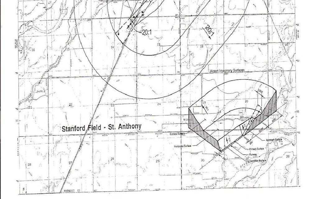
106 Page 104 of 104
GARDEN HIGHWAY SPECIAL PLANNING AREA
 GARDEN HIGHWAY SPECIAL PLANNING AREA 501-250. INTENT. The land area between the Garden Highway and the Sacramento River possesses unique environmental amenities that require special treatment and regulation.
CHAPTER 2 RELATIONSHIP WITH OTHER LAWS.
 CHAPTER 2 General Provisions 12-2-1 Minimum Requirements 12-2-2 Relationship with Other Laws 12-2-3 Effect on Existing Agreements 12-2-4 Scope of Regulations 12-2-5 Building Permit 12-2-6 Nonconforming
ARTICLE 3 DEFINITIONS
 Sections: 3-1 Rules of Construction 3-2 Definitions ARTICLE 3 DEFINITIONS SECTION 3-1 RULES OF CONSTRUCTION 3-101. a. The language set forth in these regulations shall be interpreted in accordance with
CHAPTER 2 GENERAL PROVISIONS
 CHAPTER 2 GENERAL PROVISIONS 200 ZONING DISTRICTS ESTABLISHED 201 SUPPLEMENTAL DISTRICTS ESTABLISHED 202 OFFICIAL ZONING MAP ESTABLISHED 203 DISTRICT BOUNDARY DESCRIPTION and INTERPRETATION 204 LIMITATION
Midwest City, Oklahoma Zoning Ordinance
 2010 Midwest City, Oklahoma Zoning Ordinance 9/2/2010 Table of Contents Section 1. General Provisions... 5 1.1. Citation... 5 1.2. Authority... 5 1.3. Purpose... 5 1.4. Nature and Application... 5 1.5.
SECTION 822 "R-1-A" AND "R-1-AH" - SINGLE FAMILY RESIDENTIAL DISTRICTS
 SECTION 822 "R-1-A" AND "R-1-AH" - SINGLE FAMILY RESIDENTIAL DISTRICTS The "R-1-A" and "R-1-AH" Districts are intended to provide for the development of single family residential homes at urban standards
(a) Commercial uses on Laurel Avenue, abutting the TRO District to the
 Commercial uses on Laurel Avenue, abutting the TRO District to the") 32X Zoning Code 150.36 TRANSITIONAL RESIDENTIAL OVERLAY DISTRICT. (A) Intent and purpose. (1) It is the intent of the Transitional Residential Overlay District (hereinafter referred to as the "TRO District")
32X Zoning Code 150.36 TRANSITIONAL RESIDENTIAL OVERLAY DISTRICT. (A) Intent and purpose. (1) It is the intent of the Transitional Residential Overlay District (hereinafter referred to as the "TRO District")
ORDINANCE NO. Be it ordained by the City Council of the City of Abilene, Texas:
 ORDINANCE NO. An ordinance repealing Chapter 23, Subpart B of the Code of the City of Abilene, Texas, entitled Mobile Homes and Vacation Travel Trailers; stating the authority; setting forth the scope
TITLE XV: LAND USAGE 150.BUILDING REGULATIONS 151.FLOOD DAMAGE PREVENTION 153.[RESERVED] 154.COMPREHENSIVE PLAN 155.SUBDIVISION AND ZONING CODE
![TITLE XV: LAND USAGE 150.BUILDING REGULATIONS 151.FLOOD DAMAGE PREVENTION 153.[RESERVED] 154.COMPREHENSIVE PLAN 155.SUBDIVISION AND ZONING CODE](/thumbs/86/94109177.jpg "TITLE XV: LAND USAGE 150.BUILDING REGULATIONS 151.FLOOD DAMAGE PREVENTION 153.[RESERVED] 154.COMPREHENSIVE PLAN 155.SUBDIVISION AND ZONING CODE") 1 TITLE XV: LAND USAGE Chapter 150.BUILDING REGULATIONS 151.FLOOD DAMAGE PREVENTION 152.SIGN AND BILLBOARD REGULATIONS 153.[RESERVED] 154.COMPREHENSIVE PLAN 155.SUBDIVISION AND ZONING CODE 2006 S-2 1 2
1 TITLE XV: LAND USAGE Chapter 150.BUILDING REGULATIONS 151.FLOOD DAMAGE PREVENTION 152.SIGN AND BILLBOARD REGULATIONS 153.[RESERVED] 154.COMPREHENSIVE PLAN 155.SUBDIVISION AND ZONING CODE 2006 S-2 1 2
HUERFANO COUNTY SIGN REGULATIONS SECTION 14.00
 TABLE OF CONTENTS Section Title Page 14.01 SIGN CODE... 14-1 14.01.01 Intent and Purpose... 14-1 14.02 GENERAL PROVISIONS... 14-1 14.02.01 Title... 14-1 14.02.02 Repeal... 14-1 14.02.03 Scope and Applicability
WEST UNION VILLAGE ORDINANCE ZONING
 Section 01: General Interpretation Clause WEST UNION VILLAGE ORDINANCE 2007-13 ZONING Unless a contrary intention clearly appears, the following words and phrases shall have the purpose of this zoning
Box Elder County Land Use Management & Development Code Article 3: Zoning Districts
 Chapter 3-6 Mobile Homes, Mobile Home Subdivisions, & Recreational Vehicle Parks Box Elder Zoning Ordinance as Adopted October 2007 Sections. 3-6-010. Purpose and Intent. 3-6-020. Conditional Use Permit
BONNER COUNTY PLANNING DEPARTMENT
 BONNER COUNTY PLANNING DEPARTMENT 1500 HIGHWAY 2, SUITE 208, SANDPOINT, ID 83864 (208) 265-1458 (208) 265-1463 (FAX) planning@bonnercountyid.gov (email) www.bonnercounty.us (web page) INFORMATION SHEET
ARTICLE 15. RULES, REGULATIONS AND DEFINITIONS
 ARTICLE 15. RULES, REGULATIONS AND DEFINITIONS Section 1. Interpretation and Construction: The following rules and regulations regarding interpretation and construction of the Ulysses-Grant County, Kansas,
MOBILE HOME PARKS. MOBILE HOME: A manufactured, relocatable dwelling unit which may not meet the minimum requirements of the Uniform Building Code.
 Title 10 Zoning Ordinance Definitions: MOBILE HOME PARKS MOBILE HOME: A manufactured, relocatable dwelling unit which may not meet the minimum requirements of the Uniform Building Code. MOBILE HOME COURT:
SUBDIVISION DESIGN PRINCIPLES AND STANDARDS
 SECTION 15-200 SUBDIVISION DESIGN PRINCIPLES AND STANDARDS 15-201 STREET DESIGN PRINCIPLES 15-201.01 Streets shall generally conform to the collector and major street plan adopted by the Planning Commission
SECTION 7000 LAND DEVELOPMENT REQUIREMENTS
 SECTION 7000 LAND DEVELOPMENT REQUIREMENTS 7000 LAND DEVELOPMENT REQUIREMENTS... 1 7001 LEGISLATIVE AUTHORITY... 1 7001.1 LAND DEVELOPMENT... 1 7001.1.1 Title 40, Idaho Code... 1 7001.1.2 Idaho Code 40-1415
ARTICLE VII. NONCONFORMITIES. Section 700. Purpose.
 ARTICLE VII. NONCONFORMITIES. Section 700. Purpose. The purpose of this chapter is to regulate and limit the development and continued existence of legal uses, structures, lots, and signs established either
ORDINANCE NO. O-5-10
 ORDINANCE NO. O-5-10 AN ORDINANCE OF THE TOWN COMMISSION OF THE TOWN OF PALM BEACH SHORES, FLORIDA, AMENDING THE TOWN CODE OF ORDINANCES AT APPENDIX A. ZONING. SECTION VI. DISTRICT B REGULATIONS BY AMENDING
UPPER MOUNT BETHEL TOWNSHIP NORTHAMPTON COUNTY, PENNSYLVANIA
 UPPER MOUNT BETHEL TOWNSHIP NORTHAMPTON COUNTY, PENNSYLVANIA JOINDER DEED / LOT CONSOLIDATION TOWNSHIP REVIEW PROCESS When accepting proposed Joinder Deeds / Lot Consolidations, review the Joinder Deed
ARTICLE 5.0 SCHEDULE OF REGULATIONS
 ARTICLE 5.0 SCHEDULE OF REGULATIONS Section 5.101 Table of Dimensional Standards by District. Dimensional Standards AG AG with sewer Districts Rural Residential Business Other SF SF with sewer R-1 R-1
FREQUENTLY USED PLANNING & ZONING TERMS
 City Of Mustang FREQUENTLY USED PLANNING & ZONING TERMS Abut: Having property lines, street lines, or zoning district lines in common. Accessory Structure: A structure of secondary importance or function
 Page 1 of 8 Laguna Beach Municipal Code Up Previous Next Main Collapse Search Print No Frames Title 25 ZONING Chapter 25.10 R-1 RESIDENTIAL LOW DENSITY ZONE 25.10.002 Intent and purpose. This zone is intended
BOARD OF COUNTY COMMISSIONERS ARCHULETA COUNTY, COLORADO RESOLUTION 2018-
 BOARD OF COUNTY COMMISSIONERS ARCHULETA COUNTY, COLORADO RESOLUTION 2018- ARCHULETA COUNTY IMPROPERLY DIVIDED PARCELS EXEMPTION INTERIM RESOLUTION - A RESOLUTION ADDRESSING PARCELS UNDER THE SIZE OF 35
SECTION CLASSIFICATION OF ZONES For the purpose of this Code the following primary land use zoning districts are hereby established:
 ARTICLE 4 ZONING DISTRICTS SECTION 4.010 CLASSIFICATION OF ZONES For the purpose of this Code the following primary land use zoning districts are hereby established: Primary Zones Abbreviated Designation
NONCONFORMITIES ARTICLE 39. Charter Township of Commerce Page 39-1 Zoning Ordinance. Article 39 Nonconformities
 ARTICLE 39 NONCONFORMITIES SECTION 39.01. Intent and Purpose It is recognized that there exists within the districts established by this Ordinance lots, structures, sites and uses which were lawful prior
4.2 RESIDENTIAL ZONING DISTRICTS
 4.2 RESIDENTIAL ZONING DISTRICTS A. Purpose: To define regulations and standards for each residential zoning district in the City. The following sections identify uses, regulations, and performance standards
SECTION 821 "R-A" - SINGLE FAMILY RESIDENTIAL-AGRICULTURAL DISTRICT
 SECTION 821 "R-A" - SINGLE FAMILY RESIDENTIAL-AGRICULTURAL DISTRICT The "R-A" District is intended to provide for the development of single family residential estate homes in a semi-rural environment on
The following regulations shall apply in the R-E District:
 "R-E" RESIDENTIAL ESTATE DISTRICT (8/06) The following regulations shall apply in the R-E District: 1. Uses Permitted: The following uses are permitted. A Zoning Certificate may be required as provided
ARTICLE 11. NAMEPLATES AND SIGNS Signs in all districts.
 //Culpeper County, Virginia/CODE OF ORDINANCES COUNTY OF CULPEPER, VIRGINIA Codified through Ordinance of November 7, 2007. (Supplement No. 3)/APPENDIX A ZONING ORDINANCE*/ARTICLE 11. NAMEPLATES AND SIGNS
City of Lynden Title 19 ZONING
 City of Lynden Title 19 ZONING Chapters Page Number 19.03 Comprehensive Plan 2 19.05 General Provisions 3 19.09 Maps and District Boundaries 4 19.11 Districts Established 5 19.13 Agricultural Zone 6 19.15
ARTICLE 9 C-B - COMMERCIAL-BUSINESS DISTRICT
 Section 901. PURPOSE ARTICLE 9 C-B - COMMERCIAL-BUSINESS DISTRICT The Commercial-Business (C-B) District is established to provide development opportunities for mixed use business and highway oriented
May 12, Chapter RH HILLSIDE RESIDENTIAL ZONES REGULATIONS Sections:
 May 12, 2017 Chapter 17.13 RH HILLSIDE RESIDENTIAL ZONES REGULATIONS Sections: 17.13.010 Title, intent, and description. 17.13.020 Required design review process. 17.13.030 Permitted and conditionally
ARTICLE III ZONING DISTRICTS AND GENERAL REGULATIONS
 ARTICLE III ZONING DISTRICTS AND GENERAL REGULATIONS 3.1 Districts. The City of Wheaton, Illinois, is hereby divided into the following zoning districts. The following are general descriptions, but not
Article. Table of Contents City of Birmingham Zoning Ordinance. 2006, Bradley E. Johnson, AICP
 00 Table of Contents City of Birmingham Zoning Ordinance 2006, Bradley E. Johnson, AICP Table of Contents One: Zoning Ordinance Foundation Page # 1.01 Title... 1-2 1.02 Defined Words... 1-2 1.03 Authority...
Section 7.22: Multifamily Assisted Housing in AA-30 Residential Zone (MAHZ) [Note: an additional line will be added to the Table in Article 3, 3.1.
 [Note: an additional line will be added to the Table in Article 3, 3.1.") Section 7.22: Multifamily Assisted Housing in AA-30 Residential Zone (MAHZ) [Note: an additional line will be added to the Table in Article 3, 3.1.1A] 7.22.1 Purpose The purpose of this Special Regulation
Section 7.22: Multifamily Assisted Housing in AA-30 Residential Zone (MAHZ) [Note: an additional line will be added to the Table in Article 3, 3.1.1A] 7.22.1 Purpose The purpose of this Special Regulation
Chapter CONSTRUCTION CODES
 Chapter 15.04 CONSTRUCTION CODES Sections: 15.04.010 Uniform codes adopted 15.04.020 Uniform Code for the Abatement of Dangerous Building adopted 15.04.030 Violation 15.04.040 Other remedies 15.04.010
ARTICLE 2: General Provisions
 ARTICLE 2: General Provisions 2-10 Intent The basic intent of the Town of Orange s Zoning Ordinance is to implement the goals and objectives of the adopted Town of Orange Comprehensive Plan, hereafter
-MENDOCINO COUNTY PLANNING AND BUILDING SERVICES- DIVISION OF LAND REGULATIONS TITLE 17
 ARTICLE VI -- GENERAL REGULATIONS AND PROVISIONS Sec. 17-50. Sec. 17-51 General Plan. Sec. 17-52 Lot and Block Design and Configuration. Sec. 17-53 Lot Access. Sec. 17-54 Private Roads. Sec. 17-55 Water
ARTICLE SCHEDULE OF REGULATIONS
 ARTICLE 21.00 SCHEDULE OF REGULATIONS FOOTNOTES TO ARTICLE 21.00 SCHEDULE OF REGULATIONS a. If one or both public sanitary sewers and/or public water supply are not available minimum lot size shall be
CHAPTER 154: SIGNS. Section
 CHAPTER 154: SIGNS Section 154.01 Permit required 154.02 Where prohibited 154.03 Street decorations 154.04 Approval by state 154.05 Purpose 154.06 Definitions 154.07 General sign and street graphics regulations
Section 7.01 Area Regulations
 SECTION 7: AREA, YARD AND FENCE REGULATIONS Section 7.01 Area Regulations Except as hereinafter provided, no building or structure or part thereof shall be erected, altered or converted for any use permitted
Title 17 MOBILE HOMES AND RECREATIONAL VEHICLES
 17.04 General Provisions Title 17 MOBILE HOMES AND RECREATIONAL VEHICLES 17.04.010 General provisions 17.04.020 Application 17.04.030 Interpretation 17.04.040 Mobile homes and recreational vehicles--location
17.0 NONCONFORMITIES CHAPTER 17: NONCONFORMITIES Purpose and Applicability
 17.0 NONCONFORMITIES 17.1 Purpose and Applicability The purpose of this section is to regulate and limit the continued existence of uses and structures established prior to the effective date of this Ordinance
Article 1 UNIVERSITY PARK ZONING DRAFT. LEGEND See inside front cover. August 31, 2018 DRAFT 4.0 ZONING ORDINANCE CITY OF UNIVERSITY PARK
 Article 1 UNIVERSITY PARK ZONING DRAFT LEGEND See inside front cover DRAFT 4.0 August 31, 2-12018 Article 1 LEGEND Proposed deletion of existing ordinance provision (red text with red strke-through) Proposed
DRAFT PARK COUNTY US HIGHWAY 89 SOUTH EAST RIVER ROAD OLD YELLOWSTONE TRAIL ZONING DISTRICT REGULATIONS
 Formatting: Changes recommended by the Board and accepted by the County Commission are formatted in RED: Changes made by the Park County Commission are formatted in YELLOW highlight: and changes made by
this page left intentionally blank DENVER ZONING CODE
 Article 1. GENERAL PROVISIONS this page left intentionally blank Contents ARTICLE 1. GENERAL PROVISIONS DIVISION 1.1 GENERAL...1.1-1 Section 1.1.1 Purpose...1.1-1 Section 1.1.2 Intent...1.1-1 Section 1.1.3
City of Smithville Code of Ordinances
 City of Smithville Code of Ordinances Chapter 14 - Zoning Smithville Zoning Ordinance_v9_10-16-18_FINAL TABLE OF CONTENTS 1. PROVISIONS... 3 1.1. Title... 3 1.2. Effective Date... 3 1.3. Previous Zoning
ARTICLE 20 SIGN REGULATIONS
 ARTICLE 20 SIGN REGULATIONS Section 20.01 Purpose The purpose of this Article is to regulate the size, placement, and general appearance of all privately owned signs and billboards in order to promote
ARTICLE 7 R-1 ONE FAMILY RESIDENTIAL DISTRICT
 ARTICLE 7 R-1 ONE FAMILY RESIDENTIAL DISTRICT SECTION 700 STATEMENT OF PURPOSE This district classification is designed to be the most restrictive of the residential districts intended to encourage an
Accessory Dwelling Unit Permit
 PLANNING SERVICES DEPARTMENT 411 Main Street (530) 87-6800 P.O. Box 3420 Chico, CA 527 Application No. APPLICATION FOR Accessory Dwelling Unit Permit Applicant Information Applicant Street Address Daytime
TOOELE COUNTY LAND USE ORDINANCE CHAPTER 4 Page 1
 CHAPTER 4 SUPPLEMENTARY AND QUALIFYING REGULATIONS Section 4-1 Effect of chapter. 4-2 Substandard lots at time of ordinance passage. 4-3 Lot standards. 4-4 Every dwelling to be on a lot - Exceptions. 4-5
St. Mary s County Comprehensive Zoning Ordinance Article 1. GENERAL PROVISIONS
 0 0 0 0 ARTICLE. GENERAL PROVISIONS CHAPTER 0 TITLE, PURPOSE AND ORGANIZATION Sections: 0. Title. 0. Authority. 0. Purpose. 0. Organization of the Zoning Ordinance. 0. Official Zoning Map. 0. Applicability.
SECTION 820 "R-R" - RURAL RESIDENTIAL DISTRICT
 SECTION 820 "R-R" - RURAL RESIDENTIAL DISTRICT The "R-R" District is intended to create or preserve rural or very large lot residential homesites where a limited range of agricultural activities may be
SECTION 23 PLANNED RESIDENTIAL DEVELOPMENT FOR ELDERLY PERSONS
 SECTION 23 PLANNED RESIDENTIAL DEVELOPMENT FOR ELDERLY PERSONS 23.1 General: In order to provide for the special needs of elderly and handicapped persons who may require multifamily type living accommodations,
ARTICLE 6.07 FENCES Division 1. Generally
 FENCE REGULATIONS ARTICLE 6.07 FENCES Division 1. Generally Sec. 6.07.001 Definitions For the purpose of this article, the following terms, phrases and words shall have meanings respectively ascribed to
DEFINITIONS. 202 General Construction of Language The following general rules of construction apply to the text of the Zoning Regulations.
 2 ARTICLE TWO DEFINITIONS 201 Purpose Article Two shall be known as the Definitions. The purpose of these provisions is to promote consistency and precision in the interpretation of the Zoning Regulations.
Chapter Residential Mixed Density Zone
 Chapter 19.16 Residential Mixed Density Zone 19.16.010 Purpose and Intent 19.16.020 Permitted Uses 19.16.030 Accessory Permitted Uses 19.16.040 Secondary Permitted Uses 19.16.050 Conditional Uses 19.16.060
Signs along highways shall meet all of the requirements of the zoning districts in which they are located.
 SECTION 39 SIGNS 39.1 INTENT 39.1.1 The intent of this section is to regulate signs as defined hereinafter, to protect the safety of users of the streets and highways, to assure compatibility with uses
Article 7: Residential Land Use and Development Requirements
 Article 7: Residential Land Use and Section 701: Statement of Intent (A) (B) (C) The intent of Article 7 is to develop certain land use and development requirements for the residential uses within Cumru
ARTICLE 1 GENERAL PROVISIONS
 ARTICLE 1 GENERAL PROVISIONS SECTION 100 TITLE This Ordinance shall be known and cited as the "Rice Township Subdivision and Land Development Ordinance." SECTION 101 AUTHORITY Rice Township is empowered
Memorandum: October 13, 2008 REVISED To: Trowbridge Township Planning Commission From: P. Hudson, AICP Re: Suggested New Ordinance
 1 Memorandum: October 13, 2008 REVISED 2-11-09 To: Trowbridge Township Planning Commission From: P. Hudson, AICP Re: Suggested New Ordinance Because of changes in both the Michigan Planning Enabling Act
ARTICLE 4.00 NONCONFORMITIES
 Section 4.01 -- INTENT ARTICLE 4.00 NONCONFORMITIES Nonconformities are uses, structures, buildings, or lots which do not conform to one or more provisions or requirements of this Ordinance or a subsequent
Charter Township of Plymouth Zoning Ordinance No. 99 Page 200 Article 20: Schedule of Regulations
 Charter Township of Plymouth Zoning Ordinance No. 99 Page 200 ARTICLE XX SCHEDULE OF REGULATIONS SEC. 20.1 HEIGHT, AREA, LOT COVERAGE, YARD REQUIREMENTS AND FLOOR AREA (as amended /25/07) ZONG DISTRICT
SECTION 500 RURAL RESIDENTIAL DISTRICTS VERY LOW DENSITY RESIDENTIAL DISTRICTS (VLDR-5, VLDR-2 ½, VLDR-1) [Last Amended 5/24/12; Ord.
 [Last Amended 5/24/12; Ord.") This section and related information is available at www.co.yamhill.or.us/plan/planning/ordinance/zoning_toc.asp SECTION 500 RURAL RESIDENTIAL DISTRICTS 502. VERY LOW DENSITY RESIDENTIAL DISTRICTS (VLDR-5,
This section and related information is available at www.co.yamhill.or.us/plan/planning/ordinance/zoning_toc.asp SECTION 500 RURAL RESIDENTIAL DISTRICTS 502. VERY LOW DENSITY RESIDENTIAL DISTRICTS (VLDR-5,
Bulk Requirements (For other supplementary location and bulk regulations, see Article VII.)
") 4.13 TOWNSITE OVERLAY DISTRICT (TO) 4.13.1 Purpose The purpose of the Townsite Overlay District is to promote the health, safety and welfare of current and future residents of the City of Hailey; to modify
4.13 TOWNSITE OVERLAY DISTRICT (TO) 4.13.1 Purpose The purpose of the Townsite Overlay District is to promote the health, safety and welfare of current and future residents of the City of Hailey; to modify
SECTION 817 "AL" - LIMITED AGRICULTURAL DISTRICT
 SECTION 817 "AL" - LIMITED AGRICULTURAL DISTRICT The "AL" District is a limited agricultural district. It is intended to protect the general welfare of the agricultural community by limiting intensive
4-1 TITLE 6 MOBILE HOME AND RECREATIONAL VEHICLE PARKS 4-3
 4-1 TITLE 6 MOBILE HOME AND RECREATIONAL VEHICLE PARKS 4-3 Chapter 4 RECREATIONAL VEHICLE PARKS Sec. 4-1: Sec. 4-2: Sec. 4-3: Sec. 4-4: Sec. 4-5: Sec. 4-6: Sec. 4-7: Sec. 4-8: Sec. 4-9: Sec. 4-10: Sec.
17.13 RH HILLSIDE RESIDENTIAL ZONES REGULATIONS SECTIONS:
 Effective April 14, 2011 Chapter 17.13 RH HILLSIDE RESIDENTIAL ZONES REGULATIONS SECTIONS: 17.13.010 Title, Intent, and Description 17.13.020 Required Design Review Process 17.13.030 Permitted and Conditionally
An Ordinance to provide regulations for private roads and driveways.
 30.0400 PRIVATE ROADS AND DRIVEWAYS TOWNSHIP OF GRAND HAVEN, MICHIGAN ord no. 262 eff. Apr. 27, 1997 An Ordinance to provide regulations for private roads and driveways. 30.0401 Sec. 1 TITLE This Ordinance
CHAPTER XX ZONING PART 1 GENERAL PROVISIONS PART 2 RESIDENTIAL DISTRICTS
 CHAPTER XX ZONING PART 1 GENERAL PROVISIONS 101 Titles 102 General Intent 103 General Goals 104 General Provisions 105 Relationship to the Comprehensive Plan 106 Establishment of Controls and Districts
Hopkins City Code (Zoning) (Revised ) Section Zoning; general provisions
 (Revised ) Section Zoning; general provisions") Hopkins City Code (Zoning) 520.01 (Revised 12-28-06) Section 520 - Zoning; general provisions 520.01. Application. Subdivision 1. Minimum standards. The provisions of this code are the minimum requirements
Hopkins City Code (Zoning) 520.01 (Revised 12-28-06) Section 520 - Zoning; general provisions 520.01. Application. Subdivision 1. Minimum standards. The provisions of this code are the minimum requirements
Philomath Low-Density Residential Zone (PR-1)
") Chapter 65 Philomath Low-Density Residential Zone (PR-1) 65.005 Purpose. The Philomath Low-Density Residential Zone is intended to provide for urban development, primarily single-family dwellings, within
Chapter 65 Philomath Low-Density Residential Zone (PR-1) 65.005 Purpose. The Philomath Low-Density Residential Zone is intended to provide for urban development, primarily single-family dwellings, within
AN ORDINANCE AMENDING THE CITY ZONING ORDINANCE AND THE OFFICIAL CODE OF THE CITY OF CLARKSVILLE RELATIVE TO CLUSTER OPTION DEVELOPMENTS
 ORDINANCE 74-2012-13 AN ORDINANCE AMENDING THE CITY ZONING ORDINANCE AND THE OFFICIAL CODE OF THE CITY OF CLARKSVILLE RELATIVE TO CLUSTER OPTION DEVELOPMENTS BE IT ORDAINED BY THE CITY COUNCIL OF THE CITY
Chapter 10 RD TWO-FAMILY (DUPLEX) RESIDENTIAL DISTRICT/ZONE
 RESIDENTIAL DISTRICT/ZONE") Chapter 10 RD TWO-FAMILY (DUPLEX) RESIDENTIAL DISTRICT/ZONE 10-10-1: DESCRIPTION AND PURPOSE: 10-10-2: PERMITTED BUILDINGS AND USES: 10-10-3: BUILDINGS AND USES PERMITTED CONDITIONALLY: 10-10-4: BUILDING
Chapter 10 RD TWO-FAMILY (DUPLEX) RESIDENTIAL DISTRICT/ZONE 10-10-1: DESCRIPTION AND PURPOSE: 10-10-2: PERMITTED BUILDINGS AND USES: 10-10-3: BUILDINGS AND USES PERMITTED CONDITIONALLY: 10-10-4: BUILDING
Charter Township of Plymouth Zoning Ordinance No. 99 Page 208 Article 21: Residential Unit Developments Amendments: ARTICLE XXI
 Charter Township of Plymouth Zoning Ordinance No. 99 Page 208 ARTICLE XXI RESIDENTIAL UNIT DEVELOPMENTS PURPOSE The purpose of the Residential Unit Development (RUD) is to permit two (2) optional methods
ARTICLE III GENERAL PROCEDURES, MINOR PLANS AND FEE SCHEDULES
 ARTICLE III GENERAL PROCEDURES, MINOR PLANS AND FEE SCHEDULES 301. Prior to Submission a. Copies of this Ordinance shall be available on request, at cost, for the use of any person who desires information
** If your lot does not meet the requirements above, please read Sec below
 Sec. 13-1-60 Zoning District Dimensional Requirements. For the Zoning Dept To Issue a Land Use Permit The Following Dimensions are Required. Minimum Side and Rear Yards s Lakes Classification Minimum Class
Sec Building Permits Issuance
 ARTICLE III GENERAL PROVISIONS Sec. 20-300 Building Permits Issuance A building permit shall be obtained from the building inspector before any construction, erection, alteration, or addition to any structure
AAAA. Planning and Zoning Staff Report Zoning Text Amendment, ZOA-PH Request
 AAAA Hearing Date: September 3, 2015 Planning and Zoning Staff Report Zoning Text Amendment, ZOA-PH2015-23 Development Services Department Applicant: Request Staff: Christian Samples, 455-5958 csamples@canyonco.org
Sec HC - Highway commercial district.
 Sec. 36-422. - HC - Highway commercial district. (1) Purpose. This district is intended for commercial uses which depend upon high visibility, generate high traffic volumes, or cater to the traveling public.
STATE OF MICHIGAN COUNTY OF MARQUETTE, TOWNSHIP OF NEGAUNEE LAND DIVISION, SUBDIVISION AND CONDOMINIUM ORDINANCE
 STATE OF MICHIGAN COUNTY OF MARQUETTE, TOWNSHIP OF NEGAUNEE LAND DIVISION, SUBDIVISION AND CONDOMINIUM ORDINANCE Adopted: August 8 th, 2008 Effective: August 28 th, 2008 Sec.100. Title ARTICLE I GENERAL
CHAPTER 14 PLANNED UNIT DEVELOPMENTS
 9-14-1 9-14-1 CHAPTER 14 PLANNED UNIT DEVELOPMENTS SECTION: 9-14-1: Purpose 9-14-2: Governing Provisions 9-14-3: Minimum Area 9-14-4: Uses Permitted 9-14-5: Common Open Space 9-14-6: Utility Requirements
C HAPTER 15: N ONCONFORMITIES
 SECTION 15.1: PURPOSE AND APPLICABILITY The purpose of this Chapter is to regulate and limit the continued existence of uses and structures established prior to the effective date of this Code (or any
ARTICLE XVII SCHEDULE OF REGULATIONS
 ARTICLE XVII SCHEDULE OF REGULATIONS SECTION 1700. LIMITING HEIGHT, BULK, DENSITY, AND AREA BY DISTRICT TYPE Use Minimum Size Lot Per Unit Maximum Height of Structures Minimum Yard Setback (Per Lot in
VILLAGE OF SOUTH RUSSELL SUBDIVISION RULES. Revised
 VILLAGE OF SOUTH RUSSELL SUBDIVISION RULES Revised 7 2 96 1 TABLE OF CONTENTS CHAPTER 1: TITLE AND SCOPE Page 1.00 Title 1 1.01 Jurisdiction 1 1.02 Objectives 1 1.03 Interpretation 1 1.04 Separability
CITY OF APALACHICOLA ORDINANCE
 CITY OF APALACHICOLA ORDINANCE 2017-05 AN ORDINANCE AMENDING ORDINANCE 91-7 WHICH ADOPTS THE CITY OF APALACHICOLA LAND DEVELOPMENT CODE REVISING SECTION II (DEFINITIONS) RELATING TO HISTORIC STRUCTURES,
ZONING ORDINANCE: OPEN SPACE COMMUNITY. Hamburg Township, MI
 ZONING ORDINANCE: OPEN SPACE COMMUNITY Hamburg Township, MI ARTICLE 14.00 OPEN SPACE COMMUNITY (Adopted 1/16/92) Section 14.1. Intent It is the intent of this Article to offer an alternative to traditional
CHAPTER 5 ZONING SECTION 5.1 PURPOSE
 CHAPTER 5 ZONING SECTION 5.1 PURPOSE The purpose of this Chapter is to regulate the nature and extent of uses of land, and of buildings and structures thereon, in order to promote the purposes of this
PLANNED RESIDENTIAL DEVELOPMENT (PRD)
") PLANNED RESIDENTIAL DEVELOPMENT SECTION 10. PLANNED RESIDENTIAL DEVELOPMENT (PRD) 10.1 Purpose Planned Residential Development allows by special permit from the Board an alternative pattern of residential
PLANNED RESIDENTIAL DEVELOPMENT SECTION 10. PLANNED RESIDENTIAL DEVELOPMENT (PRD) 10.1 Purpose Planned Residential Development allows by special permit from the Board an alternative pattern of residential
ORDINANCE NO
 ORDINANCE NO. 2014-160 AN ORDINANCE OF THE CITY COUNCIL OF THE CITY OF MENIFEE, CALIFORNIA, REPEALING SECTION 10.35 OF RIVERSIDE COUNTY LAND USE ORDINANCE NO. 460.152 AS ADOPTED BY THE CITY OF MENIFEE
a. provide for the continuation of collector streets and thoroughfare streets between adjacent subdivisions;
 Section 7.07. Intent The requirements of this Section are intended to provide for the orderly growth of the Town of Holly Springs and its extra-territorial jurisdiction by establishing guidelines for:
ARTICLE XI SIGNS Shelbyville Zoning Regulations 1994
 ARTICLE XI SIGNS Shelbyville Zoning Regulations 1994 Section 1100 Section 1110 Section 1120 Section 1130 Section 1140 Section 1150 Section 1160 Intent General Sign Regulations Residential Districts Business
Chapter 15: Non-Conformities
 Chapter 15: Non-Conformities Section 15.1 Purpose... 15-2 Section 15.2 Non-Conforming Vacant Lots... 15-2 Section 15.3 Non-Conforming Buildings or Structures... 15-3 Section 15.4 Non-Conforming Uses...
Special Use Permit - Planned Unit Development Checklist. Property Address:
 Special Use Permit - Planned Unit Development Checklist Special Use Permit Number. Parcel Code/s #28-11- - - Property Address: Applicant: ARTICLE VIII Ordinance Reference - Section 8.1.2 Permit Procedures:
ORDINANCE NO The Town Council of the Town of Yucca Valley does ordain as follows:
 ORDINANCE NO. 141 AN ORDINANCE OF THE TOWN COUNCIL OF THE TOWN OF YUCCA VALLEY, CALIFORNIA, AMENDING TITLE 8, DIVISION 12, CHAPTER 1 RELATING TO DEFINITIONS AND TITLE 8, DIVISION 8, CHAPTER 3, RELATING
ORDINANCE NO AMENDING CHAPTER 94 OF THE CODE OF ORDINANCES OF THE ORDINANCE, TEXAS), AS HERETOFORE AMENDED, BY AMENDING; RELATING
, AS HERETOFORE AMENDED, BY AMENDING; RELATING") ORDINANCE NO. 3513 AN OF THE CITY OF FARMERS BRANCH, TEXAS ORDINANCE AMENDING CHAPTER 94 OF THE CODE OF ORDINANCES OF THE CITY OF FARMERS BRANCH ( THE COMPREHENSIVE ZONING ORDINANCE, TEXAS), AS HERETOFORE
ORDINANCE NO. 3513 AN OF THE CITY OF FARMERS BRANCH, TEXAS ORDINANCE AMENDING CHAPTER 94 OF THE CODE OF ORDINANCES OF THE CITY OF FARMERS BRANCH ( THE COMPREHENSIVE ZONING ORDINANCE, TEXAS), AS HERETOFORE
Chapter 22 Historic Preservation/Design Review
 Chapter 22 Historic Preservation/Design Review Section 20.01 Purpose and Intent 22.02 Definitions 22.03 Historic Preservation/Design Review Commission 22.04 Administration Historic Preservation/Design
This Ordinance shall be known as the Zoning Ordinance of the Town of Holly Ridge, North Carolina.
 CHAPTER 7. ZONING ARTICLE I. LEGAL PROVISIONS Section 7.1 Enactment and Authority The Town Council of the Town of Holly Ridge, North Carolina pursuant to the authority granted by Article 1, Chapter 160A
TOWN OF WATERVILLE VALLEY NEW HAMPSHIRE SITE PLAN REVIEW REGULATIONS
 TOWN OF WATERVILLE VALLEY NEW HAMPSHIRE Effective date March 17, 1981 Revised March 16, 1982 Revised March 13, 1986 Revised March 10, 1987 Revised March 14, 2013 Revised March 8, 2016 TOWN OF WATERVILLE