H7 instrument U!/d. K
|
|
|
- Claude Garrison
- 5 years ago
- Views:
Transcription
1
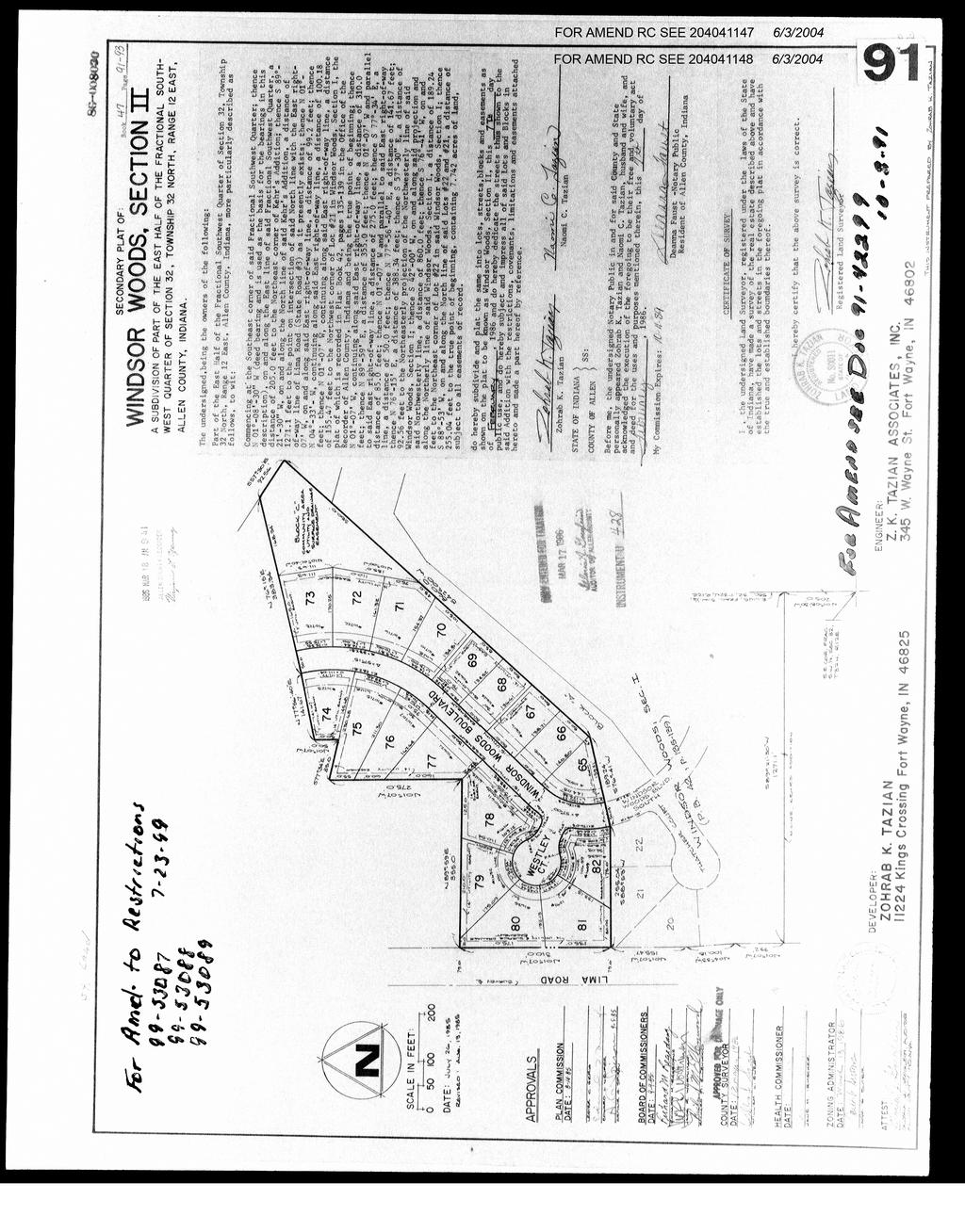
2 Book H7 instrument U!/d. K DEDICATION, PROTECTIVE RESTRICTIONS, COVENANTS LIMITATIONS, EASEMENTS AND APPROVALS APPENDED TO AS PART OF THE DEDICATION AND PLAT OF WINDSOR WOODS, SECTION II We, Zohrab K. Tazian and Naomi C. Tazian hereinafte~ referred to as "DECLARANTS", being the owners of record of the real estate shown and described on the plat of Windsor Woods, Section II, do hereby lay off, plat and subdivide said real estate in accordance with the information shown on the final plat, being the certified plat appended hereto and incorporated herein. The subdivision shall be known and designated as Windsor Woods, Section II, an Addition to the City of Fort Wayne, Indiana. The lots are numbered 65 through 2, inclusive, and all dimensions are shown in feet and decimals of a foot on the plat. All streets and easements specifically shown or described are hereby expressly dedicated to public use for their usual and intended purpose. 1. No lot shall be used except for residential purposes. No building shall be erected, altered, placed or permitted to ~~~ remain on any lot other than one detached single-family dwelling ~ c, not to exceed two and one-half stories in height. Each house t = shall include not less than a two car garage, which shall be ~ = built as part of said structure and attached thereto. 2. No building shall be built on any lot having a ground floor area upon the foundation, exclusive on one-story open porches, breezeway or garage, of less than 1300 square feet for a one-story dwelling, nor less than 900 square feet for a dwelling of more than one story. 3. No building shall be located on any lot nearer to the front lot line or nearer to the side street than the minimum building setback lines shown on the recorded plat. In any event, no building shall be located nearer than a distance of ten percent (10%) of the lot at the building line, and the combined width of both side yards shall be not less than a distance equal to twenty-five percent (25%) of the lot width. No dwelling shall be located on any interior lot nearer than 25 feet to the rear lot line. 4. No dwelling shall be erected or placed on any lot having a width of less than 70 feet at the minimum building setback line, nor shall any dwelling be erected or placed on any lot having an area of less than 7500 square feet. 5. No building shall be erected, placed or altered on any lot until the construction plans and specifications, and a plan showing the location of the structure, have been approved by the Architectural Control Committee as to quality of workmanship and materials, harmony of enternal design with existing structures, and as to location with respect to topography and finished grade elevations- No fence or wall shall be erected, placed or altered on any lot nearer to any street than the minimum building setback line. 6. Easements for the installation and maintenance of utilities and drainage facilities are reserved as shown on the recorded plat and over the rear seven (7) feet of each lot, or as shown on the plat for the construction of poles, wires and conduits and the necessary or proper attachments in connection therewith for th'7 transmission o~ utili ties, t'7lephc;>ne service, constr~l~'f.'i:.ljit\:!s,,,, and ma1ntenance of dra1ns, sewers, p1pe l1nes, gas, water andt t'ie a \::., 1.' and for any other public or quasi public utility or functiqi-"":(:. ~AJ;ly ::: :.. municipal, public or quasi public corporation engaged in s>.~ppty?-hgl,>..'. any one or more of the above utilities will have the right.:to ep):~r- : upon said easements for any purpose of which said easement's are:.:.,: reserved. All of said easements shall be kept free of penl\~p.~i1e. :.; c..... c=a t--...j,_,_. = f-- ffi ~ =:».... : =
3 structures (except those installed by any such municipal, public or quasi public corporation) and removal of any obstructions by any such utility company shall in no way obligate the utility company to pay damages or to restore any such removed obstruction to its original form. All such obstructions, whether temporary or permanent, shall be subject to the paramount rights of any such utility company to construct, install, repair, maintain or replace its utilities and/or sewer installations. 7. No noxious or offensive activity shall be carried on upon any lot nor shall anything be done thereon which may be or may become an annoyance or nuisance of the neighborhood.. No structure of a temporary character, trailer, boat, boat trailer, camper or camping trailer, basement, tent, shack, garage, barn or other outbuilding shall be either used or located on any lot at any time or used as a residence, either temporarily or permanently. 9. No sign of any kind shall be displayed to the public view on any lot except one professional sign of not more than one foot square, one sign of not more than five square feet, advertising the property for sale or rent, or signs used by a builder to advertise the property during the construction and sales period. 10. No radio or television antenna with more than 30 square feet or grid area or which attains a height in excess of six (6) feet above the highest point of the roof shall be attached to any dwelling house. No free standing radio or television antenna shall be permitted on any lot. 11. No oil drilling, oil development operations, oil refining, quarrying or mining operations of any kind shall be permitted upon or in any lot. No derrick or other structure designed for the use in boring for oil or natural gas shall be erected, maintained or permitted upon any lot. 12. No animals, livestock, or poultry of any kind shall be raised, bred or kept on any lot, except that dogs, cats or other household pets may be kept, provided that they are not kept, bred or maintained for any commercial purpose. 13. No lot shall be used or maintained as a dumping ground for rubbish. Trash, garbage or other waste shall not be kept except in sanitary containers. No incinerators or outside incinerators shall be kept or allowed on any lot. 14. No fence, wall, hedge or shrub planting which obstructs sightline at elevations between two (2) and six(6) feet above roadways shall be placed or permitted to remain on any corner lot within the triangular area formed by the street property lines and a line connecting them at points 25 feet from the intersection of the street lines, or in the case of a rounded property corner, from the intersection of the street property lines extended. The same sightline limitations shall apply on any lot within 10 feet from the intersection of a street property line with the edge of a driveway or alley pavement. No tree shall be permitted to remain within such distances of such intersections, unless the foliage line is maintained at sufficient height to prevent obstruction of such sightlines. 15. All buildings shall be constructed in a substantial and good workmanlike manner and of new materials. No roll siding, asbestos shingle siding, or siding containing asphalt or tar as one of its principal ingredients shall be used in the exterior construction of any building on any lots of said subdivision, and no roll roofing of any description or character shall be used on the roof of the dwelling house or attached garage on any of saici..,..,. <D 1 ots. /~~;:;. 1 ~\::;,~E:; : :_; ~,.~~-; ~:. ; ~:... ~,~,.. ~. ~ \. -2- <{~~::
4 16. All driveways from the street to the garage shall be poured concrete and not less than 16 feet in width. Any driveway constructed within the boundary lines of any lot prior to the existence of sidewalks shall be so constructed that the elevation thereof at a point one (l) foot outside of the lot boundary line shall be four (4) inches above the grade elevation of the established curb adjacent to such lot. It shall at this point have installed one-half inch bituminous expansion joint, and then proceed at a gradient of one-fourth inch per foot to a point of six (6) feet outside the lot boundary line at which point another one-half inch bituminous expansion joint shall be installed. The remaining five and one-half (5-l/2) feet to the curb shall have a gradient of one-half inch per foot. 17. All fuel and oil storage tanks shall be installed underground or concealed within the main structure of the dwelling house, its basement or attached garage. 1. No individual water supply, system or disposal system shall be installed, maintained in this subdivision. individual sewage or used on any lots 19. In addition to the utility easements herein designated, easements in the streets, as shown on this plat, are hereby reserved and granted to all public utility companies, the proprietors of the land herein platted and their respective successors and assigns, to install, lay, construct, renew, operate, repair, replace, maintain and remove all and every type of gas main, water main and sewer main (sanitary and/or storm) with allnecessary appliances, subject, nevertheless, to all reasonable requirements of any governmental body having jurisdiction thereof as to maintenance and repair of said streets. 20. No rain and storm water run off or such things as roof water, street pavement and surface water, caused by natural precipitation, shall at any time be discharged into or permitted to flow into the sanitary sewage system, which shall be a separate sewer system from the storm water and surface water run off sewer system. No sanitary sewage shall at any time be discharged or permitted to flow into the above-mentioned storm water and surface water run off sewer system. 21. The Architectural Control Committee is composed of two (2) members, the first Committee members to be Zohrab K. Tazian and Naomi c. Tazian. The Committee may designate a representative to act for it. In the event of death or resignation of any member of the Committee, the remaining member shall have full authority to designate a successor. Neither the members of the Committee nor its designated representative shall be entitled to any conpensation for services performed pursuant to this covenant. 22. The Architectural Control Committee's approval or disapproval, as required by these covenants, shall be in writing. In the event the Committee, or its designated representative, fails to approve or disapprove within 30 days, after plans and specifications have been submitted to it, or in any event if no suit to enjoin the construction has been commenced prior to the completion thereof, approval will not be required and the related covenants shall be deemed to have been fully complied with. 23. The restrictions and covenants herein contained shall run with the land and be effective for a period of 25 years, unless prior to the expiration of 25 years said restrictions and covenants are altered or amended by the owners of sixty percent (60%) of the lots in said subdivision at the time the alteration or amendment of restrictions and covenants are made; provided, however, DECLARANTS, their successors or assigns shall have the exclusive right of two ( 2) years from the date of recordiintj.u",,., of this pla~ to amend any of the covenants and restrictions.,;.'~~~:; :I l_,,,.. except Sect1on 2 above. The term "owners" shall be a pers.!.ri. :. """ -~:.. firm or corporation in whose name the fee simple title ap~et~-rs~.:..- 0::' 1 _.\. of record in the Office of the Recorder of Allen County, ::fn'diana- -- '<;'- ~ : ~:; \:;,~;~~-~.:~,~--;~::/'.. -3-
5 . ~~ Book 1.7 Page 9 3 ~.~.:. ~;1 'l H u.. Any and all amendments or alterations to these restrictions and covenants shall be made subject to the prior approval of the Allen County Plan Commission. 24. Enforcement shall be by proceedings at law or in equity against any person or persons violating or attempting to violate any covenant, either to restrain violation or to recover damages. 25. No driveway access shall be permitted from lots numbered 0 and 1 onto the Lima Road right-of-way. 26. Before any house or building on any platted lot or tract in this subdivision shall be used and occupied as a dwelling or as otherwise provided in the subdivision restrictions above, the developer or any subsequent developing owner of said platted lot or tract shall install all improvements serving said platted lot or tract as provided in said plans and specifications for this addition filed with the Allen County Plan Commission. 27. For the purpose of this plat and the covenants appended thereto, the word "lot" may mean either any of said lots as platted or any tract or tracts of land as conveyed originally or by subsequent owners, which may consist of one or more lots or parts of one or more lots as platted upon which a residence may be erected~;:: in accordance with the restrictions hereinabove set out or such ~- ~ further restrictions as may be imposed by any applicable zoning r' ~ ordinance, PROVIDED, HOWEVER, no tract of land consisting of part~of any one lot or parts of more than one lot shall be considered ~ ~ a "lot" unless said tract of land has a frontage of 70 feet in ~ r' width at the established building lines as shown in this plat. ~ n 2. No lot or combination of lots may be further subdivided until approval therefor has been obtained from the Allen County Plan Commission. 4 ~; co 29. Before any lot or tract may be used or occupied, such user or occupier shall first obtain an Improvement Location Permit and Certificate of Occupancy. 30. Every owner of a lot shall be a member of the Windsor Woods Association, Inc. Membership shall be appurtenant to and may not be seperated from ownership of any lot which is subject to assessment. Said not-for-profit corporation, acting for and on behalf of the owners of lots as aforesaid, may impose upon the owners of each lot an annual maintenance fee in an amount to be determined by said corporation, but in no event more than Fifty Dollars ($50.00) per year, and funds so collected shall be used by said corporation for the purpose of cutting of weeds on sold or vacant lots, seeing to the repair of public drains, providing community services and activities, maintaining the common open spaces, p.:~yrnent of all taxes assessed upon the common open spaces, and for such other purposes as the corporation may desire. Membership within the assocation, shall be mandatory upon the owners of all lots within Windsor Woods, Section II. Further, ownership and permanent maintenance of the common open spaces within the plat of Windsor Woods, Section II, shall be conveyed and transferred to the said association by Zohrab K. Tazian and Naomi c. Tazian. 31. Invalidation of any one of these covenants by judgment or court order shall in no way affect any of the other provisions. Which shall remain in full force and effect. Further, the owners expressly acknowledge that they have no right of reversion in the event any one of these covenants is violated by a subsequent owner. -4- r 1
6 \ 32. Sidewalks - plans and specifications for this subdivision, j on file with the Allen County Plan Commission require the installation of concrete sidewalks within the street rights-of-way in front of all lots. Installation of said sidewalks shall be the obligation of the owner of any such lot, exclusive of DECLARANTS, shall be completed in accordance with said plans and specifications and prior to the issuance of a Certificate of Occupancy for any such lot and the cost of said installation shall be a lien against any such lot enforceable by the Allen County Plan Commission or its successor agency. Should such Certificates of Occupancy be issued to the DECLARANTS, said individual or corporation shall be considered an owner for the purposes of the enforcement of this covenant. The foregoing declaration made this 19th day of February 196. STATE OF INDIANA COUNTY OF ALLEN SS: Before me, the undersigned Notary Public in and for said County and State personally appeared Zohrab K. Tazian and Naomi c. Tazian, husband and wife, and acknowledged the execution of the foregoing to be their free and voluntary act and deed for the uses and purposes mentioned therein, this 19th day of February 196. My Commission Expires: { xjjll L,1, 0 --= Yr,' j, r-/- Deanna Faust - Notary Public Resident of Allen County, Indiana * -: :-' ""\. (_": :_."; ~ "" Prepared by Zohrab K. Tazian ~... ~.,_:.
PROTECTIVE COVENANTS Filings 1-4
 Page 1 of 5 PROTECTIVE COVENANTS (Book 3662 Page 457) The following are Protective Covenants for WOODGATE SUBDIVISION FILINGS NO. 1 THROUGH 4, a subdivision situated in the City of Aurora, County of Arapahoe,
Page 1 of 5 THE STATE OF TEXAS: KNOW ALL MEN BY THESE PRESENTS: COUNTY OF HARRIS:
 Page 1 of 5 THE STATE OF TEXAS: COUNTY OF HARRIS: KNOW ALL MEN BY THESE PRESENTS: WESTCHESTER REALTY CO., a Texas corporation, owner of the lands and premises hereinafter described for the purpose of evidencing
Architectural Control Committee Guidelines
 Architectural Control Committee Guidelines The Architectural Control Committee (ACC) uses existing covenants as a guide when reviewing architectural changes or new construction requests. Covenants are
COUNTRY CLUB HILLS / TWIN LAKES PROTECTIVE COVENANTS -- DEED RESTRICTIONS
 COUNTRY CLUB HILLS / TWIN LAKES PROTECTIVE COVENANTS -- DEED RESTRICTIONS Instructions: Obtain the Legal Description Lot No. from your Allen County Real Estate Tax Statement. Use the chart at the end of
 WHEREAS, U.S. Home Corporation, a Delaware Corporation, is the owner of the following described real property, situate in the County of Arapahoe, State of Colorado: Lots Block 1-10 1 1-12 2 1-44 3 1-17
DECLARATION OF PROTECTIVE COVENANTS, CONDITIONS AND RESTRICTIONS
 DECLARATION OF PROTECTIVE COVENANTS, CONDITIONS AND RESTRICTIONS LOWDER NEW HOMES/DUBOSE, LLC. AN ALABAMA LIMITED LIABILITY CORPORARTION, AND LOWDER NEW HOMES, INC. AN ALABAMA CORPORATION, OWNERS OF THE
WOODSHIRE CIVIC CLUB DEED RESTRICTIONS FOR SUBDIVISION and FIRST ADDITIONS
 WOODSHIRE CIVIC CLUB DEED RESTRICTIONS FOR SUBDIVISION and FIRST ADDITIONS 1 TABLE OF CONTENTS SECTION PAGE # Section 1 3 Section 2 4 Section 3 5 Section 4 6 Common to Sections 2,3 7 Common to Sections
HIGH PARK NORTH COVENANTS AND RESTRICTIONS
 Page 0 of 5 H HIGH PARK NORTH COVENANTS AND RESTRICTIONS Wilton, North Dakota Please see City Auditor for a copy of these covenants that include signatures Page 1 of 5 KNOW ALL MEN BY THESE PRESENT. That
DECLARATION OF PROTECTIVE COVENANTS, RESTRICTIONS APPLICABLE TO JOHN'S WOODS CLACKAMAS COUNTY, OREGON
 DECLARATION OF PROTECTIVE COVENANTS, RESTRICTIONS APPLICABLE TO JOHN'S WOODS CLACKAMAS COUNTY, OREGON Recorded in Clackamas County, Oregon, No. 80 2276, January 15, 1980, as amended on October 18, 2005,
PROTECTIVE COVENANTS
 PROTECTIVE COVENANTS BY ADOPTION OF THIS PLAT, LOWDER NEW HOMES, INC., AN ALABAMA CORPORATION; OWNER OF ALL THE LOTS EMBRACED HEREIN, HEREBY ADOPTS THE FOLLOWING PROTECTIVE COVENANTS AND IMPOSES THEM UPON
THAT WE, the undersigned, being sole Owners of the lands and premises described as follows:
 THE STATE OF TEXAS COUNTY OF POLK KNOW ALL MEN BY THESE PRESENTS: THAT WE, the undersigned, being sole Owners of the lands and premises described as follows: BRIDGEVIEW Subdivision, Section One, a subdivision
AMENDED RESTRICTIONS FOR GRAND OAK ESTATES BEAUMONT, JEFFERSON COUNTY, TEXAS
 AMENDED RESTRICTIONS FOR GRAND OAK ESTATES BEAUMONT, JEFFERSON COUNTY, TEXAS On this 9 day of January, 1996, Graff Development Company, L.C., hereinafter called Developer joined herein by all current owners
DEEDS Vol. 804: Beginning Page 366
 THE STATE OF TEXAS COUNTY OF MONTGOMERY KNOW ALL MEN BY THESE PRESENTS: THAT WALTER M. MISCHER CO., a Texas Corporation, Trustee being the owner of that certain subdivision known as River Plantation, Section
DECLARATION OF PROTECTIVE COVENANTS, RESTRICTIONS, LIMITATIONS, CONDITIONS AND AGREEME1NTS WITH RESPECT TO THE PLAT OF SOMERSET # 8
 Auditors File #5499481 Dated: October 16, 1962 Auditor's File No. 5499481 Recorded: October 30, 1962 DECLARATION OF PROTECTIVE COVENANTS, RESTRICTIONS, LIMITATIONS, CONDITIONS AND AGREEME1NTS WITH RESPECT
TIMBERLINE VALLEY SUBDIVISION NO. 4 CHAMPAIGN COUNTY, ILLINOIS PROTECTIVE COVENANTS OWNER S CERTIFICATE
 STATE OF ILLINOIS ) ) SS. COUNTY OF CHAMPAIGN) TIMBERLINE VALLEY SUBDIVISION NO. 4 CHAMPAIGN COUNTY, ILLINOIS PROTECTIVE COVENANTS OWNER S CERTIFICATE The undersigned, JOHN KENNY HOMES, INC., being the
DECLARATION OF RESTRICTIVE COVENANTS OF FALLS CREEK SUBDIVISION
 DECLARATION OF RESTRICTIVE COVENANTS OF FALLS CREEK SUBDIVISION KNOW ALL MEN BY THESE PRESENTS, that Falls Creek, Inc. (hereinafter referred to as Developer), is the owner and developer of that certain
DECLARATION OF PROTECTIVE COVENANTS ROSITA HILLS, LTD
 DECLARATION OF PROTECTIVE COVENANTS ROSITA HILLS, LTD KNOW ALL MEN BY THESE PRESENTS: That, WHEREAS the Declarant, ROSITA HILLS, LTD, hereinafter sometimes called Rosita Hill Property Owners Association,
SECTION 5 DEED RESTRICTIONS FOR TIMBERGROVE MANOR
 Filed: 11/19/1952 Amended: 12/l/1952 Whereas, Brace & Carruth, a partnership consisting of C. R. Brace, E. R. Carruth, and S. Alex Susholtz, is the owner of an Addition known as Timbergrove Manor, an Addition
PROTECTIVE COVENANTS FOR SMOKE RISE BLOUNT COUNTY SECTOR TWO (2)
") PROTECTIVE COVENANTS FOR SMOKE RISE BLOUNT COUNTY SECTOR TWO (2) Whereas Smoke Rise Development Corporation, a corporation, is the owner of the lands comprising Smoke Rise Sector Two, situated in Blount
PROTECTIVE COVENANTS FOR SMOKE RISE BLOUNT COUNTY SECTOR TWO (2) Whereas Smoke Rise Development Corporation, a corporation, is the owner of the lands comprising Smoke Rise Sector Two, situated in Blount
DEEDS Vol. 721: Beginning Page 605
 THE STATE OF TEXAS COUNTY OF MONTGOMERY KNOW ALL MEN BY THESE PRESENTS: THAT WALTER M. MISCHER CO., a Texas Corporation, Trustee being the owner of that certain subdivision known as River Plantation, Section
FIRST AMENDED DEED RESTRICTION
 RECORDED AT THE POLK COUNTY COURTHOUSE IN VOLUME 349, PAGES 850 TO 854 STATE OF TEXAS COUNTY OF POLK FIRST AMENDED DEED RESTRICTION WHEREAS, the undersigned DON E. WARFIELD, and C. L. CONNER, CO- TRUSTEES,
AMENDED RESTRICTIVE COVENANTS
 AMENDED RESTRICTIVE COVENANTS of WOODHAVEN HOMES, INC. State of North Carolina, County of Henderson This is a copy of the current Covenants. The original of this document was filed with the Henderson County
PROTECTIVE COVENANTS FOR DEER CREEK ACRES
 KNOW ALL MEN BY THESE PRESENTS: PROTECTIVE COVENANTS FOR DEER CREEK ACRES Comore Development, Inc., being the owners of the following described property located in Bonneville County, State of Idaho to
Dunham Lake Estates Covenants (Oakland County)
") Dunham Lake Estates Covenants (Oakland County) THESE ARE THE BASIC RESTRICTIONS. BLANK SPACES ARE FOR, THE SECTIONS AS RFCORDED DECLARATION OF RESTRICTIONS AND EASEMENTS KNOW ALL MEN BY THESE PRESENTS,
Dunham Lake Estates Covenants (Oakland County) THESE ARE THE BASIC RESTRICTIONS. BLANK SPACES ARE FOR, THE SECTIONS AS RFCORDED DECLARATION OF RESTRICTIONS AND EASEMENTS KNOW ALL MEN BY THESE PRESENTS,
CLEAR LAKE FOREST, SECTION ONE. RECORDED: Vol. 6398, Page 278 Deed Record of Harris County, Texas STATE OF TEXAS KNOW ALL MEN BY THESE PRESENTS:
 RECORDED: Vol. 6398, Page 278 Deed Record of Harris County, Texas STATE OF TEXAS COUNTY OF HARRIS KNOW ALL MEN BY THESE PRESENTS: That Friendswood Development Company, an Arizona corporation with a permit
1. No lot shall be used except for single family residential purpose.
 DECLARATION OF PROTECTIVE COVENANTS CONDITIONS AND RESTRICTIONS FOR THE OAKS OF BUENA VISTA PLAT NO. 3B REVISED 08/22/2013 By adoption of this plat, The Oaks of Buena Vista, L. L. C., owner of all of the
PROTECTIVE COVENANTS FOR SMOKE RISE BLOUNT COUNTY, ALABAMA SECTOR ONE (1)
") PROTECTIVE COVENANTS FOR SMOKE RISE BLOUNT COUNTY, ALABAMA SECTOR ONE (1) Whereas, Smoke Rise Development Corporation, a corporation, is the owner of the lands comprising Smoke Rise, Sector One, situated
PROTECTIVE COVENANTS FOR SMOKE RISE BLOUNT COUNTY, ALABAMA SECTOR ONE (1) Whereas, Smoke Rise Development Corporation, a corporation, is the owner of the lands comprising Smoke Rise, Sector One, situated
Deed Restrictions for Willowbend Section One
 Deed Restrictions for Willowbend Section One State of Texas County of Harris KNOW ALL MEN BY THESE PRESENTS: That WILLOW BEND, INC., WILLOW GLEN, INC. and T.G.P.m. Co., Inc., owners of that certain tract
Amended Building and Use Restrictions Affecting Division No.1 of the Plat of Dugualla Bay Heights
 Amended Building and Use Restrictions Affecting Division No.1 of the Plat of Dugualla Bay Heights A majority of the owners of building sites having completed dwellings upon the premises located in Division
COVENANTS AND RESTRICTIONS ON AND FOR THE WOODS RESIDENTIAL SUBDIVISION
 COVENANTS AND RESTRICTIONS ON AND FOR THE WOODS RESIDENTIAL SUBDIVISION WHEREAS; The Woods Property Owners Association, Inc., hereinafter referred to as Association, is a non-profit entity incorporated
DECLARATION OF RESTRICITONS AFFECTING EWING PLACE SUBDIVISION SECTION 2
 DECLARATION OF RESTRICITONS AFFECTING EWING PLACE SUBDIVISION SECTION 2 WITNESSETH:-- THAT WHEREAS, KOSMAR, INCORPORATED, a Corporation, is the owner of the following described property located in Jefferson
DECLARATION OF COVENANTS, CONDITIONS, AND RESTRICTIONS OF MAPLE TREE HOMES ASSOCIATION, INC.
 DECLARATION OF COVENANTS, CONDITIONS, AND RESTRICTIONS OF MAPLE TREE HOMES ASSOCIATION, INC. (A Missouri Non-Profit Corporation) KNOW ALL PERSONS BY THESE PRESENTS: That Maple Tree Homes Association, Inc.,
DECLARATION OF RESTRICITONS AFFECTING EWING PLACE SUBDIVISION SECTION 3
 DECLARATION OF RESTRICITONS AFFECTING EWING PLACE SUBDIVISION SECTION 3 WITNESSETH:-- THAT WHEREAS, KOSMAR, INCORPORATED, a Corporation, is the owner of the following described property located in Jefferson
BILL OF ASSURANCE DAKOTA FIRST ADDITION
 BILL OF ASSURANCE DAKOTA FIRST ADDITION KNOW ALL MEN BY THESE PRESENTS: That Cherokee Village Development Company, Inc., a corporation, holds the title to all of the following described lands situated
ARCHITECTURAL CONTROL
 ARCHITECTURAL CONTROL The Franklin Valley Restrictions, or covenants, form a legally recorded document prepared by prior owners of the land on which the community is located. The purpose of restrictions
BILL OF ASSURANCE BIG OAK ESTATES SUBDIVISION
 KNOW ALL MEN BY THESE PRESENTS: BILL OF ASSURANCE BIG OAK ESTATES SUBDIVISION THAT Ronald G. Patterson and Peggy J. Patterson, his wife, and Jimmy L. Jones and Deborah L. Jones, his wife, hereinafter referred
SECTION III - RESTRICTIVE COVENANTS
 , dated August 26, 1986 and recorded September 2, 1986 as Document No. 8622978: Lots 1-117, 118-152 SECTION III - RESTRICTIVE COVENANTS The covenants and restrictions contained in this instrument shall
Shawnee Woods Subdivision
 Shawnee Woods Subdivision Declaration of Restrictions WHEREAS, D & P Inc. Lakeview Development LLC, Developer, having heretofore executed a plat of Shawnee Woods, which plat was recorded on the 11 th day
PO Box 7747 PO Box 7747 Urbandale, IA Urbandale, IA RESTRICTIVE COVENANTS FOR WATERCREST L.C. AN OFFICIAL PLAT, ANKENY, IOWA
 - - - - - - - - - - - - - - - - - - - - - - - - - - - - - - - - - - - - - - - - - - - - - - - - - - - - - - - - - - - - - - - - - - - - - - - - - - - - - - - - - - - - - - - - - - - - - - - - - - - - -
RESTRICTIVE AND PROTECTIVE COVENANTS FOR GLENN LAUREL SECTION NINE
 Prepared by and return to: W. Mack Rice, P.A. RESTRICTIVE AND PROTECTIVE COVENANTS FOR GLENN LAUREL SECTION NINE KNOW ALL MEN BY THESE PRESENTS: THE H. RAY FAMILY LIMITED PARTNERSHIP, WILL ROGERS SULLIVAN
DECLARATION OF PROTECTIVE COVENANTS FOR UTE MESA SUBDIVISION
 DECLARATION OF PROTECTIVE COVENANTS FOR UTE MESA SUBDIVISION KNOW ALL MEN BY THESE PRESENTS THAT: WHEREAS, Chubb Investments, Inc., a Colorado Corporation, is owner of certain real estate situate, lying,
CLEAR LAKE FOREST, SECTION TWO RESIDENTIAL RESTRICTIONS
 RECORDED: Vol. 7153, Page 478 Deed Record of Harris County, Texas STATE OF TEXAS COUNTY OF HARRIS KNOW ALL MEN BY THESE PRESENTS: That Friendswood Development Company, an Arizona corporation with a permit
RESTRICTIONS FOR FOX CROFT SUBDIVISION
 RESTRICTIONS FOR FOX CROFT SUBDIVISION STATE OF LOUISIANA PARISH OF EAST BATON ROUGE BEFORE ME, the undersigned Notary Public, personal came and appeared: AK DEVELOPMENT, L.L.C., a limited liability company,
(14) Roofs shall have a minimum pitch of 5/12.
 Roofs shall have a minimum pitch of 5/12.") STATE OF NORTH CAROLINA COUNTY OF HENDERSON RESTRICTIVE COVENANTS OF THE LEDGES OF HIDDEN HILLS THIS DECLARATION OF LIMITATIONS, RESTRICTIONS and USES made and entered into this 7th day of December, 1988,
STATE OF NORTH CAROLINA COUNTY OF HENDERSON RESTRICTIVE COVENANTS OF THE LEDGES OF HIDDEN HILLS THIS DECLARATION OF LIMITATIONS, RESTRICTIONS and USES made and entered into this 7th day of December, 1988,
DECLARATION OF DEED RESTRICTIONS HORSESHOE FALLS ESTATES STATE OF TEXAS KNOW ALL MEN BY THESE PRESENTS: COUNTY OF COMAL
 DECLARATION OF DEED RESTRICTIONS HORSESHOE FALLS ESTATES STATE OF TEXAS KNOW ALL MEN BY THESE PRESENTS: COUNTY OF COMAL That CANYON LAKE HORSESHOE FALLS ESTATES PROPERTY OWNERS ASSOCIATION, INC., ( POA
Dunham Lake Estates Covenants (Livingston County)
") Dunham Lake Estates Covenants (Livingston County) DECLARATION OF RESTRICTIONS AND EASEMENTS KNOW ALL MEN BY THESE PRESENTS, That, WHEREAS, DUNHAM LAKE DEVELOPMENT COMPANY, a Michigan corporation, has platted
Dunham Lake Estates Covenants (Livingston County) DECLARATION OF RESTRICTIONS AND EASEMENTS KNOW ALL MEN BY THESE PRESENTS, That, WHEREAS, DUNHAM LAKE DEVELOPMENT COMPANY, a Michigan corporation, has platted
BILL OF ASSURANCE NAVASOTA FIRST ADDITION
 BILL OF ASSURANCE NAVASOTA FIRST ADDITION KNOW ALL MEN BY THESE PRESENTS: That Cherokee Village Development Company, Inc., a corporation, holds the title to all of the following described lands situated
BILL OF ASSURANCE CHOCTAW FIFTH ADDITION (Blocks 29-32)
") KNOW ALL MEN BY THESE PRESENTS: BILL OF ASSURANCE CHOCTAW FIFTH ADDITION (Blocks 29-32) THAT Cherokee Village Development Company, Inc., a corporation, holds the title to all of the following described
KNOW ALL MEN BY THESE PRESENTS: BILL OF ASSURANCE CHOCTAW FIFTH ADDITION (Blocks 29-32) THAT Cherokee Village Development Company, Inc., a corporation, holds the title to all of the following described
BILL OF ASSURANCE SAW GRASS ADDITION
 BILL OF ASSURANCE SAW GRASS ADDITION KNOW ALL MEN BY THESE PRESENTS: That Kevin N. King and Lita N. King, holds the title to all of the following described lands situated in the Northern District of Sharp
W I T N E S S E T H: ARTICE I
 STATE OF NORTH CAROLINA COUNTY OF WAKE PROTECTIVE COVENANTS THIS DECLARATION, made this 29th day of September 1978, by STURBRIDGE DEVELOPMENT COMPANY, INC., a North Carolina corporation, hereinafter called
DECLARATION OF RESTRICTIONS OF CHESHIRE FOREST PHASE 1-A
 DECLARATION OF RESTRICTIONS OF CHESHIRE FOREST PHASE 1-A This DECLARATION OF RESTRICTIONS is made this 7 th day of July, 1988. WHEREAS, PARKER ROAD ASSOCIATES, a Virginia Limited Partnership is the owner
SECTION VIII. Use Restrictions
 SECTION VIII Use Restrictions 8.1 Compliance with Zoning. All Residences shall be used primarily for residential purposes only and shall not be used for any business, manufacturing or commercial purpose;
That we, Earl Galceran, Jack J. Valenti, William W. Sherrill, Jack E. Wilson and Welcome
 1 2 3 4 5 6 7 8 9 10 11 12 13 14 15 KNOW ALL MEN BY THESE PRESENTS: That we, Earl Galceran, Jack J. Valenti, William W. Sherrill, Jack E. Wilson and Welcome W. Wilson, owners of that certain property conveyed
PROTECTIVE COVENANTS COUNTRY PLACE UNIT TWO (2) As Of December 1982
 As Of December 1982") PROTECTIVE COVENANTS COUNTRY PLACE UNIT TWO (2) As Of December 1982 NOTE: The enclosed document has been extracted from documents on file in the Bossier Parish Courthouse. Every effort has been made to
PROTECTIVE COVENANTS COUNTRY PLACE UNIT TWO (2) As Of December 1982 NOTE: The enclosed document has been extracted from documents on file in the Bossier Parish Courthouse. Every effort has been made to
DECLARATION OF PROTECTIVE COVENANTS CONDITIONS AND RESTRICTIONS PEORIA PARK SUBDIVISION - FILING #1 (THE CROSSINGS WEST)
") DECLARATION OF PROTECTIVE COVENANTS CONDITIONS AND RESTRICTIONS IN PEORIA PARK SUBDIVISION - FILING #1 (THE CROSSINGS WEST) CITY OF AURORA - ARAPAHOE COUNTY, COLORADO KNOW ALL MEN BY THESE PRESENTS THAT:
DECLARATION OF PROTECTIVE COVENANTS CONDITIONS AND RESTRICTIONS IN PEORIA PARK SUBDIVISION - FILING #1 (THE CROSSINGS WEST) CITY OF AURORA - ARAPAHOE COUNTY, COLORADO KNOW ALL MEN BY THESE PRESENTS THAT:
DECLARATION OF RESTRICTIONS AND COVENANTS FOR GRACELAND PHASE I. Covenants is made, adopted, published and declared this the 11th
 STATE OF ALABAMA ) COUNTY OF MOBILE ) DECLARATION OF RESTRICTIONS AND COVENANTS FOR GRACELAND PHASE I KNOW ALL MEN BY THESE PRESENT, that this Declaration of Restrictions and Covenants is made, adopted,
Protective Covenants Section One
 Protective Covenants Section One For your protection as a home owner these restrictions and covenants have been provided. These Restrictions are applicable to the numbered lots appearing on the Plat entitled
WITNESSETH: WHEREAS, Declarants are the owners of more than ninety percent (90%) of the following described lots:
 of the following described lots:") AMENDMENT TO PROTECTIVE COVENANTS LOTS 1-19, BLOCK 21; LOTS 1-21, BLOCK 22; LOTS 1-28, BLOCK 23, LOTS 1-10, BLOCK 24; AND LOTS 1-101, BLOCK 26, ALL IN BUCCANEER BAY THIS DECLARATION, made on the date hereinafter
AMENDMENT TO PROTECTIVE COVENANTS LOTS 1-19, BLOCK 21; LOTS 1-21, BLOCK 22; LOTS 1-28, BLOCK 23, LOTS 1-10, BLOCK 24; AND LOTS 1-101, BLOCK 26, ALL IN BUCCANEER BAY THIS DECLARATION, made on the date hereinafter
DECLARATION OF RESTRICTIONS AND COVENANTS
 DECLARATION OF RESTRICTIONS AND COVENANTS THIS DECLARATION, Made this 14 th day of April 1982, by QUENTIN V. FREY, JR. and JAMES G. GROSS, hereinafter referred to as the Developers. W I T N E S S E T H:
Prepared for the Board of Directors of the Green Trails Improvement Association. July, 1981
 DEED RESTRICTIONS - GREEN TRAILS Prepared for the Board of Directors of the Green Trails Improvement Association. July, 1981 1. Residential Use No lot or portion thereof within the property shall be used
AMENDED RESTRICTIONS AND PROTECTIVE COVENANTS FOR MARKSBOROUGH,
 AMENDED RESTRICTIONS AND PROTECTIVE COVENANTS FOR MARKSBOROUGH, a Subdivision of Part of Sections 22, 23, and 26, in Township 12 North, Range 8 East of the Third Principal Meridian, Coles County, Illinois
DECLARATION OF COVENANTS AND RESTRICTIONS RECITALS
 DECLARATION OF COVENANTS AND RESTRICTIONS THIS DECLARATION, made this 10 th day of July, 1986 by Bridgepointe Development Company, a Missouri Corporation, hereinafter called Developer. RECITALS Developer
THESE PROTECTIVE COVENANTS ARE RECORDED IN THE APPLICABLE COUNTY AS FOLLOWS.
 THESE PROTECTIVE COVENANTS ARE RECORDED IN THE APPLICABLE COUNTY AS FOLLOWS. Valencia County Units 1 through 4, 13 and 14, Book 238 Page 503-506, 1/5/73; Units 19 through 24, Book 35 Page 577-580, 11/19/76
RESTRICTIONS This is an UNOFFICIAL clear text version of the Durham Park Deed Restrictions (See Exhibit A for original document information)
") RESTRICTIONS This is an UNOFFICIAL clear text version of the Durham Park Deed Restrictions (See Exhibit A for original document information) THE STATE OF TEXAS : COUNTY OF WILLIAMSON : KNOW ALL MEN BY
RESTRICTIONS This is an UNOFFICIAL clear text version of the Durham Park Deed Restrictions (See Exhibit A for original document information) THE STATE OF TEXAS : COUNTY OF WILLIAMSON : KNOW ALL MEN BY
DECLARATION OF RESTRICTIVE COVENANTS OF THE RANCH SUBDIVISION
 DECLARATION OF RESTRICTIVE COVENANTS OF THE RANCH SUBDIVISION THIS DECLARATION OF RESTRICTIVE COVENANTS is made this day of September, 2013, by 4T Ranch Developers, Inc. ( Developer ). WITNESSETH: WHEREAS
RULES AND REGULATIONS OF CLEARBROOK COMMUNITY SERVICES ASSOCIATION REVISED - FEBRUARY 2, 2016
 RULES AND REGULATIONS OF CLEARBROOK COMMUNITY SERVICES ASSOCIATION REVISED - FEBRUARY 2, 2016 1 RULES AND REGULATIONS The following Rules and Regulations adopted by the Board of Directors of Clearbrook
AMENDMENT AND RESTATEMENT OF RESTRICTIVE COVENANTS
 AMENDMENT AND RESTATEMENT OF RESTRICTIVE COVENANTS WHEREAS, on July 11, 1978, a Declaration of Restrictions was filed with the Director of Records for Jackson County, Missouri at Independence under Document
RESTRICTIVE COVENANTS GATE HOLLOW ESTATES ADDITION, BLOCK A, LOTS 1-8. This Declaration of Restrictions, made this day of W I T N E S S E T H:
 THE STATE OF TEXAS COUNTY OF TRAVIS RESTRICTIVE COVENANTS GATE HOLLOW ESTATES ADDITION, BLOCK A, LOTS 1-8 This Declaration of Restrictions, made this day of, 2006, by the undersigned, GREGORY A. ATTWOOD
MSC Ridgewood Subdivision
 Ay' MSC 2011 12523 CERTIFICATE OF RECORD STATE OF ARKANSAS cowl, I of WHITE CERTIFY THAT THIS INSTRUMENT WAS FILED FOR RECORD AN,D IS RECORDED AS STAMPED HEREON. DATE a - 3- I The. 1: mspry) BOOK Bill
RECITALS. WHEREAS, the term Lot or Lots, as used herein, shall include all eighteen (18) lots set forth in Kahler Hills Estates Phase III; and
 lots set forth in Kahler Hills Estates Phase III; and") DECLARATION OF COVENANTS AND RESTRICTIONS APPLICABLE TO THE KAHLER HILLS ESTATES PHASE III SUBDIVISION, LOCATED IN WOLF TOWNSHIP, LYCOMING COUNTY, PENNSYLVANIA THIS DECLARATION OF COVENANTS AND RESTRICTIONS,
DECLARATION OF COVENANTS AND RESTRICTIONS APPLICABLE TO THE KAHLER HILLS ESTATES PHASE III SUBDIVISION, LOCATED IN WOLF TOWNSHIP, LYCOMING COUNTY, PENNSYLVANIA THIS DECLARATION OF COVENANTS AND RESTRICTIONS,
RESTRICTIONS AND PROTECTIVE COVENANTS FOR THE WATERS OF MILLAN
 RESTRICTIONS AND PROTECTIVE COVENANTS FOR THE WATERS OF MILLAN BC Land Development Co, LLC, being the sole owner of all lots in The Waters of Millan (the Subdivision ), as the same appears of record in
THORINGTON TRACE SUBDIVISION
 THORINGTON TRACE SUBDIVISION RESTRICTIONS THORINGTON TRACE 1. NO LOT SHALL BE USED EXCEPT FOR RESIDENTIAL PURPOSES. 2. NO BUILDING SHALL BE ERECTED, ALTERED, PLACED OR PERMITTED TO REMAIN ON ANY LOT OTHER
7/11/2005 STATE OF LOUSIANA PARISH OF EAST BATON ROUGE
 STATE OF LOUSIANA PARISH OF EAST BATON ROUGE BEFORE ME, the undersigned authority, a Notary Public, in and for the Parish of East Baton Rouge, Louisiana, duly commissioned and qualified, personally came
DECLARATION OF COVENANTS AND RESTRICTIONS Balsam Subdivision
 No. 388795 Records Jul 14 1972 388-379 Jul 14 1972 Oct 13 1972 DECLARATION OF COVENANTS AND RESTRICTIONS Balsam Subdivision KNOW ALL MEN BY THESE PRESENTS that THE WOODS MARKETING, INC., a Wisconsin corporation,
SWAN LAGOON DEED RESTRICTIONS. WHEREAS, by instrument recorded in volume 3538, page
 SWAN LAGOON DEED RESTRICTIONS STATE OF TEXAS COUNTY OF HARRIS KNOW ALL MEN BY THESE PRESENTS: WHEREAS, by instrument recorded in volume 3538, page 562, on July 25, 1958, in the deed records of Harris County,
HIDDEN LAKE ESTATES. 1.! All streets shown on this plat, and not heretofore dedicated, are hereby dedicated to the public.
 HIDDEN LAKE ESTATES! The undersigned, R & F Development, Inc., ("Declarant"), an Indiana corporation, being the owner of the real estate shown and described herein, does hereby certify that it has laid
DEED OF DEDICATION OF WEST ECHO FIRST ADDITION CITY OF JESUP, BLACK HA WK COUNTY, IOWA
 KNOW ALL MEN BY THESE PRESENTS: DEED OF DEDICATION OF WEST ECHO FIRST ADDITION CITY OF JESUP, BLACK HA WK COUNTY, IOWA That West Jesup Development, LLC, an Iowa limited liability company, with its principal
Fox Hollow Amended, Integrated and Restated Declarations of Restrictions For Northdale, Section E Units 1, 2, 3 & 4
 Fox Hollow Amended, Integrated and Restated Declarations of Restrictions For Northdale, Section E Units 1, 2, 3 & 4 Declaration of Covenants and Restrictions made this 15 th day of November, 1978, by Criterion
DEED OF DEDICATION OF LOTS 1-94 OF TWIN OAKS, HUDSON, IOWA TWIN OAKS, HUDSON, IOWA EASEMENTS RESTRICTIONS
 KNOW ALL MEN BY THESE PRESENTS: DEED OF DEDICATION OF LOTS 1-94 OF TWIN OAKS, HUDSON, IOWA That Hudson Land Development, LLC, an Iowa limited liability company, with its principal office in Cedar Falls,
AMENDED, INTEGRATED AND RESTATED DECLARATIONS OF RESTRICTIONS FOR NORTHDALE, SECTION A, UNITS 1, 2, 3 AND 4
 AMENDED, INTEGRATED AND RESTATED DECLARATIONS OF RESTRICTIONS FOR NORTHDALE, SECTION A, UNITS 1, 2, 3 AND 4 Declaration of Covenants and Restrictions made this 7 th day of June, 1977, by CRITERION CORPORATION,
DECLARATION OF RESTRICTIONS AND EASEMENTS OF OAKWOOD MEADOWS SUBDIVISION
 DECLARATION OF RESTRICTIONS AND EASEMENTS OF OAKWOOD MEADOWS SUBDIVISION WHEREAS, OAKWOOD MEADOWS, a subdivision of part of the Southwest quarter of Section 24, Town 1 North, Range 6 East, Green Oak Township,
BILL OF ASSURANCE BLOCKS 1 THROUGH 7, INCLUSIVE TETON ADDITION CHEROKEE DEVELOPMENT FULTON COUNTY, ARKANSAS
 BILL OF ASSURANCE BLOCKS 1 THROUGH 7, INCLUSIVE TETON ADDITION CHEROKEE DEVELOPMENT FULTON COUNTY, ARKANSAS KNOW ALL MEN BY THESE PRESENTS: That John A. Cooper Company, a corporation, holds the title to
Blaire Meadows Homeowners Association Board of Directors And By Laws And Declarations
 Blaire Meadows Homeowners Association Board of Directors And By Laws And Declarations This declaration is made this 15th day September 1994 by Blaire Meadows Venture, a registered Michigan homeowners association
9. STORAGE TANKS No fuel oil or other above ground outside storage tanks shall be erected, maintained or utilized on any lot.
 This instrument prepared by: James C. Johnston, Esquire Smoot, Johnston & Johnson 2207 First Street Ft. Myers, FL 33901 DEED OF RESTRICTIONS OF ALDEN PINES SUBDIVISION THE FIRST ADDITION TO ALDEN PINES
BILL OF ASSURANCE MIMBRENO ADDITION. Blocks 1 thru 7, inclusive
 KNOW ALL MEM BY THESE PRESENTS: BILL OF ASSURANCE MIMBRENO ADDITION Blocks 1 thru 7, inclusive That John A Cooper Company, a corporation, holds the title to all of the following-described lands situated
RESTRICTIVE COVENANTS BELMOR LAKES SUBDIVISION
 RESTRICTIVE COVENANTS BELMOR LAKES SUBDIVISION Each of the lots in the Belmor Lakes Subdivision shall be impressed with the following restrictions, covenants and conditions for the purpose of carrying
REVISED DECLARATION OF RESTRICTIONS FOR MILLER S CROSSING, SECTION II
 REVISED DECLARATION OF RESTRICTIONS FOR MILLER S CROSSING, SECTION II THESE RESTRICTIONS, made this day of 2002, by Miller s Crossing, LLC, a Kentucky Corporation, of Shepherdsville, KY 40165, hereinafter
RENEWAL OF RESTRICTIONS FOR NORTHRIDGE SUBDIVISION, OF THE JONATHAN C. PITTS SURVEY A-28 MONTGOMERY COUNTY, TEXAS CONSISTING OF ACRES.
 RENEWAL OF RESTRICTIONS FOR NORTHRIDGE SUBDIVISION, OF THE JONATHAN C. PITTS SURVEY A-28 MONTGOMERY COUNTY, TEXAS CONSISTING OF 413.5465 ACRES. COPY OF RESTRICTIONS AND NOTARIZED SIGNATURES OF OWNERS ARE
DECLARATION OF COVENANTS AND RESTRICTIONS FOR THE PLAT OF ABBEY ROAD DIVISION # 1
 DECLARATION OF COVENANTS AND RESTRICTIONS FOR THE PLAT OF ABBEY ROAD DIVISION # 1 THIS DECLARATION, made this 28 th day of November, 1989, by BURNSTEAD CONSTRUCTION COMPANY, a Washington Corporation, hereinafter
DECLARATION OF COVENANTS AND RESTRICTIONS SUMMER OAKS FARRAGUT, TENNESSEE
 THIS INSTRUMENT WAS PREPARED BY EAGLE BEND REALTY, LLC P.O. Box 11315 FARRAGUT, TN 37939 DECLARATION OF COVENANTS AND RESTRICTIONS SUMMER OAKS FARRAGUT, TENNESSEE WHEREAS, Eagle Bend Realty, LLC, has caused
Section 1. Association shall mean and refer to Fairwood Firs Homeowners Association, its successors and assigns.
 Fairwood Firs DECLARATION OF COVENANTS, CONDITIONS & RESTRICTIONS PLAT OF FAIRWOOD FIRS THIS DECLARATION, made on the date hereinafter set forth by Country Craft, Inc Fairwood Firs Homeowner s Association.,
THIS INSTRUMENT PREPARED BY: Gary Phillips 235 Allison Cove Trail Piney Flats, TN 37686
 THIS INSTRUMENT PREPARED BY: Gary Phillips 235 Allison Cove Trail Piney Flats, TN 37686 RESTRICTIVES AND RESERVATIONS FOR THE VILLAGE AT BEECHWOOD MEADOWS THAT WHEREAS, GARY and KARLA PHILLIPS, hereinafter
Canar Pines. DECLARATION OF DEVELOPMENT COVENANTS and RESTRICTIONS
 Canar Pines DECLARATION OF DEVELOPMENT COVENANTS and RESTRICTIONS Salmon Investments, LLC and/or Michael J Miller, herein referred to as developer, the owner of a parcel of land, the legal description
DECLARATION OF COVENANTS, CONDITIONS, AND RESTRICTIONS, JACKSON COUNTY, MISSOURI
 DECLARATION OF COVENANTS, CONDITIONS, AND RESTRICTIONS, JACKSON COUNTY, MISSOURI KNOW ALL MEN THESE PRESENTS, that WHEREAS, the undersigned, BLUE VALLEY VENTURES, INC., a Missouri corporation, hereafter
STATE OF NORTH CAROLINA * * DECLARATION OF RESTRICTIONS * OF CAROLINA SANDS, SECTIONS 1 and 2 COUNTY OF NEW HANOVER *
 STATE OF NORTH CAROLINA * AMENDED * DECLARATION OF RESTRICTIONS * OF CAROLINA SANDS, SECTIONS 1 and 2 COUNTY OF NEW HANOVER * KNOW ALL MEN BY THESE PRESENTS, THAT WHEREAS by written instrument dated September
STAR VALLEY RANCH ASSOCIATION
 STAR VALLEY RANCH ASSOCIATION PLAT 21 DECLARATION OF COVENANTS, CONDITIONS AND RESTRICTIONS THIS DECLARATION made on the date hereinafter set forth by LEISURE VALLEY, INC., a Nevada corporation doing business
DECLARATION OF COVENANTS, CONDITIONS AND RESTRICTIONS OF RIDGEWOOD SUBDIVISION UNIT II
 First Title Company/Sonora 27104-C DECLARATION OF COVENANTS, CONDITIONS AND RESTRICTIONS OF RIDGEWOOD SUBDIVISION UNIT II THIS DECLARATION is made on the date hereinafter set forth by P.C. FRY PROPERTIES,
DECLARATION OF RESTRICTIONS AND COVENANTS FOR. HARMONY RIDGE SUBDIVISION Units 2-4
 STATE OF ALABAMA ) COUNTY OF MOBILE ) DECLARATION OF RESTRICTIONS AND COVENANTS FOR HARMONY RIDGE SUBDIVISION Units 2-4 KNOW ALL MEN BY THESE PRESENT, that this Declaration of Restrictions and Covenants
DECLARATION OF COVENANTS, CONDITIONS, AND RESTRICTIONS FOR PEPPERMILL AT PROVIDENCE LAKES
 DECLARATION OF COVENANTS, CONDITIONS, AND RESTRICTIONS FOR PEPPERMILL AT PROVIDENCE LAKES STATE OF FLORIDA COUNTY OF HILLSBOROUGH This Declaration of Covenants, Conditions, and Restrictions for Peppermill
DEED RESTRICTIONS PROTECTIVE COVENANTS
 DEED RESTRICTIONS PROTECTIVE COVENANTS The undersigned, being owner of the property on North Territorial Road and as described on the attached exhibit known as Exhibit A do, this day of April, 2006; HEREBY