City of Santa Clarita
|
|
|
- Jeffrey Eaton
- 5 years ago
- Views:
Transcription


1 City of Santa Clarita Engineer s Report Open Space Preservation District FISCAL YEAR 2015/2016 Intent Meeting: May 26, 2015 Public Hearing: June 09, 2015 Prepared on May 13, 2015 Updated on June 1, Via Industria Suite 200 Temecula, CA T F
2 CITY OF SANTA CLARITA OPEN SPACE PRESERVATION DISTRICT ENGINEER S REPORT CERTIFICATE This Report describes the District including the improvements, budgets, parcels and assessments to be levied for fiscal year 2015/2016, as they existed at the time of the passage of the Resolution of Intention. Reference is hereby made to the Los Angeles County Assessor s maps for a detailed description of the lines and dimensions of parcels within the District. The undersigned respectfully submits the enclosed Report as directed by the City Council. Dated this day of, Willdan Financial Services Assessment Engineer By: By: Stacee Reynolds Richard Kopecky Sr. Project Manager, District Administration Services R. C. E. # I HEREBY CERTIFY that the enclosed Engineer s Report, together with Assessment Roll and Assessment Diagram thereto attached was filed with me on the day of, By: Kevin Tonoian, City Clerk City of Santa Clarita Los Angeles County, California I HEREBY CERTIFY that the enclosed Engineer s Report, together with Assessment Roll and Assessment Diagram thereto attached was approved and confirmed by the City Council of the City of Santa Clarita, California, on the day of, By: Kevin Tonoian, City Clerk City of Santa Clarita Los Angeles County, California
3 TABLE OF CONTENTS I. OVERVIEW... 1 A. BACKGROUND... 1 B. EFFECTS OF PROPOSITION II. PLANS AND SPECIFICATIONS... 1 A. IMPROVEMENTS AUTHORIZED BY THE 1972 ACT... 1 B. DESCRIPTION OF IMPROVEMENTS TO BE MAINTAINED AND SERVICED... 3 III. ESTIMATE OF COST... 4 IV. METHOD OF APPORTIONMENT... 5 A. GENERAL... 5 B. REASON FOR THE ASSESSMENT... 5 C. SPECIAL BENEFIT ANALYSIS... 5 D. SPECIAL BENEFIT DETERMINATION... 6 E. AREA OF BENEFIT... 8 F. GENERAL BENEFIT... 8 G. SPECIAL BENEFIT METHODOLOGY... 9 V. ASSESSMENT ROLL VI. ASSESSMENT DIAGRAM APPENDICES 1) Certificate of Participation (Open Space and Parkland Acquisition Program) 2) Open Space Acquisition Implementation Work Program
4 I. OVERVIEW A. BACKGROUND Since the City of Santa Clarita s ( the City ) incorporation in 1987, the City has made a significant effort to preserve the greenbelts and undeveloped land within and outside the City. This includes implementing the vision of the first and subsequent City Councils to buffer the Santa Clarita Valley with a greenbelt to help maintain the character and quality of life for residents. During the The Big Picture Community Strategic Planning process in 2004, several open space goals were reaffirmed. Additionally, in 2007 a number of community members spoke to the Council in support of preserving undeveloped land and asked the Council to, once again, pursue the creation of a mechanism to finance the acquisition and preservation of undeveloped land. In April 2007, the City Council adopted a resolution to initiate the formation of the City of Santa Clarita Open Space Preservation District. On August 13, 2014, LAFCO approved Annexation (North Saugus) to the City of Santa Clarita. On October 14, 2014 LAFCO approved the boundary change of the City of Santa Clarita to include the North Saugus area. Beginning in Fiscal Year 2015/16, parcels in Annexation are subjected to the Open Space Preservation District Assessment. B. EFFECTS OF PROPOSITION 218 On November , the electorate approved Proposition 218, Right to Vote on Taxes Act, which added Articles XIIIC and XIIID to the California Constitution. The Article XIIID affects all assessments upon real property for a special benefit conferred on the property. Assessments imposed under the Landscaping and Lighting Act of 1972 are these types of benefit assessments. The provisions of Proposition 218 can be summarized in four general areas: 1. Strengthens the general and special tax provisions of Propositions 13 and 62; 2. Extends the initiative process to all local taxes, assessments, fees and charges; 3. Adds substantive and procedural requirements to assessments; and 4. Adds substantive and procedural requirements to property-related fees and charges. II. PLANS AND SPECIFICATIONS A. IMPROVEMENTS AUTHORIZED BY THE 1972 ACT As applicable or may be applicable to this District, the 1972 Act defines improvements to mean one or any combination of the following: The installation or planting of landscaping. The installation or construction of statuary, fountains, and other ornamental structures and facilities. Fiscal Year 2015/2016 Open Space Preservation District Engineer s Report Page 1
5 The installation or construction of public lighting facilities, including, but not limited to, traffic signals. The installation or construction of any facilities which are appurtenant to any of the foregoing or which are necessary or convenient for the maintenance or servicing thereof, including, but not limited to, grading, clearing, removal of debris, the installation or construction of curbs, gutters, walls, sidewalks, or paving, or water, irrigation, drainage, or electrical facilities. The installation of park or recreational improvements, including, but not limited to, all of the following: Land preparation, such as grading, leveling, cutting and filling, sod, landscaping, irrigation systems, sidewalks, and drainage. Lights, playground equipment, play courts, and public restrooms. The maintenance or servicing, or both, of any of the foregoing. The acquisition of land for park, recreational, or open-space purposes. The acquisition of any existing improvement otherwise authorized pursuant to this section. Incidental expenses associated with the improvements include, but are not limited to: The cost of preparation of the report, including plans, specifications, estimates, diagram, and assessment; The costs of printing, advertising, and the publishing, posting and mailing of notices; Compensation payable to the County for collection of assessments; Compensation of any engineer or attorney employed to render services; Any other expenses incidental to the construction, installation, or maintenance and servicing of the improvements; Any expenses incidental to the issuance of bonds or notes pursuant to Section Costs associated with any elections held for the approval of a new or increased assessment. The 1972 Act defines "maintain" or "maintenance" to mean furnishing of services and materials for the ordinary and usual maintenance, operation, and servicing of any improvement, including: Repair, removal, or replacement of all or any part of any improvement. Providing for the life, growth, health, and beauty of landscaping, including cultivation, irrigation, trimming, spraying, fertilizing, or treating for disease or injury. The removal of trimmings, rubbish, debris, and other solid waste. The cleaning, sandblasting, and painting of walls and other improvements to remove or cover graffiti. Fiscal Year 2015/2016 Open Space Preservation District Engineer s Report Page 2
6 B. DESCRIPTION OF IMPROVEMENTS TO BE MAINTAINED AND SERVICED The Open Space Preservation District expands the City s existing Open Space, Park and Parkland Program. This program preserves, improves, finances, services and maintains facilities as described below. It is the City Council s intent to utilize the additional funding from the Open Space Preservation District to expand the existing Open Space, Park, and Parkland Program to accelerate vacant land acquisition in and around the City in accordance with the guidelines outlined in the Open Space Acquisition Implementation Work Program, which is included herein and is provided in the Appendix. The improvements are the acquisition, preservation, improvement, financing, servicing and maintenance of parks, parkland and open space lands and appurtenant equipment and facilities, including but not limited to, personnel, electrical energy, utilities such as water, materials, contracting services, debt service costs, and other items necessary for the satisfactory provision of these facilities and services. Facilities include but are not limited to: Open Space Lands The Santa Clara River Watershed Trail Systems Wildlife Corridors Park and Recreation Facilities and Equipment Maintenance means the furnishing of services and materials for the ordinary and usual maintenance, operation, preservation and servicing, including repair, removal or replacement of all or part of any of the park, parklands and open space lands or appurtenant equipment or facilities; providing for the life, growth, health and beauty of the landscaping, including cultivation, irrigation, trimming, spraying, fertilizing and treating for disease or injury; the removal of trimmings, rubbish, debris and other solid waste; brush clearing; and the cleaning, sandblasting, and painting of walls and other improvements to remove or cover graffiti. Servicing means the furnishing of water for the irrigation and the furnishing of electric current or energy, gas or other illuminating agent for the operation of the park, parklands and open space lands or appurtenant equipment or facilities. The City financed a portion of the facilities through the issuance of bonded indebtedness. The plans and specifications for the improvements, showing the general nature, location and the extent of the facilities, are on file in the City Parks, Recreation and Community Services Department and are by reference herein made a part of this report. Fiscal Year 2015/2016 Open Space Preservation District Engineer s Report Page 3
7 III. ESTIMATE OF COST The City's budget for the Open Space, Park, and Parkland Program, shown below, details the estimated costs for Fiscal Year 2015/2016 as available at the time of preparation of this report. The 1972 Act provides that the total cost of the construction, acquisition, preservation, improvement, servicing and maintenance, together with incidental expenses, may be financed from the assessment proceeds. The incidental expenses may include engineering fees, legal fees, printing, mailing, postage, publishing, and all other related costs identified with the district proceedings. Open Space, Park and Parkland Program Estimate of Costs: Open Space, Park, and Parkland Program $7,390,549 Expansion of the Program through the Preservation District 2,294,410 Less General Benefit Contribution (71.98%) (6,971,234) Assessment shall not exceed Special Benefit Quantification of (28.02%) $2,713,725 Budget for Expansion of the Program through the Open Space Preservation District Resources: Beginning Bond Net Proceeds - Acquisition Reserve $0 Beginning Land Acquisition Reserve (Beginning Fund Balance FY 15/16) 6,503,824 Other Revenue (interest, etc) 12,892 Total Resources: $6,516,716 Uses: Administration $499,059 Bond Debt Service 848,451 Capital Projects (T4005: Haskell Canyon Open Space Access Improvements) 100,000 Bond Debt Service Reserve 1,433,299 Estimated Land Acquisition Costs 4,000,000 Operating Reserve Per Section 22569(a) 723,755 Ending Land Acquisition Reserve (Ending Fund Balance FY 15/16) 1,206,562 Total Uses: $8,811,126 Total Preservation District Expansion Budget: $2,294,410 Total Assessable Benefit Units 72, Maximum Assessment per Benefit Unit $33.00 Applied Rate per Benefit Unit $31.50 Note: (1) Detailed estimated costs of components of the Program are available in the Parks Recreation and Community Services Department and are incorporated herein by this reference. (2) Under the Preservation District, the total estimated cost of the Improvements to be funded by the Preservation District is greater than the amount that can be conveniently raised from a single annual assessment. The City is authorized to determine such costs of one or more Improvements, including related debt service, to be collected in installments over a period not to exceed thirty (30) fiscal years from its initial funding, as provided in the annual Engineer s Report. On December 12, 2007, the City executed and delivered $15,525,000 Certificates of Participation (Open Space and Parkland Acquisition Program) 2007 Series (the Certificates ) to fund such Improvements and the assessments from the Preservation District were pledged to make debt service payments on the Certificates. The debt service schedule is attached hereto as Appendix 1. The 1972 Act requires that a special fund be set-up for the revenues and expenditures of the District. Funds raised by assessment shall be used only for the purpose as stated herein. The City may advance funds or incur bonded indebtedness, if needed, to ensure adequate cash flow or timing of the provision of the facilities, and will be reimbursed for any such advances or payment of annual bond debt service upon receipt of assessments. Any surplus or deficit remaining on July 1 must be carried over to the next fiscal year. Fiscal Year 2015/2016 Open Space Preservation District Engineer s Report Page 4
8 IV. METHOD OF APPORTIONMENT A. GENERAL Part 2 of Division 15 of the Streets and Highways Code, the Landscaping and Lighting Act of 1972, permits the establishment of Assessment Districts by cities for the purpose of providing certain public improvements which include the construction, maintenance and servicing of park and recreation improvements and the acquisition of land for park, recreation or open space purposes. Section 22573, Landscaping and Lighting Act of 1972 requires that assessments be levied according to benefit rather than according to assessed value. This section states: "The net amount to be assessed upon lands within an assessment district may be apportioned by any formula or method which fairly distributes the net amount among all assessable lots or parcels in proportion to the estimated benefits to be received by each such lot or parcel from the improvements. The Act permits the designation of zones of benefit within any individual assessment district if "by reason of variations in the nature, location, and extent of the improvements, the various areas will receive different degrees of benefit from the improvements." (Sec ). Thus, the 1972 Act requires the levy of a true "assessment" rather than a "special tax." In addition, Proposition 218, the "Right to Vote on Taxes Act" which was approved on the November 1996 Statewide ballot and added Article XIIID to the California Constitution, requires that a parcel's assessment may not exceed the reasonable cost of the proportional special benefit conferred on that parcel. XIIID provides that only special benefits are assessable and the City must separate the general benefits from the special benefits. XIIID also requires that publicly owned properties that benefit from the improvements be assessed. B. REASON FOR THE ASSESSMENT The District funds a portion of the City s Open Space, Park, and Parkland Program (the Program ) as previously defined herein in Section II of this Report. This Program covers park and recreation facilities, open space lands, the Santa Clara River watershed, trail systems and wildlife corridors throughout the City of Santa Clarita, and open space preservation around the perimeter of the City. C. SPECIAL BENEFIT ANALYSIS Parcels within the District are assessed for those improvements that provide a special benefit to the properties. Article XIIID of the California Constitution defines special benefit as: "A particular and distinct benefit over and above general benefits conferred on real property located in the district or to the public at large. General enhancement of property value does not constitute special benefit." Fiscal Year 2015/2016 Open Space Preservation District Engineer s Report Page 5
9 D. SPECIAL BENEFIT DETERMINATION In determining the proportionate special benefit derived by each identified parcel, the proximity of the parcel to the public improvements detailed in Part A above, and the capital, maintenance and operating costs of said public improvements, was considered and analyzed. Due to the close proximity of the parcels to the improvements detailed in Part A above, it has been demonstrated and determined the parcels are uniquely benefited by, and receive a direct advantage from, and are conferred a particular and distinct special benefit over and above general benefits by, said public improvements. The overall quality of life and desirability of an area is enhanced when parks, open space and recreational facilities are in place, improved, operable, safe, clean and maintained. Property desirability in an area also increases when there is an increase in the number of parks, open space and recreation facilities. Studies in a number of communities have indicated that recreation areas and facilities, if well maintained and wisely administered, have caused a marked increase in the property values of parcels in the community. Consequently, such recreation and park facilities have proved to be a potent factor in maintaining a sound economic condition and a high standard of livability in the community. These studies confirm the opinion long held by planning authorities as to the economic value of parks and recreational facilities in a community. "The recreation value is realized as a rise in the value of land and other property in or near the recreation area, and is of both private interest to the landowner and others, holding an economic stake in the area, and of public interest to the taxpayers, who have a stake..." (National Recreation and Park Association, June 1985) Recreation and park amenities are central components in establishing the quality of life in a community.... [businesses ] main resource is their employees for whom quality of life is an important issue... The availability and attractiveness of local parks and programs influences some companies relocation decisions.... the presence of a park encourages real estate development around it... (California Parks & Recreation, Winter 1997) The special benefit of parks and other recreational facilities conferred to residential and non residential properties has been summarized by a number of studies. The United States Department of the Interior, National Park Service, in a publication dated June 1984, concluded that: "Parks and recreation stimulate business and generate tax revenues." "Parks and recreation help conserve land, energy, and resources." "An investment in parks and recreation helps reduce pollution and noise, and makes for a more pleasing community... "Public recreation benefits all employers by providing continuing opportunities to maintain a level of fitness throughout one's working life, and through helping individuals cope with the stress of a fast-paced and demanding life." Collaborative Economics, a Silicon Valley think-tank, has found strong connections between the physical design and attractive maintenance of community facilities and the new knowledge-driven, service-oriented economy (Linking the New Economy to Livable Communities, Collaborative Economics 1998). Businesses are increasingly valuing Fiscal Year 2015/2016 Open Space Preservation District Engineer s Report Page 6
10 quality of life as a way to recruit and retain skilled workers (Profiles of Business Leadership on Smart Growth, National Association of Local Government Environmental Professionals, 1999). Non-residential property (either vacant or developed) located within a community that actively promotes the design and maintenance of park and recreation facilities, is conferred a distinct and special benefit because these features attract businesses, ensuring the highest and best use of the property. Area desirability helps to assure that vacant property is actually marketable to willing buyers and helps assure that the property owner can actually capture the full market value for property. Residential property (both vacant and developed) benefits from the area desirability because workers are attracted to community, and will purchase homes, which again assures the highest and best use of the property. As described above, when an area is desirable, property is more marketable and owners are better positioned to capture the benefits full market value. The entire community, and parcels within the community, are conferred a special benefit when parks and recreational facilities are included as part of the overall community design standard and are maintained. The Supreme Court of California, in Knox v. City of Orland, acknowledged that parks confer special benefit. In this opinion, the Supreme Court of California stated in California, there is a lengthy history of legislative and judicial recognition that parks constitute proper subjects for special assessment. Homebuyers over age 55, considering a move, were surveyed about the amenities that would seriously influence them in selecting a new community in Boomers on the Horizon: Housing Preferences of the 55+ Market, National Association of Home Builders, The following results were found: Amenity Walking and jogging trails Walking and jogging trails Group >$75k per year , moving to suburbs % Seeking Amenity Rank on List 1 Outdoor spaces Outdoor spaces (park) Open Spaces Finally, the ERE Yarmouth and Real Estate Research Corporation has found that smart communities (those that actively plan and maintain parks, open space, streetscaping and pedestrian friendly features) will experience the fastest rise in real estate values (Defining New Limits, Emerging Trends in Real Estate, ERE Yarmouth and Real Estate Research Corporation, 1988). In addition, all of the aforementioned above illustrates that parks, open space and recreational facilities contribute to a specific increase in property desirability which Fiscal Year 2015/2016 Open Space Preservation District Engineer s Report Page 7
11 confers a particular and distinct special benefit upon the real property located within the district. E. AREA OF BENEFIT Proposition 218 states, No assessment shall be imposed on any parcel which exceeds the reasonable cost of the proportional special benefit conferred on that parcel. Only special benefits are assessable, and an agency must separate the general benefits from the special benefits conferred on a parcel. Based on the above, the area of benefit for the facilities and services funded by the District are defined below: The National Recreation and Park Association standards are used to define the service area of the City s existing parklands and open space areas. These standards state that a community park, which serves the needs of several neighborhoods, has a service radius of up to 3 miles. Properties within this 3-mile service radius are considered to receive special benefit from the facility. To define the service area of the District, a 3-mile radius was drawn around all of the City s existing parklands and open space areas. This is shown on the Assessment Diagram at the back of this Report. Parcels within the District service area are considered to receive special benefit from the District. The total area served by the Program, as defined above, is 144, acres. Of that area, 103, acres, or approximately 71.98%, is outside the city boundaries. The benefits conferred on these non-city parcels within the service areas are considered the general benefits associated with the District. Therefore, only 28.02% of the District budget is assessed to City properties as the quantification of special benefits received, and 71.98% of the budget will be provided from other sources (e.g.: general fund, Proposition A funds, etc.). F. GENERAL BENEFIT Section 4 of Article XIIID requires that the general benefits imparted by the Open Space, Park and Parkland Program be separated from the special benefits and that only the special benefit portion of the costs of the project be assessed against those parcels which are identified as receiving special benefits. As stated above, only 28.02% of the District budget is assessed to properties within the City boundaries as the quantification of special benefits received, and 71.98% of the budget is defined as the general benefits. This quantification of general benefit is considered a conservative estimate as much of the area outside the City boundaries is currently sparsely developed when compared with the development intensity within the City. All properties within the City of Santa Clarita are within the service area of the City s existing parklands and open space areas. Therefore, these properties receive special benefit from the existing facilities. The existing facilities are distributed throughout all Fiscal Year 2015/2016 Open Space Preservation District Engineer s Report Page 8
12 areas of the City. Due to the uniform distribution of the existing parklands and open space areas in the City, it is considered a reasonable approximation of the ultimate service area of the parklands and open space to be obtained, developed and preserved through the Program. Any future acquisition of undeveloped lands will be within the City of Santa Clarita city limits or within the service area of the City s existing parklands and open space areas. Due to this account and the fact that any undeveloped lands outside the City boundaries will remain essentially in their natural state, these additional areas are not considered to increase the benefit boundaries of the District. Additional general benefits to the public at large are considered incidental and nonquantifiable and are more than adequately funded by the City s additional contribution. G. SPECIAL BENEFIT METHODOLOGY The District boundaries are coterminous with the City of Santa Clarita. To establish the special benefit to the individual parcels within the District, a Benefit Unit system is utilized. Each parcel of land is assigned Benefit Units (BU's) in proportion to the estimated special benefit the parcel receives relative to the other parcels within the District from the Program. Benefit Units are established by considering both the dwelling unit equivalency of a property and the benefits provided, as discussed above. Basic Formula: (Equivalent Dwelling Units) x (Benefit Factor) = Benefit Units EQUIVALENT DWELLING UNITS In order to allocate benefit fairly between the parcels, an Equivalent Dwelling Unit (EDU) methodology is utilized, which equates different types of land uses to a single-family residential parcel, thereby allowing a uniform method of assessment. The EDU method uses the single family home as the basic unit of apportionment. A single family home equals one Equivalent Dwelling Unit (EDU). Every other land use is converted to EDU's as described below. All assessable properties in the District are assigned dwelling units and land use classifications per the County Assessor's roll. (Inaccuracies in the County data will be reviewed on a case by case basis as they are brought to the City s attention.) The methodology to calculate the EDU s for other residential land uses and for nonresidential parcels is as follows: Every land use is converted to EDU's. Parcels containing apartments are converted to EDU's based on the number of dwelling units on each parcel of land; non-residential parcels are converted based on the lot size of each parcel of land. Table 1 outlines the EDU formula. Fiscal Year 2015/2016 Open Space Preservation District Engineer s Report Page 9
13 Table I: EDU Formula Land Use Residential Assessed Unit x EDU Factor = Equivalent Dwelling Unit Rate (EDU) Single family home 1 dwelling x 1 = 1.00 EDU/dwelling Single family vacant 1 parcel x 0.25 = 0.25 EDU/parcel Multi-Family (incl. Condo/Apt) 1 dwelling x 0.75 = 0.75 EDU/dwelling Mobile Home Parks 1 space x 0.5 = 0.50 EDU/space Developed Non-Residential Commercial, Industrial, 1 acre x 6 = 6.00 EDU/acre Government, Church 1.00 EDU/parcel min Vacant 1 acre x 1.5 = 1.50 EDU/acre 0.25 EDU/parcel min 5 acre x 1.5 = 7.50 EDU/parcel max Residential Single Family Residences (SFR). A single family home equals 1 EDU. Multi-family Residences (Apartments and Condominiums) and Mobile Home Parks. Multifamily residential parcels and Mobile Home Park equivalencies are determined by multiplying the number of dwelling units on each parcel by 0.75 and 0.5, respectively, due to the relative population density of these types of dwelling units and reduced unit size compared to the typical density and size of a SFR. Studies have consistently shown that the average apartment unit impacts infrastructure approximately 75% as much as a single-family residence and the average mobile home unit impacts infrastructure approximately 50%. (Sources: Institute of Transportation Engineers Informational Report Trip Generation, Fifth Edition, 1991; Metcalf and Eddy, Wastewater Engineering Treatment, Disposal, Reuse, Third Edition, 1991). Trip generation and wastewater usage are a function of population density. Based on this, it is concluded that other infrastructure will be similarly impacted at a reduced level. The smaller average unit size of multiple-residential and mobile homes result in a lesser enhancement per unit to property values. The EDU's assigned to a multi-residential or to a mobile home parcel are calculated based on the number of dwelling units and the appropriate EDU factor. For example, the EDU factor for multi-residential (0.75) is multiplied by the number of dwelling units on the parcel to determine the total EDU's for the multiple residential parcel. Similarly, the total EDU's for a mobile home parcel are calculated by multiplying the EDU factor (0.5) by the number of mobile home units on the parcel. Fiscal Year 2015/2016 Open Space Preservation District Engineer s Report Page 10
14 Developed Non-Residential Developed non-residential properties are defined as improved commercial, industrial and institutional properties (such as churches). In converting these properties to EDU's, the size of the parcels are compared to the median size of a single-family residential lot, which is 0.17 acres. This equals approximately 6 SFR lots per acre of land. Therefore, developed non-residential parcels are assigned EDU s at a rate of 6 EDU s per acre. The minimum EDU assignment for a developed non-residential parcel is 1.0 EDU per parcel, which is the same as a developed SFR. The area of non-residential condominium parcels is calculated based on the individual area of the condo plus an equal share of the common area associated with the condominium project. Vacant Vacant property consists of parcels with few or no improved structures. These properties have virtually no impacts on infrastructure to make a comparison to developed property; however, based on the Los Angeles County Assessor s data, the average land value of a SFR property is between 45% and 50% of the total value. Splitting the difference between value and impacts, vacant property is assigned EDU s at the rate of 25 percent of improved property. A vacant parcel, designated exclusively for a single-family residential unit by a recorded Tract Map or Parcel Map, will be assigned 0.25 EDUs per lot. Other vacant parcels, including those properties designated as agricultural, are assessed based upon the acreage of the parcel. All of these parcels will be assigned EDU's at the rate of 25% of the developed non-residential properties, or 1.5 EDU s per acre. Regarding larger vacant properties, a strict application of the EDU rate per acre will result in an inappropriately large assessment, particularly considering the fact that the vacant parcel provides some of the open space attributes the park system endeavors to provide. As the size of a parcel increases, it begins to provide proportionally larger open space characteristics. In order to recognize this, the EDU rate for vacant, non-sfr property is applied to the first 5 acres only. This provides the City with a mechanism to effectively model the benefits received by vacant, non-sfr property in the more urbanized areas (where vacant lot sizes tend to be smaller because of encroaching development) while also crediting the open space benefits provide by larger, undeveloped parcels. Therefore, vacant, non-sfr parcels will be assessed 1.5 EDU s per acre up to a maximum of 5 acres per parcel. The minimum EDU assignment for a vacant parcel is 0.25 EDU s per parcel, which is 25% of a developed SFR. Exempt Exempted from the assessment are the areas of streets, avenues, lanes, roads, drives, courts, alleys, and public easements, rights-of-ways, and parkways. Also exempted from assessment are utility rights-of-way, common areas (such as in condominium Fiscal Year 2015/2016 Open Space Preservation District Engineer s Report Page 11
15 complexes), landlocked parcels and small parcels vacated by the City as these parcels have little or no value and therefore do not benefit from the improvements. In addition, parks, greenbelts and open space are exempt from assessment, as are public schools, golf courses (which are considered as parks in most cities planning documents) and cemeteries, which are also considered to provide a type of parkland and open space. Government-Owned Property Prop. 218 states, Parcels within a district that are owned or used by any [public] agency shall not be exempt from the assessment unless the agency can demonstrate that [the] parcels in fact receive no special benefit. Government-owned (public) properties must be assessed for the benefits they receive. If no benefit is received (for example, parks and schools as discussed above) then the government owned parcels can be exempt from the assessment. Uses such as City Hall and maintenance yards are assessed as developed non-residential property. BENEFIT FACTORS Proper preservation of parklands and open space within and surrounding the City benefits properties by providing environmental quality and recreational enhancement. The amount of benefit received will vary with the different land use of the property. There are two categories from which the total benefit of a parcel is derived, and these benefits are weighted equally with respect to each other: 1. Environmental Quality Benefit. The improvement of the quality of air, visual aesthetics and attractiveness of the community as a place to live, work and do business. All properties within the District are considered to receive this benefit. 2. Recreation Enhancement Benefit. The availability of useable and safe parkland and recreational facilities. Only residential properties are considered to receive this benefit as it more directly relates to the enhancement of the quality of life in the residential community. Table 2 outlines the Benefit Factors for the Open space, park and parkland program: Table II: Open Space & Parkland Benefit Factors Land Use: Residential Non-Residential 1. Environmental Quality Recreation Enhancement Total Benefit Factor = BENEFIT UNITS As discussed above, the basic formula for calculating Benefit Units for each property is as follows: Fiscal Year 2015/2016 Open Space Preservation District Engineer s Report Page 12
16 Basic Formula: (Equivalent Dwelling Units) x (Benefit Factor) = Benefit Units Table 3, below, outlines the Benefit Unit calculations for various properties: Table III: Benefit Unit Calculation Land Use Assessed Unit x EDU Factor x Benefit Factor = Benefit Unit (BU) Rate Residential Single family home 1 dwelling x 1.0 x 1.0 = 1.00 BU / dwelling Single family vacant 1 parcel x 0.25 x 1.0 = 0.25 BU / parcel Multi-Family (incl. Condo) 1 dwelling x 0.75 x 1.0 = 0.75 BU / dwelling Mobile Home Parks 1 space x 0.5 x 1.0 = 0.50 BU / space Developed Non-Residential Commercial, Industrial, Gov, Church 1 acre x 6 x 0.5 = 3.00 BU / acre 1 EDU min x 0.5 = 0.50 BU/ parcel min Vacant 1 acre x 1.5 x 0.5 = 0.75 BU / acre 0.25 EDU min x 0.5 = BU/ parcel min 5 acre x 1.5 x 0.5 = 3.75 BU/ parcel max Table 4, below, provides a summary of Benefit Units for the City of Santa Clarita. Table IV: Assessable Benefit Unit Summary by Land Use No. of Parcels No. of dwellings No. Of Benefit Units Land Use No. of Acres Residential Single family home 37,819 37,819 37, Single family vacant 1,438 1, Multi-family residential ,935 8, Condominiums 16,519 16,519 12, Mobile Home Parks 30 2,578 1, Developed Non- Residential Commercial / Industrial 1,974 3, , (incl. Government & Church) Vacant Vacant 5 acres or less Vacant more than 5 acres 257 6, , Totals: 59,094 70,289 10, , ASSESSMENT RATE CALCULATION Table 5 provides the assessment rate calculation for FY 2015/16. Fiscal Year 2015/2016 Open Space Preservation District Engineer s Report Page 13
17 Table V: Assessment Rate Calculation Estimated Budget No. of BU's FY Applied Assessment per BU FY Maximum* Assessment per BU FY Maximum Assessment per BU $2,294, , $31.50 $33.00 $32.00 * The maximum annual assessment rate will be increased each year by $1.00 per Benefit Unit (table below). The actual assessments levied in any fiscal year will be as approved by the City Council and may not exceed the maximum assessment rate without receiving property owner approval for the increase. Sample calculations for various land uses are provided in the following Table 6: Table VI: Sample Calculations No. of Units or Parcel Size EDU Factor Benefi t Factor = Benefit Units FY Annual Asmt. Land Use x x Residential Single family home 1 dwelling x 1 x 1 = 1 $31.50 Single family vacant (subdivided) 1 parcel x 0.25 x 1 = 0.25 $7.88 Condominium 1 dwelling x 0.75 x 1 = 0.75 $23.63 Duplex 2 dwellings x 0.75 x 1 = 1.5 $ plex 4 dwellings x 0.75 x 1 = 3 $ unit Apartment 10 dwellings x 0.75 x 1 = 7.5 $ Mobile Home Parks 10 spaces x 0.5 x 1 = 5 $ Developed Non-Residential Commercial, Industrial, Gov, Church 0.25 acre x 6 x 0.5 = 0.75 $23.63 Commercial, Industrial, Gov, Church 0.5 acre x 6 x 0.5 = 1.5 $47.25 Commercial, Industrial, Gov, Church 1 acre x 6 x 0.5 = 3 $94.50 Vacant Vacant 0.5 acre x 1.5 x 0.5 = 0.38 $11.97 Vacant 1 acre x 1.5 x 0.5 = 0.75 $23.63 Vacant 5 acre x 1.5 x 0.5 = 3.75 $ Vacant 10 acre = 3.75 $ ASSESSMENT DURATION The Open Space Preservation District is proposed to exist for thirty (30) years beginning with 2007/08 and maturing in fiscal year 2036/37. Fiscal Year 2015/2016 Open Space Preservation District Engineer s Report Page 14
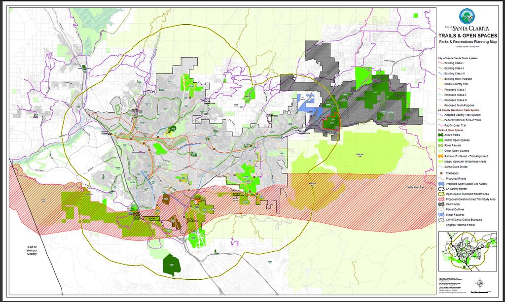
18 V. ASSESSMENT ROLL The Assessment Roll is a listing of the proposed assessment for Fiscal Year 2015/16 apportioned to each lot or parcel, as shown on the last equalized roll of the Assessor of the County of Los Angeles. The Preliminary Assessment Roll is provided as part of this report and is incorporated herein. The description of each lot or parcel is part of the records of the Assessor of the County of Los Angeles and these records are, by reference, made part of this Report. VI. ASSESSMENT DIAGRAM The Assessment Diagram for the District is provided on the following page. The lines and dimensions of each lot or parcel within the District are those lines and dimensions shown on the maps of the Assessor of the County of Los Angeles, for the year when this Report was prepared, and are incorporated by reference herein and made part of this Report. Fiscal Year 2015/2016 Open Space Preservation District Engineer s Report Page 15
19
20 Appendix 1 Certificates of Participation Open Space and Parkland Acquisition Program 2007 Series Debt Service Schedule Fiscal Year 2014/2015 City of Santa Clarita Open Space Preservation District Engineer s Report APPENDIX 1
21 Fiscal Year 2014/2015 City of Santa Clarita Open Space Preservation District Engineer s Report APPENDIX 1
22 Fiscal Year 2014/2015 City of Santa Clarita Open Space Preservation District Engineer s Report APPENDIX 1
23 Appendix 2 Open Space Acquisition Implementation Work Program Fiscal Year 2014/2015 City of Santa Clarita Open Space Preservation District Engineer s Report APPENDIX 2

24 OPEN SPACE ACQUISITION IMPLEMENTATION WORK PROGRAM FISCAL YEAR Approved by Financial Accountability and Audit Panel:
25 ` Open Space Acquisition Implementation Work Program TABLE OF CONTENTS EXECUTIVE SUMMARY 3 WORK PROGRAM A. Present Challenges 5 B. Types of Undeveloped Land to be Acquired 6 C. Acquisition Principles 6 D. Acreage Allocation Ratio 7 E. Description of Land Acquisition Projects 7 F. Acquisition Work Plan 10 o Potential Open Space o Ranking Process o Applications G. Open Space Evaluation Process 15 o Step-by-Step Instructions Appendix A Open Space Inventory Criteria (OSIC) Checklist & Definitions Appendix B Open Space Preservation District Map City of Santa Clarita Page 2 FY Open Space Acquisition Implementation Work Program
26 ` Open Space Preservation District EXECUTIVE SUMMARY Background Since the City of Santa Clarita s incorporation in 1987, the City has made a significant effort to preserve greenbelts and undeveloped land within and outside the City. This includes implementing the vision of the first and subsequent City Councils to buffer the Santa Clarita Valley with a greenbelt to help maintain the character and quality of life for residents. During the The Big Picture Community Strategic Planning process in 2004, several open space goals were reaffirmed. Additionally, in 2007 a number of community members spoke to the Council in support of preserving undeveloped land and asked the Council to, once again, pursue the creation of a mechanism to finance the acquisition and preservation of undeveloped land. In April 2007, the City Council adopted a resolution to initiate the formation of the City of Santa Clarita Open Space Preservation District. Open Space Preservation District Formation Property owners from the City voted to support the new Open Space Preservation District (the District ), with 69 percent ballots in favor and 31 percent not in favor. The District needed a simple majority of assessment to pass, which was received. On July 17, 2007, the City Council adopted a resolution forming the City of Santa Clarita Open Space Preservation District. The City of Santa Clarita s Open Space Preservation District represents a significant step forward in the City s ongoing efforts to acquire, preserve, and protect open space. District Purpose The Open Space Preservation District will expand upon the City s existing Open Space, Park, and Parkland Program ( Program ). The City already has an extensive Program for the acquisition, preservation, improvement, servicing and maintenance of parks, parkland, and open space lands. The existing program is responsible for the implementation of various functions associated with parks maintenance, park planning, and development. It provides planning and administration for the acquisition and construction of parks, open space, trails, and grounds as well as the operations and maintenance supplies to maintain the parks, facilities, trails, and open space. In addition, this program works with the community on the master plans and designs of various park facilities, and oversees the implementation of these designs by managing the construction process. Many properties outside the City s boundaries benefit from the City s existing Program. It is the City Council s intent to use the additional funding from the District to expand the existing Program to accelerate vacant land acquisition in and around the City. The City had been doing this to some extent in previous years, but this allowed more funds to be used for this purpose. City of Santa Clarita Page 3 FY Open Space Acquisition Implementation Work Program
27 ` District Funds At the time the Open Space Preservation District was formed, in Fiscal Year , the City s existing Parks Program budget was approximately $6.8 million. The Open Space Preservation District was projected to increase the funds by approximately $1.5 million, and the City Council had committed these $1.5 million funds from the Open Space Preservation District to acquire vacant lands in and around the City, as identified in this Annual Open Space Acquisition Implementation Work Program ( Work Program ). In 2007, the City Council approved the issuance of debt to finance the acquisition of open space and parkland by executing and delivering $15,525,000 in Certificates of Participation (Open Space and Parkland Program) 2007 Series (the COPs ). This represented approximately half of the City's borrowing capacity and was the first bond issuance in a series of two. As of fiscal year ending June 30, 2013, $4.4 million in bond proceeds remain, accounting for over $10.3 million in bond proceeds used to leverage land purchases, including properties in East Walker Ranch, Placerita/Quigley Canyon, Rodda/Agua Dulce partners (in Soledad Canyon), Elsmere Canyon, Wildwood Canyon, Haskell Canyon, and Prince/Placerita Canyon. Parcel Payments into the District In 2007, a single-family residence paid $25, which is the designated Assessment Rate. Condominiums, townhomes, and apartments paid $18.75 for each unit, and mobile home parks paid $12.50 per space. Non-residential developed property, such as commercial, industrial, and institutional land uses, paid $75 per acre, and vacant parcels paid $18.75 per acre up to 5 acres (not to exceed $93.75). The maximum Assessment Rate that can be charged may increase by $1 each year. The actual Assessment Rate in any fiscal year must be approved by the City Council prior to the levy and may not exceed the maximum Assessment Rate without receiving property owner approval for the increase. Assessment District Duration: The assessment will be in place for thirty (30) years through Fiscal Year Engineer s Report and Annual Work Program: An Engineer s Report for the formation of this District was developed. The Engineer s Report is a legally required document, pursuant to Article XIIID of the California Constitution, for assessment districts. This document (Work Program) outlines how the open space acquisition will be accomplished, what the priorities are, etc. This Work Program provides acquisition principles, such as: City of Santa Clarita Page 4 FY Open Space Acquisition Implementation Work Program
28 ` The acquired land is within the three-mile benefit area boundary for the District (which is defined as within a 3-mile radius of the City s existing boundary, and At least 90 percent of the acres purchased will be preserved for natural open space (so that no more than 10 percent of the acres purchased will be used for future improved active parkland). WORK PROGRAM A. PRESENT CHALLENGES The City of Santa Clarita incorporated in 1987 and recently celebrated its twenty-five (25) year anniversary. The City encompasses the communities of Canyon Country, Newhall, Saugus, and Valencia. Surrounding the City are various unincorporated areas and the Angeles National Forest. As of 2012, the City had approximately 311 acres of developed parkland, 73 miles of trails, and over 6,866 acres of City-owned open space. The City s General Plan requires five (5) acres of active parkland per 1,000 in population. Based on this requirement, the City currently faces a deficit of over 600 acres of active parkland and continues to seek a greenbelt/buffer of preserved open space around the valley and the City. Santa Clarita is a vibrant community. Since incorporation, the City has experienced significant growth in area and population that has impacted the relationship between open space areas and developed land. The City desires to ensure that our open space areas are protected and maintained, it recognizes that growth must be complemented with continued protection of our open spaces and the addition of parks and recreation opportunities if the area s quality of life is to be maintained. The City should build upon its strong history of park stewardship, development, trail construction, and open space preservation. If the City wishes to pass on to future generations of residents a community that retains the attractions that drew them here, the City must continue to protect and enhance its open space and parkland. The City recently annexed Elsmere Canyon. Also, we are moving forward with the annexation of areas north of Copperhill Drive, which includes the Haskell Canyon Open Space and areas south of the 14 freeway and west of Sand Canyon Road, including East Walker Ranch. Once areas are brought into the City, we are exempt from paying property taxes to the County. City of Santa Clarita Page 5 FY Open Space Acquisition Implementation Work Program
29 ` B. TYPES OF UNDEVELOPED LAND TO BE ACQUIRED The following category descriptions explain the variety of open space preservation actions that are needed in the City: Undeveloped Land Preservation This effort will seek to preserve and protect the undeveloped areas around the valley and further the City s goal to create a greenbelt/buffer around the valley and reduce sprawl. Santa Clara River Watershed To bring the last unchanneled river in Southern California into public ownership and protect its wild, valuable habitat has long been a City goal. Trails Santa Clarita is well known for its miles of scenic and effective bike and multi-use trails which link neighborhoods to parks and open space, yet many more critical linkages remain to be added and completed. Wildlife Corridors Protection and enhancement of the core habitat of unique, endemic, and valuable plants and animals is a critical goal. C. ACQUISITION PRINCIPLES The following principles are the basis for allocation categories and the criteria within each allocated category. They will also guide the implementation of this Work Program and serve as benchmarks for the Financial Accountability and Audit Panel in reviewing project expenditures. The following principles are intended to maximize the special benefit derived from this Work Program, maintain the integrity of the Work Program, and to assure fair and equitable distribution of acreage. A land acquisition project does not need to address each of these principles to be acquired, but the consistency with principles will be considered when allocations are determined. 1) To acquire parcels of undeveloped land 2) To provide local matching funds as a way to attract state, federal, and foundation funds 3) To provide new methods for undeveloped land preservation, including the appropriate use of conservation easements, trails, and protection of rivers and creeks 4) To distribute the open space acquisition equitably in and around the City and/or the threemile Area of Benefit boundary 5) To assure that new and existing undeveloped lands receive the necessary stewardship City of Santa Clarita Page 6 FY Open Space Acquisition Implementation Work Program
30 ` 6) To ensure that land that is acquired is within the three-mile benefit area boundary; this is defined as within a 3-mile radius of the City s existing boundary. 7) To acquire ecologically significant parcels of undeveloped land and engage in regional cooperative efforts 8) To acquire parcels of undeveloped land of regional importance In addition, there are several principles that assure that the Open Space Preservation District funds will be expended in a way that complement good public policy. These will also be used by the Financial Accountability and Audit Panel to gauge the appropriateness of expenditures. 9) To minimize impacts and respect adjacent property owners and the values they place on their property 10) To rely on existing institutions to implement this Work Program, to the extent possible, so that funds are spent efficiently 11) To endeavor to acquire property and easements from willing sellers 12) To acquire parcels in a fiscally responsible manner D. ACREAGE ALLOCATION RATIO Funds derived from the Open Space Preservation District that are utilized for this Work Program shall fund the acquisition of acres of undeveloped land in the following ratio: At least 90 percent of the acres purchased will be preserved natural open space, and No more than 10 percent of the acres purchased will be used for future improved active parkland E. DESCRIPTION OF LAND ACQUISITION PROJECTS The City of Santa Clarita s 2002 Open Space Acquisition Plan, the Nature Conservancy s 2006 Santa Clara River Upper Watershed Conservation Plan, Santa Clarita River Watershed Plan, LA County SEA, South Coast Wildlands Missing Linkages, Rim-of-the-Valley studies and other relevant technical documents will be considered to prioritize properties for land acquisition. The City of Santa Clarita s Open Space Acquisition Plan, adopted by the City Council in August 2002, established a set of guidelines and policies for bringing open space in the Santa Clarita Valley into public ownership. The primary objective defined in the Open Space Acquisition Plan is creating a greenbelt of open space around the City. The purpose of the City of Santa Clarita Page 7 FY Open Space Acquisition Implementation Work Program
31 ` greenbelt is to ensure the character and natural habitat of the pristine environment surrounding the City. In addition, the Open Space Acquisition Plan also identifies finding open space within the City as a priority, not only as natural land, but as active park space as well. During the community process that helped form the Open Space Acquisition Plan, staff was able to identify what members of the public consider open space to be. Open space was defined as vacant, undeveloped land in its natural state as well as both active and passive park space. It should be noted that in order for park space to be considered open space, the park needed to be of regional size. A small neighborhood tot lot, for example, would not be considered open space. However, the City s Central Park, Newhall Park, and Canyon Country Park (to name only a few) were considered to be open space. The Open Space Acquisition Plan s primary function as a planning tool is to identify sites that represent the best value for the City for acquisition. This is done by a set of established and approved criteria that can be applied to any potential property. At the same time, the Open Space Acquisition Plan can be used to determine if a potential property does not represent a good value to the City. Under either circumstance, when land is acquired, the City endeavors to respect the land use for which the current terrain, topography, and environmental characteristics best represents. To establish a regional scope, the Open Space Acquisition Plan identifies five key areas in the Santa Clarita Valley that are consistent with the City Council s direction for potential open space acquisition. These regions are: Eastern Region: o o o Approximate Area: From the 14 Freeway east to the Angeles National Forest and from the intersection of the 5/14 Freeways north to Vasquez Rocks. Goals: To create a continuous strip of open space along the eastern border of the City of Santa Clarita. Connect open space between the City s boundary and the Angeles National Forest whenever possible. Status: The City has made considerable progress in the eastern region. Currently, open space property is in public ownership near the proposed Transit Mixed Concrete (Cemex) project, Whitney Canyon, and several hundred acres associated with the Golden Valley Ranch development. The City, working with the Mountains Recreation Conservation Authority, purchased an additional 243 acres in this region in 2010, and in 2012, in partnership with Santa Monica Mountains and Los Angeles County, acquired 1,027 acres in the Eastern CAPP. Southern Region: o Approximate Area: From the intersection of the 5/14 Freeways north to the City of Santa Clarita boundary and between the identified eastern and western regions. City of Santa Clarita Page 8 FY Open Space Acquisition Implementation Work Program
32 ` o o Goals: Link natural habitat and habitat migration corridors between the eastern and western regions. Status: Over 200 acres of open space will be dedicated to the City associated with the Gate-King project. This region also contains the historic Beale s Cut property. Western Region: o Approximate Area: From the 5 Freeway to the Santa Susanna Mountains Significant Ecological Area, areas around Stevenson Ranch, and from the intersection of the 5/14 Freeways north along San Francisquito Creek. o Goals: To create a continuous strip of open space along the western border of the City of Santa Clarita. o Status: Several significant properties exist in the region including the Santa Clarita Woodlands, Towsley Canyon, Mentryville, and 6,000 acres associated with the Newhall Ranch Development. Northern Region: o Approximate Area: From the northern boundary of the City of Santa Clarita north to the Angeles National Forest and from the 5 Freeway/Highway 126 interchange to Vasquez Rocks. o Goals: To create a continuous strip of open space along the northern border of the City of Santa Clarita. Connect open space between the City of Santa Clarita and the Angeles National Forest whenever possible. o Status: Future development of this region should be monitored and open space dedication pursued whenever possible. City of Santa Clarita: o Area: All areas contained within the defined boundaries of the City of Santa Clarita. o Goals: Work with all City departments, partners, and in conjunction with the Open Space Plan; the Parks, Recreation, and Open Space Master Plan; River Features Study; and other documents to acquire and protect open space, both active and passive, within the City limits. Work in partnership with the development community to secure open space through dedication. o Status: To date, the City has acquired 2,426 acres of open space and another 170 acres of passive or special use parkland, and has developed 240 acres of parkland. City of Santa Clarita Page 9 FY Open Space Acquisition Implementation Work Program
33 ` The regions described above cover a significant area in the Santa Clarita Valley. As a result, a considerable acreage of land must be considered and analyzed prior to deciding upon a set of properties to pursue. The Open Space Acquisition Plan, along with this Work Program, can be used as a tool to assist the City Council and planners in determining which property or properties represent the best value for the City. The land acquisition projects to be considered for funding from the Open Space Preservation District will be located within the benefit area as identified in the Engineers Report. F. ACQUISTION WORK PLAN Procedures to Accomplish and Implement Goals The goals and objectives of the Open Space Acquisition Plan will be met by an objective work plan. This work plan will enable the City of Santa Clarita to evaluate and rank potential open space in the Santa Clarita Valley and maximize the limited funding and resources available for land acquisition and the Open Space Preservation District funds. Potential Open Space It is important to note that existing undeveloped land is not considered open space. For purposes of this plan, property will only be considered preserved open space if it is: In public ownership and/or; Appropriately zoned, designated, or identified as open space or parkland. Properties being considered for acquisition will be considered potential open space until such a time that they come into public ownership and/or receive the appropriate designation or zoning. Ranking Process The City of Santa Clarita lacks the financial means to purchase all of the potential open space in the Santa Clarita Valley. As a result, the identification and acquisition of the most valuable pieces of potential open space becomes critically important to maximize the allocation of the City s limited resources. To achieve this end, an objective method of evaluation must be established to evaluate and rank each potential open space property being considered for acquisition. Ideally, those properties that present the greatest value to the City and/or Region should be acquired. The following seven-step process will allow the City of Santa Clarita to determine which potential open space properties represent the greatest value for acquisition. This process will be applied to each parcel being considered for acquisition. City of Santa Clarita Page 10 FY Open Space Acquisition Implementation Work Program
34 ` Step One Category of Land Determine the category of the potential open space. There are two possible categories: 1. Inside the City of Santa Clarita 2. Outside the City of Santa Clarita and within the Open Space Preservation District s three-mile Area of Benefit boundary Potential open space outside the City of Santa Clarita and within the three-mile Area of Benefit boundary should receive priority for acquisition because: Preserving land outside the City will assist in the development of a greenbelt and ecological value surrounding the Santa Clarita Valley More development is occurring in Los Angeles County than in the City Land outside the City can create corridors between the City and the Angeles National Forest There is more potential open space to acquire outside the City Step Two Development Status Determine the development status of the potential open space. The seven status categories are: A. Entitlements Pending: Development plans have been formally submitted to the City or Los Angeles County and are in the process of being considered, or plans are being prepared for submittal. B. Information Inquiries: The property owner has approached the City or Los Angeles County regarding the property with the intent to develop. C. Entitlements Approved: Plans to develop the property have been approved by the City or Los Angeles County, and an opportunity exists to acquire open space from the property owner. D. Amendments when changes or amendments to the property are proposed. E. Boundaries The property s boundary status has changed because of annexation, etc. The property is now within the three-mile Area of Benefit boundary. F. No Action: No action has been taken to develop the property on the part of the property owner, OR the owner has indicated no interest in developing the property. G. No Information: There is currently no information and/or the development status of the property is unknown. Status categories are shown in order of priority, with Status A being the highest. City of Santa Clarita Page 11 FY Open Space Acquisition Implementation Work Program
35 ` Step Three Availability Status Determine if the owner of the potential open space property is a willing seller or would enter into agreements to have the land acquired by the City. Priority should be given to properties with a willing seller/donor unless the acquisition of the property presents an overriding benefit to the public good. An overriding benefit to the public good would be determined by City Council. Step Four Create Subcategories The potential open space property will now fit into one of several subcategories depending on whether it is inside or outside of the City, inside the three-mile Area of Benefit boundary, and depending on its development status. Hence, each potential open space property will fall within one of the following categories: Inside the City Development Status A Development Status B Development Status C Development Status D Development Status E Development Status F Development Status G Outside the City and within the Area of Benefit Development Status A Development Status B Development Status C Development Status D Development Status E Development Status F Development Status G Each category will have several potential open space properties within it forming a catalog of properties in each category. However, each potential open space property will not receive a relative ranking until Step 5 below. At this time, the properties in each list should be sorted by their availability status. Those properties with willing sellers/donors should be placed at the top of the list, and those without at the bottom. Step Five Apply Criteria This step will apply the Open Space Inventory Checklist (OSIC) to each property on each list. (This step will also be the most time consuming.) The OSIC identifies resources that the City of Santa Clarita believes to be valuable. These resources are divided into five categories: Habitat Areas; Ridgelines and Viewsheds; Recreational Resources; Cultural and Historical Resources; and Other Resources. Each category contains several elements and sub-elements. Each element and sub-element represents a specific benefit that is either present or not present at each individual property. Each element and sub-element is weighted equally. City of Santa Clarita Page 12 FY Open Space Acquisition Implementation Work Program
36 ` The purpose of the OSIC is to assign numerical scores to each parcel of potential open space surveyed, based on their overall benefit to the City. Over time, as more parcels are considered, it will be possible to determine which parcels are more desirable and which are less desirable based on their relative scores. To determine the numerical score for each property, the following steps should be followed: 1. Beginning with the Habitat Area Category, place a check in the status column of the OSIC for each element and/or sub-element that is present on the property. 2. Do not place a check in the status column in the OSIC of elements or subelements that do not exist on the property. 3. Apply Steps 1 and 2 to each of the remaining categories. 4. Count the number of check marks in each category and write that number in the corresponding Category Subtotal space. 5. Transfer the numbers from each Category Subtotal space to the front page of the OSIC in the spaces provided. 6. Add each of the category subtotals together and place the result on the front page of the OSIC in the space marked Total Score. This figure is the final numerical score of the property and will be used to establish its rank with other potential open space properties. A copy of the Open Space Inventory Checklist and corresponding definitions is attached as Appendix A. Step Six Catalog Generation After each potential open space property has a numerical value assigned to it, each property should be listed within each category in numerical order, with the highest value at the top of each list. As indicated in Step 3, properties that do not have a willing seller/donor should be listed at the bottom of each list. The only exception to this is any property that has been identified as one whose acquisition would present significant benefit to the public good, as defined by the City Council. These properties should be listed among the properties with willing sellers/donors. In addition, a general assessment of maintenance costs and liability of each property should be weighed at this time. All else being equal, those properties that present fewer maintenance challenges and reduced liability should be considered before those with more challenges and greater risk. Indeed, those properties that present unreasonable maintenance costs or significant risk may not be considered, regardless of their numerical score. City of Santa Clarita Page 13 FY Open Space Acquisition Implementation Work Program
37 ` Step Seven Recommend Parcels for Acquisition When each property has been ranked, a final catalog of the highest priority properties can be compiled by staff. A variety of methods can be used to create the final list of recommendations. This catalog will grow as more properties are considered. Plan Flexibility Applications It is important to realize that this plan is only a guide. The ultimate decision on the acquisition of property belongs to the City Council. The evolving catalog of properties to acquire will not obligate the City but will serve as a tool in the decisionmaking process. The plan must be flexible enough to allow for amendments. Because development occurs rapidly and the status of land changes in a similar fashion, the plan, or parts of the plan, should be updated as needed. An explanation of steps one through seven is explained further in Section G: Open Space Evaluation Process, Step-by-Step. This plan can be used for a variety of applications. However, there are three major areas of implementation: 1. Dedication: Often the City of Santa Clarita is approached by developers and/or property owners who wish to dedicate all or a portion of their property to the City as open space. Although additional, natural land is needed in Santa Clarita and may present numerous opportunities, in some cases costs or liability associated with property ownership may not warrant acquisition. In cases where the City is approached by a property owner with the intention to dedicate property, either the City can evaluate the property using the OSIC or it may be the case that the City has already evaluated the property independently. In either case, the property will receive or already have a numerical score. In both cases, the proposed parcel will receive a score and be ranked against other potential open space in the Santa Clarita Valley. Depending on its score and rank, the City will be able to make an objective decision on whether to accept or deny the dedication. 2. Development Review Committee: Developers often propose to dedicate open space as part of the development process. The OSIC can be used by staff during the development review process to help determine whether the proposed open space meets the City s needs. City of Santa Clarita Page 14 FY Open Space Acquisition Implementation Work Program
38 ` Depending on the rank given to the property using the OSIC, City staff will be able to make an objective decision about how the dedication will fit into the overall development process. 3. Grant Writing: There is a significant amount of grant funds available for acquisition of open space. Being able to provide an objective statement of value for any given property being sought for acquisition will help build valid justification for bringing the site into public ownership and enhance the City s ability to receive funding. City staff applies for grants as they become available and as they meet the objectives of the City. Staff resources will be utilized to apply for available grant funds for acquisition of open space. Over time, a substantial catalog of potential open space properties will be compiled. G. OPEN SPACE EVALUATION PROCESS Step-by-Step Instructions The City s Open Space Acquisition Plan outlines the evaluation process for open space in the Santa Clarita Valley. The work plan is a series of seven steps designed to categorize and objectively determine the overall value of potential open space properties. This section includes detailed instructions for each step in the process. 1. Land Category Determine whether the property is inside or outside of the Open Space Preservation District s three-mile Area of Benefit boundary 2. Development Status Determine the development status of the property 3. Availability Status Determine if the property owner is a willing seller or donor 4. Create Subcategories Categorize the property according Steps Apply Criteria Apply criteria on the Open Space Inventory Checklist (OSIC) to the property 6. Create Final Lists Based on the property s OSIC score, determine its relative rank within the property s sub-list from Step Catalog Generation Based on the final lists in Step 6, make recommendations on whether the property should or should not be considered for acquisition. Note that recommendations should always be directed to the City Council for approval. City of Santa Clarita Page 15 FY Open Space Acquisition Implementation Work Program
39 ` Step 1 Land Category Step 1 requires the evaluator to determine whether the property is inside or outside of the three-mile Area of Benefit boundary. This can be done by consulting the Open Space Preservation District map (Appendix B). After Step 1 is completed, the potential property will be categorized as either Inside the City or Outside the City and Within the three-mile Area of Benefit boundary. Properties categorized as Outside the City and Within the three-mile Area of Benefit boundary have been identified by the City Council as higher priority than those categorized as Inside the City and Within the three-mile Area of Benefit boundary. Step 2 Development Status Step 2 in the process is to obtain the development status of the property from the Planning Division. Provide Planning with one of the following pieces of information (listed in priority order): 1. Address 2. Location (i.e., cross streets, etc.) 3. Tentative Parcel Map or Tentative Tract Map 4. Assessors Parcel Number (APN) Based on the results of the Development Status search, the evaluator should assign the development history to one of the following categories: A. Entitlements Pending: Development plans have been formally submitted to the City or Los Angeles County and are in the process of being considered, or plans are being prepared for submittal. B. Information Inquiries: The property owner has approached the City or Los Angeles County regarding the property with the intent to develop. C. Entitlements Approved: Plans to develop the property have been approved by the City or Los Angeles County, and an opportunity exists to acquire open space from the property owner. D. Amendments when changes or amendments to the property are proposed. E. Boundaries The property s boundary status has changed because of annexation, etc. The property is now within the three-mile Area of Benefit boundary. F. No Action: No action has been taken to develop the property on the part of the property owner, OR the owner has indicated no interest in developing the property. G. No Information: There is currently no information and/or the development status of the property is unknown. Development status categories are shown in priority order, with Status A being the highest priority. City of Santa Clarita Page 16 FY Open Space Acquisition Implementation Work Program
40 ` By the end of Step 2, the property should be categorized as either Inside the City or Outside the City and Within the three-mile Area of Benefit boundary and assigned a Development Status. (To this point, a property that is Outside the City and Within the three-mile Area of Benefit boundary and has Development Status A would receive the highest priority. This will be discussed in Step 4 Creating Subcategories.) Step 3 Availability Status In this step, determine if the property owner is known to be a willing seller/donor or a non-willing seller/donor. If this is not known, it may be necessary to contact the property owner. (Contact information should be included in the information provided by Planning in Step 2.) Priority should be given to properties with a willing seller/donor unless the acquisition of the property presents an overriding benefit to the public good, as determined by the City Council. At the end of Step 3, the property should be categorized as Inside the City or Outside the City and Within the three-mile Area of Benefit boundary, have a development status assigned to it (A through G), and whether the property owner is a willing seller/donor. Step 4 Create Subcategories By this time, the potential open space property should have been categorized as indicated above in Step 3. The first relative value judgment of that property can now be assessed and compared with other open space properties that have been evaluated. Properties that are Outside the City and Within the three-mile Area of Benefit boundary and have a development status of A are identified as the highest priority for acquisition. Conversely, properties that are Inside the City with a development status of D or E are identified as the lowest priority for acquisition. It should be noted that properties that are Outside the City and Within the three-mile Area of Benefit boundary with a development status of D or E may or may not be a higher acquisition priority than, for example, a property that is Inside the City and a development status of A. These instances should be considered on a case-by-case basis. After Step 4, the property being evaluated should be placed in one of the following categories. Inside the City Development Status A Development Status B Development Status C Development Status D Development Status E Outside the City and within the Area of Benefit Development Status A Development Status B Development Status C Development Status D Development Status E City of Santa Clarita Page 17 FY Open Space Acquisition Implementation Work Program
41 ` Development Status F Development Status G Development Status F Development Status G Step 5 Apply Criteria Step 5 of the evaluation is by far the most lengthy and the most involved segment of the process. For each property the evaluator should complete an Open Space Inventory Checklist (OSIC) form. In most cases, it will be necessary to travel to the site itself to complete the form. Accessing each property will generally require the permission of the property owner. Steps to Complete the OSIC: 1. Provide basic property information including: The Assessor s Parcel Number (APN) The date(s) the evaluation was conducted The initials of the evaluator The availability status (willing seller/donor?) A brief description of the location of the property 2. Provide basic category and development status information. Circle whether the property is inside or outside the City, and inside or outside the three-mile Area of Benefit boundary, and circle the letter that corresponds to the property s appropriate development status. 3. Evaluate each element and sub-element of each of the six inventory categories. These six categories are: Habitat Areas Ridgelines and Viewsheds Recreational Resources Cultural/Historical Resources Other Resources Hazard/Other Areas To evaluate the elements and sub-elements in each inventory category, place an X or checkmark in the status column of each element or sub-element known to exist or observed to exist on the property. Place no marks in the status column for elements or sub-elements not known or observed to exist on the property. For Example: If a hypothetical property being evaluated contains a wildlife migration corridor, riparian habitat, a portion of the Santa Clara River, and a known presence of the Southwestern Willow Flycatcher (to name a few), then these elements and subelements should each receive an X or checkmark in the corresponding status City of Santa Clarita Page 18 FY Open Space Acquisition Implementation Work Program
42 ` column. Other elements and sub-elements that are not known to be or observed to be present on the site should NOT receive a mark. Special Instructions: Some elements and sub-elements have special scoring instructions associated with them. In most cases, only one mark should be placed in the corresponding status column of known or observed elements and sub-elements. However, there are exceptions. These are: Known threatened/endangered plant and animal species: The species listed on the OSIC are those that appeared on the 2008 list provided by the California Department of Fish and Game. These elements and sub-elements should always reflect the most current list of state and federally endangered and threatened species. Place only one mark in the status column for each sub-element present regardless of the population of the species. Do not, for example, place one mark in the status column for each individual of that species present on the property. Ridgelines: Place a mark in the status column if there is at least one ridgeline present on the property. Cultural and/or Historical Resource Areas: Place one mark in each sub-element for each site on the property. For example, a hypothetical property containing two Native American sites and two other archaeological sites should receive a total of four marks in the corresponding status column. 4. Score each inventory category. To complete this step, simply count all of the X s or checkmarks for elements and sub-elements within each inventory category. Record the total number of marks for each category in the space provided in the category column. In addition, record the same figures in the spaces provided in the score summary box at the top left of the first page of the OSIC. Note that marks in the Hazard/Other Area category are not included in the overall total. Instead, these marks are meant to be general indicators of potentially negative aspects of the property. The City may wish to reconsider acquisition of properties that contain any of the sub-elements in this category, regardless of the extent or frequency. For Example: A hypothetical property has one primary ridgeline, the presence of secondary ridgelines, a significant dark sky viewshed, a significant regional viewshed, and a unique on-site visual feature yielding a total of five marks in the Ridgeline and Viewshed Category. The number 5 would be recorded in the category column and on the front page in the space provided next to Ridgelines and Viewsheds. The same process would be completed for each of the six inventory categories. City of Santa Clarita Page 19 FY Open Space Acquisition Implementation Work Program
43 ` 5. Add the inventory category scores to compute the property s overall score. When each category score has been recorded in the spaces provided on the front page of the OSIC, the scores should be totaled (except those in the Hazards category). This is the final score of the property being evaluated. By the end of Step 5, the property being evaluated should have a total score associated with it. The higher the score, the greater the relative value of the property to the City. Step 6 Catalog Generation At this point, the property being evaluated should have the following assigned to it: A land category either Inside the City or Outside the City and Within the threemile Area of Benefit boundary A development status of either A through G A total score based on criteria in the OSIC As the catalog of open space grows, properties should be sorted according to their land category and development status. Properties of the same land category and development status should then be sorted by the score received, based on the criteria in the OSIC. A higher OSIC score represents a property of greater value. Hence, a property that is Outside the City and Within the three-mile Area of Benefit boundary, development status A, and with the highest OSIC score should theoretically represent the greatest overall value to the City for acquisition. Note: Those properties with non-willing sellers/donors should be grouped at the bottom of subcategories, in OSIC score order. Step 7 Recommend Parcels for Acquisition Based on the final set of lists, parcels that represent the greatest value for the City to acquire should be recommended. All recommendations should be directed to the City Council for final approval. City of Santa Clarita Page 20 FY Open Space Acquisition Implementation Work Program
44 APPENDIX A Open Space Inventory Criteria Form (OSIC) Contents: Open Space Inventory Site Checklist Definitions
45 CITY OF SANTA CLARITA OPEN SPACE INVENTORY SITE CHECKLIST APN#: Date of Entry: Initials of Surveyor: Site ID Number: Willing Seller? qyes qno Within 3-mile Benefit Area Boundary? qyes qno TOTAL SCORE: Habitat: Ridgelines and Viewsheds: Recreational Resources: Cultural/Historical Resources: Category Development Status Outside City & In A.B.* A Entitlements Pending Other Resources: In-City B Information Inquires Hazards: (Not included in total) C Entitlements Approved * (Area of Benefit) D E No Action No Information CATEGORY ELEMENT Habitat Areas Wildlife migration corridor None Category Subtotal: Riparian habitat None SUB ELEMENT STATUS Contains part of a Significant Ecological Area (SEA) (General Plan Open Space and Conservation Element) Contains a block of known undisturbed critical habitat Elsmere/Whitney/Placerita Canyon Lyon Canyon San Francisquito Canyon Santa Clara River Corridor Santa Suzanna Mountains Valley Oaks Savanna None Open Space Inventory Site Checklist - Page 1 of 5
46 CATEGORY ELEMENT SUB ELEMENT STATUS Habitat Areas (Continued) Contains one of the seven Coast Live Oak Woodland identified major plant communities Forest (General Plan Open Space and Interior Live Oak Woodland Conservation Element) Mulefat Scrub Riversidean Sage Scrub Semi-Desert Chaparral Southern Cottonwood-Willow Riparian Valley Oak Woodland Contains land within an identified important canyon area (General Plan Open Space and Conservation Element) Contains rivers or creeks East Canyon Elsmere Canyon Placerita Canyon Rice Canyon San Francisquito Canyon Towsley Canyon Whitney Canyon Wiley Canyon "Other" canyon Bouquet Creek Newhall Creek Other creek/tributary Placerita Creek San Francisquito Creek Sand Canyon Creek Santa Clara River South Fork of the Santa Clara River Open Space Inventory Site Checklist - Page 2 of 5
47 CATEGORY ELEMENT SUB ELEMENT STATUS Habitat Areas (Continued) Contains known endangered or American Peregrine Falcon threatened animal species California Red-Legged Frog (pursuant to most recent list of state and Coastal California Gnatcatcher federal species. Those shown at left Least Bells Vireo are reflective of April, California Quino Checkerspot Butterfly Fish and Game) Riverside Fairy Shrimp Santa Ana Sucker Southwestern Arroyo Toad Southwestern Willow Flycatcher Swainson's Hawk Unarmored Three-Spined Stickleback Western Yellow Bellied Cuckoo Willow Flycatcher Other Contains known endangered or threatened plant species (pursuant to most recent list of state and federal species. Those shown at left are reflective of April, California Fish and Game) Brauton's Milk-Velch California Orcutt Grass Nevin's Barberry Slender-Horned Spineflower Spreading Navarretia Three-Leaved Brodiaea Other Open Space Inventory Site Checklist - Page 3 of 5
48 CATEGORY ELEMENT SUB ELEMENT Habitat Areas (Continued) Contains oak trees Heritage Oak Non-Heritage Oak Oak Forest Oak Savanna Oak Woodlands STATUS Ridgelines and Viewsheds Contains identified ridgelines Primary ridgelines Secondary ridgelines Category Subtotal: Contains visual resources "Dark Sky" viewshed Significant local viewshed Significant regional viewshed Unique or special visual features on-site Site visible from public right of way Recreational Resources Contains passive recreation areas Existing pedestrian trail Connection to existing offsite trails Category Subtotal: Existing equestrian trail Existing mixed-use trail Other passive recreation resource Potential equestrian trail Potential mixed-use trail Potential pedestrian trail Cultural/Historical Resources Contains cultural and/or historical National Register of Historic Places resource areas State significant historic landmark Category Subtotal: Local significant historic resource Native American site Other archaeological site/resource Open Space Inventory Site Checklist - Page 4 of 5
49 CATEGORY ELEMENT SUB ELEMENT STATUS Other Resources Contains a groundwater recharge area None Category Subtotal: Is in a significant location Abuts existing open space Expands a regional open space corridor Located in a parks/open space poor area Potential buffer zone Provides links to existing or future trail systems Access to site Conservation Easement Utility Easement or other Easement Existing equestrian access Existing pedestrian access Existing vehicular access Provides access to other sites None Hazard/Other Areas: Contains hazards rendering the site Areas of soil instability undevelopable Fault zone Total Score: Fire hazard areas (Not included in total) Floodway Mineral resource area Site is Contaminated Notes: Open Space Inventory Site Checklist - Page 5 of 5
50 Open Space Inventory Items Definitions TERM Wildlife Corridor Riparian Habitat Significant Ecological Areas DEFINITION Wildlife corridors are generally described as pathways or habitat linkages that connect discrete areas of natural open space otherwise separated or fragmented by topography, changes in vegetation, and other natural factors in combination with urbanization. Corridors: 1) allow animals to move between remaining habitats, which allow depleted populations to be replenished and promotes genetic exchange; 2) provide escape routes from fire, predators, and human disturbances, thus reducing the risk that catastrophic events, such as fire or disease, will result in population or species extinction; 3) serve as travel paths for individual animals as they wander throughout their home ranges in search of food, water, mates, and other needs, or for dispersing juveniles in search of new home ranges. Specifically referring to habitat located on the banks of or within a natural watercourse, including rivers, lakes, and tidewaters. These corridors are generally defined by a blue-line stream designation on United States Geologic Survey maps. In Santa Clarita, the riparian habitat of the Santa Clara River is home to several Federal and State Endangered Species, including, but not limited to: the Unarmored Three-spine Stickleback, the Southwestern Arroyo Toad, and the Least Bells Vireo. In addition to being important breeding grounds for a variety of species, riparian habitat also protect water quality by reducing runoff and allowing for groundwater recharge. Areas that contain significant or special biological resource value. Los Angeles County has designated five SEA s in and around the City of Santa Clarita. They are 1) The Santa Clara River Corridor, 2) The Santa Suzanna Mountains, 3) San Francisquito Canyon, 4) Lyon Canyon, and 5) Valley Oaks Savanna. In addition, the City has recommended that sections of Elsmere Canyon, Whitney Canyon, Placerita Canyon, Los Pinetos Canyon, and Los Pinetos Spring be included as SEA s by Los Angeles County. Generally, the SEA designation provides protection and special development standards designed to protect the significant or special biological resources contained within them. Open Space Inventory Definitions - Page 1
51 Critical Habitat Major Plant Communities Important Canyon Areas Rivers and Creeks The specific areas within a geographical area, occupied by an endangered/threatened species, on which are found those physical or biological features essential to the conservation of the species and which may require special management, consideration, or protection. The Open Space and Conservation Element of the General Plan identifies seven major plant communities in the Santa Clarita Valley. They are: 1) Interior Live Oak Woodland, 2) Valley Oak Woodland, 3) Coast Live Oak Woodland, 4) Riversidean Sage Scrub, 5) Semi-Desert Chaparral, 6) Southern Cottonwood-Willow Riparian Forest, and 7) Mulefat Scrub. The Open Space and Conservation Element of the General Plan identifies the following canyons as important for their habitat and biological resources: Whitney Canyon, Elsmere Canyon, Wiley Canyon, East Canyon, Towsley Canyon, Rice Canyon, San Francisquito Canyon, Placerita Canyon, and other canyons that provide important habitat (water, food, and shelter) and biological resources, in addition to adding to the viewshed of the Santa Clarita Valley. Rivers and creeks in Santa Clarita (most notably the Santa Clara River) support a variety of natural habitats, including freshwater marsh, coastal sage scrub, oak woodlands, and riparian woodlands. Many of the rivers and creeks in Santa Clarita remain dry for most of the year, although a subsurface flow runs year round. In scattered areas, however, the water table under the streambed is high, and lush riparian vegetation provides refuge for birds and wildlife. The assemblage of vegetation is unlike that found in steeper mountain canyons and is rare in the Los Angeles Basin. The Santa Clara River is the only major drainage from the San Gabriel Mountains and remains unchannelized for most of its length. Wetlands found along the Santa Clara River and its tributaries are considered a sensitive resource by the California Department of Fish and Game and are subject to the Clean Water Act, under the jurisdiction of the U.S. Army Corps of Engineers. Open Space Inventory Definitions - Page 2
52 Known Endangered and Threatened Animal Species Known Endangered and Threatened Plant Species Oak Trees The following species can be found in the Santa Clarita Valley, according to the California Fish and Game List of State and Federally Endangered and Threatened Animal Species, April 2001: American Peregrine Falcon (SE), California Red-Legged Frog (FT), Coastal Gnatcatcher (FT), Least Bells Vireo (SE, FE), Quino Checkerspot Butterfly (FE), Riverside Fairy Shrimp (FE), Santa Ana Sucker (FT), Southwestern Willow Flycatcher (FE), Southwestern Arroyo Toad (FE), Swainson s Hawk (ST), Unarmored Three-Spined Stickleback (SE, FE), Western Yellow Bellied Cuckoo (SE), and the Willow Flycatcher (SE). 1 The following species can be found in the Santa Clarita Valley, according to the California Fish and Game List of State and Federally Endangered and Threatened Plant Species, April 2001: Braunton s Milk-Velch (FE), Nevin s Barberry (SE, FE), Three-Leaved Brodiaea (SE, FT), Slender-Horned Spineflower (SE, FE), Spreading Navarretia (FT), and the California Orcutt Grass (SE, FE). Heritage Oak Tree: Any oak tree of the genus Quercus including, but not limited to, Valley Oak, California Live Oak, Interior Live Oak, Canyon Oak, and Scrub Oak, measuring onehundred-eight (108) inches or more in circumference or, in the case of multiple trunk oak trees, two (2) or more trunks measuring seventy-two (72) inches each or greater in circumference measured four-and-one-half (4 ½) feet above the natural grade surrounding such a tree. In addition, a Heritage Oak is defined as any oak tree specifically classified as such by the Planning Commission and/or City Council when the tree possess exceptional historic, aesthetic, and/or environmental qualities of major significance or prominence to the community. Non-Heritage Oak Tree: Any oak tree not fitting the description of a Heritage Oak tree (above) of the genus Quercus including, but not limited to, Valley Oak, California Live Oak, Interior Live Oak, Canyon Oak, and Scrub Oak. Structural Types: Oak trees are generally grouped into one of three structural types: Oak Savannas, Oak Woodlands, and Oak Forests. 1 Where FE = Federally Endangered, FT = Federally Threatened, SE = State Endangered, and ST = State Threatened Open Space Inventory Definitions - Page 3
53 Ridgelines Oak Savanna: Of the three structural types, an Oak Savanna is the most spacious with oak trees scattered far apart from each other over the landscape. Generally, Oak Savannas are found in the driest and warmest environments at the lowest elevations of the three oak structural types. Oak Woodland: Of the three structural types, Oak Woodlands have a greater tree density than Oak Savannas but are less dense than an Oak Forest. Individual oak canopies may touch, but rarely overlap those of other oak trees. Oak Woodlands are generally found in higher elevations and in cooler, moister, environments than Oak Savannas, but less than in Oak Forests. Oak Forest: Oak Forests are characterized by deep, overlapping canopies that produce constant shade. Forests are generally associated with upland slopes, or with streams and rivers at any elevation where the environment is very moist and relatively cool. Ridgelines: Ridgelines that surround or visually dominate the valley landscape, either through their size in relation to the hillside or mountain terrain, of which they are a part; their visual dominance, as characterized by a silhouetting appearance against the sky; as a significant natural backdrop feature or separation of communities; through visual dominance, due to proximity and view from existing development or major corridors; or as an area of significant ecological, historical, or cultural importance, such as those which connect park or trail systems. Ridgelines are those which are characterized by any condition of significant ridgeline criteria. Open Space Inventory Definitions - Page 4
54 Viewsheds Natural and cultural features of the environment that can be viewed by either stationary or transitory populations. Prominent visual features can be further identified as features that are unique to the Santa Clarita Valley and/or those that stand out in relation to their surroundings. Significant Regional Viewshed: A viewshed where a significant number of prominent visual features unique to the Santa Clarita Valley can be identified. Significant Local Viewshed: A viewshed where a significant number of prominent visual features unique to the Santa Clarita Valley or the City of Santa Clarita can be identified, but that are secondary in quantity or nature to a Significant Regional Viewshed. Dark Sky Viewshed: A location away from artificial or urban light sources, which preserves the nighttime view of stars, planets, constellations, and other heavenly bodies. Unique or Special Visual Resources: Unique or special scenic elements on-site, such as waterfalls, wildflower displays, geologic formations, scenic vistas, etc. Trails Existing Trails: maintained. A trail of any class which has been established and is currently being Potential Trails: A location where developing trailheads or trails on the site is feasible. Other Passive Recreation Resources: The potential for the development of other types of passive recreation on-site. Open Space Inventory Definitions - Page 5
55 Cultural/Historical Resources A variety of classifications of Cultural/Historical sites exist: National Register of Historic Places: The National Register of Historic Places is the Nation's official list of cultural resources worthy of preservation. Authorized under the National Historic Preservation Act of 1966, the National Register is part of a national program to coordinate and support public and private efforts to identify, evaluate, and protect our historic and archeological resources. At the time this document was published, the Santa Clarita Valley contained no known sites of this kind. State Significant Historic Landmarks: Properties of historical importance in California are designated as significant resources in three state registration programs: State Historical Landmarks, Points of Historical Interest, and the California Register of Historic Places. Historical landmarks are sites, buildings, features, or events that are of statewide significance and have anthropological, cultural, military, political, architectural, economic, scientific, technical, religious, experimental, or other value. At the time this document was published, Santa Clarita contained nine State Historical Landmarks and over twenty State and City Points of Historic Interest. State Historical Landmarks are: # Beale s Cut, #168 - The Oak of the Golden Dream, #172 - Pioneer Oil Refinery, #516 Well CSO4 (Pico 4), # Mentryville, #556 Rancho San Francisco, #590 Lang Station, #688 Lyons Station Stagecoach Stop, and #919 The St. Francis Dam Disaster Site. Native American Sites: Archaeological evidence suggests no fewer than twenty-two semipermanent villages throughout the Valley settled by the Tataviam Indians, circa 550 A.D., during their migration westward from the interior. It is estimated that approximately 500 Tataviams lived in these villages at that time. Other Archaeological Site/Historical Resource: resources not mentioned above. Other archaeological or historical Open Space Inventory Definitions - Page 6
56 Groundwater Recharge Area Conservation Easement Significant Location Areas that provide for the replenishment of underground water resources, specifically the Saugus and alluvial aquifers. Primary groundwater recharge areas within the Santa Clarita Valley include, but are not limited to, the Santa Clara River and its tributaries and local canyons. Generally, natural or soft-bottom drainage channels and wide, natural floodways and floodplains also serve as groundwater recharge areas. In granting a conservation easement, a landowner transfers certain property rights to a nonprofit conservation organization or government agency. The landowner agrees to restrict uses of the property, and the agency or nonprofit gains the right to ensure that the restrictions are upheld. Serves as a tool for preventing intensification of land use on property having important natural, agricultural, scenic, or historical value. The landowner retains title to the property but agrees to forgo certain uses, including, but not limited to, residential and/or commercial development. Explicit and legally binding, but negotiable, so that the needs of all parties involved can be accommodated. Uses are restricted only to the degree necessary to protect the land s significant values. Conservation easements are written into the deed for the property and run with the land. All subsequent property owners are bound by the terms of the easement. (Source: California Wetlands Information System.) The site is significantly located in relation to other sites and/or resources: Potential Buffer Zone: The location provides a buffer zone between more intensive and less intensive uses. Abuts Existing Open Space: The location abuts existing open space areas. Located in a Parks/Open Space Poor Area: The location is in a part of the Santa Clarita Valley that is poor in open space and/or park space. These areas tend to be those that have the greatest urban density, such as, Newhall and Canyon Country. Open Space Inventory Definitions - Page 7
57 Access Mineral Resource Area Floodway, Seismic Fault Zone, Fire Hazard Area, Area of Soil Instability Utility Easement Expands a Regional Open Space Corridor: The property is adjacent to and/or expands a regional open space corridor. Provides Links to Existing or Future Trail System: The location provides linkages to other trail systems. A means to approach or enter a site. In order to be valuable, a site should have some form of existing or attainable access. Gold mining and oil production mineral extraction areas, within and around the Santa Clarita Valley. Other mineral resource areas may include construction aggregate, titanium, and tuff materials. Specifically, mineral resource areas identified for managed production and protection include the Placer Gold Gulches, Lode Mines, Oil Fields, Construction Aggregate Resource Areas, and Santa Clara River Bed, as identified in Exhibit OS-5 of the City of Santa Clarita General Plan s Open Space and Conservation Element. Natural hazard areas throughout the Santa Clarita Valley include, but are not limited to, floodways, seismic fault zones, wildland fire hazard areas, and areas of geologic instability, due to the presence of unstable soil conditions. Areas of soil instability that may be targeted for preservation should include unmitigable landslide and liquifaction hazard areas. Hazardous areas as specified above are identified in the City of Santa Clarita General Plan s Open Space and Conservation Element, City of Santa Clarita General Plan s Safety Element, and maps produced by the California State Department of Mines and Geology. Infrastructure improvements used to service the public, located either above ground or below, that include, but are not limited to, the following: solid waste collection, conversion, reduction and disposal lines; communication service lines (e.g., cable television/telephone lines), water supply and treatment lines, sewerage collection and treatment lines, storm drains, engineered flood control channels, natural gas pipelines, and electrical transmission lines. Open Space Inventory Definitions - Page 8

58 APPENDIX B Open Space Preservation District Map Contents: Open Space Preservation District Map

59 DEL VALL E RD RIDGE RD ROUTE HILLCREST PKWY HENRY THE OLD RD MAYO DR LAKE HUGHES RD RYE CANYON RD ROCKWELL CA NYON RD NEWHALL S AN FRANCISQUITO CA NYON RD COPPER HILL MCBEAN PKWY MAGIC MOUNTAIN PKWY THE OLD RD MCBEAN PKWY SECO CANYON RD RANCH RD RAILROAD DR HASKELL CANYON RD GOLDEN VALLEY PLUM CAN YON RD RD CANYON RD BOUQ UET VASQUE Z CA NYON RD SIERRA HWY SAND CANYON RD Open Space Preservation District Assessment Diagram DAVENPORT RD AGUA ANYONR D DULCEC ESCONDIDO CANYON RD PICO CANYON RD ORCHARD VILLAGE RD AV PICO CANYONRD LYONS AV DOCKW EILER DR NEWHALL PLACERITACANYON RD AV SESNON BLVD CORBIN AV TAMPA AV WILBUR AV WOODLE YAV RINALDI ST BORDEN AV HERRICK AV ROXFORD ST BRADLEY AV SAN FERNANDO RD OLIVE VIEW DR POLK ST TRUMAN ST FOOTHILL BLVD 4TH ST HARDING AV SAYRE ST HUBBARD ST MACLAY ST N MACLAY AV ARROYO AV ARROYO ST PAXTON ST Legend GLADSTONE AV 3-Mile Buffer Around City Limits LOP EZ CANYO N RD FENTON AV LCANYON RD Parks & Open Spaces (OSPD) Other Parks & Open Spaces Angeles National Forest KAGE Santa Clara River City of Santa Clarita Boundary Miles Parks & Open Spaces from City of Santa Clarita GIS The City of Santa Clarita does not warrant the accuracy of the data and assumes no liability for any errors or omissions. Map prepared by: City of Santa Clarita - GIS Q:\PROJECTS\as\140311e1\mxd\city_3milebuff.mxd
City of Santa Clarita
 City of Santa Clarita Engineer s Report Open Space Preservation District FISCAL YEAR 2017/2018 Intent Meeting: May 9, 2017 Public Hearing: May 23, 2017 Prepared on: April 13, 2017 27368 Via Industria Suite
Felicia Newhouse, Public Works Administrative Manager Russ Thompson, Public Works Director SUBJECT: WILDWOOD GLEN LANDSCAPING ASSESSMENT DISTRICT C-91
 STAFF REPORT MEETING DATE: May 19, 2015 TO: FROM: City Council Felicia Newhouse, Public Works Administrative Manager Russ Thompson, Public Works Director 922 Machin Avenue Novato, CA 94945 (415) 899-8900
ENGINEER S REPORT FOR. OPEN SPACE MAINTENANCE DISTRICT (Golden Valley Ranch) Fiscal Year CITY OF SANTA CLARITA LOS ANGELES COUNTY, CALIFORNIA
 Fiscal Year CITY OF SANTA CLARITA LOS ANGELES COUNTY, CALIFORNIA") ENGINEER S REPORT FOR OPEN SPACE MAINTENANCE DISTRICT (Golden Valley Ranch) Fiscal Year 2006-07 CITY OF SANTA CLARITA LOS ANGELES COUNTY, CALIFORNIA Prepared by: May 16, 2006 Engineer's Report, FY 2006-07
ENGINEER S REPORT FOR OPEN SPACE MAINTENANCE DISTRICT (Golden Valley Ranch) Fiscal Year 2006-07 CITY OF SANTA CLARITA LOS ANGELES COUNTY, CALIFORNIA Prepared by: May 16, 2006 Engineer's Report, FY 2006-07
Felicia Newhouse, Public Works Administrative Manager Russ Thompson, Public Works Director
 STAFF REPORT MEETING DATE: June 16, 2015 TO: FROM: City Council Felicia Newhouse, Public Works Administrative Manager Russ Thompson, Public Works Director 922 Machin Avenue Novato, CA 94945 (415) 899-8900
Felicia Newhouse, Public Works Administrative Manager Russ Thompson, Public Works Director
 STAFF REPORT MEETING DATE: June 16, 2015 TO: FROM: City Council Felicia Newhouse, Public Works Administrative Manager Russ Thompson, Public Works Director 922 Machin Avenue Novato, CA 94945 (415) 899-8900
FINAL ENGINEER S REPORT FOR. OPEN SPACE MAINTENANCE DISTRICT (Golden Valley Ranch) Fiscal Year
 Fiscal Year") FINAL ENGINEER S REPORT FOR OPEN SPACE MAINTENANCE DISTRICT (Golden Valley Ranch) Fiscal Year 2007-08 CITY OF SANTA CLARITA LOS ANGELES COUNTY, CALIFORNIA Prepared by: June 20, 2007 Engineer's Report,
FINAL ENGINEER S REPORT FOR OPEN SPACE MAINTENANCE DISTRICT (Golden Valley Ranch) Fiscal Year 2007-08 CITY OF SANTA CLARITA LOS ANGELES COUNTY, CALIFORNIA Prepared by: June 20, 2007 Engineer's Report,
CITY OF LAFAYETTE ENGINEER S REPORT LANDSCAPE AND LIGHTING DISTRICT NO (RESIDENTIAL LIGHTING) FISCAL YEAR 2017/2018
 FISCAL YEAR 2017/2018") CITY OF LAFAYETTE ENGINEER S REPORT LANDSCAPE AND LIGHTING DISTRICT NO. 1979-2 (RESIDENTIAL LIGHTING) FISCAL YEAR 2017/2018 INTENT MEETING: APRIL 10, 2017 PUBLIC HEARING: MAY 22, 2017 27368 Via Industria
CITY OF LAFAYETTE ENGINEER S REPORT LANDSCAPE AND LIGHTING DISTRICT NO. 1979-2 (RESIDENTIAL LIGHTING) FISCAL YEAR 2017/2018 INTENT MEETING: APRIL 10, 2017 PUBLIC HEARING: MAY 22, 2017 27368 Via Industria
City of Santa Clarita
 City of Santa Clarita Drainage Benefit Assessment Areas (DBAA) NOS. 3, 6, 18, 19, 20, 22, 2008-1, 2008-2, 2013-1, 2014-1 and 2015-1 FISCAL YEAR Intent Meeting: May 23, 2017 Public Hearing: June 13, 2017
City of Lafayette Staff Report
 City of Lafayette Staff Report For: City Council By: Donna Feehan, Public Works Services Administrative Analyst Date Written: May 13,2013 Meeting Date: May 28, 2013 Subject: Residential Lighting District
City of Calabasas. Landscaping Lighting Act District Nos. 22, 24, 27 & 32 (1972 Act Districts) FISCAL YEAR 2018/2019 ENGINEER S REPORT
 FISCAL YEAR 2018/2019 ENGINEER S REPORT") City of Calabasas Landscaping Lighting Act District Nos. 22, 24, 27 & 32 (1972 Act Districts) FISCAL YEAR 2018/2019 ENGINEER S REPORT Intent Meeting: April 11, 2018 Public Hearing: June 13, 2018 27368
City of Calabasas Landscaping Lighting Act District Nos. 22, 24, 27 & 32 (1972 Act Districts) FISCAL YEAR 2018/2019 ENGINEER S REPORT Intent Meeting: April 11, 2018 Public Hearing: June 13, 2018 27368
6/10/2015 Item #10B Page 1
 MEETING DATE: June 10, 2015 PREPARED BY: Christine Ruess, Sr. Management Analyst DEPT. DIRECTOR: Glenn Pruim DEPARTMENT: Engineering & Public Works INTERIM CITY MANAGER: Larry Watt SUBJECT: PUBLIC HEARING
Town of Danville. Danville street lighting and landscape assessment district no
 Town of Danville Danville street lighting and landscape assessment district no. 1983-1 Fiscal Year 2015-16 Preliminary Engineer s Report May 19, 2015 Prepared by: 130 Market Place, Suite 160 San Ramon,
PRELIMINARY ENGINEER S REPORT
 PRELIMINARY ENGINEER S REPORT FOR THE LANDSCAPING AND LIGHTING DISTRICTS FISCAL YEAR 2004-05 May 12, 2004 Landscaping and Lighting District No. 22 (CALABASAS PARK AREA) Landscaping and Lighting District
Intent Meeting: May 20, 2009 Public Hearing: June 17, 2009
 CITY OF EL CENTRO LEGACY RANCH LANDSCAPING AND LIGHTING DISTRICT FISCAL YEAR 2009/2010 Intent Meeting: May 20, 2009 Public Hearing: June 17, 2009 Corporate Office: Regional Office Locations: 27368 Via
CITY OF EL CENTRO ENGINEER S ANNUAL LEVY REPORT BUENA VISTA LANDSCAPING AND LIGHTING DISTRICT FISCAL YEAR 2009/2010
 CITY OF EL CENTRO ENGINEER S ANNUAL LEVY REPORT BUENA VISTA LANDSCAPING AND LIGHTING DISTRICT FISCAL YEAR 2009/2010 Intent Meeting: May 20, 2009 Public Hearing: June 17, 2009 Corporate Office: Regional
Engineer's Report. City of Santa Clarita Drainage Benefit Assessment Area No (Golden Valley Ranch Commercial) For. Fiscal Year
 For. Fiscal Year") Engineer's Report For City of Santa Clarita Drainage Benefit Assessment Area No. 2008-2 (Golden Valley Ranch Commercial) Fiscal Year 2008-09 Submitted To: City of Santa Clarita, California Prepared By:
Engineer's Report For City of Santa Clarita Drainage Benefit Assessment Area No. 2008-2 (Golden Valley Ranch Commercial) Fiscal Year 2008-09 Submitted To: City of Santa Clarita, California Prepared By:
City of Santa Clarita
 FISCAL YEAR Intent Meeting: May 08, 2012 Public Hearing: May 22, 2012 Prepared May 14, 2012 27368 Via Industria Suite 110 Temecula, CA 92590 T 951.587.3500 800.755.6864 F 951.587.3510 www.willdan.com/financial
5/20/2015 Item #8C Page 1
 MEETING DATE: May 20, 2015 PREPARED BY: Christine Ruess, Sr. Management Analyst DEPT. DIRECTOR: Glenn Pruim DEPARTMENT: Engineering & Public Works INTERIM CITY MANAGER: Larry Watt SUBJECT: THE RENEWAL
City Council Agenda Report Meeting Date: 7/1/14
 City Council Agenda Report Meeting Date: 7/1/14 TO: City Council FROM : Ruben Martinez, Public Works Director, 879-6901 RE: HEARING TO CONSIDER THE FINAL ANNUAL ENGINEER'S REPORT AND THE LEVY AND COLLECTION
ENGINEER'S REPORT FOR CITY OF WESTLAKE VILLAGE LIGHTING MAINTENANCE ASSESSMENT DISTRICT NO. 1 FISCAL YEAR
 ENGINEER'S REPORT FOR CITY OF WESTLAKE VILLAGE LIGHTING MAINTENANCE ASSESSMENT DISTRICT NO. 1 FISCAL YEAR 2017-18 A. BACKGROUND Until July 1979, the County of Los Angeles financed street lighting maintenance
CITY AND COUNTY OF HONOLULU DEPARTMENT OF BUDGET & FISCAL SERVICES ADMINISTRATIVE GUIDELINES FOR COMMUNITY FACILITIES DISTRICTS
 Working Draft of May 14, 2004 Working Draft of August 11, 2004 Working Draft of September 8, 2004 CITY AND COUNTY OF HONOLULU DEPARTMENT OF BUDGET & FISCAL SERVICES ADMINISTRATIVE GUIDELINES FOR COMMUNITY
REPORT OF SPECIAL TAX LEVY FOR THE CITY OF LAKE ELSINORE. CITY OF LAKE ELSINORE CFD (Rosetta Canyon Public Improvements) Fiscal Year
 Fiscal Year") REPORT OF SPECIAL TAX LEVY FOR THE CITY OF LAKE ELSINORE CITY OF LAKE ELSINORE CFD 2004-3 (Rosetta Canyon Public Improvements) Fiscal Year 2006-07 Submitted to: City of Lake Elsinore Riverside County,
REPORT OF SPECIAL TAX LEVY FOR THE CITY OF LAKE ELSINORE CITY OF LAKE ELSINORE CFD 2004-3 (Rosetta Canyon Public Improvements) Fiscal Year 2006-07 Submitted to: City of Lake Elsinore Riverside County,
CITY OF PLACENTIA STREET LIGHTING DISTRICT NO. 81-1
 ENGINEER S REPORT APRIL 2015 FISCAL YEAR 2015/2016 PURSUANT TO THE LANDSCAPING AND LIGHTING ACT OF 1972 AND ARTICLE XIIID OF THE CALIFORNIA CONSTITUTION ENGINEER OF WORK: SCIConsultingGroup 4745 MANGELS
Public Improvement District (PID) Policy
 Policy") Public Improvement District (PID) Policy OVERVIEW Public Improvement Districts ( PIDs ), per the Texas Local Government Code Chapter 372 ( the code or PID Act ), provide the City of Marble Falls ( the
Public Improvement District (PID) Policy OVERVIEW Public Improvement Districts ( PIDs ), per the Texas Local Government Code Chapter 372 ( the code or PID Act ), provide the City of Marble Falls ( the
Table of Contents. Sections. Tables. Appendices
 - Table of Contents Sections Section 1. Bond Profile 1 Section 2. Fund Information 2 Section 3. Special Tax Information 3 Section 4. Owner and Development Status Information 4 Section 5. Payment History
SECOND AMENDED RATE AND METHOD OF APPORTIONMENT OF SPECIAL TAXES FOR TUSTIN UNIFIED SCHOOL DISTRICT COMMUNITY FACILITIES DISTRICT NO
 SECOND AMENDED RATE AND METHOD OF APPORTIONMENT OF SPECIAL TAXES FOR TUSTIN UNIFIED SCHOOL DISTRICT COMMUNITY FACILITIES DISTRICT NO. 07-1 (ORCHARD HILLS) A Special Tax shall be levied and collected within
City of Santa Clarita
 Santa Clarita Landscaping and Lighting District Intent Meeting: June 12, 2018 Public Hearing: June 26, 2018 Prepared on: May 21, 2018 27368 Via Industria Suite 200 Temecula, CA 92590 T 951.587.3500 800.755.6864
REPORT OF SPECIAL TAX LEVY FOR THE CITY OF LAKE ELSINORE. CITY OF LAKE ELSINORE CFD NO (West Lake Elsinore Public Improvements)
") REPORT OF SPECIAL TAX LEVY FOR THE CITY OF LAKE ELSINORE CITY OF LAKE ELSINORE CFD NO. 88-3 (West Lake Elsinore Public Improvements) Fiscal Year 2002-03 Submitted to: City of Lake Elsinore Riverside County,
REPORT OF SPECIAL TAX LEVY FOR THE CITY OF LAKE ELSINORE CITY OF LAKE ELSINORE CFD NO. 88-3 (West Lake Elsinore Public Improvements) Fiscal Year 2002-03 Submitted to: City of Lake Elsinore Riverside County,
 ~ CITYa ctuco..
 City of Atwater. Lighting and Drainage Maintenance Districts 2017/18 CONSOLIDATED ENGINEER S REPORT
 Lighting and Drainage Maintenance Districts CONSOLIDATED ENGINEER S REPORT Intent Meeting: June 12, 2017 Public Hearing: July 10, 2017 27368 Via Industria Suite 200 Temecula, CA 92590 T 951.587.3500 800.755.6864
CITY OF FOLSOM BROADSTONE NO. 4 LANDSCAPING AND LIGHTING ASSESSMENT DISTRICT
 BROADSTONE NO. 4 LANDSCAPING AND LIGHTING ASSESSMENT DISTRICT FINAL ENGINEER S REPORT JULY 2015 PURSUANT TO THE LANDSCAPING AND LIGHTING ACT OF 1972 AND ARTICLE XIIID OF THE CALIFORNIA CONSTITUTION ENGINEER
QUARTERPATH COMMUNITY DEVELOPMENT AUTHORITY CITY OF WILLIAMSBURG, VIRGINIA SPECIAL ASSESSMENT REPORT. Prepared By: MuniCap, Inc.
 QUARTERPATH COMMUNITY DEVELOPMENT AUTHORITY CITY OF WILLIAMSBURG, VIRGINIA SPECIAL ASSESSMENT REPORT Prepared By: MuniCap, Inc. October 25, 2011 QUARTERPATH COMMUNITY DEVELOPMENT AUTHORITY CITY OF WILLIAMSBURG,
Public Works Staff Report Prepared: June 24, 2014 Subject: Public Hearing for Approving the Amended Assessment Engineer s Report, Conducting a Special
 Mammoth Lakes Town Council Agenda Action Sheet Agenda Item # ~ Council Meeting Date: July 2, 2014 Date Prepared: June 24, 2014 (?~P~j() io~ -1- O I Prepared by: Grady Dutton, Public Works Dire~~~ Title:
CHAPTER V: IMPLEMENTING THE PLAN
 CHAPTER V: IMPLEMENTING THE PLAN A range of resources is available to fund the improvements included in the Action Plan. These resources include existing commitments of County funding, redevelopment-related
ORDINANCE NO AN ORDINANCE AMENDING THE CODE OF ORDINANCES OF THE CITY OF PORT ARANSAS, TEXAS, BY ADOPTING A NEW CHAPTER
 ORDINANCE NO. 2008-09 AN ORDINANCE AMENDING THE CODE OF ORDINANCES OF THE CITY OF PORT ARANSAS, TEXAS, BY ADOPTING A NEW CHAPTER TWENTY-SIX CONCERNING IMPACT FEES FOR ROADWAY FACILITIES; INCORPORATING
NOTICE OF SPECIAL TAX LIEN CITY OF ALAMEDA COMMUNITY FACILITIES DISTRICT NO (ALAMEDA LANDING MUNICIPAL SERVICES DISTRICT)
") Quint & Thimmig LLP 12/9/13 RECORDING REQUESTED BY AND RETURN TO: CITY CLERK CITY OF ALAMEDA 2263 Santa Clara Avenue, Room 380 Alameda, CA 94501 EXEMPT FROM RECORDER S FEES Pursuant to Government Code
Quint & Thimmig LLP 12/9/13 RECORDING REQUESTED BY AND RETURN TO: CITY CLERK CITY OF ALAMEDA 2263 Santa Clara Avenue, Room 380 Alameda, CA 94501 EXEMPT FROM RECORDER S FEES Pursuant to Government Code
SUMTER COUNTY BOARD OF COMMISSIONERS EXECUTIVE SUMMARY. Managing Division / Dept: Office of Management & Budget
 SUMTER COUNTY BOARD OF COMMISSIONERS EXECUTIVE SUMMARY SUBJECT: Public Hearing - Annual Assessment Resolution and Establishment of Fees for the Sumter County Fire District (MSBU). REQUESTED ACTION: Staff
Goals and Policies Concerning Use of MELLO-ROOS COMMUNITY FACILITIES ACT OF 1982
 Goals and Policies Concerning Use of MELLO-ROOS COMMUNITY FACILITIES ACT OF 1982 Section TABLE OF CONTENTS Page Introduction 1 1 Policy & Goals 1 2 Definitions 2 3 Eligible Public Facilities 3 4 Value-to-Lien
Recommendation -The Public Works Director - Operations recommends adoption of the following resolution.
 ,* City Council Agenda Report Meeting Date: 6/7/16 TO: City Council FROM: Linda Herman, Public Works Administration Manager, 896-7241 RE: HEARING TO CONSIDER THE FINAL ANNUAL ENGINEER'S REPORT AND THE
TOWN OF PALM BEACH Information for Town Council Meeting on: July 12, 2017
 TOWN OF PALM BEACH Information for Town Council Meeting on: July 12, 2017 To: Via: Mayor and Town Council Thomas G. Bradford, Town Manager From: Jane Struder, Director of Finance Re: Town-wide Undergrounding
Chapter 52 FARMLAND AND OPEN SPACE PRESERVATION
 Chapter 52 FARMLAND AND OPEN SPACE PRESERVATION [HISTORY: Adopted by the Town Board of the Town of Troy 10-11-1999 by Ord. No. 99-2. Amendments noted where applicable.] GENERAL REFERENCES Building construction
TOWN OF PALM BEACH. Utility Undergrounding Assessment Methodology Update. June 2, 2017
 TOWN OF PALM BEACH Utility Undergrounding Assessment Methodology Update June 2, 2017 TABLE OF CONTENTS 1. EXECUTIVE SUMMARY... 4 BACKGROUND... 4 2. PROPOSED PUBLIC FACILITIES... 5 FACILITIES... 5 3. BENEFIT
PLEASANT VALLEY RECREATION AND PARK DISTRICT STAFF REPORT / AGENDA REPORT DAN LABRADO, GENERAL MANAGER
 STAFF REPORT / AGENDA REPORT TO: FROM: BOARD OF DIRECTORS DAN LABRADO, GENERAL MANAGER DATE: MAY 4, 2011 SUBJECT: RESOLUTION NO. 471, DECLARING INTENTION TO LEVY ASSESSMENTS FOR FY 2011-12, PRELIMINARILY
Preliminary Analysis
 City of Manhattan Beach May 21, 2014 Rate Analysis Feasibility Report APPENDIX A DRAFT Preliminary Analysis for the For the City of Manhattan Beach June 18, 2014 Preliminary Analysis Introduction The City
TRUCKEE FIRE PROTECTION DISTRICT ORDINANCE
 TRUCKEE FIRE PROTECTION DISTRICT ORDINANCE 01-2017 AN ORDINANCE OF THE BOARD OF DIRECTORS OF THE TRUCKEE FIRE PROTECTION DISTRICT LEVYING SPECIAL TAXES WITHIN COMMUNITY FACILITIES DISTRICT NO. 2017-01
Water Investigation Zone No. 2 Fee Analysis Report Fiscal Year
 SAN JOAQUIN COUNTY FLOOD CONTROL & WATER CONSERVATION DISTRICT Water Investigation Zone No. 2 Fee Analysis Report Fiscal Year 2017-2018 Prepared by: San Joaquin County Department of Public Works Water
ELSINORE VALLEY (ZONE 3) FLOOD CONTROL BENEFIT ASSESSMENT AREA
 FLOOD CONTROL BENEFIT ASSESSMENT AREA") ENGINEER'S REPORT TO THE BOARD OF SUPERVISORS OF THE RIVERSIDE COUNTY FLOOD CONTROL AND WATER CONSERVATION DISTRICT ON THE ELSINORE VALLEY (ZONE 3) FLOOD CONTROL BENEFIT ASSESSMENT AREA JULY 2014 WARREN
ENGINEER'S REPORT TO THE BOARD OF SUPERVISORS OF THE RIVERSIDE COUNTY FLOOD CONTROL AND WATER CONSERVATION DISTRICT ON THE ELSINORE VALLEY (ZONE 3) FLOOD CONTROL BENEFIT ASSESSMENT AREA JULY 2014 WARREN
City of Santa Clarita
 City of Santa Clarita Stormwater Pollution Prevention Fee 2015/2016 ANNUAL FEE REPORT PREPARED ON: MAY 13, 2015 27368 Via Industria Suite 200 Temecula, CA 92590 T 951.587.3500 800.755.6864 F 951.587.3510
CITY OF ELK GROVE CITY COUNCIL STAFF REPORT
 CITY COUNCIL STAFF REPORT AGENDA ITEM NO. 8.9 AGENDA TITLE: Adopt resolutions declaring intention to: 1) annex territory to Community Facilities District No. 2003-2 (Police Services) and to levy a special
Community Facilities District Report. Jurupa Unified School District Community Facilities District No. 13. September 14, 2015
 Community Facilities District Report Jurupa Unified School District Community Facilities District No. 13 September 14, 2015 Prepared For: Jurupa Unified School District 4850 Pedley Road Jurupa Valley,
ORDINANCE NUMBER 1154
 ORDINANCE NUMBER 1154 AN ORDINANCE OF THE CITY COUNCIL OF THE CITY OF PERRIS ACTING AS THE LEGISLATIVE BODY OF COMMUNITY FACILITIES DISTRICT NO. 2005-1 (PERRIS VALLEY VISTAS) OF THE CITY OF PERRIS AUTHORIZING
PROPOSED METRO JOINT DEVELOPMENT PROGRAM: POLICIES AND PROCESS July 2015 ATTACHMENT B
 PROPOSED METRO JOINT DEVELOPMENT PROGRAM: POLICIES AND PROCESS ATTACHMENT B TABLE OF CONTENTS I. INTRODUCTION / PURPOSE............................ 3 II. OBJECTIVES / GOALS..................................
Administration Report Fiscal Year 2016/2017. Hesperia Unified School District Community Facilities District No June 20, 2016.
 Administration Report Fiscal Year 2016/2017 Hesperia Unified School District Community Facilities District No. 2006-2 June 20, 2016 Prepared For: Hesperia Unified School District 15576 Main Street Hesperia,
 CITY OF HERCULES BAYWOOD LANDSCAPING AND LIGHTING ASSESSMENT DISTRICT No. 2004-1 Fiscal Year 2014-15 Final Engineer s Report July 8, 2014 Prepared by: 130 Market Place, Suite 160 San Ramon, CA 94583 (925)
OLD GRANADA VILLAGE MANAGEMENT DISTRICT PLAN
 OLD GRANADA VILLAGE BUSINESS IMPROVEMENT DISTRICT (BID) MANAGEMENT DISTRICT PLAN Being Renewed Under California Streets and Highways Code Section 36600 et seq. Property and Business Improvement District
ORDINANCE NO
 ORDINANCE NO. 2014-160 AN ORDINANCE OF THE CITY COUNCIL OF THE CITY OF MENIFEE, CALIFORNIA, REPEALING SECTION 10.35 OF RIVERSIDE COUNTY LAND USE ORDINANCE NO. 460.152 AS ADOPTED BY THE CITY OF MENIFEE
MIDWAY CITY Municipal Code
 MIDWAY CITY Municipal Code TITLE 9 ANNEXATION CHAPTER 9.01 PURPOSE CHAPTER 9.02 GENERAL REQUIREMENTS CHAPTER 9.03 PROPERTY OWNER INITIATION OF ANNEXATION CHAPTER 9.04 PROCEDURES FOR CONSIDERATION OF PETITION
Tarzana Safari Walk Business Improvement District Management District Plan
 Tarzana Safari Walk Business Improvement District Management District Plan For A Property Based Business Improvement District In Tarzana September 2017 Prepared by Tarzana Improvement Association 1 Table
BYLAW a) To impose and provide for the payment of Off-site development levies;
 To impose and provide for the payment of Off-site development levies;") BYLAW 2018-3388 A Bylaw of the City of Weyburn, in the Province of Saskatchewan to establish an Off-Site Development Levy in respect of land that is to be subdivided, developed or redeveloped within the
BYLAW 2018-3388 A Bylaw of the City of Weyburn, in the Province of Saskatchewan to establish an Off-Site Development Levy in respect of land that is to be subdivided, developed or redeveloped within the
CIMARRON HILLS PUBLIC IMPROVEMENT DISTRICT SERVICE AND ASSESSMENT PLAN 2012 UPDATE
 CIMARRON HILLS PUBLIC IMPROVEMENT DISTRICT SERVICE AND ASSESSMENT PLAN 2012 UPDATE Introduction Sections 372.013 372.014 of Chapter 372 of the Local Government Code known as the Public Improvement District
POWAY UNIFIED SCHOOL DISTRICT ADMINISTRATION REPORT FISCAL YEAR 2017/2018 IMPROVEMENT AREA NO. 1 OF COMMUNITY FACILITIES DISTRICT NO.
 POWAY UNIFIED SCHOOL DISTRICT ADMINISTRATION REPORT FISCAL YEAR 2017/2018 IMPROVEMENT AREA NO. 1 OF COMMUNITY FACILITIES DISTRICT NO. 2 JUNE 29, 2017 PREPARED FOR: Poway Unified School District Planning
RESOLUTION NO Adopted by the Sacramento City Council. December 11, 2018
 RESOLUTION NO. 2018-0480 Adopted by the Sacramento City Council December 11, 2018 Resolution of Intention to Establish Territory as a Future Annexation Area to the Sacramento Services Community Facilities
EXHIBIT A. City of Corpus Christi Annexation Guidelines
 City of Corpus Christi Annexation Guidelines Purpose: The purpose of this document is to describe the City of Corpus Christi s Annexation Guidelines. The Annexation Guidelines provide the guidance and
New Home Tax Disclosure Report
 New Home Tax Disclosure Report This report satisfies the seller s obligation, pursuant to Civil Code Section 1102.6b, to disclose all special tax and/or assessment districts affecting the subject property
REPORT OF SPECIAL TAX LEVY FOR THE CITY OF LAKE ELSINORE. CITY OF LAKE ELSINORE CFD 91-2 (Summerhill Public Improvements) Fiscal Year
 Fiscal Year") REPORT OF SPECIAL TAX LEVY FOR THE CITY OF LAKE ELSINORE CITY OF LAKE ELSINORE CFD 91-2 (Summerhill Public Improvements) Fiscal Year 2002-03 Submitted to: City of Lake Elsinore Riverside County, California
REPORT OF SPECIAL TAX LEVY FOR THE CITY OF LAKE ELSINORE CITY OF LAKE ELSINORE CFD 91-2 (Summerhill Public Improvements) Fiscal Year 2002-03 Submitted to: City of Lake Elsinore Riverside County, California
STORMWATER MANAGEMENT SYSTEM AND FACILITIES
 152.01 Purpose 152.09 Nonresidential Unit 152.02 Findings 152.10 Rate Determinations; Compliance with Bond 152.03 Scope and Responsibility for Stormwater Utility Covenants 152.04 Definitions 152.11 Billing,
RESOLUTION NUMBER 3970
 RESOLUTION NUMBER 3970 A RESOLUTION OF THE CITY COUNCIL OF THE CITY OF PERRIS, COUNTY OF RIVERSIDE, STATE OF CALIFORNIA, AUTHORIZING THE CHANGES TO THE FACILITIES AND SPECIAL TAXES WITHIN IMPROVEMENT AREA
CHAPTER Committee Substitute for Committee Substitute for Senate Bill No. 2188
 CHAPTER 2004-372 Committee Substitute for Committee Substitute for Senate Bill No. 2188 An act relating to land development; amending s. 197.502, F.S.; providing for the issuance of an escheatment tax
RATE STUDY IMPACT FEES PARKS
 RATE STUDY FOR IMPACT FEES FOR PARKS CITY OF KENMORE, WASHINGTON May 15, 2001 TABLE OF CONTENTS Executive Summary................................................... 1 1. Statutory Basis and Methodology
REPORT OF SPECIAL TAX LEVY FOR THE CITY OF LAKE ELSINORE. CITY OF LAKE ELSINORE CFD 98-1 (Summerhill Public Improvements) Fiscal Year
 Fiscal Year") REPORT OF SPECIAL TAX LEVY FOR THE CITY OF LAKE ELSINORE CITY OF LAKE ELSINORE CFD 98-1 (Summerhill Public Improvements) Fiscal Year 2004-05 Submitted to: City of Lake Elsinore Riverside County, California
REPORT OF SPECIAL TAX LEVY FOR THE CITY OF LAKE ELSINORE CITY OF LAKE ELSINORE CFD 98-1 (Summerhill Public Improvements) Fiscal Year 2004-05 Submitted to: City of Lake Elsinore Riverside County, California
PRELIMINARY PROJECT PLAN AND REINVESTMENT ZONE FINANCING PLAN FOR PROPOSED TAX INCREMENT REINVESTMENT ZONE NO. 1, CITY OF OAK RIDGE NORTH
 PRELIMINARY PROJECT PLAN AND REINVESTMENT ZONE FINANCING PLAN FOR PROPOSED TAX INCREMENT REINVESTMENT ZONE NO. 1, CITY OF OAK RIDGE NORTH DECEMBER 15, 2014 TABLE OF CONTENTS 1. Overview 1.1 Background...
BRENTWOOD VILLAGE PROPERTY AND BUSINESS IMPROVEMENT DISTRICT MANAGEMENT DISTRICT PLAN
 BRENTWOOD VILLAGE PROPERTY AND BUSINESS IMPROVEMENT DISTRICT MANAGEMENT DISTRICT PLAN 2013-2022 Being renewed pursuant to Section 36600 et seq. of the California Streets and Highways Code- The Property
SERVICE AND ASSESSMENT PLAN CITY OF HASLET PUBLIC IMPROVEMENT DISTRICT NO. 2 SERVICE AND ASSESSMENT PLAN August 3, \ v
 SERVICE AND ASSESSMENT PLAN CITY OF HASLET PUBLIC IMPROVEMENT DISTRICT NO. 2 SERVICE AND ASSESSMENT PLAN August 3, 2015 CITY OF HASLET PUBLIC IMPROVEMENT DISTRICT NO. 2 SERVICE AND ASSESSMENT PLAN Table
(THIS PAGE INTENTIONALLY LEFT BLANK)
") (THIS PAGE INTENTIONALLY LEFT BLANK) PAGE I FAIR OAKS RECREATION & PARK DISTRICT BOARD OF DIRECTORS Geoff Simcoe, Chair Ralph Carhart, Vice-Chair Rand Jacobs, Director John O Farrell, Director Delinda
(THIS PAGE INTENTIONALLY LEFT BLANK) PAGE I FAIR OAKS RECREATION & PARK DISTRICT BOARD OF DIRECTORS Geoff Simcoe, Chair Ralph Carhart, Vice-Chair Rand Jacobs, Director John O Farrell, Director Delinda
Open Space. Introduction. Vision. Defining Open Space. Midway City 2017 General Plan
 Open Space Midway City 2017 General Plan Introduction The importance of preserving open space to meet the goals and objectives of the General Plan cannot be overstated. Indeed, references to preserving
IC Chapter 15. Public Safety Communications Systems and Computer Facilities Districts
 IC 36-8-15 Chapter 15. Public Safety Communications Systems and Computer Facilities Districts IC 36-8-15-1 Application of chapter Sec. 1. This chapter applies to the following counties: (1) A county having
Amelia Walk Community Development District. September 27, 2018
 Amelia Walk Community Development District September 27, 2018 AGENDA Amelia Walk Community Development District Continued Meeting Agenda Thursday Amelia Walk Amenity Center September 27, 2018 85287 Majestic
RESOLUTION NUMBER 3992
 RESOLUTION NUMBER 3992 A RESOLUTION OF THE CITY COUNCIL OF THE CITY OF PERRIS AUTHORIZING THE CHANGES TO THE SPECIAL TAXES WITHIN COMMUNITY FACILITIES DISTRICT NO. 2006-3 (ALDER) OF THE CITY OF PERRIS;
RESOLUTION NO Adopted by the Sacramento City Council. April 14, 2015
 RESOLUTION NO. 2015-0088 Adopted by the Sacramento City Council April 14, 2015 RESOLUTION OF INTENTION TO PROVIDE FOR FUTURE ANNEXATION OF TERRITORY TO THE SACRAMENTO MAINTENANCE SERVICES COMMUNITY FACILITIES
RESOLUTION NUMBER 3968
 RESOLUTION NUMBER 3968 A RESOLUTION OF THE CITY COUNCIL OF THE CITY OF PERRIS, COUNTY OF RIVERSIDE, STATE OF CALIFORNIA, AS THE LEGISLATIVE BODY OF COMMUNITY FACILITIES DISTRICT NO. 2001-1 (MAY FARMS)
SPECIAL TAX AND BOND ACCOUNTABILITY REPORT
 SPECIAL TAX AND BOND ACCOUNTABILITY REPORT FOR IMPROVEMENT AREA A OF COMMUNITY FACILITIES DISTRICT NO. 10 OF THE POWAY UNIFIED SCHOOL DISTRICT November 14, 2003 SPECIAL TAX AND BOND ACCOUNTABILITY REPORT
RESOLUTION NO. WHEREAS, The City of Santa Clara is the Government entity responsible for providing public
 RESOLUTION NO. A RESOLUTION OF THE CITY OF SANTA CLARA, CALIFORNIA ESTABLISHING THE 2018-19 PARKLAND IN LIEU FEE SCHEDULE FOR NEW RESIDENTIAL DEVELOPMENT IN ACCORDANCE WITH TITLE 17 ( DEVELOPMENT ) CHAPTER
Harris Ranch Community Infrastructure District No. 1. Feasibility Report Special Assessment Bonds (Assessment Area One)
") Harris Ranch Community Infrastructure District No. 1 Feasibility Report Special Assessment Bonds (Assessment Area One) September 21, 2010 Submitted By: Mr. Doug Fowler Lenir, Ltd. 4940 East Mill Station
Harris Ranch Community Infrastructure District No. 1 Feasibility Report Special Assessment Bonds (Assessment Area One) September 21, 2010 Submitted By: Mr. Doug Fowler Lenir, Ltd. 4940 East Mill Station
WHITEHAWK RANCH MUTUAL WATER COMPANY
 1. The Development WHITEHAWK RANCH MUTUAL WATER COMPANY (Offering Circular) WHITEHAWK RANCH is located in Eastern Plumas County, 230 miles from San Francisco and 150 miles from Sacramento via Interstate
Change 6, September 1, TITLE 18 WATER AND SEWERS 1
 Change 6, September 1, 2011 18-1 TITLE 18 WATER AND SEWERS 1 CHAPTER 1. MISCELLANEOUS. 2. CITY WASTEWATER SYSTEM. 3. WASTEWATER TREATMENT (SEWER) SYSTEM. 4. WATER. 5. CONNECTIONS WITH PUBLIC WATER SUPPLY.
SERVICE & IMPROVEMENT PLAN AND ASSESSMENT PLAN:
 DOWNTOWN MIDLAND MANAGEMENT DISTRICT SERVICE & IMPROVEMENT PLAN AND ASSESSMENT PLAN: 2010-2019 August 25, 2009 Table of Contents 1. Introduction...1 2. Background: The First Five Years...2 3. Service &
CORDOVA RECREATION & PARK DISTRICT MEASURE J
 CORDOVA RECREATION & PARK DISTRICT MEASURE J J Safe, Clean, Accessible Neighborhood Parks Measure. To provide clean and safe neighborhood parks; reduce homelessness and drug use in parks; improve park
REPORT OF SPECIAL TAX LEVY FOR THE CITY OF LAKE ELSINORE
 REPORT OF SPECIAL TAX LEVY FOR THE CITY OF LAKE ELSINORE REDEVELOPMENT AGENCY OF THE CITY OF LAKE ELSINORE CFD 90-2 (Tuscany Hills Public Improvements) Fiscal Year 2004-05 Submitted to: City of Lake Elsinore
RATE AND METHOD OF APPORTIONMENT FOR CASITAS MUNICIPAL WATER DISTRICT COMMUNITY FACILITIES DISTRICT NO (OJAI)
") RATE AND METHOD OF APPORTIONMENT FOR CASITAS MUNICIPAL WATER DISTRICT COMMUNITY FACILITIES DISTRICT NO. 2013-1 (OJAI) A Special Tax shall be levied on all Assessor s Parcels of Taxable Property in Casitas
RATE AND METHOD OF APPORTIONMENT FOR CASITAS MUNICIPAL WATER DISTRICT COMMUNITY FACILITIES DISTRICT NO. 2013-1 (OJAI) A Special Tax shall be levied on all Assessor s Parcels of Taxable Property in Casitas
City Council Successor Redevelopment Agency Financing Authority Housing Authority AGENDA
 City Council Successor Redevelopment Agency Financing Authority Housing Authority AGENDA Wednesday Regular Closed Session 5:00 p.m. Regular Session 6:00 p.m. May 4, 2016 City Hall 100 West California Avenue
Steven J. Pinkerton, Housing and Redevelopment Director
 TO: FROM: Mayor and City Council Steven J. Pinkerton, Housing and Redevelopment Director SUBJECT: RESOLUTION: COMMUNITY FACILITIES DISTRICT NO. 2001-1 (DOWNTOWN PARKING): ADOPT A RESOLUTION DECLARING RESULTS
Financing Open Space and Watershed Acquisition in California
 1 Financing Open Space and Watershed Acquisition in California Rachel Dinno Director for Government Relations The Trust for Public Land Peggy Chiu Western States Research Director The Trust for Public
RESOLUTION NO Adopted by the Sacramento City Council. May 19, 2015
 RESOLUTION NO. 2015-0130 Adopted by the Sacramento City Council May 19, 2015 RESOLUTION ESTABLISHING THE FUTURE ANNEXATION AREA FOR THE SACRAMENTO MAINTENANCE COMMUNITY FACILITIES DISTRICT NO. 2014-04
SOUTH DAVIS METRO FIRE AGENCY FIRE IMPACT FEE FACILITIES PLAN (IFFP) AND IMPACT FEE ANALYSIS (IFA)
 AND IMPACT FEE ANALYSIS (IFA)") SOUTH DAVIS METRO FIRE AGENCY FIRE IMPACT FEE FACILITIES PLAN (IFFP) AND IMPACT FEE ANALYSIS (IFA) JULY 2012 PREPARED BY LEWIS YOUNG ROBERTSON & BURNINGHAM, INC. IMPACT FEE FACILITIES PLAN AND IMPACT FEE
SOUTH DAVIS METRO FIRE AGENCY FIRE IMPACT FEE FACILITIES PLAN (IFFP) AND IMPACT FEE ANALYSIS (IFA) JULY 2012 PREPARED BY LEWIS YOUNG ROBERTSON & BURNINGHAM, INC. IMPACT FEE FACILITIES PLAN AND IMPACT FEE
Santa Clara Valley Water District Page 1 of 2
 Santa Clara Valley Water District File No.: 17-0232 Agenda Date: 5/9/2017 Item No.: 2.6. BOARD AGENDA MEMORANDUM SUBJECT: Public Hearing-Annual Report Recommending Flood Control Benefit Assessments and
Midway City Council 16 October 2018 Work Meeting. Ordinance / General Plan Amendment
 Midway City Council 16 October 2018 Work Meeting Ordinance 2018-23 / General Plan Amendment CITY COUNCIL MEETING STAFF REPORT DATE OF MEETING: October 16, 2018 DOCUMENT: NAME OF APPLICANT: AGENDA ITEM:
PROJECT SCORING GUIDANCE. Introduction: National Proiect Selection:
 FOREST LEGACY PROGRAM PROJECT SCORING GUIDANCE Introduction: This document provides guidance to the National Review Panel on how to score individual Forest Legacy Program (FLP) projects, including additional
BOARD AGENDA MEMO. A. Accept the fiscal year Safe, Clean Water and Natural Flood Protection Special Tax Summary Report (Attachment 1); and
; and") FC 1025 (09-20-13) Meeting Date: 05/12/15 Agenda Item: Unclassified Manager: N. Camacho Extension: 2084 Director(s): All BOARD AGENDA MEMO SUBJECT: Safe, Clean Water and Natural Flood Protection Special
FC 1025 (09-20-13) Meeting Date: 05/12/15 Agenda Item: Unclassified Manager: N. Camacho Extension: 2084 Director(s): All BOARD AGENDA MEMO SUBJECT: Safe, Clean Water and Natural Flood Protection Special
SUMTER COUNTY, FLORIDA FIRE RESCUE SERVICES ASSESSMENT ANNUAL ASSESSMENT RATE RESOLUTION THE VILLAGES FIRE DISTRICT
 SUMTER COUNTY, FLORIDA FIRE RESCUE SERVICES ASSESSMENT ANNUAL ASSESSMENT RATE RESOLUTION THE VILLAGES FIRE DISTRICT ADOPTED: AUGUST 23, 2011 TABLE OF CONTENTS PAGE SECTION 1. AUTHORITY.... 3 SECTION 2.
EXHIBIT B COUNTY OF SACRAMENTO COMMUNITY FACILITIES DISTRICT NO (NORTH VINEYARD STATION NO. 1)
") EXHIBIT B COUNTY OF SACRAMENTO COMMUNITY FACILITIES DISTRICT NO. 2005-2 (NORTH VINEYARD STATION NO. 1) AMENDED RATE AND METHOD OF APPORTIONMENT OF SPECIAL TAX A Special Tax applicable to each Assessor
EXHIBIT B COUNTY OF SACRAMENTO COMMUNITY FACILITIES DISTRICT NO. 2005-2 (NORTH VINEYARD STATION NO. 1) AMENDED RATE AND METHOD OF APPORTIONMENT OF SPECIAL TAX A Special Tax applicable to each Assessor