Intersection of Winding Creek Road and Embrey Mill Road. 200 Chatham Heights Road Fredericksburg, Virginia 22405
|
|
|
- Jessica Clark
- 5 years ago
- Views:
Transcription


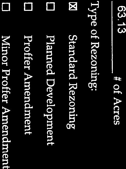
1 November 12, 2014 MEMORANDUM TO: FROM: Stafford County Planning Commission J Board of Supervisors Jack R. Cavalier, Chairman Gary F. Snellings, Vice Chairman Meg Bohmke Paul V. Milde, III Laura A. Sellers Cord A. Sterling Robert Bob Thomas, Jr. Anthony J. Romanello, ICMA CM County Administrator 2 SUBJECT: ATTACHMENTS: RC ; Reclassification; Winding Creek 1. Location Map 2. Application and Related Materials 4. Proposed Proffer Statement 5. Proposed Ordinance and Resolution 3. Generalized Development Plan ISSUE: The Planning Commission is to consider a request for a Reclassification from the A-1, Agricultural Zoning District to the R-1, Suburban Residential Zoning District to allow for a higher density subdivision on Assessor's Parcels 29-4 and 29-5C. BACKGROUND: Location: Election Districts: Applicant: Agent: Property Owner: Intersection of Winding Creek Road and Embrey Mill Road Garrisonville and Rock Hill Winding Creek Owner LLC 1256 Welton Court Centreville, Virginia Mr. Charles W. Payne, Jr. Hirschler Fleischer 725 Jackson Street, Suite 200 Fredericksburg, VA Earl F. Musselman Trust 200 Chatham Heights Road Fredericksburg, Virginia Courthouse Road, P. O. Box 339, Stafford, VA Phone: (540) Fax: (540)
 October 21, 2014 (Complete Application) Advertisement Dates: October 28, 2014 and November 4, 2014 Time Limit: February 10, 2015 Staff Project Manager: Erica H.")
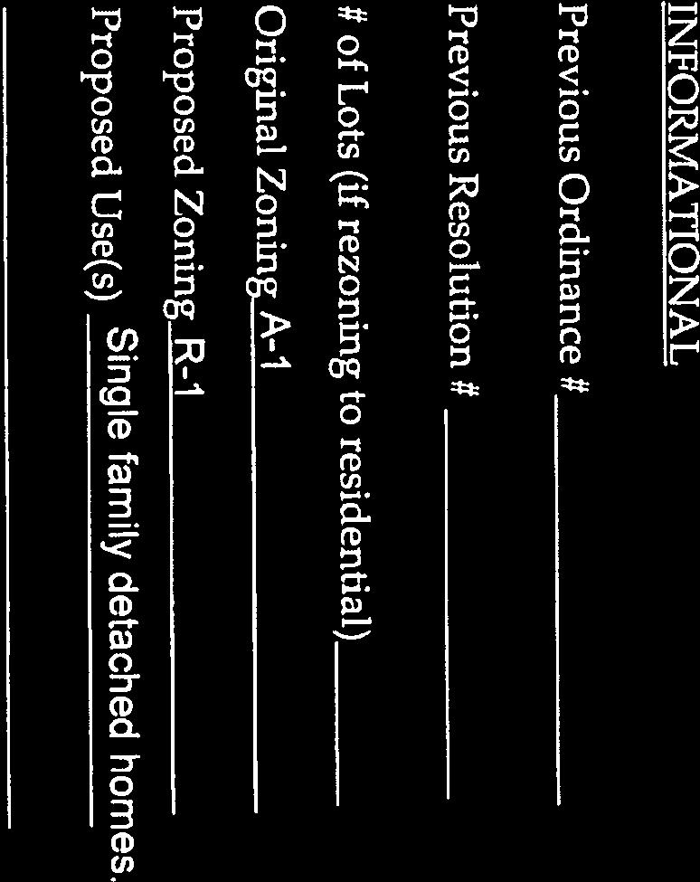
2 Memorandum to: Stafford County Planning Commission November 12, 2014 Page 2 of 15 Current Use: Proposed Use: Application Date: Undeveloped 97 Lot Single-Family Residential Subdivision May 12, 2014 (Original Submission) October 21, 2014 (Complete Application) Advertisement Dates: October 28, 2014 and November 4, 2014 Time Limit: February 10, 2015 Staff Project Manager: Erica H. Ehly, AICP Assessor s Parcels: 29-4 and 29-5C Area: Comprehensive Plan: acres Suburban (Future Land Use)
 Suburban A-1, Agricultural Religious Institution South A-1, Agricultural Single-Family Residential Suburban East R-1, Suburban")
3 Memorandum to: Stafford County Planning Commission November 12, 2014 Page 3 of 15 Zoning Classification: A-1, Agricultural Abutting Properties: Location Zoning Existing Use Comprehensive Plan North PD-1, Planned Development 1 Residential Subdivision (Park Ridge) Suburban A-1, Agricultural Religious Institution South A-1, Agricultural Single-Family Residential Suburban East R-1, Suburban Residential Residential Subdivision (Autumn Suburban A-1, Agricultural Ridge) Single-Family Residential West R-1, Suburban Residential Residential Subdivision (Berkshire ) Suburban Utilities: Transportation: The property is located within the Urban Services Area, and is served by the public water and sewer system. The proposed development of 97 single-family homes would create demand for 23,280 gallons per day (gpd) for water and 29,100 gpd for sewer; this is an increase of 18,240 and 22,800 gpd respectively, over the demand of by-right development of approximately 20 dwelling units. Winding Creek Road is a two-lane undivided urban local roadway with an estimated traffic volume of 2,100 vehicle trips per day (VPD) between Flatford Road and Embrey Mill Road, according to Virginia Department of Transportation (VDOT) 2013 Daily Traffic Volume Estimates. The Comprehensive Plan identifies a future upgrade to Winding Creek Road between Courthouse Road and Shelton Shop Road to an urban two lane major local standard. The proposed development will contribute 1,021 VPD, which is an increase of 771 VPD
4 Memorandum to: Stafford County Planning Commission November 12, 2014 Page 4 of 15 compared to the 250 VPD of by-right development of approximately 20 singlefamily homes. Stormwater Management: Schools: Parks and Recreation: Proffer Valuation: The development of the parcel as a 97 lot residential subdivision will result in approximately acres of impervious area, whereas by-right development within the zoning district would likely result in 4.5 acres of impervious area. The proposed development would generate approximately 64 primary and secondary students utilizing the countywide average of 0.66 students per unit, or 126 students utilizing the new neighborhoods generation rate of 1.3 students per unit; by-right development would generate 13 and 26, respectively. Students generated by this development will attend Winding Creek Elementary, Rodney Thompson Middle and Colonial Forge High Schools. The applicant has identified a cash proffer amount of $14, per unit for Schools. Utilizing the Parks & Recreation Level of Service of 20-acres per 1,000 residents, the proposed development will create a demand for 5 acres of land for parks and recreation; by-right development would generate demand for approximately one acre. The applicant has not identified a cash proffer amount for the Parks & Recreation category; however, the proposal includes the dedication of acres of land for County recreational purposes. A proffer statement has been submitted with this application. Monetary proffers include per unit contributions of $27,010 for School, Transportation, and Fire & Rescue facilities. This amount is below the guideline of $46,925 for single-family homes and does not include amounts for Parks & Recreation, Library, and General Government categories. COMMENTS: The applicant is requesting reclassification from the A-1, Agricultural Zoning District to the R-1, Suburban Residential Zoning District to allow for a higher intensity residential development on Assessor's Parcels 29-4 and 29-5C, which total acres. The current zoning classification of A-1, Agricultural, would allow approximately 20 single-family homes on 3-acre lots; the reclassification to the R-1, Suburban Residential Zoning District would result in approximately 94 residential lots on the property. The applicant has concurrently submitted an application for a conditional use permit for additional density under the cluster provisions, which will result in a total of 97 single-family units. Existing Conditions The acre subject property is located at the intersection of Winding Creek and Embrey Mill Road. The property is surrounded by single-family residential uses. An existing underground utility easement transects the southern portion of the property; Winding Creek Road transects the western portion of the property; and Austin Run transects the northern portion of the property from west to east.
 buffer.")
5 Memorandum to: Stafford County Planning Commission November 12, 2014 Page 5 of 15 Site - Aerial Location The property includes areas of medium-aged mixed deciduous and coniferous forest and Austin Run flowing through the northern portion, which is protected by a Critical Resource Protection Area (CRPA) buffer. Major portions of the property are dominated by relatively young regrowth in which Virginia pine trees are prevalent. There are areas of mature hardwood forest, consisting of white oak, southern red oak, American beech, and hickory trees with diameter-at-breast-height (DBH) greater than 12 inches. These areas will remain predominantly within the designated open space areas as depicted on the Generalized Development Plan. A Threatened and Endangered Species Review, dated April 25, 2014, and a Small Whorled Pogonia Survey, dated July 31, 2013, were completed for the subject property, the result of which was the determination that the potential of occurrences or impacts related to listed species is considered low. Areas of potential suitable habitat were identified during the survey of the proposed development site for the small whorled pogonia. This small plant is an orchid that is a State-listed endangered and Federallisted threatened plant species. However, there were no individuals or colonies that were observed on or immediately adjacent to the property during the survey. Additionally, the dwarf wedgemussel is listed as having the potential to occur within the area of Austin Run located on the property; however, given the existing habitat conditions of Austin Run and tributaries, specifically the streambed substrate, it is highly unlikely that suitable habitat exists on the property.
, which is above the 1.5 du/ac maximum for a cluster subdivision in the R-1 Zoning District.")
6 Memorandum to: Stafford County Planning Commission November 12, 2014 Page 6 of 15 Generalized Development Plan The Generalized Development Plan (GDP), dated October 21, 2014, depicts the proposed design of the site to include 97 lots at a density of 1.54 dwelling units an acre (du/ac), which is above the 1.5 du/ac maximum for a cluster subdivision in the R-1 Zoning District. The applicant has submitted an application for a Conditional Use Permit to allow for additional density. The parcel is acres in size and, at the time this application was submitted, the density calculation utilized the gross acreage of the site. The proposed development identifies acres, or 57 percent of the site, as common open space, well above the 30 percent minimum requirement. All residential units will be located on the portion of the property to the east of Winding Creek Road and build-out is expected to occur by Generalized Development Plan The applicant has proffered the construction of sidewalk along Winding Creek Road and a crosswalk connecting the east and west side of Winding Creek Road to provide pedestrian access to the recreational area, consistent with Comprehensive Plan Policy , which states that development proposals should establish sidewalks to connect local neighborhoods with activity centers. Staff recommends that these are clearly depicted on the GDP. The proposed development will result in the clearing of acres of the acres of forested area. Staff recommended that existing tree canopy be protected and/or restored to the greatest extent possible. Policy of the Comprehensive Plan states that the maximum amount of tree cover on developed and developing sites shall be protected or restored, and also with Section 200 of the Design and Construction Standards for Landscaping, Buffering and Screening (DCSL), which states that buffer yards are intended

7 Memorandum to: Stafford County Planning Commission November 12, 2014 Page 7 of 15 to recreate or preserve native woodlands. In addition to the forested area encompassed within the common open space areas, the proposal includes a 20-foot buffer consisting of a double row of evergreen trees between the residential lots and the right-of-way along Winding Creek Road as a condition of the conditional use application. Additionally, the applicant has agreed to the provision of a tree in the rear yard of each lot. Staff recommends that the GDP clearly reflect this additional landscaping. The GDP identifies that the proposed development will have two access points to Winding Creek Road. Secondary access will be provided via an inter-parcel connection through the development to Fireberry Boulevard, within the Autumn Ridge neighborhood. Street Access Points Internal roadways will be designed to potentially provide future access through properties to the north and east of the property. In addition, the Traffic Impact Assessment shows that 2021 traffic conditions at build-out will be adequately accommodated at the study intersections with no need for offsite improvements. The open space parcels encompass a Virginia Dominion Power easement, which transects the southern portion of the property, and jurisdictional wetlands. The GDP shows minor impacts to wetlands and streams that are not protected by a CRPA buffer, because they are not contiguous to or connected by surface flow to a perennial stream, however, these will be within the maximum thresholds under the state permitting process.

8 Memorandum to: Stafford County Planning Commission November 12, 2014 Page 8 of 15 VEPCO Easement The Comprehensive Plan identifies a future upgrade to Winding Creek Road between Courthouse Road and Shelton Shop Road to an urban two lane major local standard. The upgraded design would provide safety measures such as wider travel lanes, a five-foot shoulder, a four-foot shoulder and a five-foot sidewalk and is not necessarily related to providing additional capacity. Urban Two Lane Major Local Standard
9 Memorandum to: Stafford County Planning Commission November 12, 2014 Page 9 of 15 The applicant is dedicating 0.84 acres of right-of-way along both sides of Winding Creek Road to achieve 60 feet in width, but has not agreed to upgrade the road to the future design standard as recommended by staff. The TIA (dated May 9, 2014) identifies the intersections on Winding Creek Road operating at an LOS A and B in 2021 and does not show a need for an increase to capacity. The TIA identifies an increased delay of approximately 5 seconds and an additional 13 feet in queuing for the intersection of Eustace Road, Northampton Boulevard and Hampton Park Road, which will continue to operate at a Level of Service (LOS) E. The Comprehensive Plan states that the LOS of the existing network should be maintained at LOS C or better. It is further stated that where LOS C cannot be attained, development applications will be evaluated by non-degradation and offsetting impact policies as described on Page 4-10 of the Comprehensive Plan: The Non-Degradation Policy requires applicants to ensure that the transportation system affected by the application performs no worse after the project is developed than it would otherwise. This approach is primarily a performance based approach which requires applicants to provide improvements or other guarantees to maintain certain performance levels. The Offsetting Impact Policy requires the applicant to contribute to transportation improvements proportional to the trips generated by the project and the amount of capacity required to accommodate those trips. The applicant has proffered $2, per unit toward Transportation facilities. In order to be consistent with these policies, staff recommended that the applicant consider the proffer guidelines recommendation of $16,754 per residential unit and direct the transportation proffers toward mitigating intersection improvements, such as a westbound right-turn lane, a signal or a roundabout. The applicant may also prepare a cost estimate for an intersection improvement project and proffer the proportionate amount toward the project or construct the project as an in-kind contribution. Proffers The applicant will be submitting a revised proffer statement incorporating most of the conditions that are related to the conditional use permit application, following discussions with staff. In addition, following proffers have been submitted establishing standards for the development of the site and improvements to be made to mitigate the impacts of the development. The proffers propose to: limit development to 97 single-family detached residential units; provide a commitment to a general type, character and quality of architectural design, details and materials of the units and proposed entrance feature, including: (a) The front elevation of 75% of the Units will consist of a minimum of 60% brick, natural stone, or cultured stone (excluding doors, windows and garages). All homes will include beaded vinyl and applicant will offer fiber cement siding as an option to buyers. (b) The side elevation facing the street of a Unit on a corner lot will have at least two operable windows. (c) All Units will have brick or stone to grade on any side facing a street (including corner lots).
10 Memorandum to: Stafford County Planning Commission November 12, 2014 Page 10 of 15 Architectural Design (d) The same elevation may not be repeated within three Units of each other. For example, for the same elevation to be repeated in close proximity there must be at least three houses with completely different elevations between them, including if the repeated elevation is across the street. (e) All Units will include architectural shingles only at the time of new construction. Thereafter, the homeowner s association, as described below, will need to approve shingle replacements. (f) All Units will include pitched roofs symmetrically sloped no less than 5:12, except that porches and attached sheds may be no less than 2:12 and all Units will avoid continuous roof planes on the front side of dwellings by incorporating gables as depicted on the renderings. (g) An entrance monument out of brick or stone utilized in the development. The client has attached a rendering which reflects the general architectural features and materials of the entrance sign. require the dedication of 0.84 acres of right-of-way along Winding Creek Road, 60 feet from centerline; require the dedication of 0.78 acres of right-of-way for the potential relocation of Embrey Mill Road; require the construction of a sidewalk along Winding Creek Road; require the placement of a crosswalk connecting the east and west sides of Winding Creek Road; provide for an inter-parcel connection to Fireberry Boulevard; require, for lots located within the CRPA buffer, the installation of signage and required plant material, in addition to the recordation of related deed restrictions, all by the developer and the provision of notification to the Zoning Administrator when completed, prior to the issuance of certificate of occupancy; offer as an option to home purchasers of fire sprinkler systems within the units; require a Phase I Cultural Resource Study to be completed if historical artifacts are discovered during site development, in addition to a subsequent Phase II study, if recommended in Phase I; and require cash contributions toward School, Transportation, and Fire & Rescue in the total amount of $27, per single-family detached dwelling unit. The applicant has proffered to a provide a commitment to a general type, character and quality of architectural design, details and materials of the units and has included the following examples as an attachment to the proffer statement:
 identifies this site as being within the Suburban future land use designation.")


11 Memorandum to: Stafford County Planning Commission November 12, 2014 Page 11 of 15 Comprehensive Plan The Comprehensive Plan (Plan) identifies this site as being within the Suburban future land use designation. The proposed development is generally consistent with the recommended development standards for the designation as described in the Plan. The average lot size within the proposed development of 0.18 acres is consistent with the cluster design, which permits a smaller lot size to cluster development away from open space areas, although it is less than the typical ¼ to ½ acre lot size consistent with the suburban scale of development of single-family detached dwelling units. The site is surrounded by developed parcels to the north, east and south. The proposed development will have direct access to Winding Creek Road, an urban local roadway which connects to Embrey Mill Road and Walpole Street. This is consistent with infill development as described in the Plan to be located in the proximity of the established communities in the northern and southern areas of the County and in close proximity to major existing or planned transportation networks. The proposed development is consistent with the Plan in that it reflects a density of 1.54 du/ac; includes pedestrian connectivity to Open Space Parcel E, which will be dedicated to the County for recreational purposes; and includes 57 percent open space. Development densities within the Suburban future land use designation should not exceed 3 du/ac for residential development; sidewalks and pedestrian trails should be located within neighborhoods and provide access between residential and nonresidential uses; and developments are encouraged to preserve 25 to 50 percent of the site for a combination of natural and usable open space. Preservation of unique or sensitive environmental features should be incorporated into development design. The Plan states that the use of innovative development techniques, including clustering, are encouraged to allow for development with minimal impact on sensitive natural resources. The lots are predominantly located outside of the CRPA buffer; mature forest is located in the common open space area; and the jurisdictional wetlands are located on Open Space Parcel E.
12 Memorandum to: Stafford County Planning Commission November 12, 2014 Page 12 of 15 Fiscal Impacts The Neighborhood Development Standards identify specific architectural guidelines for all new residential development. The applicant has proffered a commitment to a general design type, as illustrated in Exhibit A of the proffer statement. The examples appear consistent with the standards related to variations in roof lines and the consistency of mass and scale within the development; front porches are also shown. Sidewalks within the subdivision contribute to an interconnected network of sidewalks. The applicant has included additional specificity within the proffer statement addressing building materials and the treatment of unadorned wall planes; conditions related to the conditional use permit address the foundation landscaping in front of homes and a minimum driveway length of 20 feet. Additionally, the Plan states that buffering should be required along major arterial and collector roads to limit road noise in residential areas; the applicant is proposing the minimum 20-foot buffer of a double row of evergreen trees between residential lots and Winding Creek Road. The Comprehensive Plan identifies a future upgrade to Winding Creek Road between Courthouse Road and Shelton Shop Road to an urban two lane major local standard. The applicant is dedicating the right-of-way to achieve 60 feet in width, but has not committed to upgrading the roadway within the property line. The applicant has submitted a fiscal impact analysis (FIA) of the proposed project, prepared by S. Patz and Associates, Inc., dated May Generally, the FIA concludes that for purposes of complete buildout, this project will generate (based on 2014 constant dollars) a net benefit annually of $244,230, when utilizing the new neighborhoods student generation rate of 1.3, or of $546,000, utilizing the County average generation rate of Monetary Proffers The applicant is proffering cash contributions of $27, per single-family dwelling unit to offset the anticipated demand upon capital facilities; this amount is less than the County monetary proffer guidelines of $46,925 per single-family dwelling unit. Proffers are being proposed specifically for Schools, Transportation, and Fire & Rescue categories. Cash contribution amounts have not been identified for the Parks & Recreation, Library, and General Government categories. The applicant is proposing in-kind proffers totaling $1,057,249.09, including the dedication of right-ofway along Winding Creek Road, with a stated value of $74,341.98; the dedication of 0.78 acres of rightof-way for the future relocation of Embrey Mill Road, if necessary; the construction of a sidewalk along of Winding Creek Road and a crosswalk; and the dedication of acres of land for County recreational purposes. The per unit value of these proffers equate to $10,900.
13 Memorandum to: Stafford County Planning Commission November 12, 2014 Page 13 of 15 EVALUATION CRITERIA: Section of the Zoning Ordinance lists 12 criteria to be considered at each public hearing for reclassification. A summary of the criteria are as follows: 1. Compliance of the request with the stated requirements of the district or districts involved - The request is in compliance with the stated requirements of the R-1 Zoning District. 2. The existing use and character of the property and the surrounding property - The property is currently vacant. The site contains forested area, wetlands and CRPA. Land surrounding the site is developed for residential uses. 3. The suitability of the property for various uses - The conditions of the site make it suitable for residential uses; special consideration has been given to the sensitive natural resources that are present on the site, in accordance with the Comprehensive Plan. 4. The trend of growth and development in the surrounding area - The site can be qualified as infill development, surrounded by single-family residential uses. 5. The current and future requirements of the county for land - The proposed residential development takes into account the future upgrades to Winding Creek Road by dedicating the required right-ofway; approximately 10 acres of land is being dedicated for County recreational purposes. 6. The transportation requirements of the project and the county, and the impact of the proposed land use on the county transportation network - The proposed development will contribute to an increased delay of approximately 5 seconds and an additional 13 feet in queuing for the intersection of Eustace Road, Northampton Boulevard and Hampton Park Road, which will continue to operate at a Level of Service (LOS) E. 7. Requirements for schools, parks, recreational lands and facilities, and other public services, potentially generated by the proposed classification - The proposal would increase the impact on parks, recreational lands and schools, and other public facilities. The monetary proffers include per unit contributions of $27, for Fire & Rescue, School and Transportation facilities, which is below the County monetary proffer guidelines of $46,925 per single-family dwelling unit. Additionally, the monetary proffers do not include a per-unit contribution for Library, General Government, and Parks & Recreation categories, though the proposal does include the dedication of acres of land for County recreational purposes, with an in-kind proffer value of $913, The conservation of property values in the surrounding area - The proposed subdivision would not have a negative effect on any property values in the surrounding area. The development is compatible with the surrounding uses and is consistent with the surrounding residential form of development. 9. The preservation of natural resources and the impact of the proposed uses on the natural environment - The site contains sensitive natural resources including forested area, wetlands and CRPA. The proposal takes measures to protect and/or restore the large amount of tree canopy
14 Memorandum to: Stafford County Planning Commission November 12, 2014 Page 14 of 15 proposed for removal and has proffered to place appropriate signage on lots within the CRPA buffer to further protect that area. 10. The most appropriate use of land - The Land Use Plan recommends this area as Suburban area. The proposed uses and development pattern meets the intent in the Comprehensive Plan for Suburban areas, including the types of dwellings, density, proximity to major existing or planned transportation network, proposed pedestrian interconnectivity and amount of open space. 11. The timing of the development of utilities and public facilities and the overall public costs of the development - The area is served by existing water and sewer utilities; the applicant will be required to install any required transportation and utility improvements required for the project at their expense. The development will generate a need for additional public services, which are partially mitigated through monetary proffers. 12. The consistency, or lack thereof, of the proposed rezoning with the Stafford County Comprehensive Plan as in effect at that time - The proposal is generally consistent with the Comprehensive Plan recommendations regarding the Suburban land use recommendations and future transportation needs. The proposal utilizes the cluster design in order to avoid more than minimal impacts to wetlands, the stream channel and CRPA, a twenty-foot buffer between the residential lots and right-of-way along Winding Creek Road to mitigate noise impacts from the a two-lane undivided urban collector roadway, and includes protection for natural resources, in addition to fractional restoration of tree canopy through additional landscaping material in accordance with the environmental protection policies in the Plan. However, staff has requested that the applicant upgrade Winding Creek Road in accordance with the Comprehensive Plan. SUMMARY OF POSITIVE AND NEGATIVE FEATURES POSITIVE: 1. The proposal is consistent with the established development pattern in the vicinity. 2. The proposed uses and development pattern meets the intent of the Comprehensive Plan, including land use, transportation, building design, pedestrian connectivity and open space recommendations. 3. The dedication of right-of-way would accommodate planned transportation improvements. 4. Monetary proffers exceed the Fire & Rescue category recommendation. NEGATIVE: 1. Monetary proffers do not include a per-unit contribution to mitigate impacts to Parks, Library, or General Government and provide amounts that are below the recommendations for Transportation. 2. The applicant has not proposed to upgrade Winding Creek Road to an urban two lane major local standard.
15 Memorandum to: Stafford County Planning Commission November 12, 2014 Page 15 of Potential impacts to the intersection of Eustace Road, Northampton Boulevard and Hampton Park Road, which will continue to operate at a Level of Service (LOS) E. RECOMMENDATION Staff believes that the positive aspects of the proposal outweigh the negative factors and recommend approval of the application for reclassification of Assessor s Parcel 29-4 and 29-5C, pursuant to Ordinance O Staff recommends that the Planning Commission consider the following recommendations in response to issues raised by staff: 1. Include a proffer to upgrade Winding Creek Road to an urban two lane major local standard within the property; 2. Provision of per-unit contributions closer to the proffer guidelines overall, with additional consideration to the proffer guidelines recommendation of $16,754 per residential unit and direct the transportation proffers toward mitigating intersection improvements, such as a westbound right-turn lane, a signal or a roundabout; an alternative option could include the preparation of a cost estimate for an intersection improvement project and submitting the proportionate amount toward the project or construct the project as an in-kind contribution as part of the proffer statement; and 3. Include without compensation in Proffers #4.a. and 4.b., related to the dedication of right-ofway. 4. Clarify, on the GDP, the location of the sidewalk to be constructed along Winding Creek Road. JAH:ehe Attachments (5)
16 Property & Location NUGENT DR APPLING RD WALPOLE ST WATERMILL CT EASTER DR ^_ MELODY LN WINDING CREEK RD LIVE OAK LN EUSTACE RD BOXELDER DR RC RECLASSIFICATION WINDING CREEK Attachment 1 Page 1 of 1 NUGENT DR WALPOLE ST NOAHS CT MT ARARAT LN BLESSED CT EASTER DR 29-4 WINDING CREEK RD Feet , SITE FIREBERRY BLVD 29-5C WET ROCK LN EMBREY MILL RD LIVE OAK LN BURNINGBUSH CT EUSTACE RD Stafford County Department of Planning & Zoning P.O. Box 339 Stafford, VA (540)

17 Page 1 of 83

18 Page 2 of 83


19 Page 3 of 83


20 Page 4 of 83


21 Page 5 of 83


22 Page 6 of 83


23 Page 7 of 83


24 Page 8 of 83


25 Page 9 of 83


26 Page 10 of 83

27 Page 11 of 83


28 Page 12 of 83


29 Page 13 of 83


30 Page 14 of 83

31 Page 15 of 83


32 Page 16 of 83


33 Page 17 of 83


34 Page 18 of 83

35 Page 19 of 83

36 Page 20 of 83
37 Page 21 of 83

38 Page 22 of 83
39 Page 23 of 83 FIRST ADDENDUM IMPACT STATEMENT COUNTY CASE NO. RC COUNTY CASE NO. CUP WINDING CREEK Applicant: Property Owners: Property: Winding Creek Owner, LLC TM 29-4: John J Musselman, Trustee of the Earl F. Musselman Trust; and TM 29-5C: John J Musselman, Trustee of the Earl F. Musselman and John Jeffrey Musselman, Jenifer Jo Musselman, Jodi Janelle Schopfel and William Gerald Musselman Tax Parcels 29-4 and 29-5C and as shown on the GDP Rezoning Request: From A-1 to R-1 Project Name: CUP Request: Winding Creek Cluster subdivision in the R-1 District Date: August 26, 2014 File No. RC CUP The following information is being provided as an addendum to that certain impact statement dated May 12, 2014, and submitted with the application material for the above referenced matters and is being submitted as supplemental material to the rezoning and conditional use permit applications referenced herein. Impact Analysis 1. Current capacity of and anticipated demands on highways, utilities, storm drainage, schools and recreational facilities. For purposes of comparing various impacts depending on whether rezoned to R-1, CUP cluster or by right, please note the following analysis: 1
40 Page 24 of 83 A. Highways. (i) R-1 Rezoning Impact: Under a R-1 rezoning, the Applicant could develop 94 single family detached units (subject to significant reduction if unable to develop acres on west side of Winding Creek Road). The 94 units would generate 992 new trips per 24 hour period. Of these trips, 76 would occur in the AM peak hour and 99 would occur in the PM peak hour. (i) Cluster Impact: The proposed clustered plan generates 97 single family units at a density of 1.54 units per acres vs. 142 units or 2.25 units per acre as allowed under the cluster ordinance. Based on the Traffic Impact Analysis, dated May 9, 2014, prepared by Bowman Consulting (the TIA ), the project will generate 1,021 new trips per 24 hour period. Of these trips, 78 new trips will occur during the AM peak hour and 102 new trips will occur during the PM peak hour. These traffic volumes do not exceed traffic thresholds outlined in of the Code of Virginia and the Virginia Traffic Impact Analysis Regulations (24 VAC ), which are commonly referred to as Chapter 527 requirements. Exhibit A attached hereto summarizes potential trip generation under multiple development scenarios. Primary access to the Property is proposed via one full movement entrance along Winding Creek Road. Secondary access will be provided via an inter-parcel connection through the development to Fireberry Boulevard. Internal roadways will be stubbed to potentially provide future access through properties to the north and east of the Property. In addition, the TIA shows that 2021 traffic conditions with the build out of the Property will be adequately accommodated at the study intersections with no need for offsite improvements. We are not aware of any specific traffic volume capacity based on the classification by either the County or VDOT. Classification is based on the function and character of the road rather than the volume of traffic it could (or should) carry. For instance, a six-lane divided urban roadway designed to serve numerous business while carrying 30,000 vehicles per day could have a lower functional classification than a two-lane rural road carrying 8,500 vehicles per day and designed to carry traffic between regional destinations. Stafford County s Comprehensive Plan calls for development applications to meet a Level of Service C or better or to show non-degradation. The TIA shows that all studied intersections will operate at LOS C or better with the exception of the westbound approach to the Eustace Road/Northampton Blvd/Hampton Park Road intersection which operates at LOS E during the PM peak hour under existing conditions. The LOS E 2
41 Page 25 of 83 occurs for the westbound through-right movement at the Eustace Road/Northampton Boulevard/Hampton Park Road intersection during existing, background, and total future scenarios. The Applicant s proposal does not add any traffic to the westbound through-right movement. Further, under Total Future 2021 conditions, the site generated traffic comprises 3.4% and 3.2% of the overall intersection traffic during the AM and PM peak hours, respectively. The analysis shows that the approach would continue to operate at LOS E in 2021 with or without the buildout of the site. Therefore, the application meets Stafford County s Comprehensive Plan requirement of LOS C or nondegradation. To offset any alleged impacts the Applicant will dedicate 60' of right-ofaway along Winding Creek Road at a value of $74, and not develop on the west side of Winding Creek Road, as shown on the GDP, which shall reduce traffic impacts. The Applicant will also dedicate 0.78 acres of right of way at a value of $69, for the relocation of Embrey Mill Road. Additionally, the Applicant will construct a sidewalk along Winding Creek Road and a crosswalk connecting the east and west sides of Winding Creek Road, as shown on the GDP. Such improvements are not otherwise required for the purpose of this development but are intended to be pedestrian amenities. (iii) By Right Impact: If the Property is developed as a cluster subdivision under the existing A-1 zoning, the maximum traffic intensity would occur with build out of approximately 21 single family residential dwelling units. Pursuant to a by-right clustered development, the aggregate new daily trips would be approximately 771 per 24 hour period, 54 new trips during the AM peak hour, and 76 new trips during the PM peak hour. B. Utilities. The project is located within the County s Urban Service Area and will have access to existing 12 water and sewer lines located in the Winding Creek Road right of way. (i) R-1 Rezoning Impact: With a rezoning, the proposed project could generate 94 single family detached units (subject to significant reduction if unable to develop the acres on west side of Winding Creek Road). Under this scenario, the anticipated daily demand for water and sewer follows: Water - 94 lots x 240 gpd/lot = 22,560 gpd Sewer - 94 lots x 300 gpd/lot = 28,200 gpd (ii) Cluster Impact: As noted above, the proposed rezoning is located within the County s Urban Service Area and has access to public water and sewer. The proposed clustered plan generates 97 single family units at 3
42 Page 26 of 83 a density of 1.54 units per acres vs. 142 units or 2.25 units per acre as allowed under the cluster ordinance. It is our opinion that the proposed project will have minimal impact on utility demands. Existing water and sewer lines are located in the Winding Creek Road right of way. These utility lines and applicable water and sewer treatment facilities appear to have available capacity, or the reasonable ability to be upgraded to provide adequate capacity. Public Water: This project is located in the Garrisonville Zone. There is an existing 12 DIP water line in the Winding Creek Road right of way. Onsite water lines will generally be constructed along the proposed roads within the development creating loops and networks throughout the Property. The anticipated daily demand for water is as follows: 97 lots x 240 gpd/lot = 23,280 gpd Sewer: This project is located in the Austin Run sewer service area. An existing 12 sewer line is located in the Winding Creek Road right of way. Onsite sewer lines will generally be constructed along the proposed roads within the development creating loops and networks throughout the Property. The anticipated daily demand for sewer is as follows: 97 lots x 300 gpd/lot = 29,100 gpd (iii) By-Right Impact: If the Property is developed as a cluster subdivision under the existing A-1 zoning, the maximum traffic intensity would occur with build out of approximately 21 single family residential dwelling units. Under this scenario, the anticipated daily demand for water and sewer follows: Water - 21 lots x 240 gpd/lot = 5,040 gpd Sewer - 21 lots x 300 gpd/lot = 6,300 gpd C. Storm Drainage. (i) R-1 Rezoning Impact: As noted above, the project rezoned under R-1 could generate 94 single family detached units (subject to significant reduction if unable to develop the approximately acres on west side of Winding Creek Road). If the Property is developed under this scenario using the same road layout as depicted on the GDP, approximately 17.55% of the Property would consist of impervious surface, which is comparable to the impervious surface depicted on the GDP and described below. Since both an R-1 development and the proposed development would be subject to the same stormwater management regulations, both the R-1 and proposed developments would result in the same postdeveloped flow requirements and would have minimal impacts downstream. 4
43 Page 27 of 83 (ii) Clustered Development: The proposed clustered plan generates 97 single family units at a density of 1.54 units per acres vs.142 units or 2.25 units per acre as allowed under the cluster ordinance. The proposed development will incorporate low impact development techniques as well as conventional stormwater management techniques in order to reduce the post-developed runoff from the site to pre-developed levels in accordance with County and State requirements. The GDP depicts four stormwater management facilities, and projects that approximately 17.89% of the Property will consist of impervious surface, which is a relatively low percentage for a subdivision of this size. The proposed development will have minimal impacts downstream of the Property. (iii) By Right Impact: If the Property is developed as a cluster subdivision under the existing A-1 zoning and the same road layout as depicted on the GDP is used, approximately 7.19% of the Property would consist of impervious surface. Since both a by-right development and the proposed development would be subject to the same stormwater management regulations, both the by-right and proposed developments would result in the same post-developed flow requirements and would have minimal impacts downstream. D. Schools. (i) R-1 Rezoning Impact: As noted above, a R-1 rezoning of the property could generate 94 single family detached units (subject to significant reduction if unable to develop the acres on west side of Winding Creek Road). Applying the below calculations, there could be a student pupil generation ranging from 62 to 122 in total from the project. (ii) Clustered Impact: The proposed clustered plan generates 97 single family units at a density of 1.54 units per acres vs. 142 units or 2.25 units per acre as allowed under the cluster ordinance. The proposed clustered plan will generate sufficient revenue to pay for annual operating impacts, all as more particularly provided in the FIA. It is estimated that the project will generate approximately 64 to 127 school aged pupils (depending on formula applied of 0.66, which is the per student ratio provided by the County s school system, or 1.06, which is the average median number between the school system number and commissioner of revenue number, or 1.3 which is the average for new developments provided previously by the County s Commissioner of Revenue) as provided in the attached FIA. Please also note that based on the above calculations, a 142 unit (as fully clustered) project would generate 94 to 185 students. As noted above, we believe the Applicant s project will generate adequate net tax revenue (onsite and off-site) to pay for annual operational impacts 5
44 Page 28 of 83 to the County s schools and additional dollars towards necessary capital improvements. The Applicant will also provide cash proffers in the amount of $1.4 million dollars to offset any school capital impacts in the relevant school attendance zone area of the Property. This amount calculates to approximately $14,433 per unit. Please review additional details in the attached and revised proffer statement. (iii) By Right Impact: A by-right development would result in approximately 21 dwelling units or approximately 14 to 28 school aged students without the benefit of any proffers for school improvements. Based on the County s current proffer guidelines, this could have an capital cost impact of $293,986 to $587,972. In addition, depending on the type of home constructed on the site by right, the County could further suffer a deficit from an annual operational cost impact if the value of the home and its occupants do not generate adequate tax revenue. E. Recreational Facilities. (i) Impact of R-1 Zoning: As noted above, a R-1 rezoning of the property could generate 94 single family detached units (subject to significant reduction if unable to develop the acres on west side of Winding Creek Road). Pursuant to the County s guidelines under the Comp Plan, the level of service methodology for parks is 20 acres per 1000 people. It is estimated by the County that 94 units will generate approximately persons, which equates to 24.4% of said 20 acres or 4.88 acres. (ii) Cluster Development: The proposed cluster development will generate 97 single family detached units or (based on above said county guidelines) approximately 252 persons. This equates to a level of service need of approximately 5 acres. As noted above, the GDP (labeled as Parcel E on the attached GDP) includes acres of open space west of Winding Creek Road, which will serve as a dedicated recreation area valued at $913, Additionally, the GDP provides for a sidewalk system that can be connected to the surrounding residential neighborhoods. Please review additional details in the attached and revised proffer statement. (iii) By-Right Impact: A by-right development would generate approximately 21 dwelling units without the benefit of any proffers for park improvements as provided in the attached proffer statement. Said development will require 1.1 acres of park area to meet County level of service requirements. 2. Fiscal Impact. The FIA concludes that for purposes of complete build-out, the project will generate (based on 2014 constant dollars) approximately $1,176,170 in gross annual tax revenues for the County with a net annual tax revenue benefit of $357,390, all as provided more particularly in the attached FIA. In addition 6
45 Page 29 of 83 and as noted above, the FIA applied three different school aged generation numbers, including 0.66 (the school system s county wide average), 1.06 (median number based on recent developed projects) and 1.3 (school age pupil number deriving from the County s commissioner of revenue), all as provided in the FIA. In applying these three variations of school aged impact numbers, the annual net tax revenue surplus generated by the project is projected at $244,230 to $546,000. In essence, the project will pay for itself as applied to the costs of annual county services, plus generate additional tax dollars for use towards necessary county capital improvements. The FIA s assumptions are based on several factors, including the County s current tax rate, budget and CPI projections, County estimates for the costs for public services, market business activity (including BRAC, courthouse and hospital industry expansion) and conditions, and County demographics, all as more particularly described in the FIA. 3. Environmental Impact. A Perennial Flow Evaluation and Critical Resource Protection Area (CRPA) Determination study was completed for the Property by Bowman Consulting Group, Ltd. concurrent with a formal Wetland Delineation study, and will be submitted under separate cover to Stafford County for review and approval. As depicted on the GDP, two perennial streams are located on the Property. Austin Run is located at the Property s north end, and an unnamed tributary is located on the Property s east side. The portions of these perennial streams located on the Property total 466 linear feet. All other stream channels located on the Property were determined to be non-perennial, or intermittent. The GDP also depicts approximately 0.62 acre of palustrine forested wetlands located throughout the Property; none of these wetlands were determined to be contiguous to or connected by surface flow to a perennial stream. In accordance with the County s CBPA Policy and Virginia Department of Conservation and Recreation s Resource Protection Areas: Nontidal Wetlands, Guidance on the Chesapeake Bay Preservation Area Designation and Management Regulations, the CRPA boundaries are mapped 100-feet upslope or landward of the surveyed perennial stream boundaries, encompassing approximately 2.8 acres of the Property. As depicted on the GDP, the proposed development will not impact any perennial streams or their associated CRPAs. A threatened and endangered species evaluation was completed by Bowman Consulting Group, Ltd. based on information obtained from the U.S. Fish and Wildlife Service, the Virginia Department of Conservation and Recreation, and the Virginia Department of Game and Inland Fishers for the Property. Additionally, a habitat assessment and field survey for the State-listed endangered and Federal-listed threatened small whorled pogonia (Isotria medeoloides) was conducted on the Property on June 25, Based on existing site habitat conditions and the results of the threatened and endangered species evaluation and small whorled pogonia survey, no adverse impacts to Federal or State-listed threatened and endangered species or critical habitat are anticipated from the development of the Property. 7
46 Page 30 of 83 The proposed development has been designed to avoid disturbance to the CRPA and the majority of the wetlands and streams on the Property, with only minor impacts to environmentally sensitive features proposed. If permanent impacts exceed 0.1 acre of wetlands and/or 300 linear feet of stream channel, appropriate compensatory mitigation will be provided through the purchase of wetland and/or stream credits from approved mitigation bank(s), or as otherwise required by the U.S. Army Corps of Engineers and Virginia Department of Environmental Quality permits. No impacts are proposed to the CRPA, nor are any adverse impacts to threatened and endangered species or critical habitat anticipated. Less than 0.01 acre of land within the CRPA is proposed to be located on subdivision lots; however, these areas are located outside of the buildable areas for the lots, and construction activities on these lots will not impact the CRPA. By-Right Impact: Any development utilizing the same developable area will have roughly the same impacts on environmentally sensitive features. Under the proposed development, acres of the acres of forested area on the east side of Winding Creek Road will be impacted. If the same number of lots were developed under R-1 zoning without a cluster subdivision, the impacted forested area would exceed the acres impacted under the proposed development due to the wider lots required in a conventional subdivision. 4. Impact on Adjacent Properties. Nearby properties are either wooded or developed for cluster subdivisions similar to the Applicant s proposal. The GDP provides for appropriate buffering along shared property lines and rights of way to maintain the rural character of the area and to minimize impacts on adjacent properties. The proposed low density residential development is compatible with and similar to development on surrounding properties and is a positive in-fill residential development plans in accordance with the Comp Plan policies for this area. 5. Historical Sites. This Property has no known archeological or architecturally significant sites. Accordingly, there will be no impact to historical sites under the proposed development. Notwithstanding the foregoing, the Applicant does agree to perform a Phase 1 Archeology Study on the Property if historical artifacts are discovered during development of the Property, and to perform a Phase 2 Archeology Study if required by the said Phase Architectural Features. The Applicant will proffer certain architectural features and materials, all as provided more particularly on the revised proffer statement. In addition, in as much as the Architectural Design Guidelines are general in nature and are intended to provide guidance for the desired appearance of future development every effort has been made to incorporate as many of the guidelines as possible into the architecture shown in the GDP submitted in support of the zoning reclassification. The elevations shown were selected because they offer, at a minimum, a covered portico at the front door. In addition some of the homes shown have a full front porch, which will enhance interaction between the private 8
47 Page 31 of 83 space of the home and yard and the public space of the street and sidewalk. This will naturally promote a sense of community and engender a closer-knit neighborhood. Each home shown is also accented with a reverse gable to provide roofline articulation along the front of the house. The front elevations also feature several varied planes providing interest and avoiding long unadorned wall planes. Each of the different planes features windows, a front portico or is topped by a reverse gable. As many of the guidelines have been incorporated as possible and the combination of proposed architectural features and components will provide the enhanced architecture which is the intent of the guidelines. 9
48 Page 32 of 83 EXHIBIT A See attached Table 1 ITE Site Trip Generation Analysis
49 Page 33 of 83 Table 1 - ITE Site Trip Generation Analysis (1) Weekday Land Use AM Peak Hour PM Peak Hour Daily Land Use Size Units Code In Out Total In Out Total Trips Proposed Winding Creek Development By-Right Single-Family Detached 21 D.U Proposed Zoning (R-1) Single-Family Detached 94 D.U Proposed Development (R-1 Cluster) Single-Family Detached 97 D.U ,021 Difference (Proposed Development - By-Right) Notes: (1) Based on the Institute of Transportation Engineers Trip Generation, 9th Edition.
50 Page 34 of 83 D R A F T For Discussion Purposes Only STAFFORD COUNTY, VIRGINIA PROFFER STATEMENT Applicant: Property Owners: Winding Creek Owner, LLC TM 29-4: John J Musselman, Trustee of the Earl F. Musselman Trust; and TM 29-5C: John J Musselman, Trustee of the Earl F. Musselman and John Jeffrey Musselman, Jenifer Jo Musselman, Jodi Janelle Schopfel and William Gerald Musselman Property: Tax Parcels 29-4 and 29-5C Rezoning Request: From A-1 to R-1 Project Name: Winding Creek Date: October 21, 2014 County File No. RC CUP General Requirements. (a) The following proffers are being made pursuant to Sections and , et al. of the Code of Virginia (1950), as amended, and Section , et seq. of the Stafford County Zoning Ordinance. The proffers provided herein are the only proffered conditions offered in this rezoning application, and any prior proffers to which the Property (as generally defined above and shown on the GDP) may be subject to or previously offered with the Applicant s application or otherwise previously proffered are hereby superseded by these proffers, and further said prior proffers are hereby void and of no further force and effect. In addition and notwithstanding the foregoing, the proffers provided hereunder are conditioned upon and become effective only in the event the Applicant s rezoning application No. RC and associated conditional use permit application CUP are approved (including through applicable appeal periods) by the Stafford County Board of Supervisors (the County ). 1
51 Page 35 of 83 (b) Subject to the terms hereunder, the Property will be developed in accordance with that certain generalized development plan entitled Winding Creek Generalized Development Plan dated May 12, 2014, last revised October 21, 2014, prepared by Bowman Consulting, attached hereto as Exhibit A (the GDP ), which plan includes a clustered development with a maximum of ninety-seven (97) single family detached units ( Units or Unit ). The proffers provided herein apply only to the clustered development plan and applicable density shown on the GDP. (c) For purposes of the final site plan, which will supersede the GDP, proposed parcel lines, parcel sizes, building envelopes and footprints, access points, building sizes, building locations, public road locations, private driveway, road and travel way locations, interparcel connectors, RPAs and wetland areas, utility locations, storm water management facilities, and dimensions of undeveloped areas shown on the GDP may be relocated and/or amended from time-to-time by the Applicant to address final development, engineering, and design requirements and/or compliance with federal or state agency regulations including, but not limited to, VDOT, DEQ, Army Corps of Engineers, etc., and compliance with the requirements of the County s applicable development regulations and design standards manual. 2. Architecture & Materials. For purposes of the proposed development, the architectural design of the Units shall be in general accordance with Sheets 10 & 11of the GDP (the Renderings ). The Renderings are illustrative only and do not depict the final elevations for this project. In this regard, the Renderings depict (i) a commitment to a general type, character, and quality of architectural design, details and materials; and (ii) the general types of architectural and decorative elements and features. In addition, the Units will specifically include the following: (a) The front elevation of 75% of the Units will consist of a minimum of 60% brick, natural stone, or cultured stone (excluding doors, windows and garages). All homes will include beaded vinyl and Applicant will offer fiber cement siding as an option to buyers. (b) The side elevation facing the street of a Unit on a corner lot will have at least two operable windows. (c) corner lots). All Units will have brick or stone to grade on any side facing a street (including (d) The same elevation may not be repeated within three (3) Units of each other. For example, for the same elevation to be repeated in close proximity there must be at least three (3) houses with completely different elevations between them, including if the repeated elevation is across the street. (e) All Units will include architectural shingles only at the time of new construction. Thereafter, the homeowner s association, as described below, will need to approve shingle replacements. 2
52 Page 36 of 83 (f) All Units will include pitched roofs symmetrically sloped no less than 5:12, except that porches and attached sheds may be no less than 2:12 and all Units will avoid continuous roof planes on the front side of dwellings by incorporating gables as depicted on the Renderings. 3. Entrance Features. The Applicant agrees to construct an entrance monument out of brick or stone utilized in the development. The client has attached a rendering which reflects the general architectural features and materials of the entrance sign. 4. Transportation. The Applicant, subject to necessary County and VDOT approvals for the development of the project, agrees to provide the following in-kind transportation proffers, all as generally shown on the GDP: (a) The Applicant agrees to dedicate 0.84 acres of right of way along Winding Creek Road to widen the right of way to a width of sixty feet (60'), all in the areas generally shown on the GDP. This dedication is an in kind proffer with a value of $74, (b) The Applicant agrees to dedicate 0.78 acres of right of way for the relocation of Embrey Mill Road, all in the areas generally shown on the GDP. This dedication is an in kind proffer with a value of $69, (c) The Applicant agrees to construct a sidewalk along Winding Creek Road and a crosswalk connecting the east and west sides of Winding Creek Road, all in the areas generally shown on the GDP. Such improvements are not otherwise required for the purpose of this development and are an in kind transportation proffer. (d) The Applicant agrees to provide an interparcel connection to Fireberry Boulevard, all as shown on the GDP. (e) The monetary value of all transportation improvements (not otherwise required for the development) and/or dedications of right of way, as provided above under this Section 4, are an in kind transportation proffer for purposes of this rezoning with an aggregate value of $143, These in-kind proffers may qualify as a credit toward and offset any transportation impact fees assessed against the Property for purposes of this rezoning, all as may be applicable under state code and County ordinance. Any said dedications and/or improvements shall be provided as part of a final subdivision plan for the Property. 5. Recreation. The Applicant shall dedicate approximately acres of land and labeled as Open Space Parcel E on the GDP for County recreation purposes. Said dedication shall occur upon final subdivision plan of the Property. The fair market value of this dedication is approximately $913, Cash Contribution. For purposes of this rezoning and in addition to other proffers described hereunder, the Applicant agrees to pay $2,620,000 in aggregate cash proffers for purposes of schools, transportation, and fire and rescue, all as described in more detail below. These cash proffers are also subject to annual increases to be calculated on a yearly basis 3
53 Page 37 of 83 commencing two (2) years after the date of final County approval of this proffer statement. Such increases shall be calculated by multiplication of the Marshall-Swift Index and not the Consumer Price Index of the Department of Labor Statistics for the current year by the original per unit cash proffer amount. All cash proffers shall be paid by the Applicant upon the issuance of a final certificate of occupancy by the County for each Unit (e.g. 97 single family detached units). These cash proffer contributions, paid from the Applicant to the County, shall be allocated based on the following for schools, roads, and fire and rescue capital improvement projects within the Garrisonville District: (a) Schools: $1.42 million ($14, per Unit) to be paid and allocated for school capital improvement projects within the applicable school attendance zone for this Property. $20,000 of the said $1.42 million shall be allocated to the County s school crossing guard training program. (b) Parks & Recreation: $0.00 (c) Transportation: $200, ($2,061.86) (d) Libraries: $0.00 (e) Fire & Rescue: $1 million ($10, per Unit per Unit) to be paid and allocated for the construction of Fire Station 14, located within the Garrisonville District (f) General Government: $0.00 Notwithstanding anything to the contrary under this Proffer Statement, in the event any of the aforesaid cash proffers under this Section 6 are not expended for the intended purposes expressed herein within ten (10) years after rezoning approval of this application, then any and all remaining unexpended cash proffers shall be applied to capital improvement projects for schools, roads, parks and fire and rescue within the Garrisonville district, and for purposes of schools within the applicable Garrisonville attendance zone. Total Cash Proffers are $2,620,000 ($27, per Unit) Total In-Kind Proffers: $1,057, ($10, per Unit) Total Cash Proffers and In-kind Contributions are $3,677, ($37, per Unit) 7. Covenants. The Applicant, prior to developing the Property, shall encumber the Property with a declaration of conditions, covenants, restrictions, and easements for the purpose of (a) protecting the value and desirability of the property; (b) facilitating the planning and development of the development in a unified and consistent manner; and (c) providing for the installation, maintenance, and repair for all landscaping, on-site amenities, open space, and other 4
54 Page 38 of 83 common areas. The Applicant will also create a property or homeowner s association as a nonstock corporation under the laws of Virginia that will provide and ensure oversight and structure for services provided, quality standards, intercampus relationships, and common area maintenance. 8. Fire Sprinklers in Residential Units. The Applicant agrees to offer as an option to purchasers of any of the Units, but not as a requirement, fire sprinkler systems within said Units. In no event shall these fire sprinkler systems be a requirement for purposes of construction and/or permitting, but rather only an option payable by purchasers of the Units. 9. Environmental Impact Mitigation. The Applicant proffers the following for any lot depicted on the GDP as being located within a Critical Resource Protection Area ( CRPA ): (a) (b) (c) Subsequent to the issuance of a building permit and prior to the issuance of an occupancy permit for the construction of a single-family dwelling on any residential lot or parcel with lot lines within the CRPA, a sign shall be installed by the developer identifying the landward limits of the CRPA and notification will be provided to the County Zoning Administrator after completion. Such signs shall conform to the Critical Resource Protection Area Signage Policy and shall be installed at the expense of the developer in accordance with the Critical Resource Protection Area Signage Policy. No certificate of occupancy shall be issued for a single-family dwelling on any residential lot or parcel with lot lines within the CRPA until the installation of any required plant materials is completed and documentation of such is submitted to the County Zoning Administrator. The deeds for such lots shall include deed restrictions providing the following: i. The property owner shall be responsible for the maintenance and replacement of all vegetation as may be required by the provisions of the County s Chesapeake Bay Preservation Area Overlay District. ii. Plant material within the CRPA shall be tended and maintained in healthy growing condition and free from refuse and debris at all times. iii. Diseased plant materials shall be replaced during the next planting season, as may be required by the provisions of the County s Chesapeake Bay Preservation Area Overlay District. iv. No certificate of occupancy shall be issued until the installation of any plant materials required by the County s Chesapeake Bay Preservation Area Overlay District is completed and documentation of such is submitted to the County Zoning Administrator. 10. Historic Preservation. The Applicant agrees to perform a Phase 1 Archeology Study on the Property if historical artifacts are discovered during development of the Property, and to perform a Phase 2 Archeology Study on the Property if required by the said Phase 1 Archeology Study. 5
55 Page 39 of 83 APPLICANT ACKNOWLEDGMENT & CONSENT Winding Creek Owner, LLC, a Virginia limited liability company By: Name: Title: STATE/COMMONWEALTH OF, CITY/COUNTY OF, to wit: The foregoing instrument was acknowledged before me this day of, 2014, by, of Winding Creek Owner, LLC, on behalf of said company. Notary Public My Commission expires: Notary Registration number: 6
56 Page 40 of 83 OWNERS ACKNOWLEDGMENT & CONSENT The Earl F. Musselman Trust created November 28, 2001 BY: John J. Musselman, Trustee STATE/COMMONWEALTH OF, CITY/COUNTY OF, to wit: The foregoing instrument was acknowledged before me this day of, 2014, by John J. Musselman, Trustee for The Earl F. Musselman Trust created November 28, Notary Public My Commission expires: Notary Registration number: 7
57 Page 41 of 83 BY: John Jeffrey Musselman STATE/COMMONWEALTH OF, CITY/COUNTY OF, to wit: The foregoing instrument was acknowledged before me this day of, 2014, by John Jeffrey Musselman. Notary Public My Commission expires: Notary Registration number: 8
58 Page 42 of 83 By: Jenifer Jo Musselman STATE/COMMONWEALTH OF, CITY/COUNTY OF, to wit: The foregoing instrument was acknowledged before me this day of, 2014, by Jenifer Jo Musselman. Notary Public My Commission expires: Notary Registration number: 9
59 Page 43 of 83 By: Jodi Janelle Schopfel STATE/COMMONWEALTH OF, CITY/COUNTY OF, to wit: The foregoing instrument was acknowledged before me this day of, 2014, by Jodi Janelle Musselman. Notary Public My Commission expires: Notary Registration number: 10
60 Page 44 of 83 By: William Gerald Musselman STATE/COMMONWEALTH OF, CITY/COUNTY OF, to wit: The foregoing instrument was acknowledged before me this day of, 2014, by William Gerald Musselman. Notary Public My Commission expires: Notary Registration number: 11
61 Page 45 of 83 EXHIBIT A Generalized Development Plan See attached Winding Creek Generalized Development Plan dated October 21, 2014, and prepared by Bowman Consulting
62 Page 46 of 83
63 Page 47 of 83 METES AND BOUNDS DESCRIPTION ON THE LANDS OF JOHN J. MUSSELMAN, TRUSTEE OF THE EARL F. MUSSELMAN TRUST, CREATED U/A/D NOVEMBER 28, 2001 LR & LR TAX MAP 29, PARCELS 4 & 5C ROCK HILL MAGISTERIAL DISTRICT STAFFORD COUNTY, VIRGINIA TAX MAP 29, PARCEL 4 (PORTION WEST OF WINDING CREEK ROAD) BEGINNING AT A POINT, SAID POINT BEING AN IRON PIPE SET (IPS) IN THE WESTERLY RIGHT OF WAY LINE OF WINDING CREEK ROAD VIRGINIA STATE ROUTE 628 (40 WIDE RIGHT OF WAY) AND CORNER TO LANDS NOW OR FORMERLY STANDING IN THE NAME OF EMBREY (TAX MAP 29, PARCEL 9C DEED BOOK 778, PAGE 62); THENCE, DEPARTING SAID WINDING CREEK ROAD VIRGINIA STATE ROUTE 628 (40 WIDE RIGHT OF WAY) AND RUNNING WITH SAID EMBREY (TAX MAP 29, PARCEL 9C DEED BOOK 778, PAGE 62) TWO (2) COURSES AS FOLLOW: N 68 10'45" W TO A POINT, SAID POINT BEING A NAIL FOUND IN A STUMP; THENCE N 73 32'16" W ' TO A POINT, SAID POINT BEING A PINCHED TOP PIPE FOUND (PPF) IN THE LINE OF SAID EMBREY (TAX MAP 29, PARCEL 9C DEED BOOK 778, PAGE 62) AND CORNER TO PARCEL D COMMON AREA OF BERKSHIRE SECTION TWO (PM ) BEING LANDS NOW OR FORMERLY STANDING IN THE NAME OF BERKSHIRE HOMEOWNERS ASSOCIATION INC. (TAX MAP 29E-2- D LR ); THENCE, WITH SAID PARCEL D COMMON AREA OF BERKSHIRE SECTION TWO (PM ), IN PART, AND PARCEL B COMMON AREA OF BERKSHIRE SECTION ONE (PM ) BEING LANDS NOW OR FORMERLY STANDING IN THE NAME OF BROOKSTONE HOMES AT BERKSHIRE, INC. (TAX MAP 29E-1-B LR ), IN PART, AND THE WESTERLY RIGHT OF WAY LINE OF WINDING CREEK ROAD VIRGINIA STATE ROUTE 628 (40 WIDE RIGHT OF WAY) IN PART, N 13 18'51" E, PASSING THROUGH A NAIL IN A STUMP FOUND AT 1,485.50, ' IN TOTAL, TO A POINT, SAID POINT BEING N 15 36' E 2.2 FROM A PPF AND IN THE AFOREMENTIONED WESTERLY RIGHT OF WAY LINE OF WINDING CREEK ROAD VIRGINIA STATE ROUTE 628 (40 WIDE RIGHT OF WAY); THENCE, CONTINUING WITH SAID WESTERLY RIGHT OF WAY LINE OF WINDING CREEK ROAD VIRGINIA STATE ROUTE 628 (40 WIDE RIGHT OF WAY) FIVE (5) COURSES AS FOLLOW: ' ALONG THE ARC OF A CURVE DEFLECTING TO THE RIGHT (NON-TANGENT TO PREVIOUS COURSE) WITH A RADIUS OF ', A CENTRAL ANGLE OF 05 15'52", AND A CHORD BEARING AND DISTANCE OF S 17 38'15" E, ' TO A POINT; THENCE S 15 00'19" E ' TO A POINT OF CURVATURE; THENCE ' ALONG THE ARC OF A CURVE DEFLECTING TO THE RIGHT WITH A RADIUS OF ', A CENTRAL ANGLE OF 32 03'20", AND A CHORD BEARING AND DISTANCE OF S 01 01'21" W, ' TO A POINT; THENCE 650A NELMS CIRCLE // FREDERICKSBURG, VA // // BOWMANCONSULTING.COM
64 Page 48 of 83 S 17 03'01" W ' TO A POINT OF CURVATURE; THENCE ' ALONG THE ARC OF A CURVE DEFLECTING TO THE LEFT WITH A RADIUS OF ', A CENTRAL ANGLE OF 06 31'14", AND A CHORD BEARING AND DISTANCE OF S 13 47'24" W, ' TO THE POINT OF BEGINNING AND CONTAINING ACRES OF LAND, MORE OR LESS. AREA EAST OF WINDING CREEK ROAD TAX MAP 29, PARCEL 4 (PORTION) & TAX MAP 29, PARCEL 5C BEGINNING AT A POINT, SAID POINT BEING IN THE EASTERLY RIGHT OF WAY LINE OF WINDING CREEK ROAD VIRGINIA STATE ROUTE 628 (40 WIDE RIGHT OF WAY) AND ALSO BEING N 13 24' E 1.6 FROM A PPF ; THENCE, RUNNING WITH SAID EASTERLY RIGHT OF WAY LINE OF WINDING CREEK ROAD VIRGINIA STATE ROUTE 628 (40 WIDE RIGHT OF WAY), IN PART, AND LANDS NOW OR FORMERLY STANDING IN THE NAME OF HORIZONS CHURCH (TAX MAP 29, PARCEL 3D LR ), IN PART, N 13 24'05" E, ' TO A POINT, SAID POINT BEING S 13 24' W 0.3 FROM AN IRON PIPE FOUND (IPF) AS CORNER TO SAID HORIZONS CHURCH (TAX MAP 29, PARCEL 3D LR ) IN THE LINE OF PARCEL L OPEN SPACE OF PARK RIDGE SECTION 15 (PLAT BOOK 34, PAGE 291 TAX MAP 20S-15-L) BEING LANDS NOW OR FORMERLY STANDING IN THE NAME OF PARK RIDGE HOMEOWNERS ASSOCIATION INC. LR ); THENCE, WITH SAID PARCEL L OPEN SPACE OF PARK RIDGE SECTION 15 (PLAT BOOK 34, PAGE 291 TAX MAP 20S-15-L) S 25 11'06" E ' TO A POINT, SAID POINT BEING CORNER TO PARCEL L OPEN SPACE OF PARK RIDGE SECTION 15 (PLAT BOOK 34, PAGE 291 TAX MAP 20S-15-L) AND PARCEL J COMMON AREA OF AUTUMN RIDGE SECTION 5 (PLAT BOOK 33, PAGE 112 TAX MAP 29D-5-J) BEING LANDS NOW OR FORMERLY STANDING IN THE NAME OF AUTUMN RIDGE HOMEOWNER S ASSOCIATION (LR ) AT OR NEAR THE CENTER OF AUSTIN RUN ; THENCE, WITH SAID PARCEL J COMMON AREA OF AUTUMN RIDGE SECTION 5 (PLAT BOOK 33, PAGE 112 TAX MAP 29D-5-J), IN PART, AND LOT 159 OF AUTUMN RIDGE SECTION 5, IN PART, S 24 53'58" E ' TO A POINT, SAID POINT BEING AN IRON ROD FOUND (IRF) AS CORNER TO SAID LOT 159 OF AUTUMN RIDGE SECTION 5; THENCE, WITH SAID LOT 159 OF AUTUMN RIDGE SECTION 5 N 45 00'15" E ' TO A POINT, SAID POINT BEING AN IPS; THENCE, CONTINUING WITH SAID LOT 159 OF AUTUMN RIDGE SECTION 5, THE RIGHT OF WAY OF FIREBERRY BOULEVARD (50 WIDE RIGHT OF WAY), AND LANDS NOW OR FORMERLY STANDING IN THE NAME OF AUTUMN RIDGE HOMEOWNER S ASSOCIATION (TAX MAP 29D-5-1 LR ), ALL IN PART, S 25 26'31" E ' TO A POINT, SAID POINT BEING A 1 IPF AS CORNER TO SAID AUTUMN RIDGE HOMEOWNER S ASSOCIATION (TAX MAP 29D-5-1 LR ) AND LANDS NOW OR FORMERLY STANDING IN THE NAME OF LEATHERS (TAX MAP 29, PARCEL 5D DEED BOOK 207, PAGE 492); THENCE, WITH SAID LANDS OF LEATHERS (TAX MAP 29, PARCEL 5D DEED BOOK 207, PAGE 492) S 25 36'05" E ' TO A POINT, SAID POINT BEING A 2" IPF AS CORNER TO SAID LEATHERS (TAX MAP 29, PARCEL 5D DEED BOOK 207, PAGE 492), LANDS NOW OR FORMERLY STANDING IN THE NAME OF US BANK NATIONAL ASSOCIATION TRUSTEE (TAX MAP 29, PARCEL 5B LR ) AND LANDS NOW OR FORMERLY STANDING IN THE NAME OF WILLARD (TAX MAP 29, PARCEL 5A LR ); THENCE, WITH SAID LANDS OF WILLARD (TAX MAP 29, PARCEL 5A LR ) TWO (2) COURSES AS FOLLOW: S 44 57'17" W ' TO A POINT, SAID POINT BEING A 2" IPF; THENCE, S 25 46'47" E ' TO A POINT, SAID POINT BEING AN IPF IN THE LINE OF SAID LANDS OF WILLARD (TAX MAP 29, PARCEL 5A LR ) AND CORNER TO LANDS NOW OR FORMERLY STANDING IN THE NAME OF AUTUMN RIDGE HOMEOWNER S ASSOCIATION (TAX MAP 29, PARCEL 5K 650A NELMS CIRCLE // FREDERICKSBURG, VA // // BOWMANCONSULTING.COM
65 Page 49 of 83 LR ); THENCE, WITH SAID LANDS OF AUTUMN RIDGE HOMEOWNER S ASSOCIATION (TAX MAP 29, PARCEL 5K LR ) S 44 46'42" W ' TO A POINT, SAID POINT BEING AN IPF AS CORNER TO SAID LANDS OF AUTUMN RIDGE HOMEOWNER S ASSOCIATION (TAX MAP 29, PARCEL 5K LR ) AND LANDS NOW OR FORMERLY STANDING IN THE NAME OF EMBREY (TAX MAP 29, PARCEL 8D DEED BOOK 169, PAGE 506); THENCE, WITH SAID LANDS OF EMBREY (TAX MAP 29, PARCEL 8D DEED BOOK 169, PAGE 506), IN PART, AND OTHER LANDS NOW OR FORMERLY STANDING IN THE NAME OF EMBREY (TAX MAP 29, PARCEL 8A NO DEED REFERENCE FOUND), IN PART, N 68 10'45" W ' TO A POINT, SAID POINT BEING AN IPS AS A POINT OF CURVATURE IN THE NORTHERLY RIGHT OF WAY LINE OF EMBREY MILL ROAD VIRGINIA STATE ROUTE 733 (50 WIDE RIGHT OF WAY); THENCE, WITH SAID NORTHERLY RIGHT OF WAY LINE OF EMBREY MILL ROAD VIRGINIA STATE ROUTE 733 (50 WIDE RIGHT OF WAY) TWO (2) COURSES AS FOLLOW: ' ALONG THE ARC OF A CURVE DEFLECTING TO THE LEFT (NON-TANGENT TO PREVIOUS COURSE) WITH A RADIUS OF ', A CENTRAL ANGLE OF 19 57'32", AND A CHORD BEARING AND DISTANCE OF N 59 43'06" W, ' TO A POINT, SAID POINT BEING AN IPS; THENCE N 69 41'52" W ' TO A POINT, SAID POINT BEING AN IPS AT A POINT OF CURVATURE IN THE AFOREMENTIONED EASTERLY RIGHT OF WAY LINE OF WINDING CREEK ROAD VIRGINIA STATE ROUTE 628 (40 WIDE RIGHT OF WAY); THENCE, CONTINUING WITH THE SAID EASTERLY RIGHT OF WAY LINE OF WINDING CREEK ROAD VIRGINIA STATE ROUTE 628 (40 WIDE RIGHT OF WAY) SIX (6) COURSES AS FOLLOW: ' ALONG THE ARC OF A CURVE DEFLECTING TO THE RIGHT WITH A RADIUS OF ', A CENTRAL ANGLE OF 06 24'16", AND A CHORD BEARING AND DISTANCE OF N 13 50'53" E, ' TO A POINT; THENCE N 17 03'01" E ' TO A POINT OF CURVATURE; THENCE ' ALONG THE ARC OF A CURVE DEFLECTING TO THE LEFT WITH A RADIUS OF ', A CENTRAL ANGLE OF 32 03'20", AND A CHORD BEARING AND DISTANCE OF N 01 01'21" E, ' TO A POINT; THENCE N 15 00'19" W ' TO A POINT OF CURVATURE; THENCE ' ALONG THE ARC OF A CURVE DEFLECTING TO THE LEFT WITH A RADIUS OF ', A CENTRAL ANGLE OF 05 58'13", AND A CHORD BEARING AND DISTANCE OF N 17 59'25" W, ' TO A POINT; THENCE N 20 58'32" W 19.80' TO THE POINT OF BEGINNING AND CONTAINING ACRES OF LAND, MORE OR LESS. 650A NELMS CIRCLE // FREDERICKSBURG, VA // // BOWMANCONSULTING.COM
66 Page 50 of 83 Market and Fiscal Impacts Analyses Winding Creek Subdivision Stafford, Virginia Prepared for: Mr. Frank X. Lackman Winding Creek Owners, LLC May, 2014 S. Patz and Associates, Inc Westlake Drive, Suite 400 Potomac Falls, Virginia 20165
67 Page 51 of 83 May 13, 2014 Mr. Frank X. Lackman, Member Winding Creek Owners, LLC Welton Court Centreville, Virginia Dear Mr. Lackman: This will set forth our market study and fiscal impacts analysis of the proposed 97-lot subdivision, Winding Creek, to be built on a vacant and fully wooded parcel located on Winding Creek Road, just north of Embrey Mills Road and along the evolving housing market area along the Courthouse Road corridor. The subdivision is expected to have finished lots available for home construction by late-2016 or early Homes are expected to average $525,000 per contract price. The following chart summarizes the net fiscal benefit to the County at project build out. The net fiscal benefit includes total on-site and off-site projected revenues minus the costs calculated for the County to serve the 97 new families and true public school children that will be generated from the new homes. Total Fiscal Impacts On-site Off-site Total Total Tax Revenue $754,890 $421,280 $1,176,170 Tax-supportable Costs -$669,770 -$149,010 -$818,780 Net Fiscal Benefit $85,120 $272,270 $357,390 The net fiscal benefit shown above is based on an expected pupil generation ratio of 1.06 public students per household. The report conclusions also show alternative fiscal impacts with two other per household pupil totals. Two of the three alternative calculations generate sizable net benefits for the County. One is a more break even scenario. The detailed market and financial data prepared for this analysis are presented in the attached report. Please call if additional data or clarification are needed. 2
68 Page 52 of 83 Mr. Frank X. Lackman May 13, 2014 Sincerely, Stuart M. Patz President SMP/mes 3
69 Page 53 of 83 TABLE OF CONTENTS PAGE Introduction...5 Site Description...8 Site Setting...8 General Development Plan...10 Overview Market Analysis...12 Projected Single Family Home Sales...13 Market Analysis Conclusions...17 Detailed Fiscal and Economic Impact Analysis...18 Summary of Fiscal Impacts...18 On-Site Impacts: Tax Revenues...19 Real Property Tax...19 Personal Property Taxes...20 Consumer Utility Taxes...22 Motor Vehicle License Fees...23 Recordation Tax...23 Summary of Tax Revenues...23 On-Site Costs to Stafford County...23 County Budgeting Expenditures...24 Tax-Supported County Costs...25 Per Capita County Costs...26 On-Site Costs to the County...27 Net Fiscal Impact On-Site...28 Off-Site Impacts: Economic and Fiscal...29 Business Receipts...30 Employment and Earnings...30 Off-Site Fiscal Impacts...30 Total Fiscal Impacts...32 Alternative Fiscal Impacts

70 Page 54 of 83 Introduction Following is our overview market study and fiscal impacts analysis for the 97-lot subdivision proposal, Winding Creek, which is located off of Courthouse Road (Route 630) in the Mountain View section of Stafford County, which is west of I-95 and along the developing Courthouse Road corridor. The site is located along Winding Creek Road, north of Route 630, and just north of the intersection of Winding Creek Road and Embrey Mill Road. (see Map A). Map A - Winding Creek Site Setting 5

71 Page 55 of 83 The site is vacant and heavily wooded. It is located along an undeveloped section of Winding Creek, a two-lane rural roadway, but has excellent access to I-95 via Winding Creek Road south and Courthouse Road east. To the north, Winding Creek Road intersects with Shelton Shop Road; Shelton Shop Road runs northeast to Route 610, Garrisonville Road, which is also a intersecting arterial road with I-95. Garrisonville Road is also the commercial corridor in Stafford County with several shopping centers, medical office space, and big box retail stores. Access, via Route 641 north (Orville Road) off of Garrisonville Road is a direct entrance into Quantico Marine Corp Base. The following aerial shows the site with frontage along Winding Creek Road. The property is north of the Vepco right-of-way. To the west, off of Walpole Street, is the relatively new subdivision of The Greens at Amyclae, with homes priced from the low $500,000 s. The Colonies and Autumn Ridge communities are to the east, off of Embrey Mill Road. The immediate area becomes more dense to the north and east of the Winding Creek site, as the area to the north is Garrisonville which has considerable development dating back to the 1980 s. 6


72 Attachment 2 Page 56 of 83 Following are two photos of the property. Both are views into the site from Winding Creek Road. The site includes a small area on the west side of Winding Creek Road, but the main portion of the site is on the east side. Both photos show the fully treed site. View of Site on East Side of Winding Creek Road View of Site on West Side of Winding Creek Road As noted prior, the site is located in a pastoral section along Winding Creek Road. The photo on the left looks south on Winding Creek Road. Winding Creek Road is a two-lane country road. The adjacent parcels are vacant rolling meadowland. On the right, the photo is a view north along Winding Creek Road. This section of Winding Creek Road is fully wooded, also undeveloped, and is treed up to the intersection of Winding Creek Road, Walpole Street and Flatford Road. View of South Along Winding Creek Road View North Along Winding Creek Road 7

73 Page 57 of 83 Site Description The Winding Creek site is a irregular shaped rectangular parcel, as shown below. It is (gross) acres in size and zoned A-1 currently. The proposal is to rezone the site to R1 cluster, which will allow 97 single family lots of just under 10,000 square feet per lot and a development density of 1.54 units per acre. Only 20.2 acres of the site is to be developed, with 36.7 acres dedicated to open space. Site Location - (generalized) Site Setting In addition to the site s excellent highway access, there are two other key issues shown on Map B. First, the Winding Creek site is located in close proximity to three schools. Winding Creek Elementary School is located on Winding Creek Road at its intersection with Courthouse Road. H.H. Poole Middle School is nearby and adjacent to 8
74 Page 58 of 83 the Autumn Ridge subdivision. Colonial Forge High School fronts on Courthouse Road, a short distance east of Winding Creek Road. Each number on Map B denotes the location of an active or planned subdivisions. Number two is the location of two adjacent planned subdivisions Shelton Woods and Shelton Knolls. Shelton Woods is expected to be started later in The adjacent site, Shelton Knolls, will be started approximately one year later. Number 4 is the location of Liberty Knolls I and II. The first subdivision has started. The second is 1+ years away. Three is Colonial Forest which is active with three single family home builders and Number 5 is the location of the large Embrey Mills, a mixeduse development with multiple home builders. These communities will be described below. The area along Courthouse Road has no sizable commercial areas. Commercial services are located along Route 610 to the east of the area shown on Map B. Public services are located along Courthouse Road east of I-95. Overall, the Courthouse Road corridor has evolved into an active and successful area for new housing development. The Winding Creek site is equally competitive with all of the current and planned subdivisions. 9


75 Page 59 of 83 Map B - Winding Creek Subdivision Setting General Development Plan Next shown is the General Development Plan (GDP) for the site. There will be two entrances to the subdivision from Winding Creek Road and the property will be developed with a north-south interior street, which cul-de-sacs on the north and has two other interior streets extending east from the primary development street. One interior road will connect with Fireberry Boulevard into the adjacent The Colonies subdivision. Fireberry Boulevard intersects with Parkway Boulevard. Parkway Boulevard runs north 10

76 Page 60 of 83 to Garrisonville Road, which is the best alternative route to Route 610 from the site under study. All other interior roads are cul-de-sacs. None of the proposed 97 homes will front along Winding Creek Road. All have tree buffers along the roadway. The GDP also shows the extensive amount of open space in the plan. There are several locations where a storm water management area could be located. Of note, and shown by a star, is the area to the west of Winding Creek Road which will not be developed. Public water is available at the site by a 12 line that runs along Winding Creek Road in front of the property. Public sewer will be provided by a 12 line that exists in an easement that runs across the northern portion of the property. Winding Creek Aerial Development Plan 11
77 Page 61 of 83 The sponsor, Winding Creek Owners, LLC, intends to develop the 97 lots and sell finished lots to area home builders. It is likely that one or more of the active home builders, in the County, will be selected and the home prices at Winding Creek will be in line with current sale prices, as described below. Overview Market Analysis This part of the report presents an overview market analysis of the active new home market along the Courthouse Road corridor of Stafford County, with the market findings, in terms of home prices and new home sales pace, used for the preparation of the fiscal impacts analysis. Currently, the Courthouse Road corridor is the County s one primary development area for new home communities. To a lesser extent, new homes have been built along Telegraph Road on the northeast corner of the County, near Aquia Harbour. This area now has one active subdivision and one in active planning. Thus, the market area under study, defined as the Courthouse Road corridor, extending from I-95 on the east to Shelton Shop Road on the west, is the one primary area in Stafford County with multiple new subdivisions. Within the market area, and including Winding Creek, there are seven active and planned new subdivisions. The analysis to follow will show that all will compete for the expanding for-sale home market in this section of Stafford County. Each is priced comparatively. Data on the seven competitive properties are summarized in Table 1 and are described in more detail in the paragraphs following Table 1. Table 1 lists the seven subdivisions that are being developed currently or will be placed on the market over the next few years. These communities will add over 800 new single family homes in time (plus towns and condos). Only single family homes are listed in Table 1, as Colonial Forge and Embrey Mills have new towns and condos (at 12
78 Page 62 of 83 Colonial Forge) for sale. The two larger communities, Colonial Forge and Embrey Mills, are being built in phases and with multiple home builders. Two of the area subdivisions have been open for one or more years and are actively selling homes. Colonial Forge has 270 single family homes planned out of a total 578 for the planned community. To date, approximately 90 homes are sold there among three homebuilders. Single family home sales started at Colonial Forge in January, There are also towns and condos being built and marketed at Colonial Forge. Embrey Mills has 298 single family homes planned, but only a part of the lots are available for development at this time. Home sales started at Embrey Mills in Fall, 2013; to date, there are approximately 40 sales among six single family home builders in the community. However, not all home builders started sales in The Embrey Mills community also has new townhomes for sale. Thus, of the 800 homes in planning, 130± are now sold. Home construction at Liberty Knolls I has just started. Ryan Homes, the one home builder, has 7 sales to date in two months after opening their model home. Home sales at Shelton Woods, Shelton Knolls, Liberty Knolls II, and at the Fitzhugh site will not start until mid-2015 and after. Projected Single Family Home Sales. The new home sales market within the section of Stafford County under study has only been active for less than a two-year period. Colonial Forge, with three home builders, was the first to open. Drees Homes and Beazer Homes opened in early-2012 and each has 25 to nearly 40 home sales to date. Augustine Homes started somewhat after. There are 90 single family home sales at Colonial Forge over approximately 2.0 years. Embrey Mills opened in Fall, 2013 with half of their six single family home builders. Within the past year, over 40 homes have been sold. There has also been considerable townhome sales at Embrey Mills and Colonial Forge over the past few years. In 2015 and after, the market area should have up to 14 active home builders. This is compared with 10 now. With increased subdivisions and home builders, the 13
79 Page 63 of 83 annual sales pace for single family homes should increase to 150 to 200 homes per year by The 150 to 200 annual sales equals about 15 sales per home builder. That is compared with a 12-unit per year sales pace per home builder during the past 1.5 years. In terms of market support for the 97 homes at Winding Creek, we expect home sales to increase to 100+ per year for the mid-2014 to 2016 period with more active home builders. That will add 250 home sales to the current total of 130. Thus, by 2017, at least half of the 800 lots at active and planned subdivisions would be sold and developed by the time that lots at Winding Creek are delivered. The addition of Winding Creek and the establishment of sales at Liberty Knolls II, Shelton Woods, Shelton Knolls, the Fitzhugh property and Winding Creek should generate a higher new home sales pace by 2017 and after. The new home market is clearly dependent on low interest rates and has been somewhat cyclical over the past year or so. Otherwise, new home sales along the Courthouse Road corridor would have been larger than the current number. However, the current sales level was 130 home sales in 1.5 years. In 2015 and 2016, three new subdivisions will open and Liberty Knolls I is now on the market. An increase in annual sales with four new subdivisions will generate an evolving market. The 800± planned homes shown in Table 1 includes 250 lots at Embrey Mills. To date, and within one year, 30 homes were sold. Richmond American opened in January, 2014 and one or two other homes builders there also just started. It s likely that a larger sales pace will occur with more homes available. Table 1 also shows the base home price of single family homes being realized at the three active subdivisions and the proposed one s. These are base prices which are typically increased by $50,000 to $100,000 for add-ons and upgrades. 14
80 Page 64 of 83 Table 1 Characteristics of Active and Planned Subdivisions, Courthouse Road West Corridor, May, 2014 Number of Homes Base Sales Price Range Development Status Shelton Woods 95 $500,000-$550,000 Open Mid-2015 Shelton Knolls 94 $500,000-$550,000 Open Mid-2016 Liberty Knolls 91 $460,000-$550,000 Actively Selling Liberty Knolls II 56 $450,000± Open Early-2017 Colonial Forge 170 $400,000-$565,000 Actively Selling Embry Mills 250 $400,000-$600,000 Actively Selling Fitzhugh Property 57 $525,000 Open Mid-2016 Total 813 Source: S. Patz & Associates Field and Telephone Survey Following are brief descriptions of the current active and planned new home market along the Courthouse Road corridor. These descriptions are number-keyed to Map B. Shelton Woods (2) is located at the northeast intersection of Courthouse Road and Shelton Shop Road. Richmond American is the designated homebuilder. Land development is expected to start by Summer, 2014 and home sales and construction could start by early Richmond American has homes priced at $600,000 at Embrey Mills, as the average contract price for homes with a base price of $475,000. This is likely the product to be built at Shelton Woods. Shelton Knolls (2) is located next to Shelton Woods on the north. Shelton Woods will be accessed from Courthouse Road, but will also be accessed from Shelton Shop Road, via a connecting road into Shelton Woods. Start of home sales at Shelton Knolls is about one-year behind Shelton Woods. No home builder has been identified, but home prices should be similar to Shelton Woods. At Liberty Knolls I (4) a model home is now open (see below), and since March, 2014, when the model home was built, seven homes have been sold at prices of $459,000 to $700,000, with a $50,000 to $100,000 upgrade from the lower base priced homes. All of the site work is finished in the entire community. This property is located on the north side of Courthouse Road across from Colonial Forge High School. Ryan Homes is the homebuilder for the 91 lots planned. The following two photos show the completed site work in the subdivision and the model home being built. 15


81 Page 65 of 83 Interior Road Liberty Knolls I Model Home Liberty Knolls I On the immediate west of Liberty Knolls is Liberty Knolls II (4). It will be connected to Liberty Knolls I via Penn Charter Lane which is an east-west street running through the two subdivisions. Penn Charter Lane will run through both subdivisions and intersect on Courthouse Road, just to the west of Woodcutter Road. Ryan could be the homebuilder at this property also. If so, development will likely start once the initial phase of home development is well underway. In constant 2014 dollars, the home prices should be similar. Home builders at Colonial Forge (3)have been actively marketing new homes for about 2.0 years. There are three home builders for single family homes at this community Augustine Homes, Drees Homes and Beazer Homes. There are 578 homes planned at Colonial Forge with 278 of these homes being single family. The current phase has 170 single family homes. This phase is over 50 percent sold out. It should be fully sold out by year-end 2016 at the current sales pace at the community. Phase II may not start until after 2016, as no site work has been started on the next phase. There are also 200 townhomes and 100 condominium homes currently being marketed at Colonial Forge. Considerable sales have been realized for these units. Model Homes at Colonial Forge 16
82 Page 66 of 83 Embrey Mills (5) is a very new community located north of Route 630 along Austin Ridge Road. It is a 831-acre, master planned site that will have 1,827 homes at completion. These homes will include a mix of single family detached homes and townhomes. Sales at the community started in late-september or early-october of 2013 for some of the home builders. There are six home builders in the community Brookfield, Integrity, Richmond American, K Hovnanian, Atlantic Builders, and Miller and Smith. All but Miller and Smith are building singles. The current phase includes about 250 single family lots, with 40± sales to date. The community does have considerable home sales for townhomes. Phase I build-out will likely require several years. Market Analysis Conclusions The two active large subdivisions under study have base home prices that range from $400,000 to $600,000, not including add-ons for upgrades. Ryan Homes at Liberty Knolls I has seven sales with a contract average of $600,000. Liberty Knolls I is a good comp for Winding Creek. We used an average contract sales price for new homes at Winding Creek of $525,000 for our fiscal impacts analysis. This may be conservative. In terms of market support for the 97 new homes to be built at Winding Creek, our analysis shows that current plans for active and planned subdivisions have a total of 800+ single family lots. Of these, 130± have been sold over the past two years. With four new communities to be added to the market in 2015 and 2016, plus sales in the second half of 2014, another 350 to 400 homes are expected to be sold prior to the delivery of lots at Winding Creek. By that time, Colonial Forge will likely be sold out of single family home lots in their initial phase and Embrey Mills will be a fully established community with all home builders fully established. Currently, some home builders at Embrey Mills are just getting started with home sales. Winding Creek will be priced competitively with the evolving market and is well located. The selected home builder will be fully competitive to capture part of the 150+ annual new home sales in the market area by
83 Page 67 of 83 Detailed Fiscal and Economic Impact Analysis Fiscal and economic impacts for the Winding Creek subdivisions will be treated in two ways: first, those impacts which occur directly from activities on-site at the property; and, second, those impacts which occur off-site due to the multiplier, spin-off or ripple effect of resident expenditures. The off-site impacts will be explained further on in this report; the present section deals with the on-site impacts. These include taxes generated by the development on-site to accrue to the County, such as the real property and personal property taxes. The fiscal impacts analysis also projects the public service and facility costs to be incurred by Stafford County by development on-site and for off-site spin-off effects. The results of the fiscal impacts analysis will be to compare the tax revenues generated by the property with the tax-supported costs incurred by the County to determine the net fiscal impacts in terms of a revenue surplus or deficit over costs. This is done for both on-site and off-site impacts. Total annual impacts for the property are projected at complete buildout of this phase of the project. Results are given in constant year 2014 dollars, rounded to the nearest ten dollars. Summary of Fiscal Impacts The following chart summarizes the on-site and off-site (spin-off) effects that will accrue to Stafford County once the Winding Creek property has been fully built out. The chart shows an eleven percent revenue surplus of $85,000 in on-site impacts (real estate taxes, population and education costs, etc.) and a net revenue surplus of $272,000 for off-site spin-off effects (note: see note on chart below). The smaller on-site surplus results from the high cost of educating pupils living in new homes in the County. Overall, this gives a net revenue surplus of $357,000 annually for the County. The remainder of this report will give the derivation of these figures. 18
84 Page 68 of 83 On Site Impacts Off-site Impacts Total Impacts Total Tax Revenues $754,890 $421,280 $1,176,170 Less: Tax-supported Costs 1/ -$669,770 -$149,010 -$818,780 Net Fiscal Benefit $85,120 $272,270 $357,390 Note: 1/ Based on school pupil generation dates provided by County Commissioner of Revenue. On-site Impacts: Tax Revenues The revenues to be considered in this report are taxes collected by Stafford County for General Fund use. These include the property taxes, utility tax, and other smaller taxes. The paragraphs to follow document the derivation of the tax amounts for the on-site development at the property. Real Property Tax. This is a tax on the assessed value of real estate. Homes on the Winding Creek property will average $525,000, reported in constant 2014 dollars. This average includes the base home price of $472,500 and add-on options averaging $52,500. For 97 homes at this price, taxed at the rate of $1.07 per $100 of valuation, the total real property tax at the site would be nearly $545,000 each year, as data in Table 2 shows. Table 2. Real Estate Taxes for the Winding Creek Property Development at Buildout (constant $2014) Amount Number of Homes 97 Average Value Per Home $525,000 Total Market Value $50,925,000 Tax Rate/$ Real Estate Tax $544,900 Sources: Winding Creek Owners, LLC and S. Patz & Associates., Inc. 19
85 Page 69 of 83 Personal Property Taxes. Residences are assessed personal property taxes. For residents, this is a tax on motor vehicles. To address residential personal property taxes, the first step is to estimate the average depreciated value per vehicle in the County. The sequence of calculation to achieve this is shown in Table 3 and summarized as follows: The FY 2014 Adopted Budget for Stafford County gives an allocation of $45.4 million for expected personal property taxes. Based on the percent of real estate assessments that are residential 75 percent it is estimated that residential personal property taxes are $34.0 million. To this base is added the amount of Personal Property Tax Relief Act (PPTRA) funding the County is expected to receive from the State of Virginia, which has been set at $12.5 million since 2004, bringing the total to $46.5 million. Dividing the total residential personal property tax by the effective tax rate produces the total assessed value of vehicles in the County, $1.7 billion It is estimated that there are 93,500 vehicles in the County. Dividing the number of vehicles into the total assessed value of vehicles gives an average assessed value per vehicle of $18,100. Table 3. Estimation of the Average Depreciated Value of Residential Vehicles, Stafford County, Virginia (constant $2014) Amount Personal Property Tax FY 2014 $45,378,700 Percent Residential 0.75 Residential Prop. Tax $34,034,025 PPTRA $12,500,000 Total Residential Tax $46,534,025 Property Tax Rate Per $100 $6.89 Assessment Ratio $675,384,978 Effective Tax Rate 0.40 Depreciated Value of Vehicles $1,688,462,446 Number of Vehicles 93,500 Depreciated Value per Vehicle $18,058 Number of Households 137,903 Ave Vehicles Per Household 0.68 Sources: FY 2014 Adopted Budget and Statistical Section for Stafford County, Virginia 20
86 Page 70 of 83 Table 4 provides an estimate of the average depreciated value per vehicle at the home on the Winding Creek property. For homes averaging $525,000, it is estimated that the average income of households in those homes is $191,000, based on a ratio of 2.75 to account for home price affordability. This compares to an estimated average household income in the County of $110,000 (the median household income is about $95,000). Assuming that homes at the Winding Creek property have vehicles valued at the same ratio as income compared to the County as a whole, average value of vehicles at the site would be $31,000, appropriate for this level of income. Table 4. Estimation of the Average Depreciated Value of Vehicles at the Winding Creek Property, Stafford County, Virginia (constant $2014) Amount Average Home Value $525,000 Income Ratio 2.75 Average Income $190,909 County Average Income $110,000 Income Ratio 1.74 County Value Per Vehicle $18,058 Average Value Per Vehicle $31,341 Sources: FY 2014 Adopted Budget and Statistical Section for Stafford County, Virginia The last step in deriving the personal property tax for the Winding Creek property is to estimate the number of vehicles at the site, apply the average vehicle depreciated value, and compute the property tax at the County rate of $6.89 per $100, assessed at 40 percent of value. In the analysis, an occupancy rate of 97 percent for homes is assumed to account for normal turnover. The result is a projection of the personal property tax at $106,850 annually. 21
87 Page 71 of 83 Table 5. Derivation of Personal Property Taxes at the Winding Creek Property at Buildout, Stafford County, Virginia (constant $2014) Amount Number of Homes 97 Occupancy Rate 0.97 Number of Households 94 Persons Per Household 3.3 Numbers of Persons 310 Vehicles Per Capita 0.68 Number of Vehicles 211 Average Value of Vehicles $31,341 Total Vehicle Value $6,597,950 Assessment Ratio 0.4 Vehicle Assessed Value $2,639,180 Tax Rate per $100 $6.89 Personal Property Tax $181,840 Sources: FY 2014 Adopted Budget and Statistical Section for Stafford County, Virginia, and S. Patz & Associates., Inc. Consumer Utility Taxes. Expenditures on utilities are typically taxed in Virginia municipalities on the following utilities: electric, gas, water, land line, cell phone, and internet. For households most utility taxes are approximately $3.00 per month per utility; for five utilities this is $180 per household per year. For 55 households at the site, utility taxes would come to $9,900 annually, as the following chart shows. Amount Number of Utilities 5 Ave. Monthly Tax/Utility $3.00 Number of Months 12 Annual Utility Tax $180 Households 94 Utility Tax $16,940 22
88 Page 72 of 83 Motor Vehicle License Fees. It was shown above that there would be an estimated 211 vehicles at the Winding Creek Property, at build-out for all 97 homes. Motor vehicle license fees in the County are $23 per vehicle, yielding total fees at the site of $4,840. Recordation Tax. The last tax to be considered is the recordation tax, which yields a negligible amount per year for the property. At total property value of $50.9 million, and assuming a home resale every ten years plus the initial recordation, the total taxable amount over 20 years would be $152.8 million. The state taxes the (re-)sales at $0.25 per $1,000 of valuation, of which one third is returned to the municipality. Total taxes over 20 years would come to $127,300, or $6,370 annually. Summary of Tax Revenues. Table 6 summarizes the tax revenues that could be expected to flow from the homes at the Winding Creek property annually after buildout, in constant $2014. The total would come to nearly $755,000 each year. Table 6. Summary of Annual Taxes for Stafford County from the Winding Creek Property Annually at Buildout (constant $2014. Amount Percent Real Estate Tax $544, % Personal Property Tax $181, % Utility Tax $16, % Motor Vehicle Licenses $4, % Recordation Tax $6, % Total Tax Revenue $754, % Source: S. Patz & Associates., Inc. On-site Costs to Stafford County The previous section derived the major tax revenues that would accrue to Stafford County from the on-site development at the property. The fiscal impacts 23
89 Page 73 of 83 analysis seeks to compare revenues with costs. In this case, since taxes are deposited in the County s General Fund, those revenues for the site should be compared with the taxsupported costs that the County would incur in serving the residents and businesses at the site. Other sources of revenue can be ignored, since they accrue to separate funds in which expenditures generally equal revenues. The source for determining the tax-supported costs the County would incur for service to the site is the County s FY2014 Adopted Budget. In the succeeding paragraphs, the budget will be presented both in terms of budgeted expenses and the portion that must be tax supported. The tax-supported portion of the budgeted expenditures will be derived and expressed on a per capita basis for population (representing residents), employment (representing businesses), and pupils (representing costs of public education. The per capita costs to the County will be applied to the population and pupils at the site to determine the overall costs to the County from the development of the site. County Budget Expenditures. The recent history of expenditures in the Stafford County budget is presented in Table 7. This is a summary by department or function. FY2012 is the actual audited expenditure, FY2013 and FY2014 are the adopted budgets for the County. The total budget for FY 2014 of $255 million represents a steady increase in the General Fund allocation compared to FY2013 and FY2012. Of the total in FY2014, the transfer to the School Fund of $136 million represents a steady 53 percent of the General Fund budget over the last three years. The School Fund has other sources of funding besides these tax transfers, such as state and federal grants. 24
90 Page 74 of 83 Table 7. Annual General Fund Budgets for Stafford County, Virginia, FY 2012 to FY 2014 (current dollars) Actual Adopted Adopted Department or Function FY2012 FY2013 FY2014 General Government $12,729,940 $12,392,881 $12,796,640 Judicial and Courts $12,481,174 $13,039,452 $13,123,820 Public Safety $37,290,975 $38,367,068 $39,755,640 Health and Welfare $13,802,124 $13,032,074 $13,441,624 Recreation & Culture $14,865,947 $15,156,650 $15,926,170 Planning and Public Works $5,994,707 $6,640,347 $6,675,480 Miscellaneous $19,286,777 $15,608,956 $16,842,640 General Fund Except Schools $116,451,644 $114,237,428 $118,562,014 Transfer to Schools $127,028,247 $133,054,514 $136,453,431 Total General Fund $243,479,891 $247,291,942 $255,015,445 Source: Adopted Annual Budget for FY2014, Stafford County, Virginia Tax-supported County Costs. The FY2014 Adopted Budget for Stafford County gives the proportion of each departmental or functional expenditure that must be supported by local taxes; these are shown in Table 8. Of the total General Fund budget, 89 percent must be supported by taxes. This is 100 percent for the transfer to the schools, and 77 percent for all other expenditures. The tax supported expenditures will be considered costs that must be made up by taxpayers, such as the residents of the Winding Creek property. 25
91 Page 75 of 83 Table 8. FY2014 Budget for Stafford County, Virginia: Total Adopted Expenditures, Designated Revenue, and Net Tax Support Adopted Designated Net Tax Percent Department or Function FY2014 Revenue Support Taxes General Government $12,796,640 $851,800 $11,944, % Judicial and Courts $13,123,820 $2,316,112 $10,807, % Public Safety $39,755,640 $10,387,900 $29,367, % Health and Welfare $13,441,624 $7,662,833 $5,778, % Recreation & Culture $15,926,170 $2,022,300 $13,903, % Planning and Public Works $6,675,480 $4,041,500 $2,633, % Miscellaneous $16,842,640 $350,000 $16,492, % General Fund Ex. Schools $118,562,014 $27,632,445 $90,929, % Transfer to Schools $136,453,431 $0 $136,453, % Total General Fund $255,015,445 $27,632,445 $227,383, % Source: Adopted FY2014 Annual Budget for Stafford County, Virginia Per Capita County Costs. In Table 9 budgeted General Fund expenditures for FY2014 are allocated to population (residents), employment (businesses) and public school pupils. One hundred percent of the General Fund transfer to the School Fund is tax support, meaning that General Fund tax-supported costs per pupil are $5,011 based on recent enrollment of 27,229 pupils in the County school system. Non-school expenditures are allocated by department to the two other classes of users, population and employment. For most functional non-school departments, total FY2014 expenditures are allocated to the users in proportion to their numbers, 78 percent population and 22 percent employment. The exceptions are health and welfare, and parks, recreation and culture, which are allocated in their entirety to population. The table shows that the per 26
92 Page 76 of 83 capita cost of services and facilities for the population average $516 per capita; for employees, the amount is $405 per capita. Per pupil cost is $5,011. Table 9. Allocation of FY2014 Tax-supported General Fund Expenditures to Residents, Employees, and Public School Pupils, Stafford County, Virginia Total Net Population Employment Department or Function Tax Support Share Share General Government $11,944,840 $9,355,696 $2,589,144 Judicial and Courts $10,807,708 $8,465,047 $2,342,661 Public Safety $29,367,740 $23,002,036 $6,365,704 Health and Welfare $5,778,791 $5,778,791 $0 Recreation & Culture $13,903,870 $13,903,870 $0 Planning and Public Works $2,633,980 $2,063,043 $570,937 Miscellaneous $16,492,640 $12,917,722 $3,574,918 General Fund Except Schools $90,929,569 $75,486,204 $15,443,365 Persons 176, ,903 38,164 Per Capita $516 $547 $405 Transfer to Schools $136,453,431 $136,453,431 $0 Pupils 27,229 27,229 0 Transfer Per Capita $5,011 $5,011 $0 Total General Fund $227,383,000 $211,939,635 $15,443,365 Sources: Adopted FY2014 Annual Budget and Statistical Section, Stafford County, Virginia, and S. Patz & Associates, Inc. On-site Costs to the County. Both residents and public school pupils living onsite at the Winding Creek property would incur costs to Stafford County for services and facilities. The table above derived the per capita costs for each of these. The discussion to follow estimates the numbers of residents and pupils would be living at the site after buildout. The estimation of the number of residents is straightforward. The 94 households (occupied housing units) are expected to have 3.3 persons per household. This is a total of 310 people; at a cost of $547 per person, the resident cost (including children) would come to $169,
93 Page 77 of 83 Calculation of the costs of public school pupils is problematic. The County has prepared estimates of pupil generation by type of housing unit for the County as a whole. For single family homes, this is 0.63 public school pupils per single family home. However, the County recognizes that this average cold be too low for new subdivisions, for which an estimate of 1.06 pupils per unit has been determined. This corresponds closely to the pupil generation at two comparable established developments, Austin Ridge and Augustine in Stafford, which average 1.05 pupils per unit between them. On the recommendation of the Commissioner of Revenue of the County, the figure of 1.06 pupils per single family home was applied. For 94 households, this would give 100 pupils; at $5,011 in General Fund expenditures per pupil, the cost of education of $449,810. Total General Fund costs to the County of the development of the Winding Creek property would be nearly $670,000, as shown in the following chart: Amount Population Costs $169,960 Pupil Costs $499,810 Total Tax-supported Cost $669,770 Net Fiscal Impact On-site The high cost of educating public school pupils limits the fiscal impact at the Winding Creek property at the site to a significant tax revenue surplus of $85,000 annually. (It will be shown below that an off-site revenue surplus for spin-off impacts would considerably increase this tax revenue surplus.) The following chart shows that the surplus would come close to $85,000 annually. This is a surplus of eleven percent. Since the margin of error for this type of analysis should be approximately plus or minus three percent, this surplus is a statistically significant amount. 28
94 Page 78 of 83 On-site Impacts Amount Total Tax Revenue $754,890 Tax-supportable Costs -$669,770 Net Fiscal Benefit $85,120 Off-site Impacts: Economic and Fiscal In addition to the revenues and costs that accrue to Stafford County from the Winding Creek development on-site, as described above, there are also off-site impacts that occur as residents and businesses on-site spend their income and receipts off-site in the County, and as other businesses then re-spend the business receipts offsite for the purchase of goods and services from other vendors in the County. The multipliers used in this analysis are specific to Stafford Virginia. Consumer budgets are identified by the U.S. Bureau of Labor Statistics by area and income level. About 77 percent of this income is spent, other uses being taxes, savings and transfers to others not living in the household. It is assumed that 50 percent of all consumer expenditures from on-site are made outside of Stafford County, and 50 percent are retained within the County. Among the larger expenditures by consumers are 19 percent for shelter and 27 percent for retail trade, including automobiles. Consumer expenditures made off-site in the County are translated into economic impacts in the County using multiplier matrices provided for the local area by the U.S. Bureau of Economic Analysis. These multipliers capture the round-by-round flows of expenditures in the County initiated by residents from on-site. There are separate matrices for business receipts, employment and employee earnings. The items in the consumer budget are multiplied in turn by these expenditure-specific categories in each matrix and summed to give the ripple effect, spin-off, or multiplier effect of circulation of money through the economy. The ripple effects, plus the original consumer expenditures, equal the total economic impacts of new residents on the county economy. 29
95 Page 79 of 83 Business Receipts The chart below sets forth the economic dollar flows set in motion by activities on-site at the property. The direct expenditures represent the expenditures by residents directly. They total $19.2 million for occupied housing units. This $19.2 million in expenditures for goods and services are expected to comprise 50 percent of resident expenditures in-county. Another $50.3 million in indirect ripple effects or spin-off are created within the County. The indirect ripple effects are almost three times direct expenditures. Altogether, the business impact in Stafford County would come to $69.4 million. These off-site impacts also create tax receipts and costs to the County as do onsite impacts (see above). These will be explained in paragraphs to follow. Source of Impacts Off-site Amount Direct Expenditures $19,154,883 Indirect Ripple Effect $50,266,401 Total Business Receipts $69,421,283 Employment and Earnings The expenditures off-site by residents living at the property would create 370± new jobs in the County. These off-site employment impacts would generate $10.1 million in employee earnings in the County annually. This is an average of about $27,000 per employee. This is a modest amount since most of the job impacts are in services such as retail trade, eating establishments, and overnight accommodations. Off-site Fiscal Impacts The methodology used in projecting fiscal impacts off-site mirror those used to project fiscal impacts on-site. As before, revenues will be limited to taxes, and costs will be those that must be tax-supported, as based on employment. The RIMS II multipliers from the Bureau of Economic Analysis break receipts, employment and earnings 30
96 Page 80 of 83 impacts down into 21 different sectors, and the impact dollar amounts (business revenues) in the sectors form the basis for determining taxes. Many taxes can be calculated directly from these receipts, such as the retail sales tax, the lodging tax, and the meals tax. Other taxes are based on employment impacts in particular sectors. For example, utility taxes in the County accrue from businesses at the rate of $40 per employee. Similar relations to employment can be derived for real property taxes and personal property taxes, based on square footage per employee and costs per square foot for real property and personal property, from experience on-site and at other developments. To calculate each tax for 21 sectors for the impacts for the residential use on site would be tedious, so the results will be presented here in summary form according to the type of use on-site that generates the off-site spin-off impacts. The residences on-site would generate almost $421,000 in taxes off-site for the County annually some time after buildout and stabilized occupancies on-site. Impacts would not be immediate, but would build over time as businesses gradually expanded to meet increased demand for goods and services. As with tax-supported costs to the County for on-site uses, the cost to the County for serving expanded business is based on projected employment. The property would generate about 370 jobs off-site in the County. It was shown previously that each job represents about $405 in costs to the County, for a total cost of about $149,000 to the County from off-site uses.. Deducting these tax-supported costs from projected tax revenues would leave a net fiscal benefit (tax revenue surplus) of $272,000 annually, in constant year 2014 dollars. 31
97 Page 81 of 83 Table 10. Summary of Fiscal Impacts Generated Offsite by Development of the Winding Creek Property at Full Impact (constant $2014) Amount Real Estate Tax $177,310 Business Property Tax $60,650 Retail Sales Tax $59,010 Meals Tax $67,430 Transient Occupancy $33,060 Utility Taxes $21,060 Recordation Tax $2,760 Total Taxes $421,280 Total Cost $149,010 Net Fiscal Benefit $272,270 Sources: Bureau of Economic Analysis, U.S. Department of Commerce, and S. Patz & Associates, Inc. Total Fiscal Impacts With an off-site fiscal surplus of $272,300 and an on-site surplus of $85,000 per year, the net fiscal benefit to Stafford County would be approximately $357,000 per year. As noted above, the off-site impacts may not all happen coincident with the on-site impacts, as the expansion of the local economy from the development will lag slightly behind on-site development as businesses adjust to increased demand for their goods and services. The chart below summarizes the on-site and off-site fiscal impacts for the Winding Creek property, in constant year 2014 dollars. 32
98 Page 82 of 83 Total Fiscal Impacts On-site Off-site Total Total Tax Revenue $754,890 $421,280 $1,176,170 Tax-supportable Costs -$669,770 -$149,010 -$818,780 Net Fiscal Benefit $85,120 $272,270 $357,390 Alternative Fiscal Impacts The fiscal impacts analysis presented above relies on an average pupil generation rate of 1.06 pupils per household, as suggested by the Commissioner of Revenue. Alternative pupil generation rates have been advanced by county planners. The first is the average of all single family homes, of 0.66 pupils per household, which produces an on-site net benefit of $274,000. The method applied here, at 1.06 pupils per household, yields an on-site net benefit of $85,000, as shown above. A very high pupil generation scenario of 1.3 pupils per household creates an on-site deficit of $28,000, which is greatly offset by the off-site impacts of a net surplus of $272,000. Results for the three alternative scenarios, on-site and off-site, are shown in Table 11, below: 33
99 Page 83 of 83 Table 11. On-site, Off-site and Total Net Fiscal Impacts for Winding Creek Under Three Alternative Pupil Generation Rate Scenarios (constant $2014). On Site Impacts Off-site Impacts Total Impacts County Average Scenario 1/ Total Tax Revenues $754,890 $421,280 $1,176,170 Less: Tax-supported Costs -$481,160 -$149,010 -$630,170 Net Fiscal Benefit $273,730 $272,270 $546,000 New Subdivisions Scenario 2/ Total Tax Revenues $754,890 $421,280 $1,176,170 Less: Tax-supported Costs -$669,770 -$149,010 -$818,780 Net Fiscal Benefit $85,120 $272,270 $357,390 High Generation Scenario 3/ Total Tax Revenues $754,890 $421,280 $1,176,170 Less: Tax-supported Costs -$782,930 -$149,010 -$931,940 Net Fiscal Benefit -$28,040 $272,270 $244,230 1/ At 0.66 pupils per household. 2/ At 1.06 pupils per household (preferred alternative) 3/ At 1.30 pupils per household Sources: Stafford County and S. Patz & Associates, Inc. 34

100 Attachment 3 Page 1 of 11

101 Attachment 3 Page 2 of 11

102 Attachment 3 Page 3 of 11

103 Attachment 3 Page 4 of 11

104 Attachment 3 Page 5 of 11

105 Attachment 3 Page 6 of 11

106 Attachment 3 Page 7 of 11

107 Attachment 3 Page 8 of 11

108 Attachment 3 Page 9 of 11

109 Attachment 3 Page 10 of 11

110 Attachment 3 Page 11 of 11
RC ; Reclassification The Garrison at Stafford Proffer Amendment (formerly Stafford Village Center)
") Board of Supervisors Robert Bob Thomas, Jr., Chairman Laura A. Sellers, Vice Chairman Meg Bohmke Jack R. Cavalier Wendy E. Maurer Paul V. Milde, III Gary F. Snellings Anthony J. Romanello, ICMA CM County
Board of Supervisors Robert Bob Thomas, Jr., Chairman Laura A. Sellers, Vice Chairman Meg Bohmke Jack R. Cavalier Wendy E. Maurer Paul V. Milde, III Gary F. Snellings Anthony J. Romanello, ICMA CM County
RC ; Reclassification - The Courtyards of Colonial Forge
 3 Board of Supervisors Robert Bob Thomas, Jr., Chairman Laura A. Sellers, Vice Chairman Meg Bohmke Jack R. Cavalier Wendy E. Maurer Paul V. Milde, III Gary F. Snellings November 9, 2016 C. Douglas Barnes
North of the intersection of Courthouse Road and Dent Road, south of Hope Road and approximately 2,000 feet east of Jefferson Davis Highway
 1 Board of Supervisors Jack R. Cavalier, Chairman Gary F. Snellings, Vice Chairman Meg Bohmke Paul V. Milde, III Laura A. Sellers Cord A. Sterling Robert Bob Thomas, Jr. November 12, 2014 Anthony J. Romanello,
RC ; Reclassification - Winding Creek CUP ; Conditional Use Permit - Winding Creek
 Board of Supervisors Gary F. Snellings, Chairman Laura A. Sellers, Vice Chairman Meg Bohmke Jack R. Cavalier Paul V. Milde, III Cord A. Sterling Robert Bob Thomas, Jr. Anthony J. Romanello, ICMA CM County
SUBJECT: CUP ; Conditional Use Permit - Telegraph Road Vehicle Sales / Storage
 2 Board of Supervisors Robert Bob Thomas, Jr., Chairman Laura A. Sellers, Vice Chairman Meg Bohmke Jack R. Cavalier Wendy E. Maurer Paul V. Milde, III Gary F. Snellings August 24, 2016 Anthony J. Romanello,
SUB ; Courthouse Manor, Preliminary Subdivision Plan
 5 Board of Supervisors Gary F. Snellings, Chairman Laura A. Sellers, Vice Chairman Meg Bohmke Jack R. Cavalier Paul V. Milde, III Cord A. Sterling Robert Bob Thomas, Jr. October 14, 2015 Anthony J. Romanello,
Amendments to the Subdivision and Zoning Ordinances Regarding Open Space Land in Cluster Subdivisions
 Board of Supervisors Gary F. Snellings, Chairman Laura A. Sellers, Vice Chairman Meg Bohmke Jack R. Cavalier Paul V. Milde, III Cord A. Sterling Robert Bob Thomas, Jr. 10 May 13, 2015 Anthony J. Romanello,
1101 Washington Avenue Fredericksburg, VA 22401
 1 Board of Supervisors Robert Bob Thomas, Jr., Chairman Laura A. Sellers, Vice Chairman Meg Bohmke Jack R. Cavalier Wendy E. Maurer Paul V. Milde, III Gary F. Snellings December 14, 2016 C. Douglas Barnes
Amendment to the Zoning and Subdivision Ordinances; Consider Repeal Cluster Development Standards
 2 Board of Supervisors Meg Bohmke, Chairman Gary F. Snellings, Vice Chairman Jack R. Cavalier Thomas C. Coen L. Mark Dudenhefer Wendy E. Maurer Cindy C. Shelton February 28, 2018 Thomas C. Foley County
CUP ; Conditional Use Permit - 5 Twelve Convenience Store Expansion
 Board of Supervisors Meg Bohmke, Chairman Gary F. Snellings, Vice Chairman Jack R. Cavalier Thomas C. Coen L. Mark Dudenhefer Wendy E. Maurer Cindy C. Shelton 2 March 28, 2018 Thomas C. Foley County Administrator
North side of Garrisonville Road, approximately 275 feet east of Center Street
 2 Board of Supervisors Gary F. Snellings, Chairman Laura A. Sellers, Vice Chairman Meg Bohmke Jack R. Cavalier Paul V. Milde, III Cord A. Sterling Robert Bob Thomas, Jr. December 9, 2015 Anthony J. Romanello,
Article 7: Residential Land Use and Development Requirements
 Article 7: Residential Land Use and Section 701: Statement of Intent (A) (B) (C) The intent of Article 7 is to develop certain land use and development requirements for the residential uses within Cumru
Cover Letter with Narrative Statement
 Cover Letter with Narrative Statement March 31, 2017 rev July 27, 2017 RE: Rushton Pointe Residential Planned Unit Development Application for Public Hearing for RPUD Rezone PL2015 000 0306 Mr. Eric Johnson,
Cobb County Community Development Agency Zoning Division 1150 Powder Springs St. Marietta, Georgia 30064
 Cobb County Community Development Agency Zoning Division 1150 Powder Springs St. Marietta, Georgia 30064 Case # Z-63 Public Hearing Dates: PC: 11-06-18 BOC: 11-20-18 SITE BACKGROUND Applicant: Loyd Development
Open Space Model Ordinance
 Open Space Model Ordinance Section I. Background Open space development has numerous environmental and community benefits, including: 1) Reduces the impervious cover in a development. Impervious cover
RC ; Reclassification - Falmouth Village Commercial
 Board of Supervisors Paul V. Milde, III, Chairman Meg Bohmke, Vice Chairman Jack R. Cavalier Wendy E. Maurer Gary F. Snellings Laura A. Sellers Robert Bob Thomas, Jr. Thomas C. Foley County Administrator
Marion County Board of County Commissioners
 Marion County Board of County Commissioners Date: 6/4/217 P&Z: 9/25/217 BCC Transmittal: 1/17/217 BCC Adopt: TBD Amendment No: 217-L6 Type of Application Large-Scale Comp Plan Amendment Request: Change
Request Conditional Rezoning (AG-1 & AG-2 Agricultural to Conditional R-10 Residential) Staff Recommendation Deferral. Staff Planner Jimmy McNamara
 Staff Recommendation Deferral. Staff Planner Jimmy McNamara") Applicants & Property Owners Public Hearing May 9, 2018 (Deferred by Planning Commission, 12/13/17) City Council Election District Princess Anne Agenda Item D2 Request Conditional Rezoning (AG-1 & AG-2
Applicants & Property Owners Public Hearing May 9, 2018 (Deferred by Planning Commission, 12/13/17) City Council Election District Princess Anne Agenda Item D2 Request Conditional Rezoning (AG-1 & AG-2
9. REZONING NO Vicinity of the northwest corner of 143 rd Street and Metcalf Avenue
 9. REZONING NO. 2002-15 Vicinity of the northwest corner of 143 rd Street and Metcalf Avenue 1. APPLICANT: Andrew Schlagel is the applicant for this request. 2. REQUESTED ACTION: The applicant is requesting
Request Conditional Rezoning (AG-1 & AG-2 Agricultural to Conditional R-10 Residential & P- 1 Preservation District) Staff Recommendation Approval
 Staff Recommendation Approval") Applicant & Property Owner Public Hearing February 14, 2018 City Council Election District Princess Anne Agenda Item 7 Request Conditional Rezoning (AG-1 & AG-2 Agricultural to Conditional R-10 Residential
Applicant & Property Owner Public Hearing February 14, 2018 City Council Election District Princess Anne Agenda Item 7 Request Conditional Rezoning (AG-1 & AG-2 Agricultural to Conditional R-10 Residential
New Millennium Senior Living Communities, LLC
 Applicant Property Owners Baylake Limited Partnership, W. Heywood Fralin 2012 Revocable Trust, W. Heywood Fralin Irrevocable Children s Trust, & Karen Holly Waldron Trust Public Hearing August 9, 2017
HERON LANDING SUBDIVISION
 HERON LANDING SUBDIVISION Engineering Comments: Per FEMA guidelines, any development greater than 5 acres in size or subdivision 50 lots in size, requires a flood study. Width of drainage easement to be
GWINNETT COUNTY CSO CONSERVATION SUBDIVISION OVERLAY DISTRICT REQUIREMENTS
 GWINNETT COUNTY CSO CONSERVATION SUBDIVISION OVERLAY DISTRICT REQUIREMENTS Section 1316. CSO Conservation Subdivision Overlay District. 1. Purposes. The purposes of this overlay district are as follows:
Amendments to Transfer of Development Rights Program
 Board of Supervisors Jack R. Cavalier, Chairman Gary F. Snellings, Vice Chairman Meg Bohmke Paul V. Milde, III Laura A. Sellers Cord A. Sterling Robert Bob Thomas, Jr. Anthony J. Romanello, ICMA CM County
TOWN OF ORO VALLEY PLANNING & ZONING COMMISSION MEETING DATE: December 6, 2011
 PLANNING & ZONING COMMISSION MEETING DATE: December 6, 2011 TO: FROM: SUBJECT: PLANNING & ZONING COMMISSION Matt Michels, Senior Planner mmichels@orovalleyaz.gov; tel. 229-4822 Public Hearing: Rancho de
MONTGOMERY COUNTY PLANNING DEPARTMENT THE MARYLAND-NATIONAL CAPITAL PARK AND PLANNING COMMISSION
 MONTGOMERY COUNTY PLANNING DEPARTMENT THE MARYLAND-NATIONAL CAPITAL PARK AND PLANNING COMMISSION MCPB Item No. 8 Date: 03-07-13 Sonoma, Preliminary Plan, 120130040 Melissa Williams, Senior Planner, Melissa.williams@montgomeryplanning.org,
EXHIBIT D. Planned Unit Development Written Description April 13, 2016 Rouen Cove Phase II PUD
 1 EXHIBIT D Planned Unit Development Written Description April 13, 2016 Rouen Cove Phase II PUD Development # 8986.001 Developer: Curtis L. Hart Hart Resources LLC 8051 Tara Lane Jacksonville, Florida
Request Conditional Rezoning (R-7.5 Residential to Conditional A-18 Apartment) Staff Recommendation Approval. Staff Planner Jimmy McNamara
 Staff Recommendation Approval. Staff Planner Jimmy McNamara") Applicants Property Owners Baker Villas, LLC; Ocean Rental Properties, LLC; James Edward Sollner; & Linda Susan Sollner Public Hearing November 8, 2017 City Council Election District Kempsville Agenda
Applicants Property Owners Baker Villas, LLC; Ocean Rental Properties, LLC; James Edward Sollner; & Linda Susan Sollner Public Hearing November 8, 2017 City Council Election District Kempsville Agenda
Town of Cary, North Carolina Rezoning Staff Report 14-REZ-31 Cary Park PDD Amendment (Waterford II) Town Council Meeting January 15, 2015
 Town Council Meeting January 15, 2015") Town of Cary, North Carolina Rezoning Staff Report 14-REZ-31 Cary Park PDD Amendment (Waterford II) Town Council Meeting January 15, 2015 REQUEST To amend the Town of Cary Official Zoning Map by amending
Town of Cary, North Carolina Rezoning Staff Report 14-REZ-31 Cary Park PDD Amendment (Waterford II) Town Council Meeting January 15, 2015 REQUEST To amend the Town of Cary Official Zoning Map by amending
Staff Report. Planning Commission Public Hearing: October 17, 2007 Staff Recommendation: Denial
 COUNTY OF PRINCE WILLIAM 5 County Complex Court, Prince William, Virginia 22192-9201 PLANNING (703) 792-6830 Metro 631-1703, Ext. 6830 FAX (703) 792-4401 OFFICE Internet www.pwcgov.org Stephen K. Griffin,
SPECIAL ZONING DISTRICTS
 SPECIAL ZONING DISTRICTS 5.01 5.99 RESERVED 5.100 PLANNED DEVELOPMENTS: Purpose: This district is intended to accommodate unified design of residential, commercial, office, professional services, retail
3 July 13, 2011 Public Hearing APPLICANT / PROPERTY OWNER: MARQUETTE & ASSOCIATES, L.L.C. /G.S. DEVELOPERS, L.L.C.
 3 July 13, 2011 Public Hearing APPLICANT / PROPERTY OWNER: MARQUETTE & ASSOCIATES, L.L.C. /G.S. DEVELOPERS, L.L.C. STAFF PLANNER: Faith Christie REQUEST: Conditional Change of Zoning (AG-2 Agricultural
22 March 14, 2012 Public Hearing APPLICANTS/ PROPERTY OWNERS: SOUTHGATE COMMONS, LLC & HOLLOMAN BROWN FUNERAL HOME,INC.
 22 March 14, 2012 Public Hearing APPLICANTS/ PROPERTY OWNERS: SOUTHGATE COMMONS, LLC & HOLLOMAN BROWN FUNERAL HOME,INC. STAFF PLANNER: Karen Prochilo REQUEST: Conditional Change of Zoning (AG-1 & AG-2
A. Location. A MRD District may be permitted throughout the County provided it meets the standards established herein.
 752. Multi-Residential District (MRD) The Multi-Residential (MRD) District is intended to provide opportunities for rural, suburban and urban density mixed-residential developments consistent with the
CHAPTER 6 CHESAPEAKE BAY PRESERVATION AREAS AND STREAM PROTECTION AREAS
 CHAPTER 6 CHESAPEAKE BAY PRESERVATION AREAS AND STREAM PROTECTION AREAS 6.1 INTRODUCTION Virginia s Chesapeake Bay Preservation Area (CBPA) Designation and Management Regulations (9VAC10-20 et seq.) require
Staff Report: Date: Applicant: Property Identification: Acreage of Request: Current Zoning of Requested Area: Requested Action: Attached:
 Staff Report: Completed by Jeff Palmer Director of Planning & Zoning Date: November 7, 2018, Updated November 20, 2018 Applicant: Greg Smith, Oberer Land Developer agent for Ronald Montgomery ET AL Property
Town of Cary, North Carolina Rezoning Staff Report 14-REZ-20 Habitat for Humanity Evans Road Town Council Meeting October 16, 2014
 Town of Cary, North Carolina Rezoning Staff Report 14-REZ-20 Habitat for Humanity Evans Road Town Council Meeting October 16, 2014 REQUEST To amend the Town of Cary Official Zoning Map by rezoning 0.53
4 June 11, 2014 Public Hearing
 4 June 11, 2014 Public Hearing APPLICANT: FRANKLIN JOHNSTON MANAGEMENT DEVELOPMENT, L.L.C. PROPERTY OWNER: TRUSTEES OF FIRST LYNNHAVEN BAPTIST CHURCH STAFF PLANNER: Stephen J. White REQUEST: Change of
3 NOVEMBER 9, 2011 Public Hearing APPLICANT:
 REQUEST: Conditional Change of Zoning (B-2 & I-1 to Conditional A-18) 3 NOVEMBER 9, 2011 Public Hearing APPLICANT: S.L. NUSBAUM REALTY COMPANY PROPERTY OWNER: USF PROPCO II, LLC STAFF PLANNER: Leslie Bonilla
WHEREAS, the staff of The Maryland-National Capital Park and Planning Commission recommended APPROVAL of the application with conditions; and
 R E S O L U T I O N WHEREAS, Redeemed Christian Church of God is the owner of a 2.83-acre parcel of land known as Lot 9, Lot 19, P/O Lot 1 and P/O Lot 18, Block B, Plat Book A, Plat 5, said property being
1 September 9, 2015 Public Hearing
 1 September 9, 2015 Public Hearing APPLICANT & PROPERTY OWNER: HOLLOMON- BROWN FUNERAL HOME, INC. STAFF PLANNER: Carolyn A.K. Smith REQUEST: Change of Zoning (R-5D Residential District to Conditional O-2
ZRTD , Glenn Drive. M. Tyler Klein, AICP, Project Manager, Planning and Zoning John Merrithew, Acting Director, Planning and Zoning
 DEPARTMENT OF PLANNING Date of Hearing: AND ZONING STAFF REPORT # 4 BOARD OF SUPERVISORS PUBLIC HEARING SUBJECT: ELECTION DISTRICT: ZRTD-2014-0003, 22675 Glenn Drive Broad Run CRITICAL ACTION DATE: September
Conditional Use Permit case no. CU 14-06: Bristol Village Partners, LLC
 PLANNING AND ZONING COMMISSION STAFF REPORT August 7, 2014 Conditional Use Permit case no. CU 14-06: Bristol Village Partners, LLC CASE DESCRIPTION: LOCATION: LEGAL DESCRIPTION: EXISTING LAND USE: ZONING:
ARLINGTON COUNTY, VIRGINIA. County Board Agenda Item Meeting of June 17, 2017
 ARLINGTON COUNTY, VIRGINIA County Board Agenda Item Meeting of June 17, 2017 DATE: June 9, 2017 SUBJECT: Request to authorize advertisement of public hearings by the Planning Commission and County Board
Planning Department Oconee County, Georgia
 Planning Department Oconee County, Georgia STAFF REPORT REZONE CASE #: 6985 DATE: October 31, 2016 STAFF REPORT BY: Andrew C. Stern, Planner APPLICANT NAME: Williams & Associates, Land Planners PC PROPERTY
REPORT OF THE PLANNING AND DEVELOPMENT DEPARTMENT FOR APPLICATION FOR REZONING ORDINANCE TO PLANNED UNIT DEVELOPMENT SEPTEMBER 22, 2016
 BEL REPORT OF THE PLANNING AND DEVELOPMENT DEPARTMENT FOR APPLICATION FOR REZONING ORDINANCE 2016-576 TO PLANNED UNIT DEVELOPMENT SEPTEMBER 22, 2016 The Planning and Development Department hereby forwards
STAFF REPORT. Guttman Development Group, LLC. PUD-R (Residential Planned Unit Development Plan)
") P a g e 1 STAFF REPORT CASE: APPLICANT: LOCATION: ZONED: REQUEST: ZC09-2017 Guttman Development Group, LLC 4990 Wilmington Pike PUD-R (Residential Planned Unit Development Plan) A Major Change to an Approved
P a g e 1 STAFF REPORT CASE: APPLICANT: LOCATION: ZONED: REQUEST: ZC09-2017 Guttman Development Group, LLC 4990 Wilmington Pike PUD-R (Residential Planned Unit Development Plan) A Major Change to an Approved
COM ; Comprehensive Plan Amendment RC ; Reclassification CUP ; Conditional Use Permit Stafford Village Center
 Board of Supervisors Gary F. Snellings, Chairman Laura A. Sellers, Vice Chairman Meg Bohmke Jack R. Cavalier Paul V. Milde, III Cord A. Sterling Robert Bob Thomas, Jr. 7,8&9 June 10, 2015 Anthony J. Romanello,
Town of Cary, North Carolina Rezoning Staff Report 13-REZ-13 An Zou Property Town Council Meeting November 21, 2013
 Town of Cary, North Carolina Rezoning Staff Report 13-REZ-13 An Zou Property Town Council Meeting November 21, 2013 REQUEST To amend the Town of Cary Official Zoning Map by rezoning 0.63 acres located
O-I (Office-Institutional) and AG-1(Agricultural)
 and AG-1(Agricultural)") PROPERTY INFORMATION ADDRESS 3503 and 3505 Bethany Bend DISTRICT, LAND LOTS 2/1 973 and 974 OVERLAY DISTRICT State Route 9 PETITION NUMBERS EXISTING ZONING O-I (Office-Institutional) and AG-1(Agricultural)
PROPERTY INFORMATION ADDRESS 3503 and 3505 Bethany Bend DISTRICT, LAND LOTS 2/1 973 and 974 OVERLAY DISTRICT State Route 9 PETITION NUMBERS EXISTING ZONING O-I (Office-Institutional) and AG-1(Agricultural)
County of Loudoun. Department of Planning MEMORANDUM
 County of Loudoun Department of Planning MEMORANDUM DATE: September 3, 2013 TO: FROM: Marchant Schneider, Project Manager Land Use Review Marie Genovese, AICP, Planner III, Community Planning SUBJECT:
19 June 9, 2010 Public Hearing APPLICANT AND PROPERTY OWNER: KEMP ENTERPRISES, INC.
 19 June 9, 2010 Public Hearing APPLICANT AND PROPERTY OWNER: KEMP ENTERPRISES, INC. STAFF PLANNER: Karen Prochilo REQUEST: Change of Zoning District Classification, Conditional A-24 Apartment District
STAFF REPORT. Permit Number: Unlimited. Kitsap County Board of Commissioners; Kitsap County Planning Commission
 STAFF REPORT Permit Number: 15 00550 Unlimited DATE: March 2, 2016 TO: FROM: Kitsap County Board of Commissioners; Kitsap County Planning Commission Katrina Knutson, AICP, Senior Planner, DCD and Jeff
Attachment 1. O17-17 Page 2
 Attachment 1 O17-17 Page 2 BACKGROUND REPORT LCT and JSC, LLC (Applicant) is requesting a zoning reclassification from the R-1, Suburban Residential Zoning District to the B-1, Convenience Commercial Zoning
Comprehensive Plan Amendment #PLN , Reserve at Cannon Branch (Coles Magisterial District)
") COUNTY OF PRINCE WILLIAM 5 County Complex Court, Prince William, Virginia 22192-9201 PLANNING (703) 792-7615 FAX (703) 792-4758 OFFICE Internet www.pwcgov.org Christopher M. Price, AICP Director of Planning
COUNTY OF PRINCE WILLIAM 5 County Complex Court, Prince William, Virginia 22192-9201 PLANNING (703) 792-7615 FAX (703) 792-4758 OFFICE Internet www.pwcgov.org Christopher M. Price, AICP Director of Planning
D1 August 12, 2015 Public Hearing APPLICANT: CCW DEVELOPMENT ASSOCIATES, LLC PROPERTY OWNER: WAYNE DUPREE
 D1 August 12, 2015 Public Hearing APPLICANT: CCW DEVELOPMENT ASSOCIATES, LLC PROPERTY OWNER: WAYNE DUPREE REQUEST: Change of Zoning (A-12 Apartment District to Conditional A-12 Apartment District) STAFF
DRAFT FOR PUBLIC HEARING (rev. March, 2016)
") Chapter 200. ZONING Article VI. Conservation/Cluster Subdivisions 200-45. Intent and Purpose These provisions are intended to: A. Guide the future growth and development of the community consistent with
Chapter 200. ZONING Article VI. Conservation/Cluster Subdivisions 200-45. Intent and Purpose These provisions are intended to: A. Guide the future growth and development of the community consistent with
Request Conditional Rezoning (R-5D Residential Duplex District and I-1 Light Industrial District to Conditional A-36 Apartment District)
") Request Conditional Rezoning (R-5D Residential Duplex District and I-1 Light Industrial District to Conditional A-36 Apartment District) Staff Planner Ashby Moss Location 5833 Sandpit Road & Nearby Parcels
Request Conditional Rezoning (R-5D Residential Duplex District and I-1 Light Industrial District to Conditional A-36 Apartment District) Staff Planner Ashby Moss Location 5833 Sandpit Road & Nearby Parcels
REPORT OF THE PLANNING AND DEVELOPMENT DEPARTMENT FOR APPLICATION FOR REZONING ORDINANCE TO PLANNED UNIT DEVELOPMENT APRIL 21, 2016
 BEL REPORT OF THE PLANNING AND DEVELOPMENT DEPARTMENT FOR APPLICATION FOR REZONING ORDINANCE TO PLANNED UNIT DEVELOPMENT APRIL 21, 2016 The Planning and Development Department hereby forwards to the Planning
Planning Department Oconee County, Georgia STAFF REPORT
 Planning Department Oconee County, Georgia STAFF REPORT REZONE CASE #: 7332 DATE: November 28, 2017 STAFF REPORT BY: Gabriel Quintas, Planner APPLICANT NAME: Smith Planning Group PROPERTY OWNER: John Hadden
MONTGOMERY COUNTY PLANNING DEPARTMENT THE MARYLAND-NATIONAL CAPITAL PARK AND PLANNING COMMISSION
 MONTGOMERY COUNTY PLANNING DEPARTMENT THE MARYLAND-NATIONAL CAPITAL PARK AND PLANNING COMMISSION MCPB Item No. Hearing Date: 10/8/15 Howard Hughes Medical Institute, Limited Amendment of the Preliminary
CONDITIONAL USE PERMIT APPLICATION FOR AN EXCAVATION/BORROW PIT
 CONDITIONAL USE PERMIT APPLICATION FOR AN EXCAVATION/BORROW PIT CHESAPEAKE PLANNING DEPARTMENT APPLICATION NUMBER: (Ased by Chesapeake Planning Department) GENERAL INFORMATION Project 1. Applicant(s) Intending
REPORT TO THE SHELBY COUNTY PLANNING COMMISSION From the Department of Development Services Planning Services. February 4, 2019
 REPORT TO THE SHELBY COUNTY PLANNING COMMISSION From the Department of Development Services Planning Services February 4, 2019 Case No. Request for Rezoning Approval From E-1 to E-2 SD This is a request
TOTTENHAM SECONDARY PLAN
 TOTTENHAM SECONDARY PLAN AMENDMENT NO. 11 TO THE OFFICIAL PLAN OF THE TOWN OF NEW TECUMSETH The following text and schedules to the Official Plan of the Town of New Tecumseth constitute Amendment No. 11
STAFF SUMMARY FOR Z18-09 CONDITIONAL ZONING DISTRICT APPLICATION
 STAFF SUMMARY FOR Z18-09 CONDITIONAL ZONING DISTRICT APPLICATION APPLICATION SUMMARY Case Number: Z18-09 Request: Conditional R-10 Zoning District in order to develop a performance residential development
STAFF REPORT. Permit Number: Porter. Kitsap County Board of Commissioners; Kitsap County Planning Commission
 STAFF REPORT Permit Number: 15 00461 Porter DATE: November 9, 2015 TO: FROM: Kitsap County Board of Commissioners; Kitsap County Planning Commission Katrina Knutson, AICP, Senior Planner, DCD and Jeff
1.94 acres. Gwinnett Prado, L.P. c/o Brogdon Consulting Duluth, GA Contact: Ted Sandler
 Land Use Petition RZ-15-006 Date of Staff Recommendation Preparation: April 21, 2015 Revised to Incorporate Planning Commission Recommendations: 5/6/15 PROJECT LOCATION: 10800 Block of State Bridge Road
PLANNING COMMISSION PUBLIC HEARING STAFF REPORT ZRTD FAIRFAX MARBLE & GRANITE
 Date of Hearing: PLANNING COMMISSION PUBLIC HEARING STAFF REPORT SUBJECT: ELECTION DISTRICT: ZRTD-2016-0009 FAIRFAX MARBLE & GRANITE Broad Run CRITICAL ACTION DATE: September 27, 2017 STAFF CONTACTS: APPLICANT:
Request Subdivision Variance (Section 4.4(c)(1) of the Subdivision Regulations) Staff Recommendation Approval. Staff Planner Jonathan Sanders
(1) of the Subdivision Regulations) Staff Recommendation Approval. Staff Planner Jonathan Sanders") Applicant & Owner Public Hearing February 14, 2018 City Council Election District Bayside Agenda Item 4 Request Subdivision Variance (Section 4.4(c)(1) of the Subdivision Regulations) Staff Recommendation
Applicant & Owner Public Hearing February 14, 2018 City Council Election District Bayside Agenda Item 4 Request Subdivision Variance (Section 4.4(c)(1) of the Subdivision Regulations) Staff Recommendation
Staff Planner Jimmy McNamara. Location 3736 & 3744 Shore Drive GPINs & Site Size 24,288 square feet AICUZ Less than 65 db DNL
 Applicant Property Owner 3744 Shore Associates, LLC Public Hearing October 12, 2016 (Previously deferred 09/14/2016) City Council Election District Bayside Agenda Item D4 Requests Conditional Rezoning
Glades County Staff Report and Recommendation Unified Staff Report for Small Scale Plan Amendment and Rezoning
 Glades County Staff Report and Recommendation Unified Staff Report for Small Scale Plan Amendment and Rezoning CASE NUMBERS: COMP17-02 and RZ17-02 DATE of STAFF REPORT: May 1, 2017 CASE TYPE: Application
Staff Report: Date: Applicant: Property Identification: Acreage of Request: Current Zoning of Requested Area: Requested Action: Attached:
 Staff Report: Completed by Jeff Palmer Director of Planning & Zoning Date: November 7, 2018 Applicant: Greg Smith, Oberer Land Developer agent for Ronald Montgomery ET AL Property Identification: Frontage
STAFF REPORT FOR Z19-01 CONDITIONAL ZONING DISTRICT APPLICATION
 STAFF REPORT FOR Z19-01 CONDITIONAL ZONING DISTRICT APPLICATION APPLICATION SUMMARY Case Number: Z19-01 Request: To rezone the southern 2 acres of the subject property along Piner Road to (CZD) B-1 in
Town of Cary, North Carolina Rezoning Staff Report 12-REZ-27 Morris Branch Town Council Public Hearing January 24, 2013
 Town of Cary, North Carolina Rezoning Staff Report 12-REZ-27 Morris Branch Town Council Public Hearing January 24, 2013 REQUEST To amend the Town of Cary Official Zoning Map to rezone approximately 9.0
Bylaw No , being "Official Community Plan Bylaw, 2016" Schedule "A" DRAFT
 Bylaw No. 2600-2016, being "Official Community Plan Bylaw, 2016" Schedule "A" Urban Structure + Growth Plan Urban Structure Land use and growth management are among the most powerful policy tools at the
Draft Model Access Management Overlay Ordinance
 Draft Model Access Management Overlay Ordinance This model was developed using the City of Hutchinson and the Trunk Highway 7 corridor. The basic provisions of this model may be adopted by any jurisdiction
Planning Commission Application Summary
 Planning Commission Application Summary Project Name: Creekside Estates Zone Change and Land Use Amendment Address: 571 West 11400 South Current Zoning: RA1 Hearing Date: July 14, 2016 Summary of Request
Special Use Permit #SUP , Youssef Home Fitness Studio Occoquan Magisterial District
 COUNTY OF PRINCE WILLIAM 5 County Complex Court, Prince William, Virginia 22192-9201 PLANNING (703) 792-7615 FAX (703) 792-4401 OFFICE Internet www.pwcgov.org Christopher M. Price, AICP Acting Director
Marion County Board of County Commissioners
 Marion County Board of County Commissioners Date: 12/29/2015 P&Z: 12/28/2015 BCC: 1/12/2016 Item Number 160113Z Type of Application Rezoning Request From: A-1 (General Agriculture) To: PUD (Planned Unit
8Land Use. The Land Use Plan consists of the following elements:
 8Land Use 1. Introduction The Land Use Plan consists of the following elements: 1. Introduction 2. Existing Conditions 3. Opportunities for Redevelopment 4. Land Use Projections 5. Future Land Use Policies
STAFF REPORT. Permit Number: Lee. Kitsap County Board of Commissioners; Kitsap County Planning Commission
 STAFF REPORT Permit Number: 15 00689 Lee DATE: March 2, 2016 TO: FROM: Kitsap County Board of Commissioners; Kitsap County Planning Commission Katrina Knutson, AICP, Senior Planner, DCD and Jeff Arango,
Town of Cary, North Carolina Rezoning Staff Report. 956 W. Chatham Street. Town Council Meeting January 9, 2014
 Town of Cary, North Carolina Rezoning Staff Report 13-REZ-22 956 W. Chatham Street Town Council Meeting January 9, 2014 REQUEST To amend the Town of Cary Official Zoning Map by rezoning 0.85 acres located
PLANNED UNIT DEVELOPMENT & SUBDIVISION STAFF REPORT Date: April 18, 2019
 PLANNED UNIT DEVELOPMENT & SUBDIVISION STAFF REPORT Date: April 18, 2019 DEVELOPMENT NAME SUBDIVISION NAME Springhill Village Subdivision Springhill Village Subdivision LOCATION 4350, 4354, 4356, 4358,
The Maryland-National Capital Park and Planning Commission Prince George s County Planning Department Development Review Division
 The Maryland-National Capital Park and Planning Commission Prince George s County Planning Department Development Review Division 301-952-3530 Note: Staff reports can be accessed at www.mncppc.org/pgco/planning/plan.htm.
Initial Subdivision Applications Shall Include the Following:
 Initial Subdivision Applications Shall Include the Following: 1) Subdivision Application Form: completely filled out (12 copies) 2) Plat: The Plat must adhere to the requirements set forth in the Town
7 August 14, 2013 Public Hearing
 7 August 14, 2013 Public Hearing APPLICANT & OWNER: STAFF PLANNER: Stephen J. White REQUEST: Conditional Use Permit (motor vehicle sales) ADDRESS / DESCRIPTION: 4717 Hollis Road / 4740 Shore Drive GPIN:
Staff Recommendation Approval. Staff Planner Carolyn A.K. Smith
 Applicant & Property Owner Public Hearing October 11, 2017 City Council Election District Lynnhaven Agenda Item D1 Requests Conditional Rezoning (B-2 Community Business & R-7.5 Residential Districts to
CITY OF MERCED SMALL LOT SINGLE-FAMILY HOME DESIGN GUIDELINES
 CITY OF MERCED SMALL LOT SINGLE-FAMILY HOME DESIGN GUIDELINES Development Services Department Planning and Permitting Adopted August 15, 2005 SMALL LOT SINGLE FAMILY HOME GUIDELINES A. Purpose and Applicability.
Request to Advertise: Chesapeake Bay Preservation Area (CBPA) Map Update. June 20, 2017
 Map Update. June 20, 2017") Request to Advertise: Chesapeake Bay Preservation Area (CBPA) Map Update June 20, 2017 Outline Context Past County Board actions Why update the CBPA Map? What and Why - Resource Protection Areas Property
Request to Advertise: Chesapeake Bay Preservation Area (CBPA) Map Update June 20, 2017 Outline Context Past County Board actions Why update the CBPA Map? What and Why - Resource Protection Areas Property
2 November 9, 2011 Public Hearing APPLICANT: ASHVILLE PARK, L.L.C.
 2 November 9, 2011 Public Hearing APPLICANT: ASHVILLE PARK, L.L.C. PROPERTY OWNER: ATC REALTY SIXTEEN, INC. STAFF PLANNER: Faith Christie REQUEST: Modification of Conditional Change of Zoning approved
INDIAN RIVER COUNTY, FLORIDA. The Honorable Members of the Planning and Zoning Commission DEPARTMENT HEAD CONCURRENCE
 Public Hearing Legislative INDIAN RIVER COUNTY, FLORIDA M E M O R A N D U M TO: The Honorable Members of the Planning and Zoning Commission DEPARTMENT HEAD CONCURRENCE Robert M. Keating, AICP; Community
ARTICLE 23 CONDOMINIUM STANDARDS
 ARTICLE 23 CONDOMINIUM STANDARDS Section 23.01 Intent. The intent of this Article is to provide regulatory standards for condominiums and site condominiums similar to those required for projects developed
Town of Cary, North Carolina Rezoning Staff Report 14-REZ-24 Indian Wells Road Properties Town Council Meeting November 20, 2014
 Town of Cary, North Carolina Rezoning Staff Report 14-REZ-24 Indian Wells Road Properties Town Council Meeting November 20, 2014 REQUEST To amend the Town of Cary Official Zoning Map by revising a condition
Rezone property from RR(T)D3, D1(T)D3, and RR(T)D15 to D3 and D15 along North Douglas Highway.
D3, D1(T)D3, and RR(T)D15 to D3 and D15 along North Douglas Highway.") DATE: TO: FROM: Planning Commission Chrissy McNally, Planner Community Development Department FILE NO.: AME2013 0016 PROPOSAL: Rezone property from RR(T)D3, D1(T)D3, and RR(T)D15 to D3 and D15 along North
DATE: TO: FROM: Planning Commission Chrissy McNally, Planner Community Development Department FILE NO.: AME2013 0016 PROPOSAL: Rezone property from RR(T)D3, D1(T)D3, and RR(T)D15 to D3 and D15 along North
Community Development
 Land Use Petition RZ-15-010 Concurrent Variance VC-15-010-01 Date of Staff Recommendation Preparation: August 14, 2015 Date of Planning Commission Recommendation: September 1, 2015 PROJECT LOCATION: DISTRICT/SECTION/LANDLOT(S):
RE: 6. GILL/GREEN COMPREHENSIVE PLAN AMENDMENT, REZONING AND PRELIMINARY PLAT
 commission memo DATE: Thursday - August 9, 2018 TO: Marion Planning & Zoning Commission FROM: David N. Hockett, AICP Principal Planner RE: 6. GILL/GREEN COMPREHENSIVE PLAN AMENDMENT, REZONING AND PRELIMINARY
Staff Planner Carolyn A.K. Smith
 Applicant Property Owner, Pamela K. & Steven A. Gray Public Hearing April 13, 2016 City Council Election District Princess Anne Agenda Item 8 Request Modification of Proffers (Modification to the proffer
1. Future Land Use FLU6.6.8 Land uses within the Rural Service Area portion of the Wekiva Study Area shall be limited to very low and low intensity
 1. Future Land Use FLU6.6.8 Land uses within the Rural Service Area portion of the Wekiva Study Area shall be limited to very low and low intensity uses to the greatest extent possible. Existing land uses
MONTGOMERY COUNTY PLANNING DEPARTMENT THE MARYLAND-NATIONAL CAPITAL PARK AND PLANNING COMMISSION
 MONTGOMERY COUNTY PLANNING DEPARTMENT THE MARYLAND-NATIONAL CAPITAL PARK AND PLANNING COMMISSION MCPB Item No. 3 Date: 01-31-13 Preliminary Plan 120090300, Boyds Highlands Calvin Nelson, Jr. Planner Coordinator,
PALM BEACH COUNTY PLANNING, ZONING AND BUILDING DEPARTMENT ZONING DIVISION
 PALM BEACH COUNTY PLANNING, ZONING AND BUILDING DEPARTMENT ZONING DIVISION Application No.: DOA-2014-01111 Application Name: World Class Academy Control No.: 1998-00052 Applicant: World Class Academy Inc