2017 BILLINGS-YELLOWSTONE COUNTY HOUSEHOLD TRAVEL SURVEY CITY COUNCIL WORK SESSION APRIL 2, 2018
|
|
|
- Barnaby Sharp
- 5 years ago
- Views:
Transcription
1 Agenda Items

2 2017 BILLINGS-YELLOWSTONE COUNTY HOUSEHOLD TRAVEL SURVEY CITY COUNCIL WORK SESSION APRIL 2, 2018
3 EXECUTIVE SUMMARY JOINT BETWEEN BILLINGS MPO AND MDT ($140,000 PROJECT TOTAL) INVITED 20,000 HOUSEHOLDS TO PARTICIPATE GOAL 1100 COMPLETED SURVEYS REACHED 1,066 SURVEY TIME (TRAVEL DATES) MAY 2-JUNE 8, 2017 SCHOOL IN SESSION, NOT SUMMER BREAK TUESDAY THURSDAY

4 PURPOSE OF SURVEY
5 SURVEY SELECTED CHARACTERISTICS A TYPICAL SURVEYED HOUSEHOLD IN THE REGION MAKES 7.9 TRIPS A DAY AND A TYPICAL PERSON MAKES 3.6 TRIPS PER DAY. AFTER APPLYING WEIGHTS, THE AVERAGE NUMBER OF HOUSEHOLD TRIPS RISES TO 8.0 PER DAY AND THE AVERAGE PERSON TRIP RATE FALLS TO 3.43 THE MAJORITY OF TRIPS MADE (89.7 PERCENT) IN THE REGION ARE AS THE DRIVER OR PASSENGER OF AN AUTOMOBILE, VAN OR TRUCK NON-MOTORIZED TRIPS (BY BIKE OR WALKING) ACCOUNT FOR 6.9 PERCENT OF THE TOTAL TRIPS MADE USING A PRIVATE VEHICLE TAKE 15.6 MINUTES AND COVERED 5.7 MILES ON AVERAGE COMPARED TO TRANSIT TRIPS WHICH TAKE 23.4 MINUTES AND COVERED 2.8 MILES. WORK TRIPS TAKE AN AVERAGE OF 16 MINUTES IN THE REGION THE AVERAGE DISTANCE TRAVELED WAS 5.3 MILES WORK TRIPS ACCOUNT FOR 13.7 PERCENT OF ALL TRIPS MADE IN THE REGION TRIPS NOT CATEGORIZED AS WORK, SCHOOL, SHOPPING, OR RECREATIONAL ACCOUNT FOR 22.5 PERCENT OF ALL TRIPS MADE (THESE INCLUDE ESCORTING MINORS, AND NON-MANDATORY ERRANDS AND MAINTENANCE ACTIVITIES).
6

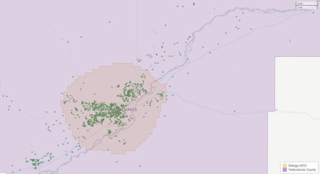
7 CAPTURED GPS POINTS

8 VOLUME OF HOUSEHOLD TRIPS
9 MODE SHARE Mode Weighted Surveyed Not Ascertained 0.21% * 0.26% * Walk 5.36% 4.54% Bicycle 1.57% 1.26% Motorcycle / moped 0.17% * 0.24% * Auto / van / truck (as the driver) 71.96% 74.13% Auto / van / truck (as the passenger) 17.78% 17.22% Carpool / vanpool 0.48% 0.45% School bus 1.03% 0.98% MET Public transit - local bus 1.03% 0.45% Private bus or shuttle 0.05% * 0.05% * Airplane 0.04% * 0.02% * Something Else 0.3% 0.41%
10 TRIP DURATION Mode Weighted Std. Error Surveyed Not Ascertained * * * Walk Bicycle Motorcycle / moped * * 19.5 * Auto / van / truck (as the driver) Auto / van / truck (as the passenger) Carpool / vanpool School bus MET Public transit - local bus Private bus or shuttle * * 40.5 * Airplane 64 * 0 * 64 * Something Else
11 AVERAGE TRIP DISTANCE Mode Weighted Std. Error Surveyed Not Ascertained 4.71 * 1.52 * 5.36 * Walk Bicycle Motorcycle / moped 4.92 * 8.46 * 5.57 * Auto / van / truck (as the driver) Auto / van / truck (as the passenger) Carpool / vanpool School bus MET Public transit - local bus Private bus or shuttle 9.86 * 7.23 * 8.45 * Airplane * 0 * * Something Else
12
13

14 QUESTIONS Link to full survey:
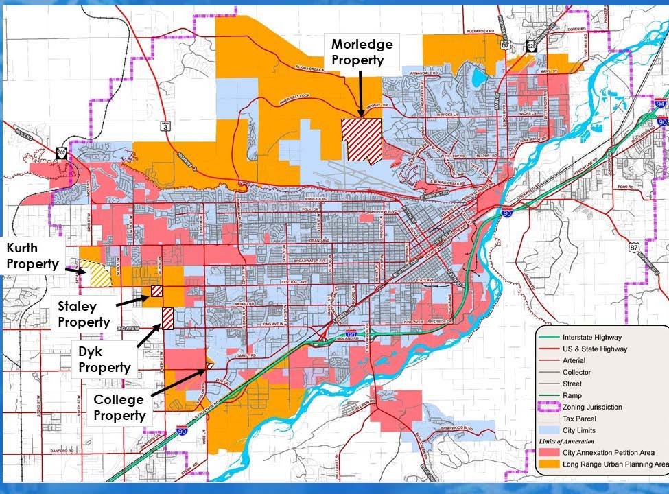
15 CITY COUNCIL WORK SESSION ITEM CITY OF BILLINGS, MONTANA Monday, April 2, 2018 TITLE: DEPARTMENT: PRESENTED BY: Annexation Committee Map Amendment Recommendations Planning and Community Services Wyeth Friday, AICP, Director PROBLEM/ISSUE STATEMENT To provide guidance on Annexation Policy and Map amendments, an Annexation Committee, consisting of representatives from Parks, Recreation and Public Lands, Police, Fire, Public Works, Transit, Administration, Planning, and Billings School District 2, and County Water District of Billings Heights, advises the City Council. The Committee has met four times from January 2018 through March 2018 to review the Annexation Policy, discuss revisions to the map, and discuss approaches to a cost of service analysis for delivery of City services. The Committee received five requests from private property owners to amend the Annexation Map and the Committee is recommending three changes to the map from the requests. The Committee is not recommending any changes to the Policy at this time. The Annexation Committee s recommendations are being presented to the Council at its Work Session on April 2. Formal action on the recommendations is expected at the Council s regular meeting on April 23. ALTERNATIVES ANALYZED In making its recommendations to amend the Limits of Annexation Map, staff considered the ability to serve areas outside the existing City limits based on existing resources, effects on City residents, and programmed improvements, including the Capital Improvement Plan (CIP). The Committee also strives not to favor one department s ability to provide service over another department s limitation(s). BACKGROUND The City Council first adopted an Annexation Policy and accompanying Map 16 years ago on May 28, 2002.The original adoption of the Policy was driven by annexations in the early 2000s of areas like Rehberg Ranch and Briarwood that were placing significant service demands on City services and the Council realized it needed a formal process and criteria to make future annexation decisions. To provide guidance on Annexation Policy and Map amendments, an Annexation Committee was formed to advise the City Council. The Committee reviews map amendment requests from private property owners as well as City Departments, and also makes recommendations on updates to the Policy and Map brought to the Committee from City 1
16 staff. The current adopted policy established two limits of annexation. The City Annexation Petition Area (Red) defines an area where annexation petitions may be supported in the short term. The Long Range Urban Planning Area (Orange) covers areas where City services may be extended but would require additional analysis and funding to support those services. The City of Billings has annexed more than 4 square miles since 2004 (38.65 to 43 sq. mi.), when the Policy and Limits of Annexation Map were further refined to be similar to what they are today. The community s growth over this 14-year period has challenged the City s ability to balance serving new areas and maintaining a high level of service to present citizens. The Committee has been cautious in recommending any expansion of the annexation areas because expansion may add to the challenges of achieving that balance. The Committee has maintained the premise that since the City in the past determined its ability to serve property already in the City Annexation Petition Area, the City s commitment to considering annexing property already in the Red Area should be maintained. This approach is something the Council may make further determinations on, as annexations are at the complete discretion of the City Council, but the Committee wants to ensure the Council understands its approach to both Limits of Annexation Map Amendments and Annexation Petition requests. Limits of Annexation Map Amendment Requests Staff received five requests from property owners and agents for map amendments. One request was to include property in the Orange Area (Long Range Urban Planning Area) of the Limits of Annexation Map. This is referred to as the Kurth Property Request. The other four requests were to include property in the Red Area of the Limits of Annexation Map. These are referred to as the Dyk Property Request, Yellowstone Christian College Request, Morledge Property Request, and the Staley Property Request. All of the requests are described in detail below. The City did not have any changes to the Limits of Annexation Map regarding City owned property for this year. Orange Area Request Kurth Property Request C/S 3532, Parcel 1, Parcel 2; W2SE Less C/S 3146 and C/S 3151; that part of the NENW described as Tract 1 of C/S 3653 and Tract 2 of C/S 3653; Section 5, Township 1 South, Range 25 East. This request includes bringing 175 acres southwest of the Trails West Subdivision south of Grand Avenue and west of 56 th Street West into the Long Range Urban Planning Area (Orange Area). The request was made to begin planning for future annexation and development of residential and park/open space in the City. Properties included in the Long Range Urban 2
17 Planning Area required further research and analysis by both the City and the property owner. The next formal step after being included in the Long Range Urban Planning Area would be to prepare an Urban Planning Study as per the City s Annexation Policy and request inclusion in the City Annexation Petition Area for future annexation consideration. Property owner Brian Kurth in coordination with Sanderson Stewart presented the request for the map amendment to the Annexation Committee and provided information regarding concepts of how the property might develop in the City with residential densities of about 6 units per acre. Mr. Kurth stated that he ultimately envisions an area similar to the neighborhood around Rose Park where he grew up to be developed on his property. Annexation Committee Review: The Annexation Committee discussed this map amendment request over the course of two of its meetings in January and February. The Committee ultimately supported bringing the property into the Long Range Urban Planning Area and its comments and discussion were as follows: School District #2: There is space for a future elementary school on the property where Ben Steele Middle School is located, which could someday provide added school capacity in this area. However, Ben Steele is currently at its capacity for students in the current school year. Parks: About 200 acres of park land is projected to be needed across the City, according to the City-Wide Parks Comprehensive Master Plan that was just completed. There is going to be a demand for park land in this area as the City continues to grow. The existing irrigation canal corridor and floodplain areas appear to provide an opportunity for open space or programmable space on the subject property. Mr. Kurth stated he has been approached by a baseball group and that sports tourism is gaining traction across the community and he sees potential on his property to help accommodate some of the park needs. Planning: The City brought property directly to the north of the subject property into the Long Range Urban Planning Area in 2016 recognizing the proximity of the new school and already annexed property that is developing in the City is northeast of the subject property. Maintaining residential development densities of at least 6 units per acre would be more sustainable for the City for future development. Bringing this property into the Long Range Urban Planning Area provides for further analysis and coordination on future City development in this area. Police: The Police Department did not have any concerns with adding this property to the Long Range Urban Planning Area for future consideration for annexation. A School Resource Officer is now located at Ben Steele Middle School and the Police Department patrols within the City limits just north and west of the subject property now, so there is already a police presence in the area. 3
18 Fire: The Fire Department stated that the subject property is in the Billings Urban Fire Service Area (BUFSA) and that Station #7 is in close proximity to the area at 54 th Street West and Grand Avenue. The Fire Departments recently completed its Long Range Master Plan also will be used to assess future service delivery at the time the subject property requests inclusion in the City Annexation Petition Area. Public Works: Public Works staff is supportive of bringing the subject property into the Long Range Urban Planning Area for further research and analysis. It may be sometime before water and sewer infrastructure is close enough for the property to be brought into the Red Area to served. Currently, water and sewer utilities are installed in a portion of 56 th Street West and Grand Avenue north and west of the subject property, but further build out of the Trails West Subdivision already in the City in the area will help inform future provision of water and sewer service in the area as well as transportation connections. Transit: MET will not be able to serve the subject property for quite a long time based on its current routes and service area limitations, but Transit staff said they have no objection to the property being brought into the Long Range Urban Planning Area for further research and analysis. Recommendation for Kurth Property Request The Annexation Committee recommends that the City Council amend the Limits of Annexation Map to include the Kurth property in the Long Range Urban Planning Area. Red Area Requests Dyk Property Request C/S 983, Parcel 14 of Amended Tract 2B and 13, Parcel 12 of Amended Tract 2A, Parcel 11 of Amended Tract 2A, Parcel 2C of Amended Tract 2, and Parcel 2G Corrected, Section 10 of Township 1 South, Range 25 East. This request includes bringing about 67 acres at the northeast corner of the intersection of King Avenue West and 48 th Street West into the City Annexation Petition Area (Red Area). The request was made to begin planning for annexation and development of residential and commercial uses in the City. Inclusion of the subject property within the City Annexation Petition Area would enable the property owner to petition to annex the property into the City and access City services at any time in the future. Property owner the Dyk family, in coordination with developer Propriedad, LLC and Performance Engineering and Consulting presented the request for the map amendment to the Annexation Committee and provided the required Urban Planning Study outlining the proposed development concepts for the property. The concepts include residential manufactured home, 4
19 two-unit residential and potentially some single family residential development averaging 9 units per acre and commercial development closer to the King Avenue West and 48 th Street West intersection and along the two arterials. Property to the east and south across King Avenue West is already in the City limits, so coordination for utilities and infrastructure could be planned for multiple developments if this area is able to begin its annexation preparations. Annexation Committee Review: The Annexation Committee discussed this map amendment request over the course of two of its meetings in January. The Committee ultimately supported bringing the property into the City Annexation Petition Area and its comments and discussion were as follows: School District #2: The subject property is southeast of property the School District owns for a future school site, however there are no short term plans to develop a school at that location. There would eventually be some school impact from the residential development on the subject property as the west end schools are mostly full at this time. Parks: There is currently no community park to service this area. Parks has a concern of over burdening of park facilities. Performance Engineering s Scott Aspenleider, an agent for the applicants, stated that the future development planned to provide trail and pedestrian infrastructure and connect into the trail and pedestrian facilities in place or planned in the Lenhardt Square development to the east and the King Avenue West corridor. Park staff stated that trails are great but programmable space is still necessary, and if higher density development occurs in the area, a minimum of 3 acres of parkland would be needed to adequately serve the neighborhood. Planning: This area is developing rapidly east of 48 th Street West and on both sides of King Avenue West from 48 th Street West back to Shiloh Road. Property to the east and south is already within the City limits. It makes sense to bring this property into the City Annexation Petition Area for future annexation and development in the City. Police: The Police Department stated it already is providing services along the King Avenue West Corridor just east of the subject property as well as to the south and the property is adjacent to patrol beat. Currently, the Police Department has an agreement with the Sheriff s Office to go out into the County in this area for stolen vehicle cases, but not for service calls. As the City does continue to grow, additional resources and officers will be needed to meet service demands. Fire: The Fire Department stated that the subject property is in the Billings Urban Fire Service Area (BUFSA) and that Station #7 at 54 th Street West and Grand Avenue is the closest to the area. The property also is north of property already within the City limits along King Avenue West and that water utilities will be able to be extended to the property to meet water supply requirements. 5
20 Public Works: Public Works staff is supportive of the request with the understanding that any extension of services would be at the cost of the developer. A City project this year will extend utilities as far as 46th Street West as part of coordinating expansion with other property owners along King Avenue West. The developer is aware that water and sewer will be required to go to the furthest edge of the property at the intersection of 48 th Street West and King Avenue West. Performance Engineering and Consulting has been working with the City Engineering Division already to determine service requirements. Both the water and sewer plants have capacity to serve this area. Transit: MET will likely not be able to serve the subject property within the next 5 years. The intersection of Shiloh Road and King Avenue West is the furthest point west that MET transit provides service, about 0.8 miles east of the subject property. Recommendation for Dyk Request The Annexation Committee recommends that the City Council amend the Limits of Annexation Map to include the Dyk property in the Red Area at this time. Yellowstone Christian College Request C/S 640 Amended and C/S 3329, Tract 2. This request includes bringing about 12 acres at the northeast corner of the intersection of Shiloh Road and Hesper Road into the City Annexation Petition Area (Red Area). The request was made to begin planning for annexation and expansion of the Yellowstone Christian College on the property. The College currently has its campus on the property and would like to access City services in the future to serve its existing campus and to expand its campus on the property. Inclusion of the subject property within the City Annexation Petition Area would enable the property owner to petition to annex the property into the City and access City services at any time in the future. The property owners, the Yellowstone Christian College, and its agent, WWC Engineering, presented the request for the map amendment to the Annexation Committee and provided the required Urban Planning Study outlining the proposed college development concepts for the property. The College is looking at long term expansion plans, that could include added student dormitories, class room and activity spaces, and an increase in total student population from about 60 to 120 students over time. Annexation Committee Review: The Annexation Committee discussed this map amendment request over the course of two of its meetings in January. The Committee ultimately supported bringing the property into the City Annexation Petition Area and its comments and discussion were as follows: 6
21 School District #2: No comments on this request. Parks: No comments on this request Planning: This area is surrounded by property already within the City limits or property already with in the City Annexation Petition Area. While there are some infrastructure challenges to getting water and sewer utilities to the property in the very short term, it makes sense to bring this property into the City Annexation Petition Area for future annexation and development in the City. Police: The Police Department stated it already is providing services along Shiloh Road and east along Hesper Road and had no specific concerns with the subject property. As the City does continue to grow, additional resources and officers will be needed to meet service demands. Fire: The Fire Department stated that a walk through inspection on the existing College buildings and facilities would be required upon annexation to ensure that all building codes would be met. Staff indicated that the College has already requested this inspection prior annexation to be aware and to be able to address any code deficiencies in a timely manner. Staff also indicated that fire hydrants would be required within 400 feet of all structures and the hydrants would need to be installed prior to annexation since the College has existing structures in use on the property. Public Works: Public Works staff has been anticipating this request for several years and is supportive of the request with the understanding that any extension of services would be at the cost of the developer. There is a water main on Shiloh Road that will need an extension of 2,200 feet. An 8 dry sewer line also fronts the property and would need to be extended by the College 1,250 feet. These extensions would be critical to when the property could be annexed. Reimbursement agreements for water and sewer infrastructure are available to this development and would be encouraged so that the College might recover some of its costs from other properties that would use the utilities. Transit: MET already goes by the property on Shiloh Road and can pick up riders. Recommendation for Yellowstone Christian College Request The Annexation Committee recommends that the City Council amend the Limits of Annexation Map to include the Yellowstone Christian College property in the Red Area at this time. 7
22 Morledge Property Request Property is described as Section 19, Township 1 North, Range 26 East, All Less a Fraction in the W2W2SW4, Less Tract A, C/S 663, and Less C/S 1260 and the S30, Township 1 North, Range 26 East, Fraction of the N2NE4 This request includes bringing a total of about 578 acres into the City Annexation Petition Area (Red Area). The property borders the Billings Logan International Airport property on the north and straddles Alkali Creek Road, and is a little south of the intersection of Skyway Drive and Alkali Creek Road in the Billings Heights. The owners of the property would like to have the land included in the City Annexation Petition Area to plan for future annexation and development of the property for residential and commercial uses. The owners expect to begin development within the next 5 years, according to information in the Urban Planning Study prepared for the request. The property owners, Dr. Morledge Family, LLC, in coordination with Sanderson Stewart provided the map amendment request and the Urban Planning Study for the subject property. The overall plan for the property is to develop with residential and commercial uses on portions of the land. The residential development would primarily be on the south side of Alkali Creek Road and the commercial would be primarily on the north side of Alkali Creek Road. While the property is 578 acres, about 320 acres is developable given the significant drainages, steep slopes and the flood plain along Alkali Creek in the area. The Morledges have provided a letter to the City Council in regard to their request and it is attached to this memo for City Council reference and review. Annexation Committee Review: The Annexation Committee discussed this map amendment request over the course of two of its meetings in February and March. The Committee ultimately decided to not recommend bringing the property into the City Annexation Petition Area at this time, and its comments and discussion were as follows: School District #2: No specific comments on this request. Parks: In the actual development of the area, a Neighborhood Park and options for a Community Park would be important to consider as well as trail development. The topography of the proposed parkland areas provided with the Urban Planning Study is questionable as far as useable/programmable space is concerned. The areas look more like open space and natural areas with some trails, but recreation needs may not be met under current concept. The applicant s agent, Mac Fogelsong of Sanderson Stewart, agreed that much of the area would not be programmable space for soccer fields or other uses, but some of the acreage close to Alkali Creek might have some potential for specific recreation uses. 8
23 Planning: This area has the City limits to the south where the Airport is located and City limits along the northeast portion of the property on the north side of Alkali Creek Road. Property to the southeast along Alkali Creek Road remains in the County. One property on the north side of Alkali Creek Road just deannexed as the property could not be developed as platted given floodplain and infrastructure limitations and the owner is looking to regroup and determine a new development plan for the land. There are major utility infrastructure challenges to serve this property, with water and sewer utility extensions of 3,300-3,600 feet needed to reach the subject property. These utilities would currently be passing along Alkali Creek Road though property that is outside the City. The proposed average density of residential development around 4 units per acre is at the bottom end of the City Annexation Policy s stated range of 4-7 dwelling units per acre. This density is much less efficient for City service delivery over the long term. Approaching this property with a conservation development approach having large areas undeveloped and higher density in the areas that may be developed would make the future sustainability of the area for City service delivery much greater. While Planning staff finds it makes sense to bring this property into the City Annexation Petition Area for future annexation and development in the City at some time in the future, staff is concerned that the intent of the annexation map is to identify properties that are able to be annexed quickly and immediately if they are brought into the City Annexation Petition Area. This property is not currently in this category. Police: The Police Department stated that Alkali Creek Road provides access to the area. The Billings Heights is currently separated from the rest of town from a patrol standpoint. Most of the time, two patrol officers are dedicated to the Heights area. Sometime, there may be 4 officers in the area. The Police Department will eventually need more staff and resources to meet service demands in the Heights area if expansion continues. Fire: Chief Bill Rash stated that he has a concern about the inability to serve the area based on existing station location and existing response times. He said that the new Fire Department Long Range Master Plan identified in its facilities report that a second station location in the Heights is the number one priority. He stated that response time is a tremendous concern for the Heights area. Since an additional Fire Station in the Heights is not yet planned and funded for construction, The Department has great concern that enabling this property to be able to annex into the City will increase the burden of an already underserved area. The Fire Department does not support inclusion of this property at this time. Public Works: The property is a large parcel, if annexation were to occur, it will be a long jump as far as utilities are concerned. The Urban Planning Study states water and sewer extensions would be approximately 3,300 to 3,600 linear feet. This property has been in the Long Range Urban Planning Are for quite some time and it is adjacent to city limits. The construction of the inner belt loop in the next 5-10 years is favorable and could have synergy for commercial 9
24 development activities. Public Works is supportive of including the property in the City Annexation Petition Area, but states again that the developer would be responsible for the utility extensions at this time and they are significant. Transit: MET service is limited on Alkali Creek Road and turns at Senators Boulevard, south of the subject property. MET would like to readjust its service area boundary with time, however adding transit service now in one area requires a cut to services elsewhere. In regards to the property being adjacent to the Billings Logan International Airport, staff has concern with pieces of the property that are closest to the Airport and even considered in the noise restriction areas. Development can occur in some areas with proper insulation, however, residential development may not be a compatible land use so near an active airport operation. Staff also is concerned about how storm water would be addressed along the boundary with the airport to avoid conflicts between the airport and residential development. Given the location of some of the property in the Airport Influence Area and the storm water concerns, it is likely that any development would need to address construction requirements to address noise mitigation and storm drainage facilities. MET Transit and the Airport staff are not against all future development in this area, but have significant concerns about how development might occur and the impacts it might have on Airport operations. Recommendation for Morledge Property Request The Annexation Committee recommends that the City Council not amend the Limits of Annexation Map at this time to include the Morledge property in the Red area. Staley Property Request C/S 1880, Parcels 1B2 and 2B, 3 rd Amended, and C/S 1880, Tract 1A, Amended, Section 9, Township 1 South, Range 25 East. This request includes bringing a total of about 39 acres into the City Annexation Petition Area (Red Area). The property is at the southwest corner of the intersection of Central Avenue and 48 th Street West. It is surrounded by property that is in the Long Range Urban Planning Area. It is about half a mile from the City Annexation Petition Area to the east and more than half a mile to the City Limits to the east as well. The owners of the property would like to have the land included in the City Annexation Petition Area to plan for future annexation and development of the property for residential and commercial uses. Although the property is some distance from the City limits and City services, the owners expect to begin development within the next 5 years, according to information in the Urban Planning Study prepared for the request. The property owners, The Staley Family Irrevocable Land Trust, and Susan and Harry Staley, in coordination with Sanderson Stewart provided the map amendment request and the Urban Planning Study for the subject property. The overall plan for the property is to develop with residential and commercial uses on portions of the land. The commercial development would be primarily at the northeast portion of the property near the intersection of 48 th Street West and 10
25 Central Avenue. The residential development would surround the commercial property on the remainder of the property. Annexation Committee Review: The Annexation Committee discussed this map amendment request over the course of two of its meetings in January and February. The Committee ultimately concluded that it would not recommend the City Council amend the Limits of Annexation Map at this time to include the Staley property in the City Annexation Petition Area, and its comments and discussion were as follows: School District #2: The subject property is north of property the School District owns on 48 th Street West for a future school site, however there are no short term plans to develop a school at that location. There would eventually be school impact if this property were annexed from the residential development, and the west end schools are mostly full at this time. Parks: There are currently no community parks identified in this specific area of the West End. The City has not built a community park in many years and the existing City parks are feeling the impacts of it with very intense usage across the City and facilities that are needing updates and replacement. While this property is proposing 124 residential units, which is not a major impact in itself, additional park facilities are needed for the current City residents/users and for property that is already in the City Annexation Petition Area. Planning: This subject property is surrounded by land in the Long Range Planning Area. The City Annexation Petition Area and the City Limits are at least half a mile to the east and north. The challenges of bringing this property into the Red Area now are similar to those of the Morledge property. Staff is concerned that the intent of the annexation map is to identify properties that are able to be annexed immediately or in the very short term if they are brought into the City Annexation Petition Area. This property is not currently in this category. There are significant distances to where current City services are available and new County development to the east of the subject property along Central Avenue creates a barrier to construction and maintenance of City infrastructure along the Central Avenue Corridor in this area. Police: The property is nowhere close to existing Police Department beats. Police will have challenges with staffing and resources if this property were annexed into the City so far from the current City limits and service areas. There are three officers on the West End on any given day between the three beats. There is office space at Fire Station #7 for a Police Satellite Office, but it is not occupied by Police staff on a regular basis. Fire: The Fire Department stated that water supply is critical to any new area that it might serve and so distance to services and the challenges of providing those services is key to having the water infrastructure in place to serve the new annexed area. The property is already within the 11
26 BUFSA area and is currently served under that service in the County, so the Billings Fire Department would continue to be the fire protection provider for the property. Public Works: Staff is concerned that the area is not contiguous to the City Annexation Petition Area or the City limits. Staff had further follow up on this property with additional Public Works staff after the initial review and the Departments position has not changed that is not supportive of this request. There are infrastructure challenges along Central Avenue, water and sewer services are at least 900 feet away. A difficulty in the past is that subdivisions in the County are never up to City standards when annexation is needed, so then annexation of those subdivisions is cost prohibitive and discourages annexation. The existing subdivisions in the County along Central Avenue are relatively new and do not meet City standards. Transit: This property is way out of the MET service area, far from the current City limits, and transit will not be in the area for a long time. Recommendation for the Staley Request The Annexation Committee recommends that the City Council not amend the Limits of Annexation Map at this time to include the Staley property in the Red area. CONSISTENCY WITH ADOPTED POLICIES OR PLANS In making its recommendations, the Annexation Committee takes into consideration many plans and policies, including, but not limited to, the most current Water and Wastewater Master Plan, Storm Water Master Plan, 2016 City of Billings Growth Policy, 2014 Billings Urban Area Transportation Plan, the Billings Comprehensive Parks and Recreation Master Plan 2017, neighborhood or area plans as applicable, and the most current CIP. These recommendations are based on an effort to be consistent with adopted policies and plans, and attempt not to favor one department s ability to provide service over another department s limitation. ATTACHMENTS 2017 Limits of Annexation Map Property Requests Shown Letter from Morledges regarding their map amendment request City Annexation Policy 12
27 13
28 14
29 15
30 16
31 17
32 18
33 19
34 Other Items
35 FROM THE DESK OF...WYNNETTE MADDOX Executive Secretary City Administrator s Office Office of the Mayor PO Box 1178 Billings, MT (406) FAX (406) maddoxw@ci.billings.mt.us MEMORANDUM To: Mayor & Council Date: March 30, 2018 RE: Upcoming Boot Camp and Training Attached please find information regarding the Montana State University Extension Local Government Center Invitations to attend: Elected Officials Boot Camp May 8 th and Elected Officials Workshop May 8 th 10 th Please review the agendas for the boot camp and the officials workshop and let me know by April 13 th if you are interested in attending as I will have to register you for the camp or workshop. The programs will be held at the Billings Hotel & Convention Center in Billings. 1
36 9 Montana State University Extension Local Government Center Invitation to Attend Elected Officials Boot Camp 7 Tuesday, May 8 th The Municipal Institute Boot camp is designed to give municipal elected officials a brief yet comprehensive overview of the fundamental roles and responsibilities of their positions. W $75 Fees and Registration X Elected Officials Boot Camp: May 8th Includes Breakfast, Lunch, & Access To Elected Official Reception $175 Elected Officials Workshop: May 9-10th Includes Breakfasts, Lunches, & Access To Banquet Celebration & Elected Official Reception Topics Covered Good Governance Municipal Powers, Forms, Plans, & Functions Roles & Responsibilities of Municipal Officials Open Meetings Citizen Participation Ethics And More! Hotel Information *room not included in fees* Same Place New Name Billings Hotel & Convention Center (Formerly the Red Lion) 1223 Mullowney Ln, Billings, MT $225 Full Elected Officials Program: May 8-10th Includes Breakfasts, Lunches, Elected Officials Reception, & Banquet Celebration Room block reserved under Municipal Clerks To Reserve call (406) Cancellation Policy If written notice of cancellation is received by the MSU Local Government Center by Wednesday, May 2, 2018, the total registration fee will be refunded. No refund will be made for cancellations received after May 2, To Register, Visit: msulocalgov.org/ offering/ ElectedOfficials.html 1
37 7 9 9 Tuesday, May 8 th Elected Officials Boot Camp 7 Draft Agenda 8:00 am Welcome 1:00 pm Ethics 8:15 am Good Governance 2:00 pm Quasi-Judicial Role of Council in Land-Use Planning 8:45 am Power, Form, and Plan of Municipal Governments in MT 3:00 pm Citizen Participation 9:30 am Municipal Government Powers 3:15 pm Break 10:00 am Break 4:00 pm Resources Available for Local Governments in Montana 10:15 am Roles & Responsibilities of Municipal Officials 5:00 pm Adjourn 11:00 am Open Meetings 5:30 pm Elected Officials Reception 12:00 pm Lunch 2
38 9 Montana State University Extension Local Government Center Invitation to Attend Elected Officials Workshop W $75 Fees and Registration X Elected Officials Boot Camp: May 8th Includes Breakfast, Lunch, & Access To Elected Official Reception $175 Elected Officials Workshop: May 9-10th Includes Breakfasts, Lunches, & Access To Banquet Celebration & Elected Official Reception Hotel Information *room not included in fees* Billings Hotel & Convention Center (Formerly the Red Lion) 1223 Mullowney Ln, Billings, MT Same Place New Name Room block reserved under Municipal Clerks To Reserve call (406) $225 Full Elected Officials Program: May 8-10th Includes Breakfasts, Lunches, Elected Officials Reception, & Banquet Celebration Cancellation Policy If written notice of cancellation is received by the MSU Local Government Center by Wednesday, May 2, 2018, the total registration fee will be refunded. No refund will be made for cancellations received after May 2, To Register, Visit: msulocalgov.org/ offering/ ElectedOfficials.html 1


39 7 9 9 Elected Officials Workshop 7 Draft Agenda Tuesday, May 8 th Pre-Conference Sessions Mayor Agenda Council Member Agenda 10-5 pm Registration 1-2pm Writing Policies An overview of the essential components of a fair and consistent policy. 2-3:30 pm 3:30-5 pm Effective Listening An overview of effective listening techniques to aid in the communication with mayors, councils, fellow employees and the public. Maintaining Historical Records An overview of best practices for historical record management. Special Districts An in-depth discussion of the fundamentals of creating, assessing and maintaining special districts. Gas Tax A review of the new Gas Tax legislation, implementation, and resulting changes for municipal governments in Montana. Elected Officials Reception Sponsored by: 5:30 pm 2
40 Wednesday, May 9 th Mayor Agenda Council Member Agenda 7-8 am Breakfast 8-9 am 9-10 am Recognizing & Avoiding Workplace Violence An in-depth discussion of workplace violence and related communication skills. Workplace Safety An overview of federal and state laws, along with best practices used, to ensure workplace safety Americans with Disabilities Act An introduction to the Americans with Disabilities Act and its impact on public facilities and proceedings. Funding Capital Replacement An overview of establishing and funding a municipal capital improvement program (CIP) pm Risk Reduction in Personnel Management 2 An intensive review and application of policies and practices to reduce risk exposure in managing municipal employees. Fundamentals of Bond Financing An overview of bond financing options available to local governments pm Lunch 1-3 pm Reasonable Suspicion Testing 2 An overview of the federal and state regulations of reasonable suspicion testing including a discussion of the signs, symptoms and effects of alcohol or controlled substance use, how to approach an employee and initiate reasonable suspicion testing, documentation and handling difficult situations. MLCT Initiatives (1-2pm) A review and discussion of effective grant application procedures including administrative requirements for a successful grant application. Elected Official to Elected Official (2-3pm) An interactive round-table discussion designed to allow elected officials to learn from one another. 3-5 pm Real Colors 5:30 pm Mayors Forum Thursday, May 10 th Mayor Agenda Council Member Agenda 7-8 am Breakfast 8-9 am Roles & Responsibilities A review and discussion of the roles and responsibilities of appointed and elected municipal officials am Employee Hiring Process A review of the legal requirements and appropriate procedures to hire new municipal employees. Managing Risk for Elected Officials A review of common risks and how elected officials can decrease risk for their municipalities. 3
 Learning how to respond to those famous words from our citizens I m Going to Sue 3-5 pm Building a Strong, Resilient Team A review and")
41 11-12 pm Cyber Security Cyber Security is a set of principles and practices designed to safeguard your putting assets and online information. 12-1:30 pm Banquet Lunch 1:30-3 pm I m Gonna Sue (Don t Panic) Learning how to respond to those famous words from our citizens I m Going to Sue 3-5 pm Building a Strong, Resilient Team A review and discussion of the importance of a strong, resilient team and effective team building strategies. 4
MIDWAY CITY Municipal Code
 MIDWAY CITY Municipal Code TITLE 9 ANNEXATION CHAPTER 9.01 PURPOSE CHAPTER 9.02 GENERAL REQUIREMENTS CHAPTER 9.03 PROPERTY OWNER INITIATION OF ANNEXATION CHAPTER 9.04 PROCEDURES FOR CONSIDERATION OF PETITION
NOTICE TO THE PUBLIC. Introduction of the Yellowstone County Zoning Commission Members and Planning Department Staff.
 COUNTY OF YELLOWSTONE ZONING COMMISSION AGENDA-Friday, February 12, 2016 (Continued from February 8, 2016) 11:00 a.m. Billings Library Community Meeting Room 510 North Broadway, 1st Floor, Billings, Montana
A. Land Use Relationships
 Chapter 9 Land Use Plan A. Land Use Relationships Development patterns in Colleyville have evolved from basic agricultural and residential land uses, predominate during the early stages of Colleyville
Mount Airy Planning Commission March 26, Staff Report
 Mount Airy Planning Commission March 26, 2018 Staff Report Special Exception Request Mixed Use Development in CC District Recommendation to Board of Appeals CASE MA-A-18-01 Applicant: Location: Zoning:
Planning Department Oconee County, Georgia
 Planning Department Oconee County, Georgia STAFF REPORT REZONE CASE #: 6985 DATE: October 31, 2016 STAFF REPORT BY: Andrew C. Stern, Planner APPLICANT NAME: Williams & Associates, Land Planners PC PROPERTY
Diamond Falls Subdivision PROPOSED YELLOWSTONE COUNTY BOARD OF PLANNING FINDINGS OF FACT
 Diamond Falls Subdivision PROPOSED YELLOWSTONE COUNTY BOARD OF PLANNING FINDINGS OF FACT The City/County Planning Staff has prepared the Findings of Fact for the Diamond Falls Subdivision. These findings
RE: 6. GILL/GREEN COMPREHENSIVE PLAN AMENDMENT, REZONING AND PRELIMINARY PLAT
 commission memo DATE: Thursday - August 9, 2018 TO: Marion Planning & Zoning Commission FROM: David N. Hockett, AICP Principal Planner RE: 6. GILL/GREEN COMPREHENSIVE PLAN AMENDMENT, REZONING AND PRELIMINARY
City of Grande Prairie Development Services Department
 City of Grande Prairie Development Services Department COUNTRYSIDE SOUTH OUTLINE PLAN Prepared by: GPEC Consulting Ltd. #202, 10712-100th Street Grande Prairie, AB Council Resolution of August 20, 2001
E X E C U T I V E S U M M A R Y
 E X E C U T I V E S U M M A R Y CASE PLANNER: Aaron Wilson & Janet Rhoades VINE REVIEWED AND APPROVED BY: Mary McCrea BROADWAY INTERSTATE 90 INTERSTATE 90 PUBLIC HEARINGS: CC: August 22, 2011 AGENDA ITEM:
9. REZONING NO Vicinity of the northwest corner of 143 rd Street and Metcalf Avenue
 9. REZONING NO. 2002-15 Vicinity of the northwest corner of 143 rd Street and Metcalf Avenue 1. APPLICANT: Andrew Schlagel is the applicant for this request. 2. REQUESTED ACTION: The applicant is requesting
STAFF SUMMARY OF Z17-10 CONDITIONAL ZONING DISTRICT APPLICATION
 STAFF SUMMARY OF Z17-10 CONDITIONAL ZONING DISTRICT APPLICATION APPLICATION SUMMARY Case Number: Z17-10 Request: Conditional B-2 Zoning District in order to expand an existing retail and warehousing business
GENERAL DESCRIPTION STAFF RECOMMENDATION IMPLEMENTATION REQUIREMENTS
 Application No.: 891418 Applicant: AREA-WIDE MAP AMENDMENT Rezone two parcels from Moderate Density Single Family (MSF) to Neighborhood Center (NC) and Employment Center (EC). Charles Bitton GENERAL DESCRIPTION
Canyons South. Annexation Impact Report. September 1, 2015
 Canyons South Annexation Impact Report September 1, 2015 1 Introduction This Annexation Impact Report has been prepared to meet the statutory requirements set forth in Colorado Revised Statutes 31 12 108.5
DEPARTMENT OF COMMUNITY PLANNING, HOUSING AND DEVELOPMENT Planning Division
 DEPARTMENT OF COMMUNITY PLANNING, HOUSING AND DEVELOPMENT Planning Division #1 Courthouse Plaza, 2100 Clarendon Boulevard, Suite 700 Arlington, VA 22201 TEL 703.228.3525 FAX 703.228.3543 www.arlingtonva.us
Comprehensive Plan /24/01
 IV The is a central component of the Comprehensive Plan. It is an extension of the general goals and policies of the community, as well as a reflection of previous development decisions and the physical
METROPOLITAN COUNCIL 390 North Robert Street, St. Paul, MN Phone (651) TDD (651)
 TDD (651)") METROPOLITAN COUNCIL 390 North Robert Street, St. Paul, MN 55101 Phone (651) 602-1000 TDD (651) 291-0904 DATE: December 26, 2012 TO: Metropolitan Parks and Open Space Commission FROM: Jan Youngquist, AICP;
METROPOLITAN COUNCIL 390 North Robert Street, St. Paul, MN 55101 Phone (651) 602-1000 TDD (651) 291-0904 DATE: December 26, 2012 TO: Metropolitan Parks and Open Space Commission FROM: Jan Youngquist, AICP;
Community Development
 Land Use Petition RZ-16-002 Date of Staff Recommendation Preparation: April 15, 2016 (CEL) Date of Planning Commission Recommendation: May 3, 2016 PROJECT LOCATION: DISTRICT/SECTION/LANDLOT(S): ACREAGE
STAFF REPORT. Community Development Director PO Box 4755 Beaverton, OR 97076
 STAFF REPORT HEARING DATE: July 7, 2010 TO: Planning Commission STAFF: Jana Fox, Assistant Planner PROPOSAL: Southeast Beaverton Office Commercial Zoning Map Amendment (ZMA2010-0006) LOCATION: The subject
PLANNING COMMISSION REPORT PUBLIC HEARING ITEM. DE-ANNEXATION OF 2.4 ACRES LOCATED AT 1820 N. 3 rd STREET. (DDW)
") A-6-1-10 Item No. 5-1 PC Staff Report 9/20/10 PLANNING COMMISSION REPORT PUBLIC HEARING ITEM ITEM NO. 5: DE-ANNEXATION OF 2.4 ACRES LOCATED AT 1820 N. 3 rd STREET. (DDW) A-6-1-10: De-annexation of approximately
A-6-1-10 Item No. 5-1 PC Staff Report 9/20/10 PLANNING COMMISSION REPORT PUBLIC HEARING ITEM ITEM NO. 5: DE-ANNEXATION OF 2.4 ACRES LOCATED AT 1820 N. 3 rd STREET. (DDW) A-6-1-10: De-annexation of approximately
Absent: Major Chris Hanson, Volk Field John Ross, Jackson County Emergency Management; Paul Wydeven, Wisconsin Department of Transportation
 Monroe County/Fort McCoy Joint Land Use Study (JLUS) Technical Advisory Group (TAG) December 8, 2011, 2:00 4:00 p.m. Angelo Town Hall, 14123 Co. Hwy. I, Sparta, WI Meeting Minutes Attendance: Bryan Law,
Planning and Zoning Commission STAFF REPORT REQUEST. DSA : Zone Change from R-3 (Multi-Family Residential) to B-4 (Community Services).
 to B-4 (Community Services).") Planning and Zoning Commission STAFF REPORT AGENDA # TO: FROM: PLANNING AND ZONING COMMISSION Joseph Horn, City Planner MEETING DATES: August 4, 2016 SUBJECT: Gino Tarantini zone change requests REQUEST
Planning and Zoning Commission STAFF REPORT AGENDA # TO: FROM: PLANNING AND ZONING COMMISSION Joseph Horn, City Planner MEETING DATES: August 4, 2016 SUBJECT: Gino Tarantini zone change requests REQUEST
PLANNING COMMISSION STAFF REPORT
 PLANNING COMMISSION STAFF REPORT West Capitol Hill Zoning Map Amendment Petition No. PLNPCM2011-00665 Located approximately at 548 W 300 North Street, 543 W 400 North Street, and 375 N 500 West Street
CITY OF PALM BEACH GARDENS CITY COUNCIL Agenda Cover Memorandum Meeting Date: November 1, 2018 Ordinance 24, 2018 / *Ordinance 25, 2018
 CITY OF PALM BEACH GARDENS CITY COUNCIL Agenda Cover Memorandum Meeting Date: November 1, 2018 Subject/Agenda Item: 11940 U.S. Highway One Small-Scale Comprehensive Plan Future Land Use Map Amendment and
Community Development Committee
 Community Development Committee For the Metropolitan Council meeting of February 13, 2013 Committee Report Business Item 2013-29 ADVISORY INFORMATION Date Prepared: January 25, 2013 Subject: Rice Creek
PLAINFIELD CHARTER TOWNSHIP COMMUNITY DEVELOPMENT DEPARTMENT PLANNING, ZONING & BUILDING SERVICES MEMORANDUM
 PLAINFIELD CHARTER TOWNSHIP COMMUNITY DEVELOPMENT DEPARTMENT PLANNING, ZONING & BUILDING SERVICES 6161 BELMONT AVENUE N.E. BELMONT, MI 49306 PHONE 616-364-1190 FAX: 616-364-1170 www.plainfieldchartertwp.org
51st. Annual County Finance School
 May 2-4, 2017 Sheraton Syracuse University Hotel Syracuse, New York 51st Annual County Finance School Sponsored by: New York State Association of Counties Office of the State Comptroller NYS County Treasurers
CITY PLANNING COMMISSION AGENDA ITEM NOS: B.1-B.3 STAFF: MEGGAN HERINGTON
 Page 17 CITY PLANNING COMMISSION AGENDA ITEM NOS: B.1-B.3 STAFF: MEGGAN HERINGTON FILE NO(S): CPC MP 87-00381-A13MN14 QUASI-JUDICIAL CPC PUZ 14-00101 QUASI-JUDICIAL CPC PUP 05-00139-A1MJ14 QUASI-JUDICIAL
Appendix J - Planned Unit Development (PUD)
") Appendix J - Planned Unit Development (PUD) Intent and Purpose The purpose of the PUD is: 1. To provide development that is consistent with the Comprehensive Land Use Plan and promote the goals and objectives
Appendix J - Planned Unit Development (PUD) Intent and Purpose The purpose of the PUD is: 1. To provide development that is consistent with the Comprehensive Land Use Plan and promote the goals and objectives
CITY OF NORTH LAS VEGAS MEMORANDUM
 CITY OF NORTH LAS VEGAS MEMORANDUM TO: FROM: SUBJECT: Planning Commission Community Development and Compliance Department # 28 ) AMP-03-15; Coleman Airpark II & III - Comprehensive Plan Amendment (Public
TREASURE COAST REGIONAL PLANNING COUNCIL M E M O R A N D U M
 TREASURE COAST REGIONAL PLANNING COUNCIL M E M O R A N D U M To: Council Members AGENDA ITEM 5F From: Date: Subject: Staff July 16, 2010 Council Meeting Local Government Comprehensive Plan Review Draft
8Land Use. The Land Use Plan consists of the following elements:
 8Land Use 1. Introduction The Land Use Plan consists of the following elements: 1. Introduction 2. Existing Conditions 3. Opportunities for Redevelopment 4. Land Use Projections 5. Future Land Use Policies
STAFF REPORT. Lee County School Board APPLICANT/PROPERTY OWNER DOCKET/CASE/APPLICATION NUMBER
 STAFF REPORT ZA17-0012 DOCKET/CASE/APPLICATION NUMBER Wyatt Daltry, AICP, Planning Team Coordinator (239) 573-3160, wdaltry@capecoral.net STAFF PLANNER Lee County School Board APPLICANT/PROPERTY OWNER
CITY OF WEST PARK PROPOSED TRANSIT ORIENTED CORRIDOR (TOC) EXPANSION WORKSHOP JUNE 15, 2016 FREQUENTLY ASKED QUESTIONS (FAQ)
 EXPANSION WORKSHOP JUNE 15, 2016 FREQUENTLY ASKED QUESTIONS (FAQ)") CITY OF WEST PARK PROPOSED TRANSIT ORIENTED CORRIDOR (TOC) EXPANSION WORKSHOP JUNE 15, 2016 FREQUENTLY ASKED QUESTIONS (FAQ) Q: Have you considered that people here love driving their cars and trucks,
CITY OF WEST PARK PROPOSED TRANSIT ORIENTED CORRIDOR (TOC) EXPANSION WORKSHOP JUNE 15, 2016 FREQUENTLY ASKED QUESTIONS (FAQ) Q: Have you considered that people here love driving their cars and trucks,
PLANNING COMMISSION REPORT Regular Agenda Public Hearing Item
 PC Staff Report 11/12/12 Item No. 2B- 1 PLANNING COMMISSION REPORT Regular Agenda Public Hearing Item ITEM NO. 2B: A TO GPI; 110 ACRES; E OF K-10 & N OF W 6 TH ST (MKM) : Consider a request to rezone approximately
City of Peachtree City. Annexation Review Process
 City of Peachtree City Annexation Review Process Page 1 Annexation Review Process Step One: Initial annexation information The following information is to be completed by the property owner and/ or their
Crossroads. On Lot Septic Management Program to begin Spring Inside this issue: Benner Township Zoning Ordinance Update
 Crossroads The Newsletter of Benner Township Inside this issue: Page 1 *On Lot Septic Management Program Begins *Zoning Ordinance Update Page 2 *Spring Brush Collection *Watershed Clean Up Volunteers Needed
CITY OF FARMERSVILLE CITIZEN ADVISORY COMMITTEE AGENDA November 17, :30 P.M. 1, COUNCIL CHAMBERS, CITY HALL
 I. PRELIMINARY MATTERS CITY OF FARMERSVILLE CITIZEN ADVISORY COMMITTEE AGENDA November 17, 2014 6:30 P.M. 1, COUNCIL CHAMBERS, CITY HALL Call to Order, Roll Call, Prayer and Pledge of Allegiance Welcome
MEMORANDUM. City Council. David J. Deutsch City Manager. Resolution R TLBT, LLC Annapolis Road Annexation Plan. DATE: September 3, 2015
 MEMORANDUM TO: FROM: RE: City Council David J. Deutsch City Manager Resolution R-66-15 TLBT, LLC 13401 Annapolis Road Annexation Plan DATE: September 3, 2015 In accordance with the Annotated Code of Maryland,
Public Facilities and Finance Element
 This Element of the General Plan addresses the following public facilities issues: Water Service, including both potable (drinkable) and non-potable water delivery. Sewer Service, and Financing and construction
3. FISCAL IMPACT ANALYSIS FISCAL IMPACT ANALYSIS 29
 3. FISCAL IMPACT ANALYSIS FISCAL IMPACT ANALYSIS 29 The purpose of fiscal impact analysis is to estimate the impact of a development or a land use change on the budgets of governmental units serving the
PLANNING COMMISSION WILLIAMSBURG, VIRGINIA WORK SESSION AGENDA Wednesday, May 23, 2012
 PLANNING COMMISSION WILLIAMSBURG, VIRGINIA WORK SESSION AGENDA Wednesday, May 23, 2012 The meeting will be called to order in the third floor Conference Room (Room 310), Williamsburg Municipal Building,
CITY OF CHARLOTTESVILLE DEPARTMENT OF NEIGHBORHOOD DEVELOPMENT SERVICES STAFF REPORT APPLICATION FOR A SPECIAL USE PERMIT
 CITY OF CHARLOTTESVILLE DEPARTMENT OF NEIGHBORHOOD DEVELOPMENT SERVICES STAFF REPORT APPLICATION FOR A SPECIAL USE PERMIT PLANNING COMMISSION AND CITY COUNCIL JOINT PUBLIC HEARING DATE OF HEARING: December
STAFF REPORT FOR ANNEXATION AND ZONING. CASE NAME: Taylor Annexation and Zoning PC DATE: August 7, 2013
 STAFF REPORT FOR ANNEATION AND ZONING ANNEATION CASE NO: A-13-001 ZONING CASE NO: RZ-13-002 REPORT DATE: July 30, 2013 CASE NAME: Taylor Annexation and Zoning PC DATE: August 7, 2013 ADDRESS OF PROPOSAL:
COMMUNITY BENEFIT REQUIREMENTS & IMPACT FEES FOR DEVELOPMENTS IN VARIOUS CITIES
 COMMUNITY BENEFIT REQUIREMENTS & IMPACT FEES FOR DEVELOPMENTS IN VARIOUS CITIES Prepared by Office of Mayor Tom Bates Current Requirements for Projects in Berkeley Downtown* Under Consideration for Projects
Charlottesville Planning Commission, Neighborhood Associations & News Media
 CITY OF CHARLOTTESVILLE A World Class City Department of Neighborhood Development Services City Hall Post Office Box 911 Charlottesville, Virginia 22902 Telephone 434-970-3182 Fax 434-970-3359 www.charlottesville.org
Town of Cary, North Carolina Rezoning Staff Report 14-REZ-31 Cary Park PDD Amendment (Waterford II) Town Council Meeting January 15, 2015
 Town Council Meeting January 15, 2015") Town of Cary, North Carolina Rezoning Staff Report 14-REZ-31 Cary Park PDD Amendment (Waterford II) Town Council Meeting January 15, 2015 REQUEST To amend the Town of Cary Official Zoning Map by amending
Town of Cary, North Carolina Rezoning Staff Report 14-REZ-31 Cary Park PDD Amendment (Waterford II) Town Council Meeting January 15, 2015 REQUEST To amend the Town of Cary Official Zoning Map by amending
CONNECTING ARLINGTON S POLICY FRAMEWORK TO THE RESIDENTIAL PARKING WORKING GROUP
 CONNECTING ARLINGTON S POLICY FRAMEWORK TO THE RESIDENTIAL PARKING WORKING GROUP Contents Arlington County Development and Growth Goals... 1 Master Transportation Plan Policies Related to Multi Family
Glades County Staff Report and Recommendation Unified Staff Report for Small Scale Plan Amendment and Rezoning
 Glades County Staff Report and Recommendation Unified Staff Report for Small Scale Plan Amendment and Rezoning CASE NUMBERS: COMP17-02 and RZ17-02 DATE of STAFF REPORT: May 1, 2017 CASE TYPE: Application
JEFFERSON COUNTY, WEST VIRGINIA Office of Planning and Zoning 116 East Washington Street, 2 nd Floor P.O. Box 716 Charles Town, WV 25414
 JEFFERSON COUNTY, WEST VIRGINIA Office of Planning and Zoning 116 East Washington Street, 2 nd Floor P.O. Box 716 Charles Town, WV 25414 www.jeffersoncountywv.org Email: planningdepartment@jeffersoncountywv.org
Town of Jamestown Planning Board Zoning Staff Report June 14, 2010
 Town of Jamestown Planning Board Zoning Staff Report June 14, 2010 The information provided in this staff report has been included for the purpose of reviewing proposed zoning changes. Since the zoning
AAAA. Planning and Zoning Staff Report Lake Shore Land Holdings, LLC CU-PH Analysis
 AAAA Planning and Zoning Staff Report Lake Shore Land Holdings, LLC CU-PH2016-28 Hearing Date: April 21, 2016 Development Services Department Applicant: BRS Architects/Cindy Huebert Staff: Kyle McCormick,
PRELIMINARY PROJECT PLAN AND REINVESTMENT ZONE FINANCING PLAN FOR PROPOSED TAX INCREMENT REINVESTMENT ZONE NO. 1, CITY OF OAK RIDGE NORTH
 PRELIMINARY PROJECT PLAN AND REINVESTMENT ZONE FINANCING PLAN FOR PROPOSED TAX INCREMENT REINVESTMENT ZONE NO. 1, CITY OF OAK RIDGE NORTH DECEMBER 15, 2014 TABLE OF CONTENTS 1. Overview 1.1 Background...
Long Range Development Plan (LRDP) Mission Bay Community Workshop #2
 Mission Bay Community Workshop #2") Long Range Development Plan (LRDP) Mission Bay Community Workshop #2 Campus Planning February 28, 2013 2 Agenda 1. Welcome 2. Agenda Overview 3. Near-Term Mission Bay Space Needs Discussion 4. LRDP Planning
Long Range Development Plan (LRDP) Mission Bay Community Workshop #2 Campus Planning February 28, 2013 2 Agenda 1. Welcome 2. Agenda Overview 3. Near-Term Mission Bay Space Needs Discussion 4. LRDP Planning
CLEARFIELD CITY COUNCIL AGENDA AND SUMMARY REPORT July 31, 2018 SPECIAL POLICY SESSION
 CLEARFIELD CITY COUNCIL AGENDA AND SUMMARY REPORT July 31, 2018 SPECIAL POLICY SESSION Meetings of the City Council of Clearfield City may be conducted via electronic means pursuant to Utah Code Ann. 52-4-207
ATTENDING THE MEETING Robert Balogh, Vice-Chairman Sonia Stopperich, Supervisor Marcus Staley, Supervisor Bob Ross, Supervisor
 SPECIAL HEARING - TUESDAY, APRIL 12, 2016 PAGE 1 The North Strabane Township Board of Supervisors held a Special Meeting- Conditional Use Hearing, Tuesday, April 12, 2016, at approximately 6:30 P.M., at
AGENDA ITEM SUMMARY GLADES COUNTY BOARD OF COUNTY COMMISSIONERS
 AGENDA ITEM SUMMARY GLADES COUNTY BOARD OF COUNTY COMMISSIONERS SUBJECT: Case Number COMP17-02, RFYC, LLC This is a Legislative Hearing. DEPARTMENT REQUEST: The Community Development Department requests
GOALS, OBJECTIVES, AND STRATEGIES
 GOALS, OBJECTIVES, AND STRATEGIES What follows is a series of goals, recommendations and actions that reflect the themes outlined in the Mineral Springs Vision Plan (incorporated into this document as
CHAPTER IV IMPLEMENTATION
 CHAPTER IV IMPLEMENTATION Chapter Outline IV. Implementation Page A. Public Works Projects/Public Infrastructure IV-1 1. Facilities Master Plan Overview IV-1 2. Facilities Master Plan Service Standards
B. Subarea Provisions, including the Design Elements and Area of Special Concern and Potential Park/Open Space/Recreation Requirements;
 ARTICLE III: LAND USE DISTRICTS III-1 300 INTRODUCTION Article III of the Washington County Community Development Code consists of the primary and overlay districts which apply to the unincorporated areas
Danby Planning Commission 3/13/ pm Meeting at Town Office Regular Meeting Agenda
 Danby Planning Commission 3/13/2017 630pm Meeting at Town Office Regular Meeting Agenda Last meeting minutes revised / approved Agenda reviewed / adjusted as needed Fuller Sand and Gravel Permit Application
Section 4 Master Plan Framework
 Section 4 Master Plan Framework 4.1 PURPOSE The Master Plan, as an implementation tool of the SPC District, establishes the primary framework for the overall development of the Property. Detailed site
Chapter 100 Planned Unit Development in Corvallis Urban Fringe
 100.100 Scope and Purpose. Chapter 100 Planned Unit Development in Corvallis Urban Fringe (1) All applications for land divisions in the Urban Residential (UR) and Flood Plain Agriculture (FPA) zones within
TOTTENHAM SECONDARY PLAN
 TOTTENHAM SECONDARY PLAN AMENDMENT NO. 11 TO THE OFFICIAL PLAN OF THE TOWN OF NEW TECUMSETH The following text and schedules to the Official Plan of the Town of New Tecumseth constitute Amendment No. 11
Walworth County Farmland Preservation Plan Update, Chapter 1 Plan Summary (Cover Document)
") Background Walworth County Farmland Preservation Plan Update, 2012 Chapter 1 Plan Summary (Cover Document) For over 30-years, the Wisconsin Farmland Preservation Program has served to preserve Walworth
Background Walworth County Farmland Preservation Plan Update, 2012 Chapter 1 Plan Summary (Cover Document) For over 30-years, the Wisconsin Farmland Preservation Program has served to preserve Walworth
Department of Planning & Zoning
 Department of Planning & Zoning M E M O R A N D U M TO: Brian Wismer, Planning Commission Chairman FROM: Bill Johnston, City Planner SUBJECT: DATE: Tuesday, 1 September 2015 FINDINGS Mr. Floyd Anderson,
REZONING GUIDE. Zone Map Amendment (Rezoning) - Application. Rezoning Application Page 1 of 3. Return completed form to
 - Application. Rezoning Application Page 1 of 3. Return completed form to") Zone Map Amendment (Rezoning) - Application COMMUNITY PLANNING & DEVELOPMENT REZONING GUIDE Rezoning Application Page 1 of 3 PROPERTY OWNER INFORMATION* CHECK IF POINT OF CONTACT FOR APPLICATION Property
Zone Map Amendment (Rezoning) - Application COMMUNITY PLANNING & DEVELOPMENT REZONING GUIDE Rezoning Application Page 1 of 3 PROPERTY OWNER INFORMATION* CHECK IF POINT OF CONTACT FOR APPLICATION Property
REZONING GUIDE. Zone Map Amendment (Rezoning) - Application. Rezoning Application Page 1 of 3. Return completed form to
 - Application. Rezoning Application Page 1 of 3. Return completed form to") COMMUNITY PLANNING & DEVELOPMENT REZONING GUIDE Rezoning Application Page 1 of 3 Zone Map Amendment (Rezoning) - Application PROPERTY OWNER INFORMATION* PROPERTY OWNER(S) REPRESENTATIVE** CHECK IF POINT
COMMUNITY PLANNING & DEVELOPMENT REZONING GUIDE Rezoning Application Page 1 of 3 Zone Map Amendment (Rezoning) - Application PROPERTY OWNER INFORMATION* PROPERTY OWNER(S) REPRESENTATIVE** CHECK IF POINT
Guide to Combined Preliminary and Final Plats
 Guide to Combined Preliminary and Final Plats Introduction The Douglas County is committed to providing open, transparent application processes to the public. This Guide is provided to assist anyone interested
CITY OF KIMBERLEY. Report dated May 10, 2017 from the Manager, Planning Services.
 CITY OF KIMBERLEY Minutes of Kimberley Committee of the Whole held on Monday, May 15, 2017 at 7:00 p.m. in the Council Chamber of City Hall, 340 Spokane Street, Kimberley, British Columbia. PRESENT: ABSENT:
LAND USE ASSUMPTIONS REPORT POTENTIAL FUTURE DEVELOPMENT WEST WHITELAND TOWNSHIP, CHESTER COUNTY, PA
 LAND USE ASSUMPTIONS REPORT POTENTIAL FUTURE DEVELOPMENT WEST WHITELAND TOWNSHIP, CHESTER COUNTY, PA Adopted June 17, 2015 by Township Resolution No. 2015-30 Prepared by Theurkauf Design & Planning, LLC
CITY OF COLORADO SPRINGS 2006 ANNEXATION PLAN CHAPTER 4 ENCLAVES
 CITY OF COLORADO SPRINGS 2006 ANNEXATION PLAN CHAPTER 4 ENCLAVES As the City has expanded, enclaves, remnants of land that are surrounded by the City, have remained within the jurisdiction of El Paso County.
Check List # 5: For Processing a Zoning Special Use Permit (including some PUDs) in Michigan
 in Michigan") Michigan State University Extension Land Use Series Check List # 5: For Processing a Zoning Special Use Permit (including some PUDs) in Michigan Original version: (January 21, 2014) Last revised: (January
Michigan State University Extension Land Use Series Check List # 5: For Processing a Zoning Special Use Permit (including some PUDs) in Michigan Original version: (January 21, 2014) Last revised: (January
City of Lake Elmo Planning Commission Meeting Minutes of January 26, 2015
 City of Lake Elmo Planning Commission Meeting Minutes of January 26, 2015 Chairman Williams called to order the meeting of the Lake Elmo Planning Commission at 7:00 p.m. COMMISSIONERS PRESENT: Williams,
Attachment 4. Planning Commission Staff Report. June 26, 2017
 Planning Commission Staff Report June 26, 2017 Agenda #: Regular Agenda - 2 Title: Applicant: Request: Location: Existing Zoning: Proposed Use: Staff Planner: The Brands and The Brands West Eagle Crossing
MOHAVE VALLEY IRRIGATION & DRAINAGE DISTRICT
 MOHAVE VALLEY IRRIGATION & DRAINAGE DISTRICT APPROVED: MAY 1, 2012 MINUTES OF THE REGULAR BOARD MEETING HELD TUESDAY, APRIL 3, 2012 AT THE OFFICES OF THE MOHAVE VALLEY IRRIGATION & DRAINAGE DISTRICT (
ZONING & LAND USE APPLICATION
 City of Maple Plain 5050 Independence St P.O. Box 97 Maple Plain, MN 55359 Office: (763) 479-0515 Fax: (763) 479-0519 ZONING & LAND USE APPLICATION APPLICANT INFORMATION Applicant Name Company, if applicable
AGENDA ITEM SUMMARY GLADES COUNTY BOARD OF COUNTY COMMISSIONERS
 AGENDA ITEM SUMMARY GLADES COUNTY BOARD OF COUNTY COMMISSIONERS SUBJECT: Case Number COMP17-01, Legend Moto LLC This is a Legislative Hearing. DEPARTMENT REQUEST: The Community Development Department requests
Upcoming Apartment Projects with No On-Site Parking Frequently Asked Questions June 2012
 Upcoming Apartment Projects with No On-Site Parking Frequently Asked Questions June 2012 Recent proposals to construct apartment buildings with no on-site parking along many of Portland s commercial streets
AGENDA. EDMOND PLANNING COMMISSION 20 S. Littler, Edmond, Oklahoma Tuesday, February 18, :30 p.m. CITY COUNCIL WORKSHOP
 City of Edmond NOTICE OF PUBLIC MEETING The City of Edmond encourages participation from all its citizens. If participation at any Public meeting is not possible due to a disability, notification to the
LAND USE, ZONING, & DEVELOPMENT STANDARDS
 02 LAND USE, ZONING, & DEVELOPMENT STANDARDS CHAPTER 2: LAND USE, ZONING, & DEVELOPMENT STANDARDS 2.1 Introduction The City s General Plan Land Use Map (LUE Figure 3) designates the Froom Ranch Area as
INDIANA AV NORFOLK SOUTHERN R/R
 HOSKINS DR MOTOR RD 75 S 260 260 79 INDIANA AV NORFOLK SOUTHERN R/R October 22, 2003 Jimmy L. Norwood, Jr. and Jennifer Norwood 35 Motor Road Winston-Salem, NC 27105 RE: ZONING MAP AMENDMENT W-2656 Dear
AGENDA OF THE COUNCIL OF THE CITY OF FORT COLLINS, COLORADO
 AGENDA OF THE COUNCIL OF THE CITY OF FORT COLLINS, COLORADO April 2, 2002 Proclamations and Presentations 5:30 p.m A. Proclamation Proclaiming the Month of April as Strategic Information Management Month.
Planned Residence District (PR) To review a plan to construct 11 single family homes on approximately 4.01 acres.
 To review a plan to construct 11 single family homes on approximately 4.01 acres.") STAFF REPORT PLANNING & ZONING COMMISSION Village Green Municipal Building, Council Chambers 47 Hall Street Wednesday, March 13, 2019 7:00 P.M. 1. FINAL DEVELOPMENT PLAN REVIEW Applicant: Romanelli and
STAFF REPORT PLANNING & ZONING COMMISSION Village Green Municipal Building, Council Chambers 47 Hall Street Wednesday, March 13, 2019 7:00 P.M. 1. FINAL DEVELOPMENT PLAN REVIEW Applicant: Romanelli and
Prince George s County Zoning Ordinance and Subdivision Regulations Rewrite March 13, 2017
 Prince George s County Zoning Ordinance and Subdivision Regulations Rewrite March 13, 2017 The Maryland National Capital Park & Planning Commission 1 Worksessions Schedule Topic Date Zone Structure January
STAFF REPORT. Permit Number: Lee. Kitsap County Board of Commissioners; Kitsap County Planning Commission
 STAFF REPORT Permit Number: 15 00689 Lee DATE: March 2, 2016 TO: FROM: Kitsap County Board of Commissioners; Kitsap County Planning Commission Katrina Knutson, AICP, Senior Planner, DCD and Jeff Arango,
Planning Commission Report
 Planning Commission Report To: From: Subject: Planning Commission Planning Commission Meeting: February 18, 2015 Tony Kim, Acting Special Projects Manager Beth Rolandson, AICP, Principal Transportation
Town of Cary, North Carolina Rezoning Staff Report 14-REZ-20 Habitat for Humanity Evans Road Town Council Meeting October 16, 2014
 Town of Cary, North Carolina Rezoning Staff Report 14-REZ-20 Habitat for Humanity Evans Road Town Council Meeting October 16, 2014 REQUEST To amend the Town of Cary Official Zoning Map by rezoning 0.53
Nassau County Department of Planning & Economic Opportunity Nassau Place Yulee, Florida 32097
 Nassau County Department of Planning & Economic Opportunity 96161 Nassau Place Yulee, Florida 32097 APPLICATION AND INSTRUCTIONS FOR FUTURE LAND USE MAP AMENDMENT (TEN (10) ACRES OR MORE) NOTICE: Florida
APPENDIX D: DEFINITIONS
 D APPENDIX D: DEFINITIONS Terms used throughout the 2040 Comprehensive Plan should be interpreted using the definitions provided in this appendix. For interpretation of any term not defined, defer to the
Magna Metro Township Council Meeting Public Meeting Agenda. Tuesday, July 18, :00 P.M.
 Planning and Development Services 2001 S. State Street N3-600 Salt Lake City, UT 84190-4050 Phone: (385) 468-6700 Fax: (385) 468-6674 www.pwpds.slco.org Magna Metro Township Council Meeting Public Meeting
Concept Plan Project Narrative For 852 River Ranch Court
 Concept Plan Project Narrative For 852 River Ranch Court Date: January 5, 2016 Prepared by: Robert W. Jones II, P.E. Vortex Engineering, Inc. 2394 Patterson Rd., Ste 201 Grand Junction, CO 81505 970-245-9051
Request Conditional Rezoning (R-5D Residential Duplex District and I-1 Light Industrial District to Conditional A-36 Apartment District)
") Request Conditional Rezoning (R-5D Residential Duplex District and I-1 Light Industrial District to Conditional A-36 Apartment District) Staff Planner Ashby Moss Location 5833 Sandpit Road & Nearby Parcels
Request Conditional Rezoning (R-5D Residential Duplex District and I-1 Light Industrial District to Conditional A-36 Apartment District) Staff Planner Ashby Moss Location 5833 Sandpit Road & Nearby Parcels
Community Development
 Land Use Petition RZ-15-010 Concurrent Variance VC-15-010-01 Date of Staff Recommendation Preparation: August 14, 2015 Date of Planning Commission Recommendation: September 1, 2015 PROJECT LOCATION: DISTRICT/SECTION/LANDLOT(S):
M E M O. September 14, 2017 Agenda Item #4. Planning Commission. David Goodison, Planning Director
 September 14, 2017 Agenda Item #4 M E M O To: From: Planning Commission David Goodison, Planning Director Re: Preliminary review of an application for a mixed-use development proposed for 870 Broadway
Hearing Date: April 17, 2014
 Community Development Department SUBJECT: ACTION ITEM: PUBLIC HEARING: PLANNING COMMISSION STAFF REPORT Comprehensive Plan CPA #13-01; Comprehensive Plan Amendment (CPA) _ X_ YES X NO _ Hearing Date: April
Approval of Takoma Amended Joint Development Agreement
 Planning, Program Development and Real Estate Committee Item IV- A October 10, 2013 Approval of Takoma Amended Joint Development Agreement Washington Metropolitan Area Transit Authority Board Action/Information
Palmerton Area Comprehensive Plan
 DRAFT Palmerton Area Comprehensive Plan Bowmanstown Borough, Lower Towamensing Township, Palmerton Borough and Towamensing Township Carbon County, Pennsylvania Draft - With Minor Revisions - March 2008
Georgia Conservation Tax Credit Program Frequently Asked Questions
 Georgia Conservation Tax Credit Program Frequently Asked Questions What are the minimum requirements for eligibility under the Georgia Conservation Tax Credit Program (GCTCP)? Individual and corporate
SUBDIVISION, PLANNED UNIT DEVELOPMENT, ZONING AMENDMENT, & SIDEWALK WAIVER STAFF REPORT Date: July 19, 2018
 SUBDIVISION, PLANNED UNIT DEVELOPMENT, ZONING AMENDMENT, & SIDEWALK WAIVER STAFF REPORT Date: July 19, 2018 NAME SUBDIVISION NAME LOCATION West Mobile Properties, LLC U.S. Machine Subdivision 556, 566,
Rezoning Petition Pre-Hearing Staff Analysis December 4, 2018
 Rezoning Petition 2018-108 Pre-Hearing Staff Analysis December 4, 2018 REQUEST Current Zoning: I-1 (light industrial) Proposed Zoning: R-22MF(CD) (multi-family residential, conditional) LOCATION Approximately