North of the intersection of Courthouse Road and Dent Road, south of Hope Road and approximately 2,000 feet east of Jefferson Davis Highway
|
|
|
- Jonah Underwood
- 5 years ago
- Views:
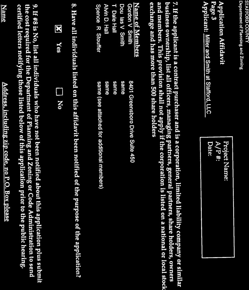
Transcription


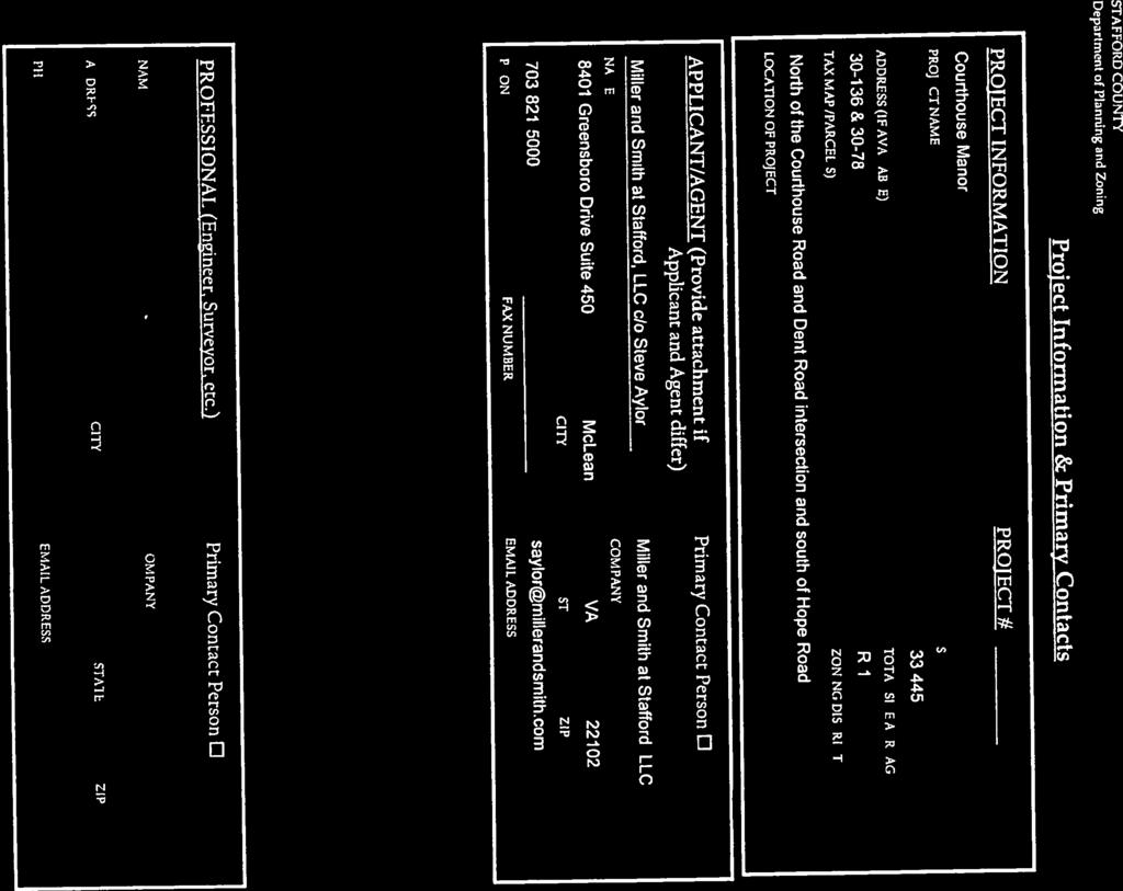
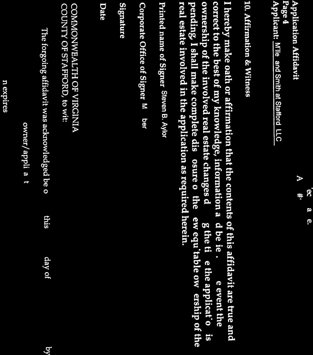
1 1 Board of Supervisors Jack R. Cavalier, Chairman Gary F. Snellings, Vice Chairman Meg Bohmke Paul V. Milde, III Laura A. Sellers Cord A. Sterling Robert Bob Thomas, Jr. November 12, 2014 Anthony J. Romanello, ICMA CM County Administrator MEMORANDUM TO: FROM: Stafford County Planning Commission J SUBJECT: CUP ; Conditional Use Permit; Courthouse Manor ATTACHMENTS: 1. Location Map 2. Application and Related Materials 4. Transportation Assessment 5. Proposed Resolutions 3. Generalized Development Plan ISSUE: The Planning Commission is to consider a request for a Conditional Use Permit to allow for additional density in a cluster subdivision on Assessor's Parcels and BACKGROUND: Location: Election District: Applicant: Agent: North of the intersection of Courthouse Road and Dent Road, south of Hope Road and approximately 2,000 feet east of Jefferson Davis Highway Aquia Miller and Smith at Stafford, LLC 8401 Greensboro Drive, Suite 450 McLean, Virginia Mr. Charles W. Payne, Jr. Hirschler Fleischer 725 Jackson Street, Suite 200 Fredericksburg, VA Courthouse Road, P. O. Box 339, Stafford, VA Phone: (540) Fax: (540)

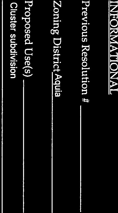
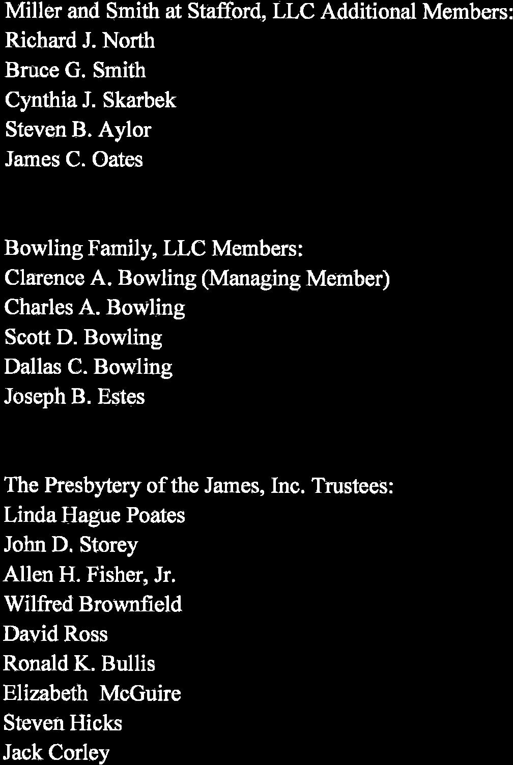
2 Memorandum to: Stafford County Planning Commission November 12, 2014 Page 2 of 14 Property Owners: TM The Presbytery of the James, Incorporated 3218 Chamberlayne Avenue Richmond, Virginia TM Bowling Family, LLC 1950 Courthouse Road Stafford, Virginia Current Use: Proposed Use: Application Date: Undeveloped 75 Lot Single-Family Residential Cluster Subdivision June 30, 2014 (Original Submission) October 10, 2014 (Complete Application) Advertisement Dates: October 28, 2014 and November 4, 2014 Time Limit: February 10, 2015 Staff Project Manager: Erica H. Ehly, AICP Assessor s Parcels: and Area: acres Comprehensive Plan: TM Courthouse UDA (Future Land Use) TM Suburban (Future Land Use)

 Zoning Classification: R-1,")
3 Memorandum to: Stafford County Planning Commission November 12, 2014 Page 3 of 14 TM & TM Courthouse Redevelopment Area (RDA) Zoning Classification: R-1, Suburban Residential
4 Memorandum to: Stafford County Planning Commission November 12, 2014 Page 4 of 14 Abutting Properties: Location Zoning Existing Use Comprehensive Plan North R-1, Suburban Residential Single-Family Residential Suburban and Courthouse UDA/RDA South R-1, Suburban Residential A-1, Agricultural Religious Institution Single-Family Residential Suburban and Courthouse UDA/RDA East R-1, Suburban Residential Single-Family Residential Suburban West R-1, Suburban Residential Stafford Elementary School Courthouse UDA/RDA Utilities: Transportation: The property is located within the Urban Services Area, and is served by the public water and sewer system. There is an existing 12 waterline in the Courthouse Road right-of-way, as well as existing 8 water lines in the Hope Road and Dent Road right-of-way. The Utilities Department has requested an easement through the property to connect the two waterlines; a 15-foot easement running the length of the proposed Northeast Courthouse Bypass Road right-of-way will be dedicated by the applicant. The proposed development of 75 single-family homes would create demand for 18,000 gallons per day (gpd) for water and 22,500 gpd for sewer; this is an additional demand of 6,000 and 7,500 gpd, respectively when compared to byright development. According to the Transportation Assessment for Planned Northeast Courthouse Bypass, dated October 3, 2014, the transportation network in the area of the proposal can be described as follows: Courthouse Road is a two-lane undivided urban collector roadway with a posted speed limit of 35 mph and an estimated traffic volume of 10,000 vehicle trips per day (VPD); Hope Road is a two-lane undivided urban collector with a posted speed limit of 35 mph and an estimated traffic volume of 5,900 VPD; Dent Road is a twolane undivided local road with an un-posted speed limit and an estimated traffic volume of 370 VPD. The proposed development of 75 lots will generate an increase of approximately 269 vehicular trips per day (VPD) for a total of 806 VPD; by-right development would generate approximately 537 VPD. Stormwater Management: Schools: Parks and Recreation: The development of the parcel as a 75-lot residential subdivision will result in approximately 9.94 acres acres of impervious area; by-right development within the zoning district would result in 6.7 acres of impervious area. The proposed development would generate approximately 49.5 primary and secondary students utilizing the countywide average of 0.66 students per unit, or 97.5 students utilizing the new neighborhoods generation rate of 1.3 students per unit; this is an additional 16.5 to 32.5 students respectively, when compared to byright development. Utilizing the Parks & Recreation Level of Service of 20-acres per 1,000 residents, the proposed development will create a demand for 3.9 acres of land for parks and

5 Memorandum to: Stafford County Planning Commission November 12, 2014 Page 5 of 14 COMMENTS: recreation; this is an additional demand of 1.3 acres when compared to the by-right demand of 2.6 acres. The applicant has stated that the proposal provides acres of passive recreational facilities in the form of common open space. The applicant is requesting a conditional use permit for additional density for a cluster subdivision in the R-1, Suburban Residential Zoning District, to allow for a proposed 75-lot residential subdivision on Assessor's Parcels and 30-78, which total acres. The current R-1 zoning classification allows for up to 1.5 dwelling units an acre, which would yield approximately 50 single-family homes in both a conventional or by-right cluster subdivision; the conditional use permit will allow for 25 additional units, resulting in a density of 2.24 du/ac. Existing Conditions The acre subject property is located north of the intersection between Courthouse Road and Dent Road, south of Hope Road. Stafford Elementary School is located on the property immediately to the west; a church to the south; single-family residential development to the east and the north. Site - Aerial Location
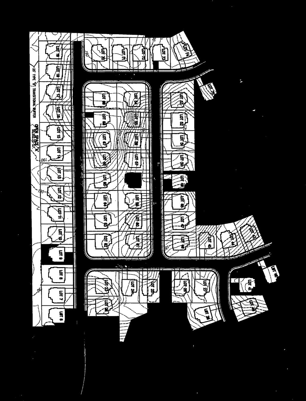
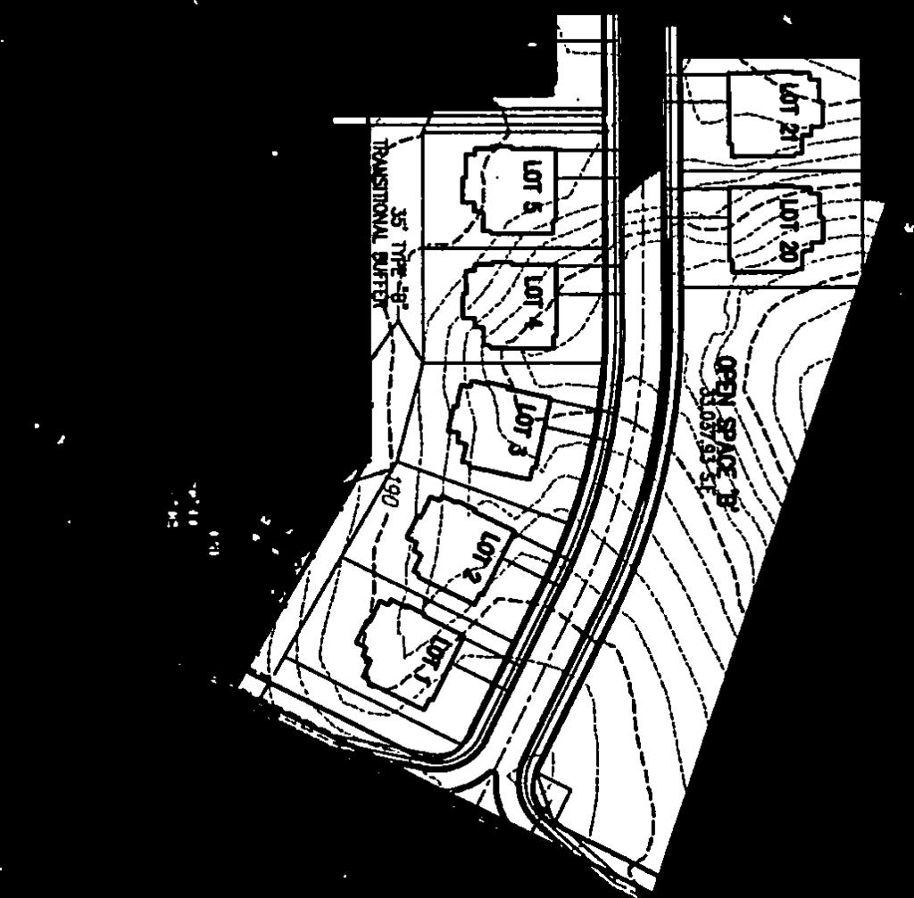
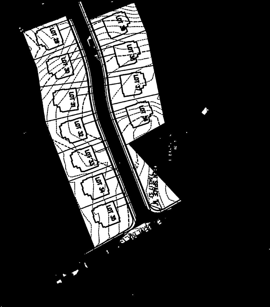
6 Memorandum to: Stafford County Planning Commission November 12, 2014 Page 6 of 14 The property is currently vacant and the majority of the site is wooded. Approximately 32 acres of wooded area will be removed as a result of this proposal. A preliminary jurisdictional determination made by the U.S. Army Corps of Engineers concluded that there are no wetlands or streams located on the property. The Virginia Department of Historic Resources identifies the northern area of the property as located within the land route taken by the Continental, French and Crown forces from August 1781 to July of 1782 to, and from, the siege of Yorktown. There are two archaeological site records listed with the Department; these are temporary camp sites identified in this location as a result of a review of an itinerary of troop marches in the Rochambeau Papers, dated July of The first site is a French infantry campsite and the second is the campsite of Lauzun s Legion, both at Garrit s Tavern. All known campsites along the Washington-Rochambeau Route have been listed as archaeological sites as part of the survey that was completed in order to protect potentially valuable archaeological resources, although the specific location is not always known. A condition has been added that a Phase I Cultural Resource Study is completed prior to the submission of the preliminary plan. Staff also recommends the posting of a narrative sign on the property line along Hope Road in accordance with the practice of posting other historical markers throughout the County. Generalized Development Plan The Generalized Development Plan (GDP), dated October 10, 2014, depicts the proposed design of the site to include 75 lots at a density of 2.24 dwelling units per acre (du/ac), which is under the 2.5 du/ac maximum permitted under the cluster provisions within the R-1 zoning classification, permitted with the approval of a conditional use permit. The parcel is acres in size and, at the time this application was submitted, the density calculation utilized the gross acreage of the site. The proposed development identifies acres, or percent of the site, as common open space, meeting the 30-percent requirement.

. The School Division has requested an additional pedestrian easement at the north end of the development at Lot 15 to come out near the baseball field (see image B below).")
7 Memorandum to: Stafford County Planning Commission November 12, 2014 Page 7 of 14 Generalized Development Plan The GDP reflects the construction of a 6-foot sidewalk connecting the development to the existing sidewalk network of Stafford Elementary School through an open space area adjacent to Lot 1, consistent with Comprehensive Plan Policy 6.3.1, which states that development proposals should establish sidewalks to connect local neighborhoods with activity centers such as shopping, employment, and schools and with one another (see image A below). The School Division has requested an additional pedestrian easement at the north end of the development at Lot 15 to come out near the baseball field (see image B below). The applicant has stated that there is not an existing pedestrian system to connect to, and has declined the request. Staff supports the request made by the School Division for a pedestrian easement. Image A Image B

8 Memorandum to: Stafford County Planning Commission November 12, 2014 Page 8 of 14 A 17.5-foot modified transitional buffer with a fence is shown along the western property line with Stafford Elementary School. A 35-foot transitional buffer is required between institutional uses, such as schools, and single-family detached residential development; however, the Code permits the buffer width, and the number of plant units within it, to be reduced by 50 percent if a 6-foot tall privacy/opaque fence is located within the buffer yard. The GDP shows a 20-foot wide buffer along the proposed Northeast Courthouse Bypass Road right-ofway of a double row of evergreen trees, consistent with the Suburban land use description in the Comprehensive Plan, which states that buffering should be required along major arterial and collector roads to limit road noise in residential areas. The proposed development will have two access points; one to Dent Road and the other to Courthouse Road. The proposal received approval for access to Dent Road, which currently has an un-posted speed limit; in these instances, a 55 mph speed limit is assumed for design purposes. The applicant conducted a Dent Road Speed Study, dated June 10, 2014, which determined an appropriate speed limit of 30 mph. This conclusion was reviewed by the Virginia Department of Transportation (VDOT) and it was found that the analysis is acceptable for purposes of sight distance for a proposed street connection. Revisions reflecting additional specificity as requested by VDOT will need to be included with the submission of future development plans, such as the Preliminary Plan. Staff notes that it does not appear that VDOT intends to post a speed limit sign for Dent Road in this location and recommends that a sign is placed either by VDOT or the developer before access occurs. The proposed right-in/right-out on Courthouse Road has been designed to decrease the ability to make a left turn into the site, per the request of VDOT. Primary Entrances
9 Memorandum to: Stafford County Planning Commission November 12, 2014 Page 9 of 14 Additionally, the GDP shows future connections to Dent Road and Hope Road via two access points on the proposed Northeast Courthouse Bypass Road. There is also an inter-parcel connection to TM identified between Lots 16 and 71 to the north. Future Access Points The applicant is dedicating 30 feet of right-of-way along Hope Road, 55 feet from centerline on Courthouse Road, and 25 feet from centerline on Dent Road. In addition, the applicant is dedicating a 60- foot right-of-way, together with the necessary construction easements (25 feet on the west side of the right-of-way and 15 feet on the east side), for the proposed Northeast Courthouse Bypass Road as called for in the Comprehensive Plan; the dedication is shown on the GDP along the eastern property line. The applicant has submitted analysis to determine the classification of roadway necessary to maintain the fourlane design of Route 1 (Transportation Assessment for Planned Northeast Courthouse Bypass, dated October 3, 2014, attached) and it was concluded that the future roadway could meet functional objectives as a two-lane divided section. Comprehensive Plan The Comprehensive Plan (Plan) identifies this site as being within the Suburban and Courthouse Urban Development Area (UDA) future land use designations. Additionally, the property is located within the Courthouse Area Redevelopment (RDA) Plan and the Courthouse Small Area Plan. The proposal reflects a density that is consistent with the Suburban land use designation and more consistent with the UDA than the by-right development.
10 Memorandum to: Stafford County Planning Commission November 12, 2014 Page 10 of 14 The proposed development is generally consistent with the recommended development standards for the Suburban and Courthouse UDA future land use designations as described in the Plan. The average lot size within the proposed development is 9,000 square feet, which is consistent with the suburban scale of development of single-family detached dwelling units, typically on ¼ to ½ acre lots. The site is surrounded by developed parcels and is located with direct access to an existing four-lane undivided urban collector roadway, consistent with infill development in the proximity of the established communities in the northern and southern areas of the County and in close proximity to major existing or planned transportation networks. The proposed development reflects a density of 2.24 du/ac; includes pedestrian connectivity to the Stafford Elementary School to the west; and includes 30 percent open space. Development densities within the Suburban future land use designation should not exceed 3 du/ac for residential development; sidewalks and pedestrian trails should be located within neighborhoods and provide access between residential and non-residential uses; and developments are encouraged to preserve 25 to 50 percent of the site for a combination of natural and usable open space. The increase in density and compact form of development is consistent with the maximum 4 du/ac of the UDA. The Courthouse Small Area Plan, which provides more specific recommendations for the Courthouse UDA, recommends single-family detached residential units on this property. The Plan states that the use of innovative development techniques (clustering, zero lot lines and planned unit developments) are encouraged to allow for development with minimal impact on sensitive natural resources (steep slopes, poor soils, floodplains, and drainage ways). There are no wetlands or streams located on the property; however, approximately 32 acres of wooded area will be removed as a result of the proposal. A tree will be provided in each rear yard, which is in addition to code requirements of one tree in the front yard. A reduced 17.5-foot transitional buffer will be provided along the majority of the property line with the elementary school to the west; staff recommends a full 35-foot buffer, consistent with Policy of the Comprehensive Plan, which states that the maximum amount of tree cover on developed and developing sites shall be protected or restored, and also with Section 200 of the Design and Construction Standards for Landscaping, Buffering and Screening (DCSL), which states that buffer yards are intended to recreate or preserve native woodlands. The Neighborhood Development Standards identify specific architectural guidelines for residential development. The applicant has included a commitment to a general design type, as illustrated in Exhibit B of the application, which shows five different examples of single-family home design.


11 Memorandum to: Stafford County Planning Commission November 12, 2014 Page 11 of 14 Proposed Conditions The examples appear consistent with the standards related to variations in rooflines and the consistency of mass and scale within the development; front stoops and porches are also shown. Sidewalks within the subdivision contribute to an interconnected network of sidewalks. Staff recommended a condition that all building permits are reviewed for consistency with the Neighborhood Development Standards, which apply to all new development within the UDAs, in addition to conditions for a minimum 20-foot driveway length and the provision of foundation landscaping in front of homes. Additionally, the Plan states that buffering should be required along major arterial and collector roads to limit road noise in residential areas; the proposal includes a 20-foot buffer along the proposed Northeast Courthouse Bypass Road in order to reduce road noise impacts. The applicant has dedicated 60 feet of right-of-way on the property in the location of the Northeast Bypass Road as identified in the Comprehensive Plan; this is consistent with the hierarchical system of streets called for in the UDA and the future bypass road described in the RDA Plan. Staff is proposing several conditions to help offset any potential impacts, primarily related to the historical resources, buffering and future transportation improvements. 1. This conditional use permit is to allow for a cluster subdivision in the R-1, Suburban Residential Zoning District, which shall be limited to 75 single-family dwelling units. 2. A 20-foot street buffer shall be located between the residential lots and the right-of-way for the future Northeast Courthouse Bypass Road consisting of a double row of evergreen trees feet of right-of-way shall be dedicated for the future Northeast Courthouse Bypass Road prior to approval of a Preliminary Plan.
12 Memorandum to: Stafford County Planning Commission November 12, 2014 Page 12 of The easement for a sewer force main from Hope Road to Dent Road, running the length of the proposed Northeast Courthouse Bypass Road right-of-way as depicted on the Generalized Development Plan (GDP), prepared by Bowman Consulting, dated October 10, 2014, shall be dedicated to the County prior to the recordation of the first section of the subdivision. 5. Each building permit shall be reviewed for consistency with the design elevation in Exhibit B, dated June 2, 2014, with the addition that potential expanses of unadorned wall shall be divided by windows or trees. 6. Driveways shall maintain a distance of at least 20 feet from the edge of the sidewalk abutting the lot line to the garage. 7. Each lot shall contain typical foundation landscaping and at least one tree shall be provided in the rear yard. 8. The option of at least one access point at grade for handicap access will be available for home purchasers. 9. A Phase 1 Cultural Resource Study shall be completed prior to the submission of the Preliminary Plan; a Phase II Study will also be completed if warranted by the results of the Phase I Study. 10. The stormwater management pond embankment shall be designed to appropriate width and stability to support the future construction of the Northeast Courthouse Bypass Road. 11. The applicant shall clear, grade and sod the area within the full right-of-way for the Northeast Courthouse Bypass Road. 12. The applicant shall provide construction easements for the future construction of the Northeast Courthouse Bypass Road. 13. The applicant shall dedicate right-of-way on Hope Road to equal a minimum of 30 feet from the centerline and to accommodate the design of the Northeast Courthouse Bypass Road intersection. 14. The applicant shall dedicate right-of-way on Courthouse Road to equal 55 feet from the centerline. 15. Residential fire sprinklers shall be provided within each residential unit, or each side-yard setback shall be ten feet. 16. The applicant shall construct a sidewalk adjacent to Lot 1 and connecting to the pedestrian network of the Stafford Elementary School to the west, as shown on the GDP. 17. The applicant shall dedicate an access easement to accommodate a 6-foot wide pedestrian connection to the school in the vicinity of where Lot 15 is shown on the GDP.
13 Memorandum to: Stafford County Planning Commission November 12, 2014 Page 13 of This Conditional Use Permit may be revoked or conditions amended by the Board for violation of these conditions or any applicable county, state or federal code, law, ordinance, or regulation. EVALUATION CRITERIA: Section of the Zoning Ordinance lists six (6) criteria to be considered at each public hearing for a conditional use permit. A summary of each criteria are as follows: 1. The use shall not change the character and established pattern of development in the vicinity of the proposed use - Although the proposed use is a more intense residential development than the large-lot single-family development to the east, it helps to create an area of transition between the church, school and commercial uses to the west, and is consistent with the higher density UDA future land use designation. 2. The use shall be in harmony with uses permitted by-right under a zoning permit in the land use district and shall not adversely affect the use of adjacent properties - The proposed use is in harmony with the permitted by-right uses in the R-1 Zoning District; the proposal includes adequate buffering measures and pedestrian connectivity with the elementary school. 3. The location and height of buildings, the location, nature and height of walls and fences and the nature and extent of landscaping on the site shall be such that the use will not hinder or discourage the appropriate development and use of adjacent land and buildings or impair the value thereof - The proposed use will not hinder or discourage appropriate development or impair the value of the land and buildings on adjacent properties. 4. The use shall not adversely affect the health or safety of persons residing or working in the vicinity of the proposed use Staff recommends that the applicant coordinate with VDOT to post a speed limit sign on Dent Road; the access along Courthouse Road has been designed in such a way as to decrease the ability to turn left into the proposed development, requiring the utilization of existing Dent Road to turn left. 5. The use shall not be detrimental to the public welfare or injurious to property or improvements in the neighborhood - Proposed conditions include the option of a fire sprinkler system within each unit or a minimum 10-foot side yard setback. 6. The use shall be in accord with the purposes and intent of this chapter and the Comprehensive Plan of the County - The proposed use is consistent with the land use recommendations in the Comprehensive Plan, as the proposed location and the design configuration of the use are appropriate on the subject parcel with the addition of the proposed conditions. SUMMARY OF POSITIVE AND NEGATIVE FEATURES: POSITIVE: 1. The proposal is consistent with the established development pattern in the vicinity. 2. The proposed uses and development pattern meets the intent of the Comprehensive Plan, including land use, transportation, pedestrian connectivity and open space recommendations.
14 Memorandum to: Stafford County Planning Commission November 12, 2014 Page 14 of The proposal accommodates planned transportation improvements to the surrounding transportation network. NEGATIVE: 1. Access to Dent Road presents a safety concern if the speed limit that is consistent with the speed study remains un-posted at that time. RECOMMENDATION: Staff believes, on balance, that the positive aspects outweigh the negative aspects and recommends approval of the conditional use permit with the application of the proposed conditions pursuant to R JAH:ehe Attachments (5)
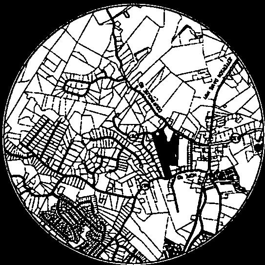
15 Property & Location BELLS HILL RD CLUB DR Attachment 1 Page 1 of 1 OAK DR HOPE RD ^_ COURTHOUSE RD MOURNING DOVE DR DENT RD CUP CONDITIONAL USE PERMIT COURTHOUSE MANOR CARE LN PERSEVERE DR HOPE RD LOVELACE LN ROLES LN MOURNING DOVE DR STAFFORD AVE SITE COURTHOUSE RD DENT RD LITTLE ROCKY RUN LN Feet , Stafford County Department of Planning & Zoning P.O. Box 339 Stafford, VA (540)

16 Attachment 2 Page 1 of 44

17 Attachment 2 Page 2 of 44

18 Attachment 2 Page 3 of 44

19 Attachment 2 Page 4 of 44


20 Attachment 2 Page 5 of 44


21 Attachment 2 Page 6 of 44
22 Attachment 2 Page 7 of 44

23 Attachment 2 Page 8 of 44

24 Attachment 2 Page 9 of 44

25 Attachment 2 Page 10 of 44

26 Attachment 2 Page 11 of 44

27 Attachment 2 Page 12 of 44

28 Attachment 2 Page 13 of 44

29 Attachment 2 Page 14 of 44


30 Attachment 2 Page 15 of 44


31 Attachment 2 Page 16 of 44

32 Attachment 2 Page 17 of 44


33 Attachment 2 Page 18 of 44

34 Attachment 2 Page 19 of 44


35 Attachment 2 Page 20 of 44
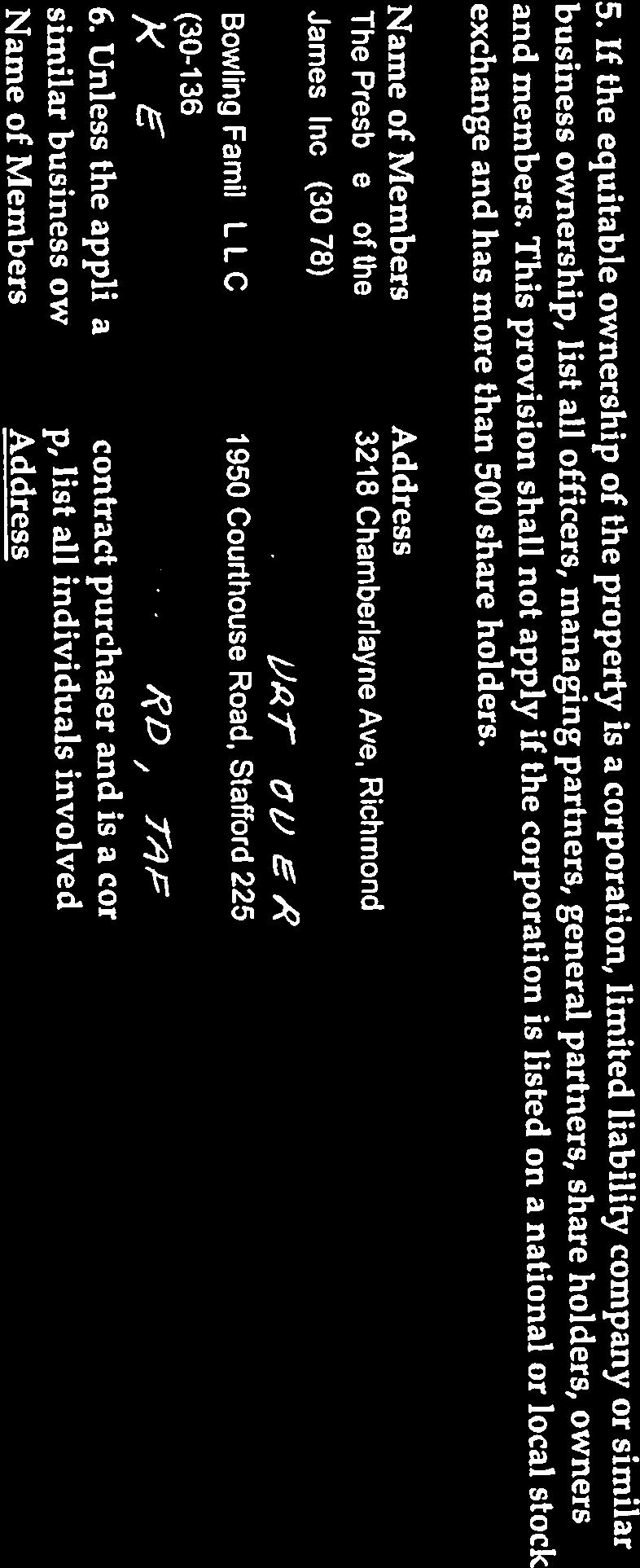
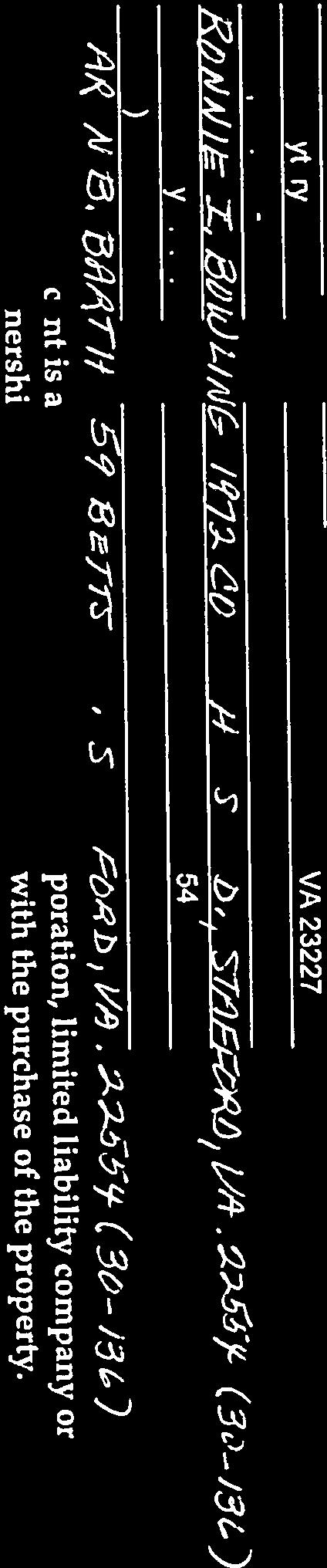
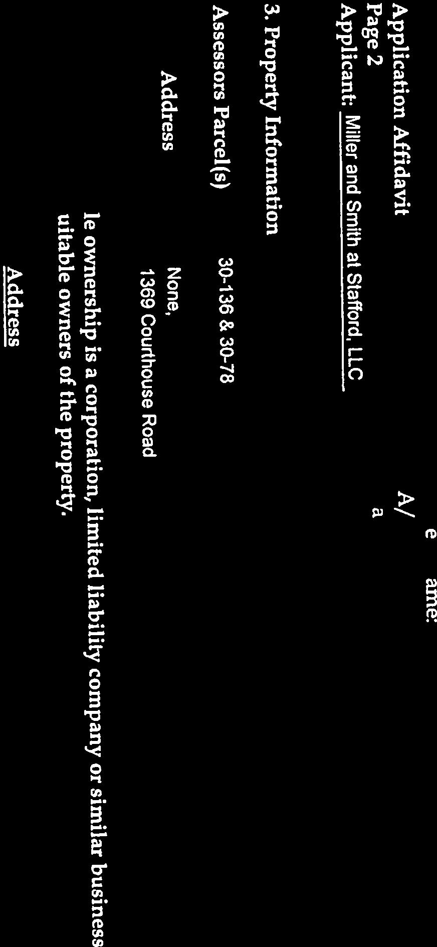
36 Attachment 2 Page 21 of 44 STAFFORD COUNTY, VIRGINIA CONDITIONAL USE PERMIT APPLICATION IMPACT STATEMENT Applicant: Property Owners: Miller and Smith at Stafford, LLC TM : Ronnie Bowling and Bowling Family, LLC TM 30-78: The Presbytery of the James, Inc. Property: Tax Parcels and Project Name: CUP Request: Courthouse Manor Cluster subdivision in the R-1 District Date: October 10, 2014 File No. CUP I. APPLICATION The property owners, as provided above (collectively the Owners ), through the contract purchaser, Miller and Smith at Stafford, LLC, or its assigns or successors (the Applicant ), hereby request a conditional use permit ( CUP ) to develop the following property for a cluster subdivision in the Suburban Residential (R-1) land use district in accordance with the Stafford County Zoning Ordinance (the Zoning Ordinance ), including without limitation Article III, Section and Article XI Section : Tax Parcels (of record in Instrument No. LR ) and (of record in Instrument No. LR ) (collectively, the Property ), consisting of approximately acres total, and generally located north of the Courthouse Road and Dent Road intersection and south of Hope Road, within the Aquia Magisterial District, all as more particularly described on the attached Courthouse Manor Generalized Development Plan, dated October 10, 2014, prepared by Bowman Consulting, which plan is attached hereto as Exhibit A and is incorporated as a material part of this application by this reference (the GDP ) 1. 1 The GDP is a general overview of the proposed development and improvements to the Property in accordance with Article XIII, Section , et seq., of the Zoning Ordinance. The Applicant reserves the right to make modifications or amendments to the GDP in order to address final site engineering, architectural, and design issues, internal road placements and entry areas, RPA requirements, and to ensure compliance with applicable federal, state and county regulations, laws and ordinances. 1
37 Attachment 2 Page 22 of 44 The R-1 district permits cluster subdivisions by right, except for densities greater than 1.5 dwelling units per acre, which then require a conditional use permit ( CUP ). As depicted on the GDP, the Applicant s proposed density for the Property is 2.24 dwelling units per acre. We have included with this application illustrative elevations and renderings depicting the proposed architectural design and building material features, which only include general type, character, and quality of architectural design, details, and materials, all as generally shown on Exhibit B attached hereto and made a part hereof by this reference (the Renderings ). This application provides the following key development features: (1) No more than 75 single-family detached units (2) Average lot size of acres (3) Density of 2.24 dwelling units per acre (4) Open space of acres, or 30.05% of the Property; without the Northeast Courthouse Bypass right of way dedication the open space would be 37.55% of the Property (5) Clustering of lots to promote appropriately dense development (6) Proffered architectural and design features as generally provided on the Renderings (7) Dedication of a thirty foot (30') wide right of way for Hope Road (8) Dedication of right of way along Dent Road to widen the right of way to twenty five feet (25 ) from the centerline (9) Dedication of a sixty foot (60') wide right of way, together with necessary construction easements, across the Property for the future Northeast Courthouse Bypass along with partial grading and clearing of the said dedicated area (10) Dedication of right of way along Courthouse Road to widen the right of way to fifty five feet (55 ) from the centerline (11) Total right of way dedications and associated grading and roadway improvements valued at $2,389,467 (12) Construction of a pedestrian pathway or sidewalk from the site to the adjoining elementary school (13) Project is located within Stafford County s (the County ) Urban Service Area, and will connect to public water and sewer (14) Project is consistent with the County s Comprehensive Plan (the Comp Plan ), as described below. II. OVERVIEW As noted above, the Property is zoned R-1. Section of the County s Zoning Ordinance states the following concerning the R-1 district: The purpose of the R-1 district is to provide areas which are in close proximity to existing or future development of equivalent or higher densities, and which are 2
38 Attachment 2 Page 23 of 44 intended for low density residential development where public water and sewerage facilities are available. Development in the R-1 district is intended to be characterized by single-family dwellings. Pursuant to Article III, Section of the Zoning Ordinance, a CUP is required in order to develop a cluster subdivision in the R-1 district if the applicant requests a density of dwelling units greater than 1.5 per acre. The Zoning Ordinance defines cluster as [a] subdivision development design technique that concentrates detached single-family dwellings in specific areas on the site to allow the remaining land to be used for recreation, common open space, and preservation of environmentally sensitive features and rural character... Cluster subdivisions in the R-1 district permit an average density of up to 2.25 dwelling units per acre, while conventional subdivisions permit an average density of up to 1.5 dwelling units per acre. The proposed development includes 2.24 dwelling units per acre, which requires a conditional use permit. The Applicant s proposed cluster subdivision includes 75 lots located on approximately acres. The GDP reflects acres of open space accounting for approximately 30.05% of the Property. Please note that without the Northeast Courthouse Bypass right of way dedication, the open space percentage would be 37.55%. This exceeds the 30 percent minimum required by the R-1 district for cluster subdivisions. The open space will be used for stormwater management facilities, and recreational and natural areas. The Property is located north of the Courthouse Road and Dent Road intersection and south of Hope Road. Adjacent and nearby properties are generally developed as similar cluster subdivisions, while some nearby properties are wooded or developed as low density residential lots. Stafford Elementary School is located immediately west of the Property, and a church is located immediately south. Existing and planned residential subdivisions in the area include Moncure Estates, Somerset Landing, and Seasons Landing. The Applicant s proposal will be compatible with existing and planned uses in the area. Additionally, the Applicant s proposal will further enhance the local housing stock while maintaining the rural character of the area through inclusion of appropriate buffering and open space. As described below, the Applicant s proposal conforms to the policies established by the Comp Plan. Adjacent properties will experience minimal impacts as this is a similar and compatible proposes use. Furthermore, the proposal will result in minimal impacts on public facilities and services, and will result in a net economic benefit for the County. III. COMPREHENSIVE PLAN Future Land Use Map The Comp Plan s Future Land Use Map classifies Parcel as part of the Courthouse Urban Development Area (the CUDA ), while Parcel is designated Suburban Residential. The Property in its entirety is also part of the Courthouse Redevelopment Area (the CRA ). 3
39 Attachment 2 Page 24 of 44 In general, the Urban Development Areas (the UDAs ) are intended to encourage mixed use development, TND concepts, a compact built environment, and public amenities including open space and pedestrian facilities. For residential development, the recommended minimum densities for single family subdivisions, townhouse developments, and multifamily developments are 4, 6, and 12 dwelling units per acre, respectively. These figures also serve as density maximums. The CUDA calls for approximately 1,386 dwelling units and 2,727,310 square feet of retail and office space for the entire CUDA. The CRA calls for 1,446 dwelling units and 1,327,310 square feet of commercial development for the entire CRA. The overall density of the CRA is planned for 0.76 dwelling units per acre, while the planned density for the CUDA is the same as provided above for other UDAs. Both the CUDA and the CRA encourage developments to include recreational facilities and dedicated open space. The Suburban Residential designation encourages low density residential development, as well as limited commercial development. Development is expected to occur on quarter to half acre lots, with densities of up to three dwelling units per acre. Townhouses and multifamily development are generally discouraged. Additionally, the Suburban Residential designation promotes preservation of sensitive environmental features and open space through use of innovative development techniques such as clustering and planned unit developments. The Plan encourages preservation of 25 to 50 percent of land for a combination of natural and usable open space. Given the Property s location in multiple Future Land Use designations, the Comp Plan s policies should be blended when interpreting whether the Comp Plan supports the Applicant s proposal. The CUDA and the CRA call for moderately dense residential development, while the Suburban Residential calls for lower density residential development. If the policies of the CUDA and Suburban Residential designation are blended, and if the CRA s density policies are considered, the Client s proposed density of 2.24 dwelling units per acre is supported by the Comp Plan when all of the applicable density policies are taken as a whole. Furthermore, the Applicant s proposal meets the Comp Plan s open space policies. The Applicant s proposed density also provides for the maximum number of lots possible without exceeding the R-1 district s maximum density for cluster subdivisions of 2.25, which provides further reason for applying a lower density than provided in the CUDA. When the Comp Plan s policies are interpreted as a whole, the Comp Plan supports the Applicant s proposed development. Urban Service Area The Comp Plan includes the Property in the Urban Service Area. This designation attempts to funnel new development in the County to the land around I-95 and other major transportation corridors in order to take advantage of existing public utilities in the area. The Urban Service Area supports any new development which is compatible with the Property s Future Land Use Map designation. The Property s location in the Urban Service Area supports the project s utilization of existing public utilities. Based on nearby development patterns, water and sewer lines appear to be 4
40 Attachment 2 Page 25 of 44 located adjacent to the Property in the Courthouse Road, Dent Road, and Hope Road rights of way. Transportation The Property is located north of the Courthouse Road and Dent Road intersection and south of Hope Road. Courthouse Road and Hope Road are urban collector roads, while Dent Road is a local road. The Comp Plan s Anticipated Transportation Needs Map designates this segment of Hope Road for future two lane upgrades and this segment of Courthouse Road for future four lane upgrades, but does not specify the type of upgrades. As depicted on the GDP, the Applicant will dedicate right of way for Hope Road, Courthouse Road, and Dent Road to accommodate future road improvements. In addition, the Comp Plan s Proposed Transportation Improvements Map calls for construction of a Northeast Courthouse Bypass, which extends through Parcel The Applicant s planned transportation improvements and dedications will advance the Comp Plan s policies, as discussed below in Section V. This dedication will provide 71.5% of the necessary right of way length for the Northeast Courthouse Bypass, as depicted on the Transportations Improvements Map, and the Applicant will further clear and partially grade said dedicated area. Top soil will be removed within the dedicated area to assist in the future final grading of the Northeast Courthouse Bypass, and no unsuitable soils will be placed in the dedicated area. This is a positive opportunity for the County to ensure future and improved mobility in the Courthouse area. IV. CONDITIONAL USE PERMIT STANDARDS Section (d) of the County s Zoning Ordinance requires conditional use permit applications to meet the following standards: 1. The use shall not tend to change the character and established pattern of development in the vicinity of the proposed use The Property is mostly wooded. Properties in the area are either wooded or developed for single family dwellings in subdivisions of varying densities. Other nearby uses include Stafford Elementary School, a church, and commercial uses along Courthouse Road. Several cluster subdivisions are located nearby. Since most nearby properties are developed for single family subdivisions, the Client s proposal will not change the character and established pattern of development in the area and will provide adequate buffering to neighboring properties, as shown on the GDP. 2. The use shall be in harmony with the uses permitted by right under a zoning permit in the land use district and shall not adversely affect the use of adjacent properties The permitted uses in the R-1 district generally relate to relatively low density residential development. A cluster subdivision is in harmony with by-right uses in the R-1 district because it is simply a denser version of permitted development. Surrounding developments consist of comparable density, and most surrounding property is also zoned R-1, which means the proposal will not adversely affect the use of adjacent properties. 5
41 Attachment 2 Page 26 of The location and height of buildings, the location, nature and height of walls and fences and the nature and extent of landscaping on the site shall be such that the use will not hinder or discourage the appropriate development and use of adjacent land and buildings or impair the value thereof The Applicant s proposal will not hinder or discourage the appropriate development of adjacent land. As depicted on the GDP, the Applicant will provide appropriate buffering, screening, and open space around the Property s perimeter to ensure impacts on adjacent properties are minimized. Additionally, the proposed cluster subdivision will not detrimentally impact property values, and may result in an increase in nearby residential property values if the sale of new residences in the development results in favorable comparable sales. 4. The use shall not adversely affect the health or safety of persons residing or working in the vicinity of the proposed use Since the proposed development is compatible with surrounding development as described above, the proposed cluster subdivision will not adversely affect the health or safety of persons residing or working in the vicinity of the proposed use. 5. The use shall not be detrimental to the public welfare or injurious to property or improvements in the neighborhood Since the proposed development is compatible with surrounding development as described above, the proposed cluster subdivision will not be detrimental to the public welfare or injurious to property or improvements in the neighborhood. 6. The use shall be in accord with the purposes and intent of this chapter and the comprehensive plan of the county See Comprehensive Plan analysis in Section III above. V. TRAFFIC AND TRANSPORTATION IMPACTS The Property is located north of the Courthouse Road and Dent Road intersection and south of Hope Road. Internal subdivision roads constructed by the Applicant will have curb cuts on Courthouse Road and Dent Road, while the future Northeast Courthouse Bypass will have curb cuts on Dent Road and Hope Road. The internal subdivision road accessing Courthouse Road will have a right in, right out curb cut, and the internal subdivision road accessing Dent Road will have a full access curb cut. As shown on the GDP, the Applicant will dedicate a thirty foot (30 ) wide right of way along Hope Road. Additionally, the Applicant will dedicate right of way to widen the Dent Road and Courthouse Road rights of way to twenty five feet (25 ) and fifty five feet (55 ), respectively, from the applicable centerlines, which will provide the necessary right of way for planned future road improvements adjacent to the Property. Further, the Applicant will dedicate a sixty foot (60') wide right of way, together with necessary construction easements, for the proposed Northeast Courthouse Bypass in the location called for in the Comp Plan, and the Applicant will further clear and partially grade said dedicated area. Top soil will be removed within the dedicated area to assist in the future final grading of the Northeast Courthouse Bypass, and no unsuitable soils will be placed in the dedicated area. Additionally, a Northeast Courthouse Bypass disclosure will be included in the homeowners association documents. 6
42 Attachment 2 Page 27 of 44 The Applicant will dedicate a total of 3.17 acres of external right of way at a value of $397,612. The Applicant will also clear the Northeast Courthouse Bypass right of way area at a cost of approximately $19, and partially grade for the same at a cost of approximately $120,100. In addition, there will be approximately 4.87 acres of internal roads at a total value of $610,843. Additionally, the Applicant will construct internal subdivision roads and sidewalks, to be maintained by VDOT, at a total value of $1,241,412. Projected traffic generated by the proposed development does not trigger the requirement for a traffic impact analysis. Potential traffic impacts will be mitigated through the dedications and improvements described above. VI. PUBLIC UTILITIES, FACILTIIES AND SERVICES As noted above, the Property is located within the County s Urban Service Area and has access to public water and sewer. The proposed project will have minimal impact on utility demands. Existing water and sewer lines are located in adjacent right of ways. These utility lines and applicable water and sewer treatment facilities appear to have available capacity, or the reasonable ability to be upgraded to provide adequate capacity. The Property is located in the Aquia and Central water pressure zones. There is an existing 12 water line in the Courthouse Road right of way, as well as existing 8 water lines in both the Hope Road and Dent Road rights of way. Onsite water lines will generally be constructed along the proposed roads within the development creating loops and networks throughout the Property. The anticipated daily demand for water is as follows: 75 lots x 240 gpd/lot = 18,000 gpd The Property is located in the Austin Run sewer service area. There is an existing 8 sewer line in the Courthouse Road right of way and on the adjacent school property. An agreement has been reached between the Applicant and the school board for an easement to connect to the sewer line located on the school property. Onsite sewer lines will generally be constructed along the proposed roads within the development creating loops and networks throughout the Property. The anticipated daily demand for sewer is as follows: 75 lots x 300 gpd/lot = 22,500 gpd The Applicant s proposed use will have minimal impacts on schools, recreational facilities, police and emergency services, or other public services and facilities. By-right, the Applicant could develop fifty (50) single family detached units. With the cluster, the Applicant is gaining twenty-five (25) additional units, but is also providing 30.05% of the entire Property as open space, and dedicating necessary right of way (plus clearing and partial grading), at a cost to the Applicant of approximately $537,212 excluding internal roads, and a total cost of $2,389,467 including dedication and construction of internal roads. The twenty-five (25) additional units will produce anywhere from 16.5 (using county wide average of 0.66 pupils per unit for SFD) to 32.5 (using most recent county new development average of 1.3 pupils per unit) total pupils. We understand that there is adequate school facility capacity for this increase in the applicable attendance zone (Brook Point High School, Stafford Elementary and Middle Schools) of the Property. 7
43 Attachment 2 Page 28 of 44 County policies call for 20 acres of recreational facilities per 1,000 residents. Based on this policy, if each of the project s 75 homes are occupied by an average of four people, the project will generate demand for six acres of recreational facilities. Since the Applicant could develop 50 homes by-right under the current zoning, four of the recommended six acres for recreational facilities can be attributed to by-right dwelling units (which would not be required to provide associated recreational facilities under a by-right development), and two of the recommended six acres for recreational facilities can be attributed to additional density permitted by this application. As depicted on the GDP, the project will provide acres of passive recreational facilities, which more than satisfies the County s recreational facilities policies. Further, the average home price within this project is estimated at $450,000 to $525,000. We believe these homes will generate positive tax revenues similar to previously approved Shelton Woods and Shelton Knolls as the housing product, market and features are substantially similar. VII. ENVIRONMENTAL IMPACTS, NOISE, DUST, AND SMOKE No sensitive environmental features are located on the Property. Most of the Property is currently wooded. Approximately 32 acres of wooded area will be impacted by the proposed development, including impacts from development of roads and residential lots. Existing trees and vegetation will be preserved in open space as reasonably practical and buffer areas will be provided all as depicted on the GDP. Additionally, the proposed use will not generate noise, dust, or smoke. Some noise and dust may be generated during construction, but all construction activity will conform with applicable County requirements. The proposed development will incorporate low impact development techniques as well as conventional stormwater management techniques in order to reduce the post-developed runoff from the Property to pre-developed levels in accordance with County and State requirements. As a result, the proposed development will have minimal impacts downstream of the Property. The GDP indicates that approximately 29.71% of the Property will consist of impervious surface, which is an appropriate percentage for a subdivision of this size. 8
44 Attachment 2 Page 29 of 44 EXHIBIT A See attached Courthouse Manor Generalized Development Plan, prepared by Bowman Consulting, dated October 10,
45 Attachment 2 Page 30 of 44 EXHIBIT B See attached Courthouse Manor Architectural Elevation Illustrative prepared by Bowman Consulting, dated June 2,

46 Attachment 2 Page 31 of 44

47 Attachment 2 Page 32 of 44

48 Attachment 2 Page 33 of 44


49 Attachment 2 Page 34 of 44


50 Attachment 2 Page 35 of 44

51 Attachment 2 Page 36 of 44
52 Attachment 2 Page 37 of 44
53 Attachment 2 Page 38 of 44

54 Attachment 2 Page 39 of 44

55 Attachment 2 Page 40 of 44
56 Attachment 2 Page 41 of 44

57 Attachment 2 Page 42 of 44

58 Attachment 2 Page 43 of 44

59 Attachment 2 Page 44 of 44

60 Attachment 3 Page 1 of 8

61 Attachment 3 Page 2 of 8

62 Attachment 3 Page 3 of 8

63 Attachment 3 Page 4 of 8

64 Attachment 3 Page 5 of 8

65 Attachment 3 Page 6 of 8

66 Attachment 3 Page 7 of 8

67 Attachment 3 Page 8 of 8
68 Attachment 4 Page 1 of 28 October 3, 2014 Mr. Jeff Harvey 1300 Courthouse Road P.O. Box 339 Stafford, VA Re: CUP , Conditional Use Permit Courthouse Manor (the Project ) Transportation Assessment for Planned NE Courthouse Bypass Aquia Magisterial District Stafford County, VA BCG # Dear Mr. Harvey: Bowman Consulting Group (BCG) has prepared this transportation assessment for Miller & Smith, Inc. (the Applicant) in response to General Comment 3(c) in the County s 9/8/14 comment letter for the referenced Project. The Applicant is seeking a Conditional Use Permit (CUP) to allow the Project to be developed under R-1 Cluster zoning with 75 single-family residential units on approx acres. The current zoning of the site is R-1. The County s comment refers to the right-of-way dedication width for the northern segment of the planned Northeast Courthouse Bypass as depicted on the Project s Generalized Development Plan (GDP) dated 6/2/14 by BCG (see Attachment A, which shows the Overall Key Plan from the GDP). General Comment 3(c) states: The site design shows two access points onto the bypass road, this will require a fourlane design in this area and consequently 110 feet of ROW dedication; alternatively, the applicant may consider a two-lane undivided road without access with 60 feet of right-ofway dedication; or the applicant may submit a study to identify the roadway classification needed to provide the adequate mitigation of impacts to the intersection of Route 1 and Courthouse Road in order to maintain Route 1 as a four-lane road though the Courthouse area. This memorandum demonstrates that the Northeast Courthouse Bypass can function acceptably as a two-lane undivided roadway with level of service (LOS) C under projected 2035 conditions and provide two (2) points of access to the Project. The background, methodology, results and conclusions for this transportation assessment are offered below Westerre Parkway, Suite 150 Richmond, Virginia
69 Courthouse Manor Transportation Assessment October 3, 2014 Stafford County, VA Page 2 of 8 Attachment 4 Page 2 of 28 Background BCG and the Applicant understand that the County s comment is made in the context of significant planning efforts and studies (by the County) in recent years to prepare the Stafford County Courthouse Area Master Redevelopment Plan (Courthouse Plan). The Courthouse Plan is part of the Stafford County Master Redevelopment Plan, which was adopted as part of the County Comprehensive Plan in The Courthouse Plan was designed to further the following transportation objectives of the County s Comprehensive Plan: Maintain a safe road system Provide & maintain a multi-modal public transit system Create a system of sidewalks, bike paths, and trails to provide non-motorized transportation alternatives Create better patterns of traffic flow and circulation Attachment B includes the following illustrations and exhibits from the County s Courthouse Plan, with the Project location shown for reference: Figure 6.3 Courthouse UDA Land Use Concepts Figure 6.5 Courthouse UDA Street Types In Attachment B, Figure 6.3 identifies the Northeast Courthouse Bypass as a Collector Road, and Figure 6.5 identifies it as a Neighborhood Street. Both figures illustrate a conceptual grid network of streets which traverse the Applicant s property and connect at four (4) different locations to the planned Northeast Courthouse Bypass. These figures also illustrate the overall role that the Northeast Courthouse Bypass will play in providing street connectivity and circulation in the Courthouse Plan, as discussed in further detail below. Northeast Courthouse Bypass As illustrated on the graphics in Attachment B, the Applicant s project includes land which can provide right-of-way to complete the northern segment of the Northeast Courthouse Bypass. This segment is approximately 2,100 in length and would extend from Hope Road south to Dent Road. To complete the Northeast Courthouse Bypass, an additional 900 would need to be constructed (by others) from Dent Road to the intersection of Courthouse Road and Hospital Center Boulevard. When completed, the Northeast Courthouse Bypass will allow for a continuous ±1.6 mile route around the east side of Stafford s Historical Courthouse Village with connections to Route 1 at both ends. This route will begin at the Route 1/Bells Hill Road/Hope Road intersection and proceed east on Hope Road before turning south on the Northeast Courthouse Bypass and then connecting to Hospital Center Boulevard at Courthouse Road. Hospital Center Boulevard then curves back to the west before tying back into Route 1. The Route 1/Hospital Center Boulevard intersection is currently a 3-leg T intersection, but it is
70 Courthouse Manor Transportation Assessment October 3, 2014 Stafford County, VA Page 3 of 8 Attachment 4 Page 3 of 28 expected to have a western leg added to create a direct connection to the proposed relocation of the I-95/Route 630 interchange. Completion of the interchange project and connection to Route 1/Hospital Center Boulevard is expected between 2018 and Planned Roadways in the Courthouse Plan One of the key tenets of the Courthouse Plan is to create a grid network of streets in the Courthouse Area that will allow for safe and efficient mobility for all roadway users (car, pedestrian, bicycle and transit). Conceptual layouts of these roadways are provided in the Courthouse Plan figures included in Attachment B. In addition, the Courthouse Plan firmly states that a four-lane [Route 1] is the critical infrastructure item for the Courthouse Area. Although the County s Courthouse Plan was specific about the required cross-section for Route 1, there was no analysis conducted to determine the anticipated cross-sections of most of the roadways in the Courthouse Area including the Northeast Courthouse Bypass which are to comprise the desired grid network. Instead, the Courthouse Plan provided the functional recommendations shown in Attachment B and recommended that updated analyses be conducted as future development occurs to correlate capacity of the available street network with land use. This assessment is intended to serve that purpose, and a summary of the analysis methodology and results is provided in the sections below. Existing Conditions The key characteristics of the roadways in the vicinity of the Project are provided below for reference: Route 1 4-lane undivided o north of Hope Road (Rte. 687) 4-lane divided Functional Class = Urban (Other) Principal Arterial Posted Speed limit = 35 mph Avg. Annual Daily Traffic (AADT, 2013) = 16,000 VPD o south of Hope Road (Rte. 687) 4-lane undivided Functional Class = Rural Minor Arterial Posted Speed limit = 35 mph AADT (2013) = 15,000 VPD Route 630 east of Route 1 o 4-lane undivided o Functional Class = Urban Collector o Posted Speed limit = 35 mph o AADT (2013) = 10,000 VPD
71 Courthouse Manor Transportation Assessment October 3, 2014 Stafford County, VA Page 4 of 8 Attachment 4 Page 4 of 28 Hope Road (Rte. 687) east of Route 1 o 2-lane undivided o Functional Class = Urban Collector o Posted Speed limit = 35 mph o AADT (2013) = 5,900 VPD Dent Road (Rte. 707) north of Route 630 o 2-lane undivided o Functional Class = Local o Posted Speed limit = not posted o AADT (2013) = 370 VPD Currently, in the portion of the Courthouse Area northeast of the Route 1/Route 630 intersection, there is only one street connection to bypass the intersection. That connection is provided by Hope Road (proceeding east from its signal at Route 1) to Stafford Avenue, which proceeds south from its unsignalized intersection with Hope Road to an unsignalized intersection with Route 630 approximately 850 east of the Route 1/Route 630 intersection. This connection is currently being used by some vehicles to avoid traveling through the Route 1/Route 630 intersection. Numerous past traffic studies (including the recent US Route 1 Corridor Study) have documented that the Route 1/Route 630 intersection operates at overall LOS F (with delays between 2-3 minutes) during the existing weekday AM and PM peak hour. This intersection is believed to be the highest-delay intersection in the entire County. Future Conditions The traffic volume projections used for this assessment were derived from the following studies commissioned previously by VDOT and the County: VDOT I-95/Route 630 Interchange Modification Report (2011) Stafford Courthouse Urban Development Area (UDA) Traffic Impact Analysis (2012) Stafford County US Route 1 Corridor Study (Draft, Sep. 2014) For the purposes of this assessment, a horizon year of 2035 was chosen for analysis on the planned Northeast Courthouse Bypass because that horizon year coincides with the draft US Route 1 Corridor Study, which is the most recently completed study of those listed above. The projected volumes on the Northeast Courthouse Bypass were estimated based on engineering judgment applied to an evaluation of the following factors [associated contribution of estimated daily traffic noted in brackets]:
72 Courthouse Manor Transportation Assessment October 3, 2014 Stafford County, VA Page 5 of 8 Attachment 4 Page 5 of 28 Anticipated diversions from Route 1 (north) to Route 630 (east) and vice versa [approx. 3,700 VPD] Anticipated diversions from Hope Road traffic originating from residential uses to the east of its future intersection with the Northeast Courthouse Bypass roadway [approx. 4,400 VPD] Potential Route 1 through traffic which might divert to the east to avoid the Route 1/Route 630 intersection [approx. 1,700 VPD] Projected Courthouse Manor site trips [approx. 500 VPD, which represents 65% of the site trips] Assumed 100% build-out of the Stafford Urban Development Area (UDA) [traffic contribution is part of the diversions listed above] By summing the volumes noted above, projected 2035 daily traffic along the Northeast Courthouse Bypass is anticipated to be approximately 10,300 VPD. This estimate is presumed to be conservative (high) for year 2035 given that the Courthouse UDA may take significantly longer than 20 years to build out fully. Courthouse UDA trips are estimated to comprise approximately 40% of the projected 10,300 VPD on the Northeast Courthouse Bypass. Courthouse Manor Site Traffic Anticipated site trips for the Courthouse Manor project were determined by utilizing the ITE Trip Generation (9th Edition) for the weekday AM and PM peaks as well as for daily (weekday) conditions. Pass-by and internal capture trip adjustments were assumed to be zero. Table 1 in Attachment C contains a summary of the site trip generation. Distribution percentages for site trips were based on percentages from recent approved traffic studies in the area and reflect the commuter-oriented nature of the peak hour trips for the Project. Refer to Figure 1 in Attachment C for the trip distribution percentages. Total future 2035 weekday AM/PM peak hour trips along the Northeast Courthouse Bypass and at its intersections with the two (2) Project entrances were derived by applying a K-factor of 0.10 to the daily traffic volumes estimated along the Northeast Courthouse Bypass and a directional split of 70/30 northbound/southbound in the AM peak hour and 30/70 northbound/southbound in the PM peak hour. Project site trips were assigned to the two (2) Project entrances on the Northeast Courthouse Bypass based on the trip distribution percentages, the layout of lots within the Project, and engineering judgment. Refer to Figure 2 in Attachment C for the projected total future (2035) peak hour traffic conditions along the Northeast Courthouse Bypass.
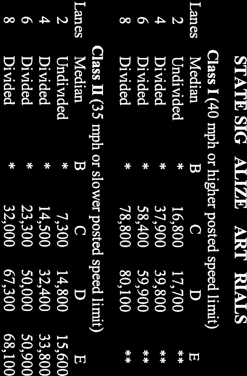
73 Courthouse Manor Transportation Assessment October 3, 2014 Stafford County, VA Page 6 of 8 Attachment 4 Page 6 of 28 Turn Lane Warrant Analysis BCG prepared turn lane warrant analyses for left-turn and right-turn movements from the proposed Northeast Courthouse Bypass to the Project s North and South Entrances. Based on the projected Total Future weekday AM and PM peak hour traffic volumes in 2035, no turn lane warrants are met for either right-turn or left-turns at either entrance. Refer to Attachment D for copies of the turn lane warrant worksheets. Roadway Link Capacity Analysis The roadway link analysis contained herein is based on Highway Capacity Manual methodology for long-range planning, which is applicable to this assessment. A series of LOS tables using this methodology was published by the Systems Planning Office of the Florida Department of Transportation (FDOT). The long-range link LOS for the proposed Northeast Courthouse Bypass was evaluated against Stafford County s LOS standards and transportation impact policies set forth in the 2010 Stafford County Comprehensive Plan. The transportation element of the County s Comprehensive Plan calls for LOS C or better on public roadways, but recognizes that in certain instances LOS C may not be achievable. In such instances, the County sets forth policies of Non-Degradation and Offsetting Impacts to ensure that that the transportation system affected by proposed changes in land use performs no worse after the project is developed than it would otherwise. It is noted that the Virginia Department of Transportation (VDOT) generally deems LOS D (or better) to be acceptable. For the purposes of the roadway link LOS analysis, the Northeast Courthouse Bypass is assumed to be posted for a speed limit of 35 mph (or less), and its connection to the Route 630/Hospital Center Boulevard intersection is assumed to be signalized. The analysis thus utilized the State Signalized Arterial Class II criteria (see Attachment E) for 2-lane undivided roadways. The unfactored range of AADT volumes that function at LOS C is 7,300 14,799 vehicles/day (VPD). However, adjustments to this range are required to be applied as follows: -20% for 2-lane undivided with no left-turn or right-turn lanes With the adjustment applied, the LOS C range is reduced to 5,840 11,480 VPD. Based on the projected AADT of 10,300 VPD, the Northeast Courthouse Bypass roadway link is anticipated to operate at a daily LOS C under projected 2035 conditions. Refer to Attachment E for the roadway LOS worksheet.
74 Courthouse Manor Transportation Assessment October 3, 2014 Stafford County, VA Page 7 of 8 Attachment 4 Page 7 of 28 Results Based on the analyses contained herein, the Northeast Courthouse Bypass can function acceptably as a two-lane undivided roadway with LOS C under projected 2035 conditions under an estimated daily traffic loading of 10,300 VPD. This LOS result is based on traffic projections which include the Project s site trips, estimated trip diversions to the Northeast Courthouse Bypass, and full build-out of the Courthouse Urban Development Area per the County s Courthouse Redevelopment Plan. It is specifically noted that full build-out of the Courthouse UDA by year 2035 is a conservative assumption, as it may likely take significantly (potentially decades) longer. As a two-lane undivided roadway, the Northeast Courthouse Bypass can accommodate two (2) full-movement entrance connections for the Project. Turn lane warrant analyses under projected 2035 conditions indicate that right-turn and left-turn lanes will not be required along the Northeast Courthouse Bypass to serve these entrances. In addition to the results above, it is noted that the Project proposes two (2) fewer roadway connections to the Northeast Courthouse Bypass, which is a 50% reduction from the four (4) roadway connections shown in the County s Courthouse Redevelopment Plan. Conclusions Based on the results above, the Northeast Courthouse Bypass can be planned for as a 2-lane roadway without turn lanes. This facility can be accommodated easily within a 60 right-of-way as a two-lane facility with 12 lanes, curb/gutter, utility/buffer strips, and 5 wide sidewalks on both sides. Stafford County s code includes a typical section for a 2-lane roadway that illustrates how these design elements may be accommodated within a similar right-of-way width (see Attachment F). If necessary, an additional lane may be constructed within the 60 right-of-way should future traffic studies identify the need for additional through capacity in either the northbound or southbound direction or should VDOT or the County desire to have an auxiliary lane for turning movements or incident management. A sample typical section for the Northeast Courthouse Bypass which includes a 3-lane cross-section is provided for reference in Attachment G. Alternatively, additional space within the 60 right-of-way may be utilized for transit stops, bicycle lanes, expansion of sidewalks to wider shared-use paths, wider utility/landscaping strips, or on-street parking. In conclusion, the 60 right-of-way dedication will allow the planned Northeast Courthouse Connector both the capacity and flexibility to support the stated transportation objectives of the County s Comprehensive Plan, which include maintaining a safe road system, providing & maintaining a multi-modal public transit system, creating a system of sidewalks (and other facilities) to provide non-motorized transportation alternatives, and creating better patterns of traffic flow and circulation.

75 Courthouse Manor Transportation Assessment October 3, 2014 Stafford County, VA Page 8 of 8 Attachment 4 Page 8 of 28 BCG appreciates the opportunity to prepare this assessment for use by the County in evaluating the Applicant s Project and CUP application. Should the County have any questions concerning the methodologies, results, or conclusions of this assessment, please do not hesitate to contact me at (804) or jriley@bowmancg.com. Sincerely, BOWMAN CONSULTING GROUP, LTD. John D. Riley, PE, PTOE Sr. Project Manager
76 Attachment 4 Page 9 of 28 ATTACHMENT A COURTHOUSE MANOR GDP OVERALL KEY PLAN


77 Attachment 4 Page 10 of 28
78 Attachment 4 Page 11 of 28 ATTACHMENT B EXHIBITS FROM STAFFORD COUNTY COURTHOUSE AREA REDEVELOPMENT MASTER PLAN

79 Site Attachment 4 Page 12 of 28

80 Attachment 4 Page 13 of 28 Site
81 Attachment 4 Page 14 of 28 ATTACHMENT C SITE TRIP GENERATION SITE TRIP DISTRIBUTION PROJECTED 2035 TRAFFIC VOLUMES
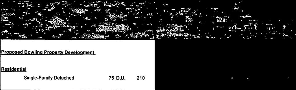
82 Attachment 4 Page 15 of 28 Table 1 - ITE Site Trip Generation Analysis (1) Weekday Land Use AM Peak Hour PM Peak Hour Daily Land Use Size Units Code In Out Total In Out Total Trips Proposed Bowling Property Development Residential Single-Family Detached 75 D.U Notes: (1) Based on the Institute of Transportation Engineers Trip Generation, 9th Edition.
83 Attachment 4 Page 16 of 28
84 Attachment 4 Page 17 of 28
85 Attachment 4 Page 18 of 28 ATTACHMENT D TURN LANE WARRANT ANALYSIS WORKSHEETS
86 Attachment 4 Page 19 of Right Turn Lane Warrant (2-Lane Highway) Figure 3-26 from VDOT RDM Appendix F Full-Width Turn Lane and Taper Required Right Turns (VPH) 60 Taper Required AM Peak Hour PM Peak Hour 40 No Turn Lanes or Tapers Required Approaching Volume (VPH) Intersection: NE Courthouse Bypass/Northern Site Entrance (Study Intersection #1) Approach: Southbound Right Scenario: Total Future 2035 Speed Limit: 35 mph AM Peak Hour PM Peak Hour Approaching Volume Right Turns 0 1 Right Turn Adjustment: No No Adjusted Right Turns: N/A N/A
87 Attachment 4 Page 20 of Right Turn Lane Warrant (2-Lane Highway) Figure 3-26 from VDOT RDM Appendix F Full-Width Turn Lane and Taper Required Right Turns (VPH) 60 Taper Required AM Peak Hour PM Peak Hour 40 No Turn Lanes or Tapers Required Approaching Volume (VPH) Intersection: NE Courthouse Bypass/Southern Site Entrance (Study Intersection #2) Approach: Southbound Right Scenario: Total Future 2035 Speed Limit: 35 mph AM Peak Hour PM Peak Hour Approaching Volume Right Turns 1 1 Right Turn Adjustment: No No Adjusted Right Turns: N/A N/A
88 Attachment 4 Page 21 of 28 Intersection: NE Courthouse Bypass/Southern Site Entrance (Study Intersection #2) Approach: Northbound Left Scenario: Total Future 2035 AM Peak Hour PM Peak Hour VO, Opposing Volume VA, Advancing Volume VL, Left Turning Volume 7 23 Percent Left Turns 1.0% 6.8% Symbol N/A* * Percentage of left turns is significantly less than minimum chart threshold. Synchro analysis of intersection shows northbound delay of 0.2 seconds/veh with a 95 th percentile queue of 0 feet.


89 Attachment 4 Page 22 of 28 Intersection: NE Courthouse Bypass/Northern Site Entrance (Study Intersection #1) Approach: Northbound Left Scenario: Total Future 2035 AM Peak Hour PM Peak Hour VO, Opposing Volume VA, Advancing Volume VL, Left Turning Volume 3 8 Percent Left Turns 0.4% 2.5% Symbol N/A* N/A* * Percentage of left turns is significantly less than minimum chart threshold. Synchro analysis of intersection shows northbound delay of 0.1 seconds/veh with a 95 th percentile queue of 0 feet in the AM peak hour and delay of 0.4 seconds/veh and a 95 th percentile queue of 1 foot in the PM peak hour.
90 Attachment 4 Page 23 of 28 ATTACHMENT E HCM ROADWAY LINK LOS WORKSHEET


91 Attachment 4 Page 24 of 28
92 Attachment 4 Page 25 of 28 ATTACHMENT F STAFFORD COUNTY TYPICAL SECTION FOR 2-LANE URBAN ROADWAY

93 10/2/2014 Page 1 of Attachment 1 4 Page 26 of 28
SUB ; Courthouse Manor, Preliminary Subdivision Plan
 5 Board of Supervisors Gary F. Snellings, Chairman Laura A. Sellers, Vice Chairman Meg Bohmke Jack R. Cavalier Paul V. Milde, III Cord A. Sterling Robert Bob Thomas, Jr. October 14, 2015 Anthony J. Romanello,
SUBJECT: CUP ; Conditional Use Permit - Telegraph Road Vehicle Sales / Storage
 2 Board of Supervisors Robert Bob Thomas, Jr., Chairman Laura A. Sellers, Vice Chairman Meg Bohmke Jack R. Cavalier Wendy E. Maurer Paul V. Milde, III Gary F. Snellings August 24, 2016 Anthony J. Romanello,
RC ; Reclassification The Garrison at Stafford Proffer Amendment (formerly Stafford Village Center)
") Board of Supervisors Robert Bob Thomas, Jr., Chairman Laura A. Sellers, Vice Chairman Meg Bohmke Jack R. Cavalier Wendy E. Maurer Paul V. Milde, III Gary F. Snellings Anthony J. Romanello, ICMA CM County
Board of Supervisors Robert Bob Thomas, Jr., Chairman Laura A. Sellers, Vice Chairman Meg Bohmke Jack R. Cavalier Wendy E. Maurer Paul V. Milde, III Gary F. Snellings Anthony J. Romanello, ICMA CM County
Amendments to the Subdivision and Zoning Ordinances Regarding Open Space Land in Cluster Subdivisions
 Board of Supervisors Gary F. Snellings, Chairman Laura A. Sellers, Vice Chairman Meg Bohmke Jack R. Cavalier Paul V. Milde, III Cord A. Sterling Robert Bob Thomas, Jr. 10 May 13, 2015 Anthony J. Romanello,
1101 Washington Avenue Fredericksburg, VA 22401
 1 Board of Supervisors Robert Bob Thomas, Jr., Chairman Laura A. Sellers, Vice Chairman Meg Bohmke Jack R. Cavalier Wendy E. Maurer Paul V. Milde, III Gary F. Snellings December 14, 2016 C. Douglas Barnes
CUP ; Conditional Use Permit - 5 Twelve Convenience Store Expansion
 Board of Supervisors Meg Bohmke, Chairman Gary F. Snellings, Vice Chairman Jack R. Cavalier Thomas C. Coen L. Mark Dudenhefer Wendy E. Maurer Cindy C. Shelton 2 March 28, 2018 Thomas C. Foley County Administrator
RC ; Reclassification - The Courtyards of Colonial Forge
 3 Board of Supervisors Robert Bob Thomas, Jr., Chairman Laura A. Sellers, Vice Chairman Meg Bohmke Jack R. Cavalier Wendy E. Maurer Paul V. Milde, III Gary F. Snellings November 9, 2016 C. Douglas Barnes
Amendment to the Zoning and Subdivision Ordinances; Consider Repeal Cluster Development Standards
 2 Board of Supervisors Meg Bohmke, Chairman Gary F. Snellings, Vice Chairman Jack R. Cavalier Thomas C. Coen L. Mark Dudenhefer Wendy E. Maurer Cindy C. Shelton February 28, 2018 Thomas C. Foley County
North side of Garrisonville Road, approximately 275 feet east of Center Street
 2 Board of Supervisors Gary F. Snellings, Chairman Laura A. Sellers, Vice Chairman Meg Bohmke Jack R. Cavalier Paul V. Milde, III Cord A. Sterling Robert Bob Thomas, Jr. December 9, 2015 Anthony J. Romanello,
Cover Letter with Narrative Statement
 Cover Letter with Narrative Statement March 31, 2017 rev July 27, 2017 RE: Rushton Pointe Residential Planned Unit Development Application for Public Hearing for RPUD Rezone PL2015 000 0306 Mr. Eric Johnson,
A. Location. A MRD District may be permitted throughout the County provided it meets the standards established herein.
 752. Multi-Residential District (MRD) The Multi-Residential (MRD) District is intended to provide opportunities for rural, suburban and urban density mixed-residential developments consistent with the
Intersection of Winding Creek Road and Embrey Mill Road. 200 Chatham Heights Road Fredericksburg, Virginia 22405
 November 12, 2014 MEMORANDUM TO: FROM: Stafford County Planning Commission J Board of Supervisors Jack R. Cavalier, Chairman Gary F. Snellings, Vice Chairman Meg Bohmke Paul V. Milde, III Laura A. Sellers
Staff Report: Date: Applicant: Property Identification: Acreage of Request: Current Zoning of Requested Area: Requested Action: Attached:
 Staff Report: Completed by Jeff Palmer Director of Planning & Zoning Date: November 7, 2018, Updated November 20, 2018 Applicant: Greg Smith, Oberer Land Developer agent for Ronald Montgomery ET AL Property
Amendments to Transfer of Development Rights Program
 Board of Supervisors Jack R. Cavalier, Chairman Gary F. Snellings, Vice Chairman Meg Bohmke Paul V. Milde, III Laura A. Sellers Cord A. Sterling Robert Bob Thomas, Jr. Anthony J. Romanello, ICMA CM County
Staff Report: Date: Applicant: Property Identification: Acreage of Request: Current Zoning of Requested Area: Requested Action: Attached:
 Staff Report: Completed by Jeff Palmer Director of Planning & Zoning Date: November 7, 2018 Applicant: Greg Smith, Oberer Land Developer agent for Ronald Montgomery ET AL Property Identification: Frontage
Article 7: Residential Land Use and Development Requirements
 Article 7: Residential Land Use and Section 701: Statement of Intent (A) (B) (C) The intent of Article 7 is to develop certain land use and development requirements for the residential uses within Cumru
REPORT TO THE SHELBY COUNTY PLANNING COMMISSION From the Department of Development Services Planning Services. February 4, 2019
 REPORT TO THE SHELBY COUNTY PLANNING COMMISSION From the Department of Development Services Planning Services February 4, 2019 Case No. Request for Rezoning Approval From E-1 to E-2 SD This is a request
PLANNED UNIT DEVELOPMENT & SUBDIVISION STAFF REPORT Date: April 18, 2019
 PLANNED UNIT DEVELOPMENT & SUBDIVISION STAFF REPORT Date: April 18, 2019 DEVELOPMENT NAME SUBDIVISION NAME Springhill Village Subdivision Springhill Village Subdivision LOCATION 4350, 4354, 4356, 4358,
Comprehensive Plan Amendment #PLN , Reserve at Cannon Branch (Coles Magisterial District)
") COUNTY OF PRINCE WILLIAM 5 County Complex Court, Prince William, Virginia 22192-9201 PLANNING (703) 792-7615 FAX (703) 792-4758 OFFICE Internet www.pwcgov.org Christopher M. Price, AICP Director of Planning
COUNTY OF PRINCE WILLIAM 5 County Complex Court, Prince William, Virginia 22192-9201 PLANNING (703) 792-7615 FAX (703) 792-4758 OFFICE Internet www.pwcgov.org Christopher M. Price, AICP Director of Planning
M-43 CORRIDOR OVERLAY ZONE
 ARTICLE 26.00 M-43 CORRIDOR OVERLAY ZONE Section 26.01 Findings A primary function of the M-43 state highway is to move traffic through the Township and to points beyond. As the primary east-west arterial
4 June 11, 2014 Public Hearing
 4 June 11, 2014 Public Hearing APPLICANT: FRANKLIN JOHNSTON MANAGEMENT DEVELOPMENT, L.L.C. PROPERTY OWNER: TRUSTEES OF FIRST LYNNHAVEN BAPTIST CHURCH STAFF PLANNER: Stephen J. White REQUEST: Change of
Midwest City, Oklahoma Zoning Ordinance
 2010 Midwest City, Oklahoma Zoning Ordinance 9/2/2010 Table of Contents Section 1. General Provisions... 5 1.1. Citation... 5 1.2. Authority... 5 1.3. Purpose... 5 1.4. Nature and Application... 5 1.5.
Planning Department Oconee County, Georgia
 Planning Department Oconee County, Georgia STAFF REPORT REZONE CASE #: 6985 DATE: October 31, 2016 STAFF REPORT BY: Andrew C. Stern, Planner APPLICANT NAME: Williams & Associates, Land Planners PC PROPERTY
Request Conditional Rezoning (R-7.5 Residential to Conditional A-18 Apartment) Staff Recommendation Approval. Staff Planner Jimmy McNamara
 Staff Recommendation Approval. Staff Planner Jimmy McNamara") Applicants Property Owners Baker Villas, LLC; Ocean Rental Properties, LLC; James Edward Sollner; & Linda Susan Sollner Public Hearing November 8, 2017 City Council Election District Kempsville Agenda
Applicants Property Owners Baker Villas, LLC; Ocean Rental Properties, LLC; James Edward Sollner; & Linda Susan Sollner Public Hearing November 8, 2017 City Council Election District Kempsville Agenda
Conditional Use Permit case no. CU 14-06: Bristol Village Partners, LLC
 PLANNING AND ZONING COMMISSION STAFF REPORT August 7, 2014 Conditional Use Permit case no. CU 14-06: Bristol Village Partners, LLC CASE DESCRIPTION: LOCATION: LEGAL DESCRIPTION: EXISTING LAND USE: ZONING:
Draft Model Access Management Overlay Ordinance
 Draft Model Access Management Overlay Ordinance This model was developed using the City of Hutchinson and the Trunk Highway 7 corridor. The basic provisions of this model may be adopted by any jurisdiction
WESTMINSTER PARK SUBDIVISION
 WESTMINSTER PARK SUBDIVISION Engineering Comments: FINAL PLAT COMMENTS (should be addressed prior to submitting the FINAL PLAT for review and/or signature by the City Engineer): A. Provide all of the required
19 June 9, 2010 Public Hearing APPLICANT AND PROPERTY OWNER: KEMP ENTERPRISES, INC.
 19 June 9, 2010 Public Hearing APPLICANT AND PROPERTY OWNER: KEMP ENTERPRISES, INC. STAFF PLANNER: Karen Prochilo REQUEST: Change of Zoning District Classification, Conditional A-24 Apartment District
Chapter Planned Residential Development Overlay
 Chapter 19.29 Planned Residential Development Overlay Sections 010 Purpose 020 Scope 030 Definitions 030 Minimum Size 040 Allowable Uses 050 Minimum Development Standards 060 Density Bonus 070 Open Space
CITY OF CHARLOTTESVILLE DEPARTMENT OF NEIGHBORHOOD DEVELOPMENT SERVICES STAFF REPORT APPLICATION FOR A SPECIAL USE PERMIT
 CITY OF CHARLOTTESVILLE DEPARTMENT OF NEIGHBORHOOD DEVELOPMENT SERVICES STAFF REPORT APPLICATION FOR A SPECIAL USE PERMIT PLANNING COMMISSION AND CITY COUNCIL JOINT PUBLIC HEARING DATE OF HEARING: December
Letter of Intent May 2017 (Revised November 2017)
") THE BEACH AT WOODMOOR LETTER OF INTENT MAY 2017 (REVISED NOVEMBER 2017) OWNER/APPLICANT: CONSULTANT: Lake Woodmoor Holdings LLC N.E.S. Inc. 1755 Telstar Drive, Suite 211 619 North Cascade Avenue Colorado
THE BEACH AT WOODMOOR LETTER OF INTENT MAY 2017 (REVISED NOVEMBER 2017) OWNER/APPLICANT: CONSULTANT: Lake Woodmoor Holdings LLC N.E.S. Inc. 1755 Telstar Drive, Suite 211 619 North Cascade Avenue Colorado
REPORT OF THE PLANNING AND DEVELOPMENT DEPARTMENT FOR APPLICATION FOR REZONING ORDINANCE TO PLANNED UNIT DEVELOPMENT SEPTEMBER 22, 2016
 BEL REPORT OF THE PLANNING AND DEVELOPMENT DEPARTMENT FOR APPLICATION FOR REZONING ORDINANCE 2016-576 TO PLANNED UNIT DEVELOPMENT SEPTEMBER 22, 2016 The Planning and Development Department hereby forwards
O-I (Office-Institutional) and AG-1(Agricultural)
 and AG-1(Agricultural)") PROPERTY INFORMATION ADDRESS 3503 and 3505 Bethany Bend DISTRICT, LAND LOTS 2/1 973 and 974 OVERLAY DISTRICT State Route 9 PETITION NUMBERS EXISTING ZONING O-I (Office-Institutional) and AG-1(Agricultural)
PROPERTY INFORMATION ADDRESS 3503 and 3505 Bethany Bend DISTRICT, LAND LOTS 2/1 973 and 974 OVERLAY DISTRICT State Route 9 PETITION NUMBERS EXISTING ZONING O-I (Office-Institutional) and AG-1(Agricultural)
RC ; Reclassification - Falmouth Village Commercial
 Board of Supervisors Paul V. Milde, III, Chairman Meg Bohmke, Vice Chairman Jack R. Cavalier Wendy E. Maurer Gary F. Snellings Laura A. Sellers Robert Bob Thomas, Jr. Thomas C. Foley County Administrator
Request Conditional Rezoning (AG-1 & AG-2 Agricultural to Conditional R-10 Residential & P- 1 Preservation District) Staff Recommendation Approval
 Staff Recommendation Approval") Applicant & Property Owner Public Hearing February 14, 2018 City Council Election District Princess Anne Agenda Item 7 Request Conditional Rezoning (AG-1 & AG-2 Agricultural to Conditional R-10 Residential
Applicant & Property Owner Public Hearing February 14, 2018 City Council Election District Princess Anne Agenda Item 7 Request Conditional Rezoning (AG-1 & AG-2 Agricultural to Conditional R-10 Residential
Cobb County Community Development Agency Zoning Division 1150 Powder Springs St. Marietta, Georgia 30064
 Cobb County Community Development Agency Zoning Division 1150 Powder Springs St. Marietta, Georgia 30064 Case # Z-63 Public Hearing Dates: PC: 11-06-18 BOC: 11-20-18 SITE BACKGROUND Applicant: Loyd Development
Staff Report. Planning Commission Public Hearing: October 17, 2007 Staff Recommendation: Denial
 COUNTY OF PRINCE WILLIAM 5 County Complex Court, Prince William, Virginia 22192-9201 PLANNING (703) 792-6830 Metro 631-1703, Ext. 6830 FAX (703) 792-4401 OFFICE Internet www.pwcgov.org Stephen K. Griffin,
1 November 13, 2013 Public Hearing APPLICANT & PROPERTY OWNER: HOME ASSOCIATES OF VIRGINIA, INC.
 1 November 13, 2013 Public Hearing APPLICANT & PROPERTY OWNER: HOME ASSOCIATES OF VIRGINIA, INC. STAFF PLANNER: Carolyn A.K. Smith REQUEST: Conditional Change of Zoning (AG-1 & AG-2 Agricultural Districts
BEFORE THE LANCASTER TOWNSHIP BOARD OF SUPERVISORS BUTLER COUNTY, PENNSYLVANIA FINDINGS OF FACT, CONCLUSIONS OF LAW AND DECISION FINDINGS OF FACT
 BEFORE THE LANCASTER TOWNSHIP BOARD OF SUPERVISORS BUTLER COUNTY, PENNSYLVANIA IN RE: Conditional Use and Preliminary ) and Final Land Development Applications ) for Planned Unit Development by ) Arden
ARTICLE FIVE FINAL DRAFT
 ARTICLE FIVE 021218 FINAL DRAFT Sec. 503.6 Open Space Preservation Option Open Space Preservation Option Open Space Preservation developments may be approved in the AR, R-1, R-2 and R-3 zoning districts,
Financial Impact Statement There are no immediate financial impacts associated with the adoption of this report.
 STAFF REPORT Planning and Development Department Subject: Application by RYC Property to rezone a portion of lands on John Murray Dr. and Megan Lynn Dr. from R2 to R3 and to enter into a Development Agreement
PLANNING COMMISSION REPORT Regular Agenda -Public Hearing Item
 PDP-13-00518 Item No. 3B- 1 PLANNING COMMISSION REPORT Regular Agenda -Public Hearing Item PC Staff Report 2/24/14 ITEM NO. 3B PRELIMINARY DEVELOPMENT PLAN FOR HERE @ KANSAS; 1101 INDIANA ST (SLD) PDP-13-00518:
DISTRICT COUNCIL FOR PRINCE GEORGE S COUNTY, MARYLAND OFFICE OF ZONING HEARING EXAMINER SPECIAL EXCEPTION 4658 DECISION
 DISTRICT COUNCIL FOR PRINCE GEORGE S COUNTY, MARYLAND OFFICE OF ZONING HEARING EXAMINER SPECIAL EXCEPTION 4658 DECISION Application: Three Chair Barber Shop Applicants: Danta L. & Felicia B. Wright/Fort
Glades County Staff Report and Recommendation Unified Staff Report for Small Scale Plan Amendment and Rezoning
 Glades County Staff Report and Recommendation Unified Staff Report for Small Scale Plan Amendment and Rezoning CASE NUMBERS: COMP17-02 and RZ17-02 DATE of STAFF REPORT: May 1, 2017 CASE TYPE: Application
CHAPTER 14 SPECIAL DEVELOPMENTS
 10-14-1 10-14-1 CHAPTER 14 SPECIAL DEVELOPMENTS SECTION: 10-14-1: Cluster and Inner Block Development 10-14-2: Planned Unit Development 10-14-1: CLUSTER AND INNER BLOCK DEVELOPMENT: A. Land Use: Cluster
Appendix J - Planned Unit Development (PUD)
") Appendix J - Planned Unit Development (PUD) Intent and Purpose The purpose of the PUD is: 1. To provide development that is consistent with the Comprehensive Land Use Plan and promote the goals and objectives
Appendix J - Planned Unit Development (PUD) Intent and Purpose The purpose of the PUD is: 1. To provide development that is consistent with the Comprehensive Land Use Plan and promote the goals and objectives
Open Space Model Ordinance
 Open Space Model Ordinance Section I. Background Open space development has numerous environmental and community benefits, including: 1) Reduces the impervious cover in a development. Impervious cover
CHAPTER34 PRUD - PLANNED RESIDENTIAL UNIT DEVELOPMENT
 CHAPTER34 PRUD - PLANNED RESIDENTIAL UNIT DEVELOPMENT 17-34-1 17-34-2 17-34-3 17-34-4 17-34-5 17-34-6 17-34-7 17-34-8 17-34-9 Purpose Planned Residential Unit Development Defined Planned Residential Unit
D1 August 12, 2015 Public Hearing APPLICANT: CCW DEVELOPMENT ASSOCIATES, LLC PROPERTY OWNER: WAYNE DUPREE
 D1 August 12, 2015 Public Hearing APPLICANT: CCW DEVELOPMENT ASSOCIATES, LLC PROPERTY OWNER: WAYNE DUPREE REQUEST: Change of Zoning (A-12 Apartment District to Conditional A-12 Apartment District) STAFF
TOWN OF ORO VALLEY PLANNING & ZONING COMMISSION MEETING DATE: December 6, 2011
 PLANNING & ZONING COMMISSION MEETING DATE: December 6, 2011 TO: FROM: SUBJECT: PLANNING & ZONING COMMISSION Matt Michels, Senior Planner mmichels@orovalleyaz.gov; tel. 229-4822 Public Hearing: Rancho de
Request Conditional Rezoning (R-5D Residential Duplex District and I-1 Light Industrial District to Conditional A-36 Apartment District)
") Request Conditional Rezoning (R-5D Residential Duplex District and I-1 Light Industrial District to Conditional A-36 Apartment District) Staff Planner Ashby Moss Location 5833 Sandpit Road & Nearby Parcels
Request Conditional Rezoning (R-5D Residential Duplex District and I-1 Light Industrial District to Conditional A-36 Apartment District) Staff Planner Ashby Moss Location 5833 Sandpit Road & Nearby Parcels
Mount Airy Planning Commission March 26, Staff Report
 Mount Airy Planning Commission March 26, 2018 Staff Report Special Exception Request Mixed Use Development in CC District Recommendation to Board of Appeals CASE MA-A-18-01 Applicant: Location: Zoning:
Note: Staff reports can be accessed at
 The Maryland-National Capital Park and Planning Commission Prince George's County Planning Department Development Review Division 301-952-3530 Note: Staff reports can be accessed at www.mncppc.org/pgco/planning/plan.htm.
SUBJECT: Application for Planned Unit Development and Rezoning 1725 Winnetka Road
 TO: FROM: CHAIRMAN BILL VASELOPULOS AND MEMBERS OF THE PLAN & ZONING COMMISSION STEVE GUTIERREZ DIRECTOR OF COMMUNITY DEVELOPMENT MEETING DATE: September 5, 2017 SUBJECT: Application for Planned Unit Development
AAAA. Planning and Zoning Staff Report Lake Shore Land Holdings, LLC CU-PH Analysis
 AAAA Planning and Zoning Staff Report Lake Shore Land Holdings, LLC CU-PH2016-28 Hearing Date: April 21, 2016 Development Services Department Applicant: BRS Architects/Cindy Huebert Staff: Kyle McCormick,
Parkland-Spanaway-Midland LUAC - Agenda
 1. 6:30 P.M. Parkland-Spanaway-Midland LUAC - Agenda Documents: 8 2 17 PSMAC Agenda.pdf 2. Parkland-Spanaway-Midland LUAC Initial Project Review Documents: Lincoln Court PP IPR PSMAC-RJ.pdf Department
PROPOSED AMENDMENTS TO THE DERBY ZONING REGULATIONS AUGUST 12, 2008
 ARTICLE II Definitions and word usage 195-7. Definitions and word usage. Modify the following: HOUSING FOR THE ELDERLY OLDER PERSONS Housing in accordance with and as defined in the United States Fair
Metropolitan Planning Commission. DATE: April 5, 2016
 TO: FROM: Metropolitan Planning Commission MPC Staff DATE: April 5, 2016 SUBJECT: Petition of Nine Line Inc. Robert McCorkle, Agent PIN: 2-1034-01-002 380.5 Acres Aldermanic District: 5 (Shabazz) County
1.94 acres. Gwinnett Prado, L.P. c/o Brogdon Consulting Duluth, GA Contact: Ted Sandler
 Land Use Petition RZ-15-006 Date of Staff Recommendation Preparation: April 21, 2015 Revised to Incorporate Planning Commission Recommendations: 5/6/15 PROJECT LOCATION: 10800 Block of State Bridge Road
MEADOWBROOK FLATS SPECIAL USE PERMIT APPLICATION
 MEADOWBROOK FLATS SPECIAL USE PERMIT APPLICATION March 26, 2013 Submitted by: Bluestone Land, L.L.C. William N. Park, Manager 1821 Avon St. Suite 200 Charlottesville VA 22902 434-979-2900 wpark@pinnacleconstructionva.com
b) Tangerine Corridor Overlay District 1) Tangerine Corridor District Regulations
 Tangerine Corridor Overlay District 1) Tangerine Corridor District Regulations") Attachment 1 Tangerine Road Corridor Overlay District Section 27.10.D.3.f.vi.b Initiation of Code Amendment September 2, 2014, Planning and Zoning Commission b) Tangerine Corridor Overlay District 1) Tangerine
Attachment 1 Tangerine Road Corridor Overlay District Section 27.10.D.3.f.vi.b Initiation of Code Amendment September 2, 2014, Planning and Zoning Commission b) Tangerine Corridor Overlay District 1) Tangerine
CHAPTER 14 PLANNED UNIT DEVELOPMENTS
 9-14-1 9-14-1 CHAPTER 14 PLANNED UNIT DEVELOPMENTS SECTION: 9-14-1: Purpose 9-14-2: Governing Provisions 9-14-3: Minimum Area 9-14-4: Uses Permitted 9-14-5: Common Open Space 9-14-6: Utility Requirements
Implementation. Approved Master Plan and SMA for Henson Creek-South Potomac 103
 Implementation Approved Master Plan and SMA for Henson Creek-South Potomac 103 104 Approved Master Plan and SMA for Henson Creek-South Potomac Sectional Map Amendment The land use recommendations in the
Community Development
 Land Use Petition RZ-15-010 Concurrent Variance VC-15-010-01 Date of Staff Recommendation Preparation: August 14, 2015 Date of Planning Commission Recommendation: September 1, 2015 PROJECT LOCATION: DISTRICT/SECTION/LANDLOT(S):
COUNTY OF ALBEMARLE PLANNING STAFF REPORT SUMMARY
 COUNTY OF ALBEMARLE PLANNING STAFF REPORT SUMMARY Project Name: ZMA 2011-00006, Albemarle Health and Rehab Center and SP 2011-00014, Albemarle Health and Rehab Center Planning Commission Public Hearing:
PINE RIDGE COMMONS PUD AMEND ORDINANCE NUMBER 99-94
 PINE RIDGE COMMONS PUD AMEND ORDINANCE NUMBER 99-94 Title page of the Planned Unit Development Document, previously attached as Exhibit A to the PUD document of Ordinance Number 99-94, the Pine Ridge commons
ADDRESS / DESCRIPTION: Northeast corner of Sandbridge Road and Atwoodtown Road ELECTION DISTRICT: PRINCESS ANNE
 10 & 11 March 14, 2012 Public Hearing APPLICANT: MARLYN DEVELOPMENT CORPORATION PROPERTY OWNER: CORAL DEVELOPMENT, LLC STAFF PLANNER: Faith Christie REQUEST: Modification of Conditional Change of Zoning
Special Use Permit - Planned Unit Development Checklist. Property Address:
 Special Use Permit - Planned Unit Development Checklist Special Use Permit Number. Parcel Code/s #28-11- - - Property Address: Applicant: ARTICLE VIII Ordinance Reference - Section 8.1.2 Permit Procedures:
Initial Project Review
 Pierce County Department of Planning and Land Services, 2401 South 35th Street, Tacoma, WA (253) 798-7037 Initial Project Review Major Amendment to Preliminary Plat: Hawks Ridge Division 1 Application
3.1. OBJECTIVES FOR RESIDENTIAL LAND USE DESIGNATIONS GENERAL OBJECTIVES FOR ALL RESIDENTIAL DESIGNATIONS
 3. RESIDENTIAL LAND USE DESIGNATIONS INTRODUCTION The Residential land use designations provide for housing and other land uses that are integral to, and supportive of, a residential environment. Housing
REPORT OF THE PLANNING AND DEVELOPMENT DEPARTMENT FOR APPLICATION FOR REZONING ORDINANCE TO PLANNED UNIT DEVELOPMENT APRIL 21, 2016
 BEL REPORT OF THE PLANNING AND DEVELOPMENT DEPARTMENT FOR APPLICATION FOR REZONING ORDINANCE TO PLANNED UNIT DEVELOPMENT APRIL 21, 2016 The Planning and Development Department hereby forwards to the Planning
SUBDIVISION, PLANNED UNIT DEVELOPMENT, & PLANNING APPROVAL STAFF REPORT Date: February 1, 2007
 SUBDIVISION, PLANNED UNIT DEVELOPMENT, & PLANNING APPROVAL STAFF REPORT Date: February 1, 2007 DEVELOPMENT NAME SUBDIVISION NAME Pala Verde Mobile Home Park Subdivision Pala Verde Mobile Home Park Subdivision
PLANNING COMMISSION STAFF REPORT
 PLANNING COMMISSION STAFF REPORT REZONING CASE: RZ-15-002 REPORT DATE: January 26, 2016 CASE NAME: Thursday Lunch Club Rezoning PLANNING COMMISSION DATE: February 17, 2016 ADDRESS OF REZONING PROPOSAL:
1 September 9, 2015 Public Hearing
 1 September 9, 2015 Public Hearing APPLICANT & PROPERTY OWNER: HOLLOMON- BROWN FUNERAL HOME, INC. STAFF PLANNER: Carolyn A.K. Smith REQUEST: Change of Zoning (R-5D Residential District to Conditional O-2
HERON LANDING SUBDIVISION
 HERON LANDING SUBDIVISION Engineering Comments: Per FEMA guidelines, any development greater than 5 acres in size or subdivision 50 lots in size, requires a flood study. Width of drainage easement to be
ARTICLE 23 CONDOMINIUM STANDARDS
 ARTICLE 23 CONDOMINIUM STANDARDS Section 23.01 Intent. The intent of this Article is to provide regulatory standards for condominiums and site condominiums similar to those required for projects developed
STAFF REPORT MARYHILL PLAZA APARTMENTS
 STAFF REPORT MARYHILL PLAZA APARTMENTS TO: Douglas County Hearing Examiner FROM: Douglas County Land Services Staff RE: Selland Construction, DATE: July 19, 2018 I. GENERAL INFORMATION Requested Action:
MINNETONKA PLANNING COMMISSION June 2, A conditional use permit for 2,328 square feet of accessory structures at 4915 Highland Road
 MINNETONKA PLANNING COMMISSION June 2, 2016 Brief Description A conditional use permit for 2,328 square feet of accessory structures at Recommendation Recommend the city council adopt the resolution approving
MPC STAFF REPORT REZONING MAP AMENDMENT ALDERMANIC DISTRICT 1 COUNTY COMMISSION DISTRICT 5 April 3, 2013 MPC FILE NUMBER.
 MPC STAFF REPORT REZONING MAP AMENDMENT ALDERMANIC DISTRICT 1 COUNTY COMMISSION DISTRICT 5 April 3, 2013 MPC FILE NUMBER. 13-000929-ZA REZONING SUMMARY Report Status Initial Report Petitioner/Property
PLANNED UNIT DEVELOPMENT (PUD)
") SECTION 38.01. ARTICLE 38 PLANNED UNIT DEVELOPMENT (PUD) Purpose The purpose of this Article is to implement the provisions of the Michigan Zoning Enabling Act, Public Act 110 of 2006, as amended, authorizing
SECTION 38.01. ARTICLE 38 PLANNED UNIT DEVELOPMENT (PUD) Purpose The purpose of this Article is to implement the provisions of the Michigan Zoning Enabling Act, Public Act 110 of 2006, as amended, authorizing
r t h c t y w e s t * THESE PAGES REPLACE THE PAGES HAVING THE SAME PAGE NUMBER AS THOSE IN THE DEVELOPMENT UNIT 4A PLAN TEXT DATED OCTOBER 26, 1987.
 n 0 r t h c i t y w e s t * THESE PAGES REPLACE THE PAGES HAVING THE SAME PAGE NUMBER AS THOSE IN THE DEVELOPMENT UNIT 4A PLAN TEXT DATED OCTOBER 26, 1987. Amendment Adopted By City Council Resolution
EXHIBIT D. Planned Unit Development Written Description April 13, 2016 Rouen Cove Phase II PUD
 1 EXHIBIT D Planned Unit Development Written Description April 13, 2016 Rouen Cove Phase II PUD Development # 8986.001 Developer: Curtis L. Hart Hart Resources LLC 8051 Tara Lane Jacksonville, Florida
Draft Zoning Changes for the 2nd Planning Board Public Hearing, January 22, 2018.
 Draft Zoning Changes for the 2nd Planning Board Public Hearing, January 22, 2018. No changes were made at the 1st Public Hearing. Proposed wording for the 1 st Public Hearing in red, eliminated text in
Special Use Permit #SUP , Youssef Home Fitness Studio Occoquan Magisterial District
 COUNTY OF PRINCE WILLIAM 5 County Complex Court, Prince William, Virginia 22192-9201 PLANNING (703) 792-7615 FAX (703) 792-4401 OFFICE Internet www.pwcgov.org Christopher M. Price, AICP Acting Director
Article XII. R-1 Agricultural-Low Density Residential District
 Article XII R-1 Agricultural-Low Density Residential District Section 1200. Declaration of Legislative Intent In expansion of the Declaration of Legislative Intent and Statement of Community Development
County of Loudoun. Department of Planning MEMORANDUM
 County of Loudoun Department of Planning MEMORANDUM DATE: September 3, 2013 TO: FROM: Marchant Schneider, Project Manager Land Use Review Marie Genovese, AICP, Planner III, Community Planning SUBJECT:
HB-S RM8-S RS9 RM18 HB-S RS9 DOCKET #: W2872. PROPOSED ZONING: RM8-S (Child Day Care Center) EXISTING ZONING: RS9 and RM8-S
 EXISTING ZONING: RS9 and RM8-S") 150' 80' RS9 UNIVERSITY PW STANLEYVILLE DR HB-S LB 123' 70' PROPOSED BELTWAY!( RM8-S S 289' NOEL DR 202' NITA AV MILL CREEK DOCKET #: W2872 PROPOSED ZONING: RM8-S (Child Day Care Center) EXISTING ZONING:
150' 80' RS9 UNIVERSITY PW STANLEYVILLE DR HB-S LB 123' 70' PROPOSED BELTWAY!( RM8-S S 289' NOEL DR 202' NITA AV MILL CREEK DOCKET #: W2872 PROPOSED ZONING: RM8-S (Child Day Care Center) EXISTING ZONING:
Marion County Board of County Commissioners
 Marion County Board of County Commissioners Date: 12/29/2015 P&Z: 12/28/2015 BCC: 1/12/2016 Item Number 160113Z Type of Application Rezoning Request From: A-1 (General Agriculture) To: PUD (Planned Unit
MAJOR SUBDIVISION PRELIMINARY PLAT CHECKLIST
 TOWNSHIP OF EGG HARBOR PLANNING BOARD/ZONING BOARD OF ADJUSTMENT 3515 BARGAINTOWN ROAD EGG HARBOR TOWNSHIP, NJ 08234 MAJOR SUBDIVISION PRELIMINARY PLAT CHECKLIST The following checklist is designed to
Staff Planner Carolyn A.K. Smith
 Applicant Property Owner, Pamela K. & Steven A. Gray Public Hearing April 13, 2016 City Council Election District Princess Anne Agenda Item 8 Request Modification of Proffers (Modification to the proffer
Planned Residence District (PR) To review a plan to construct 11 single family homes on approximately 4.01 acres.
 To review a plan to construct 11 single family homes on approximately 4.01 acres.") STAFF REPORT PLANNING & ZONING COMMISSION Village Green Municipal Building, Council Chambers 47 Hall Street Wednesday, March 13, 2019 7:00 P.M. 1. FINAL DEVELOPMENT PLAN REVIEW Applicant: Romanelli and
STAFF REPORT PLANNING & ZONING COMMISSION Village Green Municipal Building, Council Chambers 47 Hall Street Wednesday, March 13, 2019 7:00 P.M. 1. FINAL DEVELOPMENT PLAN REVIEW Applicant: Romanelli and
ARTICLE I ZONE BASED REGULATIONS
 ARTICLE I ZONE BASED REGULATIONS RZC 21.08 RESIDENTIAL REGULATIONS 21.08.290 Cottage Housing Developments A. Purpose. The purpose of the cottage housing requirements is to: 1. Provide a housing type that
Section Intent
 Section 246. 1. Intent 2. Authority a. It is the intent of these Transfer of Development Rights (TDR s) regulations to encourage the preservation of natural resources and facilitate orderly growth in the
A. Preserve natural resources as identified in the Comprehensive Plan.
 1370.08 Conservation Residential Overlay District. Subd. 1 Findings. The City finds that the lands and resources within the Conservation Residential Overlay District are a unique and valuable resource
a. It is the intent of these regulations to encourage the preservation of natural resources and facilitate orderly growth in the County.
 Part V Transfer of Development Rights Section 246. 1. Intent a. It is the intent of these regulations to encourage the preservation of natural resources and facilitate orderly growth in the County. b.
Request Conditional Use Permit (Bulk Storage Yard) Staff Recommendation Approval. Staff Planner Robert Davis
 Staff Recommendation Approval. Staff Planner Robert Davis") Applicant & Property Owner Wal-Mart Real Estate Business Trust Public Hearing July 11, 2018 City Council Election District Beach Agenda Item 8 Request Conditional Use Permit (Bulk Storage Yard) Staff Recommendation
Applicant & Property Owner Wal-Mart Real Estate Business Trust Public Hearing July 11, 2018 City Council Election District Beach Agenda Item 8 Request Conditional Use Permit (Bulk Storage Yard) Staff Recommendation
Washington County, Minnesota Ordinances
 Washington County, Minnesota Ordinances Ordinance No. 153 Text Amendment to the Washington County Development Code - Chapter One, Section 2 and Chapter Two, Part 1, Part 2, Part 3, of the Development Code
CITY OF CHARLOTTESVILLE DEPARTMENT OF NEIGHBORHOOD DEVELOPMENT SERVICES STAFF REPORT APPLICATION FOR A SPECIAL USE PERMIT
 CITY OF CHARLOTTESVILLE DEPARTMENT OF NEIGHBORHOOD DEVELOPMENT SERVICES STAFF REPORT APPLICATION FOR A SPECIAL USE PERMIT PLANNING COMMISSION AND CITY COUNCIL JOINT PUBLIC HEARING DATE OF HEARING: July
Planning Department Oconee County, Georgia STAFF REPORT
 Planning Department Oconee County, Georgia STAFF REPORT REZONE CASE #: 7332 DATE: November 28, 2017 STAFF REPORT BY: Gabriel Quintas, Planner APPLICANT NAME: Smith Planning Group PROPERTY OWNER: John Hadden
SUBDIVISION, PLANNED UNIT DEVELOPMENT, ZONING AMENDMENT, & SIDEWALK WAIVER STAFF REPORT Date: July 19, 2018
 SUBDIVISION, PLANNED UNIT DEVELOPMENT, ZONING AMENDMENT, & SIDEWALK WAIVER STAFF REPORT Date: July 19, 2018 NAME SUBDIVISION NAME LOCATION West Mobile Properties, LLC U.S. Machine Subdivision 556, 566,