GENERAL PLAN UPDATE. Online Workshop 1 Results. May 26, 2016
|
|
|
- Derek Dickerson
- 5 years ago
- Views:
Transcription

1 GENERAL PLAN UPDATE Online Workshop 1 Results May 26, 2016
2 ONLINE WORKSHOP OVERVIEW


3 ONLINE WORKSHOP Online tool live from April 15 - May 8 Showed details related to 11 potential transform areas Comment in support or tell us what should be considered instead Showed aggregate results summary
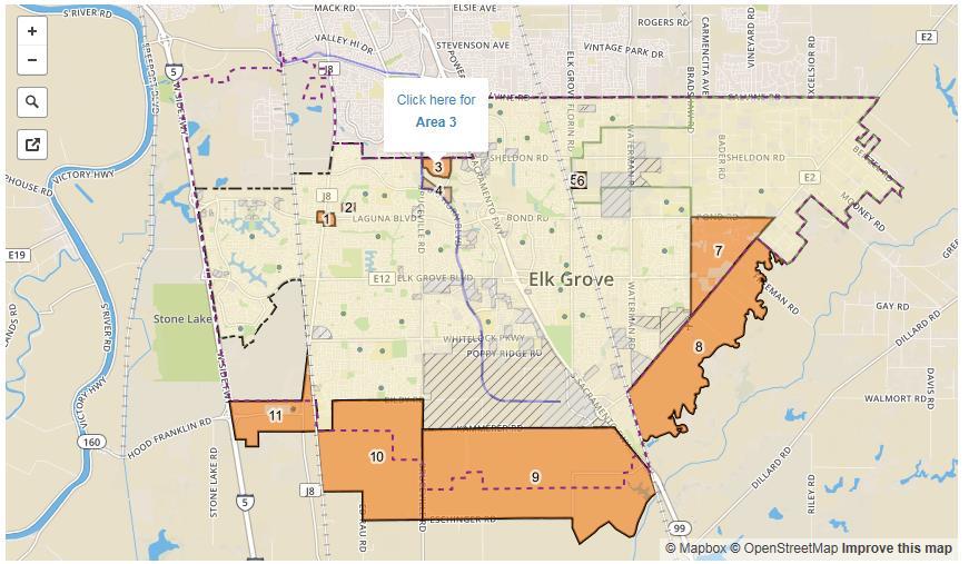
4 INTERACTIVE MAP

5 POTENTIAL TRANSFORM AREAS 11 transform areas with potential to implement the supporting principles Included areas in the existing City limits and beyond the City limits Identified based on: Existing conditions Public input provided throughout the visioning phase and at the topic workshops City analysis
6 SUPPORTING PRINCIPLES

7 ONLINE WORKSHOP RESULTS Available online at: gpworkshop.elkgrovecity.org
8 Key Takeaways Total Participants*: 144 * Controlled for duplicates based on address. # of Areas where there is support for transformation (all within city limits): 5 # of Areas where there is a desire to keep land the same (mostly outside city limits): 5 # of Areas split 50/50 (within city limits): 1


9 Area 1: Overview Acres 36.7 In Existing City Limits Existing Condition Yes The area is currently developed as commercial centers with primarily neighborhood serving uses (e.g. grocery stores, pharmacies, restaurants, general commercial services, etc.). Current Planned Land Use Commercial Looking NW across intersection of Laguna & Franklin

10 Area 1: Results Do you agree that this area has potential for transformation? Which potential transformation do you think is best suited?
11 Area 1: Comments Summary Yes, Transform: 10 Opportunities Add additional density and mixed-use development. There is good potential for more retail/commercial businesses, including more non-chain restaurants. Make the area more visually appealing (lacks a community vibe ) Develop this as the urban center of Elk Grove. Area behind Walgreens feels unsafe. Do not make this a crammed strip mall. Keep the existing grocery stores Do not add any more cell phone shops or nail salons. Be mindful of parking and circulation impacts. There is already bad traffic and parking at certain times of the day. Add a better sound wall Add better bicycle lanes to decrease car traffic to the area No, Keep the Same: 10 Reasons The existing commercial services serve the neighborhood well. Access and parking is good as is. The northeast corner is underutilized Add more restaurants Be mindful of traffic impacts and keep the area bicycle and pedestrian friendly. Nearby vacant land would be better to develop Do not add a transit service/bicycle facility.


12 Area 2: Overview Acres 15.6 In Existing City Limits Yes Existing Condition The western portion of the area is vacant and the eastern portion of the area is currently developed with rural residential homes. Current Planned Land Use Low Density Residential Looking west along Tegan NE of Laguna and Franklin

13 Area 2: Results Do you agree that this area has potential for transformation? Which potential transformation do you think is best suited?
14 Area 2: Comments Summary Yes, Transform: 9 Opportunities Higher density, infill development with neighborhood-serving commercial and residential. Add affordable housing. Expand greenway throughout area to make walking/biking to shopping and schools easy. Good for more single-family homes close to schools, parks, and shopping. Preserve current home values Make sure traffic does not increase if townhomes are built; also consider roadway safety. Consider capacity of the school to the west No, Keep the Same: 5 Reasons I like the low density plan. One of the few rural residential areas in Laguna. The area has longtime residents that should be allowed to remain Consider extending park through the vacant western portion of area.

15 Area 3: Overview Acres 80.7 In Existing City Limits Yes Existing Condition The area is currently vacant. Current Planned Land Use Rural Residential Looking SE from Bruceville & Sheldon
16 Area 3: Results Do you agree that this area has potential for transformation? Which potential transformation do you think is best suited?
17 Area 3: Comments Summary Yes, Transform: 32 Opportunities Residential: single family, multi-family apartments, for sale townhomes, student housing, high-end condos. Expand commercial/retail, specialty shops, ecofriendly buildings, mixed-use, no strip malls. Great location for higher density transitoriented development because it is walking distance to transit, parks, trails, retail, schools, entertainment, and easily accessible to HWY-99. Possible medical/dental office complex and/or education services; employment opportunities. Get good property management to ensure property maintenance of rentals. Make sure the farmers will still have space to grow food. Wildlife (pheasant and water foul) habitat and creek preservation Road access and capacity, including ingress/egress Balance open space, recreation, and trees with residential neighborhoods No, Keep the Same: 4 Reasons Keep it rural residential because it is one of the few rural residential areas left Would be a good location for a new neighborhood Some commercial would be appropriate at intersections The infrastructure is already there to expand


18 Area 4: Overview Acres 42.4 In Existing City Limits Yes Existing Condition The area is currently vacant. Current Planned Land Use Rural Residential, Public/Open Space, Office Looking E across Bruceville along Big Horn

19 Area 4: Results Do you agree that this area has potential for transformation? Which potential transformation do you think is best suited?
20 Area 4: Comments Summary Yes, Transform: 11 Opportunities Good for housing or offices because it has good connection to trails and paths, making it easy to walk or bike to stores and restaurants Would be good for student housing because of proximity of the college Mixed-use senior housing could benefit from nearby recreation, retail, and the library Expand office spaces here and encourage use of trails to walk to restaurants for lunch Add more parks and trails; dedicated open space No, Keep the Same: 4 Reasons Keep open space and preserve Laguna Creek No light rail in Elk Grove. Add greenery to this area Some offices would work at Bruceville & Big Horn Preserve Elk Grove Creek and wildlife Integrate with nature areas and create a destination for walking Add a transit hub so that residents can easily get to commercial/office locations Do not disturb existing quiet residential community on Big Horn with strong home values Build parking lots with trees and walking paths and open patios for dining.


21 Area 5: Overview Acres 4.3 In Existing City Limits Yes Existing Condition The area is currently vacant. Current Planned Land Use Light Industrial Looking SE from Elk Grove Florin south of Sheldon
22 Area 5: Results Do you agree that this area has potential for transformation? Which potential transformation do you think is best suited?
23 Area 5: Comments Summary Yes, Transform: 8 Opportunities Rural Residential to match surroundings Expand commercial space; add offices and mixed-use space. High-end boutiques and restaurants would be appropriate next to existing luxury homes. No, Keep the Same: 1 Reasons Good area for light industrial (none) Adjacent light industrial may limit residential uses Big opportunity for office spaces because it is so close to the train; bring more jobs here


24 Area 6: Overview Acres 29.4 In Existing City Limits Yes Existing Condition The northern portion of the area is currently vacant and the southern portion of the area is currently developed with a light industrial/warehouse user. Current Planned Land Use Light Industrial, Public Open Space/Recreation Looking E across site from Elk Grove Florin south of Sheldon
25 Area 6: Results Do you agree that this area has potential for transformation? Which potential transformation do you think is best suited?
26 Area 6: Comments Summary Yes, Transform: 7 Opportunities Office and mixed use space; bring jobs close to home Estate housing to augment the adjacent neighborhoods Maintain some open space in the area Old light industrial lots may have brownfield development potential Limited access to this area could be an issue Proximity to high value large lot homes Needs better transit service: Amtrak/Light Rail station or bus hub to reduce traffic congestion and make use of the existing rail line No, Keep the Same: 5 Reasons Use as a buffer zone between residential and agricultural Keep it light industrial to match nearby property Good opportunity for offices that provide good jobs


27 Area 7: Overview Acres In Existing City Limits Existing Condition Current Planned Land Use Yes The area is primarily developed with rural residential homes with some single-family homes in the northern portion. Some agricultural and vacant lands are located along Grant Line Road and intermittently throughout the area. A school and vet clinic are located along Bradshaw Road at Elk Grove Boulevard. Residential limited to 1 dwelling unit per acre, Commercial (Elk Grove Triangle Policy Area) Looking SE from Bradshaw & Bond

28 Area 7: Results Do you agree that this area has potential for transformation? Which potential transformation do you think is best suited?
29 Area 7: Comments Summary Yes, Transform: 8 Opportunities Affordable rental and for-sale housing Preserve Elk Grove ag identity while providing housing and potential commercial growth through urban farming Build out as a family recreational area with mini golf, swimming pools, etc. Buffer neighborhoods from the noise and traffic of the upcoming Grantline expressway with greenbelts and paths and trails that connect to the new soccer facility and outlet mall. No, Keep the Same: 19 Reasons Residents there want it to stay rural; this area proves for important variety in EG housing choices; adding more cookie cutter housing will make the area more congested and will change the rural character of the area. Building more residences here will encourage sprawl and increase crime; the current vacant land is serving as carbon sequestration acreage for Elk Grove. This area currently has a good balance of uses; additional commercial uses are not needed, especially not a liquor store. Some commercial or job-generating uses would be good here; attract satellite offices of silicon valley companies Do not infringe upon important agricultural lands Prevent further sprawl Leave rural Elk Grove rural No apartments or other high density residential; keep the area rural residential


30 Area 8: Overview Acres 1,773.2 In Existing City Limits No Existing Condition The area is primarily agricultural and includes a former airport. Current Planned Land Use Urban Study Area Looking E across site from RR overpass at Grantline


31 Area 8: Results Do you agree that this area has potential for transformation? Which potential transformation do you think is best suited?
32 Area 8: Comments Summary Yes, Transform: 10 Opportunities Work to attract high paying jobs here; good location for research and development facilities, technology services, and/or educational uses. Multi sports arena and/or a mall would be great here; the sports complex is the only thing that should be built here Incorporate wildlife and habitat preservation. Maintain the prime farmland and work with local growers/livestock producers to invest in additional farms. Ideal location for a tiny house village serving the homeless. Include a transit hub in the sports complex. Protect important wildlife and riparian forest habitat do not develop here. Improve road access and provide busing to/from light rail station Development would mean loss of viable farmland. No, Keep the Same: 20 Reasons The land has very high value as a flood plain and wildlife habitat. Ideal location for Sacramento County s wine country Keep our unique rural countryside feel. Maintain the land for agricultural uses to feed our city and supply the farmer s market. Preserve our heritage as a farming community by preserving farmland. We don t need more housing, we need more jobs. The land is already being used by farmers for commercial farming. Some non-residential (commercial or light industrial) development along Grant Line Rd may be appropriate.

33 Area 9: Overview Acres 3,675.6 In Existing City Limits Existing Condition Current Planned Land Use No The area is primarily agricultural with some rural residential homes as well as two solar power generating facilities. Urban Study Area Looking SW from Kammerer & Stockton

34 Area 9: Results Do you agree that this area has potential for transformation? Which potential transformation do you think is best suited?
35 Area 9: Comments Summary Yes, Transform: 5 Opportunities Good fit for a commercial center close to HWY-99 Good place for a night life center (restaurants, breweries, etc ) with a central park, food festival, and brew fests. If commercial is developed here, high density mixed-use residential and high end offices would be a good match. This area provides a reliable agricultural economy, wildlife habitat, and flood control. Should never be developed for additional residences because of the flood plain maps. No, Keep the Same: 25 Reasons Keep it for agricultural uses; maintain our farming heritage; preserve local food access. Do not extend urban sprawl; build infill instead. If EG gets too big we will have many more problems, especially in an economic downturn. The current vacant land is serving as carbon sequestration acreage Preserve open space for wildlife and recreation Use this land for solar grids. Mixed use development would demand lots of water during a time of drought. Keep this land as buffer between urban and rural/agricultural zones Development here would create more traffic Once we build over the farmland it will be difficult to go back. Help the farmers to better utilize this land. This is important land for water recharge and wildlife habitat.

36 Area 10: Overview Acres 1,914.6 In Existing City Limits No Existing Condition The area is currently agricultural. Current Planned Land Use Urban Study Area Looking SW from Bilby at Bruceville
37 Area 10: Results Which potential transformation do you think is best suited? Do you agree that this area has potential for transformation?
38 Area 10: Comments Summary Yes, Transform: 8 Opportunities Commercial uses Large park Extension of Kammerer Rd from HWY-99 to I-5. Very far from public transportation. The land is very susceptible to flooding; preserve vital wetlands for the benefit of all. No, Keep the Same: 23 Reasons Maintain agricultural uses; we need farmland for food and to preserve our heritage and unique identity. Good area to expand vineyards and attract wine tourism. Prevent further urban sprawl; save money on infrastructure expansion and encourage transit ridership by building infill. Prime location for more agricultural pursuits. This is a floodplain and is bad for residential use.


39 Area 11: Overview Acres In Existing City Limits No Existing Condition The area is primarily agricultural with some rural residential homes and vacant land. Franklin Elementary School is located at Franklin Boulevard and Hood Franklin Road. Current Planned Land Use Urban Study Area Looking SW from Railroad at Bilby


40 Area 11: Results Do you agree that this area has potential for transformation? Which potential transformation do you think is best suited?
41 Area 11: Comments Summary Yes, Transform: 8 Opportunities Incorporate some of the historical buildings, gradually add new businesses, and develop a housing village. Good place for employment/innovation centers that are agricultural or research focused. Consider the negative impacts on the town of Franklin. Do not box in the Stonelake Reserve. Traffic and parking could become issues. Limit development to the north side of Hood Franklin or immediately south without encroaching on the agricultural. No, Keep the Same: 23 Reasons Risk of flooding in this area makes it incompatible with development. This is prime agricultural land; do not get rid of the rural/agricultural areas that make EG unique. Many bike riders come here. Preserve wetlands habitat and open space. The residents of Hood Franklin do not want to be included in EG s SOI. Development here could increase traffic. There are no sidewalks; school parking is currently on the streets, which is dangerous. Some development could be appropriate near I-5.

42 New Areas Suggested: High end apartments 2. This land use should be consistent with the Silverado Village density 3. Light industrial and manufacturing to utilize the railroad access and to bring solar panel, recycling, and ag-science industries to the region. 4. Mixed use, Apartments or townhomes 5. Move area 9 and 10 to here! 6. Elk Grove Blvd needs office, restaurant and boutique shopping to support the dense nearby residences
Plan Santa Paula Workshop III: Evaluating the Proposed Housing Plans. Summary of Participant Comments
 Plan Santa Paula Workshop III: Evaluating the Proposed Housing Plans Summary of Participant Comments Following a presentation and panel discussion regarding potential impacts to water, fiscal resources,
NEC K-7 & Shawnee Mission Parkway
 FIRST TIME OFFERING 68+/- Acres of Prime Development Land For Sale: NEC K-7 & Shawnee Mission Parkway Shawnee, Johnson County, KS Supporting Land Use Information & Data INTRODUCTION CONTEXT Location: The
GENERAL PLAN UPDATE. Joint Study Session March 29, 2017
 GENERAL PLAN UPDATE Joint Study Session March 29, 2017 Interrelated Issues and Topics Property Owner Requests Mobility: Efficiency and Safety Land Use Plan (in the City) Light Rail/ Transit Jobs/ Housing
2.0 LAND USE FRAMEWORK
 Land Use Framework 2.0 LAND USE FRAMEWORK FOLSOM BOULEVARD 2.1 LAND USE OVERVIEW The proposed land uses for Easton Place offer local and regional employment, shopping, and entertainment, highlighting the
CITY OF ELK GROVE PLANNING COMMISSION NOTICE OF CONTINUED PUBLIC HEARING
 Development Services - Planning 8401 Laguna Palms Way Elk Grove, California 95758 Tel: 916.478.2265 Fax: 916.691.3175 www.elkgrovecity.org CITY OF ELK GROVE PLANNING COMMISSION NOTICE OF CONTINUED PUBLIC
SE corner of Locust Street and Loop 288, Denton, Texas
 1400 DALLAS DRIVE, DENTON, TX. 76205 Telephone (940) 484-9000; Fax (940) 380-9000 SE corner of Locust Street and Loop 288, Denton, Texas Map of location What type of retail is best suited for this location?
What are Urban Landuse Zones?
 Urban Landuse Zones What are Urban Landuse Zones? Urban = Landuse = Zones = a city or densely populated area. is the function of land or what it is used for. land use varies from area to area. These are
Town of Scipio Comprehensive Plan Public Survey 2008
 Town of Scipio Comprehensive Plan Public Survey 2008 Please answer all of the questions. If you do not have an opinion, please leave the space blank. Your input will help us create a plan that is representative
Community Workshop Public Comments January 14, 2015 #CantonForward
 Community Workshop Public Comments January 14, 2015 #CantonForward The following text documents raw, unedited comments and has not been checked for grammar, accuracy, or feasibility. Neither the consultant
Central Bridge Revitalization Public Workshop SWOT Analysis
 Central Bridge Revitalization Public Workshop SWOT Analysis Listed in order of importance based on number of comments received. If I was King for a day, with a $500,000 budget, what would I do? Hamlet
PLANNING COMMISSION REPORT Regular Agenda Public Hearing Item
 PC Staff Report 11/12/12 Item No. 2B- 1 PLANNING COMMISSION REPORT Regular Agenda Public Hearing Item ITEM NO. 2B: A TO GPI; 110 ACRES; E OF K-10 & N OF W 6 TH ST (MKM) : Consider a request to rezone approximately
Village of Queen Charlotte OCP and Bylaw Review Open House April 29, 2017 Highlights, Policy Directions, and Choices
 Village of Queen Charlotte OCP and Bylaw Review Open House April 29, 2017 Highlights, Policy Directions, and Choices Purpose The purposes of the open house were: 1) to receive community input on topics
Concept 1: Entertainment Favor/Opposed Pros Cons Favor: 56 Opposed: 7
 Concept 1: Entertainment Favor/Opposed Pros Cons Favor: 56 Opposed: 7 Really like the roundabouts. Like a small hotel. I think a lower ramp would be important. Museum excellent. This could be best use
B. Subarea Provisions, including the Design Elements and Area of Special Concern and Potential Park/Open Space/Recreation Requirements;
 ARTICLE III: LAND USE DISTRICTS III-1 300 INTRODUCTION Article III of the Washington County Community Development Code consists of the primary and overlay districts which apply to the unincorporated areas
Bylaw No , being "Official Community Plan Bylaw, 2016" Schedule "A" DRAFT
 Bylaw No. 2600-2016, being "Official Community Plan Bylaw, 2016" Schedule "A" Urban Structure + Growth Plan Urban Structure Land use and growth management are among the most powerful policy tools at the
A. Land Use Relationships
 Chapter 9 Land Use Plan A. Land Use Relationships Development patterns in Colleyville have evolved from basic agricultural and residential land uses, predominate during the early stages of Colleyville
Triangle Special Planning Area Update. Community Workshop #5 September 17, 2018
 Triangle Special Planning Area Update Community Workshop #5 September 17, 2018 Welcome and Introductions Recap of the Project and Discussion to Date Meeting Agenda Review Draft SPA Revisions Discuss Outstanding
DRAFT Plan Incentives. Part A: Basic Discount
 DRAFT 2030 Plan Incentives July 26, 2006 Part A: Basic Discount In order for a development to be eligible for any 2030 Land Resource Management Plan Discounts it must be located in the Urban Corridor and
Jefferson County. Case RZ. Presenter: Alan Tiefenbach. Planning and Zoning Division
 Green Gables Official Development Plan Case 11-119319RZ Presenter: Alan Tiefenbach Proposal Rezone from Agricultural-Two (A-2) to Planned Development (PD) 225,000 square feet of commercial uses, including
2014 Plan of Conservation and Development. Development Plan & Policies
 The Town of Hebron Section 3 2014 Plan of Conservation and Development Development Plan & Policies C. Residential Districts I. Residential Land Analysis This section of the plan uses the land use and vacant
Open Space. Introduction. Vision. Defining Open Space. Midway City 2017 General Plan
 Open Space Midway City 2017 General Plan Introduction The importance of preserving open space to meet the goals and objectives of the General Plan cannot be overstated. Indeed, references to preserving
Downtown Development Focus Area: I. Existing Conditions
 Downtown Development Focus Area: I. Existing Conditions The Downtown Development Focus Area is situated along Route 1, south of the train tracks, except for the existing Unilever property. It extends west
LAND USE. As such, the Township has estasblished the following statement of objectives for future development within its borders:
 LAND USE When creating a land use plan, a municipality should consider a process which firsts determines future population figures, whether growth or decline, and its targeted areas within the municipal
Staff Report PLANNING DIVISION COMMUNITY & ECONOMIC DEVELOPMENT. Alley Closure
 Staff Report PLANNING DIVISION COMMUNITY & ECONOMIC DEVELOPMENT To: From: Salt Lake City Planning Commission Doug Dansie, 801-535-6182, doug.dansie@slcgov.com Date: March 23, 2016 Re: PLNPCM2015-00941
Comprehensive Plan 2030
 Introduction Land use, both existing and future, is the central element of a Comprehensive Plan. Previous chapters have discussed: Projected population growth. The quality housing available in the Township
City of Peachtree City. Annexation Review Process
 City of Peachtree City Annexation Review Process Page 1 Annexation Review Process Step One: Initial annexation information The following information is to be completed by the property owner and/ or their
SECTION I - INTRODUCTION
 - INTRODUCTION 1 2 - INTRODUCTIONION THE MASTER PLAN State law requires every community to have a Master Plan establishing an orderly guide to the use of lands in the community to protect public health
TOWN OF EPSOM, NEW HAMPSHIRE PLANNING BOARD MASTER PLAN COMMUNITY SURVEY. 2. Are you a legal resident of : a Epsom b Other NH Town c Out of State
 TOWN OF EPSOM, NEW HAMPSHIRE PLANNING BOARD MASTER PLAN COMMUNITY SURVEY Part I. Base Data Statistics A. Residency Information 1. Number of individuals in Household 2. Are you a legal resident of : a Epsom
Town of Cary, North Carolina Rezoning Staff Report 14-REZ-31 Cary Park PDD Amendment (Waterford II) Town Council Meeting January 15, 2015
 Town Council Meeting January 15, 2015") Town of Cary, North Carolina Rezoning Staff Report 14-REZ-31 Cary Park PDD Amendment (Waterford II) Town Council Meeting January 15, 2015 REQUEST To amend the Town of Cary Official Zoning Map by amending
Town of Cary, North Carolina Rezoning Staff Report 14-REZ-31 Cary Park PDD Amendment (Waterford II) Town Council Meeting January 15, 2015 REQUEST To amend the Town of Cary Official Zoning Map by amending
 PROJECT NARRATIVE AVENIR PCD MISCELLANEOUS AMENDMENT November 27, 2018 Urban Planning and Design Landscape Architecture Communication Graphics Request Avenir Development, LLC and Avenir Holdings, LLC,
COUNTY OF ALBEMARLE PLANNING STAFF REPORT SUMMARY
 COUNTY OF ALBEMARLE PLANNING STAFF REPORT SUMMARY Project Name: ZMA 2010-00015, Cedar Hill Planning Commission Worksession: February 15, 2011 Public Hearing: Not scheduled Staff: Judith C. Wiegand, AICP
STAFF REPORT. Permit Number: Porter. Kitsap County Board of Commissioners; Kitsap County Planning Commission
 STAFF REPORT Permit Number: 15 00461 Porter DATE: November 9, 2015 TO: FROM: Kitsap County Board of Commissioners; Kitsap County Planning Commission Katrina Knutson, AICP, Senior Planner, DCD and Jeff
Existing Land Use. Typical densities for single-family detached residential development in Cumberland County: 1
 Existing Land Use A description of existing land use in Cumberland County is fundamental to understanding the character of the County and its development related issues. Economic factors, development trends,
TOWN OF ORO VALLEY PLANNING & ZONING COMMISSION MEETING DATE: December 6, 2011
 PLANNING & ZONING COMMISSION MEETING DATE: December 6, 2011 TO: FROM: SUBJECT: PLANNING & ZONING COMMISSION Matt Michels, Senior Planner mmichels@orovalleyaz.gov; tel. 229-4822 Public Hearing: Rancho de
2016 Rural and Critical Land Preservation Program Annual Report
 2016 Rural and Critical Land Preservation Program Annual Report Preserving our greenways, waterways, and way of life BEAUFORT COUNTY OPEN LAND TRUST Rural and Critical Land Preservation Program KEEPING
Comprehensive Plan Amendment #PLN , Reserve at Cannon Branch (Coles Magisterial District)
") COUNTY OF PRINCE WILLIAM 5 County Complex Court, Prince William, Virginia 22192-9201 PLANNING (703) 792-7615 FAX (703) 792-4758 OFFICE Internet www.pwcgov.org Christopher M. Price, AICP Director of Planning
COUNTY OF PRINCE WILLIAM 5 County Complex Court, Prince William, Virginia 22192-9201 PLANNING (703) 792-7615 FAX (703) 792-4758 OFFICE Internet www.pwcgov.org Christopher M. Price, AICP Director of Planning
STAFF SUMMARY OF Z17-10 CONDITIONAL ZONING DISTRICT APPLICATION
 STAFF SUMMARY OF Z17-10 CONDITIONAL ZONING DISTRICT APPLICATION APPLICATION SUMMARY Case Number: Z17-10 Request: Conditional B-2 Zoning District in order to expand an existing retail and warehousing business
Great Neighborhoods legislation (House 2420 and Senate 81) will make a difference in the communities we call home.
 will make a difference in the communities we call home.") Great Neighborhoods legislation (House 2420 and Senate 81) will make a difference in the communities we call home. Supporting Families and Seniors by Offering Housing Choices Multifamily housing in sensible
Great Neighborhoods legislation (House 2420 and Senate 81) will make a difference in the communities we call home. Supporting Families and Seniors by Offering Housing Choices Multifamily housing in sensible
TOWN OF MIDDLEBOROUGH COMMUNITY PRESERVATION PLAN
 TOWN OF MIDDLEBOROUGH COMMUNITY PRESERVATION PLAN Vision The residents of Middleborough desire a community which is family-oriented and which retains its small town character while preserving an abundance
Urban Land Use. Unit 4 GEO22F PB
 Urban Land Use Unit 4 GEO22F PB Important Concepts Land Value Land in Canada is either privately owned by individuals or organizations, or it belongs to the government (crown land). The value of land is
Land Use. Land Use Categories. Chart 5.1. Nepeuskun Existing Land Use Inventory. Overview
 Land Use State Comprehensive Planning Requirements for this Chapter A compilation of objectives, policies, goals, maps and programs to guide the future development and redevelopment of public and private
Enclosed are amended PUD documents for The Grove at Shoal Creek Proposed by
 Enclosed are amended PUD documents for The Grove at Shoal Creek Proposed by The Bull Creek Road Coalition (BCRC) was formed in 2012 and is made up of residents in the six neighborhoods surrounding the
LAND USE ASSUMPTIONS REPORT POTENTIAL FUTURE DEVELOPMENT WEST WHITELAND TOWNSHIP, CHESTER COUNTY, PA
 LAND USE ASSUMPTIONS REPORT POTENTIAL FUTURE DEVELOPMENT WEST WHITELAND TOWNSHIP, CHESTER COUNTY, PA Adopted June 17, 2015 by Township Resolution No. 2015-30 Prepared by Theurkauf Design & Planning, LLC
Mohave County General Plan
 63 64 65 66 67 68 69 70 71 The Land Use Diagram is not the County's zoning map. 13 It is a guide to future land use patterns. Zoning and area plan designations may be more restrictive than the land use
Attachment A First Submittal JAZB Safety Zones A and B
 Attachment A First Submittal JAZB Safety Zones A and B Attachment B Second Submittal JAZB Safety Zones A and B Attachment C Flying Cloud Airport (FCM) Draft Airport Zoning Ordinance Social and Economic
FOR SALE Land /- Acres Potential Cannabis Cultivation Opportunity $4,500,000
 FOR SALE Land - 20.04+/- Acres Potential Cannabis Cultivation Opportunity $4,500,000 27821 Dutcher Creek Rd. Cloverdale, CA 95425 Broker: William M. Severi, CCIM, CPM BRE No.: 01000344 Cell Phone: 707-291-2722
CITY OF SANTA ROSA COMMUNITY DEVELOPMENT DEPARTMENT STAFF REPORT FOR PLANNING COMMISSION SEPTEMBER 10, 2015 APPLICANT FILE NUMBER MJP
 ITEM NO. 9 CITY OF SANTA ROSA COMMUNITY DEVELOPMENT DEPARTMENT STAFF REPORT FOR PLANNING COMMISSION SEPTEMBER 10, 2015 PROJECT TITLE Yogurt Time Center ADDRESS/LOCATION 3093 Marlow Road ASSESSOR S PARCEL
Residences at Grove Park 425 Hillsborough St. Chapel Hill, NC
 9 ATTACHMENT 1 Residences at Grove Park 425 Hillsborough St. Chapel Hill, NC Zoning Atlas Amendment Application Statement of Justification December 12 th, 2008 Introduction This is a request for a Zoning
Table of Contents. Concept Plan Overview. Statement of Compliance with Design Guidelines. Statement of Compliance with Comprehensive Plan
 Table of Contents Concept Plan Overview Statement of Compliance with Design Guidelines Statement of Compliance with Comprehensive Plan Developer s Program Market Objective Benefit to Local Businesses Benefit
8Land Use. The Land Use Plan consists of the following elements:
 8Land Use 1. Introduction The Land Use Plan consists of the following elements: 1. Introduction 2. Existing Conditions 3. Opportunities for Redevelopment 4. Land Use Projections 5. Future Land Use Policies
The Park at High Crossing. vitality proximity value
 The Park at High Crossing vitality proximity value ABOUT INVESTORS ASSOCIATED, LLP Originally formed by a physicians group to invest in their own clinics, Investors Associated has been in existence for
43 Acres. Presented by: COMMERCIAL MIXED USE LAND OFFERING LAKE ELSINORE, CALIFORNIA
 COMMERCIAL MIXED USE LAND OFFERING 43 Acres Presented by: Investment Overview Lee & Associates Commercial Real Estate Services, is pleased to exclusively present for sale the +/-43.5 acre (1,895,000 SF)
Rural Living (RL) Rural Living
 Rural Living") Place Types Rural Living (RL) Rural Living Rural living areas are characterized by very large lots, abundant open space, pastoral views, and a highdegree of separation between buildings. The lots are typically
Place Types Rural Living (RL) Rural Living Rural living areas are characterized by very large lots, abundant open space, pastoral views, and a highdegree of separation between buildings. The lots are typically
Midway City Council 4 December 2018 Regular Meeting. Ordinance / General Plan Amendment
 Midway City Council 4 December 2018 Regular Meeting Ordinance 2018-23 / General Plan Amendment CITY COUNCIL MEETING STAFF REPORT DATE OF MEETING: December 4, 2018 DOCUMENT: NAME OF APPLICANT: AGENDA ITEM:
STAFF SUMMARY FOR Z18-09 CONDITIONAL ZONING DISTRICT APPLICATION
 STAFF SUMMARY FOR Z18-09 CONDITIONAL ZONING DISTRICT APPLICATION APPLICATION SUMMARY Case Number: Z18-09 Request: Conditional R-10 Zoning District in order to develop a performance residential development
Jasper 115 Street DC2 Urban Design Brief
 Jasper 115 Street DC2 Urban Design Brief Greenlong Construction Ltd. Stantec Consulting Ltd. 2017 Overview The proposed rezoning application supports the development of two mixed-use high-rise buildings
Midway City Council 16 October 2018 Work Meeting. Ordinance / General Plan Amendment
 Midway City Council 16 October 2018 Work Meeting Ordinance 2018-23 / General Plan Amendment CITY COUNCIL MEETING STAFF REPORT DATE OF MEETING: October 16, 2018 DOCUMENT: NAME OF APPLICANT: AGENDA ITEM:
TABULATED Land Use Survey
 The Town of Linn Land Use Survey was mailed to 2,143 landowners, business owners, and seasonal- and year-round residents in January 2017. A total of 342 were completed, returned to the town, and tabulated
Zoning Text Amendments & Zone Reclassifications to Implement the General Plan
 Zoning Text Amendments & Zone Reclassifications to Implement the General Plan COUNTY OF HUMBOLDT McKinleyville Municipal Advisory Committee Meeting March 13, 2019 Zoning Text and Map Amendments Info Project
Single Tenant Identity in a Multi-Level Building
 Single Tenant Identity in a Multi-Level Building At UC Berkeley Entrance 2312 Telegraph Avenue Retail Space for Lease Size: +/- 9,200 rsf Lease Rate: $30,000/month NNN Contact Kevin Gordon (510) 898-0513
Charlotte LYNX Blue Line Economic Development Impact and Land Use Patterns
 Charlotte LYNX Blue Line Economic Development Impact and Land Use Patterns National Governors Association Policy Academy on Shaping a New Approach to Transportation and Land Use Peter Zeiler Economic Development
Introduction. General Development Standards
 Introduction The development standards will set the zoning regulations for the East Park development. This section will illustrate lot standards, approximate open space locations and road standards. The
Chapter Four Growth in the Next 20 years
 Chapter Four Growth in the Next 20 years Although the city of Fargo has pushed to the limits planned for in the original growth plan, the city still has substantial amounts of land available for growth.
PLANNED UNIT DEVELOPMENT & SUBDIVISION STAFF REPORT Date: April 18, 2019
 PLANNED UNIT DEVELOPMENT & SUBDIVISION STAFF REPORT Date: April 18, 2019 DEVELOPMENT NAME SUBDIVISION NAME Springhill Village Subdivision Springhill Village Subdivision LOCATION 4350, 4354, 4356, 4358,
PLANNING FOR OUR FUTURE
 PLANNING FOR OUR FUTURE ELLSWORTH TOWNSHIP LAND USE AND POLICY PLAN The purpose of this Plan is to serve as a guide for the Township Trustees, Zoning Commission, Board of Zoning Appeals, developers, employers,
Crenshaw/LAX Transit Project Joint Development Fairview Heights Community Workshop #2 April 30, 2016
 Crenshaw/LAX Transit Project Joint Development Fairview Heights Community Workshop #2 April 30, 2016 1 Agenda 1. Introduction 2. What is Joint Development? 3. Community Input Process 4. What We ve Heard
STAFF REPORT. City of Ormond Beach Department of Planning. Exception for Outdoor Activity
 STAFF REPORT City of Ormond Beach Department of Planning DATE: March 7, 2019 SUBJECT: Lucky s Market, 101 East Granada Boulevard: Special Exception for Outdoor Activity APPLICANT: Wendy L. Petrillo-Rundle,
Summary of Topics from Public Input/References in Plan Decision Making Aid
 Summary of s from Public Input/References in Plan Decision Making Aid The following chart identifies topic from public comment, identifies where in plan that topic was discussed, and a few notes as appropriate.
PLANNING COMMISSION WILLIAMSBURG, VIRGINIA WORK SESSION AGENDA Wednesday, May 23, 2012
 PLANNING COMMISSION WILLIAMSBURG, VIRGINIA WORK SESSION AGENDA Wednesday, May 23, 2012 The meeting will be called to order in the third floor Conference Room (Room 310), Williamsburg Municipal Building,
O-I (Office-Institutional) and AG-1(Agricultural)
 and AG-1(Agricultural)") PROPERTY INFORMATION ADDRESS 3503 and 3505 Bethany Bend DISTRICT, LAND LOTS 2/1 973 and 974 OVERLAY DISTRICT State Route 9 PETITION NUMBERS EXISTING ZONING O-I (Office-Institutional) and AG-1(Agricultural)
PROPERTY INFORMATION ADDRESS 3503 and 3505 Bethany Bend DISTRICT, LAND LOTS 2/1 973 and 974 OVERLAY DISTRICT State Route 9 PETITION NUMBERS EXISTING ZONING O-I (Office-Institutional) and AG-1(Agricultural)
Burlington Unincorporated Community Plan
 Burlington Unincorporated Community Plan June 30, 2010 Meeting Page 1 of 24 Table of Contents (Page numbers to be inserted) I. Background a. Location and Community Description b. Planning of Unincorporated
The Helena Township Master Plan
 The Helena Township Master Plan I. INTRODUCTION Helena Township is located in the northwest lower peninsula of Michigan, in Antrim County, on the southeast side of Torch Lake. The township is bordered
LAKE MERRITT STATION AREA PLAN
 LAKE MERRITT STATION AREA PLAN Emerging Plan Open House Summary October 2011 2 1 Introduction The City of Oakland, Bay Area Rapid Transit (BART), and the Peralta Community College District, through a grant
GOALS, OBJECTIVES, AND STRATEGIES
 GOALS, OBJECTIVES, AND STRATEGIES What follows is a series of goals, recommendations and actions that reflect the themes outlined in the Mineral Springs Vision Plan (incorporated into this document as
Northlake Area Plan Comment Sheet Responses (As of 11/2/2006)
") The following represents the compilation and categorization of the 433 comments the Planning Department received upon distribution of the Northlake Area Plan Comment Sheet. (Note: Identical comments were
The following represents the compilation and categorization of the 433 comments the Planning Department received upon distribution of the Northlake Area Plan Comment Sheet. (Note: Identical comments were
Planning Commission Staff Report October 6, 2011
 Planning Commission Staff Report October 6, 2011 Project: Laguna Ridge Phase 3 Subdivision Projects McGeary Ranch, Arbor Ranch, Zgraggen Ranch & Tuscan Ridge Files: EG-10-059 (McGeary Ranch), EG-10-060
LILLIAN WEBB PARK DEVELOPMENT PROPOSAL. City of Norcross, Georgia 2034 Comprehensive Plan
 LILLIAN WEBB PARK DEVELOPMENT PROPOSAL City of Norcross, Georgia 2034 Comprehensive Plan AGENDA Overview: Zoning/Process: Market Studies: Design: Benefits: Bucky Johnson, Mayor John Bemis, DDA Chair Matt
Appendix B: Housing Element Sites Inventory and Detailed Analysis
 Appendix B: 2015-2023 Housing Element Sites Inventory and Detailed Analysis Redwood City General This page intentionally left blank. Redwood City General Site Identifier Assessor Parcel Number General
Town of Jamestown Planning Board Zoning Staff Report June 14, 2010
 Town of Jamestown Planning Board Zoning Staff Report June 14, 2010 The information provided in this staff report has been included for the purpose of reviewing proposed zoning changes. Since the zoning
Kitsap County Department of Community Development
 Kitsap County Department of Community Development Staff Report and Recommendation Annual Comprehensive Plan Amendment Process for 2018 George s Corner LAMIRD Boundary Adjustment Report Date 7/16/2018 Hearing
Marion County Board of County Commissioners
 Marion County Board of County Commissioners Date: 6/4/217 P&Z: 9/25/217 BCC Transmittal: 1/17/217 BCC Adopt: TBD Amendment No: 217-L6 Type of Application Large-Scale Comp Plan Amendment Request: Change
FARMLAND AMENITY PROTECTION. A Brief Guide To Conservation Easements
 FARMLAND AMENITY PROTECTION A Brief Guide To Conservation Easements The purpose of this guide is to help landowners access their land amenity value and to provide direction to be compensated for this value.
TOWN OF CARY TOWN CENTER PLAN. Chapter 2. Future Land Use
 TOWN OF CARY TOWN CENTER PLAN Chapter 2 Future Land Use 2.1 The Future Land Use Map and How to Read It Map 1: Future Land Uses depicts the future land uses recommended for the Town Center Area. Different
S ANTA B OULEVARD M ONICA FOR SALE PRICE REDUCTION PRIME MIXED-USE ALONG SANTA MONICA BOULEVARD SANTA MONICA, CA 90404
 3 101 3 105 - S ANTA M ONICA B OULEVARD SANTA MONICA, CA 90404 FOR SALE PRICE REDUCTION OWNER USER REDEVELOPMENT OPPORTUNITY PRIME MIXED-USE ALONG SANTA MONICA BOULEVARD 3 3 101-105 S ANTA M ONICA B OULEVARD
AFFORDABLE HOUSING DEVELOPMENT PROPOSAL REVIEW. Reviewer Score
 AFFORDABLE HOUSING DEVELOPMENT PROPOSAL REVIEW Proposer: USA Properties - Backer Ranch Square : Project Design and Community Benefit Project enhances and complements the surrounding neighborhood. Project
PROFILE Exclusive: How the Melo Group Took Edgewater Real Estate To The Next Level with Aria on the Bay
 June 14, 2017 UMV: 5,000 PROFILE Exclusive: How the Melo Group Took Edgewater Real Estate To The Next Level with Aria on the Bay June 14, 2017 in Edgewater, Features, PROFILE Exclusive PROFILEmiami had
MOUNT PLEASANT CENTER COMMUNITY WORKSHOP SUMMARY. Workshop Date: April 18, 2016
 MOUNT PLEASANT CENTER COMMUNITY WORKSHOP SUMMARY Workshop Date: April 18, 2016 Summary Date: April 28, 2016 1 OVERVIEW On April 18, 2016 more than 50 members of the greater Mount Pleasant community (approximately
PLANNING COMMISSION STAFF REPORT
 PLANNING COMMISSION STAFF REPORT REZONING CASE: RZ-16-001 REPORT DATE: March 8, 2016 CASE NAME: Trailbreak Partners Rezoning PLANNING COMMISSION DATE: March 16, 2016 ADDRESSES OF REZONING PROPOSAL: 5501
ANN ARBOR GREENBELT DISTRICT STRATEGIC PLAN 2013
 ANN ARBOR GREENBELT DISTRICT STRATEGIC PLAN 2013 Approved by: Greenbelt Advisory Commission April 4, 2013 Prepared for: City of Ann Arbor Community Services Area & Greenbelt Advisory Commission 301 E.
Implementation. Approved Master Plan and SMA for Henson Creek-South Potomac 103
 Implementation Approved Master Plan and SMA for Henson Creek-South Potomac 103 104 Approved Master Plan and SMA for Henson Creek-South Potomac Sectional Map Amendment The land use recommendations in the
Staff Report for Town Council
 Staff Report for Town Council Meeting Date: June 22, 2017 16-REZ-24 Trimble Avenue Residential Rezoning Purpose: Consider action on proposed rezoning request Prepared by: Katie Drye, Planning Speaker:
Pierce County Comprehensive Plan Review
 2015-2016 Pierce County Comprehensive Plan Review March 16, 2016 Introduction Planning and Management Policies Some of the policies governing both the planning and management of growth and change within
CHAPTER 50 LAND USE ZONES ARTICLE 50 BASIC PROVISIONS
 CHAPTER 50 LAND USE ZONES ARTICLE 50 BASIC PROVISIONS 50.010 - PURPOSE The purposes of this chapter are to establish land use zones required to implement the goals and policies of the Klamath County Comprehensive
Ashcroft Homes Trim Road Development Planning Rationale
 18 Antares Drive Ottawa, ON K2E 1A9 Ashcroft Homes Trim Road Development Planning Rationale Proposed Site Plan & Zoning Amendment Applications File No: D02-02-17-0129 & D07-12-17-0175 August 2018 Planning
Downtown Brampton and Queen Street Corridor: Residential and Commercial Projects
 Downtown Brampton and Queen Street Corridor: Residential and Commercial Projects What Makes a Great Downtown The economic and cultural vitality of the city depends on a robust downtown and central corridor.
Wheaton Sector Plan. Preliminary. Recommendations. Montgomery County Planning Board
 Sector Plan Preliminary Recommendations Montgomery County Planning Board 12-03-09 Scope of Work September 2008 Status Report June 2009 Preliminary Recommendations December 2009 1952 Process Today Community
WELCOME. Imagining New Communities. Open House. Planning & economic development department
 WELCOME Imagining New Open House Why are we Here? The City of Hamilton is working on several projects related to residential growth. The City is here to present an overview of the concepts behind these
Kensington Legion redevelopment: a case of NIMBY versus YIMBY
 Kensington Legion redevelopment: a case of NIMBY versus YIMBY RICHARD WHITE More from Richard White (HTTP://CALGARYHERALD.COM/AUTHOR/RICHARD-WHITE) Published on: October 30, 2015 Last Updated: October
Housing. Approved and Adopted by City Council November 13, City Council Resolution City Council Resolution
 5 Housing Approved and Adopted by City Council November 13, 2018 Chapter 5 Housing 5.1 City Council Resolution 2018-096 5.2 Fontana General Plan CHAPTER 5 Housing This chapter of the General Plan Update
Director, Community Planning, North York District
 STAFF REPORT ACTION REQUIRED 32-50, 52, 55, 56, 59, 60, 62, 65, 66, 70, 72, 76, 80, 85 & 90 Forest Manor Road, 100, 106, 110, 123, 123A, 125 and 130 Parkway Forest Drive, 1751 and 1761 Sheppard Avenue