New M5 AQCCC Meeting 2
|
|
|
- Penelope Robertson
- 5 years ago
- Views:
Transcription
 offices at Building B, Level 5, 197-201 Coward Street, Mascot.")
1 New M5 AQCCC Meeting 2 Meeting: New M5 Air Quality Community Consultative Committee Date: Tuesday, 17 October 2017 Time: Location: Arrive at 5:45pm for 6.00pm New M5 Asset Trustee (M5AT) offices at Building B, Level 5, Coward Street, Mascot. Attendees: Independent Chair Note taker New M5 AT representatives CDS-JV representatives Air Quality consultant engaged by CDS-JV Roads and Maritime representatives City of Sydney representatives Georges River Council Representatives Inner West Council representatives Bayside Council representatives Canterbury Bankstown Council representatives Community Members Stephen Lancken Zeynep Selcuk Apologies 1
2 Key Matters Discussed and Presented Meeting Notes WELCOME AND INTRODUCTIONS 1. Welcome and introduction by Independent Chair (IC) 2. Apologies noted ACTIONS ARISING FROM PREVIOUS MEETING 1. Approval pathways for land use differ depending on whether the land is owned by the local council, Roads and Maritime Services (RMS)or privately owned. An environmental assessment will be undertaken for each of the final sites proposed for use. The assessment includes determining the appropriate planning approval pathway. Local councils have a number of different approval pathways including complying and exempt development (under State environmental planning policies) and development application processes In addition to the relevant planning approvals, lease agreements would also need to be initiated to secure land. Prior to the next AQCCC meeting, the New M5 project team will continue investigations on shortlisted sites and determine the appropriate planning approval pathway. 2. Please see table at the end of the meeting notes FINALISE NEW M5 AQCCC TERMS OF REFERENCE 1. No Questions, comments or proposed amendments to the Terms of Reference circulated following Meeting 1 of the AQCCC. i. Terms of Reference will be finalised and published on the WestConnex website. OVERVIEW OF AIR QUALITY MODELLING INFORMING LOCATIONS FOR MONITORING STATIONS 2. A shortlist of potential locations for the New M5 air quality monitoring stations was provided to the New M5 AQCCC to consider prior to the meeting. New M5 Asset Trustee Community Engagement Manager explained the purpose of this meeting is to seek the New M5 AQCCC s consideration on whether any of the shortlisted locations should be ruled out or any additional information that should be considered regarding these sites. Any locations not ruled out would be considered potentially eligible and further investigations would continue. New M5 AQCC members may table additional locations for consideration by the committee and further investigation by the New M5 project team. 3. New M5 Asset Trustee Community Engagement Manager and CDS-JV air quality consultant explained that the shortlisted locations had been developed to meet New M5 Condition of Approval E10. and are informed by air quality modelling of impacts associated with the New M5 ventilation outlets based on 2
3 detailed design of the New M5 (noting the New M5 Environmental Impact Statement Air Quality assessment is based on concept design of the New M5). 4. To inform the positioning of the air quality monitoring stations, contour plot maps have been prepared modelling pollutant-less, unitless ground level concentrations associated with the New M5 ventilation outlets in three-time scenarios: i. One-hour average maximum ii. 24-hour average maximum iii. Annual average The shortlisted potential monitoring locations are numbered (in no particular order of preference) on each of the contour plot maps. See Meeting 2 presentation. 5. Questions and comments: i. When will the AQCCC provide input on the preferred locations of the air monitoring station locations The AQCCC will review and discuss the short list of potential locations and provide advice on potential alternative locations for consideration at this meeting. The New M5 Asset Trustee and RMS will consider AQCCC feedback provided at this meeting and investigate feasible new options provided by the AQCCC between now and the next meeting, tentatively scheduled for February ii. Is the purpose of the air quality monitoring stations to measure impact of the New M5 ventilation outlets or to measure air quality generally? The purpose of the air monitoring stations is to measure ambient air quality in the vicinity of the New M5 tunnel ventilation outlets. The monitoring stations must meet the requirements outlined in New M5 Condition of Approval E10. ii. How was the ambient air quality modelling presented at this meeting carried out? The Air Quality Monitoring was carried out using a steady-state plume model that incorporates air dispersion based on planetary boundary layer turbulence structure and scaling concepts, including treatment of both surface and elevated sources, both simple and complex terrain, meteorological data including topography, wind speed, atmospheric conditions, land use and predicted traffic volumes. The modelling is based on New M5 detailed design and is consistent with the modelling undertaken for the New M5 Environmental Impact Statement. The results are presented as contour plots in attached presentation (Meeting 2 presentation). o The center contour line indicates the area of highest concentration, decreasing in concentration as it moves away from the center contour line. 3
4 o The contour plots do not demonstrate exceedance of air quality targets and guidelines. SHORT LISTED POTENTIAL LOCATIONS FOR AIR QUALITY MONITORING STATIONS 6. Discussion of shortlisted sites for air monitoring stations led by New M5 Asset Trustee Community Engagement Manager. The shortlisted potential monitoring locations are numbered (in no particular order of preference) on each of the contour plot maps. See Meeting 2 presentation. 7. Questions and comments regarding air monitoring stations near the Kingsgrove ventilation outlet, to meet Condition of Approval E10 a): i. Was RMS land considered near the Kingsgrove ventilation outlet? Most of the RMS owned land in the vicinity of the Kingsgrove ventilation outlet is currently being used to construct the New M5 and will not be available in the timeframes required to meet Conditions of Approval. ii. What are the dimensions of the air quality monitoring stations? Air quality monitoring stations are approximately 3m x 3m x 3m. With provisions for fencing, access and electricity, a compound footprint of approximately 6m x 6m would be required. iii. Can air quality monitoring stations be placed on top of buildings? Technically yes, but the Conditions of Approval (E10) require the stations to be positioned at ground level. This question was addressed in Meeting 1. Further information responding to this question in the Meeting 1 notes available at the following link: iv. What pollutants are monitored? This question was addressed in Meeting 1. Further information responding to this question is available in the Meeting 1 notes and presentation at the following link: v. Proposed Kingsgrove sites 4 and 5 may be flood prone areas. How will this affect monitoring stations? Georges River Council advised that concrete slab in place on proposed Kingsgrove site 4 is above flood level. The project team will check that site 5 is not in a flood prone area. vi. A concern was raised by the group regarding the visual impact of monitoring stations on proposed Kingsgrove sites 2 and 5, given the land s use as public open space and the size of the park areas. The group indicated that these sites should be given a lower priority if other appropriate sites were available. 4
5 The comment was noted. Consideration will be given to positioning and visual amenity in the ongoing investigations. vii. Are there any other sites closer to the Kingsgrove ventilation outlet that are not included in the existing shortlist? The New M5 project team has considered all RMS owned land available near the Kingsgrove ventilation outlet and proposed four council owned sites. The New M5 team are not aware of any additional sites in close proximity that could be feasibly secured for the minimum 3-year period required under the New M5 Conditions of Approval. The group are welcome to suggest other feasible sites for consideration. viii. Could monitoring stations be placed on the side of the road or in carparks such as the Garema Circuit Carpark? Air quality monitoring stations could be located on the side of the road where land is available as long as the stations do not block footpaths, access or car parking spaces. There are few roadside verges in the vicinity of the Kingsgrove ventilation outlet which would have enough space for a ventilation outlet. The Garema Circuit Carpark is owned by Canterbury Bankstown Council. The project team will investigate whether the Garema Circuit Carpark is a suitable location and discuss with the local council. ix. Is the RMS owned land adjacent to Kingsgrove Road and the proposed Kingsgrove site 2 a possible location for an air monitoring station? This land may be used as a truck staging area for the New M5 project, subject to approval. The project team will investigate whether this site would be suitable for use as a monitoring station location. x. A comment was made that proposed Kingsgrove Site 4 was outside the areas of highest concentration indicated on the contour plot maps and that sites closer to the ventilation outlet and areas of highest concentration should be prioritised if possible. Comment was noted. Proposed Kingsgrove Site 4 was the location of a former air quality monitoring station that was used to inform the New M5 EIS. 2. Questions and comments regarding air quality monitoring stations near the Arncliffe ventilation outlet, to meet Condition of Approval E10 b): i. A comment was made about potential visual amenity of an air quality monitoring station at proposed Arncliffe Site 1 within the parcel of land currently being used to construct new frog pond habitat. 5
6 ii. Comment was noted. Current investigations indicate that space is available within the site which would not impact the footprint of the frog pond habitat under construction. Further investigations would be carried out to better understand any sensitivities associated with this location Will the future Cooks Cove residential development have an impact on proposed air quality monitoring station locations? The shortlisted potential locations are not on land proposed for the future Cooks Cover development. Assessment of the shortlisted sites will take into account the proximity of any approved high rise development scheduled to be built over the next 4 years. AQCCC member suggested the following additional potential sites for monitoring iii. iv. stations in the vicinity of the Arncliffe Ventilation outlet: Corner of Wickham Road and Princess Highway, Arncliffe Corner or Segenhoe and Avenal Street, Arncliffe v. The project team will investigate the feasibility of these potential options, consult with council and report back to the AQCCC before the next meeting. 3. Questions and comments regarding air monitoring stations near the St Peters Ventilation outlet: There is an existing air monitoring station located on the premises of St Peters Public School which will remain on site as per agreement with the St Peters Public School and the Department of Education. The group suggested that the suggested location 3 at Simpson Park may not be considered reasonable by the St Peters community given the small size of the park. Suggest this site only be considered if other suitable locations are not available. 4. AQCCC ideas for potential sites for consideration near the St Peters Ventilation outlet: Container terminal on Canal Road o This is a densely occupied council owned site, land leased to a private operator. The site is unlikely to be suitable for an air quality monitoring station given its commercial use, however the project team will investigate the suitability of this site and advise the AQCCC before next meeting. 5. Questions and comments regarding ambient air quality monitoring stations: i. A concern was raised regarding the location of proposes site 3 at Barton Park, near Bestic Street that this location may impact on the use of public open space in this area. This location had been previously used as a monitoring location during the preparation of the New M5 EIS. The location within the park is within an area of low public use. A photo of exact proposed location will be distributed before the next meeting so that that the AQCCC can consider potential impacts. 6
7 NEXT STEPS 1. The New M5 Asset Trustee will continue to investigate the feasibility of the potential locations presented at this meeting, noting the feedback provided by the AQCCC and consider the additional sites suggested by the AQCCC members at this meeting. The New M5 Asset Trustee will report back to the AQCCC by the next meeting or earlier with information on the findings of the investigations, including information that would rule out the suitability of any sites. 2. The AQCCC are invited to provide any additional information that they would like to be considered regarding the sites discussed in this meeting as soon as possible via the IC. NEXT MEETING Tentatively scheduled for 6pm, 20 February It is anticipated that this would be the only meeting required in 2018, subject to the finalisation of the air quality monitoring station locations. MEETING CLOSED AT 8:00 PM PREVIOUS ACTIONS Actions Arising Timeframe 1 AQCCC to review Draft Terms of Reference and provide feedback Addressed 2 New M5 AT will AQCCC the shortlist of locations for air monitoring stations 3 New M5 AT to confirm the approval path of air monitoring station locations as required by local councils Addressed Carried forward 4 AQCCC to discuss and set dates, if any, for AQCCC in 2018 Next meeting 6 AQCCC members encouraged to suggestions for future agenda items Before next meeting and on-going ACTIONS ARISING Actions Arising 1 Terms of Reference to be finalised and made available on the WestConnex Website 2 New M5 AT to confirm the approval path of air monitoring station locations and confirm any required involvement from local councils 33 The New M5 Asset Trustee will investigate all ideas for locations shared by the AQCCC. The IC will distribute any updates on the proposed sites and possible sites raised by the AQCCC in the meeting or earlier if possible. Timeframe Before Next Meeting Before next meeting Before next meeting 7
8 6 AQCCC members encouraged to suggestions for future agenda items Before next meeting and on-going These minutes were accepted on 3 November Stephen Lancken Independent Chair 8
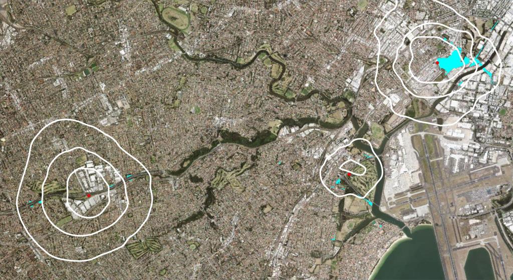
9 New M5 Air Quality Consultative Committee Meeting 2-17 October 2017 Shortlisted potential locations for New M5 ambient air quality monitoring stations

10 New M5 tunnel alignment and ventilation outlets New M5 ventilation outlet, Kingsgrove New M5 ventilation outlet, St Peters Interchange New M5 ventilation outlet, Arncliffe M4-M5 Link ventilation outlet, St Peters Interchange
11 Ambient air quality monitoring E10 This document includes a shortlist of potential locations for air quality monitoring stations required to meet Condition E10 Eight ambient air quality monitoring stations need to be installed in the New M5 corridor by early 2019 (one year prior to opening) to meet the Conditions of Approval outlined in the table below. Condition of Approval E10 a) E10 a) Measuring impact In vicinity of Kingsgrove ventilation outlet In vicinity of Kingsgrove ventilation outlet Refer to map and table Map 1, Table 1 Map 1, Table 1 E10 b) In vicinity of Arncliffe ventilation outlet Map 2, Table 2 E10 b) In vicinity of Arncliffe ventilation outlet Map 2, Table 2 E10 c) E10 c) E10 d) E10 e) In vicinity of St Peters ventilation outlet In vicinity of St Peters ventilation outlet Residential area in vicinity of St Peters Interchange Background ambient air quality reference data for the project area (must be away from other monitoring stations) Map 3, Table 3 Map 3, Table 3 Map 3, Table 3 Map 4, Table 4
12 Information on shortlisted potential locations This document includes a shortlist of potential locations for air quality monitoring stations required to meet Condition E10. The maps and tables following show the potential locations, property ownership and factors that may need to be considered in determining the final locations. Further information will be provided to the New M5 AQCCC air quality modelling with reference to these sites. All council and privately owned land listed would require permission from the landowner. The use of council land may be subject to the agreement of the elected representatives of the council. Sites may be subject to consultation with stakeholders such as sports clubs, park users and nearby residents. Advice would be sought from air quality specialists to confirm the sites have suitable space for the air quality monitoring stations to operate, without obstruction from buildings, trees or other factors that impact operation. The maps do not show the precise location of the proposed monitoring station, further investigation would be required to confirm the exact positioning of each monitoring station within the site boundary listed. Some further investigations may be required to confirm suitability of the sites, such as (but not limited to): Proximity to power supply Level of ground and whether earthworks would need to be carried out Trees and vegetation on site and whether clearing would need to be carried out Seeking the New M5 AQCC s consideration on whether any of the shortlisted locations in this document should be ruled out or any additional information that should be considered regarding these sites. Any locations not ruled out would be considered potentially eligible and further investigations would continue. New M5 AQCC members may table additional locations for consideration by the committee and further investigation by the New M5 project team.
13 Table 1. E10 a) - Kingsgrove Code (Refer to Map 1) Condition Potential location Considerations 1 E10 a) Canterbury golf course Golf course owned by Canterbury Council Use would be subject to council agreement and golf course operators Position of station would need to consider configuration of greens 2 E10 a) Forrester Reserve, adjacent to M5 Linear Park and Forrester Street 3 E10 a) RMS owned land in M5 motorway corridor, adjacent to Forrester Reserve 4 E10 a) Beverly Hills Park, adjacent to Bundara Street 5 E10 a) Tallawalla Reserve, adjacent to Tallawalla Street Public open space owned by Canterbury Bankstown Council Use would be subject to council agreement RMS owned land in motorway corridor Land is steep in some parts and further investigations would need to be carried out to confirm suitability Seeking advice on whether proximity to New M5 and M5 East surface road would impact suitability Public open space owned by Georges River Council Site was previously used for baseline monitoring during the preparation of the New M5 EIS Slab and fencing from previous monitoring station is still in place Use would be subject to council agreement Public open space owned by Georges River Council Use would be subject to council agreement Position of station would need to consider existing park uses including the grass netball courts

14 Map 1. E10 a) - Kingsgrove Canterbury golf course Beverly Hills Park New M5 ventilation outlet LEGEND RMS owned land Council owned land Privately owned land

15 Kingsgrove, ground level concentration - 1 hour average maximum

16 Kingsgrove, ground level concentration - 24 hour average maximum

17 Kingsgrove, ground level concentration - annual average

18 Option 1: Canterbury golf course Golf course owned by Canterbury Council Use would be subject to council agreement and golf course operators Position of station would need to consider configuration of greens


19 Option 2 - Forrester Reserve, adjacent to M5 Linear Park and Forrester Street Public open space owned by Canterbury Bankstown Council Use would be subject to council agreement

20 Option 3 - RMS owned land New M5, motorway corridor, adjacent to Forrester Reserve RMS owned land in motorway corridor Land is steep in some parts and further investigations would need to be carried out to confirm suitability Seeking advice on whether proximity to New M5 and M5 East surface road would impact suitability

21 Option 4 - Beverly Hills Park, adjacent to Bundara Street Public open space owned by Georges River Council Site was previously used for baseline monitoring during the preparation of the New M5 EIS Slab and fencing from previous monitoring station is still in place Use would be subject to council agreement

22 Option 5 - Tallawalla Reserve, adjacent to Tallawalla Street Public open space owned by Georges River Council Use would be subject to council agreement Position of station would need to consider existing park uses including the grass netball courts
23 Table 2. E10 b) - Arncliffe Code (Refer to Map 2) Condition Potential location Considerations 1 E10 b) Corner West Botany Street and Marsh Street 2 E10 b) Corner Princes Hwy and M5 off-ramp RMS owned land Vacant lot being used to construct new Green and Golden Bell Frog habitat. Seeking information from RMS on the on amount of available residual land following the construction of the habitat area Any installation and station maintenance activities would need to consider potential impacts to the habitat RMS owned land Small parcel of land, may be difficult to access for installation and maybe challenging finding enough space to put the station 3 E10 b) 49 West Botany Street RMS owned land Site was previously used for baseline monitoring during the preparation of the New M5 EIS Property is fenced with concrete slab ready for a monitoring station. 4 E10 b) Rockwell Avenue, adjacent to St Georges River Rowing Club RMS owned land Land identified is constrained by services and poor location on a corner block, but there maybe suitable locations directly adjacent within the compound currently used for Marsh Street widening project. RMS are confirming the availability of the adjacent land with the Marsh Street widening project team. 5 E10 b) 13 Eve Street RMS owned land Property is fenced off already Vacant land Seeking advice from RMS on any proposed future uses 6 E10 b) 95 West Botany Street - corner of Wickham and West Botany Street RMS owned land Vacant land Seeking advice from RMS on any proposed future uses
 - Arncliffe 2 Cnr Princes Highway and M5 off- ramp 6 Wickham Street 3 1 West Botany Street Cnr West Botany and Marsh Street Eve Street 5 8.")
24 Sydenham Green Map 2. E10 b) - Arncliffe 2 Cnr Princes Highway and M5 off- ramp 6 Wickham Street 3 1 West Botany Street Cnr West Botany and Marsh Street Eve Street 5 8. New M5 ventilation outlet 7. 4 Rockwell Avenue LEGEND LEGEND RMS owned land Council RMS owned owned land land Privately owned land

25 Arncliffe, ground level concentration 1 hour average maximum

26 Arncliffe, ground level concentration 24 hour average maximum

27 Arncliffe, ground level concentration annual average

28 Option 1 - Corner West Botany Street and Marsh Street RMS owned land Vacant lot being used to construct new Green and Golden Bell Frog habitat. Seeking information from RMS on the on amount of available residual land following the construction of the habitat area Any installation and station maintenance activities would need to consider potential impacts to the habitat

29 Option 2 - Corner Princes Hwy and M5 off-ramp RMS owned land Small parcel of land, may be difficult to access for installation and maybe challenging finding enough space to put the station


30 Option 3-49 West Botany Street RMS owned land Site was previously used for baseline monitoring during the preparation of the New M5 EIS Property is fenced with concrete slab ready for a monitoring station.

31 Option 4 - Rockwell Avenue, adjacent to St Georges River Rowing Club RMS owned land Land identified is constrained by services and poor location on a corner block, but there maybe suitable locations directly adjacent within the compound currently used for Marsh Street widening project. RMS are confirming the availability of the adjacent land with the Marsh Street widening project team.

32 Option 5-13 Eve Street RMS owned land Site was previously used for baseline monitoring during the preparation of the New M5 EIS Property is fenced with concrete slab ready for a monitoring station.

33 Option 6-95 West Botany Street, corner of Wickham and West Botany Street RMS owned land Vacant land Seeking advice from RMS on any proposed future uses
34 Table 3. St Peters E10 c) and d) Code (Refer to Map 3) 1 E10 c) E10 d) 2 E10 c) E10 d) 3 E10 c) E10 d) 4 E10 c) E10 d) 5 E10 c) E10 d) 6 E10 c) E10 d) Condition Potential location Considerations Grounds of St Peters Public School Existing monitoring station, proposed to remain on site until at least Adjacent to residential area Camdenville Park This site would only be considered if other options closer to the ventilation outlet were not feasible. Public open space owned by Inner West Council Use would be subject to council agreement Position of station would need to consider future Camdenville Park Upgrade plans Simpson Park This site would only be considered if other options closer to the ventilation outlet were not feasible. Public open space owned by Inner West Council Use would be subject to council agreement RMS owned land adjacent to Campbell Street, between St Peters Street and Church Street RMS owned land adjacent to Campbell Street, between Church Street and Princes Highway 7 E10 c) St Peters Interchange site, adjacent to Canal Road 8 E10 c) St Peters Interchange site, adjacent to Burrows Road 9. E10 c) E10 d) RMS owned land Within site currently being used to construct the Campbell Street upgrade. Seeking confirmation from New M5 contractor that land would be available prior to early 2019, to meet installation deadline. Seeking advice on whether proximity to Campbell Street would impact the suitability of this location RMS owned land Within site currently being used to construct the Campbell Street upgrade. Seeking confirmation from New M5 contractor that land would be available prior to early 2019, to meet installation deadline. Seeking advice on whether proximity to Campbell Street would impact the suitability of this location Sydney Park This site would only be considered if other options closer to the ventilation outlet were not feasible. Public open space owned by City of Sydney Council Use would be subject to council agreement Position of station would need to consider existing and future developments in Sydney Park including City Farm and land bridge RMS owned land Within site currently being used to construct the St Peters Interchange. Seeking confirmation from New M5 contractor that land would be available prior to early 2019, to meet installation deadline. RMS owned land Within site currently being used to construct St Peters Interchange. Seeking confirmation from New M5 contractor that land would be available prior to early 2019, to meet installation deadline. Sydenham Green Public open space owned by Inner West Council Public open space owned by City of Sydney Council Use would be subject to council agreement Position of station would need to consider skate park development under construction

35 9. Sydenham Green Map 3. St Peters E10 c) and d) Camdenville Park 1. New M5 ventilation outlet 2. Simpson Park St Peters Public School St Peters Interchange site Sydney Park LEGEND RMS owned land Council owned land Privately owned land

36 St Peters Interchange, ground level concentration 1 hour average maximum

37 St Peters Interchange, ground level concentration 24 hour average maximum

38 St Peters Interchange, ground level concentration annual average

39 Option 1 - Grounds of St Peters Public School RMS owned land Site was previously used for baseline monitoring during the preparation of the New M5 EIS Property is fenced with concrete slab ready for a monitoring station.

40 Option 2 - Camdenville Park This site would only be considered if other options closer to the ventilation outlet were not feasible. Public open space owned by Inner West Council Use would be subject to council agreement Position of station would need to consider future Camdenville Park Upgrade plans

41 Option 3 - Simpson Park This site would only be considered if other options closer to the ventilation outlet were not feasible. Public open space owned by Inner West Council Use would be subject to council agreement
42 Option 4 - RMS owned land adjacent to Campbell Street, between St Peters Street and Church Street RMS owned land Within site currently being used to construct the Campbell Street upgrade. Seeking confirmation from New M5 contractor that land would be available prior to early 2019, to meet installation deadline. Seeking advice on whether proximity to Campbell Street would impact the suitability of this location

43 Option 5 - RMS owned land adjacent to Campbell Street, between Church Street and Princes Highway RMS owned land Within site currently being used to construct the Campbell Street upgrade. Seeking confirmation from New M5 contractor that land would be available prior to early 2019, to meet installation deadline. Seeking advice on whether proximity to Campbell Street would impact the suitability of this location

44 Option 6 - Sydney Park This site would only be considered if other options closer to the ventilation outlet were not feasible. Public open space owned by City of Sydney Council Use would be subject to council agreement Position of station would need to consider existing and future developments in Sydney Park including City Farm and land bridge
45 Option 7 - St Peters Interchange site, adjacent to Canal Road RMS owned land Within site currently being used to construct the St Peters Interchange. Seeking confirmation from New M5 contractor that land would be available prior to early 2019, to meet installation deadline.

46 Option 8 - St Peters Interchange site, adjacent to Burrows Road RMS owned land Within site currently being used to construct St Peters Interchange. Seeking confirmation from New M5 contractor that land would be available prior to early 2019, to meet installation deadline.

47 Option 9 - Sydenham Green Public open space owned by Inner West Council Public open space owned by City of Sydney Council Use would be subject to council agreement Position of station would need to consider skate park development under construction
48 Table 4. E10 e) background sites Code (Refer to Map 4) Condition Potential location Considerations 1 E10 e) Corner of Bexley Road and Poole Street, Kingsgrove 2 E10 e) Duff Street, Arncliffe 3 E10 e) Barton Park, near Bestic Street RMS owned land Currently being used as a tunnel construction site for the New M5 Seeking confirmation from New M5 contractor that land would be available prior to early 2019, to meet installation deadline. Residential area between Arncliffe and Kingsgrove ventilation outlets RMS owned land Vacant land Residential area between Arncliffe and Kingsgrove ventilation outlets RMS owned land Site was previously used for baseline monitoring during the preparation of the New M5 EIS Slab and fencing from previous monitoring station is still in place Residential area

49 Map 4. E10 e) Background sites I T A C I L 1. Kingsgrove B U P Bardwell Park New M5 ventilation outlet T O LEGEND RMS owned land N Council owned land Privately owned land N O F R O Tempe 2. Arncliffe New M5 ventilation outlet 3.
50

51 Option 1 - Corner of Bexley Road and Poole Street, Kingsgrove RMS owned land Currently being used as a tunnel construction site for the New M5 Seeking confirmation from New M5 contractor that land would be available prior to early 2019, to meet installation deadline. Residential area between Arncliffe and Kingsgrove ventilation outlets

52 Option Duff Street, Arncliffe RMS owned land Vacant land Residential area between Arncliffe and Kingsgrove ventilation outlets

53 Option 3 - Barton Park, near Bestic Street RMS owned land Site was previously used for baseline monitoring during the preparation of the New M5 EIS Slab and fencing from previous monitoring station is still in place Residential area
54 Next steps Based on feedback from AQCCC, the New M5 project team will continue investigations, including (but not limited to): Seeking clearance from RMS for RMS owned sites Seeking confirmation from New M5 contractor that land currently being used for construction will be available to meet timeframes Seeking endorsement from local councils to investigated council owned options Detailed site investigations The New M5 team would report back to the AQCCC by mid February 2018 on the final monitoring station locations. Sites would be prioritised in the following order: Sites with existing monitoring stations or infrastructure from former stations RMS owned land Council owned land Privately owned land Next meeting tentatively scheduled for Tuesday 20 February, 6pm to 8pm
Division 5 Residential Low Density Zone: Assessment Criteria and Assessment Tables
 Division 5 Residential Low Density Zone: Assessment Criteria and Assessment Tables 4.5.1 Residential Low Density Zone The provisions in this division relate to the Residential Low Density Zone as follows
Planned Residence District (PR) To review a plan to construct 11 single family homes on approximately 4.01 acres.
 To review a plan to construct 11 single family homes on approximately 4.01 acres.") STAFF REPORT PLANNING & ZONING COMMISSION Village Green Municipal Building, Council Chambers 47 Hall Street Wednesday, March 13, 2019 7:00 P.M. 1. FINAL DEVELOPMENT PLAN REVIEW Applicant: Romanelli and
STAFF REPORT PLANNING & ZONING COMMISSION Village Green Municipal Building, Council Chambers 47 Hall Street Wednesday, March 13, 2019 7:00 P.M. 1. FINAL DEVELOPMENT PLAN REVIEW Applicant: Romanelli and
PUBLIC RIGHTS OF WAY. Guidance for Planners and Developers
 PUBLIC RIGHTS OF WAY Guidance for Planners and Developers 1. Introduction Public rights of way (PROW) are significant highway assets, highly valued by local people. They are a material consideration in
Division 6 Residential Medium Density Zone: Assessment Criteria and Assessment Tables
 Division 6 Residential Medium Density Zone: Assessment Criteria and Assessment Tables 4.6.1 Residential Medium Density Zone The provisions in this division relate to the Residential Medium Density Zone
LOCATION + VALUE BURROWS INDUSTRIAL ESTATE 1 3 BURROWS ROAD, ALEXANDRIA, NSW
 LOCATION + VALUE BURROWS INDUSTRIAL ESTATE 1 3 BURROWS ROAD, ALEXANDRIA, NSW OVERVIEW 2 Opportunity Ideally situated for port and airport users, Burrows Industrial Estate offers functional warehouse+office
Task Force on Kai Tak Harbourfront Development
 Task Force on Kai Tak Harbourfront Development For discussion on 14 May 2013 TFKT/07/2013 Central Kowloon Route - Kai Tak and Ma Tau Kok PURPOSE This paper seeks Members views on preliminary proposals
Housing Commission Report
 Housing Commission Report To: From: Subject: Housing Commission Meeting: July 21, 2016 Agenda Item: 4-B Chair and Housing Commission Barbara Collins, Housing Manager Draft Request for Proposals for Mountain
Hutt River City Centre Upgrade Project Preliminary Integrated Design
 Report 2016.24 Date 5 February 2016 File N/03/18/22 Committee Author Hutt Valley Flood Management Subcommittee Daya Atapattu, Senior Project Engineer Hutt River City Centre Upgrade Project Preliminary
RURAL GENERAL RG 1. PERMITTED USES DISCRETIONARY USES
 RURAL GENERAL RG PURPOSE: To protect the agricultural land base of the municipality while allowing nonagricultural developments which complement the area's economy. 1. PERMITTED USES DISCRETIONARY USES
DCLG consultation on proposed changes to national planning policy
 Summary DCLG consultation on proposed changes to national planning policy January 2016 1. Introduction DCLG is proposing changes to the national planning policy framework (NPPF) specifically on: Broadening
Division 8 General Urban (T4) Zone: Assessment Criteria and Assessment Tables
 Zone: Assessment Criteria and Assessment Tables") Division 8 General Urban (T4) Zone: Assessment Criteria and Assessment Tables 15.8.1 General Urban (T4) Zone The provisions in this division relate to the General Urban (T4) Zone as follows overall outcomes
Division 8 General Urban (T4) Zone: Assessment Criteria and Assessment Tables 15.8.1 General Urban (T4) Zone The provisions in this division relate to the General Urban (T4) Zone as follows overall outcomes
Frequently Asked Questions
 Frequently Asked Questions Cambridge West Land Use Planning Matters January 10, 2018 Q1 What is proposed for the undeveloped lands within the Cambridge West area? A. Four separate landowners each own part
Assistant Director of Housing and Built Environment. 109 St Helens Park Road, Hastings, TN34 2JW
 AGENDA ITEM NO: 6 (d) Report to: PLANNING COMMITTEE Date of Meeting: 10 October 2018 Report from: Assistant Director of Housing and Built Environment Application Address: Proposal: Application No: 109
BOUNDARY LINE ADJUSTMENT APPLICATION GUIDE
 BOUNDARY LINE ADJUSTMENT APPLICATION GUIDE SISKIYOU COUNTY PLANNING DIVISION 806 South Main Street, Yreka CA 96097 Phone: (530) 841-2100 / Fax: (530) 841-4076 WHAT IS A BOUNDARY LINE ADJUSTMENT? A Boundary
Rawlinson House, Lewisham, London SE13 5EL
 Rawlinson House, Lewisham, London SE13 5EL Client: Lewisham Homes Old Town Hall Catford London SE6 4RU Date: 18 February 2016 Job No: 2540-MA-N-RP-0001-D00 Martin Arnold Ltd 4 Gunnery Terrace The Royal
Biodiversity Planning Policy and Guidelines for (LEP) Rezoning Proposals
 Rezoning Proposals") Council Policy Biodiversity Planning Policy and Guidelines for (LEP) Rezoning Proposals Table of Contents Table of Contents... 1 Policy... 2 Policy Objectives... 2 Policy Statement... 2 Guidelines... 2
Council Policy Biodiversity Planning Policy and Guidelines for (LEP) Rezoning Proposals Table of Contents Table of Contents... 1 Policy... 2 Policy Objectives... 2 Policy Statement... 2 Guidelines... 2
Division 4 Large Lot Residential Zone: Assessment Criteria and Assessment Tables
 Division 4 Large Lot Residential Zone: Assessment Criteria and Assessment Tables 4.4.1 Large Lot Residential Zone The provisions in this division relate to the Large Lot Residential Zone as follows overall
Division 16 Bundamba Racecourse Stables Area Zone: Assessment Criteria and Assessment Tables
 Division 16 Bundamba Racecourse Stables Area Zone: Assessment Criteria and Assessment Tables 4.16.1 Bundamba Racecourse Stables Area Zone The provisions in this division relate to the Bundamba Racecourse
7. IMPLEMENTATION STRATEGIES
 7. IMPLEMENTATION STRATEGIES A. GENERAL APPROACH FOR IMPLEMENTATION Implementing the plan will engage many players, including the Municipality of Anchorage (MOA), the Government Hill Community Council,
ATTACHMENT 1: Proposed Official Plan Amendment - Affordable Housing
 ATTACHMENT 1: Proposed Official Plan Amendment - Affordable Housing AMENDMENT NUMBER (?) TO THE OFFICIAL PLAN FOR THE CORPORATION OF THE CITY OF GUELPH: AFFORDABLE HOUSING AMENDMENT INDEX PART A - THE
SUBURBAN AND URBAN RESIDENTIAL LAND USE
 SUBURBAN AND URBAN RESIDENTIAL LAND USE GOAL 1 DISCOURAGE URBAN AND SUBURBAN DEVELOPMENT OUTSIDE INCORPORATED AREAS IN WHITMAN COUNTY, EXCEPT WITHIN DESIGNATED UNINCORPORATED COMMUNITIES, AND THOSE AREAS
LAKE MERRITT STATION AREA PLAN
 LAKE MERRITT STATION AREA PLAN Emerging Plan Open House Summary October 2011 2 1 Introduction The City of Oakland, Bay Area Rapid Transit (BART), and the Peralta Community College District, through a grant
Application Procedures for Easements or Rights of Way on City of Fort Collins Natural Areas and Conserved Lands March 2012
 Application Procedures for Easements or Rights of Way on City of Fort Collins Natural Areas and Conserved Lands March 2012 IMPORTANT NOTE: This document was created to accompany the City of Fort Collins
Accepting Development Proposals
 Accepting Development Proposals Background The Economic Development Corporation (EDC) of the is currently accepting proposals from firms with an interest in redeveloping the vacant parcel of property located
4. If any perennial surface water passes through or along the property lines of the acreage, a minimum of 200 feet or frontage should be required.
 b. Provide adequate acreage for appropriate productive use of rural residential land, such as small numbers of livestock, large gardens, etc. 3. Minimum of 200 feet of frontage on an improved county or
INCLUSIONARY HOUSING PROGRAM IMPLEMENTATION GUIDELINES
 INCLUSIONARY HOUSING PROGRAM IMPLEMENTATION GUIDELINES JULY 2005 Department of Grants & Community Investment 1110 West Capitol Avenue West Sacramento, CA 95691 Phone: (916) 617-4555 Fax: (916) 372-1584
CONDITIONAL USE PERMIT Application Packet
 CONDITIONAL USE PERMIT Application Packet Community Development Department 1020 East Pioneer Road, Draper, UT 84020 (801) 576-6539 Fax (801) 576-6526 Dear Applicant, This application packet has been developed
Safe Waterfront Access, PID Council Report -2 - May 10, 2016 BACKGROUND
 14.3.1 Safe Waterfront Access, PID 00560789 Council Report -2 - May 10, 2016 BACKGROUND A staff information report dated April 11, 2016 regarding safe waterfront access at PID 00560789 was before the Halifax
Documentation Standard for an Individual Section 4(f) Evaluation
 Evaluation") Documentation Standard for an Individual Section 4(f) Evaluation Use this documentation standard (DS) to prepare an Individual Section 4(f) evaluation for Federal Highway Administration (FHWA) projects
Documentation Standard for an Individual Section 4(f) Evaluation Use this documentation standard (DS) to prepare an Individual Section 4(f) evaluation for Federal Highway Administration (FHWA) projects
LITTLE MOUNTAIN ADJACENT AREA REZONING POLICY
 LITTLE MOUNTAIN ADJACENT AREA REZONING POLICY JANUARY 2013 CONTENTS 1.0 INTENT & PRINCIPLES...1 2.0 APPLICATION...2 3.0 HOUSING TYPES, HEIGHT & DENSITY POLICIES...3 3.1 LOW TO MID-RISE APARTMENT POLICIES...4
Staff: DAVID PAOLETTA, Planning Department; Linda Shanks, Planning Department
 Livingston County Land Bank Corporation Board of Directors Meeting January 25, 2018 Meeting Minutes Members: WILLIAM BACON, Livingston County Office of Economic Development/IDA; AMY DAVIES, Livingston
SCHEDULE 12 TO THE URBAN GROWTH ZONE. Shown on the planning scheme map as UGZ12. Kororoit Precinct Structure Plan
 SCHEDULE 12 TO THE URBAN GROWTH ZONE Shown on the planning scheme map as UGZ12. Kororoit Precinct Structure Plan 1.0 The plan Map 1 below shows the future urban structure proposed in the Kororoit Precinct
From: Gerard Reiter, EGM/Asset Management Date: 14 April 2015 Peter McIntyre, Managing Director
 TO THE BOARD Item: 6 From: Gerard Reiter, EGM/Asset Management Date: 14 April 2015 Peter McIntyre, Managing Director Category: FOR APPROVAL SECOND SUPPLY TO THE ACT STOCKDILL DRIVE 330kV SWITCHING STATION
NSW Travelling Stock Reserves Review Public consultation paper
 NSW Travelling Stock Reserves Review Public consultation paper A collaborative project between: Local Land Services Department of Industry Lands Contents Executive summary 2 1. About TSRs 3 What are TSR
Conceptual Scheme SE W4
 December 2012 1. PURPOSE 1.1. The purpose of a Conceptual Scheme (CS) is as follows: a) To provide a framework for the subsequent subdivision and/or development of land within the Country Residential Policy
APPENDIX D - REAL ESTATE
 APPENDIX D - REAL ESTATE 1. Purpose Real Estate Plan For Feasibility Study For Lake Lou Yaeger Section 206 Aquatic Ecosystem Restoration Continuing Authorities Project Feasibility Study This report is
Application for Outline Plan / Outline Plan Waiver Section 176A, Resource Management Act
 Email: applications@waidc.govt.nz www.waikatodistrict.govt.nz Telephone (all hours) 07 824 8633 Call Free 0800 492 452 District Office 15 Galileo Street Private Bag 544 Ngaruawahia 3742 Application for
Architectural Control Board Handbook
 Copper Cove at Lake Tulloch Owners Association 920 Black Creek Drive Phone: (209) 785-2688 Copperopolis, CA 95228 Fax: (209) 785-2698 Website: www.ccltoa.org Email: ccltoa@caltel.com Architectural Control
METHODOLOGY GUIDE VALUING LANDS IN TRANSITION IN ONTARIO. Valuation Date: January 1, 2016
 METHODOLOGY GUIDE VALUING LANDS IN TRANSITION IN ONTARIO Valuation Date: January 1, 2016 August 2017 August 22, 2017 The Municipal Property Assessment Corporation (MPAC) is responsible for accurately assessing
Draft Neighbourhood Plan for the former Land Settlement Association Estate at Great Abington March 2017
 Draft Neighbourhood Plan for the former Land Settlement Association Estate at Great Abington March 2017 1 Neighbourhood Plan Contents 1 Why a Neighbourhood Plan for the former Abington Land Settlement
Land Transaction Procedures Approved July 17, 2012
 Land Transaction Procedures Approved July 17, 2012 Purpose: The Greenbelt Land Trust (GLT) acquires fee title or conservation easements for lands to fulfill its mission to conserve and protect in perpetuity
PORT PHILLIP PLANNING SCHEME. Condition
 SCHEDULE 1 TO THE CAPITAL CITY ZONE Shown on the planning scheme map as CCZ1. FISHERMANS BEND URBAN RENEWAL AREA Purpose To use and develop the Fishermans Bend Urban Renewal Area generally in accordance
Council 20 December Midlothian Strategic Housing Investment Plan 2017/ /22. Report by Eibhlin McHugh, Joint Director, Health & Social Care
 Council 20 December 2016 Midlothian Strategic Housing Investment Plan 2017/18 2021/22 Report by Eibhlin McHugh, Joint Director, Health & Social Care 1 Purpose of Report This Report summarises the key points
Assets, Regeneration & Growth Committee 11 July Development of new affordable homes by Barnet Homes Registered Provider ( Opendoor Homes )
") Assets, Regeneration & Growth Committee 11 July 2016 Title Report of Wards Status Urgent Key Enclosures Officer Contact Details Development of new affordable homes by Barnet Homes Registered Provider (
Assets, Regeneration & Growth Committee 11 July 2016 Title Report of Wards Status Urgent Key Enclosures Officer Contact Details Development of new affordable homes by Barnet Homes Registered Provider (
City of Brandon Brownfield Strategy
 City of Brandon Brownfield Strategy 2017 Executive Summary A brownfield is a property, the expansion, redevelopment, or reuse of which may be complicated by the presence or potential presence of a hazardous
CITY OF VAUGHAN EXTRACT FROM COUNCIL MEETING MINUTES OF DECEMBER 11, 2012
 CITY OF VAUGHAN EXTRACT FROM COUNCIL MEETING MINUTES OF DECEMBER 11, 2012 Item 1, Report No. 51, of the Committee of the Whole (Working Session), which was adopted without amendment by the Council of the
Bylaw No , being "Official Community Plan Bylaw, 2016" Schedule "A" DRAFT
 Bylaw No. 2600-2016, being "Official Community Plan Bylaw, 2016" Schedule "A" Urban Structure + Growth Plan Urban Structure Land use and growth management are among the most powerful policy tools at the
Standard for the acquisition of land under the Public Works Act 1981 LINZS15005
 Standard for the acquisition of land under the Public Works Act 1981 LINZS15005 Version date: 20 February 2014 Table of contents Terms and definitions... 5 Foreword... 6 Introduction... 6 Purpose... 6
Below Market Rate Program Administrator. Request for Proposals
 Below Market Rate Program Administrator Request for Proposals Housing and Community Development 7351 Rosanna Street Gilroy, CA 95020 Page 1 Introduction and Important Dates The City of Gilroy is seeking
PLANNING COMMISSION REPORT Regular Agenda Public Hearing Item
 PC Staff Report 11/12/12 Item No. 2B- 1 PLANNING COMMISSION REPORT Regular Agenda Public Hearing Item ITEM NO. 2B: A TO GPI; 110 ACRES; E OF K-10 & N OF W 6 TH ST (MKM) : Consider a request to rezone approximately
AUGUST 18, The regular meeting of the Planning Advisory Committee was held in the Council Chamber, Lobby Level.
 PLANNING ADVISORY COMMITTEE AUGUST 18, 2015 The regular meeting of the Planning Advisory Committee was held in the Council Chamber, Lobby Level. PRESENT Eric Falkjar, Chair Andrew Miller, First Vice-Chair
City of Peachtree City. Annexation Review Process
 City of Peachtree City Annexation Review Process Page 1 Annexation Review Process Step One: Initial annexation information The following information is to be completed by the property owner and/ or their
Absent: Major Chris Hanson, Volk Field John Ross, Jackson County Emergency Management; Paul Wydeven, Wisconsin Department of Transportation
 Monroe County/Fort McCoy Joint Land Use Study (JLUS) Technical Advisory Group (TAG) December 8, 2011, 2:00 4:00 p.m. Angelo Town Hall, 14123 Co. Hwy. I, Sparta, WI Meeting Minutes Attendance: Bryan Law,
Masshouse Plot 3, Land at Masshouse Lane/Park Street, Masshouse Plaza, City Centre, Birmingham, B5
 Committee Date: 21/08/2014 Application Number: 2014/02950/PA Accepted: 07/05/2014 Application Type: Full Planning Target Date: 06/08/2014 Ward: Nechells Masshouse Plot 3, Land at Masshouse Lane/Park Street,
Voluntary Land Acquisition and Mitigation Policy For State Significant Mining, Petroleum and Extractive Industry Developments 15 DECEMBER 2014
 Voluntary Land Acquisition and Mitigation Policy For State Significant Mining, Petroleum and Extractive Industry Developments 15 DECEMBER 2014 CONTENTS PRELIMINARY... 1 Purpose... 1 Application... 1 Commencement...
Heathrow Expansion. Land Acquisition and Compensation Policies. Interim Property Hardship Scheme. Policy Terms
 1 Introduction Heathrow Expansion Land Acquisition and Compensation Policies Interim Property Hardship Scheme Policy Terms 1.1 This document sets out the terms of the Interim Property Hardship Scheme (the
Washington Boulevard + Kirkwood Road Special General Land Use Plan (GLUP) Study "Plus"
 Study Plus") Washington Boulevard + Kirkwood Road Special General Land Use Plan (GLUP) Study "Plus" Long Range Committee of the Planning Commission Meeting #4 May 18, 2017 Department of Community Planning, Housing
Washington Boulevard + Kirkwood Road Special General Land Use Plan (GLUP) Study "Plus" Long Range Committee of the Planning Commission Meeting #4 May 18, 2017 Department of Community Planning, Housing
SECTION B - GUIDELINES
 SECTION B - GUIDELINES APPLICATION KIT FOR SUBDIVISION RESOURCE CONSENT UNDER SECTION 88 OF THE RESOURCE MANAGEMENT ACT 1991 CONTENTS: PLEASE READ AND COMPLETE 1. Making an Application for a Subdivision
Eric Feldt, Planner II, CFM Community Development Department
 DATE: August 28, 2014 TO: FROM: Board of Adjustment Eric Feldt, Planner II, CFM Community Development Department FILE NO.s: VAR2014 0017 & VAR2014 0018 PROPOSAL: A Variance to reduce two side yard setbacks
9.3.5 Dual occupancy code
 9.3.5 Dual occupancy code 9.3.5.1 Application (1) This code applies to accepted development and assessable development identified as requiring assessment against the Dual occupancy 1 code by the tables
Assets, Regeneration & Growth Committee 17 March Development of new affordable homes by Barnet Homes Registered Provider ( Opendoor Homes )
") Assets, Regeneration & Growth Committee 17 March 2016 Title Report of Wards Status Urgent Key Enclosures Officer Contact Details Development of new affordable homes by Barnet Homes Registered Provider
Assets, Regeneration & Growth Committee 17 March 2016 Title Report of Wards Status Urgent Key Enclosures Officer Contact Details Development of new affordable homes by Barnet Homes Registered Provider
Viability and the Planning System: The Relationship between Economic Viability Testing, Land Values and Affordable Housing in London
 Viability and the Planning System: The Relationship between Economic Viability Testing, Land Values and Affordable Housing in London Executive Summary & Key Findings A changed planning environment in which
DRAFT LOCAL VALIDATION CHECKLIST FOR ALL APPLICATIONS
 DRAFT LOCAL VALIDATION CHECKLIST FOR ALL APPLICATIONS For public consultation 9 February to 9 March 2015 February 2015 1 NATIONAL REQUIREMENTS Application Form Design & Access Statement (DAS) If major
AIRPORT LESSEE COMPANY CONSENT FORM
 AIRPORT LESSEE COMPANY CONSENT FORM All building activities as described under Airports Act 1996, Part 5, Division 5 - Building Control, require Airport Lessee Company (ALC) Consent. Bankstown Airport
Marin County Agricultural Land Conservation Program March 1, 2014
 Marin County Agricultural Land Conservation Program March 1, 2014 I. Purpose of this Document This document describes the Marin County Agricultural Land Conservation Program (County Program). The Marin
BYLAW 5781 ****************
 BYLAW 5781 **************** A BYLAW OF THE CITY OF LETHBRIDGE PROVIDING FOR THE IMPOSITION OF AN OFF-SITE LEVY IN RESPECT OF LAND TO BE DEVELOPED OR SUBDIVIDED FOR THE YEARS 2013, 2014, 2015 and 2016 ************************************************************
Community Occupancy Guidelines
 Community Occupancy Guidelines Auckland Council July 2012 Find out more: phone 09 301 0101 or visit www.aucklandcouncil.govt.nz Contents Introduction 4 Scope 5 In scope 5 Out of scope 5 Criteria 6 Eligibility
JURISDICTIONAL RUNOFF MANAGEMENT PROGRAM ENFORCEMENT RESPONSE PLAN
 CITY OF ESCONDIDO JURISDICTIONAL RUNOFF MANAGEMENT PROGRAM ENFORCEMENT RESPONSE PLAN June 2015 Utilities Department Environmental Programs Division 201 N. Broadway Escondido, CA 92025 760-839-4668 TABLE
Chapter 100 Planned Unit Development in Corvallis Urban Fringe
 100.100 Scope and Purpose. Chapter 100 Planned Unit Development in Corvallis Urban Fringe (1) All applications for land divisions in the Urban Residential (UR) and Flood Plain Agriculture (FPA) zones within
Application Training / Overview Questions and Answers July 10, 2018
 Application Training / Overview Questions and Answers July 10, 2018 1. Does community outreach of 500 feet need to be done before the application submittal? A. The City encourages that community outreach,
On: 20 April Report by: Director of Development and Housing Services. Heading: Paisley West End - Regeneration Masterplan. 1.
 To: Council On: 20 April 2017 Report by: Director of Development and Housing Services Heading: Paisley West End - Regeneration Masterplan 1. Summary 1.1 This report sets out proposals for the regeneration
Guidance on Public Rights of Way Affected by Coastal and Estuarine Change or Management
 Guidance on Public Rights of Way Affected by Coastal and Estuarine Change or Management The purpose of this guidance: To ensure public rights of way issues are properly addressed in any coastal (including
APPLICATION PROCESSING. CHECK WITH STAFF - Development Services Staff will explain the requirements and procedures to you.
 PLANNED DEVELOPMENT ZONE 1810 E. HAZELTON AVENUE, STOCKTON CA 95205 BUSINESS PHONE: (209) 468-3121 Business Hours: 8:00 a.m. to 5:00 p.m. (Monday through Friday) STEP 1 STEP 2 FEE FORM DEED SERVICES APPLICATION
FEE The staff will let you know the current cost of filing an application. Make checks payable to the San Joaquin County Treasurer.
 VARIANCE 1810 E. HAZELTON AVENUE, STOCKTON CA 95205 BUSINESS PHONE: (209) 468-3121 Business Hours: 8:00 a.m. to 5:00 p.m. (Monday through Friday) STEP 1 STEP 2 APPLICATION PROCESSING STEPS CHECK WITH STAFF
DRAFT PROPOSED CHAPTER 21 SPECIFIC PURPOSE - FLAT LAND RECOVERY ZONE
 DRAFT PROPOSED CHAPTER 21 SPECIFIC PURPOSE - FLAT LAND RECOVERY ZONE Note: The Specific Purpose (Flat Land Recovery) Zone is a "holding" zone that will be subject to a later plan change to confirm the
5. That the Owner shall agree that all development Blocks shown within the Draft Plan will be connected to full municipal services.
 Conditions Relating to Draft Plan of Subdivision Approval East Fonthill 26T 01014 (Draft Plan dated December 1, 2013, and revised August 28, 2014), the Town of Pelham 1. This approval applies to the Draft
Appendix J - Planned Unit Development (PUD)
") Appendix J - Planned Unit Development (PUD) Intent and Purpose The purpose of the PUD is: 1. To provide development that is consistent with the Comprehensive Land Use Plan and promote the goals and objectives
Appendix J - Planned Unit Development (PUD) Intent and Purpose The purpose of the PUD is: 1. To provide development that is consistent with the Comprehensive Land Use Plan and promote the goals and objectives
COMMUNITY MEETING REPORT Petitioner: Meritage Homes of the Carolinas, Inc. Rezoning Petition No
 COMMUNITY MEETING REPORT Petitioner: Meritage Homes of the Carolinas, Inc. Rezoning Petition No. 2018-005 This Community Meeting Report is being filed with the Office of the City Clerk and the Charlotte-Mecklenburg
FOR SALE. 200 dwellings residential development site. with a resolution to grant planning permission THE STEEDS, GREAT COXWELL, OXFORDSHIRE SN7 7NN
 FOR SALE 200 dwellings residential development site with a resolution to grant planning permission THE STEEDS, GREAT COXWELL, OXFORDSHIRE SN7 7NN Outline Planning permission for up to 130 Private and 70
Committee Date: 17/07/2014 Application Number: 2014/02247/PA Accepted: 23/04/2014 Application Type: Full Planning Target Date: 18/06/2014
 Committee Date: 17/07/2014 Application Number: 2014/02247/PA Accepted: 23/04/2014 Application Type: Full Planning Target Date: 18/06/2014 Ward: Selly Oak 99 Hubert Road, Selly Oak, Birmingham, B29 6ET
QLDC Council 30 April Report for Agenda Item: 5. Land Transfer to facilitate replacement Kawarau Falls Bridge
 Department: Infrastructure QLDC Council 30 April 2015 Report for Agenda Item: 5 Land Transfer to facilitate replacement Kawarau Falls Bridge Purpose 1 The purpose of this report is to: a. authorise the
DATE: August 9, 2017 TO:
 DATE: August 9, 2017 TO: Board of Commissioners FROM: Kimberly Branam, Executive Director SUBJECT: Report Number 17-37 Authorizing a Leasehold Purchase and Sale Agreement to Convey Approximately 3.00 Acres
CHAPTER 50 LAND USE ZONES ARTICLE 50 BASIC PROVISIONS
 CHAPTER 50 LAND USE ZONES ARTICLE 50 BASIC PROVISIONS 50.010 - PURPOSE The purposes of this chapter are to establish land use zones required to implement the goals and policies of the Klamath County Comprehensive
Crown Lands Act, the MOU with AMSA & NSW Men s Sheds
 Crown Lands Act, the MOU with AMSA & NSW Men s Sheds Introduction The State Government Department responsible for Crown reserves is the Dept of Primary Industries. Reserves are created to protect and manage
Allow continued use of existing grass runway for personal use by landowner.
 CUP-13-00193 Item No. 4-1 PLANNING COMMISSION REPORT Regular Agenda PC Staff Report 7/22/13 ITEM NO. 4: CONDITIONAL USE PERMIT; PRIVATE LANDING STRIP; 2215 N 500 (MKM) CUP-13-00193: Consider a Conditional
Napa County Planning Commission Board Agenda Letter
 Agenda Date: 9/20/2017 Agenda Placement: 8C Napa County Planning Commission Board Agenda Letter TO: FROM: Napa County Planning Commission Charlene Gallina for David Morrison - Director Planning, Building
Silver Line Acceptance
 Finance & Administration Committee Action Item III-A June 12, 2014 Silver Line Acceptance Washington Metropolitan Area Transit Authority Board Action/Information Summary Action Information MEAD Number:
SUBDIVISION AND LAND DEVELOPMENT ORDINANCE
 SUBDIVISION AND LAND DEVELOPMENT ORDINANCE County SALDO Update June 16, 2016 Agenda SALDO Background SALDO Structure Goals and Updates Schedule and Next Steps Current SALDO Adopted by the County in 1981
Real Estate Tax Relief Program Application Process, Education, & Outreach
 Recommendation 14 Recommendation 12 Recommendation 3 Recommendation 2 Recommendation 1 Application Process, Education, & Outreach Revise the RETR application materials to be more user-friendly. Edit the
STAFF REPORT. March 14, Toronto and East York Community Council. Director, Community Planning, South District
 STAFF REPORT March 14, 2005 To: From: Subject: Toronto and East York Community Council Director, Community Planning, South District Preliminary Report Official Plan Amendment and Rezoning Application 05
Land Use. Land Use Categories. Chart 5.1. Nepeuskun Existing Land Use Inventory. Overview
 Land Use State Comprehensive Planning Requirements for this Chapter A compilation of objectives, policies, goals, maps and programs to guide the future development and redevelopment of public and private
SANTA BARBARA COUNTY ZONING ADMINISTRATOR Staff Report for Coleman SFD Addition Coastal Development Permit with Hearing
 SANTA BARBARA COUNTY ZONING ADMINISTRATOR Staff Report for Coleman SFD Addition Coastal Development Permit with Hearing Supervisorial District: First Staff Report Date: August 10, 2005 Staff: Lisa Hosale
This is a conditional use permit request to establish a commercial wind energy conversion system.
 Public Works 600 Scott Boulevard South Hutchinson, Kansas 67505 620-694-2976 Road & Bridge Planning & Zoning Noxious Weed Utilities Date: March 28, 2019 To: From: Reno County Planning Commission Russ Ewy,
{{t:t;r:n;o:"signer 2";l:"Date";}}
 Application/File # Date Application Rec'd: Oct 13 2017 Fee Collected $ (for office use only) CONDITIONAL USE APPLICATION MOTLEY MN Site Address (E-911#): 164 MORRISON STREET WEST 410095000 Lake/River Name:
Proposed Framework for Multi-Residential Rental Property Licence. Tenant Issues Committee Licensing and Standards Committee
 TD3.3 STAFF REPORT ACTION REQUIRED Proposed Framework for Multi-Residential Rental Property Licence Date: May 3, 2016 To: From: Wards: Reference Number: Tenant Issues Committee Licensing and Standards
Staff Report for Council Public Meeting
 Agenda Item 3.3 Staff Report for Council Public Meeting Date of Meeting: September 27, 2017 Report Number: SRPRS.17.134 Department: Division: Subject: Planning and Regulatory Services Development Planning
REPORT OF DIRECTOR FOR COMMUNITIES, HOUSING AND CUSTOMER SERVICES PORTFOLIO: HEALTH, HOUSING & WELLBEING (COUNCILLOR SUSAN ELSMORE)
") CYNGOR DINAS CAERDYDD CITY OF CARDIFF COUNCIL CABINET MEETING: 10 NOVEMBER 2016 SUSPENDING THE RIGHT TO BUY REPORT OF DIRECTOR FOR COMMUNITIES, HOUSING AND CUSTOMER SERVICES AGENDA ITEM: 5 PORTFOLIO: HEALTH,
CYNGOR DINAS CAERDYDD CITY OF CARDIFF COUNCIL CABINET MEETING: 10 NOVEMBER 2016 SUSPENDING THE RIGHT TO BUY REPORT OF DIRECTOR FOR COMMUNITIES, HOUSING AND CUSTOMER SERVICES AGENDA ITEM: 5 PORTFOLIO: HEALTH,
A TDR Program for Naples. May 11, 2007
 ATTACHMENT G A TDR Program for Naples May 11, 2007 Introduction This paper is intended to supplement and expand upon the Draft TDR Program Framework authored by Solimar in February 2007. 1 The Framework
Village of Port Jefferson Urban Renewal Plan
 Urban Renewal Plan Village of Port Jefferson Urban Renewal Plan Port Jefferson, New York PREPARED FOR Village of Port Jefferson Village Board 121 West Broadway Port Jefferson, NY 11777 631.473.4724 PREPARED
APPLICATION PROCEDURE
 ANTRIM PLANNING BOARD P. O. Box 517 Antrim, New Hampshire 03440 Phone: 603-588-6785 FAX: 603-588-2969 APPLICATION FORM AND CHECKLIST FOR MINOR OR MAJOR SITE PLAN REVIEW File Date Received By APPLICATION