KEIZER COMMUNITY DEVELOPMENT DEPARTMENT STAFF RECOMMENDATION Subdivision/Flood Plain Development Permit Case No
|
|
|
- Marvin Thornton
- 5 years ago
- Views:
Transcription

1 KEIZER COMMUNITY DEVELOPMENT DEPARTMENT STAFF RECOMMENDATION Subdivision/Flood Plain Development Permit Case No TO: FROM: Fred Wilson, Keizer Hearings Officer Shane Witham, Senior Planner SUBJECT: Case No DATE: April 17, 2018 I. GENERAL INFORMATION A. APPLICANT: Trademark Enterprises, LLC (Mark Farrow) B. PROPERTY OWNERS: Stephen and Dianne Meyer C. AGENT: Multi-Tech Engineering Jeremy Grenz D. PROPERTY LOCATION: The property is located at 930 Claggett St NE and is identified on Marion County Tax Assessor Map as Township 6 South; Range 3 West; Section 35CD; Lot (Exhibit 1). E. EXISTING PARCEL SIZE: The subject property is approximately 1.64 acres. F. EXISTING DEVELOPMENT AND PUBLIC FACILITIES: The property is contains a single family dwelling and associated outbuildings which will be removed. Water and Sewer are available and will be extended to serve the proposed development. G. PLAN DESIGNATION AND ZONING: The subject property is designated as Low Density Residential on the Comprehensive Plan Map and is zoned RS (Residential Single Family). H. ADJACENT ZONING AND LAND USES: Surrounding properties are zoned Residential Single Family (RS) and are developed with single-family dwellings. I. PROPOSAL/REQUEST: The subject property is proposed to be subdivided into a 10 lot subdivision. The applicant is also requesting a Floodplain Development Permit due to the fact that 5 of the proposed lots are encumbered by the 100-year special flood hazard area. The applicant s written statement and preliminary plans (Exhibit 2) are attached. Case No Page 1 Of 34
2 J. NOTICE: Public notice was mailed, published and posted consistent with notice requirements in KDC II. COMMENTS AGENCY COMMENTS: A. The Keizer Public Works Department submitted comments which contain development requirements regarding sanitary sewer, water system, street and drainage improvements and other general development requirements (Exhibit 3). B. The Marion County Surveyor s Office submitted comments outlining the requirements for surveying and platting the proposed subdivision in compliance with State requirements (Exhibit 4). C. The Salem-Keizer School District provided comments related to the estimated impacts to the school system as a result of the proposed development (Exhibit 5). D. Portland General Electric (PGE) submitted comments regarding tariff and service requirements, and that a 10 PUE will be required on all front street lots (Exhibit 6). E. The Keizer Police Department submitted a letter with comments recommending street lighting be extended into the new cul-de-sac (Exhibit 7). F. City of Salem Planning Department submitted they reviewed the proposal and have no comment CITIZEN COMMENTS: A letter requesting comments was sent to the surrounding property owners within 250 feet of the subject property. Comments were received from the following: Donald and Linda Coons of 795 Claggett St submitted comments (Exhibit 8) expressing concerns regarding the readability and accessibility of application materials, accessibility for emergency vehicles, traffic impacts, parking, safety, and whether site built or manufactured homes are proposed. John Adams of 5145 Kensington Ct submitted comments (Exhibit 9) with concerns over the proposed development relating to diminished property values, tree removal, proposed building heights, and access. Sarah Hackett and Kevin Ridling of th Ave submitted comments (Exhibit 10) expressing concerns relating to proposed construction in the floodplain, inadequate street access and a design that conflicts with the surrounding neighborhood, and questioned the adequacy of the mailed notice. Jayne Rosamond of 851 Claggett St submitted comments (Exhibit 11) requesting a reduction to 5 new homes, and expressed concerns regarding traffic impacts, the lack of a traffic impact study, parking, drainage, and requested a speed reduction. Kay, Devin and Shae Reece of 5136 Bailey Ct submitted comments (Exhibit 12) requesting that 2 existing filbert trees located adjacent to their property be retained. Case No Page 2 Of 34
3 STAFF S RESPONSE TO CITIZEN COMMENTS: Staff appreciates the public participation of concerned citizens and has attempted to address the concerns expressed, as appropriate, through the findings and related conditions recommended for this proposal. It should be noted that some of the concerns expressed are not able to be addressed by staff as they are not part of the specific criteria for approval of a subdivision proposal. The following responses are offered regarding the concerns expressed. Traffic/Parking/Street Improvements the applicant s proposal will provide right of way dedication and the installation of improvements along Kensington Ct terminating with a new culde-sac bulb. In addition, sidewalks will be provided along the frontage of Claggett Street in conjunction with the homes that are built. The proposed right of way width of 42 feet with a 30 foot curb to curb street section for Kensington Ct complies with the identified street standards outlined in the Keizer Development Code (KDC). This standard allows up to 14 dwelling units to derive access, and a total of 13 parcels are proposed to access Kensington Ct. The public works department has reviewed the proposal and has recommended conditions of approval to assure compliance with the adopted street standards. The proposal to create 10 lots where one currently exists will result in the creation of approximately 90 additional average daily vehicle trips. The KDC requires a traffic impact analysis (TIA) only when 250 or more average daily trips are created, therefore no TIA was required with this application. The applicant has also shown that parking along Kensington Ct will provide additional parking areas for the proposed parcels that front on the cul-de-sac bulb, since driveway locations will limit the on-street parking options. Tree Removal/Replacement A tree removal plan was submitted by the applicant indicating 8 significant trees will be removed, while retaining 14 significant trees. The trees which are to be removed are located in areas of building envelopes and street improvements. It should be noted that the findings and recommended conditions of approval address the tree removal criteria and requirements for tree replacement. It is recommended that trees be provided along the street frontage of the properties, which will help to aesthetically mitigate some of the concerns expressed by property owners fronting Kensington Ct. Floodplain Construction/Development Layout/Density Concerns The proposal includes a floodplain development permit request for 5 of the lots within the subdivision, due to the fact the mapped 100 year floodplain passes over a portion of the property. The KDC and building code have specific design requirements for construction within the floodplain area. The applicant s proposal indicates appropriate construction practices will be followed, and this report includes recommended conditions that will assure construction within the floodplain complies with the requirements of the KDC and building code. The layout of the subdivision connects to Kensington Ct and is terminated with a cul-de-sac bulb which complies with the street design standards. Lot sizes proposed exceed the minimum requirements of the Residential Single Family (RS) zone and are similar in size to the lots that currently front on Kensington Ct, as well as the area of homes adjacent at the end of Bailey Ct. Kensington Ct was created with the intent that it would provide access to the subject property, which it does. Concerns were expressed that it would make more sense to provide a new public street to serve the subject parcel, instead of utilizing Kensington Ct. However, that would result in the creation of double frontage lots and a lack of street spacing on Claggett Street, which would Case No Page 3 Of 34
4 create additional traffic concerns. Another concern expressed was that it would have made more sense to extend Bailey Ct originally to create a through street instead of allowing Kensington Ct to be established when it was subdivided. While staff does not disagree that there may be merit to this concept, the development pattern has long been established by previous property owners which exercised their rights to develop properties with allowed uses, subject to the appropriate approval processes at the time of development. Clearly, staff cannot turn back the clock and change the established development pattern. Therefore, as the findings and recommended conditions indicate, staff is supporting the proposed subdivision layout. Concerns regarding increasing densities in residential neighborhoods were also expressed. The applicant s proposal to subdivide the subject parcel will result in a density of approximately 6 units per acre. The RS zone establishes a minimum density of 4 units per acre and a maximum density of 8 units per acre for residential subdivisions. This established density range is considered low density in the City s comprehensive plan. It should be noted that comprehensive plans are a requirement of state statute to assure an adequate supply of land is provided within urbanized areas to accommodate projected population growth. The City of Keizer currently has an identified deficit in available lands to accommodate projected population growth in the planning horizon. The subject parcel is identified in the City s underutilized/buildable lands inventory as being a property likely to be redeveloped to residential density standards within the planning horizon. Therefore, the City is under compulsion by the state planning goals to allow for the redevelopment of parcels in an orderly and efficient way, consistent with the adopted comprehensive plan. As is addressed through the findings and recommended conditions contained in this report, staff has found the applicant s proposal complies with the adopted comprehensive plan and review criteria in the KDC. Notice Area Requirements Concerns were expressed regarding inadequate notice being provided and difficulty in reading the application materials. It should be noted that the KDC dictates the area that notice is to be provided, which is within 250 feet of the subject parcel. In addition to written notice, the subdivision hearing was posted on the City s website, published in the local newspaper, and the property was also physically posted with signs indicating the date, time, and place of the public hearing. While staff empathizes with the concerns expressed for neighbors outside of the written notice area, the steps taken by the City to engage the surrounding neighborhood are robust and varied in order to provide adequate information to participate in the subdivision hearing process. III. FINDINGS - SUBDIVISION The review criteria for a subdivision are listed in Section of the Keizer Development Code (KDC). The criteria and findings for the subdivision request for 930 Claggett St NE are listed below: A. SECTION A THE PROPOSAL SHALL COMPLY WITH THE APPLICABLE DEVELOPMENT STANDARDS IN SECTION AND SECTION 2.3 AS APPROPRIATE, INCLUDING PROVISIONS FOR STREETS AND UTILITIES. Section KDC contains development standards for manufactured home parks and is therefore not applicable in this situation. Section 2.3 contains the standards which guide all development Case No Page 4 Of 34
5 approvals within the City of Keizer. Listed below are the applicable development standards contained in Section 2.3 that are pertinent to this subdivision review. 1. SECTION APPLICATION OF PUBLIC FACILITY STANDARDS FINDINGS: In order to promote and maintain healthy, safe environments and to minimize development impacts upon surrounding properties and neighborhoods the public facilities improvement requirements specified in the table found in Section are found to be the minimum necessary. The applicant will be required to provide the following public facilities: Fire Hydrant (Where required by Fire District), Street Improvements, Water Hook-up, Sewer Hook-up, Storm Drain and Street Lights. In addition, the Public Works Department has submitted comments which have been incorporated into the recommended conditions of approval that outline specific requirements for the installation of public facilities. With these items placed as conditions of approval this request will meet this criterion. 2. SECTION STREET STANDARDS GENERAL PROVISIONS a. Section A - General Requirement. The location, width, and grade of streets shall be considered in their relation to existing and planned streets, topographical conditions, public convenience and safety, and the proposed use of the land to be served by the streets. FINDINGS: The intent of this provision is to require that the layout of new streets in subdivisions and streets along the subdivision take into consideration their relationship to other streets and other factors such as topography so as to develop a safe and efficient street system. The proposed subdivision will extend an existing street (Kensington Ct) onto the subject parcel, terminating it with a cul-de-sac bulb turnaround. Additionally right of way dedication will be provided along the frontage of Kensington Ct, resulting in a street design which will be built to a Local II street standard, as outlined in Section of the KDC. The location, width, and grade of the proposed improvements are consistent with the adopted standards of the KDC which is designed to promote public convenience and safety for residential development. There are no topographical considerations, since the area is relatively flat. Comments were received from several neighbors expressing concerns over the adequacy of the proposed street design and layout. The applicant is proposing to provide right of way dedication, street frontage improvements as necessary, and sidewalks along the frontage of the newly created parcels. It should be noted that staff cannot require street improvements or street widening in excess of the adopted standards outlined in the KDC, but there is nothing that would prevent the applicant from willingly granting additional right of way dedication or street width if they chose to do so. The City has adopted minimum street standards that are found to be necessary to promote and maintain a healthy environment and to minimize impacts from the development upon surrounding properties and the area. These standards can be found in Section and the Public Works Department comments include specific conditions of approval in conformance with these standards to ensure public convenience and safety which are Case No Page 5 Of 34
6 adopted into the recommended conditions of approval for this subdivision. Details on right of way dedication and street improvement requirements will be further addressed later in this report. Prior to submitting construction plans for the proposed subdivision a predesign meeting with the developer s engineer and the Department of Public Works will be required, which will ensure the proposed street improvements and dedications are adequate and appropriate to serve the proposed development and surrounding area. With the above mentioned conditions, staff finds this proposal can satisfy this criterion. b. Section B - Continuation of Street. Development proposals shall provide for the continuation of, and connection to, existing streets where necessary to promote appropriate traffic circulation in the vicinity of the development. Where necessary to give access or permit a satisfactory future division of land, streets and utilities shall be extended to property boundaries to allow the future extension of streets and infrastructure. A temporary turnaround shall be constructed for stub streets in excess of 150 feet in length. Exemptions from these street extensions can be found in Section B.1 5. FINDINGS: The intent of this provision is for new developments to incorporate the continuation of a street as a means to avoid creating new subdivisions which do not provide for any street connectivity. In this particular case, the property is bordered on the north and west by 2 existing streets that extend across the frontage of the property which provide connectivity to the surrounding area. Kensington Ct was created by a previous land use approval, with the intent that at the time of development of the subject parcel, street improvements would be provided to the east side of Kensington Ct in order to complete the street improvement, and that the street would be extended into the property to provide access to newly created parcels. It was determined at that time that connectivity would be provided, which is why the right of way curves into and terminates at the subject property s western property line. The applicant s proposal to continue Kensington Ct onto the subject parcel and terminate it with a public cul-de-sac is consistent with the adopted street standards and therefore, staff finds this proposal complies with this criterion. c. Section C - Alignment. All streets other than minor streets or cul-de-sacs, as far as practical, shall be in alignment with existing streets by continuation of the existing centerlines. The staggering of street alignments resulting in "T" intersections shall, wherever practical, leave a minimum distance of 200 feet between the center lines of streets having approximately the same direction and otherwise shall not be less than 100 feet. FINDINGS: The purpose of this provision is to require that new streets in subdivisions meet the city s alignment and spacing standards so as to ensure safe vehicle travel. No new streets are proposed; rather existing streets are proposed to be improved. In addition Kensington Ct is a cul-de-sac. Therefore this provision is not applicable. d. Section D Future extension of streets. When it appears possible to continue a street, bicycle path and/or pedestrian accessway into a future subdivision, adjacent acreage or area attractors such as schools and shopping centers, streets, bicycle paths and/or pedestrian accessway facilities shall be platted and built to a boundary of the Case No Page 6 Of 34
7 subdivision. The street may be platted without a turnaround unless the Public Works Department finds a turnaround is necessary for reasons of traffic safety. Any street extension exceeding 150 feet in length shall be provided with an approved turnaround as set forth in Section Dead Ends of the Uniform Fire Code, 1994 edition. FINDINGS: The proposed new street does not continue to adjacent properties, as was previously addressed, therefore the street cannot be platted without a turnaround. Discussed later in this staff recommendation are sidewalk and turnaround requirements for this subdivision. Therefore, staff finds this request satisfies this criterion. e. Section E - Intersection angles. Streets shall be laid out to intersect at angles as near to right angles as practical, except where topography requires lesser angles. Intersections of less than 60 degrees shall require special intersection designs. Streets shall have at least 50 feet of tangent adjacent to intersections unless topography requires lesser distances. Intersections that are not at right angles shall have minimum corner radii of 15 feet. Major arterial intersections shall have curb radii of not less than 35 feet. Other street intersections shall have curb radii of not less than 20 feet. FINDINGS: The purpose of this provision is to require that new public street intersections are constructed consistent with city standards. The proposed development of Kensington Ct will be, as far as practical, at right angles to the existing public street. The Public Works department submitted comments pertaining to the street improvement and curb radii requirements for this proposal. Staff finds this request satisfies this criterion. f. Section F - Existing Streets. Whenever existing public streets adjacent to or within a tract are of a width less than the street design standards, additional right-of-way shall be provided at the time of subdivision, partitioning, or development. FINDINGS: The intent of this provision is to require that developers of new residential subdivisions be responsible for making needed improvements to the existing street systems that are either within, or adjacent to, a proposed subdivision. The subject property has frontage along Kensington Ct and Claggett Street which are both classified in the city s Transportation System Plan as Local streets. The applicant proposes to dedicate approximately 26 feet of right of way from the existing centerline of Kensington Ct, so that it can be built to a Local II street standard. This result will be that Kensington Ct will have 42 feet of total right of way width, with a 30 foot roadway width. The Public Works department submitted comments indicating this proposal is acceptable. However, it should be noted that final design of the right of way and dedication requirements will be reviewed as a part of the public improvement permit process. No right of way dedication is proposed along Claggett Street and will not be required, as the existing right of way width is adequate. It should be noted that sidewalks will be provided in conjunction with the development of the parcels that front along Claggett Street to provide for pedestrian connectivity to the existing neighborhood. The Public Works department has specified that information will be required to be provided showing how parking and drop curbs for the proposed driveways for the development can Case No Page 7 Of 34
8 meet the Public Works Design Standards. It should be noted the radius on the inside curve from the existing Kensington Ct to the proposed new cul-de-sac curb shall be approximately 30 feet to increase the sight distance and maneuverability of the curve. Construction permits are required by the Public Works department, which will ensure adequate right of way widths are provided for the proposed street improvements. All right of way dedication shall be shown on the preliminary and final plat. With this placed as a condition of approval this section is satisfied. g. Section G - Half-streets may be approved where essential to the reasonable development of an area and when the City finds it to be practical to require the dedication of the other half when the adjoining property is developed. When a ¾ width street can reasonably be developed, as determined the Department of Public Works, a half street will be constructed with an additional 10 feet of pavement on the opposite side of the street from full improvement. FINDINGS: No half street will be constructed, so therefore this section is not applicable. h. Section H - Cul-de-sacs. The maximum length shall be 800 feet. FINDINGS: A cul-de-sac is defined in the City of Keizer Design Standards as a dead end street having a circular turnaround area at its terminus. Kensington Ct will become a cul-de-sac and will be approximately 300 feet in length, which is significantly less than the maximum length allowed of 800 feet. Therefore, staff finds this proposal satisfies this criterion. i. Section I - Street names and numbers shall conform to the established standards and procedures in the City. FINDINGS: The purpose of this provision is to ensure that streets are named in accordance with City procedures to avoid duplicate or confusing street names. In this case there are no new streets proposed, but rather improvements and widening will be made to streets that already have approved street names. Therefore, this criterion is not applicable to this application. j. Section J - Grades shall not exceed 7 percent on arterials, 10 percent on collector streets or 15 percent on any other street. Street grades of 15 percent shall not exceed 200 feet in length. To provide for adequate drainage, all streets shall have a minimum slope of 0.5 percent. On arterials there shall be a tangent of not less than 100 feet between reversed curves. FINDINGS: The purpose of this provision is to ensure that new streets are constructed consistent with the city s established street grade standards and avoid having new streets that may be too steep and potentially endanger public safety. The area is relatively flat and there are no concerns regarding grades of the proposed street improvements. A preliminary grading and drainage plan was submitted as a part of this application. A final grading and drainage plan will be required as a condition of approval to ensure that adequate drainage is provided, as well as construction permits for the widening and improvements to the existing Case No Page 8 Of 34
9 streets, which will regulate the design of the proposed improvements. With these requirements placed as conditions of approval, this proposal will satisfy this criterion. k. Section K - Frontage Streets. If a development abuts or contains an existing or proposed arterial or collector street, the City may allow frontage streets, or may require reverse frontage lots with suitable depth, screen planting contained in a non-access reservation along the rear or side property line, or such other treatment as may be necessary for adequate protection of residential properties, to afford separation of through and local traffic, and to preserve the capacity and safety of the collector or arterial street. FINDINGS: The purpose of this provision is to minimize impacts that a new development may have on arterial and collector streets. As was previously noted, both Claggett Street and Kensington Ct are designated as local streets. Therefore, this criterion is not applicable to this proposal. l. Section L - Alleys shall be provided in commercial and industrial zones unless other permanent provisions for access to off-street parking and loading facilities are provided. The corners of alley intersections shall have radii of not less than 10 feet. FINDINGS: The property is located in a Residential zone and no alleys are proposed. Therefore, this provision is not applicable. m. Section M. - Street Landscaping. Where required as part of the right-of-way design, planting strips shall conform to the following standards: 1. Street trees shall be planted at a ratio of no less than one tree per 30 feet of property frontage. Street trees shall conform with the list of acceptable trees included in the City s Street Tree Ordinance. Installation of street trees shall be included in any improvement agreement covering the installation of public facilities and services on a property. 2. Planting strips shall be planted and maintained in predominantly living groundcover materials with hard surfaces consisting of bricks, pavers, rocks, decorative concrete work, etc., only being included as part of an overall landscape design where living plant material is predominant. In no case shall asphalt be used within the planting strip. FINDINGS: The purpose of this provision is to outline the standards relating to providing street landscaping. The applicant s proposal shows that curb tight sidewalks are proposed to be provided; therefore this criterion is not applicable. It should be noted that if the applicant modifies the street improvement design through the public construction permitting process, and landscape strips are incorporated into the street design, street trees must be provided according to the provisions of the KDC. Case No Page 9 Of 34
10 n. Section N.5 Access Control Standards. Double Frontage Lots. When a lot has frontage onto two or more streets, access shall be provided first from the street with the lowest classification. FINDINGS: Lot 3 will have frontage onto both Claggett Street and Kensington Ct which are both designated as local streets. The applicant has indicated that it is intended to be accessed from Claggett Street. The public works department submitted comments requiring that driveway locations be approved through the public improvement permitting process. The developer will be required to obtain driveway permit approval for the individual lots within the subdivision, which will ensure this requirement is met. Staff finds this proposal will comply with this criterion. o. Section O. Trees along Public Streets. Streetscape trees are required along public streets, shall comply with the provisions of Section 2.309, and must be located according to the following provisions: 1. Streetscape trees shall be planted within the boundaries of each lot within 10 feet of street improvements. 2. Lots measuring less than 45 feet in width shall be required to plant one streetscape tree. Lots measuring more than 45 feet in width shall be required to plant two streetscape trees. 3. Streetscape trees shall be selected from a list of approved trees. FINDINGS: Streetscape trees will be required to be planted consistent with this section. Based upon the applicant s proposed subdivision plan and lot frontages for each parcel, streetscape trees shall be planted in the quantities as follows: Lots 1 and 2 = 2 trees along Claggett Lot 3 = 2 trees along Claggett + 2 trees along Kensington (total of 4 trees) Lot 4 = 2 trees along Claggett + 2 trees along Kensington (total of 4 trees) Lots 5, 6, 7, and 9 = 1 tree along Kensington Lot 10 = 2 trees along Kensington Streetscape trees will be required to be planted prior to final building permit approval for each lot, unless otherwise provided as a part of the right of way landscaping. Trees must be planted consistent with Section of the KDC which requires a minimum 2 caliper and 8 feet in height for deciduous trees. As a condition of approval, streetscape trees shall be shown on the required tree replacement plan discussed elsewhere in this report. With these requirements placed as conditions of subdivision approval, staff finds this proposal can comply with this criterion. 3. SECTION GENERAL RIGHT OF-WAY AND IMPROVEMENT WIDTHS The standards outlined in this section shall be the minimum requirements for all streets, except where a variance is requested as permitted under Subsection FINDINGS: The applicant has not requested any modification to the right-of-way or improvement width requirements for public streets. The Public Works Department has submitted Case No Page 10 Of 34
11 comments which have been incorporated into the recommended conditions and requirements of this report. As a condition of subdivision approval, the requirements outlined in section and included in the Public Works requirements must be adhered to. The applicant proposes to develop Kensington to a Local II street standard as outlined in Section The required minimum right of way width for a Local II street is 42 feet. Therefore, right of way will be required to be dedicated along the frontage of Kensington Ct, as well as dedication for the proposed cul-de-sac bulb. Improvements to Kensington Ct will be provided to allow for a 30 foot wide roadway and sidewalks along Kensington Ct, as well as the new cul-de-sac with a radius of 45 feet. The Public Works Department comments indicate the radius of the inside curve of Kensington Ct will need to be 30 feet to increase the sight distance and maneuverability of the curve. No right of way dedication is required along Claggett Street. Sidewalks will be required along Claggett Street, in conjunction with the development of lots 1, 2, and 3. With these requirements places as conditions of subdivision approval, staff finds this proposal complies with this criterion. 4. SECTION CONSTRUCTION SPECIFICATIONS Construction specifications for all public streets shall comply with the standards of the most recently adopted public works street standards of the City of Keizer. FINDINGS: The intent of this provision is to ensure that new residential subdivisions design and construct new streets that are needed to serve the lots within the subdivision to meet all City standards for street construction. The proposed lots will be served by a public street, improved to City standards. Frontage improvements are being required for Kensington Ct to bring it up to the current design standards based upon the street designation. Public improvement permits will be required and construction drawings must be submitted to the Public Works Department for their review and approval consistent with all applicable adopted construction specifications and standards adopted by the city. With this placed as a condition of approval, staff finds this provision will be met. 5. SECTION PRIVATE ACCESS EASEMENTS. A private access easement created as the result of an approved partitioning or subdivision shall conform to standards governing the following: A. Width; B. Maintenance; C. Turnaround; D. Parking; E. Trees Along Access Easements; F. Screening: FINDINGS: No private access easements are proposed. Therefore this criterion is not applicable to this request. 6. SECTION OFF-STREET PARKING AND LOADING Parking shall be provided to ensure adequate areas for the parking, maneuvering, loading, and unloading of vehicles and bicycles for all land uses in the City of Keizer. FINDINGS: The minimum off-street parking requirements listed within Section of the Keizer Development Code have been determined to be the minimum necessary to provide adequate Case No Page 11 Of 34
12 parking capacity for specified uses. This has been determined by the City to be the minimum needed to meet both the needs of the residences within the new dwellings as well as serving the needs of visitors to the new residences. Required parking spaces should be installed at the time homes are constructed on each of the lots within the subdivision. The applicant s site plan and written statement address parking requirements and their intention to comply with the provisions of Section The applicant s site plan shows that 2 on-site parking spaces will be provided on all lots within the subdivision. On-street parking will be allowed on both Kensington Ct and Claggett Street. Comments were received from concerned neighbors regarding the lack of available parking, and concerns related to parking impacts to the neighborhood. While staff empathizes with the neighbor s concerns, the KDC does not require additional parking to be provided when on-street parking is available. The applicant provided a parking plan showing how the required number of parking spaces will be provided. Parking requirements will be regulated through the building permit review and approval process. With these requirements placed as a condition of approval, staff finds the proposal meets this criterion. 7. SECTION STORM DRAINAGE No construction of any facilities in a development included in Subsection shall be permitted until a storm drainage and erosion control plan for the project is prepared by a professional engineer, and approved by the City. These provisions shall also apply to any cut or fill on a property, which may impact the velocity, volume, or quality of surface water on adjacent property, or may impact any permanent natural body of water. FINDINGS: The intent of this provision is to minimize, and avoid, storm drainage and erosion runoff problems that may be associated with development by requiring that a storm drainage and erosion control plan be submitted for review and approval prior to any development occurring on the site. Erosion control permits shall be obtained from the City of Keizer prior to the disturbance of any soil on the subject property. Additionally, if required by the Oregon Department of Environmental Quality, a 1200-C permit will be required from the Oregon Department of Environmental Quality and furnished to the City of Keizer by the developer prior to issuance of an erosion control permit. The applicant submitted a preliminary grading and drainage plan. The Public Works Department submitted comments containing requirements that will assure the proposed development will comply with City storm drainage requirements. The developers engineer shall submit an overall storm drainage plan that will provide service to this development consistent with the City's Master Storm Drain Plan for this area of Keizer. Storm water quality and detention improvements will be required in conformance with the City of Keizer Public Works Department Design Standards. The developer's engineer shall conduct on-site percolation tests, (the location and frequency of tests are to be determined by the City of Keizer Public Works Department) to determine the suitability of the soils for the proposed disposal system. The percolation test and soil analysis shall be performed by a qualified geotechnical engineer. Storm Water calculations shall be submitted in conjunction with the project design drawings and shall indicate how the development complies with the City of Keizer Public Works Design Standards for the basin. All storm water runoff from the property shall be kept on site. The owner will be required to provide evidence that any private storm drain systems meeting the definition of UIC have been reviewed and permitted by the Oregon Department of Environmental Quality. The existing storm drain system is part of the MS4 Case No Page 12 Of 34
13 system and can be connected to if there is adequate downstream capacity and adequate biological treatment can be provided before the water enters the piped system. A final grading and drainage plan shall be developed for the subject property. Details shall include adequate conveyance of storm water from all contributing areas across the subject property and shall include existing elevations and proposed lot corner elevations. The plan shall be submitted to and approved by the Public Works Department prior to the issuance of any Public Construction permits for street or storm drainage for the subject property. Grading and drainage plans shall be in conformance with the City of Keizer Public Works Design Standards. Additional information regarding street grades, site grading, inverts, etc., will be required for review prior to any plan approval. With these requirements placed as conditions of approval, this application complies with this provision. 8. SECTION UTILITY LINES AND FACILITIES FINDINGS: To provide adequate services and facilities appropriate for residential development, the applicant shall meet the standards set forth in Section of the Keizer Development Code relating to water, sanitary sewer, private utilities, street lights and easements. This is a development requirement and compliance will be ensured during review of the construction and engineering drawings. A master utility plan shall be submitted to the Public Works department for review prior to the issuance of constructions permits for the proposed project. These requirements are addressed more in depth elsewhere in this report. Staff finds with appropriate conditions, this proposal will comply with this criterion. 9. SECTION SITE AND LANDSCAPING DESIGN a. Section (B)(7f) The City may require significant trees that are removed (including trees that are removed within the year prior to the application) be replaced at the rate of up to two new trees for each significant tree removed or less if a tree specimen which will result in an increased size is planted.in lieu of an on-site tree replacement plan, an off-site tree mitigation plan may be submitted to the Community Development Director for approval. FINDING: The intent of this provision is to require planting of new trees to replace trees that are cut down as part of the development of a subdivision. In particular, this provision aims to replace trees that are identified as being significant trees which are trees that are equal to or greater than 50 feet in height or 12 inches in diameter. The applicant submitted a tree removal plan that shows 8 significant trees will be removed from the site. Therefore, 16 trees could be required to be provided to replace the trees that are removed from the property in order to be consistent with the city s 2:1 replacement ratio. The applicant did not submit a tree replacement plan with their application. Therefore, a final tree replacement plan will be required to be submitted to and approved by the Community Development Department prior to final plat approval. Replacement trees designated on the approved replacement plan will be required to be planted prior to final building inspection approval for each of the individual lots, and will be required to be a minimum of 2 caliper. The tree replacement plan shall show the location and quantities of required streetscape trees previously addressed in this report as well. Streetscape trees are required outright, and may Case No Page 13 Of 34
14 be required in addition to required replacement trees identified as necessary to mitigate the removal of significant trees. The KDC gives flexibility to staff in order to consider each case on the merits and impacts to the surrounding neighborhood. Concerns were expressed over the removal of significant (as well as trees that are not considered significant) trees, but staff does not feel it would be practical to plant a total of 34 trees, in addition to the 14 trees that are being retained. Staff recommends that in addition to the 18 streetscape trees that are to be provided (previously addressed in this report), 8 replacement trees be provided within the subdivision to replace the 8 significant trees removed. Therefore, staff is recommending that in addition to the significant trees that are being retained, a total of 26 new trees are to be planted, and must be shown on an approved tree replacement plan. Staff finds with the above mentioned conditions, this request will comply with this criterion. 10. SECTION DEVELOPMENT STANDARDS FOR LAND DIVISIONS a. Section A - Minimum lot area. Minimum lot area shall conform to the requirements of the zoning district in which the parcels are located. FINDINGS: The subject property is zoned Residential Single Family (RS). Within the RS zone, the minimum lot size for detached single-family dwellings is 5,000 square feet. The applicant s site plan indicates lots range in size from 5,094 square feet (Lot 9) up to 7,340 square feet (Lot 6) which all exceed the city s minimum lot size of 5,000 square feet required within the RS zone in Section It should be noted that lot 8 is proposed to be developed as a flag lot, and it appears it will have a net area of approximately 5,700 square feet. Flag pole portions of flag lots are not counted toward the minimum lot area. Staff finds that all of the proposed lots conform to the minimum lot size requirement of the RS zone district. Both gross and net area for all lot sizes shall be shown on the preliminary and final plat and lot sizes must comply with the standards of the RS zone. This is recommended as a condition of subdivision approval to assure this requirement is met. Therefore, staff finds this proposal can comply with this criterion. b. Section C - Lot width and depth. The depth of a lot or parcel shall not be more than 3 times the width of the parcel. FINDINGS: The purpose for establishing lot width-to-depth ratios is to provide for the orderly, safe, efficient and livable development of land. The lot width-to-depth ratio also prevents lots from being created that would be practically unbuildable. The proposed lots comply with the lot depth to width ratio requirements. All lots within the proposed subdivision are shown to meet this criterion. c. Section D - Access. All lots and parcels shall provide a minimum frontage, on an existing or proposed public street, equal to the minimum lot width required by the underlying zone. Residential lots or parcels may be accessed via a private street or access easement developed in accordance with the provisions of Section Cul-de-sac lots shall have a minimum frontage of 25 feet. FINDINGS: The intent of this provision is to ensure that all lots have a minimum frontage along a street so that access to serve the lot will meet city standards and the lot can be developed in a Case No Page 14 Of 34
15 manner that will ensure that all building setback requirements are met. Lots 1-4 and lots 9 and 10 have frontage along public streets exceeding 40 feet in width, which is the minimum lot width in the RS zone. Lots 5-7 front on the new cul-de-sac and exceed 25 feet in frontage, which complies with this criterion. Lot 8 is to be developed as a flag lot and has 20 feet of frontage which is the minimum frontage required for a flag lot. The flag lot requirements are addressed more in depth later in this report. As a condition of approval, lot dimensions must be shown on the preliminary and final plat, which will ensure the minimum frontage requirements are met. Therefore, staff finds with this condition, this proposal satisfies this criterion. d. Section E -Flag Lots. Flag lots shall only be permitted if it is the only reasonable method by which the rear portion of a lot being unusually deep or having an unusual configuration may be accessed and when in compliance with Section B. If a flag-lot is permitted, the following standards shall be met: 1. The access strip shall not be less than 20 feet wide. The access strip shall be improved with a minimum 12 foot wide paved driveway and paved encroachment which meet applicable City standards. 2. The access strip shall not be included in the calculation of lot area for purposes of determining compliance with any minimum lot size provision of this Ordinance. FINDINGS: Lot 8 is proposed to be developed as a flag lot. Due to the fact that Kensington Ct has to be terminated with a cul-de-sac, lot configuration options are limited with this proposal. Therefore, staff finds the proposed flag lot is a reasonable method to develop the subdivision at an appropriate density range. As is addressed elsewhere in this report, the overall density of the proposed subdivision is less than the maximum allowed, lot size and areas are greater than the minimum allowed, and the street design complies with the standards of the KDC. In this case, the applicant could choose to create a shared access/driveway to serve lots 7 and 8 or lots 8 and 9 and avoid creating a flag lot. However, the development pattern would be identical to what is proposed and it would not result in a more desirable layout than the proposed flag lot configuration. Comments were received urging staff to disallow the creation of the flag lot since the KDC discourages the creation of flag lots, as a tool to force a different development pattern, at a lower density. It should be noted the purpose of discouraging the creation of flag lots, is to prevent large parcels from being divided into flag lots as a method of avoiding having to provide connectivity, as outlined in Section B, which intends to ultimately provide for the efficient development of land in a compact urban form. In this case, the flag lot is being proposed as a means of achieving the planned for residential density of the underlying zoning district. The access strip is shown to exceed 20 feet in width, and it appears that the total area of lot 8 will be approximately 5,700 square feet without the access strip. The access strip must be paved a minimum of 12 feet wide, which will be made a requirement of final building permit approval. Gross and Net area of all lots shall be required to be shown on the preliminary and final plat to assure minimum lots sizes and dimensions are adhered to. Therefore, with these conditions of approval, staff finds this request satisfies this criterion. e. Section F - Through Lots. Through lots shall be avoided except where essential to provide separation of residential development from major street, adjacent non-residential activities, or to overcome specific development constraints due to topography or lot orientation. Through lots shall be no less than 100 feet in depth. Lots having their access off a private access easement or adjacent to a private access easement shall not be construed as qualifying as through Case No Page 15 Of 34
16 lots. Screening or buffering, pursuant to the provision of Section 2.307, may be required by the City during the review of the land division request. FINDINGS: No through lots will be created by this proposal. Therefore this criterion is not applicable to this request. f. Section G - Lot Lines. The side lines of lots, as far as practicable, shall run at right angles to the right-of-way line of the street upon which the lots face. The rear lot line shall be no less than 1/2 the dimension of the front lot line. FINDINGS: The intent of this provision is to avoid the creation of odd-shaped lots which may meet minimum lot size, but owing to its shape may result in a lot that is too difficult to build on without a variance to requirements within the code. The intent is to avoid these types of lots in favor of the creation of lots that can be readily developed. The subject property will result in the creation of mostly regular shaped lots, with the exception that some of the lots are pie shaped, due to the fact they front on a cul-de-sac. The proposed lot lines run, as far as practicable, at right angles to the street right-of-way lines. The rear lot lines are all not less than one-half the dimension of the front lot lines. All the lots meet the city s minimum lot standards and the applicant did provide a site plan showing building footprints which demonstrates the proposed lots, can be developed with a single family dwelling on each lot. Staff finds the application complies with this criterion. g. Section H - Utility Easements. Utility easements shall be provided on lot areas where necessary to accommodate public utilities. Such easements shall have a minimum total width as specified in Section of this Code. FINDINGS: The intent of this provision is to ensure that utility easements are provided and avoid the situation where they may be needed but since no easements were provided as part of the platting of the subdivision it creates problems after the platting of the subdivision. The Public Works Department submitted comments requiring adequate utility easements be provided. Additionally, PGE submitted comments indicating development cost per current tariff and service requirements, and a 10 foot wide public utility easement is to be provided along the front of each lot abutting the public street system. The PUE along with all other necessary easements required by the Public Works Department must be shown on the final plat. This is a development requirement and shall be placed as a condition of approval of this subdivision application. With this placed as a condition of approval the application can comply with this criterion. 11. SECTION ADDITIONAL DESIGN STANDARDS FOR SUBDIVISIONS a. Section A - Standards for Blocks: 1. General: The length, width, and shape of blocks shall be designed with regard to providing adequate building sites for the use contemplated; consideration of needs for convenient access, circulation, control, and safety of street traffic; and recognition of limitations and opportunities of topography. 2. Sizes: Blocks should not exceed 600 feet in length between street lines, except blocks adjacent to arterial streets, or unless the previous adjacent development pattern or topographical conditions justify a variation. The recommended minimum distance between intersections on arterial streets is 1,800 feet. Case No Page 16 Of 34
17 FINDINGS: The proposed subdivision will not result in the creation of any blocks within the proposed subdivision; therefore, this provision is not applicable. b. Section B - Traffic Circulation. The proposed subdivision shall be laid out to provide safe and convenient vehicle, bicycle and pedestrian access to nearby residential areas, transit stops, neighborhood activity centers such as schools and parks, commercial areas, and industrial areas; and to provide safe and convenient traffic circulation. At a minimum, "nearby" is interpreted to mean uses within ¼ mile which can be reasonably expected to be used by pedestrians, and uses within 1 mile of the subdivision boundary which can reasonably be expected to be accessed by bicyclists. FINDINGS: The intent of this provision is to allow for safe vehicle, pedestrian, and bicycle access from the lots within the subdivision to nearby attractors. The applicant is proposing improvements to the existing streets abutting this development and to serve the residents of the subdivision. Street improvements, including sidewalks along both streets will be provided. Staff finds the proposed and required improvements are adequate to satisfy this criterion. 12. SECTION IMPROVEMENT REQUIREMENTS - SUBDIVISIONS a. Section A - Frontage Improvements. Street improvements to full City Standards shall be required for all public streets on which a proposed subdivision fronts in accordance with Section of this Code. Such improvements shall be designed to match with existing improved surfaces for a reasonable distance beyond the frontage of the property. Additional frontage improvements shall include: sidewalks, curbing, storm sewer, sanitary sewer, water lines, other public utilities as necessary, and such other improvements as the City shall determine to be reasonably necessary to serve the development or the immediate neighborhood. FINDINGS: The intent of this provision is to ensure that lots within the proposed subdivision include street improvements in accordance with city standards so as to avoid having substandard streets which could become a safety hazard. The subject property has frontage along Kensington Ct and Claggett Street. Both streets classified in the city s Transportation System Plan as local streets. The Public Works department submitted comments that include requirements for frontage improvements. These requirements were also addressed previously in this report. The exact design and construction of improvements will be regulated through the public improvement permit review and approval process, and will be required to comply with the City of Keizer Design Standards. With these requirements placed as conditions of approval, this proposal will comply with this criterion. b. Section B - Walkways for Private Streets. Sidewalks shall be required in accordance with applicable provisions in Sections and only if sidewalks currently exist along the connecting street. FINDINGS: There will be no private streets that will be constructed as part of the proposed subdivision, so this section is not applicable. c. Section C - Project Streets. All public or private streets within the subdivision shall be constructed as required by the provisions of Section Case No Page 17 Of 34
18 FINDINGS: The intent of this provision is to ensure that lots within the proposed subdivision include street improvements in accordance with city standards so as to avoid having substandard streets. The required improvements will be required to be consistent with Section With this condition of approval, the proposal will comply with this criterion. d. Section D - Monuments. Upon completion of street improvements, centerline monuments shall be established and protected in monument boxes at every street intersection and all points of curvature and points of tangency of street center lines. FINDINGS: The applicant will be responsible for placing appropriate monuments at the street intersection and with this as a condition this application will comply with this criterion. e. Section E - Bench Marks. Elevation bench marks shall be set at intervals established by the City Engineer. The bench marks shall consist of a brass cap set in a curb or other immovable structure. FINDINGS: The applicant will be responsible for placing appropriate bench marks at the street intersection and with this as a condition this application will comply with this criterion. f. Section F - Surface Drainage and Storm Sewer System. Drainage facilities shall be provided within the subdivision and to connect the subdivision drainage to drainage-ways or to storm sewers outside the subdivision. Design of drainage within the subdivision shall take into account the capacity and grade necessary to maintain unrestricted flow from areas draining through the subdivision and to allow extension of the system to serve such areas. Drainage shall be designed to avoid impacts on adjacent property. FINDINGS: The intent of this section is to require that new developments make use of a drainage system that is in accordance with city requirements and which will handle the storm drainage from the site and avoid any adverse impacts onto adjacent properties. These requirements were also addressed in Section elsewhere in this report. The applicant submitted a preliminary site grading and drainage plan. As a condition of subdivision approval, the developers engineer shall submit an overall storm drainage plan that will provide service to this development consistent with the City's Master Storm Drain Plan for this area of Keizer. With these requirements placed as conditions of approval, this application complies with this provision. g. Section G - Sanitary Sewers. Sanitary sewer shall be installed to serve the subdivision and to connect the subdivision to existing mains both on and off the property being subdivided. FINDINGS: The intent of this provision is to require that all of the lots in a new subdivision connect to a sanitary sewer system thereby eliminating the need for the installation of any on-site private septic systems which require additional land and increase the potential for ground water contamination. The applicant proposes to connect all of the lots to sanitary sewer. There is existing sewer located in Claggett Street and Kensington Ct. The applicant proposes to extend a new 8 sewer line into the propose cul-de-sac bulb to provide service to the new lots proposed in the cul-desac area. The Public Works Department submitted comments addressing this criterion which have been recommended as conditions of subdivision approval. The subject property is located within Case No Page 18 Of 34
19 the original Keizer Sewer District. Therefore, a sanitary sewer trunk line acreage fee will not be required. City of Salem approval for local sewer permits will need to be issued prior to construction. Prior to submitting plans to the City of Salem for approval, the developer s engineer shall submit plans to the City of Keizer for review and determination of compliance with the City s Master Sewer Plan for the area. Connecting to existing sewers that serve the general area will be the responsibility of the developer of the property. Appropriate easements for any public sewer mains located within the subject property, if located outside platted right of ways, will need to be recorded in a form which meets the City of Salem Design Standards and shown on the subdivision plat. Any sanitary sewer easements shall be in favor of the City of Keizer. It will be the responsibility of the developer s engineer to locate any existing wells (including on adjacent property) in the vicinity of the proposed new sanitary sewer lines for the subject property. The applicant, prior to platting of the proposed subdivision, shall eliminate any conflicts between existing wells and proposed sanitary sewers. This is a development requirement and shall be placed as a condition of approval of this subdivision application. With the above mentioned conditions of approval, staff finds this proposal will comply with this criterion. h. Section H - Water System. Water lines with valves and Fire District approved fire hydrants serving the subdivision and connecting the subdivision to the City mains shall be installed and operating prior to start of combustible construction. The design shall take into account provisions for extension beyond the subdivision to adequately grid the City system and to serve the area within which the development is located when the area is ultimately developed. However, the developer will be responsible for water main sizes necessary to meet minimum fire flow requirements per Uniform Fire Code. The City will not expect the developer to pay for the extra pipe material cost of mains exceeding 8 inches in size. FINDINGS: The intent of this provision is to ensure that in addition to a safe potable water supply that adequate water flow and fire hydrants are provided to ensure fire protection service is provided for each new lot in the proposed subdivision. The applicant s plan shows they intend to extend the existing 4 water main located adjacent to Kensington Ct into the newly proposed cul-de-sac. The Public Works Department submitted comments addressing this criterion which have been recommended as conditions of subdivision approval. The comments received indicate that a master water system plan showing proposed routes of public water mains, fire hydrants and individual services shall be prepared prior to submission of construction plans for the development. Appropriate easements for all public water mains, fire hydrants, and private services will be required if construction is to be outside of public right of ways. Any system development charges for water system improvements will be those in place at the time of individual service connections. Final development plans shall be reviewed by the Keizer Fire District with regard to access and adequate location of fire hydrants prior to issuance of Public Construction permits by the City of Keizer. All required fire hydrants shall be served by an 8 inch water main. Any existing wells on the subject property shall be abandoned in accordance with the Oregon State Water Resources Department requirements. The applicant shall provide evidence to the Public Works department that any abandonment of existing wells has been completed in accordance with such requirements. Location of all water meters to be approved by the Public Works Department. The existing fire hydrant at the corner of Kensington Ct. and Claggett St. shall be moved to a location approved by the City of Keizer Public Works Department and the Keizer Fire District. With these requirements placed as conditions of approval, staff finds this request will Case No Page 19 Of 34
20 meet this criterion. i. Section I - Sidewalks. Sidewalks shall be installed along both sides of each public street and in any pedestrian ways within the subdivision. The City may defer sidewalk construction until the dwellings or structures fronting the sidewalk are constructed. Any required off-site sidewalks (e.g., pedestrian walkways) or sidewalks fronting public property shall not be deferred. FINDINGS: The intent of this provision to require that sidewalks are required by new developments such as subdivisions in an effort to enhance the mobility of pedestrians who both will reside in the proposed subdivision, as well as those who may use this facility but will not reside in the new subdivision. As was addressed earlier in this report, sidewalks are proposed to be installed along the frontage of Kensington Ct, as well as along the frontage of Claggett Street. Therefore, staff finds this proposal will comply with this criterion. j. Section J - Street Lights. The installation of street lights is required at locations determined to be appropriate by the City and shall be of a type required by City standards. FINDINGS: The intent of this section is to require that new developments provide street lights to provide for an adequate level of night-time illumination. The Keizer Police Department also submitted comments concerning the necessity for adequate street lighting to be provided. A street lighting district will be required for the proposed development, and shall be created at the expense of the applicant to provide for adequate street lights along the frontage of all proposed new lots. This will assure street lighting improvements will provide for a safe, livable development and shall comply with the City regulations and requirements. Therefore, this proposal will comply with this criterion. k. Section K - Street Signs. The installation of street name signs and traffic control signs is required at locations determined to be appropriate by the city and shall be of a type required by City standards. Each street sign shall display the one hundred block range. Street signs shall be installed prior to obtaining building permits. FINDINGS: The intent of this provision is to require that the installation of street name signs and traffic control signs be placed at locations determined to be appropriate by the city and shall be of a type required by City standards so as to avoid signs that are in wrong locations or a design that are not consistent with city standards. The street system and signs are already in place, so this criterion is not applicable to this request. l. Section L - Public Works Requirements. All facility improvements shall conform to the requirements and specifications of the Keizer Department of Public Works. FINDINGS: The intent of this provision is to ensure that all facility improvements shall conform to the requirements and specifications of the Keizer Department of Public Works. The application can meet this criterion. This is addressed as a condition of subdivision approval and is a development requirement. Case No Page 20 Of 34
21 m. Section M - Curb Cuts. Curb cuts and driveway installations, excluding common drives, are not required of the subdivider, but if installed, shall be according to the City standards. FINDINGS: Public Works submitted comments indicating the developer would be required to show how parking and drop curbs for driveways for the development can meet the Public Works Design Standards. With this placed as a condition of approval, the application will comply with this criterion. n. Section N - Street Trees. Street tree planting is mandatory where a planting strip is part of the street design. Plantings shall conform to Section (M). FINDINGS: The applicant is not proposing a planting strip or separated sidewalk. Therefore, this criterion is not applicable to this request. o. Section O - Grading & Fills. All grading which results in fills in excess of 3 feet located within the identified building envelope on a subdivision lot or parcel must be engineered. FINDINGS: The property is relatively flat. The submitted materials do not show that fill will be brought into the site; however, this requirement is a State Building Code requirement and is intended as advisory at this point of the subdivision review. The applicant is also requesting a floodplain development permit, which will be addressed in detail later in this report. It should be noted that only minimal fill will be allowed and no more than 50 cubic yards of fill material will be allowed. p. Section P - Financial Requirements. All improvements required under this Section shall be completed to City standards or assured through a performance bond or other instrument acceptable to the City Attorney, prior to the approval of the Final Plat of the subdivision. FINDINGS: This requirement will be placed as a condition of approval. 13. SECTION STANDARDS FOR SINGLE FAMILY DWELLINGS FINDINGS: This section contains the design standards for all new single family dwellings constructed within the RS zone. These design requirements will be regulated through the building permit review and approval process and intended to be advisory at this point. 14. SECTION INFILL DEVELOPMENT STANDARDS a. Section Infill Development Parcel Criteria. An infill development is any residential development less than two (2) acres in size, and which directly abuts an existing residential neighborhood. FINDINGS: The purpose of this section is to allow residential infill development to achieve the planned densities specified in the Comprehensive Plan and to conserve livability and neighborhood quality while promoting neighborhood compatibility. Infill developments shall be Case No Page 21 Of 34
22 designed to be sensitive to the established patterns of existing neighborhood development. Comments were received regarding the compatibility of the proposed development. The subject property proposed to be subdivided is less than 2 acres in area and is adjacent to existing residential development. Therefore infill development standards of Section will be required to be met for the newly proposed homes. The applicant submitted an infill development plan showing conceptual building footprints and indicates the average height of adjacent residences is approximately 20 feet in height. The applicant indicates they intend to build 1 story homes that will not exceed 25 feet in height. Staff recommends that a maximum building height of 25 feet be placed as a condition of approval to assure the development is consistent with what is proposed. This regulation will be reviewed for compliance at the time of building permit approval. With the above mentioned conditions of approval, staff finds this proposal complies with the provisions of Section 2.316, and therefore, staff finds this request satisfies this criterion. B. SECTION B - EACH LOT SHALL SATISFY DIMENSIONAL STANDARDS AND DENSITY STANDARDS OF THE APPLICABLE ZONING DISTRICT, UNLESS A VARIANCE FROM THESE STANDARDS IS APPROVED. FINDINGS: The intent of this provision to ensure that new residential subdivisions meet the established dimensional and density provisions of the city to assure that the development is done consistent with this standard. The applicant has indicated that all of the lots will be developed with single-family homes. The subject property is zoned RS and is therefore regulated by Section of the KDC. Section A requires that each lot to be developed with a residential use contain a minimum average width of 40 feet and a depth of 70 feet. All of the proposed lots meet or exceed this provision. It should be noted that some of the lots are pie shaped but on average, the exceed 40feet of average width. Section I specifies a minimum density of 4 units per acre and a maximum density of 8 units per acre for property that is subdivided in the RS zone. The proposed subdivision is 1.64 acres in area (according to the Marion county tax assessor records) which would be required to contain at least 7 dwelling units and could contain a maximum of 13 dwelling units when developed. The property is proposed to be subdivided into 10 lots which complies with the density provisions of the RS zone, and is equal to a density of 6.09 dwelling units per acre. Section B contains the setback requirements in the RS zone. The property contains a single family home and associated outbuildings which are all proposed to be removed. Removal of all existing structures will be required to allow for the subdivision development. This will be placed as a condition of subdivision approval, and must be accomplished prior to final plat approval. Staff finds this proposal complies with the minimum lot dimension and density requirements of this section of the code. With the above mentioned conditions of approval, staff finds this proposal will satisfy this criterion. Case No Page 22 Of 34
23 C. SECTION C - ADEQUATE PUBLIC FACILITIES SHALL BE AVAILABLE TO SERVE THE EXISTING AND NEWLY CREATED PARCELS. FINDINGS: As previously discussed, public sewer and water are available and can serve the newly created lots within the proposed subdivision and the applicant will be responsible for complying with the applicable conditions governing the construction and installation of these facility connections. With the requirement that the applicant be responsible for providing adequate public facilities as addressed in this report, staff finds this application will comply with this criterion. D. SECTION D - ROUGH PROPORTIONALITY. IMPROVEMENTS OR DEDICATIONS REQUIRED AS A CONDITION OF DEVELOPMENT APPROVAL, WHEN NOT VOLUNTARILY ACCEPTED BY THE APPLICANT, SHALL BE ROUGHLY PROPORTIONAL TO THE IMPACT OF DEVELOPMENT. FINDINGS IN THE DEVELOPMENT APPROVAL SHALL INDICATE HOW THE REQUIRED IMPROVEMENTS OR DEDICATIONS ARE ROUGHLY PROPORTIONAL TO THE IMPACT. FINDINGS: The City has a legitimate governmental interest in assuring the development does not cause a public problem of inadequate, unsafe and inefficient public transportation facilities. This is done by ensuring that adequate streets that logically continue the City's street system are provided in order to avoid traffic generation that exceeds the street system's carrying capacity, which then causes dangerous or hazardous traffic conditions. The City of Keizer has traditionally required developers to dedicate property for and construct standard street, sidewalk, sanitary sewer, storm drain and water supply improvements in subdivisions to meet the basic needs created by the development. The absence, in this instance, of the required street improvements would be cause for denial of the application on the basis that adequate facilities are not available to serve the site. These traditional street improvements have been imposed to avoid excessive congestion, negative safety impacts and provide basic services to preserve the health of the community and the residents of the proposed development. Such street improvements and dedications are now, and have traditionally been, part of the cost considered in the developer's reasonable investment-backed expectations for constructing the subdivision. The applicant proposes a ten (10) lot subdivision for residential development. The development features access from two existing streets. No right of way dedication is required for Claggett Street. Right of way dedication is proposed and will be required for Kensington Ct to allow for the completion of the street and extension of the newly proposed cul-de-sac. The necessary improvement of a street is identified in Keizer Development Code Section The table set forth in such section indicates the minimum improvements and right of way widths required. The improvement of streets adjacent to subdivisions is necessary to provide a safe and convenient transportation network to serve the residents of the applicant's subdivision. The Keizer Development Code requires that new development make road improvements to bring their road frontage up to the designated road classification and construction standards. The legislative adoption of the street standards require road improvements and the road construction to be provided by the development as it occurs in proportion to its impacts. The residents of the Case No Page 23 Of 34
24 subdivision will utilize road systems constructed by other developments at no cost to them or the applicant. Other benefits which necessarily flow to the future residents of this development from the completion of the street improvements include access for vehicles, bicyclists and pedestrians to the arterial road system serving this area of the City and improved access for emergency vehicles to the subject property and its residents. The functional classification of the fronting streets is based on the cumulative traffic impacts from the development of properties in the area which will use the streets. Claggett Street and Kensington Ct are both classified in the city s TSP as local streets. Functional classification is established in order to ensure that the streets have adequate carrying capacity for the traffic which will utilize it to avoid traffic generation that would cause dangerous or hazardous traffic conditions. The proposed development will generate additional vehicle trips per day that will contribute to the cumulative traffic impact of the streets. Previously addressed in this report is the fact that additional right of way will be required to provide adequate width for the street system, property line radii standards, and required cul-de-sac area. These dedications are necessary to comply with the adopted street standards and provide for traffic safety for the proposed development. Staff finds the required dedication and improvements are roughly proportional to the impact of the subdivision request, since they are solely necessitated by the subdivision development. IV. FINDINGS: FLOODPLAIN DEVELOPMENT PERMIT The review criteria and requirements for a Floodplain Development Permit request are found in Section and Section of the Keizer Development Code Uses Permitted If otherwise allowed in the zone, dwellings, a manufactured home on a lot, a manufactured home in a manufactured home park, commercial, public and industrial structures, and other structures that involve a building permit, including the placement of fill to elevate a structure, may be allowed subject to a Floodplain Development Permit that the following requirements are met: A. The structure is not located within a floodway. B. The required elevation to which the lowest floor of the structure must be elevated can be determined from the Flood Insurance Study. If in zone A, the requirements of Sections B and C must be met. C. The structures will be located on natural grade or compacted fill. D. The lowest floor will be elevated to at least 1 foot above the level of the base flood elevation and the anchoring requirements in Section E. The Building Official has determined that any construction and substantial improvements below base flood elevation meet the requirements of Section Case No Page 24 Of 34
25 F. The building permit specifies the required elevation of the lowest floor, any anchoring requirements and requires provision of certification under Section F, prior to occupancy. G. An Elevation Certificate signed by a licensed surveyor or civil engineer certifying that the lowest floor including basement, is at or above the specific minimum is submitted to the Zoning Administrator prior to use of the structure. H. No alteration of topography beyond the perimeter of the structure is proposed. I. A recreational vehicle may be located in a floodplain provided it is fully licensed and ready for highway use, or meets the requirements for manufactured homes. A recreation vehicle is ready for highway use if it is on its wheels or jacking system, is attached to the site only by quick disconnect type utilities and security devices, and, has no permanently attached additions. FINDINGS: The applicants are requesting a floodplain development permit in order to develop homes within a proposed subdivision which has proposed lots that are located at least partially within the 100-year floodplain according to FEMA FIRM map 41047C0194 G. The applicant submitted a certificate of elevation which certifies the flood zone designation on this portion of the subject property is zone AE and the base flood elevation is feet. The proposed homes will be elevated to have a lowest floor elevation of feet. The topography of the site will be altered to allow for the construction of new street improvements and to prepare the site for development. Floor elevation and anchoring requirements for residential construction are found in Section of the Keizer Development Code. The submitted Elevation Certificate indicates the lowest floor elevation of proposed homes within the floodplain area will be a minimum of feet, which is 1 foot above the base flood elevation of Unless a letter of map amendment is obtained, prior to construction of the proposed homes on lots 1,2,3,5, and 6, Elevation Certificates signed by a licensed surveyor or civil engineer certifying that the lowest floor including basement, is at or above the specific minimum will be required to be submitted to the Zoning Administrator and shall be a condition of the Marion County Building Permit final approval. In addition, all anchoring shall meet the Oregon Building Code specifications and shall also be placed as a condition of the Marion County Building Permit. With these conditions, staff finds the proposal satisfies this criterion Flood Protection Standards Standards for development within the flood plan are found in Section Due to the nature of this proposal, staff finds there are several sections that are clearly not applicable to this proposal. Those sections that are found to be clearly not applicable to this proposal include: Section B. Manufactured Homes Section C. Non-residential development Section D. Accessory Structures Section J. Storage of Materials and Equipment Section K. Alteration of Watercourses Case No Page 25 Of 34
26 Section L Floodways Section M. Before Regulatory Floodway Section N. Critical Facility Section O. Willamette River Riverwall Section P. Below-grade crawl spaces The following applicable requirements found in Section Flood Protection Standards are as follows: A Flood Protection Standards Residential Construction 1. New residential construction and substantial improvement of any residential structures shall have the lowest floor, including basement, elevated on a permanent foundation to at least 1 foot above base flood elevation; and 2. Fully enclosed areas below the lowest floor that are subject to flooding are prohibited, or shall be designed to automatically equalize hydrostatic flood forces on exterior walls by allowing for the entry and exit of floodwaters. Designs for meeting this requirement must either be certified by a registered professional engineer or architect or must meet or exceed the following minimum criteria: a. A minimum of 2 openings, designed to automatically equalize hydrostatic flood forces on exterior walls by allowing for the entry and exit of floodwaters, and having a total net area of not less than 1 square inch for every square foot of enclosed area subject to flooding shall be provided. b. The bottom of all openings shall be no higher than one foot above grade. c. Openings may be equipped with screens, louvers, or other coverings or devices provided that they permit the automatic entry and exit of floodwaters. FINDINGS: The subject property is proposed to be developed with single family dwellings. The applicant is requesting to construct new homes on lots 1,2,3,5, and 6 which require floodplain development approval. The applicant submitted an Elevation Certificate which indicates a base flood elevation (BFE) of feet, and that the lowest floor elevation of any proposed dwelling will be a minimum of feet, which is one foot above the BFE. Because the proposed dwellings are proposed to be at least 1 foot above base flood elevation Section 2 does not apply. It should be noted that construction within the 100 year floodplain will be regulated by the Marion County Building Inspection Division at the time of construction. Requirements of the building code will be adhered to and regulated through the building permit review and approval process. Since the requirement of Section A.1 will be met, therefore staff finds this proposal can satisfy this requirement E. Fill and Grading 1. Any fill or grading proposed must be shown to have a beneficial purpose and the amount thereof shall not be greater than is necessary to achieve that purpose as demonstrated by Case No Page 26 Of 34
27 a plan submitted by the owner showing the uses to which the filled land will be put and the final dimensions for the proposed fill or other materials. 2. Such fill or grading shall be protected against erosion by rip-rap, vegetation cover, or bulk heading. 3. Fill or grading is prohibited within the floodway and areas within a floodplain where a floodway has not been technically determined unless the provisions in Section L are met. FINDINGS: The applicant indicates that minimal fill and grading is proposed, in order to prepare the site for development. Final drainage and grading plans shall be required to comply with the requirements of this section and will be placed as a condition of subdivision approval. The applicant has further indicated that while there may be some placement of fill as part of the subdivision development and home construction, in no case will the amount of fill exceed 50 cubic yards. As a condition of approval, final dimensions for any proposed fill must be provided to assure this requirement is met. The public works department submitted comments requiring that any proposed fills will be required to be placed in such a way that natural drainage from upstream properties is not blocked. Staff finds with this placed as a condition of approval, this request can satisfy this criterion F Flood Protection Standards Anchoring 1. All new construction and substantial improvements shall be anchored to prevent floatation, collapse, or lateral movement of the structure. 2. All manufactured homes shall be anchored to resist floatation, collapse or lateral movement by and shall be installed using methods and practices that minimize flood damage. Anchoring methods may include, but are not limited to, over-the-top and frame ties to ground anchors. All manufactured homes shall meet Oregon Building Code specifications for anchoring. FINDINGS: The applicants are proposing to construct new dwellings; therefore, the requirement to provide an anchoring method that will resist floatation, collapse or lateral movement and minimize flood damage will be placed as a condition of the Marion County Building Permit and shall meet the Oregon Building Code specifications for anchoring. Therefore staff finds this proposal can satisfy this requirement G Flood Protection Standards - Construction Materials and Methods 1. All new construction and substantial improvements below base flood elevation shall be constructed with materials and utility equipment resistant to flood damage, and the design and methods of construction are in accord with accepted standards of practice based on an engineer's or architect's review of the plans and specifications. 2. All new construction and substantial improvements shall be constructed using methods and practices that minimize flood damages. Case No Page 27 Of 34
28 3. Electrical, heating, plumbing, and air conditioning equipment and other service facilities shall be designed and/or otherwise elevated or located to prevent water from entering or accumulating within the components during conditions of flooding. FINDINGS: These requirements will be placed as a condition of floodplain development permit approval. Construction must be constructed using methods and practices that minimize flood damages. All electrical, heating, ventilation, plumbing, and air-conditioning or other service facilities equipment shall be designed and/or elevated or located so as to prevent water from entering or accumulating within the components during conditions of flooding. These requirements will be regulated by the Oregon Building Code and the Marion County Building Permit review and approval process. Therefore, this proposal can satisfy the requirement. Section H - Flood Protection Standards - Utilities 1. All new and replacement water supply systems shall be designed to minimize or eliminate infiltration of floodwaters into the system as approved by the State Health Division. 2. New and replacement sanitary sewage systems shall be designed and located to minimize or eliminate infiltration of flood water contamination consistent with the requirements of the Oregon State Department of Environmental Quality. 3. Electrical, heating, ventilation, plumbing, and air-conditioning or other service facilities equipment shall be designed and/or elevated or located so as to prevent water from entering or accumulating within the components during conditions of flooding. FINDINGS: These requirements will be placed as a condition of floodplain development permit approval. Water supply systems and sanitary sewer connections will be made according to the requirements of the City of Keizer Public Works Departement which will assure this requirement is complied with. All electrical, heating, ventilation, plumbing, and air-conditioning or other service facilities equipment shall be designed and/or elevated or located so as to prevent water from entering or accumulating within the components during conditions of flooding. These requirements will be regulated by the Oregon Building Code and the Marion County Building Permit review and approval process. Therefore, this proposal can satisfy the requirement. Section I. - General Development Requirements. Residential developments involving more than one single-family dwelling, including subdivisions, manufactured home parks, multiple-family dwellings and planned developments including development regulated under A., and C., shall meet the following requirements: (5/98) 1. Be designed to minimize flood damage. (5/98) 2. Have public utilities and facilities such as sewer, gas, electrical and water systems located and constructed to minimize or eliminate flood damage. (3/00) 3. Have adequate drainage provided to reduce exposure to flood damage. (5/98) Case No Page 28 Of 34
29 4. Base flood elevation data shall be provided by the developer. In cases where no base flood elevation is available, analysis by standard engineering methods will be required. (5/98) FINDINGS: These requirements will be placed as a condition of floodplain development permit approval. The public works department submitted comments indicating the request for flood plain development permit approval for this subdivision is acceptable. Storm water disposal for lots located in compacted fill areas will need to be provided in adjacent lot areas that can accept additional storm water or other acceptable area. With this placed as a condition of approval, staff finds this request can comply with this criterion. V. RECOMMENDATION AND CONDITIONS The available evidence indicates the subdivision proposal and floodplain development permit request complies with the decision criteria. Staff recommends approval of the subdivision and floodplain development permit subject to the following conditions, which shall be completed, including review and approval by the appropriate department, prior to the time lines outlined below. Compliance with the Conditions of Approval shall be the sole responsibility of the applicants and/or property owner. General Requirements: 1. Development on lots1,2, 3, 5, and 6 are subject to all applicable requirements of Section Flood Plain Overlay Zone, and will be regulated at the time of development accordingly. No Final Inspection or Certificate of Occupancy of any building permits located in the SFHA, shall be given until all conditions of the Floodplain Development Permit have been met. The minimum placement of fill as part of the subdivision development and home construction is allowed, but in no case may the amount of fill exceed 50 cubic yards. Final dimensions for any proposed fill must be provided to assure this requirement is complied with. 2. Significant trees identified to remain must be appropriately protected to ensure their survival and retention. 3. The following requirements are regulated and must be met to the satisfaction of the Public Works Department regarding sanitary sewers, water systems, street and drainage improvements, and other requirements: SANITARY SEWERS: The subject property is located within the original Keizer Sewer District. Therefore, a sanitary sewer trunk line acreage fee will not be required. a) City of Salem approval for local sewer permits will need to be issued prior to construction. Prior to submitting plans to the City of Salem for approval, the Applicant s engineer shall submit plans to the City of Keizer Public Works Department for review and determination of compliance with the City s Master Sewer Plan for the area. Case No Page 29 Of 34
30 b) Connecting to existing sewers that serve the general area will be the responsibility of the developer of the property. Appropriate easements for any public sewer mains located within the subject property, if located outside platted right of ways, will need to be recorded in a form which meets the City of Salem Design Standards and shown on the subdivision plat. Any sanitary sewer easements shall be in favor of the City of Keizer. c) It will be the responsibility of the Applicant s engineer to locate any existing wells (including on adjacent property) in the vicinity of the proposed new sanitary sewer lines for the subject property. The applicant, prior to platting of the proposed subdivision, shall eliminate any conflicts between existing wells and proposed sanitary sewers. WATER SYSTEM: a.) A master water system plan showing proposed routes of public water mains, fire hydrants and individual services shall be prepared prior to submission of construction plans for the development. Appropriate easements to the City of Keizer will be required for all public water mains, fire hydrants and private services if construction is to be outside of public right of ways. Any system development charges for water system improvements will be those in place at the time of individual service connections. b.) Final development plans shall be reviewed by the Keizer Fire District with regard to access and adequate location of fire hydrants prior to any issuance of Public Construction permits by the City of Keizer. All required fire hydrants shall be served by an 8 inch water main. c.) Any existing wells on the subject property shall be abandoned in accordance with the Oregon State Water Resources Department requirements. The developer shall provide evidence to the Public Works Department that any abandonment of existing wells has been completed in accordance with such requirements. d.) Location of all meters to be approved by the Public Works Department. e.) The existing fire hydrant at the corner of Kensington Ct. and Claggett St. shall be moved to a location approved by the City of Keizer Public Works Department and the Keizer Fire District. STREET AND DRAINAGE IMPROVEMENTS: a.) The Applicant s engineer shall submit an overall storm drainage plan that will provide service to this development consistent with the City's Master Storm Drain Plan for this area of Keizer. b.) Storm water quality and detention improvements will be required in conformance with the City of Keizer Public Works Department Design Standards. The developer's engineer shall conduct on-site percolation tests, (the location and frequency of tests are Case No Page 30 Of 34
31 to be coordinated with the City of Keizer Public Works Department) to determine the suitability of the soils for the proposed disposal system. The percolation test and soil analysis shall be performed by a qualified geotechnical engineer. Storm Water calculations shall be submitted in conjunction with the project design drawings and shall indicate how the development complies with the City of Keizer Public Works Design Standards for the basin. All storm water runoff from the property shall be kept on site. The owner will be required to provide evidence that any private storm drain systems meeting the definition of UIC have been reviewed and permitted by the Oregon Department of Environmental Quality. The existing storm drain system is part of the MS4 system and can be connected to if there is adequate downstream capacity and adequate biological treatment can be provided before the water enters the piped system. c.) A grading and drainage plan shall be developed for the subject property. Details shall include adequate conveyance of storm water from all contributing areas across the subject property and shall include existing elevations and proposed lot corner elevations. The plan shall be submitted to and approved by the Public Works Department prior to the issuance of any Public Construction permits for street or storm drainage for the subject property. Grading and drainage plans shall be in conformance with the City of Keizer Public Works Design Standards. Additional information regarding street grades, site grading, inverts, etc., will be required for review prior to any plan approval. d.) City standards dictate allowed driveway widths as well as drop curb dimensions. The applicant will be required to show how parking and drop curbs for driveways for the development can meet Public Works Design Standards. e.) The radius on the inside curve from the existing Kensington Court to the proposed new cul-de-sac curb shall be approximately 30 feet to increase the sight distance and maneuverability of the curve. OTHER a.) Construction permits are required by the Public Works Department prior to any public facility construction. b.) A Pre-design meeting with the City of Keizer Public Works Department will be required prior to the Developer's Engineer submitting plans to either the city of Keizer or the City of Salem for review. c.) Street opening permits are required for any work within the City Right of Way that is not covered by a Construction Permit. d.) A Pre-construction conference shall be required prior to commencement of any construction under permits issued by the city. e.) An improvement agreement shall be executed between the developer and the City of Keizer prior to recording of the subdivision plat. Case No Page 31 Of 34
32 f.) A master utility plan including all proposed power, telephone, gas and cable TV. lines shall be submitted to the Public Works Department for review prior to the Department issuing construction permits for the proposed project. g.) Erosion control permits shall be obtained from the City of Keizer prior to the disturbance of any soil on the subject property. Additionally, if required by the Oregon Department of Environmental Quality, a 1200-C permit will be required from the Oregon Department of Environmental Quality and furnished to the City of Keizer by the developer prior to issuance of an erosion control permit. h.) Developer shall coordinate the location of mailboxes with the U.S. Postal Service. i.) A street lighting district shall be created at the expense of the applicant to provide for adequate street lights along the frontage of all proposed new lots. Prior to Preliminary Plat Approval: 4. A detailed preliminary subdivision plat shall be submitted to the Marion County Surveyor s office for review. Marion County Surveyor s office will then submit the plat to Keizer for review and approval. The Preliminary Plat must be submitted for review prior to submittal of a final plat. a. Subdivision name must be approved per Oregon Revised Statue b. Must be surveyed and platted per Oregon Revised Statue c. Subdivision plat must be submitted for review. d. Checking fee and recording fees required. e. Per Oregon Revised Statue remaining monumentation bond may be required if some of the plat monuments have not been set and/or the installation of street and utility improvements has not been completed, or other conditions or circumstances cause the delay (or resetting) of monumentation. f. A current or updated title report must be submitted at the time of review. Title reports shall be no less than 15 days old at the time of approval of the plat by the Surveyor s Office, which may require additional updated reports. The detailed preliminary plat shall include the following provisions: g. The preliminary plat shall substantially conform to the proposed subdivision request. h. Include all engineering elements as required by the Department of Public Works. i. For all public water mains, fire hydrants and any public sewer mains located within the subject property (if located outside platted right of ways) easements will be required and will need to be recorded. These easements shall meet the City of Keizer or City of Salem (where applicable) Design Standards and shall be shown on the subdivision plat. j. 10 foot wide public utility easements (PUE) shall be shown along all dedicated right of ways. Case No Page 32 Of 34
33 k. All lots must conform to the lot dimension standards within the RS zone. The final plat must show both gross and net area calculations. l. Include all dedication as required by Public Works. 5. With the Preliminary plat a copy of the proposed CC&R s, Owners Agreements, Articles and By-Laws shall be submitted to the Community Development Department for review by the City Attorney as outlined in Section of the Keizer Development Code. The following information should be included within the instrument(s): a. Information regarding streetscape and replacement tree requirements for each lot. b. Building height restriction of 25 feet. Prior to Final Plat approval: 6. The existing dwelling and outbuildings must be removed. 7. The applicant shall submit a Tree Replacement Plan to the Community Development department for review and approval, showing the approximate location of all streetscape and replacement trees to be planted. A total of 18 streetscape trees and an additional 8 replacement trees (in addition to the required streetscape trees) will need to be provided. A total of 26 new trees are to be planted, and must be shown on the tree replacement plan. Two of the replacement trees shall be located adjacent to 5136 Bailey Ct NE to mitigate the loss of the existing filbert trees. 8. Upon approval of the detailed preliminary plat and engineering plans, a final plat for the subdivision, which conforms to the preliminary plat approval, must be submitted for review to Marion County Surveyor s Office. 9. Upon approval of the preliminary agreement, a final copy of any CC&R s, Homeowner Agreements, or other instrument shall be submitted to the Community Development Department which conforms to the agreements submitted during preliminary plat approval and shall contain language regarding the preservation of street and mitigation trees. 10. The final plat for the subdivision shall be recorded within 1 year from the date of final decision on this application. A one year extension may be approved by the Community Development Director. Requests for extensions must be received in writing at least thirty days prior to the one year time period. Prior To Obtaining Building Permit(s): 11. No building permits shall be issued until the plat is recorded and all conditions of any construction permits are completed to the satisfaction of the Department of Public Works. 12. Proposed dwellings must comply with the design standards of section 2.314, and may not exceed 25 feet in height. Case No Page 33 Of 34
34 Prior to Obtaining Building Permit Final for each dwelling within the Subdivision: 13. The access strip for the proposed flag lot (lot 8) must be paved a minimum of 12 feet in width. 14. The residential address requirements found in the Oregon Uniform Fire Code shall be completed as approved by Keizer Fire District and Community Development Department. 15. Streetscape trees will be required to be planted prior to final building permit approvals according to the following quantities unless an alternate plan is approved: Lots 1 and 2 = 2 trees along Claggett Lot 3 = 2 trees along Claggett + 2 trees along Kensington (total of 4 trees) Lot 4 = 2 trees along Claggett + 2 trees along Kensington (total of 4 trees) Lots 5, 6, 7, and 9 = 1 tree along Kensington Lot 10 = 2 trees along Kensington 16. Trees designated as replacement trees from the final approved Tree Replacement Plan must be planted within the subdivision for each individual lot as required. (A total of 8 trees, in addition to the identified streetscape trees, must be planted throughout the subdivision) 17. All applicable requirements outlined in Section Flood Protection Standards of the Keizer Development Code must be adhered to at all times and shall be consistent with the Oregon Building Code and the conditions of the Marion County Building Permit. 18. An Elevation Certificate signed by a licensed surveyor or civil engineer must be submitted prior to final inspection approval or occupancy certifying the lowest floor of any proposed construction is elevated to a minimum of 1 foot above the base flood elevation (BFE) of which is equal to a minimum elevation of feet; 19. All electrical, heating, ventilation, plumbing, and air-conditioning or other service facilities equipment shall be designed and/or elevated or located so as to prevent water from entering or accumulating within the components during conditions of flooding. 20. Applicant or any contractors building on lots shall comply with all applicable city regulations regarding noise, dust, times of construction, etc. Case No Page 34 Of 34
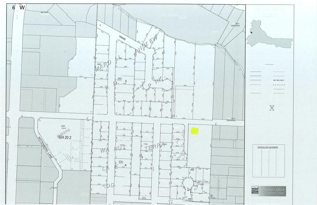
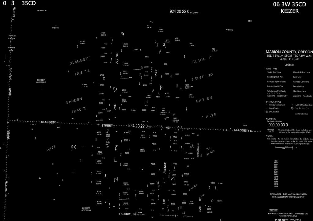

35
KEIZER COMMUNITY DEVELOPMENT DEPARTMENT STAFF RECOMMENDATION Subdivision Case No
 KEIZER COMMUNITY DEVELOPMENT DEPARTMENT STAFF RECOMMENDATION Subdivision Case No. 2014-01 TO: FROM: Cynthia Domas, Keizer Hearings Officer Sam Litke, Senior Planner SUBJECT: Subdivision Case No. 2014-01
KEIZER COMMUNITY DEVELOPMENT DEPARTMENT STAFF RECOMMENDATION Subdivision Case No
 KEIZER COMMUNITY DEVELOPMENT DEPARTMENT STAFF RECOMMENDATION Subdivision Case No. 2014-14 TO: FROM: Cynthia Domas, Keizer Hearings Officer Sam Litke, Senior Planner SUBJECT: Subdivision Case No. 2014-14
KEIZER COMMUNITY DEVELOPMENT DEPARTMENT STAFF RECOMMENDATION Subdivision Case No
 KEIZER COMMUNITY DEVELOPMENT DEPARTMENT STAFF RECOMMENDATION Subdivision Case No. 2014-19 TO: FROM: Cynthia Domas, Keizer Hearings Officer Sam Litke, Senior Planner SUBJECT: Subdivision Case No. 2014-19
NOTICE OF HEARINGS OFFICER DECISION. Subdivision Case No
 August 7, 2015 NOTICE OF HEARINGS OFFICER DECISION Subdivision Case No. You are receiving this Notice of the Hearings Officer s decision because you provided either written or verbal testimony on a proposed
Community Development Department 333 Broadalbin Street SW, P.O. Box 490 Albany, OR 97321
 SUMMARY Community Development Department 333 Broadalbin Street SW, P.O. Box 490 Albany, OR 97321 STAFF REPORT Application for Tentative Partition Plat Review Planning File PA-06-17 Phone: 541-917-7550
SUBDIVISION DESIGN PRINCIPLES AND STANDARDS
 SECTION 15-200 SUBDIVISION DESIGN PRINCIPLES AND STANDARDS 15-201 STREET DESIGN PRINCIPLES 15-201.01 Streets shall generally conform to the collector and major street plan adopted by the Planning Commission
-MENDOCINO COUNTY PLANNING AND BUILDING SERVICES- DIVISION OF LAND REGULATIONS TITLE 17
 ARTICLE VI -- GENERAL REGULATIONS AND PROVISIONS Sec. 17-50. Sec. 17-51 General Plan. Sec. 17-52 Lot and Block Design and Configuration. Sec. 17-53 Lot Access. Sec. 17-54 Private Roads. Sec. 17-55 Water
ARTICLE 23 CONDOMINIUM STANDARDS
 ARTICLE 23 CONDOMINIUM STANDARDS Section 23.01 Intent. The intent of this Article is to provide regulatory standards for condominiums and site condominiums similar to those required for projects developed
ARTICLE VI. SUBDIVISION STANDARDS, PUBLIC
 ARTICLE VI. SUBDIVISION STANDARDS, PUBLIC IMPROVEMENTS, AND DESIGN REQUIREMENTS ARTICLE VI. SUBDIVISION STANDARDS, PUBLIC IMPROVEMENTS, AND DESIGN REQUIREMENTS DIVISION 1. GENERAL PROVISIONS Sec. 21-6100.
Section Preliminary Plat Checklist and Application Forms
 Section 201 - Preliminary Plat Checklist and Application Forms PRELIMINARY SUBDIVISION PLAT REVIEW PROCESS CHART PRELIMINARY SUBDIVISION PLAT APPLICATION PRELIMINARY PLAT REVIEW CHECKLIST CITY OF NAMPA
Chapter Plat Design (LMC)
") Chapter 18.14 Plat Design (LMC) Sections: 18.14.010 Lot width 18.14.020 Right-of-way requirements 18.14.030 Pipe stem lots 18.14.040 Division resulting in minimum lot sizes 18.14.050 Flood prone and bad
Chapter 18.14 Plat Design (LMC) Sections: 18.14.010 Lot width 18.14.020 Right-of-way requirements 18.14.030 Pipe stem lots 18.14.040 Division resulting in minimum lot sizes 18.14.050 Flood prone and bad
610 LAND DIVISIONS AND PROPERTY LINE ADJUSTMENTS OUTSIDE A UGB
 ARTICLE VI: LAND DIVISIONS AND PROPERTY LINE ADJUSTMENTS VI-21 610 LAND DIVISIONS AND PROPERTY LINE ADJUSTMENTS OUTSIDE A UGB 610-1 Property Line Adjustments (Property Line Relocation) A property line
THE COUNTY BOARD OF SUPERVISORS OF THE COUNTY OF DOUGLAS DOES ORDAIN AS FOLLOWS:
 8.1 SUBDIVISION CONTROL ORDINANCE THE COUNTY BOARD OF SUPERVISORS OF THE COUNTY OF DOUGLAS DOES ORDAIN AS FOLLOWS: SECTION I. GENERAL INTERPRETATION This ordinance shall not repeal, impair or modify private
ARTICLE IV: DEVELOPMENT STANDARDS
 ARTICLE IV: DEVELOPMENT STANDARDS IV-53 409 PRIVATE STREETS A private street means any way that provides ingress to, or egress from, property by means of vehicles or other means, or that provides travel
ARTICLE 24 PRIVATE ROAD, SHARED PRIVATE DRIVEWAY AND ACCESS EASEMENT STANDARDS
 ARTICLE 24 PRIVATE ROAD, SHARED PRIVATE DRIVEWAY AND ACCESS EASEMENT STANDARDS SECTION 24.00 INTENT AND PURPOSE The standards of this Article provide for the design, construction and maintenance of private
CITY OF HOBBS ORDINANCE NO..
 CITY OF HOBBS ORDINANCE NO.. AN ORDINANCE TO AMEND TITLE 16 OF THE HOBBS MUNICIPAL CODE IN ITS ENTIRETY. BE IT ORDAINED BY THE GOVERNING BODY OF THE CITY OF HOBBS, NEW MEXICO, that the following Chapter
Condominium Unit Requirements.
 ARTICLE 19 CONDOMINIUM REGULATIONS Section 19.01 Purpose. The purpose of this Article is to regulate projects that divide real property under a contractual arrangement known as a condominium. New and conversion
APPLICATION PROCEDURE
 ANTRIM PLANNING BOARD P. O. Box 517 Antrim, New Hampshire 03440 Phone: 603-588-6785 FAX: 603-588-2969 APPLICATION FORM AND CHECKLIST FOR MINOR OR MAJOR SITE PLAN REVIEW File Date Received By APPLICATION
FREQUENTLY USED PLANNING & ZONING TERMS
 City Of Mustang FREQUENTLY USED PLANNING & ZONING TERMS Abut: Having property lines, street lines, or zoning district lines in common. Accessory Structure: A structure of secondary importance or function
ELK RAPIDS TOWNSHIP ANTRIM COUNTY, MICHIGAN ORDINANCE NO
 ELK RAPIDS TOWNSHIP ANTRIM COUNTY, MICHIGAN ORDINANCE NO. 3-2011 AN ORDINANCE TO REPLACE THE SUBDIVISION CONTROL ORDINANCE WITH A NEW SUBDIVISION DEVELOPMENT ORDINANCE, IN ACCORD WITH THE LAND DIVISION
Sterling Meadow Subdivision
 Sterling Meadow Subdivision Proposal: A pre-application conference was held on November 7, 2017, with the applicant and City staff to discuss the development. The applicant took staff s recommendations
SUBDIVISION APPLICATION CHECKLIST SKETCH PLAN PRELIMINARY PLAT FINAL PLAT
 RECEIVED STAMP SUBDIVISION APPLICATION CHECKLIST SKETCH PLAN PRELIMINARY PLAT FINAL PLAT A checklist of background information and submission requirements for processing of a sketch plan, preliminary plat
SUBDIVISION REGULATIONS
 166.01 Purpose 166.11 Final Plat Attachments 166.02 Definitions 166.12 Action by the Council 166.03 Platting Required 166.13 General Requirements 166.04 Procedure 166.05 Requirements of Preliminary Plat
PRELIMINARY PLATS. The following documents are provided as required by the City of Conroe for use in the above titled platting submittals:
 Public Works Engineering Division CITY OF CONROE PRELIMINARY PLATS The following documents are provided as required by the City of Conroe for use in the above titled platting submittals: Submittal Questionnaire
a. provide for the continuation of collector streets and thoroughfare streets between adjacent subdivisions;
 Section 7.07. Intent The requirements of this Section are intended to provide for the orderly growth of the Town of Holly Springs and its extra-territorial jurisdiction by establishing guidelines for:
The following information is for use by the Lincoln County Planning Board at their meeting/public hearing on February 3, 2014.
 LINCOLN COUNTY PLANNING & INSPECTIONS DEPARTMENT 302 NORTH ACADEMY STREET, SUITE A, LINCOLNTON, NORTH CAROLINA 28092 704-736-8440 OFFICE 704-736-8434 INSPECTION REQUEST LINE 704-732-9010 FAX To: Planning
BEFORE THE JOSEPHINE BOARD OF COUNTY COMMISSIONERS OF THE STATE OF OREGON
 THURSDAY, OCTOBER 23, 1958 BEFORE THE JOSEPHINE BOARD OF COUNTY COMMISSIONERS OF THE STATE OF OREGON IN THE MATTER OF THE ADOPTION OF } REGULATIONS FOR SUBDIVIDING LAND } IN JOSEPHINE COUNTY, OREGON, OUTSIDE
TOWN OF LEWISTON PLANNING BOARD APPLICATION
 TOWN OF LEWISTON PLANNING BOARD APPLICATION DESCRIPTION OF PROPOSED REQUEST: Name of Property Owner: Phone #: Name of Applicant:Phone #: Address or Location of Proposal:_SBL# Size of Parcel or Structure:Existing
JUSTIFICATION STATEMENT Minor Subdivision - Plat Raymond F. Kravis Center for the Performing Arts, Inc. Initial Submittal: September 11, 2018
 JUSTIFICATION STATEMENT Minor Subdivision - Plat Raymond F. Kravis Center for the Performing Arts, Inc. Initial Submittal: September 11, 2018 REQUEST On behalf of the Applicant, WGI is requesting a Minor
ARTICLE 13 CONDOMINIUM REGULATIONS
 ARTICLE 13 CONDOMINIUM REGULATIONS Section 13.01 Purpose. The purpose of this Article is to regulate projects that divide real property under a contractual arrangement known as a condominium. New and conversion
SECTION 4: PRELIMINARY PLAT
 SECTION 4: PRELIMINARY PLAT After the completion of the sketch plan process, if submitted, the owner or developer shall file with the City an application for preliminary plat. The preliminary plat stage
Module No. 2 February 14, 2018 Page 1
 Chapter 35 UNIFIED DEVELOPMENT ORDINANCE (UDO)... 3 Article 35-5. GENERAL SUBDIVISION DESIGN STANDARDS... 3 Division V.1. GENERAL LOT AND SUBDIVISION STANDARDS... 3 Sec. 35-510-1, Policies, Purpose, and
CHAPTER 5. Subdivisions Regulations
 CHAPTER 5 Subdivisions Regulations 10-5-1 Introduction and Purpose 10-5-2 Definitions 10-5-3 General Provisions 10-5-4 Procedure for Submitting Subdivisions 10-5-5 Design Standards; Streets and Lots 10-5-6
Chapter 22 LAND USE* Article III. Subdivisions
 Chapter 22 LAND USE* Article III. Subdivisions Sec. 22-256. Authority to Regulate. Sec. 22-257. Scope; plat required. Sec. 22-258. Definitions. Sec. 22-259. Interpretations and Meanings. Sec. 22-260. Procedure
City of Talent Subdivision Code
 City of Talent Subdivision Code General Ordinances, Title 8, Chapter 2 Adopted by Ordinance No. 692 on 3 October 2001 Amended by Ordinance No. 912 on 17 February 2016 Article Sec. Description Page Article
BRIDGETON SUBDIVISION APPLICATION CHECKLIST
 APPLICATION NAME AND # CHECKLIST COMPLETED BY: DATE: Signature and printed name BRIDGETON SUBDIVISION APPLICATION CHECKLIST TO SUBDIVISION APPLICANTS: The attached checklist is to assist you in the submission
Draft Model Access Management Overlay Ordinance
 Draft Model Access Management Overlay Ordinance This model was developed using the City of Hutchinson and the Trunk Highway 7 corridor. The basic provisions of this model may be adopted by any jurisdiction
ARTICLE 5. SUBDIVISION STANDARDS
 ARTICLE 5. SUBDIVISION STANDARDS 5.1. General 5.1.1. Applicability The requirements of this article shall apply to all development required to submit site plans or plats, unless expressly exempted by the
E L M E R B O R O U G H L A N D U S E B O A R D APPLICATION COVER SHEET (to be completed for all applications and appeals)
") E L M E R B O R O U G H L A N D U S E B O A R D APPLICATION COVER SHEET (to be completed for all applications and appeals) 1. Name(s): 2. Address: 3. Telephone Number(s): 4. E-mail: 5. Owner Name(s) (if
E L M E R B O R O U G H L A N D U S E B O A R D APPLICATION COVER SHEET (to be completed for all applications and appeals) 1. Name(s): 2. Address: 3. Telephone Number(s): 4. E-mail: 5. Owner Name(s) (if
NOTICE OF DECISION CITY OF CASCADE LOCKS PLANNING COMMISSION SUB 04-04
 NOTICE OF DECISION CITY OF CASCADE LOCKS PLANNING COMMISSION SUB 04-04 The City of Cascade Locks Planning Commission held a public hearing on June 10, 2004 to consider the application. The Commission s
ORDINANCE NO. Be it ordained by the City Council of the City of Abilene, Texas:
 ORDINANCE NO. An ordinance repealing Chapter 23, Subpart B of the Code of the City of Abilene, Texas, entitled Mobile Homes and Vacation Travel Trailers; stating the authority; setting forth the scope
APPLICATION SUBMITTAL REQUIREMENTS FOR Tentative Parcel or Subdivision Maps
 CITY OF EL CERRITO Community Development Department Planning and Building Division 10890 San Pablo Avenue, El Cerrito, CA 94530 (510) 215-4330 FA (510) 233-5401 planning@ci.el-cerrito.ca.us APPLICATION
PLANNED UNIT DEVELOPMENT & SUBDIVISION STAFF REPORT Date: November 17, 2016
 PLANNED UNIT DEVELOPMENT & SUBDIVISION STAFF REPORT Date: November 17, 2016 DEVELOPMENT NAME SUBDIVISION NAME LOCATION Autonation Ford of Mobile Autonation Ford of Mobile Subdivision 901, 909, and 925
DAUPHIN CREEK ESTATES SUBDIVISION
 # 12 SUB-000076-2017 DAUPHIN CREEK ESTATES SUBDIVISION Engineering Comments: FINAL PLAT COMMENTS (should be addressed prior to submitting the FINAL PLAT for review and/or signature by the City Engineer):
BEFORE THE CITY COUNCIL FOR THE CITY OF ASHLAND STATE OF OREGON
 BEFORE THE CITY COUNCIL FOR THE CITY OF ASHLAND STATE OF OREGON IN THE MATTER OF APPLICATIONS FOR ) A 7-LOT SUBDIVISION, PRELIMINARY PLAT, ) CONDITIONAL USE PERMIT FOR AN ) ACCESSORY RESIDENTIAL UNIT,
ARTICLE 15 - PLANNED UNIT DEVELOPMENT
 Section 15.1 - Intent. ARTICLE 15 - PLANNED UNIT DEVELOPMENT A PUD, or Planned Unit Development, is not a District per se, but rather a set of standards that may be applied to a development type. The Planned
CHAPTER 25 REVIEW AND APPROVAL OF SITE CONDOMINIUM AND CONDOMINIUM PROJECTS
 CHAPTER 25 REVIEW AND APPROVAL OF SITE CONDOMINIUM AND CONDOMINIUM PROJECTS Section 25.1. Purpose and Scope. 1. Tracts of land that are developed and sold as site condominium developments and condominium
FINAL PLAT APPLICATION
 FINAL PLAT APPLICATION (Page 1 of 3) LEGAL OWNER(s): NAME: STREET ADDRESS OWNER(s): CITY, STATE, ZIP CODE: PHONE NUMBER: BILLING ADDRESS: NAME OF ENGINEER/SURVEYOR: Engineer/Surveyor Address, Phone: PROPERTY
ARTICLE 15. RULES, REGULATIONS AND DEFINITIONS
 ARTICLE 15. RULES, REGULATIONS AND DEFINITIONS Section 1. Interpretation and Construction: The following rules and regulations regarding interpretation and construction of the Ulysses-Grant County, Kansas,
SUBDIVISION REGULATIONS. 1. SHORT TITLE. This chapter shall be known and may be cited as "The City of Graf, Iowa, Subdivision Control Ordinance.
 GENERAL PROVISIONS SUBDIVISION REGULATIONS 1. SHORT TITLE. This chapter shall be known and may be cited as "The City of Graf, Iowa, Subdivision Control Ordinance." 2. PURPOSE. The purpose of this Ordinance
MAJOR SUBDIVISION PRELIMINARY PLAT CHECKLIST
 TOWNSHIP OF EGG HARBOR PLANNING BOARD/ZONING BOARD OF ADJUSTMENT 3515 BARGAINTOWN ROAD EGG HARBOR TOWNSHIP, NJ 08234 MAJOR SUBDIVISION PRELIMINARY PLAT CHECKLIST The following checklist is designed to
CONDOMINIUM REGULATIONS
 ARTICLE 37 CONDOMINIUM REGULATIONS SECTION 37.01. Purpose The purpose of this Article is to regulate projects that divide real property under a contractual arrangement known as a condominium. New and conversion
UPPER MOUNT BETHEL TOWNSHIP NORTHAMPTON COUNTY, PENNSYLVANIA
 UPPER MOUNT BETHEL TOWNSHIP NORTHAMPTON COUNTY, PENNSYLVANIA JOINDER DEED / LOT CONSOLIDATION TOWNSHIP REVIEW PROCESS When accepting proposed Joinder Deeds / Lot Consolidations, review the Joinder Deed
Chapter 100 Planned Unit Development in Corvallis Urban Fringe
 100.100 Scope and Purpose. Chapter 100 Planned Unit Development in Corvallis Urban Fringe (1) All applications for land divisions in the Urban Residential (UR) and Flood Plain Agriculture (FPA) zones within
Article 10. Project Design and Construction Standards. Table of Contents DIVISION I. PROJECT DESIGN page
 Article 10. Project Design and Construction Standards Table of Contents page Sec. 1001. Purpose of Article 10.... 10-1 Sec. 1002. Standards incorporated by reference.... 10-1 Sec. 1002.01. Standard design
SECTION 11 PLANNING & ZONING. SUBDIVISION CONTROL Ord. No. 176 Adopted: December 10, 1969
 SUBDIVISION CONTROL Ord. No. 176 Adopted: December 10, 1969 An ordinance enacted under Act 288, Public Acts of 1967, as amended, of the State of Michigan establishing regulations governing the subdivision
Residential Major Subdivision Review Checklist
 Residential Major Subdivision Review Checklist Plan Submittal Requirements: 2 full sets of stamped plans Electric submittal - all plans contained in a single PDF 3 full sets if commercial kitchen or dining
FINAL DRAFT 12/1/16, Rev. to 7/18/17
 FINAL DRAFT 12/1/16, Rev. to 7/18/17 (As Adopted 8/8/17 Effective 9/1/17) SHELTON PLANNING AND ZONING COMMISSION Proposed Amendments to Zoning Regulations I. Amend Section 23 PERMITTED USES by inserting
PRELIMINARY SUBDIVISION AND LAND DEVELOPMENT PLAN CHECKLIST. Applicant's Name:
 TOWNSHIP OF UPPER ST. CLAIR PRELIMINARY SUBDIVISION AND LAND DEVELOPMENT PLAN CHECKLIST Date Filed Plan Name: Applicant's Name: PLC# Phone = OK 0 = Missing; X = Not OK; NA = Not Applicable;? To be Determined;
CHAPTER 23 SUBDIVISIONS. Article 1. General Provisions. Article 2. Administration. Division 1. General Provisions.
 CHAPTER 23 SUBDIVISIONS Article 1. General Provisions. Section 23-1. Section 23-2. Section 23-3. Section 23-4. Section 23-5. Title. Scope of chapter. Definitions. Penalty. Appeals. Article 2. Administration.
STAFF REPORT Administrative Subdivision Hearing West 150 South Street, Parcel # , and
 Petition Number: 490-06-24 STAFF REPORT Administrative Subdivision Hearing Project Name: Project Location: Project Type: Applicant: Planning Staff: Haight Industrial Subdivision 5550 West 150 South Street,
c) Stub streets shall be required as follows:
 Stub streets shall be required as follows:") Sec. 7.2.1 / Streets 7.2 DESIGN STANDARDS 7.2.1 Streets A) Interconnectivity 1) Conformity with Apex Transportation Plan. The subdivision s street system shall conform to the Apex Transportation Plan.
Sec. 7.2.1 / Streets 7.2 DESIGN STANDARDS 7.2.1 Streets A) Interconnectivity 1) Conformity with Apex Transportation Plan. The subdivision s street system shall conform to the Apex Transportation Plan.
WASCO COUNTY PRELIMINARY SUBDIVISION APPLICATION
 WASCO COUNTY PRELIMINARY SUBDIVISION APPLICATION DETAILED SPECIFIC WRITTEN REQUEST File Number: SDV- Number of Proposed Lots & their Dimensions: PRELIMINARY SUBDIVISION PLAN REQUIREMENTS The approval of
ARTICLE V PRELIMINARY PLAN SUBMISSION
 ARTICLE V PRELIMINARY PLAN SUBMISSION 501. Plan Requirements a. On or before the 25 th day of the month prior to a regularly scheduled meeting of the Planning Commission, the applicant shall submit two
M-43 CORRIDOR OVERLAY ZONE
 ARTICLE 26.00 M-43 CORRIDOR OVERLAY ZONE Section 26.01 Findings A primary function of the M-43 state highway is to move traffic through the Township and to points beyond. As the primary east-west arterial
CITY OF STURGIS Title 19-1 TITLE 19 SUBDIVISION OF LAND
 CITY OF STURGIS Title 19-1 TITLE 19 SUBDIVISION OF LAND BE IT ORDAINED by the Common Council of the City of Sturgis, Meade County, South Dakota, that the current Title 19 shall be replaced in its entirety
Initial Subdivision Applications Shall Include the Following:
 Initial Subdivision Applications Shall Include the Following: 1) Subdivision Application Form: completely filled out (12 copies) 2) Plat: The Plat must adhere to the requirements set forth in the Town
ARTICLE 9 SPECIFICATIONS FOR DOCUMENTS TO BE SUBMITTED
 ARTICLE 9 SPECIFICATIONS FOR DOCUMENTS TO BE SUBMITTED SECTION 950 GENERALLY All applications shall be properly signed and filed by the owner or, with the owner s specific written consent, a contract purchaser
ARTICLE 6 PRELIMINARY PLAT
 ARTICLE 6 PRELIMINARY PLAT SECTION: 30-06-01: Preliminary Plat 30-06-02: Information Required for Preliminary Plat 30-06-03: Determination of Requirement for Environmental Review Documents 30-06-04: Additional
PUBLIC WORKS - COMMUNITY DEVELOPMENT. Staff Report. Land Division (Tentative Partition Plat) PA October 23, 2018
 PA October 23, 2018") PUBLIC WORKS - COMMUNITY DEVELOPMENT 333 Broadalbin Street SW, PO Box 490, Albany, Oregon 97321-0144 BUILDING 541-917-7553 PLANNING 541-917-7550 Staff Report Land Division (Tentative Partition Plat) PA-08-18
PUBLIC WORKS - COMMUNITY DEVELOPMENT 333 Broadalbin Street SW, PO Box 490, Albany, Oregon 97321-0144 BUILDING 541-917-7553 PLANNING 541-917-7550 Staff Report Land Division (Tentative Partition Plat) PA-08-18
Residential Minor Subdivision Review Checklist
 Residential Minor Subdivision Review Checklist Plan Submittal Requirements: 2 full sets of stamped plans Electric submittal - all plans contained in a single PDF 3 full sets if commercial kitchen or dining
ARTICLE 900 PLAT AND PLAN REQUIREMENTS
 ARTICLE 900 PLAT AND PLAN REQUIREMENTS SEC. 900.1 ITEMS TO BE SHOWN ON PLAT OR PLAN General (1) Property lines of all property owners adjacent to the exterior boundaries of the project shall be located
COMMERCIAL SITE PLAN & CONDITIONAL USE PERMIT REVIEW PROCESS & CHECKLIST
 Community Development 110 South Main Street Springville, UT 84663 COMMERCIAL SITE PLAN & CONDITIONAL USE PERMIT REVIEW PROCESS & CHECKLIST 801.491.7861 www.springville.org Prior to the issuance of a building
CITY OF EAU CLAIRE, WISCONSIN. SPECIAL ASSESSMENT POLICY (Dated: November 8, 2016)
") CITY OF EAU CLAIRE, WISCONSIN SPECIAL ASSESSMENT POLICY (Dated: November 8, 2016) (Adopted by reference by Ordinance No. 7207 adopted November 8, 2016) PURPOSE The purpose of this Policy is to assure fair
CITY OF EAU CLAIRE, WISCONSIN SPECIAL ASSESSMENT POLICY (Dated: November 8, 2016) (Adopted by reference by Ordinance No. 7207 adopted November 8, 2016) PURPOSE The purpose of this Policy is to assure fair
Memorandum: October 13, 2008 REVISED To: Trowbridge Township Planning Commission From: P. Hudson, AICP Re: Suggested New Ordinance
 1 Memorandum: October 13, 2008 REVISED 2-11-09 To: Trowbridge Township Planning Commission From: P. Hudson, AICP Re: Suggested New Ordinance Because of changes in both the Michigan Planning Enabling Act
Organized with a "core" curriculum (the first five modules) and "electives" (the remaining modules in the program.
 and electives (the remaining modules in the program.") Introduction Sponsored by The North Carolina Chapter - American Planning Association These materials are the result of an effort by volunteer members of the North Carolina Chapter of the American Planning
Introduction Sponsored by The North Carolina Chapter - American Planning Association These materials are the result of an effort by volunteer members of the North Carolina Chapter of the American Planning
PRELIMINARY PLAT CHECK LIST
 PRELIMINARY PLAT CHECK LIST Name of Proposed Subdivision: The following items must be included with the initial submittal of a Preliminary Plat: Application, filled out completely Project Narrative Pre-application
I. Requirements for All Applications. C D W
 108-16.1. Application checklists. Checklist for Required Submissions to the Planning Board or Zoning Board of Adjustment of Monroe Township All required submissions are to be made to the Administrative
Group Sewer Only** 80 Ft Frontage* 20,000 Sq. Ft. (.46 acre) Minimum** 120 Ft Frontage* 20,000 Sq. Ft. (.46acre) Minimum** 150 Ft Frontage*
 Minimum** 120 Ft Frontage* 20,000 Sq. Ft. (.46acre) Minimum** 150 Ft Frontage*") Residential Lots Minimum Chart The minimum lot size of any minor subdivision where there is no public sewers shall be as shown below or as required by township zoning and/or the Tuscarawas General Health
Residential Lots Minimum Chart The minimum lot size of any minor subdivision where there is no public sewers shall be as shown below or as required by township zoning and/or the Tuscarawas General Health
ARTICLE 16 SUBDIVISIONS
 ARTICLE 16 SUBDIVISIONS 16.1 Subdivision Regulations 16.1-1. Purpose. The regulations for the subdivision of land set forth below are established to promote orderly growth and development; provide for
CHAPTER 91. SUBDIVISIONS, PARTITIONS, and PROPERTY LINE ADJUSTMENTS (Short Title; Definitions)
") CHAPTER 91 SUBDIVISIONS, PARTITIONS, and PROPERTY LINE ADJUSTMENTS (Short Title; Definitions) 91.110. Short Title 91.120. Purpose 91.150 Definitions 91.200 Procedures for Subdivisions and Partitions 91.210
CHAPTER 91 SUBDIVISIONS, PARTITIONS, and PROPERTY LINE ADJUSTMENTS (Short Title; Definitions) 91.110. Short Title 91.120. Purpose 91.150 Definitions 91.200 Procedures for Subdivisions and Partitions 91.210
BYRON TOWNSHIP ZONING APPLICATION
 BYRON TOWNSHIP ZONING APPLICATION Phone: (616) 878-9104 * Fax: (616) 878-3980 * Website: www.byrontownship.org This application will not be accepted if incomplete. APPLICATION FOR & REQUIRED COPIES Private
Courtyards at Kinnamon Park Sketch Plan
 Courtyards at Kinnamon Park Sketch Plan Courtyards at Kinnamon Park Sketch Plan Staff Analysis PART 1: PROJECT SUMMARY Applicant: EPCON Communities Property Owner: Johnsie M. Kinnamon Heirs, Douglas and
Article 10. Project Design Standards. Table of Contents. page
 Article 10. Project Design Standards Table of Contents page Sec. 1001 Purpose of Article 10...10-1 Sec. 1002 Standards incorporated by reference....10-1 1002 (a) Standard Design Specifications....10-1
Medical Marijuana Special Exception Use Information
 Medical Marijuana Special Exception Use Information The Special Exception Use information below is a modified version of the Unified Development Code. It clarifies the current section 5:104 Special Exceptions
(a) Commercial uses on Laurel Avenue, abutting the TRO District to the
 Commercial uses on Laurel Avenue, abutting the TRO District to the") 32X Zoning Code 150.36 TRANSITIONAL RESIDENTIAL OVERLAY DISTRICT. (A) Intent and purpose. (1) It is the intent of the Transitional Residential Overlay District (hereinafter referred to as the "TRO District")
32X Zoning Code 150.36 TRANSITIONAL RESIDENTIAL OVERLAY DISTRICT. (A) Intent and purpose. (1) It is the intent of the Transitional Residential Overlay District (hereinafter referred to as the "TRO District")
BEAR CREEK TOWNSHIP EMMET COUNTY, MICHIGAN. PRIVATE ROAD ORDINANCE Ordinance No. 11A-99. (to replace prior Private Road Ordinance No.
 BEAR CREEK TOWNSHIP EMMET COUNTY, MICHIGAN PRIVATE ROAD ORDINANCE Ordinance No. 11A-99 (to replace prior Private Road Ordinance No. 11-99) An Ordinance to protect the health, safety, and general welfare
SUBMITTAL REQUIREMENTS
 PRELIMINARY PLAT APPLICATION ***A PRE-APPLICATION MEETING WITH CITY STAFF IS REQUIRED FOR THIS APPLICATION*** DATE STAMP FOR CITY USE ONLY PROJECT NAME (if any): TO BE FILLED OUT BY APPLICANT PROJECT STREET
ARTICLE 3 DEFINITIONS
 Sections: 3-1 Rules of Construction 3-2 Definitions ARTICLE 3 DEFINITIONS SECTION 3-1 RULES OF CONSTRUCTION 3-101. a. The language set forth in these regulations shall be interpreted in accordance with
MONTGOMERY COUNTY PLANNING DEPARTMENT THE MARYLAND-NATIONAL CAPITAL PARK AND PLANNING COMMISSION
 MONTGOMERY COUNTY PLANNING DEPARTMENT THE MARYLAND-NATIONAL CAPITAL PARK AND PLANNING COMMISSION MCPB Item No. 8 Date: 03-07-13 Sonoma, Preliminary Plan, 120130040 Melissa Williams, Senior Planner, Melissa.williams@montgomeryplanning.org,
Chapter Planned Residential Development Overlay
 Chapter 19.29 Planned Residential Development Overlay Sections 010 Purpose 020 Scope 030 Definitions 030 Minimum Size 040 Allowable Uses 050 Minimum Development Standards 060 Density Bonus 070 Open Space
SUBDIVISION REGULATIONS
 CHAPTER 41 SUBDIVISION REGULATIONS 41.01 Short Title 41.17 Presentation to Commission or Board of Supervisors 41.02 Purpose 41.18 Subdivision Classified 41.03 Application 41.19 Plats Required 41.04 Recording
SUBDIVISION PROCEDURES AND REGULATIONS. for the Town of Stratford, New Hampshire
 SUBDIVISION PROCEDURES AND REGULATIONS for the Town of Stratford, New Hampshire TABLE OF CONTENTS Page A. PRE-APPLICATION 2 B. PRELIMINARY PLAN REQUIREMENTS 3 C. PRELIMINARY PLAN REVIEW 5 Site Plan Review
CHAPTER 14: DRIVEWAYS, TOWN HIGHWAYS, AND PRIVATE ROADS
 CHAPTER 14: DRIVEWAYS, TOWN HIGHWAYS, AND PRIVATE ROADS TABLE OF CONTENTS CHAPTER 14: PRIVATE DRIVEWAYS, TOWN HIGHWAYS AND PRIVATE ROADS 14-1 14.0100 AUTHORITY... 14-1 14.0200 TITLE... 14-1 14.0300 REGULATION
CHAPTER SUBDIVISION MAPS
 CHAPTER 19.66 SUBDIVISION MAPS SUBDIVISION MAPS 19.66 Section Page 19.66.010 Purpose... IV-56 19.66.020 Application... IV-57 19.66.030 Exclusions... IV-57 19.66.040 Effect of Annexation... IV-57 19.66.050
SUBDIVISION STANDARDS BEDFORD COUNTY, TENNESSEE. Certified by the Bedford County Regional Planning Commission. November 20, 1997.
 SUBDIVISION STANDARDS OF BEDFORD COUNTY, TENNESSEE Certified by the Bedford County Regional Planning Commission November 20, 1997 Effective Date November 24, 1997 Page 1 of 39 TABLE OF CONTENTS ARTICLE
Preliminary Subdivision Application (Major) (Four (4) lots or more)
 (Four (4) lots or more)") Gunnison City Offices www.gunnisoncity.org 38 West Center Gunnison, Utah 84634 (435) 528 7969 Date of Application: Preliminary Subdivision Application (Major) (Four (4) lots or more) APPLICANT INFORMATION
Gunnison City Offices www.gunnisoncity.org 38 West Center Gunnison, Utah 84634 (435) 528 7969 Date of Application: Preliminary Subdivision Application (Major) (Four (4) lots or more) APPLICANT INFORMATION
ZONING AMENDMENT, PLANNED UNIT DEVELOPMENT & SUBDIVISION STAFF REPORT Date: August 8, 2013
 ZONING AMENDMENT, PLANNED UNIT DEVELOPMENT & SUBDIVISION STAFF REPORT Date: August 8, 2013 NAME SUBDIVISION NAME PV-Magnolia, LLC Twelve Trees Subdivision LOCATION 2860, 2862 and 2866 Pleasant Valley Road
Article 10. Project Design and Construction Standards
 Article 10. Project Design and Construction Standards Effective January 1, 2009, as Amended through March 2, 2010 Table of Contents page Sec. 1001. Standards incorporated by reference.... 10-1 (a) Standard
ARTICLE 55.0 CONDOMINIUM REGULATIONS
 Section 55.01 ARTICLE 55.0 CONDOMINIUM REGULATIONS Purpose. The purpose of this Article is to regulate projects that involve the property arrangement of interests in real property known as a condominium,