ANNEXATION IMPACT REPORT
|
|
|
- Franklin Small
- 5 years ago
- Views:
Transcription

1 ANNEXATION IMPACT REPORT Project: RED MOUNTAIN RANCH ANNEXATION Hwy 6 (unincorporated Eagle County) Eagle, CO Prepared By: Town of Eagle Morgan Landers, Town Planner 200 Broadway St Eagle, CO Date: March 16, 2018
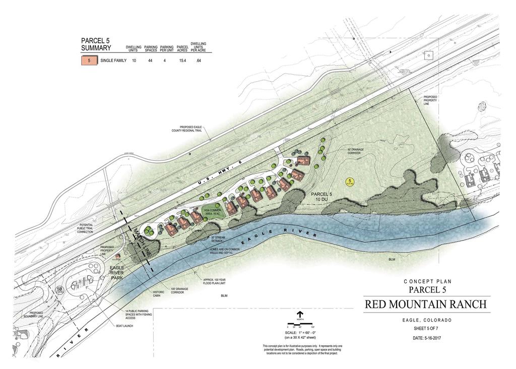
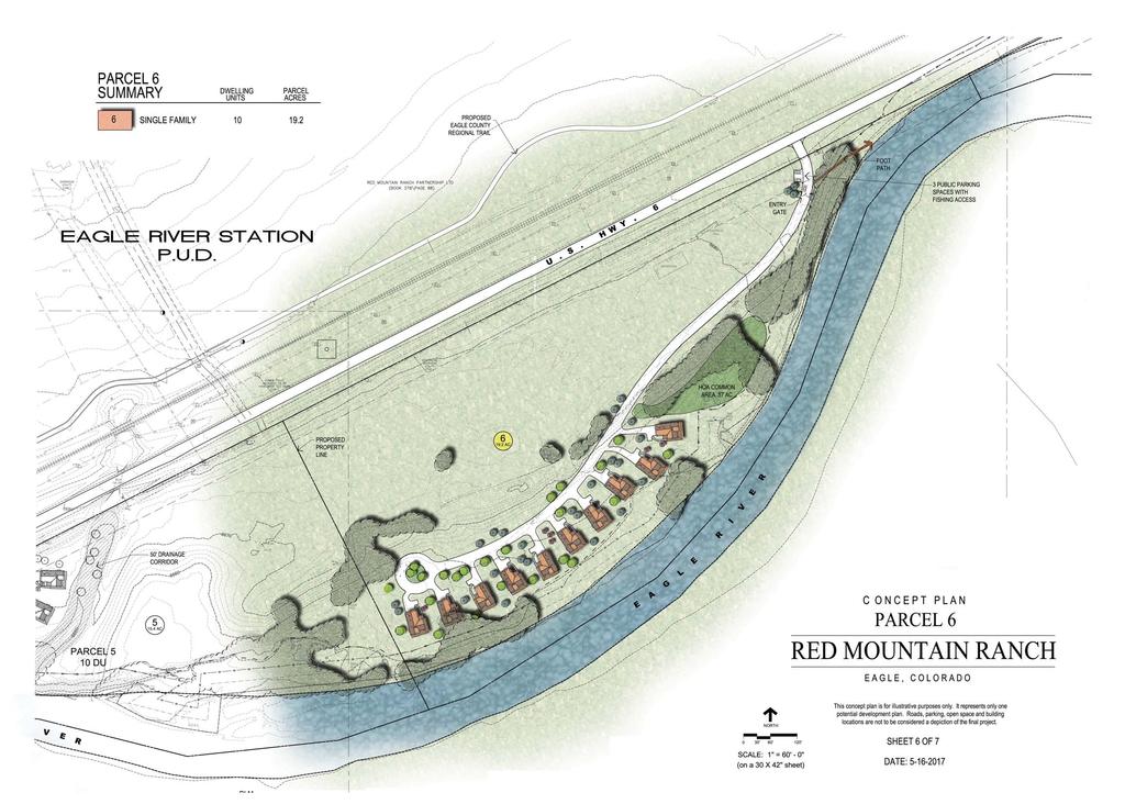
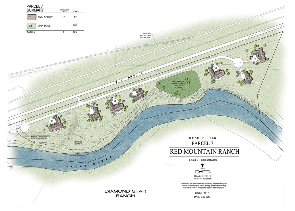
2 Page 2 Table of Contents 1.0 Applicant and Location Overview Annexation Eligibility Requirements Limitation of Annexation Impact Report Requirements..5 Attachments RMR Property Aerial Photo RMR Annexation Map RMR Development Concept Plans RMR Annexation Noticing Agencies PO Box Broadway Eagle, CO info@townofeagle.org
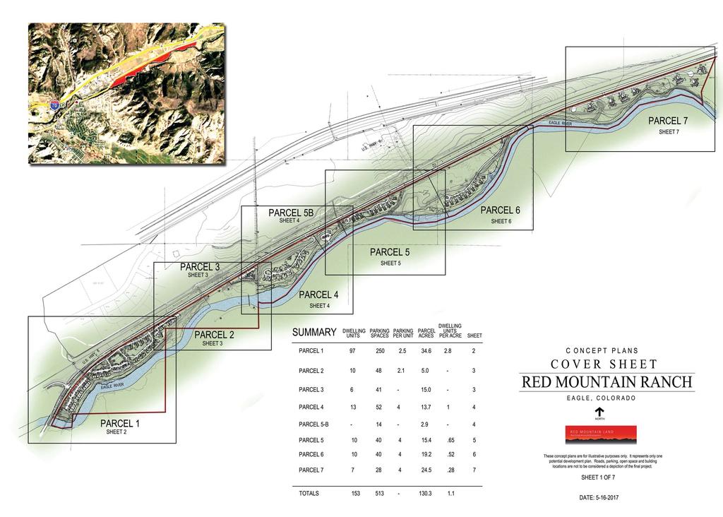
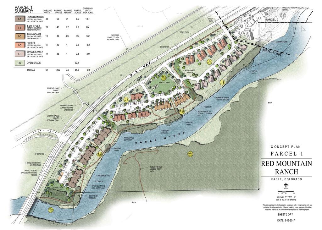
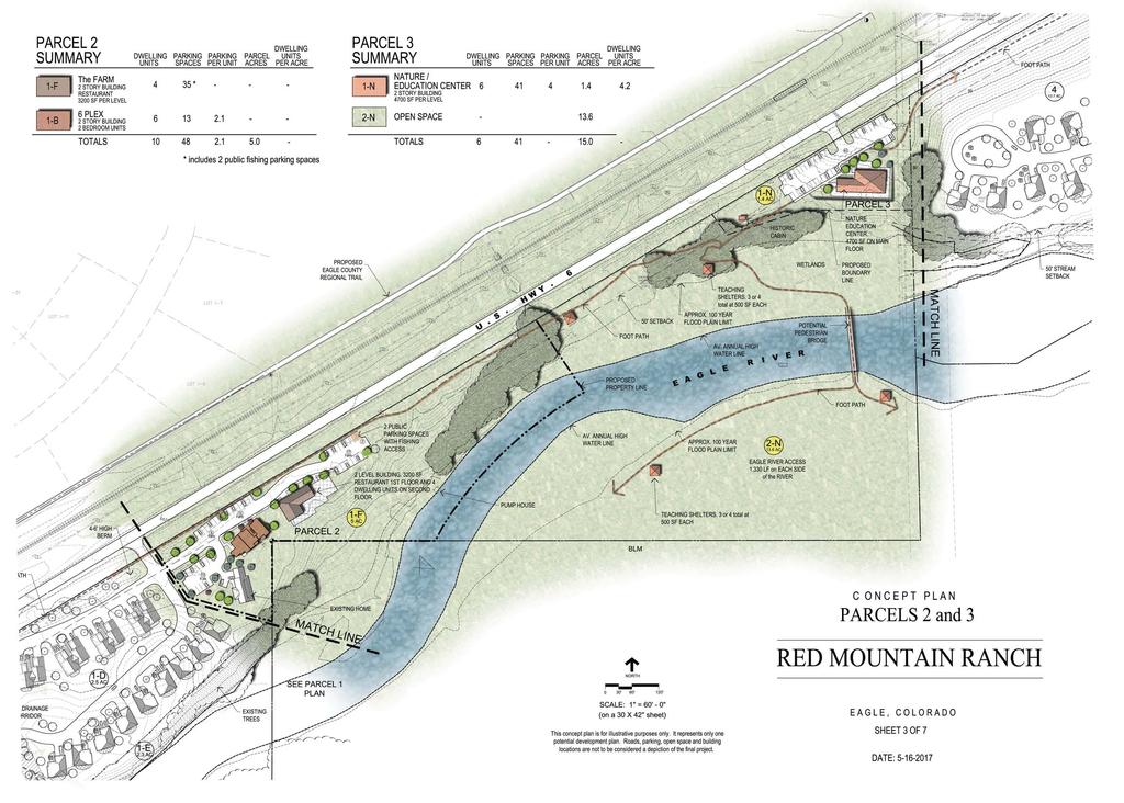
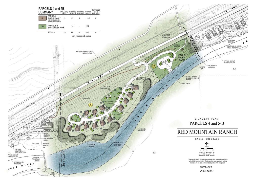
3 Page APPLICANT AND LOCATION Applicant(s): Merv Lapin Revocable Trust Red Mountain Ranch LLLP Project: Red Mountain Ranch Annexation Location: Highway 6, Eagle, CO Town of Eagle File References: AN17-01 and PUD18-01 Red Mountain Ranch LLLP and the Merv Lapin Revocable Trust request that the full acre tract of land on the attached Annexation Map be annexed into the Town of Eagle. 2.0 OVERVIEW The proposed Red Mountain Ranch Annexation is located along Highway 6 east of the Town of Eagle boundaries. The project area includes acres in Section 4, Township 5 South, and Range 84 West of the 6 th prime meridian and is owned by two separate ownerships as listed above. The project area consists of eight (8) parcels of varying sizes. The proposed annexation does not include the annexation of any Highway 6 right-of-way. Of the 130 acres, all property is located south of Highway 6 and north of the Eagle River beginning just east of the former Green Bridge on Hwy 6 to the Diamond S Ranch. The property is currently use for a variety of purposes. Much of the property is in agricultural use and serves grazing purposes for limited cattle herds. The property also includes two single-family homes and easement agreements for three public fishing access points along the property are in place. The property has four access points from Highway 6 with gravel driveway improvements. There are some wetlands and other environmentally sensitive areas that have been identified. The proposed Red Mountain Ranch development, proposed as a Planned Unit Development, includes 153 units of varying densities throughout the project. The highest densities are proposed on the western end of the property. Conservation and preservation areas have been identified. Proposed densities and preservation areas are shown in the attached Concept Plan attached to this report. 3.0 ANNEXATION ELIGIBILITY REQUIREMENTS As set forth in , C.R.S., below is information addressing the Annexation Eligibility Requirements for the Red Mountain Ranch Annexation proposal: A. Not less than one sixth of th e perimeter of the areas proposed to be annexed is contiguous with the Town of Eagle. More than one-sixth of the perimeter of the area proposed to be annexed is contiguous per the attached Annexation Map. PO Box Broadway Eagle, CO info@townofeagle.org
4 Page 4 B. A community of interest exists between the area proposed to be annexed and the Town of Eagle. The property will include a variety of housing types, environmental preservation areas, and active recreation areas serving the Town of Eagle residents and visitors as outlined in the Eagle Area Community Plan (adopted 2010), the Eagle River Corridor Plan (adopted 2015), and the Town of Eagle Strategic Plan (adopted 2017). C. The site is urban or will be urban in the near future. The Eagle Area Community Plan identifies an Urban Growth Boundary for the Town of Eagle. The majority of the proposed annexation is within the previously designated Urban Growth Boundary. D. The site is integrated or is capable of being integrated with the Town of Eagle. The project area is capable of being integrated with the Town of Eagle. The proposed project is adjacent to the Eagle Villas apartments and the Eagle Lofts condominium units. There is a public park on Nogal Rd and the proposed project has onsite park amenities proposed for residents. Eagle County just completed phase 1 construction of the Eagle Valley Trail multiuse bike path from the Nogal Rd bike path east toward Horn Ranch at the entrance to the red canyon between the Town of Eagle and Wolcott. The Eagle Valley Trail connects the eastern end of the town of Eagle west to the town of Gypsum and provides safe passage of pedestrians and cyclists from the project area to a variety of commercial and recreational opportunities. The Eagle County Transit Authority operates bus service between the Town of Eagle and the down-valley and up-valley communities. There is a park-n-ride facility at Chambers Ave and Eby Creek Rd less than one mile from the western end of the proposed project. In the future, changes to the bus system and additional stop locations will assist in the integration of the project. PO Box Broadway Eagle, CO info@townofeagle.org
5 Page LIMITATION OF ANNEXATION As set forth in C.R.S., below are responses to the Limitation of Annexation: A. In establishing the boundaries of the territory to be annexed, no land held in identical ownership, whether consisting of one tract of parcel of real estate or two or more contiguous tracts or parcels of real estate, has been divided into separate parts or parcels without the written consent of the landowners. Existing right of way and property lines are being used as boundaries for annexation and all parties have provided written consent. B. In establishing the boundaries of the areas proposed to be annexed, no land held in identical ownership, whether consisting of one tract or parcel of real estate or two or more contiguous tracts or parcels of real estate, comprising twenty acres or more (which, together with the buildings and improvements situated thereon has a valuation for assessment in excess of two hundred thousand dollars for ad valorem tax purposes for the year next preceding the annexation) has been included without written consent of the landowners. All land included with the annexation boundary is included with the written consent of the landowners. C. That no annexation proceedings have been commenced for the annexation of part or all of the subject property to another municipality. The site has not been petitioned for annexation to another municipality. D. If a portion of a platted street or alley is to annex, the entire width of said street or alley is included within the area proposed to be annexed. The annexation proposal does not include any platted street or alley. 4.0 REQUIREMENTS OF THE IMPACT REPORT As set forth in C.R.S., below are the responses to the Annexation Impact Report Requirements: (a) A map or maps of the municipality and adjacent territory to show the following information: (I) The present and proposed boundaries of the municipality in the vicinity of the proposed annexation; Refer to Annexation Map attached to this report. (II) The present streets, major trunk water mains, sewer interceptors and outfalls, other utility lines and ditches, and the proposed extension of such streets and utility lines in the vicinity of the proposed annexation; and PO Box Broadway Eagle, CO info@townofeagle.org
6 Page 6 Refer to the RMR Concept Plans attached to this report. (III) The existing and proposed land use pattern in the areas to be annexed; The property is currently in unincorporated Eagle County and is zoned Resource. The proposed land uses are outlined in the RMR Concept Plans attached to this report. (b) A copy of any draft or final preannexation agreement, if available; A Annexation and Development Agreement will be negotiated through the land use review and approval process. (c) A statement setting forth the plans of the municipality for extending to or otherwise providing for, within the area to be annexed, municipal services performed by or on behalf of the municipality at the time of annexation; Municipal services are within the vicinity of the project on the western boundary of the proposed annexation. Extension of municipal services will be addressed in the Annexation and Development Agreement negotiated and executed at the time of annexation between the town and the petitioners. (d) A statement setting forth the method under which the municipality plans to finance the extension of the municipal services into the area to be annexed; Extension of water and sewer service to the property will be at the expense of the petitioners. (e) A statement identifying existing districts within the area to be annexed; and Refer to the Annexation Referral Contact List attached to this report. (f) A statement on the effect of annexation upon local-public school district systems, including the estimated number of students generated and the capital construction required to educate such students. Potential impact to the school district is currently under review. The impact to the school district will be a function of the number of units approved and the type of those units. The school district is a referral agency of the annexation as well as the Planned Unit Development (PUD) application that has been submitted to the town. PO Box Broadway Eagle, CO info@townofeagle.org

7 Red Mountain Ranch Property Location
8
9
10
11
12
13
14
15
16
17
18 Notice List for RMR Annexation Certified Mail Eagle County Board of County Commissioners Rhea Silverkorn PO Box 850 Eagle CO Eagle County County Attorney Beth Oliver PO Box 850 Eagle CO Eagle County School District RE50J AdministrationSandy Mutchler PO Box 740 Eagle CO Eagle Valley Library District Linda Tillson PO Box 240 Eagle CO Western Eagle County Metro Recreation District Janet Bartnick PO Box 375 Gypsum CO Eagle County Soil Conservation District Rick Olson PO Box 360 Eagle CO Colorado River Water Conservation District Meredith Spyker PO Box 1120 Glenwood Springs CO Greater Eagle Fire Protection District (Eagle) Randy Cohen PO Box 961 Eagle CO Doug Cupp - Fire Chief Eagle Cemetery Association District Nancy Powell PO Box 514 Eagle CO 81631
STAFF REPORT FOR ANNEXATION AND ZONING. CASE NAME: Taylor Annexation and Zoning PC DATE: August 7, 2013
 STAFF REPORT FOR ANNEATION AND ZONING ANNEATION CASE NO: A-13-001 ZONING CASE NO: RZ-13-002 REPORT DATE: July 30, 2013 CASE NAME: Taylor Annexation and Zoning PC DATE: August 7, 2013 ADDRESS OF PROPOSAL:
CHECKLIST FOR DEVELOPMENT REVIEW
 CHECKLIST FOR DEVELOPMENT REVIEW Petitions and related documents and plans for land development or other proposals regulated by Title 16 of the Municipal Code (Development Ordinance) and Title 17 of the
TOWN OF LYONS, COLORADO ORDINANCE NO. 1017
 TOWN OF LYONS, COLORADO ORDINANCE NO. 1017 AN ORDINANCE OF THE BOARD OF TRUSTEES OF THE TOWN OF LYONS ANNEXING TO THE TOWN OF LYONS CERTAIN REAL PROPERTY OWNED BY THE TOWN OF LYONS WHEREAS, the Town of
City and County of Broomfield, Colorado
 City and County of Broomfield, Colorado CITY COUNCIL AGENDA MEMORANDUM To: From: Mayor and City Council George Di Ciero, City and County Manager Teri Malies, Principal Planner Terrance Ware, Planning Director
Lacey UGA Residential density
 Thurston County Planning Department BOARD OF COUNTY COMMISSIONERS PUBLIC HEARING DRAFT AMENDMENTS TO THE CRITICAL AREAS REGULATIONS Residential density amendment to Title 21 Title 21 6/1/2012 Lacey UGA
LEVY COUNTY VACANT LAND 01/01/2016
 LISTED at: MARKET VALUE- SUBMIT OFFER ARMEL REAL ESTATE, INC. 1101 MIRANDA LN. SUITE 131 KISSIMMEE, FL 34741 407-509-3812 1 Property Type: Vacant Land - Large Acreage Address: NW US HWY 19/98 & NW CR 347
River Rock Estates Sketch Plan, a proposed major subdivision in S24, T35N R2W NMPM on County Rd 119 (PLN18-336)
") MEMORANDUM Archuleta County Development Services Planning Department 1122 HWY 84 P. O. Box 1507 Pagosa Springs, Colorado 81147 970-264-1390 Fax 970-264-3338 TO: Archuleta County Planning Commission FROM:
MEMORANDUM Archuleta County Development Services Planning Department 1122 HWY 84 P. O. Box 1507 Pagosa Springs, Colorado 81147 970-264-1390 Fax 970-264-3338 TO: Archuleta County Planning Commission FROM:
REPLACEMENT EXHIBIT 2 SECOND AMENDMENT TO THE COMPREHENSIVE DEVELOPMENT PLAN
 REPLACEMENT EXHIBIT 2 SECOND AMENDMENT TO THE COMPREHENSIVE DEVELOPMENT PLAN User s Guide for the Douglas County Town of Parker Intergovernmental Agreement (IGA) Please be advised that approved amendments
COUNCIL COMMUNICATION Work Plan #
 Meeting Date: March 15, 2016 COUNCIL COMMUNICATION Agenda Item: Agenda Location: Work Plan # Consent Calendar 162 Legal Review: _X_ 1 st Reading 2 nd Reading Subject: Three ordinances approving the annexation
Planned Unit Development (PUD). Sections:
. Sections:") Chapter 19.07. Planned Unit Development (PUD). Sections: 19.07.01. Purpose. 19.07.02. PUD Definition and Design Compatibility. 19.07.03. General PUD Standards. 19.07.04. Underlying Zones. 19.07.05. Permitted
Chapter 19.07. Planned Unit Development (PUD). Sections: 19.07.01. Purpose. 19.07.02. PUD Definition and Design Compatibility. 19.07.03. General PUD Standards. 19.07.04. Underlying Zones. 19.07.05. Permitted
Chapter 100 Planned Unit Development in Corvallis Urban Fringe
 100.100 Scope and Purpose. Chapter 100 Planned Unit Development in Corvallis Urban Fringe (1) All applications for land divisions in the Urban Residential (UR) and Flood Plain Agriculture (FPA) zones within
PUD Zoning Plan Subdivision Sketch Plan & PUD Development Plan Subdivision Preliminary Plan. Application
 PUD Zoning Plan Subdivision Sketch Plan & PUD Development Plan Subdivision Preliminary Plan Application December 2013 Haymeadow Combined PUD Zoning Plan Subdivision Concept Plan & PUD Development Plan
PLANNING COMMISSION REPORT Regular Agenda Public Hearing Item
 PC Staff Report 11/12/12 Item No. 2B- 1 PLANNING COMMISSION REPORT Regular Agenda Public Hearing Item ITEM NO. 2B: A TO GPI; 110 ACRES; E OF K-10 & N OF W 6 TH ST (MKM) : Consider a request to rezone approximately
Article 6: Planned Unit Developments
 LUDC 2013 GARFIELD COUNTY, COLORADO Article 6: Planned Unit Developments ARTICLE 6 PLANNED UNIT DEVELOPMENTS TABLE OF CONTENTS DIVISION 1. GENERAL.... 1 6-101. GENERAL PROVISIONS.... 1 A. Purpose....
Urban Fringe Development Area Project Update And Staff Recommendation
 Urban Fringe Development Area Project Update And Staff Recommendation July 30, 2008 July 30, 2008 Urban Fringe Development Area Project Table of Contents Introduction, Background, and Next Steps 3 Constraints:
CITY OF PAPILLION PLANNING COMMISSION STAFF REPORT MAY 31, 2017 AGENDA SHADOW LAKE 2 FINAL PLAT FP
 I. GENERAL INFORMATION CITY OF PAPILLION PLANNING COMMISSION STAFF REPORT MAY 31, 2017 AGENDA SHADOW LAKE 2 FINAL PLAT FP-17-0006 A. APPLICANT: Shadow Lake 2, LLC 15950 West Dodge Road, Suite 300 Omaha,
Urban Fringe Development Area Plan 2008 Yearbook
 Urban Fringe Development Area Plan 2008 Yearbook July 2009 July 2009 Urban Fringe Development Area Plan Update 2008 Table of Contents Introduction & Glossary of commonly used terms 4 UFDA Growth Policy
CERTIFICATE OF RECOMMENDATION
 DEPARTMENT OF PLANNING AND ZONING 308 Byers Ave P.O. Box 239 Hot Sulphur Springs Colorado 80451 970-725-3347 Ext 129 or Fax 970-725-3303 CERTIFICATE OF RECOMMENDATION TO: FROM: Grand County Board of Commissioners
A favorable recommendation to the City Council is requested.
 To: Sycamore Plan Commission From: Brian Gregory, City Manager Date: November 9, 2017 Re: November 13, 2017 Plan Commission Meeting The Plan Commission has one action item and three workshop items. I.
CHAPTER 3 PRELIMINARY PLAT
 10-3-1 10-3-3 SECTION: CHAPTER 3 PRELIMINARY PLAT 10-3-1: Consultation 10-3-2: Filing 10-3-3: Requirements 10-3-4: Approval 10-3-5: Time Limitation 10-3-6: Grading Limitation 10-3-1: CONSULTATION: Each
Tentative Map Application Review Procedures
 FOR REFERENCE ONLY This page is not part of the application. Tentative Map Application Review Procedures The tentative map process in Churchill County is designed to provide a mechanism in order to divide
Appendix J - Planned Unit Development (PUD)
") Appendix J - Planned Unit Development (PUD) Intent and Purpose The purpose of the PUD is: 1. To provide development that is consistent with the Comprehensive Land Use Plan and promote the goals and objectives
Appendix J - Planned Unit Development (PUD) Intent and Purpose The purpose of the PUD is: 1. To provide development that is consistent with the Comprehensive Land Use Plan and promote the goals and objectives
MIDWAY CITY Municipal Code
 MIDWAY CITY Municipal Code TITLE 9 ANNEXATION CHAPTER 9.01 PURPOSE CHAPTER 9.02 GENERAL REQUIREMENTS CHAPTER 9.03 PROPERTY OWNER INITIATION OF ANNEXATION CHAPTER 9.04 PROCEDURES FOR CONSIDERATION OF PETITION
STAFF REPORT FOR MAJOR SUBDIVISION
 STAFF REPORT FOR MAJOR SUBDIVISION FINAL PLAT CASE NO. FA-13-001 HEARING DATE: November 6, 2013 CASE NAME: Solterra Subdivision Filing No. 14 PROCEDURE: Planning Commission ADDRESS OF MAJOR SUBDIVISION
SUBDIVISION REGULATIONS
 CHAPTER 14 SUBDIVISION REGULATIONS 14-100 Provisions 14-200 Preliminary Plat 14-300 Final Plat 14-400 Replat 14-500 Minor Subdivision 14-600 Administrative Replat 14-700 Vacation of Roadways, Public Easements,
PLANNED UNIT DEVELOPMENTS
 PLANNED UNIT DEVELOPMENTS SECTION 9.01 DESCRIPTION AND PURPOSE. A. The purpose of a planned unit development (PUD) is to permit greater flexibility in development than is generally possible under standard
The following application has been scheduled for hearing by the Boise City Council on February 15, 2011:
 MEMORANDUM TO: FROM: Mayor and City Council David Abo, AICP Chief Subdivision Review Analyst Boise City Planning and Development Services DATE: February 8, 2011 The following application has been scheduled
CITY OF ALBERT LEA PLANNING COMMISSION ADVISORY BOARD
 CITY OF ALBERT LEA PLANNING COMMISSION ADVISORY BOARD 9/1/2015, 5:30 p.m. City Council Chambers AGENDA A. CALL TO ORDER AND ROLL CALL B. APPROVAL OF THE AGENDA C. APPROVAL OF MINUTES 1. PC Minutes from
Special Use Permit - Planned Unit Development Checklist. Property Address:
 Special Use Permit - Planned Unit Development Checklist Special Use Permit Number. Parcel Code/s #28-11- - - Property Address: Applicant: ARTICLE VIII Ordinance Reference - Section 8.1.2 Permit Procedures:
Planning Department Oconee County, Georgia
 Planning Department Oconee County, Georgia STAFF REPORT REZONE CASE #: 6985 DATE: October 31, 2016 STAFF REPORT BY: Andrew C. Stern, Planner APPLICANT NAME: Williams & Associates, Land Planners PC PROPERTY
1. an RSF-R, RSF-1, RSF-2, RSF-4, RMF-5, or RMF-8 zoning district; or
 Chapter 9 INCENTIVES 9.1 General 9.1.1 Review and Approval Procedure Projects requesting bonuses under this chapter for land that has not been platted, or for land that is being voluntarily replatted,
FINAL DRAFT 12/1/16, Rev. to 7/18/17
 FINAL DRAFT 12/1/16, Rev. to 7/18/17 (As Adopted 8/8/17 Effective 9/1/17) SHELTON PLANNING AND ZONING COMMISSION Proposed Amendments to Zoning Regulations I. Amend Section 23 PERMITTED USES by inserting
Letter of Intent May 2017 (Revised November 2017)
") THE BEACH AT WOODMOOR LETTER OF INTENT MAY 2017 (REVISED NOVEMBER 2017) OWNER/APPLICANT: CONSULTANT: Lake Woodmoor Holdings LLC N.E.S. Inc. 1755 Telstar Drive, Suite 211 619 North Cascade Avenue Colorado
THE BEACH AT WOODMOOR LETTER OF INTENT MAY 2017 (REVISED NOVEMBER 2017) OWNER/APPLICANT: CONSULTANT: Lake Woodmoor Holdings LLC N.E.S. Inc. 1755 Telstar Drive, Suite 211 619 North Cascade Avenue Colorado
FINAL PLAT SUBMITTAL CHECKLIST
 FINAL PLAT SUBMITTAL CHECKLIST The submission requirements for a Final Plat Review are found beginning in Section 24-4-40 of the Weld County Code. The Weld County Code is available on line at www.co.weld.co.us
BILL SKINNER, SENIOR PLANNER SEPTEMBER 3, 2014
 ARAPAHOE BOARD OF COUNTY COMMISSIONERS PUBLIC HEARING DECEMBER 9, 2014 9:30 A.M. CASE # V13-004 PAULA DORA #12 RIGHT OF WAY VACATION BILL SKINNER, SENIOR PLANNER SEPTEMBER 3, 2014 VICINITY MAP The site
ARTICLE C. ZONING TEXT, DISTRICT CLASSIFICATIONS AND BOUNDARIES
 ARTICLE C. ZONING TEXT, DISTRICT CLASSIFICATIONS AND BOUNDARIES Sec. 10-2054. ZONING TEXT, DISTRICT CLASSIFICATIONS AND BOUNDARIES. In order to regulate the location of structures, the height and bulk
I am submitting to you applications for the Belmar Estates Subdivision, located at 6012 & 6050 N. Pierce Park Lane. These applications include:
 January 27, 2015 Cody Riddle, Manager, Current Planning David Moser, Associate Planner City of Boise Planning & Development Services 150 N. Capitol Boulevard Boise ID 83701 Re: Belmar Estates Subdivision
Canyons South. Annexation Impact Report. September 1, 2015
 Canyons South Annexation Impact Report September 1, 2015 1 Introduction This Annexation Impact Report has been prepared to meet the statutory requirements set forth in Colorado Revised Statutes 31 12 108.5
PLANNING & ZONING COMMISSION CITY OF PALMER, ALASKA REGULAR MEETING THURSDAY, JULY 17, :00 P.M. - COUNCIL CHAMBERS
 PLANNING & ZONING COMMISSION CITY OF PALMER, ALASKA REGULAR MEETING THURSDAY, JULY 17, 2014 7:00 P.M. - COUNCIL CHAMBERS A. CALL TO ORDER: The regular meeting of the Planning and Zoning Commission was
Pima Country, Arizona Code of Ordinances : Residential recreation areas.
 Pima Country, Code of Ordinances 18.69.090: Residential recreation areas. A. Purpose. 1. The purpose of this section is to ensure that recreation areas are available for the use and enjoyment of subdivision
LOCATION AND EXTENT REVIEW FOR DEVELOPMENT OF PUBLIC FACILITIES (Revised 3/1/2017)
") LOCATION AND EXTENT REVIEW FOR DEVELOPMENT OF PUBLIC FACILITIES (Revised 3/1/2017) Lana Gallegos, AICP Senior Planner 970-524-1729 Cindy Schwartz, Assistant Planner 970-524-1750 DATE APPLICATION SUBMITTED:
LOCATION AND EXTENT REVIEW FOR DEVELOPMENT OF PUBLIC FACILITIES (Revised 3/1/2017) Lana Gallegos, AICP Senior Planner 970-524-1729 Cindy Schwartz, Assistant Planner 970-524-1750 DATE APPLICATION SUBMITTED:
EDGEWATER PLANNING AND ZONING COMMISSION RESOLUTION NO. PC
 EDGEWATER PLANNING AND ZONING COMMISSION RESOLUTION NO. PC 2019-02 A RESOLUTION CONDITIONALLY APPROVING A PRELIMINARY PLAT OF PARCELS A, B, C, D, E AND F, IN THE SOUTHEAST ¼ OF THE SOUTHWEST ¼ OF SECTION
City of Edwardsville, Kansas Special Benefit District Policy
 City of Edwardsville, Kansas Special Benefit District Policy Date Adopted: September 12, 2011 Section 1. Objective The objective is to establish a policy to finance public streets, sanitary sewers, water
PLANNED UNIT DEVELOPMENTS (Ordinance No.: 3036, 12/3/07; Repealed & Replaced by Ordinance No.: 4166, 10/15/12)
") 159.62 PLANNED UNIT DEVELOPMENTS (Ordinance No.: 3036, 12/3/07; Repealed & Replaced by Ordinance No.: 4166, 10/15/12) A. PURPOSE 1. General. The Planned Unit Development (PUD) approach provides the flexibility
159.62 PLANNED UNIT DEVELOPMENTS (Ordinance No.: 3036, 12/3/07; Repealed & Replaced by Ordinance No.: 4166, 10/15/12) A. PURPOSE 1. General. The Planned Unit Development (PUD) approach provides the flexibility
Town of Prairie du Sac Sauk County, WI. Land Division Ordinance 07-3
 Town of Prairie du Sac Sauk County, WI Land Division Ordinance 07-3 1.01 DISCLAIMER (1) Multiple Jurisdictions. All persons reviewing the provisions of this Ordinance should be aware that the Town of Prairie
The Ranches Sketch Plan
 The Ranches Sketch Plan APPLICATION: RURAL LAND USE PROCESS (AKA CLUSTER DEVELOPMENT) HEARING DATES: Planning Commission: 12 July 2017 at 6:30 pm Board of County Commissioners: TBD APPLICANT: REQUEST:
SUBDIVISION APPLICATION (CHECK THE BOX THAT APPLIES)
") GARFIELD COUNTY Building & Planning Department 108 8 th Street, Suite 401 Glenwood Springs, Colorado 81601 Telephone: 970.945.8212 Facsimile: 970.384.3470 www.garfield-county.com SUBDIVISION APPLICATION
GARFIELD COUNTY Building & Planning Department 108 8 th Street, Suite 401 Glenwood Springs, Colorado 81601 Telephone: 970.945.8212 Facsimile: 970.384.3470 www.garfield-county.com SUBDIVISION APPLICATION
LOT CONSOLIDATION (for contiguous lots)
") www.larimer.org Planning Department 200 W. Oak Street 3 rd Floor Fort Collins, CO 8052 970-498-7683 LOT CONSOLIDATION (for contiguous lots) The purpose of the lot consolidation is to allow the consolidation
www.larimer.org Planning Department 200 W. Oak Street 3 rd Floor Fort Collins, CO 8052 970-498-7683 LOT CONSOLIDATION (for contiguous lots) The purpose of the lot consolidation is to allow the consolidation
PLANNING & DEVELOPMENT
 PLANNING & DEVELOPMENT STAFF REPORT Rezoning PETITION: APPLICANT: PROPERTY OWNER: TYPE OF REQUEST: SIZE OF TRACT: LOCATION: (#17-22) Rezone from A-PUD (Agri-Business Planned Unit Development) to A-PUD
PALM BEACH COUNTY PLANNING, ZONING AND BUILDING DEPARTMENT ZONING DIVISION
 PALM BEACH COUNTY PLANNING, ZONING AND BUILDING DEPARTMENT ZONING DIVISION Application No.: Z2003-094 Control No.: 2003-094 Petitioner: Mark A. & Susan L. Reinhold Owner: Mark A. & Susan L. Reinhold Agent:
Staff Report: Date: Applicant: Property Identification: Acreage of Request: Current Zoning of Requested Area: Requested Action: Attached:
 Staff Report: Completed by Jeff Palmer Director of Planning & Zoning Date: November 7, 2018, Updated November 20, 2018 Applicant: Greg Smith, Oberer Land Developer agent for Ronald Montgomery ET AL Property
KASSON TOWNSHIP PRIVATE ACCESS ROAD ORDINANCE ORDINANCE NO (EFFECTIVE: MAY 12, 2007)
") KASSON TOWNSHIP PRIVATE ACCESS ROAD ORDINANCE ORDINANCE NO. 2007-01 (EFFECTIVE: MAY 12, 2007) An ordinance providing for the standards and specifications incident to the development of Private Motor Vehicle
KASSON TOWNSHIP PRIVATE ACCESS ROAD ORDINANCE ORDINANCE NO. 2007-01 (EFFECTIVE: MAY 12, 2007) An ordinance providing for the standards and specifications incident to the development of Private Motor Vehicle
ARTICLE V AGRICULTURAL PRESERVATION AND RURAL RESIDENTIAL DISTRICT
 ARTICLE V AP AGRICULTURAL PRESERVATION AND RURAL RESIDENTIAL DISTRICT Section 500. PURPOSE It is the purpose of the AP, Agricultural Preservation and Rural Residential District, to foster the preservation
For Office Use Only. Permit No. Fee: $ $ per proposed lot (AN ADDITIONAL 10% CODE COMPLIANCE FEE WILL BE CHARGED)
") For Office Use Only Permit No. Fee: $1600 + $560.00 per proposed lot (AN ADDITIONAL 10% CODE COMPLIANCE FEE WILL BE CHARGED) LAND PARTITION FOREST (Conditional Use) Crook County Planning Department 300
For Office Use Only Permit No. Fee: $1600 + $560.00 per proposed lot (AN ADDITIONAL 10% CODE COMPLIANCE FEE WILL BE CHARGED) LAND PARTITION FOREST (Conditional Use) Crook County Planning Department 300
VILLAGE OF ORLAND PARK
 14700 Ravinia Avenue Orland Park, IL 60462 www.orlandpark.org Ordinance No: File Number: 2016-0865 ORDINANCE REZONING CERTAIN REAL ESTATE FROM E-1 ESTATE RESIDENTIAL DISTRICT TO COR MIXED USE DISTRICT
Bethel Romanian Church - Rezone, RZ
 / Planning and Zoning Staff Report Bethel Romanian Church - Rezone, RZ2018-0023 Hearing Date: November 15, 2018 Development Services Department Owners: Bethel Romanian Church, Corp. Applicant: Viorel Botos
ANNEXATION PLAN Fountain, Colorado
 City of Fountain ANNEXATION PLAN ADOPTED: NOVEMBER 13,, 2007 ANNEXATION PLAN Fountain, Colorado Prepared for CITY OF FOUNTAIN, COLORADO Prepared by Community Matters, Inc. Littleton, Colorado (303)730-0397
ARTICLE 15 - PLANNED UNIT DEVELOPMENT
 Section 15.1 - Intent. ARTICLE 15 - PLANNED UNIT DEVELOPMENT A PUD, or Planned Unit Development, is not a District per se, but rather a set of standards that may be applied to a development type. The Planned
CITY OF COLORADO SPRINGS 2006 ANNEXATION PLAN CHAPTER 4 ENCLAVES
 CITY OF COLORADO SPRINGS 2006 ANNEXATION PLAN CHAPTER 4 ENCLAVES As the City has expanded, enclaves, remnants of land that are surrounded by the City, have remained within the jurisdiction of El Paso County.
ARTICLE 5.0 SCHEDULE OF REGULATIONS
 ARTICLE 5.0 SCHEDULE OF REGULATIONS Section 5.101 Table of Dimensional Standards by District. Dimensional Standards AG AG with sewer Districts Rural Residential Business Other SF SF with sewer R-1 R-1
Marion County Board of County Commissioners
 Marion County Board of County Commissioners Date: 12/29/2015 P&Z: 12/28/2015 BCC: 1/12/2016 Item Number 160113Z Type of Application Rezoning Request From: A-1 (General Agriculture) To: PUD (Planned Unit
DEPARTMENT OF PLANNING SERVICES 1555 N 17 th Ave Greeley CO Phone (970) Fax (970)
 Fax (970)") DEPARTMENT OF PLANNING SERVICES 1555 N 17 th Ave Greeley CO 80631 Phone (970) 400-6100 Fax (970) 304-6498 SITE SPECIFIC DEVELOPMENT PLAN USE BY SPECIAL REVIEW PROCEDURAL GUIDE SOLID WASTE DISPOSAL SITES
DEPARTMENT OF PLANNING SERVICES 1555 N 17 th Ave Greeley CO 80631 Phone (970) 400-6100 Fax (970) 304-6498 SITE SPECIFIC DEVELOPMENT PLAN USE BY SPECIAL REVIEW PROCEDURAL GUIDE SOLID WASTE DISPOSAL SITES
Heber City Planning Commission Application
 Project Information Heber City Planning Commission Application 75 North Main Street, Heber City, UT 84032 (435) 657-7898 or (435) 654-4830 Fax (435) 657-2543 www.ci.heber.ut.us Date submitted: Zone: Number
PALM BEACH COUNTY PLANNING, ZONING AND BUILDING DEPARTMENT ZONING DIVISION ZONING COMMISSION VARIANCE STAFF REPORT 5/7/2009
 PALM BEACH COUNTY PLANNING, ZONING AND BUILDING DEPARTMENT ZONING DIVISION ZONING COMMISSION VARIANCE STAFF REPORT 5/7/2009 APPLICATION NO. CODE SECTION REQUIRED PROPOSED VARIANCE ZV-2009-00991 3.F.4.D.10.b.1).
Project File #: SF Project Name: Jackson Ranch Filing No. 4 Parcel Nos.: , and
 COMMISSIONERS: DARRYL GLENN (PRESIDENT) MARK WALLER (PRESIDENT PRO TEMPORE) STAN VANDERWERF LONGINOS GONZALEZ PEGGY LITTLETON PLANNING AND COMMUNITY DEVELOPMENT DEPARTMENT CRAIG DOSSEY, EXECUTIVE DIRECTOR
Cover Letter with Narrative Statement
 Cover Letter with Narrative Statement March 31, 2017 rev July 27, 2017 RE: Rushton Pointe Residential Planned Unit Development Application for Public Hearing for RPUD Rezone PL2015 000 0306 Mr. Eric Johnson,
Prt. NE W5. Prepared for: Municipal District of Foothills #31. Prepared by:
 Prt. NE 22-22-3-W5 Prepared for: Municipal District of Foothills #31 Prepared by: Bowwood Land Services Inc. R.R. 1, Dewinton, Alberta T0L 0X0 Tel: 403-995-2225 Fax: 403-938-4787 " OFFICIAL COPY " ADOPTED
PALM BEACH COUNTY PLANNING, ZONING AND BUILDING DEPARTMENT ZONING DIVISION
 PALM BEACH COUNTY PLANNING, ZONING AND BUILDING DEPARTMENT ZONING DIVISION Application No.: CA-2012-00688 Control No.: 2011-00552 Applicant: Garry Bernardo Owners: Garry Bernardo Agent: Frogner Consulting,
Kent/MSU Extension Attn: Stacy Byers 775 Ball Ave NE Grand Rapids, MI Tel: (616)
") 2017 KENT COUNTY PURCHASE OF DEVELOPMENT RIGHTS (PDR) PROGRAM Kent/MSU Extension Attn: Stacy Byers 775 Ball Ave NE Grand Rapids, MI 49503 Email: stacy@sheridanland.com Tel: (616) 632-7878 FOR OFFICIAL
2017 KENT COUNTY PURCHASE OF DEVELOPMENT RIGHTS (PDR) PROGRAM Kent/MSU Extension Attn: Stacy Byers 775 Ball Ave NE Grand Rapids, MI 49503 Email: stacy@sheridanland.com Tel: (616) 632-7878 FOR OFFICIAL
YOUNG AMERICA TOWNSHIP Draft Policy Chapter
 YOUNG AMERICA TOWNSHIP Draft Policy Chapter Produced by CARVER COUNTY Planning and Water Management Department Government Center, Administration Building 600 East 4th Street, Chaska, MN 55318 TOWNSHIP
Planning Commission Hearing Date: 1/2/2018 Board of County Commissioners Hearing Date 1/23/2018
 COMMISSIONERS: DARRYL GLENN (PRESIDENT) MARK WALLER (PRESIDENT PRO TEMPORE) STAN VANDERWERF LONGINOS GONZALEZ PEGGY LITTLETON PLANNING AND COMMUNITY DEVELOPMENT DEPARTMENT CRAIG DOSSEY, EXECUTIVE DIRECTOR
CHAPTER 18 SITE CONDOMINIUM PROJECTS
 15.1800 CHAPTER 18 SITE CONDOMINIUM PROJECTS 15.1801 SECTION 18.01 PURPOSE AND SCOPE GRAND HAVEN CHARTER TOWNSHIP Site condominium projects are condominium developments in which each condominium unit consists
Spring Creek Village Town of Gypsum, CO. Preliminary Plan and Final Plat Applications
 Spring Creek Village Town of Gypsum, CO Preliminary Plan and October 6, 2017 Table of Contents Spring Creek Village Preliminary and Gypsum, CO Section Topic Pages Submittal Cover Letter Section I Introduction
SECTION PLANNED RESIDENTIAL UNIT DEVELOPMENT
 SECTION 1609. PLANNED RESIDENTIAL UNIT DEVELOPMENT It is the purpose of this section to encourage more imaginative and livable housing environments within the Residential Districts, as noted, through a
FINAL SPUD APPLICATION
 The Planning & Development Services Department is here to assist you with your development application pursuant to the Community Development Code (CDC). This publication outlines the Final SPUD Development
Subdivision Staff Report
 Subdivision Staff Report Request Consent to vacate public alley Right-of-Way File Number SOS09-00006 Applicant Gran-Del Petroleum Products, Inc Lead Agency Boise City Alley Public Alley Right-Of-Way Comp.
PARK COUNTY PLANNING COMMISSION PLANNING DEPARTMENT STAFF REPORT
 PARK COUNTY PLANNING COMMISSION PLANNING DEPARTMENT STAFF REPORT Planning Commission Hearing Date: July 14, 2015 To: Planning Commissioners Date: July 8, 2015 Prepared by: Subject: Request: Jill Falchi,
STAFF REPORT FOR MAJOR SUBDIVISION
 STAFF REPORT FOR MAJOR SUBDIVISION FINAL PLAT CASE NO. FA-12-003 HEARING DATE: November 6, 2013 CASE NAME: Solterra Subdivision Filing No. 13 PROCEDURE: Planning Commission ADDRESS OF MAJOR SUBDIVISION
RECOMMENDATION REPORT
 SARPY COUNTY PLANNING & BUILDING DEPARTMENT RECOMMENDATION REPORT CHANGE OF ZONE (CZ 18-005) PRELIMINARY PLAT (PP 18-007) FINAL PLAT (FP 18-008) SCHOLTING ESTATES APPLICANT: DIANE SCHOLTING PLANNING COMMISSION
CITY COUNCIL STUDY SESSION MEMORANDUM
 City and County of Broomfield, Colorado To: From: Prepared by: Owner Applicant Property Size Property Location: CITY COUNCIL STUDY SESSION MEMORANDUM Mayor and City Council Charles Ozaki, City and County
these areas are compatible with such conditions. [Section (6) (c) C. R. S.]
![these areas are compatible with such conditions. [Section (6) (c) C. R. S.]](/thumbs/83/88180230.jpg "these areas are compatible with such conditions. [Section (6) (c) C. R. S.]") SECTION 14-200 PRELIMINARY PLAT 14-201 INTENT A Preliminary Plat is one of the first documents utilized when owners of a property wish to subdivide their property in accordance with State Statutes and
SECTION 14-200 PRELIMINARY PLAT 14-201 INTENT A Preliminary Plat is one of the first documents utilized when owners of a property wish to subdivide their property in accordance with State Statutes and
Guide to Replats. Step 1. Step 2. Step 3. Step 4. Step 5. Step 6. Step 7. Step 8. Step 9. Step 10
 Guide to Replats Introduction Douglas County is committed to providing open, transparent application processes to the public. This Guide is provided to assist anyone interested in the procedures and expectations
MINUTE ORDER BONNER COUNTY COMMISSIONERS PUBLIC HEARING MINUTES AUGUST 6, 2015
 MINUTE ORDER BONNER COUNTY COMMISSIONERS PUBLIC HEARING MINUTES AUGUST 6, 2015 CALL TO ORDER: Chair Cary Kelly called the Bonner County Commissioners hearing to order at 1:00 p.m. in the 3rd floor meeting
APPLICATION for MINOR SUBDIVISION REVIEW for CONCEPT and FINAL PLAT within COALVILLE CITY. Project Name: Project Address or Area: Name of Owner:
 APPLICATION for MINOR SUBDIVISION REVIEW for CONCEPT and FINAL PLAT within COALVILLE CITY For Office Use Only: Application #: Application Date: PC Approval Date: CC Approval Date: Community Development
STONE COUNTY PRELIMINARY PLAT CHECKLIST. Note: Applications need to be in the office by 2 p.m. on the cutoff day.
 STONE COUNTY PRELIMINARY PLAT CHECKLIST Note: Applications need to be in the office by 2 p.m. on the cutoff day. JOY WILSON, DIRECTOR Return form to: Planning & Zoning Administrator PO Box 301, Galena,
2. Rezone a portion of the lot from R2 (Small Lot Residential) to RD2 (Duplex: Housing Lane).
 to RD2 (Duplex: Housing Lane).") Public Notice September 6, 2018 Subject Property Subject Property: 337 Hastings Ave Lot 24, District Lot 1, Group 7, Similkameen Division Yale (Formerly Yale-Lytton) District, Plan 932 Application: The
Public Notice September 6, 2018 Subject Property Subject Property: 337 Hastings Ave Lot 24, District Lot 1, Group 7, Similkameen Division Yale (Formerly Yale-Lytton) District, Plan 932 Application: The
WESTON COUNTY FINAL PLAT APPLICATION
 WESTON COUNTY FINAL PLAT APPLICATION Property Owner: Mailing Address of owner: Telephone Number(s) of owner: Property Owner: Mailing Address of owner: Telephone Number(s) of owner: (If subdivider/applicant
ALEXANDRIA TOWNSHIP METES & BOUNDS SUBDIVISION APPLICATION. Name of Applicant Phone. Property Address (E911#) Mailing Address Local Phone
 Mailing Address Local Phone") Application # Date Application Rec d / / (for office use only) Fee Collected $ ALEXANDRIA TOWNSHIP METES & BOUNDS SUBDIVISION APPLICATION Name of Applicant Phone Property Address (E911#) Mailing Address
Application # Date Application Rec d / / (for office use only) Fee Collected $ ALEXANDRIA TOWNSHIP METES & BOUNDS SUBDIVISION APPLICATION Name of Applicant Phone Property Address (E911#) Mailing Address
MEMORANDUM. Critical Areas Ordinance Density Requirements
 COUNTY COMMISSIONERS Creating Solutions for Our Future Cathy Wolfe District One Sandra Romero District Two Karen Valenzuela District Three PLANNING DEPARTMENT Scott Clark Director MEMORANDUM TO: FROM:
Watertown City Council
 City of Watertown Watertown City Council 2/14/2017 Agenda Item: Riverpointe Subdivision 2 nd Replat Request for Action: Sketch Plan Department: Planning Request for Action Request: Paxmar, LLC (Applicant)
PALM BEACH COUNTY PLANNING, ZONING AND BUILDING DEPARTMENT ZONING DIVISION
 PALM BEACH COUNTY PLANNING, ZONING AND BUILDING DEPARTMENT ZONING DIVISION Application No.: Z/CA-2013-00493 Application Name: Trails Charter School Control No.: 2013-00085 Applicant: MG3 ALF Military LLC
SUBDIVISION EXEMPTION (SUBX) SUBMITTAL CHECKLIST
 SUBMITTAL CHECKLIST") APPLICATION REQUIREMENTS: SUBDIVISION EXEMPTION (SUBX) SUBMITTAL CHECKLIST The applicant shall submit the Subdivision Exemption application fee and the required application materials as follows: One original
APPLICATION REQUIREMENTS: SUBDIVISION EXEMPTION (SUBX) SUBMITTAL CHECKLIST The applicant shall submit the Subdivision Exemption application fee and the required application materials as follows: One original
EASEMENT VACATIONS/ RIGHTS-OF-WAY VACATIONS
 www.larimer.org Planning Department 200 W. Oak Street 3 rd Floor Fort Collins, CO 80521 970-498-7683 EASEMENT VACATIONS/ RIGHTS-OF-WAY VACATIONS The submittal requirements listed in this packet are intended
PLAINFIELD CHARTER TOWNSHIP COMMUNITY DEVELOPMENT DEPARTMENT PLANNING, ZONING & BUILDING SERVICES MEMORANDUM
 PLAINFIELD CHARTER TOWNSHIP COMMUNITY DEVELOPMENT DEPARTMENT PLANNING, ZONING & BUILDING SERVICES 6161 BELMONT AVENUE N.E. BELMONT, MI 49306 PHONE 616-364-1190 FAX: 616-364-1170 www.plainfieldchartertwp.org
TOWN COUNCIL TOWN OF GYPSUM, STATE OF COLORADO ORDINANCE NO. 10 SERIES 2017 AN ORDINANCE AMENDING THE STRATTON FLATS PLANNED UNIT DEVELOPMENT GUIDE
 TOWN COUNCIL TOWN OF GYPSUM, STATE OF COLORADO ORDINANCE NO. 10 SERIES 2017 AN ORDINANCE AMENDING THE STRATTON FLATS PLANNED UNIT DEVELOPMENT GUIDE WHEREAS, the Town of Gypsum, Colorado ( Town ), is a
SKETCH PLAN REVIEW SPECIAL EXCEPTION, SPECIAL REVIEW,
 www.larimer.org Planning Department 200 W. Oak Street 3 rd Floor Fort Collins, CO 80521 970-498-7683 SKETCH PLAN REVIEW SKETCH PLAN REVIEW for Conservation Developments, Planned Land Divisions, Subdivisions,
TRANSFERABLE DEVELOPMENT RIGHTS PROCESS GUIDE
 TRANSFERABLE DEVELOPMENT RIGHTS PROCESS GUIDE Clear Creek County Planning Department P.O. Box 2000 Georgetown, Colorado 80444 (303) 679-2436 - phone (303) 569-1103 - fax 1 PURPOSE: A Transfer of Development
Rezone property from RR(T)D3, D1(T)D3, and RR(T)D15 to D3 and D15 along North Douglas Highway.
D3, D1(T)D3, and RR(T)D15 to D3 and D15 along North Douglas Highway.") DATE: TO: FROM: Planning Commission Chrissy McNally, Planner Community Development Department FILE NO.: AME2013 0016 PROPOSAL: Rezone property from RR(T)D3, D1(T)D3, and RR(T)D15 to D3 and D15 along North
DATE: TO: FROM: Planning Commission Chrissy McNally, Planner Community Development Department FILE NO.: AME2013 0016 PROPOSAL: Rezone property from RR(T)D3, D1(T)D3, and RR(T)D15 to D3 and D15 along North
WACONIA TOWNSHIP Draft Policy Chapter
 WACONIA TOWNSHIP Draft Policy Chapter Produced by CARVER COUNTY Planning and Water Management Department Government Center, Administration Building 600 East 4th Street, Chaska, MN 55318 TOWNSHIP OVERVIEW
Chapter XX Purchase of Development Rights Program
 Chapter XX Purchase of Development Rights Program Short Title. This ordinance is to be known and may be cited as the Purchase of Development Rights ( PDR ) Program. Purpose Pursuant to the authority granted