Land Title Surveys, Title Insurance ~and~ Title Commitments
|
|
|
- Claude Rolf Grant
- 5 years ago
- Views:
Transcription
1 Land Title Surveys, Title Insurance ~and~ Title Commitments Indiana Society of Professional Land Surveyors Indianapolis, Indiana January 19, 2017 Presented by Gary R. Kent, PS The Schneider Corporation Indianapolis, Indiana 2017, Gary R. Kent, PS The Schneider Corporation Indianapolis, Indiana i


2 Biography of Gary R. Kent Gary Kent is Integrated Services Director for The Schneider Corporation, a land surveying, GIS and consulting engineering firm based in Indianapolis and with offices in Indiana, North Carolina, Texas and Iowa. He is in his 34 th year with the firm and his responsibilities include serving as an account and project manager, safety, corporate culture, training, coaching and mentoring members of the surveying staff, and advising the GIS Department on surveying matters. Gary is a graduate of Purdue University with a degree in Land Surveying; he is registered to practice as a professional surveyor in Indiana and Michigan. He has been chair of the committee on ALTA/NSPS Standards for ACSM/NSPS since and is the liaison to NSPS for the American Land Title Association. He is also past-president of the American Congress on Surveying and Mapping and a twice past president the Indiana Society of Professional Land Surveyors. A member of the adjunct faculty for Purdue University from , Gary taught Boundary Law, Legal Descriptions, Property Surveying and Land Survey Systems and was awarded Outstanding Associate Faculty and Excellence in Teaching awards for his efforts. Gary is on the faculty of GeoLearn ( an online provider of continuing education and training for surveyors and other geospatial professionals. He is also an instructor for the International Right of Way Association. Currently in his thirteenth year on the Indiana State Board of Registration for Professional Surveyors, Gary is frequently called as a consultant and/or expert witness in cases involving boundaries, easements and land surveying practice. He regularly presents programs across the country on surveying and title topics, and he also writes a column for The American Surveyor magazine. Contact Information Gary R. Kent, PS 8901 Otis Avenue Indianapolis, IN Phone gkent@schneidercorp.com
3 1
4 2
5 3
6 4
7 5
8 6
9 7
10 8
11 9
12 10
13 11
14
15
16
17
18
19
20
21
22
23
24
25
26
27
28
29
30
31
32
33
34
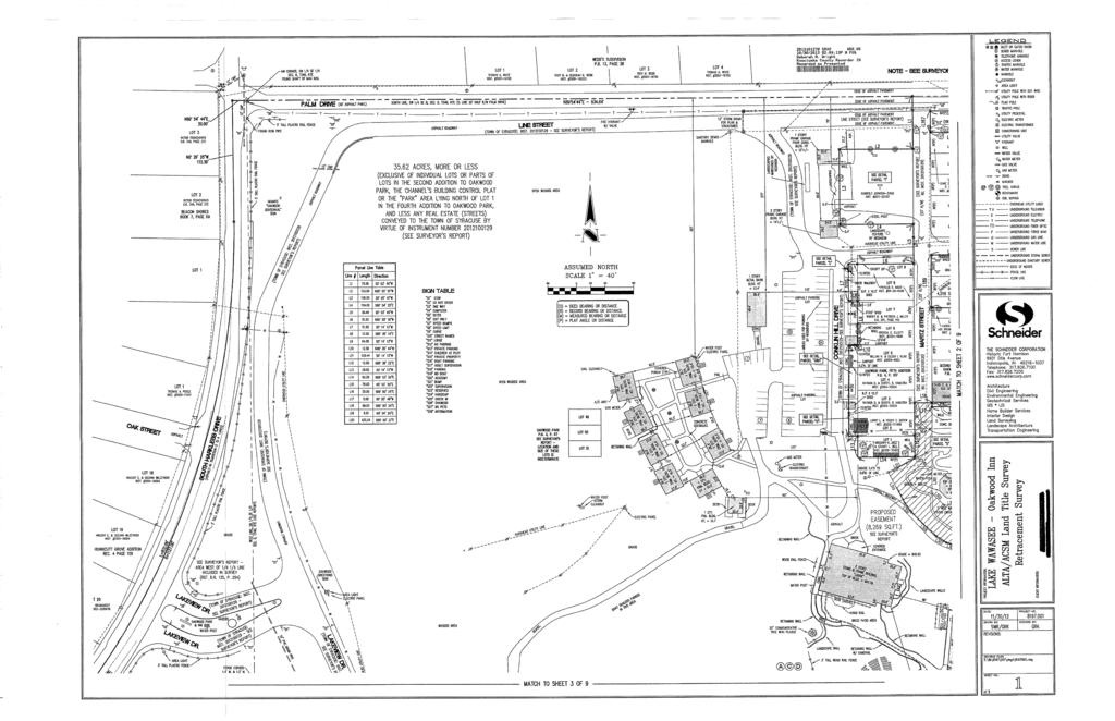
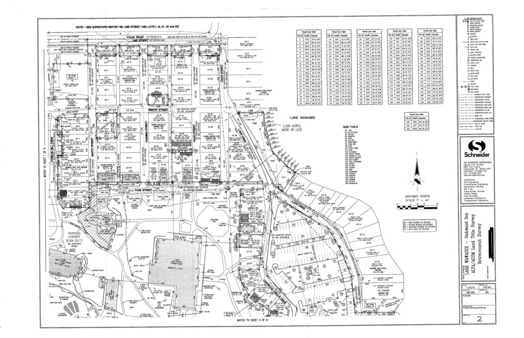
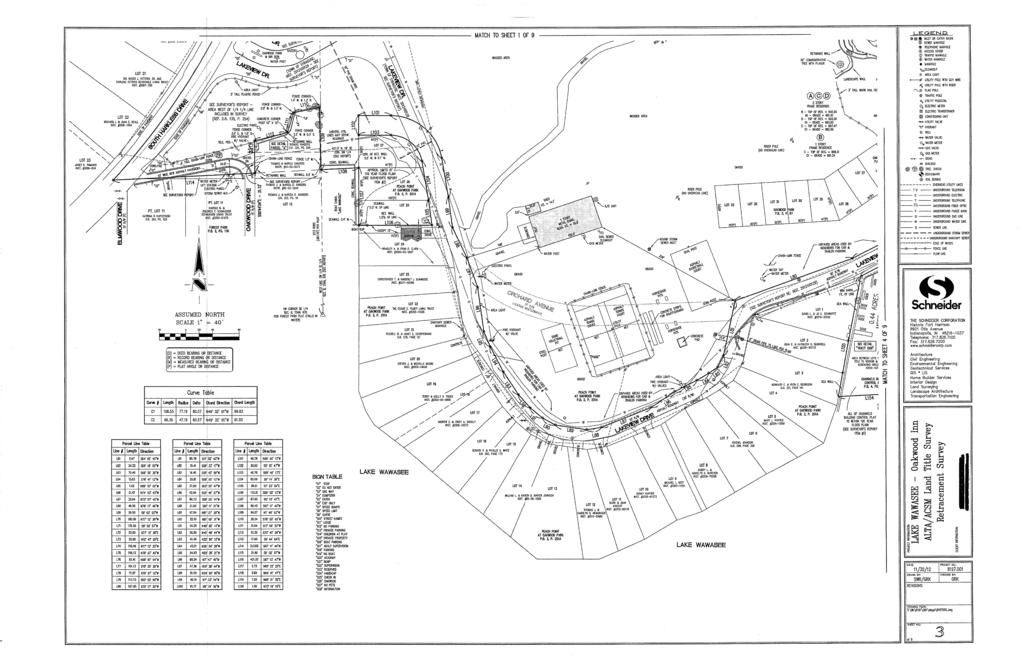
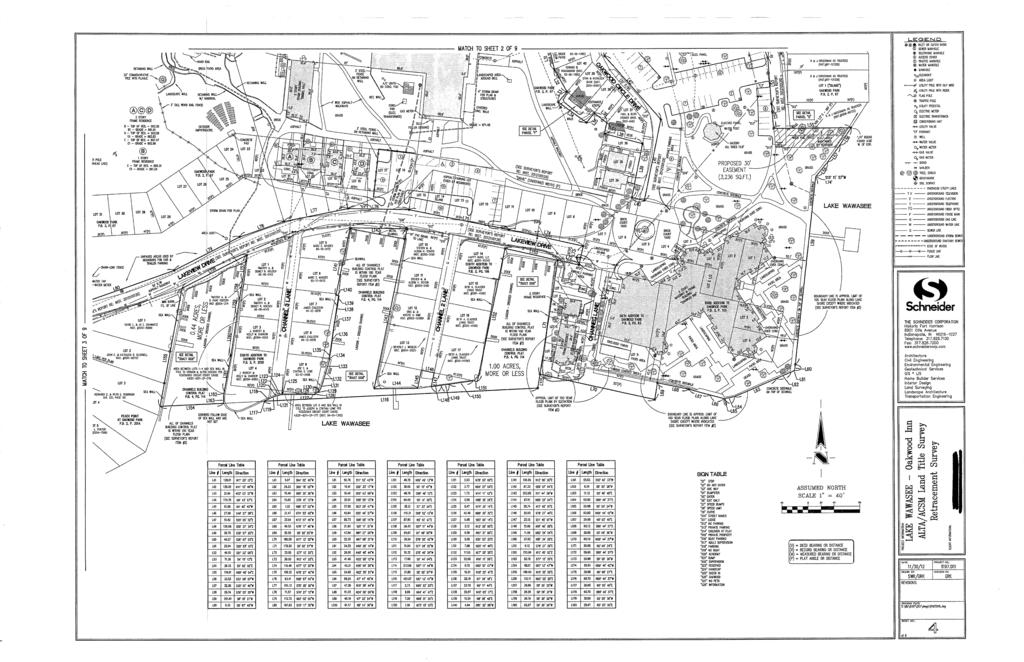
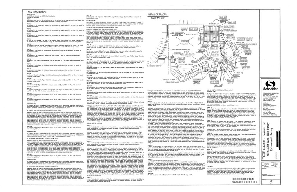
35 Surveyor's Report 1. In accordance with Title 865, Article 1, Chapter 12 of the Indiana Administrative Code ("Rule 12"), the following observations and opinions are submitted regarding the various uncertainties in the locations of the lines and corners established this survey as a result of uncertainties in reference monumentation; in record descriptions and plats; in lines of occupation; and as introduced by random errors in measurement ("Relative Positional Accuracy"). There may be unwritten rights associated with these uncertainties. The client should assume there is an amount of uncertainty along any line equal in magnitude to the discrepancy in the location of the lines of possession from the surveyed lines. There may be differences of deed dimensions versus measured dimensions along the boundary lines shown hereon and, likewise, there may be found survey markers near, but not precisely at, some boundary corners. In cases where the magnitude of these differences are less than the Relative Positional Accuracy stated below and less than the uncertainty identified for the reference monumentation (discussed below), the differences may be considered insignificant and are shown only for purposes of mathematical closure. Such differences that are greater than the Relative Positional Accuracy and the uncertainty in reference monumentation should be considered worthy of notice and are therefore further discussed below. This survey and report are based in part upon opinions formed in accordance with an Indiana Land Surveyor s responsibility to conduct a survey in accordance with law or a precedent (865 IAC (5), Rules of the Indiana State Board of Registration for Land Surveyors). Since Indiana has no statutes addressing how to resolve boundary lines, a solution based on principles derived from common law precedent must be relied upon as the basis for a boundary resolution. Unless otherwise noted or depicted hereon, there is no evidence of occupation along the perimeter lines of the subject tract. All survey monuments set or found this survey are flush with existing grade unless otherwise noted. The Relative Positional Accuracy (due to random errors in measurement) of this survey is within the specifications for a Suburban Class Survey (0.13 feet plus 100 ppm) as defined in IAC 865. This is an ALTA/ACSM Land Title Survey commissioned by the client for purposes of use in an acquisition of the subject/surveyed real estate. Primary source documents included a Quit Claim deed from XXXX to YYYY (recorded as Instrument ZZZZ), and a survey by BBBB - Survey Number GGGG, certified by HHHH, LS on October 14, XXXX (hereinafter referred to as the BBBB Survey ). Reference is made extensively in this report to the BBBBr survey and the Surveyor s Report contained therein. Other documents referenced as part of this survey include, but are not limited to:
36 The record plat of Oakwood Park (Plat Book 2, Page 67) The record plat of the Second Addition to Oakwood Park (Plat Book 2, Page 69) The record plat of the Third Addition to Oakwood Park (Plat Book 3, Page 103) The record plat of Oakwood Park Fourth Addition (Plat Book 4, Page 200) The record plat of Oakwood Park Fifth Addition (Plat Book 4, Page 107) The record plat of the Sixth Addition to Oakwood Park (Plat Book 5, Page 63) The record plat of the Eighth Addition to Oakwood Park (Plat Bok 2, Page 201B) The record plat of Peach Point at Oakwood Park (Plat Book 2, Page 201A) The record plat of Forest Park (Plat Book 4, Page 84) Channel s Building Control Plat (Plat Book 4, Page 114) Basis of Bearings The basis of bearings for this survey is the same as on the BBBB Survey with the line of Palm Drive being held this survey as North 89 degrees 54 minutes 44 seconds East. Theory of Location - Subdivisions Given that the record description of the surveyed property is basically the entire Southwest Quarter of the Southeast Quarter of Section 8, together with, and except, all or parts of certain subdivisions, the primary effort in this retracement involved determining the boundaries of those various subdivisions and the lots within. It is important to note that none of the plats identified above which comprise all or parts of the surveyed property - except Peach Point and Channel s Building Control Plat (which both called for iron pipes at the time of platting (1938 and 1955 respectively) call for any potentially recoverable original monuments at lot or subdivision corners. Additionally, the record plats mentioned above do not (or cannot) close mathematically by significant amounts and in many, if not most, cases the geometry is not even rational. Without original monuments and given the severe lack of integrity and definition in the various plats geometries, following the intent ( footsteps ) of the original platting surveyor is problematic at the very least. The hierarchy of reliance on monuments in subdivisions when original monuments (or documented perpetuated locations of original monuments) are not available provides that uncalled-for monuments by common report may control. An uncalled-for monument is one which exists on the ground, but which is not described or otherwise called-for in a record document. A monument by common report has been described as the common acceptance by numerous surveyors of a monument which is reputed to be correct, whose history is lost in antiquity, and the integrity of whose position cannot be proved or disproved. Many, many uncalled-for monuments exist in the various subdivisions within and around the surveyed property. Whether or not those qualified as monuments by common
37 report, however, and could therefore be relied upon as the basis for establishing the various related lines and corners, depended on if they met the definition above. In assessing this, a primary consideration is finding a variety of different monuments that fit a general pattern amongst themselves and that are consistent with the various plats (given the severe dearth of proper geometry). These conditions would be indicative of a reputation of correctness of those monuments amongst numerous surveyors. What was found in that regard was a tremendous variety of different types of monuments, ostensibly confirming a wide variety of surveyors. And in checking from monument to-monument against the respective plat dimensions, the huge majority of those monuments checked within just a few tenths of a foot from the record. Thus, in most cases, the monument recovered at the apparent respective lot corner met the definition of a monument by common report and was therefore held as the corner. Monuments that were set on the BBBB Survey and recovered or reset this survey (primarily being along the northerly side of Lakeview Drive and along the west side of Lake Drive) were set so as to fit record dimensions where possible and still maintain consistency with the nearby and/or related monuments by common report that were otherwise held. This was the approach taken on the BBBB Survey and there was no meaningful reason to not take the same approach this survey. Surveyors oftentimes will ostensibly disagree in retracing a line or corner. However, when those disagreements are rooted in record data or controlling monumentation that are significantly uncertain, indefinite or that represent indefinable locations, there is no logical reason to maintain those disagreements when the amount of uncertainty in their locations exceeds the amount of disagreement. That is the case on this survey. The BBBB Survey was thoroughly researched and performed, and no new information was found this survey that would support a substantive disagreement with the BBBB results. In that regard, virtually no monuments were found on Lots 2 through 33 in Oakwood Park and on the lots in the Third Addition to Oakwood Park. The lot lines were constructed this survey as they were constructed on the BBBB Survey for the reason stated in the paragraph immediately above; there was no substantive, rational or justifiable reason to disagree. Additionally, the few buildings on some of those lots generally fit with this solution. See comments on Channel s Building Control Plat below under Theory of Location Lake Wawasee. Numerous recorded surveys of lots within the various Oakwood Park plats that adjoin the surveyed property were found in the records including: Survey of Lots in Oakwood Park by KKKK dated September 14, XXXX. Several of the monuments called for on that survey were recovered as shown hereon. Survey of Lot 48 in Oakwood Park by LLLL dated May 11, XXXX. The monuments apparently set or found by LLLL at the northeast corner and
38 southwest corners of the lot were recovered this survey. Survey of Lots 38 and 39 in the Second Addition to Oakwood Park by MMMM dated August 22, XXXX. None of the monuments reportedly set or found by MMMM along the common line with the surveyed property were recovered this survey. Survey of Lot 7 in the Fifth Addition to Oakwood Park by PPPP dated September 7, XXXX. None of the monuments reportedly set or found by PPPP were recovered this survey. Survey of the property south of Lot 1 in Oakwood Park by QQQQ dated August 17, XXXX. The monuments reportedly set by QQQQ at the northwest corner and at the southeast corner of the property (at the seawall) were recovered this survey. It should also be pointed out that the real estate described in the aforementioned Quit Claim deed does not include Lots 49, 50 and 51 in Oakwood Park. This occurs because of the exception in Tract XXXII for Oakwood Park, and because these lots are not otherwise included in any of the remaining tracts. As an aside and in any event, it is impossible to locate these lots because the plat gives no location or dimensions for them. Given the above discussion, the amount of uncertainty associated with the location of the various lines and corners of the surveyed property that are formed by, or otherwise that rely on, these subdivision and lot lines (established based on monuments by common report) is estimated to be approximately 0.5 feet. In addition to the above, the north line of Forest Park Addition being formed by the north lines of Lots 11 and 12 thereof is called in the record perimeter description of Forest Park as being along the edge of highway. The BBBB survey notes that Xanders (who owns real estate in this immediate vicinity) and a representative of Oakwood Park stated that there used to be a drive running east-west from Harkless Drive to Oakwood Drive in this vicinity. No other information was found to that effect other than there existed at the time of the BBBB survey an unimproved drive in this area running from Harkless Drive. This drive was recently improved and is used by Xanders and owners in Forest Park for access to their respective properties. The apparent north line of Forest Park (being the north line of Lot 12 therein) is inconsistently described in Instrument No and Deed Record 324, Page 509. Another deed to Xanders (Instrument No ) appears to have been executed at least in part to address this issue. The line formed by courses 108 and 114 (and the line between those two courses) may be - based on the found monumentation and the above mentioned Xanders deeds - the centerline of that former 'highway' or even the north line of Forest Park. The distance north from the apparent quarterquarter corner does not work particularly well with these deeds, leaving the location of the north line of Forest Park in considerable question. For purposes of this survey courses 108 and 114 have been held as the south line of the surveyed property with course 108 representing either the easterly extension of the north line of Forest Park or
39 the centerline of that former 'highway' - the presumption being that any real estate south of that former centerline would be appurtenant to the lots in Forest Park and not to the surveyed real estate. Theory of Location Quarter-Quarter Section The north line of the overall surveyed property is the north line of the southwest quarter of the southeast quarter. However, none of the related plats show or indicate that the line that is apparently that quarter-quarter line is, in fact, truly that line. Attempting to establish that line by subdividing the section or quarter section into aliquot parts would be a meaningless exercise since several corners key to such a subdivision fall in Lake Wawasee and were never set in the original government survey. The only rational approach to this issue and one that fits with the surrounding properties and plats - is to accept the centerline of Palm Drive as shown on the plat of Webb s Subdivision as defining the supposed north quarter-quarter line. This, however, does not address the considerable question as to how this line fits with the indefinable quarter-quarter line, which is the line described in the record. There may be no acceptable way to resolve that issue other than to develop a new description that eliminates the call for the quarter-quarter line in favor of a call for Palm Drive. Even in that case, there could be no assurance or certification that the new line was one and the same as that described in the record, however, it could be stated that there was no overlap with the north adjoiners. The west line of the overall surveyed tract is the west line of the same indefinable quarter-quarter section. The plat of Forest Park calls the southeast corner of the southwest quarter and appears to have as its east line, the east line of the southwest quarter (being also the west line of the southwest quarter of the southeast quarter). Monuments by common report were relied upon on the BBBB Survey to establish this line and the northeast corner of Forest Park (being the northeast corner of Lot 12 thereof). BBBB then determined a point 20 feet east of the northwest corner of the overall surveying property to be the apparent northwest corner of the southwest quarter of the southeast quarter, and the quarter-quarter line was developed in that manner. Notice is given that the surveyed property lying west of this apparent quarter-quarter line is not included in the record deed for the surveyed property, but has been included in this survey based on a 1930 deed to the Indiana Annual Conference of the Evangelical Church (Deed Record 135, Page 254). Exact current title to this area is in question and subject to the title company s determination. There are also questions as to the exact location of the south line of the surveyed property in the vicinity of the north line of Forest Park. The southeast corner of the property described in Deed Record 135, Page 154 is feet north of the southeast corner of the quarter, which is feet north of the northeast corner of Lot 12 in Forest Park; the line then runs to the west. Pending additional information, title to the area between this line and the north line of Lot 11 in Forest Park is in question. Until this issue is otherwise resolved, the line shown is per the BBBB survey.
40 Based on scaling the possible, albeit approximate, bounds of the Southwest Quarter of the Southeast Quarter, portions of the surveyed tract lie east and south of the possible aliquot east and south lines of the quarter-quarter. It is possible, however, that those areas have been treated or otherwise included as part of the subject quarter-quarter section because they are relatively small in size and, because of the Lake, there is no adjoining quarter-quarter to which they would logically attach. Such an approach is implied in the Bureau of Land Management s 2009 Manual of Surveying Instructions (and in earlier editions) which states that it is generally better to avoid an area of less than 5 acres. However, the Instructions also note that it is inconsistent that a lot lay partly in two sections [which would be the case south of the subject quarter-quarter section], and it is generally better, when consistent with other rules, to avoid lots extending from one quarter-quarter section into another quarter-quarter section. [which would be the case east of the subject quarter-quarter section] Notwithstanding the Instructions, the undersigned has seen cases where a government lot (or quarter-quarter section) did, in fact, extend over a section line where the area involved was small, and where the entire remainder of the adjoining section fell on the opposite side of navigable waters which is the case on the south side of this quarter-quarter section. Both the original government notes for the survey of Section 8 and the original government plat show that the area encompassing what would be the Southwest quarter of the Southeast quarter and the abovementioned areas east to the lake and south to the lake were originally platted as Government Lot 4 in Section 8. Apparently at some point in time some unknown parties created a title problem by changing the designation in this area from Government Lot 4 to the Southwest quarter of the Southeast quarter. To correct this, the description contained herein as Tract XXXII should be identified as Government Lot 4 in Section 8 rather than the Southwest Quarter of the Southeast Quarter. Theory of Location - Lake Wawasee According to the Indiana Department of Natural Resources website ( the legal elevation of Lake Wawasee is feet, which is well below the top of the sea walls bounding the property. The boundaries of those portions of the surveyed property associated with the Channel s Building Control Plat were established in accordance with that plat (relying on monuments by common report) which is consistent with the plat of the Eight Addition to Oakwood Park, except where the adjoiners have gained title to certain parts of that land (e.g., south and east of Lot 9 and west of Lots 1 through 4, and other areas adjoining lots in the Eighth Addition to Oakwood Park). In those areas, the boundary was established based on the controlling calls in those deeds, which essentially follow the sea wall.
41 The remaining portions of the surveyed property adjoining Lake Wawasee (south and east of the Inn building) are shown based on the face of the seawall in those areas and consistent with the BBBB Survey and the legal lake elevation. The line of the seawall was located this survey in July The actual boundary line is subject to change due to natural causes and the line located may or may not represent the actual location of the limit of title. Other Record Descriptions The Xanders deed lying 36 feet north of Lot 12 in Forest Park (Deed Record 324, Page 509 referred to in the record description of the surveyed tract as Exception Parcel A to Tract XXXII) references an iron bar, two iron pipes and a concrete post along its north line (which defines a portion of the line of the surveyed property). All of these were recovered within less than 0.2 feet of their reported locations. The iron pipe at the northeast corner falls several feet west of the purported quarter-quarter line, which is apparently why, on the BBBB survey, it was disregarded in favor of extending the line east to the purported quarter-quarter line. However, because of the questions revolving around the quarter-quarter line (discussed above), it was held for this survey. The ½ inch iron rod marking the point of beginning of that exception also falls somewhat west of the purported quarter-quarter line (which was apparently established on the BBBB survey by connecting the east line of Forest Park Addition to the point 20 feet east of the far northwest corner of the surveyed property), but was likewise, held this survey. The west end of Course L108 was held per the BBBB survey. The record descriptions of other adjoiners with metes and bounds descriptions (primarily associated with the west side of Lots in Oakwood Park) were found to be coincident with the description of the surveyed tract. Also, for the metes and bounds portion of real estate associated with Lots 38 and 39 in Oakwood Addition, very minor differences were found from the record (less than 0.1 feet). The monuments for the Parcel I exception near Line and Bishop Streets were found per the record description for that parcel (Walker capped rebars). Rights of Way With regard to many of the drives within the surveyed property (i.e. the platted drive along the north side of Lots 2 through 15 in Oakwood Park, the north end of Oakwood Circle Drive (the Turn ) on the plat of Oakwood Park, Orchard Avenue in Peach Point, and the apparent rights of way around Lot 5 in Sixth Addition to Oakwood Park), there is considerable question as to the status of these as public streets, not to mention the geometry issues discussed above with respect to their respective plats. They are shown hereon as platted based on the respective monuments by common report, with the exception of the Turn of which there is no evidence, which is inadequately defined on the plat, and which seems to have been at least partially replatted by Oakwood Park
42 Fourth Addition. No opinion is offered by virtue of this survey as to the status of these drives as public ways. Where physical pavements exist (e.g., Lakeview Drive, Oakwood Circle Drive, South Harkless Drive and Lake Drive) they are in many cases substantially outside the platted right of way lines as indicated hereon. Additionally, in many cases, there are utility lines within these streets serving both the surveyed property and adjoining properties. Line Street which provides a means of access across the north end of the Second Addition to Oakwood Park exists physically, but no information was provided regarding its status as a public street. No point of physical access exists between Line Street and Palm Drive which runs parallel and lies north of Line Street. In fact, the only physical access to the surveyed property is off South Harkless Drive and thence north/east or south/east along the paved drive. No information was provided regarding this paved drive s status as a public street until it reaches Lakeview Drive to the south and east (platted with Peach Point) and until it reaches the platted streets within the Second Addition to Oakwood Park (which can only be reached by virtue of Line Street). There is a gap of about 1 to 4 feet between the south line of the 20 foot north half right of way of Palm Drive and the north right of way line of Line Street. Those paved drives known as Conklin Hill Drive (along the west side of Oakwood Park, Fifth Addition) and Park Drive (along the south side of the Second Addition to Oakwood Park) are both relied upon for access to lots in those subdivisions, and are also used for access to portions of the surveyed property. Both are located considerably onto the surveyed property as shown hereon. No information was provided regarding these drives status as public streets. The BBBB Survey documents very well the issues with South Harkless Drive along the entire west side of the surveyed property. No geometry or plans were found to define or document its location. As a result, the monuments found along the east side of the lots in Hunnicut Grove Addition were best fit to a curve which was then offset 20 feet (per that plat) to establish a centerline. The full 40 foot right of way shown on said plat is not supported; only the westerly 20 feet was actually part of the plat. No information was otherwise provided regarding the status of the apparent easterly right of way of South Harkless Drive. Lines of Possession/Occupation Lot 32 in the Second Addition to Oakwood: As shown, the north adjoiner s drive and well are on this lot, which the north adjoiner appears to be maintaining as part of their yard. Pt. Lot 49 in the Second Addition to Oakwood: As shown, the neighbor s shed extends over the line by about 5 feet and the southerly adjoiner s house is only 1 foot south of the line. There is a storm drain on this lot.
43 Lots 7-9 in the Second Addition to Oakwood: As shown, the southerly adjoiner is using a portion of these lots for a gravel drive. An overhead utility line crosses this property. Lots 1, 14, 27, 40 and 54 in the Second Addition to Oakwood: These lots are primarily occupied by the pavement of so-called Line Street - an unplatted way of access to all areas in the various Oakwood Subdivision plats. Various utility lines are on and cross these lots as shown. Houses along the south side of these lots are in close proximity to the common line. Parcel I Exception (Southwest corner of Line and Martz Streets): This adjoiner is occupying and maintaining the entire area to their south and west to the respective asphalt drives. Landscaped areas extend well over the lines. In conversation with the occupant, she reported that she knew where the lines were and that she was occupying well beyond. Lines along Conklin Hill Drive: As previously noted, no information was provided indicating that Conklin Hill Drive is a public street; however, all of the adjoiners in this area use it for access, including some with car ports and parking areas as shown. As shown, various improvements including two carports, two sheds and associated concrete, brick and other flatwork extend over the line by up to approximately 10 feet (to Conklin Hill drive). Additionally, it appears that some neighbors may be using the parking lot to the west of Conklin Hill Drive for parking various vehicles. As noted above, numerous other survey monuments were found along this line and all were generally within tenths of the line as established. South side of Lot 1 in Oakwood Park, Fifth Addition: As shown, the house on this lot extends over its south line by about 0.4 feet. Lines along Park Drive: As previously noted, no information was provided indicating that Park Drive is a public street. However, as with Conklin Hill drive, many of the various neighbors and adjoiners use it as a public way. As shown, the boundary line of the surveyed tract runs very close to the front of the houses on the north side of Park Drive. There are numerous cases of flatwork (brick walks, decks and patios) that extend substantially over the line from those houses. Additionally, as shown, in most cases, the front overhangs on these houses extend over the line by up to about 3 feet. In one case, the house itself extends about 0.3 feet over the line. Various utility lines apparently providing service to these and other houses in the area run in Park Drive. As noted above, numerous other survey monuments were found along this line and all were generally within tenths of the line as established. Lines along the West line of Lots in Oakwood Park: As shown, a portion of the mini-barn on Lot 48 extends about 1 foot over the line as shown. The adjoiner on Lot 47 maintains a gravel parking area that extends about 12 feet west of the line as shown. The steps to the house on Lot 46 extend about 0.6 feet west of the line as shown. The walk along the south side of Lot 46 runs generally along the line. A brick walk leading to the house on Lot 39 extends beyond the line about 6 feet as shown.
44 Along Oakwood Circle Drive: The lots that are a part of the surveyed tract that front on Oakwood Circle Drive all have walks and/or landscaping that extend beyond their respective east boundary lines to the edge of Oakwood Circle Drive as shown. The Park on the East side of Lake Drive: As shown the northerly adjoiner (on Lot 196) has a wood fence that extends about 0.5 feet over the line. In addition a concrete walk and gravel parking area may be utilized by that same adjoiner. Also as shown, numerous utility lines cross this property and a number of docks extend into the lake from the property. The pavement of Lake Drive extends substantially onto the tract as shown. The adjoining property lying south of Lot 1 ( The Island ) in Oakwood Park on the east side of Lake Drive: As show, there is a substantial area to the south of the common line that is fenced and being maintained by this adjoiner. The Channels Building Control Plat: Various docks extend into the lake (and onto the surveyed property) as shown. The seawall varies from the boundary line as shown. In some cases it is landward of the boundary, but in some cases (i.e., along the far east and west boundaries of this plat and along the south side of Lakeview Drive), it lies lakeward of the boundary. A mini barn at the far northwest corner of this plat extends about 1 foot over the boundary line as shown. Lakeview Drive along the Lots in Peach Point: There are numerous areas along the northerly side of Lakeview Drive - on the surveyed property - where the neighbors are parking vehicles and/or trailers on the surveyed property. As mentioned above, there are numerous utilities in Lakeview Drive that serve the neighboring properties. Lots 25, 26 and 27 in Peach Point: The adjoiner on Lot 24 and the south 12 feet of Lot 25 has a boat slip with sea wall that sits on the line as shown. The seawall along the west side of Lots 25 through 27 is lakeward of the boundary line as shown by about 3 to 6 feet. Where the boundary runs west from the west line of lot 27, the seawall lies about 5 to 7 feet north of the boundary line. Area west of the West line of the ¼ ¼ and east of Harkless Drive (See Detail A): There are fences in close proximity to these lines as shown. In some cases, the fence is on the neighboring property (e.g., course L109) and in other cases (e.g., courses L111 and L112) the fence lies up to 5 feet onto the surveyed property. At the far southwesternmost corner of the surveyed property, there is a newly paved 10 foot drive leading east off Harkless Drive and looping south to Oakwood Drive. A neighbor reported that this was no longer in title to the Oakwood Foundation that it had been acquired or otherwise dedicated for purposes of this street. See comments above under Theory of Location Subdivisions. Comments on Utility Lines
45 Overhead and above-ground utility features are shown as observed. Underground lines are shown as marked by utility company representatives, per plans provided by client, and in conjunction with the few observed above-ground, related features. Underground lines as shown may therefore be incomplete and are likely imprecisely shown in many cases.
46
47
48
49
50
51
52
53
54
55
56
57
58
59
60
61
62
63
64
65
66
67
68
69
70
71
72
73
74
75
76
77
78
79
80
Secret and Forgotten Elements of Rule 12
 Secret and Forgotten Elements of Rule 12 Indiana Society of Professional Land Surveyors Indianapolis, Indiana January 18, 2017 Presented by Gary R. Kent, PS The Schneider Corporation Indianapolis, Indiana
Surveying and Engineering Ethics and Standards
 Surveying and Engineering Ethics and Standards New Jersey Society ~of~ Professional Land Surveyors Atlantic City, New Jersey February 1, 2017 Presented by Gary R. Kent, PS The Schneider Corporation Indianapolis,
CONFLICTING ELEMENTS
 CONFLICTING ELEMENTS Order of importance of conflicting elements that determine land location: A. Unwritten rights. B. Senior right. C. Written intentions of Parties. D. Lines Marked and Run. E. Natural
Diligence. Due. Right. Done. Indiana Commercial Board of REALTORS 2015 Indiana Commercial Real Estate Conference. June 5, 2015
 Due Diligence Done Right Indiana Commercial Board of REALTORS 2015 Indiana Commercial Real Estate Conference June 5, 2015 Tim Jensen tjensen@theveridusgroup.com 317-450-7653 David Rainey drainey@theveridusgroup.com
BOUNDARY SURVEYS RE-SURVEYS
 BOUNDARY SURVEYS RE-SURVEYS One of the difficult tasks for a surveyor is the re-surveying of lands, the re-location of the boundary lines between privately-owned lands or the re-location of the boundary
Rule 21 STANDARDS OF PRACTICE FOR SURVEYING
 Rule 21 STANDARDS OF PRACTICE FOR SURVEYING 21.1 Whenever a survey is performed, it shall comply with Section 73-13-71 (4) and Section 73-13- 73 and the Standards of Practice for Surveying in Mississippi
Standards of Practice for Surveying in the State of Alabama
 Standards of Practice for Surveying in the State of Alabama Effective January 1, 2017 RULE NO. 1.01 PURPOSE The purpose of these rules is to establish standards for the practice of surveying in the State
ALTA/NSPS Land Title Survey Standards: What Real Estate Counsel Need to Know
 Presenting a live 90-minute webinar with interactive Q&A ALTA/NSPS Land Title Survey Standards: What Real Estate Counsel Need to Know Survey Exceptions and Survey Endorsements in Title Insurance Policies
OHIO ADMINISTRATIVE CODE CHAPTER Minimum Standards for Boundary Surveys in the State of Ohio
 OHIO ADMINISTRATIVE CODE CHAPTER 4733-37 Minimum Standards for Boundary Surveys in the State of Ohio Note: Chapter 4733-37 of the Administrative Code was filed pursuant to Chapter 119 of the Revised Code.
~ Advanced ~ Legal Description Writing. Maryland Society of Surveyors. Hunt Valley, Maryland October 5, Presented by. Gary R.
 ~ Advanced ~ Legal Description Writing Maryland Society of Surveyors Hunt Valley, Maryland October 5, 2017 Presented by Gary R. Kent, PS The Schneider Corporation Indianapolis, Indiana 2017, Gary R. Kent,
STANDARDS GOVERNING CONVEYANCES OF REAL PROPERTY IN DARKE COUNTY, OHIO
 STANDARDS GOVERNING CONVEYANCES OF REAL PROPERTY IN DARKE COUNTY, OHIO As directed by Section 319.203 of the Ohio Revised Code which states The County Auditor and the County Engineer shall adopt standards
Enforcement of Minimum Survey Standards
 Presented By: F. Anthony Rettke, P.S., Tax Map Supervisor, Franklin County John Greenhalge, Executive Director, State Board of Registration n the Ohio Revised Code, Section 315.251: If a deed conveying
SYSTEMS OF PROPERTY DESCRIPTION
 SYSTEMS OF PROPERTY DESCRIPTION Interpretation of Common Real Property Descriptions INTRODUCTION Land surveying includes 1. Surveying operations involved in original surveys to locate and monument the
Preparing Property descriptions D A V I D T. BUTCHER, PLS
 Preparing Property descriptions D A V I D T. BUTCHER, PLS Who can prepare property descriptions? 327.272. Practice as professional land surveyor defined. 1. A professional land surveyor shall include any
THE PURPOSE OF MEASUREMENTS IN BOUNDARY SURVEYS. (THE ETERNAL SUVRVEY QUESTION: HOW CLOSE IS CLOSE ENGOUGH?) By. Norman Bowers, P.S. & P.E.
 By. Norman Bowers, P.S. & P.E.") THE PURPOSE OF MEASUREMENTS IN BOUNDARY SURVEYS (THE ETERNAL SUVRVEY QUESTION: HOW CLOSE IS CLOSE ENGOUGH?) By Norman Bowers, P.S. & P.E. Steven S. Brosemer, P.S. Figure 1 Surveyors are all about measurements.
THE PURPOSE OF MEASUREMENTS IN BOUNDARY SURVEYS (THE ETERNAL SUVRVEY QUESTION: HOW CLOSE IS CLOSE ENGOUGH?) By Norman Bowers, P.S. & P.E. Steven S. Brosemer, P.S. Figure 1 Surveyors are all about measurements.
Kansas Minimum Standards For Boundary Surveys and Mortgagee Title Inspections Standards of Practice
 5/28/2010 9:28 PM 1 Kansas Minimum Standards For Boundary Surveys and Mortgagee Title Inspections Standards of Practice PREFACE These standards were first adopted by the Kansas Society of Land Surveyors
The ALTA/ACSM (NSPS) Standards. The 2016 ALTA/NSPS Standards. Section 1 - Purpose February 23, 2016
 Standards. The 2016 ALTA/NSPS Standards. Section 1 - Purpose February 23, 2016") The ALTA/ACSM (NSPS) Standards 1962 1986 1988 1992 1997 1999 2005 2011 2016 February 23, 2016 The 2016 ALTA/NSPS Standards Section 1- Purpose Section 2- Request for Survey Section 3 Survey Standards &
The ALTA/ACSM (NSPS) Standards 1962 1986 1988 1992 1997 1999 2005 2011 2016 February 23, 2016 The 2016 ALTA/NSPS Standards Section 1- Purpose Section 2- Request for Survey Section 3 Survey Standards &
APPLICATION FOR FINAL PLAT APPROVAL
 APPLICATION FOR FINAL PLAT APPROVAL Section 1. General. The undersigned Applicant (Applicant is synonymous with owner) makes this Application for Final Plat Approval in accordance with Chapter 21, Port
Sec moves to amend H.F. No as follows: 1.2 Page 5, after line 31, insert:
 1.1... moves to amend H.F. No. 1586 as follows: 1.2 Page 5, after line 31, insert: 1.3 "Sec. 6. Minnesota Statutes 2018, section 282.01, subdivision 4, is amended to read: 1.4 Subd. 4. Sale; method; requirements;
CHAPTER FINAL AND PARCEL MAPS
 CHAPTER 19.48 FINAL AND PARCEL MAPS Section Page 19.48.010 General... IV-25 19.48.020 Phasing... IV-25 19.48.030 Survey Required... IV-26 19.49.040 Form... IV-26 19.48.050 Contents... IV-27 19.48.060 Preliminary
Certified Survey Review Instructions
 DEARBORN COUNTY PLAN COMMISSION County Administration Building, 165 Mary St., Lawrenceburg, IN 47025 Phone (812) 537-8821 Fax (812) 532-2029 Website: www.dearborncounty.org/planning Certified Survey Review
New 2016 ALTA/NSPS Land Title Survey Standards: What Attorneys Need to Know
 Presenting a live 90-minute webinar with interactive Q&A New 2016 ALTA/NSPS Land Title Survey Standards: What Attorneys Need to Know Leveraging the Feasibility Assessment Tool for Land Development Deals
Land Surveys and Real Property Boundaries
 Land Surveys and Real Property Boundaries There are primarily 5 types of surveys performed on real property in the State of Indiana: Original, Retracement, Route, and Surveyor Location Report (SLR). Lenders
SECTION SITE SURVEYS
 PART 1 - GENERAL 1.1 DESCRIPTION SECTION 02 21 00 SPEC WRITER NOTES: 1. Use this section only for NCA projects. 2. Delete between //---// if not applicable to project. Also delete any other item or paragraph
Surveyor s. Time Machine. The. Product Review Triumph-LS software. Polaris Shows the Way Leveraging workflow
 SEPTEMBER 2017 The Surveyor s Time Machine Product Review Triumph-LS software Polaris Shows the Way Leveraging workflow Revitalizing a Business With laser scanning Writing a Good Narrative The Land Surveyor
CHAPTER XIX ANNEXATION ARTICLE 1. ANNEXATION
 CHAPTER XIX ANNEXATION ARTICLE 1. ANNEXATION 19.0101 JABORSKY ADDITION: WHEREAS, The City of Belfield pursuant to Section 40-51.2-07 of the North Dakota Century Code has amended having passed a Resolution
RULES OF THE GEORGIA STATE BOARD OF REGISTRATION FOR PROFESSIONAL ENGINEERS AND LAND SURVEYORS CHAPTER APPLICATIONS TABLE OF CONTENTS
 RULES OF THE GEORGIA STATE BOARD OF REGISTRATION FOR PROFESSIONAL ENGINEERS AND LAND SURVEYORS CHAPTER 180-7 APPLICATIONS TABLE OF CONTENTS 180-7-.07 Maps and Plats. All maps, plats and similar documents
CHAPTER 8 - LAND DESCRIPTIONS
 CHAPTER 8 - LAND DESCRIPTIONS Notes: While the location of land is commonly referred to by street number and city, it is necessary to use the legal description in the preparation of those instruments relating
SKETCH OF BOUNDARY SURVEY ALTA / ACSM LAND TITLE SURVEY
 SKETCH OF BOUNDARY SURVEY ALTA / ACSM LAND TITLE SURVEY SURVEYOR'S NOTES: All distances as shown hereon are based on the US Survey foot. Subject property lies inside the UBD (Urban Development Boundary),
These requirements are:
 MINIMUM STANDARD DETAIL REQUIREMENTS for ALTA/ACSM LAND TITLE SURVEYS as adopted by American Land Title Association American Congress on Surveying and Mapping and National Society of Professional Surveyors
TRACTOR SUPPLY COMPANY
 265.00' 28' 28' 486 SF DISPLAY AREA 1,023 SF 22' PERMANENT SIDEWALK SIDEWALK PERMANENT 51.67' 51.67' 125.33' 61.62' 131.18' 13.96' DUMPSTER STEEL DOCK RAMP 42' PREPARED BY: EXISTING WATER MAIN EXISTING
UTAH COUNCIL OF LAND SURVEYORS STANDARDS OF PRACTICE FOR BOUNDARY SURVEYS
 UTAH COUNCIL OF LAND SURVEYORS STANDARDS OF PRACTICE FOR BOUNDARY SURVEYS By the Utah Council of Land Surveyors Committee on Boundary Survey Standards Adopted by the Utah Council of Land Surveyors Executive
MINIMUM STANDARD DETAIL REQUIREMENTS FOR ALTA/ACSM LAND TITLE SURVEYS
 MINIMUM STANDARD DETAIL REQUIREMENTS FOR ALTA/ACSM LAND TITLE SURVEYS as adopted by American Land Title Association American Congress on Surveying & Mapping and National Society of Professional Surveyors
Requirements for All Instruments of Conveyance in Logan County, Ohio
 Requirements for All Instruments of Conveyance in Logan County, Ohio Effective Date: April 11, 1997 It is the intent of these requirements to provide a standard method of checking legal descriptions for
Auditor's Office Tuscarawas County
 Auditor's Office Tuscarawas County MATT JUDY, Auditor Telephone 125 E. High Avenue (330) 365-3220 New Philadelphia, Ohio 44663 Fax: (330) 365-3397 TO: FROM: Title Companies, Surveyors, Attorneys & Financial
Use of Possession/Occupation Lines 3. Surveyor s Responsibility Options for the Surveyor: Ownership Boundary Changed by Occupation: 1.
 Lines of Possession Use of Possession/Occupation Lines: 1. Evidence of the record boundary. 2. Foundation for title boundary. a. Estoppel b. Adverse possession c. Acquiescence d. Practical Location e.
Legal Descriptions INTRODUCTION: WARNING: Writing Legal Descriptions NYSAPLS Conf January Scott Reeser, P.L.S. NYSAPLS 2018 Conference
 Legal Descriptions Scott Reeser, P.L.S. NYSAPLS 2018 Conference INTRODUCTION: Over 25 years experience in the surveying profession Graduate of Penn State survey program Licensed in Pennsylvania, New York,
REQUIREMENTS FOR ALL INSTRUMENTS OF CONVEYANCE IN HARDIN COUNTY, OHIO
 REQUIREMENTS FOR ALL INSTRUMENTS OF CONVEYANCE IN HARDIN COUNTY, OHIO Effective Date: Michael L. Smith, P.E., P.S. Hardin County Engineer Michael T. Bacon Hardin County Auditor 1 I. GENERAL In compliance
GENESEE VALLEY LAND SURVEYORS ASSOCIATION MINIMUM STANDARDS FOR A MAP OF A SURVEY. Effective Date: February 15, 2017
 GENESEE VALLEY LAND SURVEYORS ASSOCIATION MINIMUM STANDARDS FOR A MAP OF A SURVEY Effective Date: February 15, 2017 1. The Land Surveyor shall perform due diligence in their research, maintain proper documentation
U.S. Public Land Survey - Special Instructions A Case Study
 U.S. Public Land Survey - Special Instructions A Case Study by: John E. Freemyer, LS "One of the most important duties to be performed by the surveyor general is to provide the deputy surveyor with Special
CONVEYANCE - COMMONWEALTH PROPERTY IN THE BOROUGH OF EAST STROUDSBURG, MONROE COUNTY Act of Jul. 1, 2016, P.L., No. 65 Cl.
 CONVEYANCE - COMMONWEALTH PROPERTY IN THE BOROUGH OF EAST STROUDSBURG, MONROE COUNTY Act of Jul. 1, 2016, P.L., No. 65 Cl. 85 An Act Authorizing the Department of General Services, with the approval of
CODE OF PRACTICE FOR LAND SURVEYORS
 CODE OF PRACTICE FOR LAND SURVEYORS PREPARED BY DELAWARE-HUDSON PROFESSIONAL LAND SURVEYORS ASSOCIATION P.O. BOX 502 HIGHLAND MILLS, NY 10930 ADOPTED DECEMBER 9, 1987 REVISED FEBRUARY 9, 1988 Preamble
Minimum Requirements. In Carroll County, Ohio
 Minimum Requirements For Instruments of Conveyance In Carroll County, Ohio Revision History: Original Effective Date: June 1, 2000 Revision Effective Date: October 2, 2017 Foreword Section 319.203 of the
Memorandum September 13, 2018
 Memorandum September 13, 2018 TO: FROM: Planning and Zoning Commission Julie Couch, Town Manager Israel Roberts, AICP Planning Manager SUBJECT: FINAL PLAT FOR THE EBERSOHL ADDITION BACKGROUND: This is
Exploring the 2016 ALTA/ACSM NSPS Land Title Survey Standards
 Exploring the 2016 ALTA/ACSM NSPS Land Title Survey Standards Ian Wilson, PLS Central Valley Chapter 2016 Ian Wilson 2/25/2016 Purpose of the LTS History of the Standards What a Land Title Survey is and
Part 901 Chapter 19: REINSTATEMENT OF LICENSURE OR CERTIFICATION AFTER REVOCATION
 Rule 18.12 - Any person aggrieved by the action of the Board as a result of disciplinary proceedings conducted hereunder may appeal therefrom as provided for in Section 73-13-37(10) Mississippi Code Annotated
Standards for All Instruments of Conveyance
 Standards for All Instruments of Conveyance Perry County, Ohio Effective Date: May 1, 1997 Effective Date of Revision: April 1, 2011 Page 2 of 12 Minimum Standards for all Instruments of Conveyance Perry
New Jersey Society ~of~ Professional Land Surveyors
 ALTA/ACSM Land Title Surveys ~ the 2011 Standards ~ and ~ an Update on 2016 Version ~ New Jersey Society ~of~ Professional Land Surveyors Atlantic City, New Jersey February 4, 2015 Presented by Gary R.
201 KAR 18:150. Standards of practice.
 201 KAR 18:150. Standards of practice. RELATES TO: KRS 322.290(1)(a), (2)(f) STATUTORY AUTHORITY: KRS 322.290(2)(f) NECESSITY, FUNCTION, AND CONFORMITY: KRS 322.290(1)(a) authorizes the board to administer
STANDARDS GOVERNING CONVEYANCES OF REAL PROPERTY IN SENECA COUNTY OHIO
 STANDARDS GOVERNING CONVEYANCES OF REAL PROPERTY IN SENECA COUNTY OHIO EFFECTIVE July 8, 1996 Seneca County Auditor FIRST HEARING June 14, 1996 SECOND HEARING June 26, 1996 Seneca County Engineer TABLE
Center of Section. Computed or Monumented Position. Review and Commentary
 Center of Section Computed or Monumented Position Review and Commentary Center of Section Center of section defined by law for more than 200 years Computed position vs monumented position Examine the state
AIR ONE. 829 HULL ROAD Ormond Beach, Florida BENCHMARK #1 EL NAIL IN POWER POLE EASTERLY RIGHT-OF-WAY LINE TOMOKA AIRPORT ROAD (UR) HULL ROAD
 HULL ROAD") NORTH LINE LOT 2 SOUTH LINE LOT 1 S75 46'55"E 2 NORTH LINE LOT 3 SOUTH LINE LOT 2 N75 43'32"W(UR) S75 43'32"E(D) N75 43'32"W(URD) NORTH LINE LOT 1 SOUTH LINE LOT 12 225.15'(M)225'(UR) P.O.R. PARCELS II
NORTH LINE LOT 2 SOUTH LINE LOT 1 S75 46'55"E 2 NORTH LINE LOT 3 SOUTH LINE LOT 2 N75 43'32"W(UR) S75 43'32"E(D) N75 43'32"W(URD) NORTH LINE LOT 1 SOUTH LINE LOT 12 225.15'(M)225'(UR) P.O.R. PARCELS II
The 2011 ALTA/ACSM LAND TITLE SURVEY STANDARDS
 The 2011 ALTA/ACSM LAND TITLE SURVEY STANDARDS [This article is prepared for the exclusive use of the employees and agents of Fidelity National Title Group, Inc. Please do not distribute in whole or in
ALTA/NSPS Land Title Surveys
 ALTA/NSPS Land Title Surveys ~ the 2016 Standards ~ New Jersey Society ~ of ~ Professional Land Surveyors Atlantic City, New Jersey February 1, 2017 Presented by Gary R. Kent, PS The Schneider Corporation
DAWSON COUNTY MINOR PLAT REVIEW CHECKLIST $50.00 FEE PER PLAT REVIEW, $5.00 FEE FOR SCAN & CD FOR RECORDING
 DAWSON COUNTY MINOR PLAT REVIEW CHECKLIST $50.00 FEE PER PLAT REVIEW, $5.00 FEE FOR SCAN & CD FOR RECORDING NAME ON PLAT: CONTACT/PHONE #: NAMED STREET/ADDRESS: LAND LOT: DISTRICT: SECTION: ZONING: SETBACKS:
WYANDOT COUNTY BASIC STANDARDS FOR THE APPROVAL OF REAL ESTATE DEED TRANSFERS & LAND CONTRACT AGREEMENTS
 GENERAL In compliance with Section 315.251 of the Ohio Revised Code, the County Auditor and the County Engineer have adopted these written standards governing the conveyance of real property in Wyandot
STANDARDS GOVERNING CONVEYANCES OF REAL PROPERTY
 STANDARDS GOVERNING CONVEYANCES OF REAL PROPERTY Hancock County, Ohio Charity A. Rauschenberg, Hancock County Auditor Steven C. Wilson, Hancock County Engineer Revised: March 1, 2007 TRANSFER AND CONVEYANCE
MINIMUM STANDARD DETAIL REQUIREMENTS FOR ALTA / NSPS LAND TITLE SURVEYS (Effective February 23, 2016)
") MINIMUM STANDARD DETAIL REQUIREMENTS FOR ALTA / NSPS LAND TITLE SURVEYS (Effective February 23, 2016) NOTE: Attention is directed to the fact that the National Society of Professional Surveyors, Inc. (NSPS)
MINIMUM STANDARD DETAIL REQUIREMENTS FOR ALTA / NSPS LAND TITLE SURVEYS (Effective February 23, 2016) NOTE: Attention is directed to the fact that the National Society of Professional Surveyors, Inc. (NSPS)
City of Colleyville Community Development Department. Subdivision Application Packet
 Community Development Department Subdivision Application Packet 1 Development Application Fees 100 Main Street Colleyville TX 76034 817.503.1050 Zoning Zoning Change $ 500 + $5 per acre Planned Unit Development
New Jersey Administrative Code Title 13, Chapter 40 State Board of Professional Engineers and Land Surveyors
 New Jersey Administrative Code Title 13, Chapter 40 State Board of Professional Engineers and Land Surveyors SUBCHAPTER 1. TITLE BLOCKS AND SEALS FOR PROFESSIONAL ENGINEERS AND LAND SURVEYORS 13:40-1.1
Conveyance Standards. Boundary Survey Requirements. Adams County, Ohio
 Conveyance Standards And Boundary Survey Requirements Adams County, Ohio OFFICE OF THE ADAMS COUNTY AUDITOR DAVID GIFFORD 110 WEST MAIN STREET WEST UNION, OH 45693 OFFICE OF THE ADAMS COUNTY ENGINEER DAVID
(10) The Board has the powers and duties of an arbitrator under sections 29(3) and 43 of the Arbitration Act.
 The Board has the powers and duties of an arbitrator under sections 29(3) and 43 of the Arbitration Act.") Surveys Act [Fall 2014 STATUTE LAW] Under section 9 survey error investigation of the Surveys Act. The Minister may appoint a Board consisting of three (3) members. a. List two (2) of the three (3) members.
Surveys Act [Fall 2014 STATUTE LAW] Under section 9 survey error investigation of the Surveys Act. The Minister may appoint a Board consisting of three (3) members. a. List two (2) of the three (3) members.
Cadastral Framework Standards
 Cadastral Framework Standards The goal of the Data Standards and Recommendations Committee is to provide recommendations and guidelines to Indiana GIS user communities to facilitate the collection, maintenance
Understanding Land Surveys, Legal Descriptions and Boundaries. Benjamin J. Moorman, RLS
 Understanding Land Surveys, Legal Descriptions and Boundaries Benjamin J. Moorman, RLS PERFORMING BOUNDARY SURVEYS Phases: 1. Negotiation with Client and Project Planning 2. Research of Records and Documents
CITY OF BEVERLY HILLS Department of Public Works and Transportation Civil Engineering Division FINAL MAP SUBMITTAL PROCESS Transmitted
 CITY OF BEVERLY HILLS Department of Public Works and Transportation Civil Engineering Division FINAL MAP SUBMITTAL PROCESS Transmitted From To* Planning Department Civil Engineering Division RKA Consulting
The Hennepin County platting process and common platting problems
 The platting process and common platting problems Tim Eklund Deputy County Surveyor Disclaimer This is a presentation on platting in Your county may be different. Just because we allow something don t
Department of Natural Resources
 Rules of Department of Natural Resources Division 30 Land Survey Chapter 2 Missouri Minimum Standards for Property Boundary Surveys Title Page 10 CSR 30-2.010 Application of Standards...3 10 CSR 30-2.020
ADOPTION OF REVISIONS TO STANDARDS GOVERNING CONVEYANCES IN ASHTABULA COUNTY
 PREAMBLE The intent of this revision of current rules is to perpetuate the desire for good conveyances and to modify, add, clarify or eliminate certain rules. The rules following have been restructured
OTTAWA COUNTY LEGAL DESCRIPTION REVIEW GUIDELINES
 OTTAWA COUNTY LEGAL DESCRIPTION REVIEW GUIDELINES APPROVED BY: RONALD P. LAJTI, JR., P.E., P.S. OTTAWA COUNTY ENGINEER APPROVED BY: LAWRENCE HARTLAUB OTTAWA COUNTY AUDITOR EFFECTIVE DATE: January 1, 2017
STANDARDS FOR PLATS OF SURVEYS, LEGAL DESCRIPTIONS, RECORD PLANS AND CONDOMINIUM PLANS
 OFFICE OF THE MONTGOMERY COUNTY ENGINEER STANDARDS FOR PLATS OF SURVEYS, LEGAL DESCRIPTIONS, RECORD PLANS AND CONDOMINIUM PLANS INDEX Definitions Electronic Data Submittal Program Page i Page ii I. Adoption
PLANNING COMMISSION REPORT Non-Public Hearing Item
 PC Staff Report 09/21/2015 Item No. 2B - 1 PLANNING COMMISSION REPORT Non-Public Hearing Item PC Staff Report 09/212015 ITEM NO. 2B: FINAL PLAT FOR MORGAN ADDITION; 800 MONTEREY WAY (MKM) : Consider a
Map Filing Law. 46: Effective date This act shall take effect January first, one thousand nine hundred and fiftyfour.
 46:23-9.8. Effective date This act shall take effect January first, one thousand nine hundred and fiftyfour. L.1953, c. 358, p. 1941, s. 8. 46:23-9.9. Short title This act shall be known and may be cited
SUBMITTAL REQUIREMENTS: The number indicates the number of copies for submittal (if applicable).
.") Office Use Only Preliminary Long Plat Long Subdivision Applicant Checklist PLANNING, COMMUNITY, & ECONOMIC DEVELOPMENT DEPARTMENT PRELIMINARY LONG PLAT LONG SUBDIVISION CHECKLIST Mailing Address: P.O.
Office Use Only Preliminary Long Plat Long Subdivision Applicant Checklist PLANNING, COMMUNITY, & ECONOMIC DEVELOPMENT DEPARTMENT PRELIMINARY LONG PLAT LONG SUBDIVISION CHECKLIST Mailing Address: P.O.
Methods of Perpetuation of Indiana s Section Corners J o h n G. M ce ntyre
 Methods of Perpetuation of Indiana s Section Corners J o h n G. M ce ntyre Professor of Civil Engineering Technology Purdue University IN T R O D U C TIO N The county surveyors of Indiana, as required
COUNCIL AGENDA MEMO ITEM NO. III - #1
 COUNCIL AGENDA MEMO ITEM NO. III - #1 FROM: Anton Jelinek, Director of Utilities MEETING: October 24, 2017 SUBJECT: PRESENTER: Permanent Utility and Right-of-Way Easement Anton Jelinek Discussion: At the
The legal descriptions used in Georgia (the metes and bounds, and plat map also known as the lot and block system) appear in Chapter 27.
 appear in Chapter 27.") Chapter 28 Legal Descriptions in the Sales Transaction INTRODUCTION The legal descriptions used in Georgia (the metes and bounds, and plat map also known as the lot and block system) appear in Chapter
Chapter 28 Legal Descriptions in the Sales Transaction INTRODUCTION The legal descriptions used in Georgia (the metes and bounds, and plat map also known as the lot and block system) appear in Chapter
PLANNING COMMISSION SUBDIVISION PLAT APPLICATION
 PLANNING COMMISSION SUBDIVISION PLAT APPLICATION Economic Development Department 3468 North Fulton Avenue Hapeville, Georgia 30354 Phone - 404.669.8269 Fax 404.669.3302 Rev. 09/23/16 1 The following information
FINAL PLAT. Community Development Department 8101 Ralston Road Arvada, Colorado 80002
 FINAL PLAT Community Development Department 8101 Ralston Road Arvada, Colorado 80002 September 2015 FINAL SUBDIVISION PLAT Final Subdivision Plat Review Applications for a Final Plat shall be submitted
CFedS Outline Unit 1. Course 1: History, Records & Administrative Systems
 CFedS Outline Unit 1 Course 1: History, Records & Administrative Systems History of U.S. Surveying Historical Perspective Similarities in Surveying Seniority of Calls Lack of Standards A National Debt
of Professional Surveyors
 Mississippi Association of Professional Surveyors Standards of Practice for Surveying in the State of Mississippi Exam Answer all questions. Sign and date the statement on last page. Send completed exam
Change In The Name Of Owner (s) Of Land.
 Of Land.") Clermont County TRANSFER AND CONVEYANCE STANDARDS OF THE CLERMONT COUNTY AUDITOR AND THE CLERMONT COUNTY ENGINEER AS ADOPTED UNDER OHIO REVISED CODE SECTION 319.203, AS A RESULT OF TWO PUBLIC HEARINGS
Clermont County TRANSFER AND CONVEYANCE STANDARDS OF THE CLERMONT COUNTY AUDITOR AND THE CLERMONT COUNTY ENGINEER AS ADOPTED UNDER OHIO REVISED CODE SECTION 319.203, AS A RESULT OF TWO PUBLIC HEARINGS
ARTICLE III GENERAL PROCEDURES, MINOR PLANS AND FEE SCHEDULES
 ARTICLE III GENERAL PROCEDURES, MINOR PLANS AND FEE SCHEDULES 301. Prior to Submission a. Copies of this Ordinance shall be available on request, at cost, for the use of any person who desires information
PROCEDURE. Chapter 12: Subdivision Regulations
 SECTION 14-600 ADMINISTRATIVE REPLAT PROCEDURE 14-601 INTENT These procedures are to provide an abbreviated process for Replat applications that demonstrate compliance with the criteria contained herein.
MINOR SUBDIVISION PLAT
 MINOR SUBDIVISION PLAT Community Development Department 8101 Ralston Road Arvada, Colorado 80002 MINOR SUBDIVISION PLAT Subdivisions consisting of five (5) or fewer lots are eligible for the minor subdivision
IN THE DISTRICT COURT OF THE THIRD JUDICIAL DISTRICT OF THE STATE OF IDAHO, IN AND FOR THE COUNTY OF CANYON
 Gery W. Edson GERY W. EDSON, P.A. 250 South Fifth Street, Suite 820 P. O. Box 448 Boise, ID 83701-0448 Telephone: (208) 345-8700 Fax: (208) 389-9449 Email: gedson@gedson.com ID Bar No. 2984 Attorney for
TOWN OF EASTCHESTER BUILDING AND PLANNING DEPARTMENT PLANNING BOARD APPLICATION PACKAGE SUBDIVISIONS
 TOWN OF EASTCHESTER BUILDING AND PLANNING DEPARTMENT 40 Mill Road (914) 771-3317 building@eastchester.org Eastchester, NY 10709 (914) 771-3322 Fax www.eastchester.org TABLE OF CONTENTS PLANNING BOARD APPLICATION
2017_10_MIKES_SWEETMAN_OE_PC.PDF
 1. OCTOBER PLANNING COMMISSION AGENDA Documents: OCTOBER 2017.PDF 1.I. MIKES/SWEETMAN OUTRIGHT EXEMPTIONS Documents: 2017_10_MIKES_SWEETMAN_OE_PC.PDF DEPARTMENT OF PLANNING AND ZONING 308 Byers Ave P.O.
MINNETONKA PLANNING COMMISSION October 26, Rear yard setback variance for a deck expansion at 5732 Kipling Avenue
 MINNETONKA PLANNING COMMISSION October 26, 2017 Brief Description Rear yard setback variance for a deck expansion at 5732 Kipling Avenue Recommendation Adopt the resolution approving the variance Background
REQUIREMENTS FOR ALL INSTRUMENTS OF CONVEYANCE IN GREENE COUNTY
 REQUIREMENTS FOR ALL INSTRUMENTS OF CONVEYANCE IN GREENE COUNTY A Greene County policy governing procedures and requirements for acceptance of documents for instruments of conveyance is hereby established.
TRANSFER PROCEDURES FOR WASHINGTON COUNTY, OHIO
 TRANSFER PROCEDURES FOR WASHINGTON COUNTY, OHIO The following requirements are adopted and established in conjunction with the Washington County Engineer and the Washington County Auditor as prescribed
SUBMITTAL REQUIREMENTS: The number indicates the number of copies for submittal (if applicable).
.") Office Use Only Preliminary Long Plat Long Subdivision Applicant Checklist PLANNING, COMMUNITY, & ECONOMIC DEVELOPMENT DEPARTMENT FINAL LONG PLAT LONG SUBDIVISION CHECKLIST Mailing Address: P.O. Box 547,
Office Use Only Preliminary Long Plat Long Subdivision Applicant Checklist PLANNING, COMMUNITY, & ECONOMIC DEVELOPMENT DEPARTMENT FINAL LONG PLAT LONG SUBDIVISION CHECKLIST Mailing Address: P.O. Box 547,
RESOLUTION NO. RD:EEH:LCP
 RESOLUTION NO. A RESOLUTION OF THE COUNCIL OF THE CITY OF SAN JOSE CONDITIONALLY VACATING A PORTION OF MERIDIAN AVENUE, SOUTH OF FRUITDALE AVENUE, AND RESERVING A PUBLIC SERVICE EASEMENT OVER THE VACATED
MINOR SUBDIVISION PLAT
 MINOR SUBDIVISION PLAT Community Development Department 8101 Ralston Road Arvada, Colorado 80002 September 2015 MINOR SUBDIVISION PLAT Subdivisions consisting of five (5) or fewer lots are eligible for
Planning. the propertyy. Texas Local. Government. Code. size of 2,0000 RSF-2-PUD. Road within the Wharf at a. Citizen. 0 Letter of. 1.
 Planning & Zoning Commissionn Replat Phase I of the Wharf at Clear Lake, Dock 18, Slips 1 and 2 Planning & Development Department February 15, 20166 Request Replat approximately 0.0209 acres of a previouslyy
Electronic Land Title Plan and Plan Application Requirements
 Electronic Land Title Plan and Plan Application Requirements Craig D. Johnston, Director of Land Titles Date Version 2.0 Copyright 2018, Land Title and Survey Authority of British Columbia All rights reserved
RESOLUTION NO. CONTAINING APPROXIMATELY 587 SQ.FT. RD:EEH:LCP
 RD:EEH:LCP 12-2-15 RESOLUTION NO. A RESOLUTION OF THE COUNCIL OF THE CITY OF SAN JOSE VACATING, UPON THE SATISFACTION OF CERTAIN CONDITIONS, A PORTION OF A PUBLIC EASEMENT ON PRIVATE PROPERTY LOCATED AT
TRANSFER AND CONVEYANCE STANDARDS OF THE PICKAWAY COUNTY AUDITOR AND THE PICKAWAY COUNTY ENGINEER
 TRANSFER AND CONVEYANCE STANDARDS OF THE PICKAWAY COUNTY AUDITOR AND THE PICKAWAY COUNTY ENGINEER Melissa A. Betz, Auditor Robert E. Parker, P.E., P.S., Engineer AS ADOPTED UNDER OHIO REVISED CODE SECTION
MINOR SUBDIVISION FINAL PLAT APPLICATION Town of Apex, North Carolina
 MINOR SUBDIVISION FINAL PLAT APPLICATION Town of Apex, North Carolina This document is a public record under the North Carolina Public Records Act and may be published on the Town s website or disclosed
LEGAL DESCRIPTIONS A PRACTICAL GUIDE
 Sponsored by: LEGAL DESCRIPTIONS A PRACTICAL GUIDE Jerry Morris Grab Tab Handouts 1 Can t Hear Through Your Computer Speakers? Telephone Dial-in (XXX) XXX-XXXX Access Code: XXX-XXX-XXX Audio PIN: Check
Minimum Standard Detail Requirements
 Minimum Standard Detail Requirements for ALTAjACSM LAND TITLE SURVEYS, as adopted by American Land Title Association and American Congress on Surveying & Mapping 1988 dance with the "Classification and