CLGE Working for a Profession
|
|
|
- Irma Barnett
- 5 years ago
- Views:
Transcription
1 CLGE Working for a Profession Jean-Yves Pirlot, CLGE President October 2013 PCC Conference Vilnius
2 The European Surveyor, Today and tomorrow Jean-Yves Pirlot, CLGE President October 2013 PCC Conference Vilnius
3 Overview Short presentation of CLGE Surveyors in Today s Europe Reference studies conducted since 1995 Current developments Towards a European Surveyor? The need of regulation and homogenization The publicly appointed surveyor

4

5 Leading Surveyors Association 36 Member countries + 3 Observing members 28 EU Members States >> Surveyors Requires close cooperation FIG, YSEN, EuroGeographics, PCC European Bodies National Associations
6 One Profession Civil Servants Publicly Appointed Regulated Profession Free Market
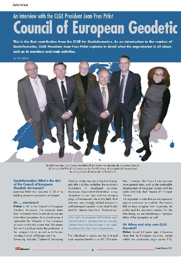
7 CLGE: a definition CLGE is the leading representational body for the Surveying Profession in Europe. - Promotes the Profession in the EU - Fosters its development in the Council of Europe Surveying includes Cadastral Surveying which provides security to land and property title and thus underlies the economic base of western society. Geospatial Information is now ubiquitous in our lives and the Surveyor plays a fundamental role in this field.
8 CLGE: a definition CLGE is the leading representational body for the Surveying Profession in Europe. - Promotes the Profession in the EU - Fosters its development in the Council of Europe Surveying includes Cadastral Surveying which provides security to land and property title and thus underlies the economic base of western society. Geospatial Information is now ubiquitous in our lives and the Surveyor plays a fundamental role in this field.
9 CLGE: a definition The individual Surveyors spread over now 36 member states are the final and most important beneficiaries of our activities. CLGE also pursues more general aims such as: - the sustainable development; - public and individual interests European Citizens.

10 The Executive Board
11 Strategic Goals of CLGE Take part in the legislative process governing the exercise of the Surveying Profession at the European and national levels; Build a Professional image of the European of Surveyor, recognized by the national governments as well as the EU; Motivate young surveyors to become active within their national associations and hence within CLGE. Make sure that the CLGE members are satisfied with the performance of CLGE.
12 Strategic Goals of CLGE Influence; Visibility; Renewal; Members Satisfaction.

13 European Code of Conduct
14

15 Global IPMS Coalition
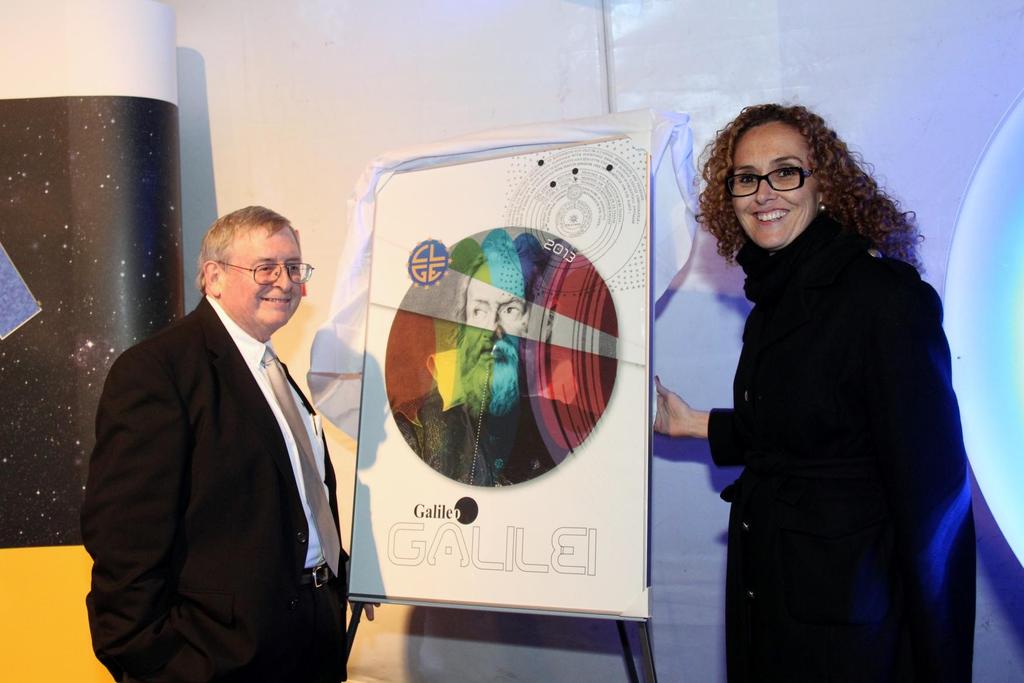
16 Strategic Goals of CLGE Influence; Visibility; Renewal; Members Satisfaction.


17 House of the European Surveyor and GeoInformation in Brussels

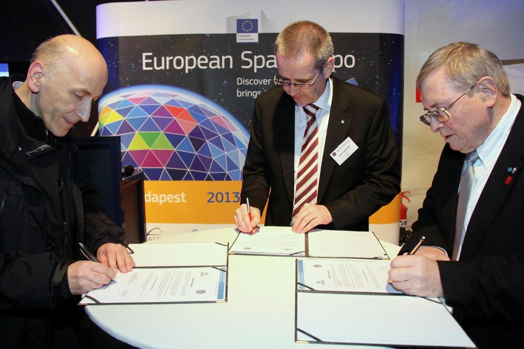
18 GSA & CLGE hand in hand


19 The European Space Expo moves to Budapest

20 (GNSS surveys to map P for disabled people)
21

22 CheeHai TEO, FIG President


23 Day Of Galileo Galilee the European Surveyor &GI Day
24
25 Budapest Declaration
26
27 Strategic Goals: Renewal Motivate young surveyors to become active within their national associations and hence within CLGE

28 CLGE Students Contest & Meeting

29 Developing a YSEN (FIG YSN)

30 CLGE Students Contest & Meeting YSEN Meeting
31 Strategic Goals: Satisfaction Make sure that the CLGE members are satisfied with our performance


32 Introduction of WorkShops
33 GeoInformatics
34 Twitter: CLGEPresident and _CLGE
35 Overview Short presentation of CLGE Surveyors in Today s Europe Reference studies conducted since 1995 Current developments Towards a European Surveyor? The need of regulation and homogenization The publicly appointed surveyor

36 Allan Report 1980, 89, 1995


37 Studies with Eurogeographics

38 Dynamic Professional Knowledge Base

39
40 Aims of the DPKB Explain and promote our profession to the European Bodies Guide the individual Surveyors Information source and decision tool for our Stakeholders and Partners European institutions National Organisations (best practices) PCC, EuroGeographics,
41 Structure Comprehensive collection of relevant information about the profession in all CLGE member countries Incorporates existing information after validity check Regularly updated, with permanent quality assessment
42 Key Elements National legal framework Fields of activity Professional recognition Public appointment Education programmes Statistical data / economical data Other relevant information
43 DPKB
44 4 PILLARS Civil Servants Publicly Appointed Regulated Profession Free Market
45 4 PILLARS Article 45 Article 51 Mutual Services Prev. 39 Prev. 45 Recognition
46 4 PILLARS Civil Servants Publicly Appointed Regulated Profession Free Market

47 4 PILLARS Civil Servants Publicly Appointed Regulated Profession Free Market
48 4 PILLARS Civil Servants Publicly Appointed Regulated Profession Free Market
49 Code Accord of PQ Multilateral for Liberal Cadastral Surveyors = BAC+5 + 2T + SE
50 Overview Short presentation of CLGE Surveyors in Today s Europe Reference studies conducted since 1995 Current developments Towards a European Surveyor? The need of regulation and homogenization The publicly appointed surveyor
51 2-pronged approach Regulate and harmonize the profession Need of a mutually recognized professional qualification level (nationally and EU) Join our code of Professional Qualifications (letter of intent) Think about a harmonized education system Introduce Public appointment Confer/confirm the Official Authority entrusted to the cadastral Surveyor
52 Conclusions Esprit de Corps (the whole profession) CLGE is eager to sign the common vision paper build on this common vision guarantee the security of land tenure CLGE proposes to coordinate our actions as presented before

53 DPKB
Presentation of CLGE
 Global and Regional Professional and Institutional Reforms, some actions of the CLGE Maurice Barbieri, CLGE President Presentation of CLGE Introduction Our Strategy Our Actions 1 Leading Surveyors Association
CLGE Working for a Profession
 CLGE Working for a Profession 13-15 November 2017 PCC - Tallinn (EE) Overview Introduction The European Legislation about establishment / provision of services Proportionality check The Code of Professional
CLGE Working for a Profession
 CLGE Working for a Profession 15. November 2017 Tallinn (ES) The public-private partnership in cadastre in Switzerland SWITZERLAND 41'290 km 2 8 million people 26 cantons ~2600 municipalities ~4.0 million
Amie Figueiredo WPLA Secretariat Wednesday, 16 October 2014 Vienna, Raiffeisen Forum
 WPLA cooperation with related international organisations and interregional cooperation Amie Figueiredo WPLA Secretariat Wednesday, 16 October 2014 Vienna, Raiffeisen Forum International cooperation International
The Cadastre of Public-law Restrictions on Landownership in Switzerland
 The Cadastre of Public-law Restrictions on Landownership in Switzerland The new official land registry information system Maurice Barbieri, CLGE President Zagreb, 26.November 2015 Utility Cadastre Seminar
The relation between the private surveyors and the Land Registry / Cadastre
 The relation between the private surveyors and the Land Registry / Cadastre Maurice Barbieri President CLGE FIG 7 Coimbra 26 10 2016 Leading Surveyors Association 37 Member countries + 3 Observing members
Agenda 25 June 2009 EXTRAORDINARY GENERAL ASSEMBLY GEOMETER EUROPAS asbl
 Brussels, 16 August 2008 Agenda 25 June 2009 EXTRAORDINARY GENERAL ASSEMBLY GEOMETER EUROPAS asbl VENUE: IDA, KALVEBOD BRYGGE 31-33, 1780 COPENHAGEN V TIMING: 13.00 18.00 HOTEL: COPENHAGEN ISLAND, KALVEBOD
PCC & EuroGeographics working as one more than a marriage of convenience. Dave Lovell Executive Director September 2011
 PCC & EuroGeographics working as one more than a marriage of convenience. Dave Lovell Executive Director September 2011 What is a Marriage? Marriage is a social union or legal contract in which parties
The importance of changes in land surveyors education
 András OSSKÓ Key words: land administration, roles of land surveyors, extended education, lifelong learning SUMMARY It s a world wide experience, especially in developed countries that the interest in
Importance of Spatial Data Infrastructure in the UNECE Region. Amie Figueiredo INSPIRE Conference 2016 Barcelona, 26 September 2016
 Importance of Spatial Data Infrastructure in the UNECE Region. Amie Figueiredo INSPIRE Conference 2016 Barcelona, 26 September 2016 United Nations Economic Commission for Europe 56 member States in Europe,
KHANALIBAYLI UNECE WPLA
 UNECE Working Party on Land Administration The role of the UNECE Working Party on Land Administration (WPLA) in the promotion and improvement of land administration and land management in the UNECE region
TERMS OF REFERENCE FOR CONSULTANCY SERVICES TO PREPARE PROJECT DOCUMENT FOR CADASTRAL MAPPING IN THE GAMBIA
 Ministry of Lands and Regional Government United Nations Development Program UNDP April 2017 TERMS OF REFERENCE FOR CONSULTANCY SERVICES TO PREPARE PROJECT DOCUMENT FOR CADASTRAL MAPPING IN THE GAMBIA
Results of Central European Land Knowledge Center (CELK) Activities
 Activities") Results of Central European Land Knowledge Center (CELK) Activities András OSSKÓ, Hungary Key words :CELK Center, Property Rights and Land Market Development, Networking, direct knowledge transfer SUMMARY
Results of Central European Land Knowledge Center (CELK) Activities András OSSKÓ, Hungary Key words :CELK Center, Property Rights and Land Market Development, Networking, direct knowledge transfer SUMMARY
The Profession between Cadastre and Citizen
 The Profession between Cadastre and Citizen Gerda Schennach, Austria Chair of FIG Commission 7 1 A human right UN DECLARATION OF HUMAN RIGHTS Article 17 par (1) Everyone has the right to own property alone
THE XXV FIG INTERNATIONAL CONGRESS IN MALAYSIA Kuala Lumpur, Malaysia, June 2014 at Kuala Lumpur Convention Centre
 CALL FOR PAPERS TO THE XXV FIG INTERNATIONAL CONGRESS IN MALAYSIA Kuala Lumpur, Malaysia, 16 21 June 2014 at Kuala Lumpur Convention Centre Dear Friend and Colleague, It is our privilege and honour to
Galicia 2009 Regional Workshop on Land Tenure and Land Consolidation. FAO s Experience with Land Development Instruments in Europe
 Galicia 2009 Regional Workshop on Land Tenure and Land Consolidation FAO s Experience with Land Development Instruments in Europe Santiago de Compostela Galicia 9-11 of February 2009 Richard Eberlin Land
Modelling Real Estate Business for Governance and Learning
 Modelling Real Estate Business for Governance and Learning Erik Stubkjær Aalborg University, Denmark FIG Workshop on e-governance, Knowledge Management and e-learning April 27-29 2006, Budapest, Hungary
Hungary is a landlocked, Central European country in the Carpathian Basin
 Brief Overview on Hungarian Land Administration MSc. György Domokos Hungarian Geodetic Surveying Liaison Group CLGE GA Hannover 12 13 October 2012 Hungary is a landlocked, Central European country in the
The Digital Cadastral Database and the Role of the Private Licensed Surveyors in Denmark
 IRISH INSTITUTE OF SURVEYORS, DUBLIN INSTITUTE OF TECHNOLOGY, 23 NOVEMBER 2005 PUBLISHED IN IIS NEWS, WINTHER 2006. The Digital Cadastral Database and the Role of the Private Licensed Surveyors in Denmark
Centre for SDIs and Land Administration Department of Geomatics Spatial systems to support sustainable development
 Centre for SDIs and Land Administration Department of Geomatics MODERN CADASTER and LAND ADMINISTRATION تهران-مرداد 1386 2014 ..... 2 ماه Centre for SDIs and Land Administration Department of Geomatics
Croatian SDI: a Tool for Accelerated Development of the Geo-Conscious Society
 STATE GEODETIC ADMINISTRATION Croatian SDI: a Tool for Accelerated Development of the Geo-Conscious Society Prof.Dr.Sc. Željko Bačić, Mr.Sc. Ljerka Rašić FIG Working Week 2009 - Surveyors Key Role in Accelerated
UNECE Working Party on Land Administration. Report on the Activities Carried Out by the UNECE WPLA Since the Committee's 72nd Session
 UNECE Working Party on Land Administration Report on the Activities Carried Out by the UNECE WPLA Since the Committee's 72nd Session Damir Pahic, dipl.ing. UNECE WPLA Chair 73rd Session 25th September
Welcome Session warm welcome by BEV, celebrating 200 years of the Austrian cadastre CVC2017 supported by 7 organizations: WPLA EuroGeographics PCC EUL
 Swiss Federal Office of Topography swisstopo Federal Directorate for Cadastral Surveying Common Vision Conference 2017 Wrap-up CVC 2017 "Tradition meets Innovation" Vienna, Austria, 5/6 Oct. 2017 Dr. Daniel
7 th international LANDNET Conference 5-7 October 2015, Ankara, Turkey. Land banks and land funds an overview and presentation of FAO publication
 7 th international LANDNET Conference 5-7 October 2015, Ankara, Turkey Land banks and land funds an overview and presentation of FAO publication With contributions from Frank van Holst, Francisco Onega
Cadastre A Vision on Future Cadastral Systems
 Cadastre 2014 - A Vision on Future Cadastral Systems Jürg Kaufmann - 1 - CONTENTS ABOUT FIG ENVIRONMENT FOR THE DEVELOPMENT OF CADASTRE 2014 DEVELOPMENT OF CADASTRE 2014 PRINCIPLES OF CADASTRE 2014 EFFECTS
Minimum Educational Requirements
 Minimum Educational Requirements (MER) For all persons elected to practice in each Member Association With effect from 1 January 2011 1 Introduction 1.1 The European Group of Valuers Associations (TEGoVA)
PROBLEMS IN REGISTRATION IN THE THIRD VERTICAL DIMENSION IN THE UNIFIED LAND REGISTRY IN HUNGARY, AND POSSIBLE SOLUTION
 3D Cadastres Technical and Legal Aspects II PROBLEMS IN REGISTRATION IN THE THIRD VERTICAL DIMENSION IN THE UNIFIED LAND REGISTRY IN HUNGARY, AND POSSIBLE SOLUTION ANDRÁS Osskó Budapest Land Office Hungary
International funding projects in Republic Geodetic Authority
 International funding projects in Republic Geodetic Authority Serbia: Republic Geodetic Authority Workshop Exploring Funding Instruments for NMCA 7-8 November 2012 Republic Geodetic Authority Republic
Economic and Social Council 6 July 2018
 1 ADVANCE UNEDITED VERSION UNITED NATIONS E/C.20/2018/12/Add.1 Economic and Social Council 6 July 2018 Committee of Experts on Global Geospatial Information Management Eighth session New York, 1-3 August
ABSTRACT Land Administration System in Lithuania
 ABSTRACT Land Administration System in Lithuania 1. General introduction to the Lithuanian Land Administration System and State Enterprise Centre of Registers ( shortly SECR) Lithuania has established
8 th FIG Regional Conference Montevideo, Uruguay, November Call for Papers
 8 th FIG Regional Conference Montevideo, Uruguay, 26-29 November 2012 Dear Friend and Colleague, Call for Papers It is our privilege and honour to invite you to the 8 th FIG Regional Conference in Montevideo,
Starting points. Starting points Personal interests in the subject Research interests/opportunities International links : eg ENHR, Nova, KRIHS, CCHPR
 Starting points Starting points Personal interests in the subject Research interests/opportunities International links : eg ENHR, Nova, KRIHS, CCHPR The changing emphasis of policy in the UK Housing renewal
THE ROLE OF ORGANISATIONS AND SECTORS. By: Mohammad Azmi Mohd Zin President The ASEAN Federation of Land Surveying and Geomatics.
 THE ROLE OF ORGANISATIONS AND SECTORS By: Mohammad Azmi Mohd Zin President The ASEAN Federation of Land Surveying and Geomatics. About The ASEAN Federation of Land Surveying and Geomatics A Federation
Flying high and Keeping the feet on the ground
 Building the Capacity The Agenda and Achievements 2007-2010 FIG handover ceremony, FIG headquarters, Copenhagen, 26 November 2010 The Agenda Building the Capacity through Flying high and Keeping the feet
Regulation. Deregulation
 Regulation of liberal property surveyors profession vs. Deregulation requirements for growth and competition - - - - Henning Elmstrøm President: The Danish Association of Chartered Surveyors (DdL) Torben
Test and Implementation of DATR System in Hungary
 Test and Implementation of DATR System in Hungary, Hungary Key words: unified land registry, cadastral map, Hungary SUMMARY During the last years there has been an important development in the Hungarian
EXPANDING AVAILABILITY OF BROADBAND ACCESS AND ADOPTION
 Single point information Ilija Kepevski Agency for Electronic Communications Regional Conference for Europe EXPANDING AVAILABILITY OF BROADBAND ACCESS AND ADOPTION 28-29 September 2015 - Budva, Montenegro
Building a European Spatial Data Infrastructure: The Role of EuroGeographics
 Building a European Spatial Data Infrastructure: The Role of EuroGeographics Richard Kirwan President of EuroGeographics 1st Congress on Cadastre in the EU 1 Presentation overview EuroGeographics - the
Aspect of preliminary activities in the function of supporting NSDI
 Sonja DIMOVA, Republic of Macedonia Key words: e-governance, geospatial data, NSDI, INSPIRE, metadata SUMMARY The successful establishment of the NSDI in the true sense of the word cannot be performed
Presented at the FIG Working Week 2016, May 2-6, 2016 in Christchurch, New Zealand
 Presented at the FIG Working Week 2016, May 2-6, 2016 in Christchurch, New Zealand The IMPULS Project Is a Project About Cooperation, Coordination, Transparency and Data Sharing A SDI project in the Western
Australia no longer down under - Official German Surveying and Mapping - Cooperation between the public and the private sector - The German Way
 Official German Surveying and Mapping - Cooperation between the public and the private sector - The German Way Australia no longer down under - Sydney, Australia, 11 16 April 2010 1 Australia no longer
Rural Land Markets in Central and Western Europe
 András OSSKÓ, Hungary and Jan K. B. SONNENBERG, The Netherlands Key words: Central European Countries (CECs), Western European Countries (WECs), Rural Land Market, Ownership Structure. ABSTRACT After the
1st Regional INSPIRE Forum 4th Croatian NSDI and INSPIRE Day
 1st Regional INSPIRE Forum 4th Croatian NSDI and INSPIRE Day State of Play EULIS Rik Wouters Managing Director EULIS Programme What is EULIS EULIS is renewed: LINE For who is EULIS? Why EULIS? Projects
Cape Town 1 November 2013
 Cape Town 1 November 2013 Three types of housing co-operatives: Rental Limited equity Market value but some are a combination of all 3 It is not possible to transplant a co-operative housing system from
Securing Land Rights for Broadband Land Acquisition for Utilities in Sweden
 Securing Land Rights for Broadband Land Acquisition for Utilities in Sweden Marija JURIC and Kristin LAND, Sweden Key words: broadband, land acquisition, cadastral procedure, Sweden SUMMARY The European
Use of data in Ukraine for sustainable economic growth. Oleksandr Maliuk State Service of Ukraine for Geodesy, Cartography and Cadastre
 Use of data in Ukraine for sustainable economic growth Oleksandr Maliuk State Service of Ukraine for Geodesy, Cartography and Cadastre Kehl, 2017 Content of the presentation Ukraine & StateGeoCadastre:
Property Transactions in the Digital Age. The Property Cadastre in the Context of Spatial. Dr. Jens Riecken, NRW Ministry of the Interior
 Property Transactions in the Digital Age The Property Cadastre in the Context of Spatial Data Infrastructure (SDI) Dr. Jens Riecken, NRW Ministry of the Interior Property Transactions in the Digital Age
EXPERIENCES FROM THE KENYAN PROCESS
 EXPERIENCES FROM THE KENYAN PROCESS Contents: 1) Introduction: Kenya 2) Current Land Administration Practices 3) Consequences of Poor Practice 4) Context of Land Policy Formulation in Africa 5) Kenya National
From Parcel to Global Cadastre: Challenges and Issues of the Post-Reform Quebec Cadastre. Elisabetta Genovese, Francis Roy
 From Parcel to Global Cadastre: Challenges and Issues of the Post-Reform Quebec Cadastre Elisabetta Genovese, Francis Roy Department of Geomatic Sciences, Laval University, Québec, Canada elisabetta.genovese@scg.ulaval.ca
THINKING OUTSIDE THE TRIANGLE TAKING ADVANTAGE OF MODERN LAND MARKETS. Ian Williamson
 THINKING OUTSIDE THE TRIANGLE TAKING ADVANTAGE OF MODERN LAND MARKETS Ian Williamson Professor of Surveying and Land Information Head, Department of Geomatics Director, Centre for Spatial Data Infrastructures
Cadastre a role model for Private-Public-People-Partnership
 Cadastre 4.0 - a role model for Private-Public-People-Partnership Gerda Schennach, Austria Chair of FIG Commission 7 1 Who owns... buildings? the mountains? land? forests? the sea? infrastructure? 2 From
PCC Conference and Plenary Meeting "Data as a basis of the digital society March 2018, Sofia. Activity of the geodetic NGOs in Bulgaria
 PCC Conference and Plenary Meeting "Data as a basis of the digital society 13-15 March 2018, Sofia Activity of the geodetic NGOs in Bulgaria Union of Surveyors and Land Managers in Bulgaria Chamber of
Recent development in land consolidation in Macedonia and land valuation issues
 Recent development in land consolidation in Macedonia and land valuation issues EMERALD(2008-2009)-Encouraging Macedonia s Endeavours to Rural Land Development and STIMERALD(2010-2012) Origin of Emerald
Quality Improvement of the Real Estate Cadastre in Serbia
 , Serbia Key words: quality improvement, real estate information, quality assurance, Serbia SUMMARY The concept of cadastral modernization in the Republic of Serbia was defined in 1992, and it is being
Social and Economic Benefits of Good Land Administration (Second Edition)
") United Nations Economic Commission for Europe Working Party on Land Administration Social and Economic Benefits of Good Land Administration (Second Edition) Published by HM Land Registry, London, on behalf
United Nations Economic Commission for Europe Working Party on Land Administration Social and Economic Benefits of Good Land Administration (Second Edition) Published by HM Land Registry, London, on behalf
Regulated and non-regulated professions in the Netherlands. Jennefer Baarn Head of Unit Competitiveness and Internal Market
 Regulated and non-regulated professions in the Netherlands Jennefer Baarn Head of Unit Competitiveness and Internal Market Outline 1. Horizontal policy framework: rationale behind regulation 2. Overview
Nomination Template for Chair Elect
 Nomination Template for Chair Elect Commission 7 Cadastre and Land Management Nominee Name Country Daniel Roberge Canada Contact Address E-mail address Tel. Fax Age 48 5700, 4e Avenue Ouest Québec (Québec)
LAND ADMINISTRATION IN CANADA HISTORICAL WISDOM AND MODERN CHALLENGES IN QUEBEC LAND ADMINISTRATION: FROM PAPER CADASTRAL MAPS TO ON-LINE SERVICES
 HISTORICAL WISDOM AND MODERN CHALLENGES IN QUEBEC LAND ADMINISTRATION: FROM PAPER CADASTRAL MAPS TO ON-LINE SERVICES Francis ROY P rof e s s or D é p. Sciences g é omatiques FIG Working Week Sofia, Bulgaria
Progress Report on Green Paper. Dr. Paddy Prendergast. on behalf of the. IIS Commission on Land Registration
 Progress Report on Green Paper By Dr. Paddy Prendergast on behalf of the IIS Commission on Land Registration Paddy Prendergast - Chair Brendan Sweeny - Hempenstall Surveys Paul Corrigan - P Corrigan Associates
Annual Meeting II/2016 FIG Commission 7 Cadastre & Land Management. Report
 Annual Meeting II/2016 FIG Commission 7 Cadastre & Land Management Report 1 Structure Chair G. Schennach (AT) V-Chair for communications, social media, web Hyunsook LEE (KR) WG 7.1 Fit-For-Purpose LA Ch.
Hans MATTSSON and Marina VASKOVICH, Sweden. Key words: Capacity building, Curricula, Education, Land management
 Hans MATTSSON and Marina VASKOVICH, Sweden Key words: Capacity building, Curricula, Education, Land management SUMMARY Current development in many countries demands a new type of land professionals who
The Boundary Concept Land Management Opportunities for Sustainable Development Provided by the Cadastre 2014 Approach. Jürg KAUFMANN, Switzerland
 The Boundary Concept Opportunities for Sustainable Development Provided by the Cadastre 2014 Approach Jürg KAUFMANN, Switzerland THE BOUNDARY CONCEPT AS A CHANCE FOR SURVEYORS OPPORTUNITIES CREATED BY
Support to Implementation of Multipurpose Cadastral Information system in Vietnam
 Support to Implementation of Multipurpose Cadastral Information system in Vietnam Lennart JOHANSSON and Per SÖRBOM, Sweden Key words: Land Registration, Land Information, Land Administration, SWOT analyse,
Click to edit Master title style
 Click to edit Master title style Modern Cadastre and Land Administration Session 5a. The toolbox approach Jude Wallace 2007 Click to edit Overview Master title style Objectives To understand the circumstances
Land Consolidation Thesaurus finding common ground. 9 th International LANDNET workshop 3-5 October 2017 Budapest, Hungary
 Land Consolidation Thesaurus finding common ground 9 th International LANDNET workshop 3-5 October 2017 Budapest, Hungary Maxim Gorgan, Land Tenure and Rural Development Specialist, FAO Regional Office
Land Administration and Management Towards the Fifth Dimension
 Bundesamt für Landestopografie swisstopo Eidgenössische Vermessungsdirektion Land Administration and Management Towards the Fifth Dimension Geoconference on Cadastre 4.0, 25/26 Oct. 2016 Dr. Daniel Steudler
Cadastral Futures building a new vision for the nature and role of cadastres. XXIV FIG International Congress Sydney, April 11-15
 Cadastral Futures building a new vision for the nature and role of cadastres XXIV FIG International Congress Sydney, April 11-15 Rohan Bennett, Abbas Rajabifard, Mohsen Kalantari, Jude Wallace, Ian Williamson
FIG WORKING WEEK Athens, Greece May 22-27, 2004 MEETING PROGRAMME
 FIG WORKING WEEK Athens, Greece May 22-27, 2004 MEETING PROGRAMME Friday May 21, 2004 09:00-17:00 Council Meeting (by invitation only) 19:00- Council Dinner To be announced (by invitation only) Saturday
MASS VALUATION DATA FOR GOVERNMENT, CITIZENS AND BUSINESS
 Permanent Committee on Cadastre in the European Union Lithuanian Presidency PCC Conference 22-23 October 2013, Vilnius MASS VALUATION DATA FOR GOVERNMENT, CITIZENS AND BUSINESS Arvydas Bagdonavičius Deputy
Participants of the Ministerial Meeting on Housing and Land Management on 8 October 2013 in Geneva
 Summary At its meeting on 2 April 2012, the Bureau of the Committee on Housing and Land Management of the United Nations Economic Commission for Europe agreed on the need for a Strategy for Sustainable
GI support for land consolidation
 Problems GI support for land consolidation Bela MARKUS University of West Hungary College of Geoinformatics Technology??? Legislation Organization Financial Awareness Ill-structured process 2 Past Present
From Measurement to Management
 From Measurement to Management The changing role of the land surveyors Prof. Stig Enemark Aalborg University, Denmark LAND MANAGEMENT AND HUMAN RIGHTS INTERNATIONAL SEMINAR, HØGSKOLEN I BERGEN, 8 9 SEPTEMBER
Land Administration and Management Towards the Fifth Dimension
 Presented at the FIG Working Week 2016, May 2-6, 2016 in Christchurch, New Zealand Bundesamt für Landestopografie swisstopo Eidgenössische Vermessungsdirektion Land Administration and Management Towards
Fit-For-Purpose what is it?
 FIG Commission 7 Annual Meeting 2016 Working Group 7.1 Fit-For-Purpose Land Administration Christiaan Lemmen October, 24th 2016 Coimbra, Portugal Fit-For-Purpose what is it? Fit-for-purpose: The systems
Memorandum of Understanding. between. the Network of the Insular Chambers of Commerce and the Industry of the European Union (INSULEUR) and
 and") Memorandum of Understanding between the Network of the Insular Chambers of Commerce and the Industry of the European Union (INSULEUR) and the Forum of the Adriatic and Ionian Chambers of Commerce (AIC
Memorandum of Understanding between the Network of the Insular Chambers of Commerce and the Industry of the European Union (INSULEUR) and the Forum of the Adriatic and Ionian Chambers of Commerce (AIC
A Geocoded Cadastral Fabric as a Precondition for a Sustainable Land Management System
 A Geocoded Fabric as a Precondition for a Sustainable Land Management System Gottfried KONECNY, Germany; J.P. LAUZON, Canada; Abdul Salam MOHAMMED, India Key words: SDI,, Parcel Boundaries, GPS-GNSS, Land
Lessons for federated countries that have state land registries the Australian experience
 Lessons for federated countries that have state land registries the Australian experience Ian Williamson Centre for SDI and Land Administration Department Infrastructure Engineering University of Melbourne
THINK BIG do little. Start an avalanche
 1 Recent activities on land consolidation in Serbia Stevan Marosan, Mladen Soskic University of Belgrade, Faculty of Civil Engineering Department for Geodesy and Geoinformatics Zoran Knezevic Ministry
Benchmarking Cadastral Systems Results of the Working Group 7.1
 Benchmarking Cadastral Systems Results of the Working Group 7.1 Jürg KAUFMANN, Switzerland Key words: ABSTRACT In 1998, FIG-Commission 7 launched three new working groups for the period 1998-2002. Working
IMPROVING GOVERNANCE OF TENURE IN UNECE REGION: FAO/WORLD BANK/UNECE/EU JRC PARTNERSHIP
 IMPROVING GOVERNANCE OF TENURE IN UNECE REGION: FAO/WORLD BANK/UNECE/EU JRC PARTNERSHIP RUMYANA TONCHOVSKA, GULNARA ROLL, KATHRINE KELM FAO of the UN, Rome, Italy, Rumyana.Tonchovska@fao.org UNECE, Geneva,
Regional Cadastral Study Reforms in the Region
 UNECE WORKING PARTY ON LAND ADMINISTRATION Workshop on the Influence of Land Administration on People and Business Cavtat, Croatia 2-3 October 2008 Regional Cadastral Study Reforms in the Region Miodrag
The Bathurst Declaration on Land Administration for Sustainable Development
 United Nations and International Federation of Surveyors The Bathurst Declaration on Land Administration for Sustainable Development The Story The cumulative evolution of society s land administration
Preprint.
 http://www.diva-portal.org Preprint This is the submitted version of a paper presented at 10th EC GI & GIS Workshop, ESDI State of the Art, Warsaw, Poland, 23-25 June 2004. Citation for the original published
Fit-For-Purpose Land Administration: Guiding Principles FACILITATED BY:
 Fit-For-Purpose Land Administration: Guiding Principles 1. GLTN overview - GLTN BRIEFING AND PROGRAMME 2. Geospatial Data - Sustainable Development - 3. Fit-for-purpose Land Administration Guiding Principles
Land consolidation and rural development in Serbia
 1 Land consolidation and rural development in Serbia Stevan Marosan University of Belgrade, Faculty of Civil Engineering, Department for Geodesy and Geoinformatics Maja Trajkovic Ministry of Finance Vladan
LAND TENURE IN ASIA AND THE PACIFIC CHALLENGES, OPPORTUNITIES AND WAY FORWARD
 LAND TENURE IN ASIA AND THE PACIFIC CHALLENGES, OPPORTUNITIES AND WAY FORWARD Workshop on Land Administration and Management 20th United Nations Regional Cartographic Conference for Asia and the Pacific
Cadastre and the crowd: a brief encounter or a long-lasting marriage?
 Cadastre and the crowd: a brief encounter or a long-lasting marriage? Martin Salzmann Cadastre, Land Registry and Mapping Agency The Netherlands PCC Conference Towards Digital Europe and Spatially Enabled
TURKISH CHAMBER OF SURVEY AND CADASTRE ENGINEERS (HKMO)
") TURKISH CHAMBER OF SURVEY AND CADASTRE ENGINEERS (HKMO) Capital : Ankara Largest City : İstanbul Area : 783,562 km 2 Population : 78,741,053 Population increase ratio : %1,3 Provinces : 81 The Chamber
TURKISH CHAMBER OF SURVEY AND CADASTRE ENGINEERS (HKMO) Capital : Ankara Largest City : İstanbul Area : 783,562 km 2 Population : 78,741,053 Population increase ratio : %1,3 Provinces : 81 The Chamber
The Message FIG-WB Partnership on Land Governance in Support of the Global Agenda
 FIG-WB Partnership on Land Governance in Support of the Global Agenda Prof. Stig Enemark, Denmark President 2007-2010 Mr. Teo Chee Hai, Malaysia President Elect 2011-2014 WORLD BANK LAND GROUP, WASHINGTON,
Creation Land Administration in Formal and Informal Environment. FIG Commission 7 Working Group 1
 Creation Land Administration in Formal and Informal Environment András OSSKÓ, Hungary Key words: land administration, informal land tenure, customary tenure, sustainable Development. SUMMARY FIG Commission
Challenges for the multi purpose cadastre
 Jens RIECKEN, Markus SEIFERT, Germany Key words: Multi purpose cadastre, 3d-cadastre, land use, SDI, solar cadastre SUMMARY Over the past 30 years, with the progress of information technologies the development
Rules for assessors. Date of approval by the Accreditation Advisory Board: SD Revision: November 2016.
 71 SD 0 008 Revision: 1.3 30. November 2016 Scope: Within the accreditation of conformity assessment bodies, the verification of the technical competence on-site is a decisive aspect. The results of the
Arvo Vitikainen An Overview of Land Consolidation in Europe
 VOLVIC, 10.-11.9.2004 Arvo Vitikainen An Overview of Land Consolidation in Europe Remembrement Flurbereinigung [ The Land Development Act an Outline] Ruilverkaveling Omarrondering p ORGANISATION p OBJECTIVES
Prague Regional Workshop 2008
 Prague Regional Workshop 2008 Land Tenure and Land Consolidation Land Banks and Impact Assessment 23-25 June 2008 Ministry of Agriculture, Czech Republic Food and Agriculture Organization of the United
Surveyors Qualifications
 Surveyors Qualifications Præludium Surveyors Qualifications Lars Jansson, Director Lantmäteriet Henning Elmstrøm, President DdL 1 Agenda 1. Introduction 2. Basic framework conditions for cadastral systems
Actual Developments of Land Consolidation in Finland. Mikko UIMONEN, Finland
 Actual developments of land consolidation in Finland Mikko UIMONEN, Finland Key words: Land consolidation, Land rearrangement, Reallotment of parcels, Quality management SUMMARY This paper describes the
INSPIRE Thematic Working. Cadastral parcels. September 2008
 INSPIRE Thematic Working Cadastral parcels September 2008 The INSPIRE context The INSPIRE Directive Its aim is to build the INfrastructure for Spatial InfoRmation in Europe The INSPIRE Directive has been
What does Social Housing
 What does Social Housing Reform mean for Practitioners? Jennie Donald, Deputy Chief Executive, NIFHA Background 2011 Review of NI Housing Executive by PwC & mature conversation 2013 Social Housing Reform
Land Administration In Public Private Partnerships
 Land Administration In Public Private Partnerships Workshop Customers - Co-operation - Services Vienna, 12-13 September 2002 Peter Creuzer Content Land Administration - Tasks History Spatial Data Infrastructure
Smart Infrastructure Benefits and Key Players from a Global Perspective
 Smart Infrastructure Benefits and Key Players from a Global Perspective Spatial@gov 2010 October 5-7 Canberra Jude Wallace and Abbas Rajabifard Centre for Spatial Data Infrastructures and Land Administration