Notice of Public Hearings for Proposed Land Use Change
|
|
|
- Alexandrina Austin
- 5 years ago
- Views:
Transcription
1 Planning and Development Department Community Planning Division 214 North Hogan Street Ed Ball Building, Suite 300 Jacksonville, Florida Council Legislative Services Division Jacksonville City Council City Hall at St. James Building 4th Floor, 117 West Duval Street Jacksonville, Florida Notice of Public Hearings for Proposed Land Use Change Land Use Application Number: 2017C-007 A request to amend the Future Land Use Map of the 2030 Comprehensive Plan and a companion rezoning has been filed with the City of Jacksonville Planning and Development Department regarding property located within 350 feet of your property (see attached location map). Information regarding the proposed change is detailed below. Property Location: 985 MIKAEL AVE 0 MIKAEL AVE. General Location: ON THE WEST SIDE OF CASSAT AVE., NORTH OF NORMANDY BLVD. Date Filed: March 09, 2017 Applicant: PAUL HARDEN 501 RIVERSIDE AVENUE, SUITE 901 JACKSONVILLE, FL Land Use Ordinance #: Rezoning Ordinance #: Land Use Acreage: 0.51 acres Zoning Acreage: 1.5 acres Development Area: URBAN AREA Current Land Use Category: LDR Current Zoning District: RLD-60, CGC-2 Proposed Land Use Category: CGC Proposed Zoning District: PUD See reverse side for additional information
2 Scheduled Public Meeting and Public Hearing Dates Dates subject to change if additional information is needed or if the proposed amendment is deferred. Citizen Informational Meeting: Department Staff Recommendation Report Available: 8/11/17 Planning Commission's LPA Public Hearing: City Council's 1st Public Hearing: Land Use and Zoning (LUZ) Committee's Public Hearing: City Council's Final Public Hearing: 7/31/2017 at 4 PM 8/17/17 at 1 PM 8/22/17 at 5 PM 9/6/17 at 5 PM 9/12/17 at 5 PM Meeting Locations: Citizen Informational Meeting: Ed Ball Building, 214 N. Hogan St., 3rd Floor Room 3112 Planning Commission Public Hearing: City Hall at St. James Bldg., Lynwood Roberts Room, 117 W. Duval St. City Council and LUZ Public Hearings: City Hall at St. James Bldg, Council Chambers, 117 W Duval St. Additional Information Citizen input may be submitted to the Department prior to the recommendation of the Staff Report. Additional opportunities for citizen input are available at the public hearings. Such input is encouraged. General procedures: City Council public hearings are formal hearings with a three (3) minute limit on speaking and no general discussion. Planning Commission public hearings are considered a public meeting/technical review and advisory recommendation to the Land Use and Zoning Committee (LUZ); speakers are permitted at the discretion of the Chair. Land Use and Zoning Committee public hearings are formal hearings, and all testimony will be heard. LUZ recommends a proposed final action to the full City Council; the Planning and Development Department staff and the applicant/ representative should be present for provision of information needed. The applicant is required to post and maintain signs at intervals of approximately 200 feet along all street sides of land in full view of the public or, if there is no frontage on a public street, on the nearest street right-of-way with a notation indicating the direction and distance to the property subject to the application, within 15 working days after an application has been determined complete by the Department. If signs are not posted, citizens are requested to notify the Department. Copies of the application and Department reports are maintained by the Planning and Development Department and the City Council Division of Legislative Services and are open to public inspection. All interested persons wishing to submit testimony, written comments, or other evidence in this matter should submit same to the City Council Division of Legislative Services and/or appear at the public hearing. Additional information is available at or on the web at CLICK ON: 2017C-007 Planning and Development Department Community Planning Division 214 North Hogan Street, Suite 300 Jacksonville, FL 32202
3 RESIDENTIAL The residential categories primarily allow for single-family dwellings, multi-family dwellings, group homes, foster care facilities, community residential homes and other congregate living facilities in appropriate locations. Not included are hotels, motels, campgrounds, travel trailer parks for the transient population, and similar other commercial facilities. Also excluded are facilities such as jails, prisons, hospitals, sanitariums and similar other facilities and dormitories, etc. Areas depicted for residential uses are shown under four residentially dominated plan categories; Rural Residential (RR), Low Density Residential (LDR), Medium Density Residential (MDR), and High Density Residential (HDR). Various housing types, ranging from detached single-family dwelling units to attached multi-family structures are allowed in the various categories. In order to encourage infill and redevelopment on existing lots of record within the Urban Development Areas (UPA and UA), the net density may exceed the allowable gross density limitation specified herein, provided such density is consistent with the applicable Land Development Regulation for such area. Pre-existing residential units may be restored to residential use at their original or historically significant (i.e., as existing 50 years previous) density, regardless of the land use plan category, as long as there is not an adopted Neighborhood Action Plan recommending against it and they are made consistent with all other applicable Land Development Regulations for the area. Achievement of the density ranges of the various categories will only be permitted when full urban services are available to the development site, subject to the provisions of this and other applicable elements of the 2030 Comprehensive Plan. It is not the intent of this plan to permit maximum allowable densities throughout the area depicted for a particular land use category on the Future Land Use Map series. Land Development Regulations that will be developed to implement the plan shall ensure that several development districts are established within each residential category to allow a variety of lot sizes and development densities. Accordingly, the average residential density in each category will be much lower than the maximum allowable density. Notwithstanding the density limitation of the residential categories, one dwelling unit will be permitted on any nonconforming lot of record, which was existing on the effective date of the 2010 Comprehensive Plan. Development on such nonconforming lots of record shall be subject to all other plan provisions. Residential Secondary Uses: The following secondary uses are permitted in all residential land use categories subject to the provisions of this and other elements of the 2030 Comprehensive Plan: Neighborhood supporting recreation facilities and public facilities, such as Schools, Churches and places of worship, Day care centers, Fire stations, Libraries, Community centers, Essential services, as well as supporting commercial retail sales and service establishments and Home occupations. Golf, yacht, tennis and country clubs; Driving ranges; Community residential homes; Cemeteries and mausoleums but not funeral homes or mortuaries; Bed and breakfast establishments in appropriate locations in the designated historic residential districts. In addition to the above, the following secondary uses may be permitted subject to the provisions of each residential land use category: Nursing homes; Emergency shelter homes; Foster care homes; Rooming houses; Residential treatment facilities; Private clubs; Animals other than household pets; Borrow pits; and Drive through facilities associated with a permitted use. In order to encourage a more compact development pattern, mixed use, Traditional Neighborhood Design (TND), planned unit and cluster developments are allowed in all plan categories allowing predominantly residential uses. These types of conditionally controlled developments, whether at a development of regional impact (DRI) scale or below, shall meet the connectivity criteria of this element but are exempt from application of the nodal and roadway classification criteria of this element in their internal site designs. Not all principal or secondary uses stated above are permitted in all residential land use categories. The intensity and range of uses permitted in a specific land use category are subject to the provisions of this and other elements of the 2030 Comprehensive Plan, and all applicable Land Development Regulations. LDR Urban Development Area May 2014
4 New neighborhood commercial uses shall not be allowed, as secondary uses, where such uses would constitute an intrusion into an existing single-family neighborhood. Low Density Residential (LDR) LDR - GENERAL INTENT Low Density Residential (LDR) is a category intended to provide for low density residential development. Generally, single-family detached housing should be the predominant development typology in this category Mixed use developments utilizing the Traditional Neighborhood Development (TND) concept, which is predominantly residential but includes a broad mixture of secondary recreational, commercial, public facilities and services may also be permitted. New residential subdivisions in LDR should be connected to reduce the number of Vehicles Miles Traveled and cul-de-sacs should be avoided. Density, location and mix of uses shall be pursuant to the Development Areas as set forth herein. LDR - URBAN AREA (UA) INTENT LDR in the Urban Area is intended to provide for low density residential development. Plan amendment requests for new LDR designations are preferred in locations which are supplied with full urban services. LDR - URBAN AREA USES The uses provided herein shall be applicable to all LDR sites within the Urban Area. Principal Uses Single family and Multi-family dwellings; Commercial retail sales and service establishments when incorporated into mixed use developments which utilize the Traditional Neighborhood Development (TND) concept and such uses are limited to 25 percent of the TND site area: and Other uses associated with and developed as an integral component of TND. Secondary Uses Secondary uses shall be permitted pursuant to the Residential land use introduction. In addition the following secondary uses may also be permitted: Borrow pits; Animals other than household pets; Foster care homes; Drive through facilities in conjunction with a permitted use; Assisted living facilities and housing for the elderly, so long as said facilities are located within three miles of a hospital and on an arterial roadway; and Commercial retail sales and service establishments when the site is located at the intersection of roads classified as collector or higher on the Functional Highway Classification Map, however logical extensions and expansions of preexisting commercial retail sales and service establishments are exempt from the roadway classification and intersection requirements. LDR - URBAN AREA DENSITY The maximum gross density in the Urban Area shall be 7 units/acre when full urban services are available to the site and there shall be no minimum density; except as provided herein. The maximum gross density shall be 2 units/acre and the minimum lot size shall be half an acre when both centralized potable water and wastewater are not available. The maximum gross density shall be 4 units/acre and the minimum lot size shall be ¼ of an acre if either one of centralized potable water or wastewater services are not available. LDR - URBAN AREA DEVELOPMENT CHARACTERISTICS New LDR subdivisions should meet a standard of connectivity as defined in this element and cul-de-sacs should be avoided. LDR Urban Development Area May 2014
5 COMMERCIAL This category is primarily intended to provide for all types of commercial retail sales and service establishments and development which includes offices and Multi-family uses. The plan includes five types of commercially dominated land use categories: Residential-Professional- Institutional, Neighborhood Commercial, Community/General Commercial, Regional Commercial, and Central Business District. The principal uses range from a small convenience store, laundry/dry cleaning shop to mixed use development, large shopping centers and multi-story office buildings. Commercial Secondary Uses: Secondary uses permitted in all residential land use categories are also allowed in all commercial land use categories, including schools. In addition, secondary uses having external impacts similar to the primary uses described above are also included. Examples of these uses are: Trade schools and colleges, hospitals, medical centers, clinics, and sanitariums; Museums; Art galleries; Theaters and related uses; Convention, exhibition, trade, and festival facilities and other similar institutional uses; Transit stations; and Off-street parking lots and garages. In addition to the above, the following secondary uses may be permitted subject to the provisions of each commercial land use category: Criminal justice facilities; Transportation terminals and facilities; Stadiums and arenas; Yard waste composting; Dude ranches; Riding academies; Shooting ranges; Commercial fishing or hunting camps; and Fairgrounds. Not all principal or secondary uses stated above are permitted in all commercial land use categories. The intensity and range of uses permitted, in a specific commercial category, are subject to the provisions of this and other elements of the 2030 Comprehensive Plan, and all applicable Land Development Regulations. COMMUNITY/GENERAL COMMERCIAL (CGC) CGC - GENERAL INTENT Community General Commercial (CGC) is a category intended to provide for a wide variety of retail goods and services which serve large areas of the City and a diverse set of neighborhoods. Uses should generally be developed in nodal and corridor development patterns. Nodes are generally located at major roadway intersections and corridor development should provide continuity between the nodes and serve adjacent neighborhoods in order to reduce the number of Vehicle Miles Traveled. Development within the category should be compact and connected and should support multi-modal transportation. All uses should be designed in a manner which emphasizes the use of transit, bicycle, and pedestrian mobility, ease of access between neighboring uses, and compatibility with adjacent residential neighborhoods. Transit-Oriented Developments (TOD), as defined in this element, are encouraged when in close proximity to an existing or planned JTA mass transit system station or Rapid Transit System (RTS). Density, location and mix of uses shall be pursuant to the Development Areas as set forth herein. CGC - GENERAL NEIGHBORHOOD PROTECTION Compatibility with adjacent and abutting residential neighborhoods shall be achieved through the implementation of site design techniques including but not limited to: transitions in uses; buffering; setbacks; the orientation of open space; and graduated height restrictions to affect elements such as height, scale, mass and bulk of structures, pedestrian accessibility, vehicular traffic, circulation, access and parking impacts, landscaping, lighting, noise and odor. In addition, all development on sites which abut a Low Density Residential and/or Rural Residential land use designation shall provide the following: A scale transition as defined and illustrated in this element. CGC Urban Development Area May 2014 Page 1 of 3
6 When developing mixed uses, residential uses shall be arranged on the site to provide a use transition between new non-residential uses and the protected abutting residential land uses to the greatest extent feasible. Elements such as yards, open space, at-grade parking and perimeter walls shall be arranged, designed and landscaped in a manner compatible with adjacent areas to serve as a visual buffering element. CGC - URBAN AREA (UA) INTENT CGC in the Urban Area is intended to provide compact development in nodal and corridor development patterns, while promoting the advancement of existing commercial land uses and the use of existing infrastructure. Development that includes residential uses is preferred to provide support for commercial and other uses. Plan amendment requests for new CGC designations are preferred in locations which are supplied with full urban services and which abut a roadway classified as an arterial or higher on the Functional Highway Classification Map. CGC - URBAN AREA USES The uses provided herein shall be applicable to all CGC sites within the Urban Area. Principal Uses Commercial retail sales and service establishments including auto sales; Restaurants; Hotels and motels; Offices, Business and Professional Offices including veterinary offices; Financial institutions; Multi-family dwellings; Live/Work Units; Commercial recreational and entertainment facilities; Auto repair and sales, mobile home/motor home rental and sales, boat storage and sales; Off street parking lots and garages; Filling stations; and Uses associated with and developed as an integral component of TOD. Residential uses shall not be the sole use and shall not exceed 80 percent of a development. Existing dwellings which were legally built as single or multi-family dwellings prior to adoption of the 2030 Comprehensive Plan are allowed within this category. Adult entertainment facilities are allowed by right only in Zoning District CCG-2. Secondary Uses Secondary uses shall be permitted pursuant to the Commercial land use introduction. In addition, the following secondary uses may also be permitted: Group care facilities; Criminal justice facilities; Dude ranches; Riding academies; Private camps; Camping grounds; Shooting ranges; Fishing and hunting camps; Fairgrounds; Race tracks; Stadiums and arenas; Transit stations; Transportation terminals and facilities (but not freight or truck terminals); Personal property storage establishments; Crematoria; Blood donation and plasma centers; Building trade contractors; Rescue missions; and Day labor pools. Accessory Uses Warehousing, light manufacturing and fabricating may be permitted provided it is part of a commercial retail sales or service establishment, and the accessory use shall be located on a road classified as collector or higher on the Functional Highway Classification Map. CGC - URBAN AREA DENSITY The maximum gross density in the Urban Area shall be 40 units/acre and there shall be no minimum density; except as provided herein. For sites abutting Low Density Residential (LDR) and Rural Residential (RR), the maximum gross density shall be 20 units/acre. CGC Urban Development Area May 2014 Page 2 of 3
7 Transit-Oriented Developments (TOD) shall provide a minimum gross density of 20 units/acre; and may increase the maximum gross density by an additional 20 units/acre; except for sites abutting Low Density Residential (LDR) and Rural Residential (RR), in which case the maximum gross density shall be 20 units/acre. For sites within the Coastal High Hazard Area (CHHA) the maximum gross density shall be 20 units/acre unless appropriate mitigation is provided consistent with the City s CHHA policies. The maximum density shall be ten units per acre and there shall be no minimum density where this category has been established by a small scale land use amendment, unless otherwise authorized under a Planned Unit Development (PUD) rezoning that is approved pursuant to Future Land Use Element Policy A. CGC - URBAN AREA DEVELOPMENT CHARACTERISTICS The development characteristics provided herein shall be applicable to all CGC sites within the Urban Area. Developments on sites greater than 30 acres should incorporate urban development characteristics as defined in this element. Residential uses shall not be permitted on the ground floor abutting roads classified as arterials or higher on the Functional Highway Classification Map. Developments shall, to the greatest extent possible, be massed along the highest abutting classified road on the Functional Highway Classification Map. Uses shall be sited in a manner to promote internal pedestrian and vehicle circulation and ease of access between abutting uses and sites and to limit the number of driveway access points on roads classified as arterials on the Functional Highway Classification Map. To promote a more compact, pedestrian-friendly environment, off street parking shall be located behind or to the side of buildings to the greatest extent possible. Structured parking is encouraged, provided it is integrated into the design of the overall development and is compatible with surrounding neighborhoods. CGC Urban Development Area May 2014 Page 3 of 3
8 Residential Low Density (RLD) Districts (a) Permitted uses and structures. (1) Single-family dwellings. (2) Townhomes (RLD-TNH only) (3) Foster care homes. (4) Family day care homes meeting the performance standards and (5) Community residential homes of six or fewer residents meeting the performance standards and development criteria set forth in Part 4. (6) Essential services, including water, sewer, gas, telephone, radio, television and electric meeting the performance standards (7) Churches, including a rectory or similar use, meeting the performance standards and development criteria set forth in Part 4. (8) Golf courses meeting the performance standards and (9) Neighborhood parks, pocket parks, playgrounds or recreational structures which serve or support a neighborhood or several adjacent neighborhoods, meeting the performance standards and (10) Country clubs meeting the performance standards and (11) Home occupations meeting the performance standards and (12) Detached Accessory Dwelling Unit (RLD-TND only). (b) Permitted accessory uses and structures. See Section (c) Permissible uses by exception. (1) Cemeteries and mausoleums but not funeral homes or mortuaries. (2) Schools meeting the performance standards and development criteria set forth in Part 4. (3) Borrow pits subject to the regulations contained in Part 9. Page 1 of
9 (4) Bed and breakfast establishments meeting the performance standards and (5) Reserved. (6) Essential services, including water, sewer, gas, telephone, radio, television and electric meeting the performance standards and (7) Day care centers meeting the performance standards and (8) Animals other than household pets meeting the performance standards and (9) Churches, including a rectory or similar use, meeting the performance standards and development criteria set forth in Part 4. (10) Home occupations meeting the performance standards and (11) Detached Accessory Dwelling Unit (RLD-TND only). (d) Minimum lot requirements (width and area). For single-family dwellings the minimum lot requirements (width and area), except as otherwise required for certain other uses, are as follows: (1) Width: (iv) (v) (vi) (vii) (viii) (ix) (x) (xi) (2) Area: RLD feet. RLD-100A 100 feet. RLD-100B 100 feet. RLD feet. RLD feet. RLD feet. RLD feet. RLD feet. RLD feet. RLD-TND 40 feet (requires access from an alley, or detached garage located behind the home). RLD-TNH 15 feet; 25 end unit; and See Section RLD ,560 square feet. RLD-100A 21,780 square feet. Page 2 of
10 RLD-100B 14,000 square feet. (iv) RLD-90 9,900 square feet. (v) RLD-80 8,800 square feet. (vi) RLD-70 7,200 square feet. (vii) RLD-60 6,000 square feet. (viii) RLD-50 5,000 square feet. (ix) RLD-40 4,000 square feet. (x) RLD-TND 4,000 square feet. (xi) RLD-TNH See Section (e) Maximum lot coverage by all buildings and structures. (1) RLD percent. (2) RLD-100A, RLD-100B, 40 percent. (3) RLD-90, RLD-80, RLD percent. (4) RLD-60, RLD-50, RLD percent. (5) RLD-TND 65 percent. (f) Minimum yard requirements. The minimum yard requirements for all uses and structures are as follows; provided, however that unenclosed front porches may extend five feet into the required front yard setback, and side opening garages may extend five feet into the required front yard setback as long as the garage doors do not face the street in the RLD-120, RLD-100A, RLD-100B, RLD-90, RLD-80, RLD-70, RLD-60, RLD-50, and RLD-40 Zoning Districts. (1) RLD-120: (2) RLD-100A: (3) RLD-100B: Front 25 feet. Side 7.5 feet. Rear 10 feet. Front 25 feet. Side 7.5 feet. Rear 10 feet. Front 20 feet. Side 7.5 feet. Rear 10 feet. Page 3 of
11 (4) RLD-90: (5) RLD-80: (6) RLD-70: (7) RLD-60: (8) RLD-50: (9) RLD-40: Front 20 feet. Side 5 feet. Rear 10 feet. Front 20 feet. Side 5 feet. Rear 10 feet. Front 20 feet. Side 5 feet. Rear 10 feet. Front 20 feet. Side 5 feet. Rear 10 feet. Front 20 feet. Side 5 feet. Rear 10 feet. Front 20 feet. Side 3 feet. Rear 10 feet. (10) RLD-TND (requires access from an alley or detached garage located behind the home): (iv) Front 5 to 20 feet. Second Front Yard 10 feet. Side 3 feet. Rear 10 feet. (11) RLD-TNH: See Section (g) Maximum height of structures. 35 feet. Page 4 of
12 (h) Minimum open space. The gross density for an RLD Zoning District may not exceed the Land Use Category density. Where individual lot sizes may exceed the Land Use Category density, open space or conservation shall be platted as a separate tract and designated as "open space" on such plat. Page 5 of
13 Commercial Community/General-2 (CCG-2) District (a) Permitted uses and structures. (1) Commercial Retail Sales and Service Establishments (2) Retail sales of new or used automobiles, trucks and tractors, mobile homes, boats, pawnshops subject to Part 4, automotive vehicle parts (but not automobile wrecking yards, junkyards or scrap processing yards), heavy machinery and equipment, dairy supplies, feed, fertilizer, plant nurseries, lumber and building supplies and similar products. (3) Service stations, truck stops, automated car wash meeting the performance standards and development criteria set forth in Part 4, auto laundry, mobile car detailing services, major automotive repair, car or truck rental, restaurants, laundromat or dry cleaners, veterinarians, animal boarding kennels meeting the performance standards and development criteria set forth in Part 4, pest control, carpenter or cabinet shops, home equipment rentals, job printing or newspapers, radio or television offices and studios, blood donor stations and similar uses. (4) Commercial, recreational and entertainment facilities such as carnivals or circuses, theaters (including open-air theaters), skating rinks, athletic complexes, arenas, auditoriums, convention centers, go-cart tracks, driving ranges, indoor and outdoor facilities operated by a licensed pari-mutuel permitholder, adult arcade amusement centers operated by a licensed permitholder, game promotions or sweepstakes utilizing electronic equipment, meeting the performance standards and development criteria set forth in Part 4, drawings by chance conducted in connection with the sale of a consumer product or service utilizing electronic equipment, meeting the performance standards and development criteria set forth in Part 4, and similar uses. (5) Fruit, vegetable, poultry or fish markets. (6) All types of professional and business offices. (7) Reserved. (8) Small scale operations including wholesaling, warehousing, storage, distributorship business where the total operation does not require more than 10,000 square feet of floor space, no vehicle is used in excess of one and one-half ton capacity, all merchandise is stored within an enclosed building and no heavy machinery or manufacturing is located on the premises. (9) Hotels and motels. Page 1 of
14 (10) Day care centers and care centers meeting the performance standards and (11) Hospital, nursing homes, assisted living facilities, group care homes, housing for the elderly or orphans and similar uses. (12) Boatyards. (13) Racetracks for animals or vehicles. (14) Adult entertainment. (15) Light manufacturing, processing (including food processing but not slaughterhouse), packaging or fabricating. (16) Off-street commercial parking lots meeting the performance standards and (17) Retail outlets for sale of used wearing apparel, toys, books, luggage, jewelry, cameras, sporting goods, home furnishing and appliances, furniture and similar uses. (18) Recycling collection points meeting the performance standards and (19) Essential services, including water, sewer, gas, telephone, radio, television and electric, meeting the performance standards and (20) Private clubs. (21) Churches, including a rectory or similar use. (22) Personal property storage establishments meeting the performance standards and (23) Vocational, trade and business schools. (24) Banks, including drive-thru tellers. (25) Dancing entertainment establishments not serving alcohol. This provision shall not supersede any other approvals or requirements for such use found elsewhere in this Chapter or elsewhere in the Ordinance Code. (26) A restaurant which includes the retail sale and service of all alcoholic beverages including liquor, beer or wine for on-premises consumption. (27) An establishment or facility which includes the retail sale of all alcoholic beverages including liquor, beer or wine for off-premises consumption. (28) The processing of Low-THC Cannabis for medicinal use by a State authorized Processing Facility, pursuant to F.S , and Ch. 64-4, F.A.C., and meeting the performance standards and Page 2 of
15 (29) The dispensing of Low-THC Cannabis for medicinal use by a State authorized Dispensing Facility, pursuant to F.S , and Ch. 64-4, F.A.C., and meeting the performance standards and (b) Permitted accessory uses. See Section (c) Permissible uses by exception. (1) Residential treatment facilities or emergency shelter. (2) Rescue missions. (3) Day labor pools. (4) Crematories. (5) An establishment or facility which includes the retail sale and service of all alcoholic beverages including liquor, beer or wine for onpremises consumption. (6) Building trades contractors with outside storage yards meeting the performance standards and (7) Travel trailer parks meeting the performance standards and (8) Automobile storage yards. (9) Bus, semi-tractor (but not trailer) or truck parking and/or storage. (10) Schools meeting the performance standards and development criteria set forth in Part 4. (11) Dancing entertainment establishments serving alcohol. This provision shall not supersede any other approvals or requirements for such use found elsewhere in this Chapter or elsewhere in the Ordinance Code. (12) Nightclubs. (13) An establishment or facility which includes the retail sale of all alcoholic beverages, not in conjunction with a restaurant, including liquor, beer or wine for on-premises consumption. (14) Manual car wash. (d) Minimum lot requirements (width and area). None, except as otherwise required for certain uses. (e) Maximum lot coverage by all buildings. None, except as otherwise required for certain uses. Page 3 of
16 (f) Minimum yard requirements. (iv) Front None. Side None, Rear Ten feet. Where the lot is adjacent to a residential district without an intervening street, a minimum yard of 25 feet shall be provided along private property lines adjoining the residential district. No improvements other than landscaping, visual screening or retention may be permitted in the required yard. (g) Maximum height of structures. Sixty feet. Page 4 of
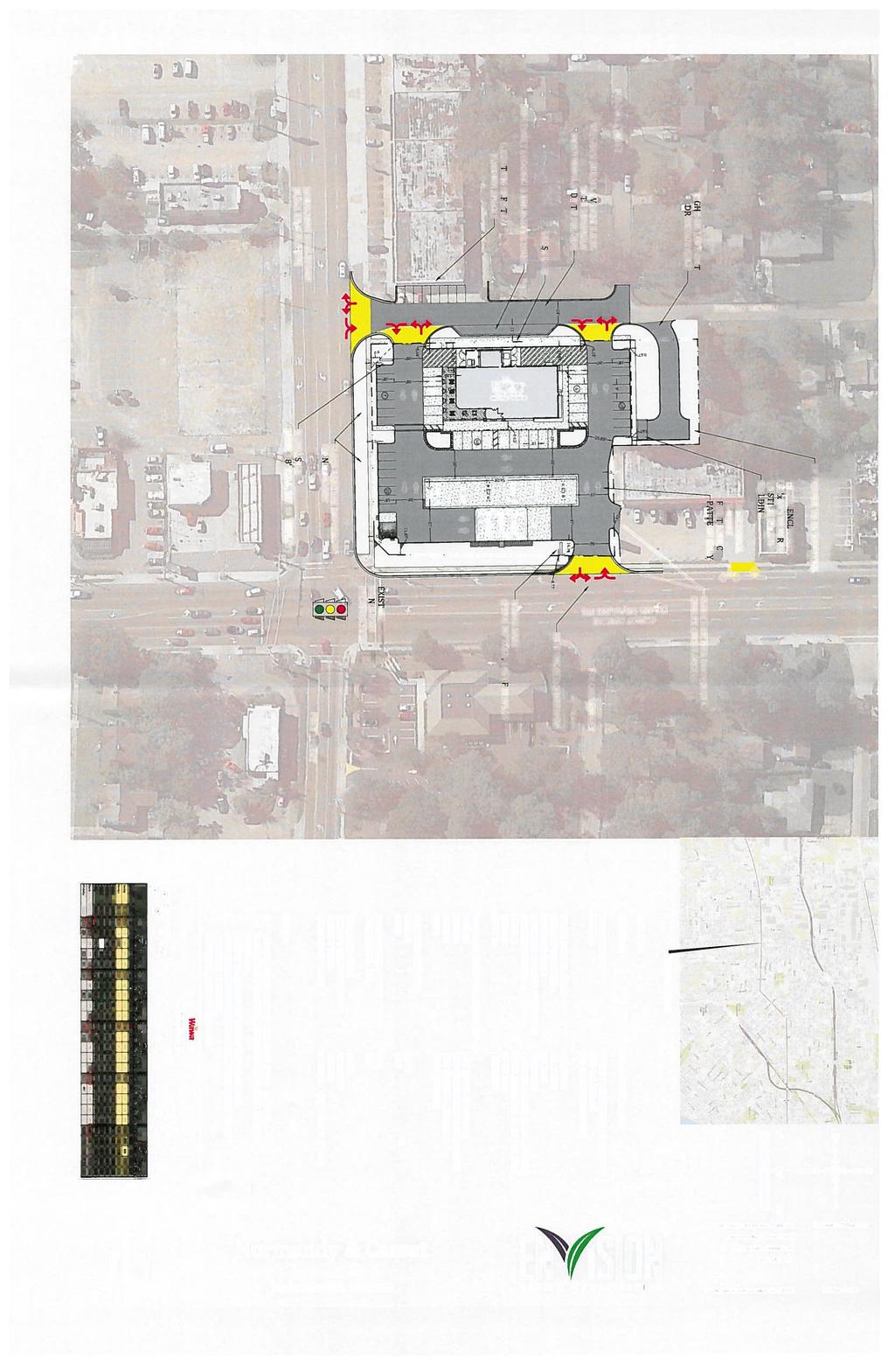
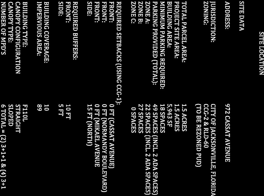
17 PUD REZONING ORDINANCE NUMBER: COMPANION LAND USE AMENDMENT NUMBER: 2017C-007 COMPANION LAND USE ORDINANCE NUMBER: SUMMARY OF PROPOSED PLANNED UNIT DEVELOPMENT (PUD) The Normandy and Cassatt PUD Application for rezoning seeks to rezone approximately 1.50 acres of land (R.E. NO(S) ; ; ; ; and ) are located in Council District 9 at 958 Cassat Avenue; 972 Cassat Avenue; 985 Mikael Avenue; 0 Normandy Avenue; and 0 Mikael Avenue between Normandy Boulevard and Lenox Avenue, from Commercial Community/General-2 (CCG-2) and Residential Low Density-60 (RLD-60) Districts to Planned Unit Development (PUD). This new PUD district shall generally permit commercial uses. The subject property is owned by Camelia J. Fouraker and Teresa J. Fischer. The applicant is Paul M. Harden, Esquire, Law Office of Paul M. Harden, 501 Riverside Avenue, Suite 901, Jacksonville, FL, 32202; (904) This PUD application is a companion to a pending application for small-scale land use amendment (2017C-007) for the northwestern portion of the property from Low Density Residential (LDR) to Community/General Commercial (CGC). Note: Please be advised that a copy of the full written description is available from the Planning and Development Department upon request or may be reviewed at the Department or in the City Council Legislative Services Division. Due to the limitations of copying larger site plans to 8½ x 11 inch size for mailing purposes, the site plans contained in the mailed notice may be difficult to read and any individuals interested in reviewing the site plan are encouraged to view the original site plan maintained by the Department.


18
19 2030 COMPREHENSIVE PLAN S RELATIONAL LISTING OF LAND USE CATEGORIES & ZONING DISTRICTS Land Use Categories Primary Zoning Districts Secondary Zoning Districts RESIDENTIAL LAND USE CATEGORIES RR (Rural Residential) LDR (Low Density Residential) MDR (Medium Density Residential) HDR (High Density Residential) RPI (Residential-Professional-Institutional) NC (Neighborhood Commercial) CGC (Community/General Commercial) RR-Acre (Residential Rural-Acre) CO (Commercial Office) RLD-120 (Residential Low Density-120) CN (Commercial Neighborhood) RLD-100A (Residential Low Density-100A) AGR (Agriculture) PBF-1 (Public Buildings and Facilities-1) PBF-2 (Public Buildings and Facilities-2) CSV (Conservation) PUD (Planned Unit Development) RR-Acre (Residential Rural-Acre) RMD-A(Residential Medium Density-A) RLD-120 (Residential Low Density-120) RMD-B(Residential Medium Density-B) RLD-100A (Residential Low Density-100A) CO (Commercial Office) RLD-100B (Residential Low Density-100B) CRO (Commercial, Residential and Office) RLD-90 (Residential Low Density-90) CN (Commercial Neighborhood) RLD-80 (Residential Low Density-80) AGR (Agriculture) RLD-70 (Residential Low Density-70) PBF-1 (Public Buildings and Facilities-1) RLD-60 (Residential Low Density-60) PBF-2 (Public Buildings and Facilities-2) RLD-50 (Residential Low Density-50) CSV (Conservation) RLD-TND (Residential Low Density-TND) PUD (Planned Unit Development) RLD-TNH (Residential Low Density-TNH) RLD-50 (Residential Low Density-50) CO (Commercial Office) RLD-60 (Residential Low Density-60) CRO (Commercial, Residential and Office) RLD-TND (Residential Low Density-TND) CN (Commercial Neighborhood) RLD-TNH (Residential Low Density-TNH) AGR (Agriculture) RMD-A (Residential Medium Density-A) PBF-1 (Public Buildings and Facilities-1) RMD-B (Residential Medium Density-B) PBF-2 (Public Buildings and Facilities-2) RMD-C (Residential Medium Density-C) CSV (Conservation) RMD-D (Residential Medium Density-D) PUD (Planned Unit Development) RMD-MH (Residential Medium Density-MH) RMD-D (Residential Medium Density-D) CO (Commercial Office) RHD-A (Residential High Density-A) CRO (Commercial, Residential and Office) RHD-B (Residential High Density-B) CN (Commercial Neighborhood) COMMERCIAL LAND USE CATEGORIES CCG-1 (Commercial Community/General-1) PBF-1 (Public Buildings and Facilities-1) PBF-2 (Public Buildings and Facilities-2) Source: Jacksonville Planning and Development Department March 2, 2012 CSV PUD (Conservation) (Planned Unit Development) RMD-D (Residential Medium Density-D) RLD-60 (Residential Low Density-60) CO (Commercial Office) RMD-A (Residential Medium Density-A) CRO (Commercial, Residential and Office) RMD-B (Residential Medium Density-B) RMD-C (Residential Medium Density-C) RMD-D (Residential Medium Density-D) RMD-MH (Residential Medium Density-MH) AGR (Agriculture) CN (Commercial Neighborhood) PBF-1 (Public Buildings and Facilities-1) PBF-2 (Public Buildings and Facilities-2) CSV (Conservation) PUD (Planned Unit Development) CO (Commercial Office) CRO (Commercial, Residential and Office) CN (Commercial Neighborhood) AGR (Agriculture) PBF-1 (Public Buildings and Facilities-1) PBF-2 (Public Buildings and Facilities-2) CSV (Conservation) PUD (Planned Unit Development) CO (Commercial Office) IBP (Industrial Business Park) CRO (Commercial, Residential and Office) AGR (Agriculture) CN (Commercial Neighborhood) PBF-1 (Public Buildings and Facilities-1) CCG-1 (Commercial Community/General-1) PBF-2 (Public Buildings and Facilities-2) CCG-2 (Commercial Community/General-2) CSV (Conservation) PBF-2 (Public Buildings and Facilities-2) ROS (Recreation and Open Space) PUD (Planned Unit Development)
20 Land Use Categories Primary Zoning Districts Secondary Zoning Districts RC (Regional Commercial) CBD (Central Business District) BP (Business Park) LI (Light Industrial) HI (Heavy Industrial) WD-WR (Water Dependent-Water Related) CSV (Conservation) AGR (Agriculture) PBF (Public Buildings and Facilities) ROS (Recreation and Open Space) COMMERCIAL LAND USE CATEGORIES (Continued) CCG-1 (Commercial Community/General-1) RHD-A (Residential High Density-A) RHD-B (Residential High Density-B) CRO (Commercial, Residential and Office) CCG-2 (Commercial Community/General-2) IBP (Industrial Business Park) PBF-1 (Public Buildings and Facilities-1) PBF-2 (Public Buildings and Facilities-2) CSV (Conservation) PUD (Planned Unit Development) RMD-D (Residential Medium Density-D) PBF-1 (Public Buildings and Facilities-1) RHD-A (Residential High Density-A) PBF-2 (Public Buildings and Facilities-2) RHD-B (Residential High Density-B) CSV (Conservation) CRO (Commercial Residential and Office) PUD (Planned Unit Development) CCG-1 (Commercial Community/General-1) CCG-2 (Commercial Community/General-2) CCBD (Commercial Central Business Dist.) IBP (Industrial Business Park) IL (Industrial Light) INDUSTRIAL LAND USE CATEGORIES IBP (Industrial Business Park) MU (Multi-Use) PUD (Planned Unit Development) RMD-D (Residential Medium Density-D) RHD-A (Residential High Density-A) AGR (Agriculture) PBF-1 (Public Buildings and Facilities-1) PBF-2 (Public Buildings and Facilities-2) CSV (Conservation) PUD (Planned Unit Development) IBP (Industrial Business Park) CCG-1 (Commercial Community/General-1) IL (Industrial Light) CCG-2 (Commercial Community/General-2) PBF-2 (Public Buildings and Facilities-2) PBF-1 (Public Buildings and Facilities-1) AGR (Agriculture) CSV (Conservation) PUD (Planned Unit Development) IBP (Industrial Business Park) CCG-1 (Commercial Community/General-1) IL (Industrial Light) CCG-2 (Commercial Community/General-2) IH (Industrial Heavy) AGR (Agriculture) PBF-1 (Public Buildings and Facilities-1) CSV (Conservation) PBF-2 (Public Buildings and Facilities-2) PUD (Planned Unit Development) IW (Industrial Water) PBF-1 (Public Buildings and Facilities-1) PBF-2 (Public Buildings and Facilities-2) AGR (Agriculture) CSV (Conservation) PUD (Planned Unit Development) OTHER LAND USES CATEGORIES CSV (Conservation) ROS (Recreation and Open Space) AGR (Agriculture) PUD (Planned Unit Development) AGR (Agriculture) PBF-1 (Public Buildings and Facilities-1) PBF-2 (Public Buildings and Facilities-2) PBF-3 (Public Buildings and Facilities-3) CSV (Conservation) PUD (Planned Unit Development) PBF-1 (Public Buildings and Facilities-1) AGR (Agriculture) PBF-2 (Public Buildings and Facilities-2) CSV (Conservation) PBF-3 (Public Buildings and Facilities-3) PUD (Planned Unit Development) ROS (Recreation and Open Space) PBF-1 (Public Buildings and Facilities-1) AGR (Agriculture) CSV (Conservation) PUD (Planned Unit Development) Definition of PUD Zoning District: A development district that may include a single or mixed use that is responsive to the needs of the inhabitants, provides flexible planning with creative and innovative design and is consistent with the Comprehensive Plan Land Use Category. Source: Jacksonville Planning and Development Department March 2, 2012
21 LEGAL ISSUES RELATED TO COMPREHENSIVE PLAN S FUTURE LAND USE MAP ( FLUM ) AMENDMENT PROCESS The following brief summary of legal issues related to FLUM amendments is provided pursuant to Section (a)(12), (13) and (14) of the Jacksonville Municipal Code: Legislative vs. Quasi-judicial Functions of Local Government. Local government boards such as the City Council have different functions. Generally, the City Council makes decisions and takes final actions which fall into two main categories - those which are legislative in nature and those which are quasi-judicial. Depending upon the nature of the decision and the type of hearing, the City Council may act in either a legislative capacity or in a quasi-judicial capacity. Future Land Use Map ( FLUM ) amendments are legislative decisions of the City Council. In contrast, when the City Council rezones property, as it often does after the FLUM is amended or as a companion to the FLUM amendment, it is almost always acting in a quasi-judicial capacity. What is the difference between a legislative decision and a quasi-judicial decision? It is the type and character of the hearing which determines whether the actions of the City Council are legislative (policy-making) or quasi-judicial (policy implementation or policy application). Legislative action results in the formulation of a general rule or policy and allows broad discretion in making the decision. Quasi-judicial action results in the implementation or application of a general rule or policy and allows less room for discretion to be exercised, since the decision must be based on competent, substantial evidence. It is important to understand the difference between these two types of decisions because, in the event a decision is challenged, the standard of review used by a court on appeal is different, depending on whether the final action is legislative or quasi-judicial in nature. The appellate review of a legislative decision such as a FLUM amendment results in a new proceeding wherein parties have the opportunity to present testimony, evidence and witnesses to a new decision-maker. The standard of review which applies to a legislative decision is the fairly debatable standard; as its name implies, this is a very deferential standard that generally operates to prevent a court from substituting its judgment for that of the City Council. The standard of review which applies to a quasi-judicial decision is much less deferential and based entirely on the record of the proceedings before the City Council. The court will look at the record to determine 3 things: (1) whether there is competent, substantial evidence to support the decision; (2) whether the City Council observed the essential requirements of law; and (3) whether procedural due process was provided. If the court finds that any one of these 3 requirements has not been met, it will remand the matter back to the City Council for further action. Criteria Upon Which FLUM Amendment is Evaluated and Council s Decision is Based. The FLUM amendment process is governed by Sections and , Florida Statutes and Chapter 650, Ordinance Code. The main criteria with respect to a proposed FLUM amendment is whether it is consistent with the Comprehensive Plan. This is not always a clear and easy determination which is based solely upon the Future Land Use Maps. In addition to reviewing the maps, City planners must review, analyze and weigh a number of different and sometimes competing Comprehensive Plan goals, objectives and policies. In its review of each application for a FLUM amendment, the Planning and Development Department and the City Council consider the following criteria: (1) The relationship of the data and information in the application to the social, economic, physical, environmental, historic and archaeological resources of the city and the projections of future growth, including an analysis of the impact of the proposed change on the amount of land required to accommodate anticipated growth and projected population; (2) The impact of the proposed amendment(s) on the public facilities and services and the Capital Improvements Element (CIE) of the comprehensive plan; (3) The relationship of the proposed amendment(s) to the applicable goals, objectives, policies, criteria and standards, including level of service standards, adopted in the comprehensive plan; (4) The relationship of the proposed amendment(s) to the existing and future land uses depicted on the FLUMs; (5) Other professional planning principles, standards, information and more detailed plans and studies considered relevant; and (6) Written comments, evidence and testimony of the public. Burden of Proof; Evidence and Testimony. The applicant for a FLUM amendment has the burden of proof to show that the amendment is consistent with the Comprehensive Plan, based upon the above criteria. Great weight is given to the recommendation of the professional planning staff, because these determinations are often made based on Comprehensive Plan data and analysis. The type of testimony and evidence that is allowable, relevant and legally sufficient must be credible, factual and relevant to the application. Evidence which is speculative or based on fears about negative future effects is not helpful. Expert opinions and/or testimony, such as from appraisers or planners, although not required, may be very helpful in certain instances. If appealed, the City Council s decision on a FLUM amendment is presumed to be correct and will be sustained as long as it is fairly debatable, unless it is shown by a preponderance of the evidence that the amendment is not in compliance with Chapter 163, Part II, Florida Statutes. NOTE: Matters involving land use decisions are dependent on the facts and circumstances of each case. Citizens with specific questions about what is or is not adequate testimony should consult an attorney.
22 LEGAL ISSUES RELATED TO REZONING APPLICATIONS The following brief summary of legal issues related to rezoning applications is provided pursuant to Section (11), (12) and (13) of the Zoning Code: Legislative vs. Quasi-judicial Functions of Local Government. Local government boards such as the City Council have different functions. Generally, the City Council makes decisions and takes final actions which fall into two main categories - those which are legislative in nature and those which are quasi-judicial. Depending upon the nature of the decision and the type of hearing, the City Council may act in either a legislative capacity or in a quasi-judicial capacity. Future Land Use Map ( FLUM ) amendments are legislative decisions of the City Council. In contrast, when the City Council rezones property, as it often does after the FLUM is amended or as a companion to the FLUM amendment, it is almost always acting in a quasi-judicial capacity. What is the difference between a legislative decision and a quasi-judicial decision? It is the type and character of the hearing which determines whether the actions of the City Council are legislative (policy-making) or quasi-judicial (policy implementation or policy application). Legislative action results in the formulation of a general rule or policy and allows broad discretion in making the decision. Quasi-judicial action results in the implementation or application of a general rule or policy and allows less room for discretion to be exercised, since the decision must be based on competent, substantial evidence. It is important to understand the difference between these two types of decisions because, in the event a decision is challenged, the standard of review used by a court on appeal is different, depending on whether the final action is legislative or quasi-judicial in nature. The appellate review of a legislative decision such as a FLUM amendment results in a new proceeding wherein parties have the opportunity to present testimony, evidence and witnesses to a new decision-maker. The standard of review which applies to a legislative decision is the fairly debatable standard; as its name implies, this is a very deferential standard which generally operates to prevent a court from substituting its judgment for that of the City Council. The standard of review which applies to a quasi-judicial decision is much less deferential and based entirely on the record of the proceedings before the City Council. The court will look at the record to determine 3 things: (1) whether there is competent, substantial evidence to support the decision; (2) whether the City Council observed the essential requirements of law; and (3) whether procedural due process was provided. If the court finds that any one of these 3 requirements has not been met, it will remand the matter back to the City Council for further action. Criteria Upon Which Rezoning Application is Evaluated and Council s Decision to Rezone is Based; Burden of Proof. An applicant for a proposed rezoning has the initial burden of proof to show, by competent, substantial evidence, that the rezoning is consistent with the Comprehensive Plan. In order to successfully meet this burden, the applicant must demonstrate not only that the proposed rezoning is consistent with the FLUM, but also that it furthers the goals, objectives and policies of the Comprehensive Plan and that it is not in conflict with the City s Land Use Regulations. If the applicant demonstrates that the proposed rezoning is consistent with the Comprehensive Plan and there is no competent, substantial evidence, such as a Planning and Development Department finding to the contrary, the burden of proof then shifts to the City Council to demonstrate that maintaining the existing land use classification accomplishes a legitimate public purpose. This can be accomplished only if testimony and/or evidence is provided at a public hearing or submitted to the City councilmembers for their review prior to public hearings, with a copy also provided to the City Council Legislative Services Division for the official file. Section (c) of the Zoning Code provides that a legitimate public purpose may be one or more of the following, or such other criteria as may be determined by law from time to time: (1) The proposed rezoning and the development permitted there under is premature or otherwise creates or contributes to an urban sprawl pattern of development; (2) The proposed rezoning will constitute spot zoning, that is, an isolated zoning district unrelated to adjacent and nearby districts; (3) Uses permitted under the proposed rezoning will not be consistent or compatible with the existing and proposed land uses and zoning of adjacent and nearby properties or the general area or will deviate from an established or developing logical and orderly development pattern; (4) The proposed rezoning and the development permitted there under will result in significant adverse impacts upon property values of the adjacent or nearby properties or in the general area more than the types of uses currently permitted; (5) The proposed rezoning and the development permitted there under will detract from the character and quality of life in the general area or neighborhood by creating excessive traffic, noise, lights, vibration, fumes, odors, dust, physical activities and other detrimental effects or nuisances. If competent, substantial evidence is provided to show that one or more of the above criteria have been met in order to demonstrate that there is a legitimate public purpose in maintaining the existing zoning classification, then the City Council has a legal basis upon which to deny the rezoning. It is possible that there may be competing evidence, some or all of which is competent and substantial, which would be adequate to support a Council decision either way. Evidence and Testimony. Rezonings are quasi-judicial decisions that must be supported by fact-based testimony and evidence. In order to support a quasijudicial decision, this fact-based testimony and evidence must be competent and substantial. Although the question of whether evidence is competent and substantial is a legal question, it is helpful to consider the following examples, all of which are taken from Florida case law: Acceptable Citizen Testimony Citizens with first-hand knowledge of the vicinity qualified as expert witnesses as to the issue of natural beauty and recreational advantages of area. Citizens may testify how conditions in a neighborhood have changed over time, if they have witnessed those changes. Citizens may testify as to the location and density of nearby developments. Citizens may testify concerning noise, vibrations and other nuisances which they have personally observed. Unacceptable Citizen Testimony: Citizens are not qualified to testify about traffic, light or noise problems that might occur. Citizens are not qualified to testify about the relationship of a proposed project to the surrounding neighborhood. Citizens are not qualified to testify about declining property values unless they have real estate or property appraisal-related experience. Expressions of mass opinion in opposition to an application are not substantial, competent evidence. The fact that there may be a large number of objectors to the approval of an application is not a sound basis for denial, no matter how strenuous the objections. Expert Testimony: Expert testimony is considered to be substantial, competent evidence as long as the expert gives testimony within his area of expertise and
Notice of Public Hearings for Proposed Land Use Change and Rezoning
 Planning and Development Department Community Planning Division 214 North Hogan Street Ed Ball Building, Suite 300 Jacksonville, Florida 32202 Council Legislative Services Division Jacksonville City Council
See reverse side for additional information
 Planning and Development Department Community Planning Division 214 North Hogan Street Ed Ball Building, Suite 300 Jacksonville, Florida 32202 Council Legislative Services Division Jacksonville City Council
Notice of Public Hearings for Proposed Land Use Change
 Planning and Development Department Community Planning Division 214 North Hogan Street Ed Ball Building, Suite 300 Jacksonville, Florida 32202 Council Legislative Services Division Jacksonville City Council
Notice of Public Hearings for Proposed Land Use Change
 Planning and Development Department Community Planning Division 214 North Hogan Street Ed Ball Building, Suite 300 Jacksonville, Florida 32202 Council Legislative Services Division Jacksonville City Council
Revised Notice of Public Hearings for Proposed Land Use Change
 ** REVISED NOTICE - CHANGE OF CIM MEETING DATE and LOCATION ** Planning and Development Department Community Planning Division 214 North Hogan Street Ed Ball Building, Suite 300 Jacksonville, Florida 32202
Notice of Public Hearings for Proposed Land Use Change
 Planning and Development Department Community Planning Division 214 North Hogan Street Ed Ball Building, Suite 300 Jacksonville, Florida 32202 Council Legislative Services Division Jacksonville City Council
Notice of Public Hearings for Proposed Land Use Change
 Planning and Development Department Community Planning Division 214 North Hogan Street Ed Ball Building, Suite 300 Jacksonville, Florida 32202 Council Legislative Services Division Jacksonville City Council
Notice of Public Hearings for Proposed Land Use Change
 Planning and Development Department Community Planning Division 214 North Hogan Street Ed Ball Building, Suite 300 Jacksonville, Florida 32202 Council Legislative Services Division Jacksonville City Council
Notice of Public Hearings for Proposed Land Use Change
 Planning and Development Department Community Planning Division 214 North Hogan Street Ed Ball Building, Suite 300 Jacksonville, Florida 32202 Council Legislative Services Division Jacksonville City Council
Notice of Public Hearings for Proposed Land Use Change
 Planning and Development Department Community Planning Division 214 North Hogan Street Ed Ball Building, Suite 300 Jacksonville, Florida 32202 Council Legislative Services Division Jacksonville City Council
Notice of Public Hearings for Proposed Land Use Change and Rezoning
 Planning and Development Department Community Planning Division 214 North Hogan Street Ed Ball Building, Suite 300 Jacksonville, Florida 32202 Council Legislative Services Division Jacksonville City Council
Notice of Public Hearings for Proposed Land Use Change
 Planning and Development Department Community Planning Division 214 North Hogan Street Ed Ball Building, Suite 300 Jacksonville, Florida 32202 Council Legislative Services Division Jacksonville City Council
Notice of Public Hearings for Proposed Land Use Change
 Planning and Development Department Community Planning Division 214 North Hogan Street Ed Ball Building, Suite 300 Jacksonville, Florida 32202 Council Legislative Services Division Jacksonville City Council
Notice of Public Hearings for Proposed Land Use Change
 Planning and Development Department Community Planning Division 214 North Hogan Street Ed Ball Building, Suite 300 Jacksonville, Florida 32202 Council Legislative Services Division Jacksonville City Council
Notice of Public Hearings for Proposed Land Use Change
 Planning and Development Department Community Planning Division 214 North Hogan Street Ed Ball Building, Suite 300 Jacksonville, Florida 32202 Council Legislative Services Division Jacksonville City Council
Notice of Public Hearings for Proposed Land Use Change
 Planning and Development Department Community Planning Division 214 North Hogan Street Ed Ball Building, Suite 300 Jacksonville, Florida 32202 Council Legislative Services Division Jacksonville City Council
Notice of Public Hearings for Proposed Land Use Change
 Planning and Development Department Community Planning Division 214 North Hogan Street Ed Ball Building, Suite 300 Jacksonville, Florida 32202 Council Legislative Services Division Jacksonville City Council
Notice of Public Hearings for Proposed Land Use Change
 Planning and Development Department Community Planning Division 214 North Hogan Street Ed Ball Building, Suite 300 Jacksonville, Florida 32202 Council Legislative Services Division Jacksonville City Council
Notice of Public Hearings for Proposed Land Use Change
 Planning and Development Department Community Planning Division 214 North Hogan Street Ed Ball Building, Suite 300 Jacksonville, Florida 32202 Council Legislative Services Division Jacksonville City Council
Income Producing Flex Warehouse
 Income Producing Flex Warehouse 6,250± SF AVAILABLE Property Features > > Flex warehouse space totaling 6,250± SF > > Total of 5 Bay Windows: 4 with 1,041± SF 1 with 810± SF > >.89± acres zoned CCG-2 >
Notice of Public Hearings for Proposed Land Use Change
 Planning and Development Department Community Planning Division 214 North Hogan Street Ed Ball Building, Suite 300 Jacksonville, Florida 32202 Council Legislative Services Division Jacksonville City Council
**REVISED Notice of Public Hearings for Proposed Land
 Planning and Development Department Community Planning Division 214 North Hogan Street Ed Ball Building, Suite 300 Jacksonville, Florida 32202 Council Legislative Services Division Jacksonville City Council
Notice of Public Hearings for Proposed Land Use Change
 Planning and Development Department Community Planning Division 214 North Hogan Street Ed Ball Building, Suite 300 Jacksonville, Florida 32202 Council Legislative Services Division Jacksonville City Council
Notice of Public Hearings for Proposed Land Use Change
 Planning and Development Department Community Planning Division 214 North Hogan Street Ed Ball Building, Suite 300 Jacksonville, Florida 32202 Council Legislative Services Division Jacksonville City Council
Notice of Public Hearings for Proposed Land Use Change
 Planning and Development Department Community Planning Division 214 North Hogan Street Ed Ball Building, Suite 300 Jacksonville, Florida 32202 Council Legislative Services Division Jacksonville City Council
Notice of Public Hearings for Proposed Land Use Change
 Planning and Development Department Community Planning Division 214 North Hogan Street Ed Ball Building, Suite 300 Jacksonville, Florida 32202 Council Legislative Services Division Jacksonville City Council
REPORT OF THE PLANNING AND DEVELOPMENT DEPARTMENT FOR APPLICATION FOR REZONING ORDINANCE TO PLANNED UNIT DEVELOPMENT AUGUST 20, 2015
 BEL REPORT OF THE PLANNING AND DEVELOPMENT DEPARTMENT FOR APPLICATION FOR REZONING ORDINANCE TO PLANNED UNIT DEVELOPMENT AUGUST 20, 2015 The Planning and Development Department hereby forwards to the Planning
ORDINANCE NUMBER 2015-
 1 1 1 1 1 1 1 1 0 0 1 ORDINANCE NUMBER 01- AN ORDINANCE OF ESCAMBIA COUNTY, FLORIDA, AMENDING PART III OF THE ESCAMBIA COUNTY CODE OF ORDINANCES, THE LAND DEVELOPMENT CODE OF ESCAMBIA COUNTY, FLORIDA;
CHAPTER COMMERCIAL ZONING DISTRICTS
 CHAPTER 27.10 - COMMERCIAL ZONING DISTRICTS 27.10.010 - Purpose of Chapter This Chapter lists the land uses that may be allowed within the commercial zoning districts established by Section 27.04.020 (Zoning
REPORT OF THE PLANNING AND DEVELOPMENT DEPARTMENT FOR APPLICATION FOR REZONING ORDINANCE TO PLANNED UNIT DEVELOPMENT SEPTEMBER 22, 2016
 BEL REPORT OF THE PLANNING AND DEVELOPMENT DEPARTMENT FOR APPLICATION FOR REZONING ORDINANCE 2016-576 TO PLANNED UNIT DEVELOPMENT SEPTEMBER 22, 2016 The Planning and Development Department hereby forwards
Application For Rezoning To Conventional Zoning District
 Application For Rezoning To Conventional Zoning District Print http://maps.coj.net/luzap/appconvprint.aspx Page 1 of 3 1/28/216 Application For Rezoning To Conventional Zoning District Planning and Development
EXHIBIT D North Main Street PUD Amended Written Description July 19, 2016
 EXHIBIT D 1636 North Main Street PUD Amended Written Description July 19, 2016 I. PROJECT DESCRIPTION Applicant proposes to rezone approximately.11 acres of property from CCG-S to PUD. The parcel is located
JACKSONVILLE O U T P A R C E I - 10
 JACKSONVILLE +/- 39,433 SF of Land Located in one of the USA s fastest growing cities Prime Location in Jacksonville, Florida OFFERING MEMORANDUM TABLE OF CONTENTS OFFERING OVERVIEW 3 PROPERTY OVERVIEW
REPORT OF THE PLANNING AND DEVELOPMENT DEPARTMENT FOR APPLICATION FOR REZONING ORDINANCE TO PLANNED UNIT DEVELOPMENT MAY 18, 2017
 BEL REPORT OF THE PLANNING AND DEVELOPMENT DEPARTMENT FOR APPLICATION FOR REZONING ORDINANCE 2016-805 TO PLANNED UNIT DEVELOPMENT MAY 18, 2017 The Planning and Development Department hereby forwards to
REPORT OF THE PLANNING AND DEVELOPMENT DEPARTMENT FOR APPLICATION FOR REZONING ORDINANCE TO PLANNED UNIT DEVELOPMENT MAY 8, 2014
 BEL REPORT OF THE PLANNING AND DEVELOPMENT DEPARTMENT FOR APPLICATION FOR REZONING ORDINANCE TO PLANNED UNIT DEVELOPMENT MAY 8, 2014 The Planning and Development Department hereby forwards to the Planning
REPORT OF THE PLANNING AND DEVELOPMENT DEPARTMENT FOR APPLICATION FOR REZONING ORDINANCE TO PLANNED UNIT DEVELOPMENT APRIL 21, 2016
 BEL REPORT OF THE PLANNING AND DEVELOPMENT DEPARTMENT FOR APPLICATION FOR REZONING ORDINANCE TO PLANNED UNIT DEVELOPMENT APRIL 21, 2016 The Planning and Development Department hereby forwards to the Planning
301. Zoning Districts. C-D A-1 R-1 R-V B-1 I-1
 301. Zoning Districts. The Township is divided into the districts set forth by this chapter and as shown by the district boundaries on the Official Zoning District Map. The zoning districts are: C-D Conservation
Residential-1 District
 Residential-1 District City of Barnum, Minnesota Zoning District Information Sheet It is the purpose of the R-1 District to encourage the establishment and the preservation of residential neighborhoods
2.110 COMMERICAL MIXED USE (CM)
") CITY OF KEIZER DEVELOPMENT BULLETIN 2.110.01 Purpose 2.110 COMMERICAL MIXED USE (CM) The Commercial Mixed Use (CM) zone is the primary commercial zone within the City. The zone is specifically designed
CITY OF KEIZER DEVELOPMENT BULLETIN 2.110.01 Purpose 2.110 COMMERICAL MIXED USE (CM) The Commercial Mixed Use (CM) zone is the primary commercial zone within the City. The zone is specifically designed
AGENDA. a. Carol Crews Special Exception Hair Salon (Continued from February) b. James Barber Special Exception Horse
 b. James Barber Special Exception Horse") Baker County Land Planning Agency (LPA) Thursday, April 23, 2015 Baker County Administration Building 55 North Third Street Macclenny, FL 32063 (904) 259-3354 AGENDA 5:OO P.M. LDR Mining Workshop A. Draft
Baker County Land Planning Agency (LPA) Thursday, April 23, 2015 Baker County Administration Building 55 North Third Street Macclenny, FL 32063 (904) 259-3354 AGENDA 5:OO P.M. LDR Mining Workshop A. Draft
Suburban Commercial Center ( CE-S ) Permitted Principal Uses and Structures
 Permitted Principal Uses and Structures") Division 12. Suburban Commercial Center ( CE-S ) 2.9.1 Purpose Suburban commercial centers provide regional commercial destinations with design and site elements compatible with suburban character. Dimensional
Division 12. Suburban Commercial Center ( CE-S ) 2.9.1 Purpose Suburban commercial centers provide regional commercial destinations with design and site elements compatible with suburban character. Dimensional
Commercial Zoning Districts
 Article 4 Commercial Zoning Districts Section 4.1 Section 4.2 Section 4.3 C-D Downtown Commercial District C-1 General Commercial District C-2 Heavy Service Commercial District 4.1 C-D, Downtown Commercial
Glades County Staff Report and Recommendation REZONING
 Glades County Staff Report and Recommendation REZONING CASE NUMBER: RZ15-01 DATE: October 2, 2015 CASE TYPE: Application for Rezoning REQUEST: J.J. Wiggins Memorial Trust is requesting a rezoning of 22.1±
Part 4, C-D Conservation District
 The Township is divided into the districts set forth by this chapter and as shown by the district boundaries on the Official Zoning District Map. The zoning districts are: C-D Conservation District A-1
THE CITY OF RAYMORE, MISSOURI Single-Family Residential Zoning Districts
 THE CITY OF RAYMORE, MISSOURI Single-Family Residential Zoning Districts REGULATIONS COMMON TO ALL DISTRICTS: Uses permitted in each district include detached single-family dwellings, manufactured homes
Commercial and Manufacturing Districts TABLE ALLOWED USES AND PERMIT REQUIREMENTS FOR COMMERCIAL AND MANUFACTURING DISTRICTS
 TRUCKEE MUNICIAL CODE - TITLE 18, DEVELOMENT CODE TABLE 2-6 - ALLOWED USES AND ERMIT REQUIREMENTS FOR COMMERCIAL AND MANUFACTURING DISTRICTS ERMIT REQUIREMENT BY DISTRICT LAND USE (1) CN (2) CG CH CS M
Road frontage 287 Sewer and Well Propane Central Air
 FOR SALE/LEASE FOR SALE $149,900 FOR LEASE $13.75/sf Modified Net 1027 Voluntown Rd., Griswold 1,440sf+/- commercial bldg. with full basement (total 2,880sf) 0.96 acre Zone C-1 15 parking spaces John Jensen,
The intent of Business District B 1 is to provide an area for local and neighborhood shopping where
 CODE OF THE COUNTY DIVISION 9. BUSINESS DISTRICT B 1 Botetourt County, Virginia, Code of Ordinances Page 71 DIVISION 9. BUSINESS DISTRICT B 1 Sec. 25 221. Purpose. Sec. 25 222. Permitted uses. Sec. 25
ARTICLE 383. PD 383.
 ARTICLE 383. PD 383. SEC. 51P-383.101. LEGISLATIVE HISTORY. PD 383 was established by Ordinance No. 21928, passed by the Dallas City Council on December 8, 1993. Ordinance No. 21928 amended Ordinance No.
Chapter CN NEIGHBORHOOD CENTER COMMERCIAL ZONES REGULATIONS
 Chapter 17.33 - CN NEIGHBORHOOD CENTER COMMERCIAL ZONES REGULATIONS Sections: 17.33.010 - Title, intent, and description. 17.33.020 - Required design review process. 17.33.030 - Permitted and conditionally
FOR SALE COMMERCIAL BEACHSIDE LOT
 FOR SALE COMMERCIAL BEACHSIDE LOT 1100 South Patrick Dr., Satellite Beach, Florida 32937.69 Acres, Zoning C-Commercial Lot is Cleared Numerous Allowable Intended Uses (see zoning on next page) High Visibility
City of Valdosta Land Development Regulations
 Chapter 206 Section 206-1 Base Zoning Districts Standards for Uses, Structures, and Property Development (B) (C) Principal Uses and Structures. Principal uses and structures permitted in each base zoning
REPORT OF THE PLANNING AND DEVELOPMENT DEPARTMENT FOR APPLICATION FOR REZONING ORDINANCE TO PLANNED UNIT DEVELOPMENT SEPTEMBER 3, 2015
 AAG REPORT OF THE PLANNING AND DEVELOPMENT DEPARTMENT FOR APPLICATION FOR REZONING ORDINANCE TO PLANNED UNIT DEVELOPMENT SEPTEMBER 3, 2015 The Planning and Development Department hereby forwards to the
2. Second dwellings and medical hardships per Article 10.
 Article 7: Zoning Districts and Zoning Map Section 135: NON-URBAN ZONING DISTRICT (NU) A. Purpose The intent of this district is to allow agricultural, recreational, wildlife, forestry, open space, farming
Farming & Livestock related activities Y Y Y Y Y Y. Commercial Type Animal Facility Y Y Y
 ( = Permitted) TABLE A PERMITTED USES B DISTRICT MU MU2 CC MH/ RV Agricultural Uses (Light) Agricultural Uses (Heavy) Residential Uses Recreational and Institutional Uses RM R C LI MI HI A Farming & Livestock
Chapter CC COMMUNITY COMMERCIAL ZONES REGULATIONS
 Effective April 14, 2011 Chapter 17.35 CC COMMUNITY COMMERCIAL ZONES REGULATIONS SECTIONS: 17.35.010 Title, Intent, and Description 17.35.020 Required Design Review Process 17.35.030 Permitted and Conditionally
For the purpose of this Zoning Ordinance, the Village is hereby divided into five classes of zoning districts known as:
 Chapter 3 District Regulations SECTION 301. VILLAGE ZONING DISTRICTS. For the purpose of this Zoning Ordinance, the Village is hereby divided into five classes of zoning districts known as: R-1 Low-Density
Glades County Staff Report and Recommendation Unified Staff Report for Small Scale Plan Amendment and Rezoning
 Glades County Staff Report and Recommendation Unified Staff Report for Small Scale Plan Amendment and Rezoning CASE NUMBERS: COMP17-02 and RZ17-02 DATE of STAFF REPORT: May 1, 2017 CASE TYPE: Application
4.2 RESIDENTIAL ZONING DISTRICTS
 4.2 RESIDENTIAL ZONING DISTRICTS A. Purpose: To define regulations and standards for each residential zoning district in the City. The following sections identify uses, regulations, and performance standards
Sec HC - Highway commercial district.
 Sec. 36-422. - HC - Highway commercial district. (1) Purpose. This district is intended for commercial uses which depend upon high visibility, generate high traffic volumes, or cater to the traveling public.
City Of Jacksonville, Florida Planning Commission. March 28, :00pm
 City Of Jacksonville, Florida Planning Commission March 28, 2013 1:00pm Planning Commission March 28, 2013 1:00 PM City Council Chambers,1 st Floor, City Hall @ St. James, 117 West Duval Street, Jacksonville,
REPORT OF THE PLANNING AND DEVELOPMENT DEPARTMENT FOR APPLICATION FOR REZONING ORDINANCE TO PLANNED UNIT DEVELOPMENT JANUARY 8, 2015
 214-49 BEL REPORT OF THE PLANNING AND DEVELOPMENT DEPARTMENT FOR APPLICATION FOR REZONING ORDINANCE 214-49 TO PLANNED UNIT DEVELOPMENT JANUARY 8, 215 The Planning and Development Department hereby forwards
CCC XXX Rural Neighborhood Conservation (NC)
") CCC 33.10.XXX Rural Neighborhood Conservation (NC) Purpose: Maintain low density rural residential areas and associated uses commonly found in rural areas consistent with the local character of the distinctive
CCC 33.10.XXX Rural Neighborhood Conservation (NC) Purpose: Maintain low density rural residential areas and associated uses commonly found in rural areas consistent with the local character of the distinctive
GC General Commercial District
 Section 712. GC General Commercial District 712.1 Intent of District. It is the intent of this section that the GC Zoning District be developed and reserved for general business purposes. The regulations
The following uses may be allowed in the CL zone with administrative approval, subject to section of this ordinance:
 Sec. 4-100 - CL/Commercial low zone. 4-101 - Purpose. The CL zone is intended to provide for small scale retail and service uses offering pedestrian oriented shopping and services for individual consumers
Subchapter 5 Zoning Districts and Limitations
 Subchapter 5 Zoning Districts and Limitations 35.5.1 Rural Districts Sections: 35.5.1.1 Purpose. 35.5.1.2 Permitted Uses. 35.5.1.3 General Regulations. 35.5.1.1 Purpose. The purpose of a Rural District
3.92 Acres Chesterfield County, VA
 3.92 Acres Chesterfield County, VA ASKING PRICE - $154,500 Represented By: William G. Grant ALC. VLS (804) 754-3476 JEFFREY S. HUFF ALC, FORESTER (804) 750-1207 Table of Contents I. Property Description
Sec Tier 2 principal uses and structures. The principal uses of land and structures allowed in Tier 2 are provided below subject to the
 Sec. 27-730.4.9. Tier 2 principal uses and structures. The principal uses of land and structures allowed in Tier 2 are provided below subject to the standards and limitations contained within this division.
TABLE OF CONTENTS. Article / Section. Article 1 Administration and Enforcement
 TABLE OF CONTENTS Preamble How To Use This Ordinance Article / Section Page Article 1 Administration and Enforcement... 1-1 Sec. 1.01 Short Title... 1-1 Sec. 1.02 Intent... 1-1 Sec. 1.03 Scope... 1-1 Sec.
THIRD EDITION REVISED
 ZONING ORDINANCE CHAPTER 64 CITY OF ST. PETERSBURG, FLORIDA Adopted by City Council on August 25, 1977 THIRD EDITION REVISED Contains all amendments adopted by City Council between date of the First Edition,
Exhibit THIRD AMENDED PUD WRITTEN DESCRIPTION. Willens Claire Lane PUD
 Exhibit D THIRD AMENDED PUD WRITTEN DESCRIPTION Willens Claire Lane PUD Date: May 7, 14 Current Zoning District: PUD Current Land Use Designation: RPI Proposed Zoning District: PUD RE #: 166- I. PROJECT
TC- Districts TC-1 TC-2 Standards Key: = Permitted = Subject to Special Use Review RESIDENTIAL USES Single-family detached, semi-detached or endrow,
 Sec. 8-3216. Traditional Commercial Districts (TC-). (1) Purpose. (a) Traditional Commercial Neighborhood (TC-1). The TC-1 District is intended to ensure the vibrancy of historic mixed use neighborhoods
ARTICLE IV DISTRICT REGULATIONS
 PART 1. RESIDENTIAL DISTRICTS 4-101. RS. Single-Family Residential Suburban District. The RS District is designed for single-family dwellings, and compatible uses, at a density no greater than one dwelling
ORDINANCE NO. 7,394 N.S.
 ORDINANCE NO. 7,394 N.S. ZONING ORDINANCE AMENDMENT TO TITLE 23 OF THE BERKELEY MUNICIPAL CODE TO AMEND THE EXISTING REQUIREMENTS FOR OFFICE USES IN THE TELEGRAPH AVENUE COMMERCIAL (C-T) DISTRICT BE IT
Day care centers: Such uses shall require a Special Permit under the terms of Article VIII of this chapter.
 Page 1 of 12 DIVISION 1. - R-1 RESIDENTIAL ZONE Sec. 38-41. - Permitted uses. Single-family dwellings, excluding factory manufactured homes constructed as a single selfcontained unit and mounted on a single
Public Review Draft. Fortuna Municipal Code. Title 17: Zoning Regulations. Fortuna Planning Commission Review Copy. June 28, 2011
 Public Review Draft Fortuna Municipal Code Title 17: Zoning Regulations Fortuna Planning Commission Review Copy June 28, 2011 This document is subject to revision and updating. Key to Text Color Code Original
SECTION 838 "C-6" - GENERAL COMMERCIAL DISTRICT
 SECTION 838 "C-6" - GENERAL COMMERCIAL DISTRICT The "C-6" District is intended to serve as sites for the many uses in the commercial classifications which do not belong in either the Neighborhood, Community
WHEREAS, currently the R-2 zoning district does not have a minimum required density; and
 ORDINANCE NO. 1130 AN ORDINANCE OF THE CITY COUNCIL OF THE CITY OF GIG HARBOR, WASHINGTON, RELATING TO LAND USE AND ZONING, ADDING TRIPLEXES AND FOURPLEXES AS CONDITIONAL USES IN THE R-2 ZONING DISTRICT;
DEVELOPMENT STANDARDS
 Chapter 5 DEVELOPMENT STANDARDS 501 Residential Development Standards 502 Neighborhood Commercial Standards 503 Mixed Use Standards 504 Industrial Development Standards 505 Public Use Standards 506 Open
ZONING ORDINANCE FOR THE CITY OF RICHLAND CENTER CHAPTER 408 SPECIFIC REGULATIONS AFFECTING LANDS IN A "C-DT" CENTRAL [DOWNTOWN] BUSINESS DISTRICT
![ZONING ORDINANCE FOR THE CITY OF RICHLAND CENTER CHAPTER 408 SPECIFIC REGULATIONS AFFECTING LANDS IN A C-DT CENTRAL [DOWNTOWN] BUSINESS DISTRICT](/thumbs/96/126607517.jpg "ZONING ORDINANCE FOR THE CITY OF RICHLAND CENTER CHAPTER 408 SPECIFIC REGULATIONS AFFECTING LANDS IN A C-DT CENTRAL [DOWNTOWN] BUSINESS DISTRICT") ZONING ORDINANCE FOR THE CITY OF RICHLAND CENTER CHAPTER SPECIFIC REGULATIONS AFFECTING LANDS IN A "C-DT" CENTRAL [DOWNTOWN] BUSINESS DISTRICT.01 APPLICABILITY OF CHAPTER 400 TO A "C-DT" CENTRAL BUSINESS
ZONING ORDINANCE FOR THE CITY OF RICHLAND CENTER CHAPTER SPECIFIC REGULATIONS AFFECTING LANDS IN A "C-DT" CENTRAL [DOWNTOWN] BUSINESS DISTRICT.01 APPLICABILITY OF CHAPTER 400 TO A "C-DT" CENTRAL BUSINESS
Chapter MIXED USE ZONING DISTRICTS
 Page 1 of 12 Page 1/12 Chapter 17.18 MIXED USE ZONING DISTRICTS Sections: 17.18.010 Purposes. 17.18.020 Permitted, conditional and prohibited uses. 17.18.030 Bulk, 17.18.010 Purposes. A. Mixed Use Districts.
ARTICLE C. ZONING TEXT, DISTRICT CLASSIFICATIONS AND BOUNDARIES
 ARTICLE C. ZONING TEXT, DISTRICT CLASSIFICATIONS AND BOUNDARIES Sec. 10-2054. ZONING TEXT, DISTRICT CLASSIFICATIONS AND BOUNDARIES. In order to regulate the location of structures, the height and bulk
ARTICLE 598. PD 598.
 ARTICLE 598. PD 598. SEC. 51P-598.101. LEGISLATIVE HISTORY. PD 598 was established by Ordinance No. 24683, passed by the Dallas City Council on August 8, 2001, and was amended on the same day by Ordinance
Pleasant Hill, IA Code of Ordinances
 Print Pleasant Hill, IA Code of Ordinances 167.08 C 1 NEIGHBORHOOD/LOCAL COMMERCIAL DISTRICT. 1. Statement of Intent. The C 1 District is intended to provide for the orderly development of central shopping
Part 10 Mixed Use/Commercial Zones (Sections )
") Part 10 Mixed Use/Commercial Zones (Sections 185-198) This part comprises the zones that are applied to the urban and suburban areas of the City in accordance with the mixed-use and commercial land use
Part 10 Mixed Use/Commercial Zones (Sections 185-198) This part comprises the zones that are applied to the urban and suburban areas of the City in accordance with the mixed-use and commercial land use
ZONING. 145 Attachment 1
 ZOIG 145 Attachment 1 Town of Belchertown Schedule of Use Regulations [Amended 3-20-1995 STM by Art. 15; 3-3-1997 STM by Art. 25; 11-17-1997 STM by Art. 19; 11-17-1997 STM by Art. 21; 3-16-1998 STM by
ARTICLE 3: Zone Districts
 ARTICLE 3: Zone Districts... 3-1 17.3.1: General...3-1 17.3.1.1: Purpose and Intent... 3-1 17.3.2: Districts and Maps...3-1 17.3.2.1: Applicability... 3-1 17.3.2.2: Creation of Districts... 3-1 17.3.2.3:
DIVISION 1 PURPOSE OF DISTRICTS
 ARTICLE 2 ZONING DISTRICTS AND MAP DIVISION 1 PURPOSE OF DISTRICTS Section 2.101 Zoning Districts. For the purpose of this Ordinance, the City of Richmond is hereby divided into districts as follows: DISTRICT
Attachment 5 - Ordinance 3154 Exhibit D (Revised for 9/15 Council Meeting) Page 1 of 7 Port Townsend Municipal Code. Chapter 17.18
 Page 1 of 7 Port Townsend Municipal Code. Chapter 17.18") Page 1 of 7 Page 1/7 Chapter 17.18 MIXED USE ZONING DISTRICTS Sections: 17.18.010 Purposes. 17.18.020 Permitted, conditional and prohibited uses. 17.18.030 Bulk, 17.18.010 Purposes. A. Mixed Use Districts.
Page 1 of 7 Page 1/7 Chapter 17.18 MIXED USE ZONING DISTRICTS Sections: 17.18.010 Purposes. 17.18.020 Permitted, conditional and prohibited uses. 17.18.030 Bulk, 17.18.010 Purposes. A. Mixed Use Districts.
East Side Community Meeting
 East Side Community Meeting November 29, 2017 Pam Thompson, Senior Planner Sustainable Development and Construction City of Dallas Authorized Hearing Process City Plan Commission authorized a hearing to
5 ft. When adjacent to MF 9 and MF 18: 20 ft. MAXIMUM SETBACKS Frontage Ground Floor Above Ground Floor State Road 7 30 ft. N/A MINIMUM ACTIVE USES
 7 8 9 0 7 8 9 0 (ii) C MU Central Mixed Use District Development Regulations Table. C MU SR7 Central Mixed Use District Development Regulations MAXIMUM DENSITY Vertical Mixed Use Building Bonus Dwelling
SECTION CLASSIFICATION OF ZONES For the purpose of this Code the following primary land use zoning districts are hereby established:
 ARTICLE 4 ZONING DISTRICTS SECTION 4.010 CLASSIFICATION OF ZONES For the purpose of this Code the following primary land use zoning districts are hereby established: Primary Zones Abbreviated Designation
CITY OF BONITA SPRINGS ZONING ORDINANCE NO
 CITY OF BONITA SPRINGS ZONING ORDINANCE NO. 04-16 A ZONING ORDINANCE OF THE CITY OF BONITA SPRINGS, FLORIDA; APPROVING A REQUEST BY CUSSON S CPD TO REZONE FROM AGRICULTURE (AG-2) AND COMMERCIAL PLANNED
;ARTICLE 27N. SOUTH BOSTON SEAPORT BUFFER ZONE INTERIM PLANNING OVERLAY DISTRICT (;Article inserted on December 6, 1997*, rescinded on July 22, 1999)
") ;ARTICLE 27N SOUTH BOSTON SEAPORT BUFFER ZONE INTERIM PLANNING OVERLAY DISTRICT (;Article inserted on December 6, 1997*, rescinded on July 22, 1999) SECTION 27N-1. Statement of Purpose. The purposes of
;ARTICLE 27N SOUTH BOSTON SEAPORT BUFFER ZONE INTERIM PLANNING OVERLAY DISTRICT (;Article inserted on December 6, 1997*, rescinded on July 22, 1999) SECTION 27N-1. Statement of Purpose. The purposes of
Permitted uses. Adult congregate living facility. Ambulance service. Animal clinics (outpatient care only and no overnight boarding)
") B-3, HIGHWAY SERVICE BUSINESS DISTRICT Intent. The B-3, Highway Service Business District is intended for application along highways carrying large volumes of traffic where establishments may locate to
B-3, HIGHWAY SERVICE BUSINESS DISTRICT Intent. The B-3, Highway Service Business District is intended for application along highways carrying large volumes of traffic where establishments may locate to
CHAPTER COMMERCIAL AND INDUSTRIAL ZONING DISTRICTS
 Commercial and Industrial Zoning Districts 106.26.010 CHAPTER 106.26 - COMMERCIAL AND INDUSTRIAL ZONING DISTRICTS COMMERCIAL AND INDUSTRIAL ZONING DISTRICTS Sections: 106.26.010 - Purpose 106.26.020 -
ARTICLE B ZONING DISTRICTS
 ARTICLE B ZONING DISTRICTS Sec. 8-3021 Established. In order to protect the character of existing neighborhoods; to prevent excessive density of population in areas which are not adequately served with
3.1. OBJECTIVES FOR RESIDENTIAL LAND USE DESIGNATIONS GENERAL OBJECTIVES FOR ALL RESIDENTIAL DESIGNATIONS
 3. RESIDENTIAL LAND USE DESIGNATIONS INTRODUCTION The Residential land use designations provide for housing and other land uses that are integral to, and supportive of, a residential environment. Housing