3. PUBLIC HEARING PROPOSED LAND DEVELOPMENT CODE AMENDMENT
|
|
|
- Hilary Benson
- 5 years ago
- Views:
Transcription
1 Planning and Zoning Board Meeting City of Deerfield Beach, Florida September 1, 2016 The following is the agenda of a regular meeting of the Planning and Zoning Board of the City of Deerfield Beach, a municipal corporation of Florida, to be held on Thursday, September 1, 2016, at 7:00 p.m. in the City Hall Commission Chambers, located at 150 NE 2 nd Avenue, Deerfield Beach, Florida A. CALL TO ORDER AND ROLL CALL B. PLEDGE OF ALLEGIANCE C. APPROVAL OF MINUTES July 7, 2016 D. OLD BUSINESS None E. NEW BUSINESS 1. PUBLIC HEARING APPLICATION 16-S-21 Applicant: CITY OF DEERFIELD BEACH (NORTH BEACH PAVILION) Proposal: To construct a 2-story building and a 2-story pavilion, along with associated parking lot and landscaping improvements. Location: The property is a acre parcel described as Lots 28, 29, 30, 66, 67, 68 and the 10-foot alley lying south of and adjacent to Lots 30 and 68, Block 1, and located at 314 NE 21 st Avenue. 2. PUBLIC HEARING PROPOSED LAND DEVELOPMENT CODE AMENDMENT Applicant: CITY OF DEERFIELD BEACH Proposal: To amend Section of the Deerfield Beach Land Development Code to include sports performance training facilities in the (PID) Planned Industrial Development zoning district. 3. PUBLIC HEARING PROPOSED LAND DEVELOPMENT CODE AMENDMENT Applicant: CITY OF DEERFIELD BEACH Proposal: To amend Section 102 of the Deerfield Beach Land Development Code pertaining to signs. F. STAFF REPORT PLANNING & ZONING BOARD AGENDA ITEM UPDATE G. CHAIRMAN S REPORT
2 Planning and Zoning Board Meeting September 1, 2016 Page 2 H. MEMBERS REPORT(S) I. ADJOURNMENT Any person wishing to appeal any decision made by the Planning and Zoning Board with respect to any of the above, will need a record of the proceedings and for such purpose, may need to ensure that a verbatim record of the proceedings is made, which record includes the testimony and evidence upon which the appeal is based. The above notice is required by State law (FS ) Anyone desiring a verbatim transcript shall have the responsibility, at his/her own expense, to arrange for the presence at the hearing of a certified court reporter. A full transcript of the proceedings will be needed in order to appeal any decision of the Board. All interested parties may present testimony relevant to the applications and participate in the proceeding. Further information may be obtained from the Planning Office during business hours in City Hall. If anyone requires auxiliary aids for communication, please call (954) Publish: Sun Sentinel August 19, 2016 Amanda Martinez Director of Planning & Development Services
3 PLANNING AND ZONING BOARD CITY OF DEERFIELD BEACH, FLORIDA July 7, 2016 MINUTES OF A MEETING A regular meeting of the Planning and Zoning Board of the City of Deerfield Beach, a municipal corporation of Florida, was called to order on the above date at 7:01 p.m. in the City Commission Chambers by Jeff Siniawsky, Assistant City Attorney. ROLL CALL Present: Kevin Craig, Alternate Henry Gould Thomas Plaut, Alternate Clayton Thomas Also Present: Naydu Glueckert, Associate Planner Amanda Martinez, Director of Planning & Development Services Heather Montemayor, Assistant to the City Clerk Jeffrey Siniawsky, Assistant City Attorney Absent: Brian Bennett Kathy Maggi, Alternate Todd Drosky, Chairman John Hillman, Vice Chairman Mr. Siniawsky explained that the Chair and Vice Chair are not in attendance; therefore, the board members must vote for a temporary chair. Motion was made by Mr. Plaut and seconded by Mr. Gould to nominate Mr. Thomas as the temporary chair. The motion CARRIED unanimously. PLEDGE OF ALLEGIANCE APPROVAL OF MINUTES OF PREVIOUS BOARD MEETING Motion was made by Mr. Plaut and seconded by Mr. Gould to approve the minutes of the June 2, 2016 Planning & Zoning Board meeting. The motion CARRIED unanimously. SEATING OF ALTERNATES Mr. Craig and Mr. Plaut replaced the regular board members who were not in attendance. None OLD BUSINESS
4 PLANNING AND ZONING BOARD MINUTES July 7, 2016 NEW BUSINESS APPLICATION 95-RM25-46 REVISION 2 Application: ALESCI S OCEAN REEF, LLC, represented by Jack Hawk Proposal: Request for site plan approval for a hotel remodel and expansion. Location: The property is an approximate 0.2-acre lot described as Lot 1, Block 15, Deerfield Beach Plat, more particularly described in the file, located at 217 SE 20 th Avenue. SUMMARY BACKGROUND/EXPLANATION This property has historically been used as an apartment building, with approvals from 1995, 1996 and 2000 for various renovations and unit expansions. This application request is to convert the apartment building to a hotel with 12 units. The units are already existing, therefore, this application does not include adding additional square footage to the building. There is no known cultural or historic significance of the site. Planning & Zoning REQUEST: This application is for a site plan modification to convert an existing apartment building to a 12 unit hotel and modify the parking lot, landscaping and façade improvements. The property measures approximately 0.2 acres in size, is generally described as Lot 1 Block 15 Deerfield Beach Plat Book 4 Page 4, more particularly described in the file, and located at 217 SE 20 th Avenue. BACKGROUND: This property has historically been used as an apartment building, with approvals from 1995, 1996 and 2000 for various renovations and unit expansions. This application request is to convert the apartment building to a hotel with 12 units. The units are already existing, therefore, this application does not include adding additional square footage to the building. There is no known cultural or historic significance of the site. REQUIREMENTS: Planning & Zoning 1. The calculation table for the lot coverage shows a lot coverage of 7,775 square feet while the survey shows a building footprint of 3,112 square feet and the FAR calculations on the table show the first flow as 2,708 square feet. These calculations do not match. Provide the correct calculations for the lot coverage and FAR. 2
5 PLANNING AND ZONING BOARD MINUTES July 7, The existing 12 parking spaces along SE 2 nd St. are designed to back out onto the street. These spaces are legally non-conforming as the code does not permit back out parking spaces. However, this application is adding one additional back out parking space. As this is not permitted by Code, a variance is required to have an additional back out parking space along SE 2 nd St. 3. Provide dimensions of the existing and proposed landscape buffer on the northwest corner of the property. It appears that the buffer is being reduced. The code requires a five foot perimeter landscape buffer. The buffer appears to be existing at 3 feet and is grandfather as such, however the buffer cannot be further reduced. 4. A hotel is a conditional use in the RM-25 zoning district. Conditional use approval is required with this application. 5. Provide dimensions for the existing and the proposed parking spaces. 6. Per section of the Land Development Code, wheel stops or curbing is required for all parking spaces. Provide wheel stops and curbing for all parking spaces. 7. Section of the Land Development Code requires a traffic study for uses that generate more than 500 trips per day. As this site is being converted from an apartment building to hotel, a trip generation analysis needs to be provided to determine if this use meets that threshold and will require a traffic study. 8. The Community Appearance Board approved this application on April 27, PLANNING CONSIDERATIONS: 1. Compliance with the Comprehensive Plan: Per Section 98-9, no permit or approval for development of land shall be approved which does not comply with the goals, objectives and policies (GOPs) of the Deerfield Beach Comprehensive Plan. The Future Land Use (FLU) Map designation identifies the site as Residential High. The proposed development of a hotel is a permitted use in the Residential land use category in the Future Land Use Element. 2. Land Development Requirements: The property is zoned RM-25, Residence, Multi-Family, per the City of Deerfield Beach Land Development Code and the City of Deerfield Beach official zoning map. 3. Findings of compatibility of a proposed development with adjacent and neighboring (500 feet) uses and zoning; Per Section (15), there must be a finding of compatibility as defined in the Land Development Regulations, between adjacent and neighboring uses (500 feet) and the proposed development. By definition, compatibility is to be measured based on the following compatibility characteristics of the proposed development in relationship to the immediate surrounding area: 3
6 PLANNING AND ZONING BOARD MINUTES July 7, 2016 (a) Permitted uses, structures and activities allowed within the zoning category; The proposed hotel is a listed conditional use per Section of the Land Development Code. The application will require conditional use approval with the site plan request. (b) Building location, dimensions, height and floor area; The existing building is a legally non-conforming structure with setbacks that do not meet current code requirements. However, this application is not adding square footage to the building or increasing the non-conformity of the structure. (c) Location and extent of parking, access drives and service areas; The Deerfield Beach Land Development Code requires 1 parking space per hotel unit. The hotel has 12 units, requiring 12 parking spaces. This application provides 15 parking spaces. The existing 12 parking spaces along SE 2nd St. are designed to back out onto the street. These spaces are legally non-conforming as the code does not permit back out parking spaces. However, this application is adding an additional back out parking space. As this is not permitted by Code, a variance is required to have an additional back out parking space along SE 2 nd St. (d) Traffic generation, hours of operation, noise levels and outdoor lighting; The Land Development Code requires that any project that generates in excess of 500 trips per day must submit a site-specific traffic study. A trip generation analysis needs to be provided to determine if a traffic study is required. The photometric plan shows a maximum spill of 4 footcandles at the property spilling over into adjacent properties. The Code allows a maximum of 1 footcandle at the property lines. The footcandles will need to be reduced to meet Code. (e) Alteration of light and air; This application is not adding to the square footage building, therefore the access of air and light onto adjacent properties will remain the same. (f) Setbacks and buffers - Fences, walls, landscaping and open space treatment; To be compatible, design treatments must reflect consideration of adjoining and surrounding development and land use; This property is currently legally non-conforming with an existing landscape area of 706 square feet (8%). The Code requires 25% (2,172 square feet) of landscape area. This application is increasing the total square footage of landscape area to 4
7 PLANNING AND ZONING BOARD MINUTES July 7, 2016 SUMMARY: 914 square feet (10.5%), bringing the landscape area closer to the code requirement. Dimensions of the existing and proposed landscape buffer on the northwest corner of the property need to be provided. It appears that the buffer is being reduced. The code requires a five foot perimeter landscape buffer. The buffer appears to be existing at 3 feet and is grandfather as such, however the buffer cannot be further reduced. (g) Conditions, uses or activities which pose a significant risk to the safety or security to those under 18 years of age using schools, churches, parks, playgrounds or other facilities which cater to those under 18 years of age; The hotel use is not anticipated to pose any risk to the safety or security to those less than 18 years of age in vicinity. (h) Outside activities associated with the proposed use which could interfere with the peace and/or tranquility of residences or propose a significant risk to the safety or security of children in public or private schools, day care facilities, churches, parks, playgrounds and other places that cater to children under the age of 18 or places which regularly provide facilities for such children to gather; and The development does not propose any outdoor activity which would pose a significant risk to the safety or security of children that gather in certain public places. (i) Conditions, uses or activities which could pose a significant risk to the safety or security of single family residences within 500 feet of the lot upon which the use will occur. This use is not anticipated to pose a risk to the safety or security of the single family residences in the area. Staff has found that application 95-RM25-46 Rev. 2 is consistent with the goals, objectives and policies of the Future Land Use Element of the Comprehensive Plan and that the use is permitted within the I Industrial designation within the City of Deerfield Beach Zoning Map and the Land Development Code. City Landscape Architect The landscape plan can be approved with the following conditions: 1. Terminal island trees are required per Section (c), 4 are required and only 2 are provided. Add 2 trees to meet this code requirement. 5
8 PLANNING AND ZONING BOARD MINUTES July 7, Per Section 98-80(i)(1), 26 flowering shrubs are required, 6 are shown on the plan. Add 20 to the plan and plant list to meet code requirement. 3. On the Southwest corner, replace existing Ixora hedge with a suitable groundcover, thereby improving the aesthetic views from the streets. Engineering Division, Public Works & Environmental Services This site plan request is approved by the Engineering Department as submitted. Be advised that prior to the issuance of a building permit, the developer/contractor must apply for and receive an Engineering Permit. During the engineering permit process, further engineering review will be made and comments provided as required. Responsible developer/contractor must contact Engineering Department at for issuance guidelines. Recycling & Solid Waste This site plan has been reviewed by the Recycling and Solid Waste Management Department and was found to be not applicable as it relates to collection services and location of recycling/solid Waste Receptacles. 1. Container is located on the NW side of the building, on the parking lot; therefore it will not be affected by the hotel remodel. If you have any questions or concerns, feel free to contact the Recycling and Solid Waste Management Department at Fire/Rescue This site plan has been review by the Fire/Rescue and is denied. Please adhere to the following requirements: 1. Show any fire hydrants, Backflow and FDC 2. Show fire dept. access roads 3. All required public lodging establishments shall be equipped with fire sprinklers 4. Knox box required 5. Fire alarm required Amanda Martinez, Director of Planning and Development Services, summarized the application. Mr. Plaut asked how long would it take for a traffic study to be performed. Ms. Martinez replied that if it generates more than 500 trips, the applicant would work with the Engineering Department to determine the methodology; however, it should not take that long, but depends on the applicant. 6
9 PLANNING AND ZONING BOARD MINUTES July 7, 2016 Chair Thomas said with it being fully occupied it should not have a huge impact on the traffic, as there are currently 12 units. Ms. Martinez said correct, it is just a different use, from apartments to hotels. Therefore, if a traffic generation report is submitted, outlining trips generated, if less than 500 a study is not required. In response to Mr. Plaut s question, Ms. Martinez said the changes are adding an additional parking space, landscape modifications and aesthetic improvements. In response to Mr. Plaut s question, Ms. Martinez replied that Fire is asking for the building to be sprinkled, which is a requirement under public lodging. Further, Fire is always asking that the applicant show fire access routes on the property. Mr. Plaut asked if turnarounds are an issue for the Fire Department. Ms. Martinez replied no. Jack Hawk, on behalf of the applicant, 125 NE 2 nd Avenue, Deerfield Beach, stated that his client has a Broward County license for a hotel; however, no site plan was properly done. He said it will be an upscale hotel, whereby all the units are existing; however, they will be improved and the handicapped access issues will be resolved. Further, he said they will be adding over 100 square feet of landscaping as well as sprinklers to all three (3) stories. Mr. Plaut asked if there was a central lobby. Mr. Hawk replied no. Each unit is individual and will have a sleeping room, small kitchen and living area. Mr. Plaut asked if they were previously rentals when they were apartments. Mr. Hawk said he cannot speak for the former owner; however, there were some extended stays. Nonetheless, the new owners intention is to run it as a hotel. Chair Thomas opened the public hearing; however there was none to speak. Motion was made by Mr. Gould and seconded by Mr. Craig to close the public hearing. The motion CARRIED unanimously. Motion was made by Mr. Gould and seconded by Mr. Craig to approve application 95-RM25-46 Revision 2 (s/b 95-RM25-49 Revision 2) subject to Staff comments. The motion CARRIED unanimously. APPLICATION 85-PID-4K REVISION 4 Applicant: ROC III FAIRLEAD 800 FAIRWAY, LLC, represented by Leigh Kerr Proposal: Request for site plan approval to add a 1.8-acre parcel to an existing 8.9-acre parcel or the purpose of a parking lot expansion. 7
10 PLANNING AND ZONING BOARD MINUTES July 7, 2016 Location: The property is described as Parcels I, J and K of the L.C.L. plat and a portion of Parcel A of the Hillsboro Technology Center plat, more particularly described in the file, and located at 800 Fairway Drive. SUMMARY BACKGROUND/EXPLANATION The request is to revise the existing surface parking lot for the existing 176,320 sq. ft. office building at located at 800 Fairway Dr. and construct a new 111 space parking. The revision will result in changing the total parking space count from 596 to 682 spaces. The Planning and Zoning Division is unaware of any historical significance of the property or prior historical activities associated with the site. Planning & Zoning REQUEST: Request for a site plan modification to add a 1.8-acre parcel to an existing 8.9-acre parcel, for a parking lot expansion. The property is identified as Parcels I, J and K of the L.C.L. plat and a portion of Parcel A of the Hillsboro Technology Center plat, more particularly described in the file, and located at 800 Fairway Drive. BACKGROUND: The request is to revise the existing surface parking lot for the existing 176,320 square feet office building and construct a 111 space parking lot. The revision will result in changing the total parking space count from 596 to 682 spaces. The Planning and Zoning Division is unaware of any historical significance of the property or prior historical activities associated with the site. COMMENTS AND REQUIREMENTS: 1. The lot area provided is inconsistent. Check calculations and revise the site statistics, building statistics, and the survey to match. According to the survey, the total site area is 469,843 square feet and the site calculations shows 468,913 square feet. 2. Revise parking calculations with the correct amount of existing and proposed parking spaces. The site plan shows a total of 682 parking spaces are provided, which include 11 handicap spaces, 111 proposed spaces, and 571 existing spaces. The calculations do not match these numbers. 3. The accessible parking requirements for 682 spaces is 14 parking spaces. The application is providing only 11 spaces accessible spaces. Provide 3 additional accessible parking spaces in order to meet code. 8
11 PLANNING AND ZONING BOARD MINUTES July 7, Per Section (5)(2)(a) an average of one footcandle shall be well distributed on the pavement areas for the parking lot. The photometric plan shows an average of 0.7 footcandles. Revise the lighting levels and the photometric plan to meet Code. 5. Provide dimensions for the parking areas in order to calculate the parking stall requirements. 6. All parking spaces are required to provide either concrete wheel stops or extruded curbing. Revise the site plan to show wheel stops or extruded curbing. 7. The landscape plan shows the easternmost perimeter landscape strip to be 4 feet, 10 inches wide. A minimum of 5 feet is required by code. Revise the plans to meet code. 8. A unity of title is required to include the new parcel in the site for the property. 9. The site plan was approved by the Community Appearance Board with stipulations on May, 25, The East Palatka Hollys are to be replaced by Green Buttonwoods and the Green Buttonwoods to be replaced by Gumbo Limbos of the same caliber and size. PLANNING CONSIDERATIONS: Compliance with the Comprehensive Plan: Per Section 98-9, no permit or approval for development of land shall be approved which does not comply with the goals, objectives and policies (GOPs) of the Deerfield Beach Comprehensive Plan. The project consist of two sites. The Future Land Use (FLU) Map designation identifies the sites as Industrial and Employment Center. Land Development Requirements: Both properties are zoned PID, Planned Industrial Development, per the Deerfield Beach Land Development Code and official zoning map. Since the request is only to revise the parking space layout for the existing 176,320 SQ. FT. office building, the revision is not anticipated to affect the existing uses. 1. Findings of compatibility of a proposed development with adjacent and neighboring (500 feet) uses and zoning; Per Section (15), there must be a finding of compatibility as defined in the Land Development Regulations, between adjacent and neighboring uses (500 feet) and the proposed development. By definition, compatibility is to be measured based on the following compatibility characteristics of the proposed development in relationship to the immediate surrounding area: a. Permitted uses, structures and activities allowed within the zoning category; The adjacent uses, structures and activities surrounding the parcels include office buildings to the south and west, vacant land to the east, and the Hillsboro Canal to the north. b. Building location, dimensions, height and floor area; 9
12 PLANNING AND ZONING BOARD MINUTES July 7, 2016 The existing structures will not be affected by this project. The minimum land area for a PID shall be 25 contiguous acres. The combined PID areas for both properties is acres and the development proposes 46.7% in landscaping. c. Location and extent of parking, access drives and service areas; Vehicular ingress/egress is proposed to continue at the north section of Fairway Drive for the existing building. d. Traffic generation, hours of operation, noise levels and outdoor lighting; The proposed project is not anticipated to increase traffic; therefore the applicant does not need to submit a transportation engineering analysis. The hours of operation and noise levels for the existing development will not be affected by this project. The photometric plan provided demonstrates that the proposed outdoor lighting levels do not meet code. We have asked the applicant to revise their photometric plan to meet code. e. Alteration of light and air; The proposed additions are not anticipated to impact light and airflow. f. Setbacks and buffers - Fences, walls, landscaping and open space treatment. To be compatible, design treatments must reflect consideration of adjoining and surrounding development and land use; The landscape plan shows the easternmost perimeter landscape strip to be 4 feet, 10 inches wide. A minimum of 5 feet is required by code. We have asked the applicant to revise their plans to meet code. g. Conditions, uses or activities which pose a significant risk to the safety or to be compatible, design treatments must reflect consideration of adjoining and surrounding development and land use; The existing conditions of the site are not anticipated to change. h. Outside activities associated with the proposed use which could interfere with the peace and/or tranquility of residences or propose a significant risk to the safety or security of children in public or private schools, day care facilities, churches, parks, playgrounds and other places that cater to children under the age of 18 or places which regularly provide facilities for such children to gather; and 10
13 PLANNING AND ZONING BOARD MINUTES July 7, 2016 SUMMARY: The existing outside activities associated the site are not anticipated to change. i. Conditions, uses or activities which could pose a significant risk to the safety or security of single family residences within 500 feet of the lot upon which the use will occur. The existing conditions, uses or activities associated the site are not anticipated to change. Staff s review of application 16-PID-4K REV.4 has found that the proposed project is consistent with the goals, objectives and policies of the Future Land Use Element of the Deerfield Beach Comprehensive Plan, and the Land Development Code. City Landscape Architect The landscape plan can be approved with the following conditions; note, existing plant material in good condition can be used to satisfy some of these deficiencies: 1. Landscape plans have to be submitted as one site plan, as such provide one combined plan, plant list and related landscape tabulation to clearly determine if the entire property meets the code. Note, keep existing format, but add additional sheet(s) to satisfy this requirement. 2. Existing trees removed from the site must be mitigated per Section 98-81(h). Section (h)(2) outlines the tree replacement calculation. Per this section an additional 50% of canopy is to be replaced. Note, trees over and above the minimum required trees may be counted toward meeting mitigation. 3. Per Section 98-81(2) (b) mitigation, once determined, may be achieved in two ways;(1) the applicant may plant additional trees on the site to satisfy this requirement or (2) for trees which cannot be mitigated on site, the applicant will have to pay into the Beautification Trust Fund. Communicate on the plans which mitigation option is decided upon to satisfy this requirement. 4. Per Section (3)(a) a landscape tree survey plan is to identify quantity and sizes (height and caliper) of existing trees. Trees which are in poor condition are to be removed as they do not count towards any landscape requirement. 5. Add tree disposition plan, listing existing tree and palm sizes (height, spread and diameter at breast height) and disposition of trees. 6. Per Section 98-80(b), 93 trees are required in the property line buffers, 21 are provided. Add 72 trees to the buffers to satisfy this code. 11
14 PLANNING AND ZONING BOARD MINUTES July 7, Per Section 98-80(f)(1), one hundred and twenty-three (123) interior trees are required, 31 are provided. Add 92 additional trees to the interior to satisfy this requirement. Note: the plan has already met the maximum number of palms the code allows on the site. 8. Terminal parking island trees are required per Section (c), 28 are required and only 24 are provided. Add 4 trees to meet this code requirement. 9. Per Section (f)(2), 5,460 shrubs or groundcover are required, 1,535 are proposed on the plan. Add an additional 3,925 to satisfy the code. 10. Per Section (i)(1), 27 flowering trees are required, 20 are provided. Add 7 trees to meet this requirement. 11. Per Section (i)(3), 109 native trees are required, 68 are provided. Add 41 trees to meet this requirement. 12. Per Section (j)(5), revise spacing on shrubs to be equal to the spread. 13. Specify all plant material per Section (j)(3), graywood, not clear trunk on palms. 14. Per Section (d), show the sight triangles on the plan. 15. Per Section (i)(1), 546 flowering shrubs are required, 509 are shown on the plan. Add 37 to the plan and plant list to meet code requirement. 16. Per Section (j)(4), 137 trees relative to the height of the building are required, none on the plan satisfy this code. Trees are to be a minimum of 18 feet tall and palms 22 feet of graywood. Revise the plan and plant list to show that 137 trees and palms meet this code requirement. 17. Add clearly legible dates to landscape plans. 18. Add overall height to existing trees and graywood to existing palms on the inventory/ disposition list. Environmental Services This request for site plan modification is approved by the Engineering Department as submitted. Prior to the issuance of a building permit, the developer/contractor must apply for and receive an Engineering Permit. During the engineering permit process, further reviews will be made and comments provided as required. Responsible developer/contractor must contact Engineering Department at for issuance guidelines. 12
15 PLANNING AND ZONING BOARD MINUTES July 7, 2016 Recycling & Solid Waste This site plan has been reviewed by the Recycling and Solid Waste Management Department and was found to be not applicable as it relates to collection services and location of Recycling/Solid Waste. Please acknowledge the following: 1. Waste enclosures are located at the west side of the building and the parking lot expansion will be at the east side of the building. Please contact the Code Compliance Specialist at if you have any questions or concerns. Fire/Rescue This site plan is denied by Fire/Rescue. Please address the following comments: 1. Show fire apparatus access throughout and demonstrate turning radii of 38 feet inside radius and 50 feet outside radius. 2. Show fire hydrants in new parking area A complete set of permitted plans must be submitted for review and approval prior to all construction. All permitted plans must comply with Broward County Local Amendments to the Florida Fire Prevention Code, NFPA 1-Fire Code, Florida Edition 2012, NFPA 101-Life Safety Code, Florida Edition Naydu Glueckert, Associate Planner, summarized the application. Alicia Lewis, on behalf of the applicant, 200 East Broward Boulevard, Suite 1800, Fort Lauderdale, displayed the location map of where the property is located in relation to the Hillsboro Technology Center. She said it is an 8.9 acre parcel; whereby, the existing office building is 176,000 square feet and currently has 596 parking spaces, with an additional 111 spaces being added, brings the total parking spaces to 682, which will be incorporated into the site as a parking garage and surface parking spaces. Thereafter, Ms. Lewis continued displaying photographs of the renderings. She said the site is comprised of four (4) different parcels; whereby, the additional parking will be added to the Hillsboro Technology plat. Further, the other three (3) areas are all part of the same plat, which is where the existing site is; therefore, the Staff report indicates a portion of parcel A as part of the Hillsboro Technology plat. Lastly, Ms. Lewis said the applicant accepts staff comments. Jeff Siniawsky, Assistant City Attorney, asked if there are any other offerings as part of the application. Ms. Lewis replied that the applicant has offered to add additional computers into the Community Center. 13
16 PLANNING AND ZONING BOARD MINUTES July 7, 2016 Mr. Siniawsky explained that there is an offer to furnish the Community Center that is being built as part of the Butter s project, as well as donating $10,000 towards computers for District 2 students in the afterschool program, where the property is located. Lastly, Mr. Siniawsky stated that this is a voluntary contribution on behalf of the applicant. Mr. Gould asked if this will go into the daycare center. Mr. Siniawsky said he is unsure, as the agreement has not been finalized; however, he reiterated that it is for use in an afterschool program for kids living within District 2. Chair Thomas asked in regard to the added parking, will any overnight storage be available and if landscape compliance would be a problem, as well as fire. Ms. Lewis replied that it will be for surface parking only, no overnight storage. Further, she said the applicant has no problem complying with the landscape comments. Mr. Siniawsky explained that the applicant would have to comply with the Fire Department requirements in moving the application forward. Mr. Plaut asked if there are any current plans for overnight or daytime security. Ms. Lewis replied that it is not a concern at this time, as it is not an issue at this site; however, if it were to become an issue it would definitely be addressed. Mr. Gould asked how the new parking will affect the existing parking. Ms. Lewis replied that it will allow additional workers to be in the building, as there are currently parking issues. Further, she said it is hard to access the current parking from the building. Mr. Siniawsky asked about the current occupancy of the building. Ms. Lewis said she is unsure; however, the additional parking will make the building more attractive to future tenants and easier to access. Mr. Craig asked if the building is currently deficit per code for parking spaces. Ms. Lewis replied no; however, this will add another option for parking. Chair Thomas opened the public hearing. Lin Bender, 5610 Adair Way, Lake Worth, stated that she is the landscape architect on the project and once the overall as built landscape plan is finished, the comments will be addressed. Motion was made by Mr. Plaut and seconded by Mr. Craig to close the public hearing. The motion CARRIED unanimously. 14
17 PLANNING AND ZONING BOARD MINUTES July 7, 2016 Motion was made by Mr. Gould and seconded by Mr. Craig to approve application 85-PID-4K Revision 4, subject to Staff comments and the applicant s offer to contribute $15,000 towards the furnishing of the new community center and $10,000 for the computers for the afterschool program in District 2. The motion CARRIED unanimously. APPLICATION 16-B3c-23 Applicant: CRYSTAL POINTE COMMERCIAL PROPERTIES, LLC, represented by Caufield & Wheeler, Inc. Proposal: Request for site plan approval for the construction of two warehouse/commercial buildings, measuring approximately 17,718 square feet. Location: The property is a portion of an 8.25-acre site described as a portion of Parcel A, ORIOLE INDUSTRIAL PARK, more particularly described in the file, and located at 4800 N. Powerline Road. SUMMARY BACKGROUND/EXPLANATION The subject property is located south of NW 48th street on N Powerline road. The proposed project is located within the Broward County B-3 (Intense Commercial Business) zoning district. This property has been annexed to the City of Deerfield Beach from Broward County, however upon annexation the zoning did not change. The Broward County zoning districts and regulations still apply but are administered by the City. The site currently consist of 5 warehouse/retail buildings. The southern and eastern most portion of the property is zoned M-1 (Limited Manufacturing and Industrial) and the remainder is zoned B- 3 per the Broward County Zoning Code. For the purpose of reviewing this project, Broward County B-3 zoning was applied. The Planning and Zoning Division is unaware of any historical significance of the property or prior historical. Planning & Zoning REQUEST: Major site plan approval for the addition of two buildings, measuring approximately 17,718 square feet, on a portion of an 8.25-acre site generally described as a portion of Parcel A, ORIOLE INDUSTRIAL PARK, more particularly described in the file, and located at 4800 N Powerline Rd. BACKGROUND: The subject property is located south of NW 48th street on N Powerline road. The proposed project is located within the Broward County B-3 (Intense Commercial Business) zoning district. This property has been annexed to the City of Deerfield Beach from Broward County, however upon annexation the zoning did not change. The Broward County zoning districts and regulations still apply but are administered by the City. 15
18 PLANNING AND ZONING BOARD MINUTES July 7, 2016 The site currently consist of 5 warehouse/retail buildings. The southern and eastern most portion of the property is zoned M-1 (Limited Manufacturing and Industrial) and the remainder is zoned B-3 per the Broward County Zoning Code. For the purpose of reviewing this project, Broward County B-3 zoning was applied. The Planning and Zoning Division is unaware of any historical significance of the property or prior historical. COMMENTS AND REQUIREMENTS: 1. Provide a breakdown of the 1st floor and 2nd floor calculations for the existing and proposed buildings, in order to calculate the correct building bulk and plot coverage. 2. Revise building area data, parking calculations, and pervious calculations to match the site plan. The data calculations provided are inconsistent for the existing and proposed buildings. Our records a total of 163 parking spaces are required for the existing buildings. These plans show a total of 130 parking spaces required for the existing buildings. Revise the plans to match the correct square footages and parking requirements. 3. Revise the floor plan to include uses and building area calculations. The calculations should match the site plan data calculations. 4. Delineate the property line on the site plan. 5. Delineate the setbacks for the new buildings from the property line. 6. As per section (C), off-street loading spaces shall be at least twelve (12) feet wide by forty-five (45) feet long with a 14-foot vertical clearance. The plan does not delineate the loading doors and the smallest loading space provided is 9 feet by 19 feet; therefore, provide the height of the loading doors on the elevation plans and revise the loading spaces on the site plan to code. 7. Provide a survey (signed and sealed by a State of Florida registered surveyor) no more than one (1) year old, which specifies acreage or square footage of the site. The survey provided is from 6/27/ Provide information on the hours of operation and noise levels for the proposed development. 9. Provide an impact assessment for the following: a. Anticipated post-development values of property and improvements. b. Anticipated post-development numbers for full-time and part-time employees, as well as associated pay ranges. 16
19 PLANNING AND ZONING BOARD MINUTES July 7, As per section 39-89(c), landscape islands shall have a minimum width dimension of eighteen (18) feet. Per the site plan, the smallest island is 5 feet wide, revise the site plan to meet code. 11. In order to calculate parking, provide a detailed description of the proposed uses. 12. As per section (b), a parking angle of 90 degrees requires that each parking space shall not be less than 9 feet by 18 feet. The site plan shows parking spaces less than the minimum required. Revise the site plan to meet code. 13. Revise parking calculations with the correct amount of existing and proposed parking. The site plan shows a total of 396 parking spaces are provided, which include 16 handicap spaces, 166 proposed spaces, and 230 existing spaces. The calculations do not match these numbers. 14. Per Section (5), the maximum light spillover at adjacent property lines is onefootcandle horizontally. The photometric plan does not show the light spillover at the property lines. Also, the plan shows a lighting level of 1.9 at the property line. Therefore, revise lighting levels and the photometric plan to meet Code. 15. The site plan was approved by the Community Appearance Board as submitted on May, 11, PLANNING CONSIDERATIONS: 1. Compliance with the Comprehensive Plan: Per Section 98-9, no permit or approval for development of land shall be approved which does not comply with the goals, objectives and policies (GOPs) of the Deerfield Beach Comprehensive Plan. The Future Land Use (FLU) Map designation identifies the site as Industrial. The Industrial use category allows warehouse, distribution and retail uses; therefore, the application for this location is in compliance with the Deerfield Beach Comprehensive Plan FLU element. 2. Land Development Requirements: The property is zoned B-3 (Intense Commercial Business), per Broward County Code of Ordinances and official zoning map. Warehouse, distribution and retail uses are permitted within the County B-3 zoning district. 3. Findings of compatibility of a proposed development with adjacent and neighboring (500 feet) uses and zoning; Per Section (15), there must be a finding of compatibility as defined in the Land Development Regulations, between adjacent and neighboring uses (500 feet) and the proposed development. By definition, compatibility is to be measured based on the following compatibility characteristics of the proposed development in relationship to the immediate surrounding area: a. Permitted uses, structures and activities allowed within the zoning category; 17
20 PLANNING AND ZONING BOARD MINUTES July 7, 2016 The proposed warehouse/ retail activities are permitted uses in the County B- 3 zoning district. The adjacent uses, structures and activities surrounding the parcel include an auto body shop to the south, a landfill to the west, and vacant property to the north and east. b. Building location, dimensions, height and floor area; The subject property is located south of NW 48th street on N Powerline road. The development includes the construction of two buildings totaling a building bulk of 17,718 Sq. Ft. The 4800 building measures 26-2 feet in height and the 4700 building measures 21-4 and both buildings comply with the County s 10-story maximum building height for properties located more than 200 feet of the residentially zoned properties. We have asked the applicant to provide the building bulk and plot coverage in order to determine if the property meets code. c. Location and extent of parking, access drives and service areas; Access and parking will be shared between the existing and proposed buildings. Vehicular ingress/egress is proposed to continue at Powerline Road for both uses. d. Traffic generation, hours of operation, noise levels and outdoor lighting; Traffic Generation. The applicant has submitted a transportation engineering analysis for the proposed development. The trip generation calculations provided estimates 476 daily trips for the proposed use. Given that the development is not anticipated to generate in excess of 500 trips per day a site-specific traffic study will not be required. The applicant must provide information on the hours of operation and noise levels for the proposed development. The applicant must revise the photometric plan in order to meet code, currently the site does not meet the spillover requirement. e. Alteration of light and air; The proposed buildings are not anticipated to impact light and airflow. The height of the structures are within allowable code limits. f. Setbacks and buffers - Fences, walls, landscaping and open space treatment. To be compatible, design treatments must reflect consideration of adjoining and surrounding development and land use; 18
21 PLANNING AND ZONING BOARD MINUTES July 7, 2016 SUMMARY: The proposal meets the required building setbacks of the County B-3 zone, as well as the landscape buffering requirements around the proposed parking lot. g. Conditions, uses or activities which pose a significant risk to the safety or security to those under 18 years of age using schools, churches, parks, playgrounds or other facilities which cater to those under 18 years of age; There are no schools, churches or parks within 500-feet of the application. The application is not proposing any uses or activities which would pose a significant risk to the safety and security to those less than 18 years of age within 500 feet of this site plan. h. Outside activities associated with the proposed use which could interfere with the peace and/or tranquility of residences or propose a significant risk to the safety or security of children in public or private schools, day care facilities, churches, parks, playgrounds and other places that cater to children under the age of 18 or places which regularly provide facilities for such children to gather; and A special one family zoning district is located approximately 1,000 feet from the east property line. The only outside activity proposed for the buildings are loading zones. Therefore it is not expected that the location of the proposed loading zones will interfere with the existing conditions of the residential use. i. Conditions, uses or activities which could pose a significant risk to the safety or security of single family residences within 500 feet of the lot upon which the use will occur. It is not expected that the proposed warehouse/retail uses will pose a significant risk to the safety or security to the single family homes located approximately 1,000 feet from the east property line of the subject property. Staff s review of application 16-B3c-23 has found that the proposed project is consistent with the goals, objectives and policies of the Future Land Use Element of the Deerfield Beach Comprehensive Plan, and the Land Development Code. City Landscape Architect The landscape plan can be approved with the following conditions: 1. Per section (b)(1), property lines are to be planted with trees at one (1) for each 30 lineal feet. 100 are required and 82 are provided; add additional trees, which meet the code minimum, to meet or exceed this requirement. Existing trees on the property within 10 of the East property line can be used to satisfy this requirement. 19
22 PLANNING AND ZONING BOARD MINUTES July 7, Per Section 39-79(c), interior islands are to be 18 feet in width, having 360 square feet of landscape area minimum. Add canopy trees to these revised islands; revise plans and plant list accordingly. 3. The Tree Preservation Plan, TP-1 shows 20 trees; 24 trees/ palms were identified as existing onsite. Revise plan and list to show all trees and palms regardless of condition. Note: Tree # 10 is a Wild Tamarind species (Native) and Tree # 6 is a dead Royal Palm (Native). A Landscape Architect or other certified professional should correctly identify species and correct the tree survey. If it its invasive, schedule removal; Native or exotic species in good condition count toward landscape requirement. 4. Mitigations calculation shall be shown on the plans. 5. Per Sec (b), an irrigation plan is required. Submit plan for review. 6. Show rain sensor location and detail on irrigation plans. 7. Show quantities of each head on the irrigation plans. 8. Per Section 39-91(2)(b), add minimum 30 inch tall hedge to screen dumpster. 9. Large Canopy trees/ palms are too close to overhead powerlines. Change to a species which satisfies FPL s Right Tree, Right Place guidelines. 10. Add shrub and groundcover around free standing signs to satisfy Section 39-91(d). Environmental Services This site plan addition of two buildings is approved by the Engineering Department as submitted. Prior to the issuance of a building permit, the developer/contractor must apply for and receive an Engineering Permit. During the engineering permit process, further reviews will be made and comments provided as required. Responsible developer/contractor must contact Engineering Department at for issuance guidelines. Recycling & Solid Waste This site plan has been reviewed by the Recycling and Solid Waste Management Department and was found to be acceptable as it relates to collection services and location of Recycling/Solid Waste receptacles. Please consider the following: 1. Enclosure interior dimensions proposed are 11 x In accordance with the Design and Construction Standards of Dumpsters Pads and Enclosures, the minimum interior dimensions: 16 x 10 is for a single-width dumpster 20
23 PLANNING AND ZONING BOARD MINUTES July 7, 2016 enclosure, and for a double-width dumpster enclosure the minimum interior dimensions is 20 x Consider 135 (when open) for enclosure s doors. Fire/Rescue This request has been denied by Fire/Rescue. Please address the following comments: 1. Demonstrate turning radii of 38ft inside radius and 50 ft. outside radius with a clear sweep of 12ft drive aisle for all fire dept. access roads. 2. Hydrant spacing shall not exceed 300 ft. as the fire apparatus drives. 3. Hydrants shall be located not less than 40 ft. from the building. A complete set of permitted plans must be submitted for review and approval prior to all construction. All permitted plans must comply with Broward County Local Amendments to the Florida Fire Prevention Code, NFPA 1-Fire Code, Florida Edition 2012, NFPA 101-Life Safety Code, Florida Edition Naydu Glueckert, Associate Planner, summarized the application. Alan Hendricks, 122 SE 4 th Avenue, Boynton Beach, stated that he is the landscape architect and the planner on the project. Thereafter, Jack Hawk, 125 NE 2 nd Avenue, Deerfield Beach, introduced himself as the architect for the project. Mr. Hendricks said they accept staff comments. He said in looking at fire, all of the radiuses are fine and they are adding a fire hydrant in one (1) location towards the new building. Thereafter, he displayed a photograph of the future renderings. He said recently, parking was added to the south end of the building; therefore, the landscape across the front will mirror what is already in place. Mr. Hendricks reiterated that staff comments are not an issue and will be taken care of. Chair Thomas opened the public hearing; however, there was none to speak. Motion was made by Mr. Plaut and seconded by Mr. Gould to close the public hearing. The motion CARRIED unanimously. Motion was made by Mr. Gould and seconded by Mr. Craig to approve application 16-B3c-23, subject to staff comments. The motion CARRIED unanimously. APPLICATION 16-B3-110 Applicant: SOUTHERN COAST ENTERPRISES, represented by Vinicio Fernandez, AIA Proposal: Request for site plan approval to modify two existing warehouse/office buildings, add 2,418 square feet of building area, along with associated parking lot and landscaping improvements. 21
24 PLANNING AND ZONING BOARD MINUTES July 7, 2016 Location: The property is an approximate 0.75-acre lot described as a portion of Lot 6 and Lots 7, 18, 19 and 20, Block 2 GROVE PARK INDUSTRIAL CENTER, more particularly described in the file, and located at 272 NW 2nd Street. SUMMARY BACKGROUND/EXPLANATION The request concerns two adjacent industrial properties. The site is bound by NW 2nd Street on the north and NW 1st Street on the south. The proposal includes additions to both buildings and modifications to the parking/drive isles and landscaping. The east building will be converted from a warehouse to an office space, which includes a 658 sq. ft. office addition. The west building will continue to be a warehouse with a 1,760 sq. ft. mezzanine addition. Planning & Zoning REQUEST: Major site plan approval to modify two existing warehouse/office buildings, add approx. 2,418 square feet of building area, along with associated parking lot and landscaping improvements. The site measures approx acres and is generally described as a portion of Lot 6 and Lots 7, 18, 19 and 20 Block 2 GROVE PARK INDUSTRIAL CENTER, more particularly described in the file, and located at 272 NW 2nd Street. BACKGROUND: The request concerns two adjacent industrial properties. The site is bound by NW 2nd Street on the north and NW 1st Street on the south. The proposal includes additions to both buildings and modifications to the parking/drive isles and landscaping. The east building will be converted from a warehouse to an office space, which includes a 658 SQ. FT. office addition. The west building will continue to be a warehouse with a 1,760 SQ. FT. mezzanine addition. COMMENTS AND REQUIREMENTS: 1. Given that the proposal are site improvements to an existing site, versus new construction, strict compliance with all code requirements will not be required. The Division acknowledges that certain items, including but not limited to, setbacks and landscaping do not fully meet code current code. 2. Provide the existing and proposed building square footages to the site plan. 3. Currently the project consist of two separate folio numbers. The applicant must consolidate the properties. Therefore, please contact Broward County to start the process and provide documentation of such process. 4. Per Section 98-80(c), rows of parking spaces shall be terminated with landscaped islands of not less than 10 feet in width and 18 feet in length. The proposed parking by the dumpster (south parking lot) and the parking lot on the north side must be terminated with landscape islands. Provide the terminal landscape islands to meet code. 22
25 PLANNING AND ZONING BOARD MINUTES July 7, In addition to the required terminal islands, one interior island shall be provided for every 20 spaces and the island shall be 10 by 18. Per the site plan, 1 landscape island is required, and 0 are provided; provide an island in order to meet code. 6. Provide detailed information on the proposed business operation, which includes but not limited to the proposed uses, hours of operation and the expected noise levels. If the proposed addition is anticipated to maintain similar hours of operation and noise levels as the surrounding commercial development, please explain. 7. Provide an impact assessment for the following: a. Anticipated post-development values of property and improvements. b. Anticipated post-development numbers for full-time and part-time employees, as well as associated pay ranges. 8. Provide a daily vehicular trip generation analysis, stamped by a State of Florida registered traffic engineer. If such analysis generates in excess of 500 trips per day, the applicant shall coordinate with the City Engineer to determine if a site-specific traffic study will be required and, if so, what methodology will be used. 9. There is a chain-link fence shown on the plans running through parking spaces. Remove the fencing so it is not located within required parking spaces. 10. The site plan was approved by the Community Appearance Board as submitted on June 22, Please note however, the chain link fence was not reviewed by the CAB. The fence will need to go before the CAB for approval before a building permit is approved. PLANNING CONSIDERATIONS: 1. Compliance with the Comprehensive Plan: Per Section 98-9, no permit or approval for development of land shall be approved which does not comply with the goals, objectives and policies (GOPs) of the Deerfield Beach Comprehensive Plan. The Future Land Use (FLU) Map designation identifies the site as Commercial 2. The Commercial 2 land use category allows warehouse, distribution and office use; therefore, the application for this location is in compliance with the Deerfield Beach Comprehensive Plan FLU element. 2. Land Development Requirements: The property is zoned B-3, Business General, per the Deerfield Beach Land Development Code and official zoning map. Warehouse, distribution and office uses are permitted within the B-3 zoning district. 3. Findings of compatibility of a proposed development with adjacent and neighboring (500 feet) uses and zoning; Per Section (15), there must be a finding of compatibility as defined in the Land Development Regulations, between adjacent and neighboring uses (500 feet) and the proposed development. By definition, compatibility 23
26 PLANNING AND ZONING BOARD MINUTES July 7, 2016 is to be measured based on the following compatibility characteristics of the proposed development in relationship to the immediate surrounding area: a. Permitted uses, structures and activities allowed within the zoning category; The adjacent uses, structures and activities surrounding the parcel include industrial buildings to the south, west and east, and single-family homes to the north. The proposed industrial buildings are permitted uses and are part of the NW 2nd Street industrial corridor, comprised of industrial uses. b. Building location, dimensions, height and floor area; The maximum height for a structure in the B-3 zoning district is 50 feet; the building height for both of the buildings is approximately 20. As a result, the proposed additions are well within the height limits for the B-3 zoning district. The maximum lot coverage for the B-3 zoning district is 65%, while development standards require a minimum of 15% in landscaping. The development proposes 29% lot coverage (combined square footage of the existing buildings and the proposed Additions) and approximately 15.7% in landscaping. c. Location and extent of parking, access drives and service areas; Access and parking will be shared between the existing buildings and proposed additions. Vehicular ingress/egress is proposed to continue at NW 2nd Street and NW 1st Street for both uses. d. Traffic generation, hours of operation, noise levels and outdoor lighting; The applicant must submit a transportation engineering analysis that identifies if the proposed uses generate more than 500 trips per day. The applicant must provide information on the hours of operation and noise levels for the proposed development. The photometric plan provided demonstrates that the proposed outdoor lighting levels meet code. e. Alteration of light and air; The proposed additions are not anticipated to impact light and airflow. The height of the structures are within allowable code limits. 24
27 PLANNING AND ZONING BOARD MINUTES July 7, 2016 SUMMARY: f. Setbacks and buffers - Fences, walls, landscaping and open space treatment. To be compatible, design treatments must reflect consideration of adjoining and surrounding development and land use; To be compatible, design treatments must reflect consideration of adjoining and surrounding development and land use. The industrial use is approximately 30 feet from a residential zone along the north property line, due to its proximity screening is not required by code; however, the applicant has provided landscape islands to buffer the existing loading zones on the north elevation. g. Conditions, uses or activities which pose a significant risk to the safety or security to those under 18 years of age using schools, churches, parks, playgrounds or other facilities which cater to those under 18 years of age; There are no schools, churches or parks within 500-feet of the application. The application is not proposing any uses or activities which would pose a significant risk to the safety and security to those less than 18 years of age within 500 feet of this site plan. h. Outside activities associated with the proposed use which could interfere with the peace and/or tranquility of residences or propose a significant risk to the safety or security of children in public or private schools, day care facilities, churches, parks, playgrounds and other places that cater to children under the age of 18 or places which regularly provide facilities for such children to gather; and A single-family zoning district is located approximately 30 feet from the north property line. The only outside activity proposed for the buildings are the existing loading zones. Therefore it is not expected that the location of the existing loading zones will interfere with the existing conditions of the adjacent residential use. i. Conditions, uses or activities which could pose a significant risk to the safety or security of single family residences within 500 feet of the lot upon which the use will occur. It is not expected that the proposed warehouse/office uses will pose a significant risk to the safety or security to the single family homes located approximately 65 feet from the north property line of the subject property. Staff s review of application 16-B3-10 has found that the proposed project is consistent with the goals, objectives and policies of the Future Land Use Element of the Deerfield Beach Comprehensive Plan, and the Land Development Code. 25
28 PLANNING AND ZONING BOARD MINUTES July 7, 2016 City Landscape Architect The landscape plan can be approved with the following conditions: 1. Existing trees removed from the site must be mitigated per Section 98-81(h). Section (h)(2) outlines the tree replacement calculation. Per this section an additional 50% of canopy is to be replaced. Note, trees over and above the minimum required trees may be counted toward meeting mitigation, currently 4 tree have been credited. 2. Per Section 98-81(2)(b), mitigation, once determined, may be achieved in two ways; (1) the applicant may plant additional trees or palms (equaling 106 ) on the site to satisfy this requirement or (2) for trees which cannot be mitigated on site, the applicant will have to pay ($7,066.66) into the Beautification Trust Fund. Communicate on the plans which mitigation option is decided upon to satisfy this requirement. 3. Specimen trees (more the 18 inches diameter at breast height and in good condition) per section 98-81(o) being removed require a valuation to determine replacement per Section 98-81(h). 4. Interior islands are required per Section 98-80(c), none are provided. Add 1 island to meet this code requirement. 5. Per Section 98-80(f) (1), 1 interior island tree is required, none are provided. Add 1 tree to the interior island to satisfy this requirement. 6. Six (6) terminal island trees are required per Section (f)(1), 4 are provided. Add 2 trees to meet this requirement. Environmental Services This site plan modification is approved by the Engineering Department as submitted. Prior to the issuance of a building permit, the developer/contractor must apply for and receive an Engineering Permit. During the engineering permit process, a further engineering review will be made and comments will be provided as required. Responsible developer/contractor must contact Engineering Department at for issuance guidelines. Recycling & Solid Waste This site plan has been reviewed by the Recycling and Solid Waste Management Department and was found to be acceptable as it relates to collection services and location of Recycling/Solid Waste receptacles. Please consider the following: 26
29 PLANNING AND ZONING BOARD MINUTES July 7, Enclosure interior dimension proposed are: 17 4 length x 10 8 width, this is enough for a single-width dumpster enclosure. If a double-width dumpster enclosure is desired, 20 length x 10 width is the minimum interior dimensions for the enclosure. 2. Also consider 135 (when open) for enclosure s door for either single-width or doublewidth dumpster enclosures. Fire/Rescue This site plan has been approved by Fire/Rescue. A complete set of permitted plans must be submitted for review and approval prior to all construction. All permitted plans must comply with Broward County Local Amendments to the Florida Fire Prevention Code, NFPA 1-Fire Code, Florida Edition 2012, NFPA 101-Life Safety Code, Florida Edition Naydu Glueckert, Associate Planner, summarized the application. Vinicio Fernandez, architect, 501 SW 11 th Place, Boca Raton, said the fence in the parking lot will be moved to the edge of the parking lot. He said the only issue is the islands, as they need as much parking as possible. Further, he said a terminal island can be provided on the southern parking lot by the entrance to the building, if the sidewalk was cut back. Thereafter, he displayed a photograph of the building and explained that removing the sidewalk would also provide more landscaping. Lastly, Mr. Fernandez said there were no issues with any other comments. Mr. Plaut asked if the removal of the sidewalk was part of the staff comments. Mr. Fernandez replied no. He said it is an idea to provide the required terminal line item. Ms. Glueckert said the terminal island being mentioned is by the dumpsters; therefore the row of parking on the south parking lot by the dumpster needs to be terminated. Also on the north parking area, there is a concrete slab for an outdoor patio, which needs to be a terminal landscape island. Mr. Fernandez said he has no problem making those necessary changes and accepts staff comments. Chair Thomas opened the public hearing; however, there was none to speak. Motion was made by Mr. Plaut and seconded by Mr. Craig to close the public hearing. The motion CARRIED unanimously. Motion was made by Mr. Gould and seconded by Mr. Craig to approve application 16-B3-110, subject to staff comments. The motion CARRIED unanimously. 27
30 PLANNING AND ZONING BOARD MINUTES July 7, 2016 LAND USE PLAN AMENDMENT 59A Applicant: CRYSTAL LAKE GOLF COURSE, represented by Greenspoon Marder Proposal: Request to amend the Deerfield Beach Future Land Use Plan to change the map designation from Recreation Commercial and Residential High to Irregular Residential, on approximately 112 acres of property. Location: The property is described as Lot 15, Block 2, and portions of Parcels B and C, CRYSTAL LAKE 1st SECTION, more particularly described in the file, and located at 3810 Crystal Lake Drive and 3941 NW 9th Avenue (N. Military Trail). SUMMARY BACKGROUND/EXPLANATION This is an application to amend the City s Future Land Use Map to change the designation of the Crystal Lake Golf Course property. The applicant intends to redevelop the property with 450 residential units. Planning & Zoning REQUEST: This Land Use Plan Amendment request is to change the land use designations on a net acre parcel consisting of the following sub parcels: 1) a net acre parcel from Recreation Commercial (RC) to Irregular Residential (4.02 DU/AC), 2) a 0.17 net acre parcel from Recreation Commercial (RC) to Irregular Residential (4.02 DU/AC), and 3) 0.23 net acre parcel from Residential High (25 DU/AC) to Irregular Residential (4.02 DU/AC) generally known as the Crystal Lake Golf Course site, more particularly described in the file, and located at 3810 Crystal Lake Drive and 3941 NW 9th Avenue (N. Military Trail). BACKGROUND: This is an application to amend the City s Future Land Use Map to change the designation of the Crystal Lake Golf Course property. The applicant intends to redevelop the property with 450 residential units. COMMENTS AND REQUIREMENTS: APPLICANT INFORMATION Applicant s Rationale. The proposed single family home use is consistent and compatible with the established uses surrounding the property. The developer proposes to mitigate the loss of open space associated with the proposed amendment with a dedicated 4 acre public park that will provide recreational opportunities for the entire community. In, addition, the proposed amendment provides the City with a redevelopment opportunity that will transform underutilized land into an attractive residential development. This change will result in an increase in the City s tax base. 1. The application has identified that 450 residential units shall be constructed at this location. A conceptual layout of the project has been provided, showing two access 28
31 PLANNING AND ZONING BOARD MINUTES July 7, 2016 points into the development, one along Military Trail and another along Crystal Lake Dr. 2. Provide a clear survey for the project. The survey should provide the net and gross acres for all three properties. Without a clear survey, the City is unable to determine if the information provided is correct. 3. The applicant has completed the traffic analysis required by the Broward County Planning Council for the amendment. The applicant is currently working with City staff on a traffic analysis looking at any impacts to the intersections surrounding the project. AMENMENT SITE DESCRIPTION 1. Provide a map at scale of 1 =300 clearly indicating the amendment locations and proposed land uses. EXISTING AND PROPOSED USES 2. Without a survey to calculate the gross acreage, the city is unable to determine how the applicant is proposing the maximum allowable development. Provide a survey for the project. ANALYSIS OF PUBLIC FACILITIES AND SERVICES Adequate potable water facility capacity and supply, sanitary sewer facility capacity, and solid waste services are anticipated to serve the proposed land use. Parks and recreation acreage is required for residential uses. A. Sanitary Sewer Analysis: i. Provide correspondence from the City of Deerfield Beach Environmental Services Department showing that the analysis submitted in the application is accurate. B. Potable Water Analysis: i. Provide correspondence from the City of Deerfield Beach Environmental Services Department showing that the analysis submitted in the application is accurate. C. Drainage Analysis: i. Provide correspondence from the City of Deerfield Beach Environmental Services Department showing that the analysis submitted in the application is accurate. ii. The FY2016-FY2019 Capital Improvement Plan includes $200,000 for miscellaneous drainage projects in the City. The City Commission recently contracted with an engineering consultant to perform a storm water study, citywide. The goal is to address the City s aging infrastructure that impact outfalls into the canals and flooding in Districts 1 and 2. The study will layout possible financing opportunities for need storm water repairs. Revise question 2 with the information provided. 29
32 PLANNING AND ZONING BOARD MINUTES July 7, 2016 D. Solid Waste i. The solid waste facilities serving the area is Sun Bergeron, not Broward County Waste-to-energy facility. A contract between the City and Sun Bergeron and John Drury Landfill exists for the processing, transportation and disposal of all the City s municipal waste and recyclables at Sun Bergeron s facility in Deerfield Beach. This contract has no limit on the volume of waste or recyclables delivered by the City. Revise the application with information provided. ii. Provide correspondence from the City of Deerfield Beach Recycling and Solid Waste Management Department and Sun Bergeron showing that the analysis submitted in the application is accurate. E. Mass Transit Analysis/Transportation i. The exhibit for the correspondence from the transit provider is Exhibit I, not H. revise the application with the correct exhibit. City Landscape Architect This application does not require the review of the Landscape Division. Environmental Services This land use plan amendment application is approved by the Engineering Department as submitted. Prior to the issuance of a building permit, the developer/contractor must apply for and receive an Engineering Permit. During the engineering permit process, a further engineering review will be made and comments will be provided as required. Responsible developer/contractor must contact Engineering Department at for issuance guidelines. Recycling & Solid Waste This site plan has been reviewed by the Recycling and Solid Waste Management Department and was found to be acceptable as it relates to collection services and location of Recycling/Solid Waste receptacles. Should you have any questions or concerns, please contact Recycling and Solid Waste Management at Fire/Rescue This request has been denied by Fire/Rescue. Please address the following comment: Developer shall provide a fire department service delivery concurrency evaluation ( Chapter 15 Fire Code 2012 Florida Fire Prevention Code) 30
33 PLANNING AND ZONING BOARD MINUTES July 7, 2016 A complete set of permitted plans must be submitted for review and approval prior to all construction. All permitted plans must comply with Broward County Local Amendments to the Florida Fire Prevention Code, NFPA 1-Fire Code, Florida Edition 2012, NFPA 101-Life Safety Code, Florida Edition Amanda Martinez, Director of Planning and Development Services, summarized the application. Thereafter, she displayed the City s future land use map and explained that the different colors represent different types of land uses. She explained that density tells you how many dwelling units are allowed to develop on a property and is set by the land use; i.e. RM-25 allows 25 dwelling units per acre. Further, she explained that the applicant is looking to do irregular residential which means they are looking at a density of four (4) dwelling units per acre. Continuing, Ms. Martinez explained that the process consists of the applicant coming through the City to the Planning & Zoning Board and then the City Commission for a transmittal hearing; whereby, that in turn will be transmitted to Broward County. The Broward County Planning Council has to hear the application, followed by the Broward County Commission and then the applicant is transmitted to Tallahassee for the State to review. Once the State reviews the application it will come back to the Broward County Planning Council and Broward County Commission for a second reading, and then back to the City Commission for a final adoption reading. The entire process can take up to a year before it comes back again for a final adoption. Lastly, Ms. Martinez said beyond the land use, there is a request to rezone the property to a residential category, along with a master plan and site plan to determine the setbacks for each individual lot, the landscaping, buffering and roads. All of this will be included in the site plan and the platting of the property to create the individual lots for the dwelling units. Jeff Siniawsky, Assistant City Attorney, explained that the first step is the land use plan, which establishes the general use of the property according to the City s land use plan. Additionally, the zoning of the property has to be consistent with the land use plan. The final step is the site plan, which has to be consistent with the zoning that has been approved. Further, he stated that each step in the process needs to be consistent. Mr. Plaut asked what irregular residential is. Ms. Martinez replied that the applicant is using a density of four (4) dwelling units per acre, whereby, it is an irregular residential, as the City does not have this type of density available. Alicia Lewis, on behalf of the applicant, 200 East Broward Boulevard, Suite 1800, Fort Lauderdale, and Stefan Hoyer, 111 SW 3 rd Street, Miami, applicant, introduced themselves for the record. Ms. Lewis explained that the property is located along Military Trail and Crystal Lake Drive, whereby it is currently functioning as a golf course. Thereafter, Ms. Lewis displayed a photograph of the site. She stated that the current land use is commercial recreational and residential high 25, which is the apartment complex area that is included in the property as it currently exists and the golf course. The applicant is proposing an irregular residential land use 31
34 PLANNING AND ZONING BOARD MINUTES July 7, 2016 designation that allows for 4.2 dwelling units per acre; whereby, based on the size of the property it would allow up to 450 dwelling units. She said a conceptual master plan is in place to provide an idea of what the applicant may be able to build; however, throughout this process it will change. Further, Ms. Lewis said once the land use plan amendment process is complete, the applicant is requesting to rezone to a PUD. Thereafter, she displayed photographs of the proposed renderings. She said the area displayed in green is the recreational area; however, there is also an existing clubhouse on the golf course that is brand new, which the applicant would like to make accessible to all the residents within the area. Continuing, Ms. Lewis said the developer has several different developments proposed in FL and throughout the United States that are currently ongoing. Thereafter, she displayed photographs of the current developments. Ms. Lewis said the City Commission and County will review all of the details about the process, which is traffic. She said a finalized traffic study will be prepared by the time the application goes before the City Commission. Further, she said two (2) community meetings have been held with the surrounding residents. Chair Thomas asked if there were only two (2) ways of accessing the property. Ms. Lewis replied that a single family home was purchased along Military Trail to allow for access along Military Trail, which provides an additional access point that will help mitigate any potential traffic impacts that could be created for the existing neighbors. Mr. Hoyer stated that there is an existing 8 plex building on Military that fronts Military Trail and the golf course. At the beginning of this process, he explained that they did not want to overburden Crystal Lake Drive; therefore, the majority of the traffic would be directed onto Military Trail. Further, they have not purchased the property; however, they control the property and upon final approval they will close on the acquisition and make that the main entrance. Mr. Hoyer said the 2 nd entrance is the existing entrance into the clubhouse, which is expected to be designed to have the least amount of traffic. Lastly, he said his main focus will be on more communication with the neighbors. Mr. Plaut asked how they are notifying people of the community meetings. Mr. Hoyer replied that he reached out to two (2) homeowner s associations, who helped in organizing the two (2) meetings. Mr. Gould said there are 450 units proposed, whereby, each home will have 1-2 cars. He asked how that will impact Military Trail and Crystal Lake Drive, as it is a very heavily traveled area. Mr. Hoyer replied that they are in the process of doing significant traffic analyses because it will not only impact Military Trail, but will impact some of the other roads as well. Further, he said he does not have an answer yet, but will be able to provide one after the traffic studies are performed. Mr. Plaut said it is a good idea to have the majority of the traffic coming and going from Military Trail; however, he asked how the traffic on Crystal Lake will be resolved, as more people are probably concerned about the Crystal Lake traffic. 32
35 PLANNING AND ZONING BOARD MINUTES July 7, 2016 Mr. Hoyer replied that by allowing guest only access through Military Trail will help eliminate the issue; further, during the site plan process, designing the project in a way that is more convenient to go onto Military Trail will also help. Chair Thomas opened the public hearing. The following individuals spoke in opposition of the proposed application. William Bair, 4100 Crystal Lake Drive, #202, Deerfield Beach. Brad Watson, 1021 Crystal Lake Drive, #304, Deerfield Beach. Brenda Parker, 1021 Crystal Lake Drive, #304, Deerfield Beach. Al Rickey, 4100 Crystal Lake Drive, #210, Deerfield Beach. Daniel Goulet, 960 NW 45 th Street, #210, Deerfield Beach. Kenneth Keown, 2522 SW Natura Blvd, Deerfield Beach. Jack Hroncheck, 2100 Crystal Lake Drive, #111, Deerfield Beach. Pat Rossi, 4550 NW 18 th Avenue, #309, Pompano Beach. Mary Campagnoli, 4311 Crystal Lake Drive, #217, Deerfield Beach. Barbara Tiffin, 3910 Crystal Lake Drive, #403, Deerfield Beach. Mike Fleiner, 1400 NW 45 th Street, B-8, Deerfield Beach. Sondra McCloskey, 3910 Crystal Lake Drive, #401, Deerfield Beach. Reese Stioliano, 1500 West Cypress Creek Road, Fort Lauderdale, said he represents the owners of the golf course, which is a group of 32 individual investors. He explained that it was purchased in a venture called Tenant In Common (TIC); whereby, it was bought as an investment by the 32 individuals, who are retired and expect a return on their investment. The golf course is currently running in the red and projected to lose about $175,000 this year alone. Further, he said it has been losing money for the last three (3) years. Mr. Stioliano stated that the group of individuals decided to sell the golf course; nonetheless, he was hired as an advisor to help coordinate its potential sale. The goal of the owners was to keep the golf course open as long as possible to try and be good neighbors and find a buyer who was going to create as minimum density as possible. Continuing, Mr. Stioliano reiterated that the golf course is running in the red. He said Mr. Hoyer is helping subsidize the golf course to keep it open, as the goal is to keep it open as long as possible. Further, he said at some point the golf course will close in the near future, as it can no longer sustain itself. Mark Rustvold, 4100 Crystal Lake Drive, Deerfield Beach, asked that the applicant be mindful of the current residents. Tom McGovern, 1510 NW 45 th Street, Deerfield Beach, spoke in opposition of the proposed project. Motion was made by Mr. Plaut and seconded by Mr. Gould to close the public hearing. Motion CARRIED unanimously. 33
36 PLANNING AND ZONING BOARD MINUTES July 7, 2016 Ms. Lewis apologized on behalf of the applicant for those individuals who did not receive notice of the community meetings. Further, she said there are no objections to having an additional community meeting should this application move forward. She explained that they will be sure to notice individuals within a 1,000 feet radius of the proposed site. Mr. Hoyer apologized for failing to communicate fully regarding the community meetings. Further, he said he will never put forth a road plan that is going to fail. He said he will make sure to mitigate the situation so traffic continues to flow. Currently, there isn t a place for children to play; nevertheless, he would like to provide community green space for all children to play and hopes to work with the community in finding and creating an area. Lastly, he said the drainage is going to look like a canal system; whereby, instead of having a golf front property, it will be a water front property. Mr. Plaut said there are two (2) issues: 1) loss of view and 2) traffic. Further, he said the golf course is not making any money; therefore, the view of the golf course is not going to be there as long as the golf course is not profitable. Mr. Plaut asked if the Board could table the item so the applicant could work more with community. Mr. Siniawsky replied that the Board must take action, unless the applicant requests to defer and the Board s action has to be within 45 days of the date of the referral from the Department. Further, the Board can offer a recommendation of approval, approval with conditions or deny the application. Mr. Siniawsky said the Commission does not meet until August 18 th (s/b August 23 rd ); therefore, there is sufficient time for the applicant to hold additional community meetings. Mr. Plaut said his reasoning for postponing the recommendation would be for more communication. Further, the elected officials are the ones to make the final decision. Mr. Plaut said it is his understanding that if something meets a zoning requirement, the Board should recommend it to move forward. He said he does not see the viability of the golf course continuing as something will eventually be built on that land. Lastly, if approved, it only moves it forward to the next point for discussion. Mr. Siniawsky said there will be a number of hearings and discussions for this application and reiterated that this is just the beginning of the process. The Board s action tonight will not end the process, as it will move forward to the City Commission where further action will be taken. In the event that the land use plan amendment is approved, the applicant will need to rezone the property, so the zoning is consistent with the new land use designation. The applicant will also need to come forward with a site plan showing exactly what they plan to build on the property, i.e. the number of units. The site plan process is when the utilities will be looked into to determine whether or not there is sufficient water and sewer to service the number of units being proposed. Fire rescue will look to verify all the turn radii as well as sufficient means for public safety to access the property. All of the regulations and rules will also be applied at that point with the site plan process. Chair Thomas asked if the number of units are already set. 34
37 PLANNING AND ZONING BOARD MINUTES July 7, 2016 Mr. Siniawsky replied that this is a proposed number of units. He said a reduction of the units can be discussed with the applicant this evening. Further, the number of units will be set at the time of the site plan. Out of the 450 units, not all of them are single family, as they are villas or attached housing. Ms. Lewis said they are looking for a recommendation to the City Commission for approval with the condition that we have a community meeting prior to the next City Commission Meeting. In response to Mr. Plaut s question, Mr. Hoyer replied that there will be no stacked apartments. Mr. Gould said he realizes the golf course is failing; however, he is concerned with the density and traffic. Additionally, he asked to see a concrete traffic study performed before he makes his decision. Mr. Hoyer said they cannot afford to have a situation as it relates to traffic to fail; notwithstanding, he will make an attempt to negotiate with property owners to provide a different ingress/egress point that may be more suitable. Once the traffic study is completed, he will have more answers as to where the right location should be for ingress/egress. Mr. Siniawsky said the rezoning will come back to this Board before it goes to the City Commission, as well as the site plan. There will also be another opportunity to look at this in more detail. Ms. Martinez said the plat will also come before the Board. Mr. Craig asked what the results were for the traffic impact study on the apartment complex. Ms. Martinez replied that both complexes were given to the applicant s traffic consultant and has been included in their analysis. Although she does not know what the results were from those two (2) studies, no changes were needed. Ms. Lewis said they will have their traffic engineer available at the next community meeting. Chair Thomas said the proposed site is private property and the City has no obligation to the property; nevertheless, he said the biggest concern is the density in regard to traffic. He asked if there is any consideration to reduce density in the plan. Mr. Hoyer said he would offer to reduce the density to 425 units. Further, he said one (1) of the conditions being proposed is to build and donate an EMS station to the City, which is a voluntary contribution. Mr. Craig said many of the infrastructure concerns will become available during the site plan process. Mr. Plaut said he hates seeing the golf course go, but if they are not making any money, it s going to eventually be replaced by something. 35
38 PLANNING AND ZONING BOARD MINUTES July 7, 2016 Mr. Gould said he is disappointed that there isn t more concrete information on how density will be handled. Mr. Siniawsky said it s due to the stage of the process; information will become more available should the land use plan amendment be approved when the applicant returns for the site plan. Chair Thomas asked if the Board will have an opportunity to revisit density or be locked into the 425 units. Mr. Siniawsky replied no. The Board will have an opportunity when it comes to the site plan to affect what is in that site plan. Mr. Gould said it is not based on zoning, as they are looking to change the zoning; therefore, if it is changed, then it will not have to be changed to conform to RM-25. Mr. Siniawsky replied no, as it will have to be changed to something that will be consistent with what this land use plan designation will be. Mr. Craig asked if the residential irregular is four (4) units by code or was that the applicant s suggestion. Ms. Martinez replied that the four (4) dwelling units per acre is the applicant s suggestion. Mr. Gould asked if this relates to the footprint on the properties. Ms. Martinez replied no, it is just the number of dwelling units allowed on site. Mr. Siniawsky said with the number of units at 425, it sets the outer boundary of what essentially would be allowed. Mr. Plaut said a motion to approve could include that limit. Mr. Siniawsky replied yes, which means it could be more than that. Further, it sets the limit in the cap. Mr. Plaut said this is a difficult decision, but the golf course is going to be gone and if it falls into disrepair it will be worse for everyone. Motion was made by Mr. Plaut and seconded by Mr. Gould to approve the application of the land use amendment 59A, subject to staff comments, with the reduction of 25 units and also the proposal to fund a complete EMS unit for the area. Motion was CARRIED unanimously. None. REPORTS STAFF'S REPORT 36
39 PLANNING AND ZONING BOARD MINUTES July 7, 2016 None. CHAIRMAN'S REPORT None. None. MEMBERS REPORTS ADJOURNMENT There being no further business, the meeting adjourned at 9:21 p.m. Todd Drosky, Chairman Planning and Zoning Board 37
40 DEERFIELD BEACH Agenda Item #1 PLANNING & ZONING BOARD Thursday, September 1, 2016 APPLICATION 16-S-21 Applicant: CITY OF DEERFIELD BEACH (NORTH BEACH PAVILION) Proposal: To construct a 2-story building and a 2-story pavilion, along with associated parking lot and landscaping improvements. Location: The property is a acre parcel described as Lots 28, 29, 30, 66, 67, 68 and the 10-foot alley lying south of and adjacent to Lots 30 and 68, Block 1, and located at 314 NE 21 st Avenue. SUMMARY BACKGROUND/EXPLANATION This request concerns the redevelopment of the existing North Beach Pavilion. The site is located east of NE 21 Ave, north of A1A. The proposal includes the demolition of the existing structures and the construction of a two story building and a two story pavilion, along with modifications to the parking/drive isles and landscaping. The building will contain a multi-purpose and concession area and the pavilion will contain an event deck. REQUESTED ACTION Recommendation to the City Commission on the proposed site plan application. ATTACHMENTS: Notification letter and map Staff Development Review Report Site Plan and Elevations
41 PUBLIC NOTICE APPLICATION 16-S-21 Dear Property Owner: August 19, 2016 This is to notify you that the PLANNING AND ZONING BOARD of the City of Deerfield Beach, a municipal corporation of Florida, shall hear an application for: CITY OF DEERFIELD BEACH (NORTH BEACH PAVILION) represented by Alan Fertel To construct a 2-story building and a 2-story pavilion, along with associated parking lot and landscaping improvements. The property is a acre parcel described as Lots 28, 29, 30, 66, 67, 68 and the 10-foot alley lying south of and adjacent to Lots 30 and 68, Block 1, and located at 314 NE 21 st Avenue. A public hearing will be held on THURSDAY, SEPTEMBER 1, 2016, at 7:00 p.m. in the City Hall Commission Chambers, located at 150 NE 2 nd Avenue, Deerfield Beach, FL All interested parties may appear in person to offer evidence in support of or against the proposal. Further information may be obtained at or you may contact the Planning Office during business hours in City Hall, 150 N.E. 2 nd Avenue, Deerfield Beach, FL 33441, phone: (954) Any person wishing to appeal any decision made by the Planning and Zoning Board with respect to any of the above, will need a record of the proceedings and for such purpose, may need to ensure that a verbatim record of the proceedings is made, which record includes the testimony and evidence upon which the appeal is based. The above notice is required by State Law (FS ) Anyone desiring a verbatim transcript shall have the responsibility, at his/her own expense, to arrange for the presence at the hearing of a certified court reporter. A full transcript of the proceedings will be needed in order to appeal any decision of the Board. If anyone requires auxiliary aids for communication, please call (954) Amanda Martinez Director of Planning & Development Services


42 NE 20 AVE NE 19 TER (A1A) SE 20 AVE (A1A) NE 20 AVE DEERFIELD TWN HMS NE 1 ST A VILLA DI F A CAPRI 12 E B ATLANTIC APT CO-OP NE 19 AVE OCEAN VUE 6 D C D B A NE 4 ST NE 3 ST NE 6 ST NE 5 ST C SUNCOAST APT CO-OP SUN RAY MAR TWNHMS VILLA TOSCANA OCEAN VUE TWNHMS A B C DEERFIELD BEACH 4-4 L V D A ANTILLA PLAZA II COMM CONDO 3 19 NE 2 ST 3 2 USA PARKING GARAGE OCEAN BREEZE CLUB BEACH HAVEN GARDENS CONDO 2A OCEAN VUE 3-34 DEERFIELD SURF CLUB CO-OP 1 5 3A PUERTA DEL SOL CONDO M.B. TOWERS 505 DEERFIELD CONDO OCEAN VUE 4 4A A DEERFIELD BUCCANEER CONDO 16 NE 6 ST NE 5 ST NE 4 ST NE 3 ST NE 2 ST NE 20 AVE 17 NE 20 AVE Subject Property. 18 NE 20 AVE (A1A) SEA ESTA CONDO 19 NE 20 AVE SHOPPING CENTER NE 4 CT TIARA EAST CONDO OCEAN VUE 3-34 NE 2 ST NE 1 ST NE 1 ST DEERFIELD MANOR CO-OP NE 20 TER VENETIAN VILLAS CONDO (A1A) DEERFIELD BEACH 4-4 NE 21 AVE E H I L L S B O R O B L V D NE (A1A) NE 21 AVE OCEAN CLUB 101 AT DEERFIELD BEACH CONDO NE 21 AVE (A1A) NE 21 AVE (A1A) SE 21 AVE EMERALD SEAS CONDO VENETIAN VILLAS CONDO BERKSHIRE BEACH CLUB OF DEERFIELD CONDO NE 4 CT NE 21 AVE NE 21 TER NORTH BEACH 67 PAVILION 20 T E R NE 21 AVE (OCEAN WAY) NE 21 TER NE 21 TER OCEAN VUE Public 10 Notification Boundary LONG'S PLEASANT BEACH SUPPLEMENTARY PLAT OF LONG'S SD 1-14 VACATED NE 2 ST DEERFIELD BEACH INTERNATIONAL FISHING PIER Public Hearing Notice Map 16-S-21 (Site Plan Application) 314 N.E. 21st Ave. For additional information call the Planning Department at or visit A T L A N T I C O C E A N A T L A N T I C O C E A N Feet
43 Development Review Committee Summary Report Development Plan Application Review General Information Application No. 16-S-21 Applicant: City of Deerfield Beach North Beach Pavilion Agent: Alan Fertel Requested Action/Description: Request to construct a 2-story building and a 2-story pavilion, along with associated parking lot and landscaping improvements. Location: 314 NE 21 st Avenue Legal Description: The property is described as Lots 28, 29, 30, 66, 67, 68 and the 10-foot alley lying south of and adjacent to Lots 30 and 68, Block 1, more particularly described in the file. Size: acres Existing Zoning: S Existing Land Use: Pavilion August 25, 2016 Page 1 of 6 Application 16-S-21
44 Future Land Use Plan Designation: Recreation Open Space Surrounding Land Use and Zoning: Existing Land Use Zoning North: Country Club S East: Beach S South: Restaurant B-1 West: Parking Lot, Multi-Family units B-1, RM-25 Applicable Regulations: Deerfield Beach Land Development Code Plat Restrictions: None Department Comments & Requirements Planning & Zoning REQUEST: Major site plan approval to construct a 2 story building and a 2 story pavilion, along with associated parking lot and landscaping improvements. The site measures approx acres and is generally described as Lots 28, 29, 30, 66, 67, 68 and the 10 foot alley lying south of the adjacent to the Lots 30 and 68, Block 1, more particularly described in the file, and located at 314 NE 21 st Avenue. BACKGROUND: The request concerns the redevelopment of the existing North Beach Pavilion. The site is located east of NE 21 Ave, north of NE 2 nd Street. The proposal includes the demolition of the existing structures and the construction of a two story building and a two story pavilion, along with modifications to the parking/drive isles and landscaping. The building will contain a multi-purpose area, a food concession area and a pavilion with an open event deck. COMMENTS AND REQUIREMENTS: 1. In order to properly review the plans, the site plan needs to be scaled. 2. The survey must specify the acreage or square footage of the total site. Also, the survey is only calculating a portion of the site, it does not include the beach area. Revise the survey to include the beach area. 3. The proposed lot coverage of 4,355 Sq. Ft. (21%), exceeds the maximum lot coverage of ten percent (2, 070 Sq. Ft.). Review and revise the total lot area data provided to include the beach area. 4. Add dimensions for all building setbacks. August 25, 2016 Page 2 of 6 Application 16-S-21
45 5. Per Section 98-80(c), rows of parking spaces shall be terminated with landscaped islands of not less than 10 feet in width and 18 feet in length. The proposed parking lot must be terminated with landscape islands. Provide terminal landscape islands to meet code. 6. In addition to the required terminal islands, one interior island shall be provided for every 20 spaces and the island shall be 10 by 18. Per the site plan, 1 landscape island is required, and 0 are provided; provide an island in order to meet code. 7. A minimum 5-foot wide landscape buffer needs to be provided for the abutting side property lines and 10 feet for the public right-of-way property lines. Revise the plan to meet code. 8. The site plan is showing bike racks, pavers, showers, the proposed building, and the parking stalls within the required landscape buffers. Revise the plan to meet code. 9. The Minimum drive aisle is 23 feet, the applicant is providing 20 feet. Revise the plan to meet code. 10. Commercial compact spaces are 9 X 18 and the applicant is providing 9 x 20, revise the plans to meet code. 11. The site plan was approved by the Community Appearance Board as submitted on August 10, PLANNING CONSIDERATIONS: 1. Compliance with the Comprehensive Plan. Per Section 98-9, no permit or approval for development of land shall be approved which does not comply with the goals, objectives and policies (GOPs) of the Deerfield Beach Comprehensive Plan. The Future Land Use (FLU) Map designation for this parcel is recreation open space. This category permits civic buildings as part of a public park. Therefore the application to construct a city civic building is in compliance with the Deerfield Beach Comprehensive Plan FLU element. 2. Compliance with the Land Development Code: The parcel is zoned S, open space per the Deerfield Beach Land Development Code and official map. Civic centers, passive parks, and food concessions are a permitted use in the S, open space zoning district. Therefore the proposed passive park and civic buildings are compliance with its zoning designation. 3. Finding of compatibility of a proposed development with adjacent and neighboring (500 feet) uses and zoning: Per Section (15), there must be a finding of compatibility as defined in the Land Development Regulations, between the adjacent and neighboring uses (500 feet) and the proposed development. By definition, compatibility is to be measured based on the following compatibility characteristics of the proposed development in relationship to the immediate surrounding area: (a) Permitted uses, structures and activities allowed within the zoning category: The adjacent uses surrounding the parcel include multi-family residential and a parking lot to the west, a restaurant to the south, a country club to the north, and the beach to the east. The activities for the center are intended to support the August 25, 2016 Page 3 of 6 Application 16-S-21
46 neighborhood and to provide a place for social interactions. activities are permitted in the S, open space zoning category. All proposed (b) Building location, dimensions, height and floor area; The maximum building height for a building in the S zoning district that is within 25 feet of a residentially zoned district is 35 feet. The proposed buildings are within the height restriction and compliment the multi-story residential building to the west. The proposed lot coverage of 4,355 Sq. Ft. (21%) exceeds the maximum lot coverage of ten percent (2, 070 Sq. Ft.). Therefore, we have asked the applicant to review and revise the total lot area data provided to include the beach area. (c) Location and extent of parking, access drives and service areas; The site plan has been designed so that the general public will access the building from the front entry off NE 21 Ave. The parking, access aisles and driveways will be constructed to service the building and the pavilion. (d) Traffic generation, hours of operation, noise levels and outdoor lighting; The center will service the surrounding neighborhood with a food concession area, a multi-purpose room, and event deck. The food concession area will be open to the public, and the event deck will be opened only as needed or reserved, and will not have daily hours of operation. With limited hours of operation, the facility is not expected to significantly increase traffic. Since the building hours of operation are limited, any noise that might be generated by outside activities should also be minimal. (e) Alteration of light and air; The height and mass of the proposed buildings are in keeping with the size and multi-story height of adjacent structures. The construction of the center should not affect light and air flow patterns to adjacent properties. (f) Setbacks and buffers - Fences, walls, landscaping and open space treatment. To be compatible, design treatments must reflect consideration of adjoining and surrounding development and land use; A minimum 5-foot contiguous landscape buffer is being requested along the entire north property lines to separate the civic center uses from the country club use. Per code, open Space does not require a minimum landscape area. (g) Conditions, uses or activities which pose a significant risk to the safety or security to those under 18 years of age using schools, churches, parks, playgrounds or other facilities which cater to those under 18 years of age; The passive park has been designed to serve the recreational and civic needs of the neighborhood. It does not propose any conditions, uses or activities which would pose a significant risk to the safety or security to those under 18 years of age. (h) Outside activities associated with the proposed use which could interfere with the peace and/or tranquility of residences or propose a significant risk to the safety or security of children in public or private schools, day care facilities, churches, parks, playgrounds and other places that cater to children under the age of 18 or places which regularly provide facilities for such children to gather;and The only outside activity associated with the civic center is the use of the open covered event deck which may be used in conjunction with the activities within the August 25, 2016 Page 4 of 6 Application 16-S-21
47 building. The recreation center is not expected to propose a significant risk to the safety or security to the surrounding neighborhood. (i) Conditions, uses, or activities which could pose a significant risk to the safety or security of single family residences within 500 feet of the lot the upon which the use will occur. The proposed recreational center is designed to service the surrounding neighborhood, there are no proposed activities or uses which would pose a significant risk to the safety or security of the adjacent single family homes. SUMMARY: Staff s review of application 16-S-21 has found that the proposed project is consistent with the goals, objectives and policies of the Future Land Use Element of the Comprehensive Plan, and that the proposed uses are permitted per the Land Development Code. City Landscape Architect The plan can be approved if the following conditions are met: 1. Show graywood on plant list for all palms, per Section (j) (3). 2. Label perimeter landscape buffers strips on the proposed landscape plan LO Per Section (b) the perimeter landscape buffer strips may only contain trees, sod, ground cover or hedge material. Remove or relocate hardscape improvements shown within these 5 buffers on the North and the South of the site, exclusive of the walkway along the Southside which was pre-existing. 4. Per section (f) (1) add trees along the south property line to satisfy this code. 5. Consider switching the location of Ficus and Pittosporum, as the Ficus will outgrow Pittosporum. 6. Remove wheel stops and add curb to center island and landscape this area. 7. Add scale to the landscape plan. Environmental Services This site plan is approved by the Engineering Department with the following condition: The north shower drain system will not work and not allow to maintain proper runoff to the drainage system. Request draining from the east side of the proposed building to the beach. Prior to the issuance of a building permit, the developer/contractor must apply for and receive an Engineering Permit. During the engineering permit process, further reviews will be made and comments provided as required. Responsible developer/contractor must contact Engineering Department at for issuance guidelines. August 25, 2016 Page 5 of 6 Application 16-S-21
48 Recycling & Solid Waste This site plan has been reviewed by the Recycling and Solid Waste Management Department and was found to be acceptable as it relates to collection services and location of Recycling/Solid Waste receptacles. Please contact the Recycling and Solid Waste Management Department if you have any questions or concerns at Fire/Rescue This request is approved as submitted. A complete set of permitted plans must be submitted for review and approval prior to all construction. All permitted plans must comply with Broward County Local Amendments to the Florida Fire Prevention Code, NFPA 1-Fire Code, Florida Edition 2012, NFPA 101-Life Safety Code, Florida Edition This report contains the requirements of the Deerfield Beach Development Review Committee members relative to this site development plan application. If there are any questions or issues regarding compliance with any of the requirements in this report, the respective department should be contacted directly. August 25, 2016 Page 6 of 6 Application 16-S-21
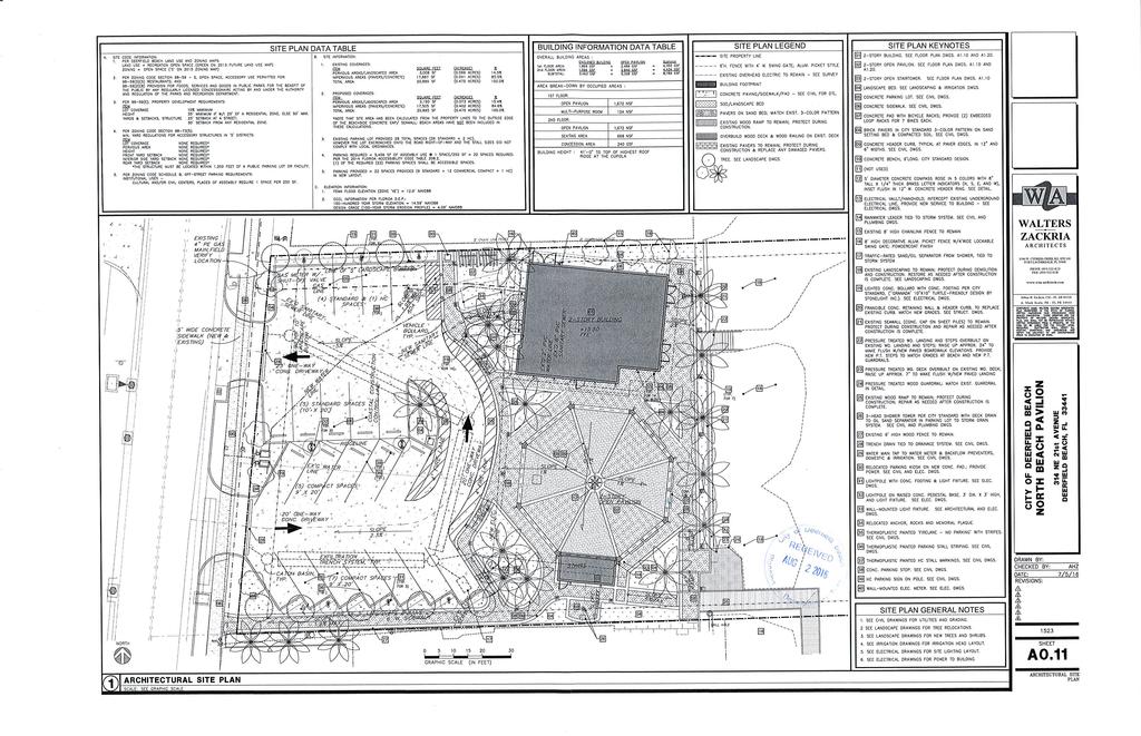
49
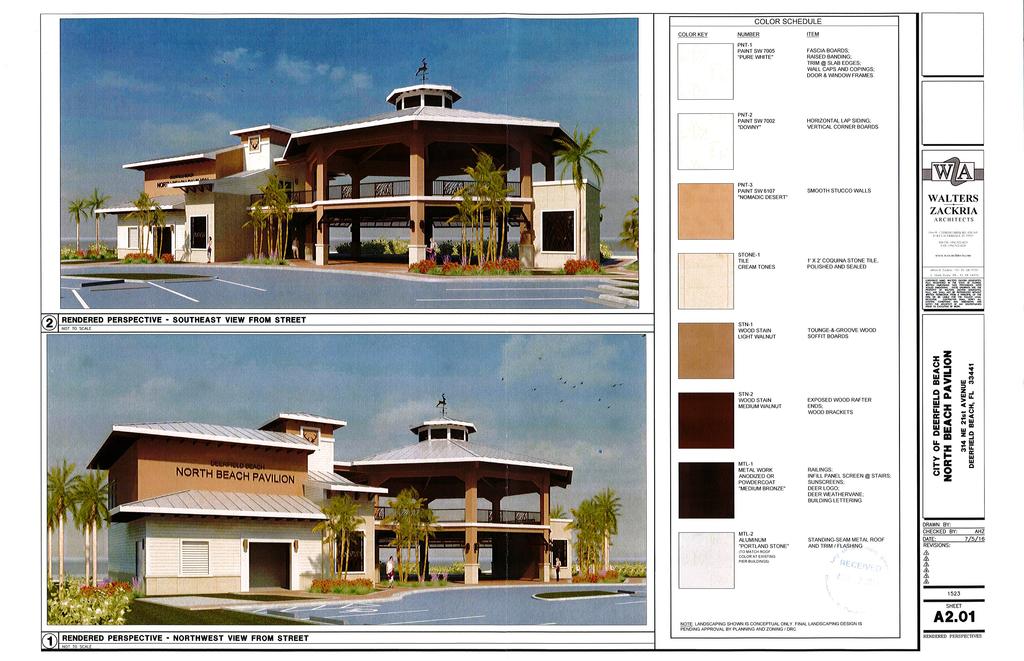
50
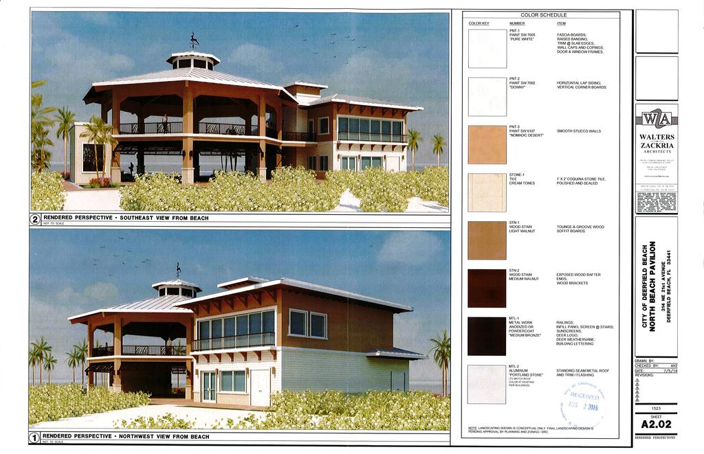
51
52 DEERFIELD BEACH Agenda Item #2 PLANNING & ZONING BOARD Thursday, September 1, 2016 PROPOSED CITY AND LAND DEVELOPMENT CODE AMENDMENT Applicant: CITY OF DEERFIELD BEACH Proposal: To amend Section of the Deerfield Beach Land Development Code to include sports performance training facilities in the (PID) Planned Industrial Development zoning district. SUMMARY BACKGROUND/EXPLANATION Enclosed is the proposed ordinance that addresses Section of the Deerfield Beach Land Development Code, to include sports performance training facilities in the (PID) Planned Industrial Development zoning district. REQUESTED ACTION: Recommendation to the City Commission on the proposed Land Development Code amendment. ATTACHMENT: Proposed ordinance amending the City s Land Development Code.
53 ORDINANCE NO. 2016/ AN ORDINANCE OF THE CITY COMMISSION OF THE CITY OF DEERFIELD BEACH, FLORIDA, AMENDING SECTION TO INCLUDE SPORTS PERFORMANCE TRAINING FACILITY AS A PERMITTED USE IN THE PID, PLANNED INDUSTRIAL DISTRICT; CONTAINING A SEVERABILITY CLAUSE, A PROVISION FOR INCLUSION IN THE CITY CODE; AND PROVIDING FOR AN EFFECTIVE DATE. WHEREAS, the City Commission wishes to add an additional permitted use to the PID Planned Industrial District; NOW THEREFORE, BE IT ORDAINED BY THE CITY COMMISSION OF THE CITY OF DEERFIELD BEACH, FLORIDA, AS FOLLOWS: SECTION 1. That section of the Deerfield Beach Land Development Code is hereby amended to read as follows: Sec PID, planned industrial district. (a) Purpose and intent. The purpose of this district is to provide for innovations in industrial or office development by encouraging projects reflective of changes in the technology of land development and the relationship to the specific site and its natural amenities. This innovation is to be encouraged through the substitution of design and performance criteria for the normally rigid development parameters of other industrial districts. This district is intended to be applied in those areas of the city identified in the land use element of the comprehensive plan as suitable for industrial use. With the exception of outdoor seating for restaurants, craft/artisan production, and brewpubs, all business shall be conducted within a fully enclosed building. (b) Permitted uses. The following uses shall be permitted principal uses in the PID district: (1) Manufacturing; (2) Office, business and professional; (3) Warehouses associated with manufacturing, assembly and distribution; (4) Wholesale packaging, supply and distribution (this category includes facilities devoted to the building trades); (5) Essential services; (6) Educational, industrial, scientific research and development; (7) Printing; (8) Building cleaning and maintenance services; (9) Construction/trade contractors; (10) Commercial kitchens; Deleted portions struck through; added portions underlined 1
54 (11) Sports performance training facility; (121) Restaurants, provided: a. No drive thru facilities shall be provided; b. Outdoor seating shall be permitted as an accessory use and limited in size to 20 percent of the gross floor area of the tenancy space. (132) Craft/artisan production (in accordance with land use plan limitations) provided: a. There is a non production area dedicated for uses such as retail, eating, drinking or tasting that is at least ten percent, but no more than 30 percent of the total floor area; b. The facility must front a street or have a well-marked and visible entrance; c. All production, processing and distribution activities are to be conducted within an enclosed building; d. Access and loading bays shall not face any street, excluding alleys; e. Silos are permitted as accessory structures and must obtain site plan approval; the maximum height shall be as allowed in the dimensional requirements of the zoning district; f. Live music or entertainment shall only be allowed as an accessory use. All noise generated by live music or entertainment activities shall be fully contained within the building. g. Outdoor seating shall be permitted as an accessory use and limited in size to 20 percent of the gross floor area of the tenancy space. (143) Brewpub (in accordance with land use plan limitations) provided: a. Revenue from food sales shall constitute more than 50 percent of the total gross sales; b. Live music or entertainment shall only be allowed as an accessory use. All noise generated by live music or entertainment activities shall be fully contained within the indoor space occupied by the brewpub; c. No more than 50 percent of the total gross floor area of the establishment shall be used for the brewery function including, but not limited to, the brewhouse, boiling and water treatment areas, bottling and kegging lines, malt milling and storage, fermentation tanks, conditioning tanks and serving tanks; d. Outdoor seating shall be permitted as an accessory use and limited in size to 20 percent of the gross floor area of the tenancy space. (c) Conditional uses. The following shall be conditional uses for a PID of 50 acres or more: (1) Child day care centers. One only per PID will be permitted. (2) Hotels. One only per PID will be permitted. Hotels and motels are subject to dimensional requirements of the RM-25 zoning district. Density is limited to 38 dwelling units per gross acre. (3) Restaurant. One only per PID will be permitted. The restaurant shall be of a minimum of 5,000 square feet in structure and no drive thrus allowed. Deleted portions struck through; added portions underlined 2
55 (d) Accessory uses. Permitted accessory uses in the PID district shall include those uses customarily incidental to a principal permitted or approved conditional use. (e) Minimum site requirements. The minimum land area for a PID shall be 25 contiguous acres. All land to be included within the PID shall be owned by the applicant. (f) Design standards. The following standards shall be applied in reviewing PID development proposals: (1) Area limitations: a. The project area shall be enclosed on all sides with the exception of accessways by a landscaped green belt area with a minimum width of 25 feet. It shall be the responsibility of the owner or developer to carry out this requirement, and to provide such maintenance or guarantee of maintenance, subject to planning and zoning board approval. b. In no instance shall off-street loading facilities front on a public right-of-way and in no event shall these facilities be located within 100 feet of a residential district. c. No building shall be closer than 25 feet to another principal building on the same site. d. All storage shall be within a fully enclosed building. (g) Administrative procedures. A PID shall be processed and adopted in the same manner as a PUD and may be varied in the same manner as provided for therein. (h) No sign shall be constructed or erected which exceeds the height of the tallest building on the lot upon which the sign is to be erected, or the maximum height as permitted in section of the Land Development Code, whichever is less. SECTION 2. It is the intention of the City Commission and it is hereby ordained that the provisions of this ordinance shall become and be made a part of the Code of the City of Deerfield Beach, and that the sections of this ordinance may be renumbered to accomplish such intent. SECTION 3. Should any section or provision of this ordinance or any portion thereof, any paragraph, sentence or word be declared by a court of competent jurisdiction to be invalid, such decision shall not affect the validity of the remainder hereof as a whole or part thereof other than the part declared to be invalid. SECTION 4. This ordinance shall be in full force and effect immediately upon its passage and adoption. PASSED 1ST READING ON THIS DAY OF, 2016 PASSED 2ND READING ON THIS DAY OF, 2016 Deleted portions struck through; added portions underlined 3 JEAN M. ROBB, MAYOR
56 ATTEST: SAMANTHA GILLYARD, CMC, CITY CLERK DEERFIELD/ORDINANCES/ Sports performance training facility - LDC Deleted portions struck through; added portions underlined 4
57 DEERFIELD BEACH Agenda Item #3 PLANNING & ZONING BOARD Thursday, September 1, 2016 PROPOSED CITY AND LAND DEVELOPMENT CODE AMENDMENT Applicant: CITY OF DEERFIELD BEACH Proposal: To amend Section 102 of the Deerfield Beach Land Development Code pertaining to signs. SUMMARY BACKGROUND/EXPLANATION Enclosed is the proposed ordinance with changes to Section 102 of the Deerfield Beach Land Development Code. REQUESTED ACTION: Recommendation to the City Commission on the proposed Land Development Code amendment. ATTACHMENT: Proposed ordinance amending the City s Land Development Code.
58 ORDINANCE NO. 2016/ AN ORDINANCE OF THE CITY COMMISSION OF THE CITY OF DEERFIELD BEACH, FLORIDA, AMENDING CHAPTER 102 SIGN CODE, PROVIDNG FOR PURPOSE, INTENT AND SCOPE, AMENDING DEFINITIONS, PROVIDING FOR SIGN PERMITS AND EXEMPTIONS, AMENDING THE SUBMISSION REQUIREMENTS FOR ALL SIGN PERMITS, PROHIBITNG CERTAIN SIGN STRUCTURES, AMENDING THE SIGNS ALLOWED IN THE VARIOUS ZONING DISTRICTS, PROVIDING FOR BENCH SIGNS, CHANGEABLE COPY SIGNS, SANDWICH BOARD SIGNS, FUEL PRICE SIGNS, ON PREMISES DIRECTIONAL SIGNS, DIRECTORY SIGNS, FLAGS, TOWING SIGNS AND BUS SHELTER SIGNS, AMENDING THE LOCATION AND SIZE OF FREESTANDING SIGNS AND BUILDING SIGNS, CREATING A TEMPORARY SIGN SECTION, PROVIDING FOR ENFORCEMENT, DELETING SECTION TEMPORARY RELIEF; AMENDING SECTION 26-89, CAMPAIGN SIGNS; AMENDING ARTICLE XI. - SPECIAL EVENTS, SECTION 2-546, SIGNS, BANNERS AND ADVERTISING; CONTAINING A SEVERABILITY CLAUSE, A PROVISION FOR INCLUSION IN THE CITY CODE; AND PROVIDING FOR AN EFFECTIVE DATE. WHEREAS, the City Commission desires to modify and update Chapter 102. Signs, in order to respond to recent case law including Reed v. Town of Gilbert, U.S., 135 S. Ct. 2218, 192 L. Ed. 2d 236 (2015); and WHEREAS, the City finds and determines that the purpose and intent provisions of its signage regulations should be detailed so as to further describe the beneficial aesthetic, traffic safety, and other effects of the City's sign regulations, and to reaffirm that the sign regulations are concerned with the secondary effects of speech and are not designed to censor speech or regulate the viewpoint of the speaker; and WHEREAS, various signs that serve as signage for particular land uses are based upon content-neutral criteria in recognition of the functions served by those land uses, but not based upon any intent to favor any particular viewpoint or control the subject matter of public discourse; and WHEREAS, the City finds and determines that the sign regulations adopted hereby allow and leave open adequate alternative means of communications, such as newspaper advertising, internet advertising and communications, advertising in shoppers and pamphlets, advertising in telephone books, advertising on cable television, advertising on UHF and/or VHF television, advertising on AM and/or FM radio, advertising on satellite radio, advertising on internet radio, Deleted portions struck through; added portions underlined 1
59 advertising via direct mail, and other avenues of communication available in the City [see State v. J & J Painting, 167 N.J. Super. 384, 400 A.2d 1204, 1205 (Super. Ct. App. Div. 1979); Board of Trustees of State University of New York v. Fox, 492 U.S. 469, 477 (1989); Green v. City of Raleigh, 523 F.3d 293, (4th Cir. 2007); Naser Jewelers v. City of Concord, 513 F.3d 27 (1st Cir. 2008); Sullivan v. City of Augusta, 511 F.3d 16, (1st Cir. 2007); La Tour v. City of Fayetteville, 442 F.3d 1094, 1097 (8th Cir. 2006); Reed v. Town of Gilbert, 587 F.3d 866, (9th Cir. 2009)]; and WHEREAS, in Reed v. Town of Gilbert, Ariz., -U.S.-, 135 S. Ct. 2218, 2221, 192 L. Ed. 2d 236 (2015), the United States Supreme Court, in an opinion authored by Justice Thomas, and joined in by Chief Justices Roberts, Scalia, Alito, Kennedy and Sotomayer, addressed the constitutionality of a local sign ordinance that had different criteria for different types of temporary noncommercial signs; and WHEREAS, in Reed, Justice Alito in a concurring opinion joined in by Justices Kennedy and Sotomayer pointed out that municipalities still have the power to enact and enforce reasonable sign regulations; and WHEREAS, Justice Alito further noted that in addition to regulating signs put up by private actors, government entities may also erect their own signs consistent with the principles that allow governmental speech [see Pleasant Grove City v. Summum, 555 U.S. 460, (2009)], and that government entities may put up all manner of signs to promote safety, as well as directional signs and signs pointing out historic sites and scenic spots; and WHEREAS, Justice Alito noted that the Reed decision, properly understood, will not prevent cities from regulating signs in a way that fully protects public safety and serves legitimate aesthetic objectives, including rules that distinguish between on-premises and off-premises signs; and WHEREAS, under established Supreme Court precedent and Eleventh Circuit precedent, commercial speech may be subject to greater restrictions than noncommercial speech and that doctrine is true for both temporary signs as well as for permanent signs; and WHEREAS, the City finds and determines that a traffic control device sign, as defined herein, should be exempt from regulation under the City's land development regulations for signage; and WHEREAS, the City finds and determines that the regulation of signs within the City strongly contributes to the development and maintenance of a pleasing, visually attractive environment, and that these sign regulations are prepared with the intent of enhancing the environment and promoting the continued well-being of the City; and Deleted portions struck through; added portions underlined 2
60 WHEREAS, the City finds and determines that the regulation of signage for purposes of aesthetics has long been recognized as advancing the public welfare; and WHEREAS, the City finds and determines that, as far back as 1954, the United States Supreme Court recognized that "the concept of the public welfare is broad and inclusive," that the values it represents are "spiritual as well as physical, aesthetic as well as monetary," and that it is within the power of the legislature "to determine that the community should be beautiful as well as healthy, spacious as well as clean, well balanced as well as carefully patrolled" [in Berman v. Parker, 348 U.S. 26, 33 (1954)]; and WHEREAS, the City finds and determines that aesthetics is a valid basis for zoning, and that the regulation of the size and appearance of signs and the prohibition of certain types of signs can be based upon aesthetic grounds alone as promoting the general welfare [see Merritt v. Peters, 65 So. 2d 861 (Fla. 1953); Dade County v. Gould, 99 So. 2d 236 (Fla. 1957); E.B. Elliott Advertising Co. v. Metropolitan Dade County, 425 F.2d 1141 (5th Cir. 1970), cert. dismissed, 400 U.S. 878 (1970)]; and WHEREAS, the City finds and determines that the purpose of the regulation of signs as set forth in this Ordinance is to promote the public health, safety and general welfare through a comprehensive system of reasonable, consistent and nondiscriminatory sign standards and requirements; and WHEREAS, the City finds and determines that the sign regulations in this Ordinance are intended to lessen hazardous situations, confusion and visual clutter caused by proliferation, improper placement, illumination, animation and excessive height, area and bulk of signs which compete for the attention of pedestrian and vehicular traffic; and WHEREAS, the City finds and determines that these sign regulations are intended to protect the public from the dangers of unsafe signs; and WHEREAS, the City finds and determines that these sign regulations are intended to permit signs that are compatible with their surroundings and aid orientation, and to preclude placement of signs in a manner that conceals or obstructs adjacent land uses or signs; and WHEREAS, the City finds and determines that these sign regulations are intended to regulate signs in a manner so as to not interfere with, obstruct vision of or distract motorists, bicyclists or pedestrians; and WHEREAS, the City finds and determines that these sign regulations are intended to require signs to be constructed, installed and maintained in a safe and satisfactory manner; and Deleted portions struck through; added portions underlined 3
61 WHEREAS, the City finds and determines that in meeting the purposes and goals established in these findings, it is appropriate to prohibit and/or to continue to prohibit certain sign types; and WHEREAS, the City finds and determines that the prohibition of the construction of billboards and certain other sign types, as well as the establishment and continuation of height, size and other standards for on-premise signs, is consistent with the policy set forth in the Florida Constitution that it shall be the policy of the state to conserve and protect its scenic beauty; and WHEREAS, the City finds that local governments may separately classify off-site and onsite advertising signs in taking steps to minimize visual pollution [see City of Lake Wales v. Lamar Advertising Association of Lakeland Florida, 414 So. 2d 1030, 1032 (Fla. 1982)]; and WHEREAS, the City finds and determines that a prohibition on the erection of off-site outdoor advertising signs will reduce the number of driver distractions and the number of aesthetic eyesores along the roadways and highways of the City [see, e.g., E. B. Elliott Adv. Co. v. Metropolitan Dade County, 425 F.2d 1141, 1154 (5th Cir. 1970), cert. denied, 400 U.S. 878 (1970)]; and WHEREAS, the City finds and determines that in order to preserve, protect and promote the safety and general welfare of the residents of the City, it is necessary to regulate off-site advertising signs, so as to prohibit the construction of off-site signs and billboards in all zoning districts, and to provide that the foregoing provisions shall be severable; and WHEREAS, the City hereby finds and determines that anything beside the road which tends to distract the driver of a motor vehicle directly affects traffic safety, and that signs, which divert the attention of the driver and occupants of motor vehicles from the highway to objects away from it, may reasonably be found to increase the danger of accidents, and agrees with the courts that have reached the same determination [see In re Opinion of the Justices, 103 N.H. 268, 169 A.2d 762 (1961); Newman Signs, Inc. v. Hjelle, 268 N.W.2d 741 (N.D.1978)]; and WHEREAS, the City finds and determines that the City has allowed noncommercial speech to appear wherever commercial speech appears; and the City desires to continue that practice through the specific inclusion of a substitution clause that expressly allows noncommercial messages to be substituted for commercial messages; and WHEREAS, the City finds and determines that, by confirming in this Ordinance that noncommercial messages are allowed wherever commercial messages are permitted, the City will continue to overcome any constitutional objection that its ordinance impermissibly favors commercial speech noncommercial speech [see Outdoor Systems, Inc. v. City of Lenexa, 67 F. Supp. 2d 1231, (D. Kan. 1999)]; and Deleted portions struck through; added portions underlined 4
62 WHEREAS, the City finds and determines that under Florida law, whenever a portion of a statute or ordinance is declared unconstitutional, the remainder of the act will be permitted to stand provided (1) the unconstitutional provisions can be separated from the remaining valid provisions, (2) the legislative purpose expressed in the valid provisions can be accomplished independently of those which are void, (3) the good and the bad features are not so inseparable in substance that it can be said that the legislative body would have passed the one without the other, and (4) an act complete in itself remains after the valid provisions are stricken [see, e.g., Waldrup v. Dugger, 562 So. 2d 687 (Fla. 1990)]; and WHEREAS, the City finds and determines that there have been several judicial decisions where courts have not given full effect to severability clauses that applied to sign regulations and where the courts have expressed uncertainty over whether the legislative body intended that severability would apply to certain factual situations despite the presumption that would ordinarily flow from the presence of a severability clause; and WHEREAS, the City finds and determines that the City has consistently adopted and enacted severability provisions in connection with its sign ordinance code provisions, and that the City wishes to ensure that severability provisions apply to its sign regulations; and WHEREAS, the City finds and determines that the Code's severability clauses were adopted with the intent of upholding and sustaining as much of the City's regulations, including its sign regulations, as possible in the event that any portion thereof (including any section, sentence, clause or phrase) be held invalid or unconstitutional by any court of competent jurisdiction; and WHEREAS, the City finds and determines that there must be an ample record of its intention that the presence of a severability clause in connection with the City's sign regulations be applied to the maximum extent possible, even if less speech would result from a determination that any provision is invalid or unconstitutional for any reason whatsoever; and WHEREAS, the City finds and determines that there must be an ample record that it intends that the height and size limitations on free-standing and other signs continue in effect regardless of the invalidity or unconstitutionality of any, or even all other, provisions of the City's sign regulations, other ordinance code provisions, or other laws, for any reason (s) whatsoever; and WHEREAS, the City finds and determines that there must be an ample record that it intends that each prohibited sign-type continue in effect regardless of the invalidity or unconstitutionality of any, or even all, other provisions of the City's sign regulations, other ordinance code provisions, or other laws, for any reason(s) whatsoever; and WHEREAS, the City Commission makes the detailed findings set forth in Section this Ordinance as to the purpose, scope and intent of the City s sign regulations, and the substantial and compelling governmental interests that are advanced by these regulations; Deleted portions struck through; added portions underlined 5
63 NOW, THEREFORE, BE IT RESOLVED BY THE CITY COMMISSION OF THE CITY OF DEERFIELD BEACH, FLORIDA, AS FOLLOWS: SECTION 1. Chapter 102, Sections through of the City of Deerfield Beach Land Development Code is hereby amended to read as follows: CHAPTER 102. SIGNS CODE Sec Purpose, intent and scope. (a) Purpose. It is the purpose of this chapter to promote the public health, safety and general welfare through reasonable, consistent and non-discriminatory sign standards. The sign regulations in this chapter are not intended to censor speech or to regulate viewpoints, but instead are intended to regulate the secondary effects of speech and especially insofar as those secondary effects may adversely affect aesthetics and traffic and pedestrian safety. In order to preserve and enhance the city as a desirable community in which to live, vacation and do business, a pleasing, visually attractive environment is of foremost importance. The regulation of signs within the city is a highly contributive means by which to achieve this desired end. These sign regulations have been prepared with the intent of enhancing the visual environment of the city and promoting its continued well-being, and are intended to:. (b) Intent. The sign regulations in this Chapter are intended to: (1) Encourage the effective use of signs as a means of communication in the city; (2) Maintain and enhance the aesthetic environment and the city's ability to attract sources of economic development and growth; (3) Improve Ensure pedestrian and traffic safety; (4) Minimize the possible adverse affect effect of signs on nearby public and private property; (5) Foster the integration of signage with architectural and landscape designs; (6) Lessen the visual clutter that may otherwise be caused by the proliferation, improper placement, illumination, animation, excessive height, and excessive size (area) of signs which compete for the attention of pedestrian and vehicular traffic and are not necessary to aid in wayfinding; (7) Allow signs that are compatible with their surroundings and aid orientation, while precluding the placement of signs that contribute to sign clutter or that conceal or obstruct adjacent land uses or signs; (8) Encourage and allow signs that are appropriate to the zoning district in which they are located and consistent with and serve the needs of the category of use land uses, activities and functions to which they pertain; Deleted portions struck through; added portions underlined 6
64 (9) Curtail the size and number of signs and sign messages to the minimum reasonably necessary to identify a residential or business location and the nature of any such business use, and to allow smooth navigation to these locations; (10) Establish sign size in relationship dimensional limits and placement criteria for signs that are legible and proportional to the scale size of the lot and building on which the sign is to be placed or to which it pertains; (11) Categorize Regulate signs so that they are effective in performing based upon the function of identifying, indexing and safely directing pedestrian and vehicular traffic to a destination that they serve and tailor the regulation of signs based upon their function; (12) Preclude signs from conflicting with the principal permitted use of the site lot and adjoining sites lots; (13) Regulate signs in a manner so as to not interfere with, obstruct the vision of or distract motorists, bicyclists or pedestrians; (14) Except to the extent expressly preempted by state or federal law, ensure that signs are constructed, installed and maintained is a safe and satisfactory manner, and protect the public from unsafe signs; (15) Preserve, conserve, protect, and enhance the aesthetic quality and scenic beauty of all zoning districts of the city; (16) Allow for traffic control devices without City regulation consistent with national standards and whose purpose is to because they promote highway safety and efficiency by providing for the orderly movement of road users on streets and highways, and that notify by notifying road users of regulations and provide providing nationally consistent warning and guidance needed for the safe, uniform and efficient operation of all elements of the traffic stream; (17) Protect property values by precluding to the maximum extent possible sign-types signs that create a nuisance to the occupancy or use of other properties as a result of their size, height, illumination, brightness, or movement; (18) Protect property values by ensuring that sign-types, as well as the number the size, number and appearance of signs, are in harmony with buildings, neighborhoods, structures and conforming signs in the area; and (19) Regulate the appearance and design of signs in a manner that promotes and enhances the beautification of the city and that complements the natural surroundings in recognition of this city's reliance on its natural surroundings and beautification efforts in retaining as a source of economic advantage for its resort community, as well as for its major office and industrial parks; (20) Not regulate signs more than necessary to accomplish the compelling and substantial governmental objectives described herein; (21) Streamline the approval process and encourage creative and aesthetic standards for signage with all large scaled developments by requiring master signage plans; and Deleted portions struck through; added portions underlined 7
65 (22) Enable the fair and consistent enforcement of these sign regulation. (c) Scope. (1) The provisions of this Chapter shall govern the number, size, location, and other similar aspects of signs and sign structures which may be permitted either as a main or accessory use under the terms of this Chapter. No signs shall be permitted on a lot or parcel either as a main or accessory use except in accordance with the provisions of this Chapter. (2) This Chapter does not regulate signs on government property, including but not limited to, signs on property owned by the City of Deerfield Beach, Broward County or the State of Florida, and this Chapter does not regulate traffic control devices. (3) No provision of this Chapter shall be intended to regulate the posting on private property of official signs and notices required by law, such as notices of zoning, etc. (4) In the event of any conflict between this Chapter and any declaration of covenants, bylaws, or other restrictions applying to any property within the City, the language affording the more restrictive interpretation shall apply. (5) The City specifically finds that these sign regulations are narrowly tailored to achieve the compelling and substantial governmental interests of traffic safety and aesthetics, and that there is no other way for the City to further these interests. (d) Impact of sign clutter. Excessive signage and sign clutter impairs the legibility of the environment, and undermines the effectiveness of governmental signs, traffic control devices and other required signs (such as nameplate sign, noncommercial onsite directional sign, identification sign, onsite or on premise wayfinding sign, and warning sign) that are essential to identifying locations for the delivery of emergency services and other compelling governmental purposes. The intent of these sign regulations is to enhance the visual environment of the City, ensure that City residents and visitors can safely navigate through the City to their intended destinations, and promote the continued well-being of the City. It is therefore the purpose of this article to promote aesthetics and the public health, safety and general welfare, and assure the adequate provision of light and air within the City through reasonable, consistent and non-discriminatory standards for the posting, displaying, erection, use, and maintenance of signs that are no more restrictive than necessary to achieve these governmental interests. (e) Case law. In accordance with the U.S. Supreme Court s cases on sign regulation, the regulations in this article are not intended to regulate or censor speech based on its content or viewpoint, but rather to regulate the secondary effects of speech that may adversely affect the City s substantial and compelling governmental interests in preserving scenic Deleted portions struck through; added portions underlined 8
66 beauty and community aesthetics, and in vehicular and pedestrian safety in conformance with the First Amendment. These cases and their holdings include, but are not limited to: (1) Reed v. Town of Gilbert, U.S., 135 S. Ct. 2218, 192 L. Ed. 2d 236 (2015) on the topic on noncommercial temporary signs; (2) Metromedia, Inc. v. City of San Diego, 453 U.S. 490 (1981) on the topic of commercial signs and off premise signs; (3) City of Ladue v. Gilleo, 512 U.S. 43 (1994) on the topic of political protest signs in residential areas; (4) Linmark Assocs., Inc. v. Township of Willingboro, 431 U.S. 85 (1977) on the topic of real estate signs in residential areas; (5) Burson v. Freeman, 504 U.S. 191 (1992) on the topic of election signs near polling places; (6) Central Hudson Gas & Electric Corp. v. Public Service Commission, 447 U.S. 557 (1980) on the topic of regulation of commercial speech; and (7) City Council v. Taxpayers for Vincent, 466 U.S. 789 (1984) on the topic of signs on public property. Sec Applicability and effect. (a) (b) A sign may be erected, placed, established, painted, created or maintained in the city only in conformance with the standards, procedures, exemptions and other requirements of this chapter. The effect of this chapter is more specifically set forth herein: (1) To establish a permit system for a variety of types of signs in community facilities, open space, institutional, commercial, and industrial, zones and a limited variety of signs in and residential zones and areas of special interest, subject to the standards and the permit procedures of the this chapter; (2) To provide for certain exemptions from permitting and to otherwise allow certain signtypes based upon their function, but subject to other requirements of this chapter; (3) To expressly prohibit certain sign-types signs; (4) To allow for a reasonable fee; and To provide sign code regulations applicable to all properties within the City Limits including all annexed properties from Broward County into the City of Deerfield Beach; and (5) To provide for the enforcement and maintenance of the provisions of this chapter. Sec Definitions. Abandoned or discontinued sign or sign structure. A sign or sign structure is considered abandoned or discontinued when its owner fails to operate or maintain a sign for a period of six months or longer. The following conditions shall be considered as the failure to operate or maintain Deleted portions struck through; added portions underlined 9
67 a sign: (1) a sign displaying advertising for a product or service which is no longer available or displaying advertising for a business which is no longer licensed, or (2) a sign which is blank. Address sign. A building sign having the letters and street name of the premises on which it is attached. Advertising. Sign copy intended to directly or indirectly promote the sale or use of a product, service, commodity, entertainment, or real or personal property. Animated sign. A sign which includes action, motion, or color changes, or the optical illusion of action, motion, or color changes, including signs set in motion by movement of the atmosphere, or made up of a series of sections that turn. Announcing sign. An on-premises temporary sign announcing a project to be under construction on an intended use of premises in the immediate future, and whose sign copy is limited to the project name, the nature of the development, the owner or agent, and telephone number for the owner or agent. Banner. Any sign having the characters, letters, illustrations, or ornamentations applied to cloth, paper, balloons, or fabric of any kind. The word "banner" shall also include pennant or any animated, rotating and/or fluttering device, with or without lettering for design, and manufactured and placed for the purpose of attracting attention. National flags, state or municipal flags or the official flag of any institution or business shall not be considered banners. Beacon. A stationary or revolving light which flashes or projects illumination, single color or multi-colored, in any manner which is intended to attract or divert attention; except, however, this term is not intended to include any kind of lighting device which is required or necessary under the safety regulations described by the Federal Aviation Administration or similar agencies. Bench sign. An off-premises sign placed on a seating bench for the purpose of advertising. Billboard. A structure, including signs located in the public right-of-way, utilized for advertising an establishment, an activity, a product, service or entertainment, which is sold, produced, manufactured, available or furnished at a place other than on the property on which said sign is located. Building sign. A sign whose entire portion is displayed upon or attached to any part of the exterior of a building, including walls, parapets and marquees. A building sign shall include a cabinet or box sign, an under-canopy sign, and a nameplate identification sign, but does not include a window sign. Building official. An agent of the City of Deerfield Beach authorized to permit, inspect, approve or deny construction within the city. Cabinet or box sign. Any sign, the face of which is enclosed, bordered or contained within a box-like structure. Canopy sign. Any sign that is a part of or attached to an awning, canopy, or other fabric, plastic, or structural protective cover over a door, entrance, window, or outdoor service area. A marquee is not a canopy. Changeable copy sign. A sign on which the message copy is changed either manually, electronically, or by any other method through the utilization of attachable letters, numbers, or Deleted portions struck through; added portions underlined 10
68 symbols, or changeable pictorial panels, and other similar characters, or internal rotating or moveable parts which change the visual message. Commercial message. Any sign wording, logo, or other representation or image that directly or indirectly names, advertises, or calls attention to a product, service, sale or sales event or other commercial activity. Construction sign. An on-premises temporary commercial message sign that functions to identify those entities engaged in construction of a building site, including the prime contractor or any subcontractor. This may include the prime contractor and sub-contractor. Copy. The linguistic or graphic content of a sign. Credit card sign. A sign signifying that goods or services may be purchased on credit by means of an established credit line (Visa, Mastercard, American Express, Discover, etc.). Directory sign. A sign listing only the names and/or use, or location of more than one business, activity or professional office conducted within a building, group of buildings or commercial center. Double-faced sign. Means a sign with two faces, which are parallel to each other, back to back with the same copy. A double-faced sign is not Sandwich Board sign. Election sign. A temporary sign erected or displayed for the purpose of expressing support for or opposition to a candidate or stating a position regarding an issue upon which the voters of the city shall vote. Façade. Means the entire building front. Flag. Any fabric, or bunting containing distinctive colors, patterns, or symbols, used as a symbol of government, political subdivision, or other entity. Flashing sign. A sign which permits lights to be turned on or off intermittently more frequently than once per minute. Free expression sign. A sign communicating information or views on matters of public policy concern or containing any other noncommercial message, as more specifically described in section Freestanding sign. A sign supported by a sign structure secured to the ground and which is wholly independent of any building, fence, vehicle or object other than the sign structure, for support. Freestanding monument sign. A freestanding sign whose ratio of width of sign to width of support is less than 3 to 1. Freestanding pole sign. A freestanding sign whose ratio of width of sign to width of support is greater than 3 to 1. Frontage wall face. The building façade, fascia, soffit, mansard and roof, which faces a frontage of the premises. Frontage. The distance along the property line which abuts the public right-of-way line. Garage or yard sale sign. Any sign pertaining to the sale of personal property in, at or upon any residentially-zoned property located in the city. Garage or yard sales shall include but not be Deleted portions struck through; added portions underlined 11
69 limited to all such sales, and shall include the advertising of the holding of any such sale, or the offering to make any sale, whether made under any name such as garage sale, lawn sale, yard sale, front yard sale, back yard sale, home sale, attic sale, rummage sale, patio sale, flea market sale, or any similar designation. Grand opening sign. An on-premises temporary sign announcing the opening of a newly licensed business, that does not exceed 16 square feet in size and that is not displayed for longer than 30 days after the issuance date of the business tax receipt for the new business. Height of sign. The vertical distance measured perpendicular from the closest adjacent average crown of road to the top of the sign face or sign structure, whichever is greater. The height shall be measured from the existing average finished grade level of the premises where the sign is located. Human commercial signs. A person wearing a costume or holding a sign or other display while outside for the purpose of advertising or promoting a business, product or service. Holiday/seasonal decorations. Decorations that pertain to legal or other recognized holidays or to recognized seasons of the year. Identification and informational sign. Any sign of an identification or informational nature bearing no advertising. Illuminated sign. Any sign having characters, letters, figures, designs or outlines illuminated by electric lights or luminous tubes designed for that purpose, whether or not said lights or tubes are physically attached to the sign. Illumination, external. A light source which illuminates the sign area located separate from the sign. Illumination, internal. A light source concealed or contained within the sign which becomes visible by shining through a translucent surface. Logo. A word, or part of a word, or character used to signify an organization, corporation or the like. A graphic representation, letter, character, symbol, trademark, design or crest or combinations thereof used to identify a business or organization. Lot. See definition of parcel. Lot means a parcel of land fronting on a street which is or may be occupied by a building and its accessory buildings or structures, including the open spaces required under this article, and which parcel of land is a matter of record in Broward County, Florida. Mansard roof. Any roof that has an angle greater than 45 degrees and which derives part of its support from the building wall and is attached to (but not necessarily a part of) a low slope roof and which extends along the full length of the front building wall or three-quarters of the length of a side building wall. For purposes of this chapter, a low slope roof shall mean any roof with a pitch less than three inches rise per 12 inches horizontal. Master signage plan. A self-imposed (by the developer) set of aesthetic and creative standards for all the components of signage within the project which must be submitted to the city for approval prior to adoption. Deleted portions struck through; added portions underlined 12
70 Marquee. Any permanent roof-like structure projecting beyond a building or extending along and projecting beyond the wall of the building, generally designed and constructed to provide protection from the weather. Marquee sign. Any sign attached to, in any manner, or made a part of a marquee. Multiple occupancy complex. A parcel of property under one ownership or singular control, or developed as a unified or coordinated project, with a building or buildings housing more than one occupant sharing a common entry. Multi-tenant center. Any shopping center, office center or business center in which two or more occupancies abut each other, share common parking facilities and drives, have individual entries from the main thoroughfare or internal drive aisles, or have individually demised areas. Nameplate sign. A flat, thin piece of material inscribed with the name, and/or profession or address of a person or persons residing on the premises or legally occupying the premises. Neon sign. Any sign formed by luminous or gaseous tubes in any configuration. Noncommercial on-site directional sign. An on-site sign providing direction or information to pedestrian or vehicular traffic that is related or reasonably necessary to the movement of pedestrian or vehicular traffic on the premises, and not displaying a commercial message, e.g., "entrance," "exit," "caution," "no parking," "one-way only," "no trespassing," and the like. Noncommercial message. A noncommercial message is any message, which is not a commercial message. Nonconforming sign. Any sign that does not conform to the provisions of this chapter. Occupancy. Any one business, activity or professional office. On-premises directional or informational sign. A non-commercial message sign which conveys wayfinding or directional information located on a lot or parcel designed to direct the public to any facility or service located on the premises of said lot or parcel or to direct and control traffic thereon, and which does not contain any advertising copy, logos or graphic display symbols. Off-premises sign. A sign which advertises merchandise, services, activities, or entertainment that is not sold, produced, manufactured, or furnished on the premises where the sign is located. Panel. The primary surface of a sign upon which the message of the sign is carried. Parapet. A vertical false front or wall extension above the roof line. Parcel. Land which has been or which is proposed to be used, developed, or built upon as a unit under single ownership. Parcel means a tract of land which may be described by metes and bounds or plat. (See "lot".) Perimeter wall sign. Any sign mounted on a perimeter wall, which is not a component defining an enclosed building area. Permanent sign. Any sign which, when installed, is intended for permanent use. For the purposes of this chapter, any sign with an intended use in excess of six months from the date of installation shall be deemed a permanent sign. Deleted portions struck through; added portions underlined 13
71 Portable sign. Any mobile or portable sign or sign structure that is not permanently attached to the ground or to any other structure. This definition shall include, but not be limited to, trailer signs, A-frame signs, sandwich signs and vehicles whose primary purpose is advertising. Projecting sign. Any sign which is affixed to any building wall or structure and extends more than 12 inches horizontally from the plane of the building wall. Project sign. An on-premises temporary sign whose function is to provide information as to a project under construction, and whose copy is limited to the name of the project, the nature of the development, the names of the general contractor, architect, lending institution, and owner or agent, and the telephone number for the owner or agent. Real estate sign. A temporary commercial message sign erected by the owner, or his agent, indicating property, which is for rent, sale or lease. Revolving or rotating sign. A sign that revolves or rotates. Roof line. Highest continuous horizontal line of a roof. On a sloping roof, the roof line is the principal ridge line, or the highest line common to one or more principal slopes of the roof. On a flat roof, the roof line is the highest continuous line of the roof or parapet, whichever is higher. Roof sign. A sign erected over or on the roof, or extending above the roof line, which is dependent upon the roof, parapet or upper walls of any building, or portion thereof, for support. Sandwich board sign means any self-supporting, A-shaped freestanding sign with only two (2) visible sides. Shopping center. Five or more commercial establishments, planned, developed, owned and managed as an integral unit, with off street parking provided on the property, and having individual entries with individually demised areas. Sign. The term "sign" shall mean and include every device, frame, letter, figure, character, mark, plane, point, design, picture, logo, stroke, stripe, trademark, or reading matter, which is used or intended to be used to attract attention or convey information when the same is placed out of doors in view of the general public; in addition, any of the above which is not placed out of doors, but which is illuminated with artificial or reflected light. Also, the above, when within two feet of the inside surface of a window in such a way as to be in view of the general public and used or intended to be used to attract attention or convey information. This term shall not be interpreted to include traffic control device signs. Sign, area of. The square foot area enclosed by the perimeter of the sign face. With respect to signs which are composed of individual symbols, letters, figures, illustrations, messages, forms or panels, "sign area" is the sum of the individual areas of the smallest contiguous rectangle, capable of containing such symbol(s), letter(s), illustration(s), message(s), forms(s) or panels. Sign face. The part of the sign that is or can be used to identify, advertise, communicate information or for visual representation, which attracts the attention of the public for any purpose. "Sign face" includes any background material, panel, trim, color and direct or self-illumination used that differentiates the sign from the building, structure, backdrop surface or object upon which or against which it is placed. The sign structure shall not be included as a portion of the sign face provided that no message, symbol or any of the aforementioned sign face criteria are displayed on or designed as part of the sign structure. Deleted portions struck through; added portions underlined 14
72 Sign structure. Any structure which supports, has supported or is capable of supporting a sign, including decorative cover. Snipe sign. Shall mean a sign of any material, including paper, cardboard, wood and metal, when tacked, nailed or attached in any way to trees, telephone poles, utility poles, stakes, fences, or other objects where such sign may or may not apply to the premises. This definition includes cardboard signs on sticks. Suspended sign. A sign that is suspended from the underside of a horizontal plane surface and is supported by such surface. Special event. A special event that has been permitted in accordance with Chapter 2, Article XI of the City of Deerfield Beach Code of Ordinances. Special event sign. Temporary signs, banners, and directional signs that are allowed for a special event and that have been permitted in accordance with Chapter 2, Article XI of the City of Deerfield Beach Code of Ordinances, subject to the height, size, number and durational limitations set forth in Chapter 2, Article XI. Subdivision entrance sign. An entrance sign shall mean a sign which designates the name of a subdivision or of a residential or business community and is located at or in close proximity to the main entrance. Tagline. An often repeated phrase associated with an individual, organization, or commercial product; a slogan. Temporary sign. Any sign intended for use not permanent in nature. For the purposes of this chapter, any sign with an intended use of six (6) months or less shall be deemed a temporary sign. Temporary commercial message sign. Any commercial message sign intended for a use not permanent in nature. For the purposes of this chapter, any commercial message sign with an intended use of six months or less shall be deemed a temporary commercial message sign. Examples of temporary commercial message signs include, but are not limited to, garage sale signs, grand opening signs, real estate signs and construction in progress signs. Temporary non-commercial message sign. Any non-commercial message sign intended for a use not permanent in nature. For the purposes of this chapter, any non-commercial message sign with an intended use of six months or less shall be deemed a temporary non-commercial message sign. Examples of temporary non-commercial message signs include, but are not limited to, free expression signs, campaign/election signs, special event signs and temporary directional signs. Temporary event. An event lasting a limited number of days not to exceed six months. Towing sign. A sign posted on private property in accordance with the provisions of Section , F.S. for the purpose of informing users that unauthorized vehicles will be towed away, providing that the same contains the name, address and telephone number of the towing company. Traffic control device sign or Traffic control device. Any sign located within the right-of-way and that is used as a traffic control device and described and identified in the Manual on Uniform Traffic Control Devices approved by the Federal Highway Administrator as the National Standard. A traffic control device sign includes those signs that are classified and defined by their function as regulatory signs (that give notice of traffic laws or regulations), warning signs (that give notice of a situation that might not readily be apparent), and guide signs (that show route designations, Deleted portions struck through; added portions underlined 15
73 directions, distances, services, points of interest, and other geographical, recreational, or cultural information). These devices are not regulated as signs under this Chapter. Vehicle sign or signs. Any sign or signs where the total sign area covers more than ten square feet of the vehicle. A sign affixed to or painted on a transportation vehicle including, but not limited to automobiles, trucks, boats, trailers, and recreational vehicles for the purpose of identification or advertisement, whether stationary or in motion, if the primary purpose of the vehicle sign is to call attention to a business establishment, production or event. Visibility triangle or vision triangle. A triangular shaped portion of land established at street intersections or street and driveway intersections in which nothing is erected, or allowed to grow in such a manner as to limit or obstruct the sight distance of motorists entering or leaving the intersection. For street intersections, this triangle is measured 30 feet in length from the intersection along the abutting right-of-way lines to form a triangle; and for driveway intersections, this triangle is measured ten feet from the intersection along the right-of-way line and along the driveway line to form a triangle. Wall sign. A sign installed or erected parallel to the facade of any building upon which it is attached and designed to be in proportion to the architectural facade or wall upon which it is fastened and not projecting or extending above the buildings' roof or parapet line (flat sign). Window area. The window area of a storefront shall be the total square footage of all glass areas of a storefront. This would include all areas of glass windows, doors, side lights and transoms, fixed or operable, located on the elevation of the building or storefront on which the front door or primary entrance to the establishment is located. Window OPEN/CLOSED sign. A small sign, either illuminated or non-illuminated announcing a place of business is open or closed for business, usually hung in storefront windows. Window sign. A sign located on a window or within two feet inside a building or other enclosed structure, which is visible from the exterior through a window or other opening intended to attract the attention of the general public. Window sign area. The entire area within a contiguous perimeter, enclosing each word, picture, logo, logotype, symbol, banding or graphic. Wind sign. A sign, which uses objects or material fastened in such a manner as to move upon being subjected to pressure by wind. This shall include but not be limited to banners, flags, pennants, ribbons, spinners, streamers or captive balloons. Sec General. (a) Substitution of noncommercial speech for commercial speech. Notwithstanding anything contained herein to the contrary, any sign erected pursuant to the provisions of this Code may, at the option of the owner, contain either a noncommercial message unrelated to the business located on the premises where the sign is erected or a commercial message. The noncommercial message may occupy the entire sign face or any portion thereof. The sign face may be changed from commercial to noncommercial messages, or from one noncommercial message to another, as frequently as desired by the owner of the sign, provided that the size, and design criteria, setbacks, etc. contained in this chapter have been satisfied. Deleted portions struck through; added portions underlined 16
74 (b) Content neutrality as to sign message (viewpoint). Notwithstanding anything to the contrary contained in this chapter, no sign or sign structure shall be subject to any limitation based solely upon the content (viewpoint) of the message contained on such sign or displayed on such sign structure. Sec Permits. Generally, signs are classified as either (i) "prohibited signs" that cannot be erected or displayed in the city, or (ii) "allowed signs" that can be erected and displayed in the city subject to certain conditions or limitations, including content-neutral conditions or limitations that apply to the number, size, height, setback, or function of signs. Some allowed signs do not require any type of permit, while other allowed signs require one or both of the following permits: (a) a sign permit to demonstrate that the sign meets the city's land development regulations, and/or (b) a building permit when the sign is of a type of construction that requires a building permit under the statewide Florida Building Code. The following provisions describe those permit requirements as applicable to signs and sign structures in the city. (a) Building permits. Except as provided herein, it shall be unlawful for any person or business or the person in charge of the business to erect, construct, alter, or maintain an outdoor advertising display sign, as defined in the Florida Building Code, without first obtaining a building permit from the city in accordance with provisions of the Florida Building Code. Fees shall be paid in accordance with city fee schedules. (b) Sign permits. In addition, a sign permit application shall be filed with the code administrator Planning and Development Services Department in accordance with section and, where applicable, a community appearance board application shall be filed with the community appearance board and shall be processed in accordance with the applicable requirements of this Code. Appeals shall be handled in accordance with section of this chapter. (c) Signs exempt from sign permits. It shall not be necessary to obtain a sign permit described in section 102-5(b), above, for the following signs, however compliance with all applicable provisions and regulations in this Code must be met: (1) Traffic control device signs. (2) Address signs, less than 12 inches in height. (3) Temporary signs project, announcing and construction signs 12 square feet or less in size. (4) Election signs. Bench signs. (5) Residential real estate signs, three square feet or less in size. (6 5) Towing signs where required to tow vehicles under Florida Law (715.07, F.S.) or no trespassing signs as permitted by Florida Law ( , F.S.). (7 6) Vehicle signs. (8) Grand opening signs (for no longer than 30 days). (9) Free expression signs. Deleted portions struck through; added portions underlined 17
75 (10 7) Warning and safety signs. (11) Special event signs which have been permitted in accordance with Chapter 2, Article XI of the City of Deerfield Beach Code of Ordinances. (12 8) All window signs. (13) Holiday/seasonal decorations. (d) Inspections. The following inspections by the building official or his designee shall be required before permits are final: (1) On freestanding signs, an inspection is required prior to the pouring of concrete, the enclosure or framing of any assembled structure, (2) Rough and final electrical inspections on all signs requiring an electrical permit, (3) On certain signs that are inaccessible for inspection because of height or location, the building official may require either a shop inspection, special access or an on-site inspection of the sign prior to the installation of such sign. Such conditions shall be so stated on the permit when it is issued. (4) Final inspection on all signs that require a permit for: a. Compliance to construction specifications, b. Conformity to setbacks, design, color, height and materials as approved. (5) In conjunction with the issuance of a final approval for a building permit, a numbered sign decal shall be placed on the sign in the lower left-hand corner. The sign inspector shall document each sign with a final photograph and history card for inventory purposes. (e) The time periods for review of permit applications and the appeal procedures governing denials or the failure to act upon sign permit applications are addressed in section Sec Submission requirements for all sign permits. (a) Master signage plan. No permit shall be issued for an individual sign requiring a permit in a commercial or industrial multiple occupancy complex or multi-tenant center unless and until a master signage plan has been submitted by the property owner and approved as conforming with to this section. The purpose of this requirement is to assure uniform compliance with this Code in multi-tenant settings. A master signage plan shall contain the following: (1) An accurate plot plan of the lot including location of buildings, parking lots, driveways, and landscaped areas on such lot; (2) Computation of the maximum total sign area, the maximum area for individual signs, the height of signs and the number of freestanding signs allowed on the zone lot(s) included in the plan under this chapter; (3) Design, style, color selection and dimensions for proposal; and an accurate indication on the plot plan of the proposed location of each present and future sign of any type, whether requiring a permit or not; Deleted portions struck through; added portions underlined 18
76 (4) A master signage plan including window signs shall indicate the areas of the windows to be covered by window signs and the general type of window signs. If a master signage plan is filed for a property on which existing signs are located, it shall include a schedule for bringing into conformance, within one year, all signs not conforming to the proposed amended plan (or to the requirements of this chapter in effect on the date of submission). After approval of a master signage plan, no sign shall be erected, placed, painted, or maintained, except in conformance with such plan, and such plan may be enforced in the same way as any provision of this chapter. In case of any conflict between the provisions of such a plan and any other provision of this chapter, the chapter shall control. (b) Development plan review. All new or modified development plans shall include the proposed location and elevations of signs including height, dimensions, setbacks, construction material and color. In all instances, the sign location shall be coordinated with the landscape design to avoid present and future tree/sign conflicts. (c) Permit review. Three sets of drawings shall be provided. These shall include: (1) Dimensions, lettering style, material, mounting details, and illumination details. (2) Building elevations for all wall signs illustrating dimensioned location of sign. (3) An up-to-date survey with dedicated easements is required for all freestanding signs. (4) Color rendering and color samples for all applications. (5) Photos of signs on abutting and subject properties. (6) Landscape plan for freestanding signs. (a) Sign Permit Application. Sign permits required by this chapter shall be filed with the Building Division and shall contain two sets of the following information: (1) Drawings. The drawings shall include the following: a. Dimensions, lettering style, material, mounting details, and illumination details. b. Color rendering and color samples for all applications. c. Photos of signs on abutting and subject properties. (2) For free-standing monument signs, submit a copy of a survey/plot plan that shows all existing buildings and all existing free-standing monument signs on the property. Show the setbacks from the property line abutting the public right-of-way to the proposed sign and show the dimensions between any existing monument sign. (3) Landscape plan for freestanding signs. In all instances, the sign location shall be coordinated with the landscape design to avoid present and future tree/sign conflicts. (4) For building signs, elevations for all building signs illustrating dimensioned location of sign. Show height, length and width of the sign structure, sign background and sign copy. Deleted portions struck through; added portions underlined 19
77 (5) Written permission to erect proposed sign from owner and/or owners of property on which said sign is to be erected. (6) Community Appearance Board (CAB) Application. See section 78-7 of the Land Development Code for the Community Appearance Board sign design criteria. The following signs shall submit a CAB Application for review, all other signs are exempt from CAB review or as determined by the director: a. Signs that are requesting variances. b. Commercial signs that have tag lines. c. Signs that have phone numbers and/or websites. (b) Sign Permit Review. Individual signs which are determined by Planning and Development Services Department to be consistent with a master signage plan or with the standards and criteria of this chapter may be approved by the department without review by the Community Appearance Board. All applications for sign permits shall be submitted to the Building Division. The Planning and Development Services shall consider the following criteria and standards in its review and approval of signs: (1) That the signage for the project is in keeping with the overall architecture and character of the building development, etc.; (2) That the signage for the project is designed to meet the directional needs of the project for communication, identification, way finding, regulatory and informational messages in keeping with the overall architectural theme of the development or project; (3) That the signage proposed is legible, conspicuous and easily readable; (4) That the visibility and impact of the type of sign, number of signs, design, size, method of, construction, illumination and location of the proposed signs does not adversely impact adjoining properties; (5) That the sign location is coordinated with the landscape design to avoid present and future tree/sign conflicts; (6) That the proposed signage is consistent and not in conflict with the intent of this Chapter. (c) Master Signage Plan. (1) Master signage plan requirements. No permit shall be issued for an individual sign requiring a permit in a commercial or industrial multiple occupancy complex or multitenant center unless and until a master signage plan has been submitted by the property owner and approved as being in conformance with this section. The purpose of the master signage plan is to encourage and promote re-development and new construction diversity and creativity for signage within all large scaled developments. Additionally, the intent is Deleted portions struck through; added portions underlined 20
78 to encourage improvements in existing signage and to set higher and more creative and aesthetic standards. A Master signage plan shall be required for the following type of projects: a. Mixed use developments. b. Residential subdivisions and multi-family developments. c. Commercial or industrial multi-tenant centers. (2) Master Signage Plan Application. A master signage plan application shall contain the following information: a. Design criteria which shall include the following: 1. Sign location; 2. Number of signs; 3. Sign height (sign structure and sign text); 4. Sign structure area; 5. Sign face area; 6. Sign type; 7. Font type; 8. Colors: Face, Return, Trim Cap, Frame; 9. Sign material; 10. Method of illumination; 11. Illumination color; and 12. Mounting details. b. Three sets of drawings shall be provided and include the following: 1. Color rendering and color samples for all signs. 2. For building signs, elevations for all building signs illustrating dimensioned location of sign. Show height, length and width of the sign structure, sign background and sign copy. Deleted portions struck through; added portions underlined 21
79 3. For free-standing monument signs, submit a copy of a survey/plot plan that shows all existing buildings and all existing free-standing monument signs on the property. Show the setbacks from the property line abutting the public right-ofway to the proposed sign and show the dimensions between any existing monument sign. 4. Landscape plan for freestanding signs. In all instances, the sign location shall be coordinated with the landscape design to avoid present and future tree/sign conflicts. (3) Master Signage Plan Review. The master signage plan will be reviewed by Planning and Development Services and the Community Appearance Board. If a master signage plan is filed for a property on which existing signs are located, it shall include a schedule for bringing into conformance, within one (1) year, all signs not conforming to the proposed amended plan. (4) Modifications to a Master Signage Plan. a. A plan which is revised or modified to come into conformity with this section shall be reviewed and approved subject to the Community Appearance Board review. b. A property that is submitting a master sign plan because it did not previously have a sign program or is changing the program in a manner to bring an existing sign plan into compliance with this section shall be subject to the Community Appearance Board process. (5) After approval of a master signage plan, no sign shall be erected, placed, painted, or maintained, except in conformance with such plan, and such plan may be enforced in the same way as any provision of this chapter. In case of any conflict between the provisions of such a plan and any other provision of this chapter, the chapter shall control. (6) Letter styles that are of a different color than the approved Master Signage Plan will be considered upon review by the Community Appearance Board. Such sign shall have a consent letter from the property owner or agent of the owner, granting permission to place the non-conforming sign on the property. Registered trademarks that deviate from the criteria set forth in the Master Signage Plan will be considered upon review. Sec Certain sign or sign structures prohibited. From and after the effective date of this chapter it shall be unlawful for any person or business, or the person in charge of the business, to (i) erect, attach or place, or (ii) cause to be erected, attached or placed, or (iii) permit or suffer to be erected, attached or placed, or (iv) permit or suffer to continue to be as erected, attached, or placed (except as to certain nonconforming signs within Deleted portions struck through; added portions underlined 22
80 the limitations and for the time periods set forth herein) within the City of Deerfield Beach any of the following: (1) Abandoned or discontinued signs. (2) Animated signs. (3) Banners, as defined in section balloons, inflatable air signs, flags, pennants or bunting with advertising, except as specifically allowed. (4) Beacons. (5) Billboards. (6) Bench signs (except for those limited locations and subject to those specific conditions as set forth in section 102-8(f)(2)) 102-8(f)(1). (7) Changeable copy signs (except where specified in section 102-9(f)(3)) 102-8(f)(2). (8) Freestanding pole signs (except towing signs where required to tow vehicles under Florida Law (715.07, F.S.) and no trespassing signs as permitted by Florida Law ( , F.S.) and temporary freestanding pole signs). where specified in sections 102-8(f)(1), (7), (10), (11), (12), (13), (f) [towing signs], (b)(1) [construction activity signs] and (b)(3) [real estate signs] and subject to the limitations set forth therein). (9) Off-premises advertising signs (except as may be specifically allowed herein). (10) Neon and LED signs (except for those in compliance with the specific conditions for window signs as set forth in section 102-8(c)(3)). (11) Portable signs except sandwich board signs. (12) Projecting signs, fixed or swinging (except as specifically allowed by the community appearance board). (13) Roof signs. (14) Snipe signs. (15) Wind and feather flag signs. (16) Reserved. (17) Any sign which constitutes a traffic hazard or detriment to traffic safety by reason of its size, location, content, coloring, or method of illumination, or by obstructing the vision of drivers, or by obstructing or detracting from the visibility of an official traffic-control device, which diverts or tends to divert the attention of drivers of motor vehicles from traffic movements on streets, roads, intersections, or access facilities. No sign shall be erected so that it obstructs the vision of pedestrians. No sign shall use the words "stop," "slow," "danger," or any other word, phrase, symbol, or character in such a manner as to interfere with, mislead, or confuse traffic. (18) Any commercial for-sale sign indicating the sale of a vehicle, trailer or boat unless said sign is at a location specifically authorized to sell such vehicle, trailer or boat and has a duly issued occupational license business tax receipt from the city for such sale. These Deleted portions struck through; added portions underlined 23
81 provisions shall not apply to any sign not larger than one foot by one foot when located on residentially zoned property wherein the owner or tenant of such property is attempting to sell his or her own vehicle, trailer or boat. (19) There shall be exempted from the prohibited provisions of this chapter those signs that are authorized by the City of Deerfield Beach at the time of the effective date of this chapter, but which become nonconforming signs due to any of the provisions of this chapter, but said exemptions shall apply only during the period set out in section within which they must be brought into compliance with all of the provisions of this chapter or removed. (20) Any freestanding sign in excess of 80 square feet for the sign structure or 40 square feet sign face within the sign structure, other than a traffic control device sign. (21) Any freestanding sign structure in excess of ten feet in height, other than a traffic control device sign. (22) Any sign that is attached to a building or structure where any portion of the sign exceeds the height of the building or structure. (23) Vehicle sign or signs with a total sign area on any vehicle in excess of ten square feet, when the vehicle: a. Is parked for more than 60 consecutive minutes within 100 feet of any street rightof-way; and b. Is visible from the street right-of-way that the vehicle is within 100 feet of; and c. Is not regularly "used in the conduct of the business advertised" on the vehicle. A vehicle used primarily for advertising, or for the purpose of advertising, or for the purpose of providing transportation for owners or employees of the occupancy advertised on the vehicle, shall not be considered a vehicle used in the conduct of business. (24) Any permanent or temporary ground or wall sign located on public property or public rights-of- way except for, a special event sign for special events permitted pursuant to Chapter 2, Article XI of the City of Deerfield Beach Code of Ordinances signs installed or authorized in writing by a governmental entity. (25) Cabinet signs. (26) Flashing signs. (27) Wind signs. ) Sight visibility. No sign over three feet in height shall be placed in that area defined as a vision triangle at street or driveway intersections. (28) Revolving and rotating signs. (29) Any sign prohibited by state or federal law. (30) Human commercial signs. (31) Four post A-frame signs. Sec Signs allowed. Deleted portions struck through; added portions underlined 24
82 (a) Single-family dwelling districts (RS-5, RM-10, RM-15, RM-25, RS-5c and RS-7) and singleand two-family uses within multiple-family residential districts (RM-5c, RM-10c, RM-12c, RM-13c, RM-14c, RM-15, RM-16c, RM-25c, and PUD). The following signs are allowed in single-family dwelling districts and in single-family and two-family uses within multifamily residential districts: (1) One name-plate sign situated on the premises and bearing only the name of the principal occupant or occupants not to exceed two square feet. (2) Street address numbers on the front of a private dwelling with a minimum height of three inches and a maximum height of ten inches. (3) Special signs as defined in section 102.8(f)(6), (7), (9), (10), (11), (15 Temporary commercial message signs and non-commercial message signs are allowed subject to the regulations set forth in Section (4) Permanent commercial message signs are not allowed in single-family dwelling districts and on single-family and two-family lots within multifamily residential districts. (b) Multiple-family residential and mobile home park districts (RM-10, RM-15, RM-25, RP-10, PUD, RM-5c, RM-10c, RM-12c, RM-13c, RM-14c, RM-15c, RM-16c, RM-25c and T-1c). The following signs are allowed in multiple-family residential, RV districts and mobile home park districts: (1) One principal main use sign as follows: One non-illuminated building sign not exceeding 32 square feet, or one perimeter wall sign not exceeding 16 square feet. No building sign shall exceed 75 percent of the length of the building upon which it is placed. a. Building signs. 1. The total sign area shall be computed by allowing one square foot for each linear foot of building or tenancy frontage. No sign shall be required to be smaller than 32 square feet nor exceed 100 square feet. The sign must be centered both vertically and horizontally on the sign band; 2. For text height, the background shall be considered in determining the size of the sign as well as the heights of allowable text. Signs may utilize no more than seventy five (75) percent of the vertical height of the background, where the sign is located, and no more than seventy five (75) percent of the width of any background space on which the sign is located; 3. Building signs may contain no more than two (2) lines of text; 4. All building signs shall meet the location requirements in section 102-9; 5. No sign visible to any adjacent residential property shall be illuminated; 6. Light source shall be limited to white; and the Illumination shall be limited to internal, indirect, or spotlight. 7. The sign must be centered both vertically and horizontally on the sign band unless an architectural feature of the building prohibits the centering of the sign. b. Perimeter wall sign. Deleted portions struck through; added portions underlined 25
83 1. The total sign area shall not exceed 32 square feet. 2. The sign must conform to all other Code requirements as contained in section (b) (1) a. for building signs. (2) One additional main use sign as follows: One additional externally illuminated freestanding monument sign provided: (1) the lot has more than 100 feet of street frontage, and (2) the principal main use sign is not a perimeter wall sign. Such freestanding monument sign shall not exceed 32 square feet, nor exceed ten feet in height, and shall meet the size and setback requirements in section In all instances, no freestanding sign shall be closer than 100 feet to any other freestanding sign and the light source shall be limited to white; and the Illumination shall be limited to internal, indirect, or spotlight. Any existing, lawfully erected freestanding sign that does not conform to this spacing requirement or to applicable setback requirements shall be deemed a nonconforming sign subject to the provisions of this chapter for nonconforming signs. (3) On parcels containing licensed approved accessory uses, other than the principal main use, one non-illuminated additional building sign, not exceeding an area of 24 square feet, shall be allowed. The second building sign may be no larger than seventy-five (75) percent of the height of the primary building sign and is designed to be in proportion to the architectural facade or wall upon which it is attached. The sign must conform to all other Code requirements as contained in section 102-8(b)(1)(a) for building signs. (4) Special signs as defined in section 102-8(f)(4), (6), (7), (9), (10), (11), (13), (15). Temporary signs are allowed subject to the regulations set forth in Section (5) For property lying east of the Intracoastal Waterway, and along Hillsboro Boulevard east of Federal Highway, refer to guidelines set forth in section 102-8(e) for the Beach and Boulevard District. (c) Business, commercial and industrial districts (B-1, B-1A, B-2, B-3, DBR, COD, I, I-2, PID, TOD, OP, B-2c, B-3c, C-1c, M-1c, and M-3c). The following signs are allowed in the business, commercial, residential office, Dixie business/residential, transit oriented development and industrial zoning districts. (1) Freestanding monument signs or Multi-tenant freestanding monument sign. Except as provided below, one freestanding or multi-tenant freestanding monument sign is allowed on lots parcels or out-parcels having at least 100 feet of street frontage. A freestanding monument sign shall contain only the name of the center as the main use and is subject to the following limitations: a. Size not exceeding (i) a square foot sign area equal to 16 percent of the frontage of the premises upon which the sign is being erected or (ii) a maximum sign area of 40 square feet, whichever is smaller. Frontages less than 150 lineal feet but at least 100 lineal feet shall be permitted a maximum area of 24 square feet; a. b. In no instance shall any freestanding sign be closer than 100 feet to any other freestanding sign; b. c. No freestanding sign shall exceed ten feet in height measured from the crown of the road of any abutting street the existing average finished grade level of the premises where the sign is located; Deleted portions struck through; added portions underlined 26
84 c. All freestanding signs shall meet the setback requirements in section d. When applicable, the color of the base of the sign shall match the color of the building. e. d. For plots parcels or out-parcels with more than 700 feet of frontage or multiple frontages, there may be an additional freestanding monument sign or multi-tenant monument sign as follows: 1. Corner parcels having more than 100 feet of frontage on each street may have two freestanding monument signs, one for each frontage, provided they are no closer than 250 feet, as measured along the frontage, or one sign calculated by combining the distance of both frontages. Such sign shall in no instance exceed 40 square feet; 2. Parallel (opposite) parcels with more than two street frontages are permitted two freestanding monument signs provided that the frontage on which the sign is placed is over 100 feet and the second monument sign is not located within 250 feet of another freestanding sign, measured along the frontage line; 3. Properties with frontage in excess of 700 feet may have one additional freestanding monument sign with placement of the second sign no closer than 250 feet to the first. e. All freestanding signs shall meet the setback requirements in section d. Multi-tenant freestanding commercial message signs. A freestanding multi-tenant commercial message sign is subject to the additional following limitations: 1. The sign may display up to six identification panels on the sign; 2. The sign shall be designed in such a manner that all text is in the same type font and same color; 3. The numeric address shall be displayed as part of the sign in text no smaller than four (4) inches capital letter height; 4. Text shall not exceed six (6) inches in height, but be no less than three (3) inches in overall capital letter height; 5. All freestanding signs shall meet the size and setback requirements in section 102-9; 6. The property owner, or designee shall be solely responsible for determining which tenant names are on the sign and assuring that the maintenance of the sign face and sign itself are maintained as described under section Sec e. When applicable, the color of the base of the sign shall match the color of the building. f. All freestanding signs shall meet the setback requirements in section g. Temporary signs are allowed subject to the regulations set forth in Section (2) Building signs. Deleted portions struck through; added portions underlined 27
85 a. The maximum number of signs for each building, or individually-demised tenancy in single story multi-tenant centers shall be one per street frontage. The building signs shall consist of one (1) wall, one (1) canopy, or one (1) awning identification sign. If the applicant chooses an awning sign, the lettering and numbering shall be either silk-screened or other such permanent application. 1. The total sign area shall be computed by allowing one square foot for each lineal linear foot of building or tenancy frontage. No sign shall be required to be smaller than 32 square feet nor exceed 100 square feet. For the purposes of calculation, maximum building signage for gasoline and/or service stations having a canopy (or convenience stores selling gasoline) shall be determined by the building frontage, not the canopy. 2. For sign text height, the background shall be considered in determining the size of the sign as well as the heights of allowable text. Signs may utilize no more than seventy five (75) percent of the vertical height of the background, where the sign is located, and no more than s seventy five (75) percent of the width of any background space on which the sign is located, or for retail tenant space no more than seventy five (75) percent of the area between the tenant's demising partitions for multiple tenant buildings; 3. Building signs may contain no more than two (2) lines of text; 4. All building signs shall meet the location requirements in section 102-9; 5. The sign must be centered both vertically and horizontally on the sign band unless an architectural feature of the building prohibits the centering of the sign. b. Additional Building Sign. If the applicant chooses a wall sign, one (1) additional wall sign is permitted for the following criteria: 1. If a freestanding structure is occupied by two (2) independent businesses having separate business tax receipts. In the event that more than two (2) corporations share the same space, only two (2) tenants shall be permitted a permanent wall sign. a. Each business shall occupy a minimum of hundred (100) square feet of floor area. b. The signs shall match in color, illumination method and method of construction. c. The total area of all signs permitted on one (1) street frontage by this section shall not exceed the maximum sign area permitted for one (1) sign. d. The sign must conform to all other Code requirements as contained in section 102-8(c)(2) for building signs. 2. Retail businesses having more than forty-thousand (40,000) square feet of retail space may have an additional wall sign. The second wall sign may be no larger than seventy-five (75) percent of the height of the primary wall sign and Deleted portions struck through; added portions underlined 28
86 shall be designed to be in proportion to the architectural facade or wall upon which it is attached. The sign must conform to all other Code requirements as contained in section 102-8(c)(2) for building signs. 3. Businesses which operate twenty-four (24) hours a day shall be entitled to one (1) sign per street frontage announcing "Open 24 Hours" which shall be displayed on the building. This "Open 24 Hours" sign must be no larger than nine (9) inches in capital letter height, no more than three (3) square feet in sign area, must be the same color and material as the approved prominent sign on the building and be designed to be in proportion to the architectural facade or wall upon which it is attached. 4. Buildings that have two (2) entry facades shall be entitled to one (1) additional wall sign. The second sign shall match the primary facade wall sign in color, illumination method and method of construction. The sign must conform to all other Code requirements as contained in section 102-8(c)(2) for building signs. 5. All buildings that face a private drive aisle may have an additional wall sign, located on the rear or side elevation of the building. The second sign shall match the primary facade wall sign in color, illumination method and method of construction. No signs at the rear of a building visible to any adjacent residential property shall be illuminated. The sign must conform to all other Code requirements as contained in section 102-8(c)(2) for building signs. 6. Buildings built as out-parcels in front of commercial shopping centers or office buildings may have one (1) additional wall type sign located at the rear or side elevation of the building. The second sign shall match the primary facade wall sign in color, illumination method and method of construction. The sign must conform to all other Code requirements as contained in section 102-8(c)(2) for building signs. b. No sign shall exceed 75 percent of the length of the building or demised tenant occupancy upon which it is placed. c.7. In retail centers, an additional under-canopy non-illuminated sign is allowed if positioned 90 degrees to the building, hung with a minimum clearance of eight feet zero inches sized not to exceed three square feet per side. All signs within a single retail center shall be the same size, color and type face except for the tenant logo. d.8. Additionally, each building or individually demised tenant occupancy, shall be allowed one rear door nameplate identification sign not to exceed one square foot with lettering not to exceed three inches in height. Address bay number shall be included on all rear doors, which shall not count toward square feet. (3) Permanent commercial message window signs, and merchandise displays, and temporary event signs: a. Permanent window signs, which meet the following number, size, height and durational requirements: Deleted portions struck through; added portions underlined 29

87 1. The window sign area shall not exceed 20 percent of the total window area for each business frontage or 20 square feet, whichever is less. 2. Maximum allowable letter height for all window signs is 12 inches. 3. All other logos, logotypes, window banding, window perimeter boarders and stripes, swash letters, pictures, symbols, graphics or combination thereof, shall not exceed 15 inches in height. 4. Open/closed signs: Each place of business may exhibit one "Open" or "Closed" sign. The sign shall be no larger than three square feet in total sign area. The sign may be illuminated or non-illuminated. Open/closed signs shall not be included within the overall sign area permitted for windows. 5. Street address and hours of operation information are allowed, but will not count towards the overall sign area permitted for windows. 6. Illuminated signs are allowed, but will count towards the calculation of the window sign area. The total of all illuminated signage shall not exceed six square feet and shall only be lit during hours of operation. No illuminated signs greater than six square feet shall be located within 15 feet from the face of any window surface. Deleted portions struck through; added portions underlined 30

88 b. Merchandise displays: (1) Merchandise displays greater than two feet from the face of any window surface are exempt from this chapter. c. Temporary event window signs, which meet the following size and durational requirements: (1) Temporary event signs promoting public and civic events, not to exceed four square feet, may be located in a window and shall be removed after three days of the event. Temporary signs shall not be included within the overall sign area permitted for windows. (4) Special signs as defined in section 102-8(f)(1), (2), (3), (4), (5), (6), (8), (9), (10), (11), (12), (13), (14), (15). (5) For property lying east of the Intracoastal waterway, and along Hillsboro Boulevard east of Federal Highway, refer to guidelines set forth in section 102-8(e) for the Beach and Boulevard District. (d) Community facilities (CF) and Open Space (S). The following signs are allowed in districts zoned community facilities and open space. (1) Freestanding monument identification signs. Except as provided below and municipally owned parks and facilities, one freestanding monument identification sign is allowed on lots having at least 100 feet of street frontage and shall contain only the name of the facility as the main use. Illumination (if any) of freestanding monument signs shall be limited to external illumination. Freestanding monument identification signs shall be subject to the following limitations: a. Size not exceeding: (i) a square foot sign equal to 16 percent of the frontage of the premises upon which the sign is being erected or (ii) a maximum sign area of 40 Deleted portions struck through; added portions underlined 31
89 square feet, whichever is smaller. Frontages of less than 150 lineal feet shall be permitted a maximum sign area of 24 square feet. b.a. The sign shall not exceed ten feet in height measured from the crown of the road of any abutting street existing average finished grade level of the premises where the sign is located. c.b. Setbacks and size: see section d.c. In no instance shall the sign be closer than 100 feet to any other freestanding sign. e.d. For parcels with multiple frontages, there may be two freestanding monument identification signs under the following conditions: 1. Corner parcels may have two monument identification signs, one for each frontage, providing they are no closer than 250 feet, as measured along the frontage, or one sign calculated by combining the distances of both frontages. A monument identification sign shall in no instance exceed 24 square feet in size (area); 2. Parallel (opposite) parcels or parcels with more than two street frontages are permitted two freestanding monument identification signs provided that the signs are not located within 250 feet of each other, measured along the frontage line. (2) Building signs. a. Each building shall be entitled to one wall sign per street frontage. The total sign area shall be computed allowing one square foot of sign for each lineal foot of frontage. No sign shall be required to be smaller than 16 square feet nor allowed to exceed 100 square feet. b. No wall sign shall exceed 75 percent of the length of the building upon which it is placed. a. The total sign area shall be computed by allowing one square foot for each linear foot of building or tenancy frontage. No sign shall be required to be smaller than 32 square feet nor exceed 100 square feet. b. For text height, the background shall be considered in determining the size of the sign as well as the heights of allowable text. Signs may utilize no more than seventy five (75) percent of the vertical height of the background, where the sign is located, and no more than seventy five (75) percent of the width of any background space on which the sign is located. c. Building signs may contain no more than two (2) lines of text. d. All building signs shall meet the location requirements in section e. The sign must be centered both vertically and horizontally on the sign band unless an architectural feature of the building prohibits the centering of the sign. (3) Special signs as defined in section 102-8(f)(1), (4), (6), (9), (11), (12), (13). Temporary signs are allowed subject to the regulations set forth in Section Deleted portions struck through; added portions underlined 32
90 (4) These provisions shall not apply to municipally owned parks and facilities. (e) Areas of special interest. Within the city there are special definable districts which because of their unique character, strategic location or necessity to the city's economic advantage, warrant special consideration. This Code herein establishes these guidelines in order to promote development along main thoroughfares control the aesthetic character of boulevards, gateways and destinations, retain the natural character and economic advantage of the beach and the main arteries that serve it, and to protect property values of adjacent residential neighborhoods. (1) RSO Residential Office District. The following signs are allowed in the RSO Residential Office District. a. One freestanding ground monument sign or one perimeter wall sign per parcel, provided that such sign does not exceed eight square feet in size (area) per sign face and does not exceed five feet in height measured from the crown of the adjacent road. Freestanding ground monument signs shall meet the following setbacks: front setback - five feet; side setbacks - ten feet. Illumination of freestanding ground monument signs and perimeter wall signs shall be allowed by external lighting only via hidden light sources. Such signs shall be designed and constructed to be compatible with the architectural elements and color of the principal building on the parcel. b. Special signs as defined in section 102-8(f)(1), (6), (7), (8), (9), (10), (11), (14), (15). Temporary signs are allowed subject to the regulations set forth in Section (2) Beach and Boulevard District (BBD). For the purpose of this chapter, this area of interest is defined as the entire area lying east of the Intracoastal Waterway, and along Hillsboro Boulevard east of Federal Highway. The following signs are allowed in this district: a. Freestanding monument signs, b. Building signs, c. Perimeter wall signs, Within the BBD District, the size, number, height, and spacing of freestanding monument signs, building signs and perimeter wall signs shall be limited as specified for the individual zoning districts within which the property lies, and the setback requirements of section shall apply to all such signs. All such signs shall be constructed of naturalistic materials; and all such signs shall be designed and constructed so as to reflect the native character of the beach area, and the use of earth and water related colors is encouraged. In no instance shall such signs be internally illuminated, and illumination (if any) shall be accomplished externally via hidden light sources. d. Special signs as defined in section 102-8(f)(1), (3), (4), (5), (6), (8), (9), (10), (11), (12), (13), (14), (15). (31) CRA District. In the CRA District, one permanent gateway monument sign that meets with the following content-neutral criteria is allowed at the western border of the District: a. It must be located at the intersection of two four-lane, or greater, roads. Deleted portions struck through; added portions underlined 33
91 b. It shall not be greater than 15 feet in height. c. It shall not have a signage area greater than 135 square feet. d. It shall have a landscaped area of a minimum of 875 square feet. e. It may incorporate and display changeable, animated copy, including noncommercial messages pertaining to the announcement of upcoming or current community events; provided, however, that the changeable copy shall not be limited in any way by virtue of the viewpoint of any message. f. Temporary signs are allowed subject to the regulations set forth in Section (42) Research Park at FAU. The following signs are permitted in the Research Park at FAU, which is operated in accordance with Chapter 159, Part V, Florida Statutes, notwithstanding any provisions to the contrary in this Code: a. One freestanding sign with internal illumination fronting I-95 and set back a minimum of ten feet from the adjacent public right-of-way which is not off-premises signage and meet all the following requirements: 1. Maximum height not to exceed 35 feet measured from the crown of the highest adjacent right-of-way existing average finished grade level of the premises where the sign is located. The area of each sign face shall not exceed 120 square feet and a maximum of two sign faces are permitted per sign. 2. The width of the sign base shall be at least 20 percent of the width of the sign face or the minimum required to meet wind load specification, whichever is greater. 3. The sign shall only identify a business (or businesses) located on the same lot (provided the message may, at any time be converted to a noncommercial message unrelated to the business). The sign shall identify the City of Deerfield Beach. In no event shall the sign be used to display an offsite commercial message, sometimes known as a billboard. b. One freestanding monument sign which meets all of the following requirements shall be allowed for each vehicular access to the Research Park from FAU Boulevard: 1. Maximum height not to exceed ten feet measured from the crown of FAU Boulevard. 2. The area of each sign face shall not exceed 40 square feet and a maximum of two sign faces are permitted per sign. 3. The maximum area of the sign structure shall be 80 square feet. 4. Minimum setback from FAU Boulevard right-of-way shall be 20 feet. c. Each building shall be allowed a total of three internally illuminated building signs with only one sign per building face which meet all the following requirements: 1. One sign with a maximum area not greater than 150 square feet and a maximum length of 35 feet or 25 percent of the length of the building face upon which the sign is located. This sign shall not be located on an easterly facing building face. Deleted portions struck through; added portions underlined 34
92 2. Two building signs shall be limited to 100 square feet each with a maximum length of 25 feet or 25 percent of the length of the building face upon which the sign is located. d. If any freestanding sign permitted herein shall ever be deemed, in any court or administrative proceeding, to be a billboard, then the freestanding sign shall be considered prohibited and removed at the owner's expense. e. Temporary signs are allowed subject to the regulations set forth in Section (f) Special signs. Other types of permitted signs. (1) Announcing, project and construction signs. As provided in section 102-5, the following temporary sign-types shall not require a sign permit if they are 12 square feet or less in size (area). a. Temporary announcing signs, which meet the following number, size, height and durational requirements: 1. Only one freestanding sign shall be allowed per street frontage per project. 2. Sign area shall not exceed 32 square feet. 3. Sign height shall not exceed eight feet. 4. Sign may not be posted until after site development plans have been approved for the project, and shall be removed after the passage of 60 days or upon the issuance of a building permit for the project, whichever shall first occur. b. Temporary project signs, which meet the following number, size, height and durational requirements: 1. Only one freestanding sign shall be allowed per street frontage per project. 2. Sign area shall not exceed: i. Four square feet in RS-5, RS-5c, RS-7, RSO and BBD. ii. Thirty-two square feet in all other zoning districts. 3. Sign height shall not exceed eight feet. 4. Sign may not be posted until the issuance of the building permit for the project and shall be removed upon the expiration of the building permit or upon the issuance of the certificate of occupancy for the project, whichever shall first occur. c. Temporary construction signs., which meet the following number, size, height and durational requirements: 1. No more than five freestanding signs shall be allowed per construction site, and shall be neatly arranged if more than one is located on the site. 2. Sign area shall not exceed 12 square feet per sign. 3. Sign height shall not exceed six feet. Deleted portions struck through; added portions underlined 35
93 4. Signs shall not be posted until the issuance of a building permit, and shall be removed upon the expiration of the building permit or upon the issuance of the certificate of occupancy for the project, whichever shall first occur. (21) Bench signs. One 12 square-foot sign per bench may be provided on benches located in commercial and industrial zoning districts. Benches with signs shall only be located in the city in the following manner: a. Benches shall not be placed at any location which is not a bus stop where regular bus service is provided (at least five days per week by public transportation). b. Benches shall not be placed in the sign vision triangle. c. Benches shall not be placed on public sidewalks. d. Benches may be placed on private property only with written authorization from the property owner. e. All benches shall be positioned parallel to the public right-of-way or at an angle up to, but not exceeding, 45 degrees from the right-of-way; and f. One bus bench per bus stop only; unless the city manager authorizes a second bench where there is sufficient demand or where a bus bench is relocated to make room for a city authorized bus shelter. (32) Changeable copy signs. Changeable copy signs are not generally allowed within the city; however, given the function that this sign-type serves for certain types of establishments, this sign-type may be utilized in the following limited situations as follows: a. Manual or electronic changeable copy signs are permitted to be used only for places of public assembly, drive-thru restaurants, and gasoline service stations. b. Electronic changeable copy signs may not move or appear to move. c. Except as may otherwise be required by this Code, changeable copy signs must comply with all code provisions for building signs and freestanding signs. d. All electronic changeable copy signs shall come equipped with automatic dimming technology that automatically adjusts the sign's brightness in direct correlation with ambient light conditions. e. Drive-thru restaurants. Outdoor changeable copy boards are only allowed on lots which have been approved for restaurants with drive-thru windows and under the following conditions: 1. Only one changeable copy board shall be permitted, per order window; 2. Display surface area shall not exceed 24 square feet; 3. If the sign is lighted, it may be internally illuminated only; 4. The outdoor menu board shall be oriented to be seen at the drive-thru location where orders from vehicle occupants are taken. Deleted portions struck through; added portions underlined 36
94 f. Fuel price informational signs. In a properly zoned district, signs advertising the price of motor vehicle fuel sold from a fuel pump located on the premises shall be permitted, subject to the following conditions: 1. One freestanding fuel price informational sign limited to 12 square feet is allowed. If there is a freestanding identification sign then this changeable copy fuel price informational sign shall be incorporated into its design so as not to have two or more freestanding signs. The sizes allowed for the fuel price informational sign shall be in addition to other allowable signage. 2. Only one fuel price informational sign shall be permitted per fuel pump limited in size to an area of 18 square inches. Each fuel price informational sign shall be affixed directly to a fuel pump and shall be stationary. (3) Sandwich board signs. a. One sandwich board sign shall be allowed along the tenant frontage of any nonresidential property. b. No sandwich board sign may be lit either internally or externally. c. Sandwich board signs shall be freestanding and moveable. They may be single-sided or double-sided. They shall be removed during inclement weather and high winds. d. Sandwich board signs shall not exceed an overall height of thirty-six (36) inches above ground level or an overall size of six (6) square feet. e. Sandwich board signs shall not be allowed on the public right-of-way including public sidewalks. f. Any sandwich board sign which encroaches upon pedestrian movement or safety shall be prohibited and removed or relocated. g. Sandwich board signs shall be readable, properly maintained, and kept in good working condition. a. Fuel price informational signs. In a properly zoned district, signs advertising the price of motor vehicle fuel sold from a fuel pump located on the premises shall be permitted, subject to the following conditions: 1. One freestanding fuel price informational sign limited to 12 square feet is allowed. If there is a freestanding identification sign then this changeable copy fuel price informational sign shall be incorporated into its design so as not to have two or more freestanding signs. The sizes allowed for the fuel price informational sign shall be in addition to other allowable signage. 2. Only one fuel price informational sign shall be permitted per fuel pump limited in size to an area of 18 square inches. Each fuel price informational sign shall be affixed directly to a fuel pump and shall be stationary. b. Drive-thru menu boards. Outdoor menu boards are only allowed on lots which have been approved for restaurants with drive-thru windows and under the following conditions: 1. Only one outdoor menu board shall be permitted, per order window; Deleted portions struck through; added portions underlined 37
95 2. Display surface area shall not exceed 24 square feet; 3. If the sign is lighted, it may be internally illuminated only; 4. The outdoor menu board shall be oriented to be seen at the drive-thru location where orders from vehicle occupants are taken. c. Moveable menu boards. A restaurant shall be permitted one moveable menu board not to exceed three square feet in size (area) and not to exceed six feet in height located nearby the primary building entrance and not impeding pedestrian or vehicular traffic. d. Places of worship. Places of worship shall be allowed changeable copy as a portion of their allowable freestanding or building signage as specified for permitted and regulated signs. The total area of the changeable copy shall be no more than eight square feet and this changeable copy shall not exceed 25 percent of the allowable sign area. e. Theater signs. One changeable copy sign shall be permitted per theater or cinema and can be included on either a freestanding sign or building sign. The total area of the changeable copy shall be no more than eight square feet for each theater screen, and the aggregate sum of each shall be included in the total area permitted for a freestanding sign or building sign as allowed in this Code. (4) On-premises directional signs. On-premises permanent directional signs shall not exceed two square feet in size, shall not be more than three feet high, shall not be placed in the public right-of-way and shall not contain copy other than as required to orient traffic display advertising copy, logos or graphic display symbols, but may use text or arrow for directional information. Where multi-tenant monument signs are used, the directional type signs must be designed so as to be similar in design, details and coloring to the monument sign. (5) Directory signs. An One (1) internally-illuminated wall building directory sign may be permitted on premises within a commercial center at each entrance to a complex or one (1) internally-illuminated ground directory sign may be permitted per parking lot entrance on premises within a multiple tenant shopping center, business complex or office building for pedestrian or vehicular directional purposes; provided, however, that such sign conforms to the following; a. The sign shall be oriented to pedestrian or vehicular traffic on the premises and shall not block the visibility of traffic; b. A single business or activity shall be limited to two square feet per individual sign face; c. The aggregate directory sign faces shall not exceed a total area of 28 square feet per directory sign; d. The directory sign shall not exceed six feet in height. e. The sign shall not be permitted to be placed in the public right-of-way or in any required yard; Deleted portions struck through; added portions underlined 38
96 f. Directory signs shall not be placed in that area defined as a vision triangle at street or driveway intersections; g. Where a multi-tenant monument sign is installed, directory signs must be designed and detailed consistent with a planned signage and should be installed at the same time as the multi-tenant monument signs; (6) Flags. Subject to limitations on their number, size (area), height, and setback, flags are permitted in all zoning districts as follows: a. On single-family, two-family and RSO developed lots, up to two flags may be displayed. On multifamily and non-residential parcels which contain a principal permitted use, up to three flags may be displayed. Flags shall be affixed to a ground mounted flagpole. b. The size of the flag shall be proportionate to the height of the flagpole to which it is affixed, so that the distance from the top to the bottom of any flag shall be no more than 20 percent of the total height of the flagpole. c. The height and size of flagpoles shall conform to the requirements of section of the Land Development Code. (7) Residential garage or yard sale signs. Three signs advertising the sale may be displayed. The signs shall be six square feet or less in size, shall not exceed six feet in height, and shall only be displayed during the hours in which the sale is conducted or for two consecutive days between the hours of 8:00 a.m. and 6:00 p.m., whichever is less. (8) Grand opening sign. One grand opening sign, which may include a banner where the banner is attached to a solid surface in a manner that precludes the banner from flopping in the wind. (9) Holiday/seasonal decorations. Temporary holiday decorations are allowed for legal holidays one month prior to the holiday and one week after the holiday and temporary seasonal decorations are allowed. (10) Election signs. In addition to one free expression sign for each parcel of private property and all other signs and sign messages that may be allowed under this Code, one nonilluminated election sign for each candidate and each issue may be placed on private property provided the signs are in compliance with the following standards: a. On residentially zoned parcels, size (area) of the sign shall not exceed six square feet. On non-residentially zoned parcels, the size (area) of the sign shall not exceed 16 square feet. b. Election signs shall not exceed four feet in height on residentially-zoned parcels, and shall not exceed six feet in height on non-residentially zoned parcels. c. Election signs shall not be placed upon property without the permission of the owner of the property or other person in legal control of the property. d. Election signs shall be removed within seven days after the election. The owner of the property, as well as the person responsible for placing the sign on the property, shall be responsible for removing election signs within the foregoing time period. Deleted portions struck through; added portions underlined 39
97 e. It is unlawful to attach election signs to trees, shrubs, fences, walls, or utility or similar poles. f. It is unlawful to place, erect or maintain election signs on or in public rights-of-way or any public property. g. It is unlawful to place, erect or maintain any election sign in the intersection visibility triangle. h. As set forth above, the election signs allowed by the provisions of this subsection are in addition to free expression signs and any other signs and sign messages that may be allowed under this Code. Accordingly, the foregoing provisions do not limit the right to substitute a noncommercial message (including a political message) for any commercial message that may otherwise appear on a lawfully erected sign. (11) Real estate signs. Real estate signs shall be governed by district, shall be temporary signs erected for a period of not more than six months, shall be non-illuminated and shall be limited to one per premises except for waterfront lots and lots having more than one street frontage. Waterfront lots shall be allowed to have one additional sign placed on the side of the property facing the water. Lots having more than one street frontage shall be allowed to have one additional sign placed on the second street frontage providing that the signs are placed a minimum of 100 feet apart. No attachments shall be permitted. Signs must be removed no later than two calendar days after closing. Two "open-house" signs per property may be displayed between the hours of 8:00 a.m. and 6:00 p.m. on the day the property is open for inspection. There shall be no attachments. The signs shall be not more than three square feet in size and not more than 44 inches in height. a. RS-5, RS-4c, RS-5c and RS-7 Districts. One sign not to exceed three square feet per face and not more than 44 inches in height. b. RM 10, RM-15, RM-25, RM-5c, RM-10c, RM-12c, RM-13c, RM-14c, RM-15c, RM-16c, RM-25c, T-1c, and RP-10 Districts. One sign with an area not exceeding eight square feet per face with a maximum height of 44 inches. c. B-1, B-1A, B-2, B-3, I, I-2, PID, B-2c, B-3c, C-1c, M-1c, M-3c, S, CF, GF, TOD and DBR zoned properties. One sign with an area not exceeding 16 square feet, with a maximum height of six feet. d. Areas of special interest. 1. BBD. One sign with an area not exceeding eight square feet per face with a maximum height of 44 inches. 2. RSO. One sign not to exceed three square feet per face and not more than 44 inches in height. (12) Special event signs. In connection with a special event that has been permitted in accordance with content-neutral standards set forth in Chapter 2, Article XI of the Deerfield Beach Code, temporary special event signs, banners and directional signs are allowed as set forth within Chapter 2, Article XI of the City of Deerfield Beach Code of Ordinances. Deleted portions struck through; added portions underlined 40
98 (13 7) Towing sign. One towing sign not to exceed three square feet and 44 inches in height may be posted at each entrance to private property. A towing sign shall include name, address and telephone number of licensed towing operation. Towing signs where required to tow vehicles under Florida Law (715.07, F.S.) shall comply with the provisions of Florida Law and Section of the City of Deerfield Beach Code of Ordinances. (14) Vehicle sign. All vehicles upon which a sign is affixed advertising a business or product available on the premises must be parked in the rear of the buildings on-site. On properties which do not provide a rear parking area, vehicles with signs must not park in parking spaces immediately adjacent to the street right-of-way if other parking spaces are available on the premises, but a vehicle sign may not be displayed in a manner that constitutes a prohibited sign. (15) Free expression signs. Signs communicating information or views on matters of public policy concern, or containing any other noncommercial message are permitted provided said signs are not in excess of six square feet, the top of the sign is not more than six feet off the ground, and the sign does not depict specified anatomical areas or specified sexual activities (as defined in section 98-3 of the City Land Development Code). A free expression sign is in addition to any other sign permitted under this Code and is permitted in any zoning district. Only one such sign shall be permitted on each parcel, or business location and the sign must be located within six feet of a building located on the lot, or parcel, or if there is no building on the lot or parcel, at least 15 feet from any street. (16 8) Bus shelter signs. A sign shall be permitted on bus shelters authorized for construction by the City of Deerfield Beach, provided bus shelters signs comply with the following requirements: a. No bus shelter shall have a roof which is more than 45 square feet. b. No bus shelter shall have a height (from ground to the top of any portion of the roof) of more than eight feet. c. No sign shall exceed 30 square feet. d. Bus shelters shall not be placed at any location which is not a bus stop where regular bus service is provided (at least five days a week by public transportation). e. Bus shelters shall not be placed in the site vision triangle. f. Bus shelters shall not be placed on public right-of-way or public sidewalks. g. Bus shelters may be placed on private property only with the written authorization from the property owner. h. Bus shelters shall be positioned parallel to the public right-of-way. (9) Residential Neighborhood and Commercial District Identification Signs. The City recognizes the desire for unique communities within its boundaries, both residential and commercial, to positively identify themselves and their geographic boundaries. To this end, the following guidelines are established to control the design and location of such identification signs. Deleted portions struck through; added portions underlined 41
99 a. Each residential neighborhood or commercial district shall display no more than one (1) sign on each entryway of the neighborhood or district. In cases of irregularlyshaped or unclear boundaries, the Director shall be authorized to determine if a given proposal conforms to this regulation. b. In no instance shall any freestanding sign be closer than 100 feet to any other freestanding sign; c. No freestanding sign shall exceed ten feet in height measured from the existing average finished grade level of the premises where the sign is located; d. For subdivisions with multiple entrances, there may be an additional wall or freestanding monument sign; e. Light source shall be limited to white; and the illumination shall be limited to internal, indirect, or spotlight. f. All freestanding signs shall meet the size and setback requirements in section g. The maximum sign area for wall signs is 32 square feet. Sec Location and size of freestanding signs and building signs. (a) Freestanding signs. (a1) Location. All signs must front on a public road right-of-way or a paved dedicated access easement, whichever is the principal access to the property, and be set back from the right-of-way as set forth below. (b2) Setback and size. All setbacks referred to herein are from the property line abutting the public right-of-way. The maximum size allowed for the sign varies in relation to the setback as follows for all zoning districts unless expressly specified otherwise in this Code: Setback Maximum Height of Sign Structure Maximum Size of Sign Structure Maximum Size of Sign Face Within the Structure 20 feet or more 10 ft. 80 sq. ft. 40 sq. ft. 10 feet to feet 8 ft. 48 sq. ft. 24 sq. ft. 2 feet to 10 9 feet 5 ft. 25 sq. ft. 15 sq. ft. 0 feet to 2 1 feet foot No Signs Permitted Deleted portions struck through; added portions underlined 42
100 (c3) Sight visibility. No sign over three feet in height shall be placed in that area defined as a vision triangle at street or driveway intersections. (d4) The limitations described in this section do not apply to traffic control device signs. (5) The address or address range shall be prominently displayed in numbers not less than four (4) inches in height. Address numbers shall be consistent in color and font to the sign. (b) Multi-story buildings. No signs shall be located higher than the first story except those signs identifying the building complex or a major occupant and where the sign conforms to the building regulations for the district in which it is located. Deleted portions struck through; added portions underlined 43

101 Deleted portions struck through; added portions underlined 44
AGENDA PLANNING AND ZONING BOARD CITY OF DEERFIELD BEACH, FLORIDA May 2, 2013
 AGENDA PLANNING AND ZONING BOARD CITY OF DEERFIELD BEACH, FLORIDA May 2, 2013 The following is the agenda of a regular meeting of the Planning and Zoning Board of the City of Deerfield Beach, a municipal
CRYSTAL LAKE COMMERCE CENTER, LLC,
 Planning and Zoning Board Meeting City of Deerfield Beach, Florida June 2, 2016 The following is the agenda of a regular meeting of the Planning and Zoning Board of the City of Deerfield Beach, a municipal
APPLICATION 14-PID-5E
 Planning and Zoning Board Meeting City of Deerfield Beach, Florida May, 0 The following is the agenda of a regular meeting of the Planning and Zoning Board of the City of Deerfield Beach, a municipal corporation
AGENDA PLANNING AND ZONING BOARD CITY OF DEERFIELD BEACH, FLORIDA September 3, 2015
 AGENDA PLANNING AND ZONING BOARD CITY OF DEERFIELD BEACH, FLORIDA September 3, 2015 The following is the agenda of a regular meeting of the Planning and Zoning Board of the City of Deerfield Beach, a municipal
AGENDA PLANNING AND ZONING BOARD CITY OF DEERFIELD BEACH, FLORIDA July 11, 2013
 AGENDA PLANNING AND ZONING BOARD CITY OF DEERFIELD BEACH, FLORIDA July 11, 2013 The following is the agenda of a regular meeting of the Planning and Zoning Board of the City of Deerfield Beach, a municipal
AGENDA PLANNING AND ZONING BOARD CITY OF DEERFIELD BEACH, FLORIDA December 1, 2011
 AGENDA PLANNING AND ZONING BOARD CITY OF DEERFIELD BEACH, FLORIDA December 1, 2011 The following is the agenda of a regular meeting of the Planning and Zoning Board of the City of Deerfield Beach, a municipal
Site Plan Application
 Site Plan Application City of St. Pete Beach Community Development Department 155 Corey Avenue St. Pete Beach, Florida 33706 (727) 367-2735 www.stpetebeach.org Case Number: PROPERTY OWNER: Name: Address:
CHAPTER 26 PLANNING AND ZONING ARTICLE VII. MOBILE HOMES AND RECREATIONAL VEHICLE (RV) PARKS. Recreational Vehicle (RV) Park Development Standards
 PARKS. Recreational Vehicle (RV) Park Development Standards") CHAPTER 26 PLANNING AND ZONING ARTICLE VII. MOBILE HOMES AND RECREATIONAL VEHICLE (RV) PARKS. Section 26-VII-1. Section 26-VII-2. Section 26-VII-3. Section 26-VII-4. Section 26-VII-5. Purpose Permitted
CHAPTER 26 PLANNING AND ZONING ARTICLE VII. MOBILE HOMES AND RECREATIONAL VEHICLE (RV) PARKS. Section 26-VII-1. Section 26-VII-2. Section 26-VII-3. Section 26-VII-4. Section 26-VII-5. Purpose Permitted
II. What Type of Development Requires Site Plan Review? There are five situations where a site plan review is required:
 I. What is a Site Plan Review? Site Plan Review is a process where the construction of new buildings, new additions, and certain types of canopies and/or tax-exempt institutions are reviewed by the City
CITY OF HOLLYWOOD. Technical Advisory Committee Submittal Checklist. Guide to TAC Submittal Checklist. General Requirements:
 CITY OF HOLLYWOOD Technical Advisory Committee Submittal Checklist Guide to TAC Submittal Checklist This document is an outline of site plan review procedures as listed in the Technical Advisory Committee
HISTORIC PRESERVATION BOARD BOARD AGENDA
 HISTORIC PRESERVATION BOARD BOARD AGENDA Historic Preservation Board Regular Meeting - Monday, November 24, 2014-6:00 p.m. City Hall - City Commission Chambers, 100 North U.S. #1, Fort Pierce, Florida
PALM BEACH COUNTY PLANNING, ZONING AND BUILDING DEPARTMENT ZONING DIVISION
 PALM BEACH COUNTY PLANNING, ZONING AND BUILDING DEPARTMENT ZONING DIVISION Application No.: CA-2012-00688 Control No.: 2011-00552 Applicant: Garry Bernardo Owners: Garry Bernardo Agent: Frogner Consulting,
CITY OF ST. CLOUD DEVELOPMENT REVIEW COMMITTEE AGENDA th STREET, BUILDING A, 2 nd FLOOR THURSDAY, DECEMBER 28, 2017, 2:00 PM
 CITY OF ST. CLOUD DEVELOPMENT REVIEW COMMITTEE AGENDA 1300 9 th STREET, BUILDING A, 2 nd FLOOR THURSDAY, DECEMBER 28, 2017, 2:00 PM NEW BUSINESS: 1. Case #17-60.17 Tohoqua South of Neptune Road, west of
ADMINISTRATIVE HEARING STAFF REPORT
 ADMINISTRATIVE HEARING STAFF REPORT Providence Place Apartments Utility Box No. 2 Conditional Use Petition PLNPCM2011-00426 309 East 100 South September 22, 2011 Planning and Zoning Division Department
the Comprehensive Plan and local land development regulations.
 RESOLUTION NO. R-90-522 RESOLUTION APPROVING ZONING PETITION NO. 87-103(B) SPECIAL EXCEPTION PETITION OF ADAMHILL FINANCIAL CORPORATION WHEREAS, the Board of County Commissioners, as the governing body,
CITY PLAN COMMISSION STAFF REPORT
 CITY PLAN COMMISSION STAFF REPORT SUBJECT: Request for a Change of Zoning and Preliminary Development Plan FROM: Mara Perry, Director of Planning & Development MEETING DATE: November 6, 2017 PETITION:
Administrative Review Application Blair Township, Grand Traverse County. Blair Township
 Blair Township ZONING DEPARTMENT 2121 Co. Rd. 633 Grawn, MI 49637 231.276.9263 Applications will NOT be accepted unless ALL information and fully completed application are submitted. Please take note of
Report to the Plan Commission August 20, 2012
 Report to the Plan Commission Legistar I.D. #27376 5692-5696 Monona Drive Conditional Use Requested Action: Approval of a conditional use for an outdoor eating area for a restaurant and an accessory parking
M E M O R A N D U M. Meeting Date: April 19, Item No. H-2. Mark Hafner, City Manager. Michele Berry, Planner II
 M E M O R A N D U M Meeting Date: April 19, 2016 Item No. H-2 To: From: Subject: Mark Hafner, City Manager Michele Berry, Planner II PUBLIC HEARING: Consider an ordinance approving a Specific Use Permit
City of Colleyville City Council Agenda Briefing
 City of Colleyville City Council Agenda Briefing City Hall 100 Main Street Colleyville, Texas 76034 www.colleyville.com Agenda Number 5a Agenda Date 01/06/2015 Number Ordinance O-14-1942 Type Ordinance
Request Conditional Use Permit (Automobile Repair Garage & Bulk Storage Yard) Staff Recommendation Approval. Staff Planner Robert Davis
 Staff Recommendation Approval. Staff Planner Robert Davis") Applicant Property Owner Edward Selamaj & Besnik Selamaj Public Hearing February 14, 2018 City Council Election District Beach Agenda Item 1 Request Conditional Use Permit (Automobile Repair Garage & Bulk
Applicant Property Owner Edward Selamaj & Besnik Selamaj Public Hearing February 14, 2018 City Council Election District Beach Agenda Item 1 Request Conditional Use Permit (Automobile Repair Garage & Bulk
Section Preliminary Plat Checklist and Application Forms
 Section 201 - Preliminary Plat Checklist and Application Forms PRELIMINARY SUBDIVISION PLAT REVIEW PROCESS CHART PRELIMINARY SUBDIVISION PLAT APPLICATION PRELIMINARY PLAT REVIEW CHECKLIST CITY OF NAMPA
CITY OF BELLEVIEW PLANNING & ZONING BOARD AGENDA
 CITY OF BELLEVIEW PLANNING & ZONING BOARD AGENDA BELLEVIEW CITY HALL COMMISSION ROOM 5:30 PM IF A PERSON SHOULD DESIRE TO APPEAL ANY DECISION MADE BY THE BOARD, A VERBATIM RECORD OF THE PROCEEDINGS WHICH
PROCEEDINGS OF THE ST. CLOUD ZONING BOARD OF APPEALS. A meeting of the St. Cloud Zoning Board of Appeals was held on September 20, 2011, at 7
 PROCEEDINGS OF THE ST. CLOUD ZONING BOARD OF APPEALS A meeting of the St. Cloud Zoning Board of Appeals was held on September 20, 2011, at 7 p.m. in the St. Cloud City Hall Council Chambers. Members present
City of Jacksonville Beach
 City of Jacksonville Beach Agenda Planning Commission 11 North Third Street Jacksonville Beach, Florida Monday, May 22, 2017 7:00 PM Council Chambers MEMORANDUM TO: Members of the Planning Commission City
Special Land Use. SLU Application & Review Standards
 review and approval is needed for certain uses of property that have the potential to impact adjacent properties and the neighborhood. The application and review procedure is intended to ensure that the
Division Development Impact Review.
 Division 51-4.800. Development Impact Review. SEC. 51-4.801. PURPOSE. The general objectives of this division are to promote and protect the health, safety, and general welfare of the public through the
WILTON MANORS, Island City 2020 WILTON DRIVE, WILTON MANORS, FLORIDA 33305
 WILTON MANORS, Island City 2020 WILTON DRIVE, WILTON MANORS, FLORIDA 33305 COMMUNITY DEVELOPMENT SERVICES (954) 390-2180 FAX: (954) 567-6069 PLAT APPLICATION PACKAGE This package includes: General Submittal
File Name: Conditional Use Application_2017
 Office Use Only Recv d: By: App #: #: Meeting Date: Conditional Use Application 2017 FEE: $2,500.00. The fee is payable upon application submittal. *Any additional meeting with mailed & published notice
APPLICATION PROCEDURE
 ANTRIM PLANNING BOARD P. O. Box 517 Antrim, New Hampshire 03440 Phone: 603-588-6785 FAX: 603-588-2969 APPLICATION FORM AND CHECKLIST FOR MINOR OR MAJOR SITE PLAN REVIEW File Date Received By APPLICATION
CHAPTER 14 SPECIAL DEVELOPMENTS
 10-14-1 10-14-1 CHAPTER 14 SPECIAL DEVELOPMENTS SECTION: 10-14-1: Cluster and Inner Block Development 10-14-2: Planned Unit Development 10-14-1: CLUSTER AND INNER BLOCK DEVELOPMENT: A. Land Use: Cluster
RESOLUTION NO. ZR
 RESOLUTION NO. ZR-2018-023 RESOLUTION APPROVING ZONING APPLICATION ABN/ZV/Z/CA-2017-02003 (CONTROL NO. 1981-00148) TYPE 2 VARIANCE (CONCURRENT) APPLICATION OF American German Club Inc. BY JMorton Planning
ARTICLE VII. NONCONFORMITIES. Section 700. Purpose.
 ARTICLE VII. NONCONFORMITIES. Section 700. Purpose. The purpose of this chapter is to regulate and limit the development and continued existence of legal uses, structures, lots, and signs established either
TOWN OF BAY HARBOR ISLANDS PLANNING AND ZONING BOARD
 When you speak, you must come to the podium in the front and clearly state your name and address for the record. mute your cell phone or pager at the start of the meeting. Please turn off or Please be
RESOLUTION NO. R RESOLUTION APPROVING ZONING PETITION NO (A) SPECIAL EXCEPTION PETITION OF BMT REALTY, INC.
 SPECIAL EXCEPTION PETITION OF BMT REALTY, INC.") t RESOLUTION NO. R-93-334 RESOLUTION APPROVING ZONING PETITION NO. 73-237(A) SPECIAL EXCEPTION PETITION OF BMT REALTY, INC. WHEREAS, the Board of County Commissioners, as the governing body, pursuant to
t RESOLUTION NO. R-93-334 RESOLUTION APPROVING ZONING PETITION NO. 73-237(A) SPECIAL EXCEPTION PETITION OF BMT REALTY, INC. WHEREAS, the Board of County Commissioners, as the governing body, pursuant to
ZONING AMENDMENT & SUBDIVISION STAFF REPORT Date: November 3, 2016
 ZONING AMENDMENT & SUBDIVISION STAFF REPORT Date: November 3, 2016 APPLICANT NAME SUBDIVISION NAME David Shumer 5955 Airport Subdivision CITY COUNCIL DISTRICT District 6 5955 Airport Boulevard, 754 Linlen
ARTICLE 15 - PLANNED UNIT DEVELOPMENT
 Section 15.1 - Intent. ARTICLE 15 - PLANNED UNIT DEVELOPMENT A PUD, or Planned Unit Development, is not a District per se, but rather a set of standards that may be applied to a development type. The Planned
SITE DEVELOPMENT PLAN REQUIREMENTS CHECKLIST
 SITE DEVELOPMENT PLAN REQUIREMENTS CHECKLIST Completed DRC Application for Review Required for Application Process DRC Processing Fee 1 Commercial $2,500.00 Fire Department Review Fee 150.00 Total $2,650.00
Administrative Plat Application Form
 1 Administrative Plat Application Form This form shall be submitted with each application for an administrative plat. CONTACT INFORMATION Applicant Architect (if different) Property Owner (if different)
MINUTES OF THE PLANNING AND ZONING COMMISSION CITY OF HAYDEN, KOOTENAI COUNTY, IDAHO. September 17, 2018
 MINUTES OF THE PLANNING AND ZONING COMMISSION CITY OF HAYDEN, KOOTENAI COUNTY, IDAHO September 17, 2018 Regular Meeting: 5:00 PM Council Chambers Hayden City Hall, 8930 N. Government Way, Hayden, ID 83835
CITY OF MURFREESBORO BOARD OF ZONING APPEALS
 CITY OF MURFREESBORO BOARD OF ZONING APPEALS Regular Meeting, September 26, 2012, at 1:00 p.m. City Hall, 111 West Vine Street, Council Chambers, 1 st Floor 1. Call to order A G E N D A 2. Consideration
Request for Action form is also defined as an application to be considered by the Planning Commission.
 CITY OF NORTH RIDGEVILLE INSTRUCTIONS FOR FILING REQUEST FOR ACTION APPLICATIONS WITH THE PLANNING COMMISSION (Please read the full instruction as it will help in providing a full complete application)
Request Conditional Use Permit (Bulk Storage Yard) Conditional Rezoning (R-10 Residential to Conditional I-1 Light Industrial)
 Conditional Rezoning (R-10 Residential to Conditional I-1 Light Industrial)") Applicant and Property Owner Public Hearing December 12, 2018 City Council Election District Beach Agenda Item 6 Request Conditional Use Permit (Bulk Storage Yard) Conditional Rezoning (R-10 Residential
Applicant and Property Owner Public Hearing December 12, 2018 City Council Election District Beach Agenda Item 6 Request Conditional Use Permit (Bulk Storage Yard) Conditional Rezoning (R-10 Residential
New Electronic Planning Commission Submittal Process
 New Electronic Planning Commission Submittal Process STANDARD OPERATING PROCEDURE Purpose: To outline the electronic submittal process for applications to the Planning Commission. Background: Procedure:
Urban Planning and Land Use
 Urban Planning and Land Use 701 North 7 th Street, Room 423 Phone: (913) 573-5750 Kansas City, Kansas 66101 Fax: (913) 573-5796 Email: planninginfo@wycokck.org www.wycokck.org/planning To: From: City Planning
MINNETONKA PLANNING COMMISSION October 20, Parking variance for a self-storage facility at 6031 Culligan Way
 MINNETONKA PLANNING COMMISSION October 20, 2016 Brief Description Parking variance for a self-storage facility at 6031 Culligan Way Recommendation Adopt the resolution approving the request Project No.
O-I (Office-Institutional) and AG-1(Agricultural)
 and AG-1(Agricultural)") PROPERTY INFORMATION ADDRESS 3503 and 3505 Bethany Bend DISTRICT, LAND LOTS 2/1 973 and 974 OVERLAY DISTRICT State Route 9 PETITION NUMBERS EXISTING ZONING O-I (Office-Institutional) and AG-1(Agricultural)
PROPERTY INFORMATION ADDRESS 3503 and 3505 Bethany Bend DISTRICT, LAND LOTS 2/1 973 and 974 OVERLAY DISTRICT State Route 9 PETITION NUMBERS EXISTING ZONING O-I (Office-Institutional) and AG-1(Agricultural)
CHANNAHON PLANNING AND ZONING COMMISSION. February 11, Chairman Curt Clark called the meeting to order at 6:00 p.m.
 CHANNAHON PLANNING AND ZONING COMMISSION February 11, 2008 Chairman Curt Clark called the meeting to order at 6:00 p.m. Chairman Clark led the Pledge of Allegiance. Members present were Curt Clark, Karen
Medical Marijuana Special Exception Use Information
 Medical Marijuana Special Exception Use Information The Special Exception Use information below is a modified version of the Unified Development Code. It clarifies the current section 5:104 Special Exceptions
LIN AVE The applicant is proposing to construct a four-unit Lot A R.P
 Public Notice June 21, 2018 Subject Property: 125 Calgary Avenue Lot 4, District Lot 250, Similkameen Division Yale District, Plan 1164, Except Plan B5473 Application: Rezone PL2018-8261 The applicant
PROCEEDINGS OF THE ST. CLOUD ZONING BOARD OF APPEALS. A meeting of the St. Cloud Zoning Board of Appeals was held on June 16, 2009, at 7:00 p.m.
 PROCEEDINGS OF THE ST. CLOUD ZONING BOARD OF APPEALS A meeting of the St. Cloud Zoning Board of Appeals was held on June 16, 2009, at 7:00 p.m. in the City Hall Council Chambers. Members present were Fandel,
MINUTES OF THE TOWN OF LADY LAKE REGULAR PLANNING AND ZONING BOARD MEETING LADY LAKE, FLORIDA. May 8, :30 p.m.
 MINUTES OF THE TOWN OF LADY LAKE REGULAR PLANNING AND ZONING BOARD MEETING LADY LAKE, FLORIDA May 8, 2017 5:30 p.m. The Planning and Zoning Board Meeting was held in the Town Hall Commission Chambers at
Unified Development Code Temporary Use Permit Application and Checklist
 Metropolitan Planning Commission Shreveport Caddo Parish Unified Development Code Temporary Use Permit Application and Checklist UDC Temporary Use Permit Application Zoning Enforcement Department 505 Travis
VILLAGE OF PALM SPRINGS VILLAGE COUNCIL MINUTES REGULAR MEETING, COUNCIL CHAMBERS, JULY 25, 2013
 VILLAGE OF PALM SPRINGS VILLAGE COUNCIL MINUTES REGULAR MEETING, COUNCIL CHAMBERS, JULY 25, 2013 CALL TO ORDER, ROLL CALL, INVOCATION, AND PLEDGE OF ALLEGIANCE Mayor Bev Smith called the regular meeting
ARTICLE 24 SITE PLAN REVIEW
 ARTICLE 24 SITE PLAN REVIEW 24.1 PURPOSE: The intent of these Ordinance provisions is to provide for consultation and cooperation between the land developer and the Township Planning Commission in order
NOTICE OSHTEMO CHARTER TOWNSHIP Zoning Board of Appeals. Tuesday, April 24 th, :00 p.m. AGENDA
 7275 W. MAIN STREET, KALAMAZOO, MI 49009-9334 269-216-5220 Fax 375-7180 TDD 375-7198 www.oshtemo.org NOTICE OSHTEMO CHARTER TOWNSHIP Zoning Board of Appeals Tuesday, April 24 th, 2018 3:00 p.m. AGENDA
Meeting Announcement and Agenda Mt. Pleasant Zoning Board of Appeals. Wednesday, April 25, :00 p.m. City Hall Commission Chamber
 Meeting Announcement and Agenda Mt. Pleasant Zoning Board of Appeals Wednesday, April 25, 2018-7:00 p.m. City Hall Commission Chamber I. Roll Call: Assmann, Berkshire, Friedrich, Orlik, Raisanen, White
PLANNED UNIT DEVELOPMENT (PUD) AREA PLAN/REZONING REVIEW PROCEDURE
 AREA PLAN/REZONING REVIEW PROCEDURE") PLANNED UNIT DEVELOPMENT (PUD) AREA PLAN/REZONING REVIEW PROCEDURE Professional inquiries will be made to our Township Planning Consultant, Township Engineer, and Township Attorney to get their opinions
PLANNED UNIT DEVELOPMENT (PUD) AREA PLAN/REZONING REVIEW PROCEDURE Professional inquiries will be made to our Township Planning Consultant, Township Engineer, and Township Attorney to get their opinions
I. Requirements for All Applications. C D W
 108-16.1. Application checklists. Checklist for Required Submissions to the Planning Board or Zoning Board of Adjustment of Monroe Township All required submissions are to be made to the Administrative
SUBDIVISION APPLICATION CHECKLIST SKETCH PLAN PRELIMINARY PLAT FINAL PLAT
 RECEIVED STAMP SUBDIVISION APPLICATION CHECKLIST SKETCH PLAN PRELIMINARY PLAT FINAL PLAT A checklist of background information and submission requirements for processing of a sketch plan, preliminary plat
CITY OF FAYETTEVILLE, ARKANSAS FINAL PLAT FOR STAFF USE ONLY FINAL PLAT FEE: $ $ Date Application Submitted: Date Accepted as Complete:
 CITY OF FAYETTEVILLE, ARKANSAS FINAL PLAT FOR STAFF USE ONLY FINAL PLAT FEE: $200.00-$800.00 Date Application Submitted: Date Accepted as Complete: Project Number: Public Hearing S-T-R: PP#: Zone: Please
Planning Director Boise City Planning and Development Services Department. CUP (Adoption of Findings & Revised Conditions of Approval)
") MEMORANDUM TO: FROM: Mayor and Boise City Council Hal Simmons Planning Director Boise City Planning and Development Services Department DATE: May 19, 2006 RE: CUP05-00172 (Adoption of Findings & Revised
MEMORANDUM TO: FROM: Mayor and Boise City Council Hal Simmons Planning Director Boise City Planning and Development Services Department DATE: May 19, 2006 RE: CUP05-00172 (Adoption of Findings & Revised
Accessory Dwelling Unit Permit
 PLANNING SERVICES DEPARTMENT 411 Main Street (530) 87-6800 P.O. Box 3420 Chico, CA 527 Application No. APPLICATION FOR Accessory Dwelling Unit Permit Applicant Information Applicant Street Address Daytime
Agenda Item No.: G.1 Date: August 11, 2009
 Agenda Item No.: G.1 Date: August 11, 2009 CASE NUMBER: PHG 09-0015 APPLICANT: LOCATION: TYPE OF PROJECT: PROJECT DESCRIPTION: Humberto Martinez On the eastern side of Orange Street, western side of Escondido
ARTICLE IV: DEVELOPMENT STANDARDS
 ARTICLE IV: DEVELOPMENT STANDARDS IV-53 409 PRIVATE STREETS A private street means any way that provides ingress to, or egress from, property by means of vehicles or other means, or that provides travel
ARTICLE 900 PLAT AND PLAN REQUIREMENTS
 ARTICLE 900 PLAT AND PLAN REQUIREMENTS SEC. 900.1 ITEMS TO BE SHOWN ON PLAT OR PLAN General (1) Property lines of all property owners adjacent to the exterior boundaries of the project shall be located
Marion County Board of County Commissioners
 Marion County Board of County Commissioners Date: 12/2/2015 P&Z: 11/30/2015 BCC: 12/16/2015 Item Number 151210SU Type of Application Special Use Permit Request To establish a Clay Electric Co-Operative
THE REDEVELOPMENT PLAN
 PAGE 37 THE REDEVELOPMENT PLAN FUTURE LAND USE The Silver Terrace Redevelopment Area is currently designated as Redevelopment Area #4 on the City of Delray Beach Future Land Use Map (FLUM). This designation
Conditional Use Permit case no. CU 14-06: Bristol Village Partners, LLC
 PLANNING AND ZONING COMMISSION STAFF REPORT August 7, 2014 Conditional Use Permit case no. CU 14-06: Bristol Village Partners, LLC CASE DESCRIPTION: LOCATION: LEGAL DESCRIPTION: EXISTING LAND USE: ZONING:
PLANNING AND ZONING COMMISSION AGENDA MEMORANDUM
 City and County of Broomfield, Colorado PLANNING AND ZONING COMMISSION AGENDA MEMORANDUM To: Planning and Zoning Commission From: John Hilgers, Planning Director Anna Bertanzetti, Principal Planner Meeting
Section 1: US 19 Overlay District
 Section 1: US 19 Overlay District Section 1.1 Intent and Purpose The purpose of the US Highway 19 Overlay District is to manage access to land development along US Highway 19 in a manner that preserves
CITY OF DEKALB PLANNING AND ZONING COMMISSION REGULAR MEETING April 22, 2015
 CITY OF DEKALB PLANNING AND ZONING COMMISSION REGULAR MEETING April 22, 2015 The City of DeKalb Planning & Zoning Commission held a regular meeting on April 22, 2015 in the City Council Chambers of the
PALM BEACH COUNTY PLANNING, ZONING AND BUILDING DEPARTMENT ZONING DIVISION
 PALM BEACH COUNTY PLANNING, ZONING AND BUILDING DEPARTMENT ZONING DIVISION Application No.: PDD/R-2014-02095 Application Name: Lake Worth Storage 2 Control No.: 2009-02300 Applicant: Michael Gilley Owners:
. \. structure. portion of a. yard setback. in height. for that. above 45 ft. structure above. 20-ft. front. 2, additional.
 Z089-254(RB) E-1 REGULATIONS Front Yard YARD, LOT, AND SPACE 00. \.,, Max.-6Oft. Mm. 15 ft. maximum front yard right-of-ways other way is dedicated existing Ft. Worth ft. from Ft. Worth Ave. or rights
PALM BEACH COUNTY PLANNING, ZONING AND BUILDING DEPARTMENT ZONING DIVISION ZONING COMMISSION VARIANCE STAFF REPORT 07/05/2012
 PALM BEACH COUNTY PLANNING, ZONING AND BUILDING DEPARTMENT ZONING DIVISION ZONING COMMISSION VARIANCE STAFF REPORT 07/05/2012 APPLICATION NO. CODE SECTION REQUIRED PROPOSED VARIANCE ZV-2012-00690 3.D.1.A
LEMOORE PLANNING COMMISSION Regular Meeting AGENDA Lemoore Council Chamber 429 C Street. May 14, :00 p.m.
 LEMOORE PLANNING COMMISSION Regular Meeting AGENDA Lemoore Council Chamber 429 C Street May 14, 2018 7:00 p.m. 1. Pledge of Allegiance 2. Call to Order and Roll Call 3. Public Comment This time is reserved
MINUTES ADJUSTMENTS AND APPEALS BOARD. April 3, 2013
 MINUTES ADJUSTMENTS AND APPEALS BOARD April 3, 2013 A Public Hearing of the City of South Daytona s Adjustments and Appeals Board was called to order in the South Daytona City Council Chambers, 1672 South
STAFF REPORT. City of Ormond Beach Department of Planning. Exception for Outdoor Activity
 STAFF REPORT City of Ormond Beach Department of Planning DATE: March 7, 2019 SUBJECT: Lucky s Market, 101 East Granada Boulevard: Special Exception for Outdoor Activity APPLICANT: Wendy L. Petrillo-Rundle,
MINUTES OF THE ROCK ISLAND BOARD OF ZONING APPEALS. Regular Meeting 7:00 p.m. May 11, ( ) Gary Snyder (x) Robert Wild (x) Faye Jalloh
 Gary Snyder (x) Robert Wild (x) Faye Jalloh") MINUTES OF THE ROCK ISLAND BOARD OF ZONING APPEALS Regular Meeting 7:00 p.m. May 11, 2011 ATTENDANCE: (x) Present ( ) Absent (x) Kevin Day (x) Karen Williams (x) Dave McAdam (x) Larry Tschappat ( ) Gary
MINUTES OF THE ROCK ISLAND BOARD OF ZONING APPEALS Regular Meeting 7:00 p.m. May 11, 2011 ATTENDANCE: (x) Present ( ) Absent (x) Kevin Day (x) Karen Williams (x) Dave McAdam (x) Larry Tschappat ( ) Gary
HOW TO APPLY FOR A USE PERMIT
 HOW TO APPLY FOR A USE PERMIT MENDOCINO COUNTY PLANNING AND BUILDING SERVICES What is the purpose of a use permit? Throughout the County, people use their properties in many different ways. They build
OFF-STREET PARKING ORDINANCE
 OFF-STREET PARKING ORDINANCE CITY OF PASADENA PLANNING DEPARTMENT (713) 475-5543 Sec. 9-7. Minimum standards for off-street parking. (a) The city hereby adopts the minimum off-street parking requirements,
CITY COUNCIL AND BURA AGENDA MEMORANDUM
 City and County of Broomfield, Colorado CITY COUNCIL AND BURA AGENDA MEMORANDUM To: From: By: Agenda Title Mayor, City Council, and Broomfield Urban Renewal Authority Charles Ozaki, City and County Manager
All of the following must be submitted before the Planning Department can process the application:
 CITY OF WEST COVINA PLANNING DEPARTMENT Instructions for filing for a Conditional Use Permit All of the following must be submitted before the Planning Department can process the application: 1. Application
ARTICLE 24 PRIVATE ROAD, SHARED PRIVATE DRIVEWAY AND ACCESS EASEMENT STANDARDS
 ARTICLE 24 PRIVATE ROAD, SHARED PRIVATE DRIVEWAY AND ACCESS EASEMENT STANDARDS SECTION 24.00 INTENT AND PURPOSE The standards of this Article provide for the design, construction and maintenance of private
Community Development
 Land Use Petition RZ-16-002 Date of Staff Recommendation Preparation: April 15, 2016 (CEL) Date of Planning Commission Recommendation: May 3, 2016 PROJECT LOCATION: DISTRICT/SECTION/LANDLOT(S): ACREAGE
Request Conditional Use Permits (Craft Brewery, Assembly Use & Open-Air Market) Staff Recommendation Approval. Staff Planner Robert Davis
 Staff Recommendation Approval. Staff Planner Robert Davis") Applicant Property Owner Weathersby Properties, LLC Public Hearing January 9, 2019 City Council Election District Bayside Agenda Item 4 Request Conditional Use Permits (Craft Brewery, Assembly Use & Open-Air
Applicant Property Owner Weathersby Properties, LLC Public Hearing January 9, 2019 City Council Election District Bayside Agenda Item 4 Request Conditional Use Permits (Craft Brewery, Assembly Use & Open-Air
Marion County Board of County Commissioners
 Marion County Board of County Commissioners Date: 6/4/217 P&Z: 9/25/217 BCC Transmittal: 1/17/217 BCC Adopt: TBD Amendment No: 217-L6 Type of Application Large-Scale Comp Plan Amendment Request: Change
City of Hollywood Zoning and Land Development Regulations. Day Care Facilities. Plant Nursery & Garden Center. School,** public or private.
 Print City of Hollywood Zoning and Land Development Regulations 4.3 Commercial Districts. A. C-1 Low Intensity Commercial District. 1. Purpose and uses: District Purposes Exception Accessory Prohibited
Also present were Bill Mann, Senior Planner and Senior Secretary Amber Lehman.
 held Monday, August 26, 2013, at 7:00 P.M. in the Council Chambers, 11 North 3 rd Street, Jacksonville Beach, Florida Call to Order The meeting was called to order by Chairman Greg Sutton. Roll Call Greg
GC General Commercial District
 Section 712. GC General Commercial District 712.1 Intent of District. It is the intent of this section that the GC Zoning District be developed and reserved for general business purposes. The regulations
OSHTEMO CHARTER TOWNSHIP ZONING BOARD OF APPEALS MINUTES OF A MEETING HELD NOVEMBER 27, 2018
 OSHTEMO CHARTER TOWNSHIP ZONING BOARD OF APPEALS MINUTES OF A MEETING HELD NOVEMBER 27, 2018 Agenda PUBLIC HEARING: VARIANCE REQUEST FROM METRO LEASING, LLC METRO LEASING, LLC, ON BEHALF OF RYKSES PROPERTIES
ARTICLE 8 R-2 MULTIPLE FAMILY RESIDENTIAL DISTRICT
 ARTICLE 8 R-2 MULTIPLE FAMILY RESIDENTIAL DISTRICT SECTION 800 STATEMENT OF PURPOSE This district classification is designed to permit the greatest density of residential uses allowed within the Township,
APPLICATION PROCESS FOR PROJECT REVIEW
 APPLICATION PROCESS FOR PROJECT REVIEW 290 NORTH 100 WEST, LOGAN UT 84321 PHONE (435) 716-9021 FAX (435) 716-9001 www.loganutah.org THE PROJECT REVIEW PROCESS The application must be complete and submitted
TOWN OF WALLINGFORD ZONING BOARD OF APPEALS MAY 18, 2009 REGULAR MEETING MINUTES
 Zoning Board of Appeals 1 TOWN OF WALLINGFORD ZONING BOARD OF APPEALS MAY 18, 2009 REGULAR MEETING MINUTES A regular meeting of the Wallingford Zoning Board of Appeals was held Monday, at 7:00 p.m. in
INTER-OFFICE COMMUNICATION PALM BEACH COUNTY DEPARTMENT OF PLANNING, ZONING AND BUILDING. Results of November 15, 2001, Board of Adjustment Hearing
 INTER-OFFICE COMMUNICATION PALM BEACH COUNTY DEPARTMENT OF PLANNING, ZONING AND BUILDING TO: FROM: Results File Jon MacGillis, Principal Site Planner DATE: RE: Results of, Board of Adjustment Hearing Please
RESOLUTION NO. Z-R-93-3 RESOLUTION APPROVING ZONING PETITION CB93-22 CLASS B CONDITIONAL USE PETITION OF AMERIGROW RECYCLING, INC.
 RESOLUTON NO. Z-R-93-3 RESOLUTON APPROVNG ZONNG PETTON CB93-22 CLASS B CONDTONAL USE PETTON OF AMERGROW RECYCLNG, NC. WHEREAS, the palm Beach County Zoning Commission, pursuant t0 Article 5 (Development
M E M O R A N D U M. Meeting Date: October 23, Item No. F-1. Planning and Zoning Commission. Daniel Turner, Planner I
 M E M O R A N D U M Meeting Date: October 23, 2017 Item No. F-1 To: From: Subject: Planning and Zoning Commission Daniel Turner, Planner I PUBLIC HEARING: Consider a recommendation of a of Planned Development
ZONING AMENDMENT, PLANNED UNIT DEVELOPMENT & SUBDIVISION STAFF REPORT Date: September 15, 2011
 ZONING AMENDMENT, PLANNED UNIT DEVELOPMENT & SUBDIVISION STAFF REPORT Date: September 15, 2011 NAME SUBDIVISION NAME LOCATION Stratford, L.L.C. Grelot Office Park Subdivision North side of Grelot Road,
PLANNED UNIT DEVELOPMENT & SUBDIVISION STAFF REPORT Date: November 17, 2016
 PLANNED UNIT DEVELOPMENT & SUBDIVISION STAFF REPORT Date: November 17, 2016 DEVELOPMENT NAME SUBDIVISION NAME LOCATION Autonation Ford of Mobile Autonation Ford of Mobile Subdivision 901, 909, and 925
Zoning Certificate/Occupancy Certification Application
 Zoning Certificate/Occupancy Certification Application One DeKorte Park Plaza PO Box 640 Lyndhurst, New Jersey 07071 Phone: 201.460.1700 Fax: 201.372.0161 Website: njsea.com/applications CHECK APPROPRIATE