United States Department of the Interior Bureau of Land Management N ew Mexico State Office
|
|
|
- Dwain Fletcher
- 5 years ago
- Views:
Transcription


1 United States Department of the Interior Bureau of Land Management N ew Mexico State Office
 Nov 29, 2004 NOTICE OF COMPETITIVE LEASE SALE Oil and Gas We are pleased to announce that we will offer for competitive sale certain Federal lands in the")
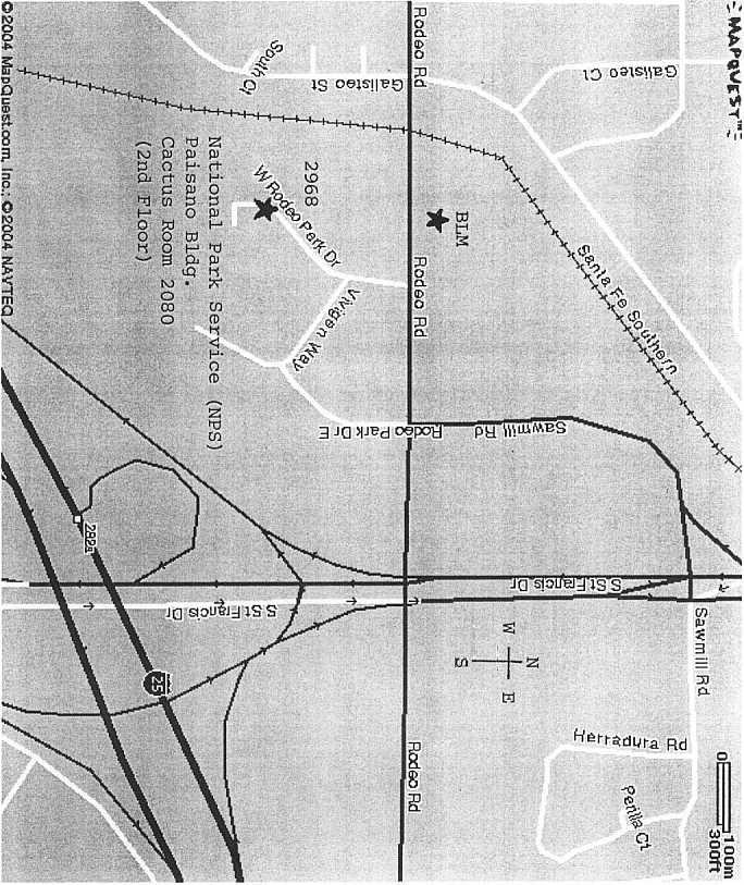
2 United States Department of the Interior Bureau of Land Management New Mexico State Office 1474 Rodeo Road P.O. Box Santa Fe, New Mexico IN REPLY REFER TO: 3120 (NM92100-lbo) Nov 29, 2004 NOTICE OF COMPETITIVE LEASE SALE Oil and Gas We are pleased to announce that we will offer for competitive sale certain Federal lands in the States of New Mexico, Oklahoma, and Texas for oil and gas leasing. This notice describes- -The time and place of the sale; -How the sale will be conducted; -How to participate in the bidding process; -The sale process; -How long the sale will last; -The conditions of the sale; -How to file a noncompetitive offer after the sale; and -How to file a pre-sale noncompetitive offer; -How to file a protest to our offering the lands in this Notice. Attached to this notice, beginning on page 1, is a list of the lands we are offering. The lands are described by parcel number and legal land description. Next to each parcel we have listed any stipulations that will be made a part of the lease at the time of issuance. We have also identified those parcels where the United States owns less than 100 percent interest in the oil and gas mineral rights, have pending pre-sale noncompetitive offers to lease, and are not available for noncompetitive offers to lease if they receive no bid at this sale. For your convenience, we are also including copies of the stipulations, affecting the parcels in this sale notice. When and where will the sale take place? When: The competitive sale will begin at 9:00 a.m. on Wednesday, January 19, The Lobby Area at the National Park Service, Paisano Building will be used to register all bidders. Registration will start at 8:00 a.m. through 9:30 a.m. so you can obtain your bidding number. Where : We will hold the sale at the NATIONAL PARK SERVICE, in the second floor conference room, (Cactus Room No. 2080), 2968 Rodeo Park Drive West, Paisano Building, Santa Fe, New Mexico, (see attached map). Access: The sale room is accessible to persons with disabilities. If you need an auxiliary aid or service to participate in the sale, such as sign language interpreter or material in an alternate format, contact the New Mexico State Office, Marcella Montoya at (505) by January 5, i
3 How will the sale be conducted? The sale will be conducted by oral auction. You must make your bids verbally. The winning bid is the highest verbal bid equal to or exceeding the National minimum acceptable bid. How do I participate in the bidding process? To participate in the bidding process, you must fill out a Bidder Registration form identifying the lessee s name and address that will be shown on the lease form and get a bidding number. We will begin registering bidders at 8:00 a.m. on the day of the sale in the Accounts Section. If you plan to bid, you must be registered before the sale begins. You must display your bid number to the auctioneer when you make a bid. What is the sale process? Starting at 9:00 a.m. on the day of the sale: -The auctioneer will offer the parcels in the order they are shown in this Notice. -All bids are on a per-acre basis for the entire acreage in the parcel; -The winning bid is the highest oral bid -The decision of the auctioneer is final. The minimum bid BLM can accept is $2 per acre. If a parcel contains fractional acreage, round the acreage up to the next whole acre. For example, a parcel of acres requires a minimum bid of $202 ($2 x101 acres). How long will the sale last? We begin the sale at 9:00 a.m. and it continues until all of the parcels in this Notice have been offered. The length of the sale depends on the number of parcels we are offering and the pace of the bidding. Normally, the sale is done before noon. What conditions apply to the lease sale? -Parcel withdrawal or sale cancellation: We reserve the right to withdraw any or all parcels before the sale begins. If we withdraw a parcel, we will post a notice in the New Mexico State Office Information Access Center (Public Room) before the day of the sale. We will announce withdrawn parcels before beginning the sale. If we cancel the sale, we will notify you as soon as possible. -Fractional interests: If the United States owns less that 100 percent of the oil and gas mineral interest for the land in a parcel we will show that information with the parcel. When we issue the lease, it will be for the percentage or fraction of interest the United States owns. However, you must calculate your bonus bid and advance rental payment on the gross acreage in the parcel, not the United States net interest. For example, if a parcel contains 200 acres and the United States owns 50 percent of the oil and gas mineral interest, the minimum bonus bid will be $400 ($2 X 200 acres) and the advance annual rental will be $300 ($1.50 X 200 acres) for the first 5-years and $400 ($2 X 200 acres) for the remainder of the lease term. Conversely, your chargeable acreage and royalty on production will be calculated on the United States net oil and gas mineral interest. ii
4 -Payment due on the day of the sale: For each parcel you are the successful high bidder, you must pay the minimum bonus bid of $2 per acre or fraction of an acre; the first years advance annual rental of $1.50 per acre or fraction of an acre; and a non-refundable administrative fee of $75. You must make this payment in our Accounts Section at the BLM office either during, or immediately following the sale. -Remaining payments: If your bonus bid was more than $2 per acre or fraction of an acre and you didn t pay the full amount on the day of the sale, you must pay the balance of your bonus bid by 4:00 p.m. on February 2, 2005, which is the 10 th working day following the sale. If you do not pay in full by this date, you lose the right to the lease and you will forfeit the money you paid on the day of the sale. If you forfeit a parcel, we may offer it at a later sale. -Forms of payment: You may pay by personal check, cashiers check, money order, or credit card, and if you choose a wire transfer please contact the Accounts Section, Roberta Sandoval at (505) Make checks payable to: Department of the Interior-BLM. We cannot accept cash. If a check you have sent to us in the past has been returned for insufficient funds, we may ask that you give us a guaranteed payment, such as a cashiers check or money order. Note: for customers planning to pay with credit card, effective January 1, 2005, The Department of the Treasury will be imposing a cap on the amount of charge we can accept. We suggest that no one plan to make a payment of $50,000 or more by credit card pending further information. If you pay by credit card and the transaction is refused, we will try to notify you early enough so that you can make other payment arrangements. However, we cannot grant you any extension of time to pay the money that is due the day of the sale. Bid Form: On the day of the sale, if you are a successful bidder you must give us a properly completed and signed competitive bid form (Form , October 1989, or later edition) with your payment. This form is a legally binding offer by the prospective lessee to accept a lease and all its terms and conditions. Once the form is signed, you cannot change it. We will not accept any bid form that has information crossed out or is otherwise altered. We recommend you get a copy of the bid form and complete all, but the money part, before the sale. You can fill out the money part at the sale. Your completed bid form certifies that: (1) You and the prospective lessee are qualified to hold an oil and gas lease under our regulations at 43 CFR ; and (2) Both of you have complied with 18 U.S. C. 1860, a law that prohibits unlawful combinations, intimidation of and collusion among bidders. A copy of the bid form is included with this notice. -Lease terms: A lease issued as a result of this sale will have a primary term of 10 years. It will continue beyond its primary term as long as oil or gas is produced in paying quantities on or for the benefit of the lease. Advance rental at $1.50 per acre or fraction of an acre for the first 5 years ($2 per acre after that) is due on or before the anniversary date each year until production begins. Once a lease is producing, you must pay a royalty of 12.5 percent of the value or the amount of production removed or sold from the lease. You will find other lease terms on our standard lease form (Form , June 1988 or later edition, copy included). - Some parcels have special requirements or restrictions which are called stipulations. These are noted with each of the parcels. Stipulations are part of the lease and supercede any inconsistent provisions of the lease form. iii
5 -Lease Issuance: After we receive the bid form and all the money due, and, if appropriate, your unit joinder information, we can issue the lease. Usually, a lease is effective the first day of the month following the month in which we sign it. If you want your lease to be effective the first day of the month in which we sign it, you must ask us in writing to do this. We have to receive your request before we sign the lease. -Legal Land Descriptions: We prepared this Notice with land status information from our Legacy Rehost 2000 (LR2000) case recordation system. We are providing you with the following information to assist you in understanding the legal descriptions given for each parcel: -Numbers shown after the Section are a listing of the lots in the parcel. -Lands are described separately by lots, aliquot parts, tracts, and exceptions to survey for each section. -LR2000 will code a ½ Township as a 2 in the database. This 2 will appear as the last digit in the number. For example, T. 14 ½ N., will appear as T. 0142N. -Cellular Phone Usage: You are restricted from using cellular phones in the saleroom during the oral auction. You must confine your cellular phone usage to the hallway or area outside the saleroom when the auction is taking place. -Other Conditions of the Sale: At the time the sale begins, we will make any rules regarding sale procedures that we feel are necessary for the proper conduct of the sale. NONCOMPETITIVE OFFERS TO LEASE What parcels are available for noncompetitive offers to lease? Unless stated in this notice, parcels that do not receive a bid at the competitive sale are available for noncompetitive offers to lease beginning the first business day following the day of the sale. If not withdrawn, or shown with a noncompetitive Pre-sale offer pending, these parcels are available for noncompetitive offers to lease for a period of two years following the day of the sale. How do I file a noncompetitive offer after the sale? If you want to file a noncompetitive offer to lease on an unsold parcel, you must give us- -Three (3) copies of form , Offer to Lease and Lease for Oil and Gas properly completed and signed. (Note: We will accept copies of the official form, including computer generated forms, that are legible and have no additions, omissions, other changes, or advertising. If you copy this form you must copy both sides on one page. If you copy the form on 2 pages or use an obsolete lease form, we will reject your offer). You must describe the lands in your offer as specified in our regulations at 43 CFR ; and -Your payment for the total of the $75 filing fee and the first year s advance rental ($1.50 per acre or fraction of an acre). Remember to round up any fractional acreage when you calculate the rental amount. iv
6 For your convenience, you may leave your noncompetitive offers for any parcel which has received no bid with the Accounts Staff. We consider all offers filed the day of the sale and the first business day after it, for any of the unsold parcels, to be filed as of 9:00 a.m. the first business day following the day of the sale. If a parcel receives more than one offer, we will hold a drawing to select the winner (see 43 CFR ). We have identified those parcels that have pending presale offers. A noncompetitive presale offer to lease has priority over any other noncompetitive offer to lease filed after the sale. The Non-Competitive Drawing will be held on Monday, January 24, 2005, at 3:00 p.m. at the NMSO Public Room. How do I file a noncompetitive presale offer? Under our regulations at 43 CFR (a), you may file a noncompetitive presale offer for lands that- -Are available, and; -Have not been under lease during the previous one-year period, or; -Have not been included in a competitive lease sale within the previous two-year period. -Your noncompetitive presale offer to lease must be filed prior to the official posting of this sale notice. If your presale offer was timely filed, was complete and we do not receive a bid for the parcel that contains the lands in your offer, it has priority over any other noncompetitive offer to lease for that parcel filed after the sale. Your presale offer to lease is your consent to the terms and conditions of the lease, including any additional stipulations. If you want to file a presale offer, follow the guidance listed above for filing a noncompetitive offer after the sale and the regulations at 43 CFR (a). When is the next competitive oil and gas lease sale scheduled? We have tentatively scheduled our next competitive sale for April 20, Please send nominations for that sale by December 10, How can I find out the results of this sale? We will post the sale results in the New Mexico State Office Information Access Center (Public Room). You can buy ($5.00) a printed copy of the results by contacting our Accounts Staff, at (505) The results list is also available on our public internet website: May I protest BLM s Decision to offer the lands in this notice for lease? -If you are adversely affected by our decision to offer the lands in this Notice for lease, you may protest the decision to the State Director under regulations 43 CFR You must submit your protest in writing to the State Director prior to the day of the sale. Generally, if we are unable to decide the protest before the sale, we will hold the sale while we consider the merits of your protest. v
7 -You may review the decision to offer the lands for lease and the supporting National Environmental Policy Act documents at our New Mexico State Office Business Information Access Center. Our office hours are from 8:00 a.m. to 4:00 p.m. Monday through Friday, except on National Holidays. Inclement Weather Conditions On occasion the Santa Fe area will have an abundance of snow or other weather conditions that prohibit the staff to make it to work safely at regular scheduled business hours. In the event of hazardous weather, please tune in to local television or radio stations. The Bureau of Land Management (BLM), New Mexico State Office follows the direction given to the Santa Fe, State of New Mexico Employees. If a 2-hour delay is broadcast for State Employees, BLM will also have a 2-hour delay. The procedure for future Oil and Gas Lease Sales scheduled on a business day with a 2-hour delay or the Office is closed for Business the BLM will proceed as follows: 1. In the event of a 2-hour delay - the doors to the BLM, NMSO will remain locked until 9:30 a.m. The Oil and Gas Lease Sale will begin at 11:00 a.m. with registration starting at 10:00 a.m., please call (505) for recorded information on delays. 2. In the event that the BLM office is CLOSED for Business on the day of an Oil and Gas Lease Sale, the sale will be cancelled and rescheduled at a later date. Please call (505) for recorded information on closures. Every effort will be made to post the information on delays of Closed for Business on the main entrance exterior doors of the building. Your safety and the safety of our BLM employees is our major concern. Power Outages In the event of a power outage, the office will be CLOSED. Whom should I contact if I have a question? For general information, please contact our Information Access Center at (505) or Lourdes B. Ortiz Land Law Examiner Fluids Adjudication Team vi
8

9


10


11
12

13
14 NEW MEXICO PUBLIC DOMAIN NM Acres T.0020N, R.0080E, 23 PM, NM Sec. 003 SW; 011 E2E2, NWNE; 013 ALL; 014 NESE; Torrance County Albuquerque FO NMNM 41256, NMNM None NM Acres T.0020N, R.0090E, 23 PM, NM Sec. 007 E2; 008 E2, N2NW; Torrance County Albuquerque FO PENDING PRESALE OFFER NO. NMNM NMNM None NM Acres T.0020N, R.0090E, 23 PM, NM Sec. 017 ALL; 018 LOTS 1-4; 018 E2,E2W2; Torrance County Albuquerque FO NMNM None NM Acres T.0030N, R.0090E, 23 PM, NM Sec. 030 LOTS 1, 6,10; 030 NE; 031 LOTS 3, 4,7-12; 031 SE; Torrance County Albuquerque FO PENDING PRESALE OFFER NO. NMNM NMNM None NM Acres T.0170S, R.0210E, 23 PM, NM Sec. 022 W2SW; Eddy County Carlsbad FO NMNM SENM -LN-1 Cave - Karst Occurrence Area SENM -S-18 Streams, Rivers, and Floodplains (Sec.22: NENWSW) SENM -S-25 Visual Resource Management SENM -S-31 Northern Aplomado Falcon Suitable Habitat NM Acres T.0210S, R.0220E, 23 PM, NM Sec. 033 S2N2,SW,N2SE,SWSE; Eddy County Carlsbad FO NMNM SENM -S-18 Streams, Rivers, and Floodplains NM Acres T.0220S, R.0220E, 23 PM, NM Sec. 005 LOTS 1-4; 005 S2N2,S2; 006 LOTS 3-7; 006 SESW; Eddy County Carlsbad FO NMNM , NMNM 84838, NMNM SENM -S-18 Streams, Rivers, and Floodplains NM Acres T.0230S, R.0220E, 23 PM, NM Sec. 004 ALL; 009 N2, N2S2, S2SW; Eddy County Carlsbad FO NMNM 89204, NMNM
15 NM Acres T.0190S, R.0240E, 23 PM, NM Sec. 002 NESE; Eddy County Carlsbad FO NMNM NM Acres T.0200S, R.0240E, 23 PM, NM Sec. 007 NENW; Eddy County Carlsbad FO NMNM SENM -LN-1 Cave - Karst Occurrence Area SENM -S-21 Caves and Karst SENM -S-25 Visual Resource Management SENM -S-31 Northern Aplomado Falcon Suitable Habitat NM Acres T.0200S, R.0240E, 23 PM, NM Sec. 020 ALL; 029 E2,E2W2,SWSW; Eddy County Carlsbad FO NMNM SENM -LN-1 Cave - Karst Occurrence Area SENM -S-18 Streams, Rivers, and Floodplains Sec. 20: N2S2 SENM -S-21 Caves and Karst SENM -S-25 Visual Resource Management NM Acres T.0200S, R.0240E, 23 PM, NM Sec. 030 LOTS 1-4; 030 E2NW,NESW; 031 LOTS 3,4; 031 E2W2; Eddy County Carlsbad FO NMNM NM-11-LN Special Cu ltural Resource Lease Notice SENM -LN-1 Cave - Karst Occurrence Area SENM -S-17 Slopes or Fragile Soils Sec. 30: Lots 1, 2 Sec. 31: Lots 3,4, E2SW SENM -S-21 Caves and Karst SENM -S-25 Visual Resource Management NM Acres T.0210S, R.0240E, 23 PM, NM Sec. 015 LOTS 1-4; 015 NE; Eddy County Carlsbad FO NMNM SENM -LN-1 Cave - Karst Occurrence Area SENM -S-17 Slopes or Fragile Soils SENM -S-21 Caves and Karst : Two archeological sites have been found in the NE of Section 15. NM Acres T.0230S, R.0240E, 23 PM, NM Sec. 003 LOTS 1-4; 003 S2N2,S2; Eddy County Carlsbad FO NMNM SENM -LN-1 Cave - Karst Occurrence Area SENM -S-18 Streams, Rivers, and Floodplains SENM -S-21 Caves and Karst 2
16 NM Acres T.0260S, R.0240E, 23 PM, NM Sec. 020 NWNE,W2,S2SE; 021 S2SW,SWSE; 028 LOTS 1-4; 028 W2NE,NW; 029 LOTS 1-8; 029 N2; 030 LOTS 5-8; 030 E2NE,E2SW; Eddy County Carlsbad FO NMNM 69571, NMNM NMNM 88243, NMNM SENM -LN-1 Cave - Karst Occurrence Area SENM -S-8 Yeso Hills Sec. 28: Lots 3, 4 SENM -S-17 Slopes or Fragile Soils Southern Gypsum Soil Area SENM -S-18 Streams, Rivers, and Floodplains SENM -S-21 Caves and Karst SENM -S-25 Visual Resource Management NM Acres T.0200S, R.0250E, 23 PM, NM Sec. 024 N2,SW; Eddy County Carlsbad FO NMNM SENM -LN-1 Cave - Karst Occurrence Area SENM -S-5 Threatened Plant Species Sec. 24: N2NE, NENW, N2SENW, N2SWNE, N2SENE Gypsum Wild-Buckwheat SENM -S-17 Slopes or Fragile Soils NM Acres T.0260S, R.0250E, 23 PM, NM Sec. 010 ALL; Eddy County Carlsbad FO NMNM 70877, NMNM 83558, NMNM SENM -LN-1 Cave - Karst Occurrence Area SENM -S-17 Slopes or Fragile Soils Southern Gypsum Soil Area SENM -S-21 Caves and Karst NM Acres T.0260S, R.0250E, 23 PM, NM Sec. 011 ALL; Eddy County Carlsbad FO NMNM 69576, NMNM SENM -LN-1 Cave - Karst Occurrence Area SENM -S-17 Slopes or Fragile Soils Southern Gypsum Soil Area SENM -S-21 Caves and Karst NM Acres T.0260S, R.0250E, 23 PM, NM Sec. 012 ALL; Eddy County Carlsbad FO NMNM 69576, NMNM SENM -LN-1 Cave - Karst Occurrence Area SENM -S-17 Slopes or Fragile Soils Southern Gypsum Soil Area SENM -S-18 Streams, Rivers, and Floodplains SENM -S-20 Springs, Seeps and Tanks SENM -S-21 Caves and Karst NM Acres T.0260S, R.0270E, 23 PM, NM Sec. 004 NE,SW; 005 NE; Eddy County Carlsbad FO NMNM SENM -S-15 Wildlife Habitat Projects SENM -S-17 Slopes or Fragile Soils Southern Gypsum Soil Area SENM -S-18 Streams, Rivers, and Floodplains NM Acres T.0180S, R.0290E, 23 PM, NM Sec. 018 LOTS 2,3; Eddy County Carlsbad FO NMNM : One archeological site is known to be located near or within the lease area SENM -LN-1 Cave - Karst Occurrence Area SENM -S-21 Caves and Karst 3
17 NM Acres T.0020S, R.0300E, 23 PM, NM Sec. 001 SE; 002 SE; 011 NW; Roosevelt County Roswell FO NMNM 62915, NMNM None NM Acres T.0020S, R.0300E, 23 PM, NM Sec. 004 LOTS 3,4; 004 S2NW,SW; 008 ALL; 009 W2,N2SE; 010 N2SW; Roosevelt County Roswell FO NMNM 66709, NMNM 68080, NMNM SENM -S-19 Playas and Alkali Lakes Sec. 09: W2, N2SE Sec. 10: N2SW NM Acres T.0020S, R.0300E, 23 PM, NM Sec. 021 NE; Roosevelt County Roswell FO NMNM None NM Acres T.0140S, R.0300E, 23 PM, NM Sec. 024 ALL; Chaves County Roswell FO NMNM 56734, NMNM 60394, NMNM SENM -S-33 NSO LPC-SDL Habitat NM Acres T.0150S, R.0300E, 23 PM, NM Sec. 013 ALL; Chaves County Roswell FO NMNM SENM -S-17R Slopes or Fragile Soils SENM -S-20 Springs, Seeps and Tanks SENM -S-34 Zone 3-POD NM Acres T.0190S, R.0300E, 23 PM, NM Sec. 004 LOTS 1,2; Eddy County Carlsbad FO NMNM NM-11-LN Special Cultural Resource Notice SENM -S-1 Potash Stipulation SENM -S-25 Visual Resource Management SENM -S-30 NSO Potash Area NM Acres T.0190S, R.0300E, 23 PM, NM Sec. 019 LOTS 4; 019 SESW; Eddy County Carlsbad FO NMNM SENM -LN-1 Cave - Karst Occurrence area SENM -S-1 Potash Stipulation SENM -S-19 Playas and Alkali Lakes SENM -S-21 Caves and Karst NM Acres T.0260S, R.0300E, 23 PM, NM Sec. 018 NENW; Eddy County Carlsbad FO NMNM SENM -S-23 Sand Dune Lizard NM Acres T.0120S, R.0310E, 23 PM, NM Sec. 004 S2NW,SESE; 009 SW; Chaves County Roswell FO NMNM , NMNM SENM -S-17R Slopes or Fragile Soils SENM -S-20 Springs, Seeps and Tanks 4
18 NM Acres T.0120S, R.0310E, 23 PM, NM Sec. 033 W2; Chaves County Roswell FO NMNM 82898, NMNM SENM -S-19 Playas and Alkali Lakes NM Acres T.0130S, R.0310E, 23 PM, NM Sec. 028 NE; Chaves County Roswell FO NMNM 83079, NMNM None NM Acres T.0180S, R.0320E, 23 PM, NM Sec. 028 E2W2; Lea County Carlsbad FO NMNM SENM -S-22 Prairie Chickens SENM -S-23 Sand Dune Lizard NM Acres T.0200S, R.0320E, 23 PM, NM Sec. 015 W2; Lea County Carlsbad FO SENM -S-4 Laguna Plata- Archeological District NSO SENM -S-22 Prairie Chickens SENM -S-23 Sand Dune Lizard NM Acres T.0210S, R.0320E, 23 PM, NM Sec. 021 All; Lea County Carlsbad FO NMNM 61600, NMNM SENM -S-1 Potash Stipulation SENM -S-33 LPC SDL NSO NM Acres T.0220S, R.0320E, 23 PM, NM Sec. 010 SENW; Lea County Carlsbad FO NMNM SENM -S-1 Potash Stipulation SENM -S-22 Prairie Chickens NM Acres T.0240S, R.0320E, 23 PM, NM Sec. 023 NWNW; Lea County Carlsbad FO NMLC E SENM -S-22 Prairie Chickens NM Acres T.0190S, R.0330E, 23 PM, NM Sec. 024 SE; Lea County Carlsbad FO NMNM SENM -S-1 Potash Stipulation SENM -S-22 Prairie Chickens SENM -S-23 Sand Dune Lizard NM Acres T.0050S, R.0330E, 23 PM, NM Sec. 027 W2NE; Roosevelt County Roswell FO NMNM SENM -LN-1 Cave - Karst Occurrence Area SENM -S-25 Visual Resource Management 5
19 NM Acres T.0230S, R.0340E, 23 PM, NM Sec. 024 W2SW,SESW,SWSE; Lea County Carlsbad FO NMNM NM Acres T.0250S, R.0340E, 23 PM, NM Sec. 015 W2; Lea County Carlsbad FO NMNM SENM -S-22 Prairie Chickens NM Acres T.0240S, R.0340E, 23 PM, NM Sec. 001 LOTS 4; 001 SWNW,NWSW; 011 E2E2,W2W2; Lea County Carlsbad FO NMNM NM Acres T.0260S, R.0340E, 23 PM, NM Sec. 010 NWSE; Lea County Carlsbad FO NMNM SENM -S-19 Playas and Alkali Lakes SENM -S-22 Prairie Chickens NM Acres T.0240S, R.0340E, 23 PM, NM Sec. 017 ALL; Lea County Carlsbad FO NMLC : One archaeological site is known to be located in the NW of Sec 17. SENM -S-19 Playas and Alkali Lakes NM Acres T.0230S, R.0350E, 23 PM, NM Sec. 019 LOTS 1-4; 019 NE,E2W2,N2SE; Lea County Carlsbad FO NMNM 63769, NMNM SENM -LN-1 Cave - Karst Occurrence Area SENM -S-19 Playas and Alkali Lakes NM Acres T.0250S, R.0340E, 23 PM, NM Sec. 011 S2; 012 ALL; 013 NE, N2NW, SENW; Lea County Carlsbad FO NMNM NM-11-LN Special Cultural Resource Lease Notice: One archaeological site has been found in the SE of Sec 12. SENM -S-22 Prairie Chickens NM Acres T.0250S, R.0350E, 23 PM, NM Sec. 024 NWSE; Lea County Carlsbad FO NMNM SENM -S-22 Prairie Chickens 6
20 NEW MEXICO NW NM Acres T.0200N, R.0050W, 23 PM, NM Sec. 003 LOTS 3,4; 003 S2NW,SW; 010 N2; McKinley County Farmington FO NMNM F-33-LN Mountain Plover NM Acres T.0200N, R.0050W, 23 PM, NM Sec. 017 ALL; 018 LOTS 3,4; 018 S2NE,E2SW,SE; 020 NE; McKinley County Farmington FO NMNM 5980, NMNM 90459, NMNM F-33-LN Mountain Plover NM Acres T.0200N, R.0050W, 23 PM, NM Sec. 021 W2E2,W2; 028 NE,E2NW; 031 LOTS 1-4; 031 W2NE,E2W2; McKinley County Farmington FO NMNM 5980, NMNM 66764, NMNM NMNM 90836, NMNM 91548, NMNM F-33-LN Mountain Plover NM Acres T.0190N, R.0060W, 23 PM, NM Sec. 008 NE; 010 W2E2,W2; McKinley County Farmington FO NMNM 85814, NMNM NM Acres T.0200N, R.0060W, 23 PM, NM Sec. 006 LOTS 3-5; 006 SENW; 008 N2; 013 NW; 014 NE,SW; 025 ALL; McKinley County Farmington FO NMNM 7250, NMNM 61259, NMNM NMNM 90940, NMNM 91517, NMNM NM Acres T.0210N, R.0060W, 23 PM, NM Sec. 004 LOTS 3,4; 004 S2NW; 021 NENE; 028 ALL; 033 NW,SE; Sandoval County Farmington FO NMNM 91519, NMNM NM Acres T.0190N, R.0070W, 23 PM, NM Sec. 001 LOTS 6,7; 001 SWSE; 011 S2; 012 LOTS 1,2; 012 W2NE,NW; McKinley County Farmington FO NMNM 25309, NMNM 57162, NMNM F-33-LN Mountain Plover 7
21 NM Acres T.0200N, R.0070W, 23 PM, NM Sec. 002 LOTS 1-4; 002 S2NE,SW; 010 SE; McKinley County Farmington FO NMNM 64846, NMNM OKLAHOMA PUBLIC DOMAIN NM Acres T.0220N, R.0150W, 17 PM, OK Sec. 021 NESW; Major County Tulsa FO OKNM None NM Acres T.0200N, R.0070W, 23 PM, NM Sec. 006 LOTS 1,2,6,7; 006 S2NE,E2SW,SE; 008 N2,SW; McKinley County Farmington FO NMNM 89107, NMNM : One archaeological site is known to be located in the NE of Section 8. NM Acres T.0240N, R.0160W, 17 PM, OK Sec. 028 ACCR & RIPR AC TO LOT 4; 032 ACCR & RIPR AC TO LOT 3; 032 ACCR & RIPR AC TO LOT 1; SEE EXHIBIT A FOR M&B W/MAP; Woods County Tulsa FO ORA-1 Floodplain Protection (CSU) ORA-2 Wetland/Riparian (CSU) ORA (LN-1) Threatened & Endangered Species NM Acres T.0290N, R.0130W, 23 PM, NM Sec. 030 LOTS 3,4; 030 E2SW,S2SE; San Juan County Farmington FO NMNM F-31-NSO Dunes Vehicle Recreation Area With Map C-24 NM-11-LN Special Cultural Resource Lease Notice NM Acres T.0300N, R.0140W, 23 PM, NM Sec. 009 E2; San Juan County Farmington FO NMNM 55114, NMNM NMNM 58896, NMNM F-9-CSU Paleontology F-24-VRM Class III Pinon Mesa Fossil Area NM Acres T.0250N, R.0160W, 17 PM, OK Sec. 026 NWSW; Woods County Tulsa FO OKNM None NM Acres T.0240N, R.0170W, 17 PM, OK Sec. 029 SWSE; Woodward County Tulsa FO OKNM ORA-3 Season of Use Stipulation 8
22 NM Acres T.0130N, R.0220W, 17 PM, OK Sec. 001 NESE; Roger Mills County Tulsa FO OKNM ORA-3 Season of Use Stipulation OKLAHOMA ACQUIRED NM Acres T.0060N, R.0240E, 17 PM, OK Sec. 035 S2SENE, E2NWSW; 035 NESW, S2SW, SE; 036 S2; 036 S2SWNE, S2S2SENE, S2S2NW; Le Flore County Tulsa FO CORPS OF ENGINEERS WISTER LAKE OKNM COE (SS-1A) NM Acres T.0060N, R.0250E, 17 PM, OK Sec. 031 LOTS 3,4; 031 E2SW; Le Flore County Tulsa FO CORPS OF ENGINEERS WISTER LAKE OKNM COE (SS-1A) NM Acres T.0230N, R.0220W, 17 PM, OK Sec. 018 E2NE,SE; Woodward County Tulsa FO CORPS OF ENGINEERS FORT SUPPLY LAKE OKNM COE (SS-1A) NM Acres T.0250N, R.0220W, 17 PM, OK Sec. 021 W 2E2,W2; 028 W2E2,W2; 029 N2,E2SW,SE; 030 NENE; 032 E2; Harper County Tulsa FO AGRICULTURE RESEARCH SERVICE 50% MINERAL INTEREST Sec. 21: W2NE, NW Sec. 28: W2SE Sec. 29: E2,NW Sec. 30: NENE Sec. 32: NE Remaining lands are 100% mineral interest OKNM 6743, OKNM 36632, OKNM ARS-1 ARS-2 TEXAS ACQUIRED NM Acres TX TR 100,103,104-1,104-2,114; TR 115, , ,126; TR , , ; Burleson County Tulsa FO CORPS OF ENGINEERS SOMERVILLE LAKE TXNM COE (STATEMENT OF AVAILABILITY) COE (NSO/ND) NM Acres TX TR 101; Burleson County Tulsa FO CORPS OF ENGINEERS SOMERVILLE LAKE TXNM COE (STATEMENT OF AVAILABILITY) COE (NSO/ND) 9
23 NM Acres TX TR A-231; Nacogdoches County Tulsa FO US OWNS 50% MINERAL INTEREST TXNM None Number of Parcels - 70 Total Acreage 36, Total number of Parcels with Presale Offers - 2 Parcel Number of Parcels with Presale Offers - 2, 4 Total Acreage With Presale Offers 1, Any portion of the listed lands may be deleted upon determination that such lands are not available for leasing. 10
24 Exhibit A Page 1 of 4 METES AND BOUNDS DESCRIPTION OF THE ACCRETION AND RIPARIAN ACREAGE TO LOT 1, SECTION 32, T. 24 N., R. 16 W., NOT INCLUDED IN BLM LEASES OKNM AND OKNM 97225, LOCATED ALONG THE CIMARRON RIVER, WOODS COUNTY, OKLAHOMA (Bearings and Distances are Geodetic) Beginning at the ancient meander corner on the ancient right bank between Sections 29 and 32, said point being S East a distance of feet from a 3/8 IP with cap at the North Quarter corner of Section 32, T. 24 N., R. 16 W., Woods County, Oklahoma. Thence along the North line of said Section 32, S East a distance of feet to the intersection point of the North line of said Section 32 and the accretion line to said Lot 1; Thence S West a distance of feet to the Southeast corner of said Lot 1; Thence along the adjusted ancient right bank the following courses and distances: N West a distance of feet; N West a distance of feet to the point of beginning, and containing acres of land more or less. 11
25 Exhibit A Page 2 of 4 METES AND BOUNDS DESCRIPTION OF THE ACCRETION AND RIPARIAN ACREAGE TO LOT 3, SECTION 32, T. 24 N., R.16 W., NOT INCLUDED IN BLM LEASES OKNM AND OKNM 97225, LOCATED ALONG THE CIMARRON RIVER, WOODS COUNTY, OKLAHOMA (Bearings and Distances are Geodetic) Beginning at the Southeast corner said Lot 3, said point being North West a distance of feet from the ancient meander corner on the ancient right bank between Sections 32 and 33, said point also being North West a distance feet from a 3/8 Iron Rod with cap at the East Quarter corner of Section 32, T. 24 N., R. 16W., Woods County, Oklahoma. Thence along the adjusted ancient right bank the following courses and distances: North West a distance of feet; North West a distance of feet to the Northwest corner of said Lot 3; Thence North East a distance of feet to a point on the South line of an existing BLM Lease OKNM Thence along the boundary of said existing BLM Lease OKNM the following courses and distances: South East a distance of feet; North East a distance of feet; North West a distance of feet; North West a distance of feet; North West a distance of feet; South West a distance of feet to a proportional point on the 1999 right bank; Thence North East a distance of feet to a proportional point on the 2004 right bank; Thence North East a distance of feet to a point on the 2004 medial line; 12
26 Exhibit A Page 3 of 4 Thence along the 2004 medial line the following courses and distances: South East a distance of feet; South East a distance of feet; South East a distance of feet; South East a distance of feet; South East a distance of feet; South East a distance of feet to a point; Thence South West a distance of feet to a proportional point on the 2004 right bank; Thence South West a distance of feet to the point of beginning, and containing acres of land more or less. 13
27 Exhibit A Page 4 of 4 METES AND BOUNDS DESCRIPTION OF THE ACCRETION AND RIPARIAN ACREAGE TO LOT 4, SECTION 28, T. 24 N., R. 16 W., NOT INCLUDED IN BLM LEASE OKNM 96105, LOCATED ALONG THE CIMARRON RIVER, WOODS COUNTY, OKLAHOMA (Bearings and Distances are Geodetic) Beginning at a point on the North line of Section 33, said point being North West a distance of feet from an Iron Rod with cap at the Northeast corner of Section 33, T. 24 N., R. 16 W., Woods County, Oklahoma; Thence South West a distance of feet to a proportional point on the 2004 left bank; Thence South West a distance of feet to a point on the 2004 medial line; Thence along the 2004 medial line the following courses and distances: North West a distance of feet; North West a distance of feet; North West a distance of feet; North West a distance of feet; North West a distance of feet; North West a distance of feet; North West a distance of feet; North West a distance of feet; North West a distance of feet; North West a distance of feet to a point on the North line of said Section 33; Thence North East a distance of feet to a point on the boundary line of said existing BLM Lease; Thence along the boundary of said existing BLM Lease the following courses and distances: South West a distance of feet; South East a distance of feet to the point of beginning and containing acres of land more or less. 14
28 ARS-1 AGRICULTURE RESEARCH SERVICE SPECIAL STIPULATION The undersigned lessee accepts the following terms and conditions and agrees to their incorporation in the above numbered oil and gas lease: 1. The lands are not to be entered at any time for the purpose of exploring for oil and gas without the written approval of the Superintendent, Southern Plains Range Research Station, Agricultural Research Service. If approval is granted, the Special Stipulations ARS-2 will be in effect. 2. The lands are not to be directionally drilled or slant-well drilled at any time. 3. The oil and gas lease is issued solely for the purpose of unitizing or communitizing the acreage embraced in this lease with other adjoining acreage. 4. The location of surface-disturbing activities will be finally determined only upon the approval of the Superintendent, Southern Plains Range Research Station, Agricultural Research Service. 15
29 ARS-2 Page 1 of 4 UNITED STATES DEPARTMENT OF THE INTERIOR BUREAU OF LAND MANAGEMENT SPECIAL STIPULATIONS FOR LANDS UNDER JURISDICTION OF THE AGRICULTURE RESEARCH SERVICE UNITED STATES DEPARTMENT OF AGRICULTURE The lands embraced in this lease for oil and gas issued under the Mineral Leasing Act for Acquired Lands of August 7, 1947, (61 Stat. 913; 30 U.S.C ) being under the jurisdiction of the Secretary of Agriculture, the lessee hereby agrees to accept the following terms and conditions, and to have them incorporated into the lease: The authorized representative of the Secretary of Agriculture is the Superintendent, Southern Plains Range Research Station, Agricultural Research Service, Woodward, Oklahoma, (hereinafter referred to as Superintendent ) to whom all matter relating to this stipulation will be addressed. Oil and gas operations on the leased lands will be conducted with due regard for good land management so as to create a minimum disturbance to the surface vegetation and to the experimental research of the Agricultural Research Service (ARS). A cooperative and mutual effort will be exercised by both parties in the solution of any and all operational problems. Each well location on the leased lands will be staked in joint agreement between the lessee and the Superintendent. The Superintendent will agree to a well location within fifteen (15) days from the date he receives a notice of lessee s intention to drill. If the location site in Section 33 as determined by the drilling and spacing pattern allowed by the Corporation Commission of the State of Oklahoma does not meet with the approval of the Superintendent, the lessee will use diligent efforts to obtain an exception by said Commission. Routes of ingress and egress to well sites, including maintenance thereon, will be specified by the Superintendent, without undue burden to normal requirements of the lessee. Such routes will be posted, and no deviation there from will be permitted except in an emergency. 16
30 ARS-2 Page 2 of 4 Any fence crossed by a route of ingress and egress to a well location will have a temporary cattle-guard and the fence properly braced on both sides; all construction to be at the expense of the lessee and in accordance with specifications to be furnished by the Superintendent. The area of all operations for drilling and production will be fenced in the manner specified by the Superintendent so as to prevent grazing livestock from entering thereon. The area of any drill site will be a minimum consistent with the standard well drilling practice of the oil and gas industry, but in no case to exceed three (3) acres without written approval of the Superintendent. If a second or alternative drill site in any section, is required because of unforeseen surface or subsurface difficulties, the Superintendent will immediately designate an adjoining area for such use. The lessee will restore the surface of the first site to its former condition, so far as reasonably possible. Pipelines will be constructed along routes specified by the Superintendent, with both minimum of interference to the experimental research of ARS and inconvenience to the lessee being given full consideration. All pipelines, however, will be buried a minimum of eighteen (18) inches below the surface of the ground, unless otherwise agreed to in writing by the Superintendent. For drilling operations, metal reservoirs or drilling pits will be used, if available without undue burden to lessee, instead of cutting pits into the ground. If drilling pits are dug, as soon as possible after conclusion of drilling operations, the drilling mud and foreign matter will be removed from said pits and the pits will be filled. The superintendent agrees to provide an area where said mud, sludge, etc., may be deposited. Water required for drilling operations on any well will not be taken from wells located on the leased lands unless approved in writing by the Superintendent. The lessee, its agents, employees, contractors, subcontractors, and employees of contractors and subcontractors, when on the leased lands 17
31 ARS-2 Page 3 of 4 shall exercise extraordinary precaution to prevent and suppress any and all range fires. Any fire caused by the lessee, its agents, employees, contractors, subcontractors, or employees of such contractors or subcontractor, which burns the major part of one experimental pasture, or parts of two or more experimental pastures, will require controlled burning of all other pastures in the same unit of which these pastures are an integral part, so that ARS experiments on the whole unit will be treated uniformly. All costs of such controlled burning will be borne by the lessee and in accordance with written instructions of the Superintendent. Unless prevented by circumstances over which he has no control, the lessee will place his employees, contractors, subcontractors, and employees of contractors and subcontractors employed on the leased land at the disposal of any authorized officer of the Department of Agriculture for the purpose of fighting brush or grass fires on or originating on the leased lands or on adjacent areas or caused by the negligence of the lessee or his employees, contractors, subcontractors and employees of contractors and subcontractors, with the understanding that payment for such services will be made at rates to be determined by the authorized representative of the Secretary of Agriculture, which rates will not be less than the current rates of pay prevailing in the vicinity for services of a similar character: Provided, that if the lessee, his employees, contractors, subcontractors, or employees of contractors or subcontractors caused or could have prevented the origin or spread of said fire, or fires, no payment will be made for service so rendered. During periods of serious fire danger to brush or grass, as may be specified by the Superintendent, the lessee will prohibit smoking and the building of camp and lunch fires by his employees, contractors, subcontractors, and employees of contractors or subcontractors within the lease area except at established camps, and will enforce this prohibition by all means within his power: Provided, that the Superintendent may designate safe places where after all inflammable material has been cleared away, at the option of the lessee, smoking may be permitted. The lessee will not burn rubbish, trash or other inflammable materials except with the consent of the Superintendent and will not use explosives in such a manner as to scatter inflammable materials on the surface of the land during the brush or grass fire season, except as authorized to do so or on areas approved by such representative. 18
32 ARS-2 Page 4 of 4 The lessee will be responsible for payment of a just and reasonable sum for death or injury to any Government-owned or Government supervised livestock properly grazing on the leased lands, where such death or injury is attributable to the negligence of the lessee, its agents, employees, contractors, subcontractors, or employees of such contractors or subcontractors. Unless otherwise authorized, prior to the beginning of operations upon the leased lands, lessee will appoint and maintain at all times during the term of this lease a local agent upon whom may be served written orders and notices respecting matters contained in this stipulation, and to inform the Superintendent, in writing, of the name and address of such agent. If a substitute agent is appointed, the lessee will immediately so inform the Superintendent. 19
33 COE-SS (1-A) WISTER LAKE Page 1 of 3 U. S. ARMY COE SPECIAL STIPULATIONS 1-A WISTER LAKE 1. This is a no surface occupancy lease. 2. All oil and gas drilling and production operations shall be under the supervision of the District Manager, Bureau of Land Management (BLM), in accordance with 43 Code of Federal Regulations The Secretary of the Army or designee reserves the right to require cessation of operations if a national emergency arises or if the Army needs the leased property for a mission incompatible with lease operations. On approval from higher authority, the District Engineer will give notice of the required suspension. The lessee agrees to this condition and waives compensation for its exercise. 4. If the District Engineer or his authorized representative discovers an imminent danger to safety or security which allows no time to consult the BLM, that person may order such activities stopped immediately. The District Manager, BLM, will be notified immediately, will review the order, and will determine the need for further remedial action. 5. Lessee liability for damage to improvements shall include improvements of the Department of Defense. Lessee shall be liable for pollution and other damages, as a result of their operations, to Government-owned land and property and to the property of the Government's authorized surface user. 6. Before beginning to drill, the lessee must consult with third parties authorized to use real estate in the lease area and must consider programs for which third parties have contractual responsibility. 7. A license to conduct geophysical test on the leased area must be obtained separately from the District Engineer. 8. That all rights under this lease are subordinate to the rights of the United States to flood and submerge the lands, permanently or intermittently, in connection with the operation and maintenance of the above-named project. 20
34 COE-SS (1-A) Wister Lake Page 2 of 3 9. That the United States shall not be responsible for damages to property or injuries to persons which may arise from or be incident to the use and occupation of the said premises, or for damages to the property of the lessee, or for injuries to the person of the lessee's officers, agents, servants, or employees, or others who may be on said premises at their invitation or the invitation of any one of them arising from or incident to the flooding of the said premises by the Government or flooding from any other cause, or arising from or incident to any other governmental activities; and the lessee shall hold the United States harmless from any and all such claims. 10. That the work performed by the lessee on the lands shall be under the general supervision of the District Engineer, Corps of Engineers, in direct charge of the project, and subject to such conditions and regulations as may be prescribed by him, and the plans and locations for all structures, appurtenances thereto, and work on said lands shall be submitted to the said District Engineer for approval in advance of commencement of any work on said lands. The District Engineer shall have the right to enter on the premises, at any time, to inspect both the installation and operational activities of the lessee. 11. That no structure or appurtenance thereto shall be of a material or construction determined to create floatable debris. 12. That the construction and operation of said structures and appurtenances thereto shall be of such a nature as not to cause pollution of the soils and the waters of the project. 13. That the United States reserves the right to use the land jointly with the lessee in connection with the construction, operation, and maintenance of the Government project and to place improvements thereon or to remove materials therefrom, including sand and gravel and other construction material, as may be necessary in connection with such work, and the lessee shall not interfere in any manner with such work or do any act which may increase the cost of performing such work. If the cost of the work performed on land outside property included in the lease is made more expensive by reason of improvements constructed on the leased property by the lessee, the lessee shall pay to the United States money in the amount, as estimated by the Chief of Engineers, sufficient to compensate for the additional expense involved. 21
35 COE-SS(1-A) Wister Lake Page 3 of All areas with 2,000 feet of any major structure, including but not limited to the dam, spillway, or embankment, are restricted areas. The lessee, his operators, agents, or employees shall not utilize the surface of restricted areas for any purpose. Drilling operations in, on, or under the restricted areas, including drilling outside of the restricted areas which would cause a bore hole to be under the restricted area, will not be permitted. The restricted areas are included in the lease for the sole purpose of becoming part of a drilling unit so that the United States will share in the royalty of the unit. 15. All existing or proposed public use areas, recreation areas, wildlife and waterfowl refuges, historical sites, and hiking and horseback trail areas may be leased for the sole purpose of becoming a part of a drilling unit. The lessee, his operators, agents, or employees will not use or enter upon the surface for any purpose. Directional drilling from non-public areas is permitted if not otherwise restricted. 16. All storage tanks and slush pits will be protected by dikes of sufficient capacity to protect the reservoir from pollution to flood pool elevation feet, for Wister Lake, National Geodetic Vertical Datum. 17. It is the responsibility of the lessee to identify and be aware of areas where entry is prohibited. 18. The operator will immediately stop work and advise the District Engineer or his authorized representative if contamination is found in the operating area. 22
36 COE-SS (1-A) Fort Supply Lake Page 1 of 3 1. This is a no surface occupancy lease. U. S. ARMY COE SPECIAL STIPULATIONS 1-A FORT SUPPLY LAKE 2. All oil and gas drilling and production operations shall be under the supervision of the District Manager, Bureau of Land Management (BLM), in accordance with 43 Code of Federal Regulations The Secretary of the Army or designee reserves the right to require cessation of operations if a national emergency arises or if the Army needs the leased property for a mission incompatible with lease operations. On approval from higher authority, the District Engineer will give notice of the required suspension. The lessee agrees to this condition and waives compensation for its exercise. 4. If the District Engineer or his authorized representative discovers an imminent danger to safety or security which allows no time to consult the BLM, that person may order such activities stopped immediately. The District Manager, BLM, will be notified immediately, will review the order, and will determine the need for further remedial action. 5. Lessee liability for damage to improvements shall include improvements of the Department of Defense. Lessee shall be liable for pollution and other damages, as a result of their operations, to Government-owned land and property and to the property of the Government's authorized surface user. 6. Before beginning to drill, the lessee must consult with third parties authorized to use real estate in the lease area and must consider programs for which third parties have contractual responsibility. 7. A license to conduct geophysical test on the leased area must be obtained separately from the District Engineer. 8. That all rights under this lease are subordinate to the rights of the United States to flood and submerge the lands, permanently or intermittently, in connection with the operation and maintenance of the above-named project. 9. That the United States shall not be responsible for damages to property or injuries to persons which may arise from or be incident to the use and occupation of the said premises, or for damages to the property of the lessee, or for injuries to the person of the lessee's officers, agents, servants, or employees, or others who may be on said premises at their 23
37 COE-SS (1-A) Fort Supply Lake Page 2 of 3 Invitation or the invitation of any one of them arising from or incident to the flooding of the said premises by the Government or flooding from any other cause, or arising from or incident to any other Governmental activities; and the lessee shall hold the United States harmless from any and all such claims. 10. That the work performed by the lessee on the lands shall be under the general supervision of the District Engineer, Corps of Engineers in direct charge of the project and subject to such conditions and regulations as may be prescribed by him, and the plans and locations for all structures, appurtenances thereto, and work on said lands shall be submitted to the said District Engineer for approval in advance of commencement of any work on said lands. The District Engineer shall have the right to enter on the premises, at any time, to inspect both the installation and operational activities of the lessee. 11. That no structure or appurtenance thereto shall be of a material or construction determined to create floatable debris. 12. That the construction and operation of said structures and appurtenances thereto shall be of such a nature as not to cause pollution of the soils and the waters of the project. 13. That the United States reserves the right to use the land jointly with the lessee in connection with the construction, operation, and maintenance of the Government project and to place improvements thereon or to remove materials therefrom, including sand and gravel and other construction material, as may be necessary in connection with such work, and the lessee shall not interfere in any manner with such work or do any act which may increase the cost of performing such work. If the cost of the work performed on land outside the property included in the lease is made more expensive by reason of improvements constructed on the leased property by the lessee, the lessee shall pay to the United States money in the amount, as estimated by the Chief of Engineers, sufficient to compensate for the additional expense involved. 14. All areas with 2,000 feet of any major structure, including but not limited to the dam, spillway, or embankment, are restricted areas. The lessee, his operators, agents, or employees shall not utilize the surface of restricted areas for any purpose. Drilling operations in, on, or under the restricted areas, including drilling outside of the restricted areas which would cause a bore hole to be under the restricted area, will not be permitted. The restricted areas are included in the lease for the sole purpose of becoming part of a drilling unit so that the United States will share in the royalty of the unit. 24
38 COE-SS (1-A) Fort Supply Lake Page 3 of All existing or proposed public use areas, recreation areas, wildlife and waterfowl refuges, historical sites, and hiking and horseback trail areas may be leased for the sole purpose of becoming a part of a drilling unit. The lessee, his operators, agents, or employees will not use or enter upon the surface for any purpose. Directional drilling from non-public areas is permitted if not otherwise restricted. 16. All storage tanks and slush pits will be protected by dikes of sufficient capacity to protect the reservoir from pollution to flood pool elevation 2,028 feet, National Geodetic Vertical Datum. 17. It is the responsibility of the lessee to identify and be aware of areas where entry is prohibited. There will be no surface or subsurface entry within 2,000 feet of the dam structure. A portion of the lease includes the Public Use Area, therefore, stipulation is applicable. Stipulation also applies to portions of the lease area. 18. The operator will immediately stop work and advise the District Engineer or his authorized representative if contamination is found in the operating area. 25
39 TX-COE (Statement of Availability) Page 1 of 2 STATEMENT OF AVAILABILITY PROPOSED OIL AND GAS LEASING SOMERVILLE LAKE, TEXAS 1. It is the policy of Department of Defense to make lands available to the maximum extent possible for mineral exploration and extraction, consistent with military operations, national defense activities, and Army civil works activities. The lands requested are not situated within incorporated cities, towns, or villages. There is no known legal policy or military considerations that adversely affect the proposed oil and gas leasing. 2. A lease application for the lands requested was submitted to the Bureau of Land Management (BLM) under noncompetitive terms. BLM is the lead agency for mineral leasing actions. 3. The lands requested are safe for nonmilitary purposes. 4. The area requested includes acres of project lands. There are no improvements included in the proposed lease. 5. The land is not being made available for a public road. 6. There are no buildings or other improvements included in the proposed lease. 7. The land requested for oil and gas leasing in necessary for project purposes and cannot be reported excess. The multiple-use contemplated by the proposed oil and gas leasing will not adversely affect use of project lands for project purposes. 8. In accordance with AR (para 7.g.) BLM will prepare the necessary environmental and cultural documents before deciding to lease the proposed area. 9. A subsurface estate is being requested. The requested areas are not included in the National Register or Historic Places. Surface occupancy requests will include an evaluation of the proposed area considering the requirements of Executive Order and the National Historic Preservation Act of
40 TX- COE (Statement of Availability) Page 2 of Portions of the area may be subject to flooding. Surface occupancy pursuant to exploration activity will include evaluations and appropriate action regarding potential flooding. The use of any existing structures is not included in the proposed oil and gas lease. 11. The proposed leasing activity will not require or include destruction, relocation or replacement of Government structures. 12. The proposed oil and gas leasing or revocation of such should not prove embarrassing to the Department of the Army. 13. Surface use activities pursuant to the proposed oil and gas lease will be conducted in conformity with authorized project purposes and in accordance with lease terms and conditions and surface use conditions included in the BLM Application or Permit to Drill, at such time as it is approved or later modified. 14. The requested area is available for the primary term of the lease and any subsequent extension resulting from production in paying quantities. 15. An estimate of fair market value is not considered applicable since the rental amount is set by law and regulation. 16. The property is not to be used for vehicle speed contests. 17. The proposed leasing does not jeopardize the habitat of any endangered or threatened species. Any surface use pursuant to exploration and production on the leased area will be considered in light of the potential to adversely effect such habitat. 18. The proposed leasing activity does not affect any approved State Coastal Zone Management Plan. 19. A waiver of competition is recommended. The proposed lease was offered noncompetitively according to the Mineral Leasing Act for Acquired Lands, 30 USC 351 et. seq. 20. There are no other conditions of significance known at this time. 27
41 COE - NSO/ND SOMERVILLE LAKE SURFACE MANAGEMENT AGENCY STIPULATIONS SOMERVILLE LAKE The stipulations No Surface Occupancy and No Drilling, applies to all Corps of Engineers (COE) fee ownership within 3000 horizontal feet of prime facilities critical to the operation of Somerville Lake. These facilities include the dam, spillway, outlet structure, levees and related structures. This stipulation allows the identified area to be included in a lease for the purpose of becoming a part of a drilling unit so that the United States will share in the royalty. Tracts 100, 101, 103, 104-1, 114, 115, 117, 118, 120, 121, 122, 123, 124, 126, 127, 128, 129, 130, 131, 132, 133, 134, 135, 137, 138, 139, 140, 141, 143, 144, 145, 149, 150, 151, 152, 153, and 154 contain acreage available for inclusion in a leasehold only. No surface Occupancy, No Drilling. The stipulation No Surface Occupancy Based on Elevation, prohibits surface occupancy on all lands lying at or below the elevation of the spillway crest or taitner gate sill where alternative surface ownership is available within the same drilling unit. At Somerville Lake, the spillway crest is at elevation N.G.V.D. If no alternative surface ownership is available, in no case will surface occupancy be permitted below the 25-year frequency pool (as calculated by DOE hydraulics engineering staff) or within 1000 horizontal feet from the lake surface at the conservation pool elevation of N.G.V.D. The purpose of this stipulation is to protect the integrity of Somerville Lake land and water resources. Portions of Tract are below N.G.V.D. and this acreage is available for directional drilling. No Surface Occupancy, based on Elevation, open for Directional Drilling. Tract (noted above) also contains portions that are above N.G.V.D., and beyond the boundary of 3000 horizontal feet of prime facilities critical to the operation of Somerville Lake. Where applicable, Tract is open for surface occupancy and drilling under the conditions and stipulations contained in Notice to Oil and Gas Lessees and Operators. Note: The surface acreage affected by the above stipulation is provided as follows: Lake surface at conservation pool.11, Designated Parks/Recreation Areas..8, Wildlife Management Areas.3, Lake Operations Areas Below 25-year frequency pool.to be Determined Archeological/Historical Sites To be Determined 28
42 F-9-CSU CONTROLLED SURFACE USE STIPULATION PALEONTOLOGY Surface occupancy or use is subject to the following special operating constraints: - Restrict vehicles to existing roads and trails. - Require a paleontological clearance on surface disturbing activities. On the lands described below: For the purpose of: To protect the area for scientific study. If circumstances or relative resource values change or if it can be demonstrated that oil and gas operations can be conducted without causing unacceptable impacts, this stipulation may be waived, excepted, or modified by the BLM Authorized Officer, if such action is consistent with the provisions of the Farmington Resource Management Plan, or if not consistent, through a land use plan amendment and associated National Environmental Policy Act analysis document. If the BLM Authorized Officer determines that the waiver, exception, or modification shall be subject to a 30-day public review period. Any changes to this stipulation will be made in accordance with the land use plan and/or the regulatory provisions for such changes. Bureau of Land Management F-9-CSU Farmington Field Office September
43 F-24-VRM Visual Resource Management Class III Objectives Special Stipulation Surface occupancy or use is subject to the following operational constraints: Surface activities in this parcel are subject to Visual Resource management (VRM) Class III restrictions. This will require the lease holder to take additional mitigation measures such as low profile tanks or other measures to minimize visual impacts. Special painting requirements for facilities may be imposed in accordance with Notice to Lessees and Operators NM The need for these additional mitigation measures will be determined on a case by case basis for each proposed well. For the purpose of: Protecting Visual Resources Bureau of Land Management F-24-VRM Farmington District Office November
44 F-31-NSO NO SURFACE OCCUPANCY STIPULATION DUNES VEHICLE RECREATION AREA No surface occupancy or use is allowed on the lands described below: For the purpose of: Public safety while managing area for moderate to intensive OHV use. Management prescriptions presented in Farmington RMP (approved September 29, 2003) apply No Surface Occupancy stipulation to new oil and gas leases. If circumstances or relative resource values change or if it can be demonstrated that oil and gas operations can be conducted without causing unacceptable impacts, this stipulation may be waived, excepted, or modified by the BLM Authorized Officer, provided such action is consistent with the provisions of the Farmington Resource Management Plan, or if not consistent, through a land use plan amendment and associated National Environmental Policy Act analysis document. If the BLM Authorized officer determines that the waiver, exception, or modification involves an issue of major public concern, the waiver, exception, or modification shall be subject to a 30-day public review period. Any changes to this stipulation will be made in accordance with the land use plan and/or the regulatory provisions for such changes. Bureau of Land Management F-31-NSO Farmington Field Office September
45 F-33-LN LEASE NOTICE MOUNTAIN PLOVER All development activities proposed under the authority of this lease are subject to compliance with mitigation measures described in the Biological Assessment prepared as part of the Endangered Species Act Section 7 consultation for the Farmington RMP. Specifically, the lease is within potential habitat for mountain plover. Surface disturbance activities proposed for the breeding season (April 1 through July 31) will require surveys for mountain plover. If the species is detected in the project area, construction will be restricted to the period of August 1 through March 31. Permanent facilities such as compressor stations may require site-specific mitigation such as noise remediation or maintenance construction timing restrictions. The BLM may require modifications to or disapprove proposed activities that would adversely affect nesting mountain plovers or their habitat. This could result in extended time frames for processing authorizations for development activities, as well as changes in the ways in which developments are implemented. Bureau of Land Management F-33-LN Farmington Field Office September
46 NM-11-LN Special Cultural Resource Lease Notice All development activities proposed under the authority of this lease are subject to compliance with Section 106 of the NHPA and Executive Order The lease area may contain historic properties, traditional cultural properties (TCP s), and/or sacred sites currently unknown to the BLM that were not identified in the Resource Management Plan or during the lease parcel review process. Depending on the nature of the lease developments being proposed and the cultural resources potentially affected, compliance with Section 106 of the National Historic Preservation Act and Executive Order could require intensive cultural resource inventories, Native American consultation, and mitigation measures to avoid adverse effects the costs for which will be borne by the lessee. The BLM may require modifications to or disapprove proposed activities that are likely to adversely affect TCP s or sacred sites for which no mitigation measures are possible. This could result in extended time frames for processing authorizations for development activities, as well as changes in the ways in which developments are implemented. Bureau of Land Management NM-11-LN New Mexico State Office February 9,
47 ORA-1 FLOODPLAIN PROTECTION STIPULATION CONTROLLED SURFACE USE All or portions of the lands under this lease lie in and/or adjacent to a major watercourse and are subject to periodic flooding. Surface occupancy of these areas will not be allowed without specific approval, in writing, of the Bureau of Land Management. For the following described land(s): Any changes in this stipulation will be made in accordance with the land use plan and/or the regulatory provisions for such changes. Bureau of Land Management ORA-1 Oklahoma Field Office November
48 ORA-2 WETLAND/RIPARIAN STIPULATION CONTROLLED SURFACE USE All or portions of the lands under this lease contain wetland and/or riparian areas. Surface occupancy of these areas will not be allowed without the specific approval, in writing, of the Bureau of Land Management. Impacts or disturbance to wetlands and riparian habitats which occur on this lease must be avoided, or mitigated. The mitigation shall be developed during the application for permit to drill process. For the following described land(s): Any changes in this stipulation will be made in accordance with the land use plan and/or the regulatory provisions for such changes. Bureau of Land Management ORA-2 Oklahoma Field Office November
49 ORA-3 SEASON OF USE STIPULATION Surface occupancy of this lease will not be allowed from February 15 to May 15, as well as all applicable hunting seasons without the specific approval, in writing, from the authorized officer of the Bureau of Land Management. This stipulation does not apply to operation and maintenance of production facilities. One the land(s) described below: For the Purpose of: Wildlife seasonal use requirements or recreation use conflicts with drilling activities. Any changes in this stipulation will be made in accordance with the land use plan and/or the regulatory provisions for such changes. Bureau of Land Management ORA-3 Oklahoma Field Office November
50 ORA (LN-1) LEASE NOTICE THREATENED AND ENDANGERED SPECIES According to preliminary information all or portions of this lease area could contain Federal and/or State-listed threatened or endangered species and/or their habitats. Any proposed surface disturbing activity may require an inventory and consultation with the U.S. Fish and Wildlife Service and/or the State Wildlife agency. The consultation could take up to 180 days to complete. Surface occupancy could be restricted or not allowed as a result of the consultation. Appropriate modifications of the imposed restrictions will be made for the maintenance and operations of producing oil and gas wells. Bureau of Land Management ORA (LN-1) Oklahoma Field Office November
51 SENM-LN-1 LEASE NOTICE POTENTIAL CAVE OR KARST OCCURRENCE AREA All or portion of the lease are located in a potential cave or karst occurrence area. Within this area, caves or karst features such as sinkholes, passages, and large rooms may be encountered from the surface to a depth of as much as 2,000 feet, within surface areas ranging from a few acres to hundreds of acres. Due to the sensitive nature of the cave or karst systems of this area, special protective measures may be developed during environmental analyses and be required as part of approvals for drilling or other operations on this lease. These measures could include: changes in drilling operations; special casing and cementing programs; modifications in surface activities; or other reasonable measures to mitigate impacts to cave or karst values. These measures may be imposed in accordance with 43 CFR ; 43 CFR ; Onshore Oil and Gas Order No. 1; and Section 6 of the lease terms. Bureau of Land Management SENM-LN-1 Roswell/Carlsbad Field Office February
52 SENM-S-1 POTASH STIPULATION Stipulations to be made part of any oil and gas lease involving lands described in Secretarial Order, 51 Federal Register (October 28, 1986). The lessee further agrees that: (1) Drilling for oil and gas shall be permitted only in the event that the lessee establishes to the satisfaction of the Authorized Officer, Bureau of Land Management, that such drilling will not interfere with the mining and recovery of potash deposits, or the interest of the United States will best be served by permitting such drilling. (2) No wells shall be drilled for oil or gas at a location which, in the opinion of the Authorized Officer, would result in undue waste of potash deposits or constitute a hazard to or unduly interfere with mining operations being conducted for the extraction of potash deposits. (3) When it is determined by the Authorized Officer, that unitization is necessary for orderly oil and gas development and proper protection of potash deposits, no well shall be drilled for oil or gas except pursuant to a unit plan approved by the Authorized Officer. (4) The drilling or the abandonment of any well on said lease shall be done in accordance with applicable oil and gas operating regulations (43 CFR 3160), including such requirements as the Authorized Officer may prescribe as necessary to prevent the infiltration of oil, gas or water into formations containing potash deposits or into mines or workings being utilized in the extraction of such deposits. On the land(s) described below: Bureau of Land Management SENM-S-1 Carlsbad Field Office Revised December
53 SENM-S-4 NO SURFACE OCCUPANCY STIPULATION No surface occupancy or use is allowed on the lands described below: For the purpose of: Protecting significant cultural resource values within Laguna Plata Archaeological District (CRA SMA No. 10) as discussed in the Carlsbad RMP. If circumstances or relative resource values change or if the lessee demonstrates that operations can be conducted without causing unacceptable impacts, this stipulation may be waived, excepted, or modified by the authorized officer if such action is consistent with the provisions of the applicable Land Use Plan, or if not consistent, through a planning amendment. If the authorized officer determines that the waiver, exception, or modification is substantial, the waiver, exception, or modification will be subject to a 30- day public review period. Bureau of Land Management SENM-S-4 Carlsbad Field Office Revised January
54 SENM-S-5 NO SURFACE OCCUPANCY STIPULATION THREATENED PLANT SPECIES No surface occupancy or use is allowed on the land(s) described below: For the purpose of: Protecting the Federally listed threatened and endangered gypsum wild-buckwheat species (Eriogonum gypsophilum) and designated Critical habitat (Federal Register Notice dated January 19, 1981), and as discussed in the Carlsbad RMP. If circumstances or relative resource values change or if the lessee demonstrates that operations can be conducted without causing unacceptable impacts, this stipulation may be waived, excepted, or modified by the authorized officer if such action is consistent with the provisions of the applicable Land Use Plan, or if not consistent, through a planning amendment. If the authorized officer determines that the waiver, exception, or modification is substantial, the waiver, exception, or modification will be subject to a 30-day public review period. Bureau of Land Management SENM-S-5 Carlsbad Field Office Revised January
55 SENM-S-8 YESO HILLS NO SURFACE OCCUPANCY STIPULATION No surface occupancy or use is allowed on the lands described below: For the purpose of: Protecting unique ecosystems and threatened and endangered plant species within the Yeso Hills Research Natural Area (CRA SMA No. 7) as discussed in the Carlsbad Resource Management Plan. If circumstances or relative resource values change or if the lessee demonstrates that operations can be conducted without causing unacceptable impacts, this stipulation may be waived, excepted, or modified by the authorized officer if such action is consistent with the provisions of the applicable Land Use Plan, or if not consistent, through a planning amendment. If the authorized officer determines that the waiver, exception, or modification is substantial, the waiver, exception, or modification will be subject to a 30-day public review period. Bureau of Land Management SENM-S-8 Carlsbad Field Office Revised January
56 SENM-S-15 WILDLIFE HABITAT PROJECTS Surface occupancy or use is subject to the following special operating constraints: Surface disturbance will not be allowed within up to 200 meters of existing or planned wildlife habitat improvement projects. Large-scale vegetation manipulation projects such as prescribed burns will be excepted. This requirement will be considered for waiver with appropriate off-site mitigation, as determined by the Authorized Officer. For the purpose of: Protecting Wildlife Habitat Projects Bureau of Land Management SENM-S-15 Roswell/Carlsbad Field Office December
57 SENM-S-17 SLOPES OR FRAGILE SOILS Surface occupancy or use is subject to the following special operating constraints: Surface disturbance will not be allowed on slopes over 30 percent. Exceptions will be considered for authorized mineral material extraction sites and designated OHV areas, for the installation of projects designed to enhance or protect renewable natural resources, or if a plan of operating and development which provides for adequate mitigation of impacts was approved by the Authorized Officer. Occupancy or use of fragile soils will be considered on a case-by-case basis. On the lands described below: For the purpose of: Protecting Slopes or Fragile Soils Bureau of Land Management SENM-S-17 Roswell/Carlsbad Field Office December
58 SENM-S-17R SLOPES OR FRAGILE SOILS WITHIN ROSWELL FIELD OFFICE AREA Surface Occupancy or use is subject to the following special operating constraints: Surface disturbance will not be allowed on slopes over 20 percent. Exceptions will be considered for authorized mineral material extraction sites and designated OHV areas, for the installment of projects designed to enhance or protect renewable resources, or if the BLM Authorized Officer has approved a plan of operations and development providing for mitigation of impacts. Occupancy or use of areas with fragile soils will be considered on a case-by-case basis. On the lands described below: For the purpose of: Protecting fragile soils and preventing damage on steep slopes. Bureau of Land Management SENM-S-17R Roswell Field Office July
59 SENM-S-18 STREAMS, RIVERS, AND FLOODPLAINS Surface occupancy or use is subject to the following special operating constraints: Surface disturbance will not be allowed within up to 200 meters of the outer edge of 100-year floodplains, to protect the integrity of those floodplains. On a case-by-case basis, an exception to this requirement may be considered based on one or more of the criteria listed below. The first three criteria would not be applied in areas of identified critical or occupied habitat for federally listed threatened or endangered species. --Additional development in areas with existing developments that have shown no adverse impacts to the riparian areas as determined by the Authorized Officer, following a case-by-case review at the time of permitting. --Suitable off-site mitigation if habitat loss has been identified. --An approved plan of operations ensures the protection of water or soil resources, or both. --Installation of habitat, rangeland or recreation projects designed to enhance or protect renewable natural resources. For the purpose of: Protecting Streams, Rivers and Floodplains On the lands described below: Bureau of Land Management SENM-S-18 Roswell/Carlsbad Field Offices December
60 SENM-S-19 PLAYAS AND ALKALI LAKES Surface occupancy or use is subject to the following special operating constraints: Surface disturbance will not be allowed within up to 200 meters of PLAYAS of Alkali Lakes. Waiver of this requirement will be considered on a case-by-case basis for projects designed to enhance or protect renewable natural resources. An exception for oil and gas development will be considered if Playa lake loss was mitigated by the protection and development of another playa exhibiting the potential for improvement. Mitigation could include: installing fencing; developing a supplemental water supply; planting trees and shrubs for shelter belts; conducting playas basin excavation; constructing erosion control structures or cross dikes; or by improving the habitat in another area. On the lands described below: For the purpose of: Protecting Playas and Alkali Lakes Bureau of Land Management SENM-S-19 Roswell/Carlsbad Field Offices December
61 SENM-S-20 SPRINGS, SEEPS AND TANKS Surface occupancy or use is subject to the following special operating constraints: Surface disturbance will not be allowed within up to 200 meters of the source of a spring or seep, or within downstream riparian areas created by flows from the source or resulting from riparian area management. Surface disturbance will not be allowed within up to 200 meters of earthen tanks or the adjacent riparian areas created as a result of the presence of the tanks. Exceptions to this requirement will be considered for the installation of habitat or rangeland projects designed to enhance the spring or seep, or downstream flows. For the purpose of: Protecting Springs, Seeps and Tanks Bureau of Land Management SENM-S-20 Roswell/Carlsbad Field Offices December
62 SENM-S-21 CAVES AND KARST Surface occupancy or use is subject to the following special operating constraints: Surface disturbance will not be allowed within up to 200 meters of known cave entrances, passages or aspects of significant caves, or significant karst features. Waiver of this requirement will be considered for projects that enhance or protect renewable natural resource values, or when an approved plan of operations ensures the protection of cave and karst resources. For the purpose of: Protecting Caves and Karst Features Bureau of Land Management SENM-S-21 Roswell/Carlsbad Field Office December
63 SENM-S-22 PRAIRIE CHICKENS No surface use is allowed during the following time periods; unless otherwise specified, this stipulation does not apply to the operation and maintenance of production facilities. Drilling for oil and gas, and 3-D geophysical exploration operations will not be allowed in Lesser Prairie Chicken Habitat during the period of March 15 through June 15, each year. During that period, other activities that produce noise or involve human activity, such as the maintenance of oil and gas facilities, geophysical exploration other than 3-D operations, and pipeline, road, and well pad construction, will be allowed except between 3:00 a.m. and 9:00 a.m.. The 3:00 a.m. and 9:00 a.m. restriction will not apply to normal, around-the-clock operations, such as venting, flaring, or pumping, which do not require a human presence during the period. Additionally, no new drilling will be allowed within up to 200 meters of leks known at the time of permitting. Normal vehicle use on existing roads will not be restricted. Exhaust noise from pump jack engines must be muffled or otherwise controlled so as not to exceed 75 db measured at 30 feet from the source of the noise. Exceptions to these requirements will be considered for areas of no or low prairie chicken booming activity, or unoccupied habitat, including leks, as determined at the time of permitting, or in emergency situations. For the purpose of: Protecting Prairie Chickens Bureau of Land Management SENM-S-22 Roswell/Carlsbad Field Offices December
64 SENM-S-23 SAND DUNE LIZARD Surface occupancy or use is subject to the following special operating constraints: Surface disturbance will not be allowed in documented occupied habitat areas, or within up to 100 meters of suitable habitat associated with occupied habitat areas identified through field review. An exception to this restriction will be considered when an on-site evaluation of habitat extent, available species occurrence data, the proposed surface use, and proposed mitigations indicate the proposal will not adversely affect the local population. For the purpose of: Protecting Sand Dune Lizards Bureau of Land Management SENM-S-23 Roswell/Carlsbad Field Offices December
65 SENM-S-25 VISUAL RESOURCE MANAGEMENT Surface occupancy or use is subject to the following special operating constraints: Painting of oil field equipment and structures to minimize visual impacts be conducted according to the requirements of Notice to Lessees (NTL) 87-1, New Mexico. Low profile facilities also may be required, when needed to reduce the contract of a project with the dominant color, line, texture, and form of the surrounding landscape. Other surface facilities or equipment approved by the BLM, such as large-scale range improvements or pipelines, will be painted, when needed, to conform with the requirements of visual resource management to minimize visual impacts. Paint colors will be selected from the ten standard environmental colors approved by the Rocky Mountain Coordinating committee. The selected paint color will match as closely as possible the predominant soil or vegetation color of the area. For the purpose of: Protecting Visual Resources Management Bureau of Land Management SENM-S-25 Roswell/Carlsbad Field Office December
66 SENM-S-30 NO SURFACE OCCUPANCY POTASH AREA All or portion of the lease is over known potash deposits. The drilling of oil and gas wells which would penetrate these deposits is prohibited. For this purpose, and in addition to the conditions imposed by Stipulation SENM-S-1, no surface occupancy (NSO) will be allowed on the lands described below. These NSO lands are leased with the requirement that they are to be explored and/or developed by wells directionally drilled from surface locations on adjacent lands. The well bore of any directionally drilled well shall be drilled vertically until it penetrates USGS Marker Bed 126 or, if not present, its stratigraphic position, both as determined by the BLM authorized officer. No surface occupancy is allowed on the lands described below: For the purpose of: To prevent the drilling of wells for oil or gas which would result in an undue waste of potash deposits or constitute a hazard to or unduly interfere with mining operations being conducted for the extraction of potash deposits. Bureau of Land Management SENM-S-30 Carlsbad Field Office August
67 SENM-S-31 Page 1 of 2 Northern Aplomado Falcon Suitable Habitat Controlled Surface Use Stipulation The Bureau of Land Management has determined that oil and gas development will be managed at three different levels throughout the Hope, New Mexico study area and adjacent outlying areas based on the following criteria: - Whether suitable Aplomado Falcon habitat exists within lease boundaries based on habitat suitability model findings and/or grassland mapping; - If grasslands occur within lease, whether the quality of the grassland is adequate for falcon occupancy (i.e. shrub density approaching threshold, nesting structure availability, etc.). This will be determined by BLM using a habitat suitability rating process. - Whether oil and gas disturbances currently exist within the lands to be leased, and/or existing adjacent leases. Level I Development Are those areas that exhibit oil and gas development at significant levels (full field development), and those areas not possessing habitat suitable for the falcon. Measures to be applied: Standard lease terms and conditions Level III Development Are areas within Eagle Draw portion of the Hope study area that are highly suitable based on the suitability ranking criteria used by the model, and/or are considered high suitability for the falcon based on the grassland mapping initiative. Measures Applied: Defer from leasing until the lands are addressed through the Resource Management Plan (RMP) process. This oil and gas lease, as described below, meets the criteria for Level II Development. Surface occupancy or use is subject to the following special operating constraints: Level II Development Are those areas that possess habitat identified as suitable for the falcon based on the model and/or the grassland mapping initiative, and those areas where there is minimal existing development (less than full field development) Measures to be applied:? A plan of development (POD) for the entire lease must be submitted to the BLM authorized officer for approval prior to initiation of any development;? The following well pad construction and reclamation measures must be implemented to provide for minimal long-term disturbance: 54
68 SENM-S-31 Page 2 of 2 -remove all caliche from well pads and roads associated with wells that are abandoned, and are not capable of producing in paying quantities. -well pad size within grasslands will not exceed 300 ft x 390 ft (unless multiple wells are drilled from the same well pad), and all unused portions of well pads/pit area associated with producing wells will be reclaimed using seed mixture below; -within grasslands determined suitable for the Aplomado Falcon, utilize a mixture that consists of the following: Tobosa (Hilaria mutica) lbs/acre Black grama (Bouteloua eriopoda) lb/acre Silver bluestem (Bothriochloa saccharoides) lbs/acre Sideoats grama (Bouteloua curtipendula) lbs/acre Plains bristlegrass (Setaria macrostachya) lbs/acre the seed? Utilize existing well pads to locate new wells when location is within a grassland;? Earthen pits for drilling and disposal are not allowed unless this restriction is waived by the BLM authorized officer. Steel tank circulation system must be used. Earthen pits will not be allowed unless they can be effectively netted;? All yuccas and/or other nesting structure greater than 5 feet in height must be avoided;? All development activities will avoid inactive raptor/raven nests by a minimum of 200 meters, and active raptor/raven nests by a minimum of 400 meters. Operations that cannot meet this offset may be delayed for up to 120 days. On the lands described below: For the purpose of: Managing habitat suitable for the Northern Aplomado Falcon within the designated Hope study area, and areas adjacent to the study area that meet the habitat characteristics of occupied falcon habitat. Waiver: Operations within the Level II Development Area will be strictly controlled. Where allowed, conditions for waiver of the above restrictions are listed above in the measures to be applied. Other restrictions may be waived or modified by the BLM authorized officer on a case by case basis. Bureau of Land Management SENM-S-31 Carlsbad Field Office April
69 SENM-S-33 NO SURFACE OCCUPANCY Lesser Prairie Chicken Sand Dune Lizard Habitat Core Areas All or a portion of the lease is within habitat suitable for the Lesser Prairie Chicken and/or the Sand Dune Lizard, special status species of concern. In accordance with the BLM INTERIM MANAGEMENT FOR THE SHINNERY OAK SAND DUNE HABITAT COMPLEX, dated August 2004, surface occupancy is not allowed within the Zone 2 habitats identified below. This lease is issued with the intention that it be developed by directional drilling from or prorationing with a pre-existing authorized well location on an adjacent tract or on another location acceptable to BLM. This stipulation may not be waived unless or until decisions on management of the habitat complex allow such waivers. These decisions will be made by the Bureau of Land Management in a Resource Management Plan (RMP) Amendment to the Rowell and Carlsbad RMPs. No Surface Occupancy on the lands described below: For the purpose of: Preserving habitat for the Lesser Prairie Chicken and Sand Dune Lizard. Bureau of Land Management SENM-S-33 Roswell and Carlsbad Field Offices August
70 SENM-S-34 SHINNERY OAK SAND DUNE HABITAT COMPLEX ZONE 3 PLAN OF DEVELOPMENT A plan of development (POD) for the entire lease must be submitted for review and approval, including NEPA analysis, by the BLM PRIOR to approval of development actions (APD, Sundry Notices). The POD must indicate planned access to well facilities (roads, pipelines, power lines), and the approximate location of well sites. Should it become necessary to amend the POD, the amendment must be approved prior to approval of subsequent development actions. Deviations from a current POD are not authorized until an amended POD has been approved by BLM. For the purpose of: Managing habitat suitable for the lesser prairie chicken (LPC) and sand dune lizard (SDL). The lease contains isolated blocks of unfragmented habitat suitable for LPC or SDL. Habitat parameters within this area are needed for the life cycle of the species (e.g., edge) or, with habitat manipulation, the area could become suitable habitat. To the extent possible, buffer zones around active LPC leks will be utilized to provide resource protection. Bureau of Land Management SENM-S-34 Roswell District Office November


71
Competitive Oil and Gas Lease Sale
 BLM New Mexico Oklahoma Texas & Kansas Competitive Oil and Gas Lease Sale October 18, 2006 Bureau of Land Management New Mexico State Office 1474 Rodeo Road Santa Fe, New Mexico, 87505 United States Department
United States Department of the Interior
 United States Department of the Interior Bureau of Land Management New Mexico State Office 1474 Rodeo Road P.O. Box 27115 Santa Fe, New Mexico 87502-0115 In reply refer to: 3120 (930-lbo) August 28, 2002
January 16, Competitive Oil and Gas Lease Sale. Oklahoma Texas & Kansas
 BLM New Mexico Oklahoma Texas & Kansas Competitive Oil and Gas Lease Sale January 16, 2008 Bureau of Land Management New Mexico State Office 1474 Rodeo Road Santa Fe, New Mexico, 87505 In Reply Refer To:
United States Department of the Interior
 United States Department of the Interior IN REPLY REFER TO: 3120 (921-btm) Bureau of Land Management New Mexico State Office 1474 Rodeo Road P.O. Box 27115 Santa Fe, New Mexico 87502-0115 www.nm.blm.gov
Competitive Oil & Gas Lease Sale
 New Mexico State Office P.O. Box 27115 Santa Fe, NM 87502-0115 Competitive Oil & Gas Lease Sale April 17, 2002 www.nm.blm.gov Bureau of Land Management 1474 Rodeo Road Santa Fe, NM United States Department
United States Department of the Interior
 United States Department of the Interior IN REPLY REFER TO: 3120 (93200-lbo) Bureau of Land Management New Mexico State Office 1474 Rodeo Road P.O. Box 27115 Santa Fe, New Mexico 87502-0115 www.nm.blm.gov
OIL AND GAS LEASE for UMBERACRE
 OIL AND GAS LEASE for UMBERACRE This lease, executed, between Leif Lindstrom, hereinafter called "lessor," and Hexetron Petroleum West LLP hereinafter called "lessee." 1. Lessor, in consideration of $,
GUIDELINES FOR SALT WATER DISPOSAL EASEMENTS
 New Mexico State Land Office Right of Way and Water Resources Bureau Patrick H. Lyons, Commissioner of Public Lands GUIDELINES FOR SALT WATER DISPOSAL EASEMENTS SECTION I. INTRODUCTION AND PURPOSE The
Sample Hunting Lease Agreement
 Sample Hunting Lease Agreement STATE OF NORTH CAROLINA COUNTY OF This Hunting Lease Agreement, made and entered into this day of, 20, by and between, hereinafter called Lessor and, hereinafter called Lessee.
PIPELINE RIGHT-OF-WAY EASEMENT
 PIPELINE RIGHT-OF-WAY EASEMENT THIS RIGHT-OF-WAY EASEMENT made this day of March, 2014, by the City of Rochester Hills, a municipal corporation in the State of Michigan,, having an address at 1000 Rochester
Restrictive Covenants
 Restrictive Covenants to Aspen Highlands Subdivision First and Second Filings KNOW ALL MEN BY THESE PRESENTS: ASPEN HIGHLANDS HOMEOWNERS ASSOCIATION, ("Association") a Wyoming non-profit corporation comprised
STATE OF NEW MEXICO GENERAL MINING LEASE SALE
 Aubrey Dunn COMMISSIONER State of New Mexico Commissioner of Public Lands 310 OLD SANTA FE TRAIL P.O. BOX 1148 SANTA FE, NEW MEXICO 87504-1148 COMMISSIONER'S OFFICE Phone (505) 827-5760 Fax (505) 827-5766
A. Applicant - Any person applying for a mineral lease covering State lands under the jurisdiction of the MMEIA
 RULES AND REGULATIONS GOVERNING LEASING FOR PRODUCTION OR EXTRACTION OF OIL, GAS AND OTHER MINERALS FROM ONSHORE STATE-OWNED LANDS The following rules and regulations, promulgated under the authority of
Aubrey Dunn, Commissioner of Public Lands State of New Mexico
 Aubrey Dunn, Commissioner of Public Lands State of New Mexico RECREATIONAL ACCESS PERMIT CONTRACT To apply for a Recreational Access Permit READ CAREFULLY the CONTRACT form below, complete the CONTRACT
Stephanie Garcia Richard, Commissioner of Public Lands State of New Mexico RECREATIONAL ACCESS PERMIT CONTRACT FOR SCHOOL/EDUCATIONAL PERMIT
 Stephanie Garcia Richard, Commissioner of Public Lands State of New Mexico RECREATIONAL ACCESS PERMIT CONTRACT FOR SCHOOL/EDUCATIONAL PERMIT To apply for a Recreational Access (SCHOOL/EDUCATIONAL) Permit,
ONLINE BIDDER REGISTRATION FORM INSTRUCTIONS. 1. Read the Terms & Conditions of the auction on page 4 6.
 ONLINE BIDDER REGISTRATION FORM INSTRUCTIONS 1. Read the Terms & Conditions of the auction on page 4 6. 2. Complete the Online Bidder Registration Form on page 2 by typing the information in the appropriate
Aubrey Dunn, Commissioner of Public Lands State of New Mexico. Information Sheet Regarding Produced Water and Fracturing Fluids
 Aubrey Dunn, Commissioner of Public Lands State of New Mexico Information Sheet Regarding Produced Water and Fracturing Fluids Special Considerations for Operation on State Trust Lands: The State Land
RESTRICTED USE EASEMENT
 RESTRICTED USE EASEMENT THIS CONSERVATION EASEMENT ("Easement") is made this day of, 2014, by, Individually and Trustee of the Trust (the "Grantor"), and the Compatible Lands Foundation, 1305 East 15 th
CHAPTER 2 RELATED DOCUMENTS AND FORMS
 CHAPTER 2 RELATED DOCUMENTS AND FORMS TABLE OF CONTENTS CHAPTER 2 RELATED DOCUMENTS AND FORMS Resolution R00- Establishing Public Improvement Design Standards Page 1 Current Plans Review & Construction
LEASE CLAUSES FOR THE MODIFIED LYNCH FORM. Description of Leased Substances Coalbed Methane. Description of Premises Limited Depth.
 LEASE CLAUSES FOR THE MODIFIED LYNCH FORM Clause 1. Grant of Leased Premises Description of Leased Substances Coalbed Methane. Lessor grants, leases and lets exclusively to Lessee any and all rights it
Purchasing Division Finance Department 44 E. Downer Place Aurora, Illinois (630) FAX (630)
 FAX (630)") Bruce Lawrie Director Purchasing & Central Services Purchasing Division Finance Department 44 E. Downer Place Aurora, Illinois 60507-2067 (630) 844-3618 FAX (630) 844-3636 CITY OF AURORA INVITATION TO
Bruce Lawrie Director Purchasing & Central Services Purchasing Division Finance Department 44 E. Downer Place Aurora, Illinois 60507-2067 (630) 844-3618 FAX (630) 844-3636 CITY OF AURORA INVITATION TO
ISSUING AGENCY: Commissioner of Public Lands - New Mexico State Land Office. [ NMAC - Rp,
 TITLE 19 CHAPTER 2 PART 10 NATURAL RESOURCES AND WILDLIFE STATE TRUST LANDS EASEMENTS AND RIGHTS OF WAY 19.2.10.1 ISSUING AGENCY: Commissioner of Public Lands - New Mexico State Land Office. [19.2.10.1
DECLARATION OF RESTRICTIVE COVENANTS
 DECLARATION OF RESTRICTIVE COVENANTS The Declarant,, is the fee simple owner of the certain real property located in County, Kansas, as described on Exhibit A, which is attached hereto and incorporated
October 25, Eric R. King
 Unitization and Communitization October 25, 2012 Eric R. King 52 O.S. 287.1 Unitized Management and Operation of Oil and Gas Properties The Legislature finds and determines that it is desirable and necessary,
LEASING OF POTASSIUM, SULPHUR, SODIUM, PHOSPHORUS, AND SIMILAR MINERALS, AND THEIR SALTS AND COMPOUNDS EXCEPT SODIUM CHLORIDE
 TITLE 19 CHAPTER 2 PART 3 NATURAL RESOURCES AND WILDLIFE STATE TRUST LANDS LEASING OF POTASSIUM, SULPHUR, SODIUM, PHOSPHORUS, AND SIMILAR MINERALS, AND THEIR SALTS AND COMPOUNDS EXCEPT SODIUM CHLORIDE
DEED AND DEDICATION FOR PUBLIC RIGHT OF WAY
 TO : BOARD OF DIRECTORS FROM : GARY PLATT, EXEC. DIRECTOR BUSINESS AND OPERATIONS SUBJECT : CITY OF STANWOOD CONSTRUCTION EASEMENT AND RIGHT-OF-WAY DEDICATION DATE : MARCH 17, 2009 TYPE : ACTION NEEDED
TOWN OF WINDSOR RESOLUTION NO
 TOWN OF WINDSOR RESOLUTION NO. 2014-39 A RESOLUTION APPROVING ONE NO- SURFACE- OCCUPANCY OIL AND GAS LEASE, AND RELATED TERMS, BETWEEN THE TOWN OF WINDSOR, COLORADO, AND EXTRACTION OIL & GAS, LLC, AND
DEED OF CONSERVATION EASEMENT WITNESS THAT:
 DEED OF CONSERVATION EASEMENT THIS DEED OF CONSERVATION EASEMENT is made on this day of, 20, by, having an address of, ( Grantor ), and Compatible Lands Foundation. an Oklahoma nonprofit public benefit
NOTICE OF AVAILABILITY
 NOTICE OF AVAILABILITY NOTICE NO. DACW25-9-17-4049 FOR LEASING DEPARTMENT OF THE ARMY REAL PROPERTY IN ROCK ISLAND COUNTY, ILLINOIS, FOR AGRICULTURAL PURPOSES MISSISSIPPI RIVER NINE-FOOT CHANNEL PROJECT
Butte Area Residents Civic Organization
 Butte Area Residents Civic Organization respectfully asks your consideration to introduce legislation as drafted below to create the Knik River Valley State Recreation Area under AS 41.21 according to
Lake Jordan Overlook Sealed Bid Wetumpka, AL. OFFERED FOR SALE BY SEALED BID BID SUBMISSION DEADLINE: Thursday, September 4, 2014 at 4:00 P.M.
 29-020 Lake Jordan Overlook Sealed Bid Wetumpka, AL OFFERED FOR SALE BY SEALED BID BID SUBMISSION DEADLINE: Thursday, September 4, 2014 at 4:00 P.M. 29-020 Lake Jordan Overlook is offered in three parcels
Legal Notice Lease of Farmland at Dayspring
 Legal Notice Lease of Farmland at Dayspring A public auction for the lease of 109.50 acres more or less of farmland with supplementary conditions on up to 30 acres annually, for RCWW Bio-Solids (sludge)
TERMS AND CONDITIONS OF SALE
 TERMS AND CONDITIONS OF SALE 1. Entire Agreement and Acceptance of Terms and Conditions. This Terms and Conditions of Sale agreement ( Agreement ) is entered into by and between Energy OCTG (A division
Oakland County Michigan Register of Deeds Plat Engineering, GIS, & Remonumentation Dept. Ph: (248) Fax (248)
 Fax (248)") Oakland County Michigan Register of Deeds Plat Engineering, GIS, & Remonumentation Dept. Ph: (248)-858-1447 Fax (248)-858-7466 Requirements Needed for Final Plat Approval No. General Requirements. 1 Routing
Oakland County Michigan Register of Deeds Plat Engineering, GIS, & Remonumentation Dept. Ph: (248)-858-1447 Fax (248)-858-7466 Requirements Needed for Final Plat Approval No. General Requirements. 1 Routing
TWENTY-FIVE PROVISIONS OF AN OIL AND GAS LEASE IN FIFTY MINUTES
 TWENTY-FIVE PROVISIONS OF AN OIL AND GAS LEASE IN FIFTY MINUTES Timothy C. Dowd Elias, Books, Brown & Nelson Oklahoma City, OK NALTA September 2017 1. TITLE OF DOCUMENT Oil and Gas Lease (Paid Up) Typically,
EASEMENT AGREEMENT. hereinafter called Grantor, (whether grammatically singular or plural) and the:
 and the:") EASEMENT AGREEMENT THIS EASEMENT AGREEMENT made and entered into as of the day of,, by and between: hereinafter called Grantor, (whether grammatically singular or plural) and the: hereinafter called Distributor.
EASEMENT AGREEMENT THIS EASEMENT AGREEMENT made and entered into as of the day of,, by and between: hereinafter called Grantor, (whether grammatically singular or plural) and the: hereinafter called Distributor.
APARTMENT LEASE AGREEMENT
 APARTMENT LEASE AGREEMENT This Apartment Lease Agreement ("Lease") is made and effective this day of, 201_ by and between Aguas Properties LLC. ("Landlord") and ("Tenant," whether one or more). This Lease
& AuctionTM. CONTACT... Marc Reck, Broker Reck Agri Realty Farm/Ranch Real Estate
 CONTACT... Marc Reck, Broker Reck Agri Realty Farm/Ranch Real Estate & AuctionTM 302 N. 3rd St. P.O. Box 407 Sterling, CO 80751 (970) 522-7770 or 1-800-748-2589 marcreck@reckagri.com www. reckagri.com
Dallas Sloan General Manager Barron Area Phone: (715) Toll Free: Fax: (715) NEW SERVICE PROCESS
 Toll Free: Fax: (715) NEW SERVICE PROCESS") Barron Area Phone: (715) 537-3171 Toll Free: 800-322-1008 Fax: (715) 637-1906 Dallas Sloan General Manager NEW SERVICE PROCESS Paperwork: Membership application social security number required for credit
Barron Area Phone: (715) 537-3171 Toll Free: 800-322-1008 Fax: (715) 637-1906 Dallas Sloan General Manager NEW SERVICE PROCESS Paperwork: Membership application social security number required for credit
RATE & FEE SCHEDULE. I. Introduction 1. II. Effective Date 1. III. Implementation 1. IV. Administrative Fees 3. V. Easements 3
 OFFICE OF GENERAL COUNSEL SYSTEM REAL ESTATE OFFICE 301 Tarrow, 6 th Floor, College Station, Texas 77840 (979) 458-6350 www.tamus.edu/legal/real-estate/ RATE & FEE SCHEDULE I. Introduction 1 II. Effective
Attached is a Clinton Township Zoning Permit Application and requirements for issuance of a permit.
 To Whom It May Concern: Attached is a Clinton Township Zoning Permit Application and requirements for issuance of a permit. The fee for the permit application is $75.00, which shall be made payable to
The Application Process
 The Application Process This document is intended as a guide and does not constitute a legal document. For further and more detailed information, please refer to the following Acts and Regulations: The
MEMORANDUM OF SPECIAL COMMISSIONER S TIMBER SALE
 MEMORANDUM OF SPECIAL COMMISSIONER S TIMBER SALE THIS MEMORANDUM OF SPECIAL COMMISSIONER S TIMBER SALE is made and entered into this 3 rd day of October, 2018, by and between ("Purchaser"), and RUSSELL
Mineral Exploration and Extraction
 Army Regulation 405 30 Real Estate Mineral Exploration and Extraction Headquarters Department of the Army Washington, DC 15 July 84 Unclassified SUMMARY of CHANGE AR 405 30 Mineral Exploration and Extraction
LAKEFRONT PARK BATH HOUSE CONCESSION AND CENTRAL STORAGE AREA LEASE
 2013 2014 LAKEFRONT PARK BATH HOUSE CONCESSION AND CENTRAL STORAGE AREA LEASE This agreement is made between the City of Hudson,(LESSOR) and Dough Boys Pizza(LESSEE). The City hereby agrees to lease to
NON-EXCLUSIVE ROADWAY AND UTILITY EASEMENT DEED AND AGREEMENT
 RETURN TO: STOGSDILL LAW OFFICE, P.C. 505 West Main, Suite 313 Lewistown, Montana 59457 (406) 538-2623 NON-EXCLUSIVE ROADWAY AND UTILITY EASEMENT DEED AND AGREEMENT THIS EASEMENT DEED AND AGREEMENT is
RFP Tillable Farm Land Lease BEG SW COR TH N 1073' TH E ' TH S ' TH W ' TO POB SEC 19 T3N R12W (09).
.") RFP Tillable Farm Land Lease Summary of Bidding Process Property Address: 128 th Avenue & 24 th Street Hopkins, MI 48328 Legal Description of Property: BEG SW COR TH N 1073' TH E 1623.22' TH S 1075.19'
RFP Tillable Farm Land Lease Summary of Bidding Process Property Address: 128 th Avenue & 24 th Street Hopkins, MI 48328 Legal Description of Property: BEG SW COR TH N 1073' TH E 1623.22' TH S 1075.19'
TRANSBAY JOINT POWERS AUTHORITY
 STAFF REPORT FOR CALENDAR ITEM NO.: 15 FOR THE MEETING OF: March 10, 2011 TRANSBAY JOINT POWERS AUTHORITY BRIEF DESCRIPTION: Approving a Temporary Easement Agreement (Temporary Easement) between the Transbay
DECLARATION OF COVENANTS, CONDITIONS AND RESTRICTIONS BENNETT FARMS SUBDIVISION MADISON COUNTY, IOWA
 DECLARATION OF COVENANTS, CONDITIONS AND RESTRICTIONS BENNETT FARMS SUBDIVISION MADISON COUNTY, IOWA We, Corkrean Homes, Inc., hereinafter referred to as ADeclarant@, are now the fee simple owners and
SURPLUS PROPERTY BID PACKAGE
 SURPLUS PROPERTY BID PACKAGE Project: DPU-0072(1), DeKalb County P. I. Number: 712870 Parcel: PM File #2901 (Bid Opening Date: February 26, 2015 @ 2pm) 1 of 7 INSTRUCTIONS TO ALL BIDDERS FOR ALL PARCELS
VACANT LAND SALES CONTRACT
 VACANT LAND SALES CONTRACT 1. Mutual Covenants. DAVID L. ANDERSON and SUSAN B. ANDERSON ( ANDERSON ), MICHAEL D. UNZICKER and CHRISTY J. UNZICKER ( UNZICKER ), and DARIN S. HOFFMIRE and JANE ANN HOFFMIRE
Special Sale Notices / Real Estate
 Special Sale Notices / Real Estate The Information contained in this catalog is deemed reliable but is not guaranteed. The Announcements made at the sale take precedence over any prior written or oral
It is necessary for the Board to adopt the attached resolution accepting the dedication of the easement.
 SOUTHAMPTON COUNTY BOARD OF SUPERVISORS Regular Session i May 28, 2013 11. ACCEPTANCE OF A SANITARY SEWER EASEMENT FROM THE COMMONWEALTH OF VIRGINIA, DEPARTMENT OF TRANSPORTATION Attached for your review
Montebello Land & Water Co.
 Rules & Regulations Montebello Land & Water Co. 344 East Madison Avenue Montebello, California 90640 October 10, 2017 TABLE OF CONTENTS Page SECTION I COMPANY STOCK... 1 1. STOCK REQUIREMENTS... 1 2. TRANSFER
APN News and Media Limited. Long Term Incentive Plan Rules
 APN News and Media Limited Long Term Incentive Plan Rules Level 36, Grosvenor Place 225 George Street Sydney NSW 2000 Australia T 61 2 9258 6000 F 61 2 9258 6999 Reference PHM SBN 02 2028 1683 Blake Dawson
LOGAN COUNTY ACREAGE & PASTURE LAND AUCTION
 LOGAN COUNTY ACREAGE & PASTURE LAND AUCTION W/RESERVE Wednesday, April 2, 2014-10:30 am, MT Reck Agri Auction Center - 535 E. Chestnut, Sterling CO 1,088 +/- Acres - Logan County, CO 10 Parcels - 3 Combos
UNIVERSITY OF MAINE SYSTEM REAL ESTATE AGREEMENT REVIEW FORM. Campus: Campus Contact: Contact #: LESSOR Name: Address: City/St/Zip:
 Property Address: UNIVERSITY OF MAINE SYSTEM REAL ESTATE AGREEMENT REVIEW FORM Use: Campus: Campus Contact: Contact #: LESSOR Name: Address: City/St/Zip: Phone: LESSEE Contact: Name: Address: City/St/Zip:
CHAPTER 17 STREETS AND SIDEWALKS ARTICLE I TOWNSHIP ROAD OCCUPANCY PERMITS
 CHAPTER 17 STREETS AND SIDEWALKS ARTICLE I TOWNSHIP ROAD OCCUPANCY PERMITS History: Adopted by the Board of Supervisors of Center Township as Ordinance No. 26, July 5, 1978 and amended by Ordinance No.
INVITATION FOR SALE BY SEALED BID. SB No MAP 429A-18A APPROXIMATELY ACRES
 INVITATION FOR SALE BY SEALED BID SB No. 17-024 MAP 429A-18A APPROXIMATELY 5.168 ACRES PROPERTY ALSO IDENTIFIED AS 2720 HIGHWAY 21 SOUTH RINCON, GA 31326 FOR EFFINGHAM COUNTY BOARD OF COMMISSIONERS Invitation
GENERAL TERMS AND CONDITIONS OF SALE AND DELIVERY (OWSiD) DAFO Plastics sp. z o.o.
 DAFO Plastics sp. z o.o.") e-mail: dafo@dafo.pl http:// GENERAL TERMS AND CONDITIONS OF SALE AND DELIVERY (OWSiD) DAFO Plastics sp. z o.o. General Terms and Conditions of DAFO Plastics sp. z o.o. seated ul. Waksmundzka 193, 34-400
e-mail: dafo@dafo.pl http:// GENERAL TERMS AND CONDITIONS OF SALE AND DELIVERY (OWSiD) DAFO Plastics sp. z o.o. General Terms and Conditions of DAFO Plastics sp. z o.o. seated ul. Waksmundzka 193, 34-400
Appendix H. Title Commitment Encumbrances for DNRC Lands. Five Access Road Easements to BPA R/W Deed #D-8257
 Title Commitment Encumbrances for DNRC Lands Colma T11N Granite 16 All Gulch Five Access Road Easements to BPA R/W Deed #D-8257 R16W Needle Peak Johnson Cutoff 10 Cutoff 12 Boyd 16 Boyd 18 R25W T17N R27W
DEPARTMENT OF NATURAL RESOURCES REAL ESTATE DIVISION OFFICE OF MINERALS MANAGEMENT
 DEPARTMENT OF NATURAL RESOURCES REAL ESTATE DIVISION OFFICE OF MINERALS MANAGEMENT NONMETALLIC MINERALS LEASED ON STATE LANDS LEASING STATE-OWNED NONMETALLIC MINERAL RIGHTS Filed with the Secretary of
Mountain View Middle School (RRPS Project # ) 4101 Montreal Loop NE, Rio Rancho, NM 87144
 4101 Montreal Loop NE, Rio Rancho, NM 87144") ADDENDUM 003 DATE: ADDENDUM NUMBER: DG PROJECT NUMBER: PROJECT NAMES/ADDRESSES: May 5, 2016 003 3701, 3702, 3703, 3704, 3705 Rio Rancho Public Schools Entry Security Modifications for: Eagle Ridge Middle
ADDENDUM 003 DATE: ADDENDUM NUMBER: DG PROJECT NUMBER: PROJECT NAMES/ADDRESSES: May 5, 2016 003 3701, 3702, 3703, 3704, 3705 Rio Rancho Public Schools Entry Security Modifications for: Eagle Ridge Middle
FARM LEASE BID SHEET - CASH RENT
 Owner: Des Moines County Conservation c/o Chris Lee, Executive Director 13700 Washington Road West Burlington, IA 52655 (319) 753-8260 Conservation@dmcounty.com Bids Due: FARM LEASE BID SHEET - CASH RENT
AIRCRAFT TIE-DOWN LEASE AGREEMENT
 AIRCRAFT TIE-DOWN LEASE AGREEMENT This Aircraft Tie-Down Lease Agreement (the "Lease ) is made and entered into by and between the EASTERN WEST VIRGINIA REGIONAL AIRPORT AUTHORITY ("Lessor"), 170 Aviation
T-HANGAR LEASE AGREEMENT
 T-HANGAR LEASE AGREEMENT This Agreement is deemed effective as of the day of, 2015, by and between The County of Marquette, with offices at the County Courthouse Complex, 234 West Baraga Avenue, Marquette,
SCHEDULE A FIDELITY NATIONAL TITLE INSURANCE COMPANY Prepared By: BNT of Alabama, LLC
 BNT of Alabama, LLC FIDELITY NATIONAL TITLE INSURANCE COMPANY 800-943-1196 Prepared By: BNT of Alabama, LLC SCHEDULE A Title Officer: Escrow Officer: Escrow No.: Loan No.: Title No.: 1. Effective date:
SANILAC COUNTY ROAD COMMISSION ROAD POLICIES. A. Drainage, Base and Grade Construction (NON BITUMINOUS)
") I. LOCAL ROADS SANILAC COUNTY ROAD COMMISSION A. Drainage, Base and Grade Construction (NON BITUMINOUS) 1. Cost Sharing: Sanilac County Road Commission Share 17% Township Share 83% 2. A Notice of Construction
I. LOCAL ROADS SANILAC COUNTY ROAD COMMISSION A. Drainage, Base and Grade Construction (NON BITUMINOUS) 1. Cost Sharing: Sanilac County Road Commission Share 17% Township Share 83% 2. A Notice of Construction
SEALED BID FORM AND SALE TERMS
 42638 Fox Farm Road Big Bear, CA Auction Date is August 23, 2018 NOON PT BIDDER # SEALED BID FORM AND SALE TERMS Please complete this BID FORM & return to BraunWorldbid by The bid deadline: August 23,
Description: Fifteen (15) containers Each container has 32 gallon capacity Each container has approximately 75% brass content
 containers Each container has 32 gallon capacity Each container has approximately 75% brass content") H Surplus Sale Spent Shells Spent Shells Description: Fifteen (15) containers Each container has 32 gallon capacity Each container has approximately 75% brass content CONTENTS OF EACH CONTAINER: Steel
H Surplus Sale Spent Shells Spent Shells Description: Fifteen (15) containers Each container has 32 gallon capacity Each container has approximately 75% brass content CONTENTS OF EACH CONTAINER: Steel
Special Sale Notices / Real Estate
 Special Sale Notices / Real Estate This real estate sale is a Sealed Bid Auction. You must deliver a completed BINDING PURCHASE CONTRACT / SEALED BID as well as payment in full to the Treasurer s office
Title Reference [Title Reference] In this Easement unless the context or subject matter require otherwise:
![Title Reference [Title Reference] In this Easement unless the context or subject matter require otherwise:](/thumbs/78/77296984.jpg "Title Reference [Title Reference] In this Easement unless the context or subject matter require otherwise:") Land Title Act 1994, Land Act 1994 and Water Act 2000 Page 2 of 7 1. DEFINITIONS AND INTERPRETATION 1.1 Definitions In this Easement unless the context or subject matter require otherwise: Easement Land
Land Title Act 1994, Land Act 1994 and Water Act 2000 Page 2 of 7 1. DEFINITIONS AND INTERPRETATION 1.1 Definitions In this Easement unless the context or subject matter require otherwise: Easement Land
Easement Grant of Easement for Habitat Protection
 Date: Grantor(s): XXXXXXXXXX Grantee: Tri-Basin Natural Resources District, (hereinafter referred to as Tri-Basin NRD)1308 2 nd St., Holdrege NE 68949 Protected Property: See Exhibit A attached for legal
C O U N T Y F A R M L E A S E
 Prepared by: Timothy R. Kenyon, Union County Attorney, Union County Courthouse, Creston, Iowa 641.782.1730 C O U N T Y F A R M L E A S E Recorder s Cover Sheet Return Document To: Grantors: Timothy R.
DECLARATION OF RESTRICTIVE COVENANTS. THIS DECLARATION OF RESTRICTIVE COVENANTS made this day of, 200_, by ( Declarant ). RECITALS
. RECITALS") DECLARATION OF RESTRICTIVE COVENANTS THIS DECLARATION OF RESTRICTIVE COVENANTS made this day of, 200_, by ( Declarant ). RECITALS WHEREAS, Declarant is the owner of the surface of certain real property
DECLARATION OF RESTRICTIVE COVENANTS THIS DECLARATION OF RESTRICTIVE COVENANTS made this day of, 200_, by ( Declarant ). RECITALS WHEREAS, Declarant is the owner of the surface of certain real property
PROPERTY FOR SALE BY BID - PROSPECTUS BID OPENING MARCH 20, 2019 AT 2:00 PM
 PROPERTY FOR SALE BY BID - PROSPECTUS BID OPENING MARCH 20, 2019 AT 2:00 PM Location: Property is approximately 343 acres of land known as the Lost Hills Airport in Lost Hills, CA; and identified as APNs
High Plains Economic District Southeast Wyoming Oil Exploration Seminar Series: Part II. Terms of Oil and Gas Lease and Surface Damage Agreement
 High Plains Economic District Southeast Wyoming Oil Exploration Seminar Series: Part II Terms of Oil and Gas Lease and Surface Damage Agreement Disclaimer Nothing in this presentation constitutes legal
CHAPTERS 35 to 37 Reserved CHAPTER 38 PRIVATE WATER WELL CONSTRUCTION PERMITS
 , 8/18/04 Ch 38, p.1 TITLE III WITHDRAWAL, DIVERSION, STORAGE AND USE OF WATER DIVISION A WATER WELL CONSTRUCTION: GENERAL STANDARDS AND REGISTRATION OF CONTRACTORS CHAPTERS 35 to 37 Reserved, 8/18/04
EASEMENT AGREEMENT. hereinafter called Grantor, (whether grammatically singular or plural) and the:
 and the:") EASEMENT AGREEMENT THIS EASEMENT AGREEMENT, made and entered into as of the day of,, by and between: hereinafter called Grantor, (whether grammatically singular or plural) and the: hereinafter called Distributor.
EASEMENT AGREEMENT THIS EASEMENT AGREEMENT, made and entered into as of the day of,, by and between: hereinafter called Grantor, (whether grammatically singular or plural) and the: hereinafter called Distributor.
PROPERTY LEASE AGREEMENT
 Attachment FAC-1 PROPERTY LEASE AGREEMENT THIS AGREEMENT ( Lease Agreement, Lease or Agreement ), is entered into as of the day of, 2013 by and between the MIDDLETOWN TOWNSHIP BOARD OF EDUCATION, a public
LAND SALES CASH PURCHASE DISPOSAL TERMS AND CONDITIONS
 LAND SALES CASH PURCHASE DISPOSAL TERMS AND CONDITIONS Facilities and Land Management Facilities and Land Management 1815 Bragaw Street, Suite 101 2025 Yukon Drive, Suite 106 Anchorage, Alaska 99508-3438
Special Sale Notices / Real Estate
 Special Sale Notices / Real Estate This real estate sale is a Sealed Bid Auction. You must deliver a completed BINDING PURCHASE CONTRACT / SEALED BID as well as payment in full to the Treasurer s office
CANCELLED PUBLIC NOTICE
 To: From: PUBLIC NOTICE Keith Allen, Cheryl Westman, Zach DeVoe Sue Sandvick, County Clerk Date: September 11, 2017 Subject: Land Sales Work Group A meeting will be held on Wednesday, September 27, 2017,
Seller: Pipefitters Local 211 Joint Educational Trust Houston Area Pipefitters Training Program/Apprentice School Address: 2507 Galveston Road
 TEXAS ASSOCIATION OF REALTORS COMMERCIAL REAL ESTATE LISTING AGREEMENT EXCLUSIVE RIGHT TO SELL USE OF THIS FORM BY PERSONS WHO ARE NOT MEMBERS OF THE TEXAS ASSOCIATION OF REALTORS IS NOT AUTHORIZED Texas
LCRA BOARD POLICY 401 LAND RESOURCES. Sept. 21, 2016
 LCRA BOARD POLICY 401 LAND RESOURCES Sept. 21, 2016 401.10 PURPOSE This policy establishes guidelines for the acquisition, disposition, use and management of all LCRA land rights. 401.20 DEFINITIONS Land
General Terms and Conditions of Sealed Bid Auction Auction Date October 4, 2017
 General Terms and Conditions of Sealed Bid Auction Auction October 4, 2017 INITIAL OFFER FORMAT: Initial Offer is to be submitted on the Written Bid & Registration Form and the Bidder Certification form
INVITATION FOR SALE BY SEALED BID: RE-BID. BID NO Nottingham Drive, Brunswick, Georgia
 INVITATION FOR SALE BY SEALED BID: RE-BID BID NO. 03-02927 105 Nottingham Drive, Brunswick, Georgia TO THE BRUNSWICK-GLYNN COUNTY JOINT WATER AND SEWER COMMISSION Issued Monday June 19, 2017 Submission
BIDDING INSTRUCTIONS FOR SALE
 MUNICIPALITY OF ANCHORAGE Real Estate Department BIDDING INSTRUCTIONS FOR SALE Site: 22351 Judd Drive, Chugiak, Alaska Address: 22351 Judd Drive, Chugiak, Alaska Legal Description: Tract C, Knik View Estates
GRANT OF TRAIL ACCESS EASEMENT, COVENANTS AND RESTRICTIONS
 This is a sample easement provided for discussion and illustrative purposes only. Easements for each property will be customized based upon the needs of each landowner and the Path. GRANT OF TRAIL ACCESS
Draft Continuing Authorities Program Section 1135 Detailed Project Report and Integrated Environmental Assessment
 Appendix G Real Estate Shorty s Island / Meander Reach Ecosystem Restoration Kootenai River, Idaho Draft Continuing Authorities Program Section 1135 Detailed Project Report and Integrated Environmental
ARKANSAS OIL AND GAS COMMISSION 301 NATURAL RESOURCES DRIVE SUITE 102 LITTLE ROCK, ARKANSAS ORDER NO February 03, 2012
 ARKANSAS OIL AND GAS COMMISSION 301 NATURAL RESOURCES DRIVE SUITE 102 LITTLE ROCK, ARKANSAS 72205 ORDER NO. 003-2-2012-01 February 03, 2012 INTEGRATION OF A DRILLING UNIT EXPLORATORY DRILLING UNIT Union
Notice of Realty Action: Recreation and Public Purposes Act Classification and. Lease/Conveyance of Public Land, La Plata County, CO
 This document is scheduled to be published in the Federal Register on 09/18/2013 and available online at http://federalregister.gov/a/2013-22662, and on FDsys.gov 4310-JB DEPARTMENT OF THE INTERIOR Bureau
28E AGREEMENT FOR SCHOOL RESOURCE OFFICER PROGRAM BETWEEN THE COLLEGE COMMUNITY SCHOOL DISTRICT AND THE CITY OF CEDAR RAPIDS
 28E AGREEMENT FOR SCHOOL RESOURCE OFFICER PROGRAM BETWEEN THE COLLEGE COMMUNITY SCHOOL DISTRICT AND THE CITY OF CEDAR RAPIDS THIS AGREEMENT, made and entered into this day of, 2014, by and between THE
EXHIBIT A AGREEMENT FOR SALE OF IMPROVEMENT TO REAL PROPERTY AND BILL OF SALE
 EXHIBIT A AGREEMENT FOR SALE OF IMPROVEMENT TO REAL PROPERTY AND BILL OF SALE This Agreement to buy and sell improvement to real property to be moved by Buyer and Bill of Sale is between Seller (also referred
HUNTING LEASE CONTRACT. This Hunting Lease Contract is made and entered into by and between: WITNESSETH:
 STATE OF LOUISIANA PARISH OF EAST BATON ROUGE HUNTING LEASE CONTRACT This Hunting Lease Contract is made and entered into by and between: Central Community School System 10510 Joor Road Suite 300 Baton
SAMPLE REMODELING CONTRACT Revised
 4984 W. Smith Valley Rd. Greenwood, Indiana 46142 (317) 888 5681 FAX (317) 888 5734 WWW.GETTUM.COM SAMPLE REMODELING CONTRACT Revised 2 1 2012 THIS AGREEMENT, made by and between, jointly and severally,
INDUSTRIAL AVENUE OFFICE BUILDING PARCEL DISPOSAL PLAN
 UNIVERSITY OF ALASKA FACILITIES AND LAND MANAGEMENT 1815 Bragaw Street, Suite 101, Anchorage, Alaska 99508-3438 Phone: (907) 786-7766 Fax: (907) 786-7733 INDUSTRIAL AVENUE OFFICE BUILDING PARCEL DISPOSAL
ARKANSAS OIL AND GAS COMMISSION 301 NATURAL RESOURCES DRIVE SUITE 102 LITTLE ROCK, ARKANSAS ORDER NO May 05, 2008
 ARKANSAS OIL AND GAS COMMISSION 301 NATURAL RESOURCES DRIVE SUITE 102 LITTLE ROCK, ARKANSAS 72205 ORDER NO. 201-2-2008-04 INTEGRATION OF A DRILLING UNIT EXPLORATORY DRILLING UNIT Logan County, Arkansas
LANDLORDS TERMS AND CONDITIONS
 LANDLORDS TERMS AND CONDITIONS AGENCY AGREEMENT Between Cloud9 Aspirational Property Management Limited The Old Chapel, 14 Fairview Drive, Redland, Bristol, BS6 6PH and Landlord s name/s (all joint landlords):..
Machinery, Plant and Equipment Sales Conditions of Sale - Sellers
 Machinery, Plant and Equipment Sales Conditions of Sale - Sellers 1. DEFINITIONS 1.1 In these conditions the following meanings apply unless inconsistent with the context: Auctioneers means Kivells. Commission