DEED OF CONSERVATION EASEMENT THIRD PARTY BENEFICIARY RIGHTS TO USACE
|
|
|
- Cora Griffith
- 5 years ago
- Views:
Transcription

1 DEED OF CONSERVATION EASEMENT THIRD PARTY BENEFICIARY RIGHTS TO USACE Prepared by: Foxbranch Cattle Company Partners Joy P. Sherwood 1444 Fairhaven Drive Lakeland, FL Return original or certified recorded document to: Southwest Florida Water Management District 2379 Broad Street Brooksville, FL THIS DEED OF CONSERVATION EASEMENT is given this day of, 20, by Foxbranch Cattle Company Partners ( Grantor ) whose mailing address is 1444 Fairhaven Drive, Lakeland, FL to Southwest Florida Water Management District( Grantee ) with third party enforcement rights to the U.S. Army Crops of Engineers ( Third Party Beneficiary ). As used herein, the term "Grantor" shall include any and all heirs, successors or assigns of the Grantor, and all subsequent owners of the "Conservation Easement Area" (as hereinafter defined); the term Grantee shall include any successor or assignee of Grantee; and the term Third Party Beneficiary shall include any successor or assignee of the Third Party Beneficiary. WITNESSETH WHEREAS, the Grantor is the fee simple owner of certain lands situated in Polk County, Florida, and more specifically described on the location map in Exhibit "A" attached hereto and incorporated herein (the "Property"); and WHEREAS, Permit No. ( Permit ) and any modifications thereto issued by the Grantee authorizes certain activities which could affect wetlands or other surface waters in or of the State of Florida; and WHEREAS, the U.S. Army Corps of Engineers Permit No. (Corps Permit) authorizes certain activities in the waters of the United States and requires this site protection instrument over the lands identified in Exhibit B as mitigation for such activities; WHEREAS, the Grantor, in consideration of the consent granted by the Permit or other good and valuable consideration provided to Grantor, is agreeable to granting and securing to the Grantee a perpetual Conservation Easement as defined in Section , Florida Statutes (F.S.), over the area of the Property described on Exhibit B ( Conservation Easement Area ); and WHEREAS, Grantor grants this Conservation Easement as a condition of the Permit, solely to off-set or prevent adverse impacts to natural resources, fish and wildlife, and wetland functions; and WHEREAS, Grantor desires to preserve the Conservation Easement Area in perpetuity in its natural condition, or, in accordance with the Permit, in an enhanced, restored, or created condition; and NOW, THEREFORE, in consideration of the issuance of the Permit to construct and operate the permitted activity, and as an inducement to Grantee in issuing the Permit, together with other good and valuable consideration provided to the Grantor, the adequacy and receipt of which are hereby Form (13) Deed of Conservation Easement Third Party Beneficiary Rights to USACE Incorporated by reference in paragraph (6)(f), F.A.C. (October 1, 2013) Page 1 of 11
2 acknowledged, Grantor hereby voluntarily grants, creates, conveys, and establishes a perpetual Conservation Easement for and in favor of the Grantee upon the Conservation Easement Area which shall run with the land and be binding upon the Grantor, and shall remain in full force and effect forever. The scope, nature, and character of this Conservation Easement shall be as follows: 1. Recitals. The recitals hereinabove set forth are true and correct and are hereby incorporated into and made a part of this Conservation Easement. 2. Purpose. It is the purpose of this Conservation Easement to retain land or water areas in their existing, natural, vegetative, hydrologic, scenic, open or wooded condition and to retain such areas as suitable habitat for fish, plants, or wildlife in accordance with Section , F.S. Those wetland and upland areas included in this Conservation Easement which are to be preserved, enhanced, restored, or created pursuant to the Permit (or any modification thereto) and any Management Plan attached hereto as Exhibit C ( Management Plan ) which has been approved in writing by the Grantee, shall be retained and maintained in the preserved, enhanced, restored, or created condition required by the Permit (or any modification thereto). To carry out this purpose, the following rights are conveyed to Grantee by this easement: a. To enter upon the Conservation Easement Area at reasonable times with any necessary equipment or vehicles to inspect, determine compliance with the covenants and prohibitions contained in this easement, and to enforce the rights herein granted in a manner that will not unreasonably interfere with the use and quiet enjoyment of the Conservation Easement Area by Grantor at the time of such entry; and b. To proceed at law or in equity to enforce the provision of this Conservation Easement and the covenants set forth herein, to prevent the occurrence of any of the prohibited activities set forth herein, and to require the restoration of such areas or features of the Conservation Easement Area that may be damaged by any activity or use that is inconsistent with this Conservation Easement. 3. Prohibited Uses. Except for activities that are permitted or required by the Permit (or any modification thereto) (which may include restoration, creation, enhancement, maintenance, and monitoring activities, or surface water management improvements) or other activities described herein or in the Management Plan (if any), any activity on or use of the Conservation Easement area inconsistent with the purpose of this Conservation Easement is prohibited. Without limiting the generality of the foregoing, the following activities are expressly prohibited in or on the Conservation Easement Area (except as authorized or required by the Permit (or any modification thereof) or in a Management Plan which has been approved in writing by the Grantee): a. Construction or placing of buildings, roads, signs, billboards or other advertising, utilities, or other structures on or above the ground; b. Dumping or placing of soil or other substance or material as landfill, or dumping or placing of trash, waste, or unsightly or offensive materials; c. Removing, destroying or trimming trees, shrubs, or other vegetation, except: i. The removal of dead trees and shrubs or leaning trees that could cause damage property is authorized; ii. The destruction and removal of noxious, nuisance or exotic invasive plant species as listed on the most recent Florida Exotic Pest Plant Council s List of Invasive Species is authorized; iii. Activities authorized by the Permit or described in the Management Plan or otherwise approved in writing by the Grantee are authorized; and Form (13) Deed of Conservation Easement Third Party Beneficiary Rights to USACE Incorporated by reference in paragraph (6)(f), F.A.C. (October 1, 2013) Page 2 of 11
3 iv. Activities conducted in accordance with a wildfire mitigation plan developed with the Florida Forest Service that has been approved in writing by the Grantee are authorized. No later than thirty (30) days before commencing any activities to implement the approved wildfire mitigation plan, Grantor shall notify the Grantee in writing of its intent to commence such activities. All such activities may only be completed during the time period for which the Grantee approved the plan; d. Excavation, dredging, or removal of loam, peat, gravel, soil, rock, or other material substance in such manner as to affect the surface; e. Surface use except for purposes that permit the land or water area to remain in its natural, restored, enhanced, or created condition; f. Activities detrimental to drainage, flood control, water conservation, erosion control, soil conservation, or fish and wildlife habitat preservation including, but not limited to, ditching, diking, clearing, and fencing; and g. Acts or uses detrimental to such aforementioned retention of land or water areas; h. Acts or uses which are detrimental to the preservation of the structural integrity or physical appearance of sites or properties having historical, archaeological, or cultural significance. 4. Grantor's Reserved Rights. Grantor reserves all rights as owner of the Conservation Easement Area, including the right to engage or to permit or invite others to engage in all uses of the Conservation Easement Area that are not prohibited herein and which are not inconsistent with the Permit (or any modification thereto), Management Plan, or the intent and purposes of this Conservation Easement. 5. Rights of the U.S. Army Corps of Engineers ( Corps ). The Corps, as a third-party beneficiary, shall have the right to enforce the terms and conditions of this Conservation Easement, including: a. The right to take action to preserve and protect the environmental value of the Conservation Easement Area; b. The right to prevent any activity on or use of the Conservation Easement Area that is inconsistent with the purpose of this Conservation Easement, and to require the restoration of areas or features of the Conservation Easement Area that may be damaged by any inconsistent activity or use; c. The right to enter upon and inspect the Conservation Easement Area in a reasonable manner and at reasonable times to determine if Grantor or its successors and assigns are complying with the covenants and prohibitions contained in this Conservation Easement; and d. The right to enforce this Conservation Easement by injunction or proceed at law or in equity to enforce the provisions of this Conservation Easement and the covenants set forth herein, to prevent the occurrence of any of the prohibited activities set forth herein, and the right to require Grantor, or its successors or assigns, to restore such areas or features of the Conservation Easement Area that may be damaged by any inconsistent activity or use or unauthorized activities. The Grantor, including their successors or assigns, shall provide the Corps at least 60 days advance notice in writing before any action is taken to amend, alter, release, or revoke this Conservation Easement. The Grantee shall provide reasonable notice and an opportunity to comment or object to the release or amendment to the U.S. Army Corps of Engineers. The Grantee shall consider any comments or objections from the U.S. Army Corps of Engineers when making the final decision to release or amend this Conservation Easement. Form (13) Deed of Conservation Easement Third Party Beneficiary Rights to USACE Incorporated by reference in paragraph (6)(f), F.A.C. (October 1, 2013) Page 3 of 11
4 6. No Dedication. No right of access by the general public to any portion of the Conservation Easement Area is conveyed by this Conservation Easement. 7. Grantee s and Third Party Beneficiary s Liability. Grantee s liability is limited as provided in Subsection (10) and Section , F.S. Additionally, Grantee and Third Party Beneficiary shall not be responsible for any costs or liabilities related to the operation, upkeep, or maintenance of the Conservation Easement Area. 8. Enforcement. Enforcement of the terms, provisions and restrictions of this Conservation Easement shall be at the reasonable discretion of Grantee, and any forbearance on behalf of Grantee to exercise its rights hereunder in the event of any breach hereof by Grantor, shall not be deemed or construed to be a waiver of Grantee's rights hereunder. Grantee shall not be obligated to Grantor, or to any other person or entity, to enforce the provisions of this Conservation Easement. 9. Third Party Beneficiary s Enforcement Rights. The Third Party Beneficiary of this Conservation Easement shall have all the rights of the Grantee under this Conservation Easement, including third party enforcement rights of the terms, provisions and restrictions of this Conservation Easement. Third Party Beneficiary s enforcement of the terms, provisions and restrictions shall be at the discretion of the Third Party Beneficiary, and any forbearance on behalf of the Third Party Beneficiary to exercise its rights hereunder in the event of any breach hereof by Grantor, shall not be deemed or construed to be a waiver of Third Party Beneficiary s rights hereunder. Third Party Beneficiary shall not be obligated to Grantor, or to any other person or entity, to enforce the provisions of this Conservation Easement. 10. Taxes. When perpetual maintenance is required by the Permit, Grantor shall pay before delinquency any and all taxes, assessments, fees, and charges of whatever description levied on or assessed by competent authority on the Conservation Easement Area, and shall furnish the Grantee with satisfactory evidence of payment upon request. 11. Assignment. Grantee will hold this Conservation Easement exclusively for conservation purposes. Grantee will not assign its rights and obligations under this Conservation Easement except to another organization or entity qualified to hold such interests under the applicable state laws. 12. Severability. If any provision of this Conservation Easement or the application thereof to any person or circumstances is found to be invalid, the remainder of the provisions of this Conservation Easement shall not be affected thereby, as long as the purpose of the Conservation Easement is preserved. 13. Terms and Restrictions. Grantor shall insert the terms and restrictions of this Conservation Easement (or incorporate the terms and restrictions by reference) in any subsequent deed or other legal instrument by which Grantor divests itself of any interest in the Conservation Easement. 14. Written Notice. All notices, consents, approvals or other communications hereunder shall be in writing and shall be deemed properly given if sent by United States certified mail, return receipt requested, addressed to the appropriate party or successor-in-interest. 15. Modifications. This Conservation Easement may be amended, altered, released or revoked only by written agreement between the parties hereto or their heirs, assigns or successors-in-interest, which shall be filed in the public records in Polk County, Florida. 16. Recordation. Grantor shall record this Conservation Easement in timely fashion in the Official Records of Polk County, Florida, and shall rerecord it at any time Grantee may require to preserve its rights. Grantor shall pay all recording costs and taxes necessary to record this Conservation Easement in the public records. Grantor will hold Grantee harmless from any Form (13) Deed of Conservation Easement Third Party Beneficiary Rights to USACE Incorporated by reference in paragraph (6)(f), F.A.C. (October 1, 2013) Page 4 of 11
5 recording costs or taxes necessary to record this Conservation Easement in the public records. TO HAVE AND TO HOLD unto Grantee forever. The covenants, terms, conditions, restrictions and purposes imposed with this Conservation Easement shall be binding upon Grantor, and shall continue as a servitude running in perpetuity with the Conservation Easement Area. Grantor hereby covenants with Grantee that Grantor is lawfully seized of said Conservation Easement Area in fee simple; that the Conservation Easement is free and clear of all encumbrances that are inconsistent with the terms of this Conservation Easement; all mortgages and liens on the Conservation Easement area, if any, have been subordinated to this Conservation Easement; that Grantor has good right and lawful authority to convey this Conservation Easement; and that it hereby fully warrants and defends record title to the Conservation Easement Area hereby conveyed against the lawful claims of all persons whomsoever. Form (13) Deed of Conservation Easement Third Party Beneficiary Rights to USACE Incorporated by reference in paragraph (6)(f), F.A.C. (October 1, 2013) Page 5 of 11
6 IN WITNESS WHEREOF, Foxbranch Cattle Company Partners ( Grantor ) has hereunto set its authorized hand this day of, 20. Foxbranch Cattle Company Partners, A Florida corporation or a Florida General Partnership (choose one) By: Name: Title: (Signature) (Print) Joy P. Sherwood General Manager Signed, sealed and delivered in our presence as witnesses: By: (Signature) By: (Signature) Name: (Print) Name: (Print) STATE OF FLORIDA COUNTY OF On this, 20, before me, the undersigned notary public, personally appeared, the person who subscribed to the foregoing instrument, as the General Manager (title), of Foxbranch Cattle Company Partners ( corporation), a Florida corporation, or a Florida General Partnership (choose one) and acknowledged that he/she executed the same on behalf of said corporation, or (choose one) and the he/she was duly authorized to do so. He/She is personally known to me or has produced a (state) driver s license as identification. IN WITNESS WHEREOF, I hereunto set my hand and official seal. NOTARY PUBLIC, STATE OF FLORIDA (Signature) (Name) My Commission Expires: Form (13) Deed of Conservation Easement Third Party Beneficiary Rights to USACE Incorporated by reference in paragraph (6)(f), F.A.C. (October 1, 2013) Page 6 of 11
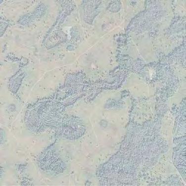
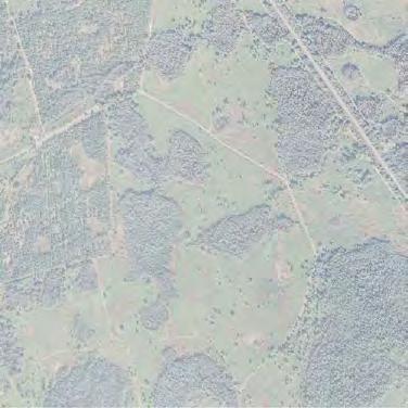
7 EXHIBIT A [LOCATION MAP] Form (13) Deed of Conservation Easement Third Party Beneficiary Rights to USACE Incorporated by reference in paragraph (6)(f), F.A.C. (October 1, 2013) Page 9 of 11

8 535 Rifle Range Parkway 30th Livingston 41 Withlacoochee State Forest Brooksville 41 Hernando 75 North Wesley Chapel UV Elgin UV50 UV 35 Ridge Manor 301 UV UV UV UV Zephyrhills 98 UV 471 Clermont Orlando Citrus Ridge Hillsborough River State Park UV UV508 Polk UV 659 UV Lakeland UV539 UV 93 UV 4 Winter Haven UV Hillsborough UV 566 UV 563 UV UV655 UV Tampa--St. Petersburg UV 549 UV UV37 UV UV 618 UV39 UV60 UV 17 UV UV 301 UV Bartow UV 580 UV st 7th 40th Ayers Fletcher 581 Pasco County Line Bruce B Downs 78th 581 Harney Orient Madison 581 Legend Mondon Hill Ha yman Bayhead Riverview Gibsonton Wpa Fowler Lake Saint Joe Lakewood Iola Darby 579 Curley Morris Bridge Parsons Kings Boyette Bryan Jessamine Curley Mcintosh Lockhart Valrico Bloomingdale Handcart Croom Rital T rilby Ruffing s pect Pro Eiland Clinton Knights Griffin Dover Fort King Chancey Fritzke Christian Powerline Durant C 20th Central Branch Forbes Turkey Creek River Chancey UV54 Sam Allen Trapnell 39 Auton Messick P a rk Keysville Lithia Pinecrest UV 471 Coronet Old Dade Nichols Fox Branch Ranch Wetland Mitigation Bank City Medulla County Line 676 Walker Kathleen Ewell Duff Galloway 10th Shepherd Nickols 640 Sumter Willis Rockridge 676 Pinecrest Rockridge Daughtery Griffin Ha rden Pipkin Beacon Carter Old Fox Branch Ranch Wetland Mitigation Bank Mitigation Service Area Polk County, Florida Moore Tom Costine Walt Willi ams Bonny Mine Old Polk 540a UV50 Reynolds City Agricola UV 19 Greenpond Saddle Creek Clubhouse M:\Projects\Fox Branch\ERP \Conservation Easement\Exhibit A - Location Map Lake 542 Lyle Scale: UV 50 UV 19 UV 33 Deen Still Van Berkley 565a Fleet UV 559 Fu s sell Main Thornhill As Shown 55 7 A Connersville 80 Foot Dean Still 557 Pierce 7 Snively Cox th 4 Polk Ci Alturas Murphy ty Old Dixie Miles Date: 08/05/2016 Murphy
9 EXHIBIT B [LEGAL DESCRIPTION AND SKETCH OF CONSERVATION EASEMENT AREA] Form (13) Deed of Conservation Easement Third Party Beneficiary Rights to USACE Incorporated by reference in paragraph (6)(f), F.A.C. (October 1, 2013) Page 10 of 11
10 A parcel of land in Sections 14, 23, 24, 25 & 26, Township 26 South, Range 22 East, and Section 30, Township 26 South, Range 23 East, Polk County, Florida, described as follows; Commence at the northwest corner of said Section 14; thence S 00 22'08" W along the west line of said Section 14 a distance of feet to the Point of Beginning; thence S 89 34'55" E a distance of feet; thence S 27 31'45" E a distance of feet to the beginning of a curve concave to the west and having a radius of feet; thence along said curve to the right through a central angle of 40 44'14", an arc distance of feet (Chord Bearing = S 07 09'38" E, Chord = feet); thence S 13 12'29" W a distance of feet to the beginning of a curve concave to the northeast and having a radius of feet; thence along said curve to the left, through a central angle of 79 35'46", an arc distance of feet (Chord Bearing = S 26 35'24" E, Chord = feet); thence S 66 23'17" E a distance of feet to the beginning of a curve concave to the southwest and having a radius of feet; thence along said curve to the right, through a central angle of 53 38'38", an arc distance of feet, (Chord Bearing = S 39 33'58" E, Chord = feet; thence S 12 44'39" E a distance of feet; thence S 75 07'17" E a distance of feet; thence N 62 45'49" E a distance of feet; thence N 68 27'13" E a distance of feet; thence N 73 04'00" E a distance of feet; thence S 88 42'58" E a distance of feet; thence N 56 12'15" E a distance of feet; thence N 62 35'53" E a distance of feet; thence N 84 53'22" E a distance of feet; thence N 76 38'46" E a distance of feet to the beginning of a curve concave to the south and having a radius of feet; thence along said curve to the right, through a central angle of 42 01'51", an arc distance of feet, (Chord Bearing = S 82 20'19" E, Chord = feet); thence S 61 19'23" E a distance of feet to the beginning of a curve concave to the southwest and having a radius of feet; thence along said curve to the right, through a central angle of 52 47'51", an arc distance of feet, (Chord Bearing = S 34 55'28" E, Chord=66.69 feet);thence S 08 31'32" E a distance of feet; thence S 00 12'41" W a distance of feet; thence S 10 54'01" E a distance of feet; thence S 01 36'35" W a distance of feet; thence S 28 29'37" E a distance of feet; thence S 08 34'32" E a distance of feet; thence S 40 43'28" E a distance of feet; thence S 21 09'44" E a distance of feet; thence S 06 28'05" E a distance of feet; thence S 14 55'42" W a distance of feet; thence S 62 44'34" E a distance of feet to the beginning of a curve concave to the west and having a radius of feet; thence along said curve to the right, through a central angle of 39 27'43", an arc distance of feet, (Chord Bearing = S 43 00'43" E, Chord = feet); thence S 23 16'51" E a distance of feet; thence S 39 51'09" E a distance of feet; thence S 55 54'37" E a distance of feet; thence S 79 58'27" E a distance of feet; thence S 75 38'21" E a distance of feet; thence S 29 07'47" E a distance of
11 97.54 feet; thence S 68 29'36" E a distance of feet; thence N 72 07'25" E a distance of feet; thence S 47 36'11" E a distance of feet; thence S 67 31'47" E a distance of feet; thence S 32 59'55" E a distance of feet to the beginning of a curve concave to the west and having a radius of feet; thence along said curve to the right, through a central angle of '22", an arc distance of feet, (Chord Bearing = S 20 59'46" W, Chord = feet); thence S 74 59'27" W a distance of feet to the beginning of a curve concave to the east and having a radius of feet; thence along said curve to the left, through a central angle of '00", an arc distance of feet, (Chord Bearing = S 13 02'57" W, Chord = feet); thence S 48 53'33" E a distance of feet; thence S 34 59'20" E a distance of feet; thence S 24 32'58" E a distance of feet; thence S 09 24'38" W a distance of feet; thence S 09 58'40" E a distance of feet to the beginning of a curve concave to the northeast and having a radius of feet; thence along said curve to the left, through a central angle of 73 20'52", an arc distance of feet, (Chord Bearing = S 46 39'06" E, Chord = feet); thence S 83 19'32" E a distance of feet; thence S 66 25'57" E a distance of feet; thence S 45 21'27" E a distance of feet to the beginning of a curve concave to the northeast and having a radius of feet; thence along said curve to the left, through a central angle of 45 16'53", an arc distance of feet, (Chord Bearing = S 67 59'53" E, Chord = feet); thence N 89 21'41" E a distance of feet; thence S 82 34'53" E a distance of feet; thence S 52 38'43" E a distance of feet; thence S 67 50'55" E a distance of feet; thence S 52 04'15" E a distance of feet; thence S 60 04'33" E a distance of feet; thence S 42 36'58" E a distance of feet to the beginning of a curve concave to the west and having a radius of feet; thence along said curve to the right, through a central angle of 53 08'11", an arc distance of feet, (Chord Bearing = S 16 02'52" E, Chord = feet); thence S 10 31'14" W a distance of feet; thence S 26 55'55" E a distance of feet; thence S 07 59'08" E a distance of feet; thence S 25 29'55" E a distance of feet; thence S 52 52'06" E a distance of feet; thence N 53 05'15" E a distance of feet; thence N 71 16'26" E a distance of feet; thence S 55 00'38" E a distance of feet; thence S 69 10'05" E a distance of feet; thence S 37 51'08" E a distance of feet; thence S 62 48'15" E a distance of feet; thence S 34 28'41" E a distance of feet; thence S 26 37'27" E a distance of feet; thence S 19 12'36" E a distance of feet; thence S 25 20'53" E a distance of feet; thence S 36 29'47" E a distance of feet; thence S 20 04'32" E a distance of feet; thence S 06 00'50" W a distance of feet; thence S 25 04'07" E a distance of feet; thence S 26 21'33" W a distance of feet; thence S 06 57'42" W a distance of feet; thence S 09 38'43" E a distance of feet; thence S 00 07'48" W a distance of feet; thence S 12 10'45" W a distance of feet; thence S 01 55'22" E a distance of feet; thence S 11 39'47" W a distance of
12 feet; thence S 04 15'07" E a distance of feet; thence S 19 36'44" W a distance of feet; thence S 28 43'07" W a distance of feet; thence N 82 00'04" E a distance of feet; thence N 89 33'48" E a distance of feet; thence N 78 10'44" E a distance of feet; thence N 76 04'04" E a distance of feet; thence N 61 40'26" E a distance of feet; thence N 68 00'55" E a distance of feet; thence N 73 22'27" E a distance of feet; thence N 81 11'07" E a distance of feet; thence N 90 00'00" E a distance of feet to a point on the east line of the northwest quarter of said Section 30; thence S 00 04'39" W along said east line a distance of feet to the southeast corner of the northwest quarter of said Section 30; thence S 89 47'53" W along the south line of said northwest quarter a distance of feet to the northeast corner of the west half of the southwest quarter of said Section 30; thence S 00 06'11" W along the east line of said west half a distance of feet; thence S 89 53'38" W a distance of feet; thence North 55 27'37" West a distance of feet; thence North 53 21'15" West a distance of 1, feet; thence North 49 10'55" West a distance of 1, feet; thence North 57 36'03" West a distance of 2, feet; thence North 66 24'21" West a distance of feet; thence North 60 11'06" West a distance of feet; thence North 52 26'47" West a distance of feet; thence North 44 06'47" West a distance of feet; thence North 46 19'26" West a distance of feet; thence North 40 31'52" West a distance of feet; thence North 36 50'04" West a distance of feet; thence North 41 34'37" West a distance of feet; thence North 03 18'05" West a distance of feet; thence N 11 43'36" W a distance of feet to the beginning of a curve concave to the west and having a radius of feet; thence along said curve to the left, through a central angle of 32 03'14", an arc distance of feet, (Chord Bearing = N 27 45'13" W, Chord = feet); thence N 43 46'50" W a distance of feet to the beginning of a curve concave to the east and having a radius of feet; thence along said curve to the right, through a central angle of 48 39'38", an arc distance of feet, (Chord Bearing = N 19 27'01" W, Chord = feet); thence N 04 52'48" E a distance of feet; thence N 17 51'43" W a distance of feet; thence N 16 01'18" E a distance of feet; thence N 33 42'07" E a distance of feet; thence N 24 36'29" E a distance of feet; thence N 35 02'48" E a distance of feet; thence N 55 40'06" E a distance of feet; thence N 43 22'51" E a distance of feet; thence N 59 26'55" E a distance of feet; thence N 77 46'15" E a distance of feet; thence N 00 14'05" W a distance of feet; thence S 89 45'55" W a distance of feet; thence N 00 14'05" W a distance of feet; thence S 89 45'55" W a distance of feet; thence N 00 14'05" W a distance of feet; thence N 48 06'32" E a distance of feet; thence N 30 51'20" E a distance of feet; thence N 01 04'58" W a distance of feet; thence N 07 50'37" E a distance of feet; thence N 16 38'49" W a distance of feet; thence N 23 57'14" W a distance of feet; thence N 89 42'32" W a distance of
13 feet; thence N 45 02'23" E a distance of feet; thence N 35 47'56" W a distance of feet to the beginning of a curve concave to the northeast and having a radius of feet; thence along said curve to the right, through a central angle of 37 41'45", an arc distance of feet, (Chord Bearing = N 16 57'03" W, Chord = feet); thence N 12 25'46" W a distance of feet; thence N 43 59'15" W a distance of feet; thence N 33 48'17" W a distance of feet to the beginning of a curve concave to the east and having a radius of feet; thence along said curve to the right, through a central angle of 57 08'34", an arc distance of feet, (Chord Bearing = N 05 14'00" W, Chord = feet); thence N 23 20'17" E a distance of feet; thence N 43 35'28" E a distance of feet; thence N 40 49'38" W a distance of feet; thence N 11 10'58" W a distance of feet; thence N 41 31'59" W a distance of feet to the beginning of a curve concave to the northeast and having a radius of feet; thence along said curve to the right, through a central angle of 36 03'25", an arc distance of feet, (Chord Bearing = N 23 09'34" W, Chord = feet); thence N 53 22'33" W a distance of feet; thence N 89 56'03" W a distance of feet to the west line of said Section 14; thence N 00 22'08" E along said west line a distance of feet to the Point of Beginning.


14 UNRECORDED RANCHO BONITO SECTION 14 SHEET 2 OLD DADE CITY ROAD SECTION 23 SHEET 3 SECTION 24 CARLTON ROAD CSX RAILROAD SECTION 26 SHEET 4 SECTION 25 SECTION 30 SHEET 5 PARCEL CONTAINS ACRES


15 Unrecorded Rancho Bonito 14 Section 14 Township 26 South Range 22 East matchline "A" SEE SHEET


16 SEE SHEET 2 matchline "A" Section 24 Township 26 South Range 22 East Section 23 Township 26 South Range 22 East matchline "B" SEE SHEET 4


17 SEE SHEET Section 26 Township 26 South Range 22 East SEE SHEET matchline "B" RANGE 23 E 23 RANGE 22 E 22 Section 25 Township 26 South Range 22 East


18 RANGE 23 E SEE SHEET 4 RANGE 22 E NW 1/4 Section 30 Township 26 South Range 23 East W 1/2 SW 1/4 E 1/2 SW 1/
19 EXHIBIT C [MANAGEMENT PLAN OR INTENTIONALLY LEFT BLANK ] Form (13) Deed of Conservation Easement Third Party Beneficiary Rights to USACE Incorporated by reference in paragraph (6)(f), F.A.C. (October 1, 2013) Page 11 of 11
AMENDED DEED OF CONSERVATION EASEMENT
 Prepared by: Wayne E. Flowers Lewis, Longman & Walker, P.A. 245 Riverside Ave. Suite 150 Jacksonville, FL 32202 Return recorded original to: Mitigation Marketing 1091 W. Morse Blvd. Suite 101 Winter Park,
DECLARATION OF RESTRICTIVE COVENANTS
 DECLARATION OF RESTRICTIVE COVENANTS The Declarant,, is the fee simple owner of the certain real property located in County, Kansas, as described on Exhibit A, which is attached hereto and incorporated
Sketch & Legal Description of Mitigation Bank and Ingress/Egress Access Easements
 Appendix H: Sketch & Legal Description of Mitigation Bank and Ingress/Egress Access Easements Tippen Bay Wetland Mitigation Bank DeSoto County, Florida Prepared by: September, 2017 Original file
Florida Gulf Coast University Board of Trustees April 18, 2006
 ITEM: 14 Florida Gulf Coast University Board of Trustees April 18, 2006 SUBJECT: Student Housing Rental Rates PROPOSED BOARD ACTION Approve student housing semester rental rates of $2,355 for single bedroom
CONSERVATION EASEMENT AND RESTRICTION
 CONSERVATION EASEMENT AND RESTRICTION The purpose of a Conservation Easement is to protect in perpetuity significant natural features and to minimize the environmental impact of activities associated with
MODEL DEED RESTRICTION FOR THE PENNSYLVANIA STATE PROGRAMMATIC GENERAL PERMIT-3 (PASPGP-3) DECLARATION OF RESTRICTIVE COVENANTS FOR CONSERVATION
 DECLARATION OF RESTRICTIVE COVENANTS FOR CONSERVATION") MODEL DEED RESTRICTION FOR THE PENNSYLVANIA STATE PROGRAMMATIC GENERAL PERMIT-3 (PASPGP-3) DECLARATION OF RESTRICTIVE COVENANTS FOR CONSERVATION THIS DECLARATION OF RESTRICTIVE COVENANTS FOR CONSERVATION
MODEL DEED RESTRICTION FOR THE PENNSYLVANIA STATE PROGRAMMATIC GENERAL PERMIT-3 (PASPGP-3) DECLARATION OF RESTRICTIVE COVENANTS FOR CONSERVATION THIS DECLARATION OF RESTRICTIVE COVENANTS FOR CONSERVATION
CONSERVATION EASEMENT AGREEMENT
 CONSERVATION EASEMENT AGREEMENT THIS INDENTURE made this day of, 20, by and between of the Town of, County of, and State of ( Grantor ), and the Town of Coventry, a municipal corporation having its territorial
Stormwater Ordinance Appendix APPENDIX K EXAMPLE TAR-PAM CONVERSATION EASEMENT
 APPENDIX K EXAMPLE TAR-PAM CONVERSATION EASEMENT Tax Parcel ID # NORTH CAROLINA FRANKLIN COUNTY CONSERVATION EASEMENT Franklin County, North Carolina THIS CONSERVATION EASEMENT (this "Conservation Easement")
TRANSFER OF DEVELOPMENT RIGHTS CONSERVATION EASEMENT
 After Recording Return to: Kitsap County Department of Community Development TDR Program Manager 614 Division St., MS-36 Port Orchard, Washington 98366 TRANSFER OF DEVELOPMENT RIGHTS CONSERVATION EASEMENT
THIS DECLARATION OF RESTRICTIVE COVENANTS is made this day of, 20, by ("Covenantor"). RECITALS
. RECITALS") Model for Use with Permits Without Mitigation Plans STATE OF COUNTY OF DECLARATION OF RESTRICTIVE COVENANTS THIS DECLARATION OF RESTRICTIVE COVENANTS is made this day of, 20, by ("Covenantor"). RECITALS
Model for Use with Permits Without Mitigation Plans STATE OF COUNTY OF DECLARATION OF RESTRICTIVE COVENANTS THIS DECLARATION OF RESTRICTIVE COVENANTS is made this day of, 20, by ("Covenantor"). RECITALS
DECLARATION OF RESTRICTIVE COVENANTS
 STATE OF MARYLAND COUNTY OF DECLARATION OF RESTRICTIVE COVENANTS THIS DECLARATION OF RESTRICTIVE COVENANTS is made this day of, 20, by ( Declarant(s) ). RECITALS WHEREAS, Declarant(s) is/are the owner(s)
DECLARATION OF RESTRICTIVE COVENANTS (AGE RESTRICTED)
") Return recorded copy to: Development and Environmental Regulation Division 115 S. Andrews Avenue, A240 Fort Lauderdale, FL 33301 Document prepared by: DECLARATION OF RESTRICTIVE COVENANTS (AGE RESTRICTED)
Return recorded copy to: Development and Environmental Regulation Division 115 S. Andrews Avenue, A240 Fort Lauderdale, FL 33301 Document prepared by: DECLARATION OF RESTRICTIVE COVENANTS (AGE RESTRICTED)
RESTRICTED USE EASEMENT
 RESTRICTED USE EASEMENT THIS CONSERVATION EASEMENT ("Easement") is made this day of, 2014, by, Individually and Trustee of the Trust (the "Grantor"), and the Compatible Lands Foundation, 1305 East 15 th
DECLARATION OF RESTRICTIVE COVENANT
 This instrument prepared by: D. Scott Knight Hillsborough County Aviation Authority PO Box 22287 Tampa, FL 33622 DECLARATION OF RESTRICTIVE COVENANT THIS DECLARATION OF RESTRICTIVE COVENANT (hereinafter
TRANSFER OF DEVELOPMENT RIGHTS CONSERVATION EASEMENT
 After Recording Return to: Snohomish County Planning and Development Services TDR Program Manager 3000 Rockefeller Ave. M/S #604 Everett, WA 98201 Tax Parcel Numbers: TRANSFER OF DEVELOPMENT RIGHTS CONSERVATION
WATER CONSERVATION EASEMENT
 WHEN RECORDED RETURN TO: Washington County Water Conservancy District 533 East Waterworks Dr. St. George, Utah 84770 Space Above This Line for Recorder s Use Serial No. WATER CONSERVATION EASEMENT THIS
DECLARATION OF RESTRICTIVE COVENANTS (AFFORDABLE HOUSING)
") Return recorded copy to: Development and Environmental Regulation Division 115 S. Andrews Avenue, A240 Fort Lauderdale, FL 33301 Document prepared by: DECLARATION OF RESTRICTIVE COVENANTS (AFFORDABLE HOUSING)
Return recorded copy to: Development and Environmental Regulation Division 115 S. Andrews Avenue, A240 Fort Lauderdale, FL 33301 Document prepared by: DECLARATION OF RESTRICTIVE COVENANTS (AFFORDABLE HOUSING)
GRANT OF CONSERVATION RESTRICTION (Wetland Mitigation/Riparian Zone Mitigation) WITNESSETH:
 WITNESSETH:") NJDEP File No.: Prepared by: GRANT OF CONSERVATION RESTRICTION (Wetland Mitigation/Riparian Zone Mitigation) THIS GRANT OF CONSERVATION RESTRICTION is made this day of 20, by, its heirs, successors and
NJDEP File No.: Prepared by: GRANT OF CONSERVATION RESTRICTION (Wetland Mitigation/Riparian Zone Mitigation) THIS GRANT OF CONSERVATION RESTRICTION is made this day of 20, by, its heirs, successors and
CONSENT ACTION BY THE BOARD OF DIRECTORS OF VENETO IN MIRAMAR CONDOMINIUM ASSOCIATION, INC.
 CONSENT ACTION BY THE BOARD OF DIRECTORS OF VENETO IN MIRAMAR CONDOMINIUM ASSOCIATION, INC. The undersigned, being all of the members of the Board of Directors of Veneto in Miramar Condominium Association,
THIS CONVEYANCE IS SUBJECT TO
 Page 1 of 10 Return signed document to: Property Agent Real Property Section 115 S. Andrews Avenue, Room 326 Fort Lauderdale, FL 33301 Formatted: Top: 1.19" Field Code Changed This instrument prepared
DEED AND DEDICATION FOR PUBLIC RIGHT OF WAY
 TO : BOARD OF DIRECTORS FROM : GARY PLATT, EXEC. DIRECTOR BUSINESS AND OPERATIONS SUBJECT : CITY OF STANWOOD CONSTRUCTION EASEMENT AND RIGHT-OF-WAY DEDICATION DATE : MARCH 17, 2009 TYPE : ACTION NEEDED
THIS DEED OF CONSERVATION EASEMENT
 NOTICE TO TITLE EXAMINERS: THIS DEED OF CONSERVATION EASEMENT CONTAINS COVENANTS THAT INCLUDE RESTRICTIONS ON THE USE, SUBDIVISION AND OFF-CONVEYANCE OF LAND. THIS DEED OF CONSERVATION EASEMENT ("Conservation
QUIT CLAIM DEED (Pursuant to F. S )
") Page 1 of 10 Return signed document to: M. Andrée Hammond, Asst. R.E. Officer Real Property Section 115 S. Andrews Avenue, Room 501 Fort Lauderdale, FL 33301 This instrument prepared by: Broward County
Page 1 of 10 Return signed document to: M. Andrée Hammond, Asst. R.E. Officer Real Property Section 115 S. Andrews Avenue, Room 501 Fort Lauderdale, FL 33301 This instrument prepared by: Broward County
DECLARATION OF DRAINAGE EASEMENTS. Document No. Document Title. (Declarant) Recording Data Return Address
 Recording Data Return Address") Document No. DECLARATION OF DRAINAGE EASEMENTS Document Title (Declarant) Recording Data Return Address DOCUMENT PREPARED BY AND AFTER RECORDING RETURN TO: Parcel No. - - - - - - DECLARATION OF DRAINAGE
Document No. DECLARATION OF DRAINAGE EASEMENTS Document Title (Declarant) Recording Data Return Address DOCUMENT PREPARED BY AND AFTER RECORDING RETURN TO: Parcel No. - - - - - - DECLARATION OF DRAINAGE
DECLARATION OF RESTRICTIVE COVENANTS. THIS DECLARATION OF RESTRICTIVE COVENANTS made this day of, 200_, by ( Declarant ). RECITALS
. RECITALS") DECLARATION OF RESTRICTIVE COVENANTS THIS DECLARATION OF RESTRICTIVE COVENANTS made this day of, 200_, by ( Declarant ). RECITALS WHEREAS, Declarant is the owner of the surface of certain real property
DECLARATION OF RESTRICTIVE COVENANTS THIS DECLARATION OF RESTRICTIVE COVENANTS made this day of, 200_, by ( Declarant ). RECITALS WHEREAS, Declarant is the owner of the surface of certain real property
DEED OF CONSERVATION EASEMENT WITNESS THAT:
 DEED OF CONSERVATION EASEMENT THIS DEED OF CONSERVATION EASEMENT is made on this day of, 20, by, having an address of, ( Grantor ), and Compatible Lands Foundation. an Oklahoma nonprofit public benefit
PIPELINE RIGHT-OF-WAY EASEMENT
 PIPELINE RIGHT-OF-WAY EASEMENT THIS RIGHT-OF-WAY EASEMENT made this day of March, 2014, by the City of Rochester Hills, a municipal corporation in the State of Michigan,, having an address at 1000 Rochester
DECLARATION OF EASEMENTS AND COST SHARING AGREEMENT
 PREPARED BY AND AFTER RECORDING RETURN TO: James Johnston, Esq. Shutts & Bowen LLP 300 S. Orange Avenue Suite 1000 Orlando, Florida 32801 Tax Parcel I.D.s: 25-21-29-0000-00-032 25-21-29-4432-00-001 DECLARATION
CERTIFICATE OF APPROVAL OF COUNTY COMMISSION
 STATE OF FLORIDA COUNTY OF PINELLAS CERTIFICATE OF APPROVAL OF COUNTY COMMISSION It is hereby certified that this plat has been officially approved for record by the Board of County Commissioners of the
LANDSCAPE AND MAINTENANCE EASEMENT. THIS LANDSCAPE AND MAINTENANCE EASEMENT, (hereinafter Easement )
") Prepared by and return to: Parcel ID # LANDSCAPE AND MAINTENANCE EASEMENT THIS LANDSCAPE AND MAINTENANCE EASEMENT, (hereinafter Easement ) is made and entered into this day of, 2009, by and between THIRD
Prepared by and return to: Parcel ID # LANDSCAPE AND MAINTENANCE EASEMENT THIS LANDSCAPE AND MAINTENANCE EASEMENT, (hereinafter Easement ) is made and entered into this day of, 2009, by and between THIRD
WEST VIRGINIA DIVISION OF FORESTRY Cooperative Forest Legacy Program. Sample Conservation Easement
 WEST VIRGINIA DIVISION OF FORESTRY Cooperative Forest Legacy Program Sample Conservation Easement This document is included in the forest legacy kit as an example for information and possible guidance
CONSERVATION EASEMENT INCLUDING MITIGATION
 After recording return to: GRANTOR: GRANTEE: GRANTEE (Trustee): LEGAL DESCRIPTION: TAX PARCEL I.D. #: REFERENCE # s: WHATCOM COUNTY N/A CONSERVATION EASEMENT INCLUDING MITIGATION This grant of a conservation
RIGHT-OF-WAY MAINTENANCE AGREEMENT
 RIGHT-OF-WAY MAINTENANCE AGREEMENT This Agreement made and entered into the day of, 20, by and between, its successors and assigns ( Owner ), and the City of Overland Park, Kansas ( City ). WITNESSETH:
WATER LINE & INGRESS/EGRESS EASEMENT AGREEMENT WITNESSETH:
 Prepared by and return to: Carie E. Shealy, MMC, City Clerk City of Cocoa 65 Stone Street Cocoa, Florida 32922 Parcel ID. #(s): WATER LINE & INGRESS/EGRESS EASEMENT AGREEMENT THIS EASEMENT AGREEMENT is
AGREEMENT RECITALS: Draft 3/26/2015
 AGREEMENT This Agreement is entered into this day of April, 2015, by and between the SCHOOL BOARD OF BREVARD COUNTY, FLORIDA (the "School Board") and THE CITY OF MELBOURNE, a Florida municipal corporation
CONTRACT FOR SALE AND PURCHASE
 CONTRACT FOR SALE AND PURCHASE THIS Contract for Sale and Purchase ( Contract ) is made this day of, 20, by and between the Southwest Florida Water Management District, a public corporation of the State
To achieve the conservation purposes, the following conditions and restrictions are set forth:
 DEED OF CONSERVATION EASEMENT (Conservation Subdivision District) STATE OF GEORGIA COUNTY OF COBB THIS DEED OF CONSERVATION EASEMENT (herein "Conservation Easement") is made this day of, 20, by and between
MARTIN COUNTY BOARD OF COUNTY COMMISSIONERS
 MARTIN COUNTY BOARD OF COUNTY COMMISSIONERS DOUG SMITH Commissioner, District 1 UTILITIES & SOLID WASTE DEPARTMENT PO Box 9000 Stuart, FL 34995-9000 John E. Polley Director Phone (772) 221-1442 Fax (772)
CORPORATE SPECIAL WARRANTY DEED FOR RIGHT OF WAY
 CORPORATE SPECIAL WARRANTY DEED FOR RIGHT OF WAY THIS INDENTURE WITNESSETH that ELI LILLY AND COMPANY, an Indiana corporation, ( Grantor ), as a gift and for no other consideration, CONVEYS ANDSPECIALLY
AGREEMENT FOR TEMPORARY CONSTRUCTION EASEMENT AND PERMANENT SEWER UTILITY EASEMENT
 AGREEMENT FOR TEMPORARY CONSTRUCTION EASEMENT AND PERMANENT SEWER UTILITY EASEMENT This Agreement for Temporary Construction Easement and Permanent Sewer Utility Easement (hereinafter the "Agreement")
EASEMENT AGREEMENT. WHEREAS, Ferguson is the 100% owner of the property described on Exhibit B attached hereto (the Williams Property );
;") EASEMENT AGREEMENT THIS EASEMENT AGREEMENT ( Agreement ) is entered into as of this day of, 2016, by and between CRAIG FERGUSON ( Ferguson ), and MAMIE DAVIS and JERRY MOORE ( Davis & Moore ), whose legal
EASEMENT AGREEMENT THIS EASEMENT AGREEMENT ( Agreement ) is entered into as of this day of, 2016, by and between CRAIG FERGUSON ( Ferguson ), and MAMIE DAVIS and JERRY MOORE ( Davis & Moore ), whose legal
MARTIN COUNTY BOARD OF COUNTY COMMISSIONERS
 MARTIN COUNTY BOARD OF COUNTY COMMISSIONERS DOUG SMITH Commissioner, District 1 UTILITIES & SOLID WASTE DEPARTMENT PO Box 9000 Stuart, FL 34995-9000 John E. Polley Director Phone (772) 221-1442 Fax (772)
DEED OF EASEMENT AND AGREEMENT Forest Conservation Easement
 DEED OF EASEMENT AND AGREEMENT Forest Conservation Easement THIS DEED OF EASEMENT AND AGREEMENT, made this day of, 20, between ( Property Owner ), and Anne Arundel County, Maryland, a body corporate and
Stormwater Treatment Facility Maintenance Agreement
 Stormwater Treatment Facility Maintenance Agreement This Agreement made and entered into this day of, 20, by, (hereinafter referred to as Property Owner") RECITALS: WHEREAS, the Property Owner is the owner
FEE SIMPLE OPTION AGREEMENT Ecosystem Enhancement Program SPO File Number
 STATE OF NORTH CAROLINA COUNTY OF Prepared by State Property Office Return after recording to: Blane Rice, State Property Office 1321 Mail Service Center Raleigh, NC 27699-1321 FEE SIMPLE OPTION AGREEMENT
MODEL DEED RESTRICTION
 MODEL DEED RESTRICTION This type of Protective Covenant is the most commonly used. It is a legal agreement between the grantor, typically the property owner or applicant, and the Corps. Please view instructions
EXHIBIT "A" THE PRESERVE AT WILDERNESS LAKE COMMUNITY DEVELOPMENT DISTRICT 5844 Old Pasco Road, Suite 100, Wesley Chapel, Florida 33544
 EXHIBIT "A" THE PRESERVE AT WILDERNESS LAKE COMMUNITY DEVELOPMENT DISTRICT 5844 Old Pasco Road, Suite 100, Wesley Chapel, Florida 33544 NATURAL AREAS POLICY STATEMENT The following is the policy statement
BILL NO (Emergency Measure) ORDINANCE NO. 5072
 ORDINANCE NO. 5072") BILL NO. 5210 (Emergency Measure) ORDINANCE NO. 5072 AN ORDINANCE AUTHORIZING THE MAYOR TO EXECUTE WITH MICHELSON-HADLEY HEIGHTS DEVELOPMENT, LLC, A CONTRACT AND QUIT CLAIM DEED CONVEYING CERTAIN PROPERTIES
BILL NO. 5210 (Emergency Measure) ORDINANCE NO. 5072 AN ORDINANCE AUTHORIZING THE MAYOR TO EXECUTE WITH MICHELSON-HADLEY HEIGHTS DEVELOPMENT, LLC, A CONTRACT AND QUIT CLAIM DEED CONVEYING CERTAIN PROPERTIES
BILL OF SALE. All of the water lines, writer mains anrl appurtenances locaterl on Exhibit "A"
 BILL OF SALE KNOW ALL MEN BY THESE PRESENTS, That on this-day of,2008, that School Board of Brevard County a Florida Corporation, hereinafter called "Sellers", and in consideration of the sum of One Dollar
CITY OF INDIANAPOLIS GRANT OF PERPETUAL DRAINAGE EASEMENT AND RIGHT-OF-WAY
 CROSS REFERENCE TO DEED#: PROJECT #: DRN - INSTRUMENT NO.: PARCEL #: CITY OF INDIANAPOLIS GRANT OF PERPETUAL DRAINAGE EASEMENT AND RIGHT-OF-WAY THIS INDENTURE made this day of, 20, by and between, ("GRANTOR")
RESIDENTIAL ACCESS AGREEMENT. ( Owner ) and Butte-Silver Bow County ( BSB ) enter into this Residential Access Agreement ( Agreement ) this day of.
 and Butte-Silver Bow County ( BSB ) enter into this Residential Access Agreement ( Agreement ) this day of.") RESIDENTIAL ACCESS AGREEMENT ( Owner ) and Butte-Silver Bow County ( BSB ) enter into this Residential Access Agreement ( Agreement ) this day of. RECITALS A. BSB has received funding to conduct certain
RESIDENTIAL ACCESS AGREEMENT ( Owner ) and Butte-Silver Bow County ( BSB ) enter into this Residential Access Agreement ( Agreement ) this day of. RECITALS A. BSB has received funding to conduct certain
LAND AUTHORITY GOVERNING BOARD AGENDA ITEM SUMMARY. Bulk Item: Yes No X Contact / Phone #: Mark Rosch /
 LAND AUTHORITY GOVERNING BOARD AGENDA ITEM SUMMARY Meeting Date: February 18, 2015 Division: Land Authority Bulk Item: Yes No X Contact / Phone #: Mark Rosch / 295-5180 Agenda Item Wording: Approval of
Cross Reference: Instrument No. A State Parcel No Parcel: TEMPORARY CONSTRUCTION EASEMENT AGREEMENT
 Cross Reference: Instrument No. A199500066899 Project: 92TU000128 State Parcel No. 49-07-18-107-004.000-801 Parcel: 8033304 Date: Version: TEMPORARY CONSTRUCTION EASEMENT AGREEMENT THIS TEMPORARY CONSTRUCTION
EASEMENT AGREEMENT. WHEREAS, Hall Brothers owns certain real property located in Weber County, Utah ( Hall Brothers Property );
;") When Recorded Return to: Parcel No. EASEMENT AGREEMENT THIS EASEMENT AGREEMENT ( Agreement ) is entered into this day of, 2016 by and between VALLEY DREAMS PROPERTIES, LLC, a Utah limited liability company
When Recorded Return to: Parcel No. EASEMENT AGREEMENT THIS EASEMENT AGREEMENT ( Agreement ) is entered into this day of, 2016 by and between VALLEY DREAMS PROPERTIES, LLC, a Utah limited liability company
MEMORANDUM. Michael D. Minton, Esq., Brad R. Gould, Esq. and Richard I. Withers, Esq.
 Dean, Mead, Minton & Zwemer 1903 South 25th Street, Suite 200 P.O. Box 2757 (ZIP 34954) Fort Pierce, Florida 34947 772-464-7700 772-464-7877 Fax www.deanmead.com Orlando Fort Pierce Viera MICHAEL MINTON
COUNCIL ACTION FORM Meeting Date: September 13, 2012 Staff Contact: John Sullivan, Public Works Director
 COUNCIL ACTION FORM Meeting Date: September 13, 2012 Staff Contact: John Sullivan, Public Works Director Agenda Item: Consider vacation of a Landscape Easement granted to the City of Westwood for the construction
Environmental and Engineering Services EASEMENT INFORMATION AND EXAMPLE DOCUMENTS
 Environmental and Engineering Services Reddy Chitepu, P.E., Director EASEMENT INFORMATION AND EXAMPLE DOCUMENTS Please refer to the information below when compiling easement documents for submittal to
GENERAL WARRANTY DEED
 PROJECT. # 89008160 TRACT NO.:10 PARCEL ID NO.:PL199032200000001003 OWNERS NAME: Park Hill School District SITUS ADDRESS:5520 N. Northwood: KANSAS CITY, MISSOURI MAILING ADDRESS:7703 NW Barry Rd. Kansas
See Exhibit "A", attached hereto, incorporated herein, and by this reference made a part hereof.
 Pinellas Suncoast Transit Authority HD Gateway Ulmerton 115kV Rebuild Thor #: 2801T1 Oracle #: 30000935 Site #: 108267 Land Unit: 1696232 Project #: 108267-458563 Prepared By: Bruce C. Crawford, Esq. Crawford
NON-EXCLUSIVE EASEMENT AGREEMENT
 Prepared by: Catherine D. Reischmann, Esq. 111 N. Orange Ave., Ste. 2000 Orlando, FL 32801 Return to: City Clerk City of Palm Coast 160 Cypress Point Parkway, Ste. B-106 Palm Coast, FL 32164 NON-EXCLUSIVE
CONTRACT FOR SALE AND PURCHASE
 CONTRACT FOR SALE AND PURCHASE THIS Contract for Sale and Purchase ( Contract ) is made this day of, 20, by and between the Southwest Florida Water Management District, a public corporation of the State
CONSERVATION EASEMENT
 When recorded return to: City of Milton Attn: City Clerk 13000 Deerfield Parkway, Suite 107-F Milton, GA 30004 CONSERVATION EASEMENT THIS DEED OF CONSERVATION EASEMENT ("Easement") is made by having an
Easement Grant of Easement for Habitat Protection
 Date: Grantor(s): XXXXXXXXXX Grantee: Tri-Basin Natural Resources District, (hereinafter referred to as Tri-Basin NRD)1308 2 nd St., Holdrege NE 68949 Protected Property: See Exhibit A attached for legal
CONTRACT FOR SALE AND PURCHASE
 Page 1 of 5 CONTRACT FOR SALE AND PURCHASE THIS ( Contract ) is made this day of, 20, by and between the Southwest Florida Water Management District, a public corporation of the State of Florida, having
EASEMENT DEED. 2) Thence N 60º12 36 W through said Parcel 1 a distance of Two Hundred Ninety- Five and 97/100 (295.97) feet to a point;
 Thence N 60º12 36 W through said Parcel 1 a distance of Two Hundred Ninety- Five and 97/100 (295.97) feet to a point;") EASEMENT DEED TALL TREES CONSTRUCTION CORP., a Maine corporation having a mailing address of 30 Preservation Drive, Falmouth, Maine 04105 (the "Grantor") for consideration paid, grants to the TOWN OF FALMOUTH,
EASEMENT DEED TALL TREES CONSTRUCTION CORP., a Maine corporation having a mailing address of 30 Preservation Drive, Falmouth, Maine 04105 (the "Grantor") for consideration paid, grants to the TOWN OF FALMOUTH,
ESCROW AGREEMENT - MAINTENANCE
 ESCROW AGREEMENT - MAINTENANCE This ESCROW AGREEMENT (the Agreement ) is made and entered into this day of,, by and between the City of O Fallon, Missouri, a Missouri municipal corporation (hereinafter
DRAINAGE AND UTILITY EASEMENT. That Bruce Conrad, a single adult, hereinafter referred to as Grantor for good and
 DRAINAGE AND UTILITY EASEMENT KNOW ALL PERSONS BY THESE PRESENTS: That Bruce Conrad, a single adult, hereinafter referred to as Grantor for good and valuable consideration, the receipt and sufficiency
RIGHT OF WAY AND COMMON DRIVEWAY AGREEMENT SUN8 PDC, LLC, c/o DISTRIBUTED SUN, LLC SUBDIVISION DRYDEN, NEW YORK
 RIGHT OF WAY AND COMMON DRIVEWAY AGREEMENT SUN8 PDC, LLC, c/o DISTRIBUTED SUN, LLC SUBDIVISION DRYDEN, NEW YORK THIS RIGHT OF WAY AGREEMENT ( Agreement ) is made this day of, 2017 by SCOTT PINNEY, an individual
HIGHLANDS TRANSFER OF DEVELOPMENT RIGHTS PROGRAM DEED OF EASEMENT (For Non-Agricultural Property with Bonus Highlands Development Credit Allocation)
") SAMPLE DRAFT EASEMENT PREPARED BY Signature Typed or Printed Name HIGHLANDS TRANSFER OF DEVELOPMENT RIGHTS PROGRAM DEED OF EASEMENT (For Non-Agricultural Property with Bonus Highlands Development Credit
SAMPLE DRAFT EASEMENT PREPARED BY Signature Typed or Printed Name HIGHLANDS TRANSFER OF DEVELOPMENT RIGHTS PROGRAM DEED OF EASEMENT (For Non-Agricultural Property with Bonus Highlands Development Credit
DECLARATION OF RESTRICTIVE COVENANT
 This instrument was prepared by: Jason S. Lichtstein, Esq. Akerman LLP 106 E. College Avenue Suite 1200 Tallahassee, FL 32301 Tel: (850) 521-8018 Fax: (850) 222-0103 DECLARATION OF RESTRICTIVE COVENANT
DECLARATION OF ELEVATED PEDESTRIAN WALKWAY EASEMENT
 AFTER RECORDING MAIL TO: Drury Southwest Broadview, LLC 101 S. Farrar Drive Cape Girardeau, Missouri 63701 Attn: Herbert J. Wedemeier (Space left blank for recording purposes) DECLARATION OF ELEVATED PEDESTRIAN
STORMWATER BEST MANAGEMENT PRACTICES OPERATIONS AND MAINTENANCE AGREEMENT
 STORMWATER BEST MANAGEMENT PRACTICES OPERATIONS AND MAINTENANCE AGREEMENT THIS AGREEMENT, made and entered into this day of, 20, by and between, (hereinafter the Landowner ), and the TOWNSHIP OF HEMPFIELD,
This document was prepared by: Albemarle County Attorney County of Albemarle 401 McIntire Road Charlottesville, Virginia 22902
 This document was prepared by: Albemarle County Attorney County of Albemarle 401 McIntire Road Charlottesville, Virginia 22902 Tax Map and Parcel Number This deed is exempt from taxation under Virginia
MEMORANDUM OF UNDERSTANDING TO CONVEY LAND
 MEMORANDUM OF UNDERSTANDING TO CONVEY LAND This Memorandum of Understanding to Convey Land ("MOU") is made as of this day of December, 2016, by and between Pueblo West Metropolitan District, a Colorado
MODEL CONSERVATION EASEMENT. January 18, 2001 Rev d October 16, 2002 Rev d August, 2003
 MODEL CONSERVATION EASEMENT January 18, 2001 Rev d October 16, 2002 Rev d August, 2003 Model Conservation Easement for use in preserving mitigation property. Language in italics is instructional, and should
CHAPTER 2 RELATED DOCUMENTS AND FORMS
 CHAPTER 2 RELATED DOCUMENTS AND FORMS TABLE OF CONTENTS CHAPTER 2 RELATED DOCUMENTS AND FORMS Resolution R00- Establishing Public Improvement Design Standards Page 1 Current Plans Review & Construction
THIS DEED OF EASEMENT AND AGREEMENT Archaeological Resource Preservation Easement
 THIS DEED OF EASEMENT AND AGREEMENT Archaeological Resource Preservation Easement THIS DEED OF EASEMENT AND AGREEMENT ( Easement ), made this day of, 20, between, (hereinafter called Property Owner(s)
BY BOARD OF COUNTY COMMISSIONERS
 BY BOARD OF COUNTY COMMISSIONERS ORDINANCE NO. AN ORDINANCE CREATING THE PLANTATION PALMS MUNICIPAL SERVICE BENEFIT UNIT; PROVIDING FOR BOUNDARIES; PROVIDING FOR LEVY OF NON AD-VALOREM SPECIAL ASSESSMENTS;
WAKE COUNTY STORMWATER CONTROL STRUCTURE AND ACCESS EASEMENT AND AGREEMENT (Corporate)
") Return to: Matthew Flynn Stormwater Field Services Administrator Water Resources Department Town of Cary PO Box 8005, Cary, NC 27512 NORTH CAROLINA WAKE COUNTY STORMWATER CONTROL STRUCTURE AND ACCESS EASEMENT
Return to: Matthew Flynn Stormwater Field Services Administrator Water Resources Department Town of Cary PO Box 8005, Cary, NC 27512 NORTH CAROLINA WAKE COUNTY STORMWATER CONTROL STRUCTURE AND ACCESS EASEMENT
DECLARATION OF COVENANTS, EASEMENTS, CONDITIONS, RESTRICTIONS THE PALMS OF FREEPORT HOA, INC.
 DECLARATION OF COVENANTS, EASEMENTS, CONDITIONS, RESTRICTIONS THE PALMS OF FREEPORT HOA, INC. THIS DECLARATION, made on the date hereinafter set forth by PALMS OF FREEPORT DEVELOPERS, LLC, hereinafter
GRANT OF TRAIL ACCESS EASEMENT, COVENANTS AND RESTRICTIONS
 This is a sample easement provided for discussion and illustrative purposes only. Easements for each property will be customized based upon the needs of each landowner and the Path. GRANT OF TRAIL ACCESS
DEED OF AGRICULTURAL CONSERVATION EASEMENT TO THE COMMONWEALTH OF PENNSYLVANIA IN PERPETUITY
 Prepared By: Return To: UPI# DPERSF (6-2006) EXHIBIT C DEED OF AGRICULTURAL CONSERVATION EASEMENT TO THE COMMONWEALTH OF PENNSYLVANIA IN PERPETUITY THIS DEED OF AGRICULTURAL CONSERVATION EASEMENT, made
Tax Map Key Nos. (1) : 003, :004 and :008 CPR No. Total Pages: Unit No.
 : 003, :004 and :008 CPR No. Total Pages: Unit No.") LAND COURT SYSTEM AFTER RECORDATION: RETURN BY MAIL ( ) PICK UP ( ) REGULAR SYSTEM Tax Map Key Nos. (1) 2-3-016: 003, :004 and :008 CPR No. Total Pages: Unit No. LIMITED WARRANTY UNIT DEED, ENCUMBRANCES
LAND COURT SYSTEM AFTER RECORDATION: RETURN BY MAIL ( ) PICK UP ( ) REGULAR SYSTEM Tax Map Key Nos. (1) 2-3-016: 003, :004 and :008 CPR No. Total Pages: Unit No. LIMITED WARRANTY UNIT DEED, ENCUMBRANCES
STORM DRAINAGE EASEMENT FOR PUBLIC STORMWATER RUNOFF (DISCHARGE) TO
 TO") After recording return to: Tacoma Mall Plaza 2702 S. 42nd Street, Suite 201 Tacoma, WA 98409-7322 STORM DRAINAGE EASEMENT FOR PUBLIC STORMWATER RUNOFF (DISCHARGE) TO (Representative) S/T/R Project Name
After recording return to: Tacoma Mall Plaza 2702 S. 42nd Street, Suite 201 Tacoma, WA 98409-7322 STORM DRAINAGE EASEMENT FOR PUBLIC STORMWATER RUNOFF (DISCHARGE) TO (Representative) S/T/R Project Name
(Space above this line reserved for Recorder of Deeds)
") (Space above this line reserved for Recorder of Deeds) STORMWATER MANAGEMENT and BEST MANAGEMENT PRACTICES FACILITIES MAINTENANCE AGREEMENT COVER PAGE Date: Grantor: Grantee: Property Owner Owner's Address
(Space above this line reserved for Recorder of Deeds) STORMWATER MANAGEMENT and BEST MANAGEMENT PRACTICES FACILITIES MAINTENANCE AGREEMENT COVER PAGE Date: Grantor: Grantee: Property Owner Owner's Address
COVENANT AGREEMENT BETWEEN THE CITY OF RAPID CITY AND GWH PROPERTIES, LLC TO PERMIT CERTAIN ENCROACHMENTS IN PEDESTRIAN AND UTILITY EASEMENT
 PREPARED BY: City Attorney s Office 300 Sixth Street Rapid City, SD 57702 (605) 394-4140 COVENANT AGREEMENT BETWEEN THE CITY OF RAPID CITY AND GWH PROPERTIES, LLC TO PERMIT CERTAIN ENCROACHMENTS IN PEDESTRIAN
TAFFREPORT. Steven A. Preston, FAICP, City Manager. Jennifer Davis, Community Development Director W trm-?f>
 Community Development Department TAFFREPORT Date: To: From: January 07, 2014 Steven A. Preston, FAICP, City Manager Jennifer Davis, Community Development Director W trm-?f> By: Daren Grilley, PE, City
PERMANENT EASEMENT AGREEMENT
 PERMANENT EASEMENT AGREEMENT This Permanent Easement Agreement ("Agreement") effective this day of, 2016, by and between Goin Straight, LLC, a Colorado limited liability company (Grantor"), whose mailing
Submittal of the Minutes from the March 9, 2011, April 5, 2011, and April 19, 2011 Cabinet Meetings.
 AGENDA BOARD OF TRUSTEES OF THE INTERNAL IMPROVEMENT TRUST FUND JUNE 16, 2011 Attachments to the items below can be viewed at the following link: http://www.dep.state.fl.us/secretary/cab/public_notices.htm
EASEMENTS, DECLARATION OF COVENANTS, AND DECLARATION OF PRESERVATION RESTRICTIONS
 EASEMENTS, DECLARATION OF COVENANTS, AND DECLARATION OF PRESERVATION RESTRICTIONS This grant of Easements, Declaration of Covenants, and Declaration of Preservation Restrictions, executed the day of, 2008
Storm Water Management BMP Maintenance Agreement City of St. George, Utah
 RECORDED, MAIL TO: St. George City 175 East 200 North St. George, UT 84770 Tax ID: BMP Maintenance Agreement City of St. George, Utah WHEREAS, the Property Owner recognizes that the post construction storm
COST/FUNDING SOURCE: Potential future Income of approximately $300,000
 AGENDA ITEM C6 DATE: June 1, 2015 TO: FROM: SUBJECT: Matt Jordan, General Manager Charles H. Carden, Chief Operating Officer Real Property Disposition-Agreement between Tampa Bay Water and the Southwest
COUNCIL AGENDA MEMO ITEM NO. III - #1
 COUNCIL AGENDA MEMO ITEM NO. III - #1 FROM: Anton Jelinek, Director of Utilities MEETING: October 24, 2017 SUBJECT: PRESENTER: Permanent Utility and Right-of-Way Easement Anton Jelinek Discussion: At the
DEED OF EASEMENT STATE OF NEW JERSEY AGRICULTURE RETENTION AND DEVELOPMENT PROGRAM. BETWEEN, whose address is and is referred to as the Grantor;
 Page 1 of 8 E3-E DEED OF EASEMENT STATE OF NEW JERSEY AGRICULTURE RETENTION AND DEVELOPMENT PROGRAM This Deed is made, 20. BETWEEN, whose address is and is referred to as the Grantor; AND, whose address
PUBLIC NOTICE SALE OF COUNTY OWNED SURPLUS REAL PROPERTY
 PUBLIC NOTICE SALE OF COUNTY OWNED SURPLUS REAL PROPERTY Notice is hereby given that the Pasco County Board of County Commissioners will receive sealed bids to purchase the following surplus County-owned
DO NOT WRITE, TYPE OR STAMP ANYTHING ABOVE THIS LINE OR IN THE MARGINS. PRIVATE LAKE AGREEMENT
 PRIVATE LAKE AGREEMENT This Agreement made and entered into the day of, 2 by ( Developer"). WITNESSETH: WHEREAS, Developer is the owner of a parcel of unimproved land ("the Tract") located within the corporate
ENCROACHMENT AGREEMENT
 THIS INSTRUMENT PREPARED BY: Roy K. Payne, Esq. Chief Assistant City Attorney City of Orlando 400 S. Orange Avenue Orlando, Florida 32801 (407) 246-3495 ENCROACHMENT AGREEMENT THIS ENCROACHMENT AGREEMENT,
THIS INSTRUMENT IS AN OPEN-ENDED MORTGAGE FOR PURPOSES OF TCA
 THIS INSTRUMENT PREPARED BY: The maximum principal indebtedness for Tennessee recording tax purposes is $0 (Governmental Entity) Tennessee Housing Development Agency 502 Deaderick Street, Third Floor Nashville,
6. LIST THE CAUSE DOCKETED NUMBER (E.G. ZONING CASE NUMBER, PLAT NUMBER...)
") GRANT OF RIGHT OF WAY CHECKLIST DOCUMENTS TO FOLLOW PLEASE MAKE SURE YOUR GRANT IS COMPLETED AS FOLLOWS: 1. NAME, COUNTY, AND THE STATE OF THE GRANTOR CLEARLY TYPED OR HAND WRITTEN. 2. A LEGAL DESCRIPTION
GRANT OF RIGHT OF WAY CHECKLIST DOCUMENTS TO FOLLOW PLEASE MAKE SURE YOUR GRANT IS COMPLETED AS FOLLOWS: 1. NAME, COUNTY, AND THE STATE OF THE GRANTOR CLEARLY TYPED OR HAND WRITTEN. 2. A LEGAL DESCRIPTION
ARLINGTON COUNTY, VIRGINIA. County Board Agenda Item Meeting of January 27, 2018
 ARLINGTON COUNTY, VIRGINIA County Board Agenda Item Meeting of January 27, 2018 DATE: January 22, 2018 SUBJECT: Deed of Easement for Public Sidewalk and Utilities Purposes on Property Located at the Corner