BUREAU OF RECLAMATION PROCESS FOR ABANDONMENT AND RELOCATION OF IRRIGATION LATERALS
|
|
|
- Russell Davidson
- 5 years ago
- Views:
Transcription
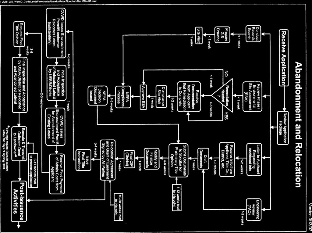
1 BUREAU OF RECLAMATION PROCESS FOR ABANDONMENT AND RELOCATION OF IRRIGATION LATERALS 1/2012 Pre-application Suggestions: 1. As soon as you are aware that your project may require abandonment and relocation of one or more existing irrigation laterals, consult with the Coachella Valley Water District (CVWD) for further guidance. The process can take some time. The sooner you can get started, the sooner your request can be completed. 2. Build the time required for abandonment and relocation of the laterals into your construction schedule up front. Because relocation of a lateral involves acquisition of an interest in land by the United States, Department of Justice Standards necessitate legal review, and a process time of between 6 and 11 months may be needed. 3. Carefully review the documents and information being submitted in your application package to ensure that the information is accurate and complete, the information is consistent, and there is no conflicting information. Following is a more detailed explanation of the process steps shown on the flow chart. For ease in correlation of the narrative below and the flow chart, steps shown on the flow chart are in BOLD CAPS. RECLAMATION RECEIVES WRITTEN APPLICATION - to ensure optimum efficiency and save time, your application should include the following: Provided by Applicant (Landowner) 1. Legal description of easement(s) to be abandoned by Reclamation (original easement[s]). 2. Survey drawing showing original easement(s) tied to section, township, range. 3. Legal description of easement(s) to be granted to Reclamation (replacement easement[s]). 4. Survey drawing showing replacement easement(s). 5. Construction drawings for the replacement lateral(s) approved by CVWD. 6. Preliminary title report (Report) for the subject land to confirm that ownership of the land which supports the original easement(s) and upon which the replacement easement(s) will be located is vested in a common landowner or that both owners are party to the action. The Report must include copies of all exceptions/instruments (i.e., recorded documents) listed in Schedule B of the Report. Please ensure that the Report only addresses 1) land which supports the original easement(s) and 2) land upon which the replacement easement(s) will be located. We do not need a Report that includes the entire parcel being developed. Report must be current within last 60 days. 7. A title commitment (Commitment) is also needed for the new easement. The Commitment must indicate that the policy to be issued will be on an ALTA U.S. Policy form, the name of the insured is United States of America ; and the estate or interest in land being acquired by the United States (relocation easement[s]) described in the report is An Easement. As with the Report, the commitment must include copies of all exceptions/instruments (i.e., recorded documents) listed Schedule B of the Commitment. Please ensure that the Commitment only addresses the land upon which the replacement easement(s) will be located. We do not need a Commitment for the entire parcel being developed. USBR needs to provide CVWD with the value of the easement being obtained so that it can be included in the title commitment. If the Landowner is involved in something like a conditional purchase which will result in a different landowner subsequent to the submittal of the relocation application, Reclamation must be informed of this
2 when the application is submitted. Reclamation can complete its Phase I Environmental Site Assessment (ESA) and National Environmental Policy Act (NEPA) reviews while the land ownership issue is being resolved, however, Reclamation cannot submit its relocation package for Solicitor review until it knows who the final landowner is. Reclamation also needs to know who the final landowner is when drafting the relocation Agreement and Grant of Easement (Agreement) Quitclaim Deed (Deed). 8. ESA for the original easement(s) and the relocation easement(s), if available and necessary to comply with other state or local requirements. (a) New Environmental Protection Agency (EPA) regulations require ESAs to be current, less than 6 months old from date of acquisition, which in this case is the execution of the Agreement and Deed. EPA s new regulations also require that if the ESA is older than 6 months, a new ESA must be prepared, not just a letter to Reclamation updating the data in the original, outdated ESA. Since Solicitor review of the abandonment/relocation package of Reclamation documents is necessary, and these reviews normally can take several months, it is unavoidable that a new ESA will be required before the Agreement is ready to be executed. (b) If remediation is necessary in the immediate area of either the original easement(s) or the replacement easement(s), based on recommendations in the ESA, provide documentation that it has been completed. 9. $5,000 deposit for administrative costs. Reclamation is required to collect, in advance, adequate funds to cover all administrative review and processing costs to address abandonment and relocation actions. Preliminary estimates for actions of this type have been determined to be approximately $5,000. Your deposit will be placed in a special account and expenditures will be monitored closely. You may request an explanation of monies expended at any time during our processing of your application. After completion of processing, and recovery of Reclamation s actual costs, any funds remaining will be returned to you. 10. GIS location map of original easement(s) and relocation easement(s) on topo map, to be used for National Environmental Policy Act (NEPA) compliance and when conducting site visit (preferably at a scale of 1:24,000 with scale, township, range, section and meridian labeled at the bottom). Example is attached. 11. Photos of the easement 12. Complete National Historic Preservations Act Section 106 Report information. See description of Reclamation s required process. Coordination with Reclamation s cultural resources staff will be necessary. This step is required to be completed as part of the environmental compliance process. Provided by CVWD on the cover letter (Needed for NEPA) 1. Date facility was constructed/ installed. 2. Any features connected with lateral(s) that will be abandoned, such as turnouts, meters, gates, etc., and their date of installation. 3. Date of last operation, maintenance, or replacement of facility; if section replaced, was the same kind of material used as the original? 4. What kind of maintenance was performed? 5. Date of last use/is the facility still in use? RECLAMATION REVIEWS APPLICATION PACKAGE - Reclamation will review the application package for completeness and will compare the documents and drawings to one another to determine accuracy or conflicts.
3 If errors, omissions, or conflicts are identified, Reclamation will then write LETTER TO APPLICANT REQUESTING ADDITIONAL INFORMATION (CVWD receives carbon copy). Examples of the most common errors/omissions/conflicts include the following: 1. Requested action is not clearly identified either in writing or by the drawings included. Drawings, legals, other instruments conflict with one another. 2. Errors are identified in the title report. Name of insured is incorrect. Interest being insured is incorrect. Legal description does not match drawings attached. Copies of instruments are not included. Applicant is not identified as landowner. Report is older than 60 days. 3. Advance of $5,000 is not included. 4. ESA is more than 6 months old. No update is included. 5. ESA is outdated, or documentation of remediation, if required by ESA, is not included. 6. Title commitment and appropriate exceptions are not included. This document and copies of the exceptions are required. 7. National Historic Preservations Act Section 106 Report information not in requested format or not complete or conflicting with application request. When Reclamation has sufficient information and advance funds to proceed, the following steps are conducted somewhat simultaneously by various appropriate staff members. ESA IS REVIEWED. 1. NO REMEDIATION IS NEEDED or REMEDIATION IS NEEDED AND HAS BEEN COMPLETED, and DOCUMENTATION HAS BEEN PROVIDED in application - next steps are as follows: a. Copies of the ESA-related documents are used by a Reclamation employee during the initial SITE VISIT described below at Initial SITE VISIT. b. Site conditions described in the ESA document(s) are compared with actual site conditions; results are recorded on Reclamation s Phase I Low-Intensity Rural, Residential, Crop/Agricultural, Etc., Real Property Questionnaire Checklist (Checklist). If results are not acceptable, proceed to b. below. c. APPROVE ESA - if results are acceptable, ESA and Checklist results are summarized in a hazmat concurrence memo, signed by Reclamation management, and NEPA COMPLIANCE PROCESS can begin. 2. REMEDIATION IS NEEDED but has not been completed - next steps are as follows: a. Reclamation will then write LETTER TO APPLICANT REQUESTING ADDITIONAL INFORMATION (CVWD carbon copied). All recommendations in the ESA must be implemented and a copy of the implementation documentation must be forwarded to this office before Reclamation conducts the initial site visit. b. After we RECEIVE DOCUMENTATION FROM APPLICANT THAT REMEDIATION IS COMPLETE, COMPLIANCE SITE VISIT is conducted and site conditions described in the ESA
4 document(s) are compared with actual site conditions; results are recorded on Checklist. If results are not acceptable, repeat 2.a. and b. c. APPROVE ESA - if results are acceptable, ESA and Checklist results are summarized in a hazmat concurrence memo, signed by Reclamation management, and NEPA COMPLIANCE PROCESS can begin. CONDUCT RECORDS RESEARCH is conducted to confirm history and use of original easement(s)/lateral(s). GIS DRAWING is developed to assist staff in conducting site visit. An initial SITE VISIT is conducted by CVWD staff to verify location and condition of subject easement(s), and take photos of the easement(s). a. Preliminary Certificate of Inspection and Possession (CIP) is completed for replacement easement(s). b. Photographs are taken for case file. c. If ESA remediation has been completed up front and implementation documentation has been provided with application, results of implementation documentation are verified. If results are acceptable, follow-up COMPLIANCE SITE VISIT is not required. ENGINEERING REVIEW CVWD approved Construction Drawings of replacement lateral(s) are sent to the Yuma Area Office for review. DRAFT CONVEYANCE DOCUMENTS - the Agreement, which defines conditions and stipulations related to relocation of facilities and grants the United States a replacement easement(s) for the lateral(s) that is being relocated; pipeline relocation acceptance letter; and Deed, which will convey the original easement(s) to the landowner subsequent to relocation of the original facility and acceptance of the relocation facility. NEPA COMPLIANCE PROCESS - Once the ESA is approved, NEPA compliance can begin. Once NEPA DECISION DOCUMENTATION ISSUED, copies of the following documents are assembled and RECLAMATION SUBMITS DOCUMENTS TO SOLICITOR FOR PRELIMINARY TITLE OPINION. 1. preliminary title report and exceptions 2. title commitment and exceptions 3. comments on title commitment 4. maps, legal descriptions 5. draft Relocation Agreement And Grant Of Easement 6. draft Quitclaim Deed 7. ESA concurrence memo 8. NEPA compliance document 9. initial Certificate of Inspection and Possession (CIP) 10. copy(ies) of original document(s) conveying original easement(s) to the United States When the Solicitor s (Reclamation attorney) comments are received, RECLAMATION MODIFIES AND FINALIZES DOCUMENTS BASED ON SOLICITOR COMMENTS. Prior to mailing the four agreements, Reclamation will a copy of the draft agreement to CVWD for their approval. Once they have approved the draft agreement Reclamation will send the offer letter with the agreements to the Landowner/Agent. CVWD CONDUCTS FINAL SITE SURVEY AND CIP.
5 AGREEMENT SIGNED BY ALL PARTIES - The Agreement (three copies) will be sent to landowner for signature (CVWD carbon copied); landowner will forward to CVWD for signature, CVWD will send Agreement back to Reclamation; Reclamation will sign and send fully executed Agreement to CVWD and landowner. Landowner will have original Agreement recorded immediately in Riverside County. FINAL TITLE INSTRUCTIONS for the policy of title insurance are transmitted to landowner by Reclamation along with the fully executed Agreement, which landowner has recorded and returned to Reclamation. CVWD ISSUES CONSTRUCTION ENCROACHMENT PERMIT AND LANDOWNER PROCEEDS WITH RELOCATION OF PIPELINE in accordance with the Agreement and Coachella Valley Water District Construction Encroachment Permit. 1. Monitoring by CVWD before and during construction. 2. FINAL INSPECTION BY RECLAMATION AND/OR CVWD. 3. RECLAMATION SENDS PIPELINE RELOCATION ACCEPTANCE LETTER TO LANDOWNER (CVWD carbon copied). CVWD ISSUES CONSTRUCTION ENCROACHMENT PERMIT AND LANDOWNER PROCEEDS WITH ABANDONMENT OF EXISTING LATERAL in accordance with Coachella Valley Water District Construction Encroachment Permit. RECEIVE FINAL PAYMENT OF ADMIN COSTS FROM APPLICANT, if necessary, to cover remaining steps in the process. REQUEST FINAL TITLE OPINION - The following documents are sent to Reclamation s Solicitor for review: 1. copy of preliminary title opinion 2. copy of recorded Agreement 3. copy of title policy with instruments for exceptions that affect the new easement only. 4. final CIP 5. copy of any curative actions required in the preliminary title opinion FINAL INSPECTION AND ACCEPTANCE BY RECLAMATION AND/OR CVWD OF THE ABANDONED LATERAL - Reclamation sends pipeline abandonment acceptance letter to landowner (CVWD carbon copied). EXECUTE AND TRANSMIT QUITCLAIM DEED TO LANDOWNER - Deed will be sent to landowner for signature (CVWD carbon copied); landowner will sign and send Deed back to Reclamation; Reclamation will sign and send fully executed Deed to landowner; landowner has original Deed recorded immediately in Riverside County and returned to Reclamation (CVWD carbon copied). Post-issuance activities Approximately 10 to 12 Reclamation staff hours; entire process can take up to 1 year (certain actions cannot be completed until the recorded conveyance documents have been returned from the County Recorders Office).
6 LCRO Lands Office (1/2012) SUGGESTED APPLICATION FORMAT Reclamation Contract No. NOTE: Please read the instructions on the back of this application format. If you have questions, contact the Bureau of Reclamation. 1. Name and address of applicant. 2. Landowner s Name: Name and Address of Agent/Contact Person: Coachella Valley Water District (CVWD) P.O. Box 1058 Coachella, CA Agent s/contact Person s Telephone No.: ( ) Contact Person: Landowner s Social Security or Tax ID Number: Telephone Number: Extension: DUNS #, if applicable Agent s/contact Person s Address: 3. Landowner is one of the following: (check one) 4. Specify what action is required: (check one) a. Individual(s) b. Corporation* a. Abandon irrigation lateral(s) c. Partnership/Association* b. Abandon and relocate irrigation lateral(s) d. State Government/State Agency c. Amend existing application e. Local Government f. Federal Agency g. State under whose laws the entity was established. * If checked, applicant may be required to furnish a Resolution by its Board of Directors approving this action before execution by Reclamation. 5. General Location and Legal Description of proposed action. Describe in aliquot parts or metes and bounds (include width and length if applicable); use a separate sheet of paper if additional space is required): Meridian: State: County: ' x > Township: Range: Section(s): Approximate Acreage: 6. Describe in detail the proposed action affecting Reclamation s lands and/or facilities: (a) type of system or facility; (b) related structures and facilities; (c) physical specifications (length, width, grading, etc.); (d) duration and timing of construction; (e) and temporary work areas needed for construction. (If additional space is required, use separate sheet of paper.) 7. Attach a topographic map with location marked, including Reclamation land boundaries. If proposed action involves construction activities, the applicant must provide two (2) complete copies of construction specifications including length and width of right-of-use area, engineering drawings, power flow diagrams, one-line diagrams, construction schedule of proposed commencement and completion dates, and any other plans for specifications of proposed use on Reclamation s lands and/or facilities, approved by CVWD. 8. Signature of Applicant (CVWD) Title Date I certify that the information given in this application is true, complete, and correct to the best of my knowledge and belief, and is given in good faith. I also understand that I am responsible for all administrative costs which are in excess of the deposit for the preparation of the document(s) issued. I further understand that I cannot occupy Reclamation lands or initiate work on Reclamation lands until I receive written authorization signed by the United States. The obligation to pay all administrative costs associated with the processing of this application shall be the sole personal responsibility of the Landowner named above unless Landowner requests and obtains written approval from Reclamation for other payment arrangements. In the event a Federal irrigation pipeline is damaged, physically removed, or abandoned prior to U.S. Bureau of Reclamation s written approval, the developer or the contractor may be subject to delays and penalties. Signature of Landowner or Agent Title Date
7 REQUIRED INFORMATION: A. No specific application format is required; however, this suggested format is supplied to assist applicants for lateral abandonment and relocation actions. B. Provide in detail the information requested on the reverse side. For accounting purposes, it is required that you identify your Social Security number or Tax ID number in the space provided. C. Attach a topographic map with location marked, including Reclamation land boundaries, township, range, and section. If proposed action involves construction activities, the applicant must provide two (2) complete copies of construction specifications, engineering drawings, power flow diagrams, one-line diagrams, and any other plans for specifications of proposed action, approved by CVWD. D. Deposit for Administrative Costs. Reclamation is required to collect, in advance, adequate funds to cover all administrative review and processing costs to address abandonment and relocation actions pursuant to OMB Circular A-25. Preliminary estimates for actions of this type have been determined to be as follows: 1) abandonment only - approximately $3,000; 2) abandonment and relocation - approximately $5,000. If the entire deposit is submitted up-front with your application, work on your action can begin more quickly. Your deposit will be placed in a special account and expenditures will be monitored closely. You may request an explanation of monies expended at any time during our processing of your application. After completion of processing, and recovery of Reclamation s actual costs, any funds remaining will be returned to you. Checks should be made out to the Bureau of Reclamation and included with your application package. E. APPLICATION PACKAGE CHECKLIST Please be sure to include the following required items listed below in the application package. Reclamation cannot begin processing an action until all of the following items are submitted. 1) Cover letter requesting the abandonment and relocation along with the history of the lateral(s) 2) Completed application format 3) Deposit for administrative fees 4) Legal description and plat depiction of easement to be abandoned by USBR (original easement)* 5) Legal description and plat depiction of easement to be granted to USBR (replacement easement)* 6) Preliminary title report (Report) to confirm that ownership of the land which supports the original easement(s) (and, for relocations, upon which the replacement easement(s) will be located) is vested in a common landowner or that both owners are party to the action. The Report must include copies of all exceptions/instruments (i.e., recorded documents) listed in Schedule B of the Report. Please ensure that the Report only addresses 1) land which supports the original easement(s) and 2) land upon which the replacement easement(s) will be located. We do not need a Report that includes the entire parcel being developed. Report must be current within last 60 days. 7) For relocations: a title commitment (Commitment) for the new easement. The Commitment must indicate that the policy to be issued will be on an ALTA U.S. Policy form, the name of the insured is United States of America ; and the estate or interest in land being acquired by the United States (relocation easement[s]) described in the report is An Easement. As with the Report, the Commitment must include copies of all exceptions/instruments (i.e., recorded documents) listed Schedule B of the Commitment. Please ensure that the Commitment only addresses the land upon which the replacement easement(s) will be located. We do not need a Commitment for the entire parcel being developed. 8) Current Phase I Environmental Site Assessment (less than 6 months) 9) Initial Certificate of Inspection and Possession for new easement 10) For relocations only: Complete National Historic Preservations Act Section 106 Report information. 11) GIS map showing location of original and new easements tied to section, township, and range 12) Photos of the easements to be abandoned (should be ed to USBR) 13) If you have questions, please contact Ms. Kay Sundberg, Realty Specialist, at , or Ms. Stacey Crowe, Lands Group Manager, at , Lower Colorado Regional Office, Bureau of Reclamation, P.O. Box 61470, Boulder City, NV ) *These items should be reviewed and accepted by CVWD prior to submitting them to USBR.
8
Section 3 Right-of-Way
 Section 3 Right-of-Way 3.1 General For the purposes of this section, Right-of-Way (ROW) is considered fee-owned land and/or easement. CVWD owns approximately 7,000 acres of land and has approximately 3,240
COACHELLA VALLEY WATER DISTRICT STANDARDS FOR LEGAL DESCRIPTIONS AND PLATS
 COACHELLA VALLEY WATER DISTRICT STANDARDS FOR LEGAL DESCRIPTIONS AND PLATS The following is the procedure for processing legal descriptions and plats (exhibits) for grants of easements, grant deeds, quitclaim
Establishing a Wetland Bank in Minnesota
 Establishing a Wetland Bank in Minnesota Updated February 1, 2018 This document provides a general summary of the key steps in establishing an individual wetland bank site within the state wetland banking
DALLAS WATER UTILITIES WATER/WASTEWATER COVENANT
 DALLAS WATER UTILITIES WATER/WASTEWATER COVENANT Procedure for obtaining a water and wastewater covenant, water covenant, or wastewater covenant; Required for initial submittal: 1. One letter from the
To provide for the review of the final engineering plans, the subdivision improvement agreement, public dedications, and other legal agreements.
 ARTICLE 5 FINAL PLAT 501 Intent DOUGLAS COUNTY SUBDIVISION RESOLUTION To provide for the review of the final engineering plans, the subdivision improvement agreement, public dedications, and other legal
PERMIT AND SUBMITTAL REQUIREMENTS (PR)
") SECTION 2 PERMIT AND SUBMITTAL REQUIREMENTS (PR) 2-1 GENERAL - No work of any type shall be performed within the City right-of-way and easements without approved plans and an encroachment permit. No grading
SECTION 2 PERMIT AND SUBMITTAL REQUIREMENTS (PR) 2-1 GENERAL - No work of any type shall be performed within the City right-of-way and easements without approved plans and an encroachment permit. No grading
FILING INSTRUCTIONS FOR LOT LINE ADJUSTMENT APPLICATION
 Steve Weiss, AICP Planning Director FILING INSTRUCTIONS FOR LOT LINE ADJUSTMENT APPLICATION The following instructions are intended to provide the necessary information and procedures to facilitate the
WASTEWATER BACKFLOW RELEASE PROCEDURES
 WASTEWATER BACKFLOW RELEASE PROCEDURES PROCEDURE FOR OBTAINING A WASTEWATER RELEASE FOR PRIVATE DEVELOPMENT PROJECTS: PLEASE NOTE THAT THE WASTEWATER BACKFLOW RELEASE DOCUMENT MUST FOLLOW THE CITY S PROCEDURES.
CITY OF LANCASTER CITY ENGINEERING DIVISION FINAL MAP SUBMITTAL PACKAGE FINAL MAP APPLICATION
 CONTENTS Page 1 - Final Map Application Page 2 - Financial Interest Disclosure Page 3-1 st Submittal Checklist Page 4 - Required Easement Tracking Sheet Page 5 - Easement Submittal Requirements Checklist
PACIFIC REGION LAND ACQUISITION REQUIREMENTS
 PACIFIC REGION LAND ACQUISITION REQUIREMENTS The following is an outline of the filing requirements for tribal land acquisition requests and timeframes involved for various steps of the process: 1) All
Guide to Combined Preliminary and Final Plats
 Guide to Combined Preliminary and Final Plats Introduction The Douglas County is committed to providing open, transparent application processes to the public. This Guide is provided to assist anyone interested
2018 EASEMENT DEDICATION PACKET
 2018 EASEMENT DEDICATION PACKET (INCLUDES PARCELS OF LAND, EASEMENTS, AND RIGHTS-OF-WAY FOR PUBLIC USE) Information Packet There are various situations in which easements, rights-of-way, and parcels of
WSSC EASEMENT PREPARATION AND SUBMITTAL GUIDELINES
 WSSC EASEMENT PREPARATION AND SUBMITTAL GUIDELINES PREPARED BY THE LAND SERVICES SECTION ENGINEERING AND ENVIRONMENTAL SERVICES DIVISION UPDATED SEPTEMBER, 2017 Page 1 TABLE OF CONTENTS TABLE OF CONTENTS...
City of Fort Lupton Amended Plat Process
 City of Fort Lupton Amended Plat Process Purpose The Amended Plat process is an administrative process to amend a recorded Plat. An Amended Subdivision is an administrative revision to a recorded Subdivision
TABLE OF CONTENTS General Legal Authority for Certification of Right of Way Control 24-2
 TABLE OF CONTENTS 2400 CERTIFICATION OF RIGHT OF WAY CONTROL PAGE 2401 General 24-1 2402 Legal Authority for Certification of Right of Way Control 24-2 2403 Right of Way Certification and Advertising for
CALTRANS- PRELIMINARY IGR PROJECT REVIEW GENERAL
 CALTRANS- PRELIMINARY IGR PROJECT REVIEW GENERAL INFORMATION AND APPLICATION Mariposa County Planning Department 5100 Bullion Street, P.O. Box 2039 Mariposa, CA 95338 Telephone (209) 966-5151 FAX (209)
Foreign Investor Guide. Buying Or Selling Property in Arizona As A Foreign Investor
 Foreign Investor Guide Buying Or Selling Property in Arizona As A Foreign Investor THE FOREIGN INVESTMENT IN REAL PROPERTY TAX ACT (FIRPTA) FIRPTA s objective is to ensure non-resident aliens file U.S.
DEPARTMENT OF THE ARMY U.S. Army Corps of Engineers Washington, DC Regulation No May 2015
 CEMP-CR DEPARTMENT OF THE ARMY U.S. Army Corps of Engineers Washington, DC 20314-1000 ER 405-1-19 Regulation No. 405-1-19 29 May 2015 Real Estate ACQUISITION BY CONDEMNATION PROCEEDINGS 1. Purpose. Engineer
Guide to Replats. Step 1. Step 2. Step 3. Step 4. Step 5. Step 6. Step 7. Step 8. Step 9. Step 10
 Guide to Replats Introduction Douglas County is committed to providing open, transparent application processes to the public. This Guide is provided to assist anyone interested in the procedures and expectations
PARK COUNTY DEVELOPMENT PERMIT APPLICATION
 1246 County Road 16 P.O. Box 517, Fairplay, CO 80440 Office: 719-836-4255 Fax: 719-836-4268 Inspection Line: 719-836-4257 www.parkco.us PARK COUNTY Schedule No: Project Address: Legal Description: Metes
WARREN TOWNSHIP SEWERAGE AUTHORITY
 WARREN TOWNSHIP SEWERAGE AUTHORITY 46 Mountain Blvd., Warren, New Jersey 07059 (908) 753-8000 * Fax (908) 753-6893 Application for Final Approval of sanitary sewers Attached is an application for the Final
APPLICATION FOR EXEMPT SUBDIVISION: NON-LOT SPLIT
 APPLICATION FOR EXEMPT SUBDIVISION: NON-LOT SPLIT ELIGIBILITY Section 12.08.03.c of the Land Development Code provides for review and approval of exempt subdivisions, which shall include any of the following:
CITY OF FAYETTEVILLE, ARKANSAS FINAL PLAT FOR STAFF USE ONLY FINAL PLAT FEE: $ $ Date Application Submitted: Date Accepted as Complete:
 CITY OF FAYETTEVILLE, ARKANSAS FINAL PLAT FOR STAFF USE ONLY FINAL PLAT FEE: $200.00-$800.00 Date Application Submitted: Date Accepted as Complete: Project Number: Public Hearing S-T-R: PP#: Zone: Please
APPLICATION FOR LOT SPLIT
 APPLICATION FOR LOT SPLIT ELIGIBILITY Section 12.09.01 of the Land Development Code provides for review and approval of lot split, which shall include any of the following: 1. The division of a single
FINAL PLAT. Community Development Department 8101 Ralston Road Arvada, Colorado 80002
 FINAL PLAT Community Development Department 8101 Ralston Road Arvada, Colorado 80002 September 2015 FINAL SUBDIVISION PLAT Final Subdivision Plat Review Applications for a Final Plat shall be submitted
STANDARDS GOVERNING CONVEYANCES OF REAL PROPERTY IN DARKE COUNTY, OHIO
 STANDARDS GOVERNING CONVEYANCES OF REAL PROPERTY IN DARKE COUNTY, OHIO As directed by Section 319.203 of the Ohio Revised Code which states The County Auditor and the County Engineer shall adopt standards
Conservation Easement Best Management Practices
 Conservation Easement Best Management Practices Natural Resources Department April 2013 The mission of the Larimer County Natural Resources Department is to establish, protect and manage significant regional
YOUR GUIDE TO THE LEGAL PROCESS FOR SELLING A PROPERTY
 YOUR GUIDE TO THE LEGAL PROCESS FOR SELLING A PROPERTY Selling a house or flat is almost certainly one of the most important transactions you'll ever make. Obviously you want to get it right, and it's
CITY OF FAYETTEVILLE, ARKANSAS PROPERTY LINE ADJUSTMENT
 CITY OF FAYETTEVILLE, ARKANSAS PROPERTY LINE ADJUSTMENT FOR STAFF USE ONLY FEE: $200.00 Date Application Submitted: Date Accepted as Complete: S-T-R: Project Number: PP#: Public Hearing Zone: Please fill
HENRY COUNTY CONVEYANCE STANDARDS AND LAND TRANSFER POLICY
 HENRY COUNTY CONVEYANCE STANDARDS AND LAND TRANSFER POLICY REVISED DECEMBER 2013 Approved By: Kevin Garringer - County Auditor Timothy J. Schumm, P.E., P.S. - County Engineer Land Transfer Policy Committee:
Standards of Practice for Surveying in the State of Alabama
 Standards of Practice for Surveying in the State of Alabama Effective January 1, 2017 RULE NO. 1.01 PURPOSE The purpose of these rules is to establish standards for the practice of surveying in the State
Instructions for Maps to Accompany Proof of Appropriation and Beneficial Use of Ground Water
 Instructions for Maps to Accompany Proof of Appropriation and Beneficial Use of Ground Water Part II of the Proof of Appropriation (Form U.W. 8) All maps to accompany proof of appropriation and beneficial
FINAL APPLICATION. N.J.A.C. 7: (Minor disposals or diversions of parkland)
") FINAL APPLICATION N.J.A.C. 7:36-26.6 (Minor disposals or diversions of parkland) PRIOR TO SUBMITTING THE FINAL APPLICATION: The pre-application must be reviewed by the and the applicant must be given permission
FINAL APPLICATION N.J.A.C. 7:36-26.6 (Minor disposals or diversions of parkland) PRIOR TO SUBMITTING THE FINAL APPLICATION: The pre-application must be reviewed by the and the applicant must be given permission
RE: File No. LD 1516 Certified Survey Map Tradewinds Parkway (B-R Enterprises of Madison, LLC)
") Department of Planning & Community & Economic Development Planning Division Katherine Cornwell, Director Madison Municipal Building, Suite LL-100 215 Martin Luther King, Jr. Boulevard P.O. Box 2985 Madison,
Department of Planning & Community & Economic Development Planning Division Katherine Cornwell, Director Madison Municipal Building, Suite LL-100 215 Martin Luther King, Jr. Boulevard P.O. Box 2985 Madison,
Policy for the Sale and Disposition of Real Property Interests Approved by City Council February 25, 2008 Revision Date Replaces
 POLICY AND PAGE 1 of 7 Tab Corporate Services Authority Realty Services Subject Policy for the Sale and Disposition of Real Property Interests Approved by City Council February 25, 2008 Revision Date Replaces
Department of Development Services Engineering; Survey Plat Review Group SPRG
 Department of Development Services Engineering; Survey Plat Review Group SPRG CITY OF DALLAS LEGAL DESCRIPTION PREPARATION GUIDELINE AND CHECKLIST The following guideline and checklist are provided to
Final Subdivision Plat
 Final Subdivision Plat Application Packet Public Works Department New Development Division 175 East 200 North St. George, UT 84770 Office (435) 627-4120 Dear Applicant, This packet has been prepared to
The Real Estate Transaction in 180 Steps What Your REALTOR Does for You
 REALTOR ASSOCIATION OF PIONEER VALLEY, INC. The Western New England Center for Real Estate Services 221 Industry Avenue Springfield, MA 01104 413-785-1328 phone 877-854-6978 toll-free 413-731-7125 fax
MINOR SUBDIVISION PLAT
 MINOR SUBDIVISION PLAT Community Development Department 8101 Ralston Road Arvada, Colorado 80002 MINOR SUBDIVISION PLAT Subdivisions consisting of five (5) or fewer lots are eligible for the minor subdivision
MINOR SUBDIVISION PLAT
 MINOR SUBDIVISION PLAT Community Development Department 8101 Ralston Road Arvada, Colorado 80002 September 2015 MINOR SUBDIVISION PLAT Subdivisions consisting of five (5) or fewer lots are eligible for
R/W PREQUALIFICATION ODOT, 3/14/2018 PROPERTY MAP SHEET
 R/W PREQUALIFICATION ODOT, 3/14/2018 3A Title Block 3B Sheet Heading 3C Station Limit Flags 3D Revision Block 3E Ownership Name and Number 3F Centerline Stationing 3G Proposed R/W and Pavement 3H Structures
EXHIBIT A LEGAL DESCRIPTION
 EXHIBIT A LEGAL DESCRIPTION DESCRIPTION LOTS 59 AND 60, BLOCK 24, THE PALM BEACH FARMS CO. PLAT NO. 3, ACCORDING TO THE MAP OR PLAT THEREOF, AS RECORDED IN PLAT BOOK 2, PAGE(S) 45 THROUGH 54, INCLUSIVE,
Description of Zoning Resolution Amendment: (attach additional sheets if necessary)
") CARBON COUNTY www.carbonwy.com Department of Planning and Development 215 West Buffalo, Suite 336 Application Fee $200.00 (plus public notice cost) Rawlins, WY 82301 Fee Paid $ Date Tel (307) 328-2651
CARBON COUNTY www.carbonwy.com Department of Planning and Development 215 West Buffalo, Suite 336 Application Fee $200.00 (plus public notice cost) Rawlins, WY 82301 Fee Paid $ Date Tel (307) 328-2651
APPLICATION PROCEDURES FOR A PLAT AMENDMENT OR REVISION
 APPLICATION PROCEDURES FOR A PLAT AMENDMENT OR REVISION DEFINITION: Any revision or amendment to an approved recorded or unrecorded final plat. A revision (not recorded) does not require a public hearing
Beltrami County Natural Resource Management Policy: Easements and Access Across County Lands
 Page 1 Purpose Beltrami County Natural Resource Management Policy: Easements and Access Across County Lands The procedure and requirements for private, government, commercial, and utility entities to cross
Solar Act Subsection t. Application Form
 Application Form: Requirements, Instructions, Terms and Conditions The following application is intended only for entities associated with the development of solar electric power generation facilities
SCOPE OF WORK. Boundary Survey for Land Acquisition PROJECT NO. P
 SCOPE OF WORK Boundary Survey for Land Acquisition Various Parcels Pleasantville City, Atlantic County, N.J. PROJECT NO. P1191-00 STATE OF NEW JERSEY Honorable Phil Murphy, Governor Honorable Sheila Oliver,
FINAL MPUD APPLICATION
 The Department is here to assist you with your development application pursuant to the Community Development Code (CDC). This publication outlines the Final MPUD Development Application process of the
Guide to Minor Developments
 Guide to Minor Developments Introduction The Douglas County (DCD) is committed to providing open, transparent application processes to the public. This Guide is provided to assist anyone interested in
Community Development District INFORMATION PACKET
 Community Development District INFORMATION PACKET Please call for an appointment to file the application (813) 276-8366 or (813) 272-5600. The Hillsborough County Board of County Commissioners adopted
COMPREHENSIVE PLAN FUTURE LAND USE MAP AMENDMENT APPLICATION
 COUNTY STAFF DATA ONLY Date Received: Project No. CPA-20 - GADSDEN COUNTY DEPARTMENT OF PLANNING & COMMUNITY DEVELOPMENT 1-B East Jefferson Street, Post Office Box 1799, Quincy, FL 32353-1799 PLANNING
Easement Program Conservation Easement Monitoring Guidelines
 A. Purpose of Monitoring Easement Program Conservation Easement Monitoring Guidelines The following guideline establishes the standards and practices associated with routine monitoring of WAC easements
Meetinghouse Facilities Department Real Estate Acquisition Process Instructions - Meetinghouse
 Instructions: This document 1) for selected steps in the process, contains explanatory guidelines for the Real Estate Acquisition Process Instructions Meetinghouse and 2) may be adapted to the acquisition
Nassau County Single Land Split Application
 NASSAU COUNTY DEPARTMENT OF PLANNING AND ECONOMIC OPPORTUNITY FLORIDA Nassau County Single Land Split Application Taco E. Pope, AICP, Director 96161 Nassau Place Yulee, Florida 32097 (904) 530-6300 APPLICATION
Sabine River Authority, State of Louisiana
 Sabine River Authority, State of Louisiana Policy for Administering the Shoreline Management Plan (SMP) Encroachments Adopted by SRA Board of Commissioners: Introduction The Federal Energy Regulatory Commission
City of Lakewood Plat Specifications
 City of Lakewood Plat Specifications Revised 12/15/2015 Plat Checklist.1 Notes, Certifications and Acknowledgements..5 Electronic Submittal Information... 20 Sheet Layout.21 A Professional Land Surveyor,
CHECKLIST FOR CUSTOMER Lawful Lot Determination
 CHECKLIST FOR CUSTOMER Lawful Lot Determination (LDO Section 10.2.1A) The following material must be submitted with a request for a lawful lot determination. Check off each item that you have included
INSTRUCTIONS FOR COMPLETING THE APPLICATION FORM
 TOWN OF HOLLY SPRINGS ENGINEERING DEPARTMENT PO Box 8 Holly Springs, NC 27540 (919) 557-3938 FAX (919) 552-9881 The following items must be submitted with the complete, signed and notarized Application
8. CONSTRUCTION SCHEDULE
 8. CONSTRUCTION SCHEDULE The project's authorizing legislation (PL 106-382, October 27, 2000) provides that funds for construction are to be appropriated..."over a period of 10 fiscal years..." (114 stat
A Final Plat will be reviewed concurrently with any other development review application(s) that is required.
 that is required.") RELATED FACTS TO KNOW: Adams County Recording Requirements, Annexation, Common Wall Subdivision, Development Plan (PUD Development Permit), Fees, Helpful Contact Information, Lot Line Adjustment, Neighborhood
RELATED FACTS TO KNOW: Adams County Recording Requirements, Annexation, Common Wall Subdivision, Development Plan (PUD Development Permit), Fees, Helpful Contact Information, Lot Line Adjustment, Neighborhood
APP. FEE: $ DATE & TIME LOCATION: 1/4 SECTION SECTION TOWNSHIP RANGE STREET ADDRESS AND GENERAL LOCATION OF PROPERTY CITY, STATE PHONE (DAY):
:") REVERSION TO ACREAGE PURSUANT TO N.R.S. 278.490 through 478.4965 Elko County Planning & Zoning 155 South 9th Street, Elko, NV 89801 (775) 738-6816 or 738-2266 APPLICATION MUST BE SUBMITTED WITH ALL REQUIRED
REVERSION TO ACREAGE PURSUANT TO N.R.S. 278.490 through 478.4965 Elko County Planning & Zoning 155 South 9th Street, Elko, NV 89801 (775) 738-6816 or 738-2266 APPLICATION MUST BE SUBMITTED WITH ALL REQUIRED
LAND SALES CASH PURCHASE DISPOSAL TERMS AND CONDITIONS
 LAND SALES CASH PURCHASE DISPOSAL TERMS AND CONDITIONS Facilities and Land Management Facilities and Land Management 1815 Bragaw Street, Suite 101 2025 Yukon Drive, Suite 106 Anchorage, Alaska 99508-3438
R/W PREQUALIFICATION ODOT, 3/14/2018
 R/W PREQUALIFICATION ODOT, 3/14/2018 BRETT SHEARER, C.O. REAL ESTATE PROPOSED RIGHT OF WAY DESIGN 172 PROPOSED RIGHT OF WAY DESIGN PROPOSED RIGHT OF WAY DESIGN Section 3200 Types of Title 173 PROPOSED
Division of Land Application
 FOR PLANNING USE ONLY Application # DIV Application Fee Receipt No. Filing Date Completeness Date Division of Land Application A. PROJECT INFORMATION 1. Project Name: 2. Address of Subject Property: 3.
Understand Exhibit A foundational info. Definition Update triggers Value to an airport Sponsor Where we ve been & where we re at today
 Pulling Together the Exhibit A Presented to: By: Date: 2017 Airports Fall Seminar Gina Mitchell, AICP November 30, 2016 Agenda Understand Exhibit A foundational info Definition Update triggers Value to
RLP Staff Policies Reviewing Title Commitments
 RLP Staff Policies Reviewing Title Commitments This document is meant to outline the general process of how a RLP project manager would review and check a title commitment for the RL project process. This
Why Use a REALTOR The Critical Role of the REALTOR in the Real Estate Transaction The REALTOR Commitment REALTOR Code REALTOR Code of Ethics
 Why Use a REALTOR The Critical Role of the REALTOR in the Real Estate Transaction Do you know what your REALTOR does, exactly? Surveys show that many homeowners and homebuyers are not aware of the true
Plat Checklist PLAT TYPES AND DESCRIPTIONS
 Master Plan / Revision to Master Plan (For Platting Purposes Only) Preliminary/Final Plat Preliminary Plat Final Plat Minor Plat Replat Amended Plat Plat Checklist So that we may efficiently review your
City of Hemet PLANNING DIVISION 445 E. Florida Avenue, Hemet, CA (951)
") PLANNING DIVISION 445 E. Florida Avenue, Hemet, CA 92543 (951) 765-2375 www.cityofhemet.org Application No.: Date Received: Received By: Planner Assigned: Concurrent Projects: PLANNING APPLICATION Administrative
PLANNING DIVISION 445 E. Florida Avenue, Hemet, CA 92543 (951) 765-2375 www.cityofhemet.org Application No.: Date Received: Received By: Planner Assigned: Concurrent Projects: PLANNING APPLICATION Administrative
MINOR SUBDIVISION INFORMATION
 A. POINTS OF CONTACT: MINOR SUBDIVISION INFORMATION Surveyor: Address: Phone #: Fax # E-Mail Address: Representative (If different from applicant): Address: Phone #: Fax # E-Mail Address: B. GENERAL INFORMATION:
2017_10_MIKES_SWEETMAN_OE_PC.PDF
 1. OCTOBER PLANNING COMMISSION AGENDA Documents: OCTOBER 2017.PDF 1.I. MIKES/SWEETMAN OUTRIGHT EXEMPTIONS Documents: 2017_10_MIKES_SWEETMAN_OE_PC.PDF DEPARTMENT OF PLANNING AND ZONING 308 Byers Ave P.O.
Standards for All Instruments of Conveyance
 Standards for All Instruments of Conveyance Perry County, Ohio Effective Date: May 1, 1997 Effective Date of Revision: April 1, 2011 Page 2 of 12 Minimum Standards for all Instruments of Conveyance Perry
City of Leavenworth DEPARTMENT OF DEVELOPMENT SERVICES MAJOR SUBDIVISION APPLICATION 1
 Proposed Name of Subdivision: City of Leavenworth DEPARTMENT OF DEVELOPMENT SERVICES MAJOR SUBDIVISION APPLICATION 1 FOR PRELIMINARY SUBDIVISION APPROVAL This application must be filled out legibly, in
Frequently Asked Questions From the Certification of R/W Training Sessions
 Frequently Asked Questions From the Certification of R/W Training Sessions 1. There are differences between appropriations of vacant land and appropriations of structures. What is a structure? A structure
LOT LINE ADJUSTMENT GENERAL INFORMATION AND
 LOT LINE ADJUSTMENT GENERAL INFORMATION AND APPLICATION Mariposa County Planning Department 5100 Bullion Street, P.O. Box 2039 Mariposa, CA 95338 Telephone (209) 966-5151 FAX (209) 742-5024 www.mariposacounty.org
I N S T R U C T I O N S
 PART 1 -- PRELIMINARY APPROVAL Office of Archaeology and Historic Preservation History Colorado Publication #1322c APPLICATION FOR COLORADO STATE INCOME TAX CREDIT FOR THE PRESERVATION OF HISTORIC STRUCTURES
BID PROPOSAL FORMS FOR THE SALE OF REAL PROPERTY LOCATED IN THE CITY OF CORONA IN THE COUNTY OF RIVERSIDE
 150813 BID PROPOSAL FORMS FOR THE SALE OF REAL PROPERTY LOCATED IN THE CITY OF CORONA IN THE COUNTY OF RIVERSIDE Bid Proposal to Purchase Real Property February 5, 2013 11:00 a.m. This Real Property is
Escrow Basics. Chapter 6. Learning Objectives
 Chapter 6 Escrow Basics Learning Objectives After reading this chapter, you will be able to: explain the basic regional differences of escrow instructions. define the general principles followed by all
APPROVAL REQUIREMENTS
 APPROVAL REQUIREMENTS FOR INSTRUMENTS OF CONVEYANCE IN ERIE COUNTY, OHIO DRAFT Requirements for all instruments of Conveyance in Erie County, revised and effective, 2014. An Erie County policy governing
Boston National Title Agency, LLC. 129 West Trade St, 9th Floor. Charlotte NC 28202
 Boston National Title Agency, LLC 129 West Trade St, 9th Floor Charlotte NC 28202 FIDELITY NATIONAL TITLE INSURANCE COMPANY 800-943-1196 Prepared By: Boston National Title Agency, LLC 129 West Trade St,
DWR REAL ESTATE COORDINATION PLAN
 DWR REAL ESTATE COORDINATION PLAN Exhibit E DWR PROPERTY ACQUISTION PLAN EXHIBIT E Revised Date: 5 10 18 DWR PROPERTY ACQUISTION PLAN EXHIBIT E Revised Date: 5-10-2018 California WaterFix Real Estate Coordination
STANDARDS GOVERNING CONVEYANCES OF REAL PROPERTY
 STANDARDS GOVERNING CONVEYANCES OF REAL PROPERTY Hancock County, Ohio Charity A. Rauschenberg, Hancock County Auditor Steven C. Wilson, Hancock County Engineer Revised: March 1, 2007 TRANSFER AND CONVEYANCE
8. Building Status. 9. Current Use
 To be Completed by Staff Application No. Date Received: Received by: APPLICATION FOR PLANNED DEVELOPMENT Please submit electronically a completed application including required submittals to the Planning
Pre-Listing Activities. Listing Appointment Presentation
 The True Value of a Realtor: 184 Tasks Surveys show that many homeowners and homebuyers are not aware of the true value of a Realtor. Realtors perform the following 184 tasks, and while the list may differ
APPLICATION FOR CERTIFICATE OF PARCEL MERGER
 Steve Weiss, AICP Planning Director APPLICATION FOR CERTIFICATE OF PARCEL MERGER INCOMPLETE APPLICATIONS WILL NOT BE ACCEPTED. APPLICATION INFORMATION Applicant Name: Contact Person: Land Surveyor/Civil
Boston National Title Agency, LLC. 129 West Trade St, 9th Floor. Charlotte NC 28202
 Boston National Title Agency, LLC 129 West Trade St, 9th Floor Charlotte NC 28202 FIDELITY NATIONAL TITLE INSURANCE COMPANY 800-943-1196 Prepared By: Boston National Title Agency, LLC 129 West Trade St,
The Filing Fee for a Minor Plat is $ PLUS $20.00 per lot created
 DEPARTMENT OF COMMUNITY DEVELOPMENT MINOR PLAT PROCEDURE The Filing Fee for a Minor Plat is $250.00 PLUS $20.00 per lot created Description: The purpose of a Minor Plat is to allow property to be platted
City of Altamonte Springs Developer s Guide
 Section 6 SUBDIVISION PLAN & PLAT REVIEW PROCESS This section contains information, applications, and checklists related to the subdivision development plan and plat review process in Altamonte Springs.
COMMERCIAL CONDOMINIUM CONVERSION APPLICATION MATERIALS. Table of Contents
 Phone: (415) 554-5827 Fax: (415) 554-5324 www.sfdpw.org Subdivision.Mapping@sfdpw.org Edwin M. Lee, Mayor Mohammed Nuru, Director Bruce R. Storrs, City and County Surveyor Office of the City and County
CITY OF EL CENTRO COMMUNITY DEVELOPMENT DEPARTMENT APPLICATION FOR LOT LINE ADJUSTMENT
 LLA No. Processing Fee:$315.00 Date Filed: Received By: CITY OF EL CENTRO COMMUNITY DEVELOPMENT DEPARTMENT APPLICATION FOR LOT LINE ADJUSTMENT Application is hereby made to the City of El Centro, County
SUBMITTAL REQUIREMENTS: The number indicates the number of copies for submittal (if applicable).
.") Office Use Only Preliminary Long Plat Long Subdivision Applicant Checklist PLANNING, COMMUNITY, & ECONOMIC DEVELOPMENT DEPARTMENT FINAL LONG PLAT LONG SUBDIVISION CHECKLIST Mailing Address: P.O. Box 547,
Office Use Only Preliminary Long Plat Long Subdivision Applicant Checklist PLANNING, COMMUNITY, & ECONOMIC DEVELOPMENT DEPARTMENT FINAL LONG PLAT LONG SUBDIVISION CHECKLIST Mailing Address: P.O. Box 547,
CONDITIONAL USE APPLICATION
 CONDITIONAL USE APPLICATION Planning Division 5155 Silverton Rd. NE; Salem OR 97305 Ph. (503) 588-5038 http://www.co.marion.or.us/pw/planning PROCEDURE: A. Once a complete application is received, the
COUNTY OF RIVERSIDE TRANSPORTATION AND LAND MANAGEMENT AGENCY
 COUNTY OF RIVERSIDE TRANSPORTATION AND LAND MANAGEMENT AGENCY Juan C. Perez, P.E., T.E. Director of Transportation and Land Management Transportation Department Patricia Romo, P.E. Assistant Director of
Guide to Preliminary Plans
 Guide to Preliminary Plans Introduction The Douglas County is committed to providing open, transparent application processes to the public. This Guide is provided to assist anyone interested in the procedures
WHAT YOUR REALTOR DOES FOR YOU IN 181 STEPS
 WHAT YOUR REALTOR DOES FOR YOU IN 181 STEPS Surveys show that many homeowners and homebuyers are not aware of the true value a REALTOR provides during the course of a real estate transaction. The list
Criteria for Appeals of Flood Insurance Rate Maps. November 30, 201 1
 Criteria for Appeals of Flood Insurance Rate Maps November 30, 201 1 This document outlines the criteria for appealing proposed changes in flood hazard information on Flood Insurance Rate Maps (FIRMS)
Establishing an Individual Wetland Bank Site in Minnesota
 Establishing an Individual Wetland Bank Site in Minnesota March 14, 2013 This document provides a general summary of the key steps in establishing a an individual wetland bank site within the state wetland
Natural Resources Assistance Council DISTRICT 12 - LUCAS COUNTY, OHIO
 Natural Resources Assistance Council DISTRICT 12 - LUCAS COUNTY, OHIO Program Eligibility Application Information Sheet Any local political subdivision or any non-profit organization within District 12
RCI, PAL and Army Housing Training. Real Estate Process / Actions
 RCI, PAL and Army Housing Training Real Estate Process / Actions Peggy Mahoney Privatization and Partnerships Division Office of the Assistant Chief of Staff for Installation Management Kathleen Germano
REQUIREMENTS FOR ALL INSTRUMENTS OF CONVEYANCE IN HARDIN COUNTY, OHIO
 REQUIREMENTS FOR ALL INSTRUMENTS OF CONVEYANCE IN HARDIN COUNTY, OHIO Effective Date: Michael L. Smith, P.E., P.S. Hardin County Engineer Michael T. Bacon Hardin County Auditor 1 I. GENERAL In compliance