DETAILED ANALYSIS. Wyoming Board of Land Commissioners. Consideration for Disposal of State Trust Land. Prepared on July 11, 2014
|
|
|
- Dylan Manning
- 5 years ago
- Views:
Transcription
1 WYOMING OFFICE OF STATE LANDS AND INVESTMENTS 122 West 25 th Street Cheyenne, WY Phone: Fax: MATTHEW H. MEAD Governor BRIDGET HILL Director DETAILED ANALYSIS Wyoming Board of Land Commissioners Consideration for Disposal of State Trust Land 0.94 ACRES in ALBANY COUNTY, WY Prepared on July 11, 2014 by Office of State Lands and Investments Herschler Building, 3West 122 West 25 th Street Cheyenne, WY EFFECTIVELY MANAGING NATURAL RESOURCES AND FUNDS FOR CURRENT AND FUTURE GENERATIONS
2 TABLE OF CONTENTS AUTHORITY 3 PROPOSAL 3 SUBJECT PROPERTY DESCRIPTIONS 3 PROPERTY INFORMATION 3 IMPROVEMENTS 4 WATER RIGHTS 4 GRAZING AND AGRICUTURAL LEASES 4 MINERAL RIGHTS AND LEASES 5 ANNUAL TAX LOAD 5 EASEMENTS, ACCESS, HAZARDS 5 SPECIAL USE LEASES 5 TEMPORARY USE PERMITS 5 FLOOD ZONE AND ZONING DESIGNATIONS 6 FOREST PRODUCTS 6 WILDLIFE HABITAT AND WILDLIFE ORIENTED RECREATIONAL OPPORTUNITIES LOCATED ON 6 THE PARCELS CULTURAL RESOURCES AND PUBLIC RECREATIONAL OPPORTUNITIES LOCATED ON THE PARCELS APPRAISED VALUE 7 INCOME GENERATING POTENTIAL 7 ANTICIPATED APPRECIATION OF THE PARCELS AS REAL ESTATE ASSETS 8 TRUST LAND MANAGEMENT OBJECTIVES 9 CONCLUSION 10 LIST OF EXHIBITS 11 PAGE 6 2
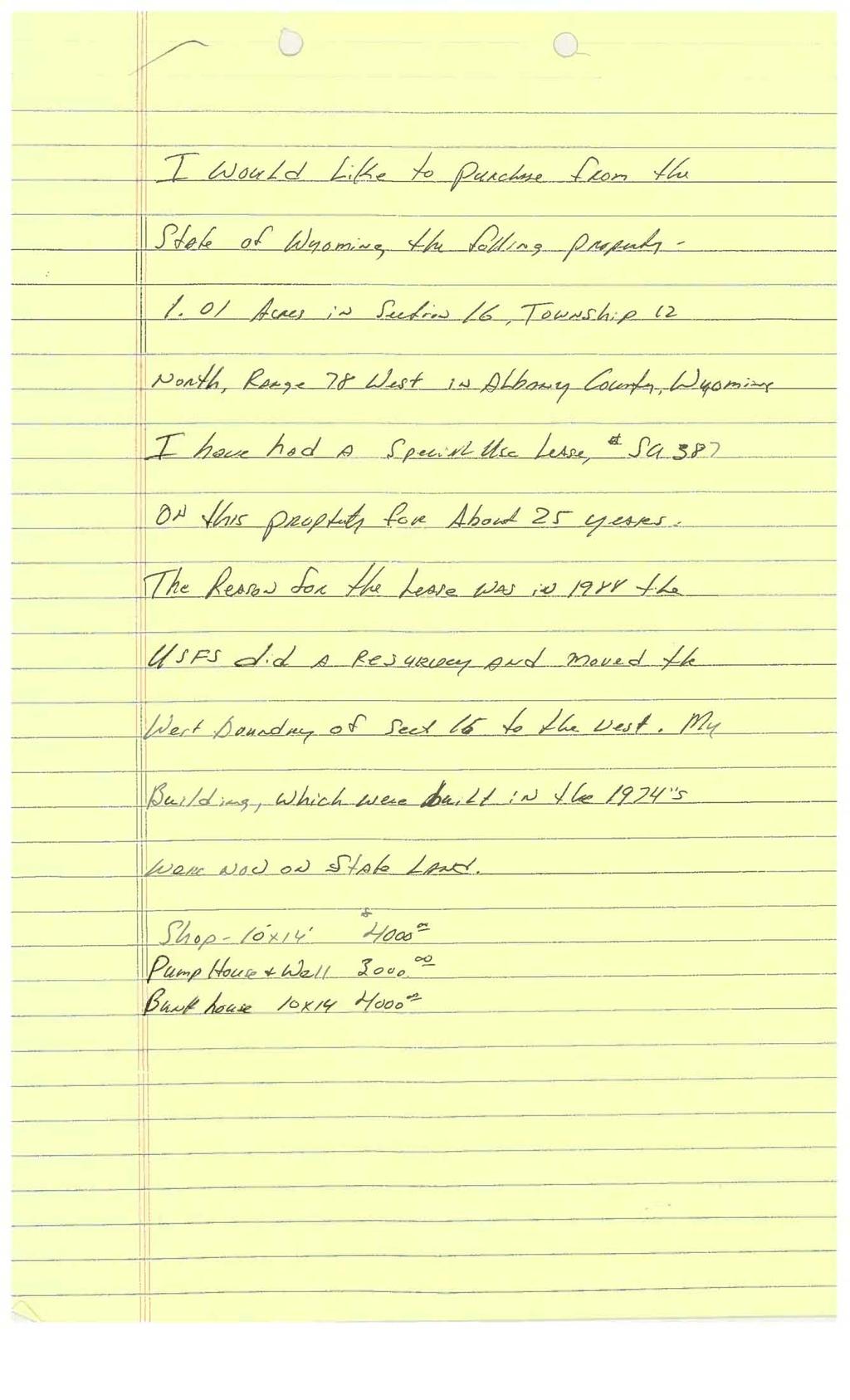
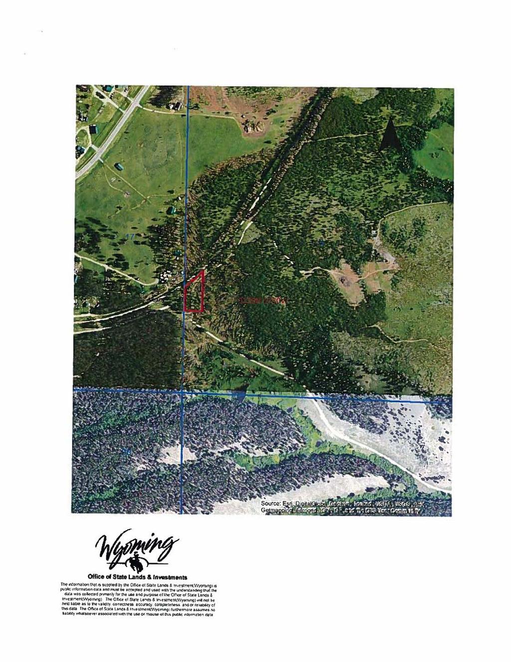
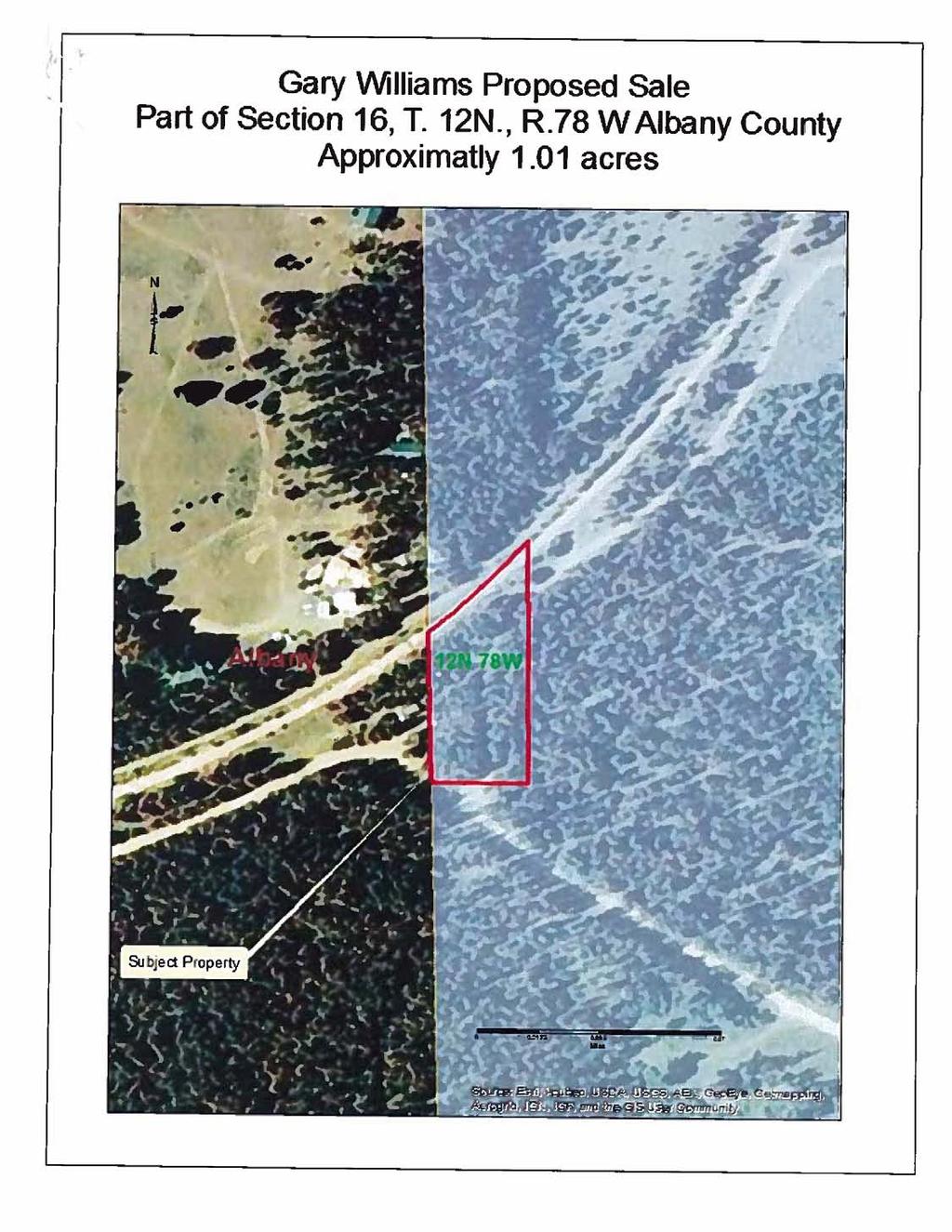
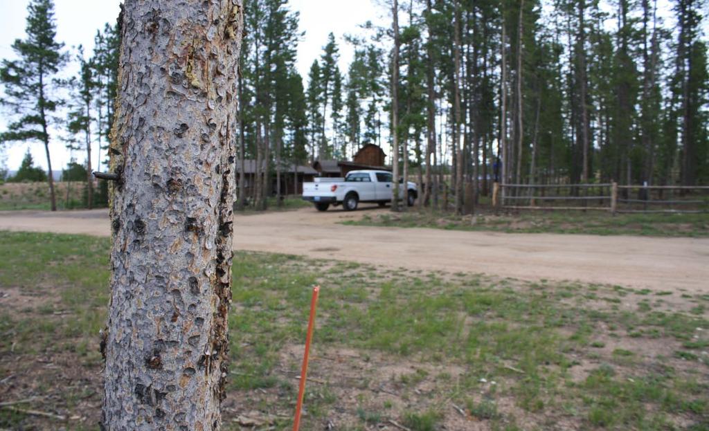
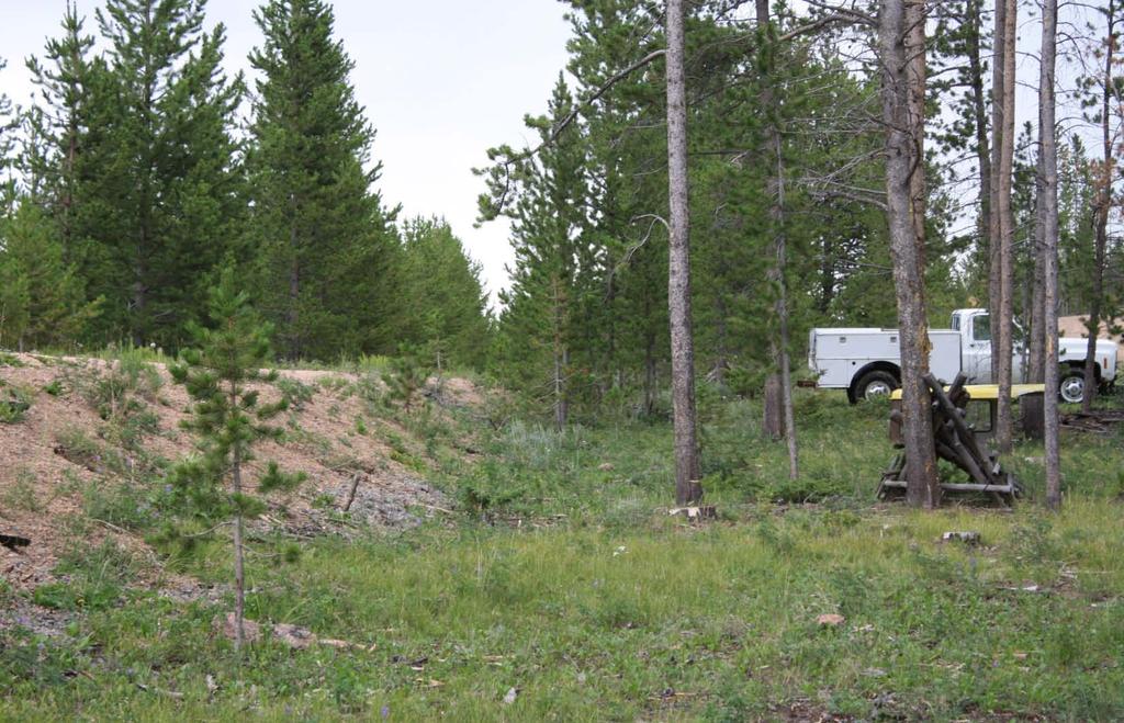
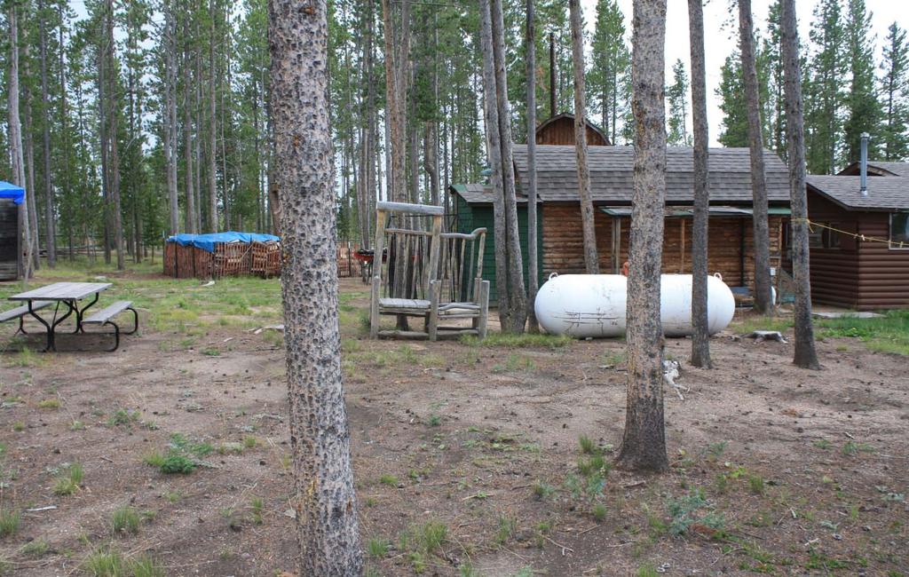
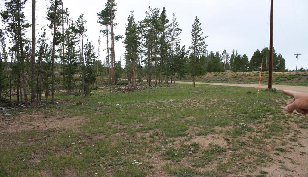
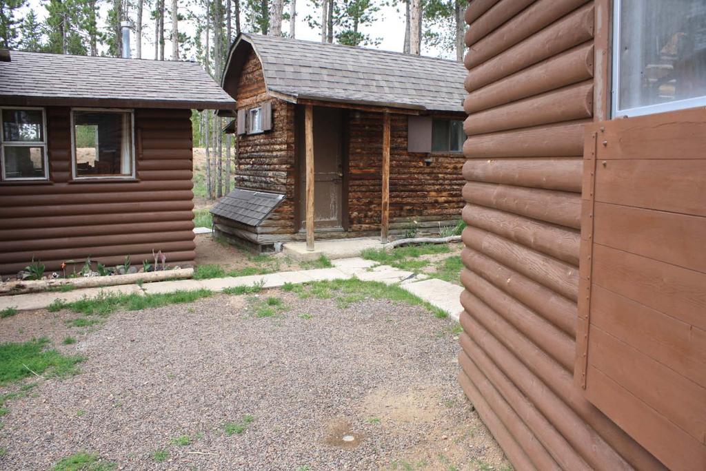
3 DETAILED ANALYSIS PROPOSED LAND DISPOSAL OF 0.94± ACRES ALBANY COUNTY, WYOMING AUTHORITY: W.S through ; Sale of State Lands. Wyoming Board of Land Commissioners Rules and Regulations, Chapter 26, Section 4. Trust Land Management Objectives adopted by the Wyoming Board of Land Commissioners, August 11, PROPOSAL: The Director of the Office of State Lands and Investments (OSLI) has determined the subject parcel of State Trust Land may be suitable for disposal. The land was nominated by Mr. Gary Williams on December 4, On December 20, 2012, the Director of OSLI moved the parcel to the Category II Disposal List in accordance with Wyoming Board of Land Commissioners Rules and Regulations (Board s Rules). The application letter is attached as Exhibit A. SUBJECT PROPERTY DESCRIPTIONS: The parcel is located in Albany County, Wyoming and is approximately 38 miles southwest of Laramie just off of Highway 230, near Mountain Home and WYCOLO, Wyoming. Maps and photos are attached as Exhibit B. Herein described as: Part of Section 16, Township 12 North, Range 78 West, Described by Metes and Bounds Legal Description per survey. Survey is attached as Exhibit C. This total proposed disposal of State Trust Lands comprises: 0.94 acres PROPERTY INFORMATION: The subject property was patented to the State of Wyoming by the Federal Government under the Act of Admission of The subject property is a small portion (0.94 acres) of a larger, half-section (320 acres) of property owned by the State of Wyoming and managed under the authority of the Board of Land Commissioners (Board) as State Trust Land. The subject property is nearly level with a gentle slope to the south. The terrain is characteristic of the mountainous area surrounding the property. The subject property is improved with two (2) structures which are the property of Mr. Gary Williams. The structures include a guest cabin and shed. Electricity, septic system, and a water well are immediately adjacent to the property. 3
4 The vegetation includes lodgepole pine, shrubs, forbs, and bunch grasses. The main soils on the subject property are sandy loams to gravely sandy loams that are moderately deep, well drained on terraces, fans, and hills of the mountains. The soils formed from alluvium material and derived mixed sources. Permeability is rated from moderate to rapid. Available water capacity is rated moderate to low. Effective rooting depth is 60 or more, unless depth to bedrock inhibits root growth. Runoff is rated as medium, and the hazard of water erosion is medium. The hazard of wind erosion is rated as moderate. Existing rights held by the State of Wyoming are 100% of surface estate and 100% of mineral estate. The proposed transaction will dispose of the surface estate only. The State of Wyoming will retain all mineral rights. Maps and photos are attached as Exhibit B. IMPROVEMENTS: The subject property is improved with two (2) structures which are the property of Mr. Gary Williams. The structures include a guest cabin, shed, fencing, and other associated minor dwelling improvements. Electricity, septic system, and a water well are immediately adjacent to the property. WATER RIGHTS: After a review of the records maintained by the Wyoming State Engineer's Office, it appears there are no water rights associated with the subject property. Should there be additional evidence presented that water rights do exist, the subject property will be conveyed in a manner that does not remove any associated water rights from the land. No water rights are to be conveyed in the proposed transaction. Surface ownership of this property is subject to W.S : "Nothing in this act [Sale of State Lands] shall be construed so as to impair the rights of any ditch company, or any person owning any ditch or ditches, on or passing through any of the lands included herein." GRAZING AND AGRICULTURAL LEASES: There is not an active Grazing and Agricultural Lease issued on the subject property or the surrounding State Trust Lands. The previous Grazing and Agricultural Lease (1-7395) consisted of acres and a rated carrying capacity of thirty-nine (39) Animal Unit Months (AUMs). Based on the AUM fee formula established by the Board, the 2013 rental income would have been $ ($4.80/AUM x 39 AUMs = $187.20). The subject parcel, consisting of 0.94 acres, is rated at 0.06 AUM s. Based on the above referenced formula, the 2013 rental income would have been $0.29 ($4.80/AUM x 0.06 AUM s = $0.29). 4
5 MINERAL RIGHTS/LEASES: The State of Wyoming owns all mineral rights, and will retain all mineral rights upon surface disposal. There are no active mineral leases on the subject property. ANNUAL TAX LOAD: The subject property is owned by the State of Wyoming, and is not currently subject to ad valorem taxation. Upon disposal, the property will be assessed and taxed by Albany County, and all taxes shall be the responsibility of the winning bidder. According to the Albany County Assessor's Office, real estate is valued using a market value system, and the taxes are calculated based on nine and one-half percent (9.5%) of the assigned value of the property times.068. Therefore, if the property is valued at twenty-five thousand dollars ($25,000.00), the estimated annual ad valorem tax would be one hundred sixty-one dollars and forty-nine cents ($161.49). Market Value $25, Assessed Value $2, % assessment Estimated Tax $ mill levy Agricultural land may be valued by the County Assessor on a productivity basis rather than actual market price. In that case, the taxes would be significantly less, but that decision is left to the County Assessor. EASEMENTS, ACCESS, HAZARDS: There are no easements located on the subject property. The subject property is accessed from the west by the Boswell County Road. No obvious hazardous materials or environmental concerns were noted during inspections of the property by the appraiser. There are no historical, documented uses that would have knowingly subjected the land to hazardous materials, or which would have created environmental concerns. SPECIAL USE LEASES: SU-387: Cabin Site Outbuildings. SU-387 was renewed in April of 2010 for a term of fifteen (15) years and shall expire on April 1, The leased area is comprised of 0.41 acres, all of which lie within the subject property. Annual rental was set at $ per year and adjusted annually by 2.7% to off-set inflationary pressure. The last annual payment received at the lease s anniversary date was $ SU-387 is currently issued to Mr. Gary Williams. TEMPORARY USE PERMITS: None. 5
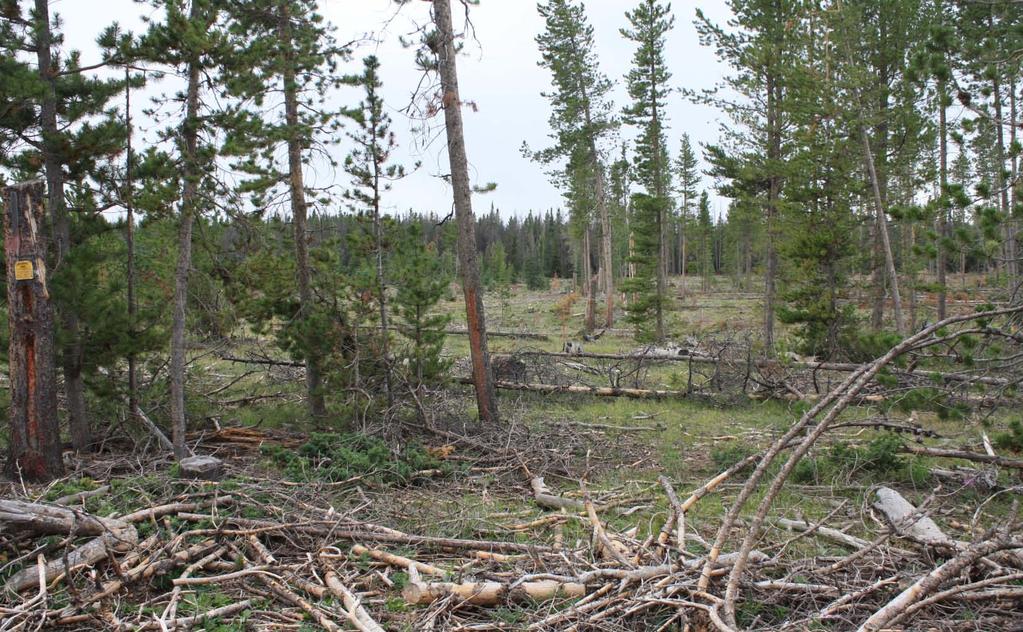
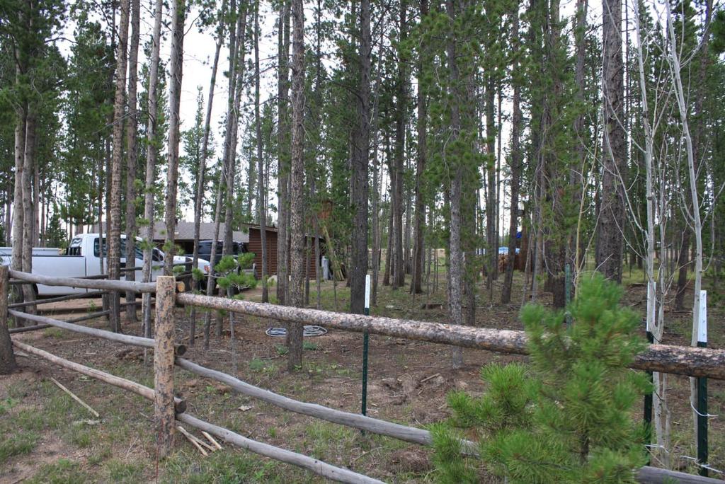
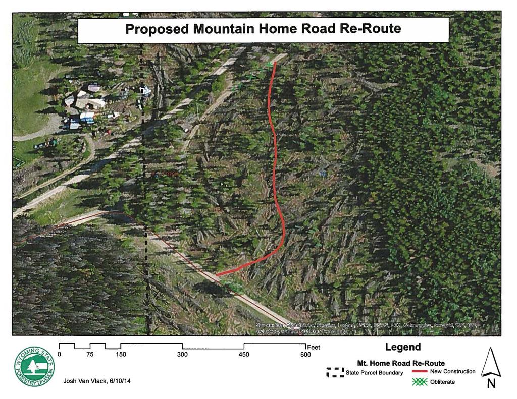
6 FLOOD ZONE AND ZONING DESIGNATIONS: Flood Zone: The subject property is located in an area with low flood risk. FOREST PRODUCTS: Merchantable forest products on the subject property are minimal with little value to the State s Trust Beneficiaries. However, a road that bisects the subject property has historically been used to access to other merchantable timber located on the remaining State Trust Land. The Wyoming State Forestry Division (WSFD) has evaluated this road and has determined it to be expendable with the creation of a new, more useable road for large timber haul trucks. WSFD has analyzed the cost and location of a new road and have determined it to be a feasible project, when considering safety, resource protection, and best management practices. WSFD comments and evaluation are attached as part of Exhibit E. WILDLIFE HABITAT AND WILDLIFE-ORIENTED RECREATIONAL OPPORTUNITIES LOCATED ON THE PARCELS: The Wyoming Game and Fish Department (WGFD) evaluated the subject property in terms of wildlife and wildlife habitat. WGFD notes that it has no terrestrial wildlife or aquatic concerns pertaining to the proposed land disposal. The evaluation letter from WGFD is attached as part of Exhibit E. CULTURAL RESOURCES AND PUBLIC RECREATIONAL OPPORTUNITIES LOCATED ON THE PARCELS: The Department of State Parks and Cultural Resources (SPCR) evaluated the subject property in terms of public recreation, cultural resources, and historical significance. SPCR notes that it has no comments related to the archaeological aspects of the subject property, nor could it find existence or importance of public recreational opportunities on the subject parcel. The evaluation letters from SPCR are attached as part of Exhibit E. 6
7 APPRAISED VALUE: Michael J. Hastings (OSLI Appraiser) has completed an appraisal of the subject property per instructions from OSLI. The effective date of the appraisal was August 13, The appraiser was instructed to estimate the current market value of the fee simple interest of the subject property, excluding mineral estate and assuming legal public access. OPINION OF VALUE: The Board will use the appraised values below, with the acreages granted by Patent at the Act of Admission of 1890, to set the minimum bid when these parcels are sold at public auction. Based on the inspection, available market data and analyses, assumptions, limiting conditions, and the certifications, the appraiser s estimated opinion of market value for the defined property rights with an effective date of August 13, 2013 is: Subject Property 0.94 Acres of State Trust Land at $26, per acre $25,000 Twenty-Five Thousand Dollars OSLI instructed a separate, internal appraiser to review the appraisal. Dave Fuller (OSLI Appraiser) has reviewed the appraisal and concurs with the methods used and estimated market values. The appraisal, comparable sales information, maps, photographs, and related information, as well as the appraisal review completed by OSLI, are available upon request. INCOME GENERATING POTENTIAL: Pursuant to Chapter 26 of the Board s Rules, the Detailed Analysis shall include an estimate of the income generating potential of the subject property: Existing Annual Income Subject Property Special Use Lease No. 387; Cabin Site Outbuildings, 0.41 acres $ Total $ Cumulative existing income for the subject property is $ annually. 7
8 ANTICIPATED APPRECIATION OF THE PARCEL AS REAL ESTATE ASSET The subject property is typical of rural recreational land, which generates an average appreciation potential. Due to the size and configuration of the parcel, future uses are limited to recreation. As a stand-alone parcel, the subject property is inadequate for new improvements, such as a cabin site, and would likely be unmarketable for most customary land uses. In the table below, OSLI staff compared a high and low estimate of appreciation plus earnings to an estimate of investment return upon disposal. Property value appreciation was based on the USDA Agricultural Land Values Summary Reports Multiple factors can dramatically increase or decrease pasture values in any given year, and these rates have varied from a high of +22.0% (2007) to a low of -26.9% (1999). The appreciation estimates are based on a conservative analysis of trends, which resulted in an annual appreciation rate with a low of 3.20% and a high of 7.90%. Investment earnings were based on the Common School Fund projected long-term average total rate of return as reported by the State Treasurer's Office. Ultimately, this comparison is based on highly fluctuating real estate values and should not be viewed as an actual performance estimate. Appreciation and investment income calculations are attached as Exhibit F. These rates are for relative earning potential only. Appreciated land value is inherently speculative and would only be realized on a future sale. 10 Year Comparison of Appreciation and Income versus Earnings 10 Year Hold (low) 10 Year Hold (high) 10 Year Disposal Appraised Value 3.2% Appreciation + Current Income (x10 yrs.) 7.9% Appreciation + Current Income (x10 yrs.) versus 4.84% Investment Earnings Tract 1 $25,000 $14,540 $33,760 $15,106 The sum of the current appraised value, estimated appreciation and income, or investment earnings for the subject tract is outlined in the table below. Total Potential Returns 10 Year Hold (low) 10 Year Hold (high) 10 Year Disposal Base Appraised Value $25,000 $25,000 $25,000 versus Total $39,540 $58,760 $40,106 Appreciation & Earnings $14,540 $33,760 $15,106 8
9 TRUST LAND MANAGEMENT OBJECTIVES: In 1997, Wyoming Session Laws Chapter 200, section 3(a)(i), the Wyoming Legislature declared that trust land should remain a substantial component of the trust portfolio, managed under a total asset management policy, and with a focus on protecting the corpus for multiple generations. Subsequently, the Board adopted criteria for evaluation of land exchanges, sales, acquisitions, and long-term leases, collectively called Trust Land Management Objectives (TLMO), on August 10, A proposal need not meet all objectives, but all objectives are considered by the Board which has the sole discretion in determining how to best manage State Trust Lands. Trust Land Management Objectives: To better meet the beneficiaries short and/or long term needs Improve the manageability of land assets Meet a specific school and/or community need A summary of key points considered in this transaction evaluation are outlined below: Better meet the beneficiaries short and/or long term objectives: The subject property is a small portion of a larger, half-section of State Trust Land. It is typically undesirable to dispose of such a small parcel when considering its affect on land values and manageability. In the case of the subject property, a cabin, guest house, shed, and related infrastructure were originally constructed on private land. After a resurvey sponsored by the United States Forest Service of the area was completed, the ownership boundary between State Trust Land and the deeded property had moved into the deeded area, leaving a portion of the described buildings located on State Trust Land. OSLI has determined that the encroachment of these buildings was not intentional on the part of the deeded property owner, and that their presence decreases or limits the value of the State Trust Land parcel. Further, presence of the buildings limits additional uses the Board may employ to enhance revenues to the State s Trust Beneficiaries. Disposal of the subject property meets the beneficiaries long term objectives by promoting the appreciation potential of the parcel as a whole. Proceeds from a sale would be deposited in the Common School Permanent Land Fund, and shall be held on deposit until such time as the Board wishes to invest the funds or purchase other lands. Therefore, an action on the subject property would yield investment earnings until such time as a separate proposed acquisition could prove substantial benefits based on TLMO beyond the subject property s potential. Improve the manageability of the land asset: As described above, encroachment of the described buildings happened as a result of a resurvey of property boundaries. The Board approved a Special Use Lease on the subject property to allow Mr. Williams continued use of the existing buildings while properly compensating the State s Trust Beneficiaries. Disposal of the subject property allows the owner of the buildings, if the winning bidder, to realize the ownership rights as he believed them to be before the resurvey took place and improves OSLI s management of the parcel. As a result 9
10 of a disposal, OSLI will work towards improving an access road that currently bisects the subject property, increasing the manageability of future timber sales. Through disposal of the subject property, the Board would have an opportunity to improve asset manageability through the consolidation of state and private ownership patterns and the ability to acquire other consolidated lands for the State s Trust Beneficiaries once an opportunity arises. Meet a specific school and/or community need: Disposal of the subject property does not meet a specific school or community need. CONCLUSION: It is the opinion of OSLI that disposal of the subject property will better meet the long term objectives of the State s Trust Beneficiaries through optimized, sustainable revenue generation, and divest the Board of a parcel with an encroaching cabin site and related infrastructure not intentionally built on State Trust Lands. Disposal may further offer the opportunity to acquire other land assets, which would improve manageability and/or meet a specific school or community need. The sale proceeds could be used in accordance with W.S (k) and the Board s Rules, Chapter 26, Section 3, to purchase land adjoining other State Trust Land, which would improve manageability. OSLI resources can be more efficiently utilized in managing land with marketable amenities, legal access, and/or multiple compatible uses rather than small isolated parcels with single or limited uses. This Detailed Analysis will be distributed to the public in accordance with the Board s Rules, and will be available on OSLI s website. It will also be available for public viewing at several locations in Albany County, including the County Library, County and City Clerk s Offices, and the County Commissioners Office. If approved by the Board, a notification of sale will be published in a local and statewide newspaper. In addition, OSLI will market the sale of the parcels to the real estate community, on OSLI s website, and have information available for public viewing at several locations in Albany County, including the County Library. As required in the Board s Rules, a public hearing will be conducted in Albany County. The date, time and location of the public hearing will be advertised in the Laramie Boomerang. It is the intent of OSLI to publicize the sale of these parcels to attract potential buyers. OSLI will then follow the disposal procedures as required by Wyoming Statute, Title 36, Chapter 9, and the Board s Rules, Chapter 26, Section 4. OSLI intends to auction the subject property as one (1) tract which is described in the appraisal. The parcels will be sold subject to any pertinent special use leases, water rights, mineral lease, and easements. All interest in the mineral estate will be retained by the State of Wyoming. 10
11 LIST OF EXHIBITS: A Cover Letter and Land Sale Application B C Subject Property Map and Photos Subject Property Survey D Category II Designation Letter E "F" State Agency Evaluation Letters Projected Appreciation and Earnings Calculations 11
12 Exhibit A Cover Letter and Land Sale Application 12
13 13
14 14
15 15
16 16
17 Exhibit B Maps and Photos 17
18 18
19 19
20 20
21 21
22 22
23 23
24 24
25 25
26 Exhibit C Subject Property Survey 26
27 27
28 Exhibit D Category II Designation Letter 28
29 29
30 30
31 Exhibit E Wyoming State Forestry Division Comments Wyoming Game and Fish Department Comments State Parks and Cultural Resources Comments 31
32 32
33 33
34 34
35 35
36 36
37 37
38 38
39 39
40 40
41 41
42 42
43 Exhibit F Projected Appreciation and Earnings Calculations 43
44 Appreciation Appreciation Rate Determination USDA Agricultural Land Values Pasture Avg. Value per Acre Year Avg. $/Acre Appreciation 1995 $ % 1996 $ % 1997 $ % 1998 $ % 1999 $ % 2000 $ % 2001 $ % 2002 $ % 2003 $ % 2004 $ % Appreciation rates are reported in the USDA National Agricultural Statistics Service, "Agricultural Land Values, " The 20-year average appreciation for Wyoming is 4.04%. Special Use Lease Income Annual Income 10 Year Income Tract 1 $ x 10 $5, % Low Estimate, Appreciation + Income Appreciation Income Total Tract 1 $9, $5, $14, % High Estimate, Appreciation + Income Appreciation Income Total Tract 1 $28, $5, $33,759 44
45 3.20% Appreciation Potential as a Low Estimate Appraised Value Tract 1 $25, Appreciation Rate 3.20% Year $25, Year $26, Year $27, Year $28, Year $29, Year $30, Year $31, Year $32, Year $33, Year $34, Year Base Value + Appreciation $34, Year Appreciation Only $9, % Appreciation Potential as a High Estimate Appraised Value Tract 1 $25, Appreciation Rate 7.90% Year $26, Year $29, Year $31, Year $33, Year $36, Year $39, Year $42, Year $45, Year $49, Year $53, Year Base Value + Appreciation $53, Year Appreciation Only $28,
46 Investment Return Rate 4.84% Long-term Investment Yield Appraised Value Tract 1 $25, Return Rate 4.84% Year $26, Year $27, Year $28, Year $30, Year $31, Year $33, Year $34, Year $36, Year $38, Year $40, Year Principal + Compound Interest $40, Year Compound Interest $15, % Short-term Investment Yield 5.05% $ 25, Year $ 26, Year $ 27, Year $ 28, total $ 28, earnings $ 3,
February 2, 2012 BOARD MATTER C - 1 WYOMING LAND AND IMPROVEMENT COMPANY, PROPOSAL TO ACQUIRE REAL PROPERTY IN ALBANY COUNTY, WYOMING
 February 2, 2012 BOARD MATTER C - 1 ACTION: WYOMING LAND AND IMPROVEMENT COMPANY, PROPOSAL TO ACQUIRE REAL PROPERTY IN ALBANY COUNTY, WYOMING AUTHORITY: W.S. 9-4-715(k); Rules Chapter 26, Section 3 ALTERNATIVES:
February 12, 2009 BOARD MATTER H 2 CHASE FARMS SALE PROPOSAL IN SHERIDAN COUNTY, WYOMING
 February 12, 2009 BOARD MATTER H 2 ACTION: CHASE FARMS SALE PROPOSAL IN SHERIDAN COUNTY, WYOMING AUTHORITY: W.S. 36-9-101; Rules Chapter 26, Section 4 ALTERNATIVES: Authorize the Land Sale, Establish the
RENITA HURDSMAN BEAR RIVER STATE PARK LAND EXCHANGE PROPOSAL
 DETAILED ANALYSIS RENITA HURDSMAN BEAR RIVER STATE PARK LAND EXCHANGE PROPOSAL June 1, 2006 Prepared by the Office of State Lands and Investments Herschler Building, 3W 122 West 25 th Street Cheyenne,
June 1, 2017 BOARD MATTER H - 1 FINAL CONSIDERATION OF STATE TRUST LAND EXCHANGE
 June 1, 2017 BOARD MATTER H - 1 ACTION: AUTHORITY: FINAL CONSIDERATION OF STATE TRUST LAND EXCHANGE W.S. 36-1-107, 36-1-110, and 36-1-111; Board of Land Commissioners Rules and Regulations, Chapter 26,
August 13, 2015 WALK-IN BOARD MATTER #3. Consideration of a Proposal to Exchange State Trust Land in Sheridan County
 August 13, 2015 WALK-IN BOARD MATTER #3 ACTION: AUTHORITY: Consideration of a Proposal to Exchange State Trust Land in Sheridan County W.S. 36-1-110,-111; Board of Land Commissioners Rules and Regulations,
FOR LEASE STATE TRUST LAND
 FOR LEASE STATE TRUST LAND NOTICE IS HEREBY GIVEN THAT PURSUANT TO WYOMING STATUTE 36-5-109, THE OFFICE OF STATE LANDS AND INVESTMENTS OFFERS THE FOLLOWING STATE TRUST LAND FOR GRAZING AND AGRICULTURAL
WILLIAMSON ACT CONTRACTS GUIDELINES
 NEVADA COUNTY COMMUNITY DEVELOPMENT AGENCY PLANNING DEPARTMENT ERIC ROOD ADMINISTRATION BUILDING 950 Maidu Avenue Nevada City, California 95959-8617 Phone: (530) 265-1222 FAX : (530) 265-9851 WILLIAMSON
Moriah Ranch Request for Proposal For Farm and Ranch Management Lease
 Moriah Ranch Request for Proposal For Farm and Ranch Management Lease PURPOSE OF REQUEST The Office of State Lands and Investments (OSLI) is seeking a long term farm and ranch management lease on the Moriah
IC Chapter 7. Real Property Transactions
 IC 8-23-7 Chapter 7. Real Property Transactions IC 8-23-7-0.1 Application of certain amendments to chapter Sec. 0.1. The amendments made to section 19 of this chapter by P.L.133-2007 apply only to public
All roads developed to access four (4) or more parcels shall be constructed to Park County Road and Bridge Standards.
 or more parcels shall be constructed to Park County Road and Bridge Standards.") P a r k C o u n t y P l a n n i n g a n d Z o n i n g 1002 Sheridan Avenue Cody, WY 82414 Phone: 307-527-8540 35-40 ACRE SUBDIVISIONS www.parkcounty.us/planandzone.htm May 2011 This is only intended as
P a r k C o u n t y P l a n n i n g a n d Z o n i n g 1002 Sheridan Avenue Cody, WY 82414 Phone: 307-527-8540 35-40 ACRE SUBDIVISIONS www.parkcounty.us/planandzone.htm May 2011 This is only intended as
54TH LEGISLATURE - STATE OF NEW MEXICO - FIRST SESSION, 2019
 HOUSE BILL TH LEGISLATURE - STATE OF NEW MEXICO - FIRST SESSION, 0 INTRODUCED BY Roberto "Bobby J. Gonzales and Jim R. Trujillo and Susan K. Herrera and Carlos R. Cisneros and Peter Wirth 0 AN ACT RELATING
Q. How is Agricultural property valued? A. GENERAL INFORMATION Many states have laws regarding the preferential assessment of agricultural land.
 Q. How is Agricultural property valued? A. GENERAL INFORMATION Many states have laws regarding the preferential assessment of agricultural land. This means that farm and ranch assessments are usually based
WYOMING WATER DISTRICTS. Harriet M. Hageman Hageman and Brighton, P.C.
 WYOMING WATER DISTRICTS Harriet M. Hageman Hageman and Brighton, P.C. TYPES OF DISTRICTS Water Conservancy District (W.S. 41-3-701 through 41-3-779) Flood Control District (W.S. 41-3-801 through 41-3-803)
October 3, 2013 BOARD MATTER D - 1. W. S ; Board of Land Commissioners Rules and Regulations, Chapter 5
 October 3, 2013 BOARD MATTER D - 1 ACTION: AUTHORITY: Consider Moriah Ranch Lease Proposal W. S. 36-5-114; Board of Land Commissioners Rules and Regulations, Chapter 5 ALTERNATIVES: Approve the Selected
CHAPTER 3 PRELIMINARY PLAT
 10-3-1 10-3-3 SECTION: CHAPTER 3 PRELIMINARY PLAT 10-3-1: Consultation 10-3-2: Filing 10-3-3: Requirements 10-3-4: Approval 10-3-5: Time Limitation 10-3-6: Grading Limitation 10-3-1: CONSULTATION: Each
Special Use Permit - Planned Unit Development Checklist. Property Address:
 Special Use Permit - Planned Unit Development Checklist Special Use Permit Number. Parcel Code/s #28-11- - - Property Address: Applicant: ARTICLE VIII Ordinance Reference - Section 8.1.2 Permit Procedures:
Grand Mesa, Uncompahgre and Gunnison National Forests Region 2, USDA Forest Service
 Decision Memo Taylor River Land Exchange Under the General Exchange Act of March 20, 1922 as Amended, The Federal Land Policy and Management Act of 1976 as Amended and the Federal Land Exchange Facilitation
DECLARATION OF RESTRICTIVE COVENANTS
 DECLARATION OF RESTRICTIVE COVENANTS The Declarant,, is the fee simple owner of the certain real property located in County, Kansas, as described on Exhibit A, which is attached hereto and incorporated
GENERAL ASSEMBLY OF NORTH CAROLINA SESSION 2017 HOUSE BILL 501 RATIFIED BILL
 GENERAL ASSEMBLY OF NORTH CAROLINA SESSION 2017 HOUSE BILL 501 RATIFIED BILL AN ACT TO REQUIRE THE DEPARTMENT OF TRANSPORTATION TO INCLUDE SURVEYING INFORMATION IN ANY PLANS PREPARED FOR THE PURPOSE OF
Georgia Conservation Tax Credit Program Frequently Asked Questions
 Georgia Conservation Tax Credit Program Frequently Asked Questions What are the minimum requirements for eligibility under the Georgia Conservation Tax Credit Program (GCTCP)? Individual and corporate
ARTICLE XI - CONSERVATION SUBDIVISIONS
 ARTICLE XI - CONSERVATION SUBDIVISIONS Section 1101: Purpose and Intent. This Article is intended to provide for residential subdivisions that are designed based first and foremost on the preservation
Short Title: Performance Guarantees/Subdivision Streets. (Public) April 28, 2016
 April 28, 2016") GENERAL ASSEMBLY OF NORTH CAROLINA SESSION S SENATE BILL Transportation Committee Substitute Adopted // House Committee Substitute Favorable // Fourth Edition Engrossed // Short Title: Performance Guarantees/Subdivision
GENERAL ASSEMBLY OF NORTH CAROLINA SESSION S SENATE BILL Transportation Committee Substitute Adopted // House Committee Substitute Favorable // Fourth Edition Engrossed // Short Title: Performance Guarantees/Subdivision
A. ARTICLE 16 - STEEP SLOPE CONSERVATION DISTRICT
 1600. 1601.A. ARTICLE 16 - STEEP SLOPE CONSERVATION DISTRICT SECTION 1600 PURPOSE The purpose of this Article is to expand upon the Community Development Objectives associated with environmental protection
MS MINOR SUBDIVISION TREVITHICK
 MS-02-015 341.12 MINOR SUBDIVISION TREVITHICK A request by Danny Trevithick for a one-lot Minor Subdivision on five acres. The property is zoned A-35 (Agricultural) District and is located ¼ mile south
GENERAL ASSESSMENT DEFINITIONS
 21st Century Appraisals, Inc. GENERAL ASSESSMENT DEFINITIONS Ad Valorem tax. A tax levied in proportion to the value of the thing(s) being taxed. Exclusive of exemptions, use-value assessment laws, and
Rule 80. Preservation of Primary Agricultural Soils Revised and approved by the Land Use Panel during its public meeting on January 31, 2006.
 Rule 80. Preservation of Primary Agricultural Soils Revised and approved by the Land Use Panel during its public meeting on January 31, 2006. (A) Purpose. In accordance with 10 V.S.A. Sections 6025(b)
STAFF REPORT. Permit Number: Porter. Kitsap County Board of Commissioners; Kitsap County Planning Commission
 STAFF REPORT Permit Number: 15 00461 Porter DATE: November 9, 2015 TO: FROM: Kitsap County Board of Commissioners; Kitsap County Planning Commission Katrina Knutson, AICP, Senior Planner, DCD and Jeff
MINOR BOUNDARY LINE ADJUSTMENT PROCESS GUIDE
 MINOR BOUNDARY LINE ADJUSTMENT PROCESS GUIDE Clear Creek County Planning Department P.O. Box 2000 Georgetown, Colorado 80444 (303) 679-2436 phone (303) 569-1103 fax 1 PURPOSE To establish criteria and
BONNER COUNTY PLANNING DEPARTMENT PLANNING & ZONING COMMISION STAFF REPORT APRIL 19, 2018
 BONNER COUNTY PLANNING DEPARTMENT PLANNING & ZONING COMMISION STAFF REPORT APRIL 19, 2018 Project Name: File Number,Type: Request: Legal Description: Location: Parcel Size: Parcel # Applicant: Project
610 LAND DIVISIONS AND PROPERTY LINE ADJUSTMENTS OUTSIDE A UGB
 ARTICLE VI: LAND DIVISIONS AND PROPERTY LINE ADJUSTMENTS VI-21 610 LAND DIVISIONS AND PROPERTY LINE ADJUSTMENTS OUTSIDE A UGB 610-1 Property Line Adjustments (Property Line Relocation) A property line
Multiple Use Forest District (MUF)
") This district is defined as Multiple Use Forest District with a minimum lot size of 20 acres. 11.15.2162 Purposes The purposes of the Multiple Use Forest District are to conserve and encourage the use
This district is defined as Multiple Use Forest District with a minimum lot size of 20 acres. 11.15.2162 Purposes The purposes of the Multiple Use Forest District are to conserve and encourage the use
Spirit Lake North, LLC
 BONNER COUNTY PLANNING DEPARTMENT PLANNING AND ZONING COMMISSION STAFF REPORT FOR March 1, 2018 Project Name: Amendment & Zone Change: Spirit Lake North, LLC File Number,Type: AM 162-18/ZC365-18 Request:
UNOFFICIAL COPY OF HOUSE BILL 1272 A BILL ENTITLED
 UNOFFICIAL COPY OF HOUSE BILL 1272 M4 6lr0525 By: Delegates Smigiel, Kelley, Rosenberg, and Sossi Introduced and read first time: February 10, 2006 Assigned to: Environmental Matters 1 AN ACT concerning
Summary of State Trust Land Revenue
 Summary of State Trust Land Revenue Data as of June 30, 2010 Narrative Summary: Attached are summary schedules of revenues earned on state trust lands for the period ending June 30, 2010. These schedules
H.B. 75 As Introduced
 AM0200X1 H.B. 75 As Introduced Topic: Complaint resolutions; reappraisal notice contents; counterclaims moved to amend as follows: In line 1 of the title, delete "section" and insert "sections 5713.01
LEGISLATIVE PURPOSES. 2. Provide sources of agricultural products within the state for the citizens of the state
 LEGISLATIVE PURPOSES 1. Assist in sustaining the farming community 2. Provide sources of agricultural products within the state for the citizens of the state 3. Control the urban expansion which is consuming
PENINSULA TOWNSHIP LAND DIVISION ORDINANCE TOWNSHIP OF PENINSULA COUNTY OF GRAND TRAVERSE, STATE OF MICHIGAN ORDINANCE NO OF 2012
 PENINSULA TOWNSHIP LAND DIVISION ORDINANCE TOWNSHIP OF PENINSULA COUNTY OF GRAND TRAVERSE, STATE OF MICHIGAN ORDINANCE NO OF 2012 AN ORDINANCE TO REGULATE THE DIVISION OF EXISTING PARCELS OF LAND PURSUANT
Project File #: SF Project Name: Jackson Ranch Filing No. 4 Parcel Nos.: , and
 COMMISSIONERS: DARRYL GLENN (PRESIDENT) MARK WALLER (PRESIDENT PRO TEMPORE) STAN VANDERWERF LONGINOS GONZALEZ PEGGY LITTLETON PLANNING AND COMMUNITY DEVELOPMENT DEPARTMENT CRAIG DOSSEY, EXECUTIVE DIRECTOR
Land Use. Land Use Categories. Chart 5.1. Nepeuskun Existing Land Use Inventory. Overview
 Land Use State Comprehensive Planning Requirements for this Chapter A compilation of objectives, policies, goals, maps and programs to guide the future development and redevelopment of public and private
SECTION 500 RURAL RESIDENTIAL DISTRICTS VERY LOW DENSITY RESIDENTIAL DISTRICTS (VLDR-5, VLDR-2 ½, VLDR-1) [Last Amended 5/24/12; Ord.
 [Last Amended 5/24/12; Ord.") This section and related information is available at www.co.yamhill.or.us/plan/planning/ordinance/zoning_toc.asp SECTION 500 RURAL RESIDENTIAL DISTRICTS 502. VERY LOW DENSITY RESIDENTIAL DISTRICTS (VLDR-5,
This section and related information is available at www.co.yamhill.or.us/plan/planning/ordinance/zoning_toc.asp SECTION 500 RURAL RESIDENTIAL DISTRICTS 502. VERY LOW DENSITY RESIDENTIAL DISTRICTS (VLDR-5,
I would like to own a parcel of agricultural land in Alaska. What programs does the State of Alaska have that would allow me to do this?
 Fact Sheet Title: AGRICULTURAL LAND FOR ALASKA Division of Agriculture I would like to own a parcel of agricultural land in Alaska. What programs does the State of Alaska have that would allow me to do
RESIDENTIAL AND RECREATIONAL
 Energy, Mines & Resources Land Management Branch 320-300 Main Street Whitehorse, Yukon Y1A 2B5 667-5215 Fax 667-3214 www.emr.gov.yk.ca RESIDENTIAL AND RECREATIONAL Lot Enlargement Policy OBJECTIVE To facilitate
MINERAL COUNTY PLANNING STAFF FINDINGS OF FACT Proposed Elk Run at St. Regis. February 12, 2017
 MINERAL COUNTY PLANNING STAFF FINDINGS OF FACT Proposed The proposed is a five-lot subdivision and is located approximately one mile east of St. Regis on Old Highway 10 East. The property is located in
204 Minor Subdivision & Large Lot Division
 204 Minor Subdivision & Large Lot Division 204.01 Purpose and Intent 204.05 General Procedures 204.10 Large Lot Division 204.02 Comprehensive Land Use 204.06 Submittal Requirements Plan Policies 204.07
Torch Lake Township Antrim County, Michigan
 Torch Lake Township Antrim County, Michigan Farmland and Open Space Development Rights Ordinance Ordinance No. 04-01 Effective September 3, 2004 AN ORDINANCE creating a farmland and open space protection
LEGISLATIVE COUNSEL'S DIGEST
 Senate Bill No. 209 CHAPTER 8 An act to amend Sections 607, 2207, and 2714 of, and to add Sections 2006.5, 2770.1, and 2773.1.5 to, the Public Resources Code, relating to surface mining. [ Approved by
LARAMIE COUNTY PLANNING & DEVELOPMENT DEPARTMENT
 LARAMIE COUNTY PLANNING & DEVELOPMENT DEPARTMENT Planning Building MEMORANDUM TO: FROM: Laramie County Planning Commission Bryan Nicholas, Associate Planner DATE: April 11, 2019 TITLE: Review and action
MAJOR BOUNDARY LINE ADJUSTMENT PROCESS GUIDE
 MAJOR BOUNDARY LINE ADJUSTMENT PROCESS GUIDE Clear Creek County Planning Department P.O. Box 2000 Georgetown, Colorado 80444 (303) 679-2436 - phone (303) 569-1103 - fax PURPOSE To establish criteria and
APPLICATION FOR SUBDIVISION APPROVAL OF A SKETCH PLAN with checklist
 Prior to filing any application for SUBDIVISION approval, the applicant shall request in writing that the zoning administrator schedule a pre-submission conference. APPLICATION TO THE PLANNING BOARD TOWN
MINUTE ORDER BONNER COUNTY COMMISSIONERS PUBLIC HEARING MINUTES AUGUST 6, 2015
 MINUTE ORDER BONNER COUNTY COMMISSIONERS PUBLIC HEARING MINUTES AUGUST 6, 2015 CALL TO ORDER: Chair Cary Kelly called the Bonner County Commissioners hearing to order at 1:00 p.m. in the 3rd floor meeting
Conservation Design Subdivisions
 Conservation Design Subdivisions An excerpt from the Rules and Regulations Governing Division of Land in Sheridan County, Wyoming, November 5, 2010 Sheridan County Public Works Department 224 S. Main Street
Title 5: ADMINISTRATIVE PROCEDURES AND SERVICES
 Title 5: ADMINISTRATIVE PROCEDURES AND SERVICES Chapter 353: LAND FOR MAINE'S FUTURE Table of Contents Part 15-A. LAND FOR MAINE'S FUTURE... Section 6200. FINDINGS... 3 Section 6201. DEFINITIONS... 3 Section
Larimer County Planning Dept. Procedural Guide for 1041 PERMITS
 - Larimer County Planning Dept. Procedural Guide for 1041 PERMITS PLEASE NOTE: A PRE-APPLICATION CONFERENCE IS REQUIRED PRIOR TO SUBMITTING THIS APPLICATION. PURPOSE: State Statutes allow local governments
A COMPARATIVE STUDY OF GRAZING FEES ON MONTANA PUBLIC SCHOOL LANDS AND OTHER GRAZING LANDS IN MONTANA KENNETH L. SIDERIUS
 A COMPARATIVE STUDY OF GRAZING FEES ON MONTANA PUBLIC SCHOOL LANDS AND OTHER GRAZING LANDS IN MONTANA BY KENNETH L. SIDERIUS Submitted in partial fulfillment of the requirements for the Master of Education
Conceptual Scheme SE W4
 December 2012 1. PURPOSE 1.1. The purpose of a Conceptual Scheme (CS) is as follows: a) To provide a framework for the subsequent subdivision and/or development of land within the Country Residential Policy
As Reported by the House Agriculture and Rural Development Committee. 131st General Assembly Regular Session Sub. H. B. No.
 As Reported by the House Agriculture and Rural Development Committee 131st General Assembly Regular Session Sub. H. B. No. 80 2015-2016 Representative Burkley Cosponsors: Representatives Blessing, Boose,
Chapter 210 CONDITIONAL USES
 Chapter 210 CONDITIONAL USES 210.01 Purpose 210.02 Authorization 210.03 Process Type 210.04 Determination of Major or Minor Conditional Use Review 210.05 Approval Criteria 210.06 Conditions of Approval
CONDITIONAL USE PERMIT Application Packet
 CONDITIONAL USE PERMIT Application Packet Community Development Department 1020 East Pioneer Road, Draper, UT 84020 (801) 576-6539 Fax (801) 576-6526 Dear Applicant, This application packet has been developed
LAND USE PLANNING. General Discussion. Objectives
 GOAL 2: LAND USE PLANNING General Discussion To establish a land use planning process for the County as a basis for all decisions and actions related to use of land and to ensure an adequate factual base
The Provincial Lands (Agriculture) Regulations
 Regulations") PROVINCIAL LANDS (AGRICULTURE) P-31.1 REG 1 1 The Provincial Lands (Agriculture) Regulations being Chapter P-31.1 Reg 1 (effective March 13, 2017) as amended by Saskatchewan Regulations 136/2017. NOTE:
PROVINCIAL LANDS (AGRICULTURE) P-31.1 REG 1 1 The Provincial Lands (Agriculture) Regulations being Chapter P-31.1 Reg 1 (effective March 13, 2017) as amended by Saskatchewan Regulations 136/2017. NOTE:
2Q. We have owned this property for many years, why are we just now hearing about this?
 Frequently Asked Questions and Answers: 1Q. Why are you surveying the flowage easement line? 1A. The United States Army Corps of Engineers (USACE) is resurveying the actual deeded flowage easement line
VALUE FINDING APPRAISAL REPORT
 RE 90 Rev. 01-2014 VALUE FINDING APPRAISAL REPORT (Compensation not to exceed $65,000) COUNTY John Doe 2880 Lancaster-Newark Rd. (SR 37), Pleasant Twp., 43030 Owner Mailing Address of Owner East side of
Experienced Professional Ranch Brokers Specializing in the sale of ranches, farms, & recreational properties.
 Experienced Professional Ranch Brokers Specializing in the sale of ranches, farms, & recreational properties. 58 E. Benteen Street Buffalo, WY 82834 Ph 307-684-9556 Toll Free 888-684-9557 Fax 307-684-8565
 ALLEGHANY COUNTY VOLUNTARY FARMLAND PRESERVATION PROGRAM APPLICATION Page 1 A. APPLICANT INFORMATION Applicant Name(s) Farm Name Mailing Address Phone (day) (evening) B. PROPERTY INFORMATION (Please see
UNIFORM RULE 5. Administration of Williamson Act Contracts
 UNIFORM RULE 5 Administration of Williamson Act Contracts I. PROCEDURE TO ESTABLISH AN AGRICULTURAL PRESERVE AND WILLIAMSON ACT CONTRACT See Appendices 1 and 2 for the following forms: Application Form
LARAMIE COUNTY PLANNING & DEVELOPMENT DEPARTMENT
 LARAMIE COUNTY PLANNING & DEVELOPMENT DEPARTMENT Planning Building MEMORANDUM TO: FROM: Laramie County Planning Commission Jean Vetter, Senior Planner DATE: January 26, 2017 TITLE: Review and action of
Notice of Continuance Land Classified as Current Use or Forest Land RCW Chapter and 84.33
 When Recorded Return to: Notice of Continuance Land Classified as Current Use or Forest Land RCW Chapter 84.34 and 84.33 Grantor(s)/Sellers: Grantee(s)/Buyers: Mailing Address: City, State, Zip: Assessor
LIMITED-SCOPE PERFORMANCE AUDIT REPORT
 LIMITED-SCOPE PERFORMANCE AUDIT REPORT Agricultural Land Valuation: Evaluating the Potential Impact of Changing How Agricultural Land is Valued in the State AUDIT ABSTRACT State law requires the value
Guide to Preliminary Plans
 Guide to Preliminary Plans Introduction The Douglas County is committed to providing open, transparent application processes to the public. This Guide is provided to assist anyone interested in the procedures
SECTION 10.7 R-PUD (RESIDENTIAL PLANNED UNIT DEVELOPMENT) ZONE
 ZONE") Article X Zones 10-20 SECTION 10.7 R-PUD (RESIDENTIAL PLANNED UNIT DEVELOPMENT) ZONE A. PURPOSE AND INTENT: The R-PUD Residential PUD Zone is intended to provide alternative, voluntary zoning procedures
Article X Zones 10-20 SECTION 10.7 R-PUD (RESIDENTIAL PLANNED UNIT DEVELOPMENT) ZONE A. PURPOSE AND INTENT: The R-PUD Residential PUD Zone is intended to provide alternative, voluntary zoning procedures
Conservation Easement Stewardship
 Conservation Easements are effective tools to preserve significant natural, historical or cultural resources. Conservation Easement Stewardship Level of Service Standards March 2013 The mission of the
Chapter SWAINSON S HAWK IMPACT MITIGATION FEES
 The Swainson s Hawk ordinance can also be viewed online at: http://qcode.us/codes/sacramentocounty/ Once at the website, click on Title 16 BUILDINGS AND CONSTRUCTION, then Chapter 16.130 SWAINSON S HAWK
CHALLENGES IN MANAGING MULTIPLE USE LANDS & TOOLS TO ENABLE SUCCESS
 CHALLENGES IN MANAGING MULTIPLE USE LANDS & TOOLS TO ENABLE SUCCESS Rocky Mountain Land Use Institute Conference March 13, 2015 Susan Culp Principal, NextWest Consulting, LLC Challenges to Achieving Conservation
TOWNSHIP OF EGG HARBOR ZONING BOARD ADJUSTMENT CHECK LIST
 TOWNSHIP OF EGG HARBOR ZONING BOARD ADJUSTMENT CHECK LIST Schedule A - General Requirements 1. Where the application involves only a variance one (1) original and nineteen (19) copies of the appropriate
L. LAND USE. Page L-1
 L. LAND USE 1. Purpose This section discusses current and likely future land use patterns in Orland. An understanding of land use trends is very important in determining Orland's ability to absorb future
RURAL GENERAL RG 1. PERMITTED USES DISCRETIONARY USES
 RURAL GENERAL RG PURPOSE: To protect the agricultural land base of the municipality while allowing nonagricultural developments which complement the area's economy. 1. PERMITTED USES DISCRETIONARY USES
Remains eligible for state or federal farm programs. Can use land as collateral for loans. Can reserve home lots for children
 December 2002 B-1132 Conservation Easements: An Introductory Review for Wyoming By Allison Perrigo and Jon Iversen, William D. Ruckelshaus Institute of Environment and Natural Resources William D. Ruckelshaus
Oregon Theodore R. Kulongoski, Governor
 Oregon Theodore R. Kulongoski, Governor Department of Land Conservation and Development 635 Capitol Street NE, Suite 150 Salem, Oregon 97301-2524 Phone: (503) 373-0050 First Floor/Coastal Fax: (503) 378-6033
LARAMIE COUNTY PLANNING & DEVELOPMENT DEPARTMENT
 LARAMIE COUNTY PLANNING & DEVELOPMENT DEPARTMENT Planning Building MEMORANDUM TO: FROM: Laramie County Planning Commission Brett Walker, Planner DATE: January 25, 2018 TITLE: Review and action of a Subdivision
Property Disposition Compliance Process Governance Committee #1345, approved March 29, 2017
 Board Policy: Policy Type: Monitored by: Board Resolution: Property Disposition Compliance Process Governance Committee #1345, approved March 29, 2017 Long Island Power Authority (referred to herein as
DISPOSITION OF REAL PROPERTY/PERSONAL PROPERTY
 BRECKSVILLE-BROADVIEW HEIGHTS CITY 7300/page 1 of 7 DISPOSITION OF REAL /PERSONAL The Board of Education believes that the efficient administration of the District may require the disposition of real property
MIDWAY CITY Municipal Code
 MIDWAY CITY Municipal Code TITLE 9 ANNEXATION CHAPTER 9.01 PURPOSE CHAPTER 9.02 GENERAL REQUIREMENTS CHAPTER 9.03 PROPERTY OWNER INITIATION OF ANNEXATION CHAPTER 9.04 PROCEDURES FOR CONSIDERATION OF PETITION
Can the Landowner Ride the Wind? By: Brandon L. Jensen Budd-Falen Law Offices, LLC
 Can the Landowner Ride the Wind? By: Brandon L. Jensen Budd-Falen Law Offices, LLC There are a lot of reasons that western landowners love to hate the wind --- it s relentless, constant, never ceasing,
ORANGE BLOSSOM GARDENS PLANNED UNIT DEVELOPMENT PREPARED BY: COASTAL ENGINEERING CONSULTANTS, INC.
 ORANGE BLOSSOM GARDENS A PLANNED UNIT DEVELOPMENT PREPARED BY: COASTAL ENGINEERING CONSULTANTS, INC. REVISED OCTOBER 19, 1992 BY THE COLLIER COUNTY LONG RANGE PLANNING DEPARTMENT REVISED DECEMBER, 2008
Procedures Used to Calculate Property Taxes for Agricultural Land in Mississippi
 No. 1350 Information Sheet June 2018 Procedures Used to Calculate Property Taxes for Agricultural Land in Mississippi Stan R. Spurlock, Ian A. Munn, and James E. Henderson INTRODUCTION Agricultural land
A. Owner s Name: Owner s Address: Description of Land as Shown on Property Tax Statement: Location of Property:,
 ODA - Ag. Adm. Form 11 Rev. - 12/2006 New Application Renewal Application APPLICATION FOR PLACEMENT OF FARMLAND IN AN AGRICULTURAL DISTRICT (O.R.C. Section 929.02) (See pages 5 & 6 for General Information
MAJOR SUBDIVISION PRELIMINARY PLAT CHECKLIST
 TOWNSHIP OF EGG HARBOR PLANNING BOARD/ZONING BOARD OF ADJUSTMENT 3515 BARGAINTOWN ROAD EGG HARBOR TOWNSHIP, NJ 08234 MAJOR SUBDIVISION PRELIMINARY PLAT CHECKLIST The following checklist is designed to
STATE OF MICHIGAN COUNTY OF MARQUETTE, TOWNSHIP OF NEGAUNEE LAND DIVISION, SUBDIVISION AND CONDOMINIUM ORDINANCE
 STATE OF MICHIGAN COUNTY OF MARQUETTE, TOWNSHIP OF NEGAUNEE LAND DIVISION, SUBDIVISION AND CONDOMINIUM ORDINANCE Adopted: August 8 th, 2008 Effective: August 28 th, 2008 Sec.100. Title ARTICLE I GENERAL
CHAPTER House Bill No. 1453
 CHAPTER 2004-451 House Bill No. 1453 An act relating to the North Sumter County Hospital District; providing a popular name; providing district purpose; providing district boundaries; providing for a board
JORDAO PROPERTY ± RIPARIAN IRRIGATED CROPLAND. $2,438,000 ($23,000/Acre)
") JORDAO PROPERTY ±106.00 RIPARIAN IRRIGATED CROPLAND Located at: 7505 Hogin Road Crows Landing, Stanislaus County, CA 95313 APN s 057-026-009 & 057-026-008 Offered for $2,438,000 ($23,000/Acre) Presented
JORDAO PROPERTY ±106.00 RIPARIAN IRRIGATED CROPLAND Located at: 7505 Hogin Road Crows Landing, Stanislaus County, CA 95313 APN s 057-026-009 & 057-026-008 Offered for $2,438,000 ($23,000/Acre) Presented
Subtitle H Agricultural Conservation Easement Program
 1 1 1 1 1 1 0 1 0 1 0 Subtitle H Agricultural Conservation Easement Program SEC.. [1 U.S.C. ] ESTABLISHMENT AND PURPOSES. (a) Establishment. The Secretary shall establish an agricultural conservation easement
3.23 LANDS AND SPECIAL USES
 3.23 LANDS AND SPECIAL USES Introduction This section addresses those aspects of SJPLC management relating to public land ownership and use. Special Use Permits, rights-of-way (ROW) grants, easements,
MIAMI-DADE EXPRESSWAY AUTHORITY PROPERTY ACQUISITION POLICY
 MIAMI-DADE EXPRESSWAY AUTHORITY PROPERTY ACQUISITION POLICY PURPOSE It is the policy of the Miami-Dade Expressway Authority to acquire property in an economical and efficient manner pursuant to MDX s statutorily
BILL JOHNSON & ASSOCIATES REAL ESTATE COMPANY WILL CO-BROKER IF BUYER IS ACCOMPANIED BY HIS OR HER AGENT AT ALL PROPERTY SHOWINGS
 WITTE ROAD RANCH For more information: Bill Johnson & Associates Real Estate Company 420 East Main, Bellville, Texas 77418 979-865-5969 281-463-3791 979-992-2636 www.bjre.com This 36.7820 acres is conveniently
Guide to Minor Developments
 Guide to Minor Developments Introduction The Douglas County (DCD) is committed to providing open, transparent application processes to the public. This Guide is provided to assist anyone interested in
PROJECT SCORING GUIDANCE. Introduction: National Proiect Selection:
 FOREST LEGACY PROGRAM PROJECT SCORING GUIDANCE Introduction: This document provides guidance to the National Review Panel on how to score individual Forest Legacy Program (FLP) projects, including additional
Transitioning from the Farmland Preservation Program to the Working Lands Initiative
 Transitioning from the to the The table below describes differences between the Department of Agriculture, Trade and Consumer Protection s (DATCP) previous and the new. Contact: DATCPWorkingLands@wisconsin.gov
STATE OF SOUTH CAROLINA ) AGREEMENT ) OF COUNTY OF RICHLAND ) PURCHASE AND SALE
 AGREEMENT ) OF COUNTY OF RICHLAND ) PURCHASE AND SALE") STATE OF SOUTH CAROLINA ) AGREEMENT ) OF COUNTY OF RICHLAND ) PURCHASE AND SALE THIS AGREEMENT (the Agreement ) executed the day of, 2010 (the Effective Date ), by and between COLUMBIA VENTURE, LLC, a
STATE OF SOUTH CAROLINA ) AGREEMENT ) OF COUNTY OF RICHLAND ) PURCHASE AND SALE THIS AGREEMENT (the Agreement ) executed the day of, 2010 (the Effective Date ), by and between COLUMBIA VENTURE, LLC, a
***** Subchapter A. GENERAL PROVISIONS ***** PERMIT APPLICATIONS
 105.11. Permit requirements. 105.12. Waiver of permit requirements. Title 25 Environmental Protection Part I. Department of Environmental Protection Subpart C. Protection of Natural Resources Article I.
COUNTY OF SAN MATEO PLANNING AND BUILDING DEPARTMENT
 COUNTY OF SAN MATEO PLANNING AND BUILDING DEPARTMENT DATE: April 16, 2015 TO: FROM: Zoning Hearing Officer Planning Staff SUBJECT: Consideration of a Coastal Development Permit and Planned Agricultural