National Parcel Layer Primer for Improving Commercial Real Estate Due Diligence
|
|
|
- Evangeline Barker
- 5 years ago
- Views:
Transcription
1 National Parcel Layer Primer for Improving Commercial Real Estate Due Diligence - Property Assessment validation - - $/SF subject parcel vs. nearby parcels. - Optimizing same Owner parcels when assembling land - Land Use and Zoning Map Display - WALK and TRANSIT Maps for anticipating Sustainable Communities - Automated Determination of same ownership of adjacent parcels Boundary Solutions, Inc. 230 East Blithedale Miller Ave. Mill Valley CA February, 2014
2

3 National Parcel Layer Handbook for Increasing Real Estate Investment Due Diligence Currently, half of all Americans, 156,000,000 people, live in counties for which its digital parcel map is posted as a free ftp download or can be acquired for $100 or less. This offers everyone the opportunity to perform the same level of real estate decision making due diligence as the most capitalized companies in town. This National Parcel Layer Primer offers a missing piece: GIS techniques so your investment due diligence can equal that of the most advantaged investors. The maps shown here were produced by a very old copy of ArcView 3.2. Other GIS software options are free geoviewers like Arc Explorer, free cloud based softwares, and for-fee software like Delorme XMAP ($259). Bexar County, TX Land Use Thematic Map

4 National Parcel Layer Handbook for Increasing Real Estate Investment Due Diligence What this Primer is and is not. 1. All displays are based on actual parcel boundaries and joined tax roll attributes records. 2. The typical county ftp download digital parcel map comes with a full complement of attributes. If is does not, ask the county to add it to the GIS. 3. Limited to parcel-layer analysis only. 4. All findings are hypothetical, to communicate ideas only. 5. Some are a bit extreme to better clarify NPL benefits. 6. No reference yet to other layers such as hazards, Multiple Listings, soils, hydrology, demographics. 7. Primer is work in progress. corrections and additions to info@boundarysolutions.com Techniques Included: - Thematic Mapping - Multi Scale Analysis - Selected Land Use Analysis - Boolean Query - Comparative Value Analysis - Comparative Tax Analysis - Proximity Analysis - Spatial Trending Value Analysis Bexar County, TX Land Use Thematic Map

5 MULTI SCALE ANALYSIS Step back and see the whole region. Then identify a subarea of interest. Then identify high value opportunities. Take some time to identify the extents of a sub-region you are the most interested in analyzing to measure, compare and rank real estate investment opportunities according to greatest possible margin at the lowest possible risk. Bexar County, TX Land Use Thematic Map

6 EXTENDED ATTRIBUTES Typical open record USA digital parcel maps come with multiple tax roll attributes. Bexar County, TX is exceptional compared to most USA counties, providing not only the essential situs, owner information and perfunctory valuation fields at no cost, but year built, floor area, lot area, unit count, use code among others as well. Such robust geospatial data models enable everyone, from the smallest business to families wanting to invest their risk capital locally, to make the smartest possible investments. Progressive counties like Bexar figure that the more they give away the more that comes back as optimized investments by local and International investors that find this high level of transparency irresistible. NOTE: The tax rolls include physical and owner address for contacting owners and occupants. Thematic Map Types Graduated from numeric fields (Value, Year Built ) Unique from non numeric fields (Use code, Type ) USE CODE Values determining color in Thematic Map

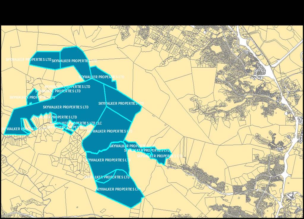
7 Automating Same Owner of Adjacent Parcels
8
9
10
11


12 SELECTED LAND USE ANALYSIS To avoid comparing apples with oranges, query the national parcel layer for all parcels that have a common land use designation like Residential, Commercial, Office / Industrial etc. In this case, all residential land of all densities were queried, highlighted and written to a Residential Layer. QUERY: USE CODE = *RESIDENTIAL* Target Parcel filter is applied to isolate all properties compliant with a value proposition like QUERY: FL AREA > 3,000 AND Value < $150,000 AND UNIT COUNT = 1 Use multiple listings or direct contact from the address info in the tax rolls to see if you want to make a red filtered parcel a blue target parcel. Target Properties are selected from first filter if for sale or other reasons.

13 THEMATIC MAP USE CODE To observe Development Patterns Relative to Interested Properties ALL PARCELS THEMATIC MAP YEAR BUILT Residential Parcels ONLY To observe Age of Neighborhoods Relative To Interested Properties ONLY RESIDENTIAL PARCELS
.")

14 ASSESED VALUE ANALYSIS There are many ways to compare relative value of properties (residential in this instance). In this map, the total assessed values of land and improvements of each parcel are used to generate a thematic map of relative value. This is great for comparing your target property to others but fails to look at this issue in terms of value per square foot. THEMATIC FIELD SELECTION: TOTAL ASSESSED VALUE Target Properties


15 RELATIVE ASSESSED VALUE ANALYSIS Here the value is made more useful by reducing to a unit count rather than a lump sum. To do this, an additional field is added to the attribute table. FIELD CALCULTION: $/SF = TOTAL VALUE/BLDAREA THEMATIC FIELD SELECTION: $/SF Target Properties

16 ASSESSED PROPERTY APPRAISAL CHECKING A great advantage of using value per sq feet rather than total assessed value is the ability it offers to compare properties side by side and up and down the block in the direct relative terms of value per square foot. In this model, the colors reflect the total assessed value (not marked) of each house (only single family in this test) divided by their total floor area. With the colors being determined values assigned by the assessor, question is, do: - Light colors next to a lot of dark colors means underassessment? - Dark colors next to a lot of light colors means over assessment?


17 PROXIMITY ANALYSIS The unsustainable sprawlbased American housing market, not able to spread out any more, has no choice but higher density implosion. With the Boomers getting old and many not that well off, what better soft landing than HUD s most commendable Sustainable Communities protocols to expedite returning to a lot like we were before - - this time with highly pedestrian oriented older and younger populations who find living within 1,000 feet of goods and services a huge plus. Pedestrian Access to Goods and Services 1,000 Foot Buffer Around Commercial Target Properties
3MAPS SUSTAINABLE COMMUNITIES GIS PROTOCOL
 BAAMA EDUCATIONAL MEETING MTC/ABAG OAKLAND CA January 30, 2013 3MAPS SUSTAINABLE COMMUNITIES GIS PROTOCOL GIS Software: Digital Parcel Map Content: GIS 3MAPS Application ESRI ArcView Marin MAP BSI JAN2014
TROUBLESHOOTING YOUR CAMA DATA WITH GIS
 Chad Rupert Office of Information Technology Outreach Services (ITOS) University of Georgia Athens, GA 30602-5418 Ph: 706-542-5308 Email: rupert@itos.uga.edu Jimmy Nolan Office of Information Technology
Comparative Housing Market Analysis: Minnetonka and Surrounding Communities
 Comparative Housing Market Analysis: Minnetonka and Surrounding Communities Prepared by Mark Huonder, Eric King, Katie Knoblauch, and Xiaoxu Tang Students in HSG 5464: Understanding Housing Assessment
86 years in the making Caspar G Haas 1922 Sales Prices as a Basis for Estimating Farmland Value
 2 Our Journey Begins 86 years in the making Caspar G Haas 1922 Sales Prices as a Basis for Estimating Farmland Value Starting at the beginning. Mass Appraisal and Single Property Appraisal Appraisal
New Models for Property Data Verification and Valuation
 New Models for Property Data Verification and Valuation for 2006 IAAO Councils and Sections Joint Seminar May 9-11, 2006 Charleston, South Carolina Presented by George Donatello, CMS Principal Consultant
BUILD-OUT ANALYSIS GRANTHAM, NEW HAMPSHIRE
 BUILD-OUT ANALYSIS GRANTHAM, NEW HAMPSHIRE A Determination of the Maximum Amount of Future Residential Development Possible Under Current Land Use Regulations Prepared for the Town of Grantham by Upper
Future Land Use Allocation Model (FLUAM) Methodology
 Methodology") Future Land Use Allocation Model (FLUAM) Methodology For: Lake/Sumter MPO By: Data Transfer Solutions (DTS) 3680 Avalon Park Blvd E, Suite 200 Orlando, FL 32828 Phone: 407-382 382-5222 Fax: 407-382 382-5420
Future Land Use Allocation Model (FLUAM) Methodology For: Lake/Sumter MPO By: Data Transfer Solutions (DTS) 3680 Avalon Park Blvd E, Suite 200 Orlando, FL 32828 Phone: 407-382 382-5222 Fax: 407-382 382-5420
Transit-Oriented Development Specialized Real Estate Services
 COLLIERS INTERNATIONAL Transit-Oriented Development Specialized Real Estate Services Accelerating success. Colliers International transit-oriented development GROUP P. 1 2 transit-oriented development
HARPS FOOD STORE/PAD SITE 1945 BUTTERFIELD COACH ROAD, SPRINGDALE, AR
 Details Harps Sale Price $2,800,000 PAD Site Sale Price $495,000 PAD Site Lot Size +/-1.27 Acres Property Overview The property consists of a 27,824 square foot free standing grocery store 100% leased
PROPERTY ASSESSMENT KNOWLEDGE
 A P E N DE UM NOUN A COLLECTION OF CONCISE BUT DETAILED INFORMATION ABOUT APPRAISAL AND APPRAISAL MANAGEMENT, ESPECIALLY IN THE PROPERTY ASSESSMENT INDUSTRY. PROPERTY ASSESSMENT KNOWLEDGE KNOWLEDGE AREAS
Orange Avenue Corridor Study
 Focusing on Orange Avenue in Winter Park, this study identifies its composition, existing conditions, and examines highest and best use opportunities from a zoning and development perspective. Its aim
90 Alton Rd, Miami Beach, FL 33139
 PROPERTY REPORT 90 Alton Rd, Miami Beach, FL 33139 Presented by Christopher Lazaro Florida Real Estate License: BK3252123 Hello & Happy New Year! You may call me any time to discuss your Residential &
Census Tract Data Analysis
 Data Analysis Study Area: s within the City of Evansville, Indiana Prepared For Mr. Kelley Coures City of Evansville Department of Metropolitan Development 1 NW MLK Jr. Boulevard Evansville, Indiana 47708
PROPERTY REPORT FOR: Cooper Ln Acres, Austin, Texas 78745
 PROPERTY REPORT FOR: Cooper Ln Acres, Austin, Texas 78745 This Is A Broker Price Opinion Or Comparative Market Analysis And Should Not Be Considered An Appraisal Or Opinion Of Value. In Making Any Decision
Past & Present Adjustments & Parcel Count Section... 13
 Assessment 2017 Report This report includes specific information regarding the 2017 assessment as well as general information about both the appeals and assessment processes. Contents Introduction... 3
Introduction. Bruce Munneke, S.A.M.A. Washington County Assessor. 3 P a g e
 Assessment 2016 Report This report includes specific information regarding the 2016 assessment as well as general information about both the appeals and assessment processes. Contents Introduction... 3
6041 E 40th St, Indianapolis, IN 46226
 ( M a i n : c N O L I C a r m R e a l 708-440 - E D r S ( 440 - ( 708 - PROPERTY REPORT P r e s e n t e d b y Charlene Gaard REALTOR W o rk : ( 317 ) 2149 M o b i l e : F a x : 317 ) 4779 h a rl e n e
3737 Truett Blvd, Shreveport, LA 71107
 PROPERTY REPORT 3737 Truett Blvd, Shreveport, LA 71107 Presented by Carolyn and Cliff Grimsley Mobile: (318) 759-7636 Century 21 Elite 8575 Fern Avenue, Suite 105 Shreveport, LA 71105 3737 Truett Blvd,
The Newsletter of the Maine Chapter IAAO SPRING Covering Maine Assessing FROM THE EDITOR:
 Covering Maine Assessing The Newsletter of the Maine Chapter IAAO SPRING 2013 FROM THE EDITOR: Maine chapter iaao SPRING 2013 By Kyle Avila, CMA I use GIS daily for explaining valuations to taxpayers in
5004 N Bay Rd, Miami Beach, FL 33140
 PROPERTY REPORT 5004 N Bay Rd, Miami Beach, FL 33140 Presented by Christopher Lazaro Florida Real Estate License: BK3252123 Hello & Happy New Year! You may call me any time to discuss your Residential
RAM. full service car lot for sale. Real Estate Asset Management S. Decatur BLVD. las vegas, nevada 89102
 RAM PRESENTED BY Information herein has been obtained from sources deemed reliable, however its accuracy cannot be guaranteed. The user is required to conduct their own due diligence and verification.
Analyses of the Results of Land Consolidation Studies by GIS
 Analyses of the Results of Land Consolidation Studies by GIS Fatih ISCAN, Turkey Key words: Land consolidation, GIS, landholding, planning, spatial analyse SUMMARY Rural development generally refers to
Washington Boulevard + Kirkwood Road Special General Land Use Plan (GLUP) Study "Plus"
 Study Plus") Washington Boulevard + Kirkwood Road Special General Land Use Plan (GLUP) Study "Plus" Long Range Committee of the Planning Commission Meeting #4 May 18, 2017 Department of Community Planning, Housing
Washington Boulevard + Kirkwood Road Special General Land Use Plan (GLUP) Study "Plus" Long Range Committee of the Planning Commission Meeting #4 May 18, 2017 Department of Community Planning, Housing
Financial Analysis of Urban Development Opportunities in the Fairfield and Gonzales Communities, Victoria BC
 Financial Analysis of Urban Development Opportunities in the Fairfield and Gonzales Communities, Victoria BC Draft 5 December 2016 Prepared for: City of Victoria By: Table of Contents Summary... i 1.0
Business Real Estate and Escrow
 This program is designed to provide the student with the comprehensive knowledge needed to enter or invest in the real estate industry. A progressively challenging course curriculum starts with the Principles
What s Next for Commercial Real Estate Leveraging Technology and Local Analytics to Grow Your Commercial Real Estate Business
 What s Next for Commercial Real Estate Leveraging Technology and Local Analytics to Grow Your Commercial Real Estate Business - A PUBLICATION OF GROWTH MAPS- TABLE OF CONTENTS Intro 1 2 What Does Local
A project of Neighborhood Projects for Community Revitalization At the Center for Urban and Regional Affairs (CURA) University of Minnesota
 University of Minnesota") Affordable Housing Siting Opportunities in Minneapolis October 2008 Rachel C. Robinson, Author With assistance from Joel Larson A project of Neighborhood Projects for Community Revitalization At the Center
Affordable Housing Siting Opportunities in Minneapolis October 2008 Rachel C. Robinson, Author With assistance from Joel Larson A project of Neighborhood Projects for Community Revitalization At the Center
Strip Commercial. Market Value Assessment in Saskatchewan Handbook. Strip Commercial Properties Valuation Guide
 Market Value Assessment in Saskatchewan Handbook Strip Commercial Saskatchewan Assessment Management Agency 2012 This document is a derivative work based upon a handbook entitled the "Market Value and
Solution. CPROP s solution consists of 3 components:
 In Brief CPROP aims to eliminate the largest inefficiencies associated with residential real estate transactions by merging the transparency and trust enabled by blockchain technology with its proprietary
R4 NoHo Development Opportunity
 R4 Ho Development Opportunity 5544 Bonner Avenue, rth Hollywood, CA 91601 7,254 SqFt Lot - 50 x 145 Lot R4-1L in Tier 3 of TOC (Transit Oriented Communities) 18 Units by Right Up to 30 Units with TOC (3
ASPECTS OF A 3D CADASTRE IN THE NEW CITY OF MODI IN, ISRAEL
 ASPECTS OF A 3D CADASTRE IN THE NEW CITY OF MODI IN, ISRAEL ARMI GRINSTEIN Armi Grinstein - Geodetic Engineering Ltd. Israel ABSTRACT 3 Dimensional Cadastre is a relatively new sphere in property registration,
435 Civic Center Dr, Augusta, ME 04330
 SELLER'S REPORT P r e s e n t e d b y John Conley REALTOR J o h n C o n l e y P A @ g m a i l. c o m Legend: Subject Property Public Record Your Comp Analysis $500,000 Last Edited: 5/18/2018 $117 Price
A View Like Never Before
 A View Like Never Before Introducing CoStar Multifamily Whether you buy, sell, develop, underwrite or value multifamily properties, or advise industry professionals, you need granular multifamily property
Monthly Market Data Report
 MARKET DATA REPORT Monthly Market Data Report Report Characteristics Report Name: Monthly Market Data Report Report Date Range: 7/2015 7/2016 : Location Avg/Med: Avg Only Include Metrics By: County Run
Making Room for Missing Middle Housing. Mini Technical Assistance Panel
 Making Room for Missing Middle Housing Mini Technical Assistance Panel The Panel Michael Dramby, Scott-Long Construction Ron Dalal, JBG Mei Li, Redbrick LMD, LLC Shannon Roberts, Jacobs Susse Yuan, GSA
TASK 2 INITIAL REVIEW AND ANALYSIS U.S. 301/GALL BOULEVARD CORRIDOR FORM-BASED CODE
 TASK 2 INITIAL REVIEW AND ANALYSIS U.S. 301/GALL BOULEVARD CORRIDOR FORM-BASED CODE INTRODUCTION Using the framework established by the U.S. 301/Gall Boulevard Corridor Regulating Plan (Regulating Plan),
Real Estate Technology
 The State of Real Estate Technology Commercial and multifamily real estate industries still rely on antiquated technology for critical business processes February 2018 Executive Summary In recent years,
Housing for the Region s Future
 Housing for the Region s Future Executive Summary North Texas is growing, by millions over the next 40 years. Where will they live? What will tomorrow s neighborhoods look like? How will they function
Multi-Tenant Commercial Building 5900 Butler Lane Scotts Valley, CA Price: $4,000,000 In Place Cap Rate: 7.43% Proforma Cap Rate: 8.
 AVAILABLE FOR SALE Multi-Tenant Commercial Building 5900 Butler Lane Scotts Valley, CA 95066 Price: $4,000,000 In Place Cap Rate: 7.43% Proforma Cap Rate: 8.78% This Offering Memorandum has been prepared
Geoinformation Technologies in Land Management and Beyond: Case of Georgia
 Geoinformation Technologies in Land Management and Beyond: Case of Georgia Joseph SALUKVADZE Professor, Department of Human Geography, Co-team Leader, Cadastre and Land Register Project, Co-financed by
California Real Estate License Exam Prep: Unlocking the DRE Salesperson and Broker Exam 4th Edition
 California Real Estate License Exam Prep: Unlocking the DRE Salesperson and Broker Exam 4th Edition ANSWER SHEET INSTRUCTIONS: The exam consists of multiple choice questions. Multiple choice questions
Provide a diversity of housing types, responsive to household size, income and age needs.
 8 The City of San Mateo is a highly desirable place to live. Housing costs are comparably high. For these reasons, there is a strong and growing need for affordable housing. This chapter addresses the
HOUSING ELEMENT GOALS, OBJECTIVES, AND POLICIES
 HOUSING ELEMENT GOALS, OBJECTIVES, AND POLICIES GOAL 1: To promote the preservation and development of high-quality, balanced, and diverse housing options for persons of all income levels throughout the
OVERVIEW OF RECENT/EXPECTED ECONOMIC/HOUSING MARKET CONDITIONS CALIFORNIA SOCIETY OF MUNICIPAL BOND ANALYSTS
 OVERVIEW OF RECENT/EXPECTED ECONOMIC/HOUSING MARKET CONDITIONS CALIFORNIA SOCIETY OF MUNICIPAL BOND ANALYSTS RECENT RETURN TO STRONG ECONOMIC FUNDAMENTALS BUT EXTRAORDINARY FACTORS DRAMATICALLY TRANSFORMING
AP444 Computer Assisted Mass Appraisal
 AP444 Computer Assisted Mass Appraisal 3 Credits Instructor: Kenneth Rutherford Phone: 780 871 5768 Original Developer: Patty Pidruchney Current Developer: Kenneth Rutherford Reviewer: Al Motley Created:
Cube Land integration between land use and transportation
 Cube Land integration between land use and transportation T. Vorraa Director of International Operations, Citilabs Ltd., London, United Kingdom Abstract Cube Land is a member of the Cube transportation
Understanding the Economics & Financing Structures of Moderately Priced Life Plan Communities
 Understanding the Economics & Financing Structures of Moderately Priced Life Plan Communities 2 Today s Presenters Wayne Olson, Executive Vice President, Volunteers of America National Services Steve Kuhns,
CLINTON COUNTY AGRICULTURAL LAND PRESERVATION BOARD Agricultural Conservation Easement Application Form
 CLINTON COUNTY AGRICULTURAL LAND PRESERVATION BOARD Agricultural Conservation Easement Application Form A separate application shall be required for each farmland tract offered for easement purchase. The
RAINS COUNTY APPRAISAL DISTRICT
 RAINS COUNTY APPRAISAL DISTRICT 2017 MASS APPRAISAL SUMMARY REPORT mass appraisal report 2017 uspap_appr_report RAINS COUNTY APPRAISAL DISTRICT 2017 MASS APPRAISAL SUMMARY REPORT Identification of Subject:
FIRE FACILITIES IMPACT FEE STUDY NEWCASTLE FIRE PROTECTION DISTRICT FINAL DRAFT JUNE 24, 2014
 FIRE FACILITIES IMPACT FEE STUDY NEWCASTLE FIRE PROTECTION DISTRICT FINAL DRAFT JUNE 24, 2014 Oakland Office Corporate Office Other Regional Offices 1939 Harrison Street 27368 Via Industria Lancaster,
1 of 6 6/11/ :05 AM
 of 6 6//20 0:0 AM Summary Sale & Lease Info Currently Active For Sale () Stats & Trends This Property Nearby Properties City Index Asking Price $/SF $3.7 $62.6 $2.34 Property Details Primary Property Type:
MARTIN COUNTY PROPERTY APPRAISER LAUREL KELLY, CFA
 MARTIN COUNTY PROPERTY APPRAISER LAUREL KELLY, CFA Fun Facts Real property parcels.... 94,532 Commercial & industrial parcels....3,525 (3.7% of RP parcels) Tangible personal property accounts.. 13,351
BUILDING HEIGHTS. The following diagram depicts the maximum allowable building height in a +3 zone.
 BUILDING HEIGHTS The following diagram depicts the allowable building height in a +1 zone in an area with substantial topography. As the diagram demonstrates, the building has 4 floors (and would have
TOWN OF HOLLIS, NEW HAMPSHIRE
 TOWN OF HOLLIS, NEW HAMPSHIRE BUILDOUT ANALYSIS NOVEMBER 20, 2001 Prepared by the NASHUA REGIONAL PLANNING COMMISSION TABLE OF CONTENTS I. INTRODUCTION...1 II. GOAL OF THE BUILDOUT ANALYSIS...1 III. METHODOLOGY...1
Easy Soft Addresses Real Estate Closing Software Security and Privacy Concerns. White Paper by Easy Soft Legal Software
 Easy Soft Addresses Real Estate Closing Software Security and Privacy Concerns White Paper by Easy Soft Legal Software Easy Soft Addresses Real Estate Closing Software Security and Privacy Concerns One
Mobile and Tablet. Ready
 Realtors are demanding newer and more accurate solutions to assist them in client communications. These solutions need to be able to deliver accurate property information both in and outside the office.
Market Segmentation: The Omaha Condominium Market
 Market Segmentation: The Omaha Condominium Market Roger P. Sindt Steven Shultz University of Nebraska at Omaha Introduction A highly visible and growing niche in the homeownership market is the condominium
GRAND PLAZA BUSINESS PARK
 LEASED INVESTMENT OFFERING RARE 27,200 SQ. FT. ORANGE COUNTY MULTI-TENANT BUSINESS PARK GRAND PLAZA BUSINESS PARK 200-220 S. GRAND AVE., SANTA ANA, CA Exclusively Presented By: Mike Hefner, SIOR Executive
JEFFERSON STATION S West Temple South Salt Lake, Ut HBC
 222 S West Temple South Salt Lake, Ut 845 HBC DEVELOPMENT JEFFERSON STATION ACRES 3.77 TOTAL DWELLING UNITS 88 TOTAL PROJECT COSTS $30,630,973 STABILIZED NOI (YR 2) $2,22,220 STABILIZED VALUE (YR 2)I $35,370,333
Using GIS To Manage Surface Ownership and Right-Of-Way
 Using GIS To Manage Surface Ownership and Right-Of-Way Jeff Bute - Sr. Land Maintenance Rep. / GIS Analyst Jeff was formerly a Property Tax Right of Way and Claims field agent for the company. Now he uses
Purchase Price Allocations ASC 805 Business Combinations
 Purchase Price Allocations Introduction Mergers, acquisitions, and other business transactions have numerous accounting and tax implications. Buyers generally identify and report the fair values of the
Part 1. Estimating Land Value Using a Land Residual Technique Based on Discounted Cash Flow Analysis
 Table of Contents Overview... v Seminar Schedule... ix SECTION 1 Part 1. Estimating Land Value Using a Land Residual Technique Based on Discounted Cash Flow Analysis Preview Part 1... 1 Land Residual Technique...
Analysis of Infill Development Potential Under the Green Line TOD Ordinance
 Analysis of Infill Development Potential Under the Green Line TOD Ordinance Prepared for the Los Angeles County Second Supervisorial District Office and the Department of Regional Planning Solimar Research
Real Estate Reference Material
 Valuation Land valuation Land is the basic essential of property development and unlike building commodities - such as concrete, steel and labour - it is in relatively limited supply. Quality varies between
October 1, 2012 thru December 31, 2012 Performance Report
 Grantee: Pinellas County, FL Grant: B-11-UN-12-0015 October 1, 2012 thru December 31, 2012 Performance Report 1 Grant Number: B-11-UN-12-0015 Grantee Name: Pinellas County, FL Grant Amount: $4,697,519.00
2016 Census Bulletin Changing Composition of the Housing Stock
 Metro Vancouver s Role Every five years, the Census of Canada provides benchmark data that is instrumental in analyzing and evaluating local government planning policies and services. Representing member
2018 Assessment Roll Edit Guide for Parcel-Level Geographical Information System (GIS) Information
 Information") 2018 Assessment Roll Edit Guide for Parcel-Level Geographical Information System (GIS) Information Florida Department of Revenue Property Tax Oversight January 2, 2018 Intended Users This edit guide is
2018 Assessment Roll Edit Guide for Parcel-Level Geographical Information System (GIS) Information Florida Department of Revenue Property Tax Oversight January 2, 2018 Intended Users This edit guide is
Appendix D HOUSING WORK GROUP REPORT JULY 10, 2002
 Appendix D HOUSING WORK GROUP REPORT JULY 10, 2002 Work Group Assignment At the 20/20 forum in April 2001, the community expressed a need for housing policies which will protect both the Town s social
SAS at Los Angeles County Assessor s Office
 SAS at Los Angeles County Assessor s Office WUSS 2015 Educational Forum and Conference Anthony Liu, P.E. September 9-11, 2015 Los Angeles County Assessor s Office in 2015 Oversees 4,083 square miles of
Phase I Environmental Site Assessments for Corridors
 Phase I Environmental Site Assessments for Corridors Prepared by: Kimberly Perkins and Jill Biesma 1 Environmental Advisors and Engineers 19211 W. 64 th Terrace, Shawnee, KS 66218 (913) 599-4326 Goal Of
Demonstration Properties for the TAUREAN Residential Valuation System
 Demonstration Properties for the TAUREAN Residential Valuation System Taurean has provided a set of four sample subject properties to demonstrate many of the valuation system s features and capabilities.
Tenant: Law Firm 4 NAICS: Primary Industry: Offices of lawyers
 Tenant: Law Firm 4 NAICS: 541110 Primary Industry: Offices of lawyers Date: 05.25.17 Table of Contents Law Firm 4 132 Main Street TABLE OF CONTENTS TIL Score Executive Summary Tenant Score Information
Voluntary Inclusionary Zoning
 Voluntary Inclusionary Zoning Zoning Ordinance Advisory Committee August 3, 2017 Pam Thompson, Senior Planner, Sustainable Development and Construction Presentation Overview Recap Purpose/Approach Proposed
ASSESSOR'S OFFICE I. DEPARTMENT MISSION OR MANDATE OR GOAL
 ASSESSOR'S OFFICE I. DEPARTMENT MISSION OR MANDATE OR GOAL The purpose of the Assessor's Office is to produce a timely roll of all property subject to local assessment; administer legally permissible exemptions;
ARCH - ARCHITECTURE. ARCH - Architecture 1. ARCH406 Graduate Architecture Design Studio III (6 Credits)
") ARCH - Architecture 1 ARCH - ARCHITECTURE ARCH400 Architecture Design Studio I (6 Introduction to architectural design with particular emphasis on conventions and principles of architecture, visual and
ARCH - Architecture 1 ARCH - ARCHITECTURE ARCH400 Architecture Design Studio I (6 Introduction to architectural design with particular emphasis on conventions and principles of architecture, visual and
Regression + For Real Estate Professionals with Market Conditions Module
 USER MANUAL 1 Automated Valuation Technologies, Inc. Regression + For Real Estate Professionals with Market Conditions Module This Regression + software program and this user s manual have been created
GOVERNMENT. Case Study Ville de Trois Rivières streamlines property assessment
 GOVERNMENT Case Study Ville de Trois Rivières streamlines property assessment GIS-generated parcel basemap provides powerful visualization & analysis capabilities With a population of just over 130,000,
Fundamentals. New ordinance takes effect April 1, 2016
 Fundamentals New ordinance takes effect April 1, 2016 Overall Concept More sustainable, more livable Update and modernize the code Also, make the code easier to read and understand by: Consolidating and
THE CORPORATION OF THE TOWNSHIP OF KING THE CERTIFICATE PAGE FOR AMENDMENT NO. 89 TO THE OFFICIAL PLAN OF THE TOWNSHIP OF KING
 THE CORPORATION OF THE TOWNSHIP OF KING THE CERTIFICATE PAGE FOR AMENDMENT NO. 89 TO THE OFFICIAL PLAN OF THE TOWNSHIP OF KING (KING CITY COMMUNITY PLAN) The attached text and schedules constituting Amendment
4 York Region Housing Incentives Study
 Clause 4 in Report No. 15 of Committee of the Whole was adopted, without amendment, by the Council of The Regional Municipality of York at its meeting held on October 15, 2015. 4 Committee of the Whole
State of the Johannesburg Inner City Rental Market
 State of the Johannesburg Inner City Rental Market Presentation to TUHF- 5th July 2017 5 July 2017 State of the Johannesburg Inner City Rental Market National Association of Social Housing Organisations
The Art of Economic Development
 City Government 101 Economic Development February 4, 2016 The Art of Economic Development ED is a complex process will address some basic concepts especially relevant to Des Moines Many definitions of
Deal Analyzer For Flips
 Preview Of What You Will Learn Sections: Introduction...5 Using This Manual...7 Section 1: General Property Information...8 Section 2: Property Values & Pricing......9 Section 3: Financing Costs...12 Section
ARTIST WALK LOCKEHOUSE. CONSTRUCTION ALMOST COMPLETE October 2017 Delivery RETAIL TOWN CENTER FREMONT BOULEVARD FREMONT
 MIXED-USE URBANISTIC RETAIL & RESIDENTIAL COMMUNITY CONSTRUCTION ALMOST COMPLETE October 2017 Delivery FREMONT, California RETAIL TOWN CENTER ±30,300 RETAIL, 185 APARTMENT UNITS Artist Walk is a highly
ARTIST WALK LOCKEHOUSE. CONSTRUCTION COMPLETE RETAIL TOWN CENTER ±30,300 RETAIL, 185 APARTMENT UNITS FREMONT, California
 ARTIST WALK MIXED-USE URBANISTIC RETAIL & RESIDENTIAL COMMUNITY CONSTRUCTION COMPLETE RETAIL TOWN CENTER ±30,300 RETAIL, 185 APARTMENT UNITS FREMONT, California ARTIST WALK Artist Walk is a highly anticipated
GIS & Mobile Technology: It s Not Just For Real Property Tangible Technology for Tangible Personal Property Valuation
 GIS & Mobile Technology: It s Not Just For Real Property Tangible Technology for Tangible Personal Property Valuation Steve Weissman, RES, CFE, MBA Manager, Personal Property Appraisal Section Palm Beach
Urban Fringe Development Area Project Update And Staff Recommendation
 Urban Fringe Development Area Project Update And Staff Recommendation July 30, 2008 July 30, 2008 Urban Fringe Development Area Project Table of Contents Introduction, Background, and Next Steps 3 Constraints:
REQUEST FOR PROPOSAL (RFP) RFP AS. Appraisal Services Valuation of DBHA Properties
 RFP AS. Appraisal Services Valuation of DBHA Properties") REQUEST FOR PROPOSAL (RFP) RFP 2019-01AS Appraisal Services Valuation of DBHA Properties Daytona Beach Housing Authority (DBHA) 211 N Ridgewood Ave Suite 300 Daytona Beach, FL 32114 (386) 253-5653 Terril
REQUEST FOR PROPOSAL (RFP) RFP 2019-01AS Appraisal Services Valuation of DBHA Properties Daytona Beach Housing Authority (DBHA) 211 N Ridgewood Ave Suite 300 Daytona Beach, FL 32114 (386) 253-5653 Terril
Cadastral and Right of Way Data Sharing
 Cadastral and Right of Way Data Sharing May 2010 TRS 1006 This Transportation Research Synthesis (TRS) provides summaries of recent research and implementation efforts on a topic of current interest. Online
MarketREVIEW INSIGHT TRENDS PERSPECTIVE. Adams County, PA 2nd Quarter 2015
 MarketREVIEW INSIGHT TRENDS PERSPECTIVE Adams County, PA 2nd Quarter 2015 RESEARCH & MAPPING TABLE OF CONTENTS RETAIL MARKET REVIEW Adams County Retail Vacancy Remains Low 3 Dear Reader, This report provides
Property Based Land Information Systems of Turkey
 Property Based Land Information Systems of Turkey Mehmet Fatih DİRİ, Bilgehan ÖZSOY, Ünsal ERGÜN, Turkey Key words: Cadaster, Land Registry, GIS, Property, TURKEY SUMMARY The property, addition to the
Contents. & equitable. 16 Cover illustration by Chris Bennett and Daniel Anzaldi, RES FAIR. 3 Appraiser-Friendly GIS: Cover Story
 Contents AUGUST 2006 VOLUME 4. NUMBER 8 Cover Story 3 Appraiser-Friendly GIS: Keeping the Focus on the User by Daniel Anzaldi, RES Feature Article 7 A Partnership in Integration: The State of Wyoming and
Puyallup Downtown Planned Action & Code Changes. January 10, 2017
 Puyallup Downtown Planned Action & Code Changes January 10, 2017 Purpose & Location Purpose Promote economic development and downtown revitalization Tools: Municipal Code amendments Change development
ARTIST WALK LOCKEHOUSE. CONSTRUCTION COMPLETE RETAIL TOWN CENTER ±30,300 RETAIL, 185 APARTMENT UNITS FREMONT, California
 ARTIST WALK MIXED-USE URBANISTIC RETAIL & RESIDENTIAL COMMUNITY CONSTRUCTION COMPLETE RETAIL TOWN CENTER ±30,300 RETAIL, 185 APARTMENT UNITS FREMONT, California ARTIST WALK Artist Walk is a highly anticipated
State of Washington Project Luke Rogers, University of Washington March 2010
 State of Washington Project Luke Rogers, University of Washington March 2010 Rural Technology Initiative (RTI) developed an online tutorial on how to use the Washington State Parcel and Forestland Databases
GSE FOCUS. Visit WorkflowGeeks.com for more free titles. Sponsored by Mercury Network
 GSE FOCUS Visit WorkflowGeeks.com for more free titles. Sponsored by Mercury Network The SaaS Vendor Management Platform chosen by over 600 of the nation s lenders and AMCs to power more than 20,000 appraisals
8Land Use. The Land Use Plan consists of the following elements:
 8Land Use 1. Introduction The Land Use Plan consists of the following elements: 1. Introduction 2. Existing Conditions 3. Opportunities for Redevelopment 4. Land Use Projections 5. Future Land Use Policies
MEDIA RELEASE. For Immediate Release June 28, 2010: (408)
") County of Santa Clara Office of the County Assessor County Government Center, East Wing 70 West Hedding Street San Jose, California 95110-1770 1-408-299-5500 FAX 1-408-297-9526 E-Mail: david.ginsborg@asr.sccgov.org
County of Santa Clara Office of the County Assessor County Government Center, East Wing 70 West Hedding Street San Jose, California 95110-1770 1-408-299-5500 FAX 1-408-297-9526 E-Mail: david.ginsborg@asr.sccgov.org
FLORIDA HOUSING FINANCE CORPORATION PLANNING COMMITTEE MEETING AGENDA. March 16, Agenda
 FLORIDA HOUSING FINANCE CORPORATION PLANNING COMMITTEE MEETING AGENDA March 16, 2012 Agenda I. CALL TO ORDER II. MINUTES A. Approval of Minutes of January 27, 2012, Committee Meeting III. 2012 RULE DEVELOPMENT
Washington Department of Revenue Property Tax Division. Valid Sales Study Kitsap County 2015 Sales for 2016 Ratio Year.
 P. O. Box 47471 Olympia, WA 98504-7471. Washington Department of Revenue Property Tax Division Valid Sales Study Kitsap County 2015 Sales for 2016 Ratio Year Sales from May 1, 2014 through April 30, 2015