ITEM # 42 DATE: COUNCIL ACTION FORM
|
|
|
- Winfred Chapman
- 5 years ago
- Views:
Transcription
1 ITEM # 42 DATE: COUNCIL ACTION FORM SUBJECT: REZONING OF PROPERTIES WITHIN THE DOWNTOWN GATEWAY FOCUS AREA OF THE LINCOLN WAY CORRIDOR PLAN FROM HIGHWAY ORIENTED COMMERCIAL (HOC) AND DOWNTOWN SERVICE CENTER (DSC) ZONING DISTRICTS TO DOWNTOWN GATEWAY COMMERCIAL ZONING DISTRICT BACKGROUND: The City of Ames finalized the Lincoln Way Corridor Plan in January The final plan is available on the Planning Division website under What s New. The Corridor Plan addresses potential land use changes, transportation improvements, and streetscape enhancements for Lincoln Way. The Downtown Gateway Focus Area, a priority area of the Corridor Plan. This focus area is generally described as properties along Lincoln Way and south of the railroad tracks between Grand Avenue and Duff Avenue. (Attachment A- Vicinity Map) The City s Land Use Policy Plan (LUPP) was amended in January 2018 to incorporate references to the Lincoln Way Corridor Plan and to include specific text for the Downtown Gateway Focus Area as part of the Downtown Expansion area section of the Chapter 2 (Attachment B-LUPP Excerpt). The Focus Area was embraced as a priority because it is the only area positioned to meet the goals described in the Corridor Plan of enhancing commercial opportunities complimentary to Downtown with options to create a unique type of commercial destination for community. It also was highlighted as an opportune area to add mixed-use housing that is not student housing focused in order to diversify our housing choices in the community. These types of changes are viewed as desirable economic development tools for the City as it looks to attract young workforce aged people to the city. The first step of implementation for the Focus Area was preparation of a new zoning district, Downtown Gateway Commercial (DGC). The new DGC zoning establishes permitted uses and development standards consistent with the desired character for the area. The intent for the zoning is to promote commercial trade uses of retail, restaurant, and entertainment; office uses, aggregating property for redevelopment while allowing for individual small site development; focusing on the 100 block of Kellogg Avenue as gateway connection to Downtown, reducing parking requirements, creating a more walkable environment, and allowing for mixed-use residential development. The second reading for approval of the DGC zoning is a separate agenda item. Additional background information on the DGC zoning standards is available under What s New at
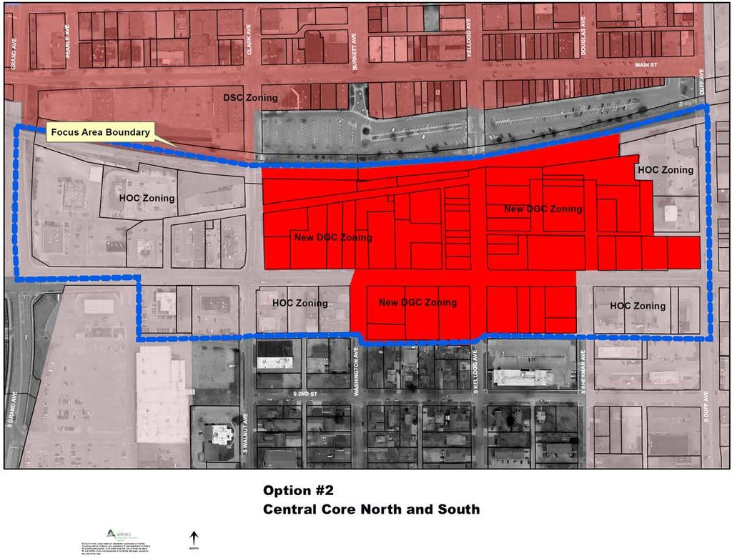
2 The proposed rezoning is critical to implementing the Corridor Plan for three primary reasons; 1) it sets clear expectations to the real estate market for desired areas of change compared to waiting for ad hoc requests, 2) it ensures the long term compatibility of uses consistent with the vision of the plan, and 3) it includes design standards necessary to shape the urban design components of the area to enhance mobility and create an attractive destination. HOC zoning as it is currently written does not include elements needed to fulfill the vision of creating a destination commercial/mixed use area as expressed within the Corridor Plan and the LUPP. City Council reviewed options for rezoning boundaries at the April 24 th meeting in conjunction with its review of the draft DGC zoning standards. City Council directed staff at that time to initiate a rezoning of the 70 properties within the Focus Area. The rezoning would affect 70 properties, 15 of which are currently DSC zoning and 55 are HOC zoning. Public hearing notices were provided to all property owners within the area and within 200 feet of rezoning area for the Planning and Zoning Commission meeting and City Council meeting. Based upon the April 24 th discussion and the final standards of the DGC zoning district, three rezoning boundary options are available to the City Council for varying levels of implementation of the Corridor Plan. OPTION 1 - REZONING AREA INITIATED BY CITY COUNCIL ON APRIL 24 TH The proposed rezoning includes all properties within the Focus Area (Attachment C). Establishing the DGC zoning along both sides of Lincoln Way and along the intersecting streets fully establishes the long term policy of the City for change in the area to match the Lincoln Way Corridor Plan. Broadly applying the DGC zoning district ensures that both short term development interests and long term evolution of the area are consistent with the Corridor Plan. Although there are a substantial number of redevelopment opportunities in the broad Focus Area, not all of this area would be expected to redevelop in the short term as there are many viable highway oriented commercial businesses throughout the area. OPTION 2 - INCLUDES DGC ZONING FOR THE CORE OF THE FOCUS AREA The Kellogg/Lincoln Way intersection is viewed as the heart of the Focus Area due to its primary connection to Downtown. This approach concentrates the rezoning on the four most critical blocks for the area and establishes a vision for redevelopment along both sides of Lincoln Way. (Attachment D) Development on the north side would be expected to be at larger scale than redevelopment on the south side due to lot sizes and configurations. This option would leave the periphery areas out of the immediate rezoning actions, which would reduce the number of new nonconformities related to use and site development standards. Many of the periphery areas are not available for redevelopment at this time and would leave HOC zoning in place on these properties. 2
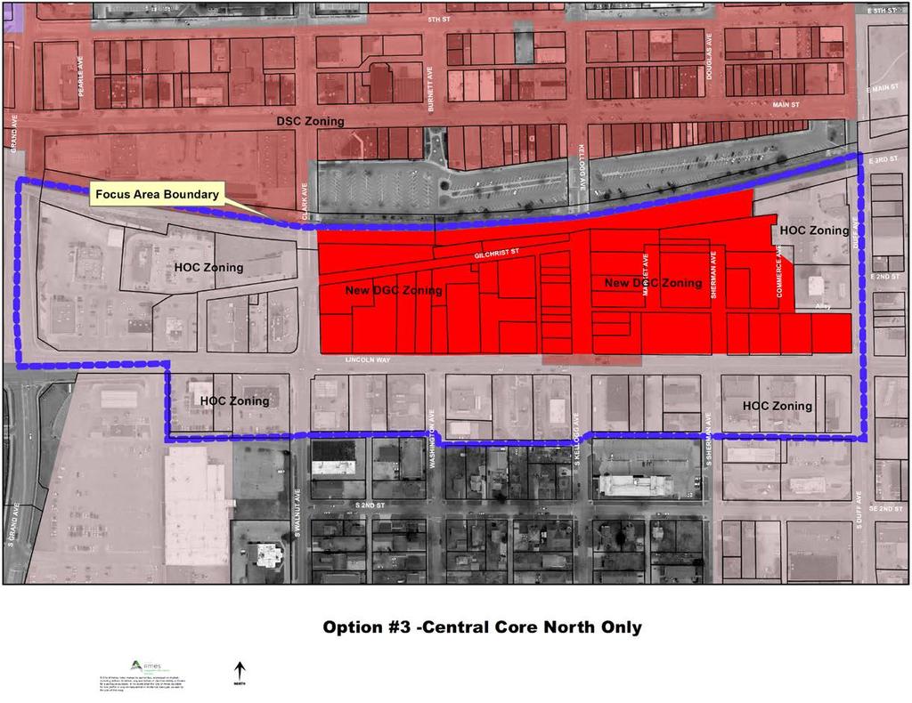
3 OPTION 3 INCLUDES DGC ZONING FOR ONLY THE NORTH SIZE OF LINCOLN WAY This option was also discussed previously with City Council for rezoning of only the north side of Lincoln Way within the core of the Focus Area. (Attachment E) This approach maintains the two most critical areas for rezoning at this time and does not change HOC zoning for the periphery area or the properties along the south side of Lincoln Way. Limiting rezoning to the north side of Lincoln Way would reduce many potential conflicts about nonconforming uses, but not all. Continuing HOC zoning along the periphery and south side of Lincoln Way would allow for the current mix of uses that already exist and for the establishment of new highway oriented commercial uses. This option allows of some site redevelopment to occur, but does not sustain the long term vision for change of character for the area by continuing to allow for the wide range of HOC uses that may not be compatible with redevelopment on the north side of the street. PLANNING AND ZONING COMMISSION RECOMMENDATION: The Planning and Zoning Commission held a public hearing on May 16 th to review the proposed rezoning. Staff provided a summary of the Corridor Plan and Downtown Gateway Focus area with an explanation of the zoning implications of the City initiated rezoning. Nine members of the public spoke on the subject. All nine speakers were property owners in the area of the rezoning. The speakers all provided comment against the rezoning of the area from HOC to DGC. Comments focused on limitations of uses under DGC zoning compared to HOC, potential effects on the value of existing businesses and properties for future sale, and a preference to allow housing in HOC with no other changes to the zoning. The Commission discussed the difference between supporting planning for changes in the area as described within Corridor Plan versus establishing zoning to implement the Corridor Plan. Thoughts on changes to community character were also part of the discussion. Some commissioners expressed concerns about the impacts on existing businesses with the proposed changes and if there was a need to rezone the entire area at this time and what would be the downside of not zoning for DGC. Ultimately the Commission voted 4-2 to recommend no change in zoning for the area and maintain the existing HOC and DSC zoning for all properties. Staff addressed some of the issues raised by the Commission during their discussion of the rezoning on the May 16 th and has included comments responding to concerns expressed on May 16 th as part of the Addendum (Pages 7 to 9). In summary, the staff cannot support the Commission recommendation for no rezoning of the area. Without rezoning to DGC, the development options available under HOC would likely be inconsistent with vision for the area as defined within the LUPP for a more walkable, attractive, destination commercial area. Staff believes the tradeoffs of proactive zoning implementation versus reactive rezoning are necessary to meet the full potential of the Corridor Plan. 3
4 ALTERNATIVES: 1. The City Council may approve rezoning of the entire Downtown Focus Area to Downtown Gateway Commercial as shown in Attachment B. (City Council Initiated Area from April 24 th ) 2. The City Council approve a rezoning with modified boundaries (Options 2 and 3 described above). 3. The City Council can choose to not rezone any of the properties within the Focus Area. (Planning and Zoning Commission Recommendation) CITY MANAGER S RECOMMENDED ACTION: The DGC Focus Area is the first priority for implementation of the Corridor Plan due to its proximity to Downtown and available properties for redevelopment in both the short term and long term. Due to the age and condition of many of properties in the area, it appears the area is ripe for reinvestment and redevelopment opportunities that can be done in manner that furthers goals of the City to diversify its commercial activities in a complimentary manner to downtown and provide for a new mixed use living environment. The decisions on development areas at this time will shape the character of the area for the next 20 years or more. The proposed rezoning is intended to not just facilitate a singular redevelopment project, but to establish the long-term policy vision for the area. Including a broad area for rezoning ensures both short term and long-term changes of use and redevelopment are consistent with the Corridor Plan. Although, staff believes that the market opportunity for redevelopment is strong for certain sites, evolution of the area will be incremental over many years. In the meantime, the existing businesses are permitted to keep operating and are not required to redevelop or sell for redevelopment. Business that may have a change in their nonconformity status due to rezoning are allowed to continue to operate and make changes to their uses and properties within the limitations of the Zoning Ordinance, including reestablishment of the use or structure due to substantial damage from a disaster. The option recommended by the Commission of no rezoning and by a number of property owners, except to allow for housing in the area, is not an approach that will accomplish the vision described in the Corridor Plan. Allowances for housing with no coordination of compatible uses and design features does not support creation of a desirable destination commercial area or living environment. Such an approach would only support increased efficiency of land use without addressing elements supportive of creating a unique and interesting environment for this high profile area of the City. The proposed DGC zoning was written expressly to allow individual property owners to continue their current uses or to redevelop individually, but to ensure that new development in the area did not detract from the larger redevelopment 4
5 vision of the area. The goal of the DGC zoning is not to remove existing businesses from the area, but to ensure that redevelopment and new uses are consistent with future expectations compared to the past history of uses oriented to a highway. Planning for infill and redevelopment areas is one of the most challenging issues in planning for the City. The proposed DGC zoning attempts to strike a balance on both sides of the issue of accommodating existing businesses versus planning for future changes. Therefore, it is the recommendation of the City Manager that the City Council act in accordance with your previous directive and approve Alternative #1 to rezone the entire Focus Area. 5
6 Addendum LINCOLN WAY CORRIDOR PLAN The objectives for the Lincoln Way Corridor Plan are to create identity along Lincoln Way as a place and not just a thoroughfare, to support enhancements for multi-modal transportation, and to identify opportunities to revitalize properties with land uses that are contextual and support Corridor identity and placemaking. Preparation of the Corridor Plan was an 18-month process of examine background conditions, soliciting public input, and creating contextual options within the Plan. The process culminated in the acceptance of the Final Plan and approval of LUPP amendments references the plan. The Lincoln Way Corridor Plan includes a Framework Plan that identifies the overall principles for the corridor by looking at the various districts within the corridor for land use, mobility and community character. The Plan identifies six districts for the overall corridor (Attachment A). The Framework Plan looks at development potential through redevelopment areas, bike, pedestrian, and vehicular improvements, and opportunity for streetscape improvements to increase the overall aesthetics and character of the corridor. The Framework Plan is intended to guide overall strategies that improve the corridor and connect it together. The Focus Areas address five different local areas along the corridor. The Focus Areas allow for more in-depth review of contextual redevelopment options, rather than broad and general interests in redevelopment and intensification along the corridor. The Focus Area concepts also could be applied to other areas along the Corridor that are of a similar nature. The five Focus Areas identified in the plan area as follows: 1. Downtown Gateway (Clark Avenue to Duff Avenue) 2. Lincoln Way and Grand Avenue (Oak Avenue to Grand Avenue) 3. Oak to Riverside Neighborhood 4. Campustown Transition (Sheldon Avenue to Campus Drive) 5. Westside Mixed Use (West Hy-Vee Area, Beedle Drive to Colorado Avenue) The Downtown Gateway Focus Area description incorporated into the LUPP includes language for development preferences within the Corridor. The Downtown Gateway Focus Area is a component of the Downtown Expansion area of the LUPP. The intent for the Focus Area is to support commercial redevelopment and allow for mixed use. The most intense redevelopment is intended for the area between Lincoln Way and the railroad tracks. Property aggregation will likely be needed in this area to fully realize the redevelopment options of the Corridor Plan. This area is intended to act as an extension of commercial uses and potentially mixed use development in relation to Downtown. Reduced parking and shared parking opportunities may be a preference north of Lincoln Way as well. The Focus Area description is intended to guide zoning decisions for the area. Attachment 2 includes the full excerpt of text for the LUPP amendment approved in January
7 7
8 DOWNTOWN GATEWAY COMMERCIAL ZONING STANDARDS The proposed Downtown Gateway Commercial zoning standards address all facets of site development and uses. Due to the targeted goals for the area the standards are tailored to Focus Area and support intense redevelopment with reduced parking requirements. As a separate agenda item, City Council is asked to compete the second reading of the ordinance to establish the DGC zoning district. A number of issues were raised during the Planning and Zoning Commission meeting concerning DGC zoning. The following is a summary of some of the primary points discussed at the meeting. 1. Limited range of uses. The proposed DGC zoning focuses on office and trade uses compared to HOC which is very broad commercial zone that includes office and trade uses along with other activities. The proposed DGC zoning allows for 16 types of uses compared to 22 types within the current DSC zoning and 31 types within HOC. The use range has been narrowed to focus on the City s priorities for a specific area compared to the broad areas currently zoned HOC across the entire City. The types of uses that would be prohibited with DGC zoning compared to HOC include based upon the proposed DGC zoning of May 22nd: a. Automotive sales, retail* b. Commercial Outdoor Recreation,* c. College and University, d. Catering (primary use), e. Detention Facilities, f. Group Living*, g. Lodges and Social Clubs, h. Medical Centers (overnight care), i. Mini-warehouse, j. Railroad Yards*, k. Religious Institution, l. Sports Practice Facility (Gym space),* m. Social Service Providers (shelters, social service care), n. Wholesale Trade,* o. Vehicle Service Facilities (gas station, automotive repair, car wash).* *Denotes uses currently not allowed within DSC zoning Additionally, new drive through facilities would have concentration limitations per one per block. All existing drive through facilities would be permitted, but most blocks within the area would not be permitted to add a drive through use due to proximity of an existing facility. The drive through standard is an effort to address access and circulation concerns along the corridor as well as impacts on site design and land use associated with drive through facilities. New drive throughs would also be subject to a major side development plan review rather than staff review of a minor site development plan. 8
9 2. Sale of properties. The change of zoning has been portrayed as taking of property and requiring its sale to others. A rezoning does not require a sale of property. Existing business can continue or be sold to another buyer to operate the same business. Individual properties can also be redeveloped without aggregation to a larger site. The City is not attempting to purchase property for redevelopment, but intends to rely upon private market transactions for redevelopment consistent with Corridor Plan. The primary argument against the rezoning has been the claim that the sale of the property for another purpose besides what exists today is more limited in DGC versus HOC and that it would significantly change the future value of property. Staff believes there are a number of factors affecting commercial property value, including viability of existing business at time of sale, condition of the property or structure, location, neighboring conditions, range of allowed uses, and costs associated with tearing down and rebuilding a site for a new use. The proposed DGC zoning allows for reasonable range of commercial uses and does not dictate value for only one type of buyer by unduly limiting resale options of properties, such as rezoning a site to wholly different type of use. In contrast to assuming lower property values, values generally rise with redevelopment when there is a successful project demonstrating market viability for a concept. If no redevelopment occurs there is likely no significant impact in the value of one business being sold to another buyer. Staff believes it is speculative to forecast future property values for existing businesses at the time an owner may wish to sell due to the wide range of conditions affecting the value of a property in this area. 3. Allowed Use and Nonconformities. Another issue identified by property owners has been the potential complication of nonconformities when going to sell a property. As discussed with Council previously, approximately 78% of the area has some form of a nonconformity of use, structure, or site development. This changes to 85% with the full rezoning after City Council allowed for no parking requirements along Kellogg Avenue. A rezoning does not necessitate proactive changes to nonconformities, but at the time of redevelopment new site improvements and uses must meet current standards. Even with the high percentage of nonconformities, properties have been purchased in this area with nonconformities. Eleven properties within the past ten years have been sold with nonconforming structures. It appears that nonconformities have not been a detriment to property sales in the past. Nonconforming uses are sometimes viewed differently from structure nonconformities by a lender due to their interest in securing a loan with assurance the use can continue. Typically, banks are willing to make a loan when a city has an allowance for rebuilding or reestablishing a nonconforming use due to disaster. The City has such provisions already in place for nonconformities, which makes this concern moot in typical situations. 9
10 4. Maintain HOC Zoning. With no rezoning of the area, the City is not following through on implementation of the Corridor Plan as a priority and does not establish support for concepts of the Plan. For staff, one of key issues of rezoning is ensuring that new uses are not established that could undermine the vision for the area. Additionally, with no rezoning there is no clear market opportunity for mixed use in the area and that calls into question support for the concept. Generally, uncertainty in the entitlement process detracts from developer interest. Staff views the situation of proactively zoning this area as analogous to the City establishing CSC zoning in 2006 with mixed-use zoning standards as a result of the University Impact Area study. Part of the redevelopment success for student housing in Campustown was the presence of zoning in support of the vision of the LUPP without having to make individual requests. When the market demand increased with enrollment, construction of mixed use development was predictable and relatively quick because of existing zoning, thereby minimizing risk to the developer and maximizing property value. However, at no time was an individual required to sell by zoning to facilitate redevelopment that was consistent with the zoning. The other downside of maintaining HOC zoning is the lack of use and design standards that support the vision of a more walkable and desirable destination area. HOC zoning is set up to accommodate quick trips into and out of an area, and not pleasant walkable environment. Allowing new development to occur under these types of standards while waiting for future rezoning could erode the opportunities for reaching the vision of the Plan by impeding both future redevelopment and detracting from intended character of the area. 10

11 Attachment A-Location Map 11
12 Attachment B- LUPP Chapter 2 Excerpt for Downtown Gateway Focus Area DOWNTOWN GATEWAY FOCUS AREA The City has established the Downtown Gateway Focus Area, located generally from Clark Avenue to Duff Avenue and south of the railroad tracks, as its first development area priority. This Focus Area is within the Downtown Expansion Area Option of the Land Use Policy Plan. The Downtown Gateway is intended to foster redevelopment with a commercial focus that may also include residential development. The area as its it is currently developed is a place of community commercial uses formatted in typical highway commercial setting, meaning automobile oriented formats, and providing for retail, office, and restaurant uses. As redevelopment occurs in the area it is important to maintain a strong commercial base that meets community needs for retail and service use. Redevelopment of the area does not require mixed use residential development, but residential uses can be accommodated when the commercial use goals of the City are met for the area. The goals of redevelopment in this area are not focused on creating student housing options that are already accommodated with the Campustown Service Center area of the Corridor. The overall character of the area is for development that is complimentary to the use and character of Downtown. Incorporating complimentary uses is a priority for the City and includes accommodating a boutique hotel, entertainment and active retail uses, incorporating outdoor space for events and commercial uses, and maintaining an office and employment presence in the Corridor. Kellogg Avenue is the focal points of the Focus Area and connects to the four-corner heart of Downtown at Main Street. Development along Kellogg must maintain individual building identity and storefront patterns similar to traditional downtown retailing. This type of development pattern can occur through redevelopment of small sites or as part of a larger redevelopment project. In other areas outside of Kellogg Avenue, the Plan encourages aggregation of property in support of a variety of development formats that accommodates the intended commercial uses and for the area. Facilitating intense redevelopment also allows for collective parking and reduced parking requirements in recognition of the rich transportation options in the area and public parking that exists to the north of the area. Due to potentially large redevelopment sites, design and architectural features are needed that provided variations in appearance of mass and height. Differentiation of façade planes and use of high quality glazing, brick, and metal siding systems is highly desirable to create an attractive and interesting area. Maintaining or creating secondary means of access into the blocks is a priority for the area to ensure that curb cuts onto Lincoln Way are reduced and minimized from existing conditions. Automotive service oriented uses are discouraged from locating in the area. Aggregating property for larger sites may require developers to relocate electric and water utility improvements and potentially have the City vacate certain minor rights-of-way if not needed to serve properties. Widening sidewalks and improving the streetscape along Lincoln Way are a priority with redevelopment. 12

13 Attachment C-Proposed Rezoning
14 Attachment D 14
15 Attachment E 15
16 DO NOT WRITE IN THE SPACE ABOVE THIS LINE, RESERVED FOR RECORDER Prepared by: Ames City Clerk, 515 Clark Avenue, Ames, IA Phone: Return to: Ames City Clerk, P.O. Box 811, Ames, IA Phone: ORDINANCE NO. AN ORDINANCE AMENDING THE OFFICIAL ZONING MAP OF THE CITY OF AMES, IOWA, AS PROVIDED FOR IN SECTION OF THE MUNICIPAL CODE OF THE CITY OF AMES, IOWA, BY CHANGING THE BOUNDARIES OF THE DISTRICTS ESTABLISHED AND SHOWN ON SAID MAP AS PROVIDED IN SECTION OF THE MUNICIPAL CODE OF THE CITY OF AMES, IOWA; REPEALING ALL ORDINANCES AND PARTS OF ORDINANCES IN CONFLICT HEREWITH AND ESTABLISHING AN EFFECTIVE DATE BE IT HEREBY ORDAINED by the City Council of the City of Ames, Iowa; Section 1: The Official Zoning Map of the City of Ames, Iowa, as provided for in Section of the Municipal Code of the City of Ames, Iowa, is amended by changing the boundaries of the districts established and shown on said Map in the manner authorized by Section of the Municipal Code of the City of Ames, Iowa, as follows: That the real estate, generally located within the Downtown Gateway Focus Area of the Lincoln Way Corridor Plan, is rezoned from Highway Oriented Commercial (HOC) and Downtown Service Center (DSC) Zoning Districts to Downtown Gateway Commercial Zoning District. Real Estate Description: BOUNDARY DESCRIPTION: A PARCEL IN THE CITY OF AMES, STORY COUNTY, IOWA; THE BOUNDARY LINE DESCRIBED AS FOLLOWS: BEGINNING AT THE CENTERLINES OF GRAND AVENUE AND THE CHICAGO AND NORTHWESTERN RAILROAD TRANSPORTATION COMPANY RIGHT OF WAY, CITY OF AMES, STORY COUNTY, IOWA; THENCE EASTERLY ON SAID RAILROAD CENTERLINE 2, FEET TO THE CENTERLINE OF DUFF AVENUE: THENCE SOUTHERLY ON SAID DUFF AVENUE CENTERLINE FEET TO THE EXTENSION OF THE EAST WEST ALLEY CENTERLINE; THENCE WESTERLY APPROXIMATELY FEET TO THE CENTERLINE OF SOUTH KELLOGG AVENUE; THENCE SOUTHERLY 25 FEET; THENCE WESTERLY ON CENTERLINE OF ALLEY APPROXIMATELY FEET TO CENTERLINE OF WASHINGTON AVENUE; THENCE NORTHERLY APPROXIMATELY FEET TO CENTERLINE OF EAST WEST ALLEY; THENCE WESTERLY FEET TO THE SOUTHEAST CORNER OF LOT 1, BLACKS THIRD ADDITION; THENCE WESTERLY ON SOUTHERLY LINE TO THE SOUTHWEST CORNER OF THE NORTHEAST CORNER OF LOT 7, BLACKS THIRD ADDITION; THENCE NORTHERLY TO THE CENTERLINE OF LINCOLN WAY; THENCE WESTERLY FEET TO THE CENTERLINE GRAND AVENUE; THENCE NORTHERLY TO POINT OF BEGINNING.
17 Section 2: All other ordinances and parts of ordinances in conflict herewith are hereby repealed to the extent of such conflict. Section 3: This ordinance is in full force and effect from and after its adoption and publication as provided by law. ADOPTED THIS day of, Diane R. Voss, City Clerk John A. Haila, Mayor 2
18
COMMISSION ACTION FORM SUBJECT: ZONING TEXT AMENDMENT FOR LINCOLN WAY CORRIDOR PLAN DOWNTOWN GATEWAY COMMERCIAL ZONING DISTRICT STANDARDS
 ITEM #: 7 DATE: _02-07-18 COMMISSION ACTION FORM SUBJECT: ZONING TEXT AMENDMENT FOR LINCOLN WAY CORRIDOR PLAN DOWNTOWN GATEWAY COMMERCIAL ZONING DISTRICT STANDARDS BACKGROUND: The Downtown Gateway area
Staff Report REZONING BOUNDARY OPTIONS FOR NEW DOWNTOWN GATEWAY COMMERCIAL ZONING. April 24, 2018
 ITEM # 40C Staff Report REZONING BOUNDARY OPTIONS FOR NEW DOWNTOWN GATEWAY COMMERCIAL ZONING BACKGROUND: April 24, 2018 The area generally described as properties along Lincoln Way and between Grand Avenue
DRAFT FOR DISCUSSION PURPOSES ONLY. Port Credit Local Area Plan Built Form Guidelines and Standards DRAFT For Discussion Purposes
 Port Credit Local Area Plan Built Form Guidelines and Standards DRAFT For Discussion Purposes 1 Local Area Plan - Project Alignment Overview Directions Report, October 2008 (General Summary Of Selected
ARTICLE 3: Zone Districts
 ARTICLE 3: Zone Districts... 3-1 17.3.1: General...3-1 17.3.1.1: Purpose and Intent... 3-1 17.3.2: Districts and Maps...3-1 17.3.2.1: Applicability... 3-1 17.3.2.2: Creation of Districts... 3-1 17.3.2.3:
LINCOLN CORRIDOR REDEVELOPMENT PROJECT UPDATE FOR DOWNTOWN GATEWAY FOCUS AREA
 ITEM: 51 BACKGROUND: Staff Report LINCOLN CORRIDOR REDEVELOPMENT PROJECT UPDATE FOR DOWNTOWN GATEWAY FOCUS AREA March 27, 2018 The City has been working for two years to develop, adopt, and implement the
Montreal Road District Secondary Plan [Amendment #127, October 9, 2013]
![Montreal Road District Secondary Plan [Amendment #127, October 9, 2013]](/thumbs/72/66783104.jpg "Montreal Road District Secondary Plan [Amendment #127, October 9, 2013]") [Amendment #127, October 9, 2013] 1.0 General The following policies are applicable to the Montreal Road District as set out in Schedule 1. 1.1 District Objectives The objective of this Plan is to guide
[Amendment #127, October 9, 2013] 1.0 General The following policies are applicable to the Montreal Road District as set out in Schedule 1. 1.1 District Objectives The objective of this Plan is to guide
Downtown Development Focus Area: I. Existing Conditions
 Downtown Development Focus Area: I. Existing Conditions The Downtown Development Focus Area is situated along Route 1, south of the train tracks, except for the existing Unilever property. It extends west
DIVISION 1 PURPOSE OF DISTRICTS
 ARTICLE 2 ZONING DISTRICTS AND MAP DIVISION 1 PURPOSE OF DISTRICTS Section 2.101 Zoning Districts. For the purpose of this Ordinance, the City of Richmond is hereby divided into districts as follows: DISTRICT
Planning Justification Report
 Planning Justification Report Kellogg s Lands City of London E&E McLaughlin Ltd. June 14, 2017 Zelinka Priamo Ltd. Page i TABLE OF CONTENTS Page No. 1.0 2.0 2.1 2.2 3.0 4.0 5.0 5.1 5.2 5.3 5.4 5.5 5.6
3.1. OBJECTIVES FOR RESIDENTIAL LAND USE DESIGNATIONS GENERAL OBJECTIVES FOR ALL RESIDENTIAL DESIGNATIONS
 3. RESIDENTIAL LAND USE DESIGNATIONS INTRODUCTION The Residential land use designations provide for housing and other land uses that are integral to, and supportive of, a residential environment. Housing
TOTTENHAM SECONDARY PLAN
 TOTTENHAM SECONDARY PLAN AMENDMENT NO. 11 TO THE OFFICIAL PLAN OF THE TOWN OF NEW TECUMSETH The following text and schedules to the Official Plan of the Town of New Tecumseth constitute Amendment No. 11
EXHIBIT 1 PROJECT DESCRIPTION AND DESCRIPTION OF REQUESTED AREA VARIANCES REDEVELOPMENT OF 201 ELLICOTT STREET
 EXHIBIT 1 PROJECT DESCRIPTION AND DESCRIPTION OF REQUESTED AREA VARIANCES REDEVELOPMENT OF 201 ELLICOTT STREET I. PROJECT DESCRIPTION: Ciminelli Real Estate Corporation (the Applicant ) is seeking area
ARTICLE 10 SPECIAL PURPOSE DISTRICTS
 ARTICLE 10 SPECIAL PURPOSE DISTRICTS Sec. 29.1000. SPECIAL PURPOSE DISTRICTS. (1) Purpose. Each Special Purpose District will appear on the City's Zoning Map as a Base Zone. The Special Purpose Districts
Composition of traditional residential corridors.
 Page 1 of 7 St. Petersburg, Florida, Code of Ordinances >> PART II - ST. PETERSBURG CITY CODE >> Chapter 16 - LAND DEVELOPMENT REGULATIONS >> SECTION 16.20.060. CORRIDOR RESIDENTIAL TRADITIONAL DISTRICTS
Bylaw No , being "Official Community Plan Bylaw, 2016" Schedule "A" DRAFT
 Bylaw No. 2600-2016, being "Official Community Plan Bylaw, 2016" Schedule "A" Urban Structure + Growth Plan Urban Structure Land use and growth management are among the most powerful policy tools at the
PLANNING REPORT Gordon Street City of Guelph. Prepared on behalf of Ontario Inc. March 17, Project No. 1507
 PLANNING REPORT 1131 Gordon Street City of Guelph Prepared on behalf of 1876698 Ontario Inc. March 17, 2016 Project No. 1507 423 Woolwich Street, Suite 201, Guelph, Ontario, N1H 3X3 Phone (519) 836-7526
DEVELOPMENT DEPARTMENT STAFF REPORT STAFF REPORT MCDONALD S ZONING MAP AMENDMENT AND CONCURRENT VARIANCES
 DEVELOPMENT DEPARTMENT STAFF REPORT Meeting Date: October 12, 2017 Item #: _PZ2017-172_ STAFF REPORT MCDONALD S ZONING MAP AMENDMENT AND CONCURRENT VARIANCES Request: Rezone property from MU-BC to CC,
Puyallup Downtown Planned Action & Code Changes. January 10, 2017
 Puyallup Downtown Planned Action & Code Changes January 10, 2017 Purpose & Location Purpose Promote economic development and downtown revitalization Tools: Municipal Code amendments Change development
Truax Park Apartments
 Truax Park Apartments Master Planning and Site Development Study Prepared by The Community Development Authority of the City of Madison In association with SMITH & SMITH ASSOCIATES, Inc CONSTRUCTION COST
ACTION FORM BRYAN CITY COUNCIL
 ACTION FORM BRYAN CITY COUNCIL DATE OF COUNCIL MEETING: July 8, 2014 DATE SUBMITTED: June 17, 2014 DEPARTMENT OF ORIGIN: Development Services SUBMITTED BY: Maggie Dalton MEETING TYPE: CLASSIFICATION: ORDINANCE:
DISCUSSION DRAFT 1 INTRODUCTORY PROVISIONS
 1 INTRODUCTORY PROVISIONS 1.1 GENERAL...3 Title 3 Authority 3 Applicability 3 Purpose 3 Regulatory Scope 4 Compliance 4 Fines and Penalties 4 Conflicting Provisions 5 Meaning & Intent 5 Text & Graphics
Appendix A: Guide to Zoning Categories Prince George's County, Maryland
 Appendix A: Guide to Zoning Categories Prince George's County, Maryland RESIDENTIAL ZONES 1 Updated November 2010 R-O-S: Reserved Open Space - Provides for permanent maintenance of certain areas of land
PLANNING COMMISSION STAFF REPORT
 PLANNING COMMISSION STAFF REPORT West Capitol Hill Zoning Map Amendment Petition No. PLNPCM2011-00665 Located approximately at 548 W 300 North Street, 543 W 400 North Street, and 375 N 500 West Street
Urban Design Brief Dundas Street. London Affordable Housing Foundation. November Zelinka Priamo Ltd.
 Urban Design Brief 1039-1047 Dundas Street London Affordable Housing Foundation November 2017 Zelinka Priamo Ltd. TABLE OF CONTENTS Page No. INTRODUCTION... 3 SECTION 1 LAND USE PLANNING CONTEXT... 3 1.1
Kinzie Industrial Corridor
 Mayor Emanuel s Industrial Corridor Modernization Kinzie Industrial Corridor Fulton Market Innovation District Plan Implementation September 19, 2017 Rahm Emanuel, Mayor David Reifman, Commissioner Dept.
13 Sectional Map Amendment
 13 Sectional Map Amendment Introduction This chapter reviews land use and zoning policies and practices in Prince George s County and presents the proposed zoning in the sectional map amendment (SMA) to
Article 3. SUBURBAN (S-) NEIGHBORHOOD CONTEXT
 NEIGHBORHOOD CONTEXT") Article 3. SUBURBAN (S-) NEIGHBORHOOD CONTEXT this page left intentionally blank Contents ARTICLE 3. SUBURBAN (S-) NEIGHBORHOOD CONTEXT DIVISION 3.1 NEIGHBORHOOD CONTEXT DESCRIPTION...3.1-1 Section 3.1.1
Article 3. SUBURBAN (S-) NEIGHBORHOOD CONTEXT this page left intentionally blank Contents ARTICLE 3. SUBURBAN (S-) NEIGHBORHOOD CONTEXT DIVISION 3.1 NEIGHBORHOOD CONTEXT DESCRIPTION...3.1-1 Section 3.1.1
Sherwood Forest (Trinity) Housing Corporation. Urban Design Brief
 Housing Corporation. Urban Design Brief") Sherwood Forest (Trinity) Housing Corporation Sherwood Place Affordable Housing Apartments Trinity Presbyterian Church Orchard Park Nursery School 590 Gainsborough Road, London Urban Design Brief REVISED
Sherwood Forest (Trinity) Housing Corporation Sherwood Place Affordable Housing Apartments Trinity Presbyterian Church Orchard Park Nursery School 590 Gainsborough Road, London Urban Design Brief REVISED
Planning Commission June 25, Lincoln Boulevard
 Purpose Float Up Review Inform Planning Commission and public about the proposed project concept; Opportunity to review and discuss the concept plans, and to provide feedback about the project design,
STAFF REPORT. Community Development Director PO Box 4755 Beaverton, OR 97076
 STAFF REPORT HEARING DATE: July 7, 2010 TO: Planning Commission STAFF: Jana Fox, Assistant Planner PROPOSAL: Southeast Beaverton Office Commercial Zoning Map Amendment (ZMA2010-0006) LOCATION: The subject
TRANSIT-ORIENTED DEVELOPMENT PLAN EXISTING CONDITIONS REPORT LAWRENCE TO BRYN MAWR MODERNIZATION
 TRANSIT-ORIENTED DEVELOPMENT PLAN EXISTING CONDITIONS REPORT LAWRENCE TO BRYN MAWR MODERNIZATION March 2018- FINAL DRAFT SITE SPECIFIC DEVELOPMENT CONCEPTS SITE SPECIFIC DEVELOPMENT CONCEPTS This report
Poughkeepsie City Center Revitalization Plan
 Purpose and Need Purpose Increase job and educational opportunities for all residents Maximize fiscal productivity of downtown land uses Diversify retail mix Eliminate surface and building vacancies Create
Public Review of the Slot Home Text Amendment
 Public Review of the Slot Home Text Amendment The proposed amendments to the Denver Zoning Code have been informed by the Slot Home Strategy Report. This document has been developed out of a robust process
PC Staff Report 11/18/2013 Z Item No. 1-1
 Z-13-00401 Item No. 1-1 PLANNING COMMISSION REPORT Regular Agenda - Public Hearing Item PC Staff Report 11/18/2013 ITEM NO. 1: Z-13-00401 IG (General Industrial) District TO CS (Strip Commercial) District;
Pierce County Comprehensive Plan Review
 2015-2016 Pierce County Comprehensive Plan Review March 16, 2016 Introduction Planning and Management Policies Some of the policies governing both the planning and management of growth and change within
Planning Department Oconee County, Georgia
 Planning Department Oconee County, Georgia STAFF REPORT REZONE CASE #: 6985 DATE: October 31, 2016 STAFF REPORT BY: Andrew C. Stern, Planner APPLICANT NAME: Williams & Associates, Land Planners PC PROPERTY
Glendale Housing Development Project Plan
 Glendale Housing Development Project Plan Draft for Public Review May 29, 2015 Table of Contents I. Introduction... 1 II. Description of Project... 1 A. Boundary of Housing Development Project... 1 B.
Planning Justification Report for 324 York Street
 Planning Justification Report for 324 York Street June 1 2018 This Planning Justification Report demonstrates how the continued use of the subject lands as a commercial surface area parking lot accords
CONNECTING ARLINGTON S POLICY FRAMEWORK TO THE RESIDENTIAL PARKING WORKING GROUP
 CONNECTING ARLINGTON S POLICY FRAMEWORK TO THE RESIDENTIAL PARKING WORKING GROUP Contents Arlington County Development and Growth Goals... 1 Master Transportation Plan Policies Related to Multi Family
Table of Contents. Concept Plan Overview. Statement of Compliance with Design Guidelines. Statement of Compliance with Comprehensive Plan
 Table of Contents Concept Plan Overview Statement of Compliance with Design Guidelines Statement of Compliance with Comprehensive Plan Developer s Program Market Objective Benefit to Local Businesses Benefit
PLANNING COMMISSION REPORT Regular Agenda - Public Hearing Item
 Z-11-25-09; Z-11-26-09; Z-11-28-09 Item No. 2-1 PC Staff Report 3/28/11 PLANNING COMMISSION REPORT Regular Agenda - Public Hearing Item ITEM NO. 2A RM32 TO MU;.19 ACRES; 1340 TENNESSEE ST (MJL) Z-1-1-11:
CPC CA 3 SUMMARY
 CPC-2009-3955-CA 2 CONTENTS Summary Staff Report Conclusion 3 4 7 Appendix A: Draft Ordinance A-1 Attachments: 1. Land Use Findings 2. Environmental Clearance 1-1 2-1 CPC-2009-3955-CA 3 SUMMARY Since its
Chapter 5: Testing the Vision. Where is residential growth most likely to occur in the District? Chapter 5: Testing the Vision
 Chapter 5: Testing the Vision The East Anchorage Vision, and the subsequent strategies and actions set forth by the Plan are not merely conceptual. They are based on critical analyses that considered how
Town Center South End Development Area District
 175.28 ESTABLISHMENT OF DISTRICTS. In order to carry out the purpose and intent of this chapter, the area of the is hereby divided into eighteen (18) Zoning District Classifications and one overlay zoning
NOTICE OF MEETING AND AGENDA FOR THE PLANNING COMMISSION OF SPRINGVILLE, UTAH... JANUARY 23, 2018
 NOTICE OF MEETING AND AGENDA FOR THE PLANNING COMMISSION OF SPRINGVILLE, UTAH............................ JANUARY 23, 2018 Notice is hereby given that the Planning Commission will hold a public meeting
MONROE WARD REZONING SUMMARY. October 2018
 MONROE WARD REZONING SUMMARY October 2018 WHY IS THE CITY REZONING MONROE WARD? In July of 2017 Richmond City Council adopted The Pulse Corridor Plan, a corridor-long planning document that outlines steps
COUNTY OF ALBEMARLE PLANNING STAFF REPORT SUMMARY
 COUNTY OF ALBEMARLE PLANNING STAFF REPORT SUMMARY Project Name: ZMA 2010-00015, Cedar Hill Planning Commission Worksession: February 15, 2011 Public Hearing: Not scheduled Staff: Judith C. Wiegand, AICP
BYLAW NO. 15/026 A BYLAW OF THE REGIONAL MUNICIPALITY OF WOOD BUFFALO TO AMEND THE LAND USE BYLAW NO. 99/059
 Attachment 2 BYLAW NO. 15/026 A BYLAW OF THE REGIONAL MUNICIPALITY OF WOOD BUFFALO TO AMEND THE LAND USE BYLAW NO. 99/059 WHEREAS Section 639 of the Municipal Government Act requires every municipality
Planning Justification Report
 Planning Justification Report 101 Kozlov Street, Barrie, Ont. Destaron Property Management Ltd. November 2015 Revised February 2017 TABLE OF CONTENTS Page 1.0 INTRODUCTION... 1 2.0 DESCRIPTION OF SUBJECT
CHAPTER 29 ARTICLE 8. 20,000 sf 30,000 sf 100,000 sf (with approval by Special Use Permit according to Sec
 CHAPTER 29 ARTICLE 8 (3) Zone Development Standards. The zone development standards for the NC Zone are set forth in Table 29.81(3) below: Table 29.81(3) Neighborhood Commercial (NC) Zone Development Standards
ORDINANCE City of DeBary Comprehensive Plan Amendments Page 1 of 3
 ORDINANCE 01-15 AN ORDINANCE OF THE CITY COUNCIL OF DEBARY, FLORIDA, AMENDING THE CITY S COMPREHENSIVE PLAN FUTURE LAND USE ELEMENT TEXT AMENDING COMPREHENSIVE PLAN POLICY 5.406 CONCERNING THE SOUTHEAST
Goal 1 - Retain and enhance Cherry Creek North s unique physical character.
 Introduction This document summarizes the proposed new zoning for the area of roughly bordered by University Boulevard, Steele Street, 3rd Avenue, and 1st Avenue. It provides a high-level review of the
PUBLIC DRAFT May 2017 Zoning Districts Use Regulations Definitions (partial)
") PUBLIC DRAFT May 2017 Zoning Districts Use Regulations Definitions (partial) Table of Contents Subchapter 1: General Provisions... 1 Subchapter 2: Administration & Procedures... 3 Subchapter 3: Zoning
PUBLIC DRAFT May 2017 Zoning Districts Use Regulations Definitions (partial) Table of Contents Subchapter 1: General Provisions... 1 Subchapter 2: Administration & Procedures... 3 Subchapter 3: Zoning
Washington-Hillside Small Area Study
 Washington-Hillside Small Area Study City of Naperville Planning Services Team March 1, 2004 PRELIMINARY REPORT Executive Summary The Downtown Plan, adopted by City Council in August 2000, strives to articulate
CITY OF ALBERT LEA PLANNING COMMISSION ADVISORY BOARD
 CITY OF ALBERT LEA PLANNING COMMISSION ADVISORY BOARD 9/1/2015, 5:30 p.m. City Council Chambers AGENDA A. CALL TO ORDER AND ROLL CALL B. APPROVAL OF THE AGENDA C. APPROVAL OF MINUTES 1. PC Minutes from
SUBJECT: Application for Planned Unit Development and Rezoning 1725 Winnetka Road
 TO: FROM: CHAIRMAN BILL VASELOPULOS AND MEMBERS OF THE PLAN & ZONING COMMISSION STEVE GUTIERREZ DIRECTOR OF COMMUNITY DEVELOPMENT MEETING DATE: September 5, 2017 SUBJECT: Application for Planned Unit Development
ORDINANCE NO. 15,060
 ORDINANCE NO. 15,060 AN ORDINANCE to amend the Municipal Code of the City of Des Moines, Iowa, 2000, adopted by Ordinance No. 13,827, passed June 5, 2000, as heretofore amended, is hereby amended by adding
Adaptive Reuse Ordinance Effective 12/20/01
 Adaptive Reuse Ordinance Effective 12/20/01 The following excerpts of the Planning and Zoning Code are related to the Adaptive Reuse Projects in the Los Angeles downtown areas. The Planning and Zoning
ARLINGTON COUNTY, VIRGINIA
 ARLINGTON COUNTY, VIRGINIA County Board Agenda Item Meeting of April 25, 2009 DATE: April 14, 2009 SUBJECTS: A. Amendments to the Arlington County Zoning Ordinance, Section 20. (Appendix A), CP-FBC Columbia
PLANNED UNIT DEVELOPMENT (PUD) AREA PLAN/REZONING REVIEW PROCEDURE
 AREA PLAN/REZONING REVIEW PROCEDURE") PLANNED UNIT DEVELOPMENT (PUD) AREA PLAN/REZONING REVIEW PROCEDURE Professional inquiries will be made to our Township Planning Consultant, Township Engineer, and Township Attorney to get their opinions
PLANNED UNIT DEVELOPMENT (PUD) AREA PLAN/REZONING REVIEW PROCEDURE Professional inquiries will be made to our Township Planning Consultant, Township Engineer, and Township Attorney to get their opinions
Parking Challenges and Trade-Offs
 Parking Challenges and Trade-Offs What is the best way to balance competing interests and priorities while updating the City s off street parking regulations? Updating off street parking regulations can
GENERAL PLAN UPDATE SPECIFIC AREAS OF THE CITY
 GENERAL PLAN UPDATE SPECIFIC AREAS OF THE CITY Background There are a total of 14 specific areas that are being reviewed as part of the update of the General Plan. Requests to review these areas came from
ARLINGTON COUNTY, VIRGINIA. County Board Agenda Item Meeting of September 19, 2015
 ARLINGTON COUNTY, VIRGINIA County Board Agenda Item Meeting of September 19, 2015 DATE: August 28, 2015 SUBJECT: Request to authorize advertisement of public hearings by the Planning Commission and the
Town of Mooresville, NC Request for Proposals Public/Private Partnership Mixed Use Development Opportunity
 Town of Mooresville, NC Request for Proposals 017-09-0005 RFP: Public/Private Partnership Mixed Use Development Opportunity September 7, 2016 1 INTRODUCTION Town of Mooresville. The Town of Mooresville,
ARLINGTON COUNTY, VIRGINIA
 ARLINGTON COUNTY, VIRGINIA County Board Agenda Item Meeting March 17, 2007 DATE: March 8, 2007 SUBJECT: Request to Advertise Public Hearings on Amendments to Section 25B. C-O Rosslyn Commercial Office
ARLINGTON COUNTY, VIRGINIA
 ARLINGTON COUNTY, VIRGINIA County Board Agenda Item Meeting December 9, 2006 DATE: November 20, 2006 SUBJECT: GP-302-05-2 Adoption of General Land Use Plan Amendments for the Clarendon Metro Station Area:
Application for a Zoning By-law Amendment, ZBA , Zelinka Priamo Ltd, on behalf of HLH Investments Inc.; Ilderton Road
 August 15, 2018 Page 1 of 64 Staff Report Report No.: PLA-44-2018 Meeting Date: August 15, 2018 Submitted by: Subject: Kelly Henderson Planner Application for a Zoning By-law Amendment, ZBA 9 2018, Zelinka
LITTLE MOUNTAIN ADJACENT AREA REZONING POLICY
 LITTLE MOUNTAIN ADJACENT AREA REZONING POLICY JANUARY 2013 CONTENTS 1.0 INTENT & PRINCIPLES...1 2.0 APPLICATION...2 3.0 HOUSING TYPES, HEIGHT & DENSITY POLICIES...3 3.1 LOW TO MID-RISE APARTMENT POLICIES...4
ORDINANCE NO. 15- Regulations (LDR) which would further the codification of TOD regulations that
 which would further the codification of TOD regulations that") 1 1 1 1 1 1 1 0 1 0 1 ORDINANCE NO. 1- AN ORDINANCE OF THE CITY OF BOYNTON BEACH, FLORIDA AMENDING THE LAND DEVELOPMENT REGULATIONS, CHAPTER 1, ARTICLE II, DEFINITIONS; CHAPTER, ARTICLE III, SECTION 1,
1 1 1 1 1 1 1 0 1 0 1 ORDINANCE NO. 1- AN ORDINANCE OF THE CITY OF BOYNTON BEACH, FLORIDA AMENDING THE LAND DEVELOPMENT REGULATIONS, CHAPTER 1, ARTICLE II, DEFINITIONS; CHAPTER, ARTICLE III, SECTION 1,
CITY OF WEST PARK PROPOSED TRANSIT ORIENTED CORRIDOR (TOC) EXPANSION WORKSHOP JUNE 15, 2016 FREQUENTLY ASKED QUESTIONS (FAQ)
 EXPANSION WORKSHOP JUNE 15, 2016 FREQUENTLY ASKED QUESTIONS (FAQ)") CITY OF WEST PARK PROPOSED TRANSIT ORIENTED CORRIDOR (TOC) EXPANSION WORKSHOP JUNE 15, 2016 FREQUENTLY ASKED QUESTIONS (FAQ) Q: Have you considered that people here love driving their cars and trucks,
CITY OF WEST PARK PROPOSED TRANSIT ORIENTED CORRIDOR (TOC) EXPANSION WORKSHOP JUNE 15, 2016 FREQUENTLY ASKED QUESTIONS (FAQ) Q: Have you considered that people here love driving their cars and trucks,
Land Use, Transportation, and Infrastructure Committee of Denver City Council FROM: Scott Robinson, Senior City Planner DATE: December 6, 2018 RE:
 Community Planning and Development Planning Services 201 W. Colfax Ave., Dept. 205 Denver, CO 80202 p: 720.865.2915 f: 720.865.3052 www.denvergov.org/cpd TO: Land Use, Transportation, and Infrastructure
TASK 2 INITIAL REVIEW AND ANALYSIS U.S. 301/GALL BOULEVARD CORRIDOR FORM-BASED CODE
 TASK 2 INITIAL REVIEW AND ANALYSIS U.S. 301/GALL BOULEVARD CORRIDOR FORM-BASED CODE INTRODUCTION Using the framework established by the U.S. 301/Gall Boulevard Corridor Regulating Plan (Regulating Plan),
SUBJECT: Official Plan and Zoning By-law Amendment Applications for 4853 Thomas Alton Boulevard
 Page 1 of Report PB-100-16 SUBJECT: Official Plan and Zoning By-law Amendment Applications for 4853 Thomas Alton Boulevard TO: FROM: Development and Infrastructure Committee Planning and Building Department
ARLINGTON COUNTY, VIRGINIA
 ARLINGTON COUNTY, VIRGINIA County Board Agenda Item Meeting of April 19, 2008 DATE: April 2, 2008 SUBJECT: ORDINANCE TO AMEND, REENACT, AND RECODIFY Section 20 CP- FBC, Columbia Pike Form Based Code Districts
PLANNED UNIT DEVELOPMENT & SUBDIVISION STAFF REPORT Date: April 18, 2019
 PLANNED UNIT DEVELOPMENT & SUBDIVISION STAFF REPORT Date: April 18, 2019 DEVELOPMENT NAME SUBDIVISION NAME Springhill Village Subdivision Springhill Village Subdivision LOCATION 4350, 4354, 4356, 4358,
900 ALBERT STREET PLANNING RATIONALE ADDENDUM NO. 2
 900 ALBERT STREET PLANNING RATIONALE ADDENDUM NO. 2 March 26, 2018 Planning Rationale Addendum No. 2 Official Plan and Zoning By-law Amendment Prepared for: TIP Albert GP Inc. 485 Bank Street, Suite 200
LAND USE AND ZONING OVERVIEW
 OVERVIEW OF PLANNING POLICIES LAND USE AND ZONING OVERVIEW The Minneapolis Plan for Sustainable Growth and Other Adopted Plans Community Planning and Economic Development Development Services Division
9. REZONING NO Vicinity of the northwest corner of 143 rd Street and Metcalf Avenue
 9. REZONING NO. 2002-15 Vicinity of the northwest corner of 143 rd Street and Metcalf Avenue 1. APPLICANT: Andrew Schlagel is the applicant for this request. 2. REQUESTED ACTION: The applicant is requesting
HOUSING ELEMENT GOALS, OBJECTIVES, AND POLICIES
 HOUSING ELEMENT GOALS, OBJECTIVES, AND POLICIES GOAL 1: To promote the preservation and development of high-quality, balanced, and diverse housing options for persons of all income levels throughout the
Community & Infrastructure Services Committee
 REPORT TO: DATE OF MEETING: September 12, 2016 Community & Infrastructure Services Committee SUBMITTED BY: Alain Pinard, Director of Planning, 519-741-2200 ext. 7319 PREPARED BY: Natalie Goss, Senior Planner,
ARLINGTON COUNTY, VIRGINIA
 ARLINGTON COUNTY, VIRGINIA County Board Agenda Item Meeting of September 18, 2004 DATE: August 19, 2004 SUBJECTS: A. GP-297-04-1 GENERAL LAND USE PLAN AMENDMENT from Service Commercial (Personal and business
174 North King Street Workforce Housing Development Downtown Jackson, Wyoming
 174 North King Street Workforce Housing Development Downtown Jackson, Wyoming Request for Proposals Release Date November 7, 2017 Information Session December 4, 2017 Submission Deadline February 9, 2018
COMMISSION ACTION FORM SUBJECT: ZONING TEXT AMENDMENT TO ALLOW SHORT-TERM RENTALS WITHIN APARTMENT UNITS.
 COMMISSION ACTION FORM ITEM: 6 DATE: 01/16/19 SUBJECT: ZONING TEXT AMENDMENT TO ALLOW SHORT-TERM RENTALS WITHIN APARTMENT UNITS. BACKGROUND: On September 19, 2018, the Planning & Zoning Commission (P&Z)
COUNCIL ACTION FORM VACATION AND CONVEYANCE OF APPLE PLACE AND PEACH LANE RIGHT-OF-WAY TO THE OLD ORCHARD/CREEKSIDE MOBILE HOME PARK
 ITEM # 21&22 DATE: 03-27-18 COUNCIL ACTION FORM SUBJECT: VACATION AND CONVEYANCE OF APPLE PLACE AND PEACH LANE RIGHT-OF-WAY TO THE OLD ORCHARD/CREEKSIDE MOBILE HOME PARK BACKGROUND: City of Ames staff
Request Subdivision Variance (4.1 (m)(1) of the Subdivision Regulations) Staff Recommendation Approval. Staff Planner Jonathan Sanders
(1) of the Subdivision Regulations) Staff Recommendation Approval. Staff Planner Jonathan Sanders") Applicant Property Owner Jo Stallard Woolling Hodges Public Hearing December 12, 2018 (Deferred November 14, 2018) City Council Election District Beach Agenda Item D4 Request Subdivision Variance (4.1
Applicant Property Owner Jo Stallard Woolling Hodges Public Hearing December 12, 2018 (Deferred November 14, 2018) City Council Election District Beach Agenda Item D4 Request Subdivision Variance (4.1
DISTRICT OF SICAMOUS REQUEST FOR EXPRESSIONS OF INTEREST MAIN STREET REDEVELOPMENT
 District of Sicamous 446 Main Street PO Box 219 Sicamous, BC V0E 2V0 T: 250 836 2477 F: 250 836 4314 E: info@sicamous.ca sicamous.ca DISTRICT OF SICAMOUS REQUEST FOR EXPRESSIONS OF INTEREST MAIN STREET
ARLINGTON COUNTY, VIRGINIA
 ARLINGTON COUNTY, VIRGINIA County Board Agenda Item Meeting of January 21, 2006 DATE: January 5, 2006 SUBJECT: Action on Proposed Amendments to provide for the achievement of affordable housing objectives
Master Plan Review SILVER SPRING CBD. Approved and Adopted February Updated January 2013
 Master Plan Review SILVER SPRING CBD Approved and Adopted February 2000 BACKGROUND ZONING CODE REWRITE In 2007, the Montgomery County Council directed the Planning Department to undertake a comprehensive
III. Mixed-Use Zone Districts
 III. A. Zone Districts Introduction There are three zone districts that are specifically tailored to mixed use development in Colorado Springs. They are the Mixed Use Neighborhood Center (MU-NC), the Mixed
Generic Environmental Impact Statement. Build-Out Analysis. City of Buffalo, New York. Prepared by:
 Generic Environmental Impact Statement Build-Out Analysis City of Buffalo, New York 2015 Prepared by: TABLE OF CONTENTS 1.0 INTRODUCTION 1 2.0 METHODOLOGY 2 3.0 EXISTING LAND USE 3 4.0 EXISTING ZONING
CITY OF PORTSMOUTH. CITY COUNCIL POLICY No HOUSING POLICY
 CITY OF PORTSMOUTH CITY COUNCIL POLICY No. 2016-03 HOUSING POLICY WHEREAS, the goals of the City of Portsmouth, as expressed in its 2025 Master Plan, include encouraging walkable mixed-use development,
Conditional Use Permit case no. CU 14-06: Bristol Village Partners, LLC
 PLANNING AND ZONING COMMISSION STAFF REPORT August 7, 2014 Conditional Use Permit case no. CU 14-06: Bristol Village Partners, LLC CASE DESCRIPTION: LOCATION: LEGAL DESCRIPTION: EXISTING LAND USE: ZONING:
COMMERCIAL AND MIXED USE zones COMMERCIAL AND MIXED USE ZONES. Zoning By-law PLANNING & ECONOMIC DEVELOPMENT PLANNING DEPARTMENT DIVISION
 Zoning By-law 05-200 COMMERCIAL AND MIXED USE zones PLANNING & ECONOMIC DEVELOPMENT PLANNING DEPARTMENT DIVISION CONTENTS CONTEXT... 1 URBAN HAMILTON OFFICIAL PLAN... 2 COMMERCIAL AND MIXED USE ZONES...
Staff Report PLANNING DIVISION COMMUNITY & ECONOMIC DEVELOPMENT. Alley Closure
 Staff Report PLANNING DIVISION COMMUNITY & ECONOMIC DEVELOPMENT To: From: Salt Lake City Planning Commission Doug Dansie, 801-535-6182, doug.dansie@slcgov.com Date: March 23, 2016 Re: PLNPCM2015-00941
City of Valdosta Land Development Regulations
 Chapter 206 Section 206-1 Base Zoning Districts Standards for Uses, Structures, and Property Development (B) (C) Principal Uses and Structures. Principal uses and structures permitted in each base zoning
Members of the Public in attendance are asked to be recognized by the Mayor before participating in any discussions of the Town Board AGENDA
 TOWN BOARD WORK SESSION August 27, 2018 // 5:30 p.m. // First floor conference room 301 Walnut Street, Windsor, CO 80550 GOAL of this Work Session is to have the Town Board receive information on topics
Kassner Goodspeed Architects Ltd.
 Kassner Goodspeed Architects Ltd. 29 & State Street Developments Ltd. The Promenade at Robie South Case 20761: Application for Development Agreement Design Rationale The land assembly is a 1.3 Acre parcel
AGENDA SLOT HOME EVALUATION & TEXT AMENDMENT. 5:30 - Welcome
 AGENDA 5:30 - Welcome Please sign-in, put a sticker on the map, grab snacks, materials and a seat 5:45 - Staff Presentation 6:15 - Open House Stations Background Information Mixed Use Districts Multi Unit
RESOLUTION NO. RD:EEH:LCP
 RESOLUTION NO. A RESOLUTION OF THE COUNCIL OF THE CITY OF SAN JOSE CONDITIONALLY VACATING A PORTION OF MERIDIAN AVENUE, SOUTH OF FRUITDALE AVENUE, AND RESERVING A PUBLIC SERVICE EASEMENT OVER THE VACATED
PLANNING RATIONALE 680 BRONSON AVENUE OTTAWA, ONTARIO PROPOSED ZONING BY-LAW AMENDMENT
 PLANNING RATIONALE 680 BRONSON AVENUE OTTAWA, ONTARIO PROPOSED ZONING BY-LAW AMENDMENT FRANK PARAVAN APRIL 2014 Planning Rationale Introduction FOTENN Consultants Inc. has been engaged by Frank and Michael