Regulatory Agency Contact Information
|
|
|
- Nancy Maxwell
- 5 years ago
- Views:
Transcription
 247-8062 Website: http://www.mrc.virginia.gov/hmac/hmoverview.")

1 Regulatory Agency Contact Information Virginia Marine Resources Commission (VMRC) Habitat Management Division 2600 Washington Avenue, 3 rd Floor Newport News, Virginia Phone: (757) , Fax: (757) Website: United States Army Corps of Engineers (USACE) Norfolk District 803 Front Street, ATTN: CENAO-WR-R Norfolk, Virginia Phone: (757) , Fax: (757) Website: Virginia Department of Environmental Quality (DEQ) Virginia Water Protection Permit Program Post Office Box 1105 Richmond, Virginia Phone: (804) Website: LOCAL WETLANDS BOARD (LWB) CONTACT INFORMATION: Links to LWB information on the Web can be found at In addition, the phone numbers listed below can be used to contact the LWB. Please be advised that these phone numbers are subject to change at any time. Accomack County (757) , Cape Charles (757) , Charles City County (804) , Chesapeake (757) , Colonial Heights (804) , Essex County (804) , Fairfax County (703) , Fredericksburg (540) , Gloucester County (804) , Hampton (757) , Hopewell (804) , Isle of Wight County (757) , James City County (757) , King and Queen County (804) , King George County (540) , King William County (804) , Lancaster County (804) , Mathews County (804) , Middlesex County (804) , New Kent County (804) , Newport News (757) , Norfolk (757) , Northampton County (757) , Northumberland County (804) , Poquoson (757) , Portsmouth (757) , Prince William County (703) , Richmond County (804) , Stafford County (540) , Suffolk (757) , Virginia Beach (757) , Westmoreland County (804) , West Point (804) , Williamsburg (757) , York County (757) Application Revised: May
2 Tidewater Joint Permit Application (JPA) For Projects Involving Tidal Waters, Tidal Wetlands and/or Dunes and Beaches in Virginia This application may be used for most commercial and noncommercial projects involving tidal waters, tidal wetlands and/or dunes and beaches in Virginia which require review and/or authorization by Local Wetlands Boards (LWB), the Virginia Marine Resources Commission (VMRC), the Department of Environmental Quality (DEQ), and/or the U. S. Army Corps of Engineers (USACE). This application can be used for: Access-related activities, including piers, boathouses, boat ramps (without associated dredging or excavation*), moorings, marinas. Shoreline stabilization projects including living shorelines, riprap revetments, marsh toe stabilization, bulkheads, breakwaters, beach nourishment, groins, and jetties. It is the policy of the Commonwealth that living shorelines are the preferred alternative for stabilizing tidal shorelines (Va. Code ). Crossings over or under tidal waters and wetlands including bridges and utility lines (water, sewer, electric). Aquaculture structures, including cages and floats except oyster gardening ** *Note: for all dredging, excavation, or surface water withdrawal projects you MUST use the Standard JPA form. **Note: for noncommercial, riparian shellfish aquaculture projects (i.e., oyster gardening ) you must use the abbreviated JPA found at or call VMRC for a form. The DEQ and the USACE use this form to determine whether projects qualify for certain General, Regional, and/or Nationwide permits. If your project does not qualify for these permits and you need a DEQ Virginia Water Protection permit or an individual USACE permit, you must submit the Standard Joint Permit application form. You can find this application at Please note that some health departments and local agencies, such as local building officials and erosion and sediment control authorities, do not use the Joint Permit Application process or forms and may have different informational requirements. The applicant is responsible for contacting these agencies for information regarding those permitting requirements. HOW TO APPLY Submit one (1) completed copy of the Tidewater JPA to VMRC: 1. If by mail or courier, use the VMRC address provided on page If by electronic mail, address the package to: JPA.permits@mrc.virginia.gov. The application must be provided in the.pdf format and should not exceed 10 MB. If larger than 10 MB you may provide a file transfer protocol (ftp) site for download purposes. The Tidewater JPA should include the following: 1. Part 1 General Information 2. Part 2 Signatures 3. Part 3 - Appendices (A, B, C, and/or D as applicable to your project) 4. Part 4 Project Drawings. The drawings shall include the following for ALL projects: Vicinity Map (USGS topographic map, road map or similar showing project location) Application Revised: May
3 Plan View Drawing (overhead, to scale or with dimensions clearly marked) Section View Drawing (side-view, to scale or with dimensions clearly marked) Sample drawings are included at the end of Part 4 of this application to show examples of the information needed to consider your application complete and allow for the timely processing. When completing this form, use the legal name of the applicant, agent, and/or property owner. For DEQ application purposes, legal name means the full legal name of an individual, business, or other organization. For an individual, the legal name is the first name, middle initial, last name, and suffix. For an entity authorized to do business in Virginia, the legal name is the exact name set forth in the entity's articles of incorporation, organization or trust, or formation agreement, as applicable. Also provide the name registered with the State Corporation Commission, if required to register. DEQ issues a permit or grants coverage to the so-named individual or business, who becomes the permittee. Correspondence from some agencies, including permits, authorizations, and/or coverage, may be provided via electronic mail. If the applicant and/or agent wishes to receive their permit via electronic mail, please remember to include an address at the requested place in the application. In order for projects requiring LWB authorization to be considered complete (Virginia Code ); The permit application shall include the following: the name and address of the applicant; a detailed description of the proposed activities; a map, drawn to an appropriate and uniform scale, showing the area of wetlands directly affected, the location of the proposed work thereon, the area of existing and proposed fill and excavation, the location, width, depth and length of any proposed channel and disposal area, and the location of all existing and proposed structures, sewage collection and treatment facilities, utility installations, roadways, and other related appurtenances of facilities, including those on the adjacent uplands; a description of the type of equipment to be used and the means of access to the activity site; the names and addresses of record of adjacent land and known claimants of water rights in or adjacent to the wetland of whom the applicant has notice; an estimate of cost; the primary purpose of the project; and secondary purpose of the proposed project; a complete description of measures to be taken during and after alteration to reduce detrimental offsite effects; the completion date of the proposed work, project, or structure; and such additional materials and documentation as the wetlands board may require. You may include signed Adjacent Property Owner (APO) Acknowledgement Forms found at the end of this Short Form. You must provide these addresses in Part 1 whether or not you use the APO forms. VMRC will request comments from APOs for projects that require permits for encroachment over stateowned submerged lands. VMRC or your local wetlands board must notify all APO s of public hearings required for all proposals involving tidal wetlands and dunes/beaches that are not authorized by statute. This information will not be used by DEQ to meet the requirements of notifying riparian land owners. You may include the RP-17 Certificate of Compliance form only if you are building a private pier and have read, understand and are in compliance with this U. S. Army Corps of Engineers Regional Permit 17. The Regional Permit can be found at: or you may contact them directly to obtain this information. You may also need a local building permit prior to commencing your private pier. Contact your local building officials to determine permit needs. Note: Land disturbance (grading, filling, etc.) or removal of vegetation associated with projects located in Chesapeake Bay Preservation Areas will require approval from local governments. Certain localities utilize this application during their Bay Act review. Part 5 of this application is included to provide assistance for the applicant to comply with Bay Act /or Erosion and Sediment Control requirements concurrent with this application. Application Revised: May
4 WHAT HAPPENS NEXT Upon receipt of an application, VMRC will assign a permit application number to the JPA and will then distribute a copy of the application and any original plan copies submitted to the other regulatory agencies that are involved in the JPA process. All agencies will conduct separate but concurrent reviews of your project. Please be aware that each agency must issue a separate permit (or a notification that no permit is required). Note that in some cases, DEQ may be taking an action on behalf of the USACE, such as when the State Program General Permit (SPGP) applies. Make sure that you have received all necessary authorizations, or documentation that no permit is required, from each agency prior to beginning the proposed work. During the JPA review process, site inspections may be necessary to evaluate a proposed project. Failure to allow an authorized representative of a regulatory agency to enter the property, or to take photographs of conditions at the project site, may result in either the withdrawal or denial of your permit application. For certain federal and state permit applications, a public notice is published in a newspaper having circulation in the project area, is mailed to adjacent and/or riparian property owners, and/or is posted on the agency s web page. The public may comment on the project during a designated comment period, if applicable, which varies depending upon the type of permit being applied for and the issuing agency. In certain circumstances, the project may be heard by a governing board, such as a Local Wetlands Board, the State Water Control Board, or VMRC in cases where a locality does not have a wetlands board and with certain subaqueous cases. You may be responsible for bearing the costs for advertisement of public notices. Public hearings that are held by VMRC occur at their regularly scheduled monthly commission meetings under the following situations: Protested applications for VMRC permits which cannot be resolved; projects costing over $500,000 involving encroachment over state-owned subaqueous land; and all projects affecting tidal wetlands and dunes/beaches in localities without a LWB. All interested parties will be officially notified regarding the date and time of the hearing and Commission meeting procedures. The Commission will usually make a decision on the project at the meeting unless a decision for continuance is made. If a proposed project is approved, a permit or similar agency correspondence is sent to the applicant. In some cases, notarized signatures, as well as processing fees and royalties, are required before the permit is validated. If the project is denied, the applicant will be notified in writing. PERMIT APPLICATION OR OTHER FEES Do not send any fees with the JPA. VMRC is not responsible for accounting for fees required by other agencies. Please consult agency websites or contact agencies directly for current fee information and submittal instructions. USACE: Permit application fees are required for USACE Individual (Standard) permits. A USACE project manager will contact you regarding the proper fee and submittal requirements. DEQ: Permit application fees required for Virginia Water Protection permits while detailed in 9VAC25-20 are conveyed to the applicant by the applicable DEQ office ( Complete the Permit Application Fee Form and submit it per the instructions to the address listed on the form. Instructions for submitting any other fees will be provided to the applicant by DEQ staff. Application Revised: May
5 VMRC: An application fee of $300 may be required for projects impacting tidal wetlands, beaches and/or dunes when VMRC acts as the LWB. VMRC will notify the applicant in writing if the fee is required. Permit fees involving subaqueous lands are $25.00 for projects costing $10,000 or less and $100 for projects costing more than $10,000. Royalties may also be required for some projects. The proper permit fee and any required royalty is paid at the time of permit issuance by VMRC. VMRC staff will send the permittee a letter notifying him/her of the proper permit fees and submittal requirements. LWB: Permit fees vary by locality. Contact the LWB for your project area or their website for fee information and submittal requirements. Contact information for LWBs may be found at FOR AGENCY USE ONLY Notes: JPA # APPLICANTS Part 1 General Information PLEASE PRINT OR TYPE ALL ANSWERS: If a question does not apply to your project, please print N/A (not applicable) in the space provided. If additional space is needed, attach 8-1/2 x 11 inch sheets of paper. County or City in which the project is located: Waterway at project site: PREVIOUS ACTIONS RELATED TO THE PROPOSED WORK (Include all federal, state, and local pre-application coordination, site visits, previous permits, or applications whether issued, withdrawn, or denied) Historical information for past permit submittals can be found online with VMRC or VIMS - Agency Action / Activity Permit/Project number, including any non-reporting Nationwide permits previously used (e.g., NWP 13) Date of Action If denied, give reason for denial 1. Applicant s legal name* and complete mailing address: Contact Information: Home ( ) Work ( ) Fax ( ) Cell ( ) State Corporation Commission Name and ID Number (if applicable) 2. Property owner(s) legal name* and complete address, if different from applicant: Contact Information: Home ( ) Work ( ) Fax ( ) Cell ( ) State Corporation Commission Name and ID Number (if applicable) Application Revised: May
6 Part 1 - General Information (continued) 3. Authorized agent name* and complete mailing Contact Information: address (if applicable): Home ( ) Work ( ) Fax ( ) Cell ( ) State Corporation Commission Name and ID Number (if applicable) * If multiple applicants, property owners, and/or agents, each must be listed and each must sign the applicant signature page. 4. Provide a detailed description of the project in the space below, including the type of project, its dimensions, materials, and method of construction. Be sure to include how the construction site will be accessed and whether tree clearing and/or grading will be required, including the total acreage. If the project requires pilings, please be sure to include the total number, type (e.g. wood, steel, etc), diameter, and method of installation (e.g. hammer, vibratory, jetted, etc). If additional space is needed, provide a separate sheet of paper with the project description. 5. Have you obtained a contractor for the project? Yes* No. *If your answer is Yes complete the remainder of this question and submit the Applicant s and Contractor s Acknowledgment Form (enclosed) Contractor s name* and complete mailing address: Contact Information: Home ( ) Work ( ) Fax ( ) Cell ( ) State Corporation Commission Name and ID Number (if applicable) * If multiple contractors, each must be listed and each must sign the applicant signature page. 6. List the name, address and telephone number of the newspaper having general circulation in the area of the project. Failure to complete this question may delay local and State processing. Name and complete mailing address: Telephone number ( ) Application Revised: May
7 Part 1 - General Information (continued) 7. Give the following project location information: Street Address (911 address if available) Lot/Block/Parcel# Subdivision City / County ZIP Code Latitude and Longitude at Center Point of Project Site (Decimal Degrees): / - (Example: / ) If the project is located in a rural area, please provide driving directions giving distances from the best and nearest visible landmarks or major intersections. Note: if the project is in an undeveloped subdivision or property, clearly stake and identify property lines and location of the proposed project. A supplemental map showing how the property is to be subdivided should also be provided. 8. What are the primary and secondary purposes of and the need for the project? For example, the primary purpose may be to protect property from erosion due to boat wakes and the secondary purpose may be to provide safer access to a pier. 9. Proposed use (check one): Single user (private, non-commercial, residential) Multi-user (community, commercial, industrial, government) 10. Describe alternatives considered and the measures that will be taken to avoid and minimize impacts, to the maximum extent practicable, to wetlands, surface waters, submerged lands, and buffer areas associated with any disturbance (clearing, grading, excavating) during and after project construction. Please be advised that unavoidable losses of tidal wetlands and/or aquatic resources may require compensatory mitigation. Application Revised: May
8 Part 1 - General Information (continued) 11. Is this application being submitted for after-the-fact authorization for work which has already begun or been completed? Yes No. If yes, be sure to clearly depict the portions of the project which are already complete in the project drawings. 12. Approximate cost of the entire project (materials, labor, etc.): $ Approximate cost of that portion of the project that is channelward of mean low water: $ 13. Completion date of the proposed work: Adjacent Property Owner Information: List the name and complete mailing address, including zip code, of each adjacent property owner to the project. (NOTE: If you own the adjacent lot, provide the requested information for the first adjacent parcel beyond your property line.) Failure to provide this information may result in a delay in the processing of your application by VMRC. Application Revised: May
9 Part 2 - Signatures 1. Applicants and property owners (if different from applicant). NOTE: REQUIRED FOR ALL PROJECTS PRIVACY ACT STATEMENT: The Department of the Army permit program is authorized by Section 10 of the Rivers and Harbors Act of 1899, Section 404 of the Clean Water Act, and Section 103 of the Marine Protection Research and Sanctuaries Act of These laws require that individuals obtain permits that authorize structures and work in or affecting navigable waters of the United States, the discharge of dredged or fill material into waters of the United States, and the transportation of dredged material for the purpose of dumping it into ocean waters prior to undertaking the activity. Information provided in the Joint Permit Application will be used in the permit review process and is a matter of public record once the application is filed. Disclosure of the requested information is voluntary, but it may not be possible to evaluate the permit application or to issue a permit if the information requested is not provided. CERTIFICATION: I am hereby applying for all permits typically issued by the DEQ, VMRC, USACE, and/or Local Wetlands Boards for the activities I have described herein. I agree to allow the duly authorized representatives of any regulatory or advisory agency to enter upon the premises of the project site at reasonable times to inspect and photograph site conditions, both in reviewing a proposal to issue a permit and after permit issuance to determine compliance with the permit. In addition, I certify under penalty of law that this document and all attachments were prepared under my direction or supervision in accordance with a system designed to assure that qualified personnel properly gather and evaluate the information submitted. Based on my inquiry of the person or persons who manage the system or those persons directly responsible for gathering the information, the information submitted is, to the best of my knowledge and belief, true, accurate, and complete. I am aware that there are significant penalties for submitting false information, including the possibility of fine and imprisonment for knowing violations. Applicant s Legal Name (printed/typed) (Use if more than one applicant) Applicant s Signature (Use if more than one applicant) Date Property Owner s Legal Name (printed/typed) (If different from Applicant) Property Owner s Signature (Use if more than one owner) (Use if more than one owner) Date Application Revised: May
10 2. Applicants having agents (if applicable) CERTIFICATION OF AUTHORIZATION Part 2 Signatures (continued) I (we),, hereby certify that I (we) have authorized (Applicant s legal name(s)) (Agent s name(s)) to act on my behalf and take all actions necessary to the processing, issuance and acceptance of this permit and any and all standard and special conditions attached. We hereby certify that the information submitted in this application is true and accurate to the best of our knowledge. (Agent s Signature) (Use if more than one agent) (Date) (Applicant s Signature) (Use if more than one applicant) (Date) 3. Applicant s having contractors (if applicable) CONTRACTOR ACKNOWLEDGEMENT I (we),, have contracted (Applicant s legal name(s)) (Contractor s name(s)) to perform the work described in this Joint Permit Application, signed and dated. We will read and abide by all conditions set forth in all Federal, State and Local permits as required for this project. We understand that failure to follow the conditions of the permits may constitute a violation of applicable Federal, state and local statutes and that we will be liable for any civil and/or criminal penalties imposed by these statutes. In addition, we agree to make available a copy of any permit to any regulatory representative visiting the project to ensure permit compliance. If we fail to provide the applicable permit upon request, we understand that the representative will have the option of stopping our operation until it has been determined that we have a properly signed and executed permit and are in full compliance with all terms and conditions. Contractor s name or name of firm Contractor s signature and title Applicant s signature Contractor s or firms address Contractor s License Number (use if more than one applicant) Date Application Revised: May 2017
11 Part 2 Signatures (continued) ADJACENT PROPERTY OWNER S ACKNOWLEDGEMENT FORM I (we),, own land next to (across the water (Print adjacent/nearby property owner s name) from/on the same cove as) the land of. (Print applicant s name(s)) I have reviewed the applicant s project drawings dated (Date) to be submitted for all necessary federal, state and local permits. I HAVE NO COMMENT ABOUT THE PROJECT. I DO NOT OBJECT TO THE PROJECT. I OBJECT TO THE PROJECT. The applicant has agreed to contact me for additional comments if the proposal changes prior to construction of the project. (Before signing this form be sure you have checked the appropriate option above). Adjacent/nearby property owner s signature(s) Date Note: If you object to the proposal, the reason(s) you oppose the project must be submitted in writing to VMRC. An objection will not necessarily result in denial of the project; however, valid complaints will be given full consideration during the permit review process. Application Revised: May 2017
12 Part 2 Signatures (continued) ADJACENT PROPERTY OWNER S ACKNOWLEDGEMENT FORM I (we),, own land next to (across the water (Print adjacent/nearby property owner s name) from/on the same cove as) the land of. (Print applicant s name(s)) I have reviewed the applicant s project drawings dated (Date) to be submitted for all necessary federal, state and local permits. I HAVE NO COMMENT ABOUT THE PROJECT. I DO NOT OBJECT TO THE PROJECT. I OBJECT TO THE PROJECT. The applicant has agreed to contact me for additional comments if the proposal changes prior to construction of the project. (Before signing this form, be sure you have checked the appropriate option above). Adjacent/nearby property owner s signature(s) Date Note: If you object to the proposal, the reason(s) you oppose the project must be submitted in writing to VMRC. An objection will not necessarily result in denial of the project; however, valid complaints will be given full consideration during the permit review process. Application Revised: May 2017

13 Application Revised: May 2017
14 Part 3 Appendices Please complete and submit the appendix questions applicable to your project, and attach the required vicinity map(s) and drawings to your application. If an item does not apply to your project, please write N/A in the space provided Appendix A: Projects for Access to the water such as private and community piers, boathouses, marinas, moorings, and boat ramps. Answer all questions that apply. 1. Briefly describe your proposed project. 2. For private, noncommercial piers: Do you have an existing pier on your property? Yes No If yes, will it be removed? Yes No Is your lot platted to the mean low water shoreline? Yes No What is the overall length of the proposed structure? feet. Channelward of Mean High Water? feet. Channelward of Mean Low Water? feet. What is the area of the piers and platforms that will be constructed over Tidal non-vegetated wetlands square feet. Tidal vegetated wetlands square feet. Submerged lands square feet. What is the total size of any and all L- or T-head platforms? sq. ft. For boathouses, what is the overall size of the roof structure? sq. ft. Will your boathouse have sides? Yes No. NOTE: All proposals for piers, boathouses and shelter roofs must be reviewed by the Virginia Marine Resources Commission (Commission or VMRC), however, pursuant to A 5 of the Code of Virginia a VMRC permit may not be required for such structures (except as required by subsection D of for piers greater than 100 feet in length involving commercially productive leased oyster or clam grounds), provided that (i) the piers do not extend beyond the navigation line or private pier lines established by the Commission or the United States Army Corps of Engineers (USACE), (ii) the piers do not exceed six feet in width and finger piers do not exceed five feet in width, (iii) any L or T head platforms and appurtenant floating docking platforms do not exceed, in the aggregate, 400 square feet, (iv) if prohibited by local ordinance open-sided shelter roofs or gazebo-type structures shall not be placed on platforms as described in clause (iii), but may be placed on such platforms if not prohibited by local ordinance, and (v) the piers are determined not to be a navigational hazard by the Commission. Subject to any applicable local ordinances, such piers may include an attached boat lift and an open-sided roof designed to shelter a single boat slip or boat lift. In cases in which open-sided roofs designed to shelter a single boat, boat slip or boat lift will exceed 700 square feet in coverage or the open-sided shelter roofs or gazebo structures exceed 400 square feet, and in cases in which an adjoining property owner objects to a proposed roof structure, permits shall be required as provided in Application Revised: May
15 Part 3 Appendices (continued) 3. For USACE permits, in cases where the proposed pier will encroach beyond one fourth the waterway width (as determined by measuring mean high water to mean high water or ordinary high water mark to ordinary high water mark), the following information must be included before the application will be considered complete. For an application to be considered complete: a. The USACE MAY require depth soundings across the waterway at increments designated by the USACE project manager. Typically 10-foot increments for waterways less than 200 feet wide and 20-foot increments for waterways greater than 200 feet wide with the date and time the measurements were taken and how they were taken (e.g., tape, range finder, etc.). b. The applicant MUST provide a justification as to purpose if the proposed work would extend a pier greater than one-fourth of the distance across the open water measured from mean high water or the channelward edge of the wetlands. c. The applicant MUST provide justification if the proposed work would involve the construction of a pier greater than five feet wide or less than four feet above any wetland substrate. 4. Provide the type, size, and registration number of the vessel(s) to be moored at the pier or mooring buoy. Type Length Width Draft Registration # 5. For Marinas, Commercial Piers, Governmental Piers, Community Piers and other non-private piers, provide the following information: A) Have you obtained approval for sanitary facilities from the Virginia Department of Health? (required pursuant to Section C of the Code of Virginia). B) Will petroleum products or other hazardous materials be stored or handled at your facility?. C) Will the facility be equipped to off-load sewage from boats?. D) How many wet slips are proposed?. How many are existing?. E) What is the area of the piers and platforms that will be constructed over Tidal non-vegetated wetlands square feet Tidal vegetated wetlands square feet Submerged lands square feet 6. For boat ramps, what is the overall length of the structure? feet. From Mean High Water? feet. From Mean Low Water? feet. Note: drawings must include the construction materials, method of installation, and all dimensions. If tending piers are proposed, complete the pier portion. Note: If dredging or excavation is required, you must complete the Standard Joint Point Permit application. Application Revised: May
16 Part 3 Appendices (continued) Appendix B: Projects for Shoreline Stabilization in tidal wetlands, tidal waters and dunes/beaches including riprap revetments and associated backfill, marsh toe stabilization, bulkheads and associated backfill, breakwaters, beach nourishment, groins, jetties, and living shoreline projects. Answer all questions that apply. Please provide any reports provided from the Shoreline Erosion Advisory Service or VIMS. NOTE: It is the policy of the Commonwealth that living shorelines are the preferred alternative for stabilizing tidal shorelines (Va. Code ). Information on non-structural, vegetative alternatives (i.e., Living Shoreline) for shoreline stabilization is available at 1. Describe each revetment, bulkhead, marsh toe, breakwater, groin, jetty, other structure, or living shoreline project separately in the space below. Include the overall length in linear feet, the amount of impacts in acres, and volume of associated backfill below mean high water and/or ordinary high water in cubic yards, as applicable: 2. What is the maximum encroachment channelward of mean high water? feet. Channelward of mean low water? feet. Channelward of the back edge of the dune or beach? feet. 3. Please calculate the square footage of encroachment over: Vegetated wetlands square feet Non-vegetated wetlands square feet Subaqueous bottom square feet Dune and/or beach square feet 4. For bulkheads, is any part of the project maintenance or replacement of a previously authorized, currently serviceable, existing structure? Yes No. If yes, will the construction of the new bulkhead be no further than two (2) feet channelward of the existing bulkhead? Yes No. If no, please provide an explanation for the purpose and need for the additional encroachment. Application Revised: May
17 Part 3 Appendices (continued) 5. Describe the type of construction and all materials to be used, including source of backfill material, if applicable (e.g., vinyl sheet-pile bulkhead, timber stringers and butt piles, 100% sand backfill from upland source; broken concrete core material with Class II quarry stone armor over filter cloth). NOTE: Drawings must include construction details, including dimensions, design and all materials, including fittings if used. 6. If using stone, broken concrete, etc. for your structure(s), what is the average weight of the: Core (inner layer) material pounds per stone Class size Armor (outer layer) material pounds per stone Class size 7. For beach nourishment, including that associated with breakwaters, groins or other structures, provide the following: Volume of material cubic yards channelward of mean low water cubic yards landward of mean low water cubic yards channelward of mean high water cubic yards landward of mean high water Area to be covered square feet channelward of mean low water square feet landward of mean low water cubic yards channelward of mean high water cubic yards landward of mean high water Source of material, composition (e.g. 90% sand, 10% clay): Method of transportation and placement: Describe any proposed vegetative stabilization measures to be used, including planting schedule, spacing, monitoring, etc. Additional guidance is available at Application Revised: May
18 Part 3 Appendices (continued) Appendix C: Crossings in, on, over, or under, waters, submerged lands, tidal wetlands and/or dunes and beaches, including but not limited to, bridges, walkways, pipelines and utility lines. 1. What is the purpose and method of installation of the crossing? 2. What is the width of the waterway and/or wetlands to be crossed from mean high water to mean high water (tidal waters)? feet. from mean low water to mean low water (tidal waters)? feet. from ordinary high water to ordinary high water (non-tidal waters)? feet. 3. For bridges (footbridges, golf cart bridges, roadway bridges, etc.), what is the width of the structure over the tidal wetlands, dunes/beaches and/or submerged lands? square feet. 4. For overhead crossings: a. What will be the height above mean high water? feet. b. If there are other overhead crossings in the area, what is the minimum height? feet. c. If the proposed crossing is an electrical line, please confirm the total number of electrical circuits: 5. For buried crossings, what will be the depth below the substrate? feet. Will the proposed utility provide empty conduits for any additional utilities that may propose to co-locate at a later date? Yes No. 6. Will there be any excavation or fill required for placement of abutments, piers, towers, or other permanent structures on State-owned submerged lands, tidal wetlands, and dunes/beaches? Yes No. If yes, please provide the following: a. Amount of excavation in wetlands cubic yards square feet b. Amount of excavation in submerged land cubic yards square feet c. Amount of excavation in dune/beach cubic yards square feet d. Amount of fill in wetlands cubic yards square feet e. Amount of fill in submerged lands cubic yards square feet f. Amount of fill in dune/beach cubic yards square feet Application Revised: May
19 Part 3 Appendices (continued) Appendix D: Aquaculture Related Structures such as cages and floats. Before completing this appendix, please review the aquaculture requirements summary at: 1. Will the activity be for commercial purposes? Yes No. If Yes and structures will be placed upon an oyster ground lease, you may qualify for the VMRC General Permit #4 for Temporary Protective Enclosures for Shellfish. For more info see: If you qualify for the General Permit #4, or if such structures are proposed that are not on an oyster planting ground lease, or for floating structures of any kind, complete this Joint Permit Application and include the necessary information requested below in question 2 through 11. If No, you may qualify for the VMRC General Permit #3, for Noncommercial Riparian Shellfish Growing (i.e. Gardening ) For more information see: If you qualify for this general permit use the Abbreviated Joint Permit Application For Noncommercial Riparian Shellfish Aquaculture Structures available at - do not use this Joint Permit Application. 2. Will aquaculture structures be attached to an existing pier or other structure? Yes No. 3. The plat file # if proposed upon oyster planting ground lease(s). 4. The maximum area where enclosures are proposed. square feet 5. The maximum number of enclosures being proposed to be deployed. 6. The species of shellfish to be cultured. 7. A detailed description of the enclosures to include width, length and height. 8. In addition to the requirements itemized in Part 4 Project Drawings, the following additional information must be included on your project drawings: A general description of the area within 500 feet of deployment area. Provide a drawing that depicts existing marine resources such as SAV, shellfish beds, fixed fishing devices, public grounds, piers, water depths at mean low water, tide range, and the minimum clearance at mean low tide over the enclosures. 9. Provide the date enclosures are proposed to be deployed. How will the structures be secured?. Application Revised: May
20 Part 3 Appendices (continued) 10. List of all riparian land owners within 500 feet of the area where enclosures are proposed along with a map (tax map or other suitable map) depicting the locations of such parcels or riparian property owner acknowledgement forms signed by the riparian land owner with any comments concerning the enclosures deployment request. 11. Proof that the applicant holds a current oyster or clam aquaculture product owners permit, and verification that the applicant is in compliance with Mandatory Harvest Reporting requirements, and verification that the current years oyster ground rent is paid, if structures are proposed on an oyster ground lease. Application Revised: May
21 Part 4 - Project Drawings Plan view and cross-sectional view drawings are required for all projects. Application drawings do not need to be prepared by a professional draftsman, but they must be clear, accurate, and should be to an appropriate scale. If a scale is not used, all dimensions must be clearly depicted in the drawings. If available, a plat of the property should be included, with the existing and proposed structures clearly indicated. Distances from the proposed structure(s) to fixed points of reference (benchmarks) and to the adjacent property lines must be shown. A vicinity map (County road map, USGS Topographic map, etc.) must also be provided to show the location of the property. NOTE: The sample drawings have been included at the end of this section to provide guidance on the information required for different types of projects. Clear and accurate drawings are essential for project review and compliance determination. Incomplete or unclear drawings may cause delays in the processing of your application. The following items must be included on ALL project drawings: (plan and crosssectional, as appropriate) - name of project - north arrow - scale - waterway name - existing and proposed structures, labeled as such - dimensions of proposed structures - mean high water and mean low water lines - all delineated wetlands and all surface waters on the site, including the Cowardin classification (i.e., emergent, scrub-shrub, or forested) for those surface waters (if applicable) - limits of proposed impacts to surface waters, such as fill areas, riprap scour protection placement, and dredged areas, and the amount of such impacts in square feet and acres - ebb/flood direction - adjacent property lines and owner s name - distances from proposed structures to fixed points of reference (benchmarks) and adjacent property lines Application Revised: May
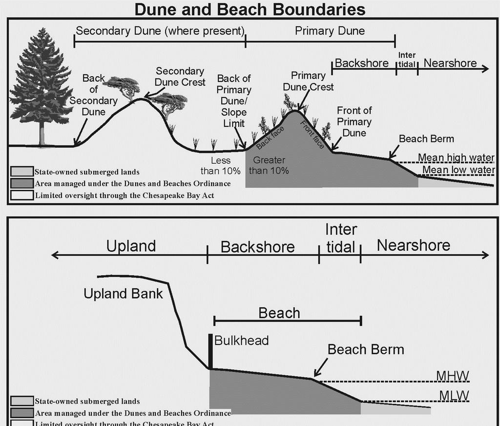
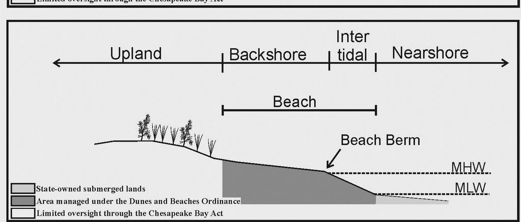
22 Part 5 - Chesapeake Bay Preservation Act Information All proposed development, redevelopment, land disturbance, clearing or grading related to this Tidewater JPA must comply with the Chesapeake Bay Preservation Area Designation and Management Regulations, which are enforced through locally adopted Chesapeake Bay Preservation Area (CBPA) ordinances. Compliance with state and local CBPA requirements mandates the submission of a Water Quality Impact Assessment (WQIA) for the review and approval of the local government. Contact the appropriate local government office to determine if a WQIA is required for the proposed activity(ies). Because the 84 local governments within Tidewater Virginia are responsible for enforcing the CBPA Regulations, the completion of the JPA process does not constitute compliance with the Bay Act Regulations nor does it guarantee that the local government will approve encroachments into the RPA that may result from this project. Applicants should contact their local government as early in the design process as possible to ensure that the final design and construction of the proposed project meets all applicable CBPA requirements. Early cooperation with local government staff can help applicants avoid unnecessary and costly delays to construction. Applicants should provide local government staff with information regarding existing vegetation within the Resource Protection Area (RPA) as well as a description and site drawings of any proposed land disturbance, construction, or vegetation clearing. As part of their review and approval processes, local government staff will evaluate the proposed project and determine whether or not approval can be granted. Once the locality has made a decision on the project, they will advise the Local Wetlands Boards and other appropriate parties of applicable CBPA concerns or issues. Resource Protection Areas (RPAs) are composed of the following features: 1. Tidal wetlands; 2. Nontidal wetlands connected by surface flow and contiguous to tidal wetlands or water bodies with perennial flow; 3. Tidal shores; 4. Other lands considered by the local government to meet the provisions of subsection A of 9VAC and to be necessary to protect the quality of state waters; and 5. A buffer area not less than 100 feet in width located adjacent to and landward of the components listed in subdivisions 1 through 4 above, and along both sides of any water body with perennial flow. Notes for all projects in RPAs Development, redevelopment, construction, land disturbance, or placement of fill within the RPA features listed above requires the approval of the locality and may require an exception or variance from the local Bay Act ordinance. Please contact the appropriate local government to determine the types of development or land uses that are permitted within RPAs. Pursuant to 9VAC , on-site delineation of the RPA is required for all projects in CBPAs. Because USGS maps are not always indicative of actual in-field conditions, they may not be used to determine the site-specific boundaries of the RPA. Notes for shoreline erosion control projects in RPAs Re-establishment of woody vegetation in the buffer will be required by the locality to mitigate for the removal or disturbance of buffer vegetation associated with your proposed project. Please contact the local government to determine the mitigation requirements for impacts to the 100-foot RPA buffer. Application Revised: May
23 Part 5 - Chesapeake Bay Preservation Act Information (continued) Pursuant to 9VAC a (4) of the Virginia Administrative Code, shoreline erosion projects are a permitted modification to RPAs provided that the project is based on the best technical advice and complies with applicable permit conditions. In accordance with 9VAC of the Virginia Administrative Code, the locality will use the information provided in this Part V, in the project drawings, in this permit application, and as required by the locality, to make a determination that: 1. Any proposed shoreline erosion control measure is necessary and consistent with the nature of the erosion occurring on the site, and the measures have employed the best available technical advice 2. Indigenous vegetation will be preserved to the maximum extent practicable 3. Proposed land disturbance has been minimized 4. Appropriate mitigation plantings will provide the required water quality functions of the buffer (9VAC ) 5. The project is consistent with the locality s comprehensive plan 6. Access to the project will be provided with the minimum disturbance necessary. Application Revised: May
24 3 miles (state) 12 miles (federal) and DEQ (including isolated wetlands) Application Revised: May
25 Application Revised: May
26 Application Revised: May
27 Application Revised: May
28 Application Revised: May
29 Application Revised: May
30 Application Revised: May
31 Application Revised: May
Regulatory Agency Contact Information
 Regulatory Agency Contact Information Virginia Marine Resources Commission (VMRC) Habitat Management Division 2600 Washington Avenue, 3 rd Floor Newport News, Virginia 23607-0756 Phone: (757) 247-2200,
Our Staff Member are committed to helping you during this process.
 Sandbridge General Permit Sand Management Sandbridge General Permit Application Instructions The Virginia Beach Wetlands Board adopted a General Permit for Sand Management & Sand Placement for properties
Rules for Use of Submerged Lands-Permitting, Dredging, Construction
 Rules for Use of Submerged Lands-Permitting, Dredging, Construction http://www.mrc.virginia.gov/regulations/subaqueous_guidelines.shtm Section I Subaqueous Guidelines VA Constitution Article XI C. General
TIDAL WETLANDS HANDBOOK
 MIDDLESEX COUNTY TIDAL WETLANDS HANDBOOK Procedures MIDDLESEX COUNTY Department of Planning and Community Development P.O. Box 427 Saluda, VA 23149-0427 Phone: (804) 758-3382 Fax: (804) 758-0061 www.co.middlesex.va.us
First Name Last Name. Company Name (if applicable) Street Address City State Zip. Owner Phone. . First Name Last Name
 Street Address City State Zip. Owner Phone. . First Name Last Name") MAIW 20 - APPLICATION TO PERFORM MISCELLANEOUS ACTIVITIES IN WETLANDS This EPC application is for all miscellaneous activities in wetlands (MAIW) as provided in Section 1-11.10 Wetlands, Rules of the EPC.
MAIW 20 - APPLICATION TO PERFORM MISCELLANEOUS ACTIVITIES IN WETLANDS This EPC application is for all miscellaneous activities in wetlands (MAIW) as provided in Section 1-11.10 Wetlands, Rules of the EPC.
CHESAPEAKE BAY PRESERVATION AREA EXCEPTION APPLICATION INSTRUCTIONS
 City of Chesapeake Department of Planning Post Office Box 15225 Chesapeake, Virginia 23328-5225 (757) 382-6176 FAX (757) 382-6406 CHESAPEAKE BAY PRESERVATION AREA EXCEPTION APPLICATION INSTRUCTIONS PURPOSE
Applicant can submit Certified Mail (date stamped) receipts which were addressed to upstream and downstream property owners.
 receipts which were addressed to upstream and downstream property owners.") INSTRUCTIONS FOR COMPLETING AN INDIVIDUAL PERMIT APPLICATION PRIVATE RECREATIONAL DOCK PERMIT APPLICATION TO THE GADNR COASTAL RESOURCES DIVISION AND US ARMY CORPS OF ENGINEERS Use this application when
INSTRUCTIONS FOR COMPLETING AN INDIVIDUAL PERMIT APPLICATION PRIVATE RECREATIONAL DOCK PERMIT APPLICATION TO THE GADNR COASTAL RESOURCES DIVISION AND US ARMY CORPS OF ENGINEERS Use this application when
TIDAL WETLANDS AND COASTAL PRIMARY SAND DUNES AND BEACHES HANDBOOK
 MIDDLESEX COUNTY TIDAL WETLANDS AND COASTAL PRIMARY SAND DUNES AND BEACHES HANDBOOK Procedures MIDDLESEX COUNTY Department of Planning and Community Development P.O. Box 428 Saluda, VA 23149-0428 Phone:
Directions For Filling Out A CAMA MINOR Permit
 Directions For Filling Out A CAMA MINOR Permit Please fill out the application completely including applicant's signature on the second page. Be sure to complete the "statement of ownership" and the "adjacent
U.S. Army Corps of Engineers - Charleston District Checklist for 2017 Nationwide Permit Review Nationwide Permit 48
 U.S. Army Corps of Engineers - Charleston District Checklist for 2017 Nationwide Permit Review Nationwide Permit 48 Commercial Shellfish Aquaculture Activities (10/404) SAC#: Applicant Name: Waterway/Location:
FLORIDA DEPARTMENT OF ENVIRONMENTAL PROTECTION
 FLORIDA DEPARTMENT OF ENVIRONMENTAL PROTECTION NOTICE OF INTENT TO USE S. 403.9327, F.S., GENERAL PERMIT FOR MANGROVE TRIMMING OR APPLICATION FOR S. 403.9328, F.S., INDIVIDUAL PERMIT TO TRIM OR ALTER MANGROVES
Honolulu District U.S. Army Corps of Engineers
 Honolulu District U.S. Army Corps of Engineers Nationwide Permit Pre-Construction Notification (PCN) This PCN template integrates requirements of the U.S. Army Corps of Engineers (Corps) Nationwide Permit
EXPERIMENTAL AQUACULTURE LEASE APPLICATION
 EXPERIMENTAL AQUACULTURE LEASE APPLICATION This is an application for an experimental aquaculture lease. You are encouraged to review the experimental lease regulations and application instructions to
A. General Information
 Important: When filling out forms on the computer, use only the tab key to move your cursor - do not use the return key. Massachusetts Department of Environmental Protection A. General Information 1. Project
A. General Information
 Important: When filling out forms on the computer, use only the tab key to move your cursor - do not use the return key. Massachusetts Department of Environmental Protection A. General Information 1. Project
Town of Jupiter Island Delegated Mangrove Authority For the State of Florida
 Town of Jupiter Island Delegated Mangrove Authority For the State of Florida Mangroves are regulated by the State of Florida. The Town of Jupiter Island is a delegated regulatory agency for the State for
Applicant s Agent Lisa Murphy, Esq. Staff Planner PJ Scully. Lot Recordation 12/01/1972 Map Book 94, Page 33 GPIN
 Property Owner and Applicant Address 3925 Shore Drive Public Hearing September 24, 2018 City Council District Bayside Agenda Item 6 Variance Request Encroachment into the Resource Protection Area (RPA)
ORDINANCE NO WHEREAS, the Town of Jupiter ( Town ) has adopted a Comprehensive Plan
 has adopted a Comprehensive Plan") 0 0 ORDINANCE NO. -0 AN ORDINANCE OF THE TOWN COUNCIL OF THE TOWN OF JUPITER, FLORIDA, AMENDING CHAPTER OF THE TOWN CODE TO AMEND SECTION -, ENTITLED INTENT TO ADD PERMITTING LANDGUAGE; TO AMEND SECTION
0 0 ORDINANCE NO. -0 AN ORDINANCE OF THE TOWN COUNCIL OF THE TOWN OF JUPITER, FLORIDA, AMENDING CHAPTER OF THE TOWN CODE TO AMEND SECTION -, ENTITLED INTENT TO ADD PERMITTING LANDGUAGE; TO AMEND SECTION
Oyster Aquaculture Tiger Team Meeting Karl R. Roscher, Director DNR Aquaculture Division
 1 Oyster Aquaculture Tiger Team Meeting Karl R. Roscher, Director DNR Aquaculture Division 2011 Legislative and Regulatory Changes HB1053/SB847-consolidated shellfish aquaculture permitting authority at
A. General Information
 Important: When filling out forms on the computer, use only the tab key to move your cursor - do not use the return key. Massachusetts Department of Environmental Protection A. General Information 1. Project
Instructions to the Applicant
 CONDITIONAL USE PERMIT APPLICATION Lake of the Woods County Land and Water Planning Office 206 8 th Avenue Southeast, Suite #290 Baudette MN 56623-2867 www.co.lake-of-the-woods.mn.us Phone: (218) 634-1945
Zoning and Building Permit Application
 Date: Zoning Permit #: County of Middlesex, Virginia Department of Planning and Community Development Zoning and Building Permit Application OFFICE USE ONLY Date: E & S Agreement #: Fee: $30.00 Approval
Construction & Earthwork Request Form (CERF)
") ShoreLand Traditions Construction & Earthwork Request Form (CERF) SECTION 1 SECTION 2 SECTION 3 Definitions and Points to Remember Requirements and Process Site Sketch Requirements and Sample If you have
ShoreLand Traditions Construction & Earthwork Request Form (CERF) SECTION 1 SECTION 2 SECTION 3 Definitions and Points to Remember Requirements and Process Site Sketch Requirements and Sample If you have
CHAPTER 6 CHESAPEAKE BAY PRESERVATION AREAS AND STREAM PROTECTION AREAS
 CHAPTER 6 CHESAPEAKE BAY PRESERVATION AREAS AND STREAM PROTECTION AREAS 6.1 INTRODUCTION Virginia s Chesapeake Bay Preservation Area (CBPA) Designation and Management Regulations (9VAC10-20 et seq.) require
Application for Use of State-owned Aquatic Lands
 s Applicant Name: Taylor Shellfish Co. Inc County: Mason County Water Body: North Bay Type of Authorization - Use: Right of Entry Aquaculture Authorization Number: 23-085711 Term: 5 years Description:
CHARLES CITY COUNTY SITE PLAN ORDINANCE. This Ordinance shall be known as the Charles City County Site Plan Ordinance.
 CHARLES CITY COUNTY SITE PLAN ORDINANCE Section 1. Title This Ordinance shall be known as the Charles City County Site Plan Ordinance. Section 2. Authority. This Ordinance is enacted pursuant to the authority
Purpose: Regulations:
 Administrative Procedures for the Designation and Refinement Of Chesapeake Bay Preservation Area Boundaries Guidance on the Chesapeake Bay Preservation Area Designation and Management Regulations September,
APPLICATION FOR A COASTAL WORKS PERMIT SEAWALLS, LAUNCHING RAMPS, GROYNES & SHORELINE MODIFICATION APPLICATION INSTRUCTIONS
 APPLICATION FOR A COASTAL WORKS PERMIT SEAWALLS, LAUNCHING RAMPS, GROYNES & SHORELINE MODIFICATION APPLICATION INSTRUCTIONS ACTIVITIES THAT REQUIRE A COASTAL WORKS PERMIT Activities which extend seaward
Wetlands Board Hearing Procedures
 Wetlands Board Hearing Procedures The Virginia Beach Wetlands Public Hearing is held at 10:00 a.m. in the Council Chamber of the City Hall Building, Municipal Center. A staff briefing is held at 8:45 a.m.
Shellfish Aquaculture Leasing. Karl Roscher, Director Aquaculture Division DNR-Fisheries Service
 Shellfish Aquaculture Leasing Karl Roscher, Director Aquaculture Division DNR-Fisheries Service 1 Shellfish Aquaculture Leasing Support from past Governors and Maryland Lawmakers in Expanding the Shellfish
K. All adjoining lots under common deed, for use as a single residence, are considered to be one lot.
 Yadkin Project Shoreline Management Plan (FERC No. 2197) Appendix E: Specifications for Private Recreation Facilities at High Rock and Narrows Reservoirs I. General A. These Specifications of Cube Yadkin
A. General Information
 Important: When filling out forms on the computer, use only the tab key to move your cursor - do not use the return key. Massachusetts Department of Environmental Protection WPA Form 3 Notice of Intent
JOINT APPLICATION FOR INDIVIDUAL ENVIRONMENTAL RESOURCE PERMIT/ AUTHORIZATION TO USE STATE-OWNED SUBMERGED LANDS/ FEDERAL DREDGE AND FILL PERMIT
 Form 62-330.060(1) JOINT APPLICATION FOR INDIVIDUAL ENVIRONMENTAL RESOURCE PERMIT/ AUTHORIZATION TO USE STATE-OWNED SUBMERGED LANDS/ FEDERAL DREDGE AND FILL PERMIT FLORIDA DEPARTMENT OF ENVIRONMENTAL PROTECTION/
PRELIMINARY SUBDIVISION PLAN APPLICATION
 PRELIMINARY SUBDIVISION PLAN APPLICATION CHESAPEAKE PLANNING DEPARTMENT APPLICATION NUMBER: (Assigned by Chesapeake Planning Department) GENERAL INFORMATION 1. Name of Subdivision: 2. Applicant(s): Address:
GUIDE FOR APPLICANTS APPLYING FOR A PERMIT FOR DOCKING AND MOORING. Completed application form
 Town of Milo, New York Department of Buildings 137 Main Street Town Hall Penn Yan, New York 14527 Telephone No.: (315) 531-8042 Facsimile No.: (315) 536-9760 Email: codeofficer@townofmilo.com GUIDE FOR
SMALL CELL TECHNOLOGY in the Right-of-Way ADMINISTRATIVE VARIANCE APPLICATION Community Development Department
 PURPOSE OF ADMINISTRATIVE VARIANCE SMALL CELL TECHNOLOGY in the Right-of-Way Pursuant to Sec. 23-706(h), an Administrative Variance is required for installation of a new Small Cell Technology Wireless
State: Zip: Daytime Phone: Ext.: Cell Phone: State: Zip: Daytime Phone: Ext.: Cell Phone: Zip: Municipality: County:
 State of New Jersey Department of Environmental Protection Division of Land Use Regulation Application Form (LURP-2) 501 E. State Street Mail Code 501-02A P.O. Box 420 Trenton, NJ 08625-0420 www.nj.gov/dep/landuse
APPENDIX D REAL ESTATE PLAN
 APPENDIX D REAL ESTATE PLAN APPENDIX D REAL ESTATE PLAN TABLE OF CONTENTS 1. STATEMENT OF PURPOSE 2. REFERENCES 3. AUTHORIZATION 4. BACKGROUND 5. LOCATION 6. REAL ESTATE REQUIREMENTS 7. OWNERSHIP OF REAL
Section A: General Information for All Activities
 Section A: General Information for All Activities PART 1: NAME, APPLICATION TYPE, LOCATION, AND DESCRIPTION OF ACTIVITY A. Name of project, including phase if applicable: F.B.I. Commercial Park B. This
SUBDIVISION APPLICATION CHECKLIST SKETCH PLAN PRELIMINARY PLAT FINAL PLAT
 RECEIVED STAMP SUBDIVISION APPLICATION CHECKLIST SKETCH PLAN PRELIMINARY PLAT FINAL PLAT A checklist of background information and submission requirements for processing of a sketch plan, preliminary plat
Jurisdictional Determination Request
 This form is intended for use by anyone requesting a jurisdictional determination (JD) from the U.S. Army Corps of Engineers, Wilmington District (Corps). Please include all supporting information, as
***** Subchapter A. GENERAL PROVISIONS ***** PERMIT APPLICATIONS
 105.11. Permit requirements. 105.12. Waiver of permit requirements. Title 25 Environmental Protection Part I. Department of Environmental Protection Subpart C. Protection of Natural Resources Article I.
Department of Legislative Services Maryland General Assembly 2010 Session
 Department of Legislative Services Maryland General Assembly 2010 Session SB 1128 FISCAL AND POLICY NOTE Revised Senate Bill 1128 (Senator Colburn) Education, Health, and Environmental Affairs Environmental
PRELIMINARY SUBDIVISION PLAN APPLICATION INSTRUCTIONS
 City of Chesapeake Department of Planning Post Office Box 15225 Chesapeake, Virginia 23328-5225 (757) 382-6176 FAX (757) 382-6406 PRELIMINARY SUBDIVISION PLAN APPLICATION INSTRUCTIONS PURPOSE A preliminary
APPLICATION PROCEDURE
 ANTRIM PLANNING BOARD P. O. Box 517 Antrim, New Hampshire 03440 Phone: 603-588-6785 FAX: 603-588-2969 APPLICATION FORM AND CHECKLIST FOR MINOR OR MAJOR SITE PLAN REVIEW File Date Received By APPLICATION
Notice of Intent (NOI)
") This section for official use only City of Columbia Permit Approval Notice of Intent (NOI) NPDES Coverage (DHEC) Land Disturbance Permit (LD) # Land Disturbance Plan (LDP) # City File (CF) # State File
This section for official use only City of Columbia Permit Approval Notice of Intent (NOI) NPDES Coverage (DHEC) Land Disturbance Permit (LD) # Land Disturbance Plan (LDP) # City File (CF) # State File
WESTON COUNTY FINAL PLAT APPLICATION
 WESTON COUNTY FINAL PLAT APPLICATION Property Owner: Mailing Address of owner: Telephone Number(s) of owner: Property Owner: Mailing Address of owner: Telephone Number(s) of owner: (If subdivider/applicant
CONDITIONAL USE PERMIT APPLICATION FOR AN EXCAVATION/BORROW PIT INSTRUCTIONS
 City of Chesapeake Department of Planning Post Office Box 15225 Chesapeake, Virginia 23328-5225 (757) 382-6176 FAX (757) 382-6406 CONDITIONAL USE PERMIT APPLICATION FOR AN EXCAVATION/BORROW PIT INSTRUCTIONS
Ministry of Forest, Lands and Natural Resource Operations
 WHEREAS: PROVINCIAL GENERAL PERMISSION FOR THE USE OF CROWN LAND FOR PRIVATE MOORAGE VERSION: January 17, 2017 (Land Act) A. The Ministry of Forests, Lands and Natural Resource Operations ( the Ministry
Planned Residential Development ( PRD ) Application
 Application") FOR PLANNING USE ONLY Application # PRD Application Fee $ Receipt No. Filing Date Completeness Date Planned Residential Development ( PRD ) Application A. PROJECT INFORMATION 1. Project Name: 2. Address
FOR PLANNING USE ONLY Application # PRD Application Fee $ Receipt No. Filing Date Completeness Date Planned Residential Development ( PRD ) Application A. PROJECT INFORMATION 1. Project Name: 2. Address
I. General. 1 Property managed by Cube includes the land below waters of the reservoirs and the generating facilities.
 Yadkin Project Shoreline Management Plan (FERC No. 2197) Appendix E: Specifications for Private Recreation Facilities at High Rock and Narrows Reservoirs I. General A. These Specifications of Cube Yadkin
Attached is a Clinton Township Zoning Permit Application and requirements for issuance of a permit.
 To Whom It May Concern: Attached is a Clinton Township Zoning Permit Application and requirements for issuance of a permit. The fee for the permit application is $75.00, which shall be made payable to
E L M E R B O R O U G H L A N D U S E B O A R D APPLICATION COVER SHEET (to be completed for all applications and appeals)
") E L M E R B O R O U G H L A N D U S E B O A R D APPLICATION COVER SHEET (to be completed for all applications and appeals) 1. Name(s): 2. Address: 3. Telephone Number(s): 4. E-mail: 5. Owner Name(s) (if
E L M E R B O R O U G H L A N D U S E B O A R D APPLICATION COVER SHEET (to be completed for all applications and appeals) 1. Name(s): 2. Address: 3. Telephone Number(s): 4. E-mail: 5. Owner Name(s) (if
INSTRUCTIONS FOR COMPLETING THE APPLICATION FORM
 TOWN OF HOLLY SPRINGS ENGINEERING DEPARTMENT PO Box 8 Holly Springs, NC 27540 (919) 557-3938 FAX (919) 552-9881 The following items must be submitted with the complete, signed and notarized Application
COASTAL DEVELOPMENT PERMIT APPLICATION
 COUNTY OF MENDOCINO DEPARTMENT OF PLANNING AND BUILDING SERVICES 501 Low Gap Road, Room 1440 Ukiah, California 95482 Telephone 707-463-4281 FAX 707-463-5709 790 South Franklin Street Fort Bragg, California
THE BUILDING PERMIT PROCESS FOR SINGLE-FAMILY DWELLINGS REVISED MAY 2006
 DEPARTMENT OF PLANNING AND ZONING Division of Inspections & Permits CUSTOMER ASSISTANCE GUIDE Visit us on the Web at: www.co.cal.md.us THE BUILDING PERMIT PROCESS FOR SINGLE-FAMILY DWELLINGS REVISED MAY
VARIANCE APPLICATION PACKET
 VARIANCE APPLICATION PACKET A variance is a modification of the specific provisions of the Unified Development Ordinance (UDO) granted when strict enforcement of the UDO would cause undue hardship owing
Major Subdivision Application Packet. Revised June 2018
 Major Subdivision Application Packet Revised June 2018 Caroline County Department of Planning and Community Development 233 West Broaddus Avenue Bowling Green, VA 22427 www.co.caroline.va.us Phone: 804-633-4303
A. General Information
 Important: When filling out forms on the computer, use only the tab key to move your cursor - do not use the return key. Note: Before completing this form consult your local Conservation Commission regarding
APPLICATION FOR CLEARANCE OF SHORELINE VEGETATION AND
 APPLICATION FOR CLEARANCE OF SHORELINE VEGETATION AND CONSERVATION AREA AUTHORIZATION* *This permit application is intended to be used when work is being proposed both within a conservation area or easement
Septic Tank / Drainfield / Holding Tank Permit Application
 Septic Tank / Drainfield / Holding Tank Permit Application : Permit # : PID #: Septic Fee $: Soil Verification Fee $: Investigative/Other Fee $: PLEASE PRINT CLEARLY Total Permit Fee $: The Applicant Is:
APPLICATION TO CONSTRUCT A DOCK
 APPLICATION TO CONSTRUCT A DOCK (In Accordance with Orange County Code Chapter 15, Article IX, Orange County Code) Mail or Orange County Environmental Protection Division Deliver To: 3165 McCrory Place,
SUBDIVISION APPLICATION
 SUBDIVISION APPLICATION Community Planning and Economic Development Development Services Division 250 South 4 th Street, Room 300 Minneapolis MN 55415-1316 612-673-3000 This application packet is used
City of East Orange. Department of Policy, Planning and Development LAND USE APPLICATION & SITE PLAN REVIEW CHECKLIST
 Department of Policy, Planning and Development LAND USE APPLICATION & SITE PLAN REVIEW CHECKLIST COMPLETE: Applicant Information: Type of Proposal: OFFICE USE ONLY: New Residential Case #: Date: New Accessory
ZONING ORDINANCE, ARTICLE 5: SITE DEVELOPMENT REGULATIONS PAGE
 ZONING ORDINANCE, ARTICLE 5: SITE DEVELOPMENT REGULATIONS PAGE 5:1 ARTICLE 5 SITE DEVELOPMENT REGULATIONS 3-100 Purpose of this Article This Article establishes minimum site development regulations and
SPECIAL EXCEPTION APPLICATION LEVY COUNTY, FLORIDA. Fee: (see fee schedule) Validation No.
 Validation No.") Filing Date Petition No. SE Fee: (see fee schedule) Validation No. TO THE LEVY COUNTY PLANNING COMMISSION: Special exceptions are intended to provide for land uses and activities not permitted by right
Filing Date Petition No. SE Fee: (see fee schedule) Validation No. TO THE LEVY COUNTY PLANNING COMMISSION: Special exceptions are intended to provide for land uses and activities not permitted by right
APPLICATION GUIDE. MARINE AQUACULTURE (East Coast)
") APPLICATION GUIDE MARINE AQUACULTURE (East Coast) Department of Agriculture, Aquaculture and Fisheries October 2011 TABLE OF CONTENTS 1. INTRODUCTION... 3 2. THE APPLICATION FORM AND SCHEDULES... 4 2.1
APPLICATION GUIDE MARINE AQUACULTURE (East Coast) Department of Agriculture, Aquaculture and Fisheries October 2011 TABLE OF CONTENTS 1. INTRODUCTION... 3 2. THE APPLICATION FORM AND SCHEDULES... 4 2.1
PROCEDURE LIST FOR LARGE-SCALE FUTURE LAND USE AMENDMENT
 DEPARTMENT OF COMMUNITY DEVELOPMENT Case # PROCEDURE LIST FOR LARGE-SCALE FUTURE LAND USE AMENDMENT 1. Applicant s portion of request shall be typewritten and signature notarized. a) All forms (Application,
Residential Major Subdivision Review Checklist
 Residential Major Subdivision Review Checklist Plan Submittal Requirements: 2 full sets of stamped plans Electric submittal - all plans contained in a single PDF 3 full sets if commercial kitchen or dining
Instructions for Preparing the Consolidated Dredging-Dredged Material Reuse/Disposal Application [Rev 12/07]
![Instructions for Preparing the Consolidated Dredging-Dredged Material Reuse/Disposal Application [Rev 12/07]](/thumbs/86/94252701.jpg "Instructions for Preparing the Consolidated Dredging-Dredged Material Reuse/Disposal Application [Rev 12/07]") Instructions for Preparing the Consolidated Dredging-Dredged Material Reuse/Disposal Application [Rev 12/07] An inter-agency Dredge Material Management Office (DMMO) has been established to simplify the
Instructions for Preparing the Consolidated Dredging-Dredged Material Reuse/Disposal Application [Rev 12/07] An inter-agency Dredge Material Management Office (DMMO) has been established to simplify the
Septic Tank / Drainfield / Holding Tank Permit Application
 Septic Tank / Drainfield / Holding Tank Permit Application : Permit # : PID #: Septic Fee $: Soil Verification Fee $: Investigative/Other Fee $: PLEASE PRINT CLEARLY Total Permit Fee $: The Applicant Is:
Town of Middleborough Conservation Commission 2014 Policy
 Approved February 20, 2014 Town of Middleborough Conservation Commission 2014 Policy The Wetland Protection Act under M.G.L. c. 131, sec. 40 and regulations 310 CMR 10.02(1)(a-f) & 310 CMR 10.02 (2)(a)
APPLICATION PACKET FOR. In the Coastal Zone Area
 APPLICATION PACKET FOR Coastal Zone Permit In the Coastal Zone Area Planning Department 1650 Mission Street Suite 400 San Francisco, CA 94103-9425 T: 415.558.6378 F: 415.558.6409 Pursuant to Planning Code
COMMERCIAL AND MULTI-USE DOCK PERMIT APPLICATION PINELLAS COUNTY WATER AND NAVIGATION
 Direct all correspondence to: Clerk, Water and Navigation, 5 th Floor 315 Court Street Clearwater, FL 33756 COMMERCIAL AND MULTI-USE DOCK PERMIT APPLICATION I. PROPERTY OWNER INFORMATION: PINELLAS COUNTY
INFORMATION REQUIRED FOR ALABAMA GENERAL PERMITS - BW&T LAKES
 INFORMATION REQUIRED FOR ALABAMA GENERAL PERMITS - BW&T LAKES THE FOLLOWING COMPLETED DOCUMENTS MUST BE RETURNED BEFORE PERMIT CAN BE ISSUED: 1. DESCRIPTION INFORMATION LIST 2. JOINT APPLICATION FORM 1668-02
Instructions for APPLICATION FOR CONSENT
 Instructions for APPLICATION FOR CONSENT THE CORPORATION OF THE CITY OF LONDON DEVELOPMENT & COMPLIANCE SERVICES, DEVELOPMENT SERVICES, 6 TH FLOOR, CITY HALL, 300 DUFFERIN AVENUE, LONDON, ONTARIO N6A 4L9
10. GENERAL PLAN 11. ZONING 12. LAND USE 13. ASSESSOR S PARCEL NUMBER 18. PROPOSED ZONING 19. PROPOSED LAND USE 20. NO. UNITS 21.
 STAFF USE ONLY ACCEPTED BY Application for Discretionary Permit Development Services Department / Planning Division (760) 435-3520 Oceanside Civic Center 300 North Coast Highway Oceanside, California 92054-2885
Plat/Site Plan Application
 Instructions Plat/Site Plan Application For your application to be officially accepted for processing, you must complete this application in full. The owner/agent certification must be signed and notarized
DEPARTMENT OF THE ARMY U.S. ARMY CORPS OF ENGINEERS, SAVANNAH DISTRICT 100 WEST OGLETHORPE AVENUE SAVANNAH, GEORGIA
 DEPARTMENT OF THE ARMY U.S. ARMY CORPS OF ENGINEERS, SAVANNAH DISTRICT 100 WEST OGLETHORPE AVENUE SAVANNAH, GEORGIA 31401-3604 June 8, 2018 Regulatory Branch SAS-2018-00375 PUBLIC NOTICE Reissuance of
PLANNING DEPARTMENT Application for a Type 2 Use through the Board of Adjustment & Appeals
 PLANNING DEPARTMENT Application for a Type 2 Use through the Board of Adjustment & Appeals Dear Applicant: Type 2 uses (formerly called Special Exceptions) are uses that may be approved if certain criteria
PERMIT FEES Within the shore impact zone (Includes Rip-Rap and Sand Blankets) $ Over 51 cubic yards $100.00
 $ Over 51 cubic yards $100.00") WHAT IS A LAND ALTERATION PERMIT? A land alteration permit is a permit to move or excavate dirt, gravel, sand, etc, on property, which is not incidental to an approved building permit or a septic system
WHAT IS A LAND ALTERATION PERMIT? A land alteration permit is a permit to move or excavate dirt, gravel, sand, etc, on property, which is not incidental to an approved building permit or a septic system
APPLICATION FOR PERMIT: (Pursuant to Ord & Reso ) 4d Habitat Loss Permit Vegetation Removal Tree Removal. Address:
 4d Habitat Loss Permit Vegetation Removal Tree Removal. Address:") CITY OF ESCONDIDO Planning Division 201 North Broadway Escondido, CA 92025-2798 (760) 839-4671 Fax: (760) 839-4313 APPLICATION FOR PERMIT: (Pursuant to Ord. 91-54 & Reso. 94-436) Case No: FOR INTERNAL
CITY OF ESCONDIDO Planning Division 201 North Broadway Escondido, CA 92025-2798 (760) 839-4671 Fax: (760) 839-4313 APPLICATION FOR PERMIT: (Pursuant to Ord. 91-54 & Reso. 94-436) Case No: FOR INTERNAL
Land Use Application
 Permit Center 210 Lottie Street, Bellingham, WA 98225 Phone: (360) 778-8300 Fax: (360) 778-8301 TTY: (360) 778-8382 Email: permits@cob.org Web: www.cob.org/permits Land Use Application Check all permits
MINOR SUBDIVISION FINAL PLAT APPLICATION Town of Apex, North Carolina
 MINOR SUBDIVISION FINAL PLAT APPLICATION Town of Apex, North Carolina This document is a public record under the North Carolina Public Records Act and may be published on the Town s website or disclosed
MAJOR SUBDIVISION APPLICATION
 Revised 2.26.18 The Department is here to assist you with your development application pursuant to the Community Development Code (CDC). This publication outlines the Major Subdivision Development Application
INSTRUCTIONS AND INFORMATION FOR LAND LEASE APPLICATION
 TED STEVENS ANCHORAGE INTERNATIONAL AIRPORT Department of Transportation & Public Facilities Airport Leasing & Property Management PO Box 196960, Anchorage AK 99519-6960 Phone: 907-266-2420 Fax: 907-266-2458
PLANNED DEVELOPMENT / CONDITIONAL USE PERMIT Application
 SUBMITTAL City of Camarillo Department of Community Development 601 Carmen Drive P.O. Box 248 Camarillo, CA 93011-0248 Phone: 805.388.5360; Fax: 805.388.5388 Email: comdevemail@cityofcamarillo.org City
FOR DEP USE ONLY ATS ID: Seq: DEP ID: Received by DEP: Bureau: S Type of Application: WF Activity: N Fees Paid: Project Analyst: Check No.
 DEPARTMENT OF ENVIRONMENTAL PROTECTION Solid Waste Program, Attn: Geraldine Travers 17 State House Station Augusta, Maine 04333-0017 Telephone: (207) 287-7688 FOR DEP USE ONLY ATS ID: Seq: DEP ID: Received
******************************************************************************
 AGENDA BOARD OF TRUSTEES OF THE INTERNAL IMPROVEMENT TRUST FUND OCTOBER 10, 2013 Attachments to the items below can be viewed at the following link: http://www.dep.state.fl.us/secretary/cab/public_notices.htm
HOUSE BILL lr0014
 M HOUSE BILL 0 lr00 By: Chair, Environmental Matters Committee (By Request Departmental Natural Resources) Introduced and read first time: February, 0 Assigned to: Rules and Executive Nominations Re referred
Request to Advertise: Chesapeake Bay Preservation Area (CBPA) Map Update. June 20, 2017
 Map Update. June 20, 2017") Request to Advertise: Chesapeake Bay Preservation Area (CBPA) Map Update June 20, 2017 Outline Context Past County Board actions Why update the CBPA Map? What and Why - Resource Protection Areas Property
Request to Advertise: Chesapeake Bay Preservation Area (CBPA) Map Update June 20, 2017 Outline Context Past County Board actions Why update the CBPA Map? What and Why - Resource Protection Areas Property
VARIANCE PROCEDURE The City Council will consider the request and either grant or deny the variance.
 VARIANCE PROCEDURE 1 The Minnetrista City Code was established to protect both current and future residents from the negative impacts of improper development and to ensure a positive future for the city.
FINAL SITE PLAN PLAT APPLICATION Town of Apex, North Carolina
 FINAL SITE PLAN PLAT APPLICATION Town of Apex, North Carolina This document is a public record under the North Carolina Public Records Act and may be published on the Town s website or disclosed to third
TALBOT COUNTY OFFICE OF PLANNING & ZONING
 TALBOT COUNTY OFFICE OF PLANNING & ZONING APPLICATION PROCEDURE FOR: MINOR VARIANCE CRITICAL AREA Refer to Article, IX, 190-182 B. Minor Variances of the Talbot County Code. If your project exceeds 10
North Carolina Shellfish Bottom Lease Application
 North Carolina Shellfish Bottom Lease Application North Carolina Division of Marine Fisheries Resource Enhancement Section 3441 Arendell Street Morehead City, North Carolina 28557 Table of Contents SHELLFISH
Application for Sketch Plan Review
 Town of Standish 175 Northeast Road Standish, ME - 04084 Phone: (207)642-3461 Fax: (207) 642-5181 Application for Sketch Plan Review Applicant & Owner Information 1) Name of Applicant: Address: Phone:
RPA Map Update Public Meeting Questions and Answers
 DEPARTMENT OF ENVIRONMENTAL SERVICES Office of Sustainability and Environmental Management 2100 Clarendon Boulevard, Suite 705, Arlington, VA 22201 TEL 703-228-4488 FAX 703-228-7134 TTY 703-228-4611 www.arlingtonva.us
Chesapeake Bay Preservation Area (CBPA) Map Update. Presentation to the County Board July 15, 2017
 Map Update. Presentation to the County Board July 15, 2017") Chesapeake Bay Preservation Area (CBPA) Map Update Presentation to the County Board July 15, 2017 Chesapeake Bay Program Comprehensive Plan Chesapeake Bay Preservation Ordinance (1992) (Chapter 61, Arlington
Chesapeake Bay Preservation Area (CBPA) Map Update Presentation to the County Board July 15, 2017 Chesapeake Bay Program Comprehensive Plan Chesapeake Bay Preservation Ordinance (1992) (Chapter 61, Arlington
SEWAGE FACILITIES PLANNING MODULE
 Code. COMMONWEALTH OF PENNSYLVANIA DEPARTMENT OF ENVIRONMENTAL PROTECTION BUREAU OF WATER STANDARDS AND FACILITY REGULATION SEWAGE FACILITIES PLANNING MODULE Component 3s. Small Flow Treatment Facilities
To provide for the review of the final engineering plans, the subdivision improvement agreement, public dedications, and other legal agreements.
 ARTICLE 5 FINAL PLAT 501 Intent DOUGLAS COUNTY SUBDIVISION RESOLUTION To provide for the review of the final engineering plans, the subdivision improvement agreement, public dedications, and other legal