The relocation of Bosheuvel farm in the Liesbeeck River Valley, Cape Town:
|
|
|
- Candace Rosamond Horton
- 5 years ago
- Views:
Transcription
1 Presented at the FIG Working Week 2016, May 2-6, 2016 in Christchurch, New Zealand The relocation of Bosheuvel farm in the Liesbeeck River Valley, Cape Town: A Case of Spatial Construction of Society in Early Dutch Settlement at the Cape from a Land Surveying Perspective Jennifer WHITTAL, South Africa Susan JONES, New Zealand May 2016 TS04J


2 Relocation of Bosheuwel Identification of original beacons and boundaries Significant addition to body of work on early settlements Add spatial survey knowledge and rigour to historical research

3 Early Cadastre at the Cape First settlers Dutch East India Company 1652 Early Farming 1657 Rondebosjen Liesbeeck River First Grants parcels by 1660 Surveyed by Pieter Potter

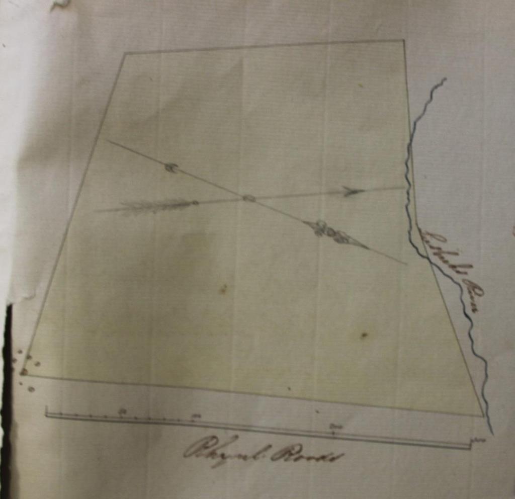
4 1658 Plan of Pieter Potter


5 Sketch of Sir John Herschel

6 Remnants of the wild almond hedge
7 Data sources Historic maps digitized and georeferenced in ArcMap 1658/9 General Plan; 1661 General Plan Modern day compilation of farms Van Der Graaf Thibault resurvey and map Pre-1840 unidentified map 1865 peninsula map 1880 map of the SW districts 1887 map of Constantia 1891 Sewerage map 1901, 1902, 1909,
8 Data sources Aerial imagery for context Surveyor-General s Office noting sheets Cadastral layer Lineage of diagrams and title deeds back through time Cadastral beacon data office and field
9 Bosheuwel Farm Loaned to Commander Jan Van Riebeeck from Transfers and eventually a grant 1685 with the oldest diagram of the farm

10 Bosheuwel Farm Thibault Plan of 1813 and new diagram

11 Bosheuwel Farm

12 Bosheuwel Farm another 4 transfers Colonial Bishops Fund purchased the land Consolidated with neighbouring Protea Estate Sale of most land for development
13 Bosheuwel Farm

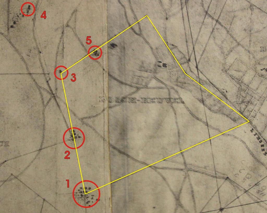
14 Identifying beacons


15 Shape, area, angles, lengths

16 Coordinates, field survey

17 Hen and Chickens Rock
18
19 Comparison of reconstructed western and eastern boundaries of Bosheuvel as in 1685
20 Reconstruction of Northern and Southern boundaries to 1685
21 Reconstructing to the 1657 grant and 1658 general plan
22 Beacon C Beacon/Boundary Conclusions original beacon oldest known cadastral boundary beacon still in use today and is currently some 359 years old.
23 The full paper Whittal, J, (2015) The relocation of VOC-era Bosheuvel farm in the Liesbeeck River Valley, Cape Town: A Land Surveying Approach, South African Historical Journal, Sage Open, 7(4), DOI / Online Available


24 UCT Geomatics Division
25 Methods Spatially-accurate research Historical research vs. Cadastral research methods Larger study of 17 farms Process of evidentiary and methodological triangulation Georeferencing - GIS map overlays Diagram/deed tracing Old Dutch Cadastral surveying and reconstruction


26
27 Beacon Description Beacons Found B C Fencing standard close to calculated position Iron peg in concrete cone at the top of a large granite boulder on calculated position. Called Hen and chickens rock D Fencing standard close to calculated position. A nearby large rock (R) could be the original beacon E F Fragments of masonry beacon with a hole Three foot concrete cone found lying prone 3m from expected position. Rail section found close to calculated position H P Concrete cone on top of a large boulder on position Concrete cone next to the old bridge over the Liesbeeck River
28 Farms and original Original Areas in square metres Reconstructed Areas Differences in square metres areas in square metres Cape Morgen Rynland morgen Cape Morgen Rynland morgen conversion conversion conversion conversion Bosheuwel 1657 loan grant to Jan van Riebeeck or -82 or Rynland morgen % less than a Cape Morgen 1% more than a Rynland Morgen Bosheuwel 1685 grant 101 Rynland morgen or 41% less than a or 18% more than a Cape Morgen Rynland Morgen 1901 transfer Protea Estate 100 morgen and 100 square roods noted as freehold (Bosheuwel or 43% more than a Cape Morgen or 101% more than a Rynland Morgen Portion)
29 Methodology Conclusions Successful mixed-method approach: GIS-based overlays for georeferencing SGO noting sheets Tracing grants Electronic desktop access to diagrams Fieldwork Traditional cadastral reconstruction essential
Jennifer WHITTAL, South Africa and Susan JONES, New Zealand. Key words: historical boundary relocation, surveying, GIS, cadastral fabrics
 a demonstration of cadastral reconstruction using regular techniques and GIS cadastral fabrics Jennifer WHITTAL, South Africa and Susan JONES, New Zealand Key words: historical boundary relocation, surveying,
General Instructions For Surveys and Plans Outside the Provincial Survey System
 May 15, 2018 General Instructions For Surveys and Plans Outside the Provincial Survey System NOTE: This document is a Controller of Surveys Policy manual to be used as a general guideline for the Legal
Jack McKenna, Director of Business Development, Africa and the Caribbean
 Presented at the FIG Working Week 2016, May 2-6, 2016 in Christchurch, New Zealand Jack McKenna, Director of Business Development, Africa and the Caribbean FIG WORKING WEEK 2016 Fit for Purpose Parcel
From Measurement to Management
 From Measurement to Management The changing role of the land surveyors Prof. Stig Enemark Aalborg University, Denmark LAND MANAGEMENT AND HUMAN RIGHTS INTERNATIONAL SEMINAR, HØGSKOLEN I BERGEN, 8 9 SEPTEMBER
Development of legislation for earthquake affected. cadastral boundaries in New Zealand. FIG Geoconference Cadastre 4.0, Coimbra Portugal
 Development of legislation for earthquake affected cadastral boundaries in New Zealand Associate Professor Dr Don Grant RMIT University FIG Geoconference Cadastre 4.0, Coimbra Portugal 26 October 2016
A Geocoded Cadastral Fabric as a Precondition for a Sustainable Land Management System
 A Geocoded Fabric as a Precondition for a Sustainable Land Management System Gottfried KONECNY, Germany; J.P. LAUZON, Canada; Abdul Salam MOHAMMED, India Key words: SDI,, Parcel Boundaries, GPS-GNSS, Land
COORDINATED CADASTRES - A KEY TO BUILDING FUTURE GIS
 Proceedings of the Regional Conference on Managing Geographic Information Systems for Success, Melbourne, 3-4 July, pp.60-69 (1996). COORDINATED CADASTRES - A KEY TO BUILDING FUTURE GIS Ian P.Williamson
STATE LAND AUDIT REPORT
 STATE LAND AUDIT REPORT 1 Presentation to the Portfolio Committee on Rural Development and Land Reform M514 Marks Building 30 March 2011 CHIEF SURVEYOR GENERAL Mr M RIBA Content 2 Background Project Objectives
SYSTEMS OF PROPERTY DESCRIPTION
 SYSTEMS OF PROPERTY DESCRIPTION Interpretation of Common Real Property Descriptions INTRODUCTION Land surveying includes 1. Surveying operations involved in original surveys to locate and monument the
The New Technology of a Survey Data Model and Cadastral Fabric as the Foundation for a Future Land Administration System.
 The New Technology of a Survey Data Model and Cadastral Fabric as the Foundation for a Future Land Ian HARPER, Australia Key words: cadastral modelling, survey data model, Survey Accuracy, Cadastre 2014
By: Barney I. S. Laseko Programme Coordinator Prime Minister s Office TANZANIA
 2014 CONFERENCE ON LAND POLICY IN AFRICA 11 14 NOVEMBER, 2014 Focussed Discussion VIII Converting from Manual Land Registration to GIS Enabled Land Information System Case of Sub Saharan Africa Tanzania
Land surveying is probably the (second) oldest profession in the world
 oldest profession in the world") Land Surveying and Land Management in an International Perspective Prof Stig Enemark Honorary President Aalborg University, Denmark CADASTRE IN A DIGITAL WORLD NORDIC AND GLOBAL PRESPECTIVES INTERNATIONAL
Land Surveying and Land Management in an International Perspective Prof Stig Enemark Honorary President Aalborg University, Denmark CADASTRE IN A DIGITAL WORLD NORDIC AND GLOBAL PRESPECTIVES INTERNATIONAL
CUSTOMARY LAND RIGHTS IN THE DEVELOPMENT
 CUSTOMARY LAND RIGHTS IN THE CONTEXT OF URBANISATION AND DEVELOPMENT Emmanuel O. Akrofi Department of Geomatic Engineering, Kwame Nkrumah University of Science and Technology, Kumasi, Ghana. Jennifer Whittal
MASS REGISTRATION OF LAND PARCELS USING FIT-FOR-PURPOSE LAND ADMINISTRATION: PROCEDURES AND METHODS
 MASS REGISTRATION OF LAND PARCELS USING FIT-FOR-PURPOSE LAND ADMINISTRATION: PROCEDURES AND METHODS TAREK ZEIN Hansa Luftbild AG, Germany zein@hansaluftbild.de Paper prepared for presentation at the 2017
Role of spatial planning in modern society
 Republic of Croatia State Geodetic Administration The Role of Cadastre in the Development of Regional and Local Planning Structure in Croatia Zdravko Cesarec and Željko Bačić 1 Role of spatial planning
Alternatives for Economic Boundary Determination in the Establishment of a Cadastral System. Paper to the FIG Working Week 2012 Rome, May 9, 2012
 Alternatives for Economic Boundary Determination in the Establishment of a Cadastral System Paper to the FIG Working Week 2012 Rome, May 9, 2012 by Gottfried Konecny Emeritus Professor Leibniz University
The Cadastral Modelling Future and The Land Surveyors Role
 The Cadastral Modelling Future and The Land Surveyors Role Ian Harper Geodata Australia ESRI Survey Summit July 2013 The Land Surveyors Future Role From Custodians of the Cadastre to Custodians of the
The Continuous Cadastral Mapping Plan the Computerized Digital File of Cadastral Map in Korea - Focusing on the Accurative Continuous Cadastral Map -
 The Continuous Cadastral Mapping Plan the Computerized Digital File of Cadastral Map in Korea - Focusing on the Accurative Continuous Cadastral Map - KO Jeongseok, PARK Sungseok, SHIN Donghyun, Republic
The Effect of Proximity to Fault Line as a Land Value Determinant in Metro Manila
 The Effect of Proximity to Fault Line as a Land Value Determinant in Metro Manila Presented at the FIG Working Week 2016, May 2-6, 2016 in Christchurch, New Zealand Florence A. Galeon University of the
FIG-WB Forum on Land Administration and reform in Sub-Sahara Africa
 FIG-WB Forum on Land Administration and reform in Sub-Sahara Africa Chris Mnyanga Ministry of Lands UNITED REPUBLIC OF TANZANIA] FIG WORKING WEEK, Abuja, NIGERIA 2013-6-10 MAY 2013 Country at Glance UNITED
RIM Spatial Data. Subhead for title slide
 RIM Spatial Data Subhead for title slide 1. GIS Data & Map Products 2. Spatial Data Accuracy Limitations 3. Application Phase: Map and Shapefile 4. More on Boundary Creation Considerations GIS Data & Map
Fiscal Cadastral Reform and the Implementation of CAMA in Cape Town: financing transformation
 Fiscal Cadastral Reform and the Implementation of CAMA in Cape Town: financing transformation Jennifer WHITTAL, South Africa Mike BARRY, Canada Policies and Innovations Expert Group Meeting on Secure Land
The Digital Cadastral Database and the Role of the Private Licensed Surveyors in Denmark
 IRISH INSTITUTE OF SURVEYORS, DUBLIN INSTITUTE OF TECHNOLOGY, 23 NOVEMBER 2005 PUBLISHED IN IIS NEWS, WINTHER 2006. The Digital Cadastral Database and the Role of the Private Licensed Surveyors in Denmark
Amalia Velasco Carlos Alonso Luis Virgos Fernando Serrano
 Inspire services of the Spanish Directorate General for Cadastre and its use to resolve an old problem of coordination between Spanish Cadastre and Land Registry. Amalia Velasco Carlos Alonso Luis Virgos
Progress Report on Green Paper. Dr. Paddy Prendergast. on behalf of the. IIS Commission on Land Registration
 Progress Report on Green Paper By Dr. Paddy Prendergast on behalf of the IIS Commission on Land Registration Paddy Prendergast - Chair Brendan Sweeny - Hempenstall Surveys Paul Corrigan - P Corrigan Associates
The Boundary and the Effects of Cadastral Surveying in Cyprus
 The Boundary and the Effects of Cadastral Surveying in Cyprus Aristi Louca, Margarita Fani Surveyor Engineers, Cyprus Association of Rural and Surveying Engineers The History of Cyprus goes back 11000
Existing Land Use. Typical densities for single-family detached residential development in Cumberland County: 1
 Existing Land Use A description of existing land use in Cumberland County is fundamental to understanding the character of the County and its development related issues. Economic factors, development trends,
Building Fit for Purpose Land Administration Systems - World Bank Experience
 Building Fit for Purpose Land Administration Systems - World Bank Experience Gavin Adlington Lead Land Administration Specialist The World Bank Fit For Purpose The only way to establish a successful land
GIS Projects and Systematic Land Registration in Romania Brasov Case Study
 GIS Projects and Systematic Land Registration in Romania Brasov Case Study Ionut SAVOIU, Ciprian SAVOIU, Mircea POPA and Georgeta CHITAC, Romania Key words: cadastre, land registration, land book SUMMARY
SPALDING COMMERCIAL:
 SPALDING COMMERCIAL: 01775 765536 www.longstaff.com HARESIGN BARNS PLUS 1.85 ACRES OR THEREABOUTS OF ESTABLISHED PADDOCK LAND Glenside South, Pinchbeck, Spalding, Lincolnshire, PE11 3SD With Planning Permission
Land Consolidation in Sweden and Land
 From chaos to order... Land Consolidation in Sweden and Land Reform in Romaniasimilarities and discrepancies a comparison Mats Backman June 16 th 2008 Personal presentation Land Consolidation work in Sweden
Cadastral Template 2003
 PCGIAP-Working Group 3 "Cadastre" FIG-Commission 7 "Cadastre and Land Management" Cadastral Template 2003 The establishment of a cadastral template is one of the objectives of Working Group 3 "Cadastre"
Land Survey Act 33 of 1993 section 5
 Republic of Namibia 1 Annotated Statutes MADE IN TERMS OF section 5 Regulations relating to the Manner in which Land Surveys shall be Conducted Government Notice 58 of 2002 (GG 2723) came into force on
Spatial Data Warehouse Ltd. Cadastral Mapping INITIATIVE 1: CADASTRAL MAPPING. Version Spatial Data Warehouse Ltd. & AltaLIS Ltd.
 Spatial Data Warehouse Ltd. Initiative 1: Cadastral Mapping INITIATIVE 1: CADASTRAL MAPPING 29 P3 The SDW/AltaLIS Model Background The Government of Alberta started a mapping program, the Municipal Integrated
Capturing the Geographic Value of Living in 3-D3. Boulder County Assessor s s Office
 Capturing the Geographic Value of Living in 3-D3 Boulder County Assessor s s Office Introduction 2 In the city of Boulder, 25 of 37 plats in 2007 were for condos Condominiums are popping up all over Boulder
An Evaluative Approach for Creating Digital Torrens Abstract Boundaries: A Case Study for Hennepin County, MN
 An Evaluative Approach for Creating Digital Torrens Abstract Boundaries: A Case Study for Hennepin County, MN Andrew King-Scribbins Saint Mary s University of Minnesota, Department of Resource Analysis,
Key Registers in Finland and some views of Cadastre 2035
 Presented at the FIG Working Week 2016, May 2-6, 2016 in Christchurch, New Zealand Key Registers in Finland and some views of Cadastre 2035 FIG Working Week, Christchurch New Zealand May, the 3rd, 2016
Understanding Cadastral Maps
 The Australian Surveyor, Vol. 41, No. 1, 38-52, 1996 by Understanding Cadastral Maps Ian Williamson Professor of Surveying and Land Information, Department of Geomatics, The University of Melbourne, Australia
STANDARDS OF PRACTICE
 STANDARDS OF PRACTICE Association of Nova Scotia Land Surveyors Approved by the membership on the 15 th day of October, 2015 (Effective January 1, 2016; Revised October 14, 2016) Page 1 of 18 STANDARDS
Reporting Thailand Cadastral System in Cadastre 2014 Trends BY VUTTINAN UTESNAN. Rajamangala University of Technology Krungthep
 Reporting Thailand Cadastral System in Cadastre 2014 Trends BY VUTTINAN UTESNAN Rajamangala University of Technology Krungthep Faculty of Engineering, Bangkok, THAILAND Topics INTRODUCTION THAILAND CADASTRAL
The programme is implemented
 Surveying Property valuation and spatial data tools to assist in land restitution by Jaco de Kock, GISCOE Land and tenure reform in the South African government context are beyond talk and have received
Analytical Cadastre in Israel: Restoring Land Boundaries Based on Photogrammetric Tools
 Analytical Cadastre in Israel: Restoring Land Boundaries Based on Photogrammetric Tools Yohanan GAVISH and Prof. Yerach DOYTSHER, Israel Key words: analytical cadastre; photogrammetry; restoring land boundaries;
Directorate of Survey and Mapping NAMIBIA. Cadastral Information System. Vehupisa Kasuko Tjatindi Surveyor Directorate of Survey and Mapping NAMIBIA
 Vehupisa Kasuko Tjatindi Directorate of Survey and Mapping NAMIBIA Tel: +64 61 965000 Directorate of Survey and Mapping NAMIBIA Cadastral Information System Introduction Over the past few decades cadastral
Demonstrate knowledge of, and extract, cadastral data from Landonline
 Page 1 of 5 Demonstrate knowledge of, and extract, cadastral data from Landonline Level 3 Credits 5 Purpose This unit standard is for people who are working in the surveying industry in jobs which involve
Modernizing Land Administration Systems
 Presented at the FIG Congress 2018, May 6-11, 2018 in Istanbul, Turkey Modernizing Land Administration Systems B r e n t J o n e s P E, PLS E s r i Land Administration Systems GIS is the Technology Platform
PRESENTATION TO THE 2004 ANNUAL MEETING OF FIG COMMISSION 7. Apie van den Berg and James Mudau SOUTH AFRICA SEPTEMBER 2004
 PRESENTATION TO THE 2004 ANNUAL MEETING OF FIG COMMISSION 7 Apie van den Berg and James Mudau SOUTH AFRICA SEPTEMBER 2004 HISTORICAL OVERVIEW Pre 1994 Tenure Systems: Full ownership Permission to Occupy
The Readiness of the Trinidad and Tobago Cadastral System for Recovery from Disaster
 Presented at the FIG Working Week 2016, May 2-6, 2016 in Christchurch, New Zealand The Readiness of the Trinidad and Tobago Cadastral System for Recovery from Disaster Charisse GRIFFITH-CHARLES Trinidad
Cadastre: definitions
 Introduction New vision towards a multipurpose cadastral system to support land management in Morocco Moha EL-AYACHI, El Hassane SEMLALI, Mohamed ETTARID, Driss TAHIRI, Institut Agronomique et Vétérinaire
Learning from land suitability analysis and Dutch spatial policy for sustainable land use in Japan
 Learning from land suitability analysis and Dutch spatial policy for sustainable land use in Japan Toru Nagayama 22 January 2009 GIS Research Group Seminar, University of Tsukuba Highlights from : Nagayama.,
The Private Surveyor Privileged Partner of the Belgian Cadastre
 The Private Surveyor Privileged Partner of the Belgian Cadastre Francis GABELE and Marc VANDERSCHUEREN, Belgium Key words: Private surveyor, Professional code of ethics, Public Officer, Partner, Preliminary
Estonian e-cadastre as basis for efficient land management
 Estonian e-cadastre as basis for efficient land management Priit Kuus Estonian Land Board November 14, 2017 Tallinn Scope of data Cadastral parcels (as of October 2017) 693 026 cadastral parcels, i.e.
INDIAN INSTITUTE OF TECHNOLOGY ROORKEE. Presentation on REAL TIME CADASTRAL SURVEYING SOLUTION WITH A SPECIAL IMPHESIS TO MODERN GPS TECHNOLOGY.
 INDIAN INSTITUTE OF TECHNOLOGY ROORKEE Presentation on REAL TIME CADASTRAL SURVEYING SOLUTION WITH A SPECIAL IMPHESIS TO MODERN GPS TECHNOLOGY By: Prof. Kamal Jain, Dept. of Civil Engg. IIT-Roorkee AIM
Land Administration and Spatial Enablement Victoria s Experience. Chris McRae, Executive Director Land Victoria
 Land Administration and Spatial Enablement Victoria s Experience Chris McRae, Executive Director Land Victoria 4 th UN Land Administration Forum, October 2011 Outline About Land Victoria Land Victoria
Field surveying inspection using tablets
 Field surveying inspection using tablets Rami Farraj, Ahmad Sghyyer Survey of Israel, Lincoln 1, Tel-Aviv, Israel rami@mapi.gov.il ahmad@mapi.gov.il Key words: Field Surveying, Cadastre, Mapping Procedures
Mission Planning for a GPS Control Survey Using ESRI ArcMap. August 8, 2004 Mickie Warwick, PLS
 Mission Planning for a GPS Control Survey Using ESRI ArcMap August 8, 2004 Mickie Warwick, PLS Using ArcMap for GPS Mission Planning Surveyors are not tapping into the benefits that can be derived from
BOUNDARY SURVEYS RE-SURVEYS
 BOUNDARY SURVEYS RE-SURVEYS One of the difficult tasks for a surveyor is the re-surveying of lands, the re-location of the boundary lines between privately-owned lands or the re-location of the boundary
FOR SALE FORMER MANUFACTURING COMPLEX OF C. 266,470 SQ FT 1 THE GREEN, TULLYNACROSS ROAD, LAMBEG, LISBURN
 FOR SALE FORMER MANUFACTURING COMPLEX OF C. 266,470 SQ FT SITE SUMMARY c.266,470 sq ft of industrial, office, storage and ancillary yard accomodation Set on site of c.17.57 acres (c.7.11 hectares) Excellent
Land Administration Infrastructures for Sustainable Development
 The Global Challenges Land Administration Infrastructures for Sustainable Development Prof. Stig Enemark Department of Development and Planning Aalborg, University, Denmark INTERNATIONAL CONFERENCE ON
DIGITAL CADASTRAL DATABASES : THE AUSTRALIAN EXPERIENCE
 Proceedings of AGI 97 Conference, Birmingham, UK DIGITAL CADASTRAL DATABASES : THE AUSTRALIAN EXPERIENCE Wolfgang Effenberg Division of information Technology La Trobe University Email: w.effenberg@bendigo.latrobe.edu.au
Lightstone Property. Giving you detailed information on any property in South Africa
 Lightstone Property Giving you detailed information on any property in South Africa Contents National property market Cape Town vs the rest Cape Town hotspots Buyer demographics Information available to
Checklist for the request for the adoption/definition of an ad hoc development setback line. July 2017
 DIRECTORATE: DEVELOPMENT MANAGEMENT Checklist for the request for the adoption/definition of an ad hoc development setback line Request for the adoption/definition of an ad hoc development setback line
Good Land Governance for the 2030 Agenda
 Good Land Governance for the 2030 Agenda Addis Ababa, Ethiopia 20-22 April, 2014 Role of Geospatial Information in Good Land Policy and Governance Oumar Sylla UN-Habitat/GLTN oumar.sylla@unhabitat.org
UC Berkeley UC Berkeley Previously Published Works
 UC Berkeley UC Berkeley Previously Published Works Title Cadastral Map Use in Uganda Permalink https://escholarship.org/uc/item/6fp3j0zg Author Bwanika, Daniel Publication Date 2015-01-01 Peer reviewed
How to read different Plan Formats & definitions of Lots & Common Property Presentation Notes
 How to read different Plan Formats & definitions of Lots & Common Property Presentation Notes This presentation provides a basic understanding of community titles schemes and the plans that generally accompany
Canadian Generally Accepted Land Sur veying Principles
 Canadian Council on Geomatics Conseil canadien de géomatique Canadian Generally Accepted Land Sur veying Principles Part 1 Principles to guide the development of Land Surveying governance models and legal
The Integration of CORS Networks and the Cadastre and its Application in NSW, Australia
 The Integration of CORS Networks and the Cadastre and its Application in NSW, Australia Jai REDDY, Australia Key words: digital cadastre, CORS, GNSS, cadastral system SUMMARY In many countries, CORS networks
TURKISH CHAMBER OF SURVEY AND CADASTRE ENGINEERS (HKMO)
") TURKISH CHAMBER OF SURVEY AND CADASTRE ENGINEERS (HKMO) Capital : Ankara Largest City : İstanbul Area : 783,562 km 2 Population : 78,741,053 Population increase ratio : %1,3 Provinces : 81 The Chamber
TURKISH CHAMBER OF SURVEY AND CADASTRE ENGINEERS (HKMO) Capital : Ankara Largest City : İstanbul Area : 783,562 km 2 Population : 78,741,053 Population increase ratio : %1,3 Provinces : 81 The Chamber
D DAVID PUBLISHING. Mass Valuation and the Implementation Necessity of GIS (Geographic Information System) in Albania
 in Albania") Journal of Civil Engineering and Architecture 9 (2015) 1506-1512 doi: 10.17265/1934-7359/2015.12.012 D DAVID PUBLISHING Mass Valuation and the Implementation Necessity of GIS (Geographic Elfrida Shehu
Journal of Civil Engineering and Architecture 9 (2015) 1506-1512 doi: 10.17265/1934-7359/2015.12.012 D DAVID PUBLISHING Mass Valuation and the Implementation Necessity of GIS (Geographic Elfrida Shehu
WHEN DANIEL BOONE led pioneers across the
 Understanding Land Measurement and Legal Descriptions WHEN DANIEL BOONE led pioneers across the Appalachian Mountains in the 1700s, it was an accepted practice for them to establish property boundaries
LADM-based Crowdsourced 3D Cadastral Surveying Potential and Perspectives
 National Technical University Of Athens School of Rural and Surveying Engineering LADM-based Crowdsourced 3D Cadastral Surveying Potential and Perspectives Maria Gkeli, Surveying Engineer, PhD student
An Analysis of Data Handling Techniques in Zimbabwe
 Edward KURWAKUMIRE, Zimbabwe and Nyaradzo CHAMINAMA, Netherlands Key words: Boundary Surveys, Accuracy Standards, GPS Surveys, Low Cost Technologies SUMMARY Land information forms an integral part of any
Topographic Signs Important Context of 3D Cadastre
 STATE GEODETIC ADMINISTRATION Gruška 20,10 000 Zagreb, Croatia Delft University of Technology Faculty of Architecture and the Built Environment Department OTB GIS Technology Section Topographic Signs Important
Subdivisions and Permit Conditions for Electricity Supplies. A guide to our requirements
 Subdivisions and Permit Conditions for Electricity Supplies A guide to our requirements Subdivisions and Permit Conditions for Electricity Supplies... 1 Definitions... 3 Introduction... 5 Making an Electricity
FIG-WB Forum on Land Administration
 FIG-WB Forum on Land Administration and Reform in Sub-Sahara Africa [Nigeria] [Peter O. Adeniyi] FIG WORKING WEEK, Abuja, NIGERIA 2013-6-10 MAY 2013 Statistic Country at a Glance Total population 162,470,737
Commission 7 Cadastre and Land Administration. Work Plan
 Commission 7 Cadastre and Land Administration Work Plan 2011 2014 Appendix to item 17.7 1. Title Cadastre and Land Administration 2. Terms of Reference Commission 7 deals with land administration and land
Lee County, North Carolina - Tax Deed Sale Sale Date: December 7, 2012 at 12:00 Noon
 Lee County, North Carolina - Tax Deed Sale Sale Date: December 7, 2012 at 12:00 Noon Property List & Info Opening Bid $2,565.16 made and entered in the action entitled "COUNTY OF LEE vs. THURMAN PALMER
GIS & GPS Applications in Valuation/Appraisal Assessments
 GIS & GPS Applications in Valuation/Appraisal Assessments Simon ADCOCK, Australia Key words: GIS, GPS, mass assessments, 3-dimensional, modelling. SUMMARY The development of GIS and GPS systems has substantially
4.0 Building Services
 4.0 Building Services Local Government Official Information and Meetings Act Section 44A PROJECT INFORMATION MEMORANDA Minor Projects Residential 289 minimum 295 minimum Commercial 329 minimum 336 minimum
Surveying in Austria. Congress Maanmittauspäivät Seinäjoki, 20 th March 2014
 Surveying in Austria Congress Maanmittauspäivät Seinäjoki, 20 th March 2014 Topics Facts, figures Organisational issues of surveying Role of the BEV Products, services The Cadastre Surveying Education
Cadastre in Addis Ababa. Status and future development
 Status and future development Dr.-Ing. Paul Hartfiel Mülheim, 1. Oct. 2010-1 - Addis Ababa Capital of Ethiopia Area population 540 km² > 3,200,000 (rapidly growing) 2,300,000 in 1994 > 22% of all urban
A Word Processor based Deed Design to facilitate Land Title Adjustment
 Presented at the FIG Working Week 2017, May 29 - June 2, 2017 in Helsinki, Finland A Word Processor based Deed Design to facilitate Land Title Adjustment Dr. Michael Barry Department of Geomatics Engineering
From Parcel to Global Cadastre: Challenges and Issues of the Post-Reform Quebec Cadastre. Elisabetta Genovese, Francis Roy
 From Parcel to Global Cadastre: Challenges and Issues of the Post-Reform Quebec Cadastre Elisabetta Genovese, Francis Roy Department of Geomatic Sciences, Laval University, Québec, Canada elisabetta.genovese@scg.ulaval.ca
REGISTRATION OF PROPERTIES IN STRATA
 REGISTRATION OF PROPERTIES IN STRATA REPORT ON THE WORKING SESSIONS INTRODUCTION A cadastre is usually, and in most countries, a parcel-based, and up-to-date land information system containing records
Old Administration Area. Archival Recording. Final January 2016
 Old Administration Area Australian National University (ANU) Archival Recording Final January 2016 Prepared for Australian National University (ANU) Old Administration Area, Australian National University
Flinders Avenue, Lara Planning Scheme Amendment Combined Application for Rezoning and Multi-Lot Subdivision Reference : Decembe
 143-179 Flinders Avenue, Lara Planning Scheme Amendment Combined Application for Rezoning and Multi-Lot Subdivision Reference: 14134-03 TGM Group Geelong Melbourne Ballarat 1/27-31 Myers Street (PO Box
A FIRST ATTEMPT FOR USING VOLUNTEERED GEOGRAPHIC INFORMATION AND CROWD SOURCING TECHNIQUES IN CADASTRE
 A FIRST ATTEMPT FOR USING VOLUNTEERED GEOGRAPHIC INFORMATION AND CROWD SOURCING TECHNIQUES IN CADASTRE Sofia Basiouka National Technical University of Athens PhD student s.basiouka@gmail.com Chryssy Potsiou
RESIDENTIAL LAND SUPPLY MONITORING PROJECT
 RESIDENTIAL LAND SUPPLY MONITORING PROJECT G21 REGION (GEELONG) June 2015 Final Spatial Economics Principal Author: Dale Stokes Reviewed by: Peter Marshall (Director) 01/06/2015 Spatial Economics Pty Ltd
Towards Kenya s Profile of the Land Administration Domain Model
 Department of Geospatial and Space Technology University of Nairobi Towards Kenya s Profile of the Land Administration Domain Model David N. Siriba and Jasper N. Mwenda dnsiriba, jnmwenda{@uonbi.ac.ke}
Land Tenure and Geospatial Data and Technology
 Land Tenure and Geospatial Data and Technology Ioana Bouvier E3/Land and Urban, USAID Senior Geospatial Analyst January 23, 2018 January 23, 2018 1 OUTLINE 1. Overview of geospatial data and technology
THE XXV FIG INTERNATIONAL CONGRESS IN MALAYSIA Kuala Lumpur, Malaysia, June 2014 at Kuala Lumpur Convention Centre
 CALL FOR PAPERS TO THE XXV FIG INTERNATIONAL CONGRESS IN MALAYSIA Kuala Lumpur, Malaysia, 16 21 June 2014 at Kuala Lumpur Convention Centre Dear Friend and Colleague, It is our privilege and honour to
PREPARING SURVEY TENDER GIS DATABASE OUTCOMES
 PREPARING SURVEY TENDER SPECIFICATIONS FOR PROJECT GIS DATABASE OUTCOMES Presentation by Ian Harper GEODATA AUSTRALIA ESRI User Conference 2009 24 st July 2009 BACKGROUND GIS databases now provide a more
Shaping the Cadastral Infrastructure for a Digital Future
 DEPARTMENT OF LANDS PLANNING and the ENVIRONMENT Shaping the Cadastral Infrastructure for a Digital Future Craig Sandy Director Surveys Surveyor General Survey Branch NT Australia Digital Cadastral Databases
Viability of a Coordinated Cadastre in New South Wales
 University Of Southern Queensland Faculty of Engineering and Surveying Viability of a Coordinated Cadastre in New South Wales A dissertation submitted by Wayne Edmund Stoeckl in fulfilment of the requirements
Measured surveys at the heart of every good survey is a strong specification (8064)
") FIG WW Christchurch 2016 TS03D 04/05/16 11.00 Measured surveys at the heart of every good survey is a strong specification (8064) Presented at the FIG Working Week 2016, May 2-6, 2016 in Christchurch,
FIG WW Christchurch 2016 TS03D 04/05/16 11.00 Measured surveys at the heart of every good survey is a strong specification (8064) Presented at the FIG Working Week 2016, May 2-6, 2016 in Christchurch,
Problems and Solution Proposals in Integration of Cadastral Data into Geographical Information System (GIS) in Turkey
 in Turkey") Problems and Solution Proposals in Integration of Cadastral Data into Geographical Information System (GIS) in Turkey Gülgün OZKAN, S. Savas DURDURAN, Ali ERDI and Bilal GIRGIN, Turkey Key words: Cadastre,
Problems and Solution Proposals in Integration of Cadastral Data into Geographical Information System (GIS) in Turkey Gülgün OZKAN, S. Savas DURDURAN, Ali ERDI and Bilal GIRGIN, Turkey Key words: Cadastre,
A Vision for a Fully Digital Cadastral Survey System
 A Vision for a Fully Digital Cadastral Survey System Anselm HAANEN, Trent GULLIVER, New Zealand Key words: cadastral survey system, digital cadastre, survey plans SUMMARY Surveyors have traditionally prepared
CADASTRAL MAPS AND GIS FOR SUSTAINABLE ECONOMIC DEVELOPMENT OF KOSOVA
 1 Title: CADASTRAL MAPS AND GIS FOR SUSTAINABLE ECONOMIC DEVELOPMENT OF KOSOVA Name and surname: E-mail: Organization: Conference Theme: Prof. Dr. sc. Murat MEHA mmeha@yahoo.com Kosovo Cadastral Agency
Residence 3 Little Ryrie Street, Geelong
 Residence 3 Little Ryrie Street, Geelong Address 3 Little Ryrie Street, Geelong. Significance Local Construction Date/s 1873 Period & Building Type Victorian residence Designer Unknown Previous Grading
UNLOCKING OUR POTENTIAL ACQUIRING MINERAL RIGHTS
 UNLOCKING OUR POTENTIAL ACQUIRING MINERAL RIGHTS IN THE NORTHWEST TERRITORIES II JULY 2016 Introduction Establishing and maintaining strong working relationships between the mineral industry and Northwest
South African Council for Town and Regional Planners
 TARIFF OF FEES South African Council for Town and Regional Planners PLEASE NOTE : THE TARIFF OF FEES WAS APPROVED BY THE COUNCIL CHAPTER 10 : TARIFF OF FEES 10.1 INTRODUCTION 10.1.1 General This tariff