Cadastral GIS An example from Bolivia. Pretoria November 7, 2002 Christiaan Lemmen
|
|
|
- Felicia Dixon
- 5 years ago
- Views:
Transcription
1 Cadastral GIS An example from Bolivia Pretoria November 7, 2002 Christiaan Lemmen

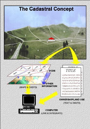
2

3 Foto: Edgar Dueri

4 Foto: Ximena Pereira

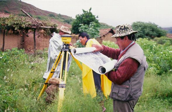
5 Foto: Eric Lawrie

6 Foto: Eric Lawrie

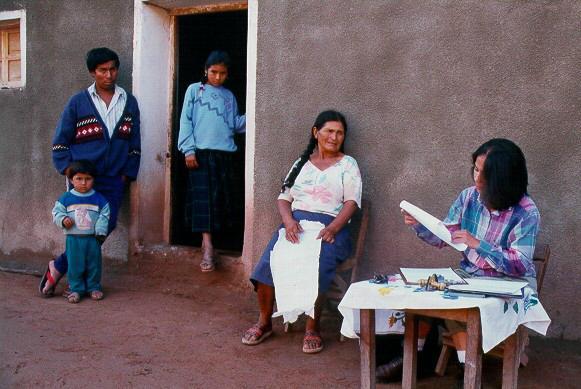
7 Foto: Raul Guarachi
8 If one buys a piece of land from someone else, how can this person be sure the other one is the real owner of all land involved?
9 If one buys a piece of land how can he or she be sure this land is not included in a TCO (TierrasComunitarias de Origen) area? Or in a communidad?
10 If one wants to invest in new buildings or in agricultural development and wants to establish mortgage, how can the bank be sure that the person requesting the mortgage holds the ownership on the complete land?
11 If one buys a piece of land how can he or she be sure this specific piece of land is free of mortgage?
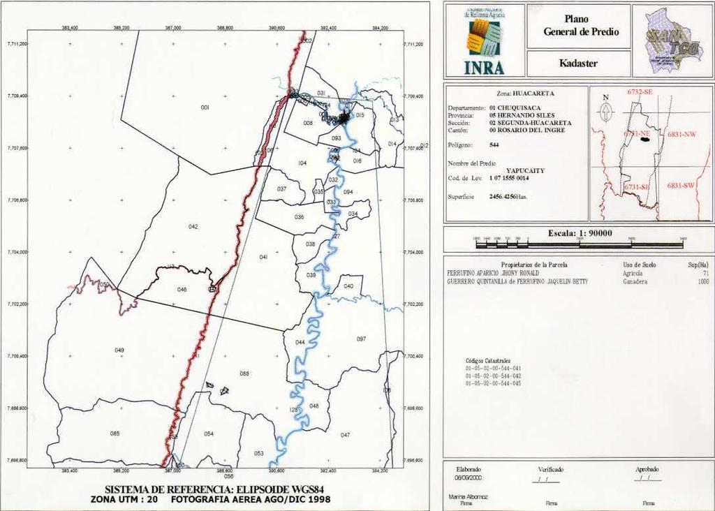
12 Chuquisaca Project, Bolivia 5.1 million ha Data collection, data cleaning Design of a maintenance proces Database and application
13

14 Information to the Public

15 Aerial Photographs

16 Data Collection: Field Office
17 Data Collection
18 Data Collection

19 Data Collection
20 Data Collection
21 Data Model Parcel Apartment Object Subject NP NNP Right Ownership Usofruct Use Mortgage Other Informal Rights
22 Model of Maintenance Cadastre Object Subject Input Right Output Throughput Feedback
23 Model of Maintenance Cadastre Object Subject Users Input Right Output Users Throughput Feedback
24 Users Insurance Companies Surveyors Brokers Provinces CentralGovernment Cadastre Notary Banks Citizens Municipalities Companies for Public Services National Bureau of Statistics
25 Basic Components Deeds Public Registers Cadastral Register Cadastral Map Cadastre Field Sketches
26 Relations Object Right Subject Parcel 1 20 ha Ownership 1/1 NP Juan
27 Relations Object Right Subject Parcel ha Ownership 1/2 NP Carlos Ownership 1/2 NP Juanita
28 Relations Object Right Subject Parcel ha Ownership 1/1 NNP TCO
29 Relations Object Right Subject Parcel 4 Parcel 5 70 ha 10 ha Ownership 1/1 Ownership 1/1 NNP Municipality
30 Relations Object Right Subject Parcel 6 50 ha Ownership 1/2 NP Javier Ownership 1/2 NP Johanna Usufruct NNP TCO
31 Relations Object Right Subject Parcel 7 20 ha Informal NP Peter
32 Relations Object Right Subject Parcel 8 1 ha Ownership 1/2 Ownership 1/2 NP Leo Parcel 8 =>Part 1 Apartment NP Jan Parcel 8 =>Part 2 Apartment

33 Foto: Raul Guarachi

34 Foto: Eric Lawrie
35 Transaction: Establishment of Mortgage Object Right Subject Parcel 9 1 ha Ownership 1/1 NP Jan Parcel 9 1 ha Ownership 1/1 NP Jan Mortgage $ NNP Bank
36 Transacción: Constitución dehipoteca Object Right Subject Parcel 10 5 ha Ownership 1/2 NP Pedro Ownership 1/2 NP Juanita Parcel 10 5 ha Ownership 1/2 NP Pedro Ownership 1/2 NP Juanita Mortgage $ NNP Bank
37 Transaction: Division Object Right Subject Parcel 11 5 ha Ownership 1/1 NP Maria Parcel 12 3 ha Ownership 1/1 NP Maria Parcel 13 2 ha Ownership 1/1 NNP Municip

38 Cadastral Map
39
40
41
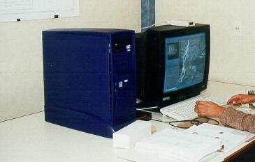
42 Platform Oracle 8i (Oracle) GeoMedia Professional (Intergraph) Windows 2000 (Microsoft) Visual Basic (Microsoft) Industrial Standards
43 SAC (Automated Cadastral System) Urban and rural cadastre Transparent Simple structure First System to maintain cadastral data in Bolivia
44 Funcionality of the SAC Cadastral maintenance (object, subject, right) Information supply Geometric data and topology Parcel identifiers + area calculation Cadastral certificate Application at national level Data security, authorisation Data conversion from other projects
45 Processes Alfa-numerical maintenance Graphical maintenance, surveying Information supply Quality improvement Management analyses Notification
46 Field survey 99-7 (orientation) T L T:tacheometer L: measuring line M: distance-series M
47 Remarks It s very easy to make a cadastral infrastructure very complex, it s very complex to make it easy Cadastre is there for it s users - not the other way around...
48 Thank you
Towards the Introduction of Workflow Management at the Netherlands Cadastre. WFM at NL Cadastre. Basic datamodel. Den Bosch G 7625
 Towards the Introduction of Workflow Management at the Netherlands Cadastre Berry van Osch Christiaan Lemmen Wednesday, May 26 2004 FIG Working Week Athens WFM at NL Cadastre Basic datamodel Nothing really
MASS VALUATION DATA FOR GOVERNMENT, CITIZENS AND BUSINESS
 Permanent Committee on Cadastre in the European Union Lithuanian Presidency PCC Conference 22-23 October 2013, Vilnius MASS VALUATION DATA FOR GOVERNMENT, CITIZENS AND BUSINESS Arvydas Bagdonavičius Deputy
Egyptian Nationwide Title Cadastre System
 Kholoud SAAD, Egypt Key words: Cadastre, Registration, Urban, Rural, National Cadastre, Automation, reengineering. SUMMARY With growing need for integrated information, Enterprise Solutions has become
SECTOR PUBLIC CADASTRES AND REGISTERS MARKET PARTICIPANTS
 E-SERVICES TO CITIZENS, GOVERNMENT AND BUSINESSES. LITHUANIA EXPERIENCE Arvydas Bagdonavičius State Enterprise Centre of Registers Arvydas.Bagdonavicius@registrucentras.lt REGISTERS AND IS MANAGED BY THE
Integration of Public Service Procedures and Use of Cadastral Data
 Integration of Public Service Procedures and Use of Cadastral Data Signe Rudzite Head of Cadastre and Register Department The State Land Service Vilnius, 21.10.2013 Content General information Current
REGISTRATION OF PROPERTIES IN STRATA
 REGISTRATION OF PROPERTIES IN STRATA REPORT ON THE WORKING SESSIONS INTRODUCTION A cadastre is usually, and in most countries, a parcel-based, and up-to-date land information system containing records
The principal tasks or competencies of the General Directorate of Cadastre are:
 4th Quality Conference 1/7 1) Title of the case. Spanish e Cadastre ( Virtual Office of Cadastre, or OVC). An open space for sustainable quality in cadastral data, working with land management administrations.
Digitalisation of the Real Property Rights Towards Spatially enabled E-Government
 Digitalisation of the Real Property Rights Towards Spatially enabled E-Government Lise Schroeder, Bent Hulegaard Jensen, Esben Munk Soerensen & Line Hvingel Istanbul, Turkey 25 june 201 Overview Introduction
Technology-driven solutions for the innovation of land administration and management
 Technology-driven solutions for the innovation of land administration and management Technology and economic growth - Studies*find link between technology innovation and national economic prosperity especially,
Cadastral Template 2003
 PCGIAP-Working Group 3 "Cadastre" FIG-Commission 7 "Cadastre and Land Management" Cadastral Template 2003 The establishment of a cadastral template is one of the objectives of Working Group 3 "Cadastre"
ParcelMap BC Compiling a Parcel Fabric for the Province of British Columbia. Presented by: Ellen Styner (General Manager) and Wendy Amy (GIS Manager)
 and Wendy Amy (GIS Manager)") ParcelMap BC Compiling a Parcel Fabric for the Province of British Columbia Presented by: Ellen Styner (General Manager) and Wendy Amy (GIS Manager) Who is MNC? MNC is a geomatics engineering firm with
ParcelMap BC Compiling a Parcel Fabric for the Province of British Columbia Presented by: Ellen Styner (General Manager) and Wendy Amy (GIS Manager) Who is MNC? MNC is a geomatics engineering firm with
GOVERNMENT OF KOSOVA MINSTRY OF PUBLIC SERVICES KOSOVO CADASTRAL AGENCY PROGRESS OF THE CADASTRE IN KOSOVO
 KOSOVO CADASTRAL AGENCY FIG Commission 7 Annual Meeting 2004 Clermont-Ferrand, France September 8-14, 8 2004 PROGRESS OF THE CADASTRE IN KOSOVO Murat MEHA E-mail: mmeha@yahoo.com Data about Kosovo About
Who we are? MIS GIS. Cadastral Data Management System in Turkey. View from MIS. View from GIS. Dr. Emin Bank MIS? GIS? IT?
 Cadastral Data Management System in Turkey Dr. Emin Bank ebank@islem.com.tr Who we are?? View from? Or? View from Nowadays and are getting closer fastly 1 Viewing from is changing Viewing from is changing
LADM-based Crowdsourced 3D Cadastral Surveying Potential and Perspectives
 National Technical University Of Athens School of Rural and Surveying Engineering LADM-based Crowdsourced 3D Cadastral Surveying Potential and Perspectives Maria Gkeli, Surveying Engineer, PhD student
A Complete, Free Solution for Cadastral Map Management
 A Complete, Free Solution for Cadastral Map Management Gyula IVÁN Institute of Geodesy, Cartography & Remote Sensing (FÖMI) HUNGARY FIG Commission 7, Annual Meeting 11-15 September 2008., Verona, ITALY
E fficient L and A dministr ation E ncour ages P r oper ty M ar k ets. surveying companies at Project commencement. Key Messages
 Secur ing Pr oper ty R ights and I ncr easing R eal E state Pr oductivity in F Y R M acedonia Victoria Stanley, Denis Boskovski and Samantha De Martino Key Messages Before 2005, FYR Macedonia did not have
Universal Geo-database Connector Interface Component (UG-CIC) For Virtual Web-base GIS Server Essential For Real Estate Industry Uses
 For Virtual Web-base GIS Server Essential For Real Estate Industry Uses") Universal Geo-database Connector Interface Component (UG-CIC) For Virtual Web-base GIS Server Essential For Real Estate Industry Uses Jad Jarroush & Dr. Kobi Zaid Zaid Orniv Group L.T.D Israel kobi_z@zaidorniv.co.il
Universal Geo-database Connector Interface Component (UG-CIC) For Virtual Web-base GIS Server Essential For Real Estate Industry Uses Jad Jarroush & Dr. Kobi Zaid Zaid Orniv Group L.T.D Israel kobi_z@zaidorniv.co.il
Ownership Data in Cadastral Information System of Sofia (CIS Sofia) from the Available Cadastral Map
 from the Available Cadastral Map") Ownership Data in Cadastral Information System of Sofia (CIS Sofia) from the Available Cadastral Map Key words: ABSTRACT Lydmila LAZAROVA, Bulgaria CIS Sofia is created and maintained by GIS Sofia ltd,
Ownership Data in Cadastral Information System of Sofia (CIS Sofia) from the Available Cadastral Map Key words: ABSTRACT Lydmila LAZAROVA, Bulgaria CIS Sofia is created and maintained by GIS Sofia ltd,
Hungarian Cadastre and its relation to LADM
 Hungarian Cadastre and its relation to LADM Gyula IVÁN CLGE General Assembly 22 March 2013, Budapest, HUNGARY Content Historical background Evolution of Cadastral modeling in Hungary LADM issues Conclusion
The Role of the Swedish Land Information System
 The Role of the Swedish Land Information System In the Business Society Tommy Österberg Swedesurvey 1 SWEDEN 9 million inhabitants 450 000 sq. km 21 Counties 291 Municipalities 4.6 million properties in
Amalia Velasco Carlos Alonso Luis Virgos Fernando Serrano
 Inspire services of the Spanish Directorate General for Cadastre and its use to resolve an old problem of coordination between Spanish Cadastre and Land Registry. Amalia Velasco Carlos Alonso Luis Virgos
DATR towards e-land Administration in Hungary
 DATR towards e-land Administration in Hungary Gyula IVÁN-Gábor SZABÓ-Zoltán WENINGER-Piroska Zalaba Institute of Geodesy, Cartography and Remote Sensing, Budapest, HUNGARY XXIV. FIG Congress Facing the
The Development of the Austrian Cadastre from Documentation to an Integrated Planning and Decision Support System
 The Development of the Austrian Cadastre from Documentation to an Integrated Planning and Decision Support System WPLA - Working Party on Land Administration 15-17 October 2014, Vienna, Austria Wernher
A Radical Solution for the Cadastre Problem in Egypt Using Integrated GPS-GIS System
 A Radical Solution for the Cadastre Problem in Egypt Using Integrated GPS-GIS System Dr. Ehab NABIL NASSIF, Egypt Key words: ABSTRACT During the period 1897-1907 the cadastral surveying of Egypt was established.
Country report, HUNGARY
 Country report, HUNGARY Gyula IVÁN Institute of Geodesy, Cartography & Remote Sensing (FÖMI) HUNGARY FIG Commission 7 Annual Meeting 2009 12-16 October, 2009, Kuala Lumpur, Malaysia Institute of Geodesy,
Spatial Data Infrastructure in Sweden
 Spatial Data Infrastructure in Sweden Hans-Erik WIBERG, Sweden Key words: ABSTRACT Sweden was one of the first countries to address Data Infrastructure matters and have during several decades developed
Cloud GIS Real Estate Management, Appraisal and Development Service USING ESRIs ARCGIS SERVER
 Cloud GIS Real Estate Management, Appraisal and Development Service USING ESRIs ARCGIS SERVER INFODIM: Was founded on 1992 and is internationally certified as a GIS company from D&B Dun & Bradstreet Global
COUNTRY REPORT ON CADASTRE AND LAND REGISTRAION IN IRAN. By: Hamid Berenjkar, IRAN
 COUNTRY REPORT ON CADASTRE AND LAND REGISTRAION IN IRAN By: Hamid Berenjkar, IRAN Key words: Comprehensive Cadastre, Cadastre System, Cadastral Survey, Land Book, Iran ABSTRACT Land registration and cadastral
The Egyptian Unified Cadastral Data Model
 The Egyptian Unified Cadastral Data Model Shokry Abd-el-Malak ROFAIL and Ashraf YOUSSEF, Egypt Key words: Standards, Cadastre, Information Society, Data Sharing. SUMMARY The Necessity to share data is
A NOMINAL ASSET VALUE-BASED APPROACH FOR LAND READJUSTMENT AND ITS IMPLEMENTATION USING GEOGRAPHICAL INFORMATION SYSTEMS
 A NOMINAL ASSET VALUE-BASED APPROACH FOR LAND READJUSTMENT AND ITS IMPLEMENTATION USING GEOGRAPHICAL INFORMATION SYSTEMS by Tahsin YOMRALIOGLU B.Sc., M.Sc. A thesis submitted for the Degree of Doctor of
Agenda Project Overview Project Objectives Registration Service Re-Engineering System Overview
 Agenda Project Overview Project Objectives Registration Service Re-Engineering System Overview Sydney, Australia, 11 16 April 2010 1 Project Overview Future Vision There is a vision within senior levels
Cadastre and the crowd: a brief encounter or a long-lasting marriage?
 Cadastre and the crowd: a brief encounter or a long-lasting marriage? Martin Salzmann Cadastre, Land Registry and Mapping Agency The Netherlands PCC Conference Towards Digital Europe and Spatially Enabled
Value Chain Mapping. 3D Cadastre and Valuation The Added Value of 3D Geo-information Richard Witmer, Kadaster NL, 30 March 2017
 Value Chain Mapping 3D Cadastre and Valuation The Added Value of 3D Geo-information Richard Witmer, Kadaster NL, 30 March 2017 Agenda Purpose: why look at 3D cadastre and valuation? Approach: what we did.
ParcelMap BC. Compiling a Parcel Fabric for the Province of British Columbia. WENDY AMY and ELLEN STYNER
 ParcelMap BC Compiling a Parcel Fabric for the Province of British Columbia WENDY AMY and ELLEN STYNER Who is MNC? Established in 1997, MNC is a geomatics engineering firm located in Calgary, Alberta.
COMPUTERIZED SYSTEM SUPPORTING DEVELOPMENT OF LAND MARKET IN GEORGIA
 COMPUTERIZED SYSTEM SUPPORTING DEVELOPMENT OF LAND MARKET IN GEORGIA S. G. TSIRAMUA, I. S. MELASHVILI Land Registration Unit of Government of Georgian, World Bank and IFAD Agriculture Development Project.
The Multi Purpose Cadastre, a network approach
 The Multi Purpose Cadastre, a network approach Peter Laarakker, Kadaster NL 1 Content 1. Introduction 2. Multi purpose cadastre 3. Definitions 4. Cadastral boundaries 5. Real property right 6. Conclusions
DATR Towards e-land Administration in Hungary
 DATR Towards e-land Administration in Hungary Gyula IVÁN, Gábor SZABÓ, Zoltán WENINGER, Piroska ZALABA, HUNGARY Key words: Land Registry, Cadastre, Land Administration, GIS SUMMARY DATR has been the most
Information contained
 Cadastral Integrity Unit Audit Survey Procedures August 2012 Table of Contents Introduction... 2 2. Objectives... 3 3. Roles, responsibilities and delegations... 4 3.1 Ethical conduct... 4 3.2 Workplace
GOVERNMENT. Case Study Ville de Trois Rivières streamlines property assessment
 GOVERNMENT Case Study Ville de Trois Rivières streamlines property assessment GIS-generated parcel basemap provides powerful visualization & analysis capabilities With a population of just over 130,000,
ABSTRACT Land Administration System in Lithuania
 ABSTRACT Land Administration System in Lithuania 1. General introduction to the Lithuanian Land Administration System and State Enterprise Centre of Registers ( shortly SECR) Lithuania has established
Functional system for cadastral plans
 , Republic of Macedonia Key words: Cadastre, Digital plans, Data, System SUMMARY The analysis shows that the real estate market in Republic of Macedonia grows daily. With the expansion of this market increases
Annual Meeting 2006 SLOVENIA, BLED RASAS GOFMANAS JAUNIUS GRIGAS RIMANTAS RAMANAUSKAS KESTUTIS TRECIOKAS
 Annual Meeting 2006 SLOVENIA, BLED LAND ADMINISTRATION IN LITHUANIA RASAS GOFMANAS JAUNIUS GRIGAS RIMANTAS RAMANAUSKAS KESTUTIS TRECIOKAS ADMINISTRATIVE STRUCTURE OF LITHUANIA HISTORY OF LAND ADMINISTRATION
The Journey to 100% Electronic Survey. Land Information New Zealand. August 2009
 The Journey to 100% Electronic Survey and Title Lodgement Land Information New Zealand August 2009 Land Information New Zealand Established 1996 Titles, Survey, Geodetic, Electoral 12 locations 500 staff
FUTURE VISION ON KOREAN CADASTRAL SURVEYING
 FUTURE VISION ON KOREAN CADASTRAL SURVEYING Myounwoo LEE, Vice President, Korea Cadastral Survey Corporation, Korea 1. INTRODUCTION Cadastral surveying, which contributes to secure the ownership of the
Development of 3D Cadastre in Hungary
 Development of 3D Cadastre in Hungary András OSSKÓ Gyula IVÁN CLGE General Assembly 22 March 2013, Budapest, HUNGARY Content Introduction Problems in development of 3D cadastre and registration Hungarian
LIS a motivation for SDI initiative
 Eric Mwaikambo Ardhi University Dar es Salaam Tanzania Overview Status of LIS in Tanzania Relationship between SDI and LIS Spatial Standards LIS a motivation for SDI initiative Conclusion & Recommendations
Possible integration of Information via a system of KEY REGISTERS. IMOLA PROJECT WS 1-2nd Seminar Athens, 6th October 2014
 Possible integration of Information via a system of KEY REGISTERS IMOLA PROJECT WS 1-2nd Seminar Athens, 6th October 2014 OUTPUT QUESTIONNAIRE Questions only partly understood unclear LR belong to system
LAND ADMINISTRATION DEVELOPMENTS IN RWANDA
 LAND ADMINISTRATION DEVELOPMENTS IN RWANDA, Rwanda Key words : Land tenure security, land registration, land rights, land commissions. SUMMARY : The new Rwandan land policy consider appropriate land administration
The Cadastral Template 2.0, From Design to Implementation
 Abbas RAJABIFARD (Australia), Daniel Steudler (Switzerland), Ali AIEN, and Mohsen KALANTARI, Australia Key words: Cadastral Template 2.0, Cadastral Template Project, Land Administration, PCGIAP SUMMARY
Bureau of Land Management
 Bureau of Land Management MAPPS Federal Update Donald Buhler Cadastral, Lands, and Realty Management April 1, 2014 Division of Cadastral, Lands and Realty Management 1 BLM Mission Manages 247 million surface
Integrating Electronic Platform (IPE) as a Basic Component of Cadastral System in Poland
 as a Basic Component of Cadastral System in Poland") Integrating Electronic Platform (IPE) as a Basic Component of Cadastral System in Poland Hans KNOOP, Germany and Wojciech WILKOWSKI, Poland Key words: cadastal system, cadastral objects, computerisation
Integrating Electronic Platform (IPE) as a Basic Component of Cadastral System in Poland Hans KNOOP, Germany and Wojciech WILKOWSKI, Poland Key words: cadastal system, cadastral objects, computerisation
Vietnam Land Administration - the Past, Recent and for the Future
 Mr. Ton Gia Huyen, Former Director General of General Department of Land Administration and Mrs. Tran Thi Minh Ha, Director of International Relation Department, Ministry of Natural Resources and Environment,
SCOPE OF PRESENTATION
 INTERNATIONAL SYMPOSIUM AND EXHIBITION ON GEOINFORMATION Global Trends: Geoinformation For The New Economy Studies Toward the Development of Implementation Plan Of Coordinated Cadastral System for Peninsular
City of Surrey s Digital Plan Submission Process
 City of Surrey s Digital Plan Submission Process Cadastral Update Karen Stewart, B.Tech. (GIS) Spatial Information Manager Peter Mueller, B.C.L.S., C.L.S. Survey Manager City of Surrey, British Columbia,
Integrated Cadastral System (ICS) of Poland Supported by the European Union
 of Poland Supported by the European Union") Integrated Cadastral System (ICS) of Poland Supported by the European Union Prof. Hans KNOOP, Germany and Prof. Wojciech WILKOWSKI, Poland Key words: Cadastral System, Cadastral Objects, Computerisation
Integrated Cadastral System (ICS) of Poland Supported by the European Union Prof. Hans KNOOP, Germany and Prof. Wojciech WILKOWSKI, Poland Key words: Cadastral System, Cadastral Objects, Computerisation
Engr. Juan P. Fernandez, Jr. Chief, Surveys and Mapping Division DENR Region-3 Club Royale Hotel, Malolos, Bulacan February 27,2016
 Engr. Juan P. Fernandez, Jr. Chief, Surveys and Mapping Division DENR Region-3 Club Royale Hotel, Malolos, Bulacan February 27,2016 ! DAO 2007-29 issued on July 31, 2007 re Revised Regulations on Land
PROPERTY TAX TIPS AND TRICKS
 PROPERTY TAX TIPS AND TRICKS Presented By: Vicki Chiasson & Wes Pogorzelski PROVEN GOVERNMENT TECHNOLOGY LEADERSHIP Enhanced Levy Calculation Tax levies take a long time to generate Corrections may require
LRIMS Cadastre Module
 LRIMS Cadastre Module User Requirements and Functionality (Seychelles Case Study) John Latham, NRL Renato Cumani, NRL Luigi Simeone, NRL Summary Background User Requirements Business Model Application
Implementing a Cadastre in Internet in Poland
 Marcin KARABIN, Poland Key words: cadastre, Internet access to cadastre SUMMARY In Poland cadastre is maintained on a district level (each province is divided into district units in Polish powiat which
Systematic Land Information Management (SLIM)
") Systematic Land Information Management (SLIM) By Mr. Jukka Nieminen Jaakko Pöyry Infra Soil and Water Ltd. Expert Group Meeting on Secure Land Tenure: New Legal Frameworks and Tools Nairobi 12 November
Systematic Land Information Management (SLIM) By Mr. Jukka Nieminen Jaakko Pöyry Infra Soil and Water Ltd. Expert Group Meeting on Secure Land Tenure: New Legal Frameworks and Tools Nairobi 12 November
Marine Spatial Data Infrastructure (MSDI) & The Marine Cadastre Application. April 10, 2018
 & The Marine Cadastre Application. April 10, 2018") Marine Spatial Data Infrastructure (MSDI) & The Marine Cadastre Application April 10, 2018 A Collaborative Pilot Project Vision of CHS: A framework of geographic data, metadata, users and tools Intent
Marine Spatial Data Infrastructure (MSDI) & The Marine Cadastre Application April 10, 2018 A Collaborative Pilot Project Vision of CHS: A framework of geographic data, metadata, users and tools Intent
STATE LAND AUDIT REPORT
 STATE LAND AUDIT REPORT 1 Presentation to the Portfolio Committee on Rural Development and Land Reform M514 Marks Building 30 March 2011 CHIEF SURVEYOR GENERAL Mr M RIBA Content 2 Background Project Objectives
LAND CADASTRE AND BUILDING CADASTRE IN SLOVENIA: CURRENT SITUATION AND POTENTIAL OF 3D DATA
 3D Cadastres Organizational and Governmental Aspects LAND CADASTRE AND BUILDING CADASTRE IN SLOVENIA: CURRENT SITUATION AND POTENTIAL OF 3D DATA EMA POGORELČNIK AND MARINA KOROŠEC Surveying and Mapping
Integrated Land Information System (ILIS) A Concept Paper
 A Concept Paper") Commissionerate of Survey, Settlements and Land Records Government of Andhra Pradesh Integrated Land Information System (ILIS) A Concept Paper 1 Introduction Land is the essence of human civilization.
Commissionerate of Survey, Settlements and Land Records Government of Andhra Pradesh Integrated Land Information System (ILIS) A Concept Paper 1 Introduction Land is the essence of human civilization.
Saulius Milevičius, Lithuanian Surveyors Association Head of the Internet Map Application Designing Group SE Centre of Registers
 LITHUANIAN EXPERIENCE IN CADASTRE Saulius Milevičius, Lithuanian Surveyors Association Head of the Internet Map Application Designing Group SE Centre of Registers Jolanta Česnauskienė, Jolanta Česnauskienė,
Mandatory use of notaries becoming unnecessary?
 NORWEGIAN MAPPING AUTHORITY SPATIAL DATA FOR THE BENEFIT OF SOCIETY Mandatory use of notaries becoming unnecessary? Helge Onsrud Director Centre for Property Rights and Development NORWEGIAN MAPPING AUTHORITY
Surveying in Austria. Congress Maanmittauspäivät Seinäjoki, 20 th March 2014
 Surveying in Austria Congress Maanmittauspäivät Seinäjoki, 20 th March 2014 Topics Facts, figures Organisational issues of surveying Role of the BEV Products, services The Cadastre Surveying Education
Implementing Norwegian funded projects with the State Geodetic Administration in Croatia
 Implementing Norwegian funded projects with the State Geodetic Administration in Croatia Fredrik Steiwer Managing Director Project Management and Mapping AS PMM? Project Management and Mapping AS (PMM)
Cadastral Information System of Sofia
 Alexander LAZAROV and Hristo DECHEV, Bulgaria Key words: ABSTRACT A new Cadastre and Property Register Act (CPRA) was passed in April 2000, setting up rules for the maintenance of these two registers.
DATACOMMUNICATION: A LIFELINE BETWEEN LAND ADMINISTRATION ORGANIZATIONS AND SOCIETY
 DATACOMMUNICATION: A LIFELINE BETWEEN LAND ADMINISTRATION ORGANIZATIONS AND SOCIETY Prof. Paul VAN DER MOLEN, The Netherlands Keywords: land administration, datacommunication, electronic conveyancing,
Commission No : 5 RCBMS : OVERVIEW
 RFID-Based Cadastral Boundary Mark System (RCBMS Abdullah Hisam Omar Tajul Ariffin Musa Ivin Amri Musliman Siti Syukriah Khamdan Kamaludin Omar Universiti Teknologi Malaysia Email: abdullahhisham@utm.my
Development of e-land Administration in Sweden
 Development of e-land Administration in Sweden Roger EKMAN, Sweden Key words: e-land Administration, e-cadastre, delivery times, process development SUMMARY A characteristic of the Swedish cadastral procedure
Developments in the Standardisation of the Core Cadastral Domain Model
 Developments in the Standardisation of the Core Cadastral Domain Model Christiaan Lemmen, Paul vander Molen Kadaster and ITC, The Netherlands Peter van Osterom, Jaap Zevenbergen and Wilko Quak Delft University,
Italian Cadastre and Real Estate Rights and Mortgages Registration System
 CLGE General Assembly Italian Cadastre and Real Estate Rights and Mortgages Registration System Franco Maggio Central Director Cartography, Cadastre and Real Estate Rights and Mortgages Registration System
Object Oriented Unified Real Estate Registry for a Good Spatial Data Management
 Object Oriented Unified Real Estate Registry for a Good Spatial Data Management Gyula IVÁN Gábor SZABÓ Zoltán WENINGER Institute of Geodesy, Cartography and Remote Sensing (FÖMI), Hungary Workshop on e-governance,
Test and Implementation of DATR System in Hungary
 Test and Implementation of DATR System in Hungary, Hungary Key words: unified land registry, cadastral map, Hungary SUMMARY During the last years there has been an important development in the Hungarian
New Developments in the Hellenic Cadastre
 New Developments in the Hellenic Cadastre Prof. M. Kavouras Vice-president Ktimatologio S.A. (Hellenic Cadastre) The Hellenic Cadastre Background The Hellenic National Cadastre Organizational and institutional
Unified Land Administration for a Better Spatial Infrastructure
 Unified Land Administration for a Better Spatial Infrastructure Gyula IVÁN Institute of Geodesy, Cartography & Remote Sensing FÖMI (HUNGARY) Open Symposium 30th Korean Cadastral Seminar & FIG Commission
Shaping the Cadastral Infrastructure for a Digital Future
 DEPARTMENT OF LANDS PLANNING and the ENVIRONMENT Shaping the Cadastral Infrastructure for a Digital Future Craig Sandy Director Surveys Surveyor General Survey Branch NT Australia Digital Cadastral Databases
Utilizing 3D Building and 3D Cadastre Geometries for Better Valuation of Existing Real Estate
 Utilizing 3D Building and 3D Cadastre Geometries for Better Valuation of Existing Real Estate Umit ISIKDAG Beykent U., Turkey Mike HORHAMMER Oracle, USA Sisi ZLATANOVA, Peter VAN OOSTEROM TU Delft, The
Problems and Solution Proposals in Integration of Cadastral Data into Geographical Information System (GIS) in Turkey
 in Turkey") Problems and Solution Proposals in Integration of Cadastral Data into Geographical Information System (GIS) in Turkey Gülgün OZKAN, S. Savas DURDURAN, Ali ERDI and Bilal GIRGIN, Turkey Key words: Cadastre,
Problems and Solution Proposals in Integration of Cadastral Data into Geographical Information System (GIS) in Turkey Gülgün OZKAN, S. Savas DURDURAN, Ali ERDI and Bilal GIRGIN, Turkey Key words: Cadastre,
NEIGHBORHOOD MEETING
 NEIGHBORHOOD MEETING Community Development Department 8101 Ralston Road Arvada, Colorado 80002 NEIGHBORHOOD MEETINGS The City of Arvada promotes citizen participation in the development review process.
Development of Cadastral Survey and Land Ownership Registration System in Mongolia
 Development of Cadastral Survey and Land Ownership Registration System in Mongolia M.Saandar,, Ph. D Vice President, the Mongolian Association of Surveying and Mapping, ( As National Member of FIG ) MonMap
Theme Strategic Plan for Cadastral Theme
 Theme Strategic Plan for Cadastral Theme Bureau of Land Management Cadastral Survey Federal Geographic Data Committee (FGDC) 2017 2021 April 2017 - Progress and Update Cadastral Theme Implementation Plan
The implementation of the European Land Registry Document in EU Member States
 The implementation of the European Land Registry Document in EU Member States Presentation by the ELRN member of Finland Henrik Ungern Chief legal counsel 28th January 2016, IMOLA closing conference 2
Land policies and land reforms in China: current situation and lessons to be learned for the future Dr. Michael Klaus
 Land policies and land reforms in China: current situation and lessons to be learned for the future Dr. Michael Klaus Presentation at 6 th International Summer School 2014 - Comprehensive Land Policy -
Esri Middle East and Africa User Conference. December Abu Dhabi, UAE. Land Administration. Mark Baker
 Esri Middle East and Africa User Conference December 10 12 Abu Dhabi, UAE Land Administration Mark Baker Our Agenda 0900 0930 Welcome Mark Baker, Esri 0930 1030 New Directions The New Addressing System
GIS and Land Records Integration A PRIA White Paper
 110 Horizon Drive, Suite 210, Raleigh, NC 27615 919.459.2081 GIS and Land Records Integration A PRIA White Paper Adopted by the PRIA Board on December 20, 2017 www.pria.us/ GIS and Land Records Integration
Technological Aspects of Land Administration Systems in the West Balkans
 Technological Aspects of Land Administration Systems in the West Balkans Ivan ALEKSIĆ, Serbia, Christiaan LEMMEN, The Netherlands and Suleiman DABASS, Serbia Key words: Land Administration and Cadastre,
IT-SUPPORTED STATE-LAND MANAGEMENT IN A TRANSITIONAL ENVIRONMENT
 IT-SUPPORTED STATE-LAND MANAGEMENT IN A TRANSITIONAL ENVIRONMENT - Examples from Eastern Germany and Mongolia - TOPICS 1 S LAND INFORMATION SYSTEM History and main components IT-strategy and development
New Danish e-cadastre and its role in the Danish e-government
 New Danish e-cadastre and its role in the Danish e-government PCC Budapest 2011 Pia Dahl Højgaard, pdh@kms.dk Cadastre and Legal Authority, National Survey and Mapping, Denmark The danish context Neighbours
REGIONAL GEOINFORMATION ENVIRONMENT REGIA
 REGIONAL GEOINFORMATION ENVIRONMENT REGIA Eglė Rimkienė Deputy Chief of Address Register Data Administration Division, State Enterprise Centre of Registers E-mail: Egle.Rimkiene@registrucentras.lt REGIONAL
Common Vision Conference Tradition meets Innovation Vienna, Austria,October 5-6, 2017
 The impact of digitization: how participatory will the cadastre function be in the future? Martin Salzmann Cadastre, Land Registry and Mapping Agency The Netherlands Common Vision Conference Tradition
Support to Implementation of Multipurpose Cadastral Information system in Vietnam
 Support to Implementation of Multipurpose Cadastral Information system in Vietnam Lennart JOHANSSON and Per SÖRBOM, Sweden Key words: Land Registration, Land Information, Land Administration, SWOT analyse,
Reliability of the Italian cadastral system data quality and improvement prospects
 Reliability of the Italian cadastral system data quality and improvement prospects Eng. Franco MAGGIO (Central Director for Cadastral, Cartographic and Land Registration Services) Eng. Arturo ANGELINI
SUBDIVISION AND LAND DEVELOPMENT ORDINANCE
 SUBDIVISION AND LAND DEVELOPMENT ORDINANCE County SALDO Update June 16, 2016 Agenda SALDO Background SALDO Structure Goals and Updates Schedule and Next Steps Current SALDO Adopted by the County in 1981
FGDC SUBCOMMITTEE FOR CADASTRAL DATA. October 2004 Albuquerque, New Mexico Meeting
 FGDC SUBCOMMITTEE FOR CADASTRAL DATA October 2004 Albuquerque, New Mexico Meeting The National Spatial Data Infrastructure is the means to assemble geographic information that describes the arrangements
Preprint.
 http://www.diva-portal.org Preprint This is the submitted version of a paper presented at 10th EC GI & GIS Workshop, ESDI State of the Art, Warsaw, Poland, 23-25 June 2004. Citation for the original published
Illinois Farmland Sales Database
 Illinois Farmland Sales Database With this program, the user can analyze actual Illinois farmland sales data from 1979 through 1999 along with associated price forecasts for 2000. Fast Tools & Resources
Cadastre in Addis Ababa. Status and future development
 Status and future development Dr.-Ing. Paul Hartfiel Mülheim, 1. Oct. 2010-1 - Addis Ababa Capital of Ethiopia Area population 540 km² > 3,200,000 (rapidly growing) 2,300,000 in 1994 > 22% of all urban