Implementation Strategy
|
|
|
- Tobias Martin
- 5 years ago
- Views:
Transcription


1 7 Implementation Strategy Trail - Raleigh, NC Introduction The Zebulon Greenway Master Plan is an overall vision and foundation for implementation of the system illustrated. The town would be challenged to fund the system illustrated without financial partners and funding support. In the pursuit of funding for implementation, a master plan is typically required by granting agencies. It is important to these agencies and other funding sources that the town has a plan and a vision. The primary purpose of this master plan is to illustrate the town s vision for the greenway system. Secondarily, the master plan provides a reasoned approach to implementation identifying priority corridors and projects that meet defined criteria and are likely to be active, successful and will build interest and momentum for continued implementation. How to Use this Plan The master plan will be used by town staff and the development community to answer the following questions: What are the benefits of greenways? Trail - Raleigh, NC Where are future trails, pedestrian and bicycle improvements going to occur? What is the scope of work associated with each corridor? How much do future trails, pedestrian and bicycle improvements cost? What are typical construction methods, details and amenities associated with greenways? What is involved in the maintenance and operations of a greenway trail? Public Policy The master plan is the basis of a town policy to require the dedication of land or easements for greenway implementation and / or the construction of greenway trails as well as other pedestrian and bicycle improvements as development projects come before the town for approval. Other methods of implementation will be contingent upon town support and funding, as well as funding from grants (see chapter 8 for potential grant funding sources) and other sources public and private. Partnerships between the town, the development community and other public agencies will be required to fulfill the vision illustrated by the master plan. Implementation Strategy 87

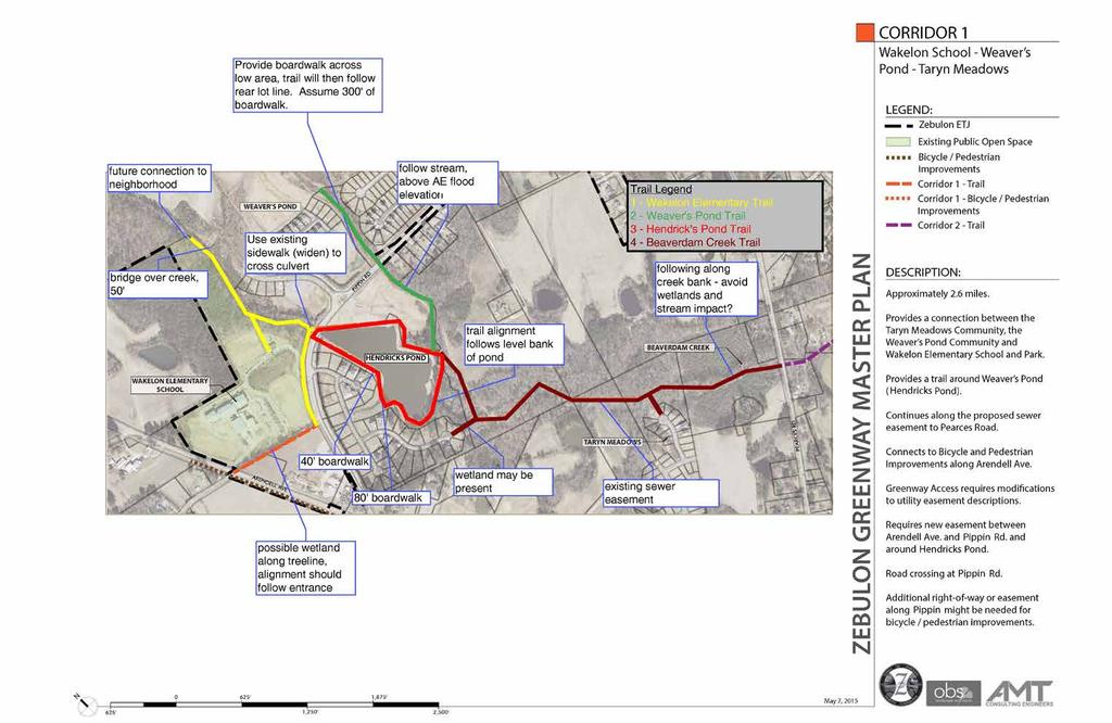
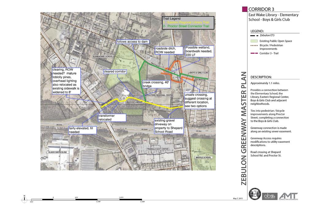
2 Priority Projects Based on the evaluation criteria defined in chapter 3 of this report two greenway projects were identified for the evaluation of probable associated costs. Within a corridor, there can be several projects. These projects were part of Corridor 1 and Corridor 3. The Corridor 1 project includes a paved greenway trail from the cul-de-sac of Spiderlily Court in the Taryn Meadows neighborhood to Pippin Road and including the trail around Hendricks Pond in the Weavers Pond neighborhood. The Corridor 3 project connects the Wake County Branch Library and Eastern Regional Center to the Zebulon Elementary School and the Boys and Girls Club as well as adjacent residential development. This project includes a greenway trail, but also includes improvements along Proctor Street and Old Bunn Road and intersection improvements at the intersection with Shepard School Road. In addition, an urban corridor connecting the Wakelon Heights neighborhood downtown to the Farmers Market also was evaluated in terms of pedestrian and bicycle improvements and probable costs associated. Maps specific to these projects and an estimate of probable construction cost follow at the end of this chapter. Implementation Process Below is an outline of the general process for building a greenway. This may change slightly for each project based on site constraints, grant requirements, community process, etc. Identify Funding Sources One of the first steps for a greenway project is to identify funding sources. This can happen before easement acquisition or after depending on the project. Funding sources may be within the Town budget, from grant sources, or from Public/Private partnerships. A project may be funding from one or a combination of these sources. Shiloh Greenway in Morrisville under construction The Town may choose to pursue these sources independently or they may hire a consultant to create and submit grant applications. This depends on the specific grant and the information required for the application. (Grants are covered in more detail in Chapter 8 - Funding Sources) It is important to note that depending on the grant requirements, there may be additional review, permits, and approvals from the grant agency throughout the design and construction of a project. These requirements should be identified early in the process and noted to the consultant hired to design and perform construction administration services for the project. Easement Acquisition One of the first steps for any greenway project is greenway easement acquisition. This may vary from project to project based on whether easements will be required from private property owners or if a greenway easement overlay is needed on an existing utility easement. A typical greenway easement is anywhere from depending on the area. This easement consists of a protected buffer as well as room for trail construction. Survey Easement acquisition and trail design will require detailed survey information of the corridor. At a minimum, the survey will need to include the following: Topographic information Location of any key features Stream Buffers including top of bank location Wetlands Any rock formations Boundary of the greenway easement Property lines 88 Implementation Strategy
3 Property owner information Location of any and all utility structures Roads and Rights of Way Greenway Corridor Design During this phase of the project the Town will need to hire a design consultant to further design the trail. This includes community involvement, trail layout, grading, erosion control, preliminary cost estimates, and specific details pertaining to the project. This phase may also include reviews required by the grant source. Documents documents must be prepared to further detail and define a project for bidding and permitting and construction. The Town should also require a final cost estimate at the end of this phase in the project. Permitting Permitting requirements will vary per project. More detail can be found on permitting in the Design Guidelines section of this report (Chapter 9). Some of the typical permit agencies that may be required are: North Carolina Department of Environment and Natural Resources Town of Zebulon In some cases Wake County NC Department of Transportation Administration The Town will hire a consultant to work in conjunction with Town staff to manage the project during construction. Some grants may also require approvals during construction. For example, NCDOT funding requires that NCDOT work with a certified engineer to approve construction during the construction process. Trail Maintenance Each trail project will require maintenance after completion. Depending on the trail and its features, these maintenance costs will vary. The Town may want to request that the design team work with the Town to identify approximate maintenance costs for the first few projects. Identify Funding Sources - Town Sources - Grants - Public/Private Partnerships Greenway, Bicycle & Pedestrian Master Plan Documents - Client Meetings / Review - Final Documents - Final Cost Estimate Administration - Grant Approvals (if required) - Bidding Process - Periodic Inspections - Project Closeout Easement Acquisition - From private property owners where necessary - Greenway easement overlay in existing utility easements Survey - Obtain survey for easements, topography, specical features, and any other data needed for plans. Trail Design - Community Engagement - Layout & Grading Design - Preliminary Cost Estimate - Grant Approvals (if required) Trail Permitting - Community Engagement - Layout & Grading Design - Preliminary Cost Estimate - Grant Approvals (if required) Trail Maintenance - Routine Inspections - System for users to identify needed maintenance - Routine Maintenance Greenway Implementation Flow Chart Implementation Strategy 89
4 Zebulon Greenway Rough Order of Magnitude Cost Estimate 9/18/2015 Corridor 1 Total Length, feet Bridges or Boardwalk, feet Property Acquisition Difficultly to build Design Estimate, Property Acquisition Inspection and Oversight, Wakelon Elementary Trail New No Some challenges, but fairly easy 70, , , , Wakelon Elementary Trail 5' to 10' No Very easy 10, , , , Weaver's Pond Trail No Could be tough if ditch has capacity volume 68, , , , Hendricks Pond Trail No Very easy if use maintenance road 66, , , , Beaverdam Creek Trail Yes Fairly easy, property easement may be needed to access utility easement alignment ROM/ linear foot ROM Trail Cost, 70, , , , Total Cost Corridor 1 286, ,336, , ,908, Corridor 3 Total Length, feet Bridges or Boardwalk, feet Property Acquisition Difficultly to build Design Estimate, Property Acquisition Inspection and Oversight, Eastern Regional Library Trail Yes Not so easy, ROW, utilities, wetland 61, , , , , Proctor Street Connector Yes Deep roadside ditch, land needed, wetland, with an unsafe crossing ROM/ linear foot ROM Trail Cost, 90, , , , , Total Cost Corridor 3 151, , , , ,009, * Rough Order of Magnitude (ROM) cost is based on 800,000 per mile and is adjusted for each corridor based upon difficulty to construct **500/linear foot for boardwalk or bridge ** Design estimate includes geotechnical engineering, survey, permitting Town of Zebulon Urban Trail Total Length, feet Bridges or Boardwalk, feet Property Acquisition Difficultly to build Design Estimate, Property Acquisition Inspection and Oversight, ROM/ linear foot ROM Sidewalk Cost, (Whitley Park to Community Center) Yes Approximately half of sidewalk exists 45, , , , , This trail is estimated based upon a 6' width, 4" concrete sidewalk. The total length of the trail is 5230 linear feet, and the estimate is for the construction of sidewalk only where existing sidewalk is not found Priority Corridor Cost Estimates 90 Implementation Strategy
5 Implementation Strategy 91
6 Implementation Strategy 92

7 Urban Trails Opportunities and Constraints Implementation Strategy 93
INTERLOCAL AGREEMENT FOR LEESVILLE BRANCH LIBRARY BETWEEN CITY OF RALEIGH, NORTH CAROLINA AND WAKE COUNTY, NORTH CAROLINA
 DRAFT 01-23-08 INTERLOCAL AGREEMENT FOR LEESVILLE BRANCH LIBRARY BETWEEN CITY OF RALEIGH, NORTH CAROLINA AND WAKE COUNTY, NORTH CAROLINA Dated as of, 2008 INTERLOCAL AGREEMENT THIS INTERLOCAL AGREEMENT
IV. IMPLEMENTATION PLAN
 IMPLEMENTATION IV. IMPLEMENTATION PLAN IV.A Phasing and Priorities The proposed city-wide network plan for the Decatur Preservation Corridor is a long term vision and guide for future implementation. It
Town of Cary, North Carolina Rezoning Staff Report 12-REZ-27 Morris Branch Town Council Public Hearing January 24, 2013
 Town of Cary, North Carolina Rezoning Staff Report 12-REZ-27 Morris Branch Town Council Public Hearing January 24, 2013 REQUEST To amend the Town of Cary Official Zoning Map to rezone approximately 9.0
PLANNED DEVELOPMENT DISTRICT STANDARDS. Cadence Site
 PLANNED DEVELOPMENT DISTRICT STANDARDS Cadence Site A Planned Development District 1. Statement of General Facts, Conditions and Objectives Property Size: Approximately 57.51 Acres York County Tax Map
DRAFT FOR PUBLIC HEARING (rev. March, 2016)
") Chapter 200. ZONING Article VI. Conservation/Cluster Subdivisions 200-45. Intent and Purpose These provisions are intended to: A. Guide the future growth and development of the community consistent with
Chapter 200. ZONING Article VI. Conservation/Cluster Subdivisions 200-45. Intent and Purpose These provisions are intended to: A. Guide the future growth and development of the community consistent with
Preliminary Plat Information & Application Packet
 Introduction Preliminary Plat Information & Application Packet This information packet was created to assist anyone who is considering applying for a preliminary plat of subdivision that is not a part
The following information is for use by the Lincoln County Planning Board at their meeting/public hearing on February 3, 2014.
 LINCOLN COUNTY PLANNING & INSPECTIONS DEPARTMENT 302 NORTH ACADEMY STREET, SUITE A, LINCOLNTON, NORTH CAROLINA 28092 704-736-8440 OFFICE 704-736-8434 INSPECTION REQUEST LINE 704-732-9010 FAX To: Planning
ARTICLE IV: DEVELOPMENT STANDARDS
 ARTICLE IV: DEVELOPMENT STANDARDS IV-53 409 PRIVATE STREETS A private street means any way that provides ingress to, or egress from, property by means of vehicles or other means, or that provides travel
Administrative Action
 Administrative Action Preliminary Subdivision City of Raleigh Development Plans Review Center One Exchange Plaza Raleigh, NC 27602 (919) 516-2626 www.raleighnc.gov Case File / Name: General Location: CAC:
Sidewalk Program Policy Revised: 06 November 13
 Sidewalk Program Policy Revised: 06 November 13 Program Scope: A program to coordinate identification, selection, design, funding sources and construction management for new sidewalk projects in the City
GRAHAM PEDESTRIAN TRANSPORTATION PLAN
 GRAHAM PEDESTRIAN TRANSPORTATION PLAN Chapter 5 T he text in this chapter describes how the City of Graham can turn the vision of a connected network of safe pedestrian routes into a reality. The strategy
a. provide for the continuation of collector streets and thoroughfare streets between adjacent subdivisions;
 Section 7.07. Intent The requirements of this Section are intended to provide for the orderly growth of the Town of Holly Springs and its extra-territorial jurisdiction by establishing guidelines for:
Courtyards at Kinnamon Park Sketch Plan
 Courtyards at Kinnamon Park Sketch Plan Courtyards at Kinnamon Park Sketch Plan Staff Analysis PART 1: PROJECT SUMMARY Applicant: EPCON Communities Property Owner: Johnsie M. Kinnamon Heirs, Douglas and
APPLICATION PROCEDURE
 ANTRIM PLANNING BOARD P. O. Box 517 Antrim, New Hampshire 03440 Phone: 603-588-6785 FAX: 603-588-2969 APPLICATION FORM AND CHECKLIST FOR MINOR OR MAJOR SITE PLAN REVIEW File Date Received By APPLICATION
Enclosed are amended PUD documents for The Grove at Shoal Creek Proposed by
 Enclosed are amended PUD documents for The Grove at Shoal Creek Proposed by The Bull Creek Road Coalition (BCRC) was formed in 2012 and is made up of residents in the six neighborhoods surrounding the
GOALS, OBJECTIVES, AND STRATEGIES
 GOALS, OBJECTIVES, AND STRATEGIES What follows is a series of goals, recommendations and actions that reflect the themes outlined in the Mineral Springs Vision Plan (incorporated into this document as
Town of Falmouth s Four Step Design Process for Subdivisions in the Resource Conservation Zoning Overlay District
 Town of Falmouth s Four Step Design Process for Subdivisions in the Resource Conservation Zoning Overlay District All subdivisions shall be designed in accordance with the following four-step process.
TOWN OF MANSFIELD RULES AND REGULATIONS FOR THE EXTENSION OF PUBLIC SEWERS
 TOWN OF MANSFIELD RULES AND REGULATIONS FOR THE EXTENSION OF PUBLIC SEWERS BOARD OF WATER & SEWER COMMISSIONERS Mansfield Board of Selectmen Adopted April 3, 1996 CONTENTS DEFINITIONS... Page 2 POLICY
City of Grande Prairie Development Services Department
 City of Grande Prairie Development Services Department COUNTRYSIDE SOUTH OUTLINE PLAN Prepared by: GPEC Consulting Ltd. #202, 10712-100th Street Grande Prairie, AB Council Resolution of August 20, 2001
SUBJECT PARCEL(S) Property Owner(s) TMS Number Approximate Acreage Carolina Park Development, LLC
 Property Owner(s) TMS Number Approximate Acreage Carolina Park Development, LLC") Staff Report Special Planning Commission Meeting November 19, 2014 For reference, the Zoning Code and Land Development Regulations are available online. AGENDA ITEM 5c. SKETCH PLAN APPROVAL REQUEST: Request
Staff Report Special Planning Commission Meeting November 19, 2014 For reference, the Zoning Code and Land Development Regulations are available online. AGENDA ITEM 5c. SKETCH PLAN APPROVAL REQUEST: Request
Planned Unit Development (PUD). Sections:
. Sections:") Chapter 19.07. Planned Unit Development (PUD). Sections: 19.07.01. Purpose. 19.07.02. PUD Definition and Design Compatibility. 19.07.03. General PUD Standards. 19.07.04. Underlying Zones. 19.07.05. Permitted
Chapter 19.07. Planned Unit Development (PUD). Sections: 19.07.01. Purpose. 19.07.02. PUD Definition and Design Compatibility. 19.07.03. General PUD Standards. 19.07.04. Underlying Zones. 19.07.05. Permitted
DAUPHIN CREEK ESTATES SUBDIVISION
 # 12 SUB-000076-2017 DAUPHIN CREEK ESTATES SUBDIVISION Engineering Comments: FINAL PLAT COMMENTS (should be addressed prior to submitting the FINAL PLAT for review and/or signature by the City Engineer):
c) Stub streets shall be required as follows:
 Stub streets shall be required as follows:") Sec. 7.2.1 / Streets 7.2 DESIGN STANDARDS 7.2.1 Streets A) Interconnectivity 1) Conformity with Apex Transportation Plan. The subdivision s street system shall conform to the Apex Transportation Plan.
Sec. 7.2.1 / Streets 7.2 DESIGN STANDARDS 7.2.1 Streets A) Interconnectivity 1) Conformity with Apex Transportation Plan. The subdivision s street system shall conform to the Apex Transportation Plan.
TOWN OF LEWISTON PLANNING BOARD APPLICATION
 TOWN OF LEWISTON PLANNING BOARD APPLICATION DESCRIPTION OF PROPOSED REQUEST: Name of Property Owner: Phone #: Name of Applicant:Phone #: Address or Location of Proposal:_SBL# Size of Parcel or Structure:Existing
ZONING & LAND USE APPLICATION
 City of Maple Plain 5050 Independence St P.O. Box 97 Maple Plain, MN 55359 Office: (763) 479-0515 Fax: (763) 479-0519 ZONING & LAND USE APPLICATION APPLICANT INFORMATION Applicant Name Company, if applicable
PLANNED DEVELOPMENT: MASTER PLAN (Preliminary Subdivision Plat)
") TOWN OF CLAYTON Planning Department 111 E. Second Street, Clayton, NC 27520 P.O. Box 879, Clayton, NC 27528 Phone: 919-553-5002 Fax: 919-553-1720 PLANNED DEVELOPMENT: MASTER PLAN (Preliminary Subdivision
TOWN OF CLAYTON Planning Department 111 E. Second Street, Clayton, NC 27520 P.O. Box 879, Clayton, NC 27528 Phone: 919-553-5002 Fax: 919-553-1720 PLANNED DEVELOPMENT: MASTER PLAN (Preliminary Subdivision
ADMINISTRATORS REPORT - MAY 16, 2018.PDF
 1. Agenda Documents: COUNCIL AGENDA - MAY 16, 2018.PDF 2. Administrator's Report Documents: ADMINISTRATORS REPORT - MAY 16, 2018.PDF 3. Engineer's Report Documents: ENGINEERS REPORT - MAY 16, 2018.PDF
Article 7: Residential Land Use and Development Requirements
 Article 7: Residential Land Use and Section 701: Statement of Intent (A) (B) (C) The intent of Article 7 is to develop certain land use and development requirements for the residential uses within Cumru
Town of Cary, North Carolina Rezoning Staff Report 14-REZ-31 Cary Park PDD Amendment (Waterford II) Town Council Meeting January 15, 2015
 Town Council Meeting January 15, 2015") Town of Cary, North Carolina Rezoning Staff Report 14-REZ-31 Cary Park PDD Amendment (Waterford II) Town Council Meeting January 15, 2015 REQUEST To amend the Town of Cary Official Zoning Map by amending
Town of Cary, North Carolina Rezoning Staff Report 14-REZ-31 Cary Park PDD Amendment (Waterford II) Town Council Meeting January 15, 2015 REQUEST To amend the Town of Cary Official Zoning Map by amending
LINCOLN COUNTY PLANNING & INSPECTIONS DEPARTMENT
 LINCOLN COUNTY PLANNING & INSPECTIONS DEPARTMENT 30 NORTH ACADEMY STREET, SUITE A, LINCOLNTON, NORTH CAROLINA 809 704-736-8440 OFFICE 704-736-8434 INSPECTION REQUEST LINE 704-73-900 FAX To: Board of Commissioners
Town of Cary, North Carolina Rezoning Staff Report 13-REZ-13 An Zou Property Town Council Meeting November 21, 2013
 Town of Cary, North Carolina Rezoning Staff Report 13-REZ-13 An Zou Property Town Council Meeting November 21, 2013 REQUEST To amend the Town of Cary Official Zoning Map by rezoning 0.63 acres located
Planning Rationale in Support of an Application for Site Plan Control Approval
 Planning Rationale in Support of an Application for Site Plan Control Approval Block 8, 4401 Fallowfield Road Subdivision, O keefe Court Prestige Business Park, South Nepean City of Ottawa Prepared by:
PLANNED UNIT DEVELOPMENTS (Ordinance No.: 3036, 12/3/07; Repealed & Replaced by Ordinance No.: 4166, 10/15/12)
") 159.62 PLANNED UNIT DEVELOPMENTS (Ordinance No.: 3036, 12/3/07; Repealed & Replaced by Ordinance No.: 4166, 10/15/12) A. PURPOSE 1. General. The Planned Unit Development (PUD) approach provides the flexibility
159.62 PLANNED UNIT DEVELOPMENTS (Ordinance No.: 3036, 12/3/07; Repealed & Replaced by Ordinance No.: 4166, 10/15/12) A. PURPOSE 1. General. The Planned Unit Development (PUD) approach provides the flexibility
Planning Commission Review ZONING ANNEXATION SUBDIVISION STREET NAMING
 Planning Commission Review ZONING ANNEXATION SUBDIVISION STREET NAMING I. Requested Action Zoning Change Annexation Street Naming/Renaming Preliminary Subdivision Approval General Subdivision Approval
Section Preliminary Plat Checklist and Application Forms
 Section 201 - Preliminary Plat Checklist and Application Forms PRELIMINARY SUBDIVISION PLAT REVIEW PROCESS CHART PRELIMINARY SUBDIVISION PLAT APPLICATION PRELIMINARY PLAT REVIEW CHECKLIST CITY OF NAMPA
YMCA Property Discussion. City Council Study Session April 10,
 YMCA Property Discussion City Council Study Session April 10, 2018 1 Council Discussion Items Questions for City Council: 1. Shall the City Council authorize staff to re-negotiate the terms of the Recreational
CHAPTER34 PRUD - PLANNED RESIDENTIAL UNIT DEVELOPMENT
 CHAPTER34 PRUD - PLANNED RESIDENTIAL UNIT DEVELOPMENT 17-34-1 17-34-2 17-34-3 17-34-4 17-34-5 17-34-6 17-34-7 17-34-8 17-34-9 Purpose Planned Residential Unit Development Defined Planned Residential Unit
Table of Contents ARTICLE 5A CHARACTER-BASED ZONING 1
 Table of Contents ARTICLE 5A CHARACTER-BASED ZONING 1 SECTION 10.5A10 GENERAL... 1 10.5A11 Purpose and Intent... 1 10.5A12 Applicability... 1 10.5A13 Compliance with Regulating Plan... 1 10.5A14 Relationship
Town of Cary, North Carolina Rezoning Staff Report 14-REZ-24 Indian Wells Road Properties Town Council Meeting November 20, 2014
 Town of Cary, North Carolina Rezoning Staff Report 14-REZ-24 Indian Wells Road Properties Town Council Meeting November 20, 2014 REQUEST To amend the Town of Cary Official Zoning Map by revising a condition
STAFF SUMMARY OF Z17-10 CONDITIONAL ZONING DISTRICT APPLICATION
 STAFF SUMMARY OF Z17-10 CONDITIONAL ZONING DISTRICT APPLICATION APPLICATION SUMMARY Case Number: Z17-10 Request: Conditional B-2 Zoning District in order to expand an existing retail and warehousing business
Town of Jamestown Planning Board Zoning Staff Report June 14, 2010
 Town of Jamestown Planning Board Zoning Staff Report June 14, 2010 The information provided in this staff report has been included for the purpose of reviewing proposed zoning changes. Since the zoning
Exhibit A-1. Piney Creek Bend Planned Development
 Exhibit A-1 Piney Creek Bend Planned Development A. Purpose and Intent The Piney Creek Bend PD is composed of approximately 90.91 acres, as described in Exhibit D (Field Notes). The development of this
RIVER VALE MASTER PLAN PZ CITY COUNCIL PUBLIC HEARING JULY 19, 2017 CITY OF BEND
 RIVER VALE MASTER PLAN PZ-16-0954 CITY COUNCIL PUBLIC HEARING JULY 19, 2017 RIVER VALE MASTER PLAN Master Plan process Required for developments over 20 acres Application submitted under old Master Plan
Lincoln County Board of Commissioner s Agenda Item Cover Sheet
 Lincoln County Board of Commissioner s Agenda Item Cover Sheet Board Meeting Date: Agenda Item Type: Consent Agenda: Public Hearing: Regular Agenda: Presentation Time (est): Submitting Person: Phone Number/Ext:
Urban Planning and Land Use
 Urban Planning and Land Use 701 North 7 th Street, Room 423 Phone: (913) 573-5750 Kansas City, Kansas 66101 Fax: (913) 573-5796 Email: planninginfo@wycokck.org www.wycokck.org/planning To: From: City Planning
Draft Model Access Management Overlay Ordinance
 Draft Model Access Management Overlay Ordinance This model was developed using the City of Hutchinson and the Trunk Highway 7 corridor. The basic provisions of this model may be adopted by any jurisdiction
Memorandum To: From: CC: Date: Re:
 Memorandum To: Paul Singer From: Craig M. Bonenberger, SEO/ Jason P. Shaner, PE CC: File 090026 Date: 4/20/2009 Re: 1550 Pottstown Pike Feasibility Study The site under investigation is an 18 acre tract
YELLOWSTONE COUNTY BOARD OF PLANNING FINDINGS OF FACT
 YELLOWSTONE COUNTY BOARD OF PLANNING FINDINGS OF FACT The City-County Planning staff has prepared the Findings of Fact for the Aspen Ridge Subdivision, 2 nd Filing. These findings are based on the preliminary
Chapter Planned Residential Development Overlay
 Chapter 19.29 Planned Residential Development Overlay Sections 010 Purpose 020 Scope 030 Definitions 030 Minimum Size 040 Allowable Uses 050 Minimum Development Standards 060 Density Bonus 070 Open Space
LINCOLN COUNTY PLANNING & INSPECTIONS DEPARTMENT
 LINCOLN COUNTY PLANNING & INSPECTIONS DEPARTMENT 302 NORTH ACADEMY STREET, SUITE A, LINCOLNTON, NORTH CAROLINA 28092 704-736-8440 OFFICE 704-736-8434 INSPECTION REQUEST LINE 704-732-9010 FAX To: Board
Easement Program Guidelines for Locating Towers and Communication Devices
 Easement Program Guidelines for Locating Towers and Communication Devices The following guidelines are established by the Easement Committee to create standards for reviewing requests by landowners to
FRANKLIN COUNTY PLANNING BOARD. April 12, 2016
 FRANKLIN COUNTY PLANNING BOARD April 12, 2016 The Franklin County Planning Board held its regular monthly meeting on Tuesday, April 12, 2016 in the Franklin County Administration Building, Commissioners
ARLINGTON COUNTY, VIRGINIA. County Board Agenda Item Meeting of July 14, 2018
 save ARLINGTON COUNTY, VIRGINIA County Board Agenda Item Meeting of July 14, 2018 DATE: July 10, 2018 SUBJECT: Increase to Contract 178-07 with Donald R. Hoover, transacting as OCULUS for Professional
TOWN OF SIDNEY BYLAW 1390
 The contents of this Bylaw are produced and consolidated for convenience only. Every effort has been made to ensure the accuracy and completeness of the material, however, the Town cannot guarantee its
CHAPTER 25 REVIEW AND APPROVAL OF SITE CONDOMINIUM AND CONDOMINIUM PROJECTS
 CHAPTER 25 REVIEW AND APPROVAL OF SITE CONDOMINIUM AND CONDOMINIUM PROJECTS Section 25.1. Purpose and Scope. 1. Tracts of land that are developed and sold as site condominium developments and condominium
Staff Report for Council Public Meeting
 Agenda Item 3.3 Staff Report for Council Public Meeting Date of Meeting: September 27, 2017 Report Number: SRPRS.17.134 Department: Division: Subject: Planning and Regulatory Services Development Planning
Washington County, Minnesota Ordinances
 Washington County, Minnesota Ordinances Ordinance No. 153 Text Amendment to the Washington County Development Code - Chapter One, Section 2 and Chapter Two, Part 1, Part 2, Part 3, of the Development Code
1. Suitability of Land for Construction or Development. 2. Name Duplication of Projects and Subdivisions Prohibited.
 . Intent The requirements of this Section are intended to provide for the orderly growth of the Town of Holly Springs and its extra-territorial jurisdiction by establishing guidelines for: the layout and
Table of Contents ARTICLE 5A CHARACTER-BASED ZONING 1
 Table of Contents ARTICLE 5A CHARACTER-BASED ZONING 1 SECTION 10.5A10 GENERAL... 1 10.5A11 Purpose and Intent... 1 10.5A12 Applicability... 1 10.5A13 Compliance with Regulating Plan... 1 10.5A14 Relationship
Montgomery Village - South Valley Park: Subdivision Regulation Waiver SRW , and Site Plan No
 Montgomery Village - South Valley Park: Subdivision Regulation Waiver SRW - 201402, and Site Plan No. 820140070 12 SUBDIVISION REGULATION WAIVER RECOMMENDATION AND CONDITIONS OF APPROVAL Staff recommends
SUBDIVISION DEVELOPMENT PROCEDURES, STANDARDS AND GUIDELINES. Issued. January 2, 2017
 2017 SUBDIVISION DEVELOPMENT PROCEDURES, STANDARDS AND GUIDELINES Issued January 2, 2017 Development Officer rejects Tentative Plan in writing. Appeal Decision Prov. Planning Board Section 86(2)(d). October
Chapter 100 Planned Unit Development in Corvallis Urban Fringe
 100.100 Scope and Purpose. Chapter 100 Planned Unit Development in Corvallis Urban Fringe (1) All applications for land divisions in the Urban Residential (UR) and Flood Plain Agriculture (FPA) zones within
Spartanburg County South Carolina
 as of July 5, 2018 Page 7 Section 5.10 Submission of Preliminary Plats has been edited to have paragraph c separate into four categories each of the possible needs of a subdivision. In paragraph d the
Gates County Planning and Zoning
 Gates County Planning and Zoning PO Box 411, 200 Court Street, Gatesville, NC 27938 phone: 252-357-2411 fax: 252-357-0073 Application for Technical Review Committee For Staff Use Only: Date: Application
MONTGOMERY COUNTY PLANNING DEPARTMENT THE MARYLAND-NATIONAL CAPITAL PARK AND PLANNING COMMISSION
 MONTGOMERY COUNTY PLANNING DEPARTMENT THE MARYLAND-NATIONAL CAPITAL PARK AND PLANNING COMMISSION MCPB Item No. Date: 12/4/14 Preliminary Plan No. 120140200, Northwood Knolls Description Patrick Butler,
1101 MAIN STREET ANDREWS NC PHONE FAX MAYOR NANCY J. CURTIS MEMORANDUM
 1101 MAIN STREET ANDREWS NC 28901 PHONE 828-321-3113 FAX 828-321-4159 MAYOR NANCY J. CURTIS ALDERMAN RAY FRAZIER ALDERMAN JERRY PULLIUM ALDERMAN GARY JAMES ALDERMAN PHIL HORTON MEMORANDUM March 7, 2017
Comprehensive Plan 2030
 Introduction The purpose of this chapter of the Comprehensive Plan is to accurately describe, in words and images, the goals and visions for the future of Clearfield, as determined by the people who live
Staff Report for Town Council
 Staff Report for Town Council Meeting Date: June 22, 2017 16-REZ-24 Trimble Avenue Residential Rezoning Purpose: Consider action on proposed rezoning request Prepared by: Katie Drye, Planning Speaker:
-MENDOCINO COUNTY PLANNING AND BUILDING SERVICES- DIVISION OF LAND REGULATIONS TITLE 17
 ARTICLE VI -- GENERAL REGULATIONS AND PROVISIONS Sec. 17-50. Sec. 17-51 General Plan. Sec. 17-52 Lot and Block Design and Configuration. Sec. 17-53 Lot Access. Sec. 17-54 Private Roads. Sec. 17-55 Water
Community Development Department 333 Broadalbin Street SW, P.O. Box 490 Albany, OR 97321
 SUMMARY Community Development Department 333 Broadalbin Street SW, P.O. Box 490 Albany, OR 97321 STAFF REPORT Application for Tentative Partition Plat Review Planning File PA-06-17 Phone: 541-917-7550
December 31, 2014 RE: PROGRAM EXTENSION REQUEST FOR SP NORTH CREEK REGIONAL GREENWAY TRAIL. Dear Mr. Keel:
 December 31, 2014 Mr. Karl Keel, P.E. Chair, TAC Funding and Programming Committee Metropolitan Council 390 Robert Street. North St. Paul, MN 55101-1805 RE: PROGRAM EXTENSION REQUEST FOR SP 188-090-002
Easement Program Guidelines for Water Resources and Stream Work
 Easement Program Guidelines for Water Resources and Stream Work The following guidelines are established by the Easement Committee to create standards for reviewing requests by landowners to conduct stream
Purpose of the Public Hearing
 Purpose of the Public Hearing To provide you with Information on the proposed sidewalk project(s) Opportunities to review plans and exhibits The ability to ask questions and get answers about each project
PLANNED UNIT DEVELOPMENT & SUBDIVISION STAFF REPORT Date: April 18, 2019
 PLANNED UNIT DEVELOPMENT & SUBDIVISION STAFF REPORT Date: April 18, 2019 DEVELOPMENT NAME SUBDIVISION NAME Springhill Village Subdivision Springhill Village Subdivision LOCATION 4350, 4354, 4356, 4358,
River Rock Estates Sketch Plan, a proposed major subdivision in S24, T35N R2W NMPM on County Rd 119 (PLN18-336)
") MEMORANDUM Archuleta County Development Services Planning Department 1122 HWY 84 P. O. Box 1507 Pagosa Springs, Colorado 81147 970-264-1390 Fax 970-264-3338 TO: Archuleta County Planning Commission FROM:
MEMORANDUM Archuleta County Development Services Planning Department 1122 HWY 84 P. O. Box 1507 Pagosa Springs, Colorado 81147 970-264-1390 Fax 970-264-3338 TO: Archuleta County Planning Commission FROM:
Condominium Unit Requirements.
 ARTICLE 19 CONDOMINIUM REGULATIONS Section 19.01 Purpose. The purpose of this Article is to regulate projects that divide real property under a contractual arrangement known as a condominium. New and conversion
610 LAND DIVISIONS AND PROPERTY LINE ADJUSTMENTS OUTSIDE A UGB
 ARTICLE VI: LAND DIVISIONS AND PROPERTY LINE ADJUSTMENTS VI-21 610 LAND DIVISIONS AND PROPERTY LINE ADJUSTMENTS OUTSIDE A UGB 610-1 Property Line Adjustments (Property Line Relocation) A property line
ATTENDING THE MEETING Robert Balogh, Vice-Chairman Sonia Stopperich, Supervisor Marcus Staley, Supervisor Bob Ross, Supervisor
 SPECIAL HEARING - TUESDAY, APRIL 12, 2016 PAGE 1 The North Strabane Township Board of Supervisors held a Special Meeting- Conditional Use Hearing, Tuesday, April 12, 2016, at approximately 6:30 P.M., at
OAKGREEN AVENUE. Project Goals. (County Road 65) Corridor Improvement Project. Turn lanes Resurfacing Stormwater management
 Corridor Improvement Project. Turn lanes Resurfacing Stormwater management") Project Overview Washington County is leading a study to develop a preliminary design concept for Oakgreen Avenue (County Road 65) between 40th Street N and 10th Street N in Baytown Township and West Lakeland
Project Overview Washington County is leading a study to develop a preliminary design concept for Oakgreen Avenue (County Road 65) between 40th Street N and 10th Street N in Baytown Township and West Lakeland
SITE PLAN REVIEW ADMINISTRATIVE REVIEW. Please Note: Once submitted to the County, all application materials become a matter of public record.
 200 W. Oak Street, 3rd Floor Fort Collins, CO 80521 (970) 498-7683 / larimer.org/planning SITE PLAN REVIEW ADMINISTRATIVE REVIEW The submittal requirements listed in this packet are intended to collect
The Philadelphia Code. In order to be eligible for any floor area bonuses pursuant to this section:
 1 of 16 2/17/2015 2:47 PM The Philadelphia Code 14-702. Floor Area and Height Bonuses. 225.1 (1) Purpose. The intent of the floor area bonus provisions is to encourage certain types of development and
CONDOMINIUM REGULATIONS
 ARTICLE 37 CONDOMINIUM REGULATIONS SECTION 37.01. Purpose The purpose of this Article is to regulate projects that divide real property under a contractual arrangement known as a condominium. New and conversion
CONCEPTUAL MASTER PLAN CHECKLIST Major Land Development Project
 CONCEPTUAL MASTER PLAN CHECKLIST Major Land Development Project To initiate the application, the applicant shall submit to the Administrative Officer: 1. The application review fee, as established by the
Request for Proposals Wake County Affordable Housing Development Program for Tax Credit Developments
 2015 Request for Proposals Wake County Affordable Housing Development Program for Tax Credit Developments 1) STATEMENT OF PURPOSE AND PROGRAM SUMMARY Wake County s Department of Housing and Community Revitalization
Town of Cary, North Carolina Rezoning Staff Report 13-REZ-19 Chapel Hill Road Townes Town Council Meeting December 19, 2013
 Town of Cary, North Carolina Rezoning Staff Report 13-REZ-19 Chapel Hill Road Townes Town Council Meeting December 19, 2013 REQUEST To amend the Town of Cary Official Zoning Map by rezoning approximately
Town of Cary, North Carolina Site Plan Staff Report Centregreen Park at Weston (13-SP-067) Town Council Quasi-Judicial Hearing April 3, 2014
 Town Council Quasi-Judicial Hearing April 3, 2014") Town of Cary, North Carolina Site Plan Staff Report Centregreen Park at Weston (13-SP-067) Town Council Quasi-Judicial Hearing April 3, 2014 REQUEST Withers and Ravenel, on behalf of Highwoods Realty Limited
Town of Cary, North Carolina Site Plan Staff Report Centregreen Park at Weston (13-SP-067) Town Council Quasi-Judicial Hearing April 3, 2014 REQUEST Withers and Ravenel, on behalf of Highwoods Realty Limited
Residential Major Subdivision Review Checklist
 Residential Major Subdivision Review Checklist Plan Submittal Requirements: 2 full sets of stamped plans Electric submittal - all plans contained in a single PDF 3 full sets if commercial kitchen or dining
STAFF REVIEW MARCH 13, Preliminary Consent - Major Subdivision. Showfield, LLC Davis, Bowen & Friedel, Inc. R-2, Residential Low Density
 STAFF REVIEW MARCH 13, 2019 Application Title Application Type Owner Engineer Showfield City Preliminary Consent - Major Subdivision Showfield, LLC Davis, Bowen & Friedel, Inc. Tax Map and Parcel 335-8.00-46.00
PLANNING AND ZONING DEPARTMENT
 Town of Minturn Development Review Process: Guide To Planned Unit Developments (Concept Plan) This guide describes the Planned Unit Development Process. This guide should be utilized in conjunction with
Shawnee Landing TIF Project. City of Shawnee, Kansas. Need For Assistance Analysis
 Shawnee Landing TIF Project City of Shawnee, Kansas Need For Assistance Analysis December 17, 2014 Table of Contents 1 EXECUTIVE SUMMARY... 1 2 PURPOSE... 2 3 THE PROJECT... 3 4 ASSISTANCE REQUEST... 7
Surface Water Management District. Summit County Engineer Alan Brubaker, P.E., P.S.
 Surface Water Management District Summit County Engineer Alan Brubaker, P.E., P.S. Stormwater We have spent the last nine years devising various solutions to stormwater issues in Summit County With no
GWINNETT COUNTY CSO CONSERVATION SUBDIVISION OVERLAY DISTRICT REQUIREMENTS
 GWINNETT COUNTY CSO CONSERVATION SUBDIVISION OVERLAY DISTRICT REQUIREMENTS Section 1316. CSO Conservation Subdivision Overlay District. 1. Purposes. The purposes of this overlay district are as follows:
SUBDIVISION APPLICATION CHECKLIST SKETCH PLAN PRELIMINARY PLAT FINAL PLAT
 RECEIVED STAMP SUBDIVISION APPLICATION CHECKLIST SKETCH PLAN PRELIMINARY PLAT FINAL PLAT A checklist of background information and submission requirements for processing of a sketch plan, preliminary plat
Letter of Intent May 2017 (Revised November 2017)
") THE BEACH AT WOODMOOR LETTER OF INTENT MAY 2017 (REVISED NOVEMBER 2017) OWNER/APPLICANT: CONSULTANT: Lake Woodmoor Holdings LLC N.E.S. Inc. 1755 Telstar Drive, Suite 211 619 North Cascade Avenue Colorado
THE BEACH AT WOODMOOR LETTER OF INTENT MAY 2017 (REVISED NOVEMBER 2017) OWNER/APPLICANT: CONSULTANT: Lake Woodmoor Holdings LLC N.E.S. Inc. 1755 Telstar Drive, Suite 211 619 North Cascade Avenue Colorado
Charlottesville Planning Commission, Neighborhood Associations & News Media
 CITY OF CHARLOTTESVILLE A World Class City Department of Neighborhood Development Services City Hall Post Office Box 911 Charlottesville, Virginia 22902 Telephone 434-970-3182 Fax 434-970-3359 www.charlottesville.org
Irvine Business Complex
 Irvine Business Complex Vision Plan Implementation Update and General Plan Amendment Scoping Session City Council May 23, 2017 AGENDA 1. Residential Unit Cap 2. Incentives for Neighborhood-serving Retail
ARTICLE 11 LAND DIVISIONS AND PLANNED DEVELOPMENTS
 ARTICLE 11 LAND DIVISIONS AND PLANNED DEVELOPMENTS 11.000 Overview. The most permanent feature of a community is the way land is divided into parcels. This article describes the process of converting raw
Subdivision & Infrastructure Standards
 Subdivision & Infrastructure Standards.1 Purpose and Intent The purpose of this chapter is to establish criteria for the site development and subdivision of real property within the jurisdiction of the
Master Plan Executive Committee Agenda, 9/26/2018
 Master Plan Executive Committee Agenda, 9/26/2018 1. Breakfast, Welcome & Updates 2. Park Framework (MVVA slides and group discussion) 3. Park Phasing (MVVA boards, slides and group discussion) 4. Master
Residential Minor Subdivision Review Checklist
 Residential Minor Subdivision Review Checklist Plan Submittal Requirements: 2 full sets of stamped plans Electric submittal - all plans contained in a single PDF 3 full sets if commercial kitchen or dining