26, Abington Park Crescent, Northampton, Northamptonshire, NN3 3AD
|
|
|
- Rolf Allison
- 5 years ago
- Views:
Transcription


1
2


3 Certificate Certificate Details Certificate Number Issue Date 30/10/2017 Client Ref Address MR/ , Abington Park Crescent, Northampton, Northamptonshire, NN3 3AD We hereby certify that, based upon historical parish and tithe district boundaries, third party data and the relevant documentation found at The National Archives, the property is within a tithe district or Parish that has no record of risk of chancel repair liability. No-one involved in the production of this report has any relationship with any party involved in the sale of the property. The service is only available for properties in England and Wales. The data used to identify potential risk is derived from an academic study of historical parish boundaries and the relevant documentation pertaining to potential chancel repair liability held at the National Archive. No record of risk means: a) no record of risk is held by The National Archives within the relevant Inland Revenue Indices for the subject parish; b) the property is within a parish with evidence of risk but the property is situated within a tithe district that has no risk per the records described above; c) the record held by the National Archive details that the total liability is held by the Church Commissioners, Cathedrals and/or educational establishments. When purchasing land from any of these parties please enquire with them directly regarding this liability. It should be noted that this service searches against the identified address point of the subject building and not the delineated boundary of the property, in order to establish the location in respect of the relevant historical boundary. ChancelCheck is provided with the benefit of a Search Insurance policy offering cover up to a market value of 2m where pre-existing matter adversely affects the result of the ChancelCheck provided on the property. Terms and Conditions This Certificate is prepared by CLS Property Insight Limited ( CLS ) and is subject to the following Terms and Conditions: Business Clients Visit: Copyright CLS Property Insight Limited 2016 Visit: info@clspropertyinsight.co.uk Call: CLS Property Insight Limited (registered in England and Wales; Company Number ) is authorised and regulated by the Financial Conduct Authority

4 ChancelCheck Guidance Note Chancel Repair Liability Background Chancel repair liability is a medieval anomaly whereby the Church of England and Wales was granted powers to charge those owning rectorial land for the upkeep of the chancel of some Parish Churches. Chancel repair liability affects millions of acres in England and Wales and is still deemed a usual and necessary search by conveyancers. Chancel repair liability can still be attached to land regardless of whether or not the liability is noted against the title, making the prospective risk unquantifiable. The Church continues to actively register their interest, to protect their right to charge for chancel repair liability in perpetuity. ChancelCheck Identifies the Problem ChancelCheck Certificate Report ChancelCheck is an online, low cost ( 20 + VAT) screening report designed to inform the Homebuyer of any potential chancel repair liability. It is in accordance with the Conveyancing and CML Handbooks. If the area of land selected falls within a parish that does not have the ability to claim for chancel repair liability, the search will be returned as a Certificate. If the area of land selected falls within a parish that has the ability to claim for chancel repair liability, a potential liability will be returned and the search will come back as a Report. Where an issue has been identified, ChancelSure is available to cover the potential risk. ChancelSure Offers a Solution NB. ChancelCheck does not publish the relevant parish name to deter contacting the Church. Doing so will put the Church on notice of a potential liability and may lead to negating insurance cover. ChancelSure ChancelSure is the market leading chancel repair indemnity product, providing comprehensive protection and security for the homeowner where a potential chancel liability has been identified. ChancelSure offers a cost effective solution, protecting the owner/occupier, mortgagee, lessees and successors if required. ChancelSure policies have been specifically designed to work in conjunction with ChancelCheck and are fully compliant with lender requirements. ChancelSure insurance is part of the ConveySure suite of legal indemnity insurance products, which are available from CLS and other authorised resellers. ChancelSure premiums start at including IPT, a schedule of online premiums is provided overleaf. Insurer Details Expert Underwriters Period of Cover Bespoke Policies Samples The highest and most consistently-rated security, AA-, available through AmTrust International Underwriters Designated Activity Company (DAC). The policies are underwritten by AmTrust International Underwriters Designated Activity Company (DAC) and fully compliant with the requirements of Part II of the CML Handbook. Cover is offered for 25, 35 years or in perpetuity. ChancelSure policies offer full value indemnity insurance against claims and legal costs of up to 3m. All ChancelSure policies include diminution of value cover. Bespoke policies are available for larger areas, higher limits of indemnity, when there is prior knowledge of a risk, a Unilateral Notice registered or a caution lodged against the title. express@clsrs.co.uk for any enquiries. To download a sample policy, please visit Visit: info@clspropertyinsight.co.uk Call:
5 ChancelSure Insurance Policy Premiums ChancelSure is the market leading chancel repair indemnity product, providing comprehensive protection and security for the homeowner where a potential chancel liability has been identified. CLS Risk Solutions Limited underwrites ChancelSure policies on behalf of AmTrust International Underwriters Designated Activity Company (DAC) and therefore offers the highest and most consistently-rated security available in the UK Title Indemnity market (AA- rated since 2005/6 per Standard & Poor s). The figures quoted below are our standard one-off policy premiums (including IPT) which will apply to most properties. However, as chancel repair liability is a fluctuating risk, these figures may alter for some properties. In addition, we periodically review our underwriting data and may carry out further assessment before confirming the availability of cover. For a draft policy, please visit our website or contact our Underwriting Team at express@clsrs.co.uk. ChancelSure offers diminution in value and a 200% escalator clause as standard, with 25 year, 35 year and in perpetuity terms available. For lender compliant insurance policies (no cover notes with invoices payable by BACS or cheque within 14 days) log onto Residential Property (25 Years) Limit of Indemnity Residential Non Successor < 5 acres Residential Successor < 5 acres Residential Non Successor 5 10 acres Residential Successor 5 10 acres 100, , , ,000, ,500, ,000, ,500, ,000, Residential Property (35 Years) Limit of Indemnity Residential Successor < 5 acres Residential Successor 5-10 acres Residential Property (In Perpetuity) Residential Successor < 5 acres Residential Successor 5-10 acres 100, , , ,000, ,500, ,000, ,500, ,000, Bespoke Policies Bespoke policies are available for larger areas, higher limits of indemnity, when there is prior knowledge of a risk, a Unilateral Notice registered or a caution lodged against the title. Please contact our underwriting team by express@clsrs.co.uk. Visit: info@clspropertyinsight.co.uk Call:

6 ChancelSure Insurance Policy Premiums Commercial Property (25 Years) Limit of Indemnity Commercial Non Successor < 3 acres Commercial Non Successor 3-5 acres Commercial Non Successor 5-10 acres 250, , , ,000, ,500, , , ,000,000 1, , , ,500,000 1, , , ,000,000 1, , , Commercial Property (25 Years) Limit of Indemnity Commercial Successor < 3 acres Commercial Successor 3-5 acres Commercial Successor 5 10 acres 250, , , ,000, , , ,500, , , ,000,000 1, , , ,500,000 1, , , ,000,000 1, , , Bespoke Policies Bespoke policies are available for larger areas, higher limits of indemnity, when there is prior knowledge of a risk, a Unilateral Notice registered or a caution lodged against the title. Please contact our underwriting team by express@clsrs.co.uk. Visit: info@clspropertyinsight.co.uk Call:
 CLS Property Insight Limited is registered with the Property Codes Compliance Board (PCCB) as a subscriber to the Search Code.")
7 PCCB Guidance Note IMPORTANT CONSUMER PROTECTION INFORMATION This search has been produced by CLS Property Insight Limited (CLS); Suite 5, 40 Churchill Square, Kings Hill, West Malling, Kent, ME19 4YU (Call: , CLS Property Insight Limited is registered with the Property Codes Compliance Board (PCCB) as a subscriber to the Search Code. The PCCB independently monitors how registered firms maintain compliance with the Code. The Search Code provides protection for homebuyers, sellers, estate agents, conveyancers, and mortgage lenders, who rely on the information included in property search reports undertaken by subscribers on residential and commercial property within the United Kingdom. sets out minimum standards which firms compiling and selling search reports have to meet. promotes the best practice and quality standards within the industry for the benefit of consumers and property professionals. enables consumers and property professionals to have confidence in firms which subscribe to the code, their products and services. By giving you this information, the search firm is confirming that they keep to the principles of the Code. This provides important protection for you. Core Principles Complaints Search providers which subscribe to the Code will: display the Code logo prominently on their search reports act with integrity and carry out work with due skill, care and diligence at all times maintain adequate and appropriate insurance to protect consumers conduct business in an honest, fair and professional manner handle complaints speedily and fairly ensure that products and services comply with industry registration rules and standards monitor their compliance with the Code If you have a query or complaint about your search, you should raise it directly with the search firm, and if appropriate ask for any complaint to be considered under their formal internal complaints procedure. If you remain dissatisfied with the firm s final response, after your complaint has been formally considered, or if the firm has exceeded the response timescales, you may refer your complaint for consideration under The Property Ombudsman scheme (TPOs). The Ombudsman can award compensation of up to 5,000 to you if he finds that you have suffered actual loss as a result of your search provider failing to keep to the Code. Please note that all queries or complaints regarding your search should be directed to your search provider in the first instance, not to TPOs or to the PCCB. TPO s Contact Details: CLS Complaint Resolution Procedure The Property Ombudsman scheme; Milford House, Milford Street Salisbury, Wiltshire, SP1 2BP. (Call: , Fax: , admin@tpos.co.uk, Website: You can also get more information about the PCCB from PLEASE ASK YOUR SEARCH PROVIDER IF YOU WOULD LIKE A COPY OF THE FULL SEARCH CODE If you have a complaint regarding our services or products, please send the details to: CLS Property Insight Limited, Suite 5, 40 Churchill Square, Kings Hill, West Malling, Kent, ME19 4YU (Call: , complaints@clspropertyinsight.co.uk). Your complaint will be acknowledged within 5 working days of receipt and you should receive a written response within 20 working days. Where this is not possible, we will inform you of the reasons why and give an indication of when you should expect a response. If you have not received a response within 40 working days of original receipt of the complaint or you are not happy with the response given you may take one of the following actions: If your complaint is in relation to our search products you may refer your complaint to: The Property Ombudsman scheme; Milford House, Milford Street Salisbury, Wiltshire, SP1 2BP. (Call: , Fax: , admin@tpos.co.uk, Website: If your complaint is in relation to our insurance products you may refer your complaint to: Financial Ombudsman Service; Exchange Tower, Harbour Exchange Square, London, E14 9SR. (Call: , Fax: , complaint.info@financial-ombudsman.org.uk). For details of the additional protection and benefits provided by commissioning a code compliant search product from an IPSA registered member please visit Visit: info@clspropertyinsight.co.uk Call:


8 Produced on:31 October 2017 Date requested:30 October 2017 Your order reference is: G Your customer reference is: Drainage and Water Enquiry Search address: Search ordered by: 26 Abington Park Crescent Northampton NN3 3AD Tm Property Searches 200 Delta Business Park Swindon SN5 7XD For any queries please contact our dedicated customer service team on Our standard terms and conditions for Residential Drainage and Water enquiries apply to this report. They are included in this search document and are available on our website, The following records are searched in compiling drainage and water reports: - The Map of Public Sewers. The Map of Waterworks. Water and sewer billing records. The Register of Properties subject to Internal Foul Flooding. The Register of Properties subject to Poor Water Pressure. And, where necessary; information from other water companies. Anglian Water Services Limited, trading as GEODESYS Registered office: Lancaster House, Lancaster Way, Huntingdon, Cambs, PE29 6XU Company registration number: Osprey House, 1 Percy Road, Huntingdon Cambridgeshire, PE29 6SZ DX Huntingdon 6 Tel: Fax:

9
10 Summary of Responses: Maps 1.1 Where relevant, please include a copy of an extract from the public sewer map. Map Included 1.2 Where relevant, please include a copy of an extract from the map of waterworks. Map Included Drainage 2.1 Does foul water from the property drain to a public sewer? Yes 2.2 Does surface water from the property drain to a public sewer? Yes 2.3 Is a surface water drainage charge payable? Yes 2.4 Does the public sewer map indicate any public sewer, disposal main or lateral drain within the boundaries of the property? No Does the public sewer map indicate any public pumping station or ancillary apparatus within the boundaries of the property? 2.5 Does the public sewer map indicate any public sewer within metres (100 feet) of any buildings within the property? Does the public sewer map indicate any public pumping station or any other ancillary apparatus within 50 metres of any buildings within the property? No Yes No 2.6 Are any sewers or lateral drains serving or which are proposed to serve the property the subject of an existing adoption agreement or an application for such an agreement? No 2.7 Has any Sewerage Undertaker approved or been consulted about any plans to erect a building or extension on the property over or in the vicinity of a public sewer, disposal main or drain? Not Applicable 2.8 Is the building which is, or forms part of the property, at risk of internal flooding due to overloaded public sewers? No 2.9 Please state the distance from the property to the nearest boundary of the nearest sewage treatment works. See Answer Water 3.1 Is the property connected to mains water supply? Yes 3.2 Are there any water mains, resource mains or discharge pipes within the boundaries of the property? No 3.3 Is any water main or service pipe serving, or which is proposed to serve the property, the subject of an existing adoption agreement or an application for such an agreement? No 3.4 Is this property at risk of receiving low water pressure or flow? No 3.5 What is the classification of the water supply for the property? See Answer 3.6 Please include details of the location of any water meter serving the property. See Answer Charging Who is responsible for providing the sewerage services for the property? Anglian Water Services Limited Who is responsible for providing the water services for the property? 4.2 Who bills the property for sewerage services? Anglian Water Services Limited Anglian Water Services Limited 4.3 Who bills the property for water services? Anglian Water Services Limited 4.4 What is the current basis for charging for sewerage and/or water services at the property? Measured 4.5 Will the basis for charging for sewerage and water services at the property change as a consequence of a change of occupation? Measured Order Ref:G Abington Park Crescent, Northampton, NN3 3AD
 (ii) (iii) (iv) any negligent or incorrect entry in the records searched.")
, the trade association working towards a more efficient and effective market for searches.")

11 Did you know? Geodesys is a trusted brand providing a full range of conveyancing searches for residential and commercial properties throughout England and Wales. Geodesys, a trading name of Anglian Water Services Limited, is responsible in respect of the following: (i) (ii) (iii) (iv) any negligent or incorrect entry in the records searched. any negligent or incorrect interpretation of the records searched. any negligent or incorrect recording of that interpretation in the search report. compensation payments. Professional Standards Geodesys is an executive member of CoPSO (Council of Property Search Organisations), the trade association working towards a more efficient and effective market for searches. We also comply with the rules set out in the PCCB (Property Codes Compliance Board) Search Code, a code of practice that ensures the delivery of high quality products across the property search industry. See Appendix 4 for more information. Geodesys have a robust complaints procedure in place. If we cannot resolve your complaint or have failed to comply with our process, you may refer your complaint under The Property Ombudsman scheme (TPOs). Further information can be found in Appendix 4. Geodesys is certified to ISO 9001 (Quality) and ISO (Business Continuity) management systems by LRQA. This helps ensure that we minimise any systems downtime by having plans in place for dealing with the unexpected and managing risk. Private Sewer Transfer On 1 October 2011 ownership of private sewers and lateral drains changed in accordance with The Water Industry (schemes for Adoption of Private Sewers) Regulations As part of this change of ownership, from 1 October 2016, many private pumping stations will also become the responsibility of Anglian Water. The contents of this search may not reflect these changes. Please visit for more details. Further information is also supplied in Appendix 3. Mapping Services Through our sister brand, digdat, we also offer an online mapping service providing: Ordnance Survey maps (ideal for unregistered land); Location plans of underground assets for various utilities including Anglian Water and Hartlepool Water. Find out more at Order Ref:G Abington Park Crescent, Northampton, NN3 3AD
12 Maps Question 1.1 Where relevant, please include a copy of an extract from the public sewer map Answer A copy of an extract of the public sewer map is included, showing the public sewers, disposal mains and lateral drains in the vicinity of the property. Guidance Notes Public Sewers are defined as those for which Anglian Water Services Limited holds statutory responsibility under the Water Industry Act Anglian Water Services Limited is not generally responsible for rivers, watercourses, ponds, culverts or highway drains. If any of these are shown on the copy extract they are shown for information only. An extract from the public sewer map is enclosed. This will show known public sewers in the vicinity of the property and it should be possible to estimate the likely length and route of any private drains and/or sewers connecting the property to the public sewerage system. Assets other than public sewers may be shown on the copy extract for information. Question 1.2 Where relevant, please include a copy of an extract from the map of waterworks Answer A copy of an extract of the map of waterworks is included, showing water mains, resource mains or discharge pipes in the vicinity of the property. Guidance Notes The map of the waterworks has been supplied by: Anglian Water Services Limited Lancaster House Lancaster Way Huntingdon Cambs PE29 6XU Tel: The 'water mains' in this context are those which are vested in and maintainable by the water company under statute. Assets other than public water mains may be shown on the plan, for information only. Water companies are not responsible for private supply pipes connecting the property to the public water main and do not hold details of these. These may pass through land outside of the control of the seller, or may be shared with adjacent properties. The buyer may wish to investigate whether separate rights or easements are needed for their inspection, repair or renewal. The enclosed extract of the public water main record shows known public water mains in the vicinity of the property. It should be possible to estimate the likely length and route of any private water supply pipe connecting the property to the public water network. Order Ref:G Abington Park Crescent, Northampton, NN3 3AD
13 Drainage Question 2.1 Does foul water from the property drain to a public sewer? Answer Records indicate that foul water from the property drains to a public sewer. Guidance Notes Anglian Water Services Limited is not responsible for any private drains and sewers that connect the property to the public sewerage system, and does not hold details of these. The property owner will normally have sole responsibility for private drains serving the property. An extract from the public sewer map is enclosed. This will show known public sewers in the vicinity of the property and it should be possible to estimate the likely length and route of any private drains and/or sewers connecting the property to the public sewerage system. Question 2.2 Does surface water from the property drain to a public sewer? Answer Records indicate that surface water from the property does drain to a public sewer. If the property was constructed after 6 April 2015 the Surface Water drainage may be served by a Sustainable Drainage System. Further information may be available from the developer or question 3.3 of the CON29 from the local authority from 4 July 2016 Guidance Notes Anglian Water Services Limited is not responsible for private drains and sewers that connect the property to the public sewerage system, and do not hold details of these. The property owner will normally have sole responsibility for private drains serving the property. If on inspection the buyer finds that the property is not connected for surface water drainage, the property may be eligible for a rebate of the surface water drainage charge. If surface water does not drain to the public sewerage system the property may have private facilities in the form of a soakaway or private connection to a watercourse. Details can be obtained from Anglian Water Services Limited, telephone or visit : For further information on surface water drainage, please visit the Ofwat website; Question 2.3 Is a surface water drainage charge payable? Answer Records confirm that a surface water drainage charge is payable for the property at 35 for each financial year. If the property was constructed after 6 April 2015 the Surface Water drainage may be served by a Sustainable Drainage System. Further information may be available from the developer or question 3.3 of the CON29 from the local authority from 4 July 2016 Guidance Notes Where surface water from a property does not drain to the public sewerage system no surface water drainage charges are payable. Where surface water charges are payable but upon inspection the property owners believe that surface water does not drain to the public sewerage system, an application can be made to Anglian Water to end future surface water charges by contacting them on Further information can be found by visiting: Order Ref:G Abington Park Crescent, Northampton, NN3 3AD
14 Question 2.4 Does the public sewer map indicate any public sewer, disposal main or lateral drain within the boundaries of the property? Answer The public sewer map included indicates that there are no public sewers, disposal mains or lateral drains within the boundaries of the property. However, on 1 October 2011, private sewers that serve a single property and lie outside the boundary of that property, were transferred into public ownership. Therefore there may be additional public sewers, disposal mains or lateral drains which are not recorded on the public sewer map but which may prevent or restrict development of the property. Guidance Notes The boundary of the property has been determined by reference to the Ordnance Survey record. The presence of a public sewer running within the boundary may restrict further development. Anglian Water Services Limited has a statutory right of access to carry out work on its assets, subject to notice. This may result in employees of the company or its contractors needing to enter the property to carry out work. Sewers indicated on the extract of the public sewer map as being subject to an agreement under Section 104 of the Water Industry Act 1991 are not an 'as constructed' record. It is recommended that these details are checked with the developer. Please note if the property was constructed after 1 July 2011 any sewers and/or lateral drain within the boundary of the property are the responsibility of the homeowner. Question Does the public sewer map indicate any public pumping station or any other ancillary apparatus within the boundaries of the property? Answer The public sewer map included indicates that there is no public pumping station within the boundaries of the property. Any other ancillary apparatus is shown on the public sewer map and referenced on the legend. Guidance Notes Only private pumping stations installed before 1 July 2011 and servicing 2 or more properties will be transferred into the ownership of Anglian Water Services. Pumping stations installed after 1 July 2011 will remain the responsibility of the homeowners unless they are the subject of an adoption agreement. Anglian Water Services will have rights of access to maintain their assets which is anticipated to be completed on a 12 monthly basis which will be reviewed dependent on monitoring and performance. Further information can be found on the pumping station adoption in the appendices of the CON29DW. Question 2.5 Does the public sewer map indicate any public sewer within metres (100 feet) of any buildings within the property? Answer The public sewer map included indicates that there is a public sewer within metres (100 feet) of a building within the property. (See supplied extract from the public sewer map). On 1 October 2011 private sewers were transferred into public ownership, therefore there may be additional lateral drains and/or public sewers which are not recorded on the public sewer map but are also within metres (100 feet) of a building within the property. Guidance Notes The presence of a public sewer within metres (100 feet) of any building within the boundary of the property can result in the local authority requiring a property to be connected to the public sewer. The measure is estimated from the Ordnance Survey record, between any building within the boundary of the property and the nearest public sewer. Sewers indicated on the extract of the public sewer map as being subject to an agreement under Section 104 of the Water Industry Act 1991 are not an 'as constructed' record. It is recommended that these details are checked with the developer. Order Ref:G Abington Park Crescent, Northampton, NN3 3AD
15 Question Does the public sewer map indicate any public pumping station or any other ancillary apparatus within 50 metres of any buildings within the property? Answer The public sewer map included indicates that there is no public pumping station within 50 metres of any buildings within the property. Any other ancillary apparatus is shown on the public sewer map and referenced on the legend. Guidance Notes Only private pumping stations installed before 1 July 2011 and servicing 2 or more properties will be transferred into the ownership of Anglian Water Services. Pumping stations installed after 1 July 2011 will remain the responsibility of the homeowners unless they are the subject of an adoption agreement. Anglian Water Services will have rights of access to maintain their assets which is anticipated to be completed on a 12 monthly basis which will be reviewed dependent on monitoring and performance. Further information can be found on the pumping station adoption in the appendices of the CON29DW. Question 2.6 Are any sewers or lateral drains serving, or which are proposed to serve the property, the subject of an existing adoption agreement or an application for such an agreement? Answer The property is part of an established development and is not subject to an adoption agreement. Guidance Notes This enquiry is of interest to purchasers of new properties who will want to know whether or not the property will be linked to a public sewer. Where the property is part of a very recent or ongoing development and the sewers are not the subject of an adoption application, buyers should consult with the developer to ascertain the extent of public drains and sewers for which they will hold maintenance and renewal liabilities. On 1 October 2011 all foul Section 104 sewers laid before 1 July 2011 were transferred into public ownership, excluding those that discharge to a privately owned sewage treatment or collection facility. All surface Section 104 sewers that do not discharge to a public watercourse were also transferred. Our mapping records are currently being reviewed and updated and may not yet reflect this change, therefore there may be additional public sewers, disposal mains or lateral drains which are not yet recorded on the public sewer map or public sewers that still show as Section 104 sewers. Question 2.7 Has a Sewerage Undertaker approved or been consulted about any plans to erect a building or extension on the property over or in the vicinity of a public sewer, disposal main or drain? Answer The company's records confirm that there is not a statutory agreement or consent in respect of building over/near a public sewer at this property. For historical reasons the company may not be aware of some agreements or consents which have been entered into by the local authority. Whilst an 'agreement' may not exist, current Building Regulation guidance permits building over/near sewers in certain circumstances. Consent without an agreement may have been issued by Anglian Water or independently by the Building Control Body. As long as the extension has a valid building regulations certificate then this should prove adequate assurance to the purchaser. Guidance Notes Anglian Water Services Limited is obliged to maintain its sewers. If any problem was to arise, Anglian Water Services Limited would investigate the problem and has a statutory right of access to carry out work on its assets, subject to notice. This may result in employees of the company or its contractors needing to enter the property. In advance of any problem it is difficult to predict the effect the works would have on the property. Similarly, the position as to liability of both the property owner and Anglian Water Services Limited would need to be ascertained. On 1 October 2011 private sewers were transferred into public ownership, therefore there may be additional public sewers, disposal mains or lateral drains which are not recorded on the public sewer map but which may further prevent or restrict development of the property. Order Ref:G Abington Park Crescent, Northampton, NN3 3AD
16 Question 2.8 Is any building which is or forms part of the property, at risk of internal flooding due to overloaded public sewers? Answer The property is not recorded as being at risk of internal flooding due to overloaded public sewers. On 1 October 2011 private sewers, disposal mains and lateral drains were transferred into public ownership. It is therefore possible that a property may be at risk of internal flooding due to an overloaded public sewer which Anglian Water may not be aware of. For further information it is recommended that enquiries are made of the vendor as to any previous flooding occurrences. Guidance Notes A sewer is "overloaded" when the flow from a storm is unable to pass through it due to a permanent problem (eg. Flat gradient, small diameter). Flooding as a result of temporary problems such as blockage, siltation, collapses, and equipment or operational failures are excluded. "Internal flooding" from public sewers is defined as flooding which enters a building or passes below a suspended floor. For reporting purposes, buildings are restricted to those normally occupied and used for residential, public, commercial, business or industrial purposes. "At Risk" properties are those that the water company has included in its Register of properties at risk of sewer flooding. These are defined as properties that have suffered flooding from public foul, combined or surface water sewers due to overloading of the sewerage system more frequently than the relevant reference period (either once or twice in ten years) as determined by the Company's reporting procedure. Flooding as a result of storm events proven to be exceptional and beyond the reference period of one in ten years are not included on the Flood Risk register. Properties may be at risk of flooding but not included on the Register where flooding incidents have not been reported to the company. Public sewers are defined as those for which the company holds statutory responsibility under the Water Industry Act It should be noted that flooding can occur from private sewers and drains which are not the responsibility of Anglian Water Services Limited. This report excluded flooding from private sewers and drains and Anglian Water Services Limited makes no comment upon this matter. For further information please visit or contact Anglian Water customer services on Question 2.9 Please state the distance from the property to the nearest boundary of the nearest sewage treatment works Answer The nearest sewage treatment works is 3.41 kilometres to the East of the property. The name of the sewage treatment works is GREAT BILLING STW (Anglian Water Services Ltd). Guidance Notes The nearest sewage treatment works will not always be the sewage treatment works serving the catchment within which the property is situated. The Sewerage Undertaker's records were inspected to determine the nearest sewage treatment works. It should be noted, therefore, that there may be a private sewage treatment works closer than the one detailed above that has not been identified. Order Ref:G Abington Park Crescent, Northampton, NN3 3AD
17 Water Question 3.1 Is the property connected to mains water supply? Answer Records indicate that the property is connected to mains water supply. Question 3.2 Are there any water mains, resource mains or discharge pipes within the boundaries of the property? Answer The map of waterworks does not indicate any water mains, resource mains or discharge pipes within the boundaries of the property. Guidance Notes The boundary of the property has been determined by reference to the Ordnance Survey record. Question 3.3 Is any water main or service pipe serving, or which is proposed to serve the property, the subject of an existing adoption agreement or an application for such an agreement? Answer Records confirm that water mains or service pipes serving the property are not the subject of an existing adoption agreement or an application for such an agreement. Guidance Notes This enquiry is of interest to purchasers of new homes who will want to know whether or not the property will be linked to the mains water supply. Please note this could relate to a piece of land and is not subject to an adoption agreement. Question 3.4 Is the property at risk of receiving low water pressure or flow? Answer Records confirm that the property is not recorded on a register kept by the water undertaker as being at risk of receiving low water pressure or flow. Guidance Notes "Low water pressure" means water pressure below the reference level which is the minimum pressure when demand on the system is not abnormal. We maintain a Low Pressure Register of properties that are at risk of persistently receiving pressure below the reference level, provided that allowable exclusions do not apply. (i.e. events which can cause pressure to temporarily fall below the reference level). The reference level of service is a flow of 9 litres/minute at a pressure of 10 metres head on the customer's side of the main stop tap (mst). The reference level of service must be applied on the customer's side of a meter or any other company fittings that are on the customer's side of the main stop tap. The reference level applies to a single property. Where more than one property is served by a common service pipe, the flow assumed in the reference level must be appropriately increased to take account of the total number of properties served. For two properties, a flow of 18 litres/minute at a pressure of 10 metres head on the customers' side of the mst is appropriate. For three or more properties the appropriate flow should be calculated from the standard loadings provided in BS6700 or Institute of Plumbing handbook. Allowable exclusions: The Company includes in the Low Pressure Register properties receiving pressure below the reference level, provided that allowable exclusions listed below do not apply. Abnormal demand: This exclusion is intended to cover abnormal peaks in demand and not the daily, weekly or monthly peaks in demand which are normally expected. We exclude properties which are affected by low pressure only on those days with the highest peak demands. During the report year we may exclude, for each property, up to five days of low pressure caused by peak demand. Planned maintenance: We do not report low pressures caused by planned maintenance. One-off incidents: This exclusion covers low pressure incidents caused by one-off events: mains bursts; failures of company equipment (such as PRVs or booster pumps); firefighting; and action by a third party. Low pressure incident of a short duration: Properties affected by low pressure which only occur for a short period, and for which there is evidence that incidents of a longer duration would not occur during the course of the year. Order Ref:G Abington Park Crescent, Northampton, NN3 3AD
18 Question 3.5 What is the classification of the water supply for the property? Answer The water supplied to the property has an average water hardness of mg/l which is defined as Hard by Anglian Water Services Limited. Guidance Notes Water hardness can be expressed in various units for example the hardness settings for dishwashers are commonly expressed in Clark's degrees, but check with the manufacturer as there are also other units. The following table shows the normal ranges of hardness. Calcium Calcium (mg/l Carbonate Classification or ppm) (mg/l or ppm) Degrees Clark Hard Degrees French Degrees German mmol/l (Millimoles of ca/l) Question 3.6 Please include details of the location of any water meter serving the property Answer Guidance Notes Records indicate that the property is served by a water meter, which is located not within the dwelling-house which is or forms part of the property, and in particular is located FP in line with window. Anglian Water have put together a list of these abbreviations to help you interpret the location of your water meter. Please remember that it is not uncommon for Water Meter locations to be recorded using a combination of these abbreviations. LHS 4M FNC - Left hand side 4 meters from fence If you are still having difficulty interpreting these abbreviations, please visit: Charging Question Who is responsible for providing the sewerage services for the property? Answer Anglian Water Services Limited Lancaster House Lancaster Way Huntingdon Cambs PE29 6XU Tel: Order Ref:G Abington Park Crescent, Northampton, NN3 3AD
19 Question Who is responsible for providing the water services for the property? Answer Anglian Water Services Limited Lancaster House Lancaster Way Huntingdon Cambs PE29 6XU Tel: Question 4.2 Who bills the property for sewerage services? Answer The property is billed for sewerage services by: Anglian Water Services Limited Lancaster House Lancaster Way Huntingdon Cambs PE29 6XU Tel: Question 4.3 Who bills the property for water services? Answer The property is billed for water services by: Anglian Water Services Limited Lancaster House Lancaster Way Huntingdon Cambs PE29 6XU Tel: Question 4.4 What is the current basis for charging for sewerage and/or water services at the property? Answer The charges are based on actual volumes of water measured through a water meter. ("metered-supply") The meter serial number is: 07M514043C The property reference number is: Guidance Notes Water and sewerage companies full charges are set out in their charge schemes which are available from the company free of charge upon request. Order Ref:G Abington Park Crescent, Northampton, NN3 3AD
20 Question 4.5 Will the basis for charging for sewerage and water services at the property change as a consequence of a change of occupation? Answer The basis for charges will be based on a metered supply. Guidance Notes For properties in the Anglian Water region, where Anglian Water supply clean water and a meter is installed, all charges levied at the property will be based on a metered consumption. Water and Sewerage companies full charges are set out in their charges schemes which are available from the company free of charge upon request. On change of occupation, the Company may install a meter at the premises and base charges upon the measured tariff. The Company may install a meter at the premises where a buyer makes a change of use of the property or where the buyer uses water for: watering the garden, other than by hand (this includes the use of sprinklers) Automatically replenishing a pond or swimming pool with a capacity greater than 10,000 litres. Where charges are levied to a third party, the occupier needs to contact the vendor to confirm charging arrangements. Order Ref:G Abington Park Crescent, Northampton, NN3 3AD
21 APPENDIX 1: General Interpretation (1)In this Schedule"the 1991 Act" means the Water Industry Act 1991(a); "the 2000 Regulations" means the Water Supply (Water Quality) Regulations 2000(b); "the 2001 Regulations" means the Water Supply (Water Quality) Regulations 2001(c); "adoption agreement" means an agreement made or to be made under Section 51A(1) or 104(1) of the 1991 Act (d); "bond" means a surety granted by a developer who is a party to an adoption agreement; "bond waiver" means an agreement with a developer for the provision of a form of financial security as a substitute for a bond; "calendar year" means the twelve months ending with 31st December; "discharge pipe" means a pipe from which discharges are made or are to be made under Section 165(1) of the 1991 Act; "disposal main" means (subject to Section 219(2) of the 1991 Act) any outfall pipe or other pipe which(a) is a pipe for the conveyance of effluent to or from any sewage disposal works, whether of a sewerage undertaker or of any other person; and (b) is not a public sewer; "drain" means (subject to Section 219(2) of the 1991 Act) a drain used for the drainage of one building or any buildings or yards appurtenant to buildings within the same curtilage; "effluent" means any liquid, including particles of matter and other substances in suspension in the liquid; "financial year" means the twelve months ending with 31st March; "lateral drain" means(a) that part of a drain which runs from the curtilage of a building (or buildings or yards within the same curtilage) to the sewer with which the drain communicates or is to communicate; or (b) (if different and the context so requires) the part of a drain identified in a declaration of vesting made under Section 102 of the 1991 Act or in an agreement made under Section 104 of that Act (e); "licensed water supplier" means a company which is the holder for the time being of a water supply licence under Section 17A(1) of the 1991 Act(f); "maintenance period" means the period so specified in an adoption agreement as a period of time(a) from the date of issue of a certificate by a sewerage undertaker to the effect that a developer has built (or substantially built) a private sewer or lateral drain to that undertaker's satisfaction; and (b) until the date that private sewer or lateral drain is vested in the sewerage undertaker; "map of waterworks" means the map made available under section 198(3) of the 1991 Act (g) in relation to the information specified in subsection (1A); "private sewer" means a pipe or pipes which drain foul or surface water, or both, from premises, and are not vested in a sewerage undertaker; "public sewer" means, subject to Section 106(1A) of the 1991 Act(h), a sewer for the time being vested in a sewerage undertaker in its capacity as such, whether vested in that undertaker(a) by virtue of a scheme under Schedule 2 to the Water Act 1989(i); (b) by virtue of a scheme under Schedule 2 to the 1991 Act (j); (c) under Section 179 of the 1991 Act (k); or (d) otherwise; "public sewer map" means the map made available under Section 199(5) of the 1991 Act (l); "resource main" means (subject to Section 219(2) of the 1991 Act) any pipe, not being a trunk main, which is or is to be used for the purpose of(a) conveying water from one source of supply to another, from a source of supply to a regulating reservoir or from a regulating reservoir to a source of supply; or (b) giving or taking a supply of water in bulk; "sewerage services" includes the collection and disposal of foul and surface water and any other services which are required to be provided by a sewerage undertaker for the purpose of carrying out its functions; "Sewerage Undertaker" means the Company appointed to be the sewerage undertaker under Section 6(1) of the 1991 Act for the area in which the property is or will be situated; "surface water" includes water from roofs and other impermeable surfaces within the curtilage of the property; "water main" means (subject to Section 219(2) of the 1991 Act) any pipe, not being a pipe for the time being vested in a person other than the water undertaker, which is used or to be used by a water undertaker or licensed water supplier for the purpose of making a general supply of water available to customers or potential customers of the undertaker or supplier, as distinct from for the purpose of providing a supply to particular customers; "water meter" means any apparatus for measuring or showing the volume of water supplied to, or of effluent discharged from any premises; "water supplier" means the Company supplying water in the water supply zone, whether a water undertaker or licensed water supplier; "water supply zone" means the names and areas designated by a water undertaker within its area of supply that are to be its water supply zones for that year; and "Water Undertaker" means the Company appointed to be the water undertaker under Section 6(1) of the 1991 Act for the area in which the property is or will be situated. (2)In this Schedule, references to a pipe, including references to a main, a drain or a sewer, shall include references to a tunnel or conduit which serves or is to serve as the pipe in question and to any accessories for the pipe. (a) 1991 c.56. (b) S.I. 2000/3184. These Regulations apply in relation to England. (c) S.I. 2001/3911. These Regulations apply in relation to Wales. (d) Section 51A was inserted by Section 92(2) of the Water Act 2003 (c. 37). Section 104(1) was amended by Section 96(4) of that Act. (e) Various amendments have been made to Sections 102 and 104 by section 96 of the Water Act (f) Inserted by Section 56 of and Schedule 4 to the Water Act (g) Subsection (1A) was inserted by Section 92(5) of the Water Act (h) Section 106(1A) was inserted by Section 99 of the Water Act (i) 1989 c.15. (j) To which there are various amendments made by Section 101(1) of and Schedule 8 to the Water Act (k) To which there are various amendments made by Section 101(1) of and Schedule 8 to the Water Act (l) Section 199 was amended by Section 97(1) and (8) of the Water Act Order Ref:G Abington Park Crescent, Northampton, NN3 3AD
22 APPENDIX 2: Terms and Conditions 1) Introduction 5) General a) These Terms (together with our General Terms) set out the terms which will apply in respect of any Orders you place with us for a residential drainage and water enquiry being (i) a CON29DW Report and / or (ii) a CON29DW Premium Report. a) b) In addition to any defined terms in the General Terms (which shall apply to these Terms), the following words shall have the following meanings: i) "Residential Property" means the address/es or location(s) of a residential property provided by you when you place an Order in respect of which you request a Report. ii) The term "Report" for the purposes of these Terms, shall mean the report known as the "CON29DW" prepared by us providing drainage and water information in relation to an individual domestic property. These Terms (and any documents referred to herein) are the only terms and conditions that shall apply to any order in respect of a CON29DW residential Report and shall constitute the entire agreement between you and us and supersede, replace and extinguish any previous arrangement, understanding or agreement between us relating to such Report. b) Any dispute or claim arising out of or in connection with these terms and or their subject matter or formation (including non-contractual disputes or claims) shall be governed by the laws of England and Wales. Any dispute shall be subject to the exclusive jurisdiction of the courts of England and Wales. c) If there is any conflict or inconsistency between the provisions of these Geodesys Terms and the General Terms, the provisions of these Geodesys Terms shall prevail. d) In the event of any conflict of inconsistency between any information on the Website describing the features of the Report and the Terms, then the Terms shall prevail. e) Where you are acting in the normal course of your business, your Client is entitled to the benefit of these Terms. No other person who is not a party to these Terms has any right to enforce their terms. c) We provide a number of other products for commercial property or development land. It is your responsibility to select the Report that is most suitable for your needs. 2) Scope of the Report a) We will prepare the Report using the Residential Property details you provide at the time you place your Order. The Report you receive will rely on the accuracy, completeness and legibility of the address and/or plans you supply with your Order. b) The Report is produced only for use in relation to Residential Property which require the provision of drainage and water information and cannot be used for non-residential properties, development of land or any property used solely for carrying on a trade or business. Where you require a report for a non residential property, or for the development of land, you can order a different report from us, and different terms shall apply. c) The Report provides information as to the indicative location and connection status of existing services and other information relating to drainage and water enquiries and should not be relied on for any other purpose. The Report may contain opinions or general advice. We cannot ensure that any such opinion or general advice is accurate, complete, valid or fit for your particular purpose, and neither you nor your Client should rely solely on this advice. d) As you may expect, the information contained in the Report can change on a regular basis so we cannot be responsible to you or your Client for any change in the information contained in the Report after the date on which the Report was produced (as shown in the Report). e) The Report does not give details about the actual state or condition of the Property nor should it be used or taken to indicate or exclude actual suitability or unsuitability of the Residential Property for any particular purpose, or be relied upon for determining saleability or value, or used as a substitute for any physical investigation or inspection. Further advice and information from appropriate experts and professionals should always be obtained by the Client. f) In providing you with this Report, we will comply with. g) The position and depth of apparatus shown on any Maps attached to the Report are approximate and are provided as a general guide only. Where you or your Client intend to carry out any excavation or other works at the Residential Property, the exact positions and depths of any apparatus should be obtained by excavation trial holes and the Maps must not be relied on in the event of excavation or other works made in the vicinity of our apparatus. 6) Customer Complaints Procedure a) Geodesys offer a robust complaints procedure which can be found by visiting b) If your complaint has gone through our complaints procedure and you are dissatisfied with the response or it has exceeded our response timescales, you may refer your complaint for consideration under The Property Ombudsman Scheme (TPOs). You can obtain further information by visiting or admin@tpos.co.uk 3) Additional Provisions relating to our Liability to you for the Report a) The Maps attached to the Report are provided pursuant to our statutory duty to make such Maps available for inspection. Notwithstanding any other provisions of the Terms, your attention is drawn to the notices on the Map(s) attached to the Report which applies to the Map and its contents. b) Where we provide a Report for a Residential Property which receives either water or drainage services from us, and another company provides the other service, then our total liability, whether for breach of contract, tort, negligence, breach of statutory duty, misrepresentation or otherwise, arising under or in connection with the supply of the information from the other service provider is limited to such sums as we are entitled to and able to recover from the other service provider 4) Additional Intellectual Property Right Provisions a) The enquiries in the Report are protected by copyright by the Law Society of 113 Chancery Lane, London WC2A 1PL and must not be used for any purpose outside the context of the Report. Order Ref:G Abington Park Crescent, Northampton, NN3 3AD

23 APPENDIX 3: Some things you should know... Private Sewer Transfer In October 2011, Anglian Water became responsible for looking after many sewers and pipes that take used water from your toilets and sinks. This was due to a change in the law. If your client's property is connected to the public sewer system, Anglian Water are now responsible for the pipes that are outside the boundary of the property and, depending on the property type, they may be responsible for pipes inside the boundary. Simply put, Anglian Water became responsible for an estimated 23,500km of additional sewers and drains which were previously looked after and maintained by our customers. To put that in context, it is an increase of 60 percent on what Anglian Water already owned. Previously if there was a blockage in a sewer outside the boundary of the homeowners property, but connecting to the main sewer, the homeowner was probably responsible for sorting it out Now, the homeowner is only responsible for pipes that are inside the property boundary that take the used water for recycling. To find out more visit or call Who should unblock or report a drain or sewer? If there is a blockage or a repair is needed to a pipe, that is not connected to the sewers, or is within the boundary and only serves that property, then the homeowner is responsible for it. If the problem is with a section of pipe that takes water from more than one property and connected to the public sewer system, it is the responsibility of Anglian Water. Please contact the team on Sewers owned by Anglian Water For sewers that have been adopted as a public sewer, or were built before 1 October 1937, then Anglian Water is responsible for sorting it out. Please call to report it on More information about sewers and drains is available on the Anglian Water website. The picture below shows examples of responsibility for different property types. Terraced properties It is common for terraced properties to have a public sewer passing within the property boundary. The only section of the sewer which would remain private is the end of the terrace where the run of the sewer would begin. Where the sewer is shared, the water company would be responsible for the maintenance. The property owner would only be responsible for the lateral drain leading to the public sewer. Semi-detached The majority of semi-detached properties will share a connection. The section of the sewer which serves both properties will have been transferred into the ownership of the water company. Detached These property types are most likely to connect directly to the public sewer. It is very unlikely that assets within the boundary of the property would be transferred into the ownership of the water company. The homeowner would be responsible for the connection up to the property boundary. Apartment/Flats Shared drainage systems within a property curtilage will remain private. Any drains and sewers outside the boundary will have been transferred. Order Ref:G Abington Park Crescent, Northampton, NN3 3AD

24 Pumping Stations After 1 October 2016, many private pumping stations became the responsibility of Anglian Water. Anglian Water are currently assessing each of these eligible pumping stations and carrying out detailed surveys and any necessary repairs. Details of power supply for the station will also be required to transfer the billing across to Anglian Water. If the station serves two or more properties, then it is eligible to transfer. A pumping station which serves a single property is exempt from the transfer and will generally remain private unless it is situated on third-party land. Once Anglian Water identify a station to adopt, they will write to the homeowner(s) to inform them of their intention to adopt which will include waivers of consent. Many industrial or commercial pumping stations will remain privately owned too on the basis that they are situated on a single site in what is deemed to be a single curtilage. Maintenance of pumping stations is anticipated to be completed on a 12 monthly basis which will be reviewed dependent on monitoring and performance. For further information on the private sewer transfer and pumping station adoption, please visit: SuDS (Sustainable Drainage Systems) SuDS are an alternative way to manage surface water by reducing or delaying rainwater run-off. SuDS manage rainfall by replicating what happens in nature. They prevent many of the problems caused by surface water run-off from development by reducing the impact of excessive quantities of water flow. They aim to mimic the way rainfall drains naturally rather than conventional piped methods, which cause problems such as flooding, pollution or damage to the environment. Since April 2015, SuDS should be considered as part of the planning process on all major developments consisting of 10 or more properties. SuDS can be provided in a number of ways including swales, retention ponds and underground storage. Ponds and detention basins provide areas for surface water to run off into, while permeable paving on driveways can absorb it, limiting the flow into nearby drains and easing the pressure on the sewer network. Swales are shallow, broad, vegetated channels designed to store surface water run-off and remove pollutants. Further information in relation to the charging and maintenance of SuDS can be found in question 3.3 in the Local Authority search or the developer of your property. Anglian Water promote the use of SuDS as a sustainable and natural way of controlling surface water run-off. A guide on who looks after what... Although it is often interconnected, our regions network of drains and sewers is managed and maintained by a number of different organisations and agencies. Some useful contacts: Anglian Water billing services Website am-8pm Mon-Fri, 9am-1pm Sat For supply queries Water and sewerage queries, interruption to services and emergencies /7 service In Your Area Select the link to get the latest updates on repairs, incidents or planned work in your area. Order Ref:G Abington Park Crescent, Northampton, NN3 3AD
25 APPENDIX 4: Important Consumer Protection Information This search has been produced by Geodesys, a trading name of Anglian Water Services Ltd. Our address is - Osprey House, 1 Percy Road, Huntingdon, Cambridgeshire, PE29 6SZ. To contact us - Tel or customer.services@geodesys.com. Geodesys is registered with the Property Codes Compliance Board (PCCB) as a subscriber to the Search Code. The PCCB independently monitors how registered search firms maintain compliance with the Code. You can get more information about the PCCB from The Search Code: - provides protection for homebuyers, sellers, estate agents, conveyancers and mortgage lenders who rely on the information included in property search reports undertaken by subscribers on residential property and commercial property within the United Kingdom sets out minimum standards which firms compiling and selling search reports have to meet promotes the best practice and quality standards with the industry for the benefit of consumers and property professionals enables consumers and property professionals to have confidence in firms which subscribe to the Code, their products and services By giving you this information, Geodesys is confirming that they keep to the principles of the Code. This provides important protection to you. The Code's core principles Firms which subscribe to the Search Code will: display the Code logo prominently on their search reports act with integrity and carry out work with due skill, care and diligence at all times maintain adequate and appropriate insurance to protect consumers conduct business in an honest, fair and professional manner handle complaints speedily and fairly ensure that all search services comply with the law, registration rules and standards monitor their compliance with the Code Please customer.services@geodesys.com if you would like a copy of the Search Code Complaints Whilst we make every effort to ensure that all our searches are accurate and dispatched in a timely way, we understand that occasionally things may not go as planned. If you have a query or complaint about your search, you should raise it directly with us, and if appropriate ask for any complaint to be considered under our formal internal complaints procedure. We will always try to resolve a query or complaint immediately. If you are not satisfied with our final response, or if we exceed the response timescales, you may refer the complaint to The Property Ombudsman Scheme (TPOS). The Ombudsman can award up to 5,000 to you if the Ombudsman finds that you have suffered actual financial loss and/or aggravation, distress or inconvenience as a result of Geodesys failing to keep to the Code. If it is not possible to resolve your complaint immediately, we will: - take all of the details and investigate your complaint under our formal complaints procedure. If we do not contact you within 5 working days of you raising the complaint, you will be entitled to 50 compensation always aim to resolve a complaint fully and in writing within 5 working days, but no later than 20 working days of receipt keep you informed by letter, telephone or as you prefer should we need more time to resolve the matter provide a final response, in writing, at the latest within 40 working days of receipt liaise, at your request, with anyone acting formally on your behalf If we consider your complaint to be justified we will: - refund your search fee provide you with a revised search take all action within our control to put things right Complaints should be sent to: Customer Services, Geodesys, Osprey House, 1 Percy Road, Huntingdon, Cambridgeshire PE29 6SZ, Tel: , customer.services@geodesys.com If you are not satisfied with our final response, or if we exceed the response timescales, you may refer the complaint to The Property Ombudsman Scheme (TPOS). TPOs Contact Details: The Property Ombudsman scheme Milford House Milford Street Salisbury SP1 2BP Telephone: Fax: Website: admin@tpos.co.uk We will co-operate fully with the Ombudsman during an investigation and comply with his final decision. Order Ref:G Abington Park Crescent, Northampton, NN3 3AD
26 N (c) Crown copyright and database rights 2017 Ordnance Survey Title: G Date: 31/10/17 Scale: 1:1000 Map Centre: , Water Main (Potable) Decommissioned Water Water Main (Raw) Raw Hydrant Fitting This plan is provided by Anglian Water pursuant its obligations under the Water Industry Act 1991 sections 198 or 199. It must be used in conjunction with any search results attached. The information on this plan is based on data currently recorded but position must be regarded as approximate. Service pipes, private sewers and drains are generally not shown. Users of this map are strongly advised to commission their own survey of the area shown on the plan before carrying out any works. The actual position of all apparatus MUST be established by trial holes. No liability whatsoever, including liability for negligence, is accepted by Anglian Water for any error or inaccuracy or omission, including the failure to accurately record, or record at all, the location of any water main, discharge pipe, sewer or disposal main or any item of apparatus. This information is valid for the date printed. This plan is produced by Anglian Water Services Limited (c) Crown copyright and database rights 2017 Ordnance Survey This map is to be used for the purposes of viewing the location of Anglian Water plant only. Any other uses of the map data or further copies is not permitted. This notice is not intended to exclude or restrict liability for death or personal injury resulting from negligence.
 Private Sewer (colour denotes effluent type) Rising Main (colour denotes effluent type) Manhole Public Pumping Station Private")
27 N (c) Crown copyright and database rights 2017 Ordnance Survey Title: G Date: 31/10/17 Scale: 1:1000 Foul Sewer Surface Sewer Combined Sewer Final Effluent Map Centre: , Decommissioned Sewer (colour denotes effluent type) Private Sewer (colour denotes effluent type) Rising Main (colour denotes effluent type) Manhole Public Pumping Station Private Pumping Station Decommissioned Pumping Station Public Sewage Treatment Works Private Sewage Treatment Works Outfall Inlet This plan is provided by Anglian Water pursuant its obligations under the Water Industry Act 1991 sections 198 or 199. It must be used in conjunction with any search results attached. The information on this plan is based on data currently recorded but position must be regarded as approximate. Service pipes, private sewers and drains are generally not shown. Users of this map are strongly advised to commission their own survey of the area shown on the plan before carrying out any works. The actual position of all apparatus MUST be established by trial holes. No liability whatsoever, including liability for negligence, is accepted by Anglian Water for any error or inaccuracy or omission, including the failure to accurately record, or record at all, the location of any water main, discharge pipe, sewer or disposal main or any item of apparatus. This information is valid for the date printed. This plan is produced by Anglian Water Services Limited (c) Crown copyright and database rights 2017 Ordnance Survey This map is to be used for the purposes of viewing the location of Anglian Water plant only. Any other uses of the map data or further copies is not permitted. This notice is not intended to exclude or restrict liability for death or personal injury resulting from negligence.

28 Energy Performance Certificate 26, Abington Park Crescent, NORTHAMPTON, NN3 3AD Dwelling type: Semi-detached house Reference number: Date of assessment: 17 June 2015 Type of assessment: RdSAP, existing dwelling Date of certificate: 17 June 2015 Total floor area: 222 m² Use this document to: Compare current ratings of properties to see which properties are more energy efficient Find out how you can save energy and money by installing improvement measures Estimated energy costs of dwelling for 3 years: 5,724 Over 3 years you could save 1,176 Estimated energy costs of this home Current costs Potential costs Potential future savings Lighting 342 over 3 years 342 over 3 years Heating 5,115 over 3 years 3,939 over 3 years Hot Water 267 over 3 years 267 over 3 years Totals 5,724 4,548 You could save 1,176 over 3 years These figures show how much the average household would spend in this property for heating, lighting and hot water and is not based on energy used by individual households. This excludes energy use for running appliances like TVs, computers and cookers, and electricity generated by microgeneration. Energy Efficiency Rating The graph shows the current energy efficiency of your home. The higher the rating the lower your fuel bills are likely to be. The potential rating shows the effect of undertaking the recommendations on page 3. The average energy efficiency rating for a dwelling in England and Wales is band D (rating 60). The EPC rating shown here is based on standard assumptions about occupancy and energy use and may not reflect how energy is consumed by individual occupants. Top actions you can take to save money and make your home more efficient Recommended measures Indicative cost Typical savings over 3 years 1 Cavity wall insulation 500-1,500 1,008 2 Internal or external wall insulation 4,000-14, Solar photovoltaic panels, 2.5 kwp 5,000-8, To find out more about the recommended measures and other actions you could take today to save money, visit or call (standard national rate). The Green Deal may enable you to make your home warmer and cheaper to run. Page 1 of 4
29 26, Abington Park Crescent, NORTHAMPTON, NN3 3AD 17 June 2015 RRN: Energy Performance Certificate Summary of this home's energy performance related features Element Description Energy Efficiency Walls Cavity wall, as built, no insulation (assumed) Roof Pitched, 200 mm loft insulation Pitched, insulated Floor Suspended, no insulation (assumed) Windows Fully double glazed Solid, no insulation (assumed) Main heating Boiler and radiators, mains gas Main heating controls Programmer, room thermostat and TRVs Secondary heating Room heaters, wood logs Hot water From main system, plus solar Lighting Low energy lighting in 93% of fixed outlets Current primary energy use per square metre of floor area: 217 kwh/m² per year The assessment does not take into consideration the physical condition of any element. Assumed' means that the insulation could not be inspected and an assumption has been made in the methodology based on age and type of construction. See addendum on the last page relating to items in the table above. Low and zero carbon energy sources Low and zero carbon energy sources are sources of energy that release either very little or no carbon dioxide into the atmosphere when they are used. Installing these sources may help reduce energy bills as well as cutting carbon. The following low or zero carbon energy sources are provided for this home: Biomass secondary heating Solar water heating Your home's heat demand For most homes, the vast majority of energy costs derive from heating the home. Where applicable, this table shows the energy that could be saved in this property by insulating the loft and walls, based on typical energy use (shown within brackets as it is a reduction in energy use). Heat demand Existing dwelling Impact of loft insulation Impact of cavity wall insulation Impact of solid wall insulation Space heating (kwh per year) 27,711 N/A (5,959) (992) Water heating (kwh per year) 2,919 You could receive Renewable Heat Incentive (RHI) payments and help reduce carbon emissions by replacing your existing heating system with one that generates renewable heat, subject to meeting minimum energy efficiency requirements. The estimated energy required for space and water heating will form the basis of the payments. For more information, search for the domestic RHI on the website. Stroma RSAP Engine (SAP 9.92) Page 2 of 4
30 26, Abington Park Crescent, NORTHAMPTON, NN3 3AD 17 June 2015 RRN: Energy Performance Certificate Recommendations The measures below will improve the energy performance of your dwelling. The performance ratings after improvements listed below are cumulative; that is, they assume the improvements have been installed in the order that they appear in the table. Further information about the recommended measures and other simple actions you could take today to save money is available at Before installing measures, you should make sure you have secured the appropriate permissions, where necessary. Such permissions might include permission from your landlord (if you are a tenant) or approval under Building Regulations for certain types of work. Recommended measures Indicative cost Typical savings per year Rating after improvement Cavity wall insulation 500-1, Internal or external wall insulation 4,000-14, Solar photovoltaic panels, 2.5 kwp 5,000-8, Alternative measures There are alternative measures below which you could also consider for your home. External insulation with cavity wall insulation Opportunity to benefit from a Green Deal on this property Green Deal Finance allows you to pay for some of the cost of your improvements in instalments under a Green Deal Plan (note that this is a credit agreement, but with instalments being added to the electricity bill for the property). The availability of a Green Deal Plan will depend upon your financial circumstances. There is a limit to how much Green Deal Finance can be used, which is determined by how much energy the improvements are estimated to save for a 'typical household'. You may be able to obtain support towards repairs or replacements of heating systems and/or basic insulation measures, if you are in receipt of qualifying benefits or tax credits. To learn more about this scheme and the rules about eligibility, call the Energy Saving Advice Service on for England and Wales. Page 3 of 4
31 26, Abington Park Crescent, NORTHAMPTON, NN3 3AD 17 June 2015 RRN: Energy Performance Certificate About this document and the data in it This document has been produced following an energy assessment undertaken by a qualified Energy Assessor, accredited by Stroma Certification. You can obtain contact details of the Accreditation Scheme at A copy of this certificate has been lodged on a national register as a requirement under the Energy Performance of Buildings Regulations 2012 as amended. It will be made available via the online search function at The certificate (including the building address) and other data about the building collected during the energy assessment but not shown on the certificate, for instance heating system data, will be made publicly available at This certificate and other data about the building may be shared with other bodies (including government departments and enforcement agencies) for research, statistical and enforcement purposes. For further information about how data about the property are used, please visit To opt out of having information about your building made publicly available, please visit Assessor's accreditation number: STRO Assessor's name: Dominic Taylor Phone number: address: dominic@houseenergysolutions.co.uk Related party disclosure: No related party There is more information in the guidance document Energy Performance Certificates for the marketing, sale and let of dwellings available on the Government website at: It explains the content and use of this document, advises on how to identify the authenticity of a certificate and how to make a complaint. About the impact of buildings on the environment One of the biggest contributors to global warming is carbon dioxide. The energy we use for heating, lighting and power in homes produces over a quarter of the UK s carbon dioxide emissions. The average household causes about 6 tonnes of carbon dioxide every year. Based on this assessment, your home currently produces approximately 7.1 tonnes of carbon dioxide every year. Adopting the recommendations in this report can reduce emissions and protect the environment. If you were to install these recommendations you could reduce this amount by 2.5 tonnes per year. You could reduce emissions even more by switching to renewable energy sources. The environmental impact rating is a measure of a home's impact on the environment in terms of carbon dioxide (CO 2 ) emissions based on standardised assumptions about occupancy and energy use. The higher the rating the less impact it has on the environment. Page 4 of 4


32 Supplied by Homecheck Environmental Contamination Risk PASSED Professional Opinion Argyll Environmental Consultants have passed this report in accordance with the definition of contaminated land within Part 2A of the Environmental Protection Act Please refer to the Professional Opinion page and Section 1 for further information. Flood Risk: None Identified Refer to Section 2 for further information Conveyancer Guidance While this report may have identified areas at risk of flooding within 250m of the search centre, we consider there to be no significant risk of flooding to the property. Please refer to Section 2 for further information. Radon: IDENTIFIED Refer to Section 3 for further information Ground Stability: None Identified Refer to Section 4 for further information Report issued for the property at 26 Abington Park Crescent Northampton Northamptonshire NN3 3AD Report Reference _1_1 National Grid Reference Customer Reference _HCP Report Date 30 October 2017 Contact Details If you require assistance please contact your Search Provider or phone Customer Services on or helpdesk@homecheck.co.uk Landmark Contribution By purchasing this report, the recipient may be eligible for Remediation Contribution of up to 60,000 if served with a Remediation Notice by the Local Authority. Such a notice may require the homeowner to pay for all, or contribute to, the remediation of the property. For more information see Landmark's Terms and Conditions. Other Influential Factors: Refer to Section 5 for further information Environmental Constraints: None Identified See Section 5a Empowering People with Information
 is unlikely that")
33 Homecheck Environmental Professional Opinion Contamination Risk PASSED In the professional opinion of Argyll Environmental Consultants, the level of contamination risk associated with the information disclosed in the Homecheck Professional report dated 30th October 2017 and reference _1_1, _HCP for 26 Abington Park Crescent Northampton Northamptonshire NN3 3AD 1) is unlikely that the property would be designated "contaminated land" within the meaning of Part 2A of the Environmental Protection Act ) is unlikely to have an adverse effect on the security of the property for normal lending purposes. The professional opinion refers to Section 1 of this report and should always be read in conjunction with the full text of that report. No physical site inspection or survey has been carried out or is proposed. Approved by Argyll Environmental Ltd Homecheck Report 26 Abington Park Crescent Northampton Northamptonshire NN3 3AD Report Reference _1_1 Copyright 2017, Landmark Information Group Ltd All rights reserved Date 30 October 2017
34 Contents and Summary of Findings Site Location Section 1: Contamination Risk Findings Contamination Risk 0-25m m m See Section Designated Contaminated Land No No No 1a Landfill and Waste No No No 1b Potentially Contaminative Activities No No No 1c Known Pollution Incidents No No Yes 1d Other Potential Contaminative Land Uses No Yes n/a 1e Section 2: Flood Findings Flood 0-25m m See Section River Flooding No No 2a Coastal Flooding No No 2b Surface Water Flooding No Yes 2c Section 3: Radon Findings Radon Result See Section Radon Affected Property Yes 3 Section 4: Ground Stability Findings Ground Stability Result See Section Man-Made Factors No 4a Natural Factors No 4b Section 5: Other Influential Factors Other Influential Factors Result See Section Environmental Constraints No 5a Homecheck Report Report Reference _1_1 26 Abington Park Crescent Copyright 2017, Landmark Information Group Ltd Northampton All rights reserved Northamptonshire Date 30 October 2017 NN3 3AD Page 1 of 21


35 Site Location Aerial Photograph The photograph below shows the location of the site to which this report relates. Homecheck Report Report Reference _1_1 26 Abington Park Crescent Copyright 2017, Landmark Information Group Ltd Northampton All rights reserved Northamptonshire Date 30 October 2017 NN3 3AD Page 2 of 21

36 Location Map The map below shows the location of the site to which this report relates. Homecheck Report Report Reference _1_1 26 Abington Park Crescent Copyright 2017, Landmark Information Group Ltd Northampton All rights reserved Northamptonshire Date 30 October 2017 NN3 3AD Page 3 of 21
37 Section 1: Contamination Risk Findings The whole of section 1 deals with potential sources of contamination and provides the information by which this report has either been passed or referred for assessment. Section 1a and 1b: Information Map The map detailed below shows the location of the Designated Contaminated Land and Landfill and Waste features highlighted within sections 1a and 1b of this report. Homecheck Report Report Reference _1_1 26 Abington Park Crescent Copyright 2017, Landmark Information Group Ltd Northampton All rights reserved Northamptonshire Date 30 October 2017 NN3 3AD Page 4 of 21
38 Section 1a: Designated Contaminated Land The data within this section tells you whether your property or surrounding area has been identified by the Local Authority as "Contaminated Land" under the Environmental Protection Act Should there be an indication of contamination, it is not necessarily a cause for concern. Your report will be assessed by our professional environmental consultants who will advise you what, if any, considerations need to be made should you proceed with the property purchase. Enquiry Has any contaminated land been identified within 500m of the property? Result No Map ID Reference Location Details Distance Contact Contaminated Land Register Entries and Notices No factors identified for this property Section 1b: Landfill and Waste The information in this section is telling you about active and historic landfill and waste sites within 500 metres of the property. Having a landfill or waste site near your property does not necessarily mean that you or the property will be affected. However, it is something you need to be aware of, because landfill and waste can have a detrimental effect on the surrounding environment, house value and health. A closed landfill/waste site should be given equal consideration to an active site, because of landfill byproducts. For instance, landfill with lots of organic material can continue to produce odours and gas for many years. Enquiry Have any landfill and waste sites been identified within 500m of the property? Result No Map ID Reference Location Details Distance Contact Registered Landfill Sites No factors identified for this property BGS Recorded Landfill Sites No factors identified for this property Local Authority Recorded Landfill Sites No factors identified for this property Local Authority Recorded Landfill Coverage The following list details the Local Authorities that cover the search area who have made landfill data available: Northampton Borough Council - Has no landfill data to supply 3 Northamptonshire County Council - Has supplied landfill data 4 For further information regarding the availability of Local Authority Recorded Landfill data you may wish to forward enquiries to one or more of the contacts indicated above. Historical Landfill Sites No factors identified for this property Permitted Waste Sites - Authorised Landfill Site Boundaries No factors identified for this property Environmental Permitting Regulations - Waste No factors identified for this property Homecheck Report Report Reference _1_1 26 Abington Park Crescent Copyright 2017, Landmark Information Group Ltd Northampton All rights reserved Northamptonshire Date 30 October 2017 NN3 3AD Page 5 of 21
39 Map ID Reference Location Details Distance Contact Integrated Pollution Control Registered Waste Sites No factors identified for this property Registered Waste Treatment or Disposal Sites No factors identified for this property Registered Waste Transfer Sites No factors identified for this property Homecheck Report Report Reference _1_1 26 Abington Park Crescent Copyright 2017, Landmark Information Group Ltd Northampton All rights reserved Northamptonshire Date 30 October 2017 NN3 3AD Page 6 of 21
40 Section 1c and 1d: Information Map The map detailed below shows the location of the Potentially Contaminative Activities and Known Pollution Incidents features highlighted within sections 1c and 1d of this report. Homecheck Report Report Reference _1_1 26 Abington Park Crescent Copyright 2017, Landmark Information Group Ltd Northampton All rights reserved Northamptonshire Date 30 October 2017 NN3 3AD Page 7 of 21
41 Section 1c: Potentially Contaminative Activities This section describes current and historic licensed activities within 500 metres of the property, which have the potential to cause contamination or have an impact on the environment. The licensed activities could range from pollution to air, land or water; storage or disposal of radioactive substances; or storage of hazardous or explosive materials. Licences may no longer be active, but the nature of the past activity means it could still have an impact. Enquiry Have any potentially contaminative activities been identified within 500m of the property? Result No Map ID Reference Location Details Distance Contact Local Authority Pollution Prevention and Controls No factors identified for this property Local Authority Integrated Pollution Prevention And Control No factors identified for this property Integrated Pollution Controls No factors identified for this property Environmental Permitting Regulations - Industry No factors identified for this property Consent to Discharge to Controlled Waters No factors identified for this property Radioactive Substances Register No factors identified for this property Planning Hazardous Substance Consents No factors identified for this property Control of Major Accident Hazards Sites (COMAH) No factors identified for this property Notification of Installations Handling Hazardous Substances (NIHHS) No factors identified for this property Explosive Sites No factors identified for this property Section 1d: Known Pollution Incidents The data within this section describes unpermitted activity in your area (e.g. polluting incidents, or exceedance of permitted allowance) where the activity led to a prosecution or enforcement of regulations. Whilst all of these records are historic, the nature of the incident may have long term effects. Enquiry Have any known pollution incidents been identified within 500m of the property? Result Yes Homecheck Report Report Reference _1_1 26 Abington Park Crescent Copyright 2017, Landmark Information Group Ltd Northampton All rights reserved Northamptonshire Date 30 October 2017 NN3 3AD Page 8 of 21
42 Map ID Reference Location Details Distance Contact Local Authority Pollution Prevention and Control Enforcements No factors identified for this property Enforcement and Prohibition Notices No factors identified for this property Planning Hazardous Substance Enforcements No factors identified for this property Prosecutions Relating to Authorised Processes No factors identified for this property Environmental Pollution Incidents 1 Reference: Not Supplied Incident Type: Pollution Incident - Environmental Impact - Water: Significant Incident Incident Date: 9th May 2008 Positional Accuracy: Located by supplier to within 10m Pollutant Type: Organic Chemicals/Products: Phenols And Creosote 417m 1 Prosecutions Relating to Controlled Waters No factors identified for this property Next Steps If you would like any further information in respect of the above findings we recommend that you contact the relevant Local Authority or the Environment Agency/Natural Resources Wales, their contact details can be found in the "Useful Contacts" section of this report. Further information is also available in the "Useful Information" section. Homecheck Report Report Reference _1_1 26 Abington Park Crescent Copyright 2017, Landmark Information Group Ltd Northampton All rights reserved Northamptonshire Date 30 October 2017 NN3 3AD Page 9 of 21

43 Section 1e: Information Map The map detailed below shows the location of the Other Potential Contaminative Land Uses features highlighted within section 1e of this report. Homecheck Report Report Reference _1_1 26 Abington Park Crescent Copyright 2017, Landmark Information Group Ltd Northampton All rights reserved Northamptonshire Date 30 October 2017 NN3 3AD Page 10 of 21
44 Section 1e: Other Potential Contaminative Land Uses This section describes either current or historic activity, which could be considered to be contaminative. This section makes no statement about whether the activity requires a licence; however our environmental experts deem that the activities described in this section could lead to potential contamination. The information is taken from a variety of sources including trade directories, Landmark's extensive historical map collection and analysis of historic activity. Records are highlighted due to the potential for contamination to exist. Enquiry Have any other potential sources of contamination been identified within 250m of the property? Result Yes Map ID Reference Location Details Distance Contact Fuel Station Entries No factors identified for this property Contemporary Trade Directory Entries No factors identified for this property Former Marshes No factors identified for this property Potentially Infilled Land (Non-Water) No factors identified for this property Potentially Infilled Land (Water) 2 Not Supplied Not Supplied Unknown Filled Ground (Pond, marsh, river, stream, dock etc) Map Published Date: m - Potentially Contaminative Industrial Uses (Past Land Use) No factors identified for this property Historical Tanks And Energy Facilities 3 Not Supplied Not Supplied Type: Electrical Sub Station Facilities Positional Accuracy: Positioned to location of cartographic text Date of Mapping: m - Next Steps If you would like any further information in respect of the above findings we recommend that you contact our Customer Services Team, whose details can be found in the 'Useful Contacts' section of this report. Further Information is also available in the 'Useful Information' section. Homecheck Report Report Reference _1_1 26 Abington Park Crescent Copyright 2017, Landmark Information Group Ltd Northampton All rights reserved Northamptonshire Date 30 October 2017 NN3 3AD Page 11 of 21

45 Section 2: Flood Findings The whole of this section deals with potential sources of flooding that may impact the property. Section 2a and 2b: River and Coastal Flood Map The map detailed below shows the location of potential river and coastal flood risk. The potential risk has been modelled on the basis of an event occurring on average every 75, 200 or 1000 years. Homecheck Report Report Reference _1_1 26 Abington Park Crescent Copyright 2017, Landmark Information Group Ltd Northampton All rights reserved Northamptonshire Date 30 October 2017 NN3 3AD Page 12 of 21

46 Section 2c: Surface Water Flood Map The map detailed below shows the location of potential surface water flood risk. The potential risk has been modelled on the basis of an event occurring on average every 75, 200 or 1000 years. Homecheck Report Report Reference _1_1 26 Abington Park Crescent Copyright 2017, Landmark Information Group Ltd Northampton All rights reserved Northamptonshire Date 30 October 2017 NN3 3AD Page 13 of 21
47 Section 2a: River Flooding River flooding mainly happens when the river catchment (that is the area of land that feeds water into the river and the streams that flow into the main river) receives greater than usual amounts of water (for example through rainfall or melting of snow). The amount of runoff depends on the soil type, catchment steepness, drainage characteristics, agriculture and urbanisation as well as the saturation of the catchment. The extra water causes the level of the water in the river to rise above its banks or retaining structures. Enquiry Result Contact Is there a potential risk of river flooding within 250m of the property? No - Section 2b: Coastal Flooding Coastal flooding is the inundation of land areas along the coast caused by sea water rising above normal tidal conditions. Coastal flooding can arise from a combination of high tides, wind induced tidal surge, storm surge created by low pressure and wave action. Enquiry Result Contact Is there a potential risk of coastal flooding within 250m of the property? No - Section 2c: Surface Water Flooding Surface water flooding results from rainfall running over ground before entering a watercourse or sewer. It is usually associated with high intensity rainfall events (typically greater than 30mm per hour) but can also occur with lower intensity rainfall or melting snow where the ground is already saturated, frozen, developed (for example in an urban setting) or otherwise has low permeability. Enquiry Result Contact Is there a potential risk of surface water flooding within 250m of the property? Yes - Next Steps In order to gain more detailed information on the type and likelihood of your property being impacted by a flood event, and the potential impact on insurance, we recommend that you purchase our Homecheck Professional Flood Report. If you would like more information please contact your Search Provider or our Customer Services Team on or helpdesk@homecheck.co.uk. Flood data provided by JBA Risk Management Limited. Copyright JBA Risk Management Limited Homecheck Report Report Reference _1_1 26 Abington Park Crescent Copyright 2017, Landmark Information Group Ltd Northampton All rights reserved Northamptonshire Date 30 October 2017 NN3 3AD Page 14 of 21
48 Section 3: Radon Findings The information within this section tells you whether the property is located in a radon affected area. Radon is a radioactive gas which occurs naturally in rocks and soils. You cannot see, hear, feel or taste it. Exposure to particularly high levels of radon may increase the risk of developing lung cancer, and is therefore something you need to be aware of or should consider. Enquiry Result Contact Is the property in a radon affected area? The property is in a radon affected area, as between 3 and 5% of homes are above the action level 2 What level of radon protection measures for new dwellings or extensions to existing ones is required for the property? Basic radon protective measures are necessary in the construction of new dwellings or extensions 2 Next Steps The level of radon concentration can only be established by having the building tested. Action should be taken if the indoor radon level is measured and found to be above 200 becquerel's per cubic meter. If you would like any further information we recommend you contact Public Health England whose details can be found in the 'Useful Contacts' section of this report. Further Action Airtech Environmental Systems can advise on radon testing kits, which cost including VAT and can run from 7 days to 3 months. They also have a team of surveyors on hand to provide recommendations and advice for any properties above the target level of 100 becquerel's per cubic meter or action level of 200 becquerel's per cubic meter. Airtech Environmental Systems can provide a report, recommendations and a quotation for any recommended works. For more detailed information please call their free-phone number Homecheck Report Report Reference _1_1 26 Abington Park Crescent Copyright 2017, Landmark Information Group Ltd Northampton All rights reserved Northamptonshire Date 30 October 2017 NN3 3AD Page 15 of 21
49 Section 4: Ground Stability Findings This section provides summary information on factors that could affect the ground stability of the property. It considers both manmade factors (e.g. mining activity) and natural hazards (e.g. geological stability). Section 4a: Man-Made Factors Enquiry Result Contact Is the property within 25m of a Coal Mining Affected Area? No - Section 4b: Natural Factors Enquiry Result Contact What is the potential for natural ground instability in the area within 50m of the Low - property? Comment: The British Geological Survey has assessed the area of search as having low potential for natural ground instability. This does not necessarily mean there is cause for concern in terms of the property's stability. Active subsidence will be dependent on local conditions, such as the proximity of trees or areas where trees have been removed, which require an inspection of the site to identify the nature of the ground on which the property is built. A house buyers survey is advised to look for signs of property damage that may indicate poor natural ground conditions. Homecheck Report Report Reference _1_1 26 Abington Park Crescent Copyright 2017, Landmark Information Group Ltd Northampton All rights reserved Northamptonshire Date 30 October 2017 NN3 3AD Page 16 of 21

50 Section 5: Other Influential Factors The following section provides information on a variety of factors which may have an influence on the property or surrounding area. Section 5a: Environmental Constraints Enquiry Is the property within 250m of an area likely to be impacted by Environmental Constraints? Result No Map ID Reference Location Details Distance Contact Areas of Outstanding Natural Beauty No factors identified for this property Local Nature Reserves No factors identified for this property National Nature Reserves No factors identified for this property National Parks No factors identified for this property Ramsar Sites No factors identified for this property Sites of Special Scientific Interest No factors identified for this property Special Areas of Conservation No factors identified for this property Special Protection Areas No factors identified for this property Homecheck Report Report Reference _1_1 26 Abington Park Crescent Copyright 2017, Landmark Information Group Ltd Northampton All rights reserved Northamptonshire Date 30 October 2017 NN3 3AD Page 17 of 21


51 Useful Contacts Contact 1 - Environment Agency - National Customer Contact Centre (NCCC) PO Box 544 Templeborough Rotherham S60 1BY Tel: enquiries@environment-agency.gov.uk Contact 2 - Public Health England - Radon Survey, Centre for Radiation, Chemical and Environmental Hazards Chilton Didcot Oxfordshire OX11 0RQ Tel: Fax: radon@phe.gov.uk Contact 3 - Northampton Borough Council - Environmental Health Department Cliftonville House Bedford Road Northampton Northamptonshire NN4 7NR Tel: Contact 4 - Northamptonshire County Council County Hall Northampton Northamptonshire NN1 1DN Landmark Information Group Limited Legal and Financial Imperium Reading Berkshire RG2 0TD Tel: Tel: Fax: helpdesk@homecheck.co.uk The Landmark website contains links to many of our data suppliers which may prove useful. Please note that the Environment Agency/Natural Resources Wales/SEPA have a charging policy in place for enquiries. Landmark works in association with: Report Version: HCP v Homecheck Report Report Reference _1_1 26 Abington Park Crescent Copyright 2017, Landmark Information Group Ltd Northampton All rights reserved Northamptonshire Date 30 October 2017 NN3 3AD Page 18 of 21
52 Useful Information The following explanatory notes may be of assistance to users of the Homecheck Professional report. Practitioners are reminded that full guidance notes are contained in the Practitioners Guide. Professional Opinion A Professional Opinion in relation to Part 2A of the Environmental Protection Act 1990 is provided by Argyll Environmental Consultants. In many cases the report will be PASSED without referral. However, in some cases, entries that may be of concern are revealed by the search, in which case the report is REFERRED free of charge for more detailed consideration, although this will not include a physical site inspection. After such referral the report may be PASSED or suggestions made of some FURTHER ACTION that could be taken, in the form of questions to ask of the appropriate authorities. When responses to these questions are received it is the responsibility of the client and their professional advisors to decide if they are happy to proceed. Flood Risk A limited flood risk screening exercise is included in this report designed to satisfy basic flood risk screening due diligence including consideration of river, coastal and surface water flooding. Where a potential flood risk is "Identified" you may wish to consider commissioning a more detailed flood risk screening report. When there is "None Identified" this does not indicate that there is not risk of flooding at the property, but that the risk of flooding from the sources screened (river, coastal and surface water) within the vicinity of the property is such that the risk may not be considered significant. Location Map The Ordnance Survey location map may show features which are not necessarily otherwise included in this report. You are advised to supplement the information contained in the report with the descriptive text shown on the map. Positional Accuracy We locate data in a variety of ways according to information provided to us and subsequent in-house research. If data is provided as a point on the ground, we provide a "positional accuracy" which tells you how confident we are of the actual location. Section 1b: Landfill and Waste At present no complete national data set exists for landfill site boundaries, therefore, a point grid reference, provided by the data supplier, is used for some landfill sites. In certain cases the point grid references supplied provide only an approximate position, and can vary from the site entrance to the centre of the site. Where the exact position of the site is unclear for Registered Landfill data, Landmark construct either a 100 metre or 250 metre "buffer" around the point to warn of the possible presence of landfill. The size of this "buffer" relates to the positional accuracy that can be attributed to the site. The "buffer" is shown on the map as a red hatched area. For further information regarding landfill sites identified in the report, please contact the relevant environment agency or authority referenced in the Useful Contacts section. The BGS holds records of over 3,000 landfill sites that accepted waste prior to the Control of Pollution Act (COPA) These were not subject to any strict regulation or monitoring. Permitted Waste Sites and Environmental Permitting Regulations - Waste cover current or recently current consents issued for landfill sites, waste transfer, treatment or disposal sites by the Environment Agency/Natural Resources Wales, under Section 64 of the Environmental Protection Act 1990 (Part 2) and prescribed by regulation 10 of SI No of the Waste Management Licensing Regulations Section 1c: Potentially Contaminative Activities Identified discharge consents could be for storm water discharges, soakaways or septic tanks. If a radioactive substance licence has been identified the consent band will be given under enquiries and replies. Consents fall into one of four bands: Band 1 and 2 Nuclear licensed sites authorised by the Nuclear Installations Inspectorate e.g. nuclear power stations Band 3 Site registered/authorised to accumulate and dispose of radioactive materials, only non-nuclear operations are carried out on site e.g. hospitals Band 4 Sites registered to keep and use radioactive material e.g. laboratories, universities, commercial premises using appliances such as monitoring equipment, alarm systems, tritium lighting etc. Data supplied for Explosive Sites, Control of Major Accident Hazards Sites (COMAH) and Notification of Installations Handling Hazardous Substances (NIHHS) contains public sector information published by the Health and Safety Executive and licensed under the Open Government Licence. Section 1e: Other Potential Contaminative Land Uses This section relates to categories of potentially contaminative land uses that have been identified by the analysis of selected Ordnance Survey historical mapping. The published date (range of dates) of the map (s) and the distance from the centre of search to the nearest point of the feature is given. Further details of the extent of the site or its activities are not available. Should you wish to examine the Ordnance Survey maps these are normally available for public inspection at the local archive or local major library. Alternatively, extracts of editions of Ordnance Survey maps are available on Potentially infilled land has been identified when a 'cavity' (a hole made by an extractive industry or natural occurrence e.g. pond) was indicated on a historic map but there was no evidence of its existence in the last available map for the area. No details of what may have been used to fill the cavity or exactly when or if it was filled are available from the mapping. The point locations of historical tanks and energy facilities are identified from the text on Ordnance Survey 1:1250 and 1:2500 scale mapping published between 1943 and 1996, based upon a predetermined list of abbreviations, e.g. El Sub (Electricity Sub-station) and F Stn (Filling Station). The position of the point has been located at the centre of the identified text so that it would be within approximately 30 meters of the feature it was describing. The features themselves are related to energy and petroleum storage and cover the following: tanks, petrol storage, potential tanks (at depots etc.), electricity sub stations and related features, gas and gas monitoring related features, oil related features and miscellaneous power features. NB: It should be noted that the Ordnance Survey abbreviation for tank (tk) is the same as that for tracks. Therefore some of the captured text may relate to tracks and not tanks when the exact nature of the feature is not clear from the mapping. Homecheck Report Report Reference _1_1 26 Abington Park Crescent Copyright 2017, Landmark Information Group Ltd Northampton All rights reserved Northamptonshire Date 30 October 2017 NN3 3AD Page 19 of 21
53 Section 2: Flood Findings Sections 2a, b and c of the report provide data on modelled extents of river, coastal and surface water flooding generated by JBA Risk Management, a market leader in flood risk assessment commonly engaged by insurers to assess flood risk. The data has been modelled for several perils or return periods: 1 in 75, 1 in 200 or 1 in 1000 which relate to areas with a 1.3%, 0.5% and 0.1% annual probability of flooding in any one year respectively. Properties at risk of flooding during a 1 in 75 year event are typically considered to be at a high risk of flooding. The data has been generated to provide a UK wide screening tool and as a result may have inherent limitations. In addition, there may be areas of the country which are modelled to varying degrees of accuracy based on currently available topographical information. Section 3: Radon Findings Due to the nature of way the information is gathered, your property/site may have more than one probability of radon attributed to it. We report the worst case scenario on the property/site you have provided. This information is an estimate of the probability that a property /site in Great Britain is at or above the "Action Level" for radon (the level at which Public Health England recommends that radon levels should be reduced, those with an average of 200 Bq m-3 or more). This information satisfies CON29 Standard Enquiry of Local Authority; 3.13 Radon Gas: Location of the Property in a Radon Affected Area. Where the property/site is a new build, this information provides information on the level of protection required for new buildings under BR211 (Scivyer, 2007) Radon: Guidance on protective measures for new buildings. Disclaimer: "Some of the responses contained in this section are based on data and information provided by the Natural Environment Research Council (NERC) or its component bodies the British Geological Survey (BGS). Your use of any information contained in this report which is derived from or based upon such data and information is at your own risk. Neither NERC, BGS nor Public Health England where applicable, gives any warranty, condition or representation as to the quality, accuracy or completeness of such information and all liability (including liability for negligence) arising from its use is excluded to the fullest extent permitted by law." Section 5a: Environmental Constraints The Local Nature Reserves national dataset is "indicative" not "definitive". Definitive information can only be provided by individual local authorities and you should refer directly to their information for all purposes that require the most up to date and complete dataset. General If after reading the details in this report regarding the sites identified, you still require further information, please contact the relevant environment agency or authority indicated in the Useful Contacts section quoting the corresponding reference given in the text of the report. The contacts in the Useful Contacts section may be able to provide further information relating to items identified in the report, however they are not in a position to advise how these might affect the value of a property. The findings of the report should be discussed with your professional advisor. Homecheck Report Report Reference _1_1 26 Abington Park Crescent Copyright 2017, Landmark Information Group Ltd Northampton All rights reserved Northamptonshire Date 30 October 2017 NN3 3AD Page 20 of 21
54 The Purpose and Scope of the Report The report is designed to satisfy the concerns raised by the Law Society warning card and has been prepared to assist conveyancing professionals who may be advising clients when they sell or buy a property, obtain a mortgage, seek further mortgage advice, or commence any building works. It is designed to bring information to their attention and help them decide whether they need to seek any further specialist advice. As the report is so detailed, this information can cause concern, but professional advisors will see that further action is suggested on all issues that have been identified. Limitations This report has been published by Landmark Information Group Limited ("Landmark") and is supplied subject to our Terms and Conditions of Business, which can be found at It has been prepared on the understanding that it is to be used for an individual residential property transaction and should not be used or relied upon in a commercial property transaction. This report is neither a guarantee of the physical condition of the subject property nor a substitute for any physical investigation or inspection. The information in Homecheck Professional is derived from a number of statutory and non-statutory sources (see The Practitioner Guide for details). Whilst every effort is made to ensure the details in the report are correct, Landmark cannot guarantee the accuracy or completeness of such information or data, nor identify all the factors that may be relevant. If you are a private individual using this report Landmark recommends that you discuss its contents in full with your professional advisor. The methodology for risk assessment and the conclusions drawn therefrom are the responsibility of Argyll Environmental Consultants. Insurance Houses registered between 1st April 1999 and 31st December 2002 and covered by the NHBC Buildmark scheme probably have insurance against certain costs if contamination occurs within ten years of their construction. From 1st January 2003, NHBC will only provide this cover if building control has been carried out by NHBC Building Control Services Limited. Landmark Standard Terms and Conditions Full Terms and Conditions can be found on the following link: If you experience difficulties accessing our Terms and Conditions, please copy and paste the link directly into your browser, you will then be able to access our Terms and Conditions from there. Should you still experience difficulties, please telephone our Customer Service Team on Copyright Statement The data supplied for this Homecheck Professional report falls under the following copyrights: Landmark Information Group and/or its Data Suppliers 2017; Environment Agency and database right 2017; Experian Ltd 2017; Produced in whole or in part under licence from, and based in whole or in part from copyright material of Thomson Directories Limited; The Coal Authority owns the copyright to this data and the coal mining information used to produce it; Peter Brett Associates LLP 2017; Ofcom copyright 2017; Natural England 2017 material is reproduced with the permission of Natural England, Contains Ordnance Survey Data. Ordnance Survey Licence number Crown Copyright and Database Right 2017; HS2 Ltd and licensed under the Open Government Licence; Contains Natural Resources Wales information Natural Resources Wales and Database Right. All rights Reserved; Contains Natural Resources Wales information Natural Resources Wales and Database Right. All rights Reserved. Contains Ordnance Survey Data. Ordnance Survey Licence number Crown Copyright and Database Right. Homecheck Report Report Reference _1_1 26 Abington Park Crescent Copyright 2017, Landmark Information Group Ltd Northampton All rights reserved Northamptonshire Date 30 October 2017 NN3 3AD Page 21 of 21
55 Search Code IMPORTANT CONSUMER PROTECTION INFORMATION This search has been produced by Landmark Information Group Ltd, Imperium, Imperial Way, Reading, Berkshire, RG2 0TD. Telephone: , Fax No: , which is registered with the Property Codes Compliance Board (PCCB) as a subscriber to the Search Code. The PCCB independently monitors how registered search firms maintain compliance with the Code. The Search Code: provides protection for homebuyers, sellers, estate agents, conveyancers and mortgage lenders who rely on the information included in property search reports undertaken by subscribers on residential and commercial property within the United Kingdom sets out minimum standards which firms compiling and selling search reports have to meet promotes the best practice and quality standards within the industry for the benefit of consumers and property professionals enables consumers and property professionals to have confidence in firms which subscribe to the code, their products and services. By giving you this information, the search firm is confirming that they keep to the principles of the Code. This provides important protection for you. The Code's core principles Firms which subscribe to the Code will: display the Search Code logo prominently on their search reports act with integrity and carry out work with due skill, care and diligence at all times maintain adequate and appropriate insurance to protect consumers conduct business in an honest, fair and professional manner handle complaints speedily and fairly ensure that products and services comply with industry registration rules and standards and relevant laws monitor their compliance with the Code COMPLAINTS If you have a query or complaint about your search, you should raise it directly with the search firm, and if appropriate ask for any complaint to be considered under their formal internal complaints procedure. If you remain dissatisfied with the firm s final response after your complaint has been formally considered, or if the firm has exceeded the response timescales, you may refer your complaint for consideration under The Property Ombudsman scheme (TPOs). The Ombudsman can award up to 5,000 to you if the Ombudsman finds that you have suffered actual financial loss and/or aggravation, distress or inconvenience as a result of your search provider failing to keep to the Code. Please note that all queries or complaints regarding your search should be directed to your search provider in the first instance, not to TPOs or to the PCCB. TPOs Contact Details: The Property Ombudsman Scheme Milford House Milford Street Salisbury Wiltshire SP1 2BP Tel: Fax: Web site: admin@tpos.co.uk You can get more information about the PCCB from PLEASE ASK YOUR SEARCH PROVIDER IF YOU WOULD LIKE A COPY OF THE SEARCH CODE

56 Search Code COMPLAINTS PROCEDURE If you want to make a complaint, we will: Acknowledge it within 5 working days of its receipt. Normally deal with it fully and provide a final response, in writing, within 20 working days of receipt. Keep you informed by letter, telephone or , as you prefer, if we need more time. Provide a final response, in writing, at the latest within 40 working days of receipt. - Liaise, at your request, with anyone acting formally on your behalf. Complaints should be sent to: Head of Customer Relations Landmark Information Group Ltd Landmark UK Property Imperium Imperial Way Reading RG2 0TYD Telephone: helpdesk@landmark.co.uk Fax: If you are not satisfied with our final response, or if we exceed the response timescales, you may refer the complaint to The Property Ombudsman Scheme (TPOs): Tel: , admin@tpos.co.uk. We will co-operate fully with the Ombudsman during an investigation and comply with his final decision.


57
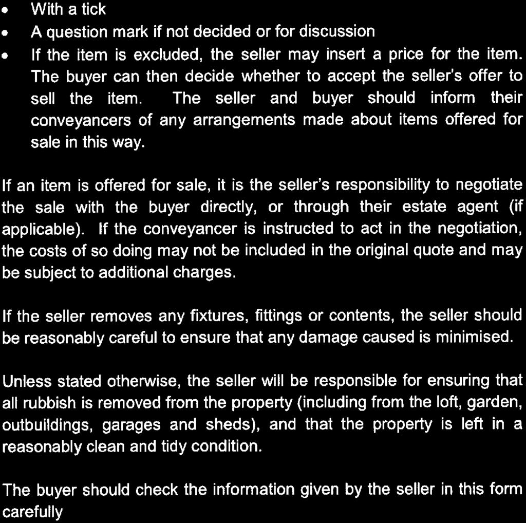

58
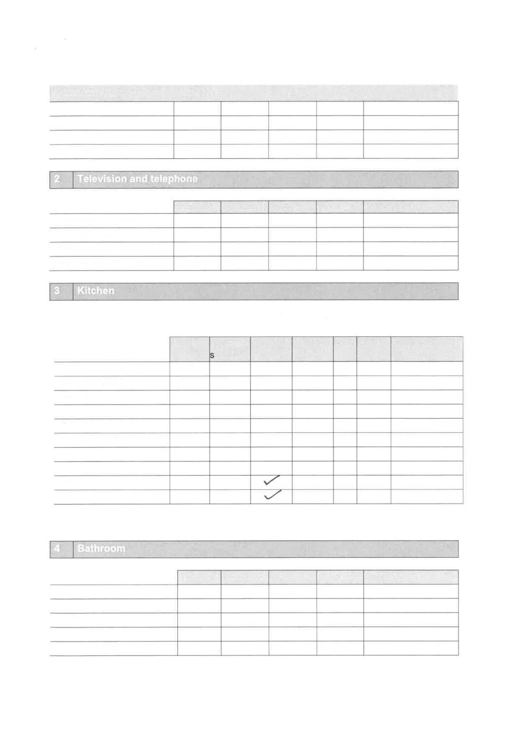


59

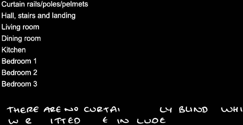

60


61

62
63

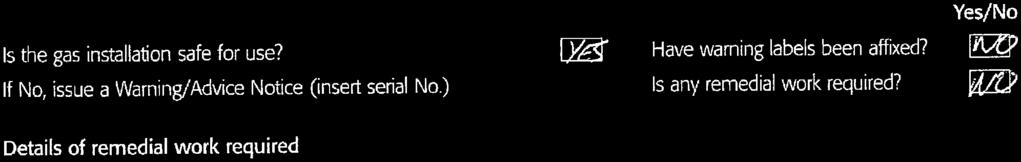


64


65 RESIDENTIAL HOMEBUYERS Search Report Date Report Reference Address , Abington Park Crescent, Northampton, NN3 3AD Grid Reference PROFESSIONAL OPINION Contaminated Land River, coastal and surface water flooding PASSED Groundsure considers there is not a High Potential Risk* that the site will be identified as Contaminated Land**. No further action is required in relation to Contaminated Land. NEGLIGIBLE The property or an area within 25m has been assessed to be at Negligible risk of flooding. The JBA Insurability Index is Green for this property. Please see the Overview and Guidance section for further information. *"High Potential Risk" is the level of risk which results in 1% of reports being In Need of Further Assessment. ** within the meaning set out in Part 2A of the Environmental Protection Act 1990 Natural Ground Subsidence Energy IDENTIFIED The property or an area within 25m has been assessed to have a Low potential for natural ground subsidence. Please see Section 5.9 for further information. IDENTIFIED The property has been identified to lie within 5km of one or more energy features. Please see section 7 for further information. No significant issues identified Issues have been identified. Further investigation is recommended. Some issues have been identified which a prudent purchaser may wish to investigate further.
66 Other Considerations Potential Infilled Land Groundsure have not identified any past activities that can cause structural problems on or in proximity to the property. Coal Mining The study site does not lie in an area which may be affected by coal mining. BGS Non-Coal Mining The British Geological Survey (BGS) have not identified a risk of non-coal mining at the property. Development Constraints The property has not been identified to lie within or in close proximity to any designated areas which may restrict development at the site. Please note this relates solely to the environmental and cultural designations listed in Section 4 of this report. Groundwater flooding The area is not considered to be prone to groundwater flooding based on rock type. Radon The study site is located in an area where some properties are Radon Affected. Please refer to the Detailed Findings and Section 5.10 and 5.11 for further guidance. HS2 and Crossrail 1 The property does not lie within 5km of the proposed High Speed 2 (HS2) train route or within 500m of the proposed Crossrail 1 train route. No further recommendations are necessary. Please note that this assessment takes account of both the original Phase 2b proposed route and the amended route proposed in As the Phase 2b route is still under consultation, Groundsure are providing information on both options until the final route is formally confirmed. Practitioners should take account of this uncertainty when advising clients. Please note that no physical inspection of the property has been carried out in the preparation of this report.if you need any further assistance, please do not hesitate to contact our helpline on quoting reference: If you need any further assistance, please do not hesitate to contact our helpline on quoting reference:
67 Environmental Overview and Guidance Recommendations - Flood Groundsure consider that the area within 25m of the centre of the property has a Negligible risk of flooding. Please note this rating is calculated using a weighted assessment of fluvial, coastal and pluvial risk and historic flood events only. Recommendations A Very Low risk of tidal/fluvial flooding and a Negligible risk of surface water (pluvial) flooding have been identified within 25m of the centre of the property. Please refer to the individual flood assessment sections below for further specific guidance. Alternatively flood resistance measures may assist in reducing the flood risk to the property. Please be aware that this is an automated assessment based upon the highest flood risk found within 25m of the centre of the property. Therefore a purchaser may wish to check the maps provided within this report to confirm whether the flood risk area lies on or in close proximity to the property. If you would like Groundsure to manually assess the property a 35 + VAT fee may be applicable. Please note this manual assessment does not include a site visit. JBA Overall Insurability Index Guidance The property has been rated as Green within JBA's Insurability Index. Green indicates a level of flood hazard such that (subject to terms, applicant's status and individual insurers' approach to risk, exclusions to the Flood Re scheme and any other factors which may be relevant), insurance covering flood risk may be obtainable relatively easily as part of a standard household insurance contract. This rating is calculated by JBA and is based entirely on JBA's modelled river, coastal and pluvial flood risk data. This data is used by a large number of top insurance companies in order to assess flood risk, though individual insurers may also have recourse to further information not used in this assessment such as claim history, and is indicative rather than definitive. On the 4th April 2016 the Flood Re scheme was implemented. The scheme is designed to provide affordable household insurance for residential properties within the UK, which are perceived to have a high flood risk. Insurance companies are able to cede residential properties they consider to have a flood risk into the Flood Re scheme. Annual premiums and excesses are then capped depending on the council tax band for individual properties. There are some exclusions to the Flood Re scheme and these include; commercial properties (including buy to let), new homes built after 1st January 2009 and blocks of flats with three or more units. Flood Re is designed to run for 25 years, to allow time for the Government, local authorities, insurers and communities to become better prepared for flooding. After this period, the market is expected to return to risk reflective pricing, and properties with flood risks that have not been mitigated may face significantly increased premiums and/or difficulty in obtaining cover. The JBA Insurability Index is categorised on a fivefold scale and also includes a statement of the possibility of insurance companies ceding the property into the Flood Re scheme (subject to terms, applicant s status and individual insurers approach to risk, historical flooding events at the property, exclusions to the Flood Re scheme and any other factors which may be relevant),- Green indicates a level of flood hazard such that insurance covering flood risk may be obtainable relatively easily as part of a standard household insurance contract. Very low possibility of insurance companies ceding the property into the Flood Re scheme unless the property has flooded in the past. Amber indicates a level of flood hazard such that insurance covering flood risk may be available but may be subject to increased premiums and non-standard and/or additional terms. Low possibility of insurance companies ceding the property into the Flood Re scheme unless the property has flooded in the past. Red indicates a level of flood hazard such that standard priced insurance covering flood risk may be more difficult to obtain. Low to moderate possibility of insurance companies ceding the property into the Flood Re scheme unless the property has flooded in the past. Black 1 indicates a level of flood hazard such that standard priced insurance covering flood risk may be significantly more difficult to obtain. Moderate to high possibility of insurance companies ceding the property into the Flood Re scheme, especially if the property has flooded in the past. Black 2 indicates a level of flood hazard such that standard priced insurance covering flood risk may be extremely difficult to obtain. High possibility of insurance companies ceding the property into the Flood Re scheme, especially if the property has flooded in the past. 3 If you need any further assistance, please do not hesitate to contact our helpline on quoting reference:
68 Please note that due to the methodology employed to produce the dataset, JBA insurability ratings are only suitable for individual residential properties and as such any rating given for commercial property should be considered invalid. As this index is indicative we recommend a number of insurers are contacted in order to obtain a comparative quote. Risk of Flooding from Rivers and the Sea (RoFRaS) As the site lies within or in close proximity to an area with a Very Low risk rating in the RoFRaS database no further recommendations are required. Guidance The Environment Agency/Natural Resources Wales RoFRaS database provides an indication of river and coastal flood risk at a national level on a 50m grid with the flood rating at the centre of the grid calculated and given above. The data considers the likelihood of flood defences overtopping or breaching by considering their location type condition and standard of protection. A number of major insurance companies refer to this information within their risk model although they may also utilise additional information such as claims histories which may further influence their decision. Where a High risk of flooding is identified there is a much higher likelihood of increased insurance premiums or the flood risk part of the insurance premium being ceded to Flood Re. Property owners of sites within Low and Medium risk areas are still considered to be at risk of flooding and insurance premiums may be increased as a result. Owners of properties within Low, Medium and High risk areas are advised to sign up to the Environment Agency/Natural Resources Wales's Flood Warning scheme on or at Please see Section 5.1 for further details. Additionally a prudent purchaser may wish to consider reducing the impact of flooding at the property by installing flood protection measures at the site if risks have been identified. Such measures may help reduce the effects of flooding at the property if flood defences are absent or are breached and may assist in obtaining insurance for the site. Further information on flood protection measures can be obtained by contacting Groundsure. Surface Water Flooding The study site or an area within 25m of the centre of the study site has been assessed to be at a Negligible risk of surface water (pluvial) flooding. This indicates that this area would be expected to be affected by surface water flooding in a 1 in 1000 year rainfall event to a depth of less than 0.1m. Guidance Surface Water (pluvial) flooding is defined as flooding caused by rainfall-generated overland flow before the runoff enters a watercourse or sewer. In such events, sewerage and drainage systems and surface watercourses may be entirely overwhelmed. Surface Water (pluvial) flooding will usually be a result of extreme rainfall events though may also occur when lesser amounts of rain falls on land which has low permeability and/or is already saturated, frozen or developed. In such cases overland flow and 'ponding' in topographical depressions may occur. This data is provided by JBA Risk Management. Please see Section 5.7 for further details. Historic Flood Events The site is not recorded to have been subject to historic flooding. However the absence of data does not provide a definitive conclusion that the site has never flooded, only that the Environment Agency/Natural Resources Wales hold no record of any flooding at the site. Guidance Over 23,500 separate events are recorded within the Environment Agency/Natural Resources Wales's national database on historic flood events. This data is used to understand where flooding has occurred in the past and provides details as available. Absence of a historic flood event for an area does not mean that the area has never flooded but only that the national Environment Agency/Natural Resources Wales do not currently have records of flooding within the area. Local Environment Agency/Natural Resources Wales offices and Local Authorities may have records of smaller-scale flooding and homeowners are also advised to check their TA6 Property Information form for any records of flooding. A record of a flood footprint in previous years does not mean that an area will flood again and this information does not take account of flood management schemes and improved flood defences. Please see Section 5.6 for further details. 4 If you need any further assistance, please do not hesitate to contact our helpline on quoting reference:
69 Areas Benefiting from Flood Defences The property does not lie in or within 25m of an area the Environment Agency/Natural Resources Wales consider to benefit from flood defences. Property-level defences and some older schemes may not be included in the Environment Agency/Natural Resources Wales database of areas considered to benefit from flood defences. Guidance These are areas that may benefit from the presence of major defences during a 1% fluvial (river) or 0.5% tidal flood event. These areas would flood if the defence were not present but may not flood because the defence is present. Proposed Flood Defences The property does not lie in or within 25m of an area the Environment Agency/Natural Resources Wales consider to benefit from proposed flood defences. Guidance Flood defences seek to reduce the risk of flooding and to safeguard life, protect property, sustain economic activity and the natural environment. Flood defences are designed to protect against flood events of a particular magnitude expressed as risk in any one year. Flooding from Groundwater The area is not considered to be prone to groundwater flooding based on rock type. Guidance The BGS Susceptibility to Groundwater Flooding hazard dataset identifies areas where geological conditions could enable groundwater flooding to occur and where groundwater may come close to the ground surface. The BGS Susceptibility to Groundwater Flooding hazard dataset identifies areas where geological conditions could enable groundwater flooding to occur and where groundwater may come close to the ground surface. The susceptibility data is suitable for use for regional or national planning purposes where the groundwater flooding information will be used along with a range of other relevant information to inform land-use planning decisions. It might also be used in conjunction with a large number of other factors e.g. records of previous incidence of groundwater flooding rainfall property type and land drainage information to establish relative but not absolute risk of groundwater flooding at a resolution of greater than a few hundred metres. The susceptibility data should not be used on its own to make planning decisions at any scale and in particular should not be used to inform planning decisions at the site scale. The susceptibility data cannot be used on its own to indicate risk of groundwater flooding. Flood Storage Areas The property does not lie in or within 25m of a Flood Storage Area. Guidance Flood Storage Areas are considered part of the functional flood plain and are areas where water has to flow or be stored in times of flood. Flood Risk Framework The Flood Risk Assessment section is based on datasets covering a variety of different flooding types. No inspection of the property or of the surrounding area has been undertaken by Groundsure or the data providers. The modelling of flood hazards is extremely complex and in creating a national dataset certain assumptions have been made and all such datasets will have limitations. These datasets should be used to give an indication of relative flood risk rather than a definitive answer. Local actions and minor variations such as blocked drains or streams etc. can greatly alter the effect of flooding. A low or negligible modelled flood risk does not guarantee that flooding will not occur. Nor will a high risk mean that flooding definitely will occur. Groundsure's overall flood risk assessment takes account of the cumulative risk as assessed within the Environment Agency/Natural Resources Wales's RoFRaS database in addition to surface water (pluvial) flooding and historic flood events. 5 If you need any further assistance, please do not hesitate to contact our helpline on quoting reference:
70 Contents Other Considerations 2 Environmental Overview and Guidance 3 Overview of Findings 7 Aerial Photograph 9 Notes on Professional Assessments Past Land Use Landfill and Waste Sites Industrial Sites and Processes Designated Environmentally Sensitive Sites Natural Hazards and Additional Factors Mining Energy Additional Information Guide to our Professional Assessment 35 Contact Details 37 Search Code 39 Standard Terms and Conditions 41 6 If you need any further assistance, please do not hesitate to contact our helpline on quoting reference:
71 Overview of Findings Factor Assessment Subsection Potentially Contaminative Historical Land Uses 1:10,000 & 1:10,560 scale Historical Data Passed 1.1 Potentially Infilled Land (1:10,000 & 1:10,560 scale survey) Identified 1.2 Additional Information 1:2,500 scale Historical Data Historical Tanks Passed 1.3 Historical Energy Features Passed 1.4 Historical Petrol Stations Passed 1.5 Historical Garage / Vehicle Repair Passed 1.6 Historical Military / Ordnance Sites Passed 1.7 Landfill and Waste Sites Landfill Sites Passed 2.1 Landfills from Local Authority and Historical Mapping Records Passed 2.2 Waste Treatment, Transfer or Disposal Sites Passed 2.3 Environment Agency/Natural Resources Wales Licensed Waste Sites Passed 2.4 Industrial Sites and Processes Potentially Contaminative Industrial Sites Passed 3.1 Petrol & Fuel Sites Passed 3.2 Historic IPC Authorisations Passed 3.3 Part A(1) Authorised Processes Passed 3.4 Part A(2) and Part B Authorised Processes and Enforcements Passed 3.5 Red List Discharge Consents Passed 3.6 Water Industry Referrals Passed 3.7 List 1 Dangerous Substances Passed 3.8 List 2 Dangerous Substances Passed 3.9 Dangerous or Hazardous Sites Passed 3.10 Sites Determined as Contaminated Land under Part 2A EPA 1990 Passed 3.11 Environment Agency/Natural Resources Wales Recorded Pollution Incidents Passed 3.12 Hazardous Substance Consents and Enforcements Passed 3.13 Environmental Setting Sites of Special Scientific Interest (SSSI) Yes 4.1 Ramsar Sites Yes 4.2 National Nature Reserves (NNR) No 4.3 Special Areas of Conservation (SAC) No 4.4 Special Protection Areas (SPA) Yes 4.5 Local Nature Reserves (LNR) Yes 4.6 World Heritage Sites No 4.7 Areas of Outstanding Natural Beauty (AONB) No 4.8 National Parks (NP) No 4.9 Green Belt No 4.10 Designated Ancient Woodland No If you need any further assistance, please do not hesitate to contact our helpline on quoting reference:
72 Factor Assessment Subsection Natural Hazards & Additional Factors What is the maximum Risk of Flooding from Rivers and the Sea (RoFRaS) Very Low 5.1 Flood Rating within 25m of the centre of the property? Are there any Areas Benefiting from Flood Defences within 250m? No 5.2 Are there any flood defences within 250m of the study site? No 5.3 Are there any Proposed Flood Defences within 250m of the study site? No 5.4 Are there any Areas Used for Flood Storage within 250m? No 5.5 Has the site or an area within 25m been subject to past flooding as recorded No 5.6 by the Environment Agency/Natural Resources Wales? What is the maximum Surface Water flood risk identified within 25m of the Negligible 5.7 centre of the property? What is the maximum susceptibility to Groundwater Flooding in proximity Site not considered prone to 5.8 to the study site? groundwater flooding Natural Ground Subsidence Low 5.9 Radon The property is in a Radon 5.10 Affected Area, as between 3 and 5% of properties are above the Action Level Radon Protective Measures Basic radon protective 5.11 measures are necessary Mining Coal Mining No 6.1 BGS Non-Coal Mining Unclassified 6.2 Mining Cavities No 6.3 Natural Cavities No 6.4 Historical Mining No 6.5 Historical Underground Workings No 6.6 Energy Existing oil, gas, shale gas or coalbed methane wells No 7.1 Proposed oil, gas, shale gas or coalbed methane wells No 7.2 Existing wind farms No 7.3 Proposed wind power projects No 7.4 Existing solar farms Yes 7.5 Proposed solar farms Yes 7.6 Existing power stations No 7.7 Existing Nuclear Establishments No 7.8 Proposed Energy and other large Infrastructure Projects No 7.9 Additional Information Ofcom Sitefinder Mobile Phone Mast Records No 8.1 Mobile Phone Mast Planning Records No 8.2 Overhead Electricity Transmission Lines and Pylons No If you need any further assistance, please do not hesitate to contact our helpline on quoting reference:

73 Aerial Photograph NW N NE W E SW S SE Aerial photography supplied by Getmapping PLC. Copyright Getmapping PLC All Rights Reserved. Site Address: 26, Abington Park Crescent, Northampton, NN3 3AD Grid Reference: Date of aerial image capture: If you need any further assistance, please do not hesitate to contact our helpline on quoting reference:
74 Notes on Professional Assessments Professional Assessment of Contaminated Land Please note that this assessment takes account of the following data: historical land use, landfill and waste transfer/treatment or disposal sites, scrap yards, current industrial uses (as defined by PointX data), Part A(1), A(2) and B Processes, COMAH and NIHHS sites, Dangerous Substances releases, RAS consents, Discharge and Red List Discharge consents, EPA 1990 sites, Pollution Incidents and Hazardous Substance Consents and Enforcements. This information is listed in this report. The Professional Assessment of Contaminated Land does not include assessment of the risk presented by natural hazards such as radon, subsidence or flooding or for past or present coal mining activity. No physical inspection of the property has been carried out. Our risk assessments assume that the Site will be used for residential accommodation. The report is not suitable for non-domestic properties or for identifying risks for developments at the planning stage in accordance with National Planning Policy Framework (NPPF). Professional Assessment of Flood Risk Please note this assessment is based entirely on information provided by the Environment Agency/Natural Resources Wales (river/coastal flooding) and JBA Risk Management (pluvial/surface water flooding). JBA Insurability Please note that this assessment is produced by JBA Risk Management and is based entirely on their own modelled data for river flooding, coastal flooding and surface water flooding. As JBA have modelled this data in-house, there may be times when JBA's assessment of river and coastal flood risk will differ from that modelled by the Environment Agency/Natural Resources Wales. If you require further explanation of the insurability data, please contact Groundsure. Introduction to Detailed Findings All mapped features within this report are given an identification number. This number identifies the feature on the maps which precede the following data sections. All distances provided are in metres and directions are given as compass headings. Section Historical maps are a widely recognised source of information for investigating site history. Nevertheless, analysis of mapping at 1:10,560 and 1:10,000 scale will not always provide a complete site history. If you are concerned about the former uses of a site, we would advise additional analysis of planning records and/or more detailed historical mapping. Please note that the number of records identified relates to areas subject to potentially contaminative former activities and these do not necessarily correspond to the number of sites found within these areas. Section Systematic analysis of historical maps can highlight areas which, over time, have the potential to have been infilled with various materials. Such areas can relate to such features as ditches, ponds, clay pits, brickfields and quarries. Areas of infill do not always refer to landfill sites, although they may sometimes indicate the presence of such sites. Such areas are normally infilled with inert materials, although in some cases contaminative materials may have been used. Sections 1.3 to 1.6 Selected highly contaminative land uses have been extracted from 1,2,500 and 1,1,250 scale historical mapping. This database covers the majority of the UK from the first available map, but where areas of the UK are not covered it is indicated in the report as No Data Available. This indicates that no assessment of the risk from these features is included in the report. In this instance if you are still concerned about the former uses of a site, we would advise additional analysis of planning records and/or more detailed historical mapping. Section 1.7 Certain military installations were not noted on historic mapping for security reasons. Whilst not all military land is necessarily of concern, Groundsure has researched and digitised a number of Ordnance Factories and other military industrial features (e.g. Ordnance Depots, Munitions Testing Grounds) which may be of contaminative concern. This research was drawn from a number of different sources, and should not be regarded as a definitive or exhaustive database of potentially contaminative military installations. The boundaries of sites within this database have been estimated from the best evidence available to Groundsure at the time of compilation. Section 2- This information is gathered from a wide range of sources including the Environment Agency/Natural Resources Wales (Agency) and the British Geological Survey (BGS). Data supplied by Environment Agency/Natural Resources Wales refers to waste management licences required by anyone involved in waste disposal under the Environmental Protection Act A survey by the BGS undertaken in 1972/3 provides data on some older landfill sites, which were not subject to this legislation. Section 3.1 The answer to this question is based on searches of current industrial data provided by PointX 10 If you need any further assistance, please do not hesitate to contact our helpline on quoting reference:
75 Section 3.2 The answer to this question is based on searches of current and recent petrol stations provided by Catalist. Sections 3.3, 3.4, and 3.14 This information is supplied by the Environment Agency/Natural Resources Wales. Section 3.5, 3.13 and 3.15 This information is supplied by Local Authorities. Section 3.12 This information is supplied by the Health and Safety Executive. Section 5.1 The answer to this question is based upon a 50m search radius from the centre of the search location. This information is supplied by the Environment Agency/Natural Resources Wales. Sections 5.2 to 5.6 The answers to these questions are based upon a 250m search radius from the centre of the earch location. This information is supplied by the Environment Agency/Natural Resources Wales. Sections The answer to this question is based upon a 50m search radius from the centre of the search location. Section 6.1 The answer to this question is based upon information found within 50m of the search centre. Sections 6.2 and 6.4 These databases provide an indication of non-coal mining and natural ground cavities. They are used to provide an indication that activities that have the potential to cause ground instability issues are present in the general vicinity of the property. However the accuracy of the data is not sufficient to confirm if the property will be directly affected. Sections 6.5 and Systematic analysis of historical maps can highlight areas where either mining or underground workings have occurred in the past. The information is taken from features presented on historical maps which do not indicate the distance or direction which underground or mining workings extend beneath the surface. e.g features such as mine shafts only indicate the entrance to a mine, and by inference indicate the potential for underground features to extend outward from this point. Some features within this database may also relate to non-mining underground activities e.g.air shafts for underground railways. Section 8.1 and Section Provides information on records of Ofcom-registered mobile phone masts and mobile mast planning records up to 250m. Section 8.3 Please be aware that the findings contained within the overhead power transmission lines section is based upon information found within Ordnance Survey OpenData. 11 If you need any further assistance, please do not hesitate to contact our helpline on quoting reference:
76 1. Past Land Use 1.1 Potentially Contaminative Uses The systematic analysis of data extracted from standard 1:10,560 and 1:10,000 scale historical maps provides the following information. Are there any potentially contaminative past land uses within 250m of the search centre? Risk Assessment Guidance: These findings are not of concern. No further action is recommended. Yes Passed Distance (m) Direction Use Date 184 NE Unspecified Ground Workings NE Unspecified Ground Workings Potentially Infilled Land The systematic analysis of data extracted from standard 1:10,560 and 1:10,000 scale historical maps provides the following information. Are there areas of potentially infilled land within 250m of the search centre? Yes Guidance: These findings are not of concern. No further action is recommended. The following Historical Surface Ground Working Features derived from the Historical Mapping information is provided by Groundsure: Distance (m) Direction Use Date 184 NE Unspecified Ground Workings NE Unspecified Ground Workings N Pond N Pond N Pond N Ponds N Ponds N Pond N Pond N Pond NW Water Body NW Water Body Additional Information Historical Tank Database The systematic analysis of data extracted from High Detailed 1:1,250 and 1:2,500 scale historical maps provides the following information. Are there any historical tanks within 100m of the search centre? Risk Assessment No Passed 12 If you need any further assistance, please do not hesitate to contact our helpline on quoting reference:
77 Guidance: Database searched and no data found. No further action is recommended. 1.4 Additional Information Historical Energy Features Database The systematic analysis of data extracted from High Detailed 1:1,250 and 1:2,500 scale historical maps provides the following information. Are there any historical energy features within 100m of the search centre? Risk Assessment No Passed Guidance: Database searched and no data found. No further action is recommended. 1.5 Additional Information Historical Petrol Station Database The systematic analysis of data extracted from High Detailed 1:1,250 and 1:2,500 scale historical maps provides the following information. Are there any historical petrol stations within 100m of the search centre? Risk Assessment No Passed Guidance: Database searched and no data found. No further action is recommended. 1.6 Additional Information Historical Garage and Motor Vehicle Repair Database The systematic analysis of data extracted from High Detailed 1:1,250 and 1:2,500 scale historical maps provides the following information. Are there any historical garage and motor vehicle repair sites within 100m of the search centre? Risk Assessment Guidance: Database searched and no data found. No further action is recommended. 1.7 Historical Military/Ordnance Sites Analysis of historic military records has identified the following information. Are there any historical military industrial sites known to Groundsure within 100m of the search centre? Risk Assessment Guidance: Database searched and no data found. No further action is recommended. No Passed No Passed 13 If you need any further assistance, please do not hesitate to contact our helpline on quoting reference:
78 2. Landfill and Waste Sites Landfill and Waste Sites Map NW N NE W E SW S SE Landfill and Waste Sites Map Crown copyright and database rights Ordnance Survey licence If you need any further assistance, please do not hesitate to contact our helpline on quoting reference:
79 2.1 Landfill Sites Are there any operational or non-operational landfill sites within 500m of the search centre? Risk Assessment No Passed Guidance: Groundsure has searched this database and no data was found. No further action is recommended Environment Agency/Natural Resources Wales Active Landfill Sites Database searched and no data found Environment Agency/Natural Resources Wales Historic Landfill Sites Database searched and no data found British Geological Survey / DoE Landfill Site Survey Database searched and no data found. 2.2 Records of Landfills in Local Authority and Historical Mapping Records Are there any additional Landfills in Local Authority and Historical Mapping records within 500m of the search centre? Risk Assessment Guidance: Groundsure has searched this database and no data was found. No further action is recommended. 2.3 Waste Sites No Passed Are there any operational or non-operational waste treatment, transfer or disposal sites within 500m of the search centre? Risk Assessment No Passed Guidance: Groundsure has searched this database and no data was found. No further action is recommended. 2.4 Environment Agency/Natural Resources Wales Licensed Waste Sites Are there any Environment Agency/Natural Resources Wales Licensed Waste Sites within 500m of the search centre? Risk Assessment Guidance: Groundsure has searched this database and no data was found. No further action is recommended. No Passed 15 If you need any further assistance, please do not hesitate to contact our helpline on quoting reference:

80 3. Industrial Sites and Processes Industrial Sites and Processes Map NW N NE W E SW S SE Industrial Sites and Processes Map Crown copyright and database rights Ordnance Survey licence If you need any further assistance, please do not hesitate to contact our helpline on quoting reference:
81 3.1 Potentially Contaminative Industrial Sites Are there any potentially contaminative industrial sites within 250m of the search centre? Risk Assessment Guidance: These findings are not of concern. No further action is recommended. The following records are represented as points on the Industrial Sites and Processes map. Yes Passed ID Distance (m) Direction Company Address Activity Category 1 83 S M S M Car & Van Hire 18 Abbey Lodge, Vehicle Hire and Rental Hire Services Landcross Drive, Northampton, NN3 3NJ S Electricity Sub Station NN3 Electrical Features Infrastructure and Facilities E Electricity Sub Station NN3 Electrical Features Infrastructure and Facilities 3.2 Petrol and Fuel Sites Are there any petrol and fuel sites within 250m of the search centre? Risk Assessment Guidance: Groundsure has searched this database and no data was found. No further action is recommended. 3.3 Historic IPC Authorisations Records of historic IPC Authorisations within 500m of the study site: Risk Assessment Guidance:Groundsure has searched this database and no data was found. No further action is recommended. 3.4 Part A(1) Authorised Processes No Passed No Passed Records of Part A(1) and IPPC Authorised Activities within 500m of the study site: Risk Assessment No Passed Guidance: Groundsure has searched this database and no data was found. No further action is recommended. 3.5 Part A(2) and Part B Authorised Processes and Enforcements Are there any Part A(2) and Part B Authorised Processes and Enforcements within 250m of the search centre? Risk Assessment Guidance: Groundsure has searched this database and no data was found. No further action is recommended. 3.6 Red List Discharge Consents Are there any Red List Discharge Consents within 250m of the search centre? Risk Assessment Guidance: Groundsure has searched this database and no data was found. No further action is recommended. No Passed No Passed 17 If you need any further assistance, please do not hesitate to contact our helpline on quoting reference:
82 3.7 Water Industry Referrals Are there any Water Industry Referrals within 250m of the search centre? Risk Assessment Guidance: Groundsure has searched this database and no data was found. No further action is recommended. 3.8 List 1 Dangerous Substances Are there any List 1 dangerous substance inventory sites within 500m of the search centre? Risk Assessment Guidance: Groundsure has searched this database and no data was found. No further action is recommended. 3.9 List 2 Dangerous Substances Are there any List 2 dangerous substance inventory sites within 500m of the search centre? Risk Assessment Guidance: Groundsure has searched this database and no data was found. No further action is recommended Dangerous or Hazardous Sites No Passed No Passed No Passed Are there any COMAH & NIHHS sites within 500m of the search centre? Risk Assessment No Passed Guidance: Groundsure has searched this database and no data was found. No further action is recommended Sites Determined as Contaminated Land under Part 2A EPA 1990 Does the Local Authority hold information under Section 78R of the Environmental Protection Act 1990 for any sites within 250m of the search centre? Risk Assessment No Passed Guidance: Groundsure has searched this database and no data was found. No further action is recommended Environment Agency/Natural Resources Wales Recorded Pollution Incidents Are there any Environment Agency/Natural Resources Wales recorded pollution incidents within 250m of the search centre? Risk Assessment Guidance: Groundsure has searched this database and no data was found. No further action is recommended Hazardous Substance Consents and Enforcements Are there any Hazardous Substance Consents or Enforcement within 500m of the search centre? Risk Assessment Guidance: Groundsure has searched this database and no data was found. No further action is recommended. No Passed No Passed 18 If you need any further assistance, please do not hesitate to contact our helpline on quoting reference:

83 4. Designated Environmentally Sensitive Sites Designated Environmentally Sensitive Sites Map NW N NE W E SW S SE Designated Environmentally Sensitive Sites Map Crown copyright and database rights Ordnance Survey licence If you need any further assistance, please do not hesitate to contact our helpline on quoting reference:
84 Designated Environmentally Sensitive Sites Presence of Designated Environmentally Sensitive Sites within 2000m of the study site? Yes 4.1 Sites of Special Scientific Interest (SSSI) Records of Sites of Special Scientific Interest (SSSI) within 2000m of the study site: 2 The following Sites of Special Scientific Interest (SSSI) records are provided by Natural England/Natural Resources Wales: ID Distance (m) Direction SSSI Name Data Source SE Upper Nene Valley Gravel Pits Natural England S Upper Nene Valley Gravel Pits Natural England 4.2 Ramsar sites Records of Ramsar sites within 2000m of the study site: 2 The following Ramsar records are provided by Natural England/Natural Resources Wales: ID Distance (m) Direction Ramsar Name Ramsar Site Status Data Source SE Upper Nene Valley Gravel Pits Listed Natural England S Upper Nene Valley Gravel Pits Listed Natural England 4.3 National Nature Reserves Records of National Nature Reserves (NNR) within 2000m of the study site: 0 Database searched and no data found. 4.4 Special Areas of Conservations (SAC) Records of Special Areas of Conservation (SAC) within 2000m of the study site: 0 Database searched and no data found. 4.5 Special Protection Areas (SPA) Records of Special Protection Areas (SPA) within 2000m of the study site: 2 The following Special Protection Areas (SPA) records are provided by Natural England/Natural Resources Wales: ID Distance (m) Direction SPA Name Data Source SE Upper Nene Valley Gravel Pits Natural England S Upper Nene Valley Gravel Pits Natural England 4.6 Local Nature Reserves (LNR) Records of Local Nature Reserves (LNR) within 2000m of the study site: 2 The following Local Nature Reserves (LNR) records are provided by Natural England/Natural Resources Wales: ID Distance (m) Direction LNR Name Data Source 20 If you need any further assistance, please do not hesitate to contact our helpline on quoting reference:
85 ID Distance (m) Direction LNR Name Data Source S Barnes Meadow Natural England NW Hills and Holes Natural England 4.7 World Heritage Sites Records of World Heritage Sites within 2000m of the study site: 0 Database searched and no data found. 4.8 Areas of Outstanding Natural Beauty Records of Areas of Outstanding Natural Beauty (AONB)/National Scenic Areas within 2000m of the study site: Database searched and no data found. 4.9 National Parks Records of National Parks within 2000m of the study site: 0 Database searched and no data found Green Belt Records of Green Belt land within 2000m of the study site: 0 Database searched and no data found Designated Ancient Woodland Records of Ancient Woodland within 2000m of the study site: 0 Database searched and no data found If you need any further assistance, please do not hesitate to contact our helpline on quoting reference:


86 5. Natural Hazards and Additional Factors Environment Agency/Natural Resources Wales River and Coastal Flood Map NW N NE W E SW S SE Environment Agency/Natural Resources Wales River and Coastal Flood Map Crown copyright and database rights Ordnance Survey licence If you need any further assistance, please do not hesitate to contact our helpline on quoting reference:

87 Environment Agency/Natural Resources Wales Recorded Historic Flood Events Map NW N NE W E SW S SE Environment Agency/Natural Resources Wales Recorded Historic Flood Events Map Crown copyright and database rights Ordnance Survey licence If you need any further assistance, please do not hesitate to contact our helpline on quoting reference:

88 JBA Surface Water (Pluvial) Flood Map NW N NE W E SW S SE JBA Surface Water (Pluvial) Flood Map Crown copyright and database rights Ordnance Survey licence If you need any further assistance, please do not hesitate to contact our helpline on quoting reference:
89 5.1 Risk of Flooding from Rivers and the Sea (RoFRaS) What is the risk of flooding at the centre of the study site? Very Low What is the highest risk of flooding within 25m of the centre of the study site? Very Low The Environment Agency/Natural Resources Wales RoFRaS database provides an indication of river and coastal flood risk at a national level on a 50m grid as used by many of the insurance companies. RoFRaS data is based on a 50m grid system, with the flood rating at the centre of the grid calculated and given below. The data considers the probability that the flood defences will overtop or breach, and the distance from the river or the sea. RoFRaS data for the study site indicates the property has a Very Low (less than 1 in 1000) chance of flooding in any given year. 5.2 Areas Benefiting from Flood Defences Are there any areas benefiting from Flood Defences within 250m of the study site? Guidance: These are areas that may benefit from the presence of major defences during a 1% river (fluvial) or 0.5% coastal flood event. These areas would flood if the defence were not present, but may not flood because the defence is present. Details of flood defences and any areas benefiting from these defences can be seen on the Risk of Flooding from Rivers and the Sea Map. 5.3 Flood Defences Are there any flood defences within 250m of the study site? Guidance: This search consists only of flood defences present in the dataset provided by the Environment Agency/Natural Resources Wales. 5.4 Proposed Flood Defences Are there any Proposed Flood Defences within 250m of the study site? Guidance: This search consists only of proposed flood defences present in the dataset provided by the Environment Agency/Natural Resources Wales. Please note that proposed flood defence schemes will not influence the current RoFRaS ratings for the site until they have been constructed. 5.5 Areas Used for Flood Storage Are there any areas used for Flood Storage within 250m of the study site? Database searched and no data found Flood Storage Areas are considered part of the functional floodplain, and are areas where water has to flow or be stored in times of flood. Technical Guidance to the National Planning Policy Framework states that only water-compatible development and essential infrastructure should be permitted within flood storage areas, and existing development within this area should be relocated to an area with a lower risk of flooding. Any relevant data is represented on the Risk of Flooding from Rivers and the Sea Map. No No No No 25 If you need any further assistance, please do not hesitate to contact our helpline on quoting reference:
90 Notes on RoFRaS data RoFRaS is an assessment of flood risk for England and Wales produced using local data and expertise. It shows the chance of flooding from rivers or the sea presented in categories taking account of flood defences and the condition those defences are in. The RoFRaS model uses local water level and flood defence data to model flood risk. It has divided England and Wales into 50m X 50m impact cells. Each cell has been assigned a flood risk likelihood from the categories below: Less than 1 in 1000 (0.1%) chance in any given year: Very Low Less than 1 in 100 (1%) but greater than or equal to 1 in 1000 (0.1%) chance in any given year: Low Less than 1 in 30 (3.3%) but greater than or equal to 1 in 100 (1%) chance in any given year: Medium Greater than or equal to 1 in 30 (3.3%) chance in any given year: High Notes on Existing Flood Defences Flood defences seek to reduce the risk of flooding and to safeguard life, protect property, sustain economic activity and the natural environment. Flood defences are designed to protect against flood events of a particular magnitude, expressed as risk in any one year. Notes on Proposed Flood Defences 'Number of Households to Benefit' illustrates the number of households that move from 'very significant' or 'significant' to 'moderate' or 'low' probability of flood risk bands if the proposed flood scheme is to be implemented This information is taken from the Environment Agency/Natural Resources Wales's database of Areas to Benefit from New and Reconditioned Flood Defences under the Medium Term Plan (MTP). The dataset contains funding allocation for the first financial year (from April). Funding for the following four financial years is not guaranteed, being only indicative, and will be reviewed annually. Projects within the Medium Term Plan qualify for inclusion in this dataset if: the investment leads to a change in the current standard of protection (change projects); the investment is a replacement or refurbishment in order to sustain the current standard of protection (sustain projects); the project has an initial construction budget of 100,000 or more; and the project is included within the first five years of the MTP. The data includes all the Environment Agency/Natural Resources Wales's projects over 100K that will change or sustain the standards of flood defence in England and Wales over the next 5 years. It also includes the equivalent schemes for all Local Authority and Internal Drainage Boards. The number of households and areas of land contributing to DEFRA's Outcome Measures (OM) are also attributed i.e. could benefit from major work on flood defences. These data also contain Intermittence Flood Maintenance Programmes that show the annual maintenance programme of work scheduled to be carried out by the Environment Agency/Natural Resources Wales, Local Authority or Internal Drainage Board on flood defences. Data details routine maintenance as well as intermittent work that has been funded for the coming year. The data contains a start and end coordinate defining the relevant river section where work is planned. Information Warning Please note that the maps show the areas where investment is being made to reduce the flood and coastal erosion risk and are not detailed enough to account for individual addresses. Individual properties may not always face the same risk of flooding as the areas that surround them. Also, note that funding figures are indicative and any use or interpretation should account for future updates where annual values may change. Every possible care is taken to ensure that the maps reflect all the data possessed by the Environment Agency/Natural Resources Wales and that they have applied their expert knowledge to create conclusions that are as reliable as possible. The Environment Agency/Natural Resources Wales consider that they have created the maps as well as they can and so should not be liable if the maps by their nature are not as accurate as might be desired or are misused or misunderstood, despite their warnings. For this reason, they are not able to promise that the maps will always be accurate or completely up to date. This site includes mapping data licensed from Ordnance Survey used for setting the Environment Agency/Natural Resources Wales's data in its geographical context. Ordnance Survey retains the copyright of this material and it can not be used for any other purpose. 26 If you need any further assistance, please do not hesitate to contact our helpline on quoting reference:
91 Flood Storage Areas Flood Storage Areas may also act as flood defences. A flood storage area may also be referred to as a balancing reservoir, storage basin or balancing pond. Its purpose is to attenuate an incoming flood peak to a flow level that can be accepted by the downstream channel. It may also delay the timing of a flood peak so that its volume is discharged over a longer time interval. A flood storage area may take the form of a wet or dry reservoir. A wet reservoir is a water storage facility in which storage can be effected by allowing water levels to rise during flood times. A dry reservoir is typically adjacent to a river and comprises an enclosed area that accepts water only at peak times. These areas are also referred to as Zone 3b or 'the functional floodplain' and has a 5% or greater chance of flooding in any given year, or is designed to flood in the event of an extreme (0.1%) flood or another probability which may be agreed between the Local Planning Authority and the Environment Agency/Natural Resources Wales, including water conveyance routes. Development within Flood Storage Areas is severely restricted. 5.6 Historic Flooding Events Has the site or any area within 250m of the site been subject to historic flooding as recorded by the Environment Agency/Natural Resources Wales? This database shows the individual footprint of every flood event recorded in the Environment Agency/Natural Resources Wales s national database on historic flood events. Please note this doesn t include records held by individual local offices. This data is used to understand where larger-scale flooding has occurred in the past and provides details as available. Absence of a historic flood event for an area does not mean that the area has never flooded, but only that it doesn t appear in the Environment Agency/Natural Resources Wales national dataset. Equally, a record of a flood footprint in previous years does not mean that an area will flood again, and this information does not take account of flood management schemes and improved flood defences. Historic flooding events: Database searched and no data found. 5.7 JBA Surface (Pluvial) Water Flooding What is the risk of pluvial flooding at the centre of the study site? What is the highest risk of pluvial flooding within 25m of the centre of the study site? Negligible Negligible Guidance: The site or an area in close proximity has been assessed to be at Negligible risk of surface water (pluvial) flooding. This indicates that this area would be expected to be affected by surface water flooding in a 1 in 1000 year rainfall event to a depth of less than 0.1m. Notes on Surface water (Pluvial) Flooding data: JBA Risk Management surface water flood map identifies areas likely to flood following extreme rainfall events, i.e. land naturally vulnerable to surface water or pluvial flooding. This data set was produced by simulating 1 in 75 year, 1 in 200 year and 1 in 1000 year rainfall events. Modern urban drainage systems are typically built to cope with rainfall events between 1 in 20 and 1 in 30 years, though older ones may even flood in a 1 in 5 year rainstorm event. The model provides the maximum depth of flooding in each 5m cell of topographical mapping coverage. The maps include 7 bands indicating areas of increasing natural vulnerability to surface water flooding. These are: Less than 0.1m in a 1 in 1000 year rainfall event: Negligible Greater than 0.1m in a 1 in 1000 year rainfall event: Low Between 0.1m and 0.3m in a 1 in 200 year rainfall event: Low to Moderate Between 0.3m and 1m in a 1 in 200 year rainfall event: Moderate Greater than 1m in a 1 in 200 year rainfall event: Moderate to High Between 0.1m and 0.3m in a 1 in 75 year rainfall event: High Between 0.3m to 1m in a 1 in 75 year rainfall event: Significant Greater than 1m in a 1 in 75 year rainfall event: Highly Significant 5.8 Groundwater Flooding Susceptibility No What is the susceptibility to Groundwater Flooding in the search area based on the underlying geological conditions? The area is not considered to be prone to groundwater flooding 27 If you need any further assistance, please do not hesitate to contact our helpline on quoting reference:
92 Guidance: The area is not considered to be prone to groundwater flooding based on rock type. Groundwater flooding is defined as the emergence of groundwater at the ground surface or the rising of groundwater into man-made ground under conditions where the normal range of groundwater levels is exceeded. The BGS Susceptibility to Groundwater Flooding hazard dataset identifies areas where geological conditions could enable groundwater flooding to occur and where groundwater may come close to the ground surface. The susceptibility data is suitable for use for regional or national planning purposes where the groundwater flooding information will be used along with a range of other relevant information to inform land-use planning decisions. It might also be used in conjunction with a large number of other factors, e.g. records of previous incidence of groundwater flooding, rainfall, property type, and land drainage information, to establish relative, but not absolute, risk of groundwater flooding at a resolution of greater than a few hundred metres. The susceptibility data should not be used on its own to make planning decisions at any scale, and, in particular, should not be used to inform planning decisions at the site scale. The susceptibility data cannot be used on its own to indicate risk of groundwater flooding. Notes on Groundwater Flooding The BGS Susceptibility to Groundwater Flooding hazard dataset identifies areas where geological conditions could enable groundwater flooding to occur and where groundwater may come close to the ground surface. Groundwater flooding is assessed on a fourfold scale: The area is not considered to be prone to groundwater flooding based on rock type. There is limited potential for groundwater flooding to occur and further relevant information should be considered to determine this assessment. There is potential for groundwater flooding of property situated below the surface such as basements and other below surface infrastructure. Further relevant information should be considered to determine whether groundwater flooding has previously occurred. There is potential for groundwater flooding to occur at the surface and groundwater flooding hazard should be considered in all land use planning decisions. Other relevant information should be considered to establish the risk of groundwater flooding to property. 5.9 Natural Ground Subsidence What is the potential for natural ground subsidence* within the search area? Guidance: The natural ground subsidence rating is obtained through the evaluation of six natural ground stability hazard datasets, which are supplied by the British Geological Survey (BGS). These datasets indicate the hazard posed by the occurrence of: Swell-Shrink Clay, Landslide, Compressible Ground, Collapsible Ground, Dissolution of Soluble Rocks and Running Sand. Many factors may contribute to ground subsidence problems. For instance, significant problems can arise in conurbations underlain by clay rich bedrock, such as over clay strata in the South East of England, or South Wales. Whilst surveyors are normally aware of local problem areas, data provided by the BGS can highlight areas where a significant potential for natural ground subsidence exists and which may need particular consideration. Where low potential is indicated, this means that there is some potential for natural ground movement to occur but that it is only likely to be of concern if significant changes are made to the ground or use of it. For example, this could include planting trees, changing drainage or building work - before doing anything like this we recommend that you seek professional advice. *The term Subsidence refers to ground movement that could cause damage to foundations in domestic or other properties Radon Affected Areas Low Is the property in a radon Affected Area as defined by Public Health England (PHE) and if so what percentage of homes are above the Action Level? The property is in a Radon Affected Area, as between 3 and 5% of properties are above the Action Level Guidance: Public Health England (PHE) recommends a radon 'Action Level' of 200 becquerels per cubic metre for the annual average of the radon gas concentration in a home. Where 1% or more of homes are estimated to exceed the Action Level (i.e. are in an Intermediate or Higher probability radon area) the area should be regarded as a radon Affected Area. This report informs you whether the property is in a radon Affected Area and the percentage of homes that are estimated to be at or above the radon Action Level. This does not necessarily mean there is a radon problem in the property; the only way to find out whether it is above or below the Action Level is to carry out a radon measurement in an existing property. 28 If you need any further assistance, please do not hesitate to contact our helpline on quoting reference:
93 PHE advises that radon gas should be measured in all properties within radon Affected Areas and that homes with radon levels above the Action Level (200 Bq m-3) should be remediated, and when achievable to below the Target Level of 100 Bq m-3. Householders with levels between the Target Level and Action Level should seriously consider reducing their radon level, especially if they are at greater risk, such as if they are current or ex smokers. Whether or not a home is in fact above or below the Action Level or Target Level can only be established by having the building tested. PHE provides a radon testing service which can be accessed at The information in this report provides an answer to one of the standard legal enquiries on house purchase in England and Wales, known as CON29 Standard Enquiry of Local Authority (part 1); 3.13 Radon Gas: Location of the Property in a Radon Affected Area. If you are buying a currently occupied property in a Radon Affected Area, you should ask the present owner whether radon levels have been measured in the property. If they have, ask whether the results were above the Radon Action Level and if so, whether remedial measures were installed, radon levels were re-tested, and the results of re-testing confirmed the effectiveness of the measures. Further information on radon is available from PHE or Radon Protective Measures Is the property in an area where radon protection measures are required for new properties or extensions to existing ones as described in publication BR211 by the Building Research Establishment? Basic radon protective measures are necessary Combined Radon Guidance: Radon is a colourless odourless radioactive gas which is present in all areas of the United Kingdom, usually at levels that pose a negligible risk to homebuyers. However, in some areas levels of radon are much higher than in others, and in these cases it can pose a health risk. The data supplied by Public Health England (PHE) and the British Geological Survey (BGS) is not able to determine exact Radon levels, as this information can only be obtained through site-specific, in-situ testing. As 3-5% of properties in the area may be radon affected PHE recommend carrying out a site-specific radon assessment. This costs including VAT and the results are confidential to the client. Please contact PHE ( ) for further information and advice. Notes on Radon RISKS OF RADON Radon is a radioactive gas which occurs naturally. It has no taste, smell or colour. Special devices are needed to measure it. Radon comes out of the ground. Outdoors, it is diluted to very low levels. However, in some cases the radon level indoors can build up to high concentrations. In such cases, it does pose a serious risk to health. ACTION LEVEL FOR RADON Public Health England (PHE) recommends that radon levels should be reduced in homes where the average is more than 200 becquerels per cubic metre of air (Bq m-3). This recommendation has been endorsed by the Government. This Action Level refers to the annual average concentration in a home, so radon measurements are carried out with two detectors (in a bedroom and living room) over three months, to average out short-term fluctuations. RADON AFFECTED AREAS PHE defines radon Affected Areas as those with a 1% probability or more of a home having radon above the Action Level. PHE recommends that people in Affected Areas should test their homes for radon. HOW TO REDUCE RADON LEVELS PHE advises that radon gas should be measured in all properties within radon Affected Areas and that homes with radon levels above the Action Level (200 Bq m-3) should be remediated, preferably to below the Target Level of 100 Bq m-3. Householders with levels between the Target Level and Action Level should seriously consider reducing their radon level, especially if they are at greater risk, such as if they are current or ex smokers. Indoor radon levels can usually be substantially reduced at a cost comparable to many home improvements, such as replacing carpets. Details of methods of reducing radon levels are given on the Building Research Establishment Website. 29 If you need any further assistance, please do not hesitate to contact our helpline on quoting reference:
94 6. Mining 6.1 Coal Authority Coal Mining Records Is the property within an area which may be affected by past, present or proposed underground coal mining? Guidance: None required. 6.2 BGS Non-Coal Mining Hazards What is the potential for undermining as a result of underground mineral extraction, excluding coal and minerals extracted as a consequence of coal mining? No Unclassified Guidance: The study site lies in an area which is unclassified in relation to non-coal mining. This means that there is no known hazard from underground mine workings because the rock types present are such that no commodities or metal ores have been worked by underground mining methods. It should be noted, however, that there is always the possibility of the existence of other sub-surface excavations, such as wells, cess pits, follies, air raid shelters/bunkers and other military structures etc. that could affect surface ground stability but which are outside the scope of this dataset. The mining hazard data (not including coal) layer draws together a diverse range of material derived from geology, which constrains distribution, supplemented by literature searches for historic locations and expert knowledge to assemble, interpret, and organise this information. Mining of coal is specifically excluded from this data set and information on Coal Mining areas can be found in the Coal Authority Coal Mining Records section above. The data provides an assessment of the likelihood that past underground mining may have occurred in the area. It does not consider the depth of the extraction nor whether any remediation has previously been undertaken. Where extraction of such minerals has taken place in workings close to the surface (meaning to approximately 50m depth) the workings can pose a subsidence risk because they sometimes cause surface collapse. Old mine shafts and other mine openings in such areas can also lead to unexpected surface collapse. The data provided by the British Geological Survey (BGS) are rated on a five point scale ranging from Rare, through Highly unlikely, Unlikely and Likely to Highly Likely that indicate how likely it is that past underground mining activities may have occurred. 6.3 Mining Cavities Is the site located in an area of mining cavities? Guidance: This information is obtained from the mining cavities dataset, which is supplied and digitally combined by Peter Brett Associates. There are no records within 250m of the site. 6.4 Natural Cavities Is the site located in an area of natural cavities? Guidance: This risk rating is obtained from the natural cavities dataset, which is supplied and digitally combined by Peter Brett Associates. There are no records within 250m of the site. 6.5 Historical Mining Features from Detailed Mapping The systematic analysis of data extracted from standard 1:10,560 and 1:10,000 scale historical maps provides the following information. No No Are there any Mining features within 500m of the centre of the study site? Guidance: No further action required. No 30 If you need any further assistance, please do not hesitate to contact our helpline on quoting reference:
95 6.6 Historical Underground Workings Features from Detailed Mapping The systematic analysis of data extracted from standard 1:10,560 and 1:10,000 scale historical maps provides the following information. Are there any Historical Underground Working Features within 500m of the centre of the study site? Guidance: No further action required. No 31 If you need any further assistance, please do not hesitate to contact our helpline on quoting reference:
96 7. Energy 7.1 Existing oil, gas, shale gas or coalbed methane wells Count of records of existing oil, gas, shale gas or coalbed methane wells within 5km of the property 0 Guidance: No records of oil, gas, shale gas or coalbed methane wells have been identified within 5km of the property. The dataset is taken from the Oil and Gas Authority (OGA) register of onshore wells and is updated monthly. No further action is recommended in regard to this aspect of the report. 7.2 Proposed oil, gas, shale gas or coalbed methane wells Count of Proposed oil, gas, shale gas or coalbed methane wells within 5km of the property 0 Guidance: No records of planning applications relating to oil, gas, shale gas or coalbed methane wells have been identified within 5km of the property. The dataset is unique to Groundsure and is derived from local authority planning records. The data is updated weekly. No further action is recommended in regard to this aspect of the report. 7.3 Existing wind farms Count of existing wind farms 0 Guidance: No records of wind projects registered with the UK Wind Energy Database (UKWED) have been identified within 5km of the property. The dataset is taken from Renewables UK and is provided for information only, with no guarantee given as to its completeness or accuracy. Renewables UK are excluded from any liability for any such inaccuracies or errors. Groundsure would advise further independent research of any sites of interest to determine exact locations and details of projects. No further action is recommended in regard to this aspect of the report. 7.4 Proposed wind power projects Count of proposed wind power projects within 5km of the property 0 Guidance: No records of planning applications relating to wind turbine developments (with two turbines or more) have been identified within 5km of the property. This dataset is unique to Groundsure and is derived from local authority planning records, updated quarterly. No further action is recommended in regard to this aspect of the report. 7.5 Existing solar farms Count of existing solar farms 2 Guidance: This dataset identifies one or more operational solar farms and those under development within 5km of the property. The dataset is taken from the Department of Energy and Climate Change (DECC) and is updated on a monthly basis. Further details of the project(s) identified can be found in a full Groundsure Energy report. 7.6 Proposed solar farms Count of proposed solar farms within 5km of the property 2 Guidance: This dataset identifies one or more planning application relating to solar farm developments within 5km of the property. The dataset is unique to Groundsure and is derived from local authority planning records. The data is updated weekly. Further details of the project(s) identified can be found in a full Groundsure Energy report. 7.7 Existing power stations Count of existing power stations within 5km of the property 0 Guidance: No existing power stations have been identified within 5km of the property. These datasets show power generating establishments with a generation capacity of 1MW or greater. The data is derived from records within the Digest of United Kingdom Energy Statistics (DUKES). No further action is recommended in regard to this aspect of the report. 7.8 Existing Nuclear Establishments Count of existing nuclear establishments within 5km of the property 0 32 If you need any further assistance, please do not hesitate to contact our helpline on quoting reference:
97 Guidance: No nuclear establishments have been identified within 5km of the property. This dataset shows nuclear establishments and is derived from records within the Health and Safety Executive, the Nuclear Decommissioning Authority, the National Infrastructure Planning Programme and the Nuclear Advanced Manufacturing Centre. No further action is recommended in regard to this aspect of the report. 7.9 Proposed Energy and other large Infrastructure Projects Count of proposed Energy and other large Infrastructure Projects within 5km of the property 0 Guidance: No major infrastructure projects have been identified within 5km of the property. This dataset is derived from information provided by the Planning Inspectorate and shows major national infrastructure projects only. No further action is recommended in regard to this aspect of the report. 33 If you need any further assistance, please do not hesitate to contact our helpline on quoting reference:
98 8. Additional Information 8.1 Ofcom Sitefinder Mobile Phone Mast Records Have any mobile phone transmitters registered with Ofcom been identified within 250m of the study site? Database searched and no data found This database is taken from Ofcom's Sitefinder database, the Government's database of mobile phone base stations. The last update to this database was applied in May 2012, although some operators ceased providing updates some years before then. Neither Ofcom nor Groundsure can accept any liability for any inaccuracies or omissions in the data provided within Sitefinder. The most recent update is based on the following datasets received at the specified times by Ofcom: O2 (May 2012), Network Rail (April 2012), Hutchison (February 2012), Vodafone (October 2011), Airwave (February 2010), Orange (February 2010) and T-Mobile (August 2005). Sites added since these dates will not appear in the database. 8.2 Mobile Phone Mast Planning Records Have any planning records relating to telecommunication masts been identified within 250m of the study site? Database searched and no data found This database is taken from Glenigan's collection of planning records dating back to 2006 and relates to sites which have applied for planning permission involving mobile phone masts. The database is normally updated quarterly. 8.3 Pylons and Electricity Transmission Lines No No Have any overhead transmission lines been identified within 500m of the study site? Database searched and no data found Guidance: None required. No 34 If you need any further assistance, please do not hesitate to contact our helpline on quoting reference:
99 9. Guide to our Professional Assessment Introduction This report is designed for residential conveyancers and their clients and satisfies standard environmental due diligence enquiries, recommended by the Law Society. This information is not always covered by Standard Con 29 Enquiries made to Local Authorities. Purpose of this Assessment As part of this report Groundsure provide a professional assessment of the risks posed by key environmental information which could lead to the property being designated as Contaminated Land as defined under Part 2A of the Environmental Protection Act This assessment is based on the following data: 1 Historical land use (compiled from 1:10,000 1:10,560 maps) 2 Additional Information Historical land use (compiled from 1:1,250 1:2,500 maps) for selected areas. 3 Landfill and waste transfer/treatment or disposal sites (including scrap yards) 4 Current industrial uses (as defined by PointX data) 5 Catalist Petrol Station 6 Part A(1), Part A(2) and Part B Authorisations 7 Control of Major Accident Hazards Sites (COMAH) and Notification of Installations Handling Hazardous Substances (NIHHS) 8 Dangerous Substances Inventory Releases (DSI) 9 Radioactive Substance Authorisations (RAS) 10 Discharge and Red List Discharge Consent 11 Sites Determined as Contaminated Land under Part 2A EPA Environment Agency/Natural Resources Wales Recorded Pollution Incidents 13 Historic Military / Ordnance Sites 14 Planning Hazardous Substance Consents From this information Groundsure provide a statement regarding the likely designation of the property under Part 2A of EPA 1990 and the level of risk associated with the property is either Passed or In Need of Further Assessment. If the site is In Need of Further Assessment it does not necessarily mean that the site is unsuitable for purchase, but only that further assessment of the risk associated with the site is required. When a site is In Need of Further Assessment then the practitioner may, if required, discuss the case with one of the Groundsure consultants. Where a site is In Need of Further Assessment Groundsure will, on request, attempt to arrange appropriate environmental insurance. Method Statement In assessing specific site risk, Groundsure follows principles used extensively throughout the environmental consultancy sector. Our system looks at the potential for specific industries to have generated residual contamination and for this contamination to remain at a site, or to have migrated to neighbouring sites. Sites are scored based on this system and if a site scores highly it indicates a high level of risk. Limitations of the Study This screening process reviews historical mapping and a range of current databases. The historical land use database reviewed for this study does NOT include 1:2,500 or 1:1,250 scale maps except for Groundsure's additional information database of selected features namely tanks, energy features, petrol filling stations and garages. This additional information database covers the majority of the UK, but not all. Where no assessment has been made No Data Available is presented in the report. Where 1:2,500 or 1:1,250 scale maps are utilised all relevant and available map epochs to Groundsure are used. Additionally, this review does NOT include specific enquiries to the Local Authority who may hold additional information and it does NOT include a site visit/inspection. Your attention is drawn to the Terms and Conditions of Groundsure Limited under which this service is provided. Remediation This report is covered by Groundsure's remediation contribution. For the purpose of this condition, Claimant shall mean one of: (a) the Beneficiary, (b) the purchaser of the site from the Beneficiary or (c) the funder of (a) or (b) as applicable. This condition shall apply solely to Groundsure Homebuyers, Homescreen, Enviroplus, Enviro Full Flood & Planning, Enviro All-in-one and Home Environmental reports with Passed rather than In Need of Further Assessment statuses. 35 If you need any further assistance, please do not hesitate to contact our helpline on quoting reference:
100 Groundsure may, at its sole discretion without any admission of liability, make a contribution to the Claimant towards the costs of any clean up works required to be carried out under a notice served on a Claimant in respect of a site under Part II (A) Environmental Protection Act 1990 ( Remediation Notice ) on the terms of this condition ( Clean up Award ). The Clean up Award: (a) is only available once in respect of a site and to one Claimant only; (b) shall only apply where the site is a single residential dwelling house or a single residential flat within a block of flats. For the avoidance of doubt, a Clean up Award will not be considered in respect of commercial property or to any site being developed or redeveloped whether for residential purposes or otherwise; and (c) shall only apply to contamination or a pollution occurring as at or prior to the date of Groundsure Homebuyers. The Clean up Award will not be paid in respect of any of the following, including without limitation: (a) asbestos; (b) radioactive contamination arising directly or indirectly from or in connection with ionising radiations or contamination by radioactivity from any nuclear waste or fuel; from the combustion of nuclear fuel or the radioactive toxic explosive or other hazardous properties of any explosive nuclear assembly or nuclear component thereof; (c) naturally occurring materials or their removal except where such materials are present in excess of their natural concentration; (d) any condition caused by acts of war or an act of terrorism;(e) any condition which is known or ought reasonably to have been known to the Claimant prior to the purchase of Groundsure Homebuyers; (f) non-compliance by the Claimant or any other person with respect to the site with any statute, regulation, byelaws complaint, or notice from any regulatory authority; (g) any property belonging to or in the custody or control of the Claimant which does not form a fixed part of the site or the structure; (h)any losses incurred following a material change in use of, alteration or development of the site; or (i) financial loss in respect of loss of rental, profit, revenue, savings, business or any consequential, indirect or economic loss, damages or expenses, including the cost of temporary accommodation or business interruption. In the event the Claimant wishes to apply for a Clean up Award, it shall notify Groundsure in writing within 3 months of the date of the Remediation Notice. The Claimant shall comply with all reasonable requirements of Groundsure with regard to the commission and conduct of the clean up works to be carried out under the Remediation Notice. In the event that the Claimant breaches this provision including, without limitation, failing to obtain Groundsure s prior written consent in respect of estimates for such works Groundsure shall not be required to pay a Clean up Award. Groundsure shall only pay a Clean up Award where a Remediation Notice is served within 36 months of the date of Groundsure Homebuyers. The maximum sum of any Clean up Award shall be 60,000 and shall be paid subject to the Claimant having paid to Groundsure an excess in respect of its claim of 5,000. Groundsure reserves the right at any time to withdraw the offer of payment of a Clean up Award.The Claimant shall take all reasonable steps to appeal such Remediation Notice and mitigate any costs incurred in connection with the remediation works required under the terms of any Remediation Notice. Groundsure reserves the right to withhold or reduce the amount of its Clean up Award in the event of a breach of this condition or an appeal is still active. The Claimant shall take all reasonable steps to appeal such Remediation Notice and mitigate any costs incurred in connection with the remediation works required under the terms of any Remediation Notice. Groundsure reserves the right to withhold or reduce the amount of its Clean up Award in the event of a breach of this condition or an appeal is still active. 36 If you need any further assistance, please do not hesitate to contact our helpline on quoting reference:


101 Contact Details TM Group Environment Agency Tel: National Customer Contact Centre, PO Box 544 Rotherham, S60 1BY Web: JBA Risk Management South Barn,Broughton Hall,Skipton,BD23 3AE Local Authority Northampton Borough Council. Address: The Guildhall, St Giles Square, Northampton, Northamptonshi, NN1 1DE. Web: Tel: British Geological Survey Enquiries Kingsley Dunham Centre,Keyworth,Nottingham Tel: Fax: The Coal Authority Property Search Services 200 Lichfield Lane, Berry Hill,Mansfield, Nottinghamshire, NG18 4RG,DX MANSFIELD 5 groundstability@coal.gov.uk Phone: Web: Public Health England Public information access office, Public Health England,Wellington House, Waterloo Road, London, SE1 8UG enquiries@phe.gov.uk Main switchboard: If you need any further assistance, please do not hesitate to contact our helpline on quoting reference:

. Groundsure's registered address is Groundsure Ltd, c/o Ascential Group Limited, The Prow, 1 Wilder Walk, London W1B 5AP. United Kingdom Registration Number: 3421028.")
102 Ordnance Survey Adanac Drive, Southampton,SO16 0AS Tel: Getmapping PLC Virginia Villas, High Street, Hartley Witney,Hampshire RG27 8NW Tel: CoPSO The Old Rectory,Church Lane,Thornby,Northants NN6 8SN Tel: This report is produced by Groundsure Ltd, whose correspondence address is Groundsure Ltd, Sovereign House, Church Street, Brighton, BN1 1UJ (Tel: , ). Groundsure's registered address is Groundsure Ltd, c/o Ascential Group Limited, The Prow, 1 Wilder Walk, London W1B 5AP. United Kingdom Registration Number: VAT Number Acknowledgements: PointX Database Right/Copyright, Thomson Directories Limited Copyright Link Interchange Network Limited Database Right/Copyright and Ordnance Survey Crown Copyright and/or Database Right. All Rights Reserved. Licence Number [ ]. This report has been prepared in accordance with the Groundsure Ltd standard Terms and Conditions of business for work of this nature. 38 If you need any further assistance, please do not hesitate to contact our helpline on quoting reference:
103 Search Code IMPORTANT CONSUMER PROTECTION INFORMATION This search has been produced by Groundsure Ltd, Sovereign House, Church Street, Brighton, BN1 1UJ. Tel: which is registered with the Property Codes Compliance Board (PCCB) as a subscriber to the Search Code. The PCCB independently monitors how registered search firms maintain compliance with the Code. The Search Code: provides protection for homebuyers, sellers, estate agents, conveyancers and mortgage lenders who rely on the information included in property search reports undertaken by subscribers on residential and commercial property within the United Kingdom sets out minimum standards which firms compiling and selling search reports have to meet promotes the best practice and quality standards within the industry for the benefit of consumers and property professionals enables consumers and property professionals to have confidence in firms which subscribe to the code, their products and services. By giving you this information, the search firm is confirming that they keep to the principles of the Code. This provides important protection for you. The Code s core principles Firms which subscribe to the Search Code will: display the Search Code logo prominently on their search reports act with integrity and carry out work with due skill, care and diligence at all times maintain adequate and appropriate insurance to protect consumers conduct business in an honest, fair and professional manner handle complaints speedily and fairly ensure that products and services comply with industry registration rules and standards and relevant laws monitor their compliance with the Code 39 If you need any further assistance, please do not hesitate to contact our helpline on quoting reference:
104 COMPLAINTS If you have a query or complaint about your search, you should raise it directly with the search firm, and if appropriate ask for any complaint to be considered under their formal internal complaints procedure. If you remain dissatisfied with the firm s final response, after your complaint has been formally considered, or if the firm has exceeded the response timescales, you may refer your complaint for consideration under The Property Ombudsman scheme (TPOs). The Ombudsman can award compensation of up to 5,000 to you if they find that you have suffered actual loss as a result of your search provider failing to keep to the Code. Please note that all queries or complaints regarding your search should be directed to your search provider in the first instance, not to TPOs or to the PCCB. TPOs Contact Details: The Property Ombudsman scheme Milford House Milford Street Salisbury Wiltshire SP1 2BP Tel: Fax: Website: admin@tpos.co.uk You can get more information about the PCCB from PLEASE ASK YOUR SEARCH PROVIDER IF YOU WOULD LIKE A COPY OF THE SEARCH CODE COMPLAINTS PROCEDURE If you want to make a complaint, we will: Acknowledge it within 5 working days of receipt. Normally deal with it fully and provide a final response, in writing, within 20 working days of receipt. Keep you informed by letter, telephone or , as you prefer, if we need more time. Provide a final response, in writing, at the latest within 40 working days of receipt. Liaise, at your request, with anyone acting formally on your behalf. Complaints should be sent to: Operations Director, Groundsure Ltd, Sovereign House, Church Street, Brighton, BN1 1UJ. Tel: info@groundsure.com If you are not satisfied with our final response, or if we exceed the response timescales, you may refer the complaint to The Property Ombudsman scheme (TPOs): Tel: , admin@tpos.co.uk. We will co-operate fully with the Ombudsman during an investigation and comply with their final decision. 40 If you need any further assistance, please do not hesitate to contact our helpline on quoting reference:
105 Standard Terms and Conditions Groundsure's Terms and Conditions can be viewed online at this link:

106 REGISTER OF LOCAL LAND CHARGES OFFICIAL CERTIFICATE OF SEARCH Enquirer: TM SEARCH CHOICE - TOLLERS LLP DX SWINDON 31 Official Number: Dated 2017/ /10/2017 Enquirer's Reference: Requisition for Search: An official search is required in the register of local land charges kept by the below-named registering authority for subsisting registrations against the land described below. Registering Authority: Northampton Borough Council Search Address: 26 Abington Park Crescent Northampton Northamptonshire NN3 3AD Total Fee Official Certificate of Search It is hereby certified that the search requested above reveals the 6 up to and including the date of this Certificate. registration(s) described in the Schedule(s) hereto Signed Francis Fernandes Borough Secretary and Monitoring Officer On behalf of Local Land Charges, Northampton Borough Council Date: 02/11/2017
107 REGISTER OF LOCAL LAND CHARGES SCHEDULE TO OFFICIAL CERTIFICATE OF SEARCH PART 3(b) OF REGISTER : OTHER PLANNING CHARGES CHANGE OF USE TO FLATS AT 25 AND 26 ABINGTON PARK CRESCENT, NORTHAMPTON Application Number: Development Address: Decision/Decision Date: Development Description: 88/1131 Originating Authority NORTHAMPTON BOROUGH COUNCIL (THE GUILDHALL, ST. GILES SQUARE, NN1 1DE) 25/26 ABINGTON PARK CRESCENT, NORTHAMPTON (AC) APPROVED SUBJECT TO CONDITIONS - 01/02/1989 CHANGE OF USE TO FLATS AT 25 AND 26 ABINGTON PARK CRESCENT, NORTHAMPTON Place where relevant documents may be inspected PLANNING DEPARTMENT (THE GUILDHALL ST GILES SQUARE NORTHAMPTON NN1 1DE) LLC1 DOCUMENT Ref.: 88/1131 Site Address/Location 25/26 ABINGTON PARK CRESCENT, NORTHAMPTON Date of Registration 01 February, 1989 SITUATE AT 25/26 ABINGTON PARK CRESCENT, ABINGTON, NORTHAMPTON PROPOSED SINGLE STOREY EXTENSION CONSISTING OF TWO BEDROOMS Application Number: Development Address: Decision/Decision Date: Development Description: 90/0069 Originating Authority NORTHAMPTON BOROUGH COUNCIL (THE GUILDHALL, ST. GILES SQUARE, NN1 1DE) 25/26 ABINGTON PARK CRESCENT, NORTHAMPTON (AC) APPROVED SUBJECT TO CONDITIONS - 07/03/1990 SITUATE AT 25/26 ABINGTON PARK CRESCENT, ABINGTON, NORTHAMPTON PROPOSED SINGLE STOREY EXTENSION CONSISTING OF TWO BEDROOMS Place where relevant documents may be inspected PLANNING DEPARTMENT (THE GUILDHALL ST GILES SQUARE NORTHAMPTON NN1 1DE) LLC1 DOCUMENT Ref.: 90/0069 Site Address/Location 25/26 ABINGTON PARK CRESCENT, NORTHAMPTON Date of Registration 07 March, 1990 TOWN AND COUNTRY PLANNING (LISTED BUILDINGS & CONSERVATION AREAS) ACT 1990 SECTION 69 ABINGTON PARK CONSERVATION AREA DATED 30TH JANUARY 2006 Originating Authority NORTHAMPTON BOROUGH COUNCIL (THE GUILDHALL, ST. GILES SQUARE, NN1 1DE) LLC1 DOCUMENT Ref.: CA/ABIPARK Place where relevant documents may be inspected LAND CHARGES DEPARTMENT (THE GUILDHALL ST GILES SQUARE NORTHAMPTON NN1 1DE) Site Address/Location ABINGTON PARK CONSERVATION AREA Date of Registration 01 February, 2006 CHANGE OF USE OF EXISTING NURSING HOME BACK TO 2NO. SEMI DETACHED DWELLINGS AND OFF ROAD PARKING Northampton Borough Council Local Land Charges, The Guildhall, St Giles Square, Northampton NN1 1DE Page 2 of 20 Search Ref: 2017/ /11/2017 Enquirer Ref:
108 AT 25 & 26 ABINGTON PARK CRESCENT NORTHAMPTON. Application Number: Development Address: Decision/Decision Date: Development Description: N/2006/1541 Originating Authority NORTHAMPTON BOROUGH COUNCIL (THE GUILDHALL, ST. GILES SQUARE, NN1 1DE) 25 & 26 ABINGTON PARK CRESCENT NORTHAMPTON (AC) APPROVED SUBJECT TO CONDITIONS - 26/02/2007 CHANGE OF USE OF EXISTING NURSING HOME BACK TO 2NO. SEMI DETACHED DWELLINGS AND OFF ROAD PARKING AT 25 & 26 ABINGTON PARK CRESCENT NORTHAMPTON. Place where relevant documents may be inspected PLANNING DEPARTMENT (THE GUILDHALL ST GILES SQUARE NORTHAMPTON NN1 1DE) LLC1 DOCUMENT Ref.: N/2006/1541 Site Address/Location 25 & 26 ABINGTON PARK CRESCENT NORTHAMPTON Date of Registration 26 February, 2007 TOWN AND COUNTRY PLANNING ACT 1990 AND TOWN AND COUNTRY PLANNING (GENERAL PERMITTED DEVELOPMENT) ORDER 1995 THE NORTHAMPTON BOROUGH COUNCIL (PERMITTED DEVELOPMENT: ABINGTON PARK CONSERVATION AREA) DIRECTION 2007 DIRECTION MADE UNDER ARTICLE 4(2) DIRECTION MADE ON 16TH APRIL 2007 CONFIRMED ON 19TH SEPTEMBER 2007 Originating Authority NORTHAMPTON BOROUGH COUNCIL (THE GUILDHALL, ST. GILES SQUARE, NN1 1DE) LLC1 DOCUMENT Ref.: SPS01800 Place where relevant documents may be inspected LAND CHARGES DEPARTMENT (THE GUILDHALL ST GILES SQUARE NORTHAMPTON NN1 1DE) Site Address/Location ARTICLE 4 ABINGTON PARK, NORTHAMPTON Date of Registration 08 May, 2007 PART 4 OF REGISTER : MISCELLANEOUS CHARGES Northampton Borough Council Local Land Charges, The Guildhall, St Giles Square, Northampton NN1 1DE Page 3 of 20 Search Ref: 2017/ /11/2017 Enquirer Ref:
109 CLEAN AIR ACT 1956 SMOKE CONTROL ORDER CONFIRMED WITHOUT MODIFICATION BY THE MINISTER OF HOUSING AND LOCAL GOVERNMENT ON 6 MARCH 1975 AND OPERATIVE FROM 1 NOVEMBER (SCO NO. 12) Originating Authority NORTHAMPTON BOROUGH COUNCIL (THE GUILDHALL, ST. GILES SQUARE, NN1 1DE) LLC1 DOCUMENT Ref.: SCO/0012 Place where relevant documents may be inspected LAND CHARGES DEPARTMENT (THE GUILDHALL ST GILES SQUARE NORTHAMPTON NN1 1DE) Site Address/Location SMOKE CONTROL ORDER NO. 12 Date of Registration 13 March, 1975 Northampton Borough Council Local Land Charges, The Guildhall, St Giles Square, Northampton NN1 1DE Page 4 of 20 Search Ref: 2017/ /11/2017 Enquirer Ref:
110 Law Society CON29 Enquiries of Local Authority (2016) Property Address: 26 Abington Park Crescent, Northampton, Northamptonshire, NN3 3AD (a) 1.01(b) 1.01(c) 1.01(d) 1.01(e) 1.01(f) 1.01(g) 1.01(h) 1.01(i) 1.01(j) 1.01(k) 1.01(l) PLANNING AND BUILDING REGULATIONS 1 Planning and building regulation decisions and pending applications Which of the following relating to the property have been granted issued or refused or (where applicable) are the subject of pending applications or agreements Planning permission 1.01(a) See Attached Schedule a listed building consent 1.01(b) See above a conservation area consent 1.01(c) See above a certificate of lawfulness of existing use or development 1.01(d) See above a certificate of lawfulness of proposed use or development 1.01(e) See above a certificate of lawfulness of proposed works for listed buildings 1.01(f) See above a heritage partnership agreement 1.01(g) See above a listed building consent order 1.01(h) See above a local listed building consent order 1.01(i) See above building regulations approval 1.01(j) See Attached Schedule a building regulation completion certificate and 1.01(k) as above any building regulations certificate or notice issued in respect of work carried out under a competent person self-certification scheme? 1.01(l) THERE ARE NO RELEVANT ENTRIES Planning designations and proposals 1.02 What designations of land use for the property or the area and what specific proposals for the property are contained in any existing or proposed development plan? 1.02 The Adopted Northampton Local Plan indicates the following land use designation for the area in which the property is located:- PRIMARILY RESIDENTIAL AREA POLICY. Please note, as of 27th September 2007, only Local Plan Saved Policies will be declared on Local Search replies. The Approved Regional Spatial Strategy (March 2009) indicates that there are no specific proposals for the property. The Approved Northamptonshire County Council Structure Plan (Policy STA1) indicates that there are no specific proposals for the property. 2 Minerals and Waste Development Framework Adopted March specific proposals can be viewed at %20Documents/Map%20Insets%2011%20-%2016.pdf ROADS AND PUBLIC RIGHTS OF WAY Roadways, footways and footpaths (2.01) Public rights of way ( ) 2 Northampton Borough Council Local Land Charges, The Guildhall, St Giles Square, Northampton NN1 1DE Page 5 of 20 Search Ref: 2017/ /11/2017 Enquirer Ref:
111 (a) 2.01(b) 2.01(c) 2.01(d) (a) 3.03(b) 3.03(c) Which of the roads, footways and footpaths named in the application for this search (via boxes B and C) are: 2.01 highways maintainable at public expense 2.01(a) (a) ABINGTON PARK CRESCENT subject to adoption and supported by a bond or bond waiver 2.01(b) None to be made up by a local authority who will reclaim the cost from the frontagers 2.01(c) None to be adopted by a local authority without reclaiming the cost from the frontagers 2.01(d) None Is any public right of way which abuts on or crosses the property shown in a definitive map or revised definitive map? 2.02 No Are there any pending applications to record a public right of way that abuts or crosses the property definitive map or revised definitive map? 2.03 No Are there any legal orders to stop up after or create a public right of way which abuts or crosses the property not yet implemented or shown on a definitive map? 2.04 No If so please attach a plan showing the approximate route Not applicable OTHER MATTERS Apart from matters entered on the registers of local land charges do any of the following matters apply to the property? If so how can copies of relevant documentation be obtained? 3 Land required for public purposes Is the property included in land required for public purposes? 3.01 NO Land to be acquired for road works Is the property included in land to be acquired for road works? 3.02 NO Drainage matters 3.03 Is the property served by a sustainable urban drainage system (SuDS)? 3.03(a) Not known Are there SuDS features within the boundary of the property if yes is the owner responsible for maintenance? 3.03(b) No information available, please contact the water drainage provider or relevant management company.. If the property benefits from a SuDS for which there is a charge who bills the property for the surface water drainage charge? 3.03(c) No information available, please contact the water drainage provider or relevant management company on a Sustainable Urban Drainage Systems (SUDS) within developments became a requirement in developments of over 10 dwellings (or equivalent site area in the case of commercial sites) in April (a) 3.04(b) Some developments prior to this time may have incorporated SUDS as part of a sustainable design feature of the development. The local planning authority may not be aware of the exact detail or any on going maintenance arrangements for SUDS in this situation. It is suggested that checks are made with the Vendor in this instance. Nearby road schemes Is the property (or will it be) within 200 metres of any of the following -: 3.04 the centre line of a new trunk road or special road specified in any order draft order or scheme 3.04(a) NO The centre line of a proposed alteration or improvement to an existing road notified to the Council by the appropriate Secretary of State involving the construction of a subway underpass flyover footbridge elevated road or dual carriageway (whether or not within existing highway limits) ; or 3.04(b) NO Northampton Borough Council Local Land Charges, The Guildhall, St Giles Square, Northampton NN1 1DE Page 6 of 20 Search Ref: 2017/ /11/2017 Enquirer Ref:
112 3.04(c) 3.04(d) 3.04(e) 3.04(f) (a) 3.05(b) (a) 3.06(b) 3.06(c) 3.06(d) 3.06(e) 3.06(f) 3.06(g) 3.06(h) 3.06(i) 3.06(j) 3.06(k) 3.06(l) the outer limits of construction works for a proposed alteration or improvement to an existing road involving (i) construction of a roundabout (other than a mini roundabout); or (ii) widening by construction of one or more additional traffic lanes; 3.04(c) NO the outer limits of (i) construction of a new road to be built by a local authority; (ii) an approved alteration or improvement to an existing road involving construction of a subway underpass flyover footbridge elevated road or dual carriageway; or (iii) construction a roundabout (other than a mini roundabout) or widening by construction of one or more additional traffic lanes; 3.04(d) NO the centre line of the proposed route of a new road under proposals published for public consultation; or 3.04(e) 'The West Northamptonshire Joint Core Strategy Local Plan Part 1 adopted December 2014 identifies the locations of growth for the towns of Northampton, Daventry, Towcester and Brackley (known as Sustainable Urban Extensions) as well as associated infrastructure including the potential construction of new roads. The limits of the growth and the associated infrastructure may be within 200m of this property and therefore you are advised to view the document. The Joint Core Strategy document and the maps (to the rear of the document) which can be viewed from this page: the outer limits of (i) construction of a proposed alteration or improvement to an existing road involving construction of a subway underpass flyover footbridge elevated road or dual carriageway; (ii) construction a roundabout (other than a mini roundabout); or (iii) widening by construction of one or more additional traffic lanes under proposals published for public consultation? 3.04(f) NO Nearby railway schemes 3.05 Is the property (or will it be) within 200 metres of the centre line of a proposed railway tramway light railway or monorail? 3.05(a) NO Are there any proposals for a railway tramway light railway or monorail within the Local Authority's boundary? 3.05(b) No Traffic schemes Has a local authority approved but not yet implemented any of the following for the roads footways and footpaths which are named in Boxes B and C and are within 200 metres of the boundaries of the property? 3.06 Permanent stopping up or diversion 3.06(a) NO Waiting or loading restrictions 3.06(b) NO One-way driving 3.06(c) NO Prohibition of driving 3.06(d) NO Pedestrianisation 3.06(e) NO Vehicle width or weight restriction 3.06(f) NO Traffic calming works e.g. road humps 3.06(g) NO Residents parking controls 3.06(h) NO Minor road widening or improvement 3.06(i) NO Pedestrian crossings 3.06(j) NO Cycle tracks 3.06(k) NO Bridge building 3.06(l) NO Northampton Borough Council Local Land Charges, The Guildhall, St Giles Square, Northampton NN1 1DE Page 7 of 20 Search Ref: 2017/ /11/2017 Enquirer Ref:
113 (a) 3.07(b) 3.07(c) 3.07(d) 3.07(e) 3.07(f) 3.07(g) (a) 3.09(b) 3.09(c) 3.09(d) 3.09(e) 3.09(f) 3.09(g) 3.09(h) 3.09(i) 3.09(j) 3.09(k) 3.09(l) 3.09(m) 3.09(n) Outstanding notices Do any statutory notices which relate to the following matters subsist in relation to the property other than those revealed in a response to any other enquiry in this form? 3.07 building works 3.07(a) NO environment 3.07(b) None health and safety 3.07(c) None housing 3.07(d) None highways 3.07(e) None public health 3.07(f) None flood and coastal erosion risk management 3.07(g) No Contravention of building regulations Has a local authority authorised in relation to the property any proceedings for the contravention of any provision contained in Building Regulations? 3.08 NO Notices, orders, directions and proceedings under Planning Acts Do any of the following subsist in relation to the property or has a local authority decided to issue serve make or commence any of the following: an Enforcement Notice 3.09(a) NO a stop notice 3.09(b) NO a listed building enforcement notice 3.09(c) NO a breach of condition notice 3.09(d) NO a planning contravention notice 3.09(e) NO another notice relating to breach of planning control 3.09(f) NO a listed building repairs notice 3.09(g) NO in the case of a listed building deliberately allowed to fall into disrepair a compulsory purchase order with a direction for minimum compensation; 3.09(h) NO a building preservation notice 3.09(i) NO a direction restricting permitted development 3.09(j) NO an order revoking or modifying a planning permission or discontinuing an existing planning use 3.09(k) NO an order requiring discontinuance of use or alterations or removal of building or works; 3.09(l) NO tree preservation order; or 3.09(m) NO proceedings to enforce a planning agreement or planning contribution 3.09(n) NO Northampton Borough Council Local Land Charges, The Guildhall, St Giles Square, Northampton NN1 1DE Page 8 of 20 Search Ref: 2017/ /11/2017 Enquirer Ref:
114 (a) 3.10(b) 3.10(c) 3.10(d) 3.10(e) 3.10(f) 3.10(g) 3.10(h) (a) 3.11(b) (a) 3.13(b) 3.13(c) (a) Community Infrastructure Levy (CIL) 3.10 Is there a CIL charge schedule? 3.10(a) Yes If yes do any of the following subsist in relation to the property or has a local authority decided to issue serve make or commence any of the following:- i) a liability notice? ii) a notice of chargeable development? iii) a demand notice? iv) a default liability notice? v) an assumption notice? (vi) a commencement notice? 3.10(b) No Has any demand notice been suspended? 3.10(c) No Has the local authority received full or part payment of any CIL liability? 3.10(d) No Has the local authority received any appeal against any of the above? 3.10(e) No Has a decision been taken to apply for a liability order? 3.10(f) No Has a liability order been granted? 3.10(g) No Have any other enforcement measures been taken? 3.10(h) No Conservation area Do the following apply in relation to the property? 3.11 the making of the area a Conservation Area before 31 August 1974; or 3.11(a) NO an unimplemented resolution to designate the area a Conservation Area? 3.11(b) None Compulsory purchase Has any enforceable order or decision been made to compulsorily purchase or acquire the property? 3.12 NO Contaminated land Do any of the following apply (including any relating to land adjacent to or adjoining the property which has been identified as contaminated land because it is such a condition that harm or pollution of controlled waters might be caused on the property)? 3.13 a contaminated land notice; 3.13(a) NOT AT PRESENT in relation to a register maintained under section 78R of the Environmental Protection Act 1990:- decision to make an entry; or (ii) an entry; or 3.13(b) NOT AT PRESENT consultation with the owner or occupier of the property conducted under section 78G(3) of the Environmental Protection Act 1990 before the service of a remediation notice? 3.13(c) NOT AT PRESENT Radon gas Do records indicate that the property is in a "Radon Affected Area" as identified by Public Heath England or Public Health Wales? 3.14 YES Assets of Community Value Has the property been nominated as an asset of community value? If so:- (i) Is it listed as an asset of community value? (ii) Was it excluded and placed on the 'nominated but not listed' list? (iii) Has the listing expired? (iv) Is the Local Authority reviewing or proposing to review the listing? (v) Are there any subsisting appeals against the listing? 3.15(a) No (i) a Northampton Borough Council Local Land Charges, The Guildhall, St Giles Square, Northampton NN1 1DE Page 9 of 20 Search Ref: 2017/ /11/2017 Enquirer Ref:
115 3.15(b) If the property is listed: (i) Has the local authority decided to apply to the Land Registry for an entry or cancellation of a restriction in respect of listed land affecting the property? (ii) Has the Local Authority received a notice of disposal? (iii) Has any community interest group requested to be treated as a bidder? 3.15(b) Not applicable Northampton Borough Council Local Land Charges, The Guildhall, St Giles Square, Northampton NN1 1DE Page 10 of 20 Search Ref: 2017/ /11/2017 Enquirer Ref:
116 3.99 Extra information Northampton Borough Council Local Land Charges, The Guildhall, St Giles Square, Northampton NN1 1DE Page 11 of 20 Search Ref: 2017/ /11/2017 Enquirer Ref:
117 3.99 IMPORTANT INFORMATION - PLEASE INFORM THE PROSPECTIVE PURCHASER This property is in a Conservation Area. Please refer to the information below for future reference. What is a Conservation Area? There are currently 19 Conservation Areas in the Borough of Northampton. Each has been specially designed for protection and enhancement following consultation with local residents and property owners because of its distinctive character and appearance. The townscape of each Conservation Area is a unique collection of buildings, streets and open spaces together with trees, walls and other, often subtle features. Dramatic change within a Conservation Area is rarely successful, and even small changes (such as replacement doors and windows) can erode the particular qualities of the area. The Council has produced a leaflet about each of the Conservation Areas. the Planning Policy & Conservation Section. For further information, contact Permission for Development As with land and buildings outside Conservation Areas, ''Planning Permission'' is needed for any works which will change the use of land or a building, or significantly alter the outside of a building. In Conservation Areas, however, these planning controls are extended to give greater protection, particularly regarding such things as the maximum size of house extensions, alterations to the roof, building in the garden, cladding the exterior with stones, tiles timber etc, and the siting of satellite antennae. Demolition of buildings in Conservation Areas may require ''Conservation Area Consent''. Consent for building work may also be required under the Building Regulations, particularly for structural alterations. Repairs Generally, repairs do not need planning permission unless they include alterations which significantly change the external appearance of a building or structure. The essence of ''repair'' is that the work is carried out on a ''like for like'' basis, using matching materials and details. Historic Buildings Grants Northampton Borough Council is committed to protecting the architectural heritage of Northampton for the enjoyment of present and future generations. For this reason, we offer ''Historic Buildings Grants'' to help with the cost of repairing and preserving historic buildings in Conservation Areas, and we hope to encourage owners to preserve their building's original features by using traditional designs and materials. The grant is intended for external repairs which are necessary to maintain or restore the character of the building. Eligible work may include the repair or renewal of: À roof timbers and coverings À gutters and downpipes À windows and external doors À stucco and render À brickwork and stonework The cleaning of facades may also qualify, as may other work. Grants will not normally be awarded if the materials being used are not in keeping with the age or character of the building; if the work is routine decoration or maintenance; if it involves the improvement of facilities: or if the work has been carried out before an inspection of the building has been made or the grant application submitted. For further advice, contact the Council's Conservation Officers in the Planning Policy & Conservation Section, telephone Northampton (01604) or Trees Trees usually make an important contribution to the character of a Conservation Area. If you wish to prune or cut down trees in a Conservation Area, notice must be given in writing to the Planning Policy & Conservation Section six weeks in advance. The work may not start during that period without Northampton Borough Council Local Land Charges, The Guildhall, St Giles Square, Northampton NN1 1DE Page 12 of 20 Search Ref: 2017/ /11/2017 Enquirer Ref:
118 permission. If you do proceed, you could be prosecuted, fined, and have to plant a replacement tree. The purpose of the notification procedure is to give Councils the opportunity to make a ''Tree Preservation Order'' in appropriate cases, normally where there is disagreement about the desirability of the proposed work. Permission is not needed to cut down or prune trees less than 7.5cm in diameter measured at 1.5m above the ground (or 10cm in diameter where this is to help the growth of other trees) unless the trees are already included in a Tree Preservation Order. If so, a Preservation Order consent will be required. Where a tree is protected by a Conservation Area or Tree Preservation Order and you think that it needs attention, the Council's Arboricultural Officers will inspect and advise on what (if anything) needs to be done. Their advice is provided free of charge and will form the basis of any consent that you need. To arrange for an inspection, contact the Planning Policy & Conservation Section: telephone Northampton (01604) **************************** This information attempts to answer some of the most common questions about Conservation Areas but is not a statement of the law. You should always consult the Planning Policy & Conservation Section if you have any queries or questions of detail. For further information contact: Planning Policy & Conservation Section The Guildhall, St Giles Square, Northampton, NN1 1DE. Telephone: (01604) , or conservation@northampton.gov.uk Northampton Borough Council Local Land Charges, The Guildhall, St Giles Square, Northampton NN1 1DE Page 13 of 20 Search Ref: 2017/ /11/2017 Enquirer Ref:
119 Law Society CON29O Enquiries of Local Authority (2016) Property Address: 26 Abington Park Crescent, Northampton, Northamptonshire, NN3 3AD REGISTERED COMMON LAND AND TOWN OR VILLAGE GREEN 22 Is the property or any land which abuts the property registered common land or town or village green under the Commons Registration Act 1965 or the Commons Act 2006? 22.1 No Is there any prescribed information about maps and statements deposited under s.15a of the Commons Act 2006 in the register maintained under s.15b(1) of the Commons Act 2006 or under s.31a of the Highways Act 1980? 22.2 No If there are any entries how can copies of the matters registered be obtained and where can the register be inspected? 22.3 For a copy of the register please quote the above mentioned register number and contact Northamptonshire Highways, Highway Investigation & Searches, Riverside House, Bedford Road, Northampton NN1 5NX. Tel: / or landsearches@kierwsp.co.uk Northampton Borough Council Local Land Charges, The Guildhall, St Giles Square, Northampton NN1 1DE Page 14 of 20 Search Ref: 2017/ /11/2017 Enquirer Ref:
120 PLANNING HISTORY SCHEDULE Application Number Development Location 88/ /26 ABINGTON PARK CRESCENT, NORTHAMPTON Development Description Decision Date 01/02/1989 CHANGE OF USE TO FLATS AT 25 AND 26 ABINGTON PARK CRESCENT, NORTHAMPTON Decision APPROVED SUBJECT TO CONDITIONS Application Number Development Location 89/ /26 ABINGTON PARK CRESCENT, NORTHAMPTON Development Description Decision Date 20/09/1989 ALTERATIONS AND EXTENSIONS TO EXISTING VACANT NURSING HOME AT ABINGTON PARK CRESCENT, NORTHAMPTON Decision REFUSED Application Number Development Location 90/ /26 ABINGTON PARK CRESCENT, NORTHAMPTON Development Description Decision Date 07/03/1990 SITUATE AT 25/26 ABINGTON PARK CRESCENT, ABINGTON, NORTHAMPTON PROPOSED SINGLE STOREY EXTENSION CONSISTING OF TWO BEDROOMS Decision APPROVED SUBJECT TO CONDITIONS Application Number Development Location N/2006/ & 26 ABINGTON PARK CRESCENT NORTHAMPTON Development Description Decision Date 26/02/2007 CHANGE OF USE OF EXISTING NURSING HOME BACK TO 2NO. SEMI DETACHED DWELLINGS AND OFF ROAD PARKING AT 25 & 26 ABINGTON PARK CRESCENT NORTHAMPTON. Decision APPROVED SUBJECT TO CONDITIONS Northampton Borough Council Local Land Charges, The Guildhall, St Giles Square, Northampton NN1 1DE Page 15 of 20 Search Ref: 2017/ /11/2017 Enquirer Ref:
121 Building Control Applications Application Number AI/2007/7220-AI 09-May-2007 Development Description Conversion and alterations to form 2no dwellings Decision Type ACCEPTED Site Address The Ingle Abington Park Crescent Completion Date 27-May-2008 Application Number BR/15/P32-BR Development Description TWO HOUSES Site Address 25 & 26 ABINGTON PARK CRESCENT 14-July-1915 Decision Type APPROVAL Completion Date Application Number BR/43/R455-BR 05-July-1943 Development Description TEMPORARY CLOAKROOM & LAVATORY ACCOMMODATION Decision Type APPROVAL Site Address THE INGLE 25/26 ABINGTON PARK CRESCENT Completion Date Application Number BR/90/110-BR Development Description SINGLE STOREY EXTENSION Site Address 25 & 26 ABINGTON PARK CRESCENT 12-February-1990 Decision Type REJECTION Completion Date Application Number FP/90/1287-FP Development Description SINGLE STOREY EXTENSION Site Address 25 & 26 ABINGTON PARK CRESCENT 13-February-1991 Decision Type APPROVED Completion Date Application Number FP/90/245-FP Development Description SINGLE STOREY EXTENSION Site Address 25 & 26 ABINGTON PARK CRESCENT 22-February-1990 Decision Type WITHDRAWN Completion Date Application Number FP/90/345-FP Development Description DRAINAGE WORKS Site Address 25 & 26 ABINGTON PARK CRESCENT 24-March-1990 Decision Type APPROVED Completion Date Northampton Borough Council Local Land Charges, The Guildhall, St Giles Square, Northampton NN1 1DE Page 16 of 20 Search Ref: 2017/ /11/2017 Enquirer Ref:
122 Standard Information/Disclaimer Addendum Northampton Borough Council Local Land Charges, The Guildhall, St Giles Square, Northampton NN1 1DE Page 17 of 20 Search Ref: 2017/ /11/2017 Enquirer Ref:
123 2016 CON29 PART 1 Informatives QUESTION 1.1(a-i) The reply does not cover other properties in the vicinity of the property. Copies of Planning Consents/Refusals can be obtained from the Planning Dept., The Guildhall, St Giles Square, Northampton, NN1 1DE. planning@northampton.gov.uk Tel: Planning Consents/Refusals after January 2005 are available to view on the Council's website Question 1.1(j)-(k) The seller or developer should be asked to provide evidence of compliance with building regulations. Building Regulation information will be disclosed where applicable. Certificate details will be disclosed when available. Copies of Certificates can only be supplied from 1996 onwards. These copies are available at a cost of 30 for file retrieval plus 10 for each copy of a document, obtainable from the Council's Building Control department. E mail buildingcontrol@northampton.gov.uk Tel: Regarding all entries within the Building Control register with a prefix of 'AI' or 'IN', these applications are being / have been inspected and approved under the Building Regulations by an Approved Inspector. Consequently Northampton Borough Council, Building Control Department have no detailed information regarding the construction of the works, drainage or foundations and can take no action against contravention of Regulations that may exist. Question 1.1(l) The local authority may not always be aware of such works and enquiries should also be made of the seller. As from 1st April 2002 the installation of a replacement window, roof light or roof window or specified type of glazed door must either have building regulation approval or be carried out and certified by a person who is registered under the Fenestration Self-Assessment Scheme (FENSA) by the Glass and Glazing Federation. From 1st January 2005 any person carrying out electrical work in a home or garden must either have Building Regulation Approval or use a contractor or installer registered with a Competent Person Scheme. However, applications submitted direct to the Council's Building Control department will be disclosed against Q.1.1(j-k). Question 1.2 The reply reflects policies or proposals in any existing development plan and in any formally proposed alteration or replacement plan, but does not include policies contained in planning guidance notes. Question 2.1 If a road, footway or footpath is not a highway maintained at public expense, there may be no right to use it and the local authority cannot express an opinion without seeing the title plan of the property and carrying out a site inspection. The reply to this enquiry is restricted to highway maintainable at public expense within the meaning of the Highways Act 1980 (S36) or ways which are subject to a Section 38 Agreement within the same Act. Extent:- (i) The local authority cannot comment on the width of a highway, or whether or not any existing highway directly abuts the boundary of the property. (ii) The local authority does not hold information on highway extents. (iii) If a Highway Extent search is required, this can be obtained from Northamptonshire Highways, Riverside House, Bedford Road, Northampton, NN1 5NX. An additional fee will be charged for this information. Question 2.2 (i)a definitive map for Northamptonshire County Council, has now been published However, a survey of all paths has not been completed and whilst this does not preclude the existence of unrecorded rights of way, the local authority is unaware of any claimed rights of way existing over the search site. If in doubt please contact Definitive Map Team, Riverside House, Bedford Road, Northampton, NN1 5NX, or defmap@kierwsp.co.uk for further information. (ii)additional public rights of way (e.g. cycle tracks) may exist other than those shown on the definitive map. If in doubt please contact Definitive Map Team, Riverside House, Bedford Road, Northampton, NN1 5NX, or defmap@kierwsp.co.uk for further information. (iii) However additional public routes (e.g. cycle tracks) may exist other than those shown on the definitive map. Question 3 With reference to questions 3.1 to 3.2 matters already entered on the Local Land Charges Register will not be revealed to in answer to this enquiry. Question 3.4 A mini roundabout is a roundabout having a one-way circulatory carriageway around a flush or slightly raised circular marking less than 4 metres in diameter and with or without flared approaches. Question 3.5 If this property sits near to the local authority boundary, enquirers are therefore advised to seek further information from the neighbouring local authority. Question 3.6 In some circumstances, road closures can be obtained by third parties from magistrate's courts, or can be made by the Secretary of State for Transport without involving the local authority. This enquiry is designed to reveal matters that are yet to be implemented and/or could not be ascertained by a visual inspection. Schemes that have, or are currently being implemented will not be referred to in answer to this enquiry. If the property sits near to the local authority boundary, enquirers will be advised to seek further information from the neighbouring local authority. Northampton Borough Council Local Land Charges, The Guildhall, St Giles Square, Northampton NN1 1DE Page 18 of 20 Search Ref: 2017/ /11/2017 Enquirer Ref:
124 Matters already entered on the Local Land Charges Register will not be revealed in answer to this enquiry. Question 3.7 Further information may be available and should be sought directly from Northamptonshire County Council who is the Lead Local Flood Authority. Enquiries should be made to Air Quality Management Orders will not be revealed under this question, bit can be viewed by accessing the Council's website. Matters already entered on the Local Land Charges Register will not be revealed in answer to this enquiry. Question 3.9 Matters already entered on the Local Land Charges Register will not be revealed in answer to this enquiry Matters already entered on the Local Land Charges Register will not be revealed in answer to this enquiry Matters already entered on the Local land Charges Register will not be revealed in answer to this enquiry. Question 3.13 A negative reply does not imply that the property or any adjoining or adjacent land is free from contamination, or from the risk of it, and the reply may not disclose steps taken by another local authority in whose area adjacent or adjoining land is situated. Question 3.14 Further information may be available and should be sought directly from Public Health England. Enquiries should be made to Question 3.15 Matters already entered on the Local land Charges Register will not be revealed in answer to this enquiry. CON29 PART 2 Informatives Question 8 You are advised to seek further information from Question 21 Further information may be available from Bedford Group of Internal Drainage Boards, Vale House, Broadmead Road, Stewartby, Bedfordshire, MK43 9ND or contact@idbs.org.uk Question 22 Informative Note: A1 & A2 All or part of the property is registered in the Register of Common Land/Town or Village Green held by the Commons Registration Authority. Generally, there are restrictions on the use which you may make of the Registered Land, and the land may to subject to rights held by others. For example: COMMON LAND You may need consent from the Secretary of State (in Wales, the National Assembly for Wales) to construct works on the land which interfere with others' access to it. The land may be subject to public right of access, and subject to rights of common (such as a right to graze animals) held by others. You should consult your conveyancer for further advice if any part of the property is registered. TOWN OR VILLAGE GREEN The land is likely to be subject to rights of recreation for the local community. The land may be subject to rights of common (such as a right to graze animals) held by others. It is likely to be an offence to do anything on the land which interferes with these rights, or which damages the green. You should consult your conveyancer for further advice if any part of the property is registered. INFORMATIVE NOTE: A3 & A4 Land abutting the property is registered in the Register of Common Land/ Town or Village Green held by the Commons Registration Authority. It would be a good idea to check the exact boundary to the registered land. 'Abut' need not mean that the registered land is directly adjacent to the boundary of the property. If vehicular access to the property is obtained over registered land, you may wish to confirm your entitlement to use that means of access. For example: Registered Common Land is generally subject rights of access, and may be subject to rights of common (such as a right to graze animals) held by others: such rights may affect the use you make of the property(e.g there is likely to be a customary obligation for you to fence the property to exclude grazing animals). You may wish to consult your conveyancer for further advice. Registered Town or Village Green is generally subject rights of recreation for the local community, and may be subject to rights of common (such as a right to graze animals) held by others: such rights may affect the use you make of the property (e.g local people may be entitled to use land adjacent to the property for sports and pastimes). You may wish to consult your conveyancer for further advice. INFORMATIVE NOTE: A5 An application has been made (but not decided) to register all or part of the property in the Register of Town or Village Greens held by Commons Registration Authority. If the application were successful, registration would place restrictions on the use which you may Northampton Borough Council Local Land Charges, The Guildhall, St Giles Square, Northampton NN1 1DE Page 19 of 20 Search Ref: 2017/ /11/2017 Enquirer Ref:
125 make to the property. You should consult your conveyancer for further advice. INFORMATIVE NOTE A6 Some land which is Common Land or a Town or Village Green was exempt from registration under the Commons Registration Act 1965, and so is not formally registered as Common Land or a Green. The New Forest, Epping Forest and the Forest of Dean are exempt from registration, and you should consult your conveyancer for further advice is the property lies within these areas. Other land was exempted from registration by order under the 1965 Act, and the exempt areas are shown on the Commons Register. You should consult your conveyancer for further advice if any part of the property was exempt from registration by order. INFORMATIVE NOTE: A7 The property is not registered in the Commons Registers. But it is possible that an application may be pending for registration of the property as a Town or Village Green, or that an application may be made at a later date. If you think that either possibility is likely, or you are in doubt, you should contact your conveyancer for further advice. INFORMATIVE NOTE: B1 If the property, or any land abutting the property, is registered, it would be sensible to obtain a copy of the register map. In some cases, it would also be sensible to obtain a copy of the full register entries relating to the registered land. A charge will be made for a copy of the register (please quote mentioned register unit number in any request). These replies have been given in accordance with the notes appended to CON29 form. References to the provisions of particular Acts of Parliament or Regulations include any provisions which they have replaced and also include existing or future amendments or re-enactments. The replies will be given in the belief that they are in accordance with information presently available to the officers of the replying local authority, but none of the local authorities or their officers accepts legal responsibility for an incorrect reply, except for negligence. Any legal responsibility for negligence will be owed to the person who raised the enquiries and the person on whose behalf they were raised. It will also be owed to any other person who has knowledge (personally or through an agent) of the replies before the time when he purchases, takes a tenancy of, or lends money on the security of the property or (if earlier) the time when he becomes contractually bound to do so. This Form should be read in conjunction with the guidance notes available separately. Area means any area in which the property is located. References to the Local Authority include any predecessor Local Authority and also any Local Authority committee, sub-committee or other body or person exercising powers delegated by the Local Authority and their approval includes their decision to proceed. The replies given to certain enquiries cover knowledge and actions of both the District Local Authority and County Local Authority. Where relevant, the source department for copy documents should be provided. Northampton Borough Council Local Land Charges, The Guildhall, St Giles Square, Northampton NN1 1DE Page 20 of 20 Search Ref: 2017/ /11/2017 Enquirer Ref:

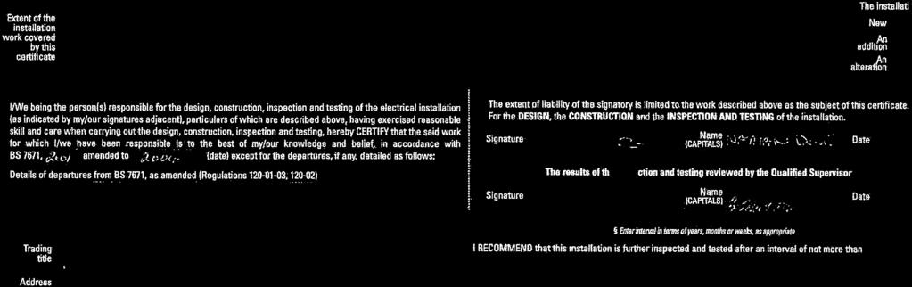
126
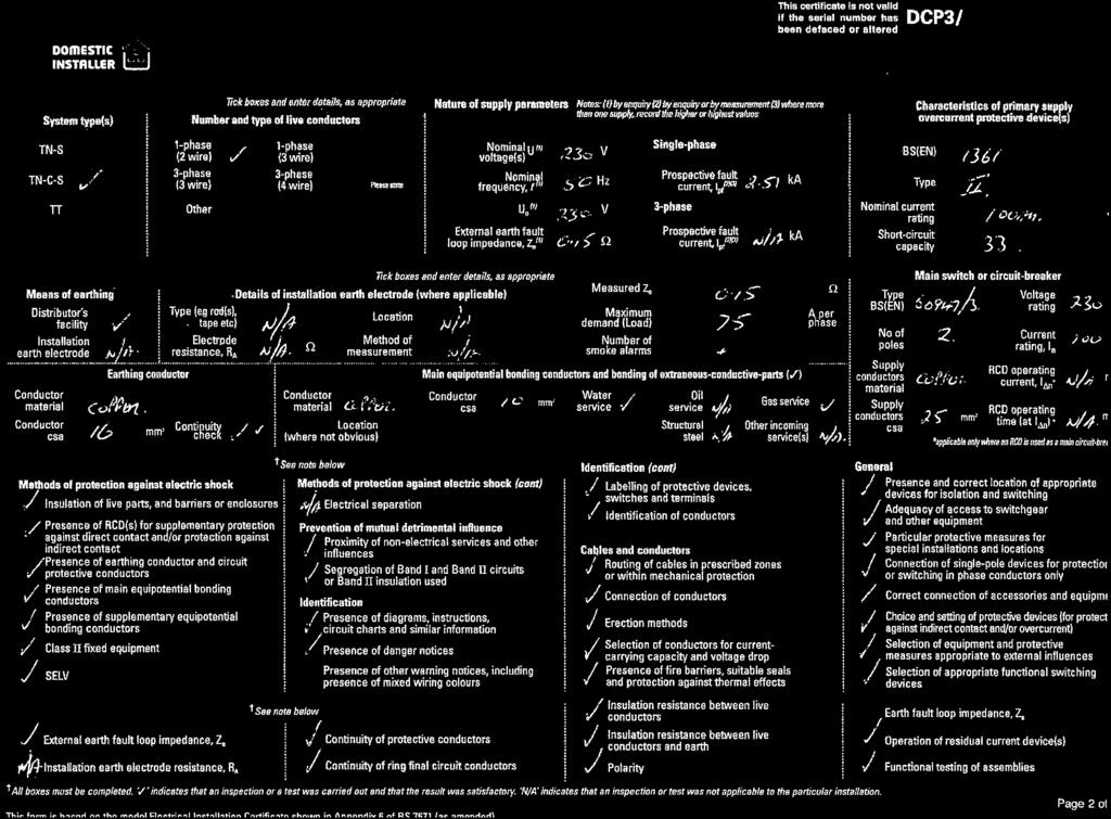
127
128 The electronic official copy of the register follows this message. Please note that this is the only official copy we will issue. We will not issue a paper official copy.


129 Title number NN9390 Edition date This official copy shows the entries on the register of title on 01 SEP 2017 at 12:35:27. This date must be quoted as the "search from date" in any official search application based on this copy. The date at the beginning of an entry is the date on which the entry was made in the register. Issued on 01 Sep Under s.67 of the Land Registration Act 2002, this copy is admissible in evidence to the same extent as the original. This title is dealt with by HM Land Registry, Leicester Office. A: Property Register This register describes the land and estate comprised in the title. NORTHAMPTONSHIRE : NORTHAMPTON 1 ( ) The Freehold land shown edged with red on the plan of the above Title filed at the Registry and being 26 Abington Park Crescent, Northampton (NN3 3AD). 2 The land edged and numbered in green on the title plan has been removed from this title and registered under the title number or numbers shown in green on the said plan. B: Proprietorship Register This register specifies the class of title and identifies the owner. It contains any entries that affect the right of disposal. Title absolute 1 ( ) PROPRIETOR: MARTY VIREN PUMBIEN of 26 Abington Park Crescent, Northampton NN3 3AD. 2 ( ) The price stated to have been paid on 31 July 2007 for the land in this title and in title NN9939 was 675, ( ) The Transfer to the proprietor contains a covenant to observe and perform the covenants referred to in the Charges Register and of indemnity in respect thereof. 4 ( ) RESTRICTION: No disposition of the registered estate by the proprietor of the registered estate is to be registered without a written consent signed by the proprietor for the time being of the Charge dated 12 August 2008 in favour of Santander UK PLC referred to in the Charges Register. C: Charges Register This register contains any charges and other matters that affect the land. 1 A Conveyance of the land tinted pink and tinted yellow on the filed plan and other land dated 7 April 1903 made between (1) The Right 1 of 3
Drainage and Water Enquiry
 Produced on: 28 June 2016 Date requested: 28 June 2016 Your order reference is: G2114586-1 Your customer reference is: Sample-CON29DW Drainage and Water Enquiry Search address: 1 Sample Street Sample Town
Drainage and Water Enquiry
 Produced on:07 February 2018 Date requested:07 February 2018 Your order reference is: Your customer reference is: Drainage and Water Enquiry Search address: 1 Sample Street Sample Town AB1 2CD Search ordered
Drainage and Water Enquiry
 Produced on:26 September 2017 Date requested:25 September 2017 Your order reference is: G2262025-1 Your customer reference is: 1459029 BE/MID00292/1 Drainage and Water Enquiry Search address: Search ordered
Drainage and Water Enquiry
 Produced on: Date requested: Your order reference is: Your customer reference is: Sample-CON29DW Drainage and Water Enquiry Search address: Search ordered by: 1 Sample Street Sample Town AB1 2CD For any
COMMERCIALDW Drainage and Water Enquiry
 Order Reference:G2252771-1 Produced on:06 September 2017 COMMERCIALDW Drainage and Water Enquiry The information in this document refers to: This document was ordered by: Pact Partnerships 5 Woodside Parade
Drainage and Water Search
 Property Search Southwest info@pssw.solutions Our Reference: Your Reference: Report Prepared by: 012345 A Searcher Invoice Number: E12345678 Date: 9th June 2015 Property Address Drainage and Water Summary
Drainage & Water Search (CON29DW)
") Drainage & Water Search (CON29DW) Search Details Prepared for: Matter: Client address: Hutharts Law Firm GH//17/1005 431 Durham Road, Low fell, NE9 5AN Property: The Barn at Rosemary Cottage, Garigill,
Drainage & Water Search (CON29DW) Search Details Prepared for: Matter: Client address: Hutharts Law Firm GH//17/1005 431 Durham Road, Low fell, NE9 5AN Property: The Barn at Rosemary Cottage, Garigill,
SAMPLE. Site Name:, Sub-Building:, Building Name:, Building No:, Road:, Assoc Road, Locality:, Town/City:, County:, RG1 7DE
 TEST Individual TEST ORGANISATION - DO NOT USE Vastern Road Reading RG1 8DB Search address supplied Your reference Our reference TEST_DWS Received date 14 July 2017 Search date 19 July 2017 Keeping you
Sample Building Name, Sample Road, Sample Town, Sample County, RG1 8DB
 The Law Society s CON29DW Drainage & Water Enquiry DX Number DX Exchange Search address supplied Your reference Our reference Sample Search Received date 10 June 2016 Search date 10 June 2016 DWS/DWS Standard/2016_3347801
Residential CON29DW Drainage and Water Enquiry
 Residential CON29DW Drainage and Water Enquiry Search Ordered 11 May 2016 Search Completed 16 May 2016 Customer: Property: SM Account 14 Nelson Street Bradford West Yorkshire BD15 7QY Search Compiled by:
Groundsure HS2 and Crossrail
 Groundsure HS2 and Crossrail Address: Specimen Address Date: Report Date Groundsure Reference: HS2 & Crossrail Specimen Your Reference: HS2 & Crossrail Specimen Grid Reference:123456,123456 HS2*: The property
CON 29 REQUIRED ENQUIRIES OF THE LOCAL AUTHORITY
 CON 29 REQUIRED ENQUIRIES OF THE LOCAL AUTHORITY Search & Report Completed By : Assured Property Searches Ltd APS House 113 Kingsway Petts Wood Kent BR5 1PP Search Completion Date : 01/11/2012 Instructed
IDENTIFIED AAAAAAAAAAAAAAA CLICK TO VIEW THE MAP
 RiskView Residential Contaminated Land PASSED We believe there is no significant risk of contaminated land at or close to the property. Please turn the page for further information. Flood PASSED The property
Stone Mining Search. Passed. Information CONTACT DETAILS
 Conveyancing Searches with Professional Opinions Passed This search is issued for the property described as: 32, Windsor Drive London W2 1QQ Search reference: WDSampleStone3/NoWarnings Date of issue: 10
Radon Risk Report. Empowering People with Information. This report is issued for the property described as: Requested By:
 Radon Risk Report This report is issued for the property described as: Landmark Information Group Ltd, Imperium Imperial Way, Reading, RG2 0TD Requested By: Landmark Po Sample Account, 5-7 Abbey Court,
CON29DW RESIDENTIAL DRAINAGE AND WATER ENQUIRY
 CON29DW RESIDENTIAL DRAINAGE AND WATER ENQUIRY Your Reference: Date Received OSDA012314567 02/10/2015 Our Reference: Date Completed 12345678 08/10/2015 Search address: 123 Sample Road Sampletown Anywhere
Drainage & Water Search (CON29DW)
") Drainage & Water Search (CON29DW) Thorogood & Co, Woking DX: 148060 Woking 12 Fax / E-mail: julia.nightingale@stlgroup.co.uk Telephone: 01483 715355 Client Ref: STL Reference: 1501926 Received Date: 14/07/2014
Drainage & Water Search (CON29DW) Thorogood & Co, Woking DX: 148060 Woking 12 Fax / E-mail: julia.nightingale@stlgroup.co.uk Telephone: 01483 715355 Client Ref: STL Reference: 1501926 Received Date: 14/07/2014
RESULT Unknown / Not requested at point of order?
 REPORT DETAIL CLIENT REFERENCE: Sample - TCR TITLECHECKER SEARCH RESULT - PROPERTY DETAIL CRITICAL RESULT - OWNERSHIP ATTENTION REQUIRED? RESULT - USE ATTENTION REQUIRED? TITLECHECKER ANALYSIS OF TITLE
Your Search Results : Martlets Cattery Coldharbour Lane Upper Dicker Hailsham East Sussex BN27 3QA
 Your Search Results : Martlets Cattery Coldharbour Lane Upper Dicker Hailsham East Sussex BN27 3QA SureSearch Legal Services Limited 3,Shannon Close Littlehampton West Sussex BN17 6PR Your Ref 7256 Our
FURTHER ACTION AAAAAAAAAAAAAAA CLICK TO VIEW THE MAP IDENTIFIED AAAAAAAAAAAAAAA
 RiskView Residential Contaminated Land FURTHER ACTION AAAAAAAAAAAAAAA CLICK TO VIEW THE MAP We have identified a potential risk of contaminated land at or close to the property. Please turn the page for
Mineral Extraction Search Report
 Conclusion: HIGH RISK Date: 01/10/2015 Our Reference: TM.MS.10.01 Client/Reference: FKGRKW2LL.001 Terrafirma Mine Searches Ltd Pure Offices, Pastures Avenue, St Georges, BS22 7SB T: 01934 806515 E: info@terrafirmaminesearches.co.uk
Home Information Pack
 .... Home Information Pack 121 Croxton Ave Mossbrook Rochdale Greater Manchester OL16 2YE Compiled by Andrew Kelly & Associates .... Welcome About Your Home Information Pack The contents of the Home Information
Search Report REQUESTED FOR. Freephone Requested by:- Sample Solicitors AF/ TEST AFisher
 Search Report Requested by:- Sample Solicitors E-Mail: kbartke@sphproperty.co.uk SUMMARY OF SEARCH REPORT : 01560281 INVOICE NUMBER : E20983778 Search of Local Land Charges Register The Search requested
Disbursements in Conveyancing
 Conveyancing Marketing Services Ltd Disbursements in Conveyancing The definition of a disbursement is a payment that has to be made to a third party such as The Land Registry for online or direct registration
Developer Services. Sewerage Technical Team: Fees for April 2018
 Developer Services Sewerage Technical Team: Fees for 2018-2019 April 2018 Fees for 2018-2019 Sewerage Technical Team Fees for 2018-2019 DOCUMENT CONTROL Author Natalie Drake Created Date February 2018
IDENTIFIED CLICK TO VIEW INTERACTIVE MAP
 RiskView Residential Contaminated Land WWW to view the interactive Click here map online now Also available at: [http://landmark.ly/7qvmi3] PASSED We believe there is no significant risk of contaminated
OTHER* GROUND WATER AAAAAA IDENTIFIED CLICK TO VIEW ONLINE VIEWER
 RiskView Residential Contaminated Land PASSED We believe there is no significant risk of contaminated land at or close to the property. Please turn the page for further information. Flood PASSED The property
Adoption of a new sewer
 Adoption of a new sewer Application form You can go to our website thameswater.co.uk/buildover and apply online or complete this form and return to Thames Water, Developer Services, Clearwater Court, Vastern
PASS. Professional opinion. Environmental search results 35, PHAROS STREET, FLEETWOOD, LANCASHIRE, FY7 6AY. Contaminated Land
 Professional opinion PASS Groundsure has not identified significant risks likely to restrict any reasonable mortgage application for the property. Homescreen also complies with Law Society practice notes
Regulated Non-Coal Mining Search
 Conveyancing Searches with Professional Opinions Further Action This search is issued for the property described as: A Property Carmarthen, SA32 Search reference: NCCS03 Date of issue: 16 April 2018 Date
London Borough of Lambeth Room 205, Town Hall Brixton Hill, London SW2 1RW
 ,, REGISTER OF LOCAL LAND CHARGES - OFFICIAL CERTIFICATE OF SEARCH TM Search Group - For Invoicing 743360 Swindon 31 200 Delta Delta Business Park Wiltshire Swindon SN5 7XD Search Reference: 16/01327 Applicant
Buying or Selling a Property Legal Terms Explained For St. James s Place Clients
 Buying or Selling a Property Legal Terms Explained For St. James s Place Clients Bankruptcy Search - a search to check whether a buyer has been declared bankrupt. Boundaries - usually marked by fencing,
PEEL WATER NETWORKS LIMITED WHOLESALE SEWERAGE CHARGES SCHEME 2017/18
 PEEL WATER NETWORKS LIMITED WHOLESALE SEWERAGE CHARGES SCHEME 2017/18 Peel Water Networks Limited, Peel Dome, Intu Trafford Centre, TraffordCity Manchester. M17 8PL. Registered No: 6680258 Table of Contents
A method of payment through a bank which is free but takes up to 3 days. A check on whether a person is, or is about to be Bankrupt.
 Adopted Apportionments BACS Payment Bankruptcy Search Caveat Emptor Certificate of Title Certified Copy Chain Chancel Repair Liability Charge Completion Conservation Area When a Local Authority (council)
WREXHAM COUNTY BOROUGH COUNCIL SEARCH FEE RECEIPT
 WREXHAM COUNTY BOROUGH COUNCIL SEARCH FEE RECEIPT RE: LAND CHARGES SEARCH LC/1617/01795 14 HAVARD WAY WREXHAM LL13 9LR This acknowledges receipt of payment for the sum of 85 received on 24/02/2017 being
Property Information Form
 Property Information Form Full Names of the Seller Address of Property Seller s Solicitor Name of firm Address E-mail Reference ABOUT THIS FORM This form is completed by the seller to provide detailed
Law Society Property Information Form (3rd edition)
") Law Society Property Information Form (3rd edition) Address of the property Postcode Full names of the seller Seller s solicitor Name of solicitor s firm Address Email Reference number About this form
Law Society Property Information Form (3rd edition) Address of the property Postcode Full names of the seller Seller s solicitor Name of solicitor s firm Address Email Reference number About this form
Purchase of a leasehold residential property
 Purchase of a leasehold residential property Our fees cover all the work required to complete the purchase of your new home, including dealing with registration at the Land Registry and dealing with the
Sample. Commercial Local Search. About Your Search. Land Charges Summary. This search reveals 6 registration(s) as described in the schedule hereto.
 as described in the schedule hereto.") Commercial Local Search Land Charges Summary This search reveals 6 registration(s) as described in the schedule hereto. Planning Permissions Sections 1.1a-1.1i Building Regulations Approval Sections 1.1j-1.1l
Commercial Local Search Land Charges Summary This search reveals 6 registration(s) as described in the schedule hereto. Planning Permissions Sections 1.1a-1.1i Building Regulations Approval Sections 1.1j-1.1l
Landowner's rights. When the Crown requires your land for a public work. April 2010
 Landowner's rights When the Crown requires your land for a public work April 2010 Image Goes HERE Landowner's rights when the Crown requires your land for a public work Land Information New Zealand April
PLEASE COMPLETE ALL SECTIONS USING BLOCK CAPITALS AND BLACK INK
 Application for adoption of new sewers Section 104 WIA t a~united ~ ~ Utilities ~~tng life f\ow smoothly This form should be used to offer proposed drainage systems for adoption by United Utilities under
LETTER TO COMPANY - DRAFT CITY OF LONDON LAW SOCIETY LAND LAW COMMITTEE CERTIFICATE OF TITLE (7 TH EDITION 2016 UPDATE)
") LETTER TO COMPANY - DRAFT CITY OF LONDON LAW SOCIETY LAND LAW COMMITTEE CERTIFICATE OF TITLE (7 TH EDITION 2016 UPDATE) This is the first of two letters which may be sent by the solicitors giving the Certificate
LETTER TO COMPANY - DRAFT CITY OF LONDON LAW SOCIETY LAND LAW COMMITTEE CERTIFICATE OF TITLE (7 TH EDITION 2016 UPDATE) This is the first of two letters which may be sent by the solicitors giving the Certificate
2012 No LAND REGISTRATION, ENGLAND AND WALES. The Land Registration Fee Order 2012
 STATUTORY INSTRUMENTS 2012 No. 1969 LAND REGISTRATION, ENGLAND AND WALES The Land Registration Fee Order 2012 Made - - - - 24th July 2012 Laid before Parliament 27th July 2012 Coming into force - - 22nd
PURCHASE OF FREEHOLD OR LEASEHOLD RESIDENTIAL PROPERTY
 PURCHASE OF FREEHOLD OR LEASEHOLD RESIDENTIAL PROPERTY Our fees cover all of the work required to complete the purchase of a residential property (either freehold or leasehold) including dealing with the
Home Information Pack. Two Hoots, Wardhedges Road Flitton Bedford Bedfordshire MK45 5ED
 Home Information Pack Two Hoots, Wardhedges Road Flitton Bedford Bedfordshire MK45 5ED Home Information Pack A Home Information Pack (HIP) is a set of documents providing important information about a
HYDRAULIC SERVICES BY - LAW
 Repeal HOBART CITY COUNCIL HYDRAULIC SERVICES BY - LAW BY-LAW 4 OF 2008 BY-LAW MADE UNDER SECTION 145 OF THE LOCAL GOVERNMENT ACT 1993 AND SECTION 67 A OF THE SEWERS AND DRAINS ACT 1954 FOR THE PURPOSE
SRA TRANSPARENCY RULES
 SRA TRANSPARENCY RULES 06/12/2018 In accordance with the transparency rules introduced by the SRA, we are now pleased to display our firm s pricing and service information in relation to the following
Application for a sewer requisition and/or the diversion of an existing sewer
 SWW Reference No: WR Application for a sewer requisition and/or the diversion of an existing sewer This form can be used to apply for a new sewer requisition, under section 98-101, and/or a new sewer diversion,
Online Bidding Terms & Conditions
 National Residential Property Auctions Online Bidding Terms & Conditions Last modified: 28/11/2017 Find your perfect property at an amazing price IMPORTANT: These terms and conditions apply to all Online
Fully Managed Landlord Agreement The Landlord and the Agent hereby agree to enter into a Contract under the following terms and conditions.
 Fully Managed Landlord Agreement The Landlord and the Agent hereby agree to enter into a Contract under the following terms and conditions. Date: Parties:. The Landlord:. Of.. The Agent: Ellen Kay Lettings
WASTEWATER SERVICE CHARGES EFFECTIVE FOR ALL BILLS ISSUED ON AND AFTER AUGUST 1, 2003
 Louisville and Jefferson County Metropolitan Sewer District WASTEWATER SERVICE CHARGES EFFECTIVE FOR ALL BILLS ISSUED ON AND AFTER AUGUST 1, 2003 A. WASTEWATER SERVICE CHARGES Applicable to all bills rendered.
we apply for the necessary searches you make your mortgage application (if applicable)
") NOTES FOR BUYERS These notes contain important information about buying a property, and we ask you to read through them carefully. They form an integral part of our conveyancing service, and we hope that
NOTES FOR BUYERS These notes contain important information about buying a property, and we ask you to read through them carefully. They form an integral part of our conveyancing service, and we hope that
RIBA Chartered Practice
 RIBA Chartered Practice Accreditation Criteria and Standards Standards and Enforcement Procedures Royal Institute of British Architects 66 Portland Place, London, W1B 1AD, UK Tel: +44 (0)20 7580 5533 Fax:
Southern Water Infrastructure Charges Scheme
 Southern Water Infrastructure Charges Scheme 2018-19 Contents Preface Statement of Board Assurance provided to the Water Services Regulation Authority 2018-19 Charges... 3 Part 1 - Introduction and Commencement...
Please note that this is the only official copy we will issue. We will not issue a paper official copy.
 The electronic official copy of the register follows this message. Please note that this is the only official copy we will issue. We will not issue a paper official copy. Edition date 17.02.2015 This official
TERMS OF SALE. 3.2 Each order accepted constitutes a separate legally binding Contract between FAV and the Buyer.
 The Arches Unit 445 Joseph Street Bow London E3 4AT T: +44 (0) 333 433 0443 E: sales@focus-av.net W: focus-av.net TERMS OF SALE 1 Definitions 1.1 In these Conditions: FAV means Focus Audio Visual Limited;
LOCAL AUTHORITY WORKS PART 8 - PROCEDURE
 LOCAL AUTHORITY WORKS PART 8 - PROCEDURE Planning & Property Development Department December 2017 INDEX Introduction Page 2 Local Authority Works to which Part 8 applies Page 3 Local Authority Works to
An independent guide to property searches. Your guide to the facts
 An independent guide to property searches Your guide to the facts Contents What are property searches? 3 Examples of Register charges 4 Requisitioning a Search 5 CON29 search process 6 The different types
Build Over Easement Guidelines
 Build Over Easement Guidelines Document Owner Creation Date 13/04/2015 Revision Date 20/04/2015 Manager Engineering Services Engineering Services Please check Council s Intranet to ensure this is the latest
Terms of Business (v4.0)
") Terms of Business (v4.0) These Terms of Business set out the services The Agent can provide to The Landlord and also set out the corresponding responsibilities of The Landlord. Please read these Terms
Terms of Business (v4.0) These Terms of Business set out the services The Agent can provide to The Landlord and also set out the corresponding responsibilities of The Landlord. Please read these Terms
REGISTER OF LOCAL LAND CHARGES OFFICIAL CERTIFICATE OF SEARCH
 REGISTER OF LOCAL LAND CHARGES OFFICIAL CERTIFICATE OF SEARCH Search Reference: NLIS Reference: Solicitors Reference: Date: 1718_02354 MDJ/GEN218 06-v-2017 Applicant: Lloyd Jones & Co DX 100802 WESTCLIFF
WASTEWATER SERVICE CHARGES EFFECTIVE FOR ALL BILLS ISSUED ON AND AFTER AUGUST 1, 2005
 Louisville and Jefferson County Metropolitan Sewer District WASTEWATER SERVICE CHARGES EFFECTIVE FOR ALL BILLS ISSUED ON AND AFTER AUGUST 1, 2005 A. WASTEWATER SERVICE CHARGES Applicable to all bills rendered.
TORONTO MUNICIPAL CODE CHAPTER 849, WATER AND SEWAGE SERVICES AND UTILITY BILL. Chapter 849 WATER AND SEWAGE SERVICES AND UTILITY BILL 1
 849-1. Definitions. 849-2. Application form. Chapter 849 WATER AND SEWAGE SERVICES AND UTILITY BILL 1 ARTICLE I Rebates 849-3. Rebate on portion of surcharge on water rates for sewage service. 849-4. Submission
HS2 Phase Two - Land & Property - preparation of Hybrid Bill activities privacy notice
 HS2 Phase Two - Land & Property - preparation of Hybrid Bill activities privacy notice Your privacy There are rules about what personal information we can record, hold, use and share. You have rights over
Buying & Selling Your Home a Guide
 Buying & Selling Your Home a Guide Introduction Buying or selling your house is likely to be the most important financial transaction you will ever enter into. Our practice covers all areas of the law
Landlord and Agent Agreement: Part A
 Granger & Oaks Landlord and Agent Agreement: Part A Today s Date: THE PROPERTY Full Address: Property available from: Property advertised price: Is the property: Furnished Unfurnished Part-Furnished Flexible
Land rights requirements relating to assets to be installed or adopted by SEPD or SHEPD for new connections
 Land rights requirements relating to assets to be installed or adopted by SEPD or SHEPD for new connections Information for SEPD and SHEPD Staff, ICPs, IDNOs and connection customers v1.1 August 2016 Background
The Conveyancing Association Protocol For England and Wales
 The Conveyancing Association Protocol For England and Wales The Conveyancing Association (CA) endorses the principles that underpin this protocol but recognises that each transaction must be judged on
REGISTER OF LOCAL LAND CHARGES OFFICIAL CERTIFICATE OF SEARCH
 REGISTER OF LOCAL LAND CHARGES OFFICIAL CERTIFICATE OF SEARCH Search Reference: NLIS Reference: Solicitors Reference: Date: 1718_03381 CKB.JAG.EHLERS 07-Mar-2018 Applicant: Chennells 100804 Westcliff on
EQ Solicitors: Pricing Information
 EQ Solicitors: Pricing Information Contents Residential Conveyancing: Purchase of a freehold residential property... 2 Residential Conveyancing: Purchase of a leasehold residential property... 3 Probate
Highways Practice Note 029 Highways Act Section 72 Guidance March HPN Control Sheet
 Highways Practice Note 029 Highways Act 1980 - Section 72 Guidance March 2015 HPN Control Sheet HPN Control Sheet HPN prepared by: Shanthi Selvarajan Development Management Engineer Highways SMO3, Unit
Blue Bubble Lettings Limited Landlord Terms of Business Fully Managed Service
 Blue Bubble Lettings Limited Landlord Terms of Business Fully Managed Service This agreement is made between the Landlord(s) of the property and Blue Bubble Lettings Limited, acting as the Landlord s Agent.
LANDLORDS TERMS AND CONDITIONS
 LANDLORDS TERMS AND CONDITIONS AGENCY AGREEMENT Between Cloud9 Aspirational Property Management Limited The Old Chapel, 14 Fairview Drive, Redland, Bristol, BS6 6PH and Landlord s name/s (all joint landlords):..
DEVELOPMENT OPPORTUNITY LAND EAST OF NEW ROAD MELBOURN, CAMBRIDGESHIRE, SG8 6BX
 DEVELOPMENT OPPORTUNITY LAND EAST OF NEW ROAD MELBOURN, CAMBRIDGESHIRE, SG8 6BX Illustrative Masterplan - Not to Scale An excellent opportunity to acquire a development site benefitting from outline planning
ICP/IDNO Land Rights Guide
 ICP/ID Land Rights Guide Our guide about land rights for connections involving Independent Connection Providers (ICPs) and Independent Distribution Network Operators (IDs) Welcome We hope this guide will
Property Information Form
 Property Information Form Address of the property Full names of the seller Seller's solicitor Name of solicitors firm Address Email Reference number About this form Definitions This form is completed by
FACTORING AGREEMENT ARGYLL COMMUNITY HOUSING ASSOCIATION LIMITED
 ARGYLL COMMUNITY HOUSING ASSOCIATION LIMITED This is a FACTORING AGREEMENT between Argyll Community Housing Association Limited, having our registered office at Menzies House, Glenshellach Business Park,
Please note that this is the only official copy we will issue. We will not issue a paper official copy.
 The electronic official copy of the register follows this message. Please note that this is the only official copy we will issue. We will not issue a paper official copy. Edition date 07.11.2017 This official
Your Guide to First Time Sewerage for Existing Properties
 Your Guide to First Time Sewerage for Existing Properties Anglian Water has a legal duty to assess the most economical and practicable way to provide effective drainage where the current drainage for two
Landlord Terms of Business: Tenant Find Service
 Landlord Terms of Business: Tenant Find Service This agreement is made between the Landlord(s) of the property and Blue Bubble Lettings Limited, acting as the Landlord s Agent. This document clearly lays
Property / Land Questionnaire for In-Specie Transfer
 Self-Invested Personal Pension SIPP Property / Land Questionnaire for In-Specie Transfer www.investaccpensions.co.uk Contents Section Personal Information About the Property / Land Transferring Scheme
BUILDING REGULATIONS SUBMISSION PACK
 BUILDING REGULATIONS SUBMISSION PACK The following documents are supplied for your convenience; please retain the information for future use. Drawings / Specifications / Calculations Please provide all
SECTION A. Applicant (This MUST be the Owner/Authorised Agent please attach written authorisation) First & Last Name/s:... Postal Address:...
 First & Last Name/s:... Postal Address:...") 1-3 Thornleigh St, Thornleigh NSW 2120 P: 9473 5488 F: 9980 2166 SECTION A-M: PAGES 1-3. APPLICATION FOR COMPLYING DEVELOPMENT CERTIFICATE CLASS 1+ 10 BUILDINGS. SSECTIONS 2-5: PAGES 4-6. CONTRACT FOR
1-3 Thornleigh St, Thornleigh NSW 2120 P: 9473 5488 F: 9980 2166 SECTION A-M: PAGES 1-3. APPLICATION FOR COMPLYING DEVELOPMENT CERTIFICATE CLASS 1+ 10 BUILDINGS. SSECTIONS 2-5: PAGES 4-6. CONTRACT FOR
1.1 Explain the nature and the characteristics of a lease
 Title Residential and Commercial Leasehold Conveyancing Level 3 Credit value 7 (Registered land only) Learning outcomes The learner will: Assessment criteria The learner can Knowledge, understanding and
Our fees for residential conveyancing
 Purchase of a freehold residential property Our fees for residential conveyancing Our fees cover all of the work* required to complete the purchase of your new home, including dealing with registration
LETTINGS & MANAGEMENT
 LETTINGS & MANAGEMENT Terms of Business Address of Property to be Let:.. Post code: www.drivers.co.uk sales lettings auctions management commercial surveyors TERMS OF BUSINESS Drivers & Norris agree to
Mobile Homes on Private Property Permits Licence and Inspection Services
 Mobile Homes on Private Property Permits Licence and Inspection Services Mobile Homes 20338 65 Ave., Langley B.C. V2Y 3J1 Phone 604-533-6018 This publication is designed to provide information for the
SELLER S GUIDE INTRODUCTION SELLER S PACK REQUEST FORM RETIREMENT PROPERTIES APPENDIX
 Transfer of Property A standard guide to our fees and requirements SELLER S GUIDE INTRODUCTION PAGE 02 SELLER S PACK PAGE 03 REQUEST FORM PAGE 04 RETIREMENT PROPERTIES PAGE 06 APPENDIX PAGE 11 Version
Agency Agreement. (Terms of Business)
") Agency Agreement (Terms of Business) This Agreement is made between the Landlord of the Property (as named at the end of this agreement) and Options Property Management & Lettings Ltd who agree to act
Agency Agreement (Terms of Business) This Agreement is made between the Landlord of the Property (as named at the end of this agreement) and Options Property Management & Lettings Ltd who agree to act
INSTRUCTIONS TO SOLICITORS
 INSTRUCTIONS TO SOLICITORS (NORTHERN IRELAND) PLATFORM Platform P.O. Box 3462 Cheadle Road Leek ST13 9BG Telephone: 0345 070 1999 DX 16351 (Leek) We should like you to act on our behalf in relation to
South African Council for Town and Regional Planners
 TARIFF OF FEES South African Council for Town and Regional Planners PLEASE NOTE : THE TARIFF OF FEES WAS APPROVED BY THE COUNCIL CHAPTER 10 : TARIFF OF FEES 10.1 INTRODUCTION 10.1.1 General This tariff
REPLIES TO STANDARD ENQUIRIES OF LOCAL AUTHORITY (2016 Edition)
") REPLIES TO STANDARD ENQUIRIES OF LOCAL AUTHORITY (2016 Edition) Applicant: Searchflow Limited 42, Kings Hill Avenue West Malling Kent ME19 4AJ Search Reference: 1819_00323 NLIS Reference: Solicitors Reference:
REPLIES TO STANDARD ENQUIRIES OF LOCAL AUTHORITY (2016 Edition) Applicant: Searchflow Limited 42, Kings Hill Avenue West Malling Kent ME19 4AJ Search Reference: 1819_00323 NLIS Reference: Solicitors Reference:
Vendor Form Property Services Agreement For The Auction of Property Other Than Land SOLE AGENCY
 CARRIER USE ONLY Carrier Name: Amount: To be charge to proceeds YES NO Seller Signature Authorising above: Office use only REF: Sp. Com: Entered: Vendor Form Property Services Agreement For The Auction
SOUTH TIPPERARY COUNTY COUNCIL
 SOUTH TIPPERARY COUNTY COUNCIL POLICY FOR THE TAKING IN CHARGE OF RESIDENTIAL DEVELOPMENTS 1 POLICY POLICY This document outlines South Tipperary County Council s policy and procedure in relation to taking
Recognition of Prior Learning (RPL) Application NSW. Surname: Given Names: Company: Address: Phone Work: Phone Home: Mobile:
 Application NSW. Surname: Given Names: Company: Address: Phone Work: Phone Home: Mobile:") Create your future NSW Real Estate Training College realestatetraining.com.au Recognition of Prior Learning (RPL) Application NSW PO Box 601, HORNSBY NSW 2077 Real Estate Agents Licence Applicant Details
Create your future NSW Real Estate Training College realestatetraining.com.au Recognition of Prior Learning (RPL) Application NSW PO Box 601, HORNSBY NSW 2077 Real Estate Agents Licence Applicant Details
Unique Estates Australia Pty Ltd ACN (the Company) Circular to Property Owners. 16 February 2018
 Circular to Property Owners. 16 February 2018") Unique Estates Australia Pty Ltd ACN 079 859 340 (the Company) Circular to Property Owners 16 February 2018 We advise that Barry Kogan and Matt Fehon of McGrathNicol together with Matt Meynell from Colliers
Unique Estates Australia Pty Ltd ACN 079 859 340 (the Company) Circular to Property Owners 16 February 2018 We advise that Barry Kogan and Matt Fehon of McGrathNicol together with Matt Meynell from Colliers
ADMINISTRATIVE GUIDANCE
 11 ADMINISTRATIVE GUIDANCE ON CONTAMINATED SITES Effective date: April 1, 2013 Version 1.1 May 2013 Expectations and Requirements for Contaminant Migration Introduction This guidance focusses on the ministry
CONDITIONS OF CONTRACT FOR THE PURCHASE OF GOODS AND SERVICES BY PENNON GROUP PLC AND/OR SOUTH WEST WATER LIMITED
 CONDITIONS OF CONTRACT FOR THE PURCHASE OF GOODS AND SERVICES BY PENNON GROUP PLC AND/OR SOUTH WEST WATER LIMITED These standard conditions of purchase together with any special conditions ("the Conditions")
APPLICATION FORM FOR COMPLYING DEVELOPMENT CERTIFICATE
 APPLICATION FORM FOR COMPLYING DEVELOPMENT CERTIFICATE SECTION A. Details of the applicant *An application may only be made by a person who has the benefit of the development consent. An application may
Service Level Agreement
 The Commission for Ethical Standards in Public Life in Scotland Service Level Agreement between «Title» «Forename» «Surname» (A Public Appointments Assessor for the Commission for Ethical Standards in