City Commission Agenda Cover Memorandum
|
|
|
- Gloria Rich
- 5 years ago
- Views:
Transcription

1 City Commission Agenda Cover Memorandum Originating Department: Planning & Zoning (PZ) Meeting Type: Regular Agenda Date: 10/24/2016 Advertised: Required?: Yes No Date: 10/17/2016 Paper: PB Post ACM#: Subject: Public Hearing and Second Reading of Ordinance No : Regarding a request by Collene Walter of Urban Design Kilday Studios, on behalf of the Palm Beach County Department of Airports, to amend the Future Land Use (FLU) designation from Community Service (CS) to Commercial (C) of approximately acres of the property located on the southwest corner of the intersection of Belvedere Road and Australian Avenue. Public Hearing and Second Reading of Ordinance : Regarding a request by Collene Walter of Urban Design Kilday Studios, on behalf of the Palm Beach County Department of Airports, to change the zoning district from Community Service (CS) to General Commercial (GC) of approximately acres of the property located on the southwest corner of the intersection of Belvedere Road and Australian Avenue. Ordinance/Resolution: ORDINANCE NO : AN ORDINANCE OF THE CITY COMMISSION OF THE CITY OF WEST PALM BEACH, FLORIDA, AMENDING THE FUTURE LAND USE MAP OF THE COMPREHENSIVE PLAN OF THE CITY BY AMENDING THE FUTURE LAND USE DESIGNATION FOR AN APPROXIMATELY ACRE PROPERTY LOCATED AT 1600 BELVEDERE ROAD FROM A COMMUNITY SERVICE (CS) DESIGNATION TO A COMMERCIAL (C) FUTURE LAND USE DESIGNATION; DECLARING THE PROPOSED AMENDMENT TO THE FUTURE LAND USE MAP TO BE CONSISTENT WITH ALL OTHER ELEMENTS OF THE COMPREHENSIVE PLAN OF THE CITY; PROVIDING A CONFLICT CLAUSE ; PROVIDING AN EFFECTIVE DATE; AND FOR OTHER PURPOSES. ORDINANCE NO : AN ORDINANCE OF THE CITY COMMISSION OF THE CITY OF WEST PALM BEACH, FLORIDA, AMENDING THE ZONING MAP OF THE CITY OF WEST PALM BEACH BY REZONING AN APPROXIMATELY ACRE PROPERTY LOCATED AT 1600 BELVEDERE ROAD FROM A COMMUNITY SERVICE (CS) ZONING DISTRICT TO A GENERAL COMMERCIAL (GC) ZONING DISTRICT; DECLARING THIS ZONING MAP AMENDMENT TO BE CONSISTENT WITH THE COMPREHENSIVE PLAN OF THE CITY; REVISING THE ZONING MAP OF THE CITY ACCORDINGLY; PROVIDING A CONFLICT CLAUSE; PROVIDING AN EFFECTIVE DATE; AND FOR OTHER PURPOSES. Staff Recommended Motion:
2 AGENDA COVER MEMORANDUM Page 2 C.M. # Date: APPROVE Ordinance No : A Future Land Use Map amendment to the City s Comprehensive Plan, to change the Future Land Use designation from Community Service to Commercial for approximately acres of property located at the southwest corner of the intersection of Belvedere Road and Australian Avenue. This motion is based upon the factual testimony presented, the application submitted, the staff report, the recommendation of the Planning Board, and the findings that the standards of the City's Comprehensive Plan have been met. APPROVE Ordinance No : An amendment to the Zoning Map to rezone approximately acres of property located at the southwest corner of the intersection of Belvedere Road and Australian Avenue to change the property s zoning district from Community Service to General Commercial. This motion is based upon the factual testimony presented, the application submitted, the staff report, the recommendation of the Planning Board, and the findings that the standards of Section of the Zoning and Land Development Regulations have been met. Background: Ordinance No : The Planning Division has determined that the request to change the Future Land Use (FLU) designation from Community Service to Commercial complies with Policy of the Future Land Use element of the Comprehensive Plan. Ordinance No : The Planning Division has determined that the rezoning request with conditions complies with all of the required standards found in Section of the City s Zoning and Land Development Regulations. Compliance with all the above mentioned standards has been detailed in Attachment A and Attachment B of the City Commission Staff Report. The Planning Board recommended approval (7-0) of the Future Land Use and Rezoning with Conditions requests to the City Commission after a Public Hearing on June 21, The City Commission approved (5-0) the Future Land Use and Rezoning Ordinances at the first Public Hearing on August 1, The Future Land Use Map amendment was transmitted to the State, Treasure Coast Regional Planning Council, South Florida Water Management District, Palm Beach County, Florida Department of Transportation, Florida Department of Education, Florida Department of Environment Protection and the State Bureau of Historic Preservation and no objections were received. ANALYSIS: The subject property is located at the southwest corner of the intersection of Belvedere Road and Australian Avenue and the current property owner is the Palm Beach County Department of Airports. The proposed request is part of the PBIA s plan to utilize additional, unused property which is not viable for aviation uses. The subject property is currently being utilized as a cell phone waiting area for the airport, which will be moved to the travel plaza, which is currently under construction, to the west of the subject property. There are currently no site plans for the subject property; the approved airport master plan calls the subject property out as non-aviation use. The property to the south is located in the limits of unincorporated Palm Beach County. The County recently awarded a Request for Proposal (RFP) to develop the property with an upper to mid-scale hotel and commercial uses. The subject
3 AGENDA COVER MEMORANDUM Page 3 C.M. # Date: property currently has a Community Service FLU designation and a Community Service zoning district to allow civic, government and airport uses. The applicant is seeking to amend the FLU designation to Commercial and rezone the property to General Commercial to support commercial uses. FUTURE LAND USE MAP AMENDMENT: Ordinance No : Future Land Use Map Amendment The change in FLU designation from Community Service (CS) to Commercial (C) will result in a decrease in the maximum floor area ratio (FAR) from 1.0 to 0.75 which will result in less intense development. A summary of the level of services (LOS) impacts was prepared and indicated a decrease in all but one impact to levels of service. It indicated one level of service, drainage, remains the same. No impacts are anticipated from the proposed FLU designation change from Community Service (CS) to Commercial (C). The City s Planning Division has determined that amending the subject property to a Commercial Future Land Use designation is compatible with the surrounding properties which are all currently or proposed to be utilized as commercial uses. In addition, the Planning Division has found that the request complies with the Future Land Use amendment standards found in policy and of the Future Land Use Element of the Comprehensive Plan as detailed in the attached staff report. REZONING: Ordinance No : Rezoning To correspond with the proposed Commercial (C) Future Land Use designation, the applicant is requesting to rezone the subject property from Community Service (CS) zoning district to General Commercial (GC). The proposed General Commercial (GC) zoning is consistent with the surrounding commercial uses. Property next to the subject property, which is located in the City, has a General Commercial (GC) zoning district. To the west and south of the subject property is Palm Beach International Airport which is located in unincorporated Palm Beach County and has a Public Ownership (PO) zoning district with an Airport Overlay that allows non-airport uses which may include, but are not limited to, commercial, public and civic, recreation, agricultural, utilities and excavation, and industrial uses, but more specifically including, but not limited to, professional, business, and medical offices, retail centers, restaurants and hotels. Based upon the compatibility with the surrounding zoning districts and uses, the City s Planning Division has found that the request complies with the required Rezoning Standards found in Section of the Zoning and Land Development Regulations. INFRASTRUCTURE IMPACT ANALYSIS: The maximum development potential for the subject parcel under the existing Community Service (CS) FLU designation is a 1.0 floor area ratio which translates to an allowable 539,272 square feet. The maximum development potential under the proposed Commercial FLU designation is 0.75 floor area ratio which translates to an allowable 404,454 square feet. The difference between the two (2) is a decrease in floor area ratio by 0.25 or 134,818 square feet. To evaluate the change in maximum development potential between the existing and proposed FLU designations, a Level of Service (LOS) analysis was conducted and is included in the attached staff report. The analysis indicated a maximum potential build-out between the existing and proposed designations would result in an decrease or equivalent in water, sewer, solid waste, and traffic impacts when compared to the build-out
4 AGENDA COVER MEMORANDUM Page 4 C.M. # Date: under the current Community Service (CS) designation. NOTICES: Courtesy notices were mailed to property owners within 500 feet of the affected parcels on June 28, 2016 and the site has had a sign posted since June 2, To date, the City has received one (1) inquiry that has resulted in no issues. COMMISSION DISTRICT: The subject property is located in Commission District 5 - Commissioner Shannon Materio. Fiscal Note Current Year: Annualized: Budgeted: Unbudgeted: Funding Source: Comment: Electronic Attachments: Click here for assistance with naming convention. Is this ACM related to a Grant? Yes No Is this ACM related to Housing? Yes No Originating Department - Approved by: Richard Greene on 09/21/ /21/2016 City Attorney's Department 10/06/2016 Asst. City Administrator Return to Agenda
5 ORDINANCE NO AN ORDINANCE OF THE CITY COMMISSION OF THE CITY OF WEST PALM BEACH, FLORIDA, AMENDING THE FUTURE LAND USE MAP OF THE COMPREHENSIVE PLAN OF THE CITY BY AMENDING THE FUTURE LAND USE DESIGNATION FOR AN APPROXIMATELY ACRE PROPERTY LOCATED AT 1600 BELVEDERE ROAD FROM A COMMUNITY SERVICE (CS) DESIGNATION TO A COMMERCIAL (C) FUTURE LAND USE DESIGNATION; DECLARING THE PROPOSED AMENDMENT TO THE FUTURE LAND USE MAP TO BE CONSISTENT WITH ALL OTHER ELEMENTS OF THE COMPREHENSIVE PLAN OF THE CITY; PROVIDING A CONFLICT CLAUSE ; PROVIDING AN EFFECTIVE DATE; AND FOR OTHER PURPOSES. * * * * * * WHEREAS, Collene Walter of Urban Kilday Studios, on behalf of Palm Beach County Department of Airports, has requested to change the Future Land Use Map designation of an approximately acre parcel located at 1600 Belvedere Road from Community Service (CS) to Commercial (C). The proposed request is a part of the PBIA s plan to utilize additional, unused property; and WHEREAS, the Future Land Use Map amendment to Commercial satisfies one or more of the Future Land Use Amendment Justification Standards found in Future Land Use Element Policy of the City s Comprehensive Plan; and WHEREAS, the amendment will meet all necessary public facilities Level of Service (LOS) standards and the appropriate service providers have indicated that they have the capacity to serve this development; and WHEREAS, upon approval of Ordinance No , the subject property will have a compatible zoning district of General Commercial (GC); and WHEREAS, the Planning Board recommended to approve (7-0) the amendment request to the City Commission after a Public Hearing on June 21, 2016; and WHEREAS, the Public Hearing was advertised in the Palm Beach Post and the Proof of Publication is housed in the Planning Division records. Additionally, the Planning Division records evidence that individual notices of the Public Hearing were mailed to all property owners within 500 feet of the subject property. NOW, THEREFORE, BE IT ORDAINED BY THE CITY COMMISSION OF THE CITY OF WEST PALM BEACH, FLORIDA, THAT: SECTION 1: Findings: The City Commission hereby makes the following determinations and findings: 1. The amendment to the Future Land Use Map of the Comprehensive Plan of the City of West Palm Beach described in this Ordinance is consistent with
6 SECTION 2: SECTION 3: SECTION 4: ORDINANCE NO Chapter 163, Florida Statutes. 2. The amendment to the Future Land Use Map described in this Ordinance is consistent with the Comprehensive Plan of the City. 3. One or more of the standards of Future Land Use Policy have been met. There are changed assumptions, as the land was originally intended to support airport operations. The recent revised Airport Master Plan developed by Palm Beach County Department of Airports has designated this parcel as not needed for airport operations and designated for non-airport related uses. 4. The standards of Future Land Use Policy have been met. The owner of the property, 1600 Belvedere Road, consented to the initiation of the Future Land Use Map amendment application. The Future Land Use Map of the City of West Palm Beach, Florida, is hereby amended by assigning a Commercial (C) Future Land Use designation to approximately acres of real property located at 1600 Belvedere Road and legally described in EXHIBIT A and shown by survey in EXHIBIT B and existing and proposed Future Land Use map designations in EXHIBIT C. The amendments shall be submitted to the State Land Planning Agency in accordance with and satisfying the requirements of Chapter 163 Florida Statutes. The effective date of this plan amendment shall be in accordance with Chapter 163, Florida Statutes. FIRST READING THIS 1st DAY OF August, SECOND READING AND FINAL PASSAGE THIS DAY OF, 2016.
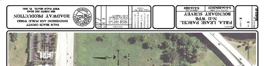
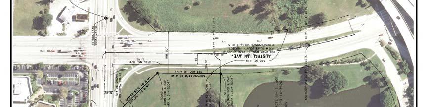
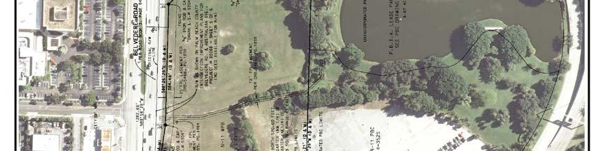
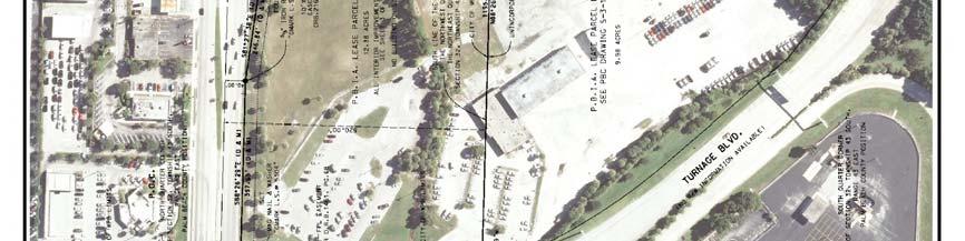
7 ORDINANCE NO EXHIBIT A Legal Description PBIA LEASE PARCEL N-11 WPB PROPERTY DESCRIPTION A PARCEL OF LAND LOCATED WITHIN PALM BEACH INTERNATIONAL AIRPORT PROPERTY AS RECORDED IN OFFICIAL RECORD BOOK 619, PAGE 344 OF THE PUBLIC RECORDS OF PALM BEACH COUNTY, FLORIDA, SITUATED IN SECTION 32, TOWNSHIP 43 SOUTH, RANGE 43 EAST, CITY OF WEST PALM BEACH, PALM BEACH COUNTY, FLORIDA, BEING MORE PARTICULARLY DESCRIBED AS FOLLOWS: COMMENCING AT THE NORTH QUARTER CORNER OF SAID SECTION 32; THENCE SOUTH 00 45'40" WEST ALONG THE NORTH/SOUTH QUARTER SECTION LINE OF SAID SECTION 32, A DISTANCE OF FEET TO A POINT LYING ON THESOUTHERLY RIGHT-OF-WAY LINE OF BELVEDERE ROAD AS RECORDED IN ROAD BOOK, PAGE 94 OF THE PUBLIC RECORDS OF PALM BEACH COUNTY, FLORIDA AND THE POINT OF BEGINNING; THENCE SOUTH 88 26'29" EAST ALONG SAID SOUTHERLYRIGHT-OF-WAY LINE, A DISTANCE OF FEET; THENCE SOUTH 81 27'38"EAST ALONG THE PROPOSED SOUTHERLY RIGHT-OF-WAY LINE OF BELVEDERE ROADAS SHOWN ON PALM BEACH COUNTY INTERSECTION IMPROVEMENT PLANS FORBELVEDERE ROAD AND AUSTRALIAN AVENUE, PROJECT NO SHEET 5 OF 6ON FILE IN THE OFFICE OF THE COUNTY ENGINEER, A DISTANCE OF FEET TO A POINT ON A LINE LYING FEET SOUTH OF (AS MEASUREDAT RIGHT ANGLES TO) AND PARALLEL WITH SAID SECTION LINE; THENCE SOUTH88 26'29" EAST ALONG SAID PARALLEL LINE AND PROPOSED RIGHT-OF-WAYLINE, A DISTANCE OF FEET TO THE PROPOSED WESTERLY RIGHT-OF-WAY LINE OF AUSTRALIAN AVENUE AS SHOWN ON THE ROAD BOOK 5, PAGE 47 OFTHE PUBLIC RECORDS OF PALM BEACH COUNTY, FLORIDA AND AS SHOWN ON PALMBEACH COUNTY PARCEL ACQUISITION MAP FOR AUSTRALIAN AVENUE, PROJECT NO88525/ SHEET 3 OF 5 ON FILE IN THE OFFICE OF THE COUNTY ENGINEER(THE NEXT TWO COURSES COINCIDE WITH SAID WESTERLY RIGHT-OF-WAY LINE);THENCE SOUTH 43 58'53" EAST, A DISTANCE OF FEET; THENCE SOUTH00 28'44"WEST, A DISTANCE OF FEET TO THE SOUTH LINE OF THECORPORATE LIMITS OF THE CITY OF WEST PALM BEACH, ALSO BEING THE SOUTH LINE OF THE NORTH FEET OF THE NORTHWEST QUARTER (NW 1/4) OF THE NORTHEAST QUARTER (NE 1/4) OF SAID SECTION 32; THENCE NORTH 88 26'29" WEST ALONG SAID SOUTH LINE, A DISTANCE OF FEET TO SAID NORTH/ SOUTH QUARTER SECTION LINE; THENCE NORTH 00 45'40"EAST ALONG SAID NORTH/SOUTH QUARTER SECTION LINE, A DISTANCE OF FEET TO SAID OUTHERLY RIGHT-OF-WAY LINE OF BELVEDERE ROAD AND THE POINT OF BEGINNING. THE PROPERTY AS SURVEYED CONTAINS 539,138 SQUARE FEET OF ACRES MORE OR LESS.
8 ORDINANCE NO EXHIBIT B Survey 1 of 3
9 EXHIBIT B Survey 2 of 3 ORDINANCE NO
10 EXHIBIT B Survey 3 of 3 ORDINANCE NO
11 EXHIBIT C Existing Future Land Use Map Designation 1 of 2 ORDINANCE NO
12 EXHIBIT C Proposed Future Land Use Map Designation 2 of 2 ORDINANCE NO
13 ORDINANCE NO AN ORDINANCE OF THE CITY COMMISSION OF THE CITY OF WEST PALM BEACH, FLORIDA, AMENDING THE ZONING MAP OF THE CITY OF WEST PALM BEACH BY REZONING AN APPROXIMATELY ACRE PROPERTY LOCATED AT 1600 BELVEDERE ROAD FROM A COMMUNITY SERVICE (CS) ZONING DISTRICT TO A GENERAL COMMERCIAL (GC) ZONING DISTRICT; DECLARING THIS ZONING MAP AMENDMENT TO BE CONSISTENT WITH THE COMPREHENSIVE PLAN OF THE CITY; REVISING THE ZONING MAP OF THE CITY ACCORDINGLY; PROVIDING A CONFLICT CLAUSE; PROVIDING AN EFFECTIVE DATE; AND FOR OTHER PURPOSES. * * * * * * WHEREAS, Collene Walter of Urban Design Kilday Studios, on behalf of Palm Beach County Department of Airports, has requested to change the Zoning Map district of an approximately acre parcel located at 1600 Belvedere Road from Community Service (CS) to General Commercial (GC); and WHEREAS, upon approval of Ord. No , the subject property will have a Future Land Use designation of Commercial (C); and WHEREAS, the General Commercial (GC) zoning district is consistent with the Commercial Future Land Use designation; and WHEREAS, the Zoning Map amendment is consistent with the standards provided in Section of the City s Zoning and Land Development Regulations; and WHEREAS, the Planning Board recommended to approve (7-0) the rezoning request to the City Commission after a Public Hearing on June 21, 2016; and WHEREAS, the Public Hearing was advertised in the Palm Beach Post and the Proof of Publication is housed in the Planning Division records. Additionally, the Planning Division records evidence that individual notices of the Public Hearing were mailed to all property owners within 500 feet of the subject property. NOW, THEREFORE, BE IT ORDAINED BY THE CITY COMMISSION OF THE CITY OF WEST PALM BEACH, FLORIDA, that: SECTION 1: SECTION 2: The City Commission hereby finds and determines that the amendment to the Zoning Map of the City of West Palm Beach, Florida, described in this Ordinance, is consistent with the Comprehensive Plan of the City adopted pursuant to Section , et seq., Florida Statutes. The City Commission hereby determines that the Zoning Map amendment is consistent with the standards provided in Section of the Zoning and Land Development Regulations based on the following findings:
14 ORDINANCE NO SECTION 3: A. Consistency with Comprehensive Plan- The proposed rezoning is concurrent with a future land use amendment. The proposed Community Service Planned Development zoning is compatible with the proposed Community Service land use designation. B. Changed Conditions- The updated Airport Master Plan adopted by the Palm Beach County Department of Airports reflects that this property is no longer intended to be used for airport operations. C. Consistency with Land Development Code-The proposed rezoning is consistent with the City of West Palm Beach s land development regulations. The proposed zoning district is consist with the prosed FLU and approved use. D. Consistency with Use- The property is located in the immediate vicinity of commercial type uses. The General Commercial zoning designation is consistent with the existing and future development of the area. E. Capacity of Public Facilities- A level of services (LOS) analysis was prepared by the applicant utilizing maximum development potential. The proposed General Commercial (GC) zoning and Commercial (C) Future Land Use designation will not result in any public facilities to exceed their capacity. F. Natural Resources It is not anticipated that the development will have a significant impact on any natural resources. The site contains some trees and a small drainage ditch. Tree removal and replacement will be addressed at site plan review. Drainage will be addressed at site plan review. G. Property Values - Proposed General Commercial (GC) Zoning District will allow a large array of commercial/ retail, restaurant and office uses, which create jobs and spur the excitement of an already commercial center of the city. No residential uses are located nearby. H. Logical Development Pattern- The proposed General Commercial (GC) zoning designation will not have a negative effect on the development patterns of the surrounding area. The subject property is immediately adjacent to commercial-type uses. Any development that could occur under the proposed zoning designation would be consistent with the existing and potential uses in the area. Thereby, the request will continue to provide for an orderly and logical development pattern. The Zoning Map of the City of West Palm Beach, Florida, is hereby amended by assigning a General Commercial (GC) zoning designation to approximately acres of real property legally described in EXHIBIT A shown by survey in EXHIBIT B with existing and proposed zoning maps EXHIBIT C.
15 ORDINANCE NO SECTION 4: SECTION 5: All ordinances or parts of ordinances in conflict herewith are hereby repealed. This Ordinance shall take effect as of the effective date of the Future Land Use Map amendments described in Ordinance No (the Effective Date ). FIRST READING THIS 1st DAY OF August, SECOND READING AND FINAL PASSAGE THIS DAY OF, 2016.
16 ORDINANCE NO EXHIBIT A Legal Description PBIA LEASE PARCEL N-11 WPB PROPERTY DESCRIPTION A PARCEL OF LAND LOCATED WITHIN PALM BEACH INTERNATIONAL AIRPORT PROPERTY AS RECORDED IN OFFICIAL RECORD BOOK 619, PAGE 344 OF THE PUBLIC RECORDS OF PALM BEACH COUNTY, FLORIDA, SITUATED IN SECTION 32, TOWNSHIP 43 SOUTH, RANGE 43 EAST, CITY OF WEST PALM BEACH, PALM BEACH COUNTY, FLORIDA, BEING MORE PARTICULARLY DESCRIBED AS FOLLOWS: COMMENCING AT THE NORTH QUARTER CORNER OF SAID SECTION 32; THENCE SOUTH 00 45'40" WEST ALONG THE NORTH/SOUTH QUARTER SECTION LINE OF SAID SECTION 32, A DISTANCE OF FEET TO A POINT LYING ON THE SOUTHERLY RIGHT-OF-WAY LINE OF BELVEDERE ROAD AS RECORDED IN ROAD BOOK 3, PAGE 94 OF THE PUBLIC RECORDS OF PALM BEACH COUNTY, FLORIDA AND THE POINT OF BEGINNING; THENCE SOUTH 88 26'29" EAST ALONG SAID SOUTHERLY RIGHT-OF-WAY LINE, A DISTANCE OF FEET; THENCE SOUTH 81 27'38" EAST ALONG THE PROPOSED SOUTHERLY RIGHT- OF-WAY LINE OF BELVEDERE ROAD AS SHOWN ON PALM BEACH COUNTY INTERSECTION IMPROVEMENT PLANS FOR BELVEDERE ROAD AND AUSTRALIAN AVENUE, PROJECT NO SHEET 5 OF 6 ON FILE IN THE OFFICE OF THE COUNTY ENGINEER, A DISTANCE OF FEET TO A POINT ON A LINE LYING FEET SOUTH OF (AS MEASURED AT RIGHT ANGLES TO) AND PARALLEL WITH SAID SECTION LINE; THENCE SOUTH 88 26'29" EAST ALONG SAID PARALLEL LINE AND PROPOSED RIGHT-OF- WAY LINE, A DISTANCE OF FEET TO THE PROPOSED WESTERLY RIGHT-OF- WAY LINE OF AUSTRALIAN AVENUE AS SHOWN ON THE ROAD BOOK 5, PAGE 47 OF THE PUBLIC RECORDS OF PALM BEACH COUNTY, FLORIDA AND AS SHOWN ON PALM BEACH COUNTY PARCEL ACQUISITION MAP FOR AUSTRALIAN AVENUE, PROJECT NO 88525/ SHEET 3 OF 5 ON FILE IN THE OFFICE OF THE COUNTY ENGINEER (THE NEXT TWO COURSES COINCIDE WITH SAID WESTERLY RIGHT-OF-WAY LINE); THENCE SOUTH 43 58'53" EAST, A DISTANCE OF FEET; THENCE SOUTH 00 28'44"WEST, A DISTANCE OF FEET TO THE SOUTH LINE OF THE CORPORATE LIMITS OF THE CITY OF WEST PALM BEACH, ALSO BEING THE SOUTH LINE OF THE NORTH FEET OF THE NORTHWEST QUARTER (NW 1/4) OF THE ORTHEAST QUARTER (NE 1/4) OF SAID SECTION 32; THENCE NORTH 88 26'29" WEST ALONG SAID SOUTH LINE, A DISTANCE OF FEET TO SAID NORTH/ SOUTH QUARTER SECTION LINE; THENCE NORTH 00 45'40"EAST ALONG SAID NORTH/SOUTH QUARTER SECTION LINE, A DISTANCE OF FEET TO SAID SOUTHERLY RIGHT-OF-WAY LINE OF BELVEDERE ROAD AND THE POINT OF BEGINNING. THE PROPERTY AS SURVEYED CONTAINS 539,138 SQUARE FEET OF ACRES MORE OR LESS.
17 ORDINANCE NO EXHIBIT B Survey 1 of 3
18 EXHIBIT B Survey 2 of 3 ORDINANCE NO


19 EXHIBIT B Survey 3 of 3 ORDINANCE NO
20 EXHIBIT C Existing Zoning Map 1 of 2 ORDINANCE NO
21 EXHIBIT C Proposed Zoning Map 2 of 2 ORDINANCE NO
 City")


")
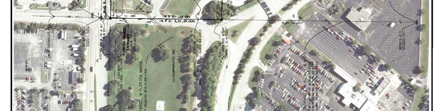
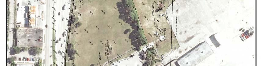
22 CITY OF WEST PALM CITY COMMISSION Meeting Date: October 24, 2016 Ordinance Ordinance Future Land Use Map Amendment and Rezoning 1600 Belvedere Road Location Aerial (Subject Property outlined in red) City of West Palm Beach Limits Subject Property I. REQUEST A request by Collene Walter of Urban Design Kilday Studios, on behalf of the Palm Beach County Department of Airports (PBIA) for the Palm Beach County Board of Commissioners for the following: Ordinance : A request to change the future land use designation of the subject property from Community Service (CS) to Commercial (C). Ordinance : A request to change the Zoning District of the subject property from Community Service (CS) to General Commercial (GC). The site is approximately acres and located at 1600 Belvedere Road and located within Commission District No. 5- Commissioner Shanon Materio
23 II. STAFF RECOMMENDATION Ordinance APPROVAL - Based on the finding that the petition meets at least one (1) of the five (5) Future Land Use (FLU) Amendment Standards found in Future Land Use Element Policy of the City s Comprehensive Plan (ATTACHMENT A). Ordinance APPROVAL - Based on the finding that the petition meets all eight (8) Rezoning Standards found in Section of the Zoning and Land Development Regulations (ZLDRs) (ATTACHMENT B).The recommendation of approval is made with the following condition: 1. The Palm Beach County Department of Airports (DOA) must supply an easement or other form of acceptable agreement for the existing City of West Palm Beach sign located on the North side of the property as indicated on the survey with the last revision dated April 14, The easement will be required at Site Plan approval. The sign may be removed only if replaced with the approval of the City of West Palm Beach at the expense of the DOA. An easement or another form of acceptable agreement for the sign is required for any relocated and/or replaced sign. 2. Parcel Control Number (PCN) is attached to four other separated properties within the municipal boundary of West Palm Beach, the subject property is to be split into a separate PCN before permit approval. 3. Removal and disposal is required of all prohibited trees on the site in accordance with the West Palm Beach Zoning Code Section (f) (11). Trees which are included as prohibited trees pursuant to subsection (4) i shall be removed and disposed of from the site before the certificate of occupancy can be obtained. III. PROJECT DETAILS The subject property is acres and located at the Southwest corner of the intersection Australian Avenue and Belvedere Road. The property s address is 1600 Belvedere Road. The subject property currently has a Community Service (CS) future land use designation and a Community Service (CS) zoning district. The subject property is currently being utilized as a cell phone waiting area which will be removed once the Travel Plaza to the west of the subject property has completed construction. The applicant is seeking to amend the future land use designation to a Commercial (C) designation and rezone the parcel to a General Commercial (GC) zoning district. Page 2
24 The following table summarizes the uses surrounding the subject parcel, their FLU designations and their Zoning districts. North Existing Use FLU Zoning Hotel, office, gas station, fast food, car rental Commercial (C) City Commercial PD (CPD) & Airport Commercial (AC) City East Vacant (Approved Gas Station with Convenience Store) Special Impact Zone/Commercial (CIZ/C) City Commercial PD (CPD) City South Airport (RFP for Hotel & Commercial Uses) Utility/Transportation County Public Ownership (PO) County West Under construction for Travel Plaza Utility/Transportation County Public Ownership (PO) County IV. INTERJURISDICTIONAL REVIEW, PUBLIC COMMENT Interdepartmental Review: The future land use amendment and rezoning request went to the City s Plans and Plats Review Committee (PPRC) on April 13, Revisions were distributed to the department heads. However, there is no site plan proposal with the future land use amendment, and rezoning request. Interlocal Plan Amendment Review Committee (IPARC): Notification of the Future Land Use Amendment was sent to IPARC on June 6, To date no comments have been received. Public Comment: Notices were mailed to property owners within 500 feet of the subject property on May 20, 2016 and the site was posted with the required signage on June 2, To date, the City has received no inquiries on the Future Land Use Amendment and/ or Rezoning. Planning Board: The Planning Board recommended approval (7-0) of the Future Land Use and Rezoning with Conditions requests to the City Commission after a Public Hearing on June 21, City Commission: The City Commission approved (7-0) of the Future Land Use and Rezoning requests at Public Hearing on August 1, State Transmittal: The Future Land Use Amendment was transmitted to the Department of Economic Opportunity, and other required review agencies (Florida Department of Education, Treasure Coast Regional Planning Council, South Florida Water Management District, Palm Page 3
25 Beach County Planning Division, Florida Department of Transportation, Florida Department of State and Florida Department of Environmental Protection) and no objections were received. V. BACKGROUND AND ANALYSIS The proposed request is to change the Future Land Use (FLU) designation and Zoning district on the Palm Beach International Airport (PBIA) property located at the Southwest corner of Australian Avenue and Belvedere Road located within the City of West Palm to allow commercial uses on the property. The proposed request is a part of the PBIA s plan to utilize additional, unused property. The Department of Airports (DOA), which is a department of Palm Beach County, has established and updated the Palm Beach International Airport Master Plan that is regulated by the Federal Aviation Administration (FFA). The master plan identifies required improvements to meet FAA standards, but within the last fifteen years also identifies locations of property that is not located in expansion areas of the airport uses and is suitable for supporting non-airport development. The most recent master plan for the airport was approved by the Board of County Commissions (BCC) on July 1, The masterplan incorporated six acquired parcels into the Airport Master Plan. This amendment was to a masterplan dated October In the 2006 Airport Master Plan, the subject property is identified as a potential site for supporting nonairport development. The properties located west and south of the subject property are in Palm Beach County and are currently being developed to have non-airport use development. The property located west of the subject property is under construction to be a travel plaza and will serve as an enhanced facility replacing the Cell Phone Waiting Area. The plan for development of the travel plaza was solicited by, and awarded through a Request for Proposals (RFP) process. The DOA is currently in the RFP process to develop the property south of the subject property. The conceptual site plan for the south property includes a 150 bed hotel and 14, 000 square feet of retail. Approval of the subject Future land use amendment and rezoning will allow the commercial uses needed for the DOA to incentivize developers to participate in a similar RFP process. Commercial uses on the subject parcel have been the intent of the DOA for some time. The subject property was first identified as a potential property for non-airport development in a 2006 study by CH2MHILL named Summarizing the Market Assessment, Opportunities and Recommendations for PBC DOA s Collateral Land. In a power point presentation briefing on June 2015 by Jerry Allen Deputy director of the DOA the subject property and the property to the south was slated as the hotel site. The exact use of the subject site is still undetermined, although the applicant has stated anticipated uses would be those allowed in the proposed Commercial Land Use Designation and General Commercial Zoning District such as, but not limited to, Professional Office (Medical and Non-Medical), Retail, Hotel, or Restaurants. With the approval of the Future land use amendment and rezoning, the subject property will be consistent with the new development being constructed, approved or planned to the west, south and east of the subject property. Page 4
26 Photos of the property are provided in ATTACHMENT C. There are currently no development plans for the subject property. A survey of the subject property is provided in ATTACHMENT D. The applicant s justification statement for the future land use and rezoning requests is provided in ATTACHMENT E. Specific details regarding each request are found below. a. Future Land Use Map Amendment (Ord ) Community Service to Commercial The change in FLU designation from Community Service (CS) to Commercial (C) will result in a decrease in the maximum floor area ratio (FAR) from 1.0 to 0.75 which will result in less intense development. A summary of the level of services (LOS) impacts was prepared and indicated a decrease in all but one impact to levels of service. It indicated one level of service, drainage, remains the same. No impacts on the current use are anticipated from this change in Future land use designation. The site is currently being used as a Cell Phone Waiting area which will be relocated to the Travel Plaza when the Plaza is finished and the associated parking lot located on the site will be demolished. The City s Planning Division has determined that assigning the subject property a Commercial (C) Future land use designation is appropriate as surrounding properties are commercial in nature. Surrounding properties within the City possess a Commercial (C) or Special Impact Zone Commercial (SIZ/C) FLU designation and surrounding properties in the county possess a Utilities and Transportation (UT) designation. The Planning Division has found that the request complies with the Future Land Use Amendment Standards found in Policy and of the Future Land Use Element (FLUE) of the Comprehensive Plan attached hereto as ATTACHMENT A. b. Rezoning Case (Ord ) Community Service to General Commercial To correspond with the proposed Commercial (C) Future land use designation, the applicant is requesting to rezone the subject property from Community Service (CS) zoning district to General Commercial (GC). The proposed General Commercial (GC) zoning is consistent with the surrounding Commercial uses both inside and outside of the City limits. Property next to the subject property, which is located in the City has a General Commercial (GC) or Airport Commercial (AC) zoning district. Please note, it is anticipated that all airport Commercial be designated to General Commercial (GC). To the west and south of the subject property is Palm Beach International Airport which has a Public Ownership (PO) zoning district with an Airport Overlay that allows non airport uses Page 5
27 which may include, but are not limited to, commercial, public and civic, recreation, agricultural, utilities and excavation, and industrial uses, but more specifically including, but not limited to, professional, business, and medical offices, retail centers, restaurants and hotels. Based upon the compatibility with the surrounding zoning districts and uses, the City s Planning Division has found that the request complies with the required Rezoning Standards found in Section of the Zoning and Land Development Regulations, attached hereto as ATTACHMENT B. c. Infrastructure Impact Analysis No development is being proposed for the property at this time. The maximum development potential for the subject parcel under the existing Community Service (CS) Future land use designation is an Floor Area Ratio (FAR) which translates to an allowable 539,272 square feet. The maximum development potential under the proposed Commercial (C) Future land use designation is 0.75 FAR which translates to an allowable 404,454 square feet. The difference between the two is a decrease in FAR by 0.25 or 134,818 square feet. To evaluate the change in maximum development potential, a Level of Service (LOS) analysis was conducted. the maximum potential build-out would result in an decrease or equivalent in water, sewer, solid waste, and traffic. A LOS summary is provided in ATTACHMENT F. The site is currently connected to Palm Beach County water and sewer and the County provides solid waste services. Palm Beach County Water utility s department has reviewed the request and has not identified any concerns with service capacity. Palm Beach County Solid Waste Authority has reviewed the request and provided certification that capacity is available. As residential uses are not permitted in the Commercial (C) FLU, the change in FLU will not result in any impact to the level of service for schools. In summary, the proposed General Commercial (GC) zoning and Commercial (C) FLU designations will not result in any public facilities to exceed their capacity. d. Overall Analysis Staff recommends approval of the requests, as the requests meet the requirements of the City s Comprehensive Plan, Zoning and Land Development Regulations (ZLDRs), and Chapter 171, Florida Statutes. Prepared and Respectfully Submitted by: Heather M. Tribou Senior Planner Page 6
28 ATTACHMENT A FUTURE LAND USE AMENDMENT STANDARDS In reviewing a proposed Future Land Use Amendment, Policy of the Future Land Use Element of the Comprehensive Plan requires that the Planning Board shall consider the following standards: A. Changed Projections B. Changed Assumptions C. Data Errors and Updates D. New Issues E. Additional Detail and Comprehensiveness Changed Assumptions Staff Response: It was projected at the time that the Community Service (CS) land use was assigned to the subject site that the lands would support services airport operations. CS was the appropriate City land use designation for publicly owned properties providing services. Over the past ten years, the Palm Beach County Department of Airports (DOA) has implemented updates to the PBIA Airport Master Plan to identify, designate and promote subsidiary development areas for non-airport related uses. Although the property will continue to be part of PBIA, it will be leased for non-airport uses that are commercial in nature. The CS designation is not suitable for this type of development. The proposed Commercial (C) Land Use Designation is more appropriate based on the anticipated pattern of development. This change is consistent with surrounding properties in the City on the Belvedere Road and Australian Avenue corridor which have a Commercial designation and many are developed with commercial uses. In reviewing a proposed Future Land Use Amendment, Policy of the Future Land Use Element of the Comprehensive Plan requires that the Planning Board shall consider the following standards: 1. The process for Amending the Comprehensive Plan shall be guided by the provisions of Florida Statutes Chapter 163, the Florida Administrative Code (FAC) rules implementing it, and in accordance with the provisions of the Comprehensive Plan. Staff Response: The process will be followed. 2. Amendments to the text, tables, charts, and maps of the Comprehensive Plan shall be initiated only by the City or the Local Planning Agency (Planning Board). Staff Response: Not applicable. 3. Amendments to the Future Land Use Map (FLUM) shall be initiated only by the owner of the parcel(s) or the City. Page 7
29 Staff Response: The owner of the property, Palm Beach County Department of Airports, initiated the FLUM amendment application. Page 8
30 ATTACHMENT B REZONING STANDARDS In reviewing a proposed rezoning, Section of the City s Zoning and Land Development Regulations requires that the Planning Board shall consider all of the following: 1. Whether the proposed amendment is consistent with all elements of the City of West Beach Comprehensive Plan. Findings COMPLIES The request is consistent with all elements of the Comprehensive Plan. Policy of the FLU Element of the Comprehensive Plan cross references F.S. The Statue restricts schools within certain levels of noise generated by airports. Schools are allowed in the general commercial zoning district and further study will be required if proposed but specific details of the proposed uses will be addressed in the Site Plan process. Nothing proposed affects runway clear zones or height restrictions. 2. Whether there exist changed conditions that require an amendment. Findings COMPLIES The proposed land use amendment change will require a compatible zoning district that allows the commercial uses so that the Department of Airports can use the land for nonairport uses. 3. Whether the proposed amendment is in conformance with all applicable portions of the City Development Code. Findings COMPLIES The proposed amendment to the City s Zoning Map is consistent with the City Development Code. 4. Whether the extent to which the proposed amendment is inconsistent with existing and proposed land uses. Findings COMPLIES The property is located in the immediate vicinity of commercial type uses. The General Commercial (GC) zoning designation is consistent with the existing and future development in the area. 5. Whether and the extent to which the proposed amendment would exceed the capacity of public facilities, including but not limited to transport, sewerage, water supply, parks, fire, police, drainage, schools, and emergency medical facilities. Page 9
31 Findings COMPLIES A level of services (LOS) analysis was prepared by the applicant utilizing maximum development potential. The proposed General Commercial (GC) zoning and Commercial (C) Future Land Use designation will not result in any public facilities to exceed their capacity. 6. Whether and the extent to which, the proposed amendment would result in significant adverse impacts on the natural environment. Findings COMPLIES Palm Beach County mygeo Nav contains points on the site for a DEP Registered Petroleum Storage Tank and/or cleanup site as well as the Palm Beach International Airport Dump #1. Proper mitigation and/or removal within state requirements will be addressed at site plan approval. The site also contains some trees and a small drainage ditch. Tree removal and replacement will be addressed in site plan review pursuant LDR Sec Preliminary Engineering at site Plan Review will be required to address drainage. 7. Whether and to the extent to which the proposed amendment would adversely affect property values in the area. Findings COMPLIES Proposed General Commercial (GC) Zoning District will allow a large array of commercial/ retail, restaurant and office uses, which create jobs and spur the excitement of an already commercial center of the city. No residential uses are located nearby. 8. Whether and the extent to which the proposed amendment would result in an orderly and logical development pattern, and the specific identification of any negative effects on such pattern. Findings COMPLIES The proposed General Commercial (GC) zoning designation will not have a negative effect on the development patterns of the surrounding area. The subject property is immediately adjacent to commercial-type uses. Any development that could occur under the proposed zoning designation would be consistent with the existing and potential uses in the area. Thereby, the request will continue to provide for an orderly and logical development pattern. Page 10


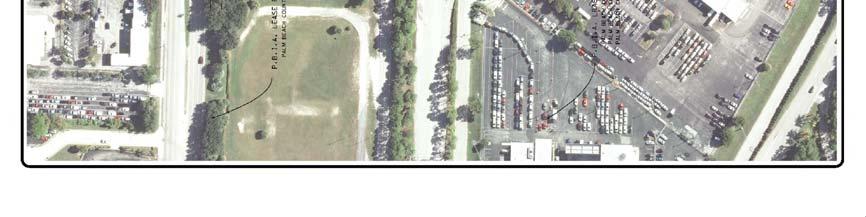
32 ATTACHMENT C PHOTOS (April 6, 2016) a e. f. g. b., c. & d. a. Looking southwest at property from intersection of Belvedere Road and Australian Ave. Page 11
 PHOTOS (April 6, 2016) b.")

33 ATTACHMENT C (cont.) PHOTOS (April 6, 2016) b. Looking west at site from Australian Ave. c. Looking northwest at site from Australian Ave. Page 12
 PHOTOS (April 6, 2016) d.")

34 ATTACHMENT C (cont.) PHOTOS (April 6, 2016) d. Looking North at site from Australian Ave. e. Looking East at Cell Phone Waiting Area from Perimeter Drive. Page 13


35 ATTACHMENT C (cont.) PHOTOS (April 6, 2016) f. Looking ditch area on South side of Cell phone wailing car parking area. g. Looking East at Additional Car Waiting Area from Cell Phone Waiting Area. Page 14
36 ATTACHMENT D Survey page 1 of 3 Page 15
37 ATTACHMENT D Survey page 2 of 3 Page 16
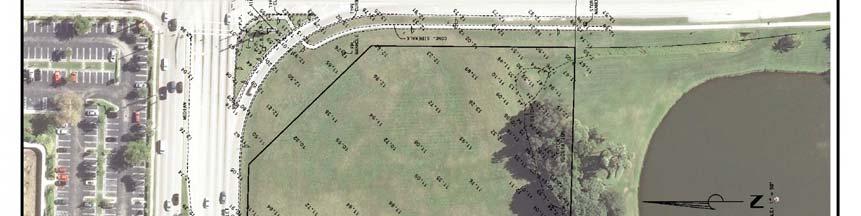
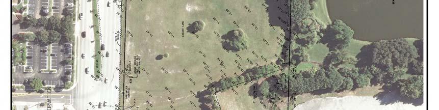
38 ATTACHMENT D Survey page 3 of 3 Page 17
, as agent for the property owner/applicant, Palm Beach")
 that is located within the municipal limits of the City of West Palm Beach.")
39 ATTACHMENT E Applicant s Justification Statement PBIA PARCEL I NORTH CITY OF WEST PALM BEACH FUTURE LAND USE MAP AMENDMENT & REZONING REQUEST JUSTIFICATION STATEMENT SUBMITTED: MARCH 8, 2016 RESUBMITTED: APRIL 21, 2016 Urban Planning and Design Landscape Architecture Communication Graphics Request Urban Design Kilday Studios (UDKS), as agent for the property owner/applicant, Palm Beach County and the Palm Beach County Department of Airports (DOA), is requesting a Future Land Use Map Amendment (Large Scale) and a Rezoning for a portion of property on Palm Beach International Airport (PBIA) that is located within the municipal limits of the City of West Palm Beach. Within the PBIA Airport Master Plan there are subsidiary development parcels that have been identified for future development. The parcel located at the southwest corner of the intersection of Belvedere Road and Australian Avenue is known as PBIA Parcel I. The northern portion of Parcel I, herein referenced as Parcel I North, is within the City s jurisdiction. These applications are requesting to change the Land Use Designation from Community Service (CS) to Commercial (C), and to change the Zoning District from Community Service (CS) to General Commercial (GC) for Parcel I North. No specific plan of development is proposed at this time therefore only a Future Land Use Map Amendment (Large Scale) and Rezoning change are being requested as part of this application. Project Overview/Background Development of the properties within PBIA are governed by the PBIA Airport Master Plan, a document regulated by the Federal Aviation Administration (FAA) and adopted by the Palm Beach County Board of County Commission (BCC). This Airport Master Plan is updated periodically to reflect proposed improvements and site acquisitions. In addition to identifying airport and aviation facilities, the Airport Master Plan identifies subsidiary development areas that may be developed with nonairport related uses that support airport operations through the revenue generated. The last update to the PBIA Airport Master Plan was approved by the BCC on July 1, The subsidiary development area within the PBIA Airport Master Plan known as Parcel I is acres in size. Due to its location 610 Clematis Street Suite CU02 West Palm Beach, FL fax LCC Page 18
40 on the perimeter of the airport, fronting two major roadways, and outside of the airport approach paths, this site has been identified as having potential for development with non-airport related uses, with the anticipation that they would be commercial and/or retail uses. The northern acres of Parcel I is the subject of this request. It is acres in size. This property is a portion of property control number (PCN) , owned by Palm Beach County and managed by the Palm Beach County Department of Airports (DOA), the applicant, and is within the municipal limits of the City of West Palm Beach. This subject site fronts Belvedere Road on the north, Australian Avenue on the east, and an Airport entrance road on the west. The site currently supports a cell phone waiting area on the west side of the property, with the balance of the site vacant. Use of the existing cell phone waiting area will be discontinued when the PBIA Travel Plaza, under construction just to the west of the Airport entrance road, is opened. The Travel Plaza site is within unincorporated Palm Beach County, and is approved for a collocated cell phone waiting area along with a convenience store with gas sales, a car wash and a Type I (Fast Food) Restaurant. The plan of development and developer of the Travel Plaza was solicited by, and awarded through, a Request for Proposals (RFP) process. The southern acres of Parcel I is also within the unincorporated area of Palm Beach County and is a portion of property control number (PCN) This southern portion is the subject of a current RFP issued by the Palm Beach County Department of Airports seeking developers for a Hotel with other supporting and accessory uses. The RFP has been issued, and a pre-proposal meeting held. Submissions are due in April. It is the desire of the Palm Beach County Department of Airports to issue a RFP in the future for development of the northern portion of Parcel I for commercial uses. The current Land Use and Zoning designation of Commercial Service (CS) are not suitable to support the type of uses anticipated for this location. The CS designations limit the type of uses to primarily government services or civic uses. Due to the site s location along two major transportation corridors, it is best suited for commercial development. Prior to issuing a RFP seeking plans of development, the DOA is seeking to change the Future Land Use and Zoning designations to better promote the site for commercial development. It is anticipated that a plan of development will be determined at a later date, at which time the appropriate site specific development applications will be submitted to the City for review. The type of uses anticipated would be those allowed in the proposed Commercial Land Use Designation and General Commercial Zoning District such as, but not limited to, Professional Office (Medical and Non-Medical), Retail, Hotel, or Restaurants. Surrounding Uses Page 19
CITY OF WEST PALM BEACH PLANNING BOARD Meeting Date: July 17, 2018 Planning Board Case No. 1670I
 CITY OF WEST PALM BEACH PLANNING BOARD Meeting Date: July 17, 2018 Planning Board Case No. 1670I Palms Gateway Commercial Planned Development (CPD) Southeast Corner of Belvedere Road and Australian Avenue
PALM BEACH COUNTY PLANNING, ZONING AND BUILDING DEPARTMENT ZONING DIVISION
 PALM BEACH COUNTY PLANNING, ZONING AND BUILDING DEPARTMENT ZONING DIVISION Application No.: ABN/Z-2015-00333 Application Name: PBIA Properties Rezoning Control No.: 2008-00362 Applicant: Palm Beach County
City Commission Agenda Cover Memorandum
 City Commission Agenda Cover Memorandum Originating Department: Finance (FIN) Meeting Type: Regular Agenda Date: 07/05/2016 Advertised: Required?: Yes No ACM#: 20924 Subject: Resolution No. 197-16 directing
PALM BEACH COUNTY PLANNING, ZONING AND BUILDING DEPARTMENT ZONING DIVISION
 PALM BEACH COUNTY PLANNING, ZONING AND BUILDING DEPARTMENT ZONING DIVISION Application No.: Z-2016-00663 Application Name: Autism School Control No.: 2014-00133 Applicant: Dayna2, LLC Owners: Dayna2, LLC
 SOUTH WIND PLAZA 5335 North Military Trail MAJOR CPD AMENDMENT FOR RETAIL /RESTAURANT BUILDINGS PROJECT NARRATIVE/JUSTIFICATION STATEMENT February 13, 2018 I. REQUEST SUMMARY Johnston Group Development
PALM BEACH COUNTY PLANNING, ZONING AND BUILDING DEPARTMENT ZONING DIVISION
 PALM BEACH COUNTY PLANNING, ZONING AND BUILDING DEPARTMENT ZONING DIVISION Petition No.: Z2003-017 Petitioner: Palm Beach County BCC Owner: Palm Beach County BCC Agent: Kilday and Associates Telephone
City Commission Agenda Cover Memorandum
 City Commission Agenda Cover Memorandum Originating Department: Mayor/Admin (MA) Meeting Type: Regular Agenda Date: 12/05/2016 Advertised: Required?: Yes No ACM#: 21161 Subject: Resolution No. 321-16 declaring
CITY OF OCALA CITY COUNCIL REPORT Council Meeting Date: 06/06/17
 CITY OF OCALA CITY COUNCIL REPORT Council Meeting Date: 06/06/17 Subject: Large Scale Land Use Map Amendment Submitted By: David Boston Department: Growth Management STAFF RECOMMENDATION (Motion Ready):
CITY OF TARPON SPRINGS Staff Report May 16, 2017
 CITY OF TARPON SPRINGS Staff Report May 16, 2017 TO: FROM: HEARING DATES: SUBJECT: MAYOR & BOARD OF COMMISSIONERS PLANNING & ZONING DEPARTMENT MAY 15, 2017 (PLANNING & ZONING BOARD) JUNE 6, 2017 (BOC 1
City Commission Agenda Cover Memorandum
 City Commission Agenda Cover Memorandum Originating Department: Planning & Zoning (PZ) Meeting Type: Regular Agenda Date: 03/14/2016 Advertised: Required?: Yes No ACM#: 20760 Subject: Resolution No. 86-16
ORDINANCE NO L02, D. Wormser/L.R. Roberts/Et. Al Page 1 of 9 Adoption Ordinance
 ORDINANCE NO. 17- AN ORDINANCE OF THE BOARD OF COUNTY COMMISSIONERS OF MARION COUNTY, FLORIDA; ADOPTING THE FOLLOWING LARGE-SCALE AMENDMENT TO THE FUTURE LAND USE MAP SERIES AND TEXT OF THE MARION COUNTY
ORDINANCE NO (PROPOSED)
") ORDINANCE NO. 1603 (PROPOSED) AN ORDINANCE OF THE CITY OF COCOA BEACH, BREVARD COUNTY, FLORIDA; AMENDING THE COCOA BEACH COMPREHENSIVE PLAN BY AMENDING THE FUTURE LAND USE MAP 2025 (FLUE 2) BY CHANGING
ORDINANCE NO. 1603 (PROPOSED) AN ORDINANCE OF THE CITY OF COCOA BEACH, BREVARD COUNTY, FLORIDA; AMENDING THE COCOA BEACH COMPREHENSIVE PLAN BY AMENDING THE FUTURE LAND USE MAP 2025 (FLUE 2) BY CHANGING
TREASURE COAST REGIONAL PLANNING COUNCIL M E M O R A N D U M. To: Regional Planning Council Members AGENDA ITEM 5D
 TREASURE COAST REGIONAL PLANNING COUNCIL M E M O R A N D U M To: Regional Planning Council Members AGENDA ITEM 5D From: Date: Subject: Staff March 20, 2009 Regional Planning Council Meeting Local Government
CITY OF PUNTA GORDA ORDINANCE NO.
 CITY OF PUNTA GORDA ORDINANCE NO. AN ORDINANCE OF THE CITY OF PUNTA GORDA, FLORIDA, REZONING PROPERTIES GENERALLY DESCRIBED AS 901, 1001, AND 1101 AQUI ESTA DRIVE, PUNTA GORDA, FLORIDA, AND MORE PARTICULARLY
RESOLUTION NO. R
 RESOLUTION NO. R-2009-0485 RESOLUTION APPROVING ZONING APPLICATION Z-2008-01745 (CONTROL NO. 2003-00062) OFFICIAL ZONING MAP AMENDMENT (REZONING) WITH A CONDITIONAL OVERLAY ZONE (COZ) APPLICATION OF Habitat
Mayor Leon Skip Beeler and Members of the City Commission. Anthony Caravella, AICP, Director of Development Services
 CITY COMMISSION BRIEFING & Planning Board Report For Meeting Scheduled for November 4, 2010 Thousand Island Conservation Area Rezoning Ordinance 1519 FINAL ACTION TO: FROM: THRU: RE: Mayor Leon Skip Beeler
Marion County Board of County Commissioners
 Marion County Board of County Commissioners Date: 12/29/2015 P&Z: 12/28/2015 BCC: 1/12/2016 Item Number 160113Z Type of Application Rezoning Request From: A-1 (General Agriculture) To: PUD (Planned Unit
ATTACHMENT 3 LEASE AND DEVELOPMENT OF VACANT LAND PALM BEACH INTERNATIONAL AIRPORT (RFP #PB 17-5) Entitlement Information/Process
 Entitlement Information/Process") ATTACHMENT 3 LEASE AND DEVELOPMENT OF VACANT LAND PALM BEACH INTERNATIONAL AIRPORT (RFP #PB 17-5) Entitlement Information/Process Proposers are advised that the following assumptions are provided for informational
ATTACHMENT 3 LEASE AND DEVELOPMENT OF VACANT LAND PALM BEACH INTERNATIONAL AIRPORT (RFP #PB 17-5) Entitlement Information/Process Proposers are advised that the following assumptions are provided for informational
ORDINANCE NO (PROPOSED)
") ORDINANCE NO. 1604 (PROPOSED) AN ORDINANCE OF THE CITY OF COCOA BEACH, BREVARD COUNTY, FLORIDA; AMENDING THE OFFICIAL ZONING MAP OF THE CITY OF COCOA BEACH, BY CHANGING THE ZONING DESIGNATION ON TWO PARCELS
ORDINANCE NO. 1604 (PROPOSED) AN ORDINANCE OF THE CITY OF COCOA BEACH, BREVARD COUNTY, FLORIDA; AMENDING THE OFFICIAL ZONING MAP OF THE CITY OF COCOA BEACH, BY CHANGING THE ZONING DESIGNATION ON TWO PARCELS
PALM BEACH COUNTY PLANNING, ZONING AND BUILDING DEPARTMENT ZONING DIVISION ZONING COMMISSION VARIANCE STAFF REPORT 06/07/2012
 PALM BEACH COUNTY PLANNING, ZONING AND BUILDING DEPARTMENT ZONING DIVISION ZONING COMMISSION VARIANCE STAFF REPORT 06/07/2012 APPLICATION NO. CODE SECTION REQUIRED PROPOSED VARIANCE ZV-2009-03300 Variance
ORDINANCE NO. NOW, THEREFORE, BE IT ORDAINED BY THE CITY COUNCIL OF THE CITY OF BRYAN, TEXAS:
 LOCATION MAPS: ORDINANCE NO. AN ORDINANCE OF THE CITY OF BRYAN, TEXAS, AMENDING CHAPTER 130, ZONING, OF THE CITY OF BRYAN CODE OF ORDINANCES, BY CHANGING THE ZONING CLASSIFICATION FROM AGRICULTURAL - OPEN
PALM BEACH COUNTY PLANNING, ZONING AND BUILDING DEPARTMENT ZONING DIVISION
 PALM BEACH COUNTY PLANNING, ZONING AND BUILDING DEPARTMENT ZONING DIVISION Application No.: CA-2012-00688 Control No.: 2011-00552 Applicant: Garry Bernardo Owners: Garry Bernardo Agent: Frogner Consulting,
ORDINANCE NO. NOW, THEREFORE, BE IT ORDAINED BY THE COUNTY BOARD OF OGLE COUNTY, ILLINOIS, as follows:
 STATE OF ILLINOIS ) ) SS COUNTY OF OGLE ) ORDINANCE NO. AN ORDINANCE APPROVING A ZONING MAP AMENDMENT ON PROPERTY LOCATED AT THE SOUTHEAST CORNER OF THE INTERSECTION OF N. JUNCTION ROAD AND DIVISION STREET,
RESOLUTION NO. ZR
 RESOLUTION NO. ZR-2016-017 RESOLUTION APPROVING ZONING APPLICATION ZV/PDD/DOA/R-2015-00317 ZV/PDD/DOAlR-2015-00317 (CONTROL NO. 1987-00032) TYPE II VARIANCE (CONCURRENT) APPLICATION OF Hippocrates Health
A. Application Summary. Assessment & Conclusion FUTURE LAND USE ATLAS AMENDMENT STAFF REPORT SMALL SCALE AMENDMENT
 Agenda Item: III.A.1 FUTURE LAND USE ATLAS AMENDMENT STAFF REPORT SMALL SCALE AMENDMENT PLANNING COMMISSION PUBLIC HEARING, JUNE 29, 2018 A. Application Summary I. General Project Name: Banyan Cove (SCA
ACTION FORM BRYAN CITY COUNCIL
 ACTION FORM BRYAN CITY COUNCIL DATE OF COUNCIL MEETING: July 8, 2014 DATE SUBMITTED: June 17, 2014 DEPARTMENT OF ORIGIN: Development Services SUBMITTED BY: Maggie Dalton MEETING TYPE: CLASSIFICATION: ORDINANCE:
COMPREHENSIVE PLAN FUTURE LAND USE MAP AMENDMENT APPLICATION
 COUNTY STAFF DATA ONLY Date Received: Project No. CPA-20 - GADSDEN COUNTY DEPARTMENT OF PLANNING & COMMUNITY DEVELOPMENT 1-B East Jefferson Street, Post Office Box 1799, Quincy, FL 32353-1799 PLANNING
AGENDA ITEM. Two Separate Public Hearings relating to the Eighth Avenue S./Orange Place Enclave Annexation
 DATE PREPARED: May 20, 2015 AGENDA ITEM PREPARED BY: Marisa M. Barmby, AICP, Senior Planner Central Florida Regional Planning Council AGENDA DATE: June 1, 2015 and June 8, 2015 REQUESTED ACTION: Two Separate
Planning Department Oconee County, Georgia
 Planning Department Oconee County, Georgia STAFF REPORT REZONE CASE #: 6985 DATE: October 31, 2016 STAFF REPORT BY: Andrew C. Stern, Planner APPLICANT NAME: Williams & Associates, Land Planners PC PROPERTY
PALM BEACH COUNTY PLANNING, ZONING AND BUILDING DEPARTMENT ZONING DIVISION. ZONING COMMISSION VARIANCE STAFF REPORT February 07, 2013
 PALM BEACH COUNTY PLANNING, ZONING AND BUILDING DEPARTMENT ZONING DIVISION ZONING COMMISSION VARIANCE STAFF REPORT February 07, 2013 APPLICATION NO. CODE SECTION REQUIRED PROPOSED VARIANCE ZV-2012-03383
CITY OF PALM BEACH GARDENS CITY COUNCIL Agenda Cover Memorandum Meeting Date: November 1, 2018 Ordinance 24, 2018 / *Ordinance 25, 2018
 CITY OF PALM BEACH GARDENS CITY COUNCIL Agenda Cover Memorandum Meeting Date: November 1, 2018 Subject/Agenda Item: 11940 U.S. Highway One Small-Scale Comprehensive Plan Future Land Use Map Amendment and
CITY OF BELLEVIEW REGULAR COMMISSION MEETING AGENDA
 CITY OF BELLEVIEW REGULAR COMMISSION MEETING AGENDA BELLEVIEW CITY HALL Commission Room Mayor CHRISTINE K. DOBKOWSKI Seat 1 MICHAEL J. GOLDMAN Seat 2 GARY W. ERNST 1/15/2019 Seat 3 RONALD T. LIVSEY 6:00
City Commission Agenda Cover Memorandum
 City Commission Agenda Cover Memorandum Originating Department: Mayor/Admin (MA) Meeting Type: Regular Agenda Date: 01/30/2017 Advertised: Required?: Yes No ACM#: 21226 Subject: Public Hearing and First
DEPARTMENT OF PLANNING AND COMMUNITY DEVELOPMENT STAFF REPORT
 DEPARTMENT OF PLANNING AND COMMUNITY DEVELOPMENT STAFF REPORT PLANNING COMMISSION AGENDA ITEM # 5: Project Name: Star Dance Zoning Map Amendment, ZMA-13-02 Prepared By: Toby Stauffer, AICP City Planner
Instructions and Application Procedures Plan Amendments
 Glades County Instructions and Application Procedures Plan Amendments Small Scale Plan Amendments are changes to the Future Land Use Map designation of properties 10 acres or less in size, or, in some
Request Conditional Rezoning (R-5D Residential Duplex District and I-1 Light Industrial District to Conditional A-36 Apartment District)
") Request Conditional Rezoning (R-5D Residential Duplex District and I-1 Light Industrial District to Conditional A-36 Apartment District) Staff Planner Ashby Moss Location 5833 Sandpit Road & Nearby Parcels
Request Conditional Rezoning (R-5D Residential Duplex District and I-1 Light Industrial District to Conditional A-36 Apartment District) Staff Planner Ashby Moss Location 5833 Sandpit Road & Nearby Parcels
TREASURE COAST REGIONAL PLANNING COUNCIL M E M O R A N D U M
 TREASURE COAST REGIONAL PLANNING COUNCIL M E M O R A N D U M To: Council Members AGENDA ITEM 6A From: Date: Subject: Staff May 20, 2011 Council Meeting Local Government Comprehensive Plan Review Draft
BCC TRANSMITTAL PUBLIC HEARING, MAY 2, 2018
 Item: 4.B.2 FUTURE LAND USE ATLAS AMENDMENT STAFF REPORT AMENDMENT ROUND 18-C BCC TRANSMITTAL PUBLIC HEARING, MAY 2, 2018 A. Application Summary I. General Project Name: Lenox North Beach (LGA 2018-002)
PALM BEACH COUNTY PLANNING, ZONING AND BUILDING DEPARTMENT ZONING DIVISION
 PALM BEACH COUNTY PLANNING, ZONING AND BUILDING DEPARTMENT ZONING DIVISION Application No.: Z2003-094 Control No.: 2003-094 Petitioner: Mark A. & Susan L. Reinhold Owner: Mark A. & Susan L. Reinhold Agent:
LOCATION MAP: AERIAL PHOTOGRAPH, 2015:
 LOCATION MAP: AERIAL PHOTOGRAPH, 2015: ORDINANCE NO. AN ORDINANCE OF THE CITY OF BRYAN, TEXAS, AMENDING CHAPTER 130, ZONING, OF THE CITY OF BRYAN CODE OF ORDINANCES, BY CHANGING THE ZONING CLASSIFICATION
PALM BEACH COUNTY PLANNING, ZONING AND BUILDING DEPARTMENT ZONING DIVISION
 PALM BEACH COUNTY PLANNING, ZONING AND BUILDING DEPARTMENT ZONING DIVISION Application No.: Z/CA-2013-00493 Application Name: Trails Charter School Control No.: 2013-00085 Applicant: MG3 ALF Military LLC
RESOLUTION NO. ZR
 RESOLUTION NO. ZR-2018-018 RESOLUTION APPROVING ZONING APPLICATION ZV/ABN/DOA/CA-2017-00354 (CONTROL NO. 1984-00058) TYPE II VARIANCE (CONCURRENT) APPLICATION OF Regions Bank BY Gunster, Yoakley & Stewart,
A. Application Summary
 Item: COMPREHENSIVE PLAN AMENDMENT STAFF REPORT AMENDMENT ROUND 18-C A. Application Summary I. General Data BCC ADOPTION PUBLIC HEARING, AUGUST 23, 2018 Project Name: Entrada Commons (LGA 2018-012) FLUA
Agenda Information Sheet
 Page 90 Agenda Information Sheet December 13, 2018 Agenda Item Z-18-10 - Conduct a public hearing and consider approval of an ordinance rezoning a 33.4 tract of land out of the H. Teal Survey Abstract
VILLAGE OF ORLAND PARK
 14700 Ravinia Avenue Orland Park, IL 60462 www.orlandpark.org Ordinance No: File Number: 2016-0865 ORDINANCE REZONING CERTAIN REAL ESTATE FROM E-1 ESTATE RESIDENTIAL DISTRICT TO COR MIXED USE DISTRICT
TREASURE COAST REGIONAL PLANNING COUNCIL M E M O R A N D U M. To: Council Members AGENDA ITEM 7C4
 TREASURE COAST REGIONAL PLANNING COUNCIL M E M O R A N D U M To: Council Members AGENDA ITEM 7C4 From: Date: Subject: Staff October 21, 2016 Council Meeting Local Government Comprehensive Plan Review Draft
There is no fiscal impact associated with this Individual Development Approval.
 CRP-06-01 R2/13-97500005 Citibank Temporary Drive-Through 700-998 South Federal Highway The Via Mizner property is approximately 6.8 acres in area and is situated on the north side of Camino Real, east
Planning and Development Services Department
 Planning and Development Services Department M E M O R A N D U M TO: Planning and Zoning Commission THROUGH: Mark Satterlee, AICP, Planning & Development Services Director Leslie Olson, AICP, Planning
Midwest City, Oklahoma Zoning Ordinance
 2010 Midwest City, Oklahoma Zoning Ordinance 9/2/2010 Table of Contents Section 1. General Provisions... 5 1.1. Citation... 5 1.2. Authority... 5 1.3. Purpose... 5 1.4. Nature and Application... 5 1.5.
AAAA. Planning and Zoning Staff Report Lake Shore Land Holdings, LLC CU-PH Analysis
 AAAA Planning and Zoning Staff Report Lake Shore Land Holdings, LLC CU-PH2016-28 Hearing Date: April 21, 2016 Development Services Department Applicant: BRS Architects/Cindy Huebert Staff: Kyle McCormick,
AGENDA REPORT FLOR1 Q. City Commission
 F P LA G r fir Y AGENDA REPORT 1 FLOR1 Q DATE 22 SEP 08 TO City Commission FROM David R Sollenberger City Manager SUBJECT Public hearing on an ordinance to modify County Line Commerce Center Community
CITY OF WEST PALM BEACH ZONING BOARD OF APPEALS
 CITY OF WEST PALM BEACH ZONING BOARD OF APPEALS Meeting Date: November 2, 2017 Zoning Board of Appeals Case No. 3356 Dr. Alice Moore Apartments Variances Location Aerial I. REQUEST Site is outlined in
A. Application Summary
 Item: A.3 FUTURE LAND USE ATLAS AMENDMENT STAFF REPORT AMENDMENT ROUND 17-D DEO TRANSMITTAL, JULY 26, 2017 A. Application Summary I. General Project Name: Request: Acres: Project Manager: Applicant: Westgate
RESOLUTION NO. ZR-2017-
 RESOLUTION NO. ZR-2017- RESOLUTION APPROVING ZONING APPLICATION ZV/ABN/DONR-2015-01924 (CONTROL NO. 1992-00017) TYPE II VARIANCE (CONCURRENT) APPLICATION OF Calvary Chapel of Jupiter Inc BY Cotleur & Hearing,
22 Commissioners adopted the 1989 Comprehensive Plan by Ordinance No ;
 1 ORDINANCE NO. 2016-048 2 3 AN ORDINANCE OF THE BOARD OF COUNTY COMMISSIONERS OF 4 PALM BEACH COUNTY, FLORIDA AMENDING THE 1989 5 COMPREHENSIVE PLAN AS ADOPTED BY ORDINANCE NO. 89-17, AS 6 AMENDED; AMENDING
TREASURE COAST REGIONAL PLANNING COUNCIL M E M O R A N D U M. To: Council Members AGENDA ITEM 10A
 TREASURE COAST REGIONAL PLANNING COUNCIL M E M O R A N D U M To: Council Members AGENDA ITEM 10A From: Date: Subject: Staff April 20, 2007 Council Meeting Local Government Comprehensive Plan Review Draft
COUNCIL COMMUNICATION
 Meeting Date: October 24, 2017 COUNCIL COMMUNICATION Agenda Item: Agenda Location: Public Hearings Work Plan # Legal Review: X 1 st Reading 2 nd Reading Subject: A public hearing regarding Zoning and a
City of South Daytona
 City of South Daytona Community Development Dept. Post Office Box 214960 South Daytona, FL 32121 386/322-3020 FAX 386/322-3029 MEMORANDUM To: From: Date: Re: Joseph W. Yarbrough, City Manager John Dillard,
TREASURE COAST REGIONAL PLANNING COUNCIL M E M O R A N D U M. To: Council Members AGENDA ITEM 4F
 TREASURE COAST REGIONAL PLANNING COUNCIL M E M O R A N D U M To: Council Members AGENDA ITEM 4F From: Date: Subject: Staff January 18, 2008 Council Meeting Local Government Comprehensive Plan Review Draft
RESOLUTION NO. R
 RESOLUTION NO. R-2008-1394 RESOLUTION APPROVING ZONING APPLICATION Z2008-00294 (CONTROL NO. 1995-00044) OFFICIAL ZONING MAP AMENDMENT (REZONING) APPLICATION OF FLORIDA SEVASHRAM SANGHA INC. BY JON E. SCHMIDT
AGENDA LOCAL PLANNING AGENCY MEETING VILLAGE HALL COUNCIL CHAMBERS 226 CYPRESS LANE NOVEMBER 9, :30 PM. COUNCIL Mayor Bev Smith ADMINISTRATION
 AGENDA LOCAL PLANNING AGENCY MEETING VILLAGE HALL COUNCIL CHAMBERS 226 CYPRESS LANE NOVEMBER 9, 2017 6:30 PM COUNCIL Mayor Bev Smith Vice Mayor Patti Waller Mayor Pro Tem Liz Shields Council Member Joni
Village of Glenview Plan Commission
 Village of Glenview Plan Commission STAFF REPORT March 24, 2015 TO: Chairman and Plan Commissioners CASE #: P2015-012 FROM: Community Development Department CASE MANAGER: Michelle House, Planner SUBJECT:
Stenberg Annexation Legal Diagram Exhibit "B" W Subject Property Annexed to the City of Red Bluff VICINITY MAP "1:3:
 Stenberg Annexation Legal Diagram Exhibit "B" W Subject Property Annexed to the City of Red Bluff VICINITY MAP "1:3: ORDINANCE NO. 991 REZONE NO. 210 AN ORDINANCE AMENDING SECTION 25.13 OF THE RED BLUFF
RESOLUTION NO. R
 RESOLUTION NO. R-2012-1055 RESOLUTION APPROVING ZONING APPLICATION ABN/DOAlRITDR-2011-03177 (CONTROL NO. 2004-00458) TRANSFER OF DEVELOPMENT RIGHTS (TOR) APPLICATION OF Hypoluxo Acquisition LLC, Trinacria
STAFF REPORT. Community Development Director PO Box 4755 Beaverton, OR 97076
 STAFF REPORT HEARING DATE: July 7, 2010 TO: Planning Commission STAFF: Jana Fox, Assistant Planner PROPOSAL: Southeast Beaverton Office Commercial Zoning Map Amendment (ZMA2010-0006) LOCATION: The subject
9. REZONING NO Vicinity of the northwest corner of 143 rd Street and Metcalf Avenue
 9. REZONING NO. 2002-15 Vicinity of the northwest corner of 143 rd Street and Metcalf Avenue 1. APPLICANT: Andrew Schlagel is the applicant for this request. 2. REQUESTED ACTION: The applicant is requesting
Planning Department Oconee County, Georgia STAFF REPORT
 Planning Department Oconee County, Georgia STAFF REPORT REZONE CASE #: 7332 DATE: November 28, 2017 STAFF REPORT BY: Gabriel Quintas, Planner APPLICANT NAME: Smith Planning Group PROPERTY OWNER: John Hadden
PALM BEACH COUNTY PLANNING, ZONING AND BUILDING DEPARTMENT ZONING DIVISION
 PALM BEACH COUNTY PLANNING, ZONING AND BUILDING DEPARTMENT ZONING DIVISION Application No.: Z-2014-01627 Application Name: Dazco Center Control No.: 2003-00040 Applicant: 4730 Hypoluxo LLC Owners: 4730
PALM BEACH COUNTY PLANNING, ZONING AND BUILDING DEPARTMENT ZONING DIVISION
 PALM BEACH COUNTY PLANNING, ZONING AND BUILDING DEPARTMENT ZONING DIVISION Application No.: DOA-2014-01111 Application Name: World Class Academy Control No.: 1998-00052 Applicant: World Class Academy Inc
PALM BEACH COUNTY PLANNING, ZONING AND BUILDING DEPARTMENT ZONING DIVISION ZONING COMMISSION VARIANCE STAFF REPORT 09/03/2015
 PALM BEACH COUNTY PLANNING, ZONING AND BUILDING DEPARTMENT ZONING DIVISION ZONING COMMISSION VARIANCE STAFF REPORT 09/03/2015 APPLICATION NO. CODE SECTION REQUIRED PROPOSED VARIANCE ZV-2015-00925 (V1)
42-Acre Parcel Rezoning and Master Plan Amendment. Danny Cagle and Patrick Stanley 6301 Duckweed Rd. Lake Worth, FL 33449
 STAFF REPORT CITY OF PARKLAND DEVELOPMENT SERVICES DEPARTMENT Date Prepared: May 2, 2014 I. Petition Description Petition No.: Project Name: Owners: RZ14-001; MPA14-002 42-Acre Parcel Rezoning and Master
TREASURE COAST REGIONAL PLANNING COUNCIL M E M O R A N D U M
 TREASURE COAST REGIONAL PLANNING COUNCIL M E M O R A N D U M To: Council Members AGENDA ITEM 5F From: Date: Subject: Staff July 16, 2010 Council Meeting Local Government Comprehensive Plan Review Draft
PALM BEACH COUNTY PLANNING, ZONING AND BUILDING DEPARTMENT ZONING DIVISION ZONING COMMISSION VARIANCE STAFF REPORT 5/7/2009
 PALM BEACH COUNTY PLANNING, ZONING AND BUILDING DEPARTMENT ZONING DIVISION ZONING COMMISSION VARIANCE STAFF REPORT 5/7/2009 APPLICATION NO. CODE SECTION REQUIRED PROPOSED VARIANCE ZV-2009-00991 3.F.4.D.10.b.1).
AVENIR COMMUNITY DEVELOPMENT DISTRICT CITY OF PALM BEACH GARDENS SPECIAL BOARD MEETING JANUARY 11, :00 A.M.
 AVENIR COMMUNITY DEVELOPMENT DISTRICT CITY OF PALM BEACH GARDENS SPECIAL BOARD MEETING JANUARY 11, 2018 11:00 A.M. Special District Services, Inc. The Oaks Center 2501A Burns Road Palm Beach Gardens, FL
PALM BEACH COUNTY PLANNING, ZONING AND BUILDING DEPARTMENT ZONING DIVISION
 PALM BEACH COUNTY PLANNING, ZONING AND BUILDING DEPARTMENT ZONING DIVISION Application No.: Z-2016-01015 Application Name: Faith Farm Ministries Control No.: 1994-00073 Applicant: Palm Beach County Board
PALM BEACH COUNTY BOARD OF COUNTY COMMISSIONERS AGENDA ITEM SUMMARY. September 10, 2013 [ ] Consent [X] Regular [ ] Ordinance [ ] Public Hearing
![PALM BEACH COUNTY BOARD OF COUNTY COMMISSIONERS AGENDA ITEM SUMMARY. September 10, 2013 [ ] Consent [X] Regular [ ] Ordinance [ ] Public Hearing](/thumbs/88/117540312.jpg "PALM BEACH COUNTY BOARD OF COUNTY COMMISSIONERS AGENDA ITEM SUMMARY. September 10, 2013 [ ] Consent [X] Regular [ ] Ordinance [ ] Public Hearing") Agenda Item#: 50 \ PALM BEACH COUNTY BOARD OF COUNTY COMMISSIONERS AGENDA ITEM SUMMARY Meeting Date: Department: September 10, 2013 [ ] Consent [X] Regular [ ] Ordinance [ ] Public Hearing Department of
Agenda Item#: 50 \ PALM BEACH COUNTY BOARD OF COUNTY COMMISSIONERS AGENDA ITEM SUMMARY Meeting Date: Department: September 10, 2013 [ ] Consent [X] Regular [ ] Ordinance [ ] Public Hearing Department of
Glades County Staff Report and Recommendation REZONING
 Glades County Staff Report and Recommendation REZONING CASE NUMBER: RZ15-01 DATE: October 2, 2015 CASE TYPE: Application for Rezoning REQUEST: J.J. Wiggins Memorial Trust is requesting a rezoning of 22.1±
APPLICATION FOR PUBLIC HEARING FOR:
 APPLICATION FOR PUBLIC HEARING FOR: AMENDMENT TO PUD (PUDA) PUD REZONE (PUDZ) PUD TO PUD REZONE (PUDZ-A) PETITION NO PROJECT NAME DATE PROCESSED To be completed by staff APPLICANT INFORMATION NAME OF APPLICANT(S)
RESOLUTION NO. R
 RESOLUTION NO. R-2017-0842 RESOLUTION APPROVING ZONING APPLICATION DOAlR-2016-01836 (CONTROL NO. 1975-00069) a Requested Use APPLICATION OF Concierge Development 2 LLC BY Wantman Group Inc., AGENT (Checkers
RESOLUTION NO. ZR
 RESOLUTION NO. ZR-2015-004 RESOLUTION APPROVING ZONING APPLICATION SV/ZV/Z-2014-01624 (CONTROL NO. 2009-02465) TYPE II VARIANCE (CONCURRENT) APPLICATION OF MPC 3 LLC BY CPH, Inc, Baker & Hostetler LLP,
MEMORANDUM. DATE: November 9, 2016 PC Agenda Item 3.B. Planning Commission Chair Thompson and Commissioners
 MEMORANDUM DATE: November 9, 2016 PC Agenda Item 3.B TO: FROM: SUBJECT: Planning Commission Chair Thompson and Commissioners Matthew Bachler, Senior Planner Planning Case #16-028 Public Hearing Required
PALM BEACH COUNTY PLANNING, ZONING AND BUILDING DEPARTMENT ZONING DIVISION
 PALM BEACH COUNTY PLANNING, ZONING AND BUILDING DEPARTMENT ZONING DIVISION Petition No.: Z2002-051 Petitioner: Rene & Gina Tercilla Owner: Rene & Gina Tercilla Agent: Rene & Gina Tercilla Telephone No.:
PALM BEACH COUNTY ENGINEERING DEPARTMENT. ZONING COMMISSION SUBDIVISION VARIANCE STAFF REPORT August 6, 2015
 PALM BEACH COUNTY ENGINEERING DEPARTMENT ZONING COMMISSION SUBDIVISION VARIANCE STAFF REPORT August 6, 2015 APPLICATION NO. CODE SECTION REQUIRED PROPOSED VARIANCE SD-148 11.E.9.B.2 No access from individual
City of Parkland Planning and Zoning Department 6600 University Drive, Parkland, FL Phone (954) Fax (954)
 Fax (954)") City of Parkland Planning and Zoning Department 6600 University Drive, Parkland, FL 33067 Phone (954) 753-5040 Fax (954) 341-5161 INSTRUCTIONS TO APPLICANTS: SPECIAL EXCEPTION USE APPLICATION 1.Please
City of Parkland Planning and Zoning Department 6600 University Drive, Parkland, FL 33067 Phone (954) 753-5040 Fax (954) 341-5161 INSTRUCTIONS TO APPLICANTS: SPECIAL EXCEPTION USE APPLICATION 1.Please
PALM BEACH COUNTY PLANNING, ZONING AND BUILDING DEPARTMENT ZONING DIVISION
 PALM BEACH COUNTY PLANNING, ZONING AND BUILDING DEPARTMENT ZONING DIVISION Application No.: PDD/R-2015-00755 Application Name: Providence Living in Delray Beach Control No.: 2005-00506 Applicant: Providence
RESOLUTION NO. R
 RESOLUTION NO. R-2016-1832 RESOLUTION APPROVING ZONING APPLICATION ZV/DOAlR-2016-00660 (CONTROL NO. 1998-00089) a Requested Use APPLICATION OF 2860 Ranch House Road LLC, Scotts Gas LLC, Ranch House Prop
FUTURE LAND USE ATLAS AMENDMENT STAFF REPORT AMENDMENT ROUND 15-1 BCC ADOPTION PUBLIC HEARING, APRIL 23, 2015
 FUTURE LAND USE ATLAS AMENDMENT STAFF REPORT AMENDMENT ROUND 15-1 BCC ADOPTION PUBLIC HEARING, APRIL 23, 2015 I. General Data Project Name: Cheney Ranch (LGA 2015-002) Request: Acres: Location: Project
ORDINANCE WHEREAS, this title is intended to implement and be consistent with the county comprehensive plan; and
 ORDINANCE 2005-015 AN ORDINANCE OF THE BOARD OF COUNTY COMMISSIONERS OF INDIAN RIVER COUNTY, FLORIDA, ADOPTING TITLE X, IMPACT FEES, AND AMENDING CODE SECTION 953, FAIR SHARE ROADWAY IMPROVEMENTS, OF THE
PALM BEACH COUNTY PLANNING, ZONING AND BUILDING DEPARTMENT ZONING DIVISION
 PALM BEACH COUNTY PLANNING, ZONING AND BUILDING DEPARTMENT ZONING DIVISION Application No.: ABN/Z/DOA/CA-2012-00696 Control No.: 2005-00589 Applicant: Florida Charter Foundation, Inc Precious Property
AGENDA ITEM SUMMARY GLADES COUNTY BOARD OF COUNTY COMMISSIONERS
 AGENDA ITEM SUMMARY GLADES COUNTY BOARD OF COUNTY COMMISSIONERS SUBJECT: Case Number COMP17-02, RFYC, LLC This is a Legislative Hearing. DEPARTMENT REQUEST: The Community Development Department requests
The applicant is requesting to amend the note to allow for 18 townhouse units in lieu of the commercial use. The requested note reads as follows:
 Page 1 of 27 STAFF REPORT Davie 39 Street Addition 133-MP-83 A request to amend the plat note has been filed with the Planning and Redevelopment Division. This plat was approved by the County Commission
COUNTY SUBDIVISION. Attachments: (1) Staff Analysis (2) Subdivision Maps (3) Related Documents including the Disclosure Statement
 Staff Analysis (2) Subdivision Maps (3) Related Documents including the Disclosure Statement") COUNTY SUBDIVISION DOÑA ANA COUNTY PLANNING AND ZONING COMMISSION Doña Ana County Government Center 845 N. Motel Blvd. Las Cruces, New Mexico 88007 Office: (575) 647-7250 MEETING DATE: August 25, 2011
COUNTY SUBDIVISION DOÑA ANA COUNTY PLANNING AND ZONING COMMISSION Doña Ana County Government Center 845 N. Motel Blvd. Las Cruces, New Mexico 88007 Office: (575) 647-7250 MEETING DATE: August 25, 2011
AGENDA DANIA BEACH CITY COMMISSION SECOND PUBLIC HEARING AIRPORT SETTLEMENT AGREEMENT MONDAY, OCTOBER 03, :00 P.M.
 AGENDA DANIA BEACH CITY COMMISSION SECOND PUBLIC HEARING AIRPORT SETTLEMENT AGREEMENT MONDAY, OCTOBER 03, 2011-7:00 P.M. ANY PERSON WHO DECIDES TO APPEAL ANY DECISION MADE WITH REGARD TO ANY MATTER CONSIDERED
RESOLUTION NO. R
 RESOLUTION NO. R-2016-0554 RESOLUTION APPROVING ZONING APPLICATION ABN/CBIZlCA-2015-00538 (CONTROL NO. 1988-00039) a Class A Conditional Use APPLICATION OF Treatment Center of The Palm Beaches LLC BY Land
REZONING APPLICATION
 Rez No. Date Received REZONING APPLICATION INSTRUCTIONS FOR COMPLETING AND FILING THE REZONING APPLICATION Applications for rezoning may be submitted to the Planning and Zoning Department at any time between
PLANNING AND ZONING DEPARTMENT
 Town of Minturn Development Review Process: Guide To Planned Unit Developments (Concept Plan) This guide describes the Planned Unit Development Process. This guide should be utilized in conjunction with
ORDINANCE NO AMENDMENT TO ORDINANCE NO NASSAU COUNTY, FLORIDA
 ORDINANCE NO. 2000-16 AMENDMENT TO ORDINANCE NO. 83-19 NASSAU COUNTY, FLORIDA WHEREAS, on the 23rd day of September, 1983, the Board of County Commissioners, Nassau County, Florida, did adopt Ordinance
2019 FUTURE LAND USE ATLAS AMENDMENT APPLICATION Part 1. Amendment Data
 2019 FUTURE LAND USE ATLAS AMENDMENT APPLICATION Part 1. Amendment Data A. Amendment Data Round 19-A2 Application Name PBIA- Treetown Acres 3.63 PCNs 00-43-43-30-00-000-5090 and a portion of 00-43-43 Location
PALM BEACH COUNTY PLANNING, ZONING AND BUILDING DEPARTMENT ZONING DIVISION
 PALM BEACH COUNTY PLANNING, ZONING AND BUILDING DEPARTMENT ZONING DIVISION ADMINISTRATIVE VARIANCE TYPE I B - STAFF PUBLIC MEETING STAFF REPORT 10/23/2014 AGENDA ITEM CODE SECTION REQUIRED PROPOSED VARIANCE
AGENDA PLANNING COMMISSION Tuesday, April 18, :00 PM City Council Chambers 125 East Avenue B, Hutchinson, Kansas
 AGENDA PLANNING COMMISSION Tuesday, April 18, 2017 5:00 PM City Council Chambers 125 East Avenue B, Hutchinson, Kansas 1. ROLL CALL Macklin Woleslagel Bisbee (Chair) Hamilton Peirce Vacant Carr Hornbeck