PLNSUB and PLNSUB Multi-Unit Housing Development. Planned Development and Preliminary Subdivision
|
|
|
- Douglas Booker
- 6 years ago
- Views:
Transcription

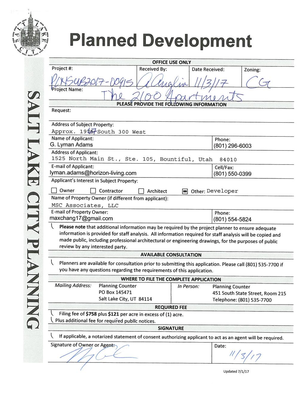
1 Staff Report PLANNING DIVISION DEPARTMENT of COMMUNITY and NEIGHBORHOODS To: Salt Lake City Planning Commission From: Chris Lee, Date: January 18, 2018 Re: PLNSUB and PLNSUB Multi-Unit Housing Development Planned Development and Preliminary Subdivision PROPERTY ADDRESS: 1967 South 300 West PARCEL ID: MASTER PLAN: Central Community ZONING DISTRICT: CG (General Commercial) REQUEST: The petitioner, G. Lyman Adams, representing the property owner, MSC Associates, LLC, is requesting a preliminary subdivision to divide the existing parcel at 1967 S 300 W into two lots and then construct an 81 unit apartment complex via a planned development. If approved, the front parcel would continue as an existing retail business while the rear parcel would be the site of the proposed apartment complex. The planned development petition is requested because the rear parcel would not have frontage on a public street and perimeter landscaping on the east and south of the rear parcel would be less than the required seven feet in width. Per Section 21A of the Salt Lake City zoning ordinance, the planning commission may change, alter, modify or waive any provisions of this title or of the city s subdivision regulations as they apply to the proposed planned development. The Planning Commission has final decision making authority for planned developments and preliminary subdivision plats. RECOMMENDATION: Based on the information in this staff report, Planning Staff recommends that the Planning Commission approve the preliminary subdivision and the planned development as proposed, subject to compliance with all applicable regulations. ATTACHMENTS: A. Vicinity and Zoning Map B. Preliminary Plat Map C. Site Plans D. Building Renderings and Elevations E. Site Photos F. Application G. Cross Access Agreements H. Existing Conditions I. Analysis of Standards J. Public Process and Comments K. Department Comments SALT LAKE CITY CORPORATION 451 SOUTH STATE STREET, ROOM PO BOX SALT LAKE CITY, UT TEL FAX
 in size and is located within the CG zoning district in a neighborhood predominantly composed of commercial uses.")
2 PROJECT DESCRIPTION: Overview The subject parcel is approximately acres (136,602 square feet) in size and is located within the CG zoning district in a neighborhood predominantly composed of commercial uses. There is an existing furniture store/warehouse fronting on 300 West. The petition stipulates that the parcel would be subdivided into two with the existing business to remain on the portion of the existing lot fronting on 300 West that will be referred to in this report as Lot 1. Lot 1 would be 86,728 square feet and would remain as it is now with the exception of providing increased parking and extending an existing ingress/egress easement. Lot 2 would be located at the rear of the existing parcel (see Attachment E for photos). It would contain 49,874 square feet and measure approximately feet by feet. The proposed development would be accessed by easements across Lot 1 to 300 West and across the Sam s Club property to the north, as illustrated by this map: 2

3 The applicant has submitted a planned development petition for a proposed structure on Lot 2. The petition seeks to modify zoning regulations related to it not fronting a public street and a reduction to the width of perimeter landscaping on the east and south sides of the lot. The proposed structure consists of 81 apartment units within a building footprint that measures approximately 288 feet long by 63 feet wide. The maximum height of the structure is 60 feet with units on levels 2-5. There will be 56 one bedroom units and 25 two bedroom units. The structure will be built on grade with the first level dedicated primarily to interior parking accessed from the middle of the south façade. The first level will also house the lobby in the south west corner. In addition to the first level parking, covered exterior stalls are proposed on both the south and east sides of the building which necessitate a reduction from the required 7 feet of perimeter landscaping to 5 feet on the south and 4 feet 6 inches on the east. Please see Attachment C for the submitted site plans and Attachment D for building elevations. The following photo offers an overall view of the proposed structure on Lot 2 looking towards the northeast: Lack of Street Frontage The proposed site of the multi-unit development (Lot 2) is not located on a street which is the primary reason that planned development approval is being sought. It is approximately 385 feet east of 300 West and will be accessible from that point via the expansion of an existing easement across the 3
4 parking lot of the front parcel to the south of the existing structure. The easement is 50 feet in width and is sufficient to handle the traffic demands of the new structure. The applicant has also provided documentation (Attachment G) of an existing easement agreement between the subject parcel and the Sam s Club parcel located to the north. That easement pertains to common areas utilized for vehicular and pedestrian ingress and egress across both parcels. The applicant reports that said easement permits access to the private road directly east of Lot 1 which intersects with 300 West at Hartwell Avenue. That additional access point would serve to further mitigate any potential effects of vehicular traffic to and from the proposed building. Reduced Landscape Yard Widths The other element of the proposed project that does not meet the underlying standards of the CG zoning district are the widths of the landscape yards on both the east and south sides of the parking lot on the rear parcel. The parking lot landscaping standards in section 21A of the Salt Lake City zoning ordinance stipulate that, Where a parking lot is located within a required yard, or within twenty feet (20') of a lot line, perimeter landscaping shall be required along the corresponding edge of the parking lot and that Where perimeter landscaping is required, it shall be provided within landscape areas at least seven feet (7') in width. The perimeter landscaping proposed by the applicant does not meet the seven foot width standard on the southern and eastern edges of the parking lot. On the south side, the landscaped area is proposed to be 5 feet wide, while on the east side it will be 4 feet 6 inches (Attachment C). The perimeter landscaping on the eastern side directly abuts the fence which delineates the UTA TRAX line corridor beyond. The applicant plans to place a fence on the south property line as well. Those fences block any buffering effects that the perimeter landscaping may have on abutting parcels. In regards to potential impacts that reducing the perimeter landscaping may have on the subject parcel, Staff is of the opinion that the requested reductions in width are not extreme and are compensated for in other areas. The application meets and exceeds all other landscape standards including interior parking lot and front yard. Additionally, although the underlying zoning does not require interior side yard setbacks, there is an 11 foot landscaped setback on the north side which provides a buffer between Lot 2 and the Sam s Club parking lot. Further towards the east along the northern property line, there is a planned green space that will serve as a small dog park for residents of the building. It is Staff s opinion that all of these elements compensate for the requested parking perimeter reductions. Parking As stipulated in section 21A G (Minimum off Street Parking Requirements) of the SLC zoning code, there needs to be a minimum of 106 parking stalls on the site due to the requirement to provide 1 parking stall for each of the 56 one bedroom units and 2 parking stalls for each of the 25 two bedroom units. However, section 21A B.7 (Parking Exemptions for Proximity to Mass Transit) stipulates that the minimum number or required off street parking stalls can be reduced by 50% when a multiunit development is located within ¼ mile of a fixed transit station. Seeing as the Central Point Station at 2100 South is located within ¼ mile of the subject parcel, the applicant plans to utilize the reduction. Although the minimum number of parking stalls could be 53 by utilizing the mass transit proximity reduction, the applicant is seeking total of 91 off street parking stalls. 4
5 The applicant also proposes additional parking on Lot 1 (Attachment C). It will be mostly located behind the existing structure to the east with some additional stalls to the existing parking to the south as well. It is meant to remedy an existing parking shortage to bring it into compliance with current parking standards. Per the information submitted by the applicant, the breakdown of the uses of the existing structure on lot 1 is the following: 20,000 square feet of retail space 9,000 square feet of warehouse space 6,000 square feet of office space. Given those ratios, the total number of parking stalls required by ordinance is 76. Currently there are a total of 25 parking stalls on site. The proposed increase would be for 52 stalls for a total up to 77 stalls which would bring Lot 1 into full off street parking compliance. When considering this new parking plan, the applicant did a tree survey and reached out to the Salt Lake City Urban Forester to verify if there would be required mediation for the trees already on site to the east of the existing structure. The applicant reported the species of trees (Chinese Elm) on site can be removed without any remediation. KEY CONSIDERATIONS: The key considerations listed below have been identified through the analysis of the project, neighbor and community input, and department review comments. 1. Cross Access Agreements 2. Compliance with Plan Salt Lake and the Central Community Master Plan Consideration 1 Cross Access Agreements Given that Lot 2 has no street frontage, cross access agreements are crucial to guarantee access to the site and to establish maintenance obligations. An easement is being established across Lot 1 as part of the preliminary subdivision process associated with this application. A copy of the memorandum of understanding which establishes the parties responsible for the maintenance of the areas covered by the easement is included in Attachment G. There is also a cross access agreement which addresses the maintenance agreement for the easement that is already established across the Sam s Club property to the north. The combination of this existing easement with the new one established across Lot 1 should ensure that the proposed development will not negatively impact traffic flows by providing another access point to 300 West at an intersection governed by a traffic light where 300 West meets Hartwell Avenue. Consideration 2 Plan Salt Lake and the Central Community Master Plan The project site is located within the boundaries of the Central Community Master Plan area as well as the city-wide plan called Plan Salt Lake. Plan Salt Lake is a city wide plan that addresses a broad range of issues important to the entire city. Chapter 2 of Plan Salt Lake focuses on growth and lists several initiatives to help facilitate 5
6 responsible growth across the city. Those that are most pertinent to this project are 1-3 and 6: 1. Locate new development in areas with existing infrastructure and amenities, such as transit and transportation corridors. 2. Encourage a mix of land uses. 3. Promote infill and redevelopment of underutilized land. 6. Accommodate and promote an increase in the City s population. Chapter 3, Housing, has the following pertinent initiative: 7. Promote high density residential in areas served by transit. And Chapter 4, Transportation & Mobility, also contains a pertinent initiative: 4. Reduce automobile dependency and single occupancy vehicle trips. This project meets each of the listed initiatives. It is located in an area of the city with existing infrastructure and provides more diversity of uses by locating residential units in an area dominated by commercial. It is a good example of infill development on underutilized land that accommodates the increasing population of the City. This project should reduce automobile dependency by developing in an area well served by various transit options. The Central Point Station at approximately 2100 S and 200 West lives up to its name. The Trax stop located there has already been mentioned, but it also serves as the western terminus of the S-Line trolley as well as being a major hub for buses with routes 9, 17, and 21 all originating there. Few locations within Salt Lake City provide such varied and convenient transit options. Additionally, it should be mentioned that when automobiles are utilized to go to or from the subject parcel, they have direct access to major streets such as 300 West and 2100 S. The proximity to such major roads lessens automobile impacts by enabling drivers to easily access other arterial streets and highways without having to pass through small neighborhoods. The Central Community Master Plan has more specific elements that directly pertain to the neighborhood where the development is proposed. The future land use map specifies that the lot proposed for the development is located in an area intended for High Density Transit Oriented Development (50 or more dwelling units/acre). Transit oriented development is defined in the plan as: a land use and urban design approach that emphasizes a mix of land uses with pedestrian access located near light rail stations. Mixed land uses include residential, retail, office, cultural, institutional, and open space. Transitoriented development districts create a walkable environment that encourages residents and employees to use modes of transit other than the automobile. 6
7 The goal of this approach is to mitigate the environmental impacts of the private automobile by reducing the cumulative vehicle miles traveled. TOD districts improve the quality of life in urban areas and may influence suburban commuters to move back into the Central Community. In the long term, this type of development can help reduce negative impacts of future regional growth on the environment, the quality of water and air, the availability of open space, and the cost of land development. TOD can assist in revitalizing neighborhoods in the Central Community, especially when retail, residential, and office uses are combined to support existing neighborhood characteristics. Urban design requirements need to focus on pedestrian orientation and scale. The plan goes on to discusses the intent of high density transit oriented development by stating that it is the same concept as medium-density TOD except at a greater scale. With that relationship established, medium density TOD development is spelled out in the plan as follows: The design emphasis for medium-density TOD is compatibility with existing medium- and low-density residential and commercial development. Higher intensive uses may be located near light rail stations where applicable. Medium density TOD areas include a mix of ground level retail or office space components with multi-story residential development above the ground floor levels. These areas must also have limits on the amount of space allocated for non-residential land uses. Individual solely residential land uses could remain within the TOD area. Building height maximums would be regulated by the zoning designations. Medium-density transit-oriented development supports residential land uses with a density range of dwelling units per acre. While this area has not yet been designated with specific TSA (Transit Station Area) zoning that Salt Lake City has adopted to further transit oriented development, the CG zoning district allows for most all of the uses and development patterns discussed in the preceding paragraphs. The proposed development meets the high density (50+ units per acre) objective due to it being an 81 unit residential building on acres of land, which yields a density is 70.7 units per acre. While this project does not have a mixed-use component, it is located in an area dominated by commercial uses with a large retailer located just to the west of the proposed structure on Lot 1. Residents living in the area will help provide balance to the neighborhood. It meets the intent of both the Central Community Master Plan and Plan Salt Lake by providing dense housing near a transit stop on an underutilized parcel. DISCUSSION: The proposed multi-family development generally satisfies the planned development standards and the master plans which serve to guide community growth in the Ballpark neighborhood. It is compatible with the neighborhood and leaves the existing business fronting on 300 West in place while developing the underutilized rear lot. As discussed above and in Attachment I, the project meets the objectives of both Plan Salt Lake and the Central Community Master Plan and generally meets the 7
8 standards for a planned development. As such, staff recommends approval of the proposed preliminary subdivision and planned development. NEXT STEPS: Even if plans were changed to provide the full width required for the perimeter parking lot landscaping, the applicant could not proceed with construction due to the lack of street frontage for the rear lot. A planned development is required in this scenario. Planned Development and Preliminary Subdivision Approval If the planned development and preliminary subdivision are approved, the applicant may proceed with the project after meeting all of the conditions required by City departments and the Planning Commission to obtain all necessary building permits. Planned Development and Preliminary Subdivision Denial If the planned development and preliminary subdivision is denied, the applicant will not be able to develop on the rear lot created by subdivision due to the lack of street frontage. A planned development is the only way to address that issue. 8

9 ATTACHMENT A: VICINITY AND ZONING MAP 9
10 ATTACHMENT B: PRELIMINARY PLAT MAP 10


11 1967 SOUTH SUBDIVISION 1700 SOUTH STREET S 89 53'17" E ' N 89 53'17" W ' UTA RIGHT-OF-WAY S 0 21'28" W ' 300 WEST STREET S 89 38'32" E ' WEST TEMPLE STREET N 0 28'56" E ' S 0 21'28" W ' 2100 SOUTH STREET 1967 SOUTH SUBDIVISION DIAMOND LAND SURVEYING, LLC 5243 South Green Pine Drive Murray, Utah office@diamondlandsurveying.com Phone (801) Fax
12 ATTACHMENT C: SITE PLANS 12
13 13
14 14
15 15


16 ATTACHMENT D: RENDERINGS AND ELEVATIONS 16
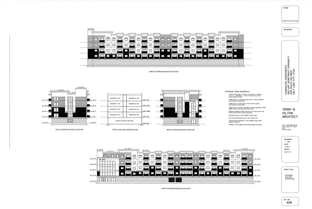
17 17


18 ATTACHMENT E: SITE PHOTOS View of the subject parcel looking east across 300 West View towards the East across Lot 2 18


19 View across Lot 2 to the Sam s Club parking lot to the North View from Lot 2 towards Lot 1 to the West 19
20 ATTACHMENT F: APPLICATION 20
21 21
22 22
23 23
24 24
25 25
26 26
27 27
28 28
29 29
30 30
31 ATTACHMENT G: CROSS ACCESS AGREEMENTS 31
32 32
33 33
34 34
35 35
36 36
37 37
38 38
39 39
40 40
41 41
42 42
43 ATTACHMENT H: EXISTING CONDITIONS Uses within the Immediate Vicinity of the Property North: Big box retail (Sam s Club parking lot) South: Warehouse or storage building and a vacant lot West: Big box retail (Home Depot) across 300 West East: Directly abuts Trax line with single-family residential to the east Zoning within the Immediate Vicinity of the Property North: CG South: CG West: CG East: R-1/5000 CG Zoning Requirements Requirement Standard Proposed Compliance Permitted Uses Subject to 21A and 21A Multi-Family Residential Yes Minimum Lot Area Minimum Lot Width Front Yard Setback Corner Side Yard Setback Interior Side Yard 10,000 square feet 44,800 square feet for rear lot (approximately) Yes 60 feet 128 feet for rear lot Yes (approximately) 10 feet minimum 10 foot setback provided Yes 10 feet minimum N/A N/A None required 11 feet on the north and 26 feet 1.25 inches to the exterior parking structure on the south. Rear Yard 10 feet minimum 24 feet to the exterior Yes parking structure Buffer Yard None required Buffer yard provided on the Yes north side. Accessory Subject to 21A Yes Buildings Landscape Yard A landscape yard of 10 feet required on all 10 foot landscaped yard Yes Requirements front or corner side yards, conforming to the requirements of 21A Maximum Building Height 60 feet without modifications The highest point is 60 feet. Yes Required Parking Spaces 106 for the number and type of units on Lot 2. 50% reduction for being within ¼ mile of a fixed transit stop. 76 stalls required on Lot 1 based on the use breakdown in the existing building, 91 stalls on Lot 2 and 77 stalls on Lot 1 Yes Yes 43
44 ATTACHMENT I: ANALYSIS OF STANDARDS 21a : Standards for Planned Developments: The planning commission may approve, approve with conditions, or deny a planned development based upon written findings of fact according to each of the following standards. It is the responsibility of the applicant to provide written and graphic evidence demonstrating compliance with the following standards: Standard Finding Rationale Complies A. Planned Development Objectives: The planned development shall meet the purpose statement for a planned development (section 21A of this chapter) and will achieve at least one of the objectives stated in said section: A. Combination and coordination of architectural styles, building forms, building materials, and building relationships; B. Preservation and enhancement of desirable site characteristics such as natural topography, vegetation and geologic features, and the prevention of soil erosion; C. Preservation of buildings which are architecturally or historically significant or contribute to the character of the city; D. Use of design, landscape, or architectural features to create a pleasing environment; E. Inclusion of special development amenities that are in the interest of the general public; F. Elimination of blighted structures or incompatible uses through redevelopment or rehabilitation; G. Inclusion of affordable housing with market rate housing; or H. Utilization of "green" building techniques in development. The applicant intends to achieve multiple objectives as addressed in the application (see Attachment F). Those that are most pertinent include A, B, D, and H. The applicant has stated that the design meets Objective A as the building incorporates a variety of building materials with breaks in wall planes, balconies, changes in materials, projections, distinctive cornices and parapets and a rooftop terrace nestled in the top southwest corner to add visual interest to the building. He goes on to state that, As this new apartment will be the first multifamily building in the near vicinity, it is purposefully being designed to differentiate itself from the commercial retail adjacent to it but at the same time be a compatible, conforming and aesthetically pleasing addition to the community. The applicant wrote that the project is meeting Objective B because Although the current land use could allow for higher density.than is proposing, the developers decided not to include any type of underground or semiunderground parking to increase the density of the project to preserve the groundwater integrity due to a high water table. The applicant has stated that it is meeting all of the criteria in Objective D. Some examples of that include the will be a contemporary designed midrise apartment building utilizing a variety of compatible materials including but not limited to tinted bronze glass, concrete, simulated relief elements, brick, hardie board and high intensity seeks to exceed landscaping requirements by utilizing primarily droughttolerant uses various heights along its roofline in order to avoid the institutionalized box like development of its commercial counterparts in the vicinity. The inclusion of spacious patios with each unit allows the resident to enjoy a beautiful view of the Wasatch and Oquirrh Mountains. 44
45 The last objective claimed to be met by the applicant is Objective H. He stated that, While not necessarily a green qualified building is designed where 70% of the units are one bedroom to reduce the need for vehicles. They will be utilizing solar panels on the roof to power the common areas and electrical vehicle stations that they will provide. Additionally, The roof will also be a white membrane to keep it cooler in the summer, all lighting will be LED, and energy efficient appliances will be used in all units. B. Master Plan And Zoning Ordinance Compliance: The proposed planned development shall be: 1. Consistent with any adopted policy set forth in the citywide, community, and/or small area master plan and future land use map applicable to the site where the planned development will be located, and 2. Allowed by the zone where the planned development will be located or by another applicable provision of this title. C. Compatibility: The proposed planned development shall be compatible with the character of the site, adjacent properties, and existing development within the vicinity of the site where the use will be located. In determining compatibility, the planning commission shall consider: 1. Whether the street or other means of access to the site provide the necessary ingress/egress without Complies Complies Staff believes that the features discussed by the applicant in the previous quotations are valid arguments for meeting the referenced objectives. The proposed project includes high quality building materials and design features, landscaping, and significant green features that meet the required objectives. 1. The proposed development is located on a parcel that is within the boundaries of the Central Community Master Plan area. The future land use map specifies that the area is intended for High Density Transit Oriented Development (50 or more dwelling units/acre) and is zoned CG (General Commercial). The Central Community Master Plan supports new residential development. The proposed development would occur on an underutilized vacant lot and would provide dense residential housing near a Trax stop in an area that has been dominated primarily by commercial development. This proposed development helps to meet the goals of the master plan as well as provide needed housing and the elimination of existing blight. This is discussed in more depth in the Key Issues section. 2. Multi-family residential uses are allowed in the CG zone. The planned development process allows for modifications to zoning standards. The requested modifications are also discussed under the Key Issues section. 1. The subject parcel (Lot 2) is located behind another parcel (Lot 1) that fronts on 300 West. Access to 300 West would be provided by an easement running west to east across Lot 1. Additionally, there is an existing easement across the Sam s Club property to the north of the subject parcel which will allow for another access point to 300 West at Hartwell Avenue at an intersection with a stop light. As with all new development, this proposed development will produce additional traffic, but the addition of 81 units to the neighborhood will have a negligible effect on the service level of 300 West or the proximate
46 materially degrading the service level on such street/access or any 2. Whether the planned development and its location will create unusual pedestrian or vehicle traffic patterns or volumes that would not be expected, based on: a. Orientation of driveways and whether they direct traffic to major or local streets, and, if directed to local streets, the impact on the safety, purpose, and character of these streets; b. Parking area locations and size, and whether parking plans are likely to encourage street side parking for the planned development which will adversely impact the reasonable use of adjacent property; c. Hours of peak traffic to the proposed planned development and whether such traffic will unreasonably impair the use and enjoyment of adjacent property. 3. Whether the internal circulation system of the proposed planned development will be designed to mitigate adverse impacts on adjacent property from motorized, nonmotorized, and pedestrian traffic; 4. Whether existing or proposed utility and public services will be adequate to support the proposed planned development at normal service levels and will be designed in a manner to avoid adverse impacts on adjacent land uses, public services, and utility resources; 5. Whether appropriate buffering or other mitigation measures, such as, but not limited to, landscaping, setbacks, building location, sound attenuation, odor control, will be provided to protect adjacent land uses from excessive light, noise, odor and visual impacts and other unusual disturbances from trash collection, deliveries, and mechanical equipment resulting from the proposed planned development; and South due to the combination of those two access points via cross access agreements. 2a. The project has incorporated the previously mentioned easement which provides a direct route from 300 W to the proposed development. The Transportation Division did not mention any potential traffic impacts caused by that easement and the location of the building on Lot 2. As mentioned in the Key Issues section, there is also an existing easement across the Sam s Club parcel which allows for another ingress/egress point at Hartwell Avenue. 2b. This project is providing a total of 91 parking spots on Lot 2 for the 81 units within the new building. Given the size and number of bedrooms in the units, this should be sufficient to limit impacts on surrounding streets. Given the proximity of the project to the 2100 S Trax station and bus route stops, a significant amount of travel on public transit is likely to occur and the parking that is proposed should be more than adequate. Additionally, the applicant is expanding the parking on Lot 1 which can be used as spill over parking for Lot 2, if needed. 2c. The development will have weekday peak traffic that corresponds with normal commuting hours. The adjacent properties are not expected to be negatively affected by the additional traffic that occurs during these hours. Neighboring properties are mostly commercial uses with parking totals that are much higher than this development. 3. The internal circulation system is designed to mitigate any potential impacts to adjacent properties. Access agreements across Lot 1 and the Sam s Club parcel to the north will provide vehicular access to 300 W at two different points. The access crossing the Sam s Club property has a traffic light at that intersection which will further serve to lessen impacts of vehicular use. A sidewalk along the southern edge of Lot 1 will provide safe access for pedestrians to access the proposed building on Lot 2 from 300 W as seen in Attachment C. The applicant has also provided documentation (see Attachment G) of an existing easement agreement between the subject parcel and the Sam s Club parcel located to the north. That easement pertains to common areas utilized for vehicular and pedestrian ingress and egress across both parcels. The applicant reports that said easement permits access to the private road directly east of Lot 1 which intersects with 300 West at Hartwell Avenue. That additional access point would serve to further mitigate any potential 46
47 6. Whether the intensity, size, and scale of the proposed planned development is compatible with adjacent properties. If a proposed conditional use will result in new construction or substantial remodeling of a commercial or mixed used development, the design of the premises where the use will be located shall conform to the conditional building and site design review standards set forth in chapter 21A.59 of this title. effects of vehicular traffic to and from the proposed building on Lot The development will be required to upgrade utility infrastructure where determined to be necessary by the Public Utilities Department and other responsible entities in order to adequately provide service. 5. The development is located in a portion of the Ballpark neighborhood which has traditionally been dominated by commercial development although the Central Community Master Plan stipulates that it should be a High Density Transit Oriented Development pattern with a variety of uses and building forms. This multi-unit housing structure will be pioneering multi-unit residential use in the immediate vicinity and should not cause any significant impacts to neighboring parcels. Although not required, there will be a landscape buffer measuring 10 feet wide on the north side of the parcel as well as perimeter landscaping of 5 feet and 4 feet 6 inches on the south, and east sides, respectively. Additionally a fence is planned to run along the south side of the parcel and the neighbors to the east are separated by the Trax line. There will be a 10 foot wide landscape buffer on the west side of the building. Being set so far back from 300 West and facing the rear of the existing building, there should be minimal impacts. D. Landscaping: Existing mature vegetation on a given parcel for development shall be maintained. Additional or new landscaping shall be appropriate for the scale of the development, and shall primarily consist of drought tolerant species; Complies Additionally, the proposed residential use, indicates that there should be no issues with lighting, noise, or odors. 6. As mentioned above, the proposed multi-family structure is a distinct use and form from most of the neighboring parcels. It is already a high intensity area with several big box commercial businesses. This building will be taller than neighboring structures but it is within the height limit allowed in the zone and located away from the street. That scenario should complement existing buildings and set the stage for taller building with mixed uses which are envisioned by the Central Community Master Plan. The development will provide added density to the neighborhood but in a manner that is compatible to the existing neighborhood with little negative impact. Currently, there is minimal vegetation on the site as it has been vacant and for a significant amount of time. Any existing vegetation will be removed and new landscaping will be installed as noted in the landscape plan. The landscape plan states that proposed plants will drought tolerant species. 47
48 E. Preservation: The proposed planned development shall preserve any historical, architectural, and environmental features of the property; F. Compliance With Other Applicable Regulations: The proposed planned development shall comply with any other applicable code or ordinance requirement. Complies Complies The parcel proposed for development is vacant. There are not historical, architectural, or environmental features of the property to be preserved. Besides the specific modifications requested by the applicant, the project appears to comply with all other applicable codes. Further compliance will be ensured during review of construction plans : STANDARDS OF APPROVAL FOR PRELIMINARY PLATS: All Preliminary Plats for subdivisions and subdivision amendments shall meet the following standards: Standard Finding Rationale Does not comply requires modification through Planned Development The subdivision complies with the general design standards and requirements for subdivisions as established in Chapter of the Subdivision Title The applicant is requesting to modify subdivision standards through the Planned Development process. The following subdivision modification is proposed for this development: Section E Access to Public Streets All buildable lots comply with all applicable zoning standards All necessary and required dedications are made; Water supply and sewage disposal shall be satisfactory to the public utilities department director; Provisions for the construction of any required public improvements, per Section , are included. Does not comply requires modification through Planned Development Complies Complies pending approval from Public Utilities Complies Lot 1 complies with the underlying zoning standards. Lot 2 generally complies, except for what has been called out in the previous table which must be modified by through the Planned Development process including lack of frontage on a public street and reduced parking lot perimeter landscaping. The proposed preliminary plat includes an access easement and a condition of approval states that the memorandum of understanding for the cross access agreement must be completed prior to issuing permits. Utility and drainage easements will also be determined prior to building permit approval. Water supply and sewage disposal will be evaluated and any upgrades or changes needed to serve the development will be required by Public Utilities prior to building permit approval. City Departments are not requiring public improvements to be made at this time. 48
49 ATTACHMENT J: PUBLIC PROCESS AND COMMENTS Notice of Application to the Ballpark Community Council: A notice of application was sent to the Chair of the Ballpark Community Council on November 16, The notice included a copy of the application, the plan set, and a formal notice letter including approval criteria for planned developments. Notice of the open house which was held on December 6, 2017 was also provided. Notice of the Open House: Notices of the December 6, 2017 open house were mailed out on November 22, 2017 to building owners and renters within 300 feet of the subject parcel. Notice of the Planning Commission Public Hearing: Notice was published to a local paper, city and state websites, and the planning division list serve on January 10, 2018 regarding the Planning Commission Public Hearing on January 24, Public Input: One public comment was received at the open house and is included on the following page. The applicant was invited to present at the Ballpark Community Council on December 14, The proposed project was well received by those in attendance with no dissenting opinions. 49
50 50
51 ATTACHMENT K: DEPARTMENT COMMENTS Transportation Michael Barry Off street parking is sufficient; parcel is within one quarter mile of a fixed transit station which reduces the minimum parking requirement by fifty per cent (50%). Zoning Alan Michelsen CG Zone Proposal to split the property, keep the existing 1967 S. 300 West building and develop a new 80 unit apartment house on the rear property requiring a planned development due to lack of frontage on a street. Also proposing to develop additional parking on the front property. A separate building permit will be required for each property where work is proposed. In developing additional parking on the front property, the maximum parking allowance for the site will need to be considered as well as the parking lot landscaping requirements. A Certified Address is to be obtained from the Engineering Dept. for use in the plan review and permit issuance process. See 21A.26 for general and specific regulations of the CG zoning district. See 21A for Use Of Land And Buildings and, 21A for a permanent recycling collection station. See 21A for construction waste management plan requirements. See 21A.37 for building entrance and parking lot Design Standards for the CG zoning districts. See 21A.40 for Accessory Uses, Buildings and Structures, and including ground mounted utility boxes. See 21A.44 for parking and maneuvering, with parking calculations provided that address the minimum parking required for each site, maximum parking allowed for each site, number provided for each site and any method of reducing or increasing the parking requirement for each site. For the new development, the parking calculations shall also include bicycle parking required/provided outside of the building and within 50 of the principle entry, off-street loading required/provided as well as clear pedestrian pathways from the parking lot to the entry of the building and the public sidewalk. Park strip tree protection during the construction process will need to be evaluated by Urban Forestry. See 21A.48 for landscaping and including removal/protection of private property trees. See 21A.55 for planned developments. See 21A.58 for site plan review. Engineering Scott Weiler If the existing public way improvements on the 300 West frontage of the proposed plat are defective (badly cracked, ponding drainage, tripping hazards, etc.), it is recommended that the developer consider replacing them as part of this development. Fire Ted Itchon I was not able to check the measurements but the following dimensions will be required. The gate width is a minimum of 20 ft. clear, the access road clear width is 26 ft. this road shall not be closer than 15 ft. measured from the face of the structure and no greater than 30 ft. the modified hammer head turn around points shall be a minimum of 80 ft. depth on each measurement. The turning radius shall be a minimum of 45 ft. outside and 20 ft. inside. Public Utilities Jason Draper Review and approval of the planned development and preliminary plat does not provide building or utility permit and approval. Easements will be required to provide water and sewer service. Utilities cannot cross property lines without appropriate easements and agreements. 51
52 Please submit site utility and grading plans for review. Other plans such as erosion control plans and plumbing plans may also be required depending on the scope of work. Submit supporting documents and calculations along with the plans. Public Utility permit, connection, survey and inspection fees will apply. An exterior, below-grade grease interceptor may be required for this application. Plumbing fixtures in the kitchen must be treated to remove solids and grease prior to discharge to the sanitary sewer. The interceptor must be sized by a licensed design professional. A 4ft diameter sampling manhole must be located downstream of the interceptor and upstream of any other connections. Covered parking area drains and work shop area drains are required to be treated to remove solids and oils prior to discharge to the sanitary sewer. These drains cannot be discharged to the storm drain. Use a sand/oil separator or similar device. A 4ft diameter sampling manhole must be located downstream of the device and upstream of any other connections. All utility design and construction must comply with APWA Standards and SLCPU Standard Practices. Storm water detention is required for this project. The allowable release rate is 0.2 cfs per acre. Detention must be sized using the 100 year 3 hour design storm using the farmer Fletcher rainfall distribution. Provide a complete Technical Drainage Study including all calculations, figures, model output, certification, summary and discussion. Storm water treatment is required prior to discharge to the public storm drain. Utilize storm water Best Management Practices (BMPs) to remove solids and oils. Green infrastructure should be used whenever possible. Sand/oil separators are commonly used to treat storm water runoff from uncovered parking areas. Projects larger than one acre require that a Storm Water Pollution Prevention Plan (SWPPP) and Technical Drainage Study are submitted for review. All utilities must be separated by a minimum of 3ft horizontally and 18 vertically. Water and sewer lines require 10ft minimum horizontal separation. Applicant must provide fire flow and culinary water demands to SLCPU for review. The public water system will be modeled with these demands. If the demand is not adequately delivered, a water main upsizing will be required at the property owner s expense. Required improvements on the public water system will be determined by the Development Review Engineer. New water mains must cross the entire frontage of the property. A plan and profile and Engineer s cost estimate must be submitted for review. The property owner is required to bond for the amount of the approved cost estimate. One culinary water meter and one fire line are permitted per parcel. If the parcel is larger than 0.5 acres, a separate irrigation meter is also permitted. Each service must have a separate tap to the main. 52
Staff Report PLANNED DEVELOPMENT. Salt Lake City Planning Commission. From: Lauren Parisi, Associate Planner; Date: December 14, 2016
 Staff Report PLANNING DIVISION COMMUNITY & NEIGHBORHOODS To: Salt Lake City Planning Commission From: Lauren Parisi, Associate Planner; 801-535-7932 Date: December 14, 2016 Re: 1611 South 1600 East PLANNED
PLANNING COMMISSION STAFF REPORT. Merrimac PLNSUB Planned Development 38 West Merrimac November 9, Request. Staff Recommendation
 PLANNING COMMISSION STAFF REPORT Merrimac PLNSUB2011-00374 Planned Development 38 West Merrimac November 9, 2011 Planning and Zoning Division Department of Community and Economic Development Applicant:
ADMINISTRATIVE HEARING STAFF REPORT
 ADMINISTRATIVE HEARING STAFF REPORT Providence Place Apartments Utility Box No. 2 Conditional Use Petition PLNPCM2011-00426 309 East 100 South September 22, 2011 Planning and Zoning Division Department
Staff Report PLANNING DIVISION COMMUNITY & ECONOMIC DEVELOPMENT. Alley Closure
 Staff Report PLANNING DIVISION COMMUNITY & ECONOMIC DEVELOPMENT To: From: Salt Lake City Planning Commission Doug Dansie, 801-535-6182, doug.dansie@slcgov.com Date: March 23, 2016 Re: PLNPCM2015-00941
PLNSUB Meridian Commerce Center Subdivision Amendment & PLNPCM Meridian Commerce Center Street Closure
 Staff Report PLANNING DIVISION COMMUNITY & ECONOMIC DEVELOPMENT To: From: Salt Lake City Planning Commission Daniel Echeverria, 801-535-7165, daniel.echeverria@slcgov.com Date: September 4, 2014 Re: PLNSUB2014-000469
PLANNING COMMISSION STAFF REPORT. QUEST ASSISTED LIVING CONDITIONAL USE PLNPCM West 800 North Hearing date: October 14, 2009
 PLANNING COMMISSION STAFF REPORT QUEST ASSISTED LIVING CONDITIONAL USE PLNPCM2009-00971 1820 West 800 North Hearing date: October 14, 2009 Planning Division Department of Community & Economic Development
David J. Gellner, AICP, Principal Planner; (801) ; Zoning Map Amendment
 ; Zoning Map Amendment") Staff Report PLANNING DIVISION DEPARTMENT of COMMUNITY and NEIGHBORHOODS To: From: Salt Lake City Planning Commission David J. Gellner, AICP, Principal Planner; (801) 535-6107; david.gellner@slcgov.com
Staff Report PLANNING DIVISION DEPARTMENT of COMMUNITY and NEIGHBORHOODS To: From: Salt Lake City Planning Commission David J. Gellner, AICP, Principal Planner; (801) 535-6107; david.gellner@slcgov.com
PLANNING COMMISSION STAFF REPORT
 PLANNING COMMISSION STAFF REPORT A1 Auto Parts Conditional Use Outdoor Auto Salvage and Recycling in M-1 PLNPCM2010-00188 5 South 5100 West June 23, 2010 Applicant: Mike Vanikiotis Staff: Katia Pace, 535-6354,
Glades County Staff Report and Recommendation Unified Staff Report for Small Scale Plan Amendment and Rezoning
 Glades County Staff Report and Recommendation Unified Staff Report for Small Scale Plan Amendment and Rezoning CASE NUMBERS: COMP17-02 and RZ17-02 DATE of STAFF REPORT: May 1, 2017 CASE TYPE: Application
ARTICLE IV: DEVELOPMENT STANDARDS
 ARTICLE IV: DEVELOPMENT STANDARDS IV-53 409 PRIVATE STREETS A private street means any way that provides ingress to, or egress from, property by means of vehicles or other means, or that provides travel
ZONING AMENDMENT & SUBDIVISION STAFF REPORT Date: November 3, 2016
 ZONING AMENDMENT & SUBDIVISION STAFF REPORT Date: November 3, 2016 APPLICANT NAME SUBDIVISION NAME David Shumer 5955 Airport Subdivision CITY COUNCIL DISTRICT District 6 5955 Airport Boulevard, 754 Linlen
UPPER MOUNT BETHEL TOWNSHIP NORTHAMPTON COUNTY, PENNSYLVANIA
 UPPER MOUNT BETHEL TOWNSHIP NORTHAMPTON COUNTY, PENNSYLVANIA JOINDER DEED / LOT CONSOLIDATION TOWNSHIP REVIEW PROCESS When accepting proposed Joinder Deeds / Lot Consolidations, review the Joinder Deed
(b) The location of principal and accessory buildings on the lot and the relationship of each structure to the other.
 The location of principal and accessory buildings on the lot and the relationship of each structure to the other.") ARTICLE XIX SITE PLAN Sec. 20-1900 Site Plan Review Procedure - Intent The site plan review procedures are instituted to provide an opportunity for the Township Planning Commission to review the proposed
ARTICLE XIX SITE PLAN Sec. 20-1900 Site Plan Review Procedure - Intent The site plan review procedures are instituted to provide an opportunity for the Township Planning Commission to review the proposed
Planning Commission Briefing Memo
 Planning Commission Briefing Memo Community & Economic Development Office of the Director To: From: Planning Commission Wayne Mills, Senior Planner Date: July 27, 2016 CC: Re: Nora Shepard, City Planning
STAFF REPORT Administrative Subdivision Hearing West 150 South Street, Parcel # , and
 Petition Number: 490-06-24 STAFF REPORT Administrative Subdivision Hearing Project Name: Project Location: Project Type: Applicant: Planning Staff: Haight Industrial Subdivision 5550 West 150 South Street,
DATE: February 28, Marilynn Lewis, Principal Planner
 DATE: February 28, 2007 TO: FROM: RE: Salt Lake City Planning Commission Marilynn Lewis, Principal Planner Planning Commission Hearing for Petition 400-06-41 Zoning Map Amendment to Rezone 6 Properties,
Planning and Zoning Division Department of Community Development. Applicant: Ivory Towns LLC
 ADMINISTRATIVE HEARING STAFF REPORT Trolley Place Condominiums New Preliminary Condominium 480-08-08 located at approximately 540 South Denver Street July 7, 2008 Planning and Zoning Division Department
M-43 CORRIDOR OVERLAY ZONE
 ARTICLE 26.00 M-43 CORRIDOR OVERLAY ZONE Section 26.01 Findings A primary function of the M-43 state highway is to move traffic through the Township and to points beyond. As the primary east-west arterial
CHAPTER 14 SPECIAL DEVELOPMENTS
 10-14-1 10-14-1 CHAPTER 14 SPECIAL DEVELOPMENTS SECTION: 10-14-1: Cluster and Inner Block Development 10-14-2: Planned Unit Development 10-14-1: CLUSTER AND INNER BLOCK DEVELOPMENT: A. Land Use: Cluster
PLANNED UNIT DEVELOPMENT & SUBDIVISION STAFF REPORT Date: April 18, 2019
 PLANNED UNIT DEVELOPMENT & SUBDIVISION STAFF REPORT Date: April 18, 2019 DEVELOPMENT NAME SUBDIVISION NAME Springhill Village Subdivision Springhill Village Subdivision LOCATION 4350, 4354, 4356, 4358,
Chapter SPECIAL USE ZONING DISTRICTS
 Chapter 20.20 Sections: 20.20.010 Urban Transition (U-T) Zoning District 20.20.020 Planned Development (P-D) Zoning Districts 20.20.010 Urban Transition (U-T) Zoning District A. Purpose. The purpose of
Composition of traditional residential corridors.
 Page 1 of 7 St. Petersburg, Florida, Code of Ordinances >> PART II - ST. PETERSBURG CITY CODE >> Chapter 16 - LAND DEVELOPMENT REGULATIONS >> SECTION 16.20.060. CORRIDOR RESIDENTIAL TRADITIONAL DISTRICTS
BUILDING AN ADU GUIDE TO ACCESSORY DWELLING UNITS PLANNING DIVISION
 BUILDING AN ADU GUIDE TO ACCESSORY DWELLING UNITS PLANNING DIVISION 1 451 S. State Street, Room 406 Salt Lake City, UT 84114-5480 P.O. Box 145480 CONTENT 04 OVERVIEW 08 ELIGIBILITY 11 BUILDING AN ADU Types
Rezoning Petition Pre-Hearing Staff Analysis April 17, 2017
 Rezoning Petition 2017-041 Pre-Hearing Staff Analysis April 17, 2017 REQUEST Current Zoning: R-5 (single family residential), R-22MF (multifamily residential), and I-1 (light industrial) Proposed Zoning:
DEVELOPMENT DEPARTMENT STAFF REPORT DRESDEN HEIGHTS PHASE II DCI
 DEVELOPMENT DEPARTMENT Meeting Date: January 10, 2019 Item #: PZ2019-393 Project Name: Applicant and Owner: Proposed Development: Requests: STAFF REPORT DRESDEN HEIGHTS PHASE II DCI Dresden Heights Phase
PLANNING COMMISSION STAFF REPORT
 PLANNING COMMISSION STAFF REPORT First Unitarian Church Conditional Use & Subdivision PLNPCM2011-00211 & PLNSUB2011-00212 569 South 1300 East Public Hearing: August 10, 2011 Planning Division Department
WESTMINSTER PARK SUBDIVISION
 WESTMINSTER PARK SUBDIVISION Engineering Comments: FINAL PLAT COMMENTS (should be addressed prior to submitting the FINAL PLAT for review and/or signature by the City Engineer): A. Provide all of the required
Bowie Marketplace Residential Detailed Site Plan Statement of Justification January 13, 2017 Revised February 2, 1017
 Bowie Marketplace Residential Detailed Site Plan Statement of Justification January 13, 2017 Revised February 2, 1017 Submitted on behalf of: BE Bowie LLC 5410 Edson Lane, Suite 220 Rockville, MD 20852
Administrative Hearing Officer, Salt Lake City Planning Division. Conditional Use for the Salt Flats Brewery Club/Tasting Room (PLNPCM )
") Staff Report PLANNING DIVISION DEPARTMENT of COMMUNITY and NEIGHBORHOODS To: From: Administrative Hearing Officer, Salt Lake City Planning Division David J. Gellner, AICP, Principal Planner (801) 535-6107
Staff Report PLANNING DIVISION DEPARTMENT of COMMUNITY and NEIGHBORHOODS To: From: Administrative Hearing Officer, Salt Lake City Planning Division David J. Gellner, AICP, Principal Planner (801) 535-6107
ARTICLE 15 - PLANNED UNIT DEVELOPMENT
 Section 15.1 - Intent. ARTICLE 15 - PLANNED UNIT DEVELOPMENT A PUD, or Planned Unit Development, is not a District per se, but rather a set of standards that may be applied to a development type. The Planned
ARTICLE 24 SITE PLAN REVIEW
 ARTICLE 24 SITE PLAN REVIEW 24.1 PURPOSE: The intent of these Ordinance provisions is to provide for consultation and cooperation between the land developer and the Township Planning Commission in order
Planning Division Department of Community & Economic Development. Applicant: Volunteers of America: Kathy Bray
 Planning Commission Staff Report Volunteers of America Large Group Home Supportive Housing for Young Men Conditional Use PLNPCM2011-00485 556 South 500 East Hearing date: October 26, 2011 Planning Division
REPORT TO THE SHELBY COUNTY PLANNING COMMISSION From the Department of Development Services Planning Services. February 4, 2019
 REPORT TO THE SHELBY COUNTY PLANNING COMMISSION From the Department of Development Services Planning Services February 4, 2019 Case No. Request for Rezoning Approval From E-1 to E-2 SD This is a request
PLANNING COMMISSION STAFF REPORT
 PLANNING COMMISSION STAFF REPORT ZONING MAP AMENDMENT PLNPCM2011-00091- Zoning Map Amendment PLNSUB2011-00090 Subdivision Amendment Approximately 700 North Columbus Court August 10, 2011 Planning and Zoning
PROPOSED AMENDMENTS TO THE DERBY ZONING REGULATIONS AUGUST 12, 2008
 ARTICLE II Definitions and word usage 195-7. Definitions and word usage. Modify the following: HOUSING FOR THE ELDERLY OLDER PERSONS Housing in accordance with and as defined in the United States Fair
RE: 6. GILL/GREEN COMPREHENSIVE PLAN AMENDMENT, REZONING AND PRELIMINARY PLAT
 commission memo DATE: Thursday - August 9, 2018 TO: Marion Planning & Zoning Commission FROM: David N. Hockett, AICP Principal Planner RE: 6. GILL/GREEN COMPREHENSIVE PLAN AMENDMENT, REZONING AND PRELIMINARY
ZONING AMENDMENT, PLANNED UNIT DEVELOPMENT & SUBDIVISION STAFF REPORT Date: August 8, 2013
 ZONING AMENDMENT, PLANNED UNIT DEVELOPMENT & SUBDIVISION STAFF REPORT Date: August 8, 2013 NAME SUBDIVISION NAME PV-Magnolia, LLC Twelve Trees Subdivision LOCATION 2860, 2862 and 2866 Pleasant Valley Road
-MENDOCINO COUNTY PLANNING AND BUILDING SERVICES- DIVISION OF LAND REGULATIONS TITLE 17
 ARTICLE VI -- GENERAL REGULATIONS AND PROVISIONS Sec. 17-50. Sec. 17-51 General Plan. Sec. 17-52 Lot and Block Design and Configuration. Sec. 17-53 Lot Access. Sec. 17-54 Private Roads. Sec. 17-55 Water
Conditional Use Permit case no. CU 14-06: Bristol Village Partners, LLC
 PLANNING AND ZONING COMMISSION STAFF REPORT August 7, 2014 Conditional Use Permit case no. CU 14-06: Bristol Village Partners, LLC CASE DESCRIPTION: LOCATION: LEGAL DESCRIPTION: EXISTING LAND USE: ZONING:
PLANNING DIVISION COMMUNITY & NEIGHBORHOODS. Conditional Use
 Staff Report PLANNING DIVISION COMMUNITY & NEIGHBORHOODS To: Salt Lake City Administrative Hearing Officer From: John Anderson, 801-535-7214 Date: March 22, 2018 Re: PLNPCM2018-00037 Conditional Use for
STAFF REPORT FOR THE MAY 24, 2006 MEETING. CASE#: Petitions and
 DATE: May 18, 2006 TO: Salt Lake City Planning Commission FROM: Doug Dansie, Principal Planner RE: STAFF REPORT FOR THE MAY 24, 2006 MEETING CASE#: Petitions 410-06-08 and 490-06-18 APPLICANT: Ken Menlove
AGENDA ITEM SUMMARY GLADES COUNTY BOARD OF COUNTY COMMISSIONERS
 AGENDA ITEM SUMMARY GLADES COUNTY BOARD OF COUNTY COMMISSIONERS SUBJECT: Case Number COMP17-01, Legend Moto LLC This is a Legislative Hearing. DEPARTMENT REQUEST: The Community Development Department requests
PLANNING DIVISION DEPARTMENT OF COMMUNITY AND NEIGHBORHOODS. Conditional Use
 Staff Report PLANNING DIVISION DEPARTMENT OF COMMUNITY AND NEIGHBORHOODS To: From: Salt Lake City Planning Commission Maryann Pickering, Principal Planner (801) 535-7660 Date: July 27, 2016 Re: Church
ARTICLE VII. NONCONFORMITIES. Section 700. Purpose.
 ARTICLE VII. NONCONFORMITIES. Section 700. Purpose. The purpose of this chapter is to regulate and limit the development and continued existence of legal uses, structures, lots, and signs established either
P. H. Robinson Consulting Urban Planning, Consulting and Project Management
 PLANNING RATIONALE REPORT FOR SITE PLAN AND DRAFT PLAN OF CONDOMINIUM APPLICATIONS 73-75 HARVEY STREET CITY OF OTTAWA PREPARED BY: P H ROBINSON CONSULTING AUGUST 2012 1 This report has been prepared on
PLANNING COMMISSION STAFF REPORT
 PLANNING COMMISSION STAFF REPORT West Capitol Hill Zoning Map Amendment Petition No. PLNPCM2011-00665 Located approximately at 548 W 300 North Street, 543 W 400 North Street, and 375 N 500 West Street
Appendix1,Page1. Urban Design Guidelines. Back to Back and Stacked Townhouses. DRAFT September 2017
 Appendix1,Page1 Urban Design Guidelines DRAFT September 2017 Back to Back and Stacked Townhouses Appendix1,Page2 Table of Contents 1 Introduction 1 1.1 Purpose 1 1.2 Urban Design Objectives 1 1.3 Building
PALM BEACH COUNTY PLANNING, ZONING AND BUILDING DEPARTMENT ZONING DIVISION
 PALM BEACH COUNTY PLANNING, ZONING AND BUILDING DEPARTMENT ZONING DIVISION Application No.: CA-2012-00688 Control No.: 2011-00552 Applicant: Garry Bernardo Owners: Garry Bernardo Agent: Frogner Consulting,
REVISED # Federal Drive Milestones Therapy Project Review for Planning and Zoning Commission
 REVISED #2012-111 394 Federal Drive Milestones Therapy Project Review for Planning and Zoning Commission Meeting Date: November 7, 2012 and November 19, 2012 Request: Location: Acreage: Existing Zoning:
Urban Design Brief Dundas Street. London Affordable Housing Foundation. November Zelinka Priamo Ltd.
 Urban Design Brief 1039-1047 Dundas Street London Affordable Housing Foundation November 2017 Zelinka Priamo Ltd. TABLE OF CONTENTS Page No. INTRODUCTION... 3 SECTION 1 LAND USE PLANNING CONTEXT... 3 1.1
PLANNING COMMISSION REPORT Regular Agenda -Public Hearing Item
 PDP-13-00518 Item No. 3B- 1 PLANNING COMMISSION REPORT Regular Agenda -Public Hearing Item PC Staff Report 2/24/14 ITEM NO. 3B PRELIMINARY DEVELOPMENT PLAN FOR HERE @ KANSAS; 1101 INDIANA ST (SLD) PDP-13-00518:
Medical Marijuana Special Exception Use Information
 Medical Marijuana Special Exception Use Information The Special Exception Use information below is a modified version of the Unified Development Code. It clarifies the current section 5:104 Special Exceptions
3.1. OBJECTIVES FOR RESIDENTIAL LAND USE DESIGNATIONS GENERAL OBJECTIVES FOR ALL RESIDENTIAL DESIGNATIONS
 3. RESIDENTIAL LAND USE DESIGNATIONS INTRODUCTION The Residential land use designations provide for housing and other land uses that are integral to, and supportive of, a residential environment. Housing
PERMITTED USES: Within the MX-1 Mixed Use Neighborhood District the following uses are permitted:
 6.25 MX-1 - MIXED USE NEIGHBORHOOD 6.25.1 INTENT: The purpose of the MX-1 Mixed Use Neighborhood District is to accommodate the development of a wide-range of residential and compatible non-residential
Land Use, Transportation, and Infrastructure Committee of Denver City Council FROM: Scott Robinson, Senior City Planner DATE: December 6, 2018 RE:
 Community Planning and Development Planning Services 201 W. Colfax Ave., Dept. 205 Denver, CO 80202 p: 720.865.2915 f: 720.865.3052 www.denvergov.org/cpd TO: Land Use, Transportation, and Infrastructure
Washington County, Minnesota Ordinances
 Washington County, Minnesota Ordinances Ordinance No. 153 Text Amendment to the Washington County Development Code - Chapter One, Section 2 and Chapter Two, Part 1, Part 2, Part 3, of the Development Code
SUBDIVISION, PLANNED UNIT DEVELOPMENT, ZONING AMENDMENT, & SIDEWALK WAIVER STAFF REPORT Date: July 19, 2018
 SUBDIVISION, PLANNED UNIT DEVELOPMENT, ZONING AMENDMENT, & SIDEWALK WAIVER STAFF REPORT Date: July 19, 2018 NAME SUBDIVISION NAME LOCATION West Mobile Properties, LLC U.S. Machine Subdivision 556, 566,
E L M E R B O R O U G H L A N D U S E B O A R D APPLICATION COVER SHEET (to be completed for all applications and appeals)
") E L M E R B O R O U G H L A N D U S E B O A R D APPLICATION COVER SHEET (to be completed for all applications and appeals) 1. Name(s): 2. Address: 3. Telephone Number(s): 4. E-mail: 5. Owner Name(s) (if
E L M E R B O R O U G H L A N D U S E B O A R D APPLICATION COVER SHEET (to be completed for all applications and appeals) 1. Name(s): 2. Address: 3. Telephone Number(s): 4. E-mail: 5. Owner Name(s) (if
Box Elder County Land Use Management & Development Code Article 3: Zoning Districts
 Chapter 3-6 Mobile Homes, Mobile Home Subdivisions, & Recreational Vehicle Parks Box Elder Zoning Ordinance as Adopted October 2007 Sections. 3-6-010. Purpose and Intent. 3-6-020. Conditional Use Permit
Division Development Impact Review.
 Division 51-4.800. Development Impact Review. SEC. 51-4.801. PURPOSE. The general objectives of this division are to promote and protect the health, safety, and general welfare of the public through the
8.5.1 R1, Single Detached Residential District
 8.5.1 R1, Single Detached Residential District The purpose of this district is to provide for residential development in the form of single detached dwellings. Dwelling, Single Detached Home Business,
ADMINISTRATIVE HEARING STAFF REPORT
 ADMINISTRATIVE HEARING STAFF REPORT Epic Brewing Center Subdivision Minor Subdivision Preliminary Plat PLNSUB2013-00846 825 S. State St., 834 and 836 S. Edison St. Hearing date: December 12, 2013 Applicant:
PLANNED UNIT DEVELOPMENT & SUBDIVISION STAFF REPORT Date: November 17, 2016
 PLANNED UNIT DEVELOPMENT & SUBDIVISION STAFF REPORT Date: November 17, 2016 DEVELOPMENT NAME SUBDIVISION NAME LOCATION Autonation Ford of Mobile Autonation Ford of Mobile Subdivision 901, 909, and 925
9. REZONING NO Vicinity of the northwest corner of 143 rd Street and Metcalf Avenue
 9. REZONING NO. 2002-15 Vicinity of the northwest corner of 143 rd Street and Metcalf Avenue 1. APPLICANT: Andrew Schlagel is the applicant for this request. 2. REQUESTED ACTION: The applicant is requesting
AN ORDINANCE TO AMEND SECTION OF THE RAPID CITY MUNICIPAL CODE TO ALLOW FOR ADMINISTRATIVE DISSOLUTION OF PLANNED DEVELOPMENTS
 Ordinance No. 6231 AN ORDINANCE TO AMEND SECTION 17.50.050 OF THE RAPID CITY MUNICIPAL CODE TO ALLOW FOR ADMINISTRATIVE DISSOLUTION OF PLANNED DEVELOPMENTS WHEREAS, the City of Rapid City has adopted a
ARTICLE 14 PLANNED UNIT DEVELOPMENT (PUD) DISTRICT
 DISTRICT") ARTICLE 14 PLANNED UNIT DEVELOPMENT (PUD) DISTRICT Section 14.01 Intent. It is the intent of this Article to allow the use of the planned unit development (PUD) process, as authorized by the Michigan Zoning
ARTICLE 14 PLANNED UNIT DEVELOPMENT (PUD) DISTRICT Section 14.01 Intent. It is the intent of this Article to allow the use of the planned unit development (PUD) process, as authorized by the Michigan Zoning
Hearing date: January 8, 2014
 Planning Commission Staff Report Administrative Item LIBERTY PARK PLACE MIXED USE PROJECT Planned Development PLNSUB2013-00587 Preliminary Condominium Plat PLNSUB2013-00589 1321 South 500 East Hearing
FINAL SUBDIVISION AND LAND DEVELOPMENT PLAN CHECKLIST. Plan Name. Applicant's Name:
 TOWNSHIP OF UPPER ST. CLAIR FINAL SUBDIVISION AND LAND DEVELOPMENT PLAN CHECKLIST Date Filed Plan Name PLC Applicant's Name: Phone Filing Date for Final Application Final Plat 114.22. FINAL APPLICATION
AAAA. Planning and Zoning Staff Report Lake Shore Land Holdings, LLC CU-PH Analysis
 AAAA Planning and Zoning Staff Report Lake Shore Land Holdings, LLC CU-PH2016-28 Hearing Date: April 21, 2016 Development Services Department Applicant: BRS Architects/Cindy Huebert Staff: Kyle McCormick,
Plan Dutch Village Road
 Plan Dutch Village Road Objective: The lands around Dutch Village Road are a minor commercial area that services the larger Fairview community. Maintaining the vibrancy of the area by planning for redevelopment
ARTICLE XI CONDITIONAL USE PERMITS
 ARTICLE XI CONDITIONAL USE PERMITS 11.1 Purpose. The City of Hailey recognizes that certain uses possess unique and special characteristics with respect to their location, design, size, method of operation,
Accessory Dwelling Units (ADUs)
") Community Development Department Planning Division 14177 Frederick Street PO Box 8805 Moreno Valley, CA 92552-0805 (951) 413-3206 Fax (951) 413-3210 Accessory Dwelling Units (ADUs) Completed Project Application
Community Development Department Planning Division 14177 Frederick Street PO Box 8805 Moreno Valley, CA 92552-0805 (951) 413-3206 Fax (951) 413-3210 Accessory Dwelling Units (ADUs) Completed Project Application
DEVELOPMENT PLAN ORDINANCE
 DEVELOPMENT PLAN ORDINANCE CITY OF GLASGOW Ordinance No. 2026 SECTION A. Section 1. INTENT AND PURPOSE The purpose of this Ordinance is to establish and define development plans, which may be utilized
Watkinsville First Baptist Church Building and Parking Masterplan Norton Road & Simonton Bridge Road Oconee County Georgia
 Watkinsville First Baptist Church Building and Parking Masterplan Norton Road & Simonton Bridge Road Oconee County Georgia Special Use Approval A-1 CUP to A-1 with Special Use Approval Total Site Area
individual building permits are taken out for each lot. subdivision with the following conditions:
 PLANNING COMMISSION STAFF REPORT ADMINISTRATIVE ITEM McClelland Court Planned Development PLNSUB2013-00407 Minor Subdivision PLNSUB2013-00752 1019 E 2700 South February 26, 2014 Planning Division Department
Cover Letter with Narrative Statement
 Cover Letter with Narrative Statement March 31, 2017 rev July 27, 2017 RE: Rushton Pointe Residential Planned Unit Development Application for Public Hearing for RPUD Rezone PL2015 000 0306 Mr. Eric Johnson,
FINAL DRAFT 12/1/16, Rev. to 7/18/17
 FINAL DRAFT 12/1/16, Rev. to 7/18/17 (As Adopted 8/8/17 Effective 9/1/17) SHELTON PLANNING AND ZONING COMMISSION Proposed Amendments to Zoning Regulations I. Amend Section 23 PERMITTED USES by inserting
2.35 BVT G Bow Valley Trail General Commercial District [ ]
![2.35 BVT G Bow Valley Trail General Commercial District [ ]](/thumbs/94/119006025.jpg "2.35 BVT G Bow Valley Trail General Commercial District [ ]") 2.35 BVT G Bow Valley Trail General Commercial District [2014 07] 2.35.1 Purpose This district is intended to form the core of Canmore s visitor accommodation outside the resorts and provide a variety
2.35 BVT G Bow Valley Trail General Commercial District [2014 07] 2.35.1 Purpose This district is intended to form the core of Canmore s visitor accommodation outside the resorts and provide a variety
ML-4 MULTIFAMILY RESIDENTIAL ZONE. [Added by Ord. No ]
![ML-4 MULTIFAMILY RESIDENTIAL ZONE. [Added by Ord. No ]](/thumbs/90/103301433.jpg "ML-4 MULTIFAMILY RESIDENTIAL ZONE. [Added by Ord. No ]") 55-26. ML-4 MULTIFAMILY RESIDENTIAL ZONE. [Added 2-2-98 by Ord. No. 1998-1 2] The following regulations apply in the ML-4 Zone. A. Permitted Uses. (1) Garden apartments, together with accessory structures
55-26. ML-4 MULTIFAMILY RESIDENTIAL ZONE. [Added 2-2-98 by Ord. No. 1998-1 2] The following regulations apply in the ML-4 Zone. A. Permitted Uses. (1) Garden apartments, together with accessory structures
SECTION 7000 LAND DEVELOPMENT REQUIREMENTS
 SECTION 7000 LAND DEVELOPMENT REQUIREMENTS 7000 LAND DEVELOPMENT REQUIREMENTS... 1 7001 LEGISLATIVE AUTHORITY... 1 7001.1 LAND DEVELOPMENT... 1 7001.1.1 Title 40, Idaho Code... 1 7001.1.2 Idaho Code 40-1415
SANDOVAL COUNTY PLANNING AND ZONING COMMISSION DECEMBER 10, 2015 PUBLIC HEARING
 SANDOVAL COUNTY PLANNING AND ZONING COMMISSION DECEMBER 10, 2015 PUBLIC HEARING To: Sandoval County Planning and Zoning Commission From: Sandoval County Planning and Zoning Division Staff Date: December
Operating Standards Attachment to Development Application
 Planning & Development Services 2255 W Berry Ave. Littleton, CO 80120 Phone: 303-795-3748 Mon-Fri: 8am-5pm www.littletongov.org Operating Standards Attachment to Development Application 1 PLANNED DEVELOPMENT
WESTMINSTER PARK PLACE SUBDIVISION
 WESTMINSTER PARK PLACE SUBDIVISION Engineering Comments: FINAL PLAT COMMENTS (should be addressed prior to submitting the FINAL PLAT for review and/or signature by the City Engineer): A. Provide all of
DEVELOPMENT DEPARTMENT STAFF REPORT STAFF REPORT EASTSIDE CHAMBLEE LINK DCI
 DEVELOPMENT DEPARTMENT STAFF REPORT Public Hearing Date: April 12, 2018 Item #: PZ-2018-248 STAFF REPORT EASTSIDE CHAMBLEE LINK DCI Request: Development of Community Compact (DCI), ten concurrent variances,
Article Optional Method Requirements
 Article 59-6. Optional Method Requirements [DIV. 6.1. MPDU DEVELOPMENT IN RURAL RESIDENTIAL AND RESIDENTIAL ZONES Sec. 6.1.1. General Requirements... 6 2 Sec. 6.1.2. General Site and Building Type Mix...
REQUEST STAFF RECOMMENDATION. On April 26, 2012, Signature Books Inc., represented by Dave Richards, submitted petitions for the following amendments:
 PLANNING COMMISSION STAFF REPORT Signature Books Zoning Map Amendment and an Amendment to the North Temple Area Plan Petitions PLNPCM2012-00254 PLNPCM2012-00255 July 11, 2012 Planning Division Department
DEVELOPMENT DEPARTMENT STAFF REPORT THE PARK AT 5 TH
 DEVELOPMENT DEPARTMENT STAFF REPORT ARB Meeting Date: July 3, 2018 Item #: _PZ2018-293_ THE PARK AT 5 TH Request: Site Address: Project Name: Parcel Number: Applicant: Proposed Development: Current Zoning:
Article 3. SUBURBAN (S-) NEIGHBORHOOD CONTEXT
 NEIGHBORHOOD CONTEXT") Article 3. SUBURBAN (S-) NEIGHBORHOOD CONTEXT this page left intentionally blank Contents ARTICLE 3. SUBURBAN (S-) NEIGHBORHOOD CONTEXT DIVISION 3.1 NEIGHBORHOOD CONTEXT DESCRIPTION...3.1-1 Section 3.1.1
Article 3. SUBURBAN (S-) NEIGHBORHOOD CONTEXT this page left intentionally blank Contents ARTICLE 3. SUBURBAN (S-) NEIGHBORHOOD CONTEXT DIVISION 3.1 NEIGHBORHOOD CONTEXT DESCRIPTION...3.1-1 Section 3.1.1
Zoning Regulations of the Town of Redding Connecticut
 Zoning Regulations of the Town of Redding Connecticut Statutory zoning authority was adopted for the Town of Redding, and a Zoning Commission established as provided by law, at a Town Meeting held May
Glades County Staff Report and Recommendation REZONING
 Glades County Staff Report and Recommendation REZONING CASE NUMBER: RZ15-01 DATE: October 2, 2015 CASE TYPE: Application for Rezoning REQUEST: J.J. Wiggins Memorial Trust is requesting a rezoning of 22.1±
CITY OF SIGNAL HILL SUBJECT: PUBLIC HEARING THE COURTYARD RESIDENTIAL DEVELOPMENT OF 10 CONDOMINIUMS AND A NEW SPECIFIC PLAN
 CITY OF SIGNAL HILL 2175 Cherry Avenue Signal Hill, CA 90755-3799 AGENDA ITEM TO: FROM: HONORABLE CHAIR AND MEMBERS OF THE PLANNING COMMISSION SELENA ALANIS ASSOCIATE PLANNER SUBJECT: PUBLIC HEARING THE
Chapter 100 Planned Unit Development in Corvallis Urban Fringe
 100.100 Scope and Purpose. Chapter 100 Planned Unit Development in Corvallis Urban Fringe (1) All applications for land divisions in the Urban Residential (UR) and Flood Plain Agriculture (FPA) zones within
Planning and Zoning Commission STAFF REPORT REQUEST. DSA : Zone Change from R-3 (Multi-Family Residential) to B-4 (Community Services).
 to B-4 (Community Services).") Planning and Zoning Commission STAFF REPORT AGENDA # TO: FROM: PLANNING AND ZONING COMMISSION Joseph Horn, City Planner MEETING DATES: August 4, 2016 SUBJECT: Gino Tarantini zone change requests REQUEST
Planning and Zoning Commission STAFF REPORT AGENDA # TO: FROM: PLANNING AND ZONING COMMISSION Joseph Horn, City Planner MEETING DATES: August 4, 2016 SUBJECT: Gino Tarantini zone change requests REQUEST
CHAPTER 26 PLANNING AND ZONING ARTICLE VII. MOBILE HOMES AND RECREATIONAL VEHICLE (RV) PARKS. Recreational Vehicle (RV) Park Development Standards
 PARKS. Recreational Vehicle (RV) Park Development Standards") CHAPTER 26 PLANNING AND ZONING ARTICLE VII. MOBILE HOMES AND RECREATIONAL VEHICLE (RV) PARKS. Section 26-VII-1. Section 26-VII-2. Section 26-VII-3. Section 26-VII-4. Section 26-VII-5. Purpose Permitted
CHAPTER 26 PLANNING AND ZONING ARTICLE VII. MOBILE HOMES AND RECREATIONAL VEHICLE (RV) PARKS. Section 26-VII-1. Section 26-VII-2. Section 26-VII-3. Section 26-VII-4. Section 26-VII-5. Purpose Permitted
ADDRESS / DESCRIPTION: Northeast corner of Sandbridge Road and Atwoodtown Road ELECTION DISTRICT: PRINCESS ANNE
 10 & 11 March 14, 2012 Public Hearing APPLICANT: MARLYN DEVELOPMENT CORPORATION PROPERTY OWNER: CORAL DEVELOPMENT, LLC STAFF PLANNER: Faith Christie REQUEST: Modification of Conditional Change of Zoning
Understanding the Conditional Use Process
 Understanding the Conditional Use Process The purpose of this document is to explain the process of applying for and obtaining a conditional use permit in the rural unincorporated towns of Dane County.
PLANNING COMMISSION STAFF REPORT
 PLANNING COMMISSION STAFF REPORT AMENDMENTS TO CHAPTER 21A.40.050: 5 Foot Maximum Rear Setback for Accessory Structures Case # 4 April 2011 Planning and Zoning Division Department of Community and Economic
REPORT TO PLANNING AND DESIGN COMMISSION City of Sacramento
 REPORT TO PLANNING AND DESIGN COMMISSION City of Sacramento 915 I Street, Sacramento, CA 95814-2671 www.cityofsacramento.org 9 PUBLIC HEARING December 10, 2015 To: Members of the Planning and Design Commission
City and County of Broomfield, Colorado
 City and County of Broomfield, Colorado CITY COUNCIL AGENDA MEMORANDUM To: From: Mayor and City Council George Di Ciero, City and County Manager Teri Malies, Principal Planner Terrance Ware, Planning Director
O-I (Office-Institutional) and AG-1(Agricultural)
 and AG-1(Agricultural)") PROPERTY INFORMATION ADDRESS 3503 and 3505 Bethany Bend DISTRICT, LAND LOTS 2/1 973 and 974 OVERLAY DISTRICT State Route 9 PETITION NUMBERS EXISTING ZONING O-I (Office-Institutional) and AG-1(Agricultural)
PROPERTY INFORMATION ADDRESS 3503 and 3505 Bethany Bend DISTRICT, LAND LOTS 2/1 973 and 974 OVERLAY DISTRICT State Route 9 PETITION NUMBERS EXISTING ZONING O-I (Office-Institutional) and AG-1(Agricultural)