walls, etc.). A new roof was installed approximately 10- to- 15 years ago, which prevents
|
|
|
- Polly Anderson
- 6 years ago
- Views:
Transcription
1 walls, etc.). A new roof was installed approximately 10- to- 15 years ago, which prevents any future damage. The building is included in the covered building list of buildings of over 50,000 square feet in New York City. A covered building must be renovated under the strict several laws known collectively as the New York City Conservation Code. Furthermore, during Superstorm Sandy the subject s ground floor was engulfed with four to five feet of water which overflowed from the East River. However, due to the original condition of the property, the storm did not appear to further compromise the already distressed condition of the subject property. The subject property is located within an M3-1 zoning district which allows a maximum FAR of 2.0, as regulated by the City of New York, and is also a contributing property within the New York City Waterfront Area and the New York City Fulton Ferry Landing Historical District. According to public records, the subject property improvements have a New York City landmark classification. Therefore, the existing subject improvements cannot be demolished and must be retained and renovated according to landmark specifications. Due to the current condition of the Empire Stores buildings and its landmark classification located within the Fulton Ferry Historic District, the City has provided a cost estimate to repair the subject property, maintain its historic classification and create a vanilla box for the floor plate of each of the subject s seven buildings. The cost estimates provided will include one core per building including one elevator and staircase within each building providing access to all floors. These costs have been relied on and utilized as the proposed renovation costs in order to bring the subject property to rentable condition. The concept estimate for Empire Stores was prepared by Gardiner Theobald Inc. on April 1, 2013 and the hard costs are projected at $ per square foot ($86,305,660.00) based on the existing 327,696±-square-foot improvements. The Concept Estimate projects the soft costs at 10% of hard costs. 101
2 In our analysis of the subject property under the highest and best use, we have not considered the potential roof deck for parking. A roof deck for parking could not be constructed without additional expenses, which were not included in the Concept Estimate. The client of this report has not provided a renovation budget for the renovation of the walls of the Tobacco Warehouse. However, the cost estimates provided for the Empire Stores buildings has a detailed breakdown of the cost to renovate the buildings exterior. As indicated in the concept estimate for the Empire Stores, the exterior renovation cost is estimated at $26.00 per square foot of hard costs, plus soft costs. This cost estimate to renovate the exterior walls appears to be a reasonable proxy of cost to renovate the subject s landmarked walls. We have relied on this cost estimate and utilized it as the proposed exterior walls renovation cost for the Tobacco Warehouse. The City of New York has plans to convert the property and remove it from part of the Brooklyn Bridge Park and make it available for redevelopment to a developer. The City has issued a Request for Proposal (RFP) for the purpose of leasing the property. In order to convert the property from parklands, it will replace this site with a City owned property that is not part of the park. 102
3 INTERIOR PHOTOGRAPHS EMPIRE STORES SITE 19 Interior Photo #1 Interior Views of Empire Stores Interior Photo #1 19 Tonia Vailas and David Zucker took all interior and exterior photographs of the subject property on March 22, 2013, the effective date of this appraisal report. 103
4 Interior Photo #1 Interior Views of Empire Stores Interior Photo #1 104
5 Interior Photo #1 Interior Views of Empire Stores Interior Photo #1 105
6 Interior Photo #1 Interior Views of Empire Stores Interior Photo #1 106
7 Interior Photo #1 Interior Views of Empire Stores Interior Photo #1 107
8 Interior Photo #1 Interior Views of Empire Stores Interior Photo #1 108
9 Interior Photo #1 Views of The Empire Stores Roof Interior Photo #1 109

10 TAX MAP Block 26, p/o Lot 1 110
11 ASSESSMENT AND REAL ESTATE TAX DATA The subject property is identified on the tax maps of the Kings County as Block 26, part of Lot 1. According to public records, Lot 1 contains a total land area of 397,820± square feet. The entire subject site is owned by the State of New York and is classified as a state land and buildings site. Properties that are owned by the State or City receive a full real estate tax exemption because it is a government agency. Although it is currently fully tax-exempt, the subject property is assessed by the City of New York. Real estate taxes are based on the lower of the actual or transitional assessed value. The tentative 2013/14 real estate assessed values have been issued by the City of New York. The subject tax lot is classifies as a Class IV property with a tax rate of $ per $ of assessed value for the 20/13 real estate tax year (latest rate published). In the pages that follow we have presented our research and analysis of comparable real estate taxes and our projections of real estate taxes for each use. The current real estate tax assessment and projected real estate taxes for the entire Lot 1, if the entire lot were not exempt, are estimated in the following table. The real estate taxes for the subject property (Tobacco Warehouse, Empire Stores and Larger Parcel) have been allocated based on the subject percentage of land and building area as compared to the entire tax lot. Estimated Real Estate Taxes Entire Lot 1 The Subject Tobacco Warehouse and Empire Stores as well as the Larger Parcel (If Not Exempt) Land Area (Sq. Ft. ±) GBA (Sq. Ft. ±) % of Total Land % of Total GBA 2013/14 Land Assessed Value 2013/14 Building Assessed Value 2013/14 Full Assessed Value RETX Rate Estimated Full 2013/14 RETX RETX/ Sq. Ft. $3,039,570 $3,330,630 $6,370, $655,366 $1.73 Address Block/Lot 51 Water Street 26/1 Tobacco Warehouse 26, part of 1 31,692 8% 7% $ 242,617 $ 226,239 $ 468, $ 48,236 $1.87 Empire Stores 26/part of 1 83, ,696 21% 86% $ 641,841 $2,873,556 $3,515, $361,664 $1.10 Larger Parcel 26/part of 1 115, ,496 29% 93% $ 884,458 $3,099,796 $3,984, $409,900 $1.16 * 397, ,820 25,800* The interior footprint of the Tobacco Warehouse is 25,800± square feet. Although this is not considered a building the real estate taxes for the Tobacco Warehouse would include an assessment for the existing structure. Therefore, the potential real estate taxes are estimated based on the area of the existing 25,800±-square-foot footprint of the structure. 111
12 As stated earlier, the subject property is currently exempt from all real estate taxes since it is part of the Brooklyn Bridge Park. The City of New York has plans to convert the property and remove it from part of the Brooklyn Bridge Park and make it available for redevelopment to a private developer. The City has issued a Request for Proposal (RFP) for the purpose of leasing the property. In order to convert the property from parklands, it will replace this site with a City owned property that is not part of the park. The current allocated real estate taxes per annum have been attributed to the subject property (Tobacco Warehouse, Empire Stores and Larger Parcel) in its current condition. In order to determine the real estate taxes of the subject property upon renovation completion or reuse, we have researched the real estate taxes of comparable properties to determine the appropriate real estate taxes for each of the potential uses of the subject property. The following table includes a summary of the current real estate taxes of comparable one-story retail buildings. It should be noted that many of the comparable buildings received between 22 and 25 year ICIP exemptions. 1
13 Real Estate Tax Comparables One-Story Retail Buildings Address Block/Lot 169 Atlantic Avenue 181 Atlantic Avenue 82 Henry Street 80 Henry Street 78 Henry Street 34 Middagh Street 137 Lawrence Street 139 Lawrence Street 156 Lawrence Street 395 Jay Street 34 Willoughby Street 225 Duffield Street 98 Willoughby Street 393 Bridge Street 90 Prince Street 191 York Street 157 York Street 19 Cadman Plaza West Block 276, Lot 16 Block 276, Lot Block 226, Lot 26 Block 226, Lot 25 Block 226, Lot 24 Block 215, Lot 9 Block 152, Lot 3 Block 152, Lot 2 Block 151, Lot 40 Block 151, Lot 15 Block 150, Lot 19 Block 146, Lot 16 Block 145, Lot 21 Block 145, Lot 8 Block 134, Lot 36 Block 55, Lot 40 Block 55, Lot 1 Block 35, Lot 5 GBA (Sq. Ft. ±) Full 2013/14 Assessed Value RETX Rate Estimated Full 2013/14 RETX RETX/ Sq. Ft. 7,200 2,050 1, ,060 2,500 1,485,520 4,566 1,890 2,500 6,390 1,100 1,378 5,715 1,371 $ 657,210 $ 192,499 $ 297,270 $ 89,5 $ 103,631 $ 61,800 $ 261,990 $ 301,500 $ 297,810 $2,107,530 $1,285,650 $ 204,617 $ 239,929 $ 425,368 $ 96,0 $ 154,350 $ 347,941 $ 134, $ 67,614 $ 19,804 $ 30,583 $ 9,169 $ 10,662 $ 6,358 $ 26,954 $ 31,018 $ 30,639 $216,823 $132,268 $ 21,051 $ 24,684 $ 43,762 $ 9,889 $ 15,880 $ 35,796 $ 13,846 $ 9.39 $ 9.66 $18.54 $11.46 $11.85 $10.60 $25.43 $.41 $20.63 $17.32 $28.97 $11.14 $ 9.87 $ 6.85 $ 8.99 $11.52 $ 6.26 $10.10 Min: Max: Mean: Median $ 6.26 $28.97 $13.39 $11.30 As indicated in the above table the comparable one-story retail buildings have full real estate taxes ranging between $6.26 and $28.97 per square foot, with a mean of $13.39 per square foot and a median of $11.30 per square foot. The subject s full real estate taxes are estimated at $6.50 per square foot of building area for retail use on the ground floor of the Tobacco Warehouse (as redeveloped with a onestory retail building). This conclusion is at the lower end of the comparable range due to the large size of the subject s existing building footprint. The full real estate taxes are included in the residual discounted cash flow analysis. The following table includes a summary of the current real estate taxes of comparable office buildings with ground floor retail. 113
14 Real Estate Tax Comparables Office Buildings with Ground Floor Retail Address Block/Lot 10 Jay Street 20 Jay Street 45 Main Street 55 Washington Street Block 1, Lot 50 Block 19, Lot 1 Block 37, Lot 1 Block 38, Lot 1 GBA (Sq. Ft. ±) Full 2013/14 Assessed Value RETX Rate Estimated Full 2013/14 RETX RETX/ Sq. Ft. 154, , , ,300 $ 6,032,310 $17,558,044 $23,022,178 $16,046, $ 620,604 $1,806,372 $2,368,522 $1,650,878 $4.02 $3.93 $4.98 $3.68 Min: Max: Mean: Median $3.68 $4.98 $4.15 $3.98 has 22 Year ICIP has 25 Year ICIP has 25 Year ICIP has 25 Year ICIP As indicated in the above table the comparable office buildings with ground floor retail have full real estate taxes ranging between $3.68 and $4.98 per square foot, with a mean of $4.15 per square foot and a median of $3.98 per square foot. These are the full real estate taxes and each property receives an ICIP (Industrial Commercial Incentive Program) exemption which reduces this amount. Equal reliance was given to the comparables because they are all situated within the DUMBO submarket. Based on the above, the full real estate taxes for the Empire Stores buildings (as renovated) are estimated at $4.00 per square foot of building area. The full real estate taxes are included in the residual discounted cash flow analysis. The following table includes a summary of the current real estate taxes of comparable apartment buildings in the local area. Real Estate Tax Comparables Apartment Buildings Address 254 Water Street 65 Washington Street 109 Gold Street 65 Hoyt Street 61 Schermerhorn Street Block/Lot GBA (Sq. Ft. ±) Full 2013/14 Assessed Value RETX Rate Estimated Full 2013/14 RETX RETX/ Sq. Ft. 42/18 51/ 56/ 2 171/ 1 269/ 16 28,358 50,457 30, ,296 47,896 $1,246,410 $4,317,570 $2,614,500 $8,018,901 $3,517, $ 164,289 $ 569,099 $ 344,617 $1,056,971 $ 463,578 $ 5.79 $11.28 $11.49 $ 5.41 $ 9.68 Min: Max: Mean: Median $ 5.41 $11.49 $ 8.73 $ 9.68 has 15 Year 421A has 15 Year 421A has 15 Year 421A has 25 Year 421A has 15 Year 421A 114
15 As indicated in the above table the comparable apartment buildings have full real estate taxes ranging between $5.41 and $11.49 per square foot, with a mean of $8.73 per square foot and a median of $9.68 per square foot. These are the full real estate taxes and each property receives a 421A exemption which reduces this amount. Assuming a new residential development, the subject s full real estate taxes are estimated at $9.00 per square foot of building area which is supported by the comparable range. This real estate tax projection is only applicable to the valuation of the subject property as if vacant and available for redevelopment as a residential building. This valuation analysis is only used for informational purposes. The full real estate taxes are included in the residual discounted cash flow analysis. All of the comparable apartment buildings benefit from 15- or 25-year 421A real estate tax exemptions. Upon redevelopment of the property by a private developer, the subject property would be reassessed by the City of New York. In the highest and best use analysis, we have tested the productivity of various financially feasible uses to determine the maximally productive use. Each of the uses required an estimate of probable real estate taxes. A comparative analysis of each of these uses was made to arrive at an indicated real estate tax on a per square foot basis. The following is a summary of the projected full real estate tax expense for each of the proposed uses: Proposed Real Estate Taxes by Use Type Tobacco Warehouse 1-Story Retail Empire Stores Retail/Office $6.50 per square foot $4.00 per square foot Residential Apartment Building (Highest and Best Use as Vacant Only) $9.00 per square foot Under each of these uses, a private developer would be entitled to real estate tax savings stemming from either a 421A tax exemption (residential uses) or an ICAP tax 115
16 exemption (commercial uses). The ICIP exemption program has been replaced with the ICAP (Industrial Commercial Exemption Program). The estimated present value of real estate tax savings under the various exemption programs offered as-of-right by the City of New York as presented on the following pages. These projections and calculations were used in the highest and best use analysis. A safe rate is a rate of return on a low-risk investment, including U.S. Treasury securities and investment grade bonds. As published in the Federal Reserve Statistical Release H.15 on March 25, 2013, 10-year Treasury Bonds are 1.93% and 20-year Treasury Bonds are 2.76%. In our projections of the present value of the tax savings for the subject property under various uses permitted as-of-right under the current regulations, a discount rate of 4% is used in estimating the present value of real estate tax savings for any proposed as-of-right development that would achieve an ICAP Abatement. The estimated 4% discount rate is estimated at approximately 200 basis points over the safe rate of 2%±. Any proposed development that will require rezoning from its current M3-1 zoning district requires additional risk associated with the potential lengthy zoning approval process and the chance that a rezoning would not be granted. Therefore, additional risk needs to be factored into the discount rate applied to the present value of real estate tax savings as these savings (421A real estate tax exemption) are not guaranteed. Whereas the ICAP real estate tax abatement is guaranteed as long as the property is developed with an industrial or commercial development permitted as-ofright. Therefore, a discount rate of 8% is used in estimating the present value of real estate tax savings for a proposed use that requires rezoning, such as the development of a residential apartment building. The estimated 8% discount rate is estimated at approximately 400 basis points over the safe rate of 2%±. 116
17 The present value of the tax savings have been added to the indicated present value of the cash flows to arrive at a residual value under each development scenario as discussed in the highest and best use section of this appraisal report. The following are the calculations for the 421A Real Estate Tax Savings, for the potential apartment building development, under the highest and best use as vacant analysis. Larger Parcel Analysis As Vacant (Highest and Best Use As Vacant Analysis Only) Present Value of 421A Real Estate Tax Savings Apartment Building Development Benefit Year Full RETX (3% Inflation) Estimated Base RETX (3% Inflation) $ 409,900 $ 422,197 $ 434,863 $ 447,909 $ 461,346 $ 475,186 $ 2,491,419 $ 5,132,323 $ 7,929,450 $ 8,167,334 $ 8,4,354 $ 8,664,725 $ 8,924,667 $ 9,192,407 $ 9,468,179 $ 9,752,224 $10,044,791 $10,346,135 $10,656,519 $10,976,215 $11,305,501 $11,644,666 $11,994,006 $,353,826 $409,900 $422,197 $434,863 $447,909 $461,346 $475,186 $489,442 $504,5 $519,249 $534,826 $550,871 $567,397 $584,419 $601,952 $620,011 $638,611 $657,769 $677,502 $697,827 $718,762 $740,325 $762,535 $785,411 $808,973 RETX Exemption Percentage Savings RETX Savings Present Value Factor (8% Rate) $ 0 $ 0 $ 0 $ 2,001,977 $ 0 $ 4,628,198 $ 0 $ 7,410,201 $7,410,201 $ 7,632,508 $7,632,508 $ 7,861,483 $7,861,483 $ 8,097,328 $8,097,328 $ 8,340,248 $8,340,248 $ 8,590,455 $8,590,455 $ 8,848,168 $8,848,168 $ 9,113,613 $9,113,613 $ 9,387,022 $9,387,022 $ 9,668,633 $9,668,633 $ 9,958,692 $9,958,692 $10,257,453 80% $8,205,962 $10,565,176 60% $6,339,106 $10,882,131 40% $4,352,852 $11,208,595 20% $2,241,719 $11,544,853 0% $ 0 Total RETX Savings $116,047,990 Present Value of Tax Savings (Rounded) Present Value RETX Savings $ 0 $ 0 $ 0 $ 0 $ 0 $3,706,945 $3,535,328 $3,371,655 $3,215,560 $3,066,692 $2,924,715 $2,789,3 $2,660,177 $2,537,021 $2,419,566 $2,307,549 $1,760,574 $1,259,300 $ 800,666 $ 381,799 $ 0 $36,736,859 $36,700,000 In our analysis of the subject larger parcel as vacant under current zoning, the property would be eligible for an ICAP. Therefore, added to the value estimate under 117
18 this approach is the estimated 25-year ICAP real estate tax savings, which are calculated as follows. Larger Parcel Analysis As Vacant (Highest and Best Use As Vacant Analysis Only) Present Value of ICAP Tax Savings Retail Development Benefit Year Full RETX (3% Inflation) Estimated Base RETX (3% Inflation) $ 409,900 $ 422,197 $ 704,265 $ 725,393 $ 747,155 $ 769,570 $ 792,657 $ 816,437 $ 840,930 $ 866,158 $ 892,143 $ 918,907 $ 946,474 $ 974,868 $1,004,114 $1,034,237 $1,065,264 $1,097,222 $1,130,139 $1,164,043 $1,198,964 $1,234,933 $1,271,981 $1,310,140 $1,349,444 $1,389,927 $1,431,625 $1,474,574 $409,900 $422,197 $434,863 $447,909 $461,346 $475,186 $489,442 $504,5 $519,249 $534,826 $550,871 $567,397 $584,419 $601,952 $620,011 $638,611 $657,769 $677,502 $697,827 $718,762 $740,325 $762,535 $785,411 $808,973 $833,242 $858,239 $883,986 $910,506 RETX Exemption $269,402 $277,484 $285,809 $294,384 $303,215 $3,3 $321,681 $331,332 $341,272 $351,510 $362,055 $372,916 $384,103 $395,626 $407,495 $419,720 $432,3 $445,281 $458,639 $472,398 $486,570 $501,167 $516,202 $531,688 $547,639 $564,068 Percentage Savings 90% 80% 70% 60% 50% 40% 30% 20% 10% 0% Total RETX Savings RETX Savings $269,402 $277,484 $285,809 $294,384 $303,215 $3,3 $321,681 $331,332 $341,272 $351,510 $362,055 $372,916 $384,103 $395,626 $407,495 $419,720 $389,081 $356,225 $321,047 $283,439 $243,285 $200,467 $154,861 $106,338 $ 54,764 $ 0 Present Value Factor (4% Rate) Present Value RETX Savings $7,539,823 Present Value of RETX Savings $239,497 $237,194 $234,914 $232,656 $230,418 $228,203 $226,009 $223,836 $221,684 $219,552 $217,441 $215,350 $213,279 $211,228 $209,197 $207,186 $184,674 $162,576 $140,886 $119,599 $ 98,707 $ 78,206 $ 58,091 $ 38,355 $ 18,993 $ 0 $4,467,731 $4,500,000 In our analysis of the subject larger parcel as improved, including the Empire Stores and Tobacco Warehouse as one development site, the property will be eligible for an ICAP. Therefore, added to the value estimate under this approach is the estimated 25year ICAP real estate tax savings, which are calculated as follows. 118
19 Larger Parcel Analysis As Improved (Empire Stores & Tobacco Warehouse as One Zoning Lot) Present Value of ICAP Tax Savings Retail/Office Development Benefit Year Full RETX (3% Inflation) Estimated Base RETX (3% Inflation) $ 409,900 $ 499,719 $ 978,247 $1,485,037 $1,529,588 $1,575,476 $1,622,740 $1,671,422 $1,721,565 $1,773,2 $1,826,408 $1,881,200 $1,937,636 $1,995,765 $2,055,638 $2,117,307 $2,180,826 $2,246,251 $2,313,639 $2,383,048 $2,454,539 $2,528,175 $2,604,020 $2,682,141 $2,762,605 $2,845,483 $2,930,847 $3,018,772 $3,109,335 $409,900 $422,197 $434,863 $447,909 $461,346 $475,186 $489,442 $504,5 $519,249 $534,826 $550,871 $567,397 $584,419 $601,952 $620,011 $638,611 $657,769 $677,502 $697,827 $718,762 $740,325 $762,535 $785,411 $808,973 $833,242 $858,239 $883,986 $910,506 $937,821 RETX Exemption $1,037,8 $1,068,242 $1,100,290 $1,133,298 $1,167,297 $1,202,316 $1,238,386 $1,275,537 $1,313,803 $1,353,217 $1,393,813 $1,435,627 $1,478,696 $1,523,057 $1,568,749 $1,615,8 $1,664,286 $1,714,214 $1,765,640 $1,818,609 $1,873,168 $1,929,363 $1,987,244 $2,046,861 $2,108,266 $2,171,514 Percentage Savings 90% 80% 70% 60% 50% 40% 30% 20% 10% 0% Total RETX Savings RETX Savings Present Value Factor (4% Rate) Present Value RETX Savings $1,037,8 $1,068,242 $1,100,290 $1,133,298 $1,167,297 $1,202,316 $1,238,386 $1,275,537 $1,313,803 $1,353,217 $1,393,813 $1,435,627 $1,478,696 $1,523,057 $1,568,749 $1,615,8 $1,497,857 $1,371,371 $1,235,948 $1,091,165 $ 936,584 $ 771,745 $ 596,173 $ 409,372 $ 210,827 $ $886,541 $878,017 $869,575 $861,213 $852,932 $844,731 $836,609 $828,565 $820,597 $8,707 $804,892 $797,153 $789,488 $781,897 $774,379 $766,933 $683,602 $601,804 $521,515 $442,714 $365,382 $289,495 $215,033 $141,977 $ 70,306 $ 0 $29,026,310 Present Value of RETX Savings $16,538,057 $16,500,000 In our analysis of the subject property as improved, with the Empire Stores and Tobacco Warehouse operating as two individual zoning lots, the properties will be eligible for ICAP exemptions. Therefore, added to the value estimate for each of these properties as available under separate zoning lots is the estimated 25-year ICAP real estate tax savings, which are calculated as follows. 119
20 Separate Zoning Lot Analysis As Improved (Empire Stores as an Individual Zoning Lot) Present Value of ICAP Tax Savings Retail/Office Development Benefit Year Full RETX (3% Inflation) Estimated Base RETX (3% Inflation) $361,664 $450,036 $927,074 $1,432,329 $1,475,299 $1,519,558 $1,565,145 $1,6,099 $1,660,462 $1,710,276 $1,761,584 $1,814,432 $1,868,865 $1,924,931 $1,982,679 $2,042,159 $2,103,424 $2,166,527 $2,231,523 $2,298,469 $2,367,423 $2,438,446 $2,511,599 $2,586,947 $2,664,555 $2,744,492 $2,826,827 $2,911,632 $2,998,981 $361,664 $372,514 $383,689 $395,200 $407,056 $419,268 $431,846 $444,801 $458,145 $471,889 $486,046 $500,627 $515,646 $531,115 $547,048 $563,459 $580,363 $597,774 $615,707 $634,178 $653,203 $672,799 $692,983 $713,772 $735,185 $757,241 $779,958 $803,357 $827,458 RETX Exemption $1,037,9 $1,068,243 $1,100,290 $1,133,299 $1,167,298 $1,202,317 $1,238,387 $1,275,538 $1,313,805 $1,353,219 $1,393,816 $1,435,631 $1,478,700 $1,523,061 $1,568,753 $1,615,816 $1,664,291 $1,714,220 $1,765,647 $1,818,616 $1,873,175 $1,929,370 $1,987,251 $2,046,869 $2,108,275 $2,171,523 Percentage Savings 90% 80% 70% 60% 50% 40% 30% 20% 10% 0% Total RETX Savings RETX Savings Present Value Factor (4% Rate) $1,037,9 $1,068,243 $1,100,290 $1,133,299 $1,167,298 $1,202,317 $1,238,387 $1,275,538 $1,313,805 $1,353,219 $1,393,816 $1,435,631 $1,478,700 $1,523,061 $1,568,753 $1,615,816 $1,497,862 $1,371,376 $1,235,953 $1,091,170 $ 936,588 $ 771,748 $ 596,175 $ 409,374 $ 210,828 $ $29,026,376 Present Value of RETX Savings Present Value RETX Savings $886,542 $878,018 $869,575 $861,214 $852,933 $844,732 $836,610 $828,565 $820,599 $8,708 $804,894 $797,155 $789,490 $781,899 $774,381 $766,935 $683,605 $601,806 $521,517 $442,716 $365,383 $289,496 $215,034 $141,978 $ 70,306 $ 0 $16,538,091 $16,500,000 0
21 Separate Zoning Lot Analysis As Improved (Tobacco Warehouse as an Individual Zoning Lot) Present Value of ICAP Tax Savings Retail Development Benefit Year Full RETX (3% Inflation) Estimated Base RETX (3% Inflation) $ 48,236 $ 77,729 $160,2 $164,926 $169,874 $174,970 $180,219 $185,626 $191,195 $196,931 $202,839 $208,924 $215,192 $221,648 $228,297 $235,146 $242,200 $249,466 $256,950 $264,659 $272,599 $280,777 $289,200 $297,876 $306,8 $316,016 $325,496 $335,261 $ 48,236 $ 49,683 $ 51,173 $ 52,708 $ 54,289 $ 55,918 $ 57,596 $ 59,324 $ 61,104 $ 62,937 $ 64,825 $ 66,770 $ 68,773 $ 70,836 $ 72,961 $ 75,150 $ 77,405 $ 79,727 $ 82,119 $ 84,583 $ 87,0 $ 89,734 $ 92,426 $ 95,199 $ 98,055 $100,997 $104,027 $107,148 RETX Exemption $108,949 $1,218 $115,585 $119,052 $2,623 $6,302 $130,091 $133,994 $138,014 $142,154 $146,419 $150,8 $155,336 $159,996 $164,795 $169,739 $174,831 $180,076 $185,479 $191,043 $196,774 $202,677 $208,757 $215,019 $221,469 $228,113 Percentage Savings 90% 80% 70% 60% 50% 40% 30% 20% 10% 0% Total RETX Savings RETX Savings Present Value Factor (4% Rate) $108,949 $1,218 $115,585 $119,052 $2,623 $6,302 $130,091 $133,994 $138,014 $142,154 $146,419 $150,8 $155,336 $159,996 $164,795 $169,739 $157,348 $144,061 $9,835 $114,626 $ 98,387 $ 81,071 $ 62,627 $ 43,004 $ 22,147 $ $3,049,185 Present Value of RETX Savings Present Value RETX Savings $96,855 $95,924 $95,002 $94,089 $93,183 $92,288 $91,400 $90,522 $89,651 $88,789 $87,935 $87,090 $86,253 $85,423 $84,601 $83,788 $74,684 $65,748 $56,976 $48,367 $39,918 $31,628 $23,492 $15,511 $ 7,681 $ 0 $1,806,798 $1,800,000 1


22 ZONING MAP Zoning Map Subject Area Zoning Map Immediate Subject Area 2
23 ZONING EXCERPT The subject property is viewed as one zoning lot20. The property is situated within an M3-1 Manufacturing district, as mapped by the City of New York. M3 zoning districts are designed for areas with heavy industries that generate noise, traffic or pollutants. Uses with potential nuisance effects are required to conform to minimum performance standards. No new residential uses are permitted. The subject property is also situated within a Waterfront Area and is subject to the special regulations as per the New York City Zoning Resolution. The special regulations were designed to guide development along the City's waterfront and in so doing to promote and protect public health, safety and general welfare. These general goals include, among others, the following purposes: (a) to maintain and reestablish physical and visual public access to and along the waterfront; (b) to promote a greater mix of uses in waterfront developments in order to attract the public and enliven the waterfront; (c) to encourage water dependent uses along the City's waterfront; (d) to create a desirable relationship between waterfront development and the water's edge, public access areas and adjoining upland communities; (e) to preserve historic resources along the City's waterfront; and (f) to protect natural resources in environmentally sensitive areas along the shore. According to Chapter 2 of the zoning regulation, a waterfront block or waterfront zoning lot is a block or zoning lot in the waterfront area having a boundary at grade coincident with or seaward of the shoreline. For the purposes of this Chapter: 20Zoning lot A "zoning lot" is either: (a) a lot of record existing on December 15, 1961 or any applicable subsequent amendment thereto; (b) a tract of land, either unsubdivided or consisting of two or more contiguous lots of record, located within a single block, which, on December 15, 1961 or any applicable subsequent amendment thereto, was in single ownership; (c) a tract of land, either unsubdivided or consisting of two or more lots of record contiguous for a minimum of ten linear feet, located within a single block, which at the time of filing for a building permit (or, if no building permit is required, at the time of the filing for a certificate of occupancy) is under single fee ownership and with respect to which each party having any interest therein is a party in interest (as defined herein); or (d) a tract of land, either unsubdivided or consisting of two or more lots of record contiguous for a minimum of ten linear feet, located within a single block, which at the time of filing for a building permit (or, if no building permit is required, at the time of filing for a certificate of occupancy) is declared to be a tract of land to be treated as one zoning lot for the purpose of this Resolution. (Source: New York City Department of City Planning Zoning Text). 3
24 (a) a block within the waterfront area shall include the land within a street that is not improved or open to the public, and such street shall not form the boundary of a block; (b) a block within the waterfront area that abuts a public park along the waterfront shall be deemed to be part of a waterfront block; and (c) a zoning lot shall include the land within any street that is not improved or open to the public and which is in the same ownership as that of any contiguous land. The provisions of this Chapter shall not be deemed to supersede or modify the regulations of any State or Federal agency having jurisdiction on affected properties. It is noted that if the subject property single zoning lot were to be subdivided, the New York City Zoning Resolution, Article IV, Chapter 2, Section 62.8 states: An existing zoning lot within a waterfront block, or within any other block included in a Waterfront Access Plan, may be subdivided into two or more zoning lots, or reconfigured in a manner that would reduce its area or any dimension, only in accordance with the provisions of this Section or as modified pursuant to Section (Modification of waterfront public access area and visual corridor requirements). Such zoning lot may be subdivided or reconfigured provided that the Chairperson of the City Planning Commission certifies that: (a) there are no requirements in this Chapter for a waterfront public access area or visual corridors on such zoning lot for any use permitted on such zoning lot; or (b) a restrictive declaration shall be recorded against each subdivided or reconfigured zoning lot, binding all such zoning lots to provide waterfront public access areas or visual corridors at the time of a development, other than an exempt development, as set forth in Section Such restrictive declaration shall include a site plan that sets forth the amount and location of the required waterfront public access areas and visual corridors on all resulting zoning lots. Such waterfront public access area or visual corridor shall be provided as required for the original zoning lot at the time of development of a non-exempt use; or (c) there are existing publicly accessible waterfront open areas on the zoning lot constructed as part of a previously approved site plan providing physical and visual access to and along the waterfront, and such open areas are 4
25 no smaller in square footage than that required under the provisions of this Chapter for waterfront public access areas and visual corridors, and restrictions have been recorded against the property requiring such existing open area to remain accessible to the public for the life of the development. In summary, a Certification from the Chair of the City Planning Commission must be obtained. A site plan must be developed that shows how waterfront access would be accommodated on the site and a restrictive declaration tying development to the provision of the waterfront public assess area coincident with development. This process requires a detailed set of drawings and an application. This process is not viewed at presenting undue risk to a developer. The subject property is mapped in an M3-1 zoning district and major regulations of this district in conjunction with the waterfront area district are presented on the following pages. 5
26 Permitted Uses: M3-1 Convenience retail or service establishments such as: bakeries, provided that floor area used for production shall be limited to 750 square feet per establishment, barber shops, beauty parlors, drug stores, dry cleaning limited to 2,000 square feet of floor area per establishment; eating or drinking establishments, including those which provide outdoor table service or have music for which there is no cover charge and no specified showtime, and those which have accessory drive-through facilities; food stores, including supermarkets, grocery stores, meat markets, or delicatessen stores, hardware stores, laundry establishments, hand or automatic self-service, liquor stores, post offices, shoe or hat repair shops, stationery stores, tailor or dressmaking shops, variety stores, limited to 10,000 square feet of floor area per establishment; offices, business, professional including ambulatory diagnostic or treatment health care, or governmental; veterinary medicine for small animals; antique stores, art galleries, commercial, artists' supply stores, automobile supply stores, with no installation or repair services; banks, including drive-in banks; bicycle sales, book stores, candy or ice cream stores, carpet, rug, linoleum or other floor covering stores, limited to 10,000 square feet of floor area per establishment; cigar or tobacco stores, clothing or clothing accessory stores, limited to 10,000, square feet of floor area per establishment; dry goods or fabrics stores, limited to 10,000 square feet of floor area per establishment; eating or drinking establishments with entertainment/musical entertainment, but not dancing, with a capacity of 200 persons or fewer; florist shops, frozen food lockers, furniture stores, limited to 10,000 square feet of floor area per establishment; furrier shops, gift shops, interior decorating establishments, provided that floor area used for processing, servicing or repairs shall be limited to 750 square feet per establishment; jewelry or art metal craft shops, leather goods or luggage stores, photographic equipment or supply stores, photographic studios; newsstand, public service establishments; wholesale establishments with not more than 1,500 square; amusements, including billiard parlors or pool halls, bowling alleys, limited to not more than 16 lanes per establishment, model car hobby center, including racing, limited to not more than 8,000 square feet of floor area per establishment; theaters -in order to prevent obstruction of street areas, a new motion picture theater, in a new or existing building, shall provide a minimum of four square feet of waiting area within the zoning lot for each seat in such theater (required waiting space shall be either in an enclosed lobby or open area that is covered or protected during inclement weather and shall not include space occupied by stairs or space within 10 feet of a refreshment stand or of an entrance to a public toilet), ; public parking garages or public parking lots with capacity of 150 spaces or less; children's amusement parks, provided that the total area of the zoning lot shall not exceed 10,000 square feet and that no amusement attractions shall be located within 20 feet of a Residence District boundary, circuses, carnivals or fairs of a temporary nature, golf driving ranges, miniature golf courses, outdoor roller skating rinks, outdoor skateboard parks, provided that the total area of the zoning lot, excluding the area used for accessory off-street parking spaces, shall not exceed two acres, and provided further that temporary enclosure of the skating runs, such as air supported structures, shall not be permitted, outdoor skating rinks; bicycle rental and repair shops; depositories for storage of office records, microfilm or computer tapes, or for data processing. 6
27 Permitted Uses: Waterfront Area Waterfront-Enhancing (WE) uses include: art galleries, non-commercial, libraries, museums and schools; community center; outdoor ice skating rinks, playgrounds or private parks; non-commercial recreation centers; outdoor tennis courts; transient hotels; antique stores, commercial art galleries; artist supply stores, automotive supply; banks including drive-in; bicycle sales; book, candy, ice cream, cigar and tobacco stores; clothing or clothing accessory stores, limited to 10,000 square feet of floor are per establishment; eating or drinking establishments with entertainment/musical entertainment, but not dancing, with a capacity of 200 persons or fewer; catering establishments and banquet halls; eating or drinking places, without restrictions on entertainment or dancing but limited to location to hotels; eating or drinking establishments without entertainment or dancing; amusement establishments including arcades, children s amusement parks with no limitation on floor area per establishment; animal exhibits; ferris wheels or similar open midway attractions. Height, Area and Bulk Requirements Maximum Floor Area Ratio (FAR): Maximum Base Height: M feet or 4 stories 20 feet narrow street 15 feet wide street None Minimum Initial Setback: Minimum Lot Area: Waterfront Area feet or 4 stories, with a maximum building height of 110 feet after a 15 foot setback 20 feet narrow street 15 feet wide street None Minimum Yard Requirements None None; however, if an open area extending along a side lot line is provided, it shall be at least 8 feet wide. 20 feet Front: Sides: Rear: Off-Street Parking Requirements: Manufacturing or Commercial Use one space for each 1,000 sq. ft. of floor area Places of Assembly i.e. Banquet Hall one space per 8 persons Retail Use food stores - one space for each 200 sq. ft. of floor area; general retail or service (including catering establishments) - one space for each 300 sq. ft. of floor area Commercial Amusements one space for each 500 sq. ft. of lot area If the above calculations result in 15 or fewer parking spaces, parking is not required. It should be noted that in high density areas such as the subject location, developers tend to provide only the minimum required parking because there is low demand for parking as a result of high pedestrian traffic and access to mass transit. 7
28 The subject property is further located within the New York City Fulton Ferry Landing Historical District. The Fulton Ferry Landing Historical District is designed to preserve the historic character and architecture of the district, to sustain and raise the quality of life for residents; and stimulate the continued development of the area, as well as the adjacent communities. The Empire Store building is included in the covered building list of buildings of over 50,000 square feet in New York City. A covered building must be renovated under the strict several laws known collectively as the New York City Conservation Code. Any new development or renovation within the historic district would need special approval. A map of the Fulton Ferry Historical District is shown below: 8

29 FULTON FERRY HISTORICAL DISTRICT 9
30 According to public records, the subject Empire Stores and Tobacco Warehouse have a New York City landmark classification. Therefore, the existing subject improvements cannot be demolished and must be retained. The subject property Empire Stores consists of seven shell buildings containing a gross building area of 327,696± square feet. The walls of the former Tobacco Warehouse are approximately 24 feet high, with an exterior footprint of 27,502± square feet, with an interior building area of 25,800± square feet. According to New York City, the definition of a building states that it must have one or more floors and a roof. Without a roof it does not count as a building, so the Tobacco Warehouse is considered a structure. Since it is not a building, it does not appear to have any floor area. Neither the Empire Stores nor the Tobacco Warehouse has a Certificate of Occupancy; however, any permitted use within the M3-1 district would require permit approval from the New York City Building Department. Any change from one as-of-right use 21 to another permitted as-of-right use does not trigger a prolonged approval process or present risk. Any planned construction that will create a new building, or will result in a change of use, egress, or occupancy for an existing building, a new or amended Certificate of Occupancy is necessary. A final Certificate of Occupancy will be issued when the completed work complies with the submitted plans and applicable laws, all paperwork is completed, all necessary approvals have been obtained from other appropriate City agencies, all fees owed to the Department are paid, and all relevant violations are resolved. A new building cannot be legally occupied until either a final or a temporary Certificate of Occupancy has been issued. Any as-of-right use is not anticipated to require a prolonged process for the issuance of a Certificate of Occupancy. 21 As-of-right Development An as-of-right development complies with all applicable zoning regulations and does not require any discretionary action by the City Planning Commission or Board of Standards and Appeals. Most developments and enlargements in the city are asof-right. (Source: New York City Department of Planning, Zoning and Land Use (ZOLA) website) 130
31 The following is our analysis of the maximum buildable areas permissible (FAR22) on the subject property under the Larger Parcel determination as improved based on the existing zoning requirements. The Empire Stores site is currently improved with a 327,696±-square-foot building, which indicates an FAR of 2.84 for the overall larger parcel. Since the Tobacco Warehouse does not contain a building, but rather a structure, and this site does not contain any FAR in its current improved state. Therefore, in order to meet zoning requirements under the Larger Parcel determination as improved, the Tobacco Warehouse cannot be developed to contain any additional FAR, which will further increase the degree of non-compliance of the overall Larger Parcel. The following chart includes a breakdown of the land and building areas achievable on the Empire Stores and Tobacco Warehouse under the Larger Parcel determination, as improved. Parcel Land Area (Sq. Ft.±): Building Area (Sq. Ft.±) Indicated FAR Comply to M3-1 FAR (2.00) Larger Parcel Empire Stores Tobacco Warehouse 115, , No 83, , No 31, Yes Based on the preceding analysis, and if assuming the two subject properties are treated as one zoning lot, the Larger Parcel building improvements cannot be expanded because the building area exceeds the maximum permitted FAR of 2.0 under M3-1 and any expansion would increase its non-compliance23, which is not permitted. 22 Floor Area Ratio (FAR) "Floor area ratio" is the total floor area on a zoning lot, divided by the lot area of that zoning lot. If two or more buildings are located on the same zoning lot, the floor area ratio is the sum of their floor areas divided by the lot area. (For example, a zoning lot of 10,000 square feet with a building containing 20,000 square feet of floor area has a floor area ratio of 2.0, and a zoning lot of 20,000 square feet with two buildings containing a total of 40,000 square feet of floor area also has a floor area ratio of 2.0). (Source: New York City, Department of City Planning zoning text.) 23Non-complying, or non-compliance A "non-complying" #building or other structure# is any lawful #building or other structure# which does not comply with any one or more of the applicable district #bulk# regulations either on December 15, 1961 or as a result of a subsequent amendment thereto. A "non-compliance" is a failure by a #non-complying building or other structure# to comply with any one of such applicable #bulk# regulations. 131
32 Under the analysis of the subject property as available under individual zoning lots, the Empire Stores site and the Tobacco Warehouse site are viewed as each being able to achieve a maximum FAR of 2.0. The Empire Stores improvements still exceed the maximum FAR of 2.0 permissible as they are currently improved to an FAR of 3.91 (327,696± sq. ft. improvements 83,841± sq. ft. land). A developer would be allowed to maintain the current exceedance under the non-compliance New York City Zoning Resolution rules. As a separate zoning lot the Tobacco Warehouse site does not contain any FAR since the site is currently improved with a structure and not a building. Therefore, the site can be developed with a building within the footprint of the existing structure, which can accommodate the maximum FAR permissible under the current zoning regulations of 2.0. As indicated, the Tobacco Warehouse was previously improved with a five-story building that was reduced to a two-story building. Although we cannot predict the determinations of the Landmarks Preservation Commission, it would be likely that a twostory proposal for a new building constructed within the footprint of the existing structure would be permitted. Furthermore, since the original structure at this site was five stories, it is possible that the Landmarks Preservations Commission would entertain a thoughtful proposal restoring up to the original five stories. However, since the existing wall structure is 24 feet (two stories) in height, it is more likely that a two-story structure would be permitted as opposed to a five-story structure. Therefore, any new building constructed within the existing structure of the Tobacco Warehouse would contain a smaller usable area than permissible on the Tobacco Warehouse site as vacant. To provide for access to the exterior of a potential new structure within the Tobacco Warehouse and to account for the existing interior dividing wall, we have estimated that a 10% loss factor of the existing 25,800± square feet of interior building area footprint is reasonable. Therefore, this valuation analysis is based on the assumption that the new building within the subject building will contain a 132
33 footprint of 23,220± square feet24 and can contain a maximum story height of two stories, for a total building area of 46,440± square feet. The following is a summary of the maximum buildable area permissible on the Tobacco Warehouse site. Tobacco Warehouse Parcel Land Area (Sq. Ft.±): Proposed Base Building Area (Sq. Ft.±) Maximum Permitted FAR Maximum Potential Building Area Sq. Ft.: Potential FAR: Comply to M3-1 FAR 31,692 23, , Yes However, as a separate zoning lot it is not certain if a private developer would have to adhere to the parking requirements under the current M3-1 zoning. Practically speaking, on-site parking is not achievable due to the historic walls that must be preserved and cannot accommodate access for a vehicle to the interior. This issue will be discussed further in our risk assessment under the highest and best use as improved. Over the past several years, sections of DUMBO have been rezoned south of John Street at the east side of the Manhattan Bridge and south of Water Street along the west side of the Manhattan Bridge (last rezoning effective June 10, 2009). These areas were up-zoned to permit residential uses within manufacturing-zoned areas. Many of the former industrial loft/manufacturing buildings have been converted to include either residential or office development. This up zoning helped meet the growing demand for residential and office uses in this market. Based on neighborhood conformity a rezoning to C6-2A or R8A is a likely consideration. The C6-2A Commercial District permits a wide range of commercial uses. Residential uses are permitted based on an R8A Residential District equivalent. C6-2A is a contextual district with maximum building heights. We have also considered an R8A 24 A three-foot setback from the landmarked walls is reasonable to allow for access to the interior of the walls for maintenance and repairs. 133
34 zoning district. The following are the zoning regulations under the R8A and C6-2A zoning districts. C6-2A and Waterfront Area Major Regulation and Uses Permitted Uses: C6-2A Transient accommodations, retail and service establishments; offices (business & professional); C6 districts are designed to provide for a wide range of retail, office, eating or drinking establishments with entertainment/musical entertainment, but not dancing, with a capacity of 200 persons or fewer; public service establishments; wholesale establishments; amusements (billiard parlors etc.); theaters; large retail establishments (i.e. department stores); custom manufacturing establishments; large entertainment facilities (i.e. bowling alleys, eating or drinking establishments with entertainment and a capacity of more than 200 persons, or establishments of any capacity with dancing. Quality housing; multi-family housing, with FAR bonus with Inclusionary Housing Program. Zoning: C6-2A Waterfront Area Maximum Commercial FAR: Maximum Residential FAR: 6.02; increase in FAR with Inclusionary Housing Program bonus 6.02 Minimum Lot Area: 1,700 sq. ft. Minimum Lot Width: 18 feet Maximum Height of Front Wall: 85 feet or 6 stories; whichever is less Sky plane Narrow street to 1 Wide street to 1 Lot Coverage of Towers on small zoning lots: Area of zoning lot 10,501 to 11,500 square feet 49% lot coverage Minimum Initial Setback: Min. /Max. Base Height: 60 ft./85 ft. Max. Heights of Buildings: 0 feet Maximum Lot Coverage: 70% 20 feet narrow street 15 feet wide street 134
35 C6-2A and Waterfront Area Major Regulation and Uses (continued) Minimum Yard Requirements None 8 feet 20 feet Front: Sides: Rear: Off-Street Parking Requirements: Commercial Use one space for each 1,000 sq. ft. of floor area Retail Use food stores - one space for each 200 sq. ft. of floor area; general retail or service (including catering establishments) - one space for each 300 sq. ft. of floor area Commercial Amusements one space for each 500 sq. ft. of lot area R8A and Waterfront Area Major Regulation and Uses Permitted Uses: R8A Quality housing; multi-family housing, with FAR bonus with Inclusionary Housing Program. Zoning: R8A Waterfront Area Maximum Commercial FAR: N/A N/A Maximum Residential FAR: 6.02; increase Inclusionary Housing designated area bonus 6.02 Minimum Lot Width: 18 feet Maximum Height of Front Wall: 85 feet or 6 stories; whichever is less Sky plane Narrow street to 1 Wide street to 1 Lot Coverage of Towers on small zoning lots: Area of zoning lot 10,501 to 11,500 square feet 49% lot coverage Minimum Initial Setback: Min. /Max. Base Height: 60 ft./85 ft. Max. Heights of Buildings: 0 feet Maximum Lot Coverage: 70% 20 feet narrow street 15 feet wide street Minimum Yard Requirements Front: Sides: Rear: None None 30 feet Off-Street Parking Requirements: 40% of the units (1 space per every 2.5 units) 135
36 It should be noted that in high density areas such as the subject location, developers tend to provide only the minimum required parking because there is low demand for parking as a result of high pedestrian traffic and access to mass transit. The Uniform Land Use Review Procedure (ULURP) establishes a standardized procedure whereby applications affecting the land use of the city would be publicly reviewed. As per the City Charter, actions requiring a Uniform Land Use Review Procedure (ULURP) are: Changes to the City Map, Mapping of subdivisions or platting of land into streets, avenues or public places, Designation or change of zoning districts, Special Permits within the Zoning Resolution requiring approval of the City Planning Commission (CPC), Site selection for capital projects, Revocable consents, requests for proposals and other solicitations or franchises, and major concessions, Improvements in real property the costs of which are payable other than by the City, Housing and urban renewal plans and project pursuant to city, state and federal laws, Sanitary or waterfront landfills, Disposition of city owned property, and Acquisition of real property by the city. The Charter also established mandated time frames within which application review must take place. Key participants in the ULURP process are now the Department of City Planning (DCP) and the City Planning Commission (CPC), Community Boards, the Borough Presidents, the Borough Boards, the City Council and the Mayor. The following is a flow and time chart of the Uniform Land Use Review Procedure (ULURP) process. 136
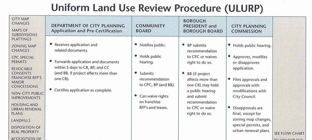
37 137
38 We have spoken with the Director of the Brooklyn Office of the Department of City Planning to gain insight into a hypothetical change in zoning of the subject site. Through this conversation we obtained an overview of the process that a private developer must undertake prior to certification of a Uniform Land Use Review Procedure ( ULURP ) application, which commences the formal land use review process. We also obtained information regarding the ULURP process itself. We were informed that a developer initially submits basic information concerning the proposed project facilitated by the rezoning, as well as its land use setting to City Planning. This is followed up with submission of more detailed information including a pre-application statement and relevant maps, plans, and drawing. During the pre-ulurp phase, City Planning does not decide the merits of the proposed project and associated changes in zoning, but rather considers how the project relates to surrounding land use (i.e., conformity of bulk and height), the rationale of the project in term of its compatibility and how it fits into the neighborhood, and whether the requested zoning makes sense in terms of land use and zoning policy. City Planning can provide insight to the developer into the needs and issues of the neighborhood and encourages the developer to reach out to the Community Board(s) affected by the project. The pre-ulurp process is fluid, the developer may modify its original project plans several times either of its own accord or in response to City Planning or community comments and concerns. This pre ULURP process can take as little as a few months or several years; depending on the issues raised by this initial outreach and the developer s response to them. There may be instances in which the developer either decides not to proceed with the project or to modify it substantially to address the anticipated concerns. If the project is to move forward in the process, Department of City Planning must certify, that the ULURP application is complete, which includes the application and all related documents, plans and environmental review. The complexity of environmental review and, in particular, the need in some 138
39 cases to prepare an Environmental Impact Statement can significantly alter the timetable for ULURP certification. Certification commences the review of the application on its merits; a decision by City Planning that the application is complete and ready for review does not constitute a determination that the project should be approved. The City Charter mandated ULURP procedure is a 7 month public review and approval process (please refer to previously presented flow chart). By the l50th day of the process following advisory review by the Community Board and Borough President, the City Planning Commission either approves, modifies or disapproves the application. Disapprovals of zoning changes are final. If the application is approved, or approved with modifications it is filed with the City Council which may either vote to approve, approve with modification or disapprove. The Council acts within 50 days, but this time frame is extended to 65 days if the Council proposed modifications prior to final action. The mayor may veto the Council action, and the Council may override the Mayor's veto by a 2/3 vote; however, vetoes and overrides are rare. Once approval is in place, the developer may submit the plans to the City Buildings Department for approval. The length of the Buildings Department process is a function of the complexity of the plans, and an iterative process of objections and modifications to drawings to comply both with code and zoning issues is commonplace; however, unlike the ULURP process, which allows the decision makers considerable discretion with regard to whether approve a zoning application, the Buildings Department process is ministerial in nature. The Director of the Brooklyn Office of the Department of City Planning provided insight into situations where the approval process can become prolonged and contentious. The development project opposite the Empire Stores/Tobacco Warehouse property at 60 Water Street at Dock Street is one such example. In 2004 the initial proposed residential project was withdrawn. At issue were the community's concerns about the views of the Brooklyn Bridge and the open space. Five years later (2009), the City Council finally 139
40 approved a l7-story residential tower with a 300-seat school. The scaled down improvement included a narrow tower that would not obscure the view of the bridge. Construction finally began in the summer 20, following litigation challenging the legality of the approvals. Another prolonged proposed development is the Domino Sugar site in Williamsburg, Brooklyn. It went through a lengthy and contentious public review process that resulted in a modified project being approved by the City Planning Commission and City Council in The modifications included reduction in building heights and other changes to the site plan. However, the site now has a new developer who may resubmit project plans with major modifications. The original version of the project was also the subject of litigation. As evident, the process to change zoning may be prolonged and increases the risk for a proposed project with a prerequisite of a zoning change. 140
41 HIGHEST AND BEST USE Highest and Best Use 25 The reasonably probable and legal use of vacant land or an improved property, that is physically possible, appropriately supported, financially feasible, and that results in the highest value. The four criteria the highest and best use must meet are legal permissibility, physical possibility, financial feasibility, and maximum productivity. Alternatively, the probable use of land or improved property, specific with respect to the user and timing of the use, that is adequately supported and results in the highest present value. To determine the highest and best use of the site, we have considered the physically possible, legally permitted, economically feasible and maximally productive uses of the subject property both as vacant and as improved. LARGER PARCEL Highest and Best Use of Larger Parcel, As Vacant 26 Among all reasonable, alternative uses, the use that yields the highest present land value, after payments are made for labor, capital and coordination. The use of a property based on the assumption that the parcel of land is vacant or can be made vacant by demolishing any improvements. The subject property Larger Parcel is an 115,533±-square-foot parcel of land improved with the historic Empire Stores buildings and the historic Tobacco Warehouse structure. The entire site is part of the Brooklyn Bridge Park, which is owned by the State of New York. The Empire Stores site consists of seven (7) contiguous four and five story shell buildings and the Tobacco Warehouse site consists of a former warehouse with the only remains being the exterior walls and one interior wall. Both the Empire Stores and the Tobacco Warehouse contain a New York City landmark classification and cannot be demolished. 25 The Dictionary of Real Estate Appraisal Fifth Edition, Appraisal Institute, Chicago, IL, 2010, p Ibid., p
42 Although the subject buildings are under the protection of the New York City Landmark Commission, USFLA appraisal standards require the highest and best use of the Larger Parcel as vacant to be performed to determine the optimal or ideal highest and best use as if the buildings/structure could legally be demolished. As vacant, the determination of the potential development of a site as one zoning lot or multiple zoning lots does not have an impact on the analysis since the same FAR is permitted under both scenarios. Legally Permitted The subject property is mapped in an M3-1 zoning district within a Waterfront Area. The legally permitted broad category uses include non-noxious industrial uses; offices; convenience stores, retail and service establishments (certain users limited to 10,000± square feet per establishment); amusement (i.e. billiard parlor, pool halls, bowling alley, etc.); transient hotel; eating and drinking establishments, with and without entertainment/musical entertainment (dancing limited to location in a hotel); catering establishments and banquet halls; outdoor recreation (i.e. skating rink, driving range, etc.); art galleries; antique stores; and museums. The subject s M3-1 zoning with an FAR of 2.0 and the Waterfront Area encourages a lower sky plane and retains a visual corridor to the Brooklyn Bridge Park, the bridges (Brooklyn and Manhattan) and the East River waterfront. Surrounding uses to the subject on Water, New Dock and Main Streets include renovated 1- to 15-story loft buildings that have been converted to commercial office space, commercial retail or luxury residential on a rental or condominium form of ownership. A new construction site on Water Street opposite the subject is underway for a school, residential apartments and retail (60 Water Street). The permitted broad categories of industrial; offices; convenience stores, retail and service establishments; eating and drinking establishments; catering establishments and banquet halls; outdoor recreation and amusement; art galleries; antique stores; and museums are likely uses for the subject site. 142
43 Over the past several years, sections of DUMBO have been rezoned south of John Street along the east side of the Manhattan Bridge and south of Water Street along the west side of the Manhattan Bridge (last rezoning effective June 10, 2009). These areas were up-zoned to permit residential uses within manufacturing-zoned areas. Many of the former industrial loft/manufacturing buildings have been converted to include either residential, commercial or office development. This up zoning addressed the lack of demand for the existing stock of manufacturing and loft buildings in the area and the reuse of the buildings to meet the growing demand for residential, commercial and office uses in this market. The subject property is located in the DUMBO section of Brooklyn, which is comprised of the M3-1 zoning district along the waterfront of the East River and M1-2 / R8A and C6-2A surrounding the subject property. Within the vicinity of the subject property, the Manufacturing districts have predominately been up zoned to include the uses and regulations of the R8A zoning or the commercial uses of the C6-2A. All of these zoning changes have occurred south of Water, Plymouth and John Streets. The contextual quality housing regulations are mandatory under the R8A zoning and permitted uses are multi-family housing. Permitted uses for the C6-2A district include the office, retail and amusement uses already included in the M3-1 zoning, but also include large retail establishments (i.e. department store), large eating and drinking establishments with entertainment and a capacity of more than 200 persons and residential uses. Based on the principle of conformity within a neighborhood, it is likely that a private developer of the subject property may consider rezoning the subject site to accommodate a residential and/or commercial office/retail development. In the zoning section of this report, we have summarized the permitted uses and regulations for the C6-2A and R8A zoning districts. We have also presented a flow chart of the process and time frame to achieve a rezoning for a project. It is noted that a project 143
44 based on a change in zoning has a high risk level as opposed to a project based on the as-of-right uses within its zoning district that inherently has nominal risk. Since Superstorm Sandy, the subject has been mapped in the FEMA Post Hurricane Sandy Advisory Base Flood Elevation Map and is within the Special Flood Hazard Area (SFHA). This area is where the National Flood Insurance Program s (NFIPs) Floodplain Management Regulations must be enforced and the area where the mandatory purchase of flood insurance applies. All development, including buildings and other structures, is subject to construction regulations if it occurs within a SFHA. Any new structure or structure that is substantially improved or substantially damaged by any cause is subject to floodplain development regulations. The subject site s proximity to the East River has a negative influence on the site in terms of building design challenges and these burdensome restrictions increase the cost of construction and create additional risk to a project. Physically Possible The physically possible uses are determined by the size, topography and configuration of the subject site. The subject property is a basically level, corner parcel containing ± feet of frontage on the north side of Water Street, ± feet along the east side of New Dock Street, 9.92± feet along the west side of Main Street, and ± feet along the south side of Brooklyn Bridge Park, with an aggregate land area of 115,533± square feet. The subject s extensive street frontage provides access to and exposure for the site from numerous points. The subject s land area size, 115,533± square feet, is sufficient to provide a positive attribute for a development site in terms of design potential. Although the shape of the parcel is irregular, particularly at the southwest boundary of the site, its configuration does not present any major development challenges in terms of placement of potential improvement on the site. However, the subject property is encumbered by a Reservation of Rights Declaration for a Pedestrian Pathway to remain part of the public park area. This Pedestrian Pathway is situated within the subject site and is 46± feet wide, running perpendicular to Water Street a 144
45 distance of ± feet in a northerly direction. The west boundary line of the public pathway is 105± feet west of northeast corner formed by New Dock Street and Water Street and divides the subject parcel from Water Street to the Brooklyn Bridge Park. The Pedestrian Pathway hinders the utility of the site in terms of layout and design. The subject is adjacent at its north boundary to the Brooklyn Bridge Park and the East River at the north boundary of the park. To the west of the subject is the Brooklyn Bridge. The subject s extensive frontage along the Brooklyn Bridge Park and its proximity to the Brooklyn Bridge affords the subject site exposure from the park and bridge users. By abutting the Brooklyn Bridge Park, the subject also has unobstructed views of the river and the lower Manhattan skyline. As previously stated in the Property Description section of this report, the subject s proximity to the East River has a negative influence on the site as was evident during Superstorm Sandy in October 20. During this Superstorm, the East River at this location overflowed and engulfed the subject site with four to five feet of water. The stigma of a site in a floodplain increases the risk of a project as it reduces the potential use of a site and the pool of potential users. The subject site s physical characteristics do present some design and development challenges stemming from its proximity to the East River and potential for flooding and the division of the site with the Pedestrian Pathway to the Brooklyn Bridge Park. However, overall the subject parcel has sufficient utility to support the permitted uses under its M3-1 zoning. Furthermore, if the subject site were rezoned to C6-2A commercial zoning district or R8A residential zoning district, the subject site can support the discussed likely permitted uses within these zoning districts. Financially Feasible The feasible uses that are legally permissible and physically possible under the current M3-1 and Waterfront area zoning regulations include industrial, office and commercial retail uses; including eating and drinking establishments, amusement and 145
46 recreation. We have also considered the potential to rezone the subject site to R8A and C6-2A. The feasible uses under the R8A zoning are residential multi-family apartment units, on a rental or condominium ownership basis. The feasible uses for the C6-2A district include the office and retail uses already included in the subject M3-1 and Waterfront area regulations, but also include large retail establishments (i.e. department store) and large eating and drinking establishments with entertainment and a capacity of more than 200 persons. The subject property is located within the DUMBO section of Brooklyn, where there is a strong demand for commercial and residential uses. The analysis of financial feasibility will focus on which potential uses are likely to produce an income (or return) equal to or greater than the amount needed to satisfy operating expenses, financial obligations, and capital amortization of the investment. A crucial element of this analysis is the timing for a specific use including when the improvements would be built and the future expectations of occupancy and rent levels. To this goal, we estimated the future gross income that can be expected from each use. Vacancy and collection losses and operating expenses are then subtracted from each gross income to obtain the likely net operating income from each use. A rate of return on the invested capital was then calculated for each use. If the net revenue capable of being generated for a use is sufficient to satisfy the required market rate of return on the investment, the use is financially feasible. In the Income Capitalization Approach section of this approach, we have presented support for our various conclusions of the key components for this analysis (please refer to comparable rentals, vacancy and collection loss, operating expenses, capitalization rates and rates of return within the section). A financial feasibility test was conducted for the uses permitted under the current M3-1/Waterfront zoning as well as any proposed rezoning into the R8A or C62A zoning districts. 146
47 The permitted uses tested include industrial, retail, office, and residential apartment. Uses such as restaurant, catering, pool halls, billiards, etc. are included in the retail category. The maximum buildable area for each type of use was estimated based on the type of construction required for each and parking requirements. Industrial uses require loading doors at grade with the majority of the building area located on the ground floor. The second floors of typical industrial buildings include ancillary office space; however, they typically do not contain industrial space. Therefore, a feasibility analysis was conducted for an industrial building, which would be constructed subject to the current parking requirements and all other zoning requirements under the M31/Waterfront area districts. The following is the projected maximum buildable area and grade level required for parking for the subject property, which meets the current zoning requirements for an industrial building under the M3-1/Waterfront area. Estimate of Potential Maximum Building Area Based on Zoning Parking Requirements Industrial Use Use Total Land Max GBA Permitted Max Achievable FAR Industrial 115,533 88, Square Feet of GBA per Space # of Parking Spaces Required Average Size of Parking Space (Sq. Ft.) Land Area Required for Parking Total Land Area Bldg & Parking 1, , ,525 Note: The maximum building area permitted takes into consideration the parking required for the specific use. A larger building would require additional parking, which cannot be accommodated by the subject site. Therefore, this is the maximum building area permitted on the site for this specific use. The total subject land area of 115,533± square feet can accommodate an industrial building containing 88,825± square feet of building area, which will require 89 parking spaces. A structured parking could satisfy the parking requirement without reducing the maximum allowable FAR for a new industrial development. However, industrial users place 147
48 a higher value on ground floor space for loading docks and storage as opposed to second floor space. Second floor industrial space is not economically feasible because the current achievable industrial rents are below the breakeven point required due to the additional construction costs for upper level load bearing floors and for a means of transporting materials to a second floor. The following analysis indicates what the financially feasible rent would be for an industrial building constructed at the subject site that is constructed based on the preceding zoning requirements. Test of Financial Feasibility Industrial Use Construction Cost Land Cost Operating Expense Real Estate Taxes* Insurance Structural Repairs & Reserves Management & Professional Fees Current Overall Rate Normal Vacancy $96.77 $ /sq. ft. /sq. ft. $1.16 $1.00 $0.25 3% 7% 5% /sq. ft. /sq. ft. /sq. ft. of EGI Calculations of Required Rent Calculation of Total Cost Construction Cost Land Cost Total Cost Calculation of Feasibility Rent Required NOI Add Operating Expenses: Real Estate Taxes Insurance Structural Repairs & Reserves Subtotal Expenses Management & Professional Fees (NOI + Exp/(1 - Mgmt%) - NOI + Exp) Total All Expenses Effective Gross Income Vacancy and Collection Loss Potential Gross Income Calculation of Required Rent for New Construction Building Size/FAR Land Area Required for Parking Land Size % Bldg. Rented Concluded Market Rent Size (Sq. Ft.) 88,825 26, ,533 $15.00 $ / Sq. Ft. Sq. Ft. Sq. Ft. Sq. Ft. Sq. ft. $ Amount 88, ,533 x x $ $ = = $ 8,595,595 $13,286,295 $21,881,890 $21,881,890 x 7.0% = $ 1,531, ,533 88,825 88,825 x x x $1.16 $1.00 $0.25 = = = $ 134,018 $ 88,825 $ 22,206 $ 245,049 $ 54,952 $ 300,001 $ 1,831,733 $ 96,407 $ 1,928,140 PGI $1,928,140 Rentable Area 88,825 = $21.71 *Current real estate taxes based on land area. 148
49 Based on the trend over the past few decades to convert existing industrial and industrial loft properties, an industrial development on the subject site is precluded given the achievable rent and the cost of construction. The above analysis indicates the market-derived industrial rent of $15.00 per square foot is below the required rent for new construction of $21.71 per square foot; therefore, industrial use is not an economically feasible use of the subject property. Retail uses in the subject area are all at grade level and do not contain upper floor retail space. Therefore, any new construction retail use would be required at grade level, with consideration to the parking requirements under the M3-1/Waterfront area districts. A feasibility analysis was conducted for a retail building, which would be constructed subject to the current parking requirements and all other zoning requirements under the M31/Waterfront area districts. The following is the projected maximum buildable area and grade level required for parking for the subject property, which meets the current zoning requirements for a retail building under the M3-1/Waterfront area. Estimate of Potential Maximum Building Area Based on Zoning Parking Requirements Retail Use Use Total Land Max GBA Permitted Maximum Achievable FAR Square Feet of GBA per Space # of Parking Spaces Required Average Size of Parking Space (Sq. Ft.) Land Area Required for Parking Total Land Area Bldg & Parking Retail 115,533 57, , ,325 Note: The maximum building area permitted takes into consideration the parking required for the specific use. A larger building would require additional parking, which cannot be accommodated by the subject site. Therefore, this is the maximum building area permitted on the site for this specific use. The total subject land area of 115,533± square feet can accommodate a retail building containing 57,725± square feet of building area, which will require 192 parking spaces. A 149
50 structured parking could satisfy the parking requirement without reducing the maximum allowable FAR for a new retail development. However, retail users and patrons place a higher value on ground floor space for street access and visibility as opposed to second floor space. The following analysis indicates what the financially feasible rent would be for a retail building constructed at the subject site that is constructed based on the preceding zoning requirements. Test of Financial Feasibility Retail Use Construction Cost Land Cost Operating Expense Real Estate Taxes* Insurance Structural Repairs & Reserves Management & Professional Fees Current Overall Rate Normal Vacancy $ $ /sq. ft. /sq. ft. $1.16 $1.00 $0.25 3% 5.8% 5% /sq. ft. /sq. ft. /sq. ft. of EGI Calculations of Required Rent Calculation of Total Cost Construction Cost Land Cost Total Cost Calculation of Feasibility Rent Required NOI Add Operating Expenses: Real Estate Taxes Insurance Structural Repairs & Reserves Subtotal Expenses Management & Professional Fees (NOI + Exp/(1 - Mgmt%) - NOI + Exp) Total All Expenses Effective Gross Income Vacancy and Collection Loss Potential Gross Income Calculation of Required Rent for New Construction Building Size/FAR Land Area Required for Parking Land Size % Bldg. Rented Concluded Market Rent Size (Sq. Ft.) 57,725 57, ,533 $40.00 $ / Sq. Ft. Sq. Ft. Sq. Ft. Sq. Ft. Sq. ft. $ Amount 57, ,533 x x $ $ = = $ 8,536,950 $13,286,295 $21,823,245 $21,823,245 x 5.8% = $ 1,265, ,533 57,725 57,725 x x x $1.16 $1.00 $0.25 = = = $ $ $ $ $ 134,018 57,725 14, ,174 45,523 $ 251,697 $ 1,517,445 $ 79,866 $ 1,597,311 PGI $1,597,311 Rentable Area 57,725 = $27.67 *Current real estate taxes based on land area. 150
51 The above analysis indicates the market-derived retail rent of $40.00 per square foot is above the required rent for new construction of $27.67 per square foot; therefore, retail use is an economically feasible use of the subject property. Many of the former loft buildings in the subject area have been converted to office use. Although many of the existing buildings do not contain parking, any new construction office building would require on-site parking, based on the M3-1/Waterfront area districts. Many of the office buildings in the area with on-site parking contain lower-level parking garages with street grade retail uses. However, these buildings are not of new construction and predate the existing zoning code and were constructed prior to the current flood zone. Any new construction office building at the subject location would not be able to be developed with lower-level parking, due to its location proximate to the East River, and its location within a major designated flood area. Since parking will be required at grade level, any new construction can be developed above the grade level parking structure. As previously discussed, retail uses in the subject area are located at grade level and an upper floor retail use would not be viable in the subject market. Therefore, if the subject property were developed with an office building, any new construction office development could not contain grade level retail space. A feasibility analysis was conducted for an office building, which would be constructed subject to the current parking requirements and all other zoning requirements under the M3-1/Waterfront area districts. The following is the projected maximum buildable area and grade level required for parking for the subject property, which meets the current zoning requirements for an office building under the M3-1/Waterfront area. 151
52 Estimate of Potential Maximum Building Area Based on Zoning Parking Requirements Office Use Use Total Land Max GBA Permitted Max Achievable FAR Square Feet of GBA per Space # of Parking Spaces Required Average Size of Parking Space Land Area Required for Parking Space* Land Area Available for Parking Maneuverability and Ramps Stories Required for Parking Office 115, , , , , * Under the current zoning regulations, structured parking would not be counted toward the maximum allowable FAR under zoning as long as the structured parking does not exceed a height of 23 feet. Since the parking would be located at grade level for this potential development, it would not be counted towards FAR. The total subject land area of 115,533± square feet can accommodate an office building containing 231,066± square feet of building area, which will require 231 parking spaces. The following analysis indicates what the financially feasible rent would be for an office building constructed at the subject site that is constructed based on the preceding zoning requirements. 152
53 Test of Financial Feasibility Office Use Construction Cost Parking Cost Land Cost Operating Expense Real Estate Taxes* Insurance Structural Repairs & Reserves Management & Professional Fees Current Overall Rate Normal Vacancy $ $ $ /sq. ft. /sq. ft. /sq. ft. $1.16 $1.00 $0.25 3% 7.35% 5% /sq. ft. /sq. ft. /sq. ft. of EGI Calculations of Required Rent Calculation of Total Cost Construction Cost Parking Cost Land Cost Total Cost Calculation of Feasibility Rent Required NOI Add Operating Expenses: Real Estate Taxes Insurance Structural Repairs & Reserves Subtotal Expenses Management & Professional Fees (NOI + Exp/(1 - Mgmt%) - NOI + Exp) Total All Expenses Effective Gross Income Vacancy and Collection Loss Potential Gross Income Calculation of Required Rent for New Construction Building Size/FAR Structured Parking Area Land Size % Bldg. Rented Concluded Market Rent Size (Sq. Ft.) 231, , ,533 $26.00 $ / Sq. Ft. Sq. Ft. Sq. Ft/ Sq. Ft. Sq. ft. $ Amount 231, , ,533 x x x $ $ $ = $87,405,336 x 7.35% = $ 6,424, , , ,066 x x x $1.16 $1.00 $0.25 = = = $ $ $ $ $ = $63,263,560 $10,855,481 $13,286,295 $87,405, , ,066 57, , ,767 $ 634,618 $ 7,058,910 $ 371,522 $ 7,430,432 PGI $7,430,432 Rentable Area 231,066 = $32.16 *Current real estate taxes based on land area. The above analysis indicates the market-derived office rent of $26.00 per square foot is below the required rent for new construction of $32.16 per square foot; therefore, office use is not an economically feasible use of the subject property. Many of the former loft buildings in the subject area have been converted to residential use and there have been several new construction projects in the areas that are zoned for residential development, including the R8A and C6-2A zoning districts. The analysis of the subject property, under the hypothetical assumption that the subject 153
54 property is vacant and available for redevelopment, is based on the assumption that a developer would seek rezoning to either the R8A or C6-2A zoning district. Although many of the existing buildings do not contain parking, any new construction apartment building would require on-site parking, based on the zoning regulations. Many of the residential buildings in the area with on-site parking contain lower-level parking garages with street grade retail uses. However, these buildings are not of new construction and predate the existing zoning code and were constructed prior to the current flood zone. Any new construction residential building at the subject location would not be able to be developed with lower-level parking, due to its location proximate to the East River, and its location within a major designated flood area. Since parking will be required at grade level, any new construction can be developed above the grade level parking structure. As previously discussed, retail uses in the subject area are located at grade level and an upper floor retail use would not be viable in the subject market. Therefore, if the subject property were developed with a residential apartment building, any new construction residential apartment development could not contain grade level retail space. A feasibility analysis was conducted for a residential apartment building, which would be constructed subject to the current parking requirements and all other zoning requirements as if rezoned under the R8A of C6-2A zoning districts. The following is the projected maximum buildable area and grade level required for parking for the subject property, which meets the current zoning requirements for residential apartment building under a proposed rezoning. 154
55 Estimate of Potential Maximum Building Area Based on Zoning Parking Requirements Residential Apartment Use Use Total Land Max GBA Permitted Max Achievable FAR Residential Apartment 115, , Average Unit Size Average # of Units 1, Parking Required (% of Units) # of Parking Spaces Required Average Size of Parking Space Land Area Required for Parking Space* 40% (1 space/2.5 units) ,400 Land Area Available for Parking Maneuverability and Ramps 115,533 Stories Required for Parking 1.00 * Under the current zoning regulations, structured parking would not be counted toward the maximum allowable FAR under zoning as long as the structured parking does not exceed a height of 23 feet. Since the parking would be located at grade level for this potential development, it would not be counted towards FAR. The total subject land area of 115,533± square feet can accommodate a residential apartment building containing 695,509± square feet of building area, which will require 278 parking spaces. The following analysis indicates what the financially feasible rent would be for a residential apartment building constructed at the subject site that is constructed based on the preceding zoning requirements. 155
56 Test of Financial Feasibility Residential Apartment Use Construction Cost Parking Cost Land Cost Operating Expense Real Estate Taxes* All Other Operating Expenses Current Overall Rate Normal Vacancy $ $ $ /sq. ft. /sq. ft. /sq. ft. $ % 5.25% 5% /sq. ft. of EGI Calculations of Required Rent Calculation of Total Cost Construction Cost Parking Cost Land Cost Total Cost Calculation of Feasibility Rent Required NOI Add Operating Expenses: Real Estate Taxes All Operating 25% Total All Expenses Effective Gross Income Vacancy and Collection Loss Potential Gross Income Calculation of Required Rent for New Construction Building Size/FAR Structured Parking Area Land Size % Bldg. Rented Concluded Market Rent Size (Sq. Ft.) 695, , ,533 85% $48.00 Sq. Ft. Sq. Ft/ Sq. Ft. Sq. ft. $ / Sq. Ft. $ Amount 695, , ,533 x x x $ $ $ = $194,693,834 $ 10,855,481 $ 21,951,270 $227,500,585 $227,500,585 x 5.25% = $ 11,943, ,533 x $1.16 = $ $ $ $ $ $ PGI $16,951,297 Rentable Area 591,183 = = 134,018 4,025,933 4,159,951 16,103, ,565 16,951,297 $28.67 *Current real estate taxes based on land area. The above analysis indicates the market-derived residential apartment rent of $48.00 per square foot is above the required rent for new construction of $28.67 per square foot; therefore, residential apartment use is an economically feasible use of the subject property. 156
57 Financial Feasibility Condominium Ownership Apartment Use With respect to the financial feasibility of an apartment building on a condominium form of ownership, we have research the historical sellout rate of new construction or renovated residential condominium offerings in DUMBO over the past several years and the results are as follows: Historical Residential Condominium Sales 100 Jay Street 266 Total Units C of O 4/29/10 Year # of Units Sold # of Months 9 4 Units/Month Water Street 52 Total Units C of O 10/17/07 Year # of Units Sold # of Months Units/Month Water Street 65 Total Units C of O 4/27/ Year # of Units Sold 51 # of Months 8 4 Units/Month Front Street 31 Total Units C of O 5/10/07 Year # of Units Sold # of Months 6 Units/Month
58 Historical Residential Condominium Sales (continued) 30 Main Street 87 Total Units C of O 5/30/03 Year # of Units Sold # of Months 11 4 Units/Month Bridge Street 45 Total Units C of O 2/27/ Year # of Units Sold 18 0 # of Months 9 4 Units/Month Bridge Street 56 Total Units C of O 3/29/04 Year # of Units Sold # of Months 4 Units/Month Year # of Units Sold # of Months 2 Units/Month Main Street 21Total Units C of O 1/16/04 158
59 Historical Residential Condominium Sales (continued) 57 Front Street 31 Total Units C of O 2/8/07 70 Washington Street 259Total Units C of O 8/2/06 79 Bridge Street 37Total Units C of O /1/03 84 Front Street 56 Total Units C of O 11/14/06 Year # of Units Sold # of Months 5 4 Units/Month Year # of Units Sold # of Months 5 4 Units/Month Year # of Units Sold # of Months 5 Units/Month Year # of Units Sold # of Months 6 4 Units/Month
60 The data for these condominium developments indicates that sales activity was active prior to 2009, with diminished sellout after thereafter. In the more recent past, 20 through 2013 to date, two small scale condominium apartment projects have been completed and the individual units were available for sale. 205 Water Street is a luxury condominium building developed by Toll Brothers City Living and contains 65 units, with a total of 51 units sold (according to public records) during the 8 months of 20 (6.38 units per month). However, there have not been any recorded sales during the first quarter of It is noted that the website for this building currently has an announcement that all units are sold. Assuming the balance of the unsold units are in contract, then the project has a sellout average of 5.42 units per month. Another project, 37 Bridge Street, is a former turn of the century loft building that has been renovated to luxury condominiums. It contains a total of 45 units and according to public records 18 units sold during 9 months 20, or 2 units per month. During the first quarter 2013, there have been no unit sales within this project according to public records, but the website for this project reports 80% of the units have sold. The 80% is equal to 36 units, resulting in an average of 3 units per month (with unit sales commencing in March 20). Both of these projects are situated east of the Manhattan Bridge. In our analysis, we have estimated the subject site could accommodate 696± apartment units. Using the sellout rate of 5.42± units per month for the 205 Water Street luxury new condominium construction, the proposed 696± units for the subject would take 10 years to sellout on a worst case scenario based on the premise that some years will have more robust sales activity than others. We have considered the fact that residential development requires a change in zoning and the high level of risk associated with this process. Furthermore at this time, a large scale residential development with a condominium form of ownership puts additional risk on the project that eliminates the feasibility. Although the DUMBO market exhibits some of the highest residential condominium sales price per square foot 160
61 in Brooklyn, the sales activity of the residential condominiums is sluggish. Similar to the rental market, the subject s location and views are desirable to potential purchasers and reduce risk to a certain degree. The property specific risk factor due to the proximity to the river and potential for flooding has an additional risk. Added to this risk is that there may be limits to the pool of potential DUMBO condominium buyers willing to consider purchasing a property this close to the water. Based on this reasoning, we have not considered a residential development on a condominium form of ownership as financially feasible. The subject DUMBO market is not an employment center nor does it contain an exhibit/cultural center such as Barclay s Center to attract regional visitors to the area. Due to the lack of neighborhood influences, the demand for a hotel is not likely. It is noted that the 60 Water Street site originally proposed a hotel on the site which was withdrawn from consideration. We have not considered a hotel to be among the financially feasible uses of the subject property. Communities that have outdoor amusement and recreation typically have an area where there is a confluence of similar uses (i.e. tennis courts, skating rinks, driving ranges, miniature golf, etc.) to create a destination for the public and an economically viable project for a developer. Although the subject is adjacent to a park and waterfront, an outdoor amusement/recreation use is not likely because the subject site is not sufficient in size to support a multi-faceted center. Small scale recreation and amusement uses generally produce a lower income than a recreation/amusement complex. We have not considered an amusement or outdoor recreation use as financially feasible uses for the subject site. Based on all of the above, we have determined that retail and residential rental apartment uses are financially feasible for the subject property. 161
62 Maximum Productivity Of the financially feasible uses, the highest and best use is the use that produces the highest residual land value consistent with the market s accepted risk and with the rate of return warranted by the market for that use given the associated risk. In the income capitalization approach section of this report a residual discounted cash flow models were completed for each of the indicated financially feasible uses. Under this analysis a key element is the risk level of each of the uses. The use with the least risk is retail because it is an as-of-right permitted use under the existing zoning and is projected at one-story in height and such a development is not anticipated to have any undue delay. Furthermore, retail use is in high demand in the subject s submarket as evidence by its current 7.2% vacancy rate, which is skewed by large (greater than 3,000± square feet) blocks of available space. Local brokers report that the vacancy rate for small retail units (less than 3,000± square feet) is much lower than the 7.2% because these smaller units are in high demand and there is a limited supply available. The subject s location in a residential/commercial neighborhood abutting the Brooklyn Bridge Park proximate to the Brooklyn Bridge and the East River attracts a greater pool of potential users drawn by the exposure afforded by the park and the bridge and views of the New York City skyline. The one risk factor is the subject s proximity to the East River and the uncertainty of future flooding as well as the additional operating costs (i.e. insurance including mandatory flood insurance) and potential increased construction costs due to possible stricter construction guidelines. Next in rank in terms of risk is the residential use, which would require a change in zoning. As previously discussed this process can be long and contentious as evidenced by the protracted delays and revisions experienced by the 60 Water Street project (opposite the subject) that took well over 5-years to finally achieve approvals for a 17story, 289-unit apartment building with a 300-seat school. Mitigating the risk to some degree is the strong rental apartment market in the area. DUMBO exhibits some of the 162
63 highest rents in Brooklyn for all unit types. Furthermore, DUMBO is one of the Brooklyn neighborhoods that have noteworthy rent appreciations. The subject s location abutting the Brooklyn Bridge Park, with views of the Brooklyn Bridge, the East River and the Manhattan skyline are locational attributes deemed desirable by market participants. Again, a risk factor that is not particularly tied to the use but to the property itself is the proximity to the East River and the potential of flooding and the costs (operating and construction) as previously discussed. In the income capitalization section of this report we have presented supporting documentation and the land residual models for the financially feasible uses. The following are the indicated land values based on the productivity of the feasible uses. Financially Feasible Use Multi-Tenant Retail (As-of-Right) Residential Rental Apartments (As if Rezoned) Indicated Residual Land Value $9,400, $6,800, For the highest and best use of the subject larger parcel as if vacant, we have determined that the maximally productive use is a one-story retail building containing a gross building area of 57,725±-square-foot building with on-site surface parking. This use satisfies the local growing demand retail rental uses in the area. The analysis however, was performed to comply with USFLA and is for informational purposes only. Highest and Best Use of the Larger Parcel, as Improved 27 The use that should be made of a property as it exists. An existing improvement should be renovated or retained as is so long as it continues to contribute to the total market value of the property, or until the return from a new improvement would more than offset the cost of demolishing the existing building and constructing a new one. 27 The Dictionary of Real Estate Appraisal Fifth Edition, Appraisal Institute, Chicago, IL, 2010, p
64 Under consideration in this analysis are whether the existing improvements should be demolished and the site redeveloped, should the existing use continue, or should the existing use be modified. The subject property consists of an 115,533±-square-foot land parcel, including the Pedestrian Pathway area that extends from Water Street to the Brooklyn Bridge Park. The Larger Parcel is improved with the historic Empire Stores shell buildings and the historic Tobacco Warehouse structure. The Empire Stores site consists of seven (7) contiguous four and five story shell buildings and the Tobacco Warehouse consists of a former warehouse with the only remains being the exterior walls and one interior wall. Both the Empire Stores and the Tobacco Warehouse contain a New York City landmark classification and cannot be demolished. As the Empire Stores are shell buildings they do not have a current use. The Tobacco Warehouse is a structure that has no permanent use but is permitted for specific temporary uses on a case-by-case basis and when it is not permitted for events, it is open to the public as open space. An aerial view from Google Earth from sometime last summer shows a tent within the Tobacco Warehouse structure; however, this appears to have been a temporary use. The Empire Stores is comprised of seven (7) separate buildings that are not interconnected. Building 1 is the most easterly of the buildings and its design includes street entry points (boarded up) from Main Street. This building has wall openings for windows and doors at its north and east elevations. Buildings #3, #4, #5 and #6 each have street entry points (boarded up) to Water Street. These buildings have wall openings for windows and doors at the north and south elevations. Building #7 is the most westerly of the buildings and has entry points (boarded up) from Water Street and from the pedestrian pathway to the park between the Empire stores and Tobacco Warehouse28. This building has wall openings for windows and doors at the north, south and west elevations. 28 This pathway is included in the subject property. 164
65 The design of each of the seven buildings includes entry points (boarded up) at the north elevations to a paved pedestrian path expanding east to west, between the Empire Stores and Brooklyn Bridge Park. The seven buildings do not have an easement with the Brooklyn Bridge Park that allows for access from their north elevations. A private developer would have to negotiate with the Brooklyn Bridge Park to gain this access. Each of the buildings has a long expanse (north to south) and if access were granted from the park, each building could be subdivided into smaller ground floor spaces either (a) with an interior corridor running north to south having two commercial units at the north end and two units at the south or (b) simply two units accessible from the north access and two from the south access. The two end buildings (#1 and #7) have additional access from Main Street or New Dock Street, respectively and can be further subdivided. The exception is Building #2 which does not have any street frontage or access except for access from its northern elevation along the Brooklyn Bridge Park pedestrian pathway. The simplest solution for this unit would be to gain access from the north. Gaining access to the north presents some degree of risk in consideration of the potential reuse of the subject ground floor. Barring access from the north, Building #2 would have to be interconnected to either Building #1 or #3. The structural integrity of the concrete block and brick walls between the subject buildings is unknown; therefore, the additional cost to remove interior walls or create openings (if possible) is unknown. This appears to be a greater a risk factor for a developer in terms of the potential use and occupancy of Building #2. Furthermore, if north access were not granted, each of the other buildings would be comprised of deep units or could be subdivided off a main corridor, but only have limited exposure from Water Street, Main Street and New Dock Street. The structural integrity of the walls is also a crucial consideration to a developer in terms of decisions for the reuse of this entire property. The ground floor areas of the 165
66 buildings range between 7,150± square feet and 14,270± square feet. The upper floors of the subject buildings contain similar configuration as the ground floor of the subject buildings. However, Buildings #1 to #3 are five stories in height and Buildings #4 to #7 are four stories in height. It is unknown if the buildings can be interconnected, not only on the ground floor but the upper floors, and whether to it is possible to create contiguous space or reconfigure the space, and the costs associated with each potential variable. These issues play a key role in the potential reuses, design and layout of the buildings and factor into the level of risk in the redevelopment of the Empire Stores. Coupled with this is the issue of the Landmark status of the Empire Stores, which creates additional burdens to a developer in terms of approvals and costs. The subject property contains frontage along Water Street, New Dock Street, Main Street and the south side of the Brooklyn Bridge Park. In the highest and best use analysis of the Conversion Property, Tobacco Warehouse site and the Empire Stores site, it was determined that a private developer would negotiate with the Brooklyn Bridge Park Corporation the terms of a public access to the Conversion Property from a pedestrian pathway that runs along the north side of the subject property from the Brooklyn Bridge Park. The risks associated with this negotiation have been included in this valuation analysis. Overall the least risk to a private developer is to negotiate with the Brooklyn Bridge Park to gain access to the buildings from the north. The subject larger parcel is also improved with the Tobacco Warehouse structure. The exterior walls and the one interior wall have arched open cavities where windows and doors used to exist. This irregular-shaped structure has access from Water Street, New Dock Street and the pedestrian pathway between Tobacco Warehouse and Empire Stores, as well as access from the pedestrian pathway of the Brooklyn Bridge Park along its north elevation. The structure is in the shadows of the Brooklyn Bridge. This building is restricted by New York City landmark classifications and cannot be demolished. 166
67 As previously stated in the Zoning section of the report, the subject larger parcel cannot be further expanded because the actual FAR of Empire Stores is 2.84, which exceeds the permitted FAR of 2.0 under M3-1 zoning. Density of the site has already exceeded that allowed by the New York City zoning regulations and any further development would increase the non-compliance of the site which is not permitted under the zoning resolution. There is a possibility that the subject Tobacco Warehouse open area could generate income by renting it as an open air market or a permitted use under M3-1 that could be enclosed in a temporary structure such as a tent. It is noted that the Tobacco Warehouse structure does not have distributed utility connections. Although the M3-1 zoning does permit as-of-right uses that could be accommodated within the bounds of the structure, it is our opinion that a private developer would view this scenario as highly speculative and risky for several reasons. A private developer would have to gain some level of confidence that the community would not oppose such a use prior to marketing the property for a particular use. By doing so, the developer would not run the risk of a contentious dispute with the community or a tenant. The subject is located in a mixed residential and commercial neighborhood and abuts an expansive public park and is part of the waterfront area. It is logical that any open air use would concern the local residents and park users in terms of noise, pedestrian and vehicular traffic, and whether any potential use meets the needs of the local residents and protects the waterfront area. Also an open air use is seasonal, which limits the potential achievable income in any given year thereby increasing the risk of such an undertaking. Based on this reasoning, it is our opinion that a private developer would not consider such an interim use. There is a potential to seasonally lease the Tobacco Warehouse space as an integrated use with the Empire Stores, which shall be discussed further under the Empire Stores. Due to the current condition of the Empire Stores and its historic classification located within the Fulton Ferry Historic District, the City has provided a cost estimate to 167
68 repair the buildings, maintain the historic classification and create a vanilla box for the floor plate of each of the subject s seven buildings. The cost estimates provided include one core per building including one elevator and staircase within each building providing access to all floors. These costs have been relied on and utilized as the proposed renovation costs in order to bring the subject property to rentable condition. The concept estimate for Empire Stores was prepared by Gardiner Theobald Inc. on April 1, 2013 and the hard costs are projected at $ per square foot ($86,305,660.00) based on the existing 327,696±-square-foot improvements. The Concept Estimate projects the soft costs at 10% of hard costs. In our analysis of the subject property under the highest and best use, we have not considered the potential for a roof deck to be used for parking or outdoor use. A roof deck could not be constructed without additional expenses, which were not included in the Concept Estimate. This parcel does not have any vehicle access to the small paved area at the rear of the site. It is noted that the Empire Stores site does not have any onsite parking and any as-of-right use within the M3-1 would also not be required to provide parking since it consists of an existing building. Under the New York City Zoning Resolution rules, a developer would be allowed to maintain this degree of noncompliance. 29 The subject improvements cannot be expanded because parking would be required for any new space by the Zoning Resolution. The building is included in the covered building list of buildings of over 50,000 square feet in New York City. A covered building must be renovated under the strict several laws known collectively as the New York City Conservation Code, which is a risk factor to a private developer as there are unknown conditions for renovation they may be imposed. 29 Non-complying, or non-compliance A "non-complying" #building or other structure# is any lawful #building or other structure# which does not comply with any one or more of the applicable district #bulk# regulations either on December 15, 1961 or as a result of a subsequent amendment thereto. A "non-compliance" is a failure by a #non-complying building or other structure# to comply with any one of such applicable #bulk# regulations. 168
69 As previously concluded in the highest and best use of the subject larger parcel as vacant, a tower type residential rental apartment building is the maximally productive use of the site as if vacant. However to convert the existing building to residential units would presents extensive development challenges and risks. First, this use would require rezoning. Second, parking would have to be provided to adhere to the residential use requirements. Third, potential for the placement of windows for the residential units is restricted by the landmark status. Fourth, the uncertainty exists as to whether the interior walls can be removed or openings can be created. Based on this reasoning, we have concluded that a reuse of the Empire Stores building to residential rental apartments is not feasible. The risks are extremely high as there are the issues of rezoning, design challenges, and the uncertainty of costs above and beyond the hard costs estimated by Gardiner Theobald Inc. of $ per square foot just to repair the building and bring it to a rental condition to a commercial type user. Another feasible use for the subject property larger parcel as vacant was for retail development at the grade level with a rental value of $40.00 per square foot overall is the maximum productive use. The local brokers indicated that units smaller than 3,000± square feet are in high demand in the local market. The existing buildings can provide smaller rentable areas since this valuation analysis is based on the assumption that the Empire Stores will have access from Water Street, the Pedestrian Pathway between Tobacco Warehouse and Empire Stores, Main Street, as well as the access from the walkway to the north of the subject property that provides access to the Brooklyn Bridge Park. The risk for this has been factored into our analysis. A retail use would not be appropriate for the upper floors of the building because retail tenants require street level exposure. The other permitted uses under the current zoning that were considered appropriate for the local market were industrial and office uses. Given the hard costs of $ per square foot to get the building into a rental condition, an industrial use with a 169
70 $15.00 per square foot rental for the upper floors is not considered a likely reuse. The $26.00 per square foot rent achievable in the market for office space is the next most likely use. The cost of new construction for an office use was estimated at $ per square foot, which is greater than the renovation costs. It is likely that a private developer who must maintain and renovate the landmarked building would elect to generate revenue for the upper floor with an office type use, which although is not a financially feasible use for the property as if vacant, it is the most economic use under the proposed renovation program. Concluding that retail and restaurant use is a feasible use for the ground floor of the Empire Stores, we have also considered that a tenant would also find a need for a seasonal use space within the Tobacco Warehouse structure. Considering the layout of the two on the larger parcel it is important to factor in the dividing Pedestrian Pathway between the Tobacco Warehouse and Empire Stores. Due to logistics, it would seem reasonable that the Empire Stores retail units that have additional access from the Pedestrian Pathway between the Tobacco Warehouse and Empires Stores, and Water Street (Building #7) may consider utilizing this space. Tenants in this building may be agreeable to a seasonal premium above the $40.00 per square foot rental that would be based on the square feet leased in the Empire Stores buildings. As previously stated, this does present major risk as the private developer/landlord would have to be assured that there would not be any community opposition to such an open air use. Furthermore, the Tobacco Warehouse is an open structure and creates additional risk to a tenant in terms of potential flooding from the East River and the costs that may be incurred. Based on the additional risk associated with scenario, we have determined that a private developer/landlord would not anticipate generating revenue on a regular basis for the Tobacco Warehouse, but would still have to maintain the landmarked walls and pay real estate taxes for the site. Based on the estimated cost of renovations for the exterior walls 170
71 provided by Gardiner Theobald Inc for Empire Stores, we have applied a hard cost estimate of $26.00 per square foot for the subject Tobacco Warehouse walls. Based upon the above, we have performed a discounted cash flow analysis for the subject property larger parcel as improved within the income capitalization approach. Our indicated value of the subject property larger parcel, as improved was negative $1,100, (Please refer to the income capitalization approach). These findings indicate that the highest and best use of the subject property, as improved, should be examined as two separate and distinct parcels under separate zoning lots. As discussed in the Zoning section of this report, it is possible to create two separate zoning lots (Empire Stores and Tobacco Warehouse) for the subject larger parcel. This process is not considered to present an undue risk to a developer. Comparison of Findings of Highest and Best Use As Vacant and As Improved - Larger Parcel As summarized on the financial feasibility chart for office use, a new construction office building would require a breakeven rent of $32.16 per square foot. However, the maximum attainable current market rental rate for office use is $26.00 per square foot, which is below the breakeven rent and is not a financially feasible use of the subject parcel as vacant. As improved, the Empire Stores site is protected by the Landmark Preservation Commission and the upper floors cannot be demolished. Although the current market rental rate for office space is below the breakeven rent for new office construction, the entire Empire Stores building must be renovated according to the Landmark Preservation Commission and the estimated renovation cost presented in this report is required to meet the landmark status. The upper floor use that has the least negative economic impact and the use that would provide the greatest return for the existing improvement would be office use. 171
72 Highest and Best Use of Empire Stores as Improved and As A Separate Zoning Lot Under consideration is this analysis are whether the existing improvements should be demolished and the site redeveloped, should the existing use continue, or should the existing use be modified. As landmarked buildings, the Empire Stores buildings cannot be demolished. The subject property consists of an 83,841±-square-foot site (including the Pedestrian Pathway). This site is irregular in shape and has ± feet of frontage on Water Street plus 23± feet of frontage on the Pedestrian Pathway extending along Water Street, 9.92± feet on Main Street and extends to a depth of ± feet along its west lot line, and ± feet of frontage along Brooklyn Bridge Park plus 23± feet of frontage of Pedestrian Pathway. As discussed in the highest and best use of the Empire Stores, as improved under the Larger Parcel analysis, the most reasonable use that creates the least risk to the renovation project is for ground floor retail and offices above. The productivity of the Empire Stores as improved but renovated as a separate zoning lot does not have the burdens of renovating/repairing the landmarked Tobacco Warehouse walls or the operating costs to maintain the property (i.e. real estate taxes, insurance, structural repairs). The indicated value of the Empire Stores as a separate zoning lot was $400, (please refer to the income capitalization approach). Highest and Best Use of Tobacco Warehouse as Improved and As A Separate Zoning Lot Under consideration is this analysis are whether the existing improvements should be demolished and the site redeveloped, should the existing use continue, or should the existing use be modified. As a landmarked structure, the Tobacco Warehouse walls cannot be demolished. The subject property consists of a 31,692±-square-foot site (including the Pedestrian Pathway). This site is irregular in shape and has 105± feet of frontage on Water Street plus 23± feet of frontage on the Pedestrian Pathway extending along Water 172
73 Street, 208.5± feet along New Dock Street and extends to a depth of ± feet along its east lot line, and 189± feet of frontage along Brooklyn Bridge Park plus 23± feet of frontage of Pedestrian Pathway at the park. As indicated in the zoning section of this report, the subject property contains an interior footprint of 25,800± square feet. As a separate zoning lot, we have considered that a new building is proposed to be constructed within the existing footprint and it will contain a smaller usable area, which is estimated at 23,220± square feet (including a rectangular portion and a triangular portion). There are four door openings along the Pedestrian Pathway to the park, four door openings along Water Street, two door openings along New Dock Street, and four door openings (4 in the rectangular section and 4 in the triangular section) along the subject s north elevation at the pedestrian pathway for the Brooklyn Bridge Park. Based on the existing door openings from the Pedestrian Pathway between Tobacco Warehouse and Empire Stores, Water Street, and from its northern elevation from the Brooklyn Bridge Park pedestrian pathway, the rectangular portion of Tobacco Warehouse can achieve smaller units with unit sizes 3,000± square feet and less, which is in demand in the marketplace. However, due to the configuration and door openings of the triangular portion with entry at New Dock Street and from its northern elevation from the Brooklyn Bridge Park pathway, it can be subdivided into fewer units. It is assumed that 22,000± square feet of the building including the entire rectangular portion and half of the triangular portion can achieve typical rectangular unit sizes that are typical and in demand in the market. The remaining half (3,800± square feet) of the triangular portion will contain units with a triangular configuration and have limited usability. The subject Tobacco Warehouse consists of a landmarked structure with several door openings (8± feet wide) along the walls of the structure for pedestrian access but they cannot accommodate vehicular access. Furthermore, it is highly unlikely that the Landmark Preservation Commission would permit alterations to the existing structure to 173
74 expand the openings to accommodate vehicular access. Therefore, it is highly likely that a developer would seek a parking variance30 from the Board of Standards and Appeals for any new building within the existing structure. New York City Zoning Code allows for parking variances from the New York City Board of Standards and Appeals under Section of the New York City Zoning Code.31 Under this section, the property would have to meet the five findings detailed in the footnote below in order to qualify for a parking variance. As a result of the limitations of the existing landmarked structure located at the Tobacco Warehouse site, it is highly likely that the Tobacco Warehouse would meet the Board of Standards and Appeals variance standards and a parking variance would be granted to remove the parking requirements for this site. As previously discussed, the local retail market has a high demand and a limited supply of retail space, particularly for smaller sized units (under 3,000 square feet). Conversations with local brokers indicated that the immediate DUMBO ground floor market contains 300,037± square feet of rentable area of which 21,630± square feet (7.2%) is currently vacant. Of the vacant rentable area there are seven vacancies of larger unit sizes between 3,300± and 7,000± square feet. The local brokers indicated that units smaller than 3,000± square feet are in high demand in the local market. In addition spaces available for food services and restaurant related uses are in greater demand than typical consumer goods retail uses. 30 Variance A variance is a discretionary action by the Board of Standards and Appeals which grants relief from the use and bulk provisions of the Zoning Resolution to the extent necessary to permit a reasonable or practical use of the land. 31 The Board is empowered by the City Charter to interpret the meaning or applicability of the Zoning Resolution, Building and Fire Codes, Multiple Dwelling Law, and Labor Law. This power includes the ability to vary in certain instances the provisions of these regulations. Section of the Zoning Resolution authorizes the Board to modify or waive zoning regulations. In applying for a variance, property owners typically claim that full compliance with zoning regulations is not possible in order to realize a reasonable economic return on their property. The Board must determine, in granting a variance, that each and every one of five findings identified in Section are met. The five findings are excerpted from the Zoning Resolution below: (a) that there are unique physical conditions. inherent in the particular zoning lot; and that, as a result of such unique physical conditions, practical difficulties or unnecessary hardship arise; (b) that because of such physical conditions there is no reasonable possibility that the development of the zoning lot will bring a reasonable return this finding shall not be required for the granting of a variance to a non-profit organization; (c) that the variance, if granted, will not alter the essential character of the neighborhood; (d) that the practical difficulties or unnecessary hardship claimed as a ground for a variance have not been created by the owner; (e) the variance, if granted, is the minimum variance necessary to afford relief. 174
75 Retail, restaurant, supermarket, catering, recreation and amusement uses are permissible uses under the current zoning regulations. Recreation and amusement uses generally produce a lower income generating potential than retail, restaurant, supermarket, and catering uses. Therefore, recreation and amusement uses are not the maximally productive uses of the subject s ground floor. Furthermore, due to the configuration of the subject Tobacco Warehouse, use of the renovated/new building will be ideal for retail and restaurant uses. As indicated in the highest and best use as vacant, retail uses are the only financially feasible uses for a new construction building in the subject market. The current market rental rates for industrial and office uses are not financially feasible based on the current construction costs for such uses. We have performed a residual land analysis of the Tobacco Warehouse as improved with a two-story building within the footprint of the existing structure, which was used to support the analysis that a one-story retail building is the highest and best use of the site as improved. In the income capitalization approach, we have tested the productivity of the subject Tobacco Warehouse based on reasonable expectation of improving the site with the least risk to a private developer. One scenario is to construct a two-story building within the structure with ground floor retail units and upper floor office units. The second potential use is to construct a one-story retail building within the structure. We have projected a market retail rental of $38.23 per square foot (blended) overall for the ground floor retail units and a $26.00 per square foot rent for the upper floor units (please refer to income capitalization approach). The indicated residual land values for these two potential reuses for the subject Tobacco Warehouse are indicated as follows: 175
76 Building Area Sq. Ft.± 23,220 46,440 Type Use One-story retail building Two-story commercial building with ground floor retail units and multi-tenant office use above Indicated Value $4,100, $2,100, Based on these findings the maximally productive use of the subject Tobacco Warehouse is to redevelop the site with a one-story retail building constructed within the landmarked structure. The proposed building would contain 23,220± square feet gross building area and could be divided among several retail units. As previously discussed, the Empire Stores buildings require extensive renovation that must be performed to preserve the building and bring it up to a rentable condition. The most reasonable use that creates the least risk to the renovation project is for ground floor retail and offices above. This use produced an as improved value of $400, Therefore, the value of the subject conversion property as improved and as two separate zoning lots is as follows: Conversion Property as Separate Zoning Lots and As Improved Empire Stores Tobacco Warehouse Total Conversion Property Indicated Value $ 400, $4,100, $4,500, In consideration of the subject property landmarked Empire Stores and Tobacco Warehouse as improved and as separate zoning lots, we have determined that a private developer would anticipate any potential rezoning of the sites as highly speculative and risky at this point in time in the market. Furthermore, certain uses permitted in a potential rezoning such as residential apartment uses would be hindered by the configuration of the existing buildings and structures. 176
77 Therefore, the highest and best use of the subject Conversion Property is to renovate, repair, and bring the Empire Stores to a rentable condition with ground floor retail stores and upper floor offices and to construct a one-story, three-unit retail building within the Tobacco Warehouse structure. The maximally productive use results in a value of $4,500,
78 INCOME CAPITALIZATION APPROACH 178
79 INCOME CAPITALIZATION APPROACH METHODOLOGY The following steps were implemented in arriving at the value estimates of the fee simple estate as encumbered by the Pedestrian Pathway Reservation of Rights of the subject property, under the income capitalization approach: 1) The carrying charges were estimated and applied accordingly. 2) An absorption period was estimated for the rent-up period for the proposed subject use(s). 3) Comparable data (rental rates, occupancy, operating costs, operating expense ratios, etc.) from similar property types was sought and applied in this analysis. 4) Information was obtained regarding the general trend of income and expenses. 5) Entrepreneurial incentive is included in the overall project yield rate and was not calculated as a separate line item. 6) The net operating income at the end of the holding period is capitalized using the appropriate market derived rate. A transaction fee was deducted from the estimated amount of the reversion, since to realize this value, appropriate transaction costs, (mortgage refinancing, half of the brokerage costs, legal fees, etc.) would be incurred. 7) In the discounted cash flow (DCF) method, the information was processed into cash flow estimates of revenues after deductions for the appropriate costs and expenses. 8) An appropriate discount rate was chosen and applied to the cash flow stream. The sum of the DCF stream equals the market value estimate of the subject property. 179
80 ANALYSIS OF THE LOCAL APARTMENT MARKET In order to estimate the appropriate market rental rate for the subject property as if available for development under the C6-2A or R8A we have researched the comparable apartment lease transactions within residential buildings that are blocks from the subject property and consist of renovated former industrial buildings that have been converted to residential buildings or new construction residential buildings. The following is our independent survey of the immediate local market. Comparable Asking Apartment Rents Asking No Location 70 Washington Street 30 Main Street 1 Main Street 70 Washington Street 81 Washington Street 1 Main Street 220 Water Street 70 Washington Street 70 Washington Street 70 Washington Street 1 Main Street 50 Bridge Street 70 Washington Street 65 Washington Street 65 Washington Street 85 Adams Street 220 Water Street 99 Gold Street 99 Gold Street 99 Gold Street 220 Water Street 100 Jay Street 100 Jay Street 25 Washington Street 70 Washington Street 100 Jay Street 65 Washington Street 70 Washington Street 100 Jay Street Available on Now 6/1/2013 4/15/2013 4/1/2013 4/1/2013 4/15/2013 4/15/2013 5/1/2013 5/15/2013 Now /23/2013 4/8/2013 Now 5/1/2013 Type Rooms Leased Area (± Sq. Ft.) Monthly Rent Annual Rent/Sq. Ft. 2 bed / 3 bath 2.5 bed / 2.5 bath 2 bed / 2 bath 2 bed / 2 bath 2 bed / 2 bath 2 bed / 2 bath 2 bed / 2 bath 2 bed / 2 bath 2 bed / 2 bath 2 bed / 2 bath 1 bed / 1.5 bath 3 bed / 1 bath 2 bed / 2 bath 2 bed / 2 bath 1 bed / 2 bath 1 bed / 1 bath 1 bed / 1 bath 1 bed / 1.5 bath 2 bed / 1 bath 1 bed / 1 bath 1 bed / 1 bath 1 bed / 1 bath 1 bed / 1 bath 1 bed / 1 bath 1 bed / 1 bath 1 bed / 1 bath 1 bed / 1 bath 1 bed / 1 bath 1 bed / 1 bath ,765 2,209 1,655 1,267 1,707 1,414 1,340 1,307 1,384 1,307 1,293 1,500 1, , $14,000 $11,000 $ 7,500 $ 7,000 $ 6,700 $ 6,600 $ 6,400 $ 6,200 $ 5,995 $ 5,800 $ 5,600 $ 5,300 $ 5,200 $ 4,450 $ 4,400 $ 3,950 $ 3,850 $ 3,750 $ 3,600 $ 3,575 $ 3,550 $ 3,450 $ 3,400 $ 3,300 $ 3,250 $ 3,250 $ 3,200 $ 3,200 $ 2,700 $95.18 $59.76 $54.38 $66.30 $47.10 $56.01 $57.31 $56.92 $51.98 $53.25 $51.97 $42.40 $49.45 $63. $58.09 $54.17 $60.16 $32.51 $49.26 $52.13 $54.06 $52.34 $51.00 $64.71 $53.79 $48.69 $64.21 $54.08 $58.17 Min: Max: Mean: Median: 557 2,209 1, $ 2,700 $14,000 $ 5,072 $ 4,350 $32.51 $95.18 $55.60 $
81 Comparable Lease Transactions for Apartment Units Asking No Location 99 Gold Street 99 Gold Street 100 Jay Street 99 Gold Street 100 Jay Street 85 Adams Street 84 Front Street 220 Water Street 99 Gold Street 79 Bridge Street 99 Gold Street 70 Washington Street 99 Gold Street 204 Front Street 70 Washington Street 99 Gold Street 85 Adams Street 31 Washington Street 37 Bridge Street 85 Adams Street 99 Gold Street 100 Jay Street Unit Number Leased On Type Rooms Leased Area (± Sq. Ft.) Monthly Rent Annual Rent/Sq. Ft. 2P 1E 15H 4B 23B 3/19/2013 3/17/2013 3/13/2013 3/8/2013 3/5/2013 2/26/2013 2/26/2013 2/24/2013 2/22/2013 2//2013 1/26/2013 1/25/2013 1/25/2013 1/7/2013 1/4/2013 /21/20 /5/20 /4/20 11/20/20 11/19/ 11/2/20 10/14/ Studio / 1 bath 2 bed / 1 bath 3 bed / 2.5 bath 2 bed / 1 bath 1 bed / 1 bath 2 bed / 2 bath 1 bed / 1 bath Studio / 1 bath 1 bed / 1 bath 1 bed / 1 bath Studio / 1 bath 2 bed / 2 bath 2 bed / 1 bath 2 bed / 1 bath 3 bed / 3 bath Studio / 1 bath 1 bed / 1 bath 2 bed / 1.5 bath 1 bed / 1.5 bath 2 bed / 1 bath 2 bed / 1 bath 2.5 bed / 1.5 bath , , , , , ,758 1,076 1,200 1,057 1,711 $2,800 $4,000 $6,000 $3,600 $3,500 $4,450 $3,100 $4,5 $3,300 $3,400 $2,450 $5,700 $3,900 $3,500 $7,000 $2,650 $3,295 $5,500 $4,200 $4,800 $3,900 $6,850 $48.84 $48.58 $45.14 $49.26 $53.10 $46.15 $51.03 $46.48 $52.59 $43.13 $43.75 $49.32 $50.38 $46.67 $50.15 $47.32 $50.69 $37.54 $46.84 $48.00 $44.28 $48.04 Min: Max: Mean: Median: 672 1,758 1, $2,450 $7,000 $4,230 $3,900 $37.54 $53.10 $47.60 $ D HC 1F 4I 2H 7M 4N 3 6R 5H 10C 4 22A 3K 21A The comparable apartment rentals contain unit sizes between 557± and 2,209± square feet. The asking rental rates between $32.51 and $95.18 per square foot, with a mean of $55.60 per square foot and a median of $54.08 per square foot. The actual leased apartment units contain rental rates between $37.54 and $53.10 per square foot. RESIDENTIAL RENTAL APARTMENT ADJUSTMENT PROCESS Prior to estimating the market rental value of the subject proposed apartment units, the differences between the comparables as they relate to the subject property were considered. On this basis, qualitative adjustments were applied to each of the rents per square foot to reflect those differences and refine the indicated range. 181
82 Market Conditions (Time) The first adjustment considered was for market conditions (time). Available market data indicates that market conditions throughout the subject market have remained relatively stable from 20 to Therefore, the comparable rentals did not warrant any adjustments. Location The subject property is located in the DUMBO section of Brooklyn, adjacent to the Brooklyn Bridge Park and proximate to with views of the Brooklyn and Manhattan Bridges. The comparable rentals are located within the immediate area of the subject property, with no adjustments warranted. Size Typically, smaller units lease for more on a per-square-foot basis than their larger counterparts. This assumes a quantity discount and the diminishing number of users that require larger spaces. A proposed residential development of the subject property will be divided into typical unit sizes that can be absorbed by the local market. Since the proposed units will be similar to the comparable units within the local market, a size adjustment is not warranted. Property Characteristics Upon completion of the new construction project, the subject property will be in similar condition to the comparable apartment buildings, warranting similar rental rates. Therefore, the comparable rentals did not warrant any adjustments for this factor. CONCLUSION RESIDENTIAL RENTAL APARTMENT MARKET RENTS AND TERMS The actual leased apartment units contain rental rates between $37.54 and $53.10 per square foot. After adjustments this range remained unchanged. The subject units will be a new luxury rental apartment building, adjacent to the Brooklyn Bridge Park and some units will have views of the East River and the Manhattan skyline. All of the comparable rentals are either new construction or renovated and having architectural details competitive with new construction. The 182
83 rentals presented are directly competitive with the subject in the Dumbo market. Equal reliance was given to the comparables. The comparable data set indicates asking rental rates are above the actual comparable contract rents. This indicates that landlords typically price available units to see what the market will bear and at times there is resistance from tenants, which is why the achieved rental rates are less than the asking rental rates. The data for the actual contract rents cluster around $46.00 to $50.00 per square foot. Based on the above, the market apartment rental rate for the subject property is estimated at $48.00 per square foot on a gross rental basis, with the tenants responsible for tenant electric and cooking gas. 183

84 COMPARABLE APARTMENT RENTALS LOCATION MAP Main Street 100 Jay Street 109 Gold Street 204 Front Street 206 Front Street 220 Water Street 25 Washington Street 30 Main Street 31 Washington Street 37 Bridge Street Bridge Street 57 Front Street 65 Washington Street 70 Washington Street 79 Bridge Street 81 Washington Street 84 Front Street 85 Adams Street 99 Gold Street 184


85 PHOTOGRAPHS OF COMPARABLE APARTMENT RENTALS 1 Main Street 100 Jay Street 185
86 109 Gold Street 204 Front Street 186
87 206 Front Street 220 Water Street 187
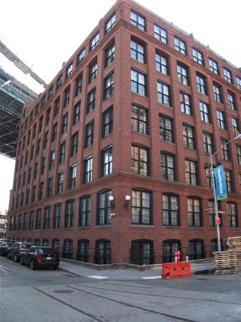
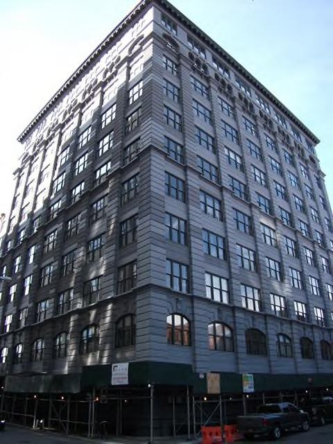
88 25 Washington Street 30 Main Street 188


89 31 Washington Street 37 Bridge Street 189
90 50 Bridge Street 57 Front Street 190


91 65 Washington Street 70 Washington Street 191


92 79 Bridge Street 81 Washington Street 192


93 84 Front Street 85 Adams Street 193

94 99 Gold Street 194
95 NEW YORK CITY OUTER BOROUGHS OFFICE MARKET OVERVIEW According to CoStar Group, Inc., the New York Outer Boroughs Office market ended the fourth quarter 20 with a vacancy rate of 6.5%. The vacancy rate was down over the previous quarter, with net absorption totaling positive 413,749 square feet in the fourth quarter. Vacant sublease space decreased in the quarter, ending the quarter at 344,634 square feet. Rental rates ended the fourth quarter at $27.84, a decrease over the previous quarter. A total of one building delivered to the market in the quarter totaling 3,556 square feet, with 421,735 square feet still under construction at the end of the quarter. The following information is excerpted from the 4th Quarter 20 CoStar Market Report. Absorption Net absorption for the overall New York Outer Boroughs office market was positive 413,749 square feet in the fourth quarter 20. That compares to positive 204,709 square feet in the third quarter 20, negative (17,344) square feet in the second quarter 20, and positive 371,604 square feet in the first quarter 20. Some of the notable move out s occurring in 20 include: JetBlue Airways Corporation moving out of (194,934) square feet at Forest Hills Tower; Visiting Nurse Regional Health Care System moving out of (35,145) square feet at 15 Metrotech Ctr., and Cooperative Home Care Associates moving out of (15,000) square feet at 349 E 149th St. Some of the notable move in s occurring in 20 include: New York City Human Resources Administration moving into 400,000 square feet at 470 Vanderbilt Ave; Federal Emergency Management Agency moving into 239,295 square feet at Forest Hills Tower; and General Services Administration (GSA) moving into 0,000 square feet at two Metrotech Ctr. 195
96 The Class-A office market recorded net absorption of positive 269,096 square feet in the fourth quarter 20, compared to positive 34,996 square feet in the third quarter 20, positive 145,680 in the second quarter 20, and positive 255,332 in the first quarter 20. The Class-B office market recorded net absorption of positive 164,856 square feet in the fourth quarter 20, compared to positive 251,141 square feet in the third quarter 20, positive 27,970 in the second quarter 20, and positive 135,345 in the first quarter 20. The Class-C office market recorded net absorption of negative (20,203) square feet in the fourth quarter 20 compared to negative (81,428) square feet in the third quarter 20, negative (190,994) in the second quarter 20, and negative (19,073) in the first quarter 20. Vacancy The office vacancy rate in the New York Outer Boroughs market area decreased to 6.5% at the end of the fourth quarter 20. The vacancy rate was 7.0% at the end of the third quarter 20, 7.1% at the end of the second quarter 20, and 7.1% at the end of the first quarter 20. Class-A projects reported a vacancy rate of 6.0% at the end of the fourth quarter 20, 7.5% at the end of the third quarter 20, 7.3% at the end of the second quarter 20, and 8.1% at the end of the first quarter 20. Class-B projects reported a vacancy rate of 5.8% at the end of the fourth quarter 20, 6.2% at the end of the third quarter 20, 6.7% at the end of the second quarter 20, and 6.8% at the end of the first quarter 20. Class-C projects reported a vacancy rate of 7.8% at the end of the fourth quarter 20, 7.7% at the end of third quarter 20, 7.4% at the end of the second quarter 20, and 6.8% at the end of the first quarter
97 Notable Lease Signings Some of the notable lease signings occurring in 20 included: the239,295square-foot lease signed by Federal Emergency Management Agency at Forest Hills Tower in the Queens market; the 187,115-square-foot deal signed by New York City Human Resources Administration at 210 Livingston St in the Brooklyn market; and the 75,060-square-foot lease signed by Mt Sinai Medical Center at One Pierrepont Plaza in the Brooklyn market. Sublease Vacancy The amount of vacant sublease space in the New York Outer Boroughs market decreased to 344,634 square feet by the end of the fourth quarter 20, from 485,481 square feet at the end of the third quarter 20. There was 483,206 square feet vacant at the end of the second quarter 20 and 559,952 square feet at the end of the first quarter 20. New York Outer Boroughs Class-A projects reported vacant sublease space of 304,195 square feet at the end of fourth quarter 20, down from the 453,992 square feet reported at the end of the third quarter 20. There were 453,992 square feet of sublease space vacant at the end of the second quarter 20, and 530,738 square feet at the end of the first quarter 20. Class-B projects reported vacant sublease space of 35,464 square feet at the end of the fourth quarter 20, up from the 26,514 square feet reported at the end of the third quarter 20. At the end of the second quarter 20 there were 26,514 square feet, and at the end of the first quarter 20 there were 26,514 square feet vacant. Class-C projects reported no vacant sublease space from the third quarter 20 to the fourth quarter 20. Sublease vacancy went from 4,975 square feet to 4,975 square feet during that time. There was 2,700 square feet at the end of the second quarter 20, and 2,700 square feet at the end of the first quarter

98 Rental Rates The average quoted asking rental rate for available office space, all classes, was $27.84 per square foot per year at the end of the fourth quarter 20 in the New York Outer Boroughs market area. This represented a 0.1% decrease in quoted rental rates from the end of the third quarter 20, when rents were reported at $27.86 per square foot. The average quoted rate within the Class-A sector was $32.16 at the end of the fourth quarter 20, while Class-B rates stood at $28.77, and Class-C rates at $ At the end of the third quarter 20, Class-A rates were $33.90 per square foot, Class-B rates were $28.78, and Class-C rates were $ The following is a summary of the New York City Outer Boroughs office market and the Brooklyn office market statistics. NEW YORK CITY OUTER BOROUGHS OFFICE MARKET STATISTICS (2003 4th QUARTER 20) 198

99 OFFICE MARKET STATISTICS BROOKLYN SUBMARKET (1st QUARTER th QUARTER 20) Deliveries and Construction During the fourth quarter 20, one building totaling 3,556 square feet were completed in the New York Outer Boroughs market area. This compares to five buildings totaling 4,576 square feet that were completed in the third quarter 20, nothing completed in the second quarter 20, and 262,100 square feet in five buildings completed in the first quarter 20. There were 421,735 square feet of office space under construction at the end of the fourth quarter 20. Some of the notable 20 deliveries include: th St, a 137,800-square-foot facility that delivered in first quarter 20 and is now 85% occupied, and 423 E 138th St, a 78,400-square foot building that delivered in first quarter 20 and is now 62% occupied. The largest projects underway at the end of fourth quarter 20 were Metro Center Atrium, a 261,645-square-foot building with 0% of its space pre-leased, and 325 Avenue Y, a 44,000-square-foot facility that is 27% pre-leased. 199
approximately 400 basis points over the safe rate of 2%±. discussed in the highest and best use section of this appraisal report.
 estate tax savings for a proposed use that requires rezoning, such as the development of a residential apartment building. The estimated 8% discount rate is estimated at approximately 400 basis points
ZONING ORDINANCE FOR THE CITY OF RICHLAND CENTER CHAPTER 408 SPECIFIC REGULATIONS AFFECTING LANDS IN A "C-DT" CENTRAL [DOWNTOWN] BUSINESS DISTRICT
![ZONING ORDINANCE FOR THE CITY OF RICHLAND CENTER CHAPTER 408 SPECIFIC REGULATIONS AFFECTING LANDS IN A C-DT CENTRAL [DOWNTOWN] BUSINESS DISTRICT](/thumbs/96/126607517.jpg "ZONING ORDINANCE FOR THE CITY OF RICHLAND CENTER CHAPTER 408 SPECIFIC REGULATIONS AFFECTING LANDS IN A C-DT CENTRAL [DOWNTOWN] BUSINESS DISTRICT") ZONING ORDINANCE FOR THE CITY OF RICHLAND CENTER CHAPTER SPECIFIC REGULATIONS AFFECTING LANDS IN A "C-DT" CENTRAL [DOWNTOWN] BUSINESS DISTRICT.01 APPLICABILITY OF CHAPTER 400 TO A "C-DT" CENTRAL BUSINESS
ZONING ORDINANCE FOR THE CITY OF RICHLAND CENTER CHAPTER SPECIFIC REGULATIONS AFFECTING LANDS IN A "C-DT" CENTRAL [DOWNTOWN] BUSINESS DISTRICT.01 APPLICABILITY OF CHAPTER 400 TO A "C-DT" CENTRAL BUSINESS
City of Sanibel Planning Department
 City of Sanibel Planning Department STAFF REPORT Planning Commission Meeting July 9, 2013 Agenda Item: No. 7 a. Subject: Commercial Redevelopment Kickoff Discussion by the Planning Commission At the June
Broadway Corridor Woodcliff Lake, NJ
 Broadway Corridor Woodcliff Lake, NJ December 5 th, 2016 History 1985 Master Plan 1995 Re examination Study 2002 Master Plan Update Identifies need to improve Broadway Corridor 2008 Broadway Corridor Study
SHOPPING CENTER DISTRICT (Zone BSC)
") Sec. 3-27. SHOPPING CENTER DISTRICT (Zone BSC) (a) (b) Area. All land designated as Zone BSC is subject to the regulations of this Section and Sec. 20.3-10. Such areas are established to provide for planned
Sec. 3-27. SHOPPING CENTER DISTRICT (Zone BSC) (a) (b) Area. All land designated as Zone BSC is subject to the regulations of this Section and Sec. 20.3-10. Such areas are established to provide for planned
Pleasant Hill, IA Code of Ordinances
 Print Pleasant Hill, IA Code of Ordinances 167.08 C 1 NEIGHBORHOOD/LOCAL COMMERCIAL DISTRICT. 1. Statement of Intent. The C 1 District is intended to provide for the orderly development of central shopping
Commercial Zoning Districts
 Article 4 Commercial Zoning Districts Section 4.1 Section 4.2 Section 4.3 C-D Downtown Commercial District C-1 General Commercial District C-2 Heavy Service Commercial District 4.1 C-D, Downtown Commercial
PR, CD and CS Zoning Districts
 PR, CD and CS Zoning Districts Excerpts from Land Use Code Chapter 20.08, Article VI Permitted and conditionally-permitted uses The following permitted and conditionally-permitted uses may be allowed in
Village of Thiensville
 Village of Thiensville REQUEST FOR PROPOSAL: DOWNTOWN REDEVELOPMENT OF TWO PARCELS February 2013 Commercial/Business Property For Sale Located in the heart of Downtown Historic Thiensville, this property
ORDINANCE WHEREAS, the Board of County Commissioners has determined that it is
 ORDINANCE 2002-63 AN ORDINANCE AMENDING ORDINANCE 97-19, AS AMENDED, KNOWN AS THE NASSAU COUNTY COMPREHENSIVE ZONING CODE; SPECIFICALLY ADDING ARTICLE 9-A, RESIDENTIAL, SINGLE FAMILY - AMERICAN BEACH:
B 1 Restricted Retail Commercial District
 Pursuant to the zoning information provided below a stand-alone parking lot would not be a permitted use at this location. Permitted uses for the B-1 zoning district will be inserted below for your review.
SECTION 838 "C-6" - GENERAL COMMERCIAL DISTRICT
 SECTION 838 "C-6" - GENERAL COMMERCIAL DISTRICT The "C-6" District is intended to serve as sites for the many uses in the commercial classifications which do not belong in either the Neighborhood, Community
Commercial Building for Lease. For Lease at $10.00/SF Gross + Expenses
 Commercial Building for Lease EXECUTIVE SUMMARY 232-242 Boston Post Road Milford, Connecticut 06460 For Lease at $10.00/SF Gross + Expenses 5,750 SF freestanding building with direct access from Plains
Incentive Zoning Regulations
 Chapter 4 1. Land Use Districts Incentive Zoning Regulations -14- Residential Village This district is envisioned to accommodate higher density residential development in the form of townhouses, garden
ARTICLE 6. GREER ZONES
 ARTICLE 6. GREER ZONES Section 601. Definitions and application of Greer Zones A. In this Article, unless otherwise specified: GA-2 means Greer Agricultural Zone GR-1 means Greer Residential Zone GC means
SERVICE COMMERCIAL ZONES
 PART 16 SERVICE COMMERCIAL ZONES 1601 CS-1 Service Commercial (1) Intent This zone provides for most types of service commercial and related uses requiring large lots, location along major transportation
DIVISION FIVE COMMERCIAL ZONES. 1. Permitted Uses of Land, Buildings, and Structures
 DIVISION FIVE - COMMERCIAL ZONES 501 GENERAL COMMERCIAL ZONE () 1. Permitted Uses of Land, Buildings, and Structures Subject to the provisions of Divisions Three and Four of this bylaw, the following uses
Air Rights Reference Guide
 Air Rights Reference Guide Revision Date August 15, 2016 City Center Real Estate Inc. 1010 Fifth Avenue New York, NY 10028 ROBERT I. SHAPIRO Founder (212) 396-9705 ris@citycenternyc.com RONALD NOVITA Executive
Division S-39. PD Subdistrict 39.
 Division S-39. PD Subdistrict 39. SEC. S-39.101. LEGISLATIVE HISTORY. PD Subdistrict 39 was established by Ordinance No. 24254, passed by the Dallas City Council on May 10, 2000. Ordinance No. 24254 amended
2.54 Acres Redevelopment Opportunity
 2.54 Acres Redevelopment Opportunity Redevelopment Site: Pat s Muffler, Sports Shop, ABC Liquor, Tire s N More, City-Owned Lot 2848 Pat s Muffler 2840 ABC Liquor County Rd 10 7861 EDA 2832 & 0 Tires-N-
2.110 COMMERICAL MIXED USE (CM)
") CITY OF KEIZER DEVELOPMENT BULLETIN 2.110.01 Purpose 2.110 COMMERICAL MIXED USE (CM) The Commercial Mixed Use (CM) zone is the primary commercial zone within the City. The zone is specifically designed
CITY OF KEIZER DEVELOPMENT BULLETIN 2.110.01 Purpose 2.110 COMMERICAL MIXED USE (CM) The Commercial Mixed Use (CM) zone is the primary commercial zone within the City. The zone is specifically designed
EXHIBIT D North Main Street PUD Amended Written Description July 19, 2016
 EXHIBIT D 1636 North Main Street PUD Amended Written Description July 19, 2016 I. PROJECT DESCRIPTION Applicant proposes to rezone approximately.11 acres of property from CCG-S to PUD. The parcel is located
ARTICLE 5: CENTRAL BUSINESS DISTRICT (CBD)
") ARTICLE 5: CENTRAL BUSINESS DISTRICT (CBD) SECTION 2.5.010 DISTRICT 1) Purpose The CBD (Central Business District) classification is intended to provide for general retail, residential, professional office/service,
ARTICLE 5: CENTRAL BUSINESS DISTRICT (CBD) SECTION 2.5.010 DISTRICT 1) Purpose The CBD (Central Business District) classification is intended to provide for general retail, residential, professional office/service,
$595,000. List Price. Lease Price $5,000/mo (3n) For Sale or Lease 345 N Main Street Chatham, Illinois Medical Office Bldg.
 For Sale or Lease 345 N Main Street Chatham, Illinois Medical Office Bldg.") For Sale or Lease reet Chatham, Illinois Medical Office Bldg. List Price $595,000 Property Details Highly Visible Building Suitable For A Variety Of Businesses Daily Traffic Count: 14,400 New roof added
For Sale or Lease reet Chatham, Illinois Medical Office Bldg. List Price $595,000 Property Details Highly Visible Building Suitable For A Variety Of Businesses Daily Traffic Count: 14,400 New roof added
The intent of Business District B 1 is to provide an area for local and neighborhood shopping where
 CODE OF THE COUNTY DIVISION 9. BUSINESS DISTRICT B 1 Botetourt County, Virginia, Code of Ordinances Page 71 DIVISION 9. BUSINESS DISTRICT B 1 Sec. 25 221. Purpose. Sec. 25 222. Permitted uses. Sec. 25
CHAPTER XI C-1 NEIGHBORHOOD BUSINESS DISTRICT
 CHAPTER XI C-1 NEIGHBORHOOD BUSINESS DISTRICT Section 11.1 Description and Purpose. The C-1 Neighborhood Business District is intended for neighborhood convenience shopping and for office purposes, with
List Price $595,000. Lease Price $5,000/mo (3n) Property Details. For Sale or Lease 345 N Main Street Chatham, Illinois Medical Office Bldg.
 Property Details. For Sale or Lease 345 N Main Street Chatham, Illinois Medical Office Bldg.") For Sale or Lease reet Chatham, Illinois Medical Office Bldg. List Price $595,000 Lease Price $5,000/mo (3n) Property Details Highly Visible Building Suitable For A Variety Of Businesses Daily Traffic
For Sale or Lease reet Chatham, Illinois Medical Office Bldg. List Price $595,000 Lease Price $5,000/mo (3n) Property Details Highly Visible Building Suitable For A Variety Of Businesses Daily Traffic
> 20,102sf, two story Office/Retail space on busy corner of Poquonnock Rd. & Mitchell St. > 1.21 acre > Town Water/Sewer/Gas > Zone GC
 PEQUOT COMMERCIAL FOR SALE / FOR LEASE John Jensen, SIOR jjensen@pequotcommercial.com 349 Mitchell St., Groton (city) > 20,102sf, two story Office/Retail space on busy corner of Poquonnock Rd. & Mitchell
Office Space Offered for Sale
 Office Space Offered for Sale Oland Professional Center Condominium 3402 Olandwood Court, Olney, Maryland 20832 Montgomery County Overview The offering is for the sale of one office space consisting of
Chapter MIXED USE ZONING DISTRICTS
 Page 1 of 12 Page 1/12 Chapter 17.18 MIXED USE ZONING DISTRICTS Sections: 17.18.010 Purposes. 17.18.020 Permitted, conditional and prohibited uses. 17.18.030 Bulk, 17.18.010 Purposes. A. Mixed Use Districts.
13. Automobile maintenance service, but not commercial truck maintenance service
 SECTION 60 B-3 COMMUNITY BUSINESS DISTRICT 60.01 General Description: This business district is intended for the conduct of personal and business services and retail business of the community. Traffic
FC-1 District Schedule
 District Schedule (East False Creek) 1 Intent The intent of this Schedule is to permit and encourage the development of a high-density mixed commercial use neighbourhood, including some residential and
Small Business in Remington: Learning from the Past Rezoning for the Future
 Small Business in Remington: Learning from the Past Rezoning for the Future Outline Vacancy is the Problem Proposed Solution -> B-1-2/C1 Historic Context - Monozoning Changes in Last Decade Transform Baltimore
Sightline Report. produced by TitleVest. 212 West 18th Street, 3, New York, NY Created For: SAMPLE REPORT TitleVest Order No.
 Sightline Report produced by TitleVest 212 West 18th Street, 3, New York, NY Created For: SAMPLE REPORT TitleVest Order No.: SL-NY-654321 2016 First American Financial Corporation and/or its affiliates.
Attachment 5 - Ordinance 3154 Exhibit D (Revised for 9/15 Council Meeting) Page 1 of 7 Port Townsend Municipal Code. Chapter 17.18
 Page 1 of 7 Port Townsend Municipal Code. Chapter 17.18") Page 1 of 7 Page 1/7 Chapter 17.18 MIXED USE ZONING DISTRICTS Sections: 17.18.010 Purposes. 17.18.020 Permitted, conditional and prohibited uses. 17.18.030 Bulk, 17.18.010 Purposes. A. Mixed Use Districts.
Page 1 of 7 Page 1/7 Chapter 17.18 MIXED USE ZONING DISTRICTS Sections: 17.18.010 Purposes. 17.18.020 Permitted, conditional and prohibited uses. 17.18.030 Bulk, 17.18.010 Purposes. A. Mixed Use Districts.
Sub-District C: Washington Park Cultural District
 of Broad Street between Bridge Street and Fulton Street. the first 100 feet of all properties fronting on the south side of Central Avenue between University Avenue and Broad Street. The below regulations
ARTICLE XI CSC COMMUNITY SERVICE COMMERCIAL DISTRICT
 ARTICLE XI CSC COMMUNITY SERVICE COMMERCIAL DISTRICT SECTION 11.01 PURPOSE This district is intended to provide areas where retail trades and service outlets can be located that are convenient to the residents
ATTACHMENT 5c Draft Implementation Program Inland Zoning Ordinance Changes and Ordinance of Adoption
 ATTACHMENT 5c Draft Implementation Program Inland Zoning Ordinance Changes and Ordinance of Adoption (Additions are shown in double underline text and deletions are shown in strikeout.) ORDINANCE NO. AN
C-2B District Schedule
 District Schedule 1 Intent The intent of this Schedule is to provide for a wide range of goods and services, to maintain commercial activities and personal services that require central locations to serve
For Sale 2 Lots Kagy Crossroads Commercial Area Lot Acres Lot Acres
 For Sale 2 Lots Kagy Crossroads Commercial Area Lot 1 2.50 Acres Lot 6 2.56 Acres B-2 Zoning City Services Water & Sewer High Traffic Area Very Close to Montana State University Prime Development Property
ZONING. 317 Attachment 4
 All 37 Attachment 4 SCHEDULE OF REGULATIONS 6 Part 2 3 4 5 6 7 8 9 0 Minimum Yard Dimensions Building Density Height Lot Minimum Floor Area Conditional Uses Area Width Depth Coverage (dwelling units per
Chapter CC COMMUNITY COMMERCIAL ZONES REGULATIONS
 Effective April 14, 2011 Chapter 17.35 CC COMMUNITY COMMERCIAL ZONES REGULATIONS SECTIONS: 17.35.010 Title, Intent, and Description 17.35.020 Required Design Review Process 17.35.030 Permitted and Conditionally
Sec Tier 2 principal uses and structures. The principal uses of land and structures allowed in Tier 2 are provided below subject to the
 Sec. 27-730.4.9. Tier 2 principal uses and structures. The principal uses of land and structures allowed in Tier 2 are provided below subject to the standards and limitations contained within this division.
Sec (JULY 2000 EDITION, Pub. by City of LA) 161
 161") Sec. 12.09 SEC. 12.09 -- R2 TWO-FAMILY ZONE. The following regulations shall apply in the R2 Two-family Zone: A. Use -- No building, structure or land shall be used and no building or structure shall be
Sec. 12.09 SEC. 12.09 -- R2 TWO-FAMILY ZONE. The following regulations shall apply in the R2 Two-family Zone: A. Use -- No building, structure or land shall be used and no building or structure shall be
Article 10 Marina District
 Michigan City MD Article 10 Article 10 ection 10.01 Intent (a) MD. The MD is to be applied to the waterfront areas of Michigan City, including Washington ark and Marina, as well as development along the
Division S-19. PD Subdistrict 19.
 Division S-19. PD Subdistrict 19. SEC. S-19.101. LEGISLATIVE HISTORY. PD Subdistrict 19 was established by Ordinance No. 23022, passed by the Dallas City Council on February 12, 1997. Ordinance No. 23022
Road frontage 287 Sewer and Well Propane Central Air
 FOR SALE/LEASE FOR SALE $149,900 FOR LEASE $13.75/sf Modified Net 1027 Voluntown Rd., Griswold 1,440sf+/- commercial bldg. with full basement (total 2,880sf) 0.96 acre Zone C-1 15 parking spaces John Jensen,
The following uses and no others are permitted in this zone:
 PART 15 COMMERCIAL ZONES 1501 C-1 Local Commercial (1) Intent This zone provides for appropriate land either within or abutting residential areas for the retailing of goods to satisfy the daily household
GENERAL ZONING CODE DESIGN CRITERIA FOR MULTIPLE- DWELLING DEVELOPMENT
 INFORMATION BULLETIN / PUBLIC - ZONING CODE REFERENCE NO.: L.A. Zoning Code Effective: 12-30-03 DOCUMENT NO. P/ZC 2002-010 Revised: Previously Issued As: None GENERAL ZONING CODE DESIGN CRITERIA FOR MULTIPLE-
ARTICLE 145. PD 145.
 ARTICLE 145. PD 145. SEC. 51P-145.101. LEGISLATIVE HISTORY. PD 145 was established by Ordinance No. 17710, passed by the Dallas City Council on February 16, 1983. Ordinance No. 17710 amended Ordinance
III. The Regulating Plans
 III. The Regulating Plans A. Understanding the Regulating Plan A REGULATING PLAN provides standards for the disposition of each property or LOT and how each relates to its adjacent properties and STREETs.
Division 3: Zoning ( Zoning added by O N.S.; effective )
") Article 12: Mid-City Communities Planned District ( Mid-City Communities Planned District added 3-27-2007 by O-19598 N.S.; effective 4-26-2007.) Division 3: Zoning ( Zoning added 3-27-2007 by O-19598 N.S.;
Article 12: Mid-City Communities Planned District ( Mid-City Communities Planned District added 3-27-2007 by O-19598 N.S.; effective 4-26-2007.) Division 3: Zoning ( Zoning added 3-27-2007 by O-19598 N.S.;
September 20, 2017 Via and hand delivery
 September 20, 2017 Via email and hand delivery Plan Commission, Urban Design Commission, City Planning & Zoning Departments City of Madison 126 S. Hamilton St. Madison, WI 53701 Re: Letter of Intent for
AN ORDINANCE, NO Defining and establishing the RMU-1 Zoning District. Approved as to form by the County Attorney
 Amherst County Board of Supervisors County Ordinance No. 2012-0003 AN ORDINANCE, NO. 2012-0003 Defining and establishing the RMU-1 Zoning District. Approved as to form by the County Attorney FIRST READING:
C4A North downtown business district.
 22.112 C4A North downtown business district. (a) Purpose and Legislative Intent. In accordance with the north downtown design plan, an additional component of the City's comprehensive plan, the purpose
Division 59-C-10. RMX Zones-Residential Mixed Use Development. [Note]
![Division 59-C-10. RMX Zones-Residential Mixed Use Development. [Note]](/thumbs/78/77243902.jpg "Division 59-C-10. RMX Zones-Residential Mixed Use Development. [Note]") Key Text highlighted in bright green deals with floating zones and will be addressed in the coming months. Text highlighted in turquoise deals with grandfathering language and will be addressed in the
Key Text highlighted in bright green deals with floating zones and will be addressed in the coming months. Text highlighted in turquoise deals with grandfathering language and will be addressed in the
C-2C1 District Schedule
 District Schedule 1 Intent The intent of this Schedule is to provide for a wide range of goods and services, to maintain commercial activities and personal services that require central locations to serve
acres total $3,500,000
 Development Land Pequot Commercial F O R Lisbon Landing shopping LISBON GRISWOLD S A L E 134.77 acres total 29 & 31 Barber Rd., Griswold CT Zone C-1 Village Commercial District Only 0.45 miles to I-395
FOR SALE 3.8 +/- Acres of Commercial Acreage on Godby Rd near Hartfield Jackson
 FOR SALE 3.8 +/- Acres of Commercial Acreage on Godby Rd near Hartfield Jackson nortoncommercial.com 3.8 Acres 1930 Godby Road College Park, GA 30349 3.8 +/- acres with 300 + feet of road frontage on Godby
C-2C District Schedule
 District Schedule 1 Intent The intent of this Schedule is to provide for a wide range of goods and services, to maintain commercial activities and personal services that require central locations to serve
Public Review Draft. Fortuna Municipal Code. Title 17: Zoning Regulations. Fortuna Planning Commission Review Copy. June 28, 2011
 Public Review Draft Fortuna Municipal Code Title 17: Zoning Regulations Fortuna Planning Commission Review Copy June 28, 2011 This document is subject to revision and updating. Key to Text Color Code Original
B. PREFERRED ALTERNATIVE: PROPOSED CONVERSION OF PARKLAND
 Chapter 2: Alternatives Considered A. INTRODUCTION The Brooklyn Bridge Park Corporation (BBPC), in cooperation with the City of New York, is proposing to convert approximately 2.65 acres of land that is
CHAPTER CC (COMMUNITY COMMERCIAL) ZONE
 ZONE") CHAPTER 17.143 CC (COMMUNITY COMMERCIAL) ZONE Section Title Page 17.143.010 Purpose 1 17.143.020 Permitted Uses 1 17.143.030 Conditional Uses 3 17.143.040 Approval Standards for Conditional Uses 3 17.143.050
CHAPTER 17.143 CC (COMMUNITY COMMERCIAL) ZONE Section Title Page 17.143.010 Purpose 1 17.143.020 Permitted Uses 1 17.143.030 Conditional Uses 3 17.143.040 Approval Standards for Conditional Uses 3 17.143.050
COMMERCIAL ZONING DISTRICTS (Amended 11/13/14) Part I. C-1 Restricted Commercial District
 Part I. C-1 Restricted Commercial District") ARTICLE XI. COMMERCIAL ZONING DISTRICTS (Amended 11/13/14) Part I. C-1 Restricted Commercial District Section 152: Purpose This district is designed to accommodate commercial uses which act as a transition
ARTICLE XI. COMMERCIAL ZONING DISTRICTS (Amended 11/13/14) Part I. C-1 Restricted Commercial District Section 152: Purpose This district is designed to accommodate commercial uses which act as a transition
NOW, THEREFORE, the Mayor and Council of the City of Alpharetta, Georgia hereby ordain:
 AN ORDINANCE TO AMEND ARTICLE II OF THE UNIFIED DEVELOPMENT CODE TO AMEND THE OFFICE INDUSTRIAL ZONING DISTRICT IN ORDER TO ADD CLIMATE CONTROLLED STORAGE AS A CONDITIONAL USE; TO PROVIDE FOR AN EFFECTIVE
Chapter CN NEIGHBORHOOD CENTER COMMERCIAL ZONES REGULATIONS
 Chapter 17.33 - CN NEIGHBORHOOD CENTER COMMERCIAL ZONES REGULATIONS Sections: 17.33.010 - Title, intent, and description. 17.33.020 - Required design review process. 17.33.030 - Permitted and conditionally
4. Public service facilities, such as police and fire stations.
 CHAPTER 500. SECTION 525. ZONING STANDARDS C-1 NEIGHBORHOOD COMMERCIAL DISTRICT 525.1. Purpose The purpose of the C-1 Neighborhood Commercial District is to provide and require a unified and organized
ARTICLE VII. NONCONFORMITIES. Section 700. Purpose.
 ARTICLE VII. NONCONFORMITIES. Section 700. Purpose. The purpose of this chapter is to regulate and limit the development and continued existence of legal uses, structures, lots, and signs established either
303. GENERAL COMMERCIAL DISTRICT (C3)
") 303. GENERAL COMMERCIAL DISTRICT (C3) This District is designed to serve the needs of a large consumer population, both on a local and a municipal level. 303.1 Uses Permitted in a C3 Zoning District: (1)
303. GENERAL COMMERCIAL DISTRICT (C3) This District is designed to serve the needs of a large consumer population, both on a local and a municipal level. 303.1 Uses Permitted in a C3 Zoning District: (1)
CHAPTER 5 ZONING DISTRICTS AND REGULATIONS
 CHAPTER 5 ZONING DISTRICTS AND REGULATIONS Section 500.00 Section 500.01 Zoning Districts and Regulations Purpose The purpose of this Chapter is to establish Zoning Districts in order to carry out the
Request for Proposals Gabbard Building 106 Judiciary Street Aurora, Indiana. Deadline for response October 19, 2015, 8:30 a.m.
 Request for Proposals Gabbard Building 106 Judiciary Street Aurora, Indiana Deadline for response October 19, 2015, 8:30 a.m. The Aurora Historic Preservation Commission is soliciting proposals on the
910 S. CEDAR RIDGE DRIVE
 910 S. CEDAR RIDGE DRIVE RETAIL/OFFICE/WAREHOUSE PROPERTY FOR LEASE Duncanville, TX 75137 OFFERING SUMMARY Available SF: 3,126 SF PROPERTY OVERVIEW Previous print shop; retail space with warehouse. Lease
By: District Council at Request of the Planning Board. AN AMENDMENT to the Montgomery County Zoning Ordinance to:
 Zoning Text Amendment No: 08-14 Concerning: Transit Mixed-Use (TMX) Zone- Establishment Draft No. & Date: 2-6/23/08 Introduced: ublic Hearing: Adopted: Effective: Ordinance No: COUNTY COUNCIL FOR MONTGOMERY
2.35 BVT G Bow Valley Trail General Commercial District [ ]
![2.35 BVT G Bow Valley Trail General Commercial District [ ]](/thumbs/94/119006025.jpg "2.35 BVT G Bow Valley Trail General Commercial District [ ]") 2.35 BVT G Bow Valley Trail General Commercial District [2014 07] 2.35.1 Purpose This district is intended to form the core of Canmore s visitor accommodation outside the resorts and provide a variety
2.35 BVT G Bow Valley Trail General Commercial District [2014 07] 2.35.1 Purpose This district is intended to form the core of Canmore s visitor accommodation outside the resorts and provide a variety
C-3A District Schedule
 District Schedule 1 Intent The intent of this Schedule is to provide for a wide range of goods and services, to maintain commercial activities, specialized services and some light manufacturing enterprises
CITY OF MADISON INTERDEPARTMENTAL CORRESPONDENCE. James Madison Park Disposal Surplus Criteria and Selection Committee
 CITY OF MADISON INTERDEPARTMENTAL CORRESPONDENCE TO: FROM: James Madison Park Disposal Surplus Criteria and Selection Committee Dan Rolfs, Community Development Project Manager DATE: 2 December 2010 SUBJECT:
DEVELOPMENT STANDARDS
 Chapter 5 DEVELOPMENT STANDARDS 501 Residential Development Standards 502 Neighborhood Commercial Standards 503 Mixed Use Standards 504 Industrial Development Standards 505 Public Use Standards 506 Open
CITY OF ITHACA, MICHIGAN ORDINANCE NO
 CITY OF ITHACA, MICHIGAN ORDINANCE NO. 2018-01 AMENDING CHAPTER 40: ZONING, OF THE CITY CODE OF ORDINANCES An Ordinance to Amend Chapter 40: Zoning; Article 12: C-1 Central Business District of the Code
$395,000 DEVELOPMENT LAND MIDWEST REALTY GROUP. Land for SALE from. Rick DeKam, CCIM. Andrew Gyorkos
 Millard Road US-131 Subject Property DEVELOPMENT LAND 401 South US-131, Three Rivers, Michigan Rick DeKam, CCIM Phone: 269.323.0717 Mobile: 269.207.5430 Email: rick@midwestrealty.com Andrew Gyorkos Phone:
BYLAW NUMBER 159D2016
 CPC2016-164 ATTACHMENT 1 BEING A BYLAW OF THE CITY OF CALGARY TO AMEND THE LAND USE BYLAW 1P2007 (LAND USE ) * * * * * * * * * * * * * * * * * * * * * * * * * * * * * * * * WHEREAS it is desirable to amend
Division 4: Commercial Community 1 (C-C1) District
 District") Division 4: Commercial Community 1 (C-C1) District 738 Purpose 738 (1) The Commercial Community 1 District is intended to be characterized by: (e) (f) (g) small to mid-scale commercial developments; developments
Division 4: Commercial Community 1 (C-C1) District 738 Purpose 738 (1) The Commercial Community 1 District is intended to be characterized by: (e) (f) (g) small to mid-scale commercial developments; developments
2010 City of San Mateo General Plan Update Zoning Code Revisions
 27.16.050 AFFORDABLE HOUSING. To implement the affordable housing goals and policies in the General Plan, the City Council adopted the Below Market Rate (BMR) Program. The BMR Program requires developers
Campus Sector Animal hospital SE N P (for properties abutting Adams and Van Buren Avenues) Antique shops N P N Appliance sales/ service
 Antique shops N P N Appliance sales/ service") 143-136. Use Regulations for. [Amended 7-20-2000 by Ord. o. 448; 2-15-2001 by Ord. o. 453; 9-21-2006 by Ord. o. 556; 12-3-2009 by Ord. o. 586] A. In the, and in the and s, land, buildings or premises shall
143-136. Use Regulations for. [Amended 7-20-2000 by Ord. o. 448; 2-15-2001 by Ord. o. 453; 9-21-2006 by Ord. o. 556; 12-3-2009 by Ord. o. 586] A. In the, and in the and s, land, buildings or premises shall
East Side Community Meeting
 East Side Community Meeting November 29, 2017 Pam Thompson, Senior Planner Sustainable Development and Construction City of Dallas Authorized Hearing Process City Plan Commission authorized a hearing to
Part 7 Uptown Mixed-Use Centre Zones
 TABLE OF CONTENTS PART 7: UPTOWN MIXED-USE CENTRE ZONES... 1. GENERAL PROVISIONS.... PERMITTED USES... 3 3. PROHIBITED USES... 5 4. UCR1 TO UOP ZONE REGULATIONS... 5 4.1 LOT WIDTH, AREA, YARDS, FLOOR AREA
FOR SALE +/-.17 ACRES / CLEARED LAND OLD PALM CITY CRA SW 29th Terrace, Palm City, Florida 34990
 www.tccommercialre.com Kyle St. John (772) 288-6646 kyle@tccommercialre.com FOR SALE +/-.17 ACRES / CLEARED LAND OLD PALM CITY CRA 1245 SW 29th Terrace, Palm City, Florida 34990 742 NW Dixie Hwy, Stuart,
THE TOWN OF Angier N O R T H C A R O L I N A
 THE TOWN OF Angier N O R T H C A R O L I N A Rate and Fee Schedule For the Fiscal Year June 30, 2014 Rate and Fee Schedule FY 2014 2 Table of Contents Taxes... 3 Recreation.. 4 Depot Rental. 4 Animal Control.
SECTION 13 COMMERCIAL DISTRICT 1 (C.1)
") SECTION 13 COMMERCIAL DISTRICT 1 (C.1) 13.1 No person shall within a C.1 District use any land or erect, alter or use any building or part thereof for any purpose other than; (a) a barber shop (b) a beauty
SECTION 13 COMMERCIAL DISTRICT 1 (C.1) 13.1 No person shall within a C.1 District use any land or erect, alter or use any building or part thereof for any purpose other than; (a) a barber shop (b) a beauty
Town of Angier Rate and Fee Schedule Fiscal Year Effective July 1, 2011
 Town of Angier Rate and Fee Schedule Fiscal Year 2011 2012 Effective July 1, 2011 Attachment A Tax Rate: Per $100 of valuation $0.53 Recreation Fees: In Town Residents Out of Town Residents $20.00 $40.00
AH-2, B-3-R, C-R & C ZONE DISTRICTS
 PROPOSED AMENDMENT TO LAND USE PLAN ELEMENT OF THE VILLAGE OF RIDGEWOOD MASTER PLAN AH-2, B-3-R, C-R & C ZONE DISTRICTS Village of Ridgewood Planning Board December 2013 The original of this report was
4-900 MILITARY PARKWAY-SYCENE CORRIDOR OVERLAY DISTRICT
 4-900 MILITARY PARKWAY-SYCENE CORRIDOR 4-901 PURPOSE AND SCOPE Ord. 3846/12-18-06 The Military Parkway Scyene Corridor is positioned centrally between the Mesquite Arena and Rodeo Entertainment District,
Chapter 17-2 Residential Districts
 Chapter 17-2 Residential Districts 17-2-0100 District Descriptions...2-1 17-2-0200 Allowed Uses...2-2 17-2-0300 Bulk and Density Standards...2-5 17-2-0400 Character Standards...2-18 17-2-0500 Townhouse
Within PUD-LU districts, the following provisions shall apply:
 Sec. 8-3047. Development standards in PUD-LU zoning districts. Within PUD-LU districts, the following provisions shall apply: (a) (b) (c) Definition: planned unit development-limited use (PUD-LU). The
90+/-Acres D-19 Southwest corner of I-96 & D-19 Marion Township, Michigan
 90+/- Acres of Commercial Land 90+/-Acres D-19 Southwest corner of I-96 & D-19 Marion Township, Michigan F O R S A L E Exclusively listed by Mark W. Szerlag, CCIM Partner T: 248.476.3700 F: 248.476.3560
Charter Township of Plymouth Zoning Ordinance No. 99 Page 65 Article 12: C-1 Neighborhood Shopping District
 Charter Township of Plymouth Zoning Ordinance No. 99 Page 65 PURPOSE ARTICLE XII C-1 NEIGHBORHOOD SHOPPING DISTRICT To provide for neighborhood shopping facilities in close proximity to residential areas
ZONING DISTRICTS AND DISTRICT PROVISIONS
 ZONING DISTRICTS AND DISTRICT PROVISIONS SECTION 150.20 ZONING DISTRICTS. 1. District Symbols. The zoning districts are designed so as to assist in carrying out the intents and purposes of the Comprehensive
The Village at Autumn Lake
 PUD:GDP Zoning Re-Approval Application 5922 Lien Road (see attached list) Madison, Wisconsin Original Adoption: December 2, 2003 First Revision Adopted: August 3, 2004 Recorded: April 20, 2006 Resubmitted:
Permitted Uses and Conditional Uses Key: P Permitted Use C Conditional Use
 Table 1153.01 ermitted Uses and onditional Uses Key: ermitted Use onditional Use RESIDENTIAL USES R1 R2 R3 R4 R5 D T1 1 2 3 O1 I1 MU One-family dwelling Two-family dwelling Multi-family dwelling Renting
Re-Zoning C a s e N u m b e r R # 6-17
 S t a f f R e p o r t Re-Zoning C a s e N u m b e r R # 6-17 Lo c at i o n m a p/a e r i a l P h oto g r a p h Subject Property 102 Hospital Ave NW (NCPIN 2850202045) N S u m m a r y Owner JOSEPH & BETTY
TOWN OF HERNDON, VIRGINIA ORDINANCE, 2016
 TOWN OF HERNDON, VIRGINIA ORDINANCE, 2016 Ordinance- to amend and reenact Chapter 78 of the Code of the Town of Herndon entitled Zoning, Sections 78-204, 78-400, and 78-403 to make changes for internal