CADASTRE SURVEY (SGHU 2313)
|
|
|
- Randall Barnett
- 6 years ago
- Views:
Transcription
1 CADASTRE SURVEY (SGHU 2313) WEEK 1-PREPARATION FOR CADASTRE SURVEY SR DR. TAN LIAT CHOON
2 OUTLINE Kalibrasi Alat Ukur Ukur Pengukuran (Jarak dan Keluasan) Sistem Kordinat Ukur Kadaster 2
3 KALIBRASI ALAT UKUR 3
4 Kalibrasi Peralatan Ukur Hasil kerja akhir bagi sesuatu pengukuran ialah pelan dan data pengukuran. Hasil kerja ini pula digunakan untuk tujuan tertentu contohnya bagi kerja ukur hakmilik, salinan Pelan Akui (PA) digunakan sebagai pelan pada dokumen hakmilik tanah. Dokumen hakmilik tanah adalah suatu dokumen rasmi yang dijamin oleh kerajaan sebagai dokumen yang tidak boleh disangkal. Sehubungan itu semua proses untuk menghasilkan dokumen yang tidak boleh disangkal perlu kepada suatu prosedur dan sistem kerja yang dapat menjamin dan mencapai status tersebut. Peralatan ukur yang digunakan untuk mengutip dan memproses data telah ditetapkan perlu melalui proses tentukur bagi mempastikan alat tersebut dalam keadaan baik dan data yang dihasilkan adalah betul. 4
5 Kalibrasi Peralatan Ukur JUPEM telah menetapkan semua peralatan ukur (kompas prisma, rantai ukur, EDM, total station, GPS, alat aras) yang digunakan dalam pengukuran kadaster hendaklah dijalankan tentukuran. Slip ujian/kalibrasi perlu dilampirkan bersama-sama dengan buku kerja luar. 5
6 Kalibrasi Peralatan Ukur Bagi memastikan peralatan yang digunakan untuk mencerap jarak dan mendapatkan koordinat relatif di atas permukaan bumi berada dalam keadaan baik, peralatan peralatan tersebut perlu dilakukan kalibrasi sekurangkurangnya setiap 6 bulan sekali untuk alat total station atau EDM dan sekurang-kurangnya 1 tahun sekali bagi alat GNSS. 6
7 Kaedah Kalibrasi Total Station Semakan Harian Dilaksanakan di lokasi kerja, setiap kali hendak memulakan kerja ukur. Kaedahnya, ukur semula jarak mana-mana garisan yang telah diukur pada hari sebelumnya. Kerja pengukuran boleh diteruskan jika jaraknya berbeza kurang daripada 10 mm jika tidak proses DFT perlu dijalankan. 7
8 Semakan Harian i. Semakan harian hendaklah dibuat setiap hari sebelum menyambung kerja-kerja ukuran bagi memastikan alat berada dalam keadaan baik. ii. Perbezaan di antara jarak diukur berbanding cerapan hari sebelumnya hendaklah tidak melebihi 10 milimeter. iii. Bagi alat GNSS, semakan harian hendaklah dibuat juga. 8
9 Kaedah Kalibrasi Total Station Differential Field Test (DFT) DFT dilaksanakan di lokasi kerja apabila; Semakan Harian mempunyai beza jarak melebihi 10 mm dan apabila setiap kali memulakan kerja ukur yang baru. 9

10 Kaedah Kalibrasi Total Station Jarak AB hendaklah dibandingkan dengan jumlah jarak CA + CB; Jika didapati jarak melebihi 10 mm, alat yang diuji tidak boleh digunakan, ianya hendaklah dibuat ujian kalibrasi 10
11 Differential Field Test (DFT) i. Differential Field Test hendaklah dijalankan setiap kali memulakan kerja baru. ii. Bagi kerja yang bermula dengan menggunakan dua (2) tanda Cadastral Reference Mark yang saling nampak, Differential Field Test hendaklah dibuat di atas garisan yang menyambungkan kedua-dua tanda Cadastral Reference Mark tersebut. iii. Sekiranya wujud perbezaan jarak di antara cerapan terus menggunakan Total Station berbanding hasil kiraan dua (2) tanda Cadastral Reference Mark, jarak hasil kiraan dua tanda Cadastral Reference Mark hendaklah digunapakai sebagai jarak muktamad garisan tersebut. Had perbezaan yang dibenarkan adalah tidak melebihi meter. 11
12 Differential Field Test (DFT) iv. Bagi perbezaan melebihi had meter, tindakan berikut hendaklah diambil jika: (a) Differential Field Test berada dalam had meter, penentuan Cadastral Reference Mark perlu dilakukan semula. (b) Differential Field Test tidak berada dalam had, alat total station tersebut perlu dibuat kalibrasi. 12
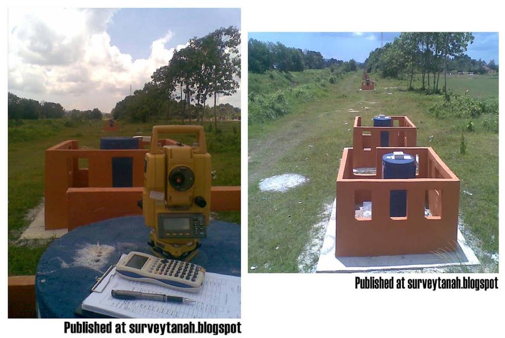
13 Kaedah Kalibrasi Total Station Alat Total Station beserta dengan reflectors hendaklah dibuat ujian kalibrasi di tapak ujian EDM apabila; Ujian DFT mempunyai beza jarak; melebihi dari 10 mm; sekali setiap 6 bulan; Selepas diservis; Berlaku penggantian salah satu unit dalam set alat; apabila berlaku kecacatan akibat jatuh atau lain-lain, ataupun bacaan jarak pada posisi yang sama tidak konsisten. 13
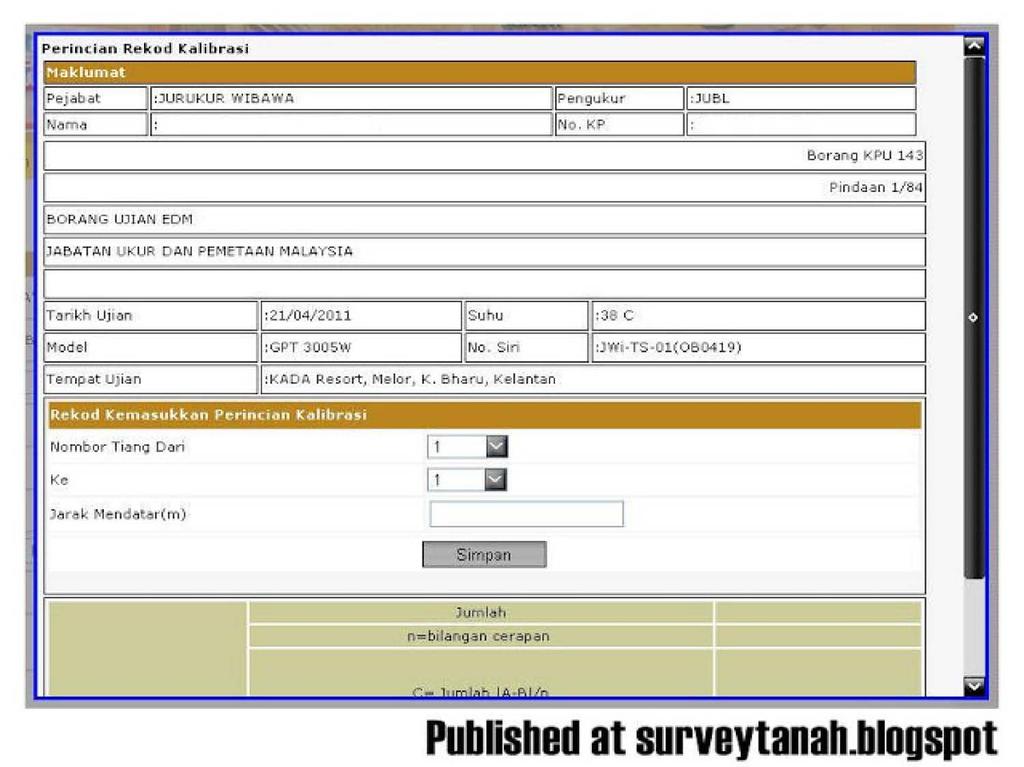
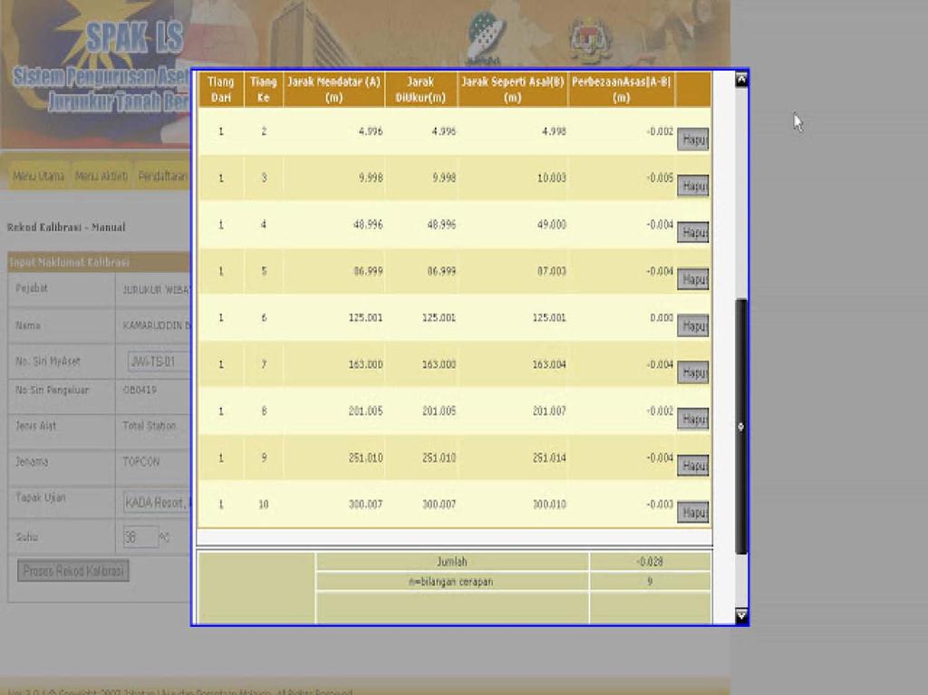
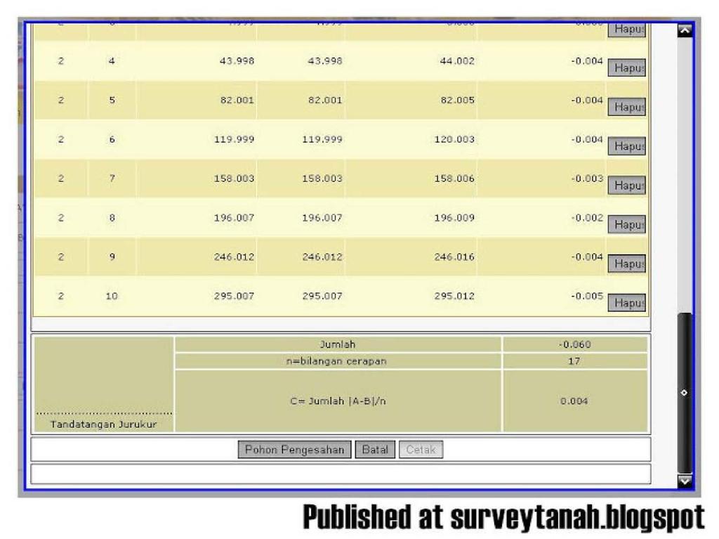
14 Kaedah Kalibrasi Total Station Alat Total Station dipasangsiap di tiang 1 dan jarak-jarak dari tiang 1 ke tiang-tiang yang lainnya dicerap dengan bantuan cermin prizam yang mempunyai beza jarak antara 5m 300m. Bacaan dicatatkan dalam Borang Ujian EDM (online atau manual). Perbezaan asas antara jarak yang dicerap dan jarak piawai (atau jarak asal) bagi setiap garisan cerapan dicatatkan dalam ruangan yang berkenaan. Perbezaan-perbezaan ini dijumlahkan, dan kemudian dibahagikan kepada bilangan cerapan yang dilakukan bagi mendapatkan satu nilai angkatap. 14
15 Kaedah Kalibrasi Total Station Had maksima constant error (jarak diukur jarak piawai / bilangan cerapan) yang dibenarkan adalah 10 mm, jika tidak alat berkenaan hendaklah dihantar untuk diservis/dibaiki. Adalah digalakan supaya cerapan dibuat berulang kali dengan alat Total Station dipasangsiap pada tiang-tiang yang lain. lni bertujuan untuk memastikan pengukuran jarak Total Station menepati kejituannya. 15
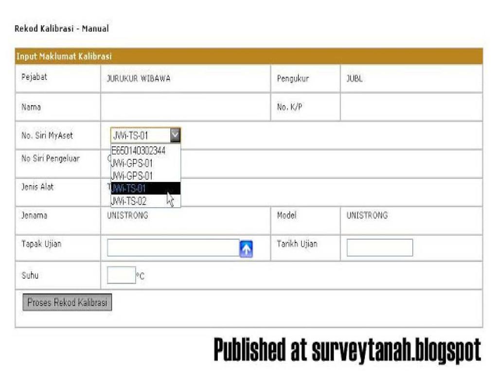
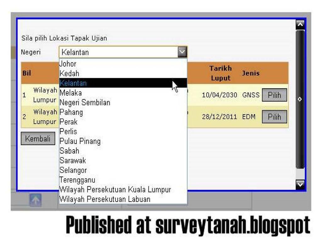
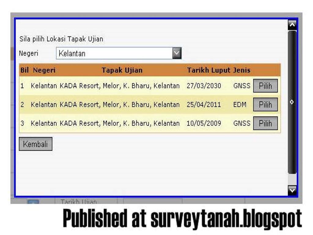
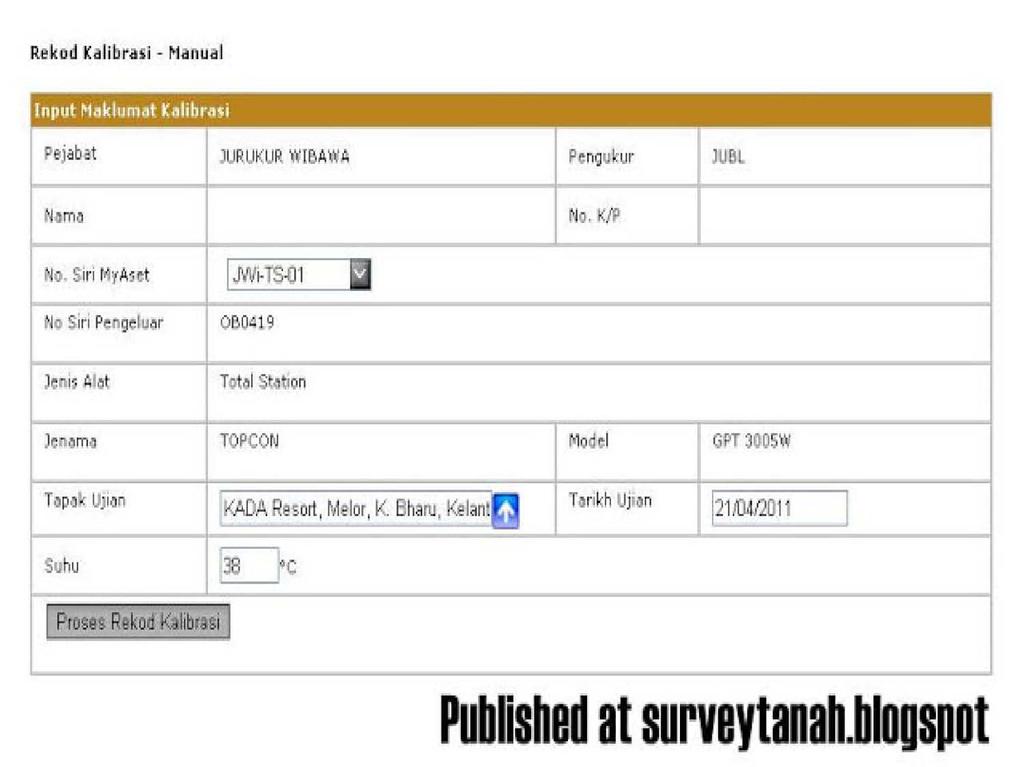
16 Kaedah Kalibrasi Total Station dan Peralatan GNSS i. Data-data berdigit bagi jarak piawai pillar (*.med dan *.gnss) dan sijil jarak piawai pillar (*.pdf) hendaklah dimuat turun secara dalam talian (on-line) daripada sistem yang telah dibangunkan. ii. Fail kalibrasi yang dihasilkan secara berdigit di lapangan hendaklah dimuat naik ke dalam sistem yang telah dibangunkan untuk tujuan validasi data dan seterusnya kelulusan. iii. Bagi kalibrasi yang dibuat secara manual pula, data-data cerapan hendaklah dimasukkan ke dalam sistem melalui key board entry untuk validasi data dan kelulusan. 16
17 Kaedah Kalibrasi Total Station dan Peralatan GNSS iv. Sistem akan mengeluarkan sijil kalibrasi (*.edm dan *.gnss) yang telah diluluskan dan hendaklah dimuat turun dan seterusnya disertakan bersama-sama fail ASCII yang lain semasa membuat penghantaran kerja melalui JUPEM2U. v. Format fail berdigit *.edm dan *.gnss yang dikeluarkan oleh sistem adalah seperti berikut : JE_2009_01_01 di mana; J - Negeri E - Tapak EDM (G - Tapak GNSS) Tahun 01 - ID Tapak 01 - Nombor Siri Sijil EDM 17
18 Contoh Borang Ujian EDM (Lama) 18
19 Contoh Borang Ujian EDM (Baru) 19
20 Kaedah Kalibrasi GNSS Tiga ujian perlu dilakukan ke atas peralatan GPS bagi mempastikan pealatan GPS berkenaan berada dalam keadaan baik iaitu: Zero Baseline Test EDM Baseline Test GPS Network Test 20
21 Kaedah Kalibrasi GNSS Zero Baseline Test Ujian ini perlu dilakukan sebelum bermulanya sesuatu projek baru. Tujuan ujian ini ialah untuk memastikan receiver GPS, antena, kabel serta perisian yang digunakan berada dalam keadaan yang baik dan bersesuaian dengan spesifikasi kerja. Caranya ialah 2 unit receiver GPS disambungkan pada 1 unit antena dengan mengunakan Antenna Cable Splitter. Kedua-dua receiver GPS sepatutnya memaparkan nilai koordinat yang sama. Had perbezaan jarak yang dibenarkan adalah tidak melebihi 3 mm. Ujian ini perlu dijalankan 2 kali untuk kedua-dua antena GPS. 21
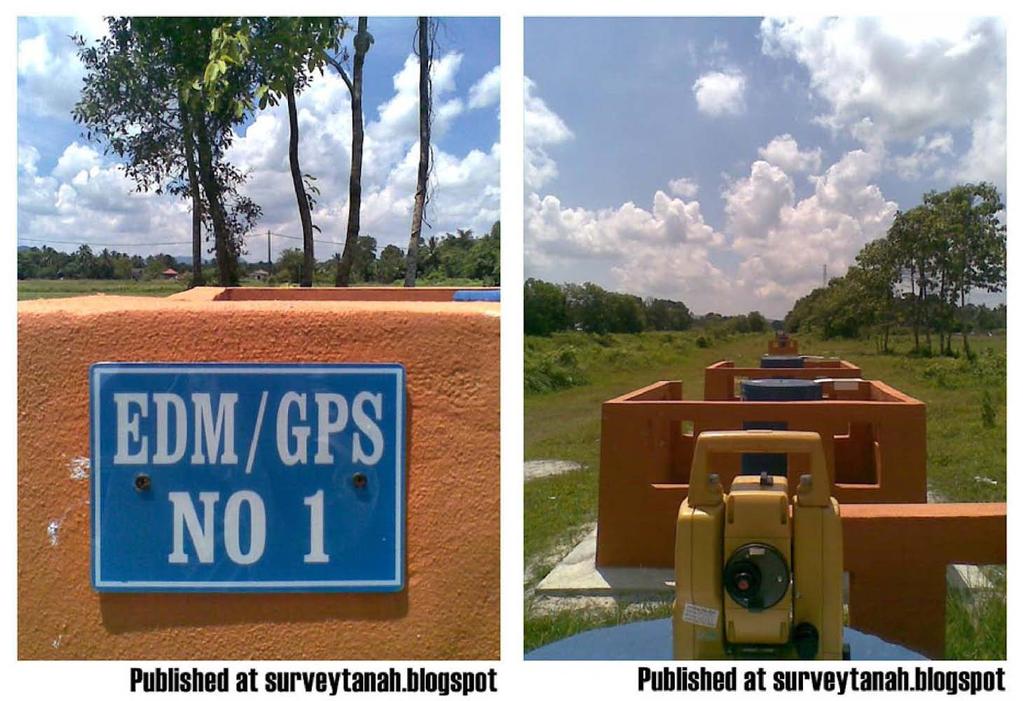
22 Kaedah Kalibrasi GNSS EDM Baseline Test Ujian ini perlu dilakukan 6 bulan sekali atau sebelum sesuatu projek yang besar dilaksanakan. Tujuan ujian ini ialah untuk memastikan pasangan receiver GPS serta perisian pemprosesan yang digunakan untuk penentuan garis dasar berada dalam keadaan baik. Ujian ini juga akan menentukan kejituan receiver GPS serta mengesahkan keupayaan pemprosesan. Ujian dilaksanakan di tapak ujian EDM/GPS iaitu di atas pilar-pilar yang mempunyai beza jarak antara 20m 1km. Receiver GPS mesti digunakan dengan antena serta kabel yang sama. Had perbezaan jarak slope (cerapan piawai) yang dibenarkan adalah tidak melebihi 10 mm. 22
23 GPS Network Test Kaedah Kalibrasi GNSS Ujian ini dijalankan setiap tahun atau semasa firmware atau perisian pemprosesan dinaiktaraf. Tujuan ujian ini ialah untuk memastikan peralatan GPS berfungsi dengan baik bagi menghasilkan koordinat relatif yang tepat. Sebelum ujian ini dijalankan optical plummet perlu diuji beserta dengan Zero Baseline Test. Ujian mesti dibuat di atas minima 3 stesen GPS jaringan geodetik GPS sedia ada. Ujian ini boleh dibuat dalam beberapa sessi cerapan dengan lebih dari 1 pasang alat. Kaedah cerapan statik digunakan dengan masa cerapan > 2 jam bagi setiap sesi cerapan. Pelarasan jaringan Minimally Constrained dibuat mengunakan datum GDM2000. Hasil koordinat akhir hendaklah dalam sistem koordinat tempatan (RSO). Allowable discrepancy; < 10mm bagi koordinat horizontal atau < 20mm bagi komponen pugak atau < 5 + 2XL = mm (L = jarak baseline dalam km) bagi ketepatan relatif. 23
24 Cut-off angle 15 kebawah semasa pemprosesan garis 24 asas. Kaedah Kalibrasi GNSS Ketika ujian Zero Baseline Test, ia memerlukan keadaan seperti berikut: Tempat ujian / cerapan perlu sekurang-kurangnya 90% sky visibility Masa cerapan sekurang-kurangnya 10 minit dengan sela cerapan 15 saat (ZBT). Receiver GPS perlu menjejak sekurang-kurangnya 5 satelit dengan GDOP < 6
25 25
26 26
27 Senarai tapak kalibrasi di setiap negeri 27
28 28
29 29
30 30
31 31
32 32
33 33
34 34
35 35
36 36
37 37
38 38
39 Kaedah Kalibrasi Alat Aras Ujian Dua Piket Ujian alat aras perlu dibuat untuk memastikan garis kolimatan berkeadaan selari dengan tangent utama. Oleh itu, apabila gelembung udara berada di tengah-tengah tiub, maka garis kolimatan adalah mengufuk. Jika garis kolimatan tidak mengufuk, maka selisih kolimatan terwujud dalam alat aras ini. Kaedah biasa bagi menguji alat aras adalah dengan menjalankan ujian dua piket. 39
40 Kaedah Kalibrasi Alat Aras Kaedah ujian dua piket (lihat rajah dibawah) ialah;- pasang alat di C di mana stesen C berada di tengah setaf A dan B. Jarak A B (L) ialah lebih kurang 40 meter. Ambil bacaan sebagai a1, b1. Anjakan alat aras di D, sebaik-baiknya berjarak L/10 iaitu lebih kurang 4 meter daripada piket B. Ambil bacaan setaf sebagai a2 dan b2. 40
41 Kaedah Kalibrasi Alat Aras 41

42 Kaedah Kalibrasi Alat Aras 42
43 Kaedah Kalibrasi Alat Aras Jika selisih (e) didapati kurang daripada +/ 2mm per 40 meter, maka alat aras tidak perlu pelarasan. Pandangan depan dan belakang hendaklah dicerap pada jarak yang sama supaya selisih (e) terhapus atau pendek supaya selisih e dapat dikurangkan. Untuk melaras alat di titik D, bacaan yang sepatut didapati di A ialah a2 Dihitung daripada a2 = a2 44e/40, L = 40 meter dan L/10 = 4 meter di mana sekiranya 43
44 Kaedah Kalibrasi Alat Aras Alat aras automatik dilengkapkan dengan skru pelarasan khas untuk kompensator, iaitu sebagai tambahan kepada diafragma bergerak. Oleh kerana pelarasan ini memerlukan kerja yang teliti, maka alat aras perlu dikembalikan kepada pengeluar untuk pelarasan di makmal. 44
45 UNIT PENGUKURAN (JARAK & KELUASAN) 45
46 Unit Pengukuran (Jarak & Keluasan) 46
47 Unit Pengukuran (Jarak & Keluasan) 47
48 CADASTRE SURVEY (SGHU 2313) WEEK 1-PREPARATION FOR CADASTRE SURVEY SR DR. TAN LIAT CHOON
49 OUTLINE Calibration of survey instruments Surveying Unit (Distance and Area) Coordinate System in Cadastre Survey 49
50 CALIBRATION OF SURVEY INSTRUMENTS 50
51 Calibration of Survey Equipment The final output of a measurement is a plan and measurement data. This output is used for specific purposes, for example, for the title survey, the copy of the Certificated (CP) is used as a plan on the document of land title. The document of land title is an official document guaranteed by the government as an irrefutable document. In this regard, all processes of producing irrefutable documents are necessary for procedure and working system that can guarantee and achieve that status. The measuring equipment used to collect and process data has to be determined through the calibration process to ensure the instrument is in good condition and the data produced is correct. 51
52 Calibration of Survey Equipment JUPEM request all measuring instrument (prisms, measuring chains, EDM, total stations, GPS, leveling instrument) used in cadastral survey to be calibrated. Test/calibration result slip need to be attached together with field book. 52
53 Calibration of Survey Equipment To ensure the instrument used to measure distances and obtain relative coordinates on the surface of the earth is in good condition, the instrument should be calibrated at least once every 6 months for total station or EDM and at least once a year for GNSS instrument. 53
54 Total Station Calibration Method Daily Check To be carried out at site, every starting of surveying work. The method is to re-measure the distance of last measured line done yesterday. Survey work can be continued if the distance is less than 10 mm otherwise the DFT process should be carried out. 54
55 Total Station Calibration Method i. Daily check should be carried out daily before continue the survey work to ensure the instrument is in good condition. ii. The difference between the measured distance compared to the previous day's observations should not exceed 10 millimeters. iii. For GNSS instrument, daily check should be made as well. 55
56 Total Station Calibration Method Differential Field Test (DFT) DFT to be carried out at site when daily check have a difference of 10 mm each time start a new survey line. 56
57 Total Station Calibration Method a) Plant peg A and B with distance not less than 50m A (peg) 50m B (peg) b) Set up Total Station at peg A and Prism at peg B, measure distance A to B c) Plan peg C in the middle of line A and B A (peg) 24m C (peg) 26m B (peg) d) Move Total Station to peg C and set up prism at A and B, measure distance CA and CB. Compare distance AB with the total distance of CA + CB; If it is found exceed 10 mm, the instrument shall not be used, it shall sent for calibration test 57
58 Differential Field Test (DFT) i. Differential Field Test must be conducted every time when start a new survey work. ii. iii. For survey work that start with two (2) visible Cadastral Reference Mark, Differential Field Test should be made on the line that connects both Cadastral Reference Marks. If there is a difference between direct observation using Total Station versus the calculated result of two (2) Cadastral Reference Mark, the distance of the calculated two Cadastral Reference Marks shall be adopted as the ultimate distance of the line. The permissible difference limit is not more than meters. 58
59 Differential Field Test (DFT) iv. For differences above the limit of meter, the following action shall be taken if: (A) Differential Field Test is within the limit of meter, the Cadastral Reference Mark determination needs to be resurvey. (B) Differential Field Test is not within the limits, the total station must be calibrated. 59
60 Total Station Calibration Method Total Station together with reflectors' shall be calibrated test at EDM test base when; the DFT test has a distance difference; exceeding 10 mm; once every 6 months; after service; replacement of any unit of the instruments; in any defect due to fall or other, or inconsistent in reading distance at the same position. 60
61 Total Station Calibration Method Set up Total Station on pole 1 and distances from pole 1 to the other poles are measure with the help of prism which have a distance between 5m - 300m. Readings are recorded in the EDM Test Form (online or manual). The basic difference between the distance measured and the standard distance (or the original distance) for each observation line is recorded in the provided space. These differences are summed up, and then divided into the number of observations to get mean value. 61
62 Total Station Calibration Method Maximum limit of constant error (measured distance - standard distance / number of observations) allowed is 10 mm, otherwise the instrument should be delivered for maintenance / repair. It is recommended that the observation be made repeatedly with the Total Station set up on the other pillars. This is to ensure that distance measured by Total Station meets its accuracy. 62
63 Total Station and GNSS Instrument Calibration Method i. The digital data for the pillar distance (*.med and *.gnss) and certificate of pillar distance (*.pdf) must be downloaded online from the system that has been developed. ii. iii. A calibration file that generated digitally in the field should be uploaded into a system that has been developed for the purposes of data validation and approval. For manual calibrations, the observation data shall be entered into the system via key board entry for 63 validation of data and approval.
64 Total Station and GNSS Instrument Calibration Method iv. The system will issue a calibration certificate (*.edm and *.gnss) which has been approved and should be downloaded and subsequently attached together with ASCII file when submitting surveyed work via JUPEM2U. v. The digital file formats *.edm and *.gnss are as follows: JE_2009_01_01 where; J State E - EDM Test Base (G GNSS Test Base) Year 01 Test Base ID 01 - EDM Certificated Serial Number 64
")
65 Sample of EDM Test Form (Old) 65
")
66 Sample of EDM Test Form (New) 66
67 GNSS Calibration Method Three tests need to be done on GPS instruments to ensure the GPS instruments are in good condition: Zero Baseline Test EDM Baseline Test GPS Network Test 67
68 GNSS Calibration Method Zero Baseline Test Should be performed before any new GPS cadastral survey activity is carried out. Should be performed to ensure the correct operation of the receivers, antennas, cabling and software. Shall be carried out by connecting two (2) GPS receivers to the same antenna, using an antenna cable-splitter appropriate for the brand of receiver/antenna. Shall be used to verify the precision of the receiver measurements, as well as validate the data processing software. The test should be applied twice, for both antennas. The resulting (computed) slope distance between the two (2) receivers being tested must be less than three (3) millimetres. If this tolerance is not met the test should be repeated or the equipment sent to the GPS agent 68 for further testing.
69 GNSS Calibration Method EDM Baseline Test Should be performed on a six monthly basis or prior to any large survey campaign being carried out. Should be performed to ensure the correct operation of a pair of GPS receivers that will be used for baseline measurement. The test shall be used to study the precision of the receiver measurements, as well as validate the data processing software. The GPS receivers should be tested against the established EDM baseline lengths (between pillars), varying from twenty (20) metres to about one (1) kilometre. The resulting difference in slope distance between the GPS measurement and the standard must be less than ten (10) millimetres. If this tolerance is not met the test should be repeated, and if the equipment fails again the instrument should be returned to the GPS agent for repair. 69
70 GPS Network Test GNSS Calibration Method The network test should be carried out on an annual basis, or when the receiver's firmware or post-processing software is upgraded to a new version. In the later case, the test should include the Zero Baseline Test and EDM Baseline Test. The GPS instrumentation must be tested on part of the established high order geodetic network (DSMM Report, 1994, GPS Derived Coordinates ). The network should include a minimum of three (3) existing First Order GPS Control stations as described in the above DSMM report (1994). The maximum allowable discrepancy between the surveyed coordinates (observed GPS values) and the true coordinates (established values) for the network test must be less than ten (10) millimetres in the horizontal component or relative accuracy of better than a + bl millimetres (a=5mm, b=2ppm, L= baseline length in kilometres), and less than twenty (20) millimetres in the vertical component. If this tolerance is not met, the surveyor will be required to validate the results by repeating the test again. If the test fails again the datasets and results should be validated by the Geodetic Authority. If the results are still outside tolerance it is advised that the surveyor proceed to carry out zero baseline and EDM baseline tests, or the equipment sent to the GPS agent for further testing. 70
71 GNSS Calibration Method When conducting Zero Baseline Test, the above test requires the following conditions: The test should be carried out at an established EDM baseline test site, by occupying pillars with at least 90% sky visibility. The test should be performed for a minimum of ten (10) minutes observation sessions with 15 second interval. Receiver GPS perlu menjejak sekurang-kurangnya 5 satelit dengan GDOP < 6 The receivers shall track at least five (5) satellites during the test session with a GDOP of less than six (6). Cut-off angle of fifteen degrees (15 ) should be applied during the baseline processing. 71
72 72

73 73

74 Senarai tapak kalibrasi di setiap negeri 74
75 75
76 76
77 77
78 78
79 79
80 80
81 81
82 82
83 83
84 84
85 85
86 Level Instrument Calibration Method Then the level is move approximately 3 to 5 metres behind one of the pegs. Then take the staff reading at A and B again. Reading at A is and at B is and the difference is In this example a big error exists (line of sight does not coincide with line of collimation). 86
87 Level Instrument Calibration Method Two Peg Test All instruments are subject to errors. The checking of the instrument (level) is therefore important. The main error is where the line of sight is not parallel to the horizontal line of collimation. In this case your levels will not be correct. A test for checking the level is known as the two peg test. This test determines the amount of error and if an error occurs notify the technician (the level must be serviced). 87
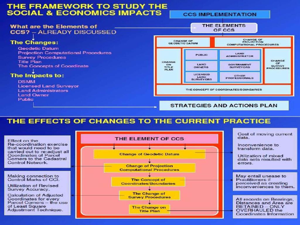
88 Level Instrument Calibration Method On the ground, two points A and B are marked a distance of approximately 50 metres apart. In sandy soil two pegs are used, on hard surfaces nails or paint may be used. The level is set up half way between the two points and carefully levelled. A levelling staff is placed at Peg A and a staff reading is taken then the level is placed on Peg B and a reading is taken. The staff reading at A is and at B The difference between the readings is
89 Level Instrument Calibration Method 89
90 Level Instrument Calibration Method 90
91 Level Instrument Calibration Method If the difference (e) is less than +/2mm per 40 meter, then the leveling equipment does not need adjustment. Foresight and backsight reading should be observed at the same distance so that the difference (e) is omitted or short so that the difference can be reduced. To adjust the instrument at point D, the readings obtained at A is a2 Calculated from a2'= a2-44e / 40, where L = 40 meters and L / 10 = 4 meters 91
92 Level Instrument Calibration Method Automatic leveling equipment is equipped with a special adjusting screw for the compensator, which is in addition to the moving diaphragm. Due to this adjustment requiring careful work, the leveling equipment must be returned to the manufacturer for the adjustment in the laboratory. 92
93 SURVEY UNIT (DISTANCE AND AREA) 93

")
94 Surveying Unit (Distance & Area) 94
")
95 Surveying Unit (Distance & Area) 95
96 COORDINATE SYSTEM IN CADASTRE SURVEY 96
97 Cadastral Control Infrastructure (CCI) Aspects of CCI and Re-adjustment of DCDB To readjust the whole cadastral network. To constraint the propagation of error in cadastral network. The usage of least square adjustment that will distribute the residues homogeneously in the large network. 97
98 Cadastral Control Infrastructure (CCI) 25,000 CCI stations MyRTKnet GPS data Tie-up survey data Final coordinates in GDM
99 Specifications for CCI AREA PRIMARY GRID SECONDARY GRID URBAN SEMI-URBAN RURAL 2.5 km x 2.5 km 10 km X 10 km 10 km X 10 km Connected to PGGN Observation Technique: static Observation Period hr Baseline Relative Accuracy less then 3ppm Coordinates Diff. From 2 Bases Stn. Less than 2 cm 0.5 km X 0.5 km 2.5 km X 2.5 km 2.5 km X 2.5 km Connected to Primary Grid Observation Technique: Rapid Static. Observation Period: min Baseline Relative Accuracy: Less than 3ppm Coordinate Differences From 2 Bases stn.: Less Than 3cm CADASTRAL CONTROL INFRASTRUCTURE PRIMARY GEODETIC GPS NETWORK MALAYSIAN ACTIVE GPS STATIONS CCI PGGN MASS Tertiary : 5, 2.5, 0.5 Spacing First Order: 238 stations Control Network Hierarchy Zero Order: 8 Stations 99
")
100 Cadastral Control Infrastructure (CCI) 100
")
101 Cadastral Control Infrastructure (CCI) 101
 EMPLOYING WHOLE TO THE PART CONCEPT & GPS")
102 Cadastral Control Infrastructure (CCI) CADASTRAL CONTROL INFRASTRUCTURE (CCI) EMPLOYING WHOLE TO THE PART CONCEPT & GPS TECHNOLOGY 102
103 Cadastral Coordinated System Definition of CCS (CCS) A cadastral reform program to improve the cadastral survey system. The use of least square adjustment for cadastral survey. The use of GPS for transfer of control for cadastral survey. Application of geocentric datum for cadastral and mapping Possible use of RSO in cadastral survey. The institutional and legal aspect of using coordinated system. 103
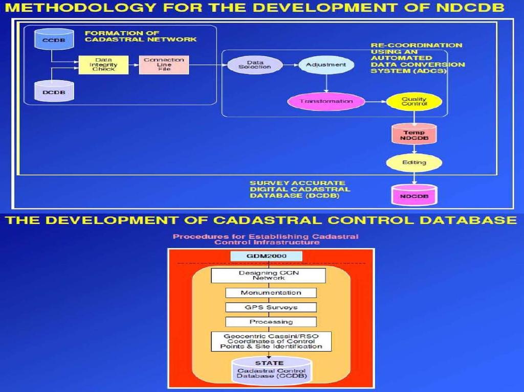
104 The Cost and Benefit of CCS Reduce field cost Reduce mobility cost Faster validation of survey work High accuracy using LSA 104
105 Main Component of CCS Coordinates - Unique Survey Accurate Coordinate - Legal (contributory) evidence of boundaries. CCI - Based on highest geodetic order - Adequate density. National Coordinate System - GDM Geocentric Cassini / RSO projection. DCDB - Contains complete cadastral map - Layered data content- appropriate data modelling design - Unique Parcel Identifier Automated Database Conversion System. Cadastral Survey Practice LSA - Whole to the Part. 105
106 CCS Conceptual Model The Characteristic (Entity) The Aspect (Attribute) Appropriate Data Modeling Unique Parcel Identifier Layered Complete Cadastral Maps Digital Cadastral Database (DCDB) Coordinates Legal (Contributory) Evidence of Boundaries Unique Single Set of Survey Accurate Coordinates CCS GDM2000 Common National Coordinate System Cadastral Survey Practice Cadastral Control Infrastructure Least Square Adjustment Geocentric Cassini/RSO Projection System Based on Highest Geodetic Order Adequate Density Whole-to-Part Survey Concept 106
 Populating DCDB With Survey Accurate Coordinates Automated Re-Coordination System Socio- Economic Related Actions Resurvey Finalized Geocentric")
107 CCS Implementation Model GDM2000 Establishing State Cadastral Control Infrastructure (CCI) Legal Organizational Related Actions New Cadastral Survey Tie-Up of Selected Parcel Corners to CCI Development of State Cadastral Control Database (CCDB) Populating DCDB With Survey Accurate Coordinates Automated Re-Coordination System Socio- Economic Related Actions Resurvey Finalized Geocentric Based Cassini & RSO Coordinates In DCDB 107
108 108
109 109
110 National Digital Cadastral Database BACKGROUND OF DCDB (NDCDB) Digital Cadastral Database (DCDB) contains all information obtained from cadastral survey jobs related to boundaries of land parcels. The existing DCDB, which covers the entire country, was developed from historical survey data (conversion from hardcopy Certified Plans to digital) as well as from current survey jobs. Coordinates in the DCDB were obtained from several means and contain varying, unpredictable, and un-quantified errors. 110
111 National Digital Cadastral Database (NDCDB) Uncertainties of surveyed values are typical, but errors are more common in some rural areas. To be able to support a modern cadastral system, an accurate positional record of the cadastre is imperative. The existing DCDB was not designed for this purpose. Digital Cadastral Database (DCDB) contains all information obtained from cadastral survey jobs related to boundaries of land parcels. Coordinates in the DCDB were obtained from several means and contain varying, unpredictable, and un-quantified errors. 111
112 National Digital Cadastral Database (NDCDB) The existing DCDB, which covers the entire country, was developed from historical survey data (conversion from hardcopy Certified Plans to digital) as well as from current survey jobs. Uncertainties of surveyed values are typical, but errors are more common in some rural areas. To be able to support a modern cadastral system, an accurate positional record of the cadastre is imperative. The existing DCDB was not designed for this purpose. 112


113 Different Types of Cadastral Coordinates RIGID COORDINATE PLOTTING COORDINATE SYSTEM COORDINATE Homogenous and Systematically Adjusted For cadastral map plotting purposes System/Software generated coordinate based on features location Rigid Coordinate Plotting Coordinate System Coordinate 113

114 System value Surveyed value 114
115 Old and New Geodetic Infrastructure GEODETIC TRIANGULATION PENINSULAR MALAYSIA GPS BASED REFERENCE SYSTEM 6.50 G071 G058 G028 G035 G023 G G057 G040 G047 G031 G030 G044 G054 G003 G025 G032 G033 G077 G G059 G076 G021 G019 G017 G063 G048 G026 G013 G050 G027 G060 G069 G053 G072 G008 G G024 G022 G037 G034 G005 G G G041 G G001 G074 G075 G070 G061 G073 G009 G036 G011 G G052 G055G065 G068 G038 G020 G066 G012 G G051 G010 G G014 G049 G002 G G043 G084 G045 G056 P075 G018 G064 P


116 Non Rigorous Adjustment Technique For Coordinates Computation Bowditch Least Squares GPS GPS Bowditch adjustment distributes closing errors linearly but not able to provide a unique coordinates solution. Least Squares adjustment technique determine a unique set of coordinates for each boundary mark from a set of observed values 116 (bearings & distances).
117 Methodology For Cadastral Data Migration To The New Geocentric Datum For Malaysia (GDM2000) Expected NDCDB Spatial Accuracy GDM2000 Establishment of Cadastral Control Infrastructure (CCI) Using JUPEM MyRTKnet GPS Service CATEGORY Urban/ New Development Std. Dev. Northing ± 5 cm or better Std. Dev. Easting ± 5 cm or better Cadastral Control Spacing 0.5 km Tie-Up of Selected Parcel Corners to CCI Automated Network Adjustment & Re-Coordination System Semi Urban/Rural ± 10 cm or better ± 10 cm or better 2.5 km Re-coordination and Re-population (R&R) Total estimated number of boundary marks to be recoordinated is about 40 million boundary marks. NDCDB 117
118 Methodology of NDCDB Establishment of CCI and State CCDB Establishing State Cadastral Control Infrastructure (CCI) Tie-Up of Selected Parcel Corners to CCI Repopulation & Re-coordination of DCDB with Survey Accurate Coordinates Development of State Cadastral Control Database (CCDB) Populating DCDB with Survey Accurate Coordinates Automated Re-Coordination System Study on Cadastral Survey Procedures Under CCS Cost-Benefit Analysis of CCS Implementation Finalized Geocentric Based Cassini & RSO Coordinates in DCDB 118
119 Adjustment of NDCDB CCDB FORMATION OF CADASTRAL NETWORK Data Integrity Check Connection Line File Data Selection Adjustment RE-COORDINATION USING AN AUTOMATED DATA CONVERSION SYSTEM (ADCS) DCDB Transformation Quality Control Temp NDCDB Editing SURVEY ACCURATE DIGITAL CADASTRAL DATABASE (NDCDB) NDCDB 119
120 National Digital Cadastral Database (NDCDB) Based on a uniform coordinate system, i.e. GDM2000 Cassini Soldner system. Uniform coordinate accuracy of about 5-10 cm throughout Peninsular Malaysia. Cadastral system that is compatible with GPS MyRTKnet system. Cadastral database that is compatible with GIS technology. 120
121 Advantages of NDCDB NDCDB just have a "single line" and is "compatible" with GIS technology. NDCDB graphic coordinates are similar to coordinate attributes. NDCDB will help the development of information systems, especially the "MULTI-PURPOSE Cadastre". 121
 State of Johor CCI Point")
122 National Digital Cadastral Database (NDCDB) State of Johor CCI Point 122
123 T H A N K YO U 123
CADASTRE SURVEY (SGHU 2313)
") CADASTRE SURVEY (SGHU 2313) WEEK 3-PREPARATION FOR CADASTRE SURVEY SR DR. TAN LIAT CHOON 07-5530844 016-4975551 1 OUTLINE Calibration of survey instruments Unit Pengukuran (Jarak dan Keluasan) Coordinate
CADASTRE SURVEY (SGHU 2313) WEEK 3-PREPARATION FOR CADASTRE SURVEY SR DR. TAN LIAT CHOON 07-5530844 016-4975551 1 OUTLINE Calibration of survey instruments Unit Pengukuran (Jarak dan Keluasan) Coordinate
INSTRUCTION: This section consists of TWO (2) structured questions. Answer ALL questions.
 structured questions. Answer ALL questions.") SECTION A : 50 MARKS BAHAGIAN A : 50 MARKAH INSTRUCTION: This section consists of TWO (2) structured questions. Answer ALL questions. ARAHAN: Bahagian ini mengandungi DUA (2) soalan berstruktur. Jawab
SECTION A : 50 MARKS BAHAGIAN A : 50 MARKAH INSTRUCTION: This section consists of TWO (2) structured questions. Answer ALL questions. ARAHAN: Bahagian ini mengandungi DUA (2) soalan berstruktur. Jawab
CADASTRE SURVEY (SGHU 2313)
") CADASTRE SURVEY (SGHU 2313) WEEK 3-METHOHS IN CADASTRAL SURVEY SR DR. TAN LIAT CHOON 07-5530844 016-4975551 1 OUTLINE Kaedah Ukur Kadastral 2 KAEDAH PENGUKURAN 3 Perlaksanaan Kerjaluar Ukuran terabas berkonsepkan
CADASTRE SURVEY (SGHU 2313) WEEK 3-METHOHS IN CADASTRAL SURVEY SR DR. TAN LIAT CHOON 07-5530844 016-4975551 1 OUTLINE Kaedah Ukur Kadastral 2 KAEDAH PENGUKURAN 3 Perlaksanaan Kerjaluar Ukuran terabas berkonsepkan
CADASTRE SURVEY PRACTICE (SGHU 4323)
") CADASTRE SURVEY PRACTICE (SGHU 4323) WEEK 11-eCADASTRE SR DR. TAN LIAT CHOON 07-5530844 016-4975551 1 OUTLINE Coordinated Cadastral System National Digital Cadastral Database Multipurpose Cadastre 3D Cadastre
CADASTRE SURVEY PRACTICE (SGHU 4323) WEEK 11-eCADASTRE SR DR. TAN LIAT CHOON 07-5530844 016-4975551 1 OUTLINE Coordinated Cadastral System National Digital Cadastral Database Multipurpose Cadastre 3D Cadastre
INSTRUCTION: This section consists of TWO (2) structured questions. Answer ALL questions.
 structured questions. Answer ALL questions.") SECTION A: 50 MARKS BAHAGIAN A: 50 MARKAH INSTRUCTION: This section consists of TWO (2) structured questions. Answer ALL questions. ARAHAN: Bahagian ini mengandungi DUA (2) soalan berstruktur. Jawab SEMUA
SECTION A: 50 MARKS BAHAGIAN A: 50 MARKAH INSTRUCTION: This section consists of TWO (2) structured questions. Answer ALL questions. ARAHAN: Bahagian ini mengandungi DUA (2) soalan berstruktur. Jawab SEMUA
PRESENTATION SUMMARY
 COORDINATED CADASTRAL SYSTEM FOR PENINSULAR MALAYSIA: FROM CONCEPT TO REALITY by: Professor Dr. Abd. Majid A. Kadir Associate Professor Ghazali Desa PMP Dr. Abdullah Hisam Omar Faculty of Geoinformation
SCOPE OF PRESENTATION
 INTERNATIONAL SYMPOSIUM AND EXHIBITION ON GEOINFORMATION Global Trends: Geoinformation For The New Economy Studies Toward the Development of Implementation Plan Of Coordinated Cadastral System for Peninsular
RMK 357 Land Administration [Pentadbiran Tanah]
![RMK 357 Land Administration [Pentadbiran Tanah]](/thumbs/89/97941171.jpg "RMK 357 Land Administration [Pentadbiran Tanah]") UNIVERSITI SAINS MALAYSIA Second Semester Examination 2009/2010 Academic Session April/May 2010 RMK 357 Land Administration [Pentadbiran Tanah] Duration: 3 hours [Masa: 3 jam] Please check that this examination
UNIVERSITI SAINS MALAYSIA Second Semester Examination 2009/2010 Academic Session April/May 2010 RMK 357 Land Administration [Pentadbiran Tanah] Duration: 3 hours [Masa: 3 jam] Please check that this examination
ESTIMATE IN FORMATION OF CONSTRUCTION CONTRACT EZATUL SHARIDA BINTI AHMAD TERMIZI UNIVERSITI TEKNOLOGI MALAYSIA
 ESTIMATE IN FORMATION OF CONSTRUCTION CONTRACT EZATUL SHARIDA BINTI AHMAD TERMIZI UNIVERSITI TEKNOLOGI MALAYSIA iii ESTIMATE IN FORMATION OF CONSTRUCTION CONTRACT EZATUL SHARIDA BINTI AHMAD TERMIZI A thesis
Jadual 1: Faktor Pemberat Bagi Jenis Petak (F1)
") Jadual 1: Faktor Pemberat Bagi Jenis Petak (F1) 179 Jadual 2: Faktor Pemberat Bagi Petak Lantai Keseluruhan (F2) 180 Jadual 3: Faktor Pemberat Bagi Petak Aksesori (F3) 181 Contoh Penggunaan Faktor Pemberat
Jadual 1: Faktor Pemberat Bagi Jenis Petak (F1) 179 Jadual 2: Faktor Pemberat Bagi Petak Lantai Keseluruhan (F2) 180 Jadual 3: Faktor Pemberat Bagi Petak Aksesori (F3) 181 Contoh Penggunaan Faktor Pemberat
CADASTRAL STUDIES (MGU1014 / MGHU1514)
") CADASTRAL STUDIES (MGU1014 / MGHU1514) WEEK 8-LAW AND REGULATIONS (FIELD) SR DR. TAN LIAT CHOON 07-5530844 016-4975551 1 OUTLINE Field Survey Practice 2 FIELD SURVEY PRACTICE 3 Survey Datum For new survey
CADASTRAL STUDIES (MGU1014 / MGHU1514) WEEK 8-LAW AND REGULATIONS (FIELD) SR DR. TAN LIAT CHOON 07-5530844 016-4975551 1 OUTLINE Field Survey Practice 2 FIELD SURVEY PRACTICE 3 Survey Datum For new survey
METHODOLOGY FOR THE DEVELOPMENT OF NATIONAL DIGITAL CADASTRAL DATABASE (NDCDB)
") KURSUS COORDINATED CADASTRAL SYSTEM (CCS) INSTITUT TANAH & UKUR NEGARA BEHRANG, PERAK METHODOLOGY FOR THE DEVELOPMENT OF NATIONAL DIGITAL CADASTRAL DATABASE (NDCDB) OLEH: PROF DR ABD MAJID BIN A KADIR
KURSUS COORDINATED CADASTRAL SYSTEM (CCS) INSTITUT TANAH & UKUR NEGARA BEHRANG, PERAK METHODOLOGY FOR THE DEVELOPMENT OF NATIONAL DIGITAL CADASTRAL DATABASE (NDCDB) OLEH: PROF DR ABD MAJID BIN A KADIR
CADASTRE SURVEY PRACTICE (SGHU 4323)
") CADASTRE SURVEY PRACTICE (SGHU 4323) WEEK 3-SURVEYING ACCORDING TO SECTION 396 OF NATIONAL LAND CODE 1965 SR DR. TAN LIAT CHOON 07-5530844 016-4975551 1 OUTLINE Survey Procedures and Deposited Plans (S396
CADASTRE SURVEY PRACTICE (SGHU 4323) WEEK 3-SURVEYING ACCORDING TO SECTION 396 OF NATIONAL LAND CODE 1965 SR DR. TAN LIAT CHOON 07-5530844 016-4975551 1 OUTLINE Survey Procedures and Deposited Plans (S396
THE INFLUENCE OF INTEREST AND UNDERSTANDING OF HOUSING DEVELOPERS ON GATED COMMUNITIES DEVELOPMENT AINUR ZAIREEN BINTI ZAINUDIN
 THE INFLUENCE OF INTEREST AND UNDERSTANDING OF HOUSING DEVELOPERS ON GATED COMMUNITIES DEVELOPMENT AINUR ZAIREEN BINTI ZAINUDIN A thesis submitted in fulfilment of the requirements for the award of the
NOVATION AGREEMENT IN DESIGN AND BUILD CONTRACTS NATASHA SAHIL UNIVERSITI TEKOLOGI MALAYSIA
 NOVATION AGREEMENT IN DESIGN AND BUILD CONTRACTS NATASHA SAHIL UNIVERSITI TEKOLOGI MALAYSIA iii To my beloved Husband and son, Thank you for your support, guidance and everything. iv ACKNOWLEDGEMENTS In
KERAJAAN MALAYSIA SURAT PEKELILING PERBENDAHARAAN BIL. 4 TAHUN 2003
 S/K.KEW/PK/PP/1100/000000/10/31 Jld.16 ( 16 ) KERAJAAN MALAYSIA SURAT PEKELILING PERBENDAHARAAN BIL. 4 TAHUN 2003 Semua Ketua Setiausaha Kementerian, Semua Ketua Jabatan Persekutuan, Semua YB Setiausaha
Faculty of Built Environment Universiti Teknologi Malaysia
 ARCHITECT S DUTIES IN RELATION TO SUPERVISION OF CONSTRUCTION PROJECTS SHARISA HUSSEIN A master s project report submitted in fulfillment of the requirements for the award of the degree of Master of Science
LAND ACQUISITION ISSUES FOR JABATAN KERJA RAYA s ROAD WORK PROJECT NOOR FAZURA ABU SAMAAN
 LAND ACQUISITION ISSUES FOR JABATAN KERJA RAYA s ROAD WORK PROJECT NOOR FAZURA ABU SAMAAN A capstone project report submitted in partial fulfilment of the requirements for the award of the degree of Master
JADUAL IX KANUN TANAH NEGARA [Aturan 36J (2)] NOTIS TAWARAN
![JADUAL IX KANUN TANAH NEGARA [Aturan 36J (2)] NOTIS TAWARAN](/thumbs/77/76166484.jpg "JADUAL IX KANUN TANAH NEGARA [Aturan 36J (2)] NOTIS TAWARAN") Kepada... JADUAL IX KANUN TANAH NEGARA [Aturan 36J (2)] NOTIS TAWARAN Suatu siasatan telah dijalankan ke atas tanah...... pada... dan didapati bahawa terdapat struktur / bangunan di atasnya dengan keluasan...
Kepada... JADUAL IX KANUN TANAH NEGARA [Aturan 36J (2)] NOTIS TAWARAN Suatu siasatan telah dijalankan ke atas tanah...... pada... dan didapati bahawa terdapat struktur / bangunan di atasnya dengan keluasan...
CADASTRAL STUDIES (MGU1014 / MGHU1514)
") CADASTRAL STUDIES (MGU1014 / MGHU1514) WEEK 10-eCADASTRE SYSTEM AND MULTIPURPOSE CADASTRE SR DR. TAN LIAT CHOON 07-5530844 016-4975551 1 OUTLINE ecadastre System Multipurpose Cadastre 2 ecadastre SYSTEM
CADASTRAL STUDIES (MGU1014 / MGHU1514) WEEK 10-eCADASTRE SYSTEM AND MULTIPURPOSE CADASTRE SR DR. TAN LIAT CHOON 07-5530844 016-4975551 1 OUTLINE ecadastre System Multipurpose Cadastre 2 ecadastre SYSTEM
Section 7 : Road Lighting
 STD DRW/S7 JKR 20400-0101-16 KERAJAAN MALAYSIA STANDARD STANDARD DRAWINGS DRAWING FOR FOR ROAD ROAD WORKS WORKS Section 7 : Road Lighting Ketua Pengarah Kerja Raya Jabatan Kerja Raya Malaysia Jalan Sultan
CADASTRE SURVEY PRACTICE (SGHU 4323)
") CADASTRE SURVEY PRACTICE (SGHU 4323) WEEK 2-CADASTRAL SURVEYING FOR ISSUE OF TITLES SR DR. TAN LIAT CHOON 07-5530844 016-4975551 1 OUTLINE Definition of Cadastral Survey Registration of Titles (S77, S85,
CADASTRE SURVEY PRACTICE (SGHU 4323) WEEK 2-CADASTRAL SURVEYING FOR ISSUE OF TITLES SR DR. TAN LIAT CHOON 07-5530844 016-4975551 1 OUTLINE Definition of Cadastral Survey Registration of Titles (S77, S85,
TEMPLATE SERAGAM SENARAI SEMAK DOKUMEN DAN SENARAI SEMAK TERPERINCI AGENSI TEKNIKAL JKT
 Maklumat Tambahan Selaras dengan arahan SPAN, PBAN tidak lagi membuat semakan pematuhan terhadap permohonan Pelan Bangunan. Pemohon perlu mengambilkira keperluan-keperluan PBAN masing-masing di samping
PROFESSIONAL PRACTICE (SGHU 4342)
") PROFESSIONAL PRACTICE (SGHU 4342) WEEK 4-REGISTRATION AND LICENCE TO PRACTICE SR DR. TAN LIAT CHOON 07-5530844 016-4975551 1 OUTLINE Preliminary Registration and Licence to Practice 2 PRELIMINARY 3 Citation
PROFESSIONAL PRACTICE (SGHU 4342) WEEK 4-REGISTRATION AND LICENCE TO PRACTICE SR DR. TAN LIAT CHOON 07-5530844 016-4975551 1 OUTLINE Preliminary Registration and Licence to Practice 2 PRELIMINARY 3 Citation
Developing Infrastructure Framework To Facilitate The Malaysia Multipurpose 3D Cadastre
 Developing Infrastructure Framework To Facilitate The Malaysia Multipurpose 3D Cadastre Sr Dr. Tan Liat Choon Sr Looi Kam Seng University of Technology Malaysia Department of Survey and mapping Malaysia
Submit to State PTG by proprietor within 2 weeks. State CS within 1 month. Superstructure Stage
 A Superstructure Stage 4 Submit to State PTG by proprietor within 2 weeks. Application for CPSP 5 within 3 months after superstructure stage. 1 month extension. FAIL Approval of CPSP 6 State CS within
DOKUMEN TIDAK TERKAWAL
 Halaman: 1/9 1.0 TUJUAN Menerangkan kaedah Dokumen yang dilaksanakan bagi mengesan dan mendapatkan dokumen yang dimohon oleh pengguna warga UPM. 2.0 SKOP 2.1 Meliputi semua permohonan untuk mendapatkan
MANUAL PROSEDUR KERJA PEMBANGUNAN APLIKASI
 UNIT BAHAGIAN PEMBANGUNAN APLIKASI MUKA SURAT 1 dari 31 PEMBANGUNAN APLIKASI BAHAGIAN SISTEM MAKLUMAT PUSAT TEKNOLOGI MAKLUMAT UNIVERSITI TUN HUSSEIN ONN MALAYSIA UNIT UNIT PEMBANGUNAN APLIKASI MUKA SURAT
OPERASI PERKHIDMATAN SOKONGAN. PERPUSTAKAAN SULTAN ABDUL SAMAD Kod Dokumen: UPM/OPR/PSAS/P016
 Halaman: 1/9 1.0 TUJUAN Menerangkan kaedah Perkhidmatan Pembekalan Dokumen yang dilaksanakan bagi mengesan dan mendapatkan dokumen yang dimohon oleh pengguna warga UPM. 2.0 SKOP 2.1 Meliputi semua permohonan
OUTLINE. Office Practice
 OUTLINE Office Practice 1 OFFICE PRACTICE 2 Deposited Plan Section 410 of the National Land Code 1965 provides the deposited plan that is a plan of the land shall be deposited if it is certified by the
RMK 357- Land Administration fpentadbiran Tanah]
![RMK 357- Land Administration fpentadbiran Tanah]](/thumbs/72/66289997.jpg "RMK 357- Land Administration fpentadbiran Tanah]") t UNIVERSITI SAINS MALAYSIA Second Semester Examination Academic Session 200812009 April/May 2009 RMK 357- Land Administration fpentadbiran Tanah] Duration: 3 hours [Masa: 3 jam] Please check that this
t UNIVERSITI SAINS MALAYSIA Second Semester Examination Academic Session 200812009 April/May 2009 RMK 357- Land Administration fpentadbiran Tanah] Duration: 3 hours [Masa: 3 jam] Please check that this
LAND LAW AND SURVEY REGULATION (SGHU 3313)
") LAND LAW AND SURVEY REGULATION (SGHU 3313) WEEK 13-STRATA TITLES MANAGEMENT SR DR. TAN LIAT CHOON 07-5530844 016-4975551 1 OUTLINE Latest Legislations and its Effect Highlights of Improvements Over Building
LAND LAW AND SURVEY REGULATION (SGHU 3313) WEEK 13-STRATA TITLES MANAGEMENT SR DR. TAN LIAT CHOON 07-5530844 016-4975551 1 OUTLINE Latest Legislations and its Effect Highlights of Improvements Over Building
CONSULTANT ARCHITECT S DILIGENCE IN RAIL INFRASTRUCTURE PROJECT SHAMS ARIDA BIN ARIFFIN
 iii CONSULTANT ARCHITECT S DILIGENCE IN RAIL INFRASTRUCTURE PROJECT SHAMS ARIDA BIN ARIFFIN A thesis submitted in partial fulfilment of the requirements for the award of the degree of Masters of Science
DLANGUAGE STUDIO NO 30 1 st FLOOR PERSIARAN B RAYA LANGKAWI MALL KEDAH D.A KERTAS PENERANGAN L FRONT OFFICE ASSISTANT
 DLANGUAGE STUDIO NO 30 1 st FLOOR PERSIARAN B RAYA LANGKAWI MALL 07000 KEDAH D.A KERTAS PENERANGAN KOD DAN NAMA PROGRAM / PROGRAM CODE AND NAME TAHAP / LEVEL NO DAN TAJUK MODUL/ MODULE NO AND TITLE L-160-2
MEMBUAT DAN MENGUJI UNIT KAWALAN SUHU MOHD FARMEZEE BIN ABDULLAH UNIVERSITI TEKNIKAL MALAYSIA MELAKA
 MEMBUAT DAN MENGUJI UNIT KAWALAN SUHU MOHD FARMEZEE BIN ABDULLAH UNIVERSITI TEKNIKAL MALAYSIA MELAKA MEMBUAT DAN MENGUJI UNIT KAWALAN SUHU MOHD FARMEZEE BIN ABDULLAH Laporan ini dikemukakan sebagai memenuhi
CURRENT TREND IN GEOINFORMATION TECHNOLOGY INTRODUCTION
 CURRENT TREND IN GEOINFORMATION TECHNOLOGY STUDIES TOWARD THE DEVELOPMENT OF IMPLEMENTATION PLAN OF COORDINATED CADASTRAL SYSTEM FOR MALAYSIA Abd. Majid A. Kadir, Shahrum Ses, Ghazali Desa, Kamalludin
HURAIAN PINDAAN DOKUMEN ISO UPM
 HURAIAN PINDAAN DOKUMEN ISO UPM BAHAGIAN A: Huraian Dokumen ISO (Diisi oleh Pemohon/ sila abaikan ruangan No. kerana akan dilengkapkan oleh TPKD PP) No. 1/2016 Nama Dokumen: Arahan Kerja Permohonan Kad
SISTEM TEMPAHAN KERETA SEWA BERASASKAN WEB (UKM EZ-CAR) Noor Aznida Farina Binti Md Saad Masnizah Mohd
 Noor Aznida Farina Binti Md Saad Masnizah Mohd") SISTEM TEMPAHAN KERETA SEWA BERASASKAN WEB (UKM EZ-CAR) Noor Aznida Farina Binti Md Saad Masnizah Mohd Fakulti Teknologi & Sains Maklumat, Universiti Kebangsaan Malaysia ABSTRAK Sistem berasaskan web iaitu
SISTEM TEMPAHAN KERETA SEWA BERASASKAN WEB (UKM EZ-CAR) Noor Aznida Farina Binti Md Saad Masnizah Mohd Fakulti Teknologi & Sains Maklumat, Universiti Kebangsaan Malaysia ABSTRAK Sistem berasaskan web iaitu
Practical issue arising and how can developers adapt to new requirement
 Certificate of Completion and Compliance (CCC)/ Integrated Mixed Developments: Practical issue arising and how can developers adapt to new requirement Is it a New Requirement or an existing requirement
INSTRUCTION: This section consists of THREE (3) essay questions. Answer ALL questions.
 essay questions. Answer ALL questions.") SECTION B: 75 MARKS BAHAGIAN B: 75 MARKAH INSTRUCTION: This section consists of THREE (3) essay questions. Answer ALL questions. ARAHAN: Bahagian ini mengandungi TIGA (3) soalan esei. Jawab semua soalan.
SECTION B: 75 MARKS BAHAGIAN B: 75 MARKAH INSTRUCTION: This section consists of THREE (3) essay questions. Answer ALL questions. ARAHAN: Bahagian ini mengandungi TIGA (3) soalan esei. Jawab semua soalan.
Abstract. the individual apartment units in a multi-storey apartment building. The hypothesis
 Abstract The aim of the research reported in this thesis was to determine the influence of building heights on radon and thoron concentration via permeation and diffusion into the individual apartment
UNIVERSITI TEKNOLOGI MALAYSIA
 UNIVERSITI TEKNOLOGI MALAYSIA PSZ 19:16 (Pind. 1/97) BORANG PENGESAHAN STATUS TESIS JUDUL: THE STUDY OF PROBLEMS FACED BY PROPERTY MANAGEMENT IN MANAGING THE HIGH RISE CONDOMINIUM IN MALAYSIA Saya SESI
CADASTRE SURVEY PRACTICE (SGHU 4323)
") CADASTRE SURVEY PRACTICE (SGHU 4323) WEEK 3-SURVEYING ACCORDING TO SECTION 396 OF NATIONAL LAND CODE 1965 SR DR. TAN LIAT CHOON 07-5530844 016-4975551 1 OUTLINE Survey Procedures and Deposited Plans (S396
CADASTRE SURVEY PRACTICE (SGHU 4323) WEEK 3-SURVEYING ACCORDING TO SECTION 396 OF NATIONAL LAND CODE 1965 SR DR. TAN LIAT CHOON 07-5530844 016-4975551 1 OUTLINE Survey Procedures and Deposited Plans (S396
Jadual H, Fasal 27 Cara Penyerahan Pemilikan Kosong Akta Pemajuan Perumahan (Kawalan Dan Pelesenan) 1966 Akta 118
 1966 Akta 118") Jadual H, Fasal 27 Cara Penyerahan Pemilikan Kosong Akta Pemajuan Perumahan (Kawalan Dan Pelesenan) 1966 Akta 118 (2) Penyerahan pemilikan kosong oleh pemaju hendaklah disokong oleh suatu perakuan siap
Jadual H, Fasal 27 Cara Penyerahan Pemilikan Kosong Akta Pemajuan Perumahan (Kawalan Dan Pelesenan) 1966 Akta 118 (2) Penyerahan pemilikan kosong oleh pemaju hendaklah disokong oleh suatu perakuan siap
RMK 357 Land Administration [Pentadbiran Tanah]
![RMK 357 Land Administration [Pentadbiran Tanah]](/thumbs/74/71283476.jpg "RMK 357 Land Administration [Pentadbiran Tanah]") UNIVERSITI SAINS MALAYSIA Second Semester Examination Academic Session 2012/2013 June 2013 RMK 357 Land Administration [Pentadbiran Tanah] Duration: 3 hours [Masa: 3 jam] Please check that this examination
UNIVERSITI SAINS MALAYSIA Second Semester Examination Academic Session 2012/2013 June 2013 RMK 357 Land Administration [Pentadbiran Tanah] Duration: 3 hours [Masa: 3 jam] Please check that this examination
SALINAN DOKUMEN TERKAWAL
 No. Rujukan : PK. UiTM.(0).25 Muka Surat : 1/ 8 PK. UiTM..(O).25 Disediakan oleh Disemak oleh Diluluskan oleh T/Tangan Nama Dr. Asliza Aris Dr. Arba iyah Ab. Aziz Prof. Dr. Hj. D zul Haimi Md. Zaim (A.I.S)
KAJIAN TERHADAP KUALITI UDARA DALAMAN BAGI BILIK KULIAH DI POLITEKNIK MERLIMAU
 Volume: 1 Issues: 12 [December, 2018] pp.-11-22] International Journal of Tourism, Hospitality and Environment Management eissn: 0128-178X Journal website: www.xxxx.com KAJIAN TERHADAP KUALITI UDARA DALAMAN
TAJUK PEMBENTANGAN : PERUNDANGAN TANAH DI BRUNEI DARUSSALAM DISAMPAIKAN OLEH : AMAL HAYATI HAJI JUNAIDI PEGAWAI TANAH BAHAGIAN PENDAFTARAN
 14 TH SOUTH EAST ASIA SURVEY CONGRESS (SEASC) 15 17 OGOS 2017 RIZQUN INTERNATIONAL HOTEL TAJUK PEMBENTANGAN : PERUNDANGAN TANAH DI BRUNEI DARUSSALAM DISAMPAIKAN OLEH : AMAL HAYATI HAJI JUNAIDI PEGAWAI
PENGURUSAN. Kod Dokumen: UPM/PGR/P001. PROSEDUR PENGURUSAN DOKUMEN ISO Tarikh: 20/6/2017
 Halaman: 1/7 1.0 TUJUAN Prosedur ini disediakan bagi tujuan menerangkan tatacara pengurusan Sistem Pengurusan ISO di Universiti Putra Malaysia. 2.0 SKOP Prosedur ini : merangkumi penghasilan, kelulusan,
OPERASI PERKHIDMATAN SOKONGAN PERPUSTAKAAN SULTAN ABDUL SAMAD Kod Dokumen: UPM/OPR/PSAS/P015. PROSEDUR PERKHIDMATAN MAKLUMAT Tarikh: 18/08/2017
 Halaman 1/15 1.0 TUJUAN Prosedur ini disediakan bagi tujuan menerangkan kaedah pengendalian dan penyediaan perkhidmatan maklumat. 2.0 SKOP Prosedur ini merangkumi semua permohonan daripada pelanggan dalam
SISTEM PENGURUSAN DOKUMEN (INFOBOX) Athirah Hazira Ab Halim Rodziah Latih ABSTRAK
 Athirah Hazira Ab Halim Rodziah Latih ABSTRAK") SISTEM PENGURUSAN DOKUMEN (INFOBOX) Athirah Hazira Ab Halim Rodziah Latih ABSTRAK Pada masa kini, sistem berasaskan elektronik membolehkan pengguna mengurus dokumen dengan mudah serta meningkatkan kadar
SISTEM PENGURUSAN DOKUMEN (INFOBOX) Athirah Hazira Ab Halim Rodziah Latih ABSTRAK Pada masa kini, sistem berasaskan elektronik membolehkan pengguna mengurus dokumen dengan mudah serta meningkatkan kadar
OPERASI PERKHIDMATAN SOKONGAN PERPUSTAKAAN SULTAN ABDUL SAMAD Kod Dokumen: UPM/OPR/PSAS/P015. PROSEDUR PERKHIDMATAN MAKLUMAT Tarikh: 29/06/2018
 Halaman 1/16 1.0 TUJUAN Prosedur ini disediakan bagi tujuan menerangkan kaedah pengendalian dan penyediaan perkhidmatan maklumat. 2.0 SKOP Prosedur ini merangkumi semua permohonan daripada pelanggan dalam
SOKONGAN KEWANGAN. PEJABAT BURSAR Kod Dokumen: UPM/SOK/KEW-BUY/P005. PROSEDUR SEBUT HARGA UNIVERSITI Tarikh: 18/08/2016
 Halaman: 1/13 1.0 TUJUAN 2.0 SKOP Prosedur ini disediakan bagi tujuan untuk menerangkan tatacara dan prosedur terperinci serta tanggungjawab bagi proses perolehan secara Sebut Harga Universiti. Prosedur
CADASTRE SURVEY PRACTICE (SGHU 4323)
") CADASTRE SURVEY PRACTICE (SGHU 4323) WEEK 10&11-STRATA TITLES MANAGEMENT SR DR. TAN LIAT CHOON 07-5530844 016-4975551 1 OUTLINE Latest Legislations and its Effect Highlights of Improvements Over Building
CADASTRE SURVEY PRACTICE (SGHU 4323) WEEK 10&11-STRATA TITLES MANAGEMENT SR DR. TAN LIAT CHOON 07-5530844 016-4975551 1 OUTLINE Latest Legislations and its Effect Highlights of Improvements Over Building
Kajian Penggunaan Termometer yang Berbeza ke atas Kualiti Penggorengan Hasilan Kerepek
 Kajian Penggunaan Termometer yang Berbeza ke atas Kualiti Penggorengan Hasilan Kerepek Mohd Syukri bin Mustafa 1, Najmi Hafizi bin Zabawi 2, Nordalilah binti Wahab 3 dan Halimah binti Ab Rahim 3 Jabatan
KAWALAN DOKUMEN. Tarikh: 29 Disember 2017 Tarikh: 29 Disember 2017
 NO.PINDAAN 00 MUKA SURAT 1/10 Disediakan oleh Diluluskan oleh Jawatan KETUA JABATAN JABATAN PENGURUSAN KUALITI DAN KEUTUHAN Jawatan REKTOR INSTITUT PENDIDIKAN GURU MALAYSIA Tarikh 29 Disember 2017 Tarikh
Faculty of Information and Communication Technology
 Faculty of Information and Communication Technology REAL ESTATE RECOMMENDER SYSTEMS USING CASE-BASED REASONING APPROACH Ebrahim Mohammed Abdo Alrawhani Master of Computer Science in Internetworking Technology
Tafsiran Dokumen untuk Permohonan evdr PRA
 1. Personal Bond (Ikatan Peribadi) ii) Harus mempunyai setem hasil RM10 berwarna. iii) Harus mempunyai maklumat majikan seperti nama, alamat dan nombor pengenalan majikan. iv) Harus mempunyai maklumat
Keywords: Pollutants, swirling flow, double radial swirler, combustion. Kata kunci: Bahan cemar, aliran berpusar, pemusar dwi aliran, pembakaran
 Jurnal Teknologi Full Paper KESAN SUDUT PUSARAN TERHADAP PEMBAKARAN MENGGUNAKAN PEMUSAR JEJARIAN DWI ALIRAN Muhammad Roslan Rahim a*, Mohammad Nazri Mohd Ja afar a,b a Department of Aeronautical, Automotive
PROCLAMATION OF SALE IN THE MATTER OF DEED OF ASSIGNMENT DATED 16 TH APRIL, 2004
 PROCLAMATION OF SALE IN THE MATTER OF DEED OF ASSIGNMENT DATED 16 TH APRIL, 2004 BANK KERJASAMA RAKYAT MALAYSIA BERHAD BETWEEN AND Assignee/Bank BAHARUDIN BIN OTHAMAN (NRIC NO.: 750601-02-6509/ A3122025)
FORM OF ACCEPTANCE AND TRANSFER CONDITIONAL MANDATORY TAKE-OVER OFFER DATUK SERI TAN JING NAM, MR ANDREW TAN JUN SUAN AND DATO TAN LEE SING
 FORM OF ACCEPTANCE AND TRANSFER THIS FORM OF ACCEPTANCE AND TRANSFER ( FORM ) IS IMPORTANT AND REQUIRES YOUR IMMEDIATE ATTENTION AND IS TO BE READ IN CONJUNCTION WITH THE OFFER DOCUMENT DATED 3 MARCH 2017
Jurnal Teknologi. Full Paper. Idris Zulkifle a*, Mohd Hafidz Hj Ruslan a, Mohd. Yusof Hj Othman a, Zahari Ibarahim a, Kamaruzzaman Sopian b
 Jurnal Teknologi DRYING OF ASAM GELUGUR (GARCINIA ATROVIRIDIS) USING SOLAR DRYING SYSTEM PENGERINGAN ASAM GELUGUR (GARCINIA ATROVIRIDIS) MENGGUNAKAN SISTEM PENGERING SURIA Idris Zulkifle a*, Mohd Hafidz
PEMBEBANAN SERBUK YANG OPTIMUM BAGI BAHAN SUAPAN DARIPADA SS 316 L, PEG, PMMA DAN AS BAGI PROSES PENGACUANAN SUNTIKAN LOGAM (MIM)
") PEMBEBANAN SERBUK YANG OPTIMUM BAGI BAHAN SUAPAN DARIPADA SS 316 L, PEG, PMMA DAN AS BAGI PROSES PENGACUANAN SUNTIKAN LOGAM (MIM) Norhamidi Muhamad, Murtadhahadi, Che Hassan Che Harun, Abu Bakar Sulong,
PEMBEBANAN SERBUK YANG OPTIMUM BAGI BAHAN SUAPAN DARIPADA SS 316 L, PEG, PMMA DAN AS BAGI PROSES PENGACUANAN SUNTIKAN LOGAM (MIM) Norhamidi Muhamad, Murtadhahadi, Che Hassan Che Harun, Abu Bakar Sulong,
THE PROCLAMATION OF SALE IN THE MATTER OF THE COMPOSITE LOAN AGREEMENT AND ASSIGNMENT AND POWER OF ATTORNEY BOTH DATED THE 18 TH APRIL 2005 BETWEEN
 THE PROCLAMATION OF SALE IN THE MATTER OF THE COMPOSITE LOAN AGREEMENT AND ASSIGNMENT AND POWER OF ATTORNEY BOTH DATED THE 18 TH APRIL 2005 BETWEEN AmBank (M) Berhad [8515-D] ASSIGNEE/BANK AND KANDAH ALANGARAM
TROPICANA CORPORATION BERHAD ( TROPICANA )
") TROPICANA CORPORATION BERHAD ( TROPICANA ) DISPOSAL OF FREEHOLD LAND WITH DEVELOPABLE AREA MEASURING IN AGGREGATE OF APPROXIMATELY 251.5855 ACRES IN AREA IN THE MUKIM OF PULAI, DISTRICT OF JOHOR BAHRU,
TROPICANA CORPORATION BERHAD ( TROPICANA ) DISPOSAL OF FREEHOLD LAND WITH DEVELOPABLE AREA MEASURING IN AGGREGATE OF APPROXIMATELY 251.5855 ACRES IN AREA IN THE MUKIM OF PULAI, DISTRICT OF JOHOR BAHRU,
DOCTRINE OF PRIVITY AND ITS APPLICATION IN RELATION TO SUB-CONTRACTOR S PAYMENT NOR AIDA BINTI MOHD AMIN
 DOCTRINE OF PRIVITY AND ITS APPLICATION IN RELATION TO SUB-CONTRACTOR S PAYMENT NOR AIDA BINTI MOHD AMIN A dissertation submitted in partial fulfilment for the award of the degree of Master of Science
SARATOGOA SDN BHD (Company No.: P) (Receiver Appointed)(In Liquidation) TENDER SSB/1
 (Receiver Appointed)(In Liquidation) TENDER SSB/1") SARATOGOA SDN BHD (Company No.: 52341-P) (Receiver Appointed)(In Liquidation) TENDER SSB/1 TENDER FORM To: The Receiver Saratogoa Sdn Bhd (Receiver Appointed)(In Liquidation) c/o HLB Ler Lum B-3-11, Megan
SARATOGOA SDN BHD (Company No.: 52341-P) (Receiver Appointed)(In Liquidation) TENDER SSB/1 TENDER FORM To: The Receiver Saratogoa Sdn Bhd (Receiver Appointed)(In Liquidation) c/o HLB Ler Lum B-3-11, Megan
KETEGASAN HABA DAN HUBUNGANNYA DENGAN PERUBAHAN FISIOLOGI DI KALANGAN PEKERJA LELAKI KILANG PEMBUATAN KOMPONEN AUTOMOTIF, SHAH ALAM
 ORIGINAL ARTICLE KETEGASAN HABA DAN HUBUNGANNYA DENGAN PERUBAHAN FISIOLOGI DI KALANGAN PEKERJA LELAKI KILANG PEMBUATAN KOMPONEN AUTOMOTIF, SHAH ALAM Nurul Ainun Hamzah 1, Shamsul Bahri Mohd Tamrin 2 1
Perjanjian Rakan Kongsi (IB)
") Perjanjian Rakan Kongsi (IB) 2 FBS Markets Inc., dirujuk di sini sebagai "Syarikat" dan Pelanggan, yang membuka akaun IB di, lagi dalam ini dirujuk sebagai "Introducing Broker", bersama-sama disebut sebagai
Perjanjian Rakan Kongsi (IB) 2 FBS Markets Inc., dirujuk di sini sebagai "Syarikat" dan Pelanggan, yang membuka akaun IB di, lagi dalam ini dirujuk sebagai "Introducing Broker", bersama-sama disebut sebagai
HURAIAN PINDAAN DOKUMEN ISO UPM
 HURAIAN INDAAN DOKUMEN ISO UM BAHAGIAN A: Huraian Dokumen ISO (Diisi oleh emohon/ dan sila abaikan ruangan No. kerana akan dilengkapkan oleh KD ) No. QMS (OR): UM- 1/2018 enerbit UM Nama Dokumen: ROSEDUR
KEBERKESANAN PENGELUARAN HAKMILIK KEKAL BERDASARKAN PINDAAN KANUN TANAH NEGARA 1965 (AKTA A1104)
") KEBERKESANAN PENGELUARAN HAKMILIK KEKAL BERDASARKAN PINDAAN KANUN TANAH NEGARA 1965 (AKTA A1104) HAJI ALIAS HAJI IBRAHIM BSc (Hons) Surv. Sc. (Newcastle) UK Fakulti Kejuruteraan dan Sains Geoinformasi,
KEBERKESANAN PENGELUARAN HAKMILIK KEKAL BERDASARKAN PINDAAN KANUN TANAH NEGARA 1965 (AKTA A1104) HAJI ALIAS HAJI IBRAHIM BSc (Hons) Surv. Sc. (Newcastle) UK Fakulti Kejuruteraan dan Sains Geoinformasi,
CADASTRE SURVEY (SGHU 2313)
") CADASTRE SURVEY (SGHU 2313) WEEK 1-SECTION 396-413 NATIONAL LAND CODE 1965 SR DR. TAN LIAT CHOON 07-5530844 016-4975551 1 OUTLINE Survey according to Section 396 National Land Code 1965 Regulations regarding
CADASTRE SURVEY (SGHU 2313) WEEK 1-SECTION 396-413 NATIONAL LAND CODE 1965 SR DR. TAN LIAT CHOON 07-5530844 016-4975551 1 OUTLINE Survey according to Section 396 National Land Code 1965 Regulations regarding
SOKONGAN KEWANGAN PEJABAT BURSAR UPM/SOK/KEW-BYR/P011. PROSEDUR PEMBAYARAN GAJI ATAU ELAUN Tarikh: 05/06/2015
 Halaman: 1/11 1.0 TUJUAN Prosedur ini disediakan untuk menerangkan tatacara pembayaran gaji atau elaun. 2.0 SKOP Meliputi pembayaran gaji pegawai tetap dan sementara serta elaun pelajar. 3.0 DOKUMEN RUJUKAN
ISU-ISU PENGINTEGRASIAN PANGKALAN DATA UKUR KADASTER DAN SISTEM PENDAFTARAN TANAH BERKOMPUTER GENGATHARAN A/L MARIAPPAN
 ISU-ISU PENGINTEGRASIAN PANGKALAN DATA UKUR KADASTER DAN SISTEM PENDAFTARAN TANAH BERKOMPUTER GENGATHARAN A/L MARIAPPAN Tesis ini dikemukakan sebagai memenuhi syarat penganugerahan Ijazah Sarjana Sains
KOD :
 www.menti.com KOD : 967643 1 J K A P I T N S B B K P I B P P P P W N T D RAJENDRAN A/L ARJUNAN CA(M), CFPA KETUA PROGRAM PERAKAUNAN INSTITUT PERAKAUNAN NEGARA JABATAN AKAUNTAN NEGARA Sesi 1 PENGENALAN
Rencana-Rencanal Arlicles
 Rencana-Rencanal Arlicles Bentuk Tajuk Nama: Perubahan-Perubahan Oi Dalam Katalog-Katalog Perpustakaan Universiti Malaya oleh Molly Chuah* Terjemahan oleh Jalaludin Hj. Musa dan Noriyah Nor Abet Rahim
KENYATAAN TAWARAN TENDER HOSPITAL PUSRAWI SDN BHD
 KENYATAAN TAWARAN TENDER HOSPITAL PUSRAWI SDN BHD 1. Tender ini adalah dipelawa kepada pembekal yang berdaftar dengan Suruhanjaya Syarikat Malaysia ( SSM). Tender Di paparkan di Laman Web Pusrawi Tarikh
PROCLAMATION OF SALE IN THE MATTER OF THE COMPOSITE LOAN AGREEMENT AND ASSIGNMENT AND POWER OF ATTORNEY BOTH DATED 12 TH JULY, 2003 BETWEEN
 PROCLAMATION OF SALE IN THE MATTER OF THE COMPOSITE LOAN AGREEMENT AND ASSIGNMENT AND POWER OF ATTORNEY BOTH DATED 12 TH JULY, 2003 BETWEEN AmBank (M) Berhad [8515-D] AND SAMSINAR BINTI AHMAD ZAINI (F)
THE STUDY OF PROBLEMS FACED BY PROPERTY MANAGEMENT IN MANAGING THE HIGH RISE CONDOMINIUM IN MALAYSIA NORAZIAH AZMIN BT ABD LATIF AZMI
 THE STUDY OF PROBLEMS FACED BY PROPERTY MANAGEMENT IN MANAGING THE HIGH RISE CONDOMINIUM IN MALAYSIA NORAZIAH AZMIN BT ABD LATIF AZMI A project report submitted in partial fulfillment of the requirements
The Integration of CORS Networks and the Cadastre and its Application in NSW, Australia
 The Integration of CORS Networks and the Cadastre and its Application in NSW, Australia Jai REDDY, Australia Key words: digital cadastre, CORS, GNSS, cadastral system SUMMARY In many countries, CORS networks
Sains Malaysiana 47(4)(2018):
(2018):") Sains Malaysiana 47(4)(2018): 789-795 http://dx.doi.org/10.17576/jsm-2018-4704-18 Kebergantungan Suhu dengan Penggunaan Tiub Kuarza Relau ke atas Sel Suria Dwi-Muka (Temperature Dependences by using Furnace
Sains Malaysiana 47(4)(2018): 789-795 http://dx.doi.org/10.17576/jsm-2018-4704-18 Kebergantungan Suhu dengan Penggunaan Tiub Kuarza Relau ke atas Sel Suria Dwi-Muka (Temperature Dependences by using Furnace
PENYAMPAIAN INTERAKTIF INFOGRAFIK DALAM TEKNIK HOLOGRAFI UNTUK MEMPERKENALKAN PERSEMBAHAN KUDA KEPANG
 PENYAMPAIAN INTERAKTIF INFOGRAFIK DALAM TEKNIK HOLOGRAFI UNTUK MEMPERKENALKAN PERSEMBAHAN KUDA KEPANG Ahmad Afif Hamid, Alias Ibrahim, Norfarizah Mohd Bakhir Universiti Sains Malaysia, MALAYSIA aafifhamid@gmail.com
UNIVERSITI PERTAHANAN NASIONAL MALAYSIA (UPNM)
") UNIVERSITI PERTAHANAN NASIONAL MALAYSIA (UPNM) PROSEDUR PEMBAYARAN GAJI PK(O). UPNM. BEND. 05 DISEDIAKAN OLEH DILULUSKAN OLEH TANDATANGAN NAMA MOHD HAIRAY BIN MD YUSOF JENERAL TAN SRI DATO SERI PANGLIMA
UNIVERSITI PERTAHANAN NASIONAL MALAYSIA (UPNM) PROSEDUR PEMBAYARAN GAJI PK(O). UPNM. BEND. 05 DISEDIAKAN OLEH DILULUSKAN OLEH TANDATANGAN NAMA MOHD HAIRAY BIN MD YUSOF JENERAL TAN SRI DATO SERI PANGLIMA
VNIMPS" P1. AYS OF FORMAL LAND OWNERSHIP AND LAND TITLING WITH REFERENCE TO THE RURAL COMMUNITIES A STUDY OF PEOPLE'S PERCEPTION
 P1. AYS W 7S VNIMPS" f, /f"" A STUDY OF PEOPLE'S PERCEPTION OF FORMAL LAND OWNERSHIP AND LAND TITLING WITH REFERENCE TO THE RURAL COMMUNITIES OF ASAJAYA PENINSULAR, SAALARAHAN Christina Lau Kieng Hung
PROCLAMATION OF SALE
 PROCLAMATION OF SALE IN THE MATTER OF THE FACILITIES AGREEMENT, DEED OF ASSIGNMENT AND POWER OF ATTORNEY ALL DATED 23 RD JUNE, 2016 AMBANK (M) BERHAD [8515-D] GOON WOON SENG (NRIC NO.: 700222-03-5127)
ANALISIS STRUKTUR DAN SPESIES PERMUKAAN TERHADAP KEREAKTIFAN MANGKIN OKSIDA MANGAN TIMAH
 ANALISIS STRUKTUR DAN SPESIES PERMUKAAN TERHADAP KEREAKTIFAN 11 Jurnal Teknologi, 35(C) Dis. 2001: 11 34 Universiti Teknologi Malaysia ANALISIS STRUKTUR DAN SPESIES PERMUKAAN TERHADAP KEREAKTIFAN MANGKIN
Establishing Efficient Cadastral Surveying Plan in Accordance with Introducing World Geodetic Reference System in Korea
 Modern Environmental Science and Engineering (ISSN 2333-2581) December 2015, Volume 1, No. 6, pp. 299-303 Doi: 10.15341/mese(2333-2581)/06.01.2015/003 Academic Star Publishing Company, 2015 www.academicstar.us
HURAIAN PINDAAN DOKUMEN ISO UPM
 HURAIAN PINDAAN DOKUMEN ISO UPM BAHAGIAN A: Huraian Dokumen ISO (Diisi oleh Pemohon/ dan sila abaikan ruangan No. kerana akan dilengkapkan oleh TPKD PP) No. PU/S- 10/2017 Unit Akademik dan Bantuan Kewangan
MESYUARAT PEMBENTANGAN KERTAS PENYELIDIKAN JABATAN BIL. 3/ DISEMBER 2009 DEWAN NUSANTARA, MENARA SRI SAUJANA INSPEN KERTAS PENYELIDIKAN
 MESYUARAT PEMBENTANGAN KERTAS PENYELIDIKAN JABATAN BIL. 3/2009 21 23 DISEMBER 2009 DEWAN NUSANTARA, MENARA SRI SAUJANA INSPEN KERTAS PENYELIDIKAN KAJIAN TERHADAP KEPUTUSAN KES MAHKAMAH BERKAITAN PRINSIP
DOKUMEN BUKTI YANG DIPERLUKAN
 Section A1 : Number of Academic Staff Section B2 : PhDs or Professional Qualifications Section B3 : Research Experience (3 cohorts) 1. Profil pensyarah 2. Surat lantikan 3. Sijil Master/PhD 4. Sijil Profesional
Section I General Information
 General Information Table of Contents A. Introduction... I-2 1. Purpose... I-2 2. Scope... I-2 3. Maintenance... I-3 4. Units... I-3 B. Public Relations... I-3 1. General Public... I-3 2. Property Owners...
PROCLAMATION OF SALE IN THE MATTER OF THE COMPOSITE LOAN AGREEMENT AND ASSIGNMENT AND POWER OF ATTORNEY BOTH DATED 07 TH DAY OF DECEMBER, 2005
 PROCLAMATION OF SALE IN THE MATTER OF THE COMPOSITE LOAN AGREEMENT AND ASSIGNMENT AND POWER OF ATTORNEY BOTH DATED 07 TH DAY OF DECEMBER, 2005 AmBank (M) Berhad [8515-D] KHOR POH ING (NRIC NO.: 621205-07-5439/6914868)
PRACTICAL COMPLETION FOR WATER SUPPLY PROJECTS KHAIRI BIN JAFFAR UNIVERSITI TEKNOLOGI MALAYSIA
 PRACTICAL COMPLETION FOR WATER SUPPLY PROJECTS KHAIRI BIN JAFFAR UNIVERSITI TEKNOLOGI MALAYSIA iii To Ijah, Khairul and Rina. Thank you for your support, love and encouragement. iv ACKNOWLEDGEMENT This
EASY ESTATE ADVERTISING SERVICES : SITI AISHAH BINTI MANSOR
 EASY ESTATE ADVERTISING SERVICES : www.sweethomes2u.com SITI AISHAH BINTI MANSOR Laporan projek ini dikemukakan sebagai memenuhi sebahagian daripada syarat penganugerahan Ijazah Sarjana Sains (Keusahawanan
THE CONSTRUCTION OF HOUSE PRICE INDEX: MODELLING BY INCORPORATING ABSOLUTE LOCATION NORSHAZWANI AFIQAH BINTI ROSMERA
 THE CONSTRUCTION OF HOUSE PRICE INDEX: MODELLING BY INCORPORATING ABSOLUTE LOCATION NORSHAZWANI AFIQAH BINTI ROSMERA A thesis submitted in fulfillment of the requirement for the award of the Degree of
ISI KANDUNGAN. BAB 3: BEKERJA DENGAN DOKUMEN 3.1 Mencipta Dokumen Baru. 3.2 Membuka Dokumen 3.3 Compatibility Mode. LATIHAN
 ISI KANDUNGAN BAB 1: PENGENALAN KEPADA MICROSOFT WORD 2016 1.1 Pengenalan. 1.2 Ciri Baru Dalam Microsoft Word 2016 1.2.1 Co-authoring 1.2.2 Smart Lookup... 1.2.3 Aplikasi Tell Me... 1.2.4 Aplikasi Skype..
NALURI VENTURES SDN BHD (Company No.: K) (In Liquidation) TENDER NVSB/LAND/1
 (In Liquidation) TENDER NVSB/LAND/1") NALURI VENTURES SDN BHD (Company No.: 586898-K) (In Liquidation) TENDER NVSB/LAND/1 TENDER FORM To: The Liquidators Naluri Ventures Sdn Bhd (In Liquidation) c/o Ler Lum Advisory Services Sdn Bhd B-3-11,
NALURI VENTURES SDN BHD (Company No.: 586898-K) (In Liquidation) TENDER NVSB/LAND/1 TENDER FORM To: The Liquidators Naluri Ventures Sdn Bhd (In Liquidation) c/o Ler Lum Advisory Services Sdn Bhd B-3-11,
RAK 346 History and Theory in Architecture 1 [Sejarah dan Teori Senibina 1]
![RAK 346 History and Theory in Architecture 1 [Sejarah dan Teori Senibina 1]](/thumbs/72/67463301.jpg "RAK 346 History and Theory in Architecture 1 [Sejarah dan Teori Senibina 1]") Angka Giliran: UNIVERSITI SAINS MALAYSIA First Semester Examination 2013/2014 Academic Session December 2013 / January 2014 RAK 346 History and Theory in Architecture 1 [Sejarah dan Teori Senibina 1] Duration:
Angka Giliran: UNIVERSITI SAINS MALAYSIA First Semester Examination 2013/2014 Academic Session December 2013 / January 2014 RAK 346 History and Theory in Architecture 1 [Sejarah dan Teori Senibina 1] Duration:
MANUAL KUALITI MK.UiTM CNS.01
 UNIVERSITI TEKNOLOGI MARA Cawangan Negeri Sembilan Kampus Kuala Pilah/Seremban Kampus Kuala Pilah : Tel : 06-4832111/2151, Fax : 06-4842521 Kampus Seremban: Tel: 06-6342247/2226 Fax: 06-6335811 http://www.nsembilan.uitm.edu.my
CADASTRE SURVEY PRACTICE (SGHU 4323)
") CADASTRE SURVEY PRACTICE (SGHU 4323) WEEK 1-INTRODUCTION SR DR. TAN LIAT CHOON 07-5530844 016-4975551 1 OUTLINE Cadastre and Cadastral National Land Code 1965 States Land Rules 2 CADASTRE AND CADASTRAL
CADASTRE SURVEY PRACTICE (SGHU 4323) WEEK 1-INTRODUCTION SR DR. TAN LIAT CHOON 07-5530844 016-4975551 1 OUTLINE Cadastre and Cadastral National Land Code 1965 States Land Rules 2 CADASTRE AND CADASTRAL