SHELBY COUNTY. 506 Highway 70 FAX COLUMBIANA, ALABAMA August 12, 2016
|
|
|
- Terence Spencer
- 6 years ago
- Views:
Transcription
1 SHELBY COUNTY KENNETH R. COLE, P.E. HIGHWAY DEPARTMENT TELEPHONE COUNTY ENGINEER COUNTY ENGINEERING S OFFICE Highway 70 FAX COLUMBIANA, ALABAMA August 12, 2016 The following information is published in compliance with Alabama Code , Disclosure of information concerning purchase of real property. The enclosed right of way purchases are pursuant to the River Road Project SCP , more particularly described as Improving River Road from Highway 13 to the Cahaba River in unincorporated Shelby County, Alabama. Value for the parcels purchased was determined by appraisal as shown. These values were then reviewed and approved or adjusted by Shelby County. The final purchase price of each parcel was negotiated and administratively settled by Shelby County. These purchases were paid 50% from the Shelby County Capital Improvement Fund and 50% from the Shelby County General Highway Department Fund which is supported by monthly disbursements from the Alabama 7 Gas Tax Fund. Questions concerning these purchases may be submitted to Mr. Scott Holladay, P.E., Chief Engineer, at the following address: Shelby County Highway Department 506 Highway 70 Columbiana, AL Summary of Purchases Tract #1 Alabama Trust Fund for the State of Alabama (Appraisal Self Administered by Alabama State Lands Division) Tract #3 The Board of Trustees of the University of Alabama (See Attached Appraisal) Summary of Donations Tract #2 Shelby Investments LLC Tract #4 Highway 13 LLC
2 Tract #1
3 STATE OF ALABAMA ) ) RIGHT OF WAY EASEMENT ACROSS FOREVER WILD # SHELBY COUNTS ) KNOW ALL MEN BY THESE PRESENTS, That the ALABAMA TRUST FUND FOR THE STATE OF ALABAMA, pursuant to Amendment No. 543 to the Constitution of Alabama of 1901 (hereinafter referred to as "GRANTOR"), acting by and through its Chairman of the Alabama Forever Wild Land Trust, for and in consideration of the sum of SIXTY-EIGHT THOUSAND SIX HUNDRED FIFTK-TWO AND N0/100 DOLLARS ($68,652.00), to be provided as described herein by Shelby County (hereinafter referred to as "GRANTEE"), does hereby grant unto GRANTEE a nonexclusive Right of Way Easement for the purpose of expanding an existing right of way along River Road to allow for the re-aligning and paving of the road across the Cahaba River Shelby County Park tract, owned by the Alabama Forever Wild Land Trust and located in Shelby County, Alabama, as follows; A public dirt road Located at Township 24 South, Range 5 West, Section 24 Shelby County, Alabama, which property is more particularly described on "Exhibit A", attached hereto. Said Right of Way Easement is granted under the following specific terms, conditions and stipulations: 1. The rights and privileges herein granted shall include the right to construct said improvements within a temporary construction easement as shown on the attached "Exhibit B". After construction completion, this temporary construction easement shall terminate. 2. The total value of consideration to be provided by GRANTEE shall be not less than $68,652.00, which shall be in the form of improvements to the road, provided however, that in the event the total value of the improvements is less than $68, then GRANTEE shall, within 30 days of completion of the improvements, remit to GRANTOR in the form of a check made payable to the Alabama Forever Wild Land Trust the difference between the value of the improvements and $68, GRANTEE agrees to maintain the improved road, as described herein, as long as this agreement is in place. GRANTOR shall not be liable in any way for any unsafe or hazardous conditions associated with lack of maintenance. After final completion of the road improvements, it will be the obligation of GRANTEE to provide all routine and preventive maintenance of the road consistent with the public use thereof, which shall include, but not be limited to, maintaining the road surfaces, clearing ditches, and removing debris from the road and right-of-way. 5. GRANTEE shall obtain all other necessary governmental regulatory permits or authorizations prior to commencement of any road work. 6. GRANTOR reserves all other rights to this Right of Way Easement including the right of ingress and egress over, under, and upon said Right of Way Easement. GRANTOR specifically reserves all minerals and mineral rights, including the right to prospect, drill and develop the same by itself or its agents on the subject property. 7. If, at any time, the said GRANTEE fails to use for a period of two (2) years or abandons the use of the Right of Way Easement for the purpose for which it is granted, the Right of Way Easement herein granted shall automatically revert to GRANTOR. 8. The Right of Way Easement granted by this instrument may not be assigned by GRANTEE without prior written consent of GRANTOR, which consent shall be at the sole discretion of GRANTOR. 3. GRANTEE agrees to save and hold harmless GRANTOR, its board members, officers, agents, and employees and the Department of Conservation and Natural Resources, its officers, agents, and employees, from any and all claims or causes of action which may arise from the Right of Way Easement herein granted or any use of the right of way herein described- -1-
4 9. GRANTEE agrees that the Laws of the State of Alabama shall govern and be controlling and binding over the provisions of the rights herein granted, and that, notwithstanding any provision to the contrary, the venue of any legal action brought in connection herewith shall be the circuit court of Montgomery County, Alabama. 10. GRANTEE further agrees to comply with all state and federal laws which prohibit discrimination on the basis of race, color, religion, age, gender, national origin, genetic information, veteran status, or disability. 11. By signing this contract, the contracting parties affirm, for the duration of the agreement, that they will not violate federal immigration law or knowingly employ, hire for employment, or continue to employ an unauthorized alien within the state of Alabama. Furthermore, if a contracting party found to be in violation of this provision, shall be deemed in breach of the agreement and shall be responsible for all damages resulting therefrom. IN WITNESS WHEREOF, the STATE OF ALABAMA, DEPARTMENT OF CONSERVATION AND NATURAL RESOURCES, has cause^this instrument to be executed by its Commissioner on this the / (^ day of RECOMMENDED: GRANTOR: ALABAMA TRUST FUND FOR THE STATE OF ALABAMA (pursuant to Amendment 543 to the Alabama Constitution of 1901) BY: Af-ABAWfA FOReVER WlkD LAND TRUi Patrici9^Pdwe]l, Director State Lands Division N. GuntferGuy, Jr Chairman GRANTEE: Shelby County Printed Name: Title: ^^c Q^b^^^k <^>. APPROVED: Robert Bentley Governor of Alabama ATTEST: John hljberrill Secretary of State u.m^f -2-
5 STATE OF ALABAMA )» MONTGOMERY COUNTY ) I, the undersigned authority, a Notary Public in and for said State and County, hereby certify that N. Gunter Guy, Jr,, whose name, as Chairman of Alabama Forever Wild Land Trust, is signed to the foregoing instrument and who is known to me, acknowledged before me on this day that, being informed of the contents of the within instrument, he, as such Chairman of Alabama Forever Wild Land Trust, and with full authority, executed the same voluntarily on the day the same bear^ date. Given under my hand and seal this the, / ^ day of ^-/( (^//^L-^, STATE OF ALABAMA ) ^rfe^s^ COUNTY ) I, the undersigned authority, a Notary Public in and for said State and County, hereby certify that ^^-e?^ J}^^^^^ of Shelby County, whose name, is signed to the foregoing instrument and who is known to me, acknowledged before me on this day that, being informed of the contents of the within instrument, he/she executed the same voluntarily on the day the same bears date. Given under my hand and seal this the ^-^ day of ^^<-Y _, ^^- ^^/ ^ lotary Public Thss instfumenf prepared by Jennifer Weber, Deputy General Counse! Department of Conservation and Natural Resources 64 North Union Street Montgomery, Alabama
6 "Exhibit A" Page 1 of 2 This Right of Way Easement granted is for a parcel of land situated in the East half of Section 24, Township 21 South, Range 5 West, Shelby County, Alabama, being more particularly described as follows: Commence at the Southeast corner of the Northeast V^. of the Southeast % of said Section 24; thence run South 0 degrees 45 minutes 01 seconds East along the East line of said Section for a distance of feet to the POINT OF BEGINNING; thence run South 0 degrees 45 minutes 01 seconds East for a distance of feet; thence run North 70 degrees 41 minutes 28 seconds West for a distance of feet to the point of commencement of a curve to the right, said curve having a radius of feet, a central angle of 43 degrees 28 minutes 39 seconds, a chord bearing of North 48 degrees 57 minutes 08 seconds West for a chord distance of feet; thence run along arc of said curve for a distance of feet; thence run North 27 degrees 12 minutes 49 seconds West for a distance of feet to the point of commencement of a curve to the right, said curve having a radius of feet, a central angle of 29 degrees 30 minutes 54 seconds, a chord bearing of North 12 degrees 27 minutes 22 seconds West for a chord distance of feet; thence run along arc of said curve for a distance of feet; thence run North 2 degrees 18 minutes 05 seconds East for a distance of feet to the point of commencement of a curve to the left, said curve having a radius of feet, a central angle of 25 degrees 14 minutes 42 seconds, a chord bearing of North 10 degrees 19 minutes 16 seconds West for a chord distance of feet; thence run along arc of said curve for a distance of feet; thence run North 22 degrees 56 minutes 37 seconds West for a distance of feet to the point of commencement of a curve to the left, said curve having a radius of feet, a central angle of 17 degrees 26 minutes 09 seconds, a chord bearing of North 31 degrees 39 minutes 42 seconds West for a chord distance of feet; thence run along arc of said curve for a distance of feet; thence run North 40 degrees 22 minutes 46 seconds West for a distance of feet to the point of commencement of a curve to the left, said curve having a radius of feet, a central angle of 08 degrees 42 minutes 56 seconds, a chord bearing of North 44 degrees 44 minutes 14 seconds West for a chord distance of feet; thence run along arc of said curve for a distance of feet; thence run North 49 degrees 05 minutes 42 seconds West for a distance of feet to the point of commencement of a curve to the right, said curve having a radius of feet, a central angle of 26 degrees 19 minutes 07 seconds, a chord bearing of North 35 degrees 56 minutes 08 seconds West for a chord distance of feet; thence run along arc of said curve for a distance of feet; thence run North 22 degrees 46 minutes 35 seconds West for a distance of feet to the point of commencement of a curve to the right, said curve having a radius of feet, a central angle of 25 degrees 22 minutes 34 seconds, a chord bearing of North 12 degrees 11 minutes 35 seconds West for a chord distance of feet; thence run along arc of said curve for a distance of feet; thence run North 55 degrees 11 minutes 03 seconds East for a distance of feet; thence run North 37 degrees 19 minutes 02 seconds East for a distance of 2.35 feet to the point of commencement of a curve to the left, said curve having a radius of feet, a central angle of 25 degrees 22 minutes 34 seconds, a chord bearing of South 10 degrees 33 minutes 54 seconds East for a chord
7 "Exhibit A" Page 2 of 2 distance of feet; thence run along arc of said curve for a distance of feet; thence run South 22 degrees 46 minutes 35 seconds East for a distance of feet to the point of commencement of a curve to the left, said curve having a radius of feet, a central angle of 26 degrees 19 minutes 07 seconds, a chord bearing of South 35 degrees 56 minutes 08 seconds East for a chord distance of feet; thence run along arc of said curve for a distance of feet; thence run South 49 degrees 05 minutes 42 seconds East for a distance of feet to the point of commencement of a curve to the right, said curve having a radius of feet, a central angle of 08 degrees 42 minutes 56 seconds, a chord bearing of South 44 degrees 44 minutes 14 seconds East for a chord distance of feet; thence run along arc of said curve for a distance of feet; thence run South 40 degrees 22 minutes 46 seconds East for a distance of feet; to the point of commencement of a curve to the right, said curve having a radius of feet, a central angle of 17 degrees 26 minutes 09 seconds, a chord bearing of South 31 degrees 39 minutes 42 seconds East for a chord distance of feet; thence run along arc of said curve for a distance of feet; thence run South 22 degrees 56 minutes 37 seconds East for a distance of feet to the point of commencement of a curve to the right, said curve having a radius of feet, a central angle of 25 degrees 14 minutes 42 seconds, a chord bearing of South 10 degrees 19 minutes 16 seconds East for a chord distance of feet; thence run along arc of said curve for a distance of feet; thence run South 2 degrees 18 minutes 05 seconds West for feet to the point of commencement of a curve to the left, said curve having a radius of feet, a central angle of 29 degrees 30 minutes 54 seconds,a chord bearing of South 12 degrees 27 minutes 22 seconds East for a chord distance of feet; thence run along arc of said curve for a distance of feet; thence run South 27 degrees 12 minutes 49 seconds East for a distance of feet to the point of commencement of a curve to the left, said curve having a radius of feet, a central angle of 43 degrees 28 minutes 39 seconds, a chord bearing of South 48 degrees 57 minutes 08 seconds East for a chord distance of feet; thence run along arc of said curve for a distance of feet; thence run South 70 degrees 41 minutes 28 seconds East for a distance of feet to the POINT OF BEGINNING. Said parcel contains 216,972 square feet or acres more or less.
8 BEATOW COURSE; CHORD BEARINC LI LI Li L< 1-3 L6 L7 LS LID LI! SS9'14'S9"W HTO'iTZe'W Nirta'52-E NZ7'12'4B-W N 12'27'22'W B 87-41'5r N W B3' Z3" H SB* ar is" HI.V3TW OESCRIPTIGN OISTANCB CHORD OBTWCE N TS' 40' Id- N<5-IS-46- TANSENT sa.ar TANGEHT 9T.G7- WAS TANGENT ' W3W TANGENT TANSENT TANGENT 21S.07' Z«4,B4' ' K9.AB' 324.3S' 3SS.3Z' MM r RAUiUB M.OO' csa.w 720flC' loro.flo1 STO.OO' LENG OF 250^1 zzi.sr ' 32S.61' UT.55' COURSE L1; L1 3 L1 < LI 5 LI u7 u8 L1 5 ua L21 LZ2 BEARI"6f CHDRO BeWING M4H'54-IS" 6 M 5V S3' 52" E M67' 13'3S'E M IT 47' 3G- S 34' W S!" E S Si~ W 58- E SWZI'IS'W SCT-13';5-W S S4- S3' 52" W swm'ia'w S 45' 1S'4yW TRACT]. PARCEL 1 OF 1 DESCRIPTION TANGENT TANGENT TAHGEhT TANGENT TANGENT TANGENT EISTANCB CHORD tustance ws.w ns.ir W1.S9' M6.1E- 1.40' 303.S5' 30'!^S St.TB' 20B.69' ' RADIUS Z55.00' pao.oir rsa aer 1SS.OD' ww.w LENSTH OF nr.13' 2BT.7G' aos.is' aa.sr 15E.GB' COURSE L23 L24 us L2B LZT Lit L2S L3U L31 BEARING; CHQBD BEAR!NG Sia'37-M-W ssa'aa'ib-w S67-oya"w S 7B" Aff W VI N B7-41'SS-W S TT 32' 3B" W S6Z-47'11-W S4i"tirsyw S IS' WWW OESCRiPTtDN TweEKT CUFlVf. TAN GENT TANGENT TANG6HT TAN GENT DISTANGB CHORO DISTAHCe rs.oo- 3G3.3S- 342.B5' 228/IB' Mfl.ao' 2M.04' ' 01.2W worn' 75.T6' RADIUS nsb.otr yao.nr STO.ca' sra.w LENGTH OF 143^7' so.es' isa.ccr iim.aa' OWNER ; ALABAMA TRUST FUND FOR THE STATE OF ALABAMA 00 DEPT. OF CONSERVATION AND NATURAL RESOURSES TOTAL ACREAGE R.O.W. ACQUIRED REMAINDER SHELBY COUNTY, ALABAMA ACRES SCALE: 1" = DATE: REVISED;
9 Tract #2

10 FORM ROW-4 Rev.3/01 STATE OF ALABAMA ) River Road Shelby County SHELBY COUNTY ) Tract No. 2 FEE SIMPLE WARRANTY DEED KNOW ALL MEN BY THESE PRESENTS, that for and in consideration of the sum of One dollar r$ 1.00), cash in hand paid to the undersigned by the Shelby County, Alabama, the receipt of which is hereby acknowledged, I (we), the undersigned grantor(s), Shelby Investments, LLC, a Georgia Limited Liability Company have this day bargained and sold, and by these presents do hereby grant, bargain, sell and convey unto Shelby County the following described property, lying and being in Shelby County, Alabama and more particularly described as Aparcelof land simated in the North half of Section 24 and South half of Section 13, Township 21 South, Range 5 West, Shelby County, Alabama, being more particularly described as follows: Commence at the Southwest comer of the Northeast VA of the Northeast VA of said Section 24; thence run North 35 degrees 12 minutes 29 seconds West for a distance of feet to the POINT OF BEGINNFNfG which is the point of commencement of a curve to the right, said curve having a radius of feet, a central angle of 25 degrees 22 minutes 34 seconds, a chord bearing of North 0 degrees 29 minutes 42 seconds East for a chord distance of feet; thence run along arc of said curve for a distance of feet; thence run North 2 degrees 35 minutes 59 seconds East for a distance of feet to the point of commencement of a curve to the right, said curve having a radius of feet, a central angle of 42 degrees 06 minutes 40 seconds, a chord bearing ofnorth 23 degrees 39 minutes 19 seconds East for a chord distance of feet; thence run along arc of said curve for a distance of feet; thence run North 44 degrees 42 minutes 39 seconds East for a distance of feet to the pomt of commencement of a curve to the left, said curve having a radius of feet, a central angle of 39 degrees 54 minutes 03 seconds, a chord bearing of North 24 degrees 45 minutes 38 seconds East for a chord distance of feet; thence run along arc of said curve for a distance of feet; thence run North 4 degrees 48 minutes 36 seconds East for a distance of feet to the point of commencement of a curve to the left, said curve having a radius of feet, a central angle of 29 degrees 00 minutes 39 seconds, a chord bearing of North 9 degrees 41 minutes 34 seconds West for a chord distance of feet; thence run along arc of said curve for a distance of feet; to the point of commencement of a curve to the right, said curve having a radius of feet, a central angle of 52 degrees 42 minutes 02 seconds, a chord bearing of North 2 degrees 08 minutes 58 seconds East for a chord distance of feet; thence run along arc of said curve for a distance of feet; thence run North 28 degrees 29 minutes 59 seconds East for a distance of feet to the point of commencement of a curve to the right, said curve having a radius of feet, a central angle of 36 degrees 56 minutes 17 seconds, a chord bearing of North 46 degrees 58 minutes 08 seconds East for a chord distance of feet; thence run along arc of said curve for a distance of feet; thence run North 65 degrees 26 minutes 16 seconds East for a distance of feet to the point of commencement of a curve to the right, said curve having a radius of feet, a central angle of 06 degrees 23 minutes 15 seconds, a chord bearing of North 66 degrees 21 minutes 26 seconds East for a chord distance of feet; thence run along arc of said curve for a distance of feet; thence run South 0 degrees 38 minutes 55 seconds East for a distance of feet to the point of commencement of a curve to the left, said curve having a radius of feet, a central angle of 06 degrees 23 minutes 15 seconds, a chord bearing of South 66 degrees 04 minutes 28 seconds West for a chord distance of feet; thence run along arc of said curve for a distance of feet; thence run South 65 degrees 26 minutes 16 seconds West for a distance of feet to the point of commencement of a curve to the left, said curve having a radius of feet, a central angle of 36 degrees 56 minutes 12 seconds, a chord bearing of South 46 degrees 58 minutes OS seconds West for a chord distance of feet; thence run along arc of said curve for a distance of feet; thence run South 28 degrees 29 minutes 59 seconds West for a distance of feet to the point of commencement of a curve to the left, said curve having a radius of feet, a central angle of 52 degrees 42 minutes 02 seconds, a chord bearing of South 2 degrees 08 minutes 58 seconds West for a chord distance of feet; thence run along arc of said curve for a distance of feet to the point of commencement of a curve to the right, said curve having a radius of feet, a central angle of 29 degrees 00 minutes 39 seconds, a chord bearmg of South 9 degrees 41 minutes 43 seconds East for a chord distance of feet; thence run along arc of said curve for a distance of feet; thence run South 4 degrees 48 minutes 36 seconds West for a distance of feet to the point of commencement of a curve to the right, said curve having a radius of feet, a central angle of 39 degrees 54 minutes 03 seconds, a chord bearing of South 24 degrees 45 minutes 38 seconds West for a chord distance of feet; thence run along arc of said curve for a distance of feet; thence run South 44 degrees 42 minutes 3 9 seconds West for to the point of commencement of a curve to the left, said curve having a radius of feet, a central angle of 42 degrees 06 minutes 40 seconds, a chord bearmg of South 23 degrees 39 minutes 19 seconds West for a chord distance of feet; thence run along arc of said curve for a distance of feet; thence run South 2 degrees 35 minutes 59 seconds West for a distance of feet to the point of commencement of a curve to the left, said curve having a radius of feet, a central angle of 25 degrees 22 mmutes 34 seconds, a chord bearing of South 2 degrees 07
11 minutes 23 seconds West for a chord distance of feet; thence run along arc of said curve for a distance of feet; thence run South 37 degrees 19 minutes 02 seconds West for 2.35; thence run South 55 degrees 11 minutes 03 seconds West for a distance of feet to the POINT OF BEGINNING. Said parcel contains 252,996 square feet or 5.81 acres more or less. And as shown on the Property Plat attached hereto and made a part hereof: To Have and To Hold, unto Shelby County, its successors and assigns in fee simple forever. And for the consideration, aforesaid, I (we) do for myself (ourselves), for my (our) heirs, executors adminisfa-ators, successors, and assigns covenant to and with Shelby County that I (we) am (are) lawfully seized and possessed in fee simple of said tract or parcel of land hereinabove described; that I (we) have a good and lawful right to sell and convey the same as aforesaid; that the same is free of all encumbrances, liens, and claims, except the lien for advalorem taxes which attached on October 1, last past, and which is to be paid by the grantor; and that I (we) will forever warrant and defend the title thereto against the lawful claims of all persons whomsoever. The grantor(s) herein further covenant(s) and agree that the purchase price above-stated is in full compensation to him-her (them) for this conveyance, and hereby release Shelby County and all or its employees and officers from any and all damages to his/her (their) remaining property contiguous to the property hereby conveyed arising out of the location, construction, improvement, landscaping, maintenance or repair of any public road or highway that may be so located on the property herein conveyed. In witness whereof, I (we) have hereunto set my (our) hand(s) and seal this the 14th day of October, Witness: By: Tim Webster, Its Sole Managing Member
12 ^OMM_ENCI_NG POINT S^'CORNERNEU4NE1M Section 24 Township 21 Smilh Raims 5 Wesl COURSE u L2 L3 LI L5 L7 LB L9 BEARING/ CHORD BEARING H 0'23'42'E H2'3S'S9'E HIS' 3V IS' E H44'4Z'3S'E N24'4S'3S'E H3'4V34'W ns'oa'ss'e ttzs'zyss-e DESCRIPTION TA?ENT TANGGNT TANG ENT DISTANCE/ CHORD DISTANCE 57.Z? ' ' -tb4.7}' 4B1.34' 1B5.35' ' 229.W RADIUS 7SO.OB' 6)5.(W T 430.0(r LENGTH OF 57.30' '162.01' S01.41' IB7.34' 395,51' COURSE L10 LH S&ftRINK/ CHORD BEARINGj H46'S8'tSS'E H 65' 26' WE tibb-zrze'e SO'3VS5'E S66'04'28'W S4e'ww'w ssyzysyw SS'OB'SS'W TRACT Z. PARCEL 1 OF I OESCRiFTTON TANS ENT TANG ENT TANGENT DISTANCE/ CHORD DISTANCE ' ' auff 64-aa' 54.8B' T20.CO SZ' 326.4S RADIUS Z55.00' ZS30.001' Z470.00T ' ' LENGTH OF 1M.W BUST M.aa' ' ' COURSE is L28 LZ7 SEARING/ CHORD BEARING SB' Hi' 43~ E s-r'fs'se'w SZ4'45'3S'W S44'4S'33'W SZS'39'IS'W ss'orzs'w 337'19'OZ'W sss'n'os'w DESCRiPTiON TAN SENT TAHBENT TAMGENT TAHGENT TANBEMT 0 [STANCE/ CHORD DISTANCE 215,41' 533,24' B32.2S' ' 39B.7S' 72B-27' 11.98' 2.3S' 7 i.33' RADIUS AW.W pao.oa' 5BS.OCT ' LENGTH OF Z17.7Z ' ' 1i,98r TRACT : NO. 2 OWNER : SHELBY TOTAL ACREAGE R.O.W. ACQUIRED REMAINDER INVESTMENTS LLC SHELBY COUNTY, ALABAMA ACRES SCALE: 1" ^200' DATE: REVISED:
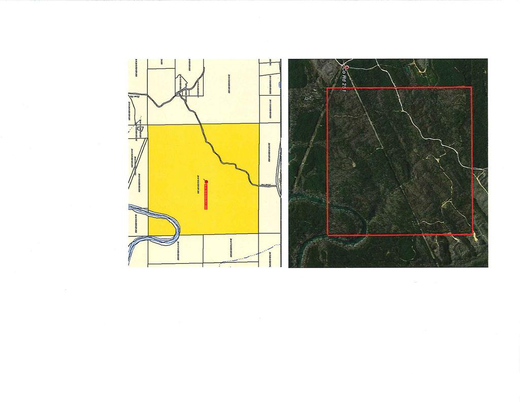
13 Tract #3
14 River Road (CR251) THIS INSTRUMENT PREPARED BY: Michael I. Spearing Office of Counsel The University of Alabama System Box Tuscaloosa, Alabama STATE OF ALABAMA } SHELBY COUNTY } PUBLIC RIGHT-OF-WAY AND EASEMENT KNOW ALL 1UEN BY THESE PRESENTS, that the undersigned. The Board of Trustees of The University of Alabama, a corporation, (hereinafter sometimes referred to as the "University"), for and in consideration of the sum of Ten Thousand and six hundred sixty five ($10,665.00) Dollars, to it in hand paid by Shelby County, the receipt of which is hereby acknowledged, and subject to certain rights of reverter and conditions imposed herein, does hereby grant to Shelby County, its successors and assigns, a right-of-way and easement for public purposes, including a public road and appurtenances, including drainage facilities, together with all rights and privileges necessary or convenient for the full enjoyment or use thereof for the purposes above described, including the right of egress and ingress to and from said right-of-way and the right to cut and keep clear all trees and undergrowth and other obstructions on said right-of-way and danger trees adjacent thereto which now or may hereafter injure or endanger any of the works on said right-of-way, and the right to prohibit the construction or maintenance of any improvement or obstruction on, over, across, or upon, said area herein conveyed without written permission of Shelby County; however, reserving, excepting, and imposing certain rights, limitations, conditions and restrictions as
 Commence at the Southwest comer of the Northeast 1/4 of the")
15 hereinafter set out. Said right-of-way and easement being located in Shelby County, Alabama, and described as follows, to wit: County Road 251 (River Road) Commence at the Southwest comer of the Northeast 1/4 of the Southwest % of said Section 18; thence mn South 00 degrees 38 minutes 55 seconds East along East section line for a distance of feet to the POFNT OF BEGFNNrNG which is the point of commencement of a curve to the right, said curve having a radius of feet, a central angle of 06 degrees 23 minutes 15 seconds, a chord bearing of North 69 degrees 33 minutes 03 seconds East for a chord distance of feet; thence run along arc of said curve for a distance of feet; thence run North 71 degrees 49 minutes 31 seconds East for a distance of feet to the point of commencement of a curve to the left, said curve having a radius of feet, a central angle of 19 degrees 38 minutes 54 seconds, a chord bearing of North 62 degrees 00 minutes 04 seconds East for a chord distance of feet; thence run along arc of said curve for a distance of feet; thence run North 52 degrees 10 minutes 37 seconds East for a distance of feet to the point of commencement of a curve to the right, said curve having a radius of feet, a central angle of 09 degrees 28 minutes 09 seconds, a chord bearing of North 56 degrees 54 minutes 41 seconds East for a chord distance of feet; thence run along arc of said curve for a distance of feet; thence run North 61 degrees 38 minutes 46 seconds East for a distance of feet to the point of commencement of a curve to the left, said curve having a radius of feet, a central angle of 61 degrees 12 minutes 58 seconds, a chord bearing of North 31 degrees 02 minutes 17 seconds East for a chord distance of feet; thence run along arc of said curve for a distance of feet; thence run North 00 degrees 25 minutes 48 seconds East for a distance of feet to the point of commencement of a curve to the right, said curve having a radius of feet, a central angle of 42 degrees 27 minutes 01 seconds, a chord bearing of North 21 degrees 39 minutes 18 seconds East for a chord distance of feet; thence run along arc of said curve for a distance of feet; thence run North 42 degrees 52 minutes 49 seconds East for a distance of feet to the point of commencement of a curve to the left, said curve having a radius of feet, a central angle of 23 degrees 41 minutes 45 seconds, a chord bearing of North 31 degrees 01 minutes 56 seconds East for a chord distance of feet; thence run along arc of said curve for a distance of feet; thence run North 19 degrees 1 1 minutes 03 seconds East for a distance of feet to the point of commencement of a curve to the right, said curve having a radius of feet, a central angle of 52 degrees 28 minutes 22 seconds, a chord bearing of North 45 degrees 25 minutes 14 seconds East for a chord distance of feet; thence run along arc of said curve for a distance of feet; thence run North 71 degrees 39 minutes 25 seconds East for a distance of feet to the point of commencement of a curve to the left, said curve having a radius of feet, a central angle of 65 degrees 12 minutes 49 seconds, a chord bearing of North 39 degrees 03 minutes 01 seconds East for a chord distance of feet; thence run along arc of said curve for a distance of feet; thence run North 06 degrees 26 minutes 36 seconds East for a distance of feet; thence mn South 89 degrees 57 minutes 28 seconds East for a distance of feet; thence run South 06 degrees 26 minutes 36 seconds West for a distance of feet; thence run South

16 71 degrees 39 minutes 25 seconds West for a distance of feet; thence run South 19 degrees 11 minutes 03 seconds West for a distance of feet to the point of commencement of a curve to the right, said curve having a radius of feet, a central angle of 23 degrees 41 minutes 45 seconds, a chord bearing of South 31 degrees 01 minutes 56 seconds West for a chord distance of feet; thence run along arc of said curve for a distance of feet; thence mn South 42 degrees 52 minutes 49 seconds West for a distance of feet to the point of commencement of a curve to the left, said curve having a radius of feet, a central angle of 42 degrees 27 minutes 01 seconds, a chord bearing of South 21 degrees 39 minutes 18 seconds West for a chord distance of feet; thence run along arc of said curve for a distance of feet; thence run South 00 degrees 25 minutes 48 seconds West for a distance of feet to the point of commencement of a curve to the right, said curve having a radius of feet, a central angle of 61 degrees 12 minutes 58 seconds, a chord bearing of South 31 degrees 02 minutes 17 seconds West for a chord distance of feet; thence run along arc of said curve for a distance of feet; thence run South 61 degrees 38 minutes 46 seconds West for a distance of feet to the point of commencement of a curve to the left, said curve having a radius of feet, a central angle of 09 degrees 28 minutes 09 seconds, a chord bearing of South 56 degrees 54 minutes 41 seconds West for a chord distance of feet; thence run along arc of said curve for a distance of feet; thence run South 52 degrees 10 minutes 37 seconds West for a distance of feet to the point of commencement of a curve to the right, said curve having a radius of feet, a central angle of 19 degrees 38 minutes 54 seconds, a chord bearing of South 62 degrees 00 minutes 04 seconds West for a chord distance of feet; thence run along arc of said curve for a distance of feet; thence run South 71 degrees 49 minutes 31 seconds West for ; to the point of commencement of a curve to the left, said curve having a radius of feet, a central angle of 06 degrees 23 minutes 15 seconds, a chord bearing of South 69 degrees 16 minutes 05 seconds West for a chord distance of feet; thence run along arc of said cuive for a distance of feet; thence run North 00 degrees 38 minutes 55 seconds West for a distance of feet to the POINT OF BEGINNING. Said parcel contains 263,059 square feet or 6.04 acres more or less. Also a temporary construction easement described as follows: A strip of land 100 feet to each side of the centerline of River Road, located outside River Road right of way being located in Parcel as shown on the attached tract sketch, situation in the North half of Section 18, Township 21 South, Range 4 West, Shelby County, Alabama containing acres, more or less. To the extent allowed by law, Shelby County agrees to indemnify, protect and hold harmless the University against any and all claims for damages by reason of Shelby County's entry, construction, operation and maintenance of its facilities; provided, however, nothing herein shall be construed as requiring Shelby County to indemnify and save the University harmless against any damage to the extent the same may be caused by the sole or concurrent acts of negligence of The University of Alabama, its employees or
17 agents. This grant of right-of-way and easement is made and accepted upon the following conditions subsequent which shall be binding upon and enforceable against said Shelby County, its successors and assigns, and each of them as follows; Shelby County, its successors or assigns, shall utilize the easement herein granted only for the purposes stated herein and shall not make a different or varying use other than said purpose. Nothing contained herein shall be construed or interpreted so as to require Shelby County to utilize the right-of-way and easement herein granted. Misuse, non-use, or abandonment of said easement shall constitute a breach of this condition subsequent. In the event of such a breach, (whether caused by legal or other inability of Shelby County, its successors or assigns) in performing any of the obligations herein set forth, and should Shelby County fail to remedy such condition within 90 days after written notice of a breach having occurred, then all right, title and interest in and to the easement or grant herein made, shall, at the option of the University, revert to and become the property of the University, or its successors in title who have an immediate right of entry thereon, and Shelby County, its successors or assigns, shall forfeit all right, title, and interest in and to the above described property and any and all of the tenements, hereditaments, and appurtenances thereunto belonging. Should the University fail to insist in any one or more instances upon complete performance of any of the said conditions, such failure shall not be construed as a waiver or relinquishment of the future performance of any such conditions, but the obligations of Shelby County with respect to such future performance shall continue in full force and effect Further, the remedy of reentry upon breach shall not serve to bar or prevent any other remedy provided by law to the University upon the breach of such conditions. Shelby County, by its acceptance of this easement, covenants and agrees for itself, its successors and assigns, and every successor in interest to the easement herein granted or any part thereof, which covenant shall attach to and run with the easement and shall, In any event, and without regard to technical classification or designation, legal or otherwise, be binding to the fullest extent permitted by law and equity, for the benefit and in favor of and enforceable by the University, its successors or assigns, against Shelby County, its successors or assigns and every successor in interest, or any part thereof, that:
18 1. Upon abandonment or non-use of the easement, Shelby County will, at its own expense, and within a reasonable time after written request by the University to do so, remove its facilities placed upon said property and restore same to a reasonable condition; and quitclaim deed all interests herein granted back to The Board of Trustees of The University of Alabama. 2. The consideration recited hereinabove does include the timber now on the herein described right-of-way; however, should Shelby County hereafter desire to cut any danger trees along said easement under any authority granted in this instrument, Shelby County will prior to cutting any danger tree(s), give notice to the University (Office of Land Management, Box , Tuscaloosa, Alabama, , or at such other address as may from time to time be suggested) of its intention to cut the said danger tree(s) not less than 90 days prior to the time the cutting will take place. The University shall have 60 days after receipt of the notice of intention to cut, during which it may elect to harvest the danger tree(s) itself or may notify Shelby County that it will not harvest said tree(s). In the event the University either elects not to harvest the danger trees or otherwise fails to communicate with Shelby County prior to the expiration of60 days after notification of Shelby County's intention to cut, then Shelby County shall be entitled to cut and remove the danger tree(s). In any circumstance under which Shelby County cuts or removes a danger tree(s), it shall reimburse the University for the Current market value of the tree(s) cut according to its highest and best use, disregarding difficulties associated with the removal of said trees(s) for commercial purposes. Payment to the University to be made not later than 45 days following the cutting of said trees. 3. To the extent allowed by law, Shelby County agrees to protect and conserve the University's rights and interest in propeity involved in this easement and adjacent property through reasonable and judicious use and development of the rights granted herein and further agrees to indemnify and pay the University for any damages to such retained rights and interest caused by Shelby County's acts or omissions in its use of the rights conveyed herein. The following examples of loss or damage are some of the losses that can reasonably be expected to occur. The examples are descriptive only and are not intended to limit in any way the occasions or losses for which Shelby County may be liable under this or any other provision of this agreement: (a) overspray or drifting spray, which said spray was intended to keep easement clean of growth which damages growth on adjacent property; (b) leaving rubbish or other material on the easement or adjacent property that becomes infested with insects that move onto property of the University damaging standing timber or other vegetation.
19 IN WITNESS WHEREOF, the parties have caused this instrument to be executed, in duplicate, in their respective names by the appropriate officers and officials of each on this the ^ / "day of Ap'**'^ _, ATTEST: THE BOARD OF TRUSTEES OF THE UNIVERSITY OF ALABAMA, a corp. By: C^AW Lynda Gilbert Vice President for Financial Affairs and Treasurer The University of Alabama Tuscaloosa, Alabama ATTEST: BY: ITS: SHELBY COUNTY ^^ ^S^ ^ C/^^~ C^// ^^h e^ STATE OF ALABAMA } COUNTY OF TUSCALOOSA } I, the undersigned, a Notary Public, in and for said County in said State, hereby certify that Lynda Gilbert, whose name as Vice-President for Financial Affairs and Treasurer of The University of Alabama, is signed to the foregoing conveyance, and who is known to me, acknowledged before me on this day, that, being informed of the contents of this conveyance, she executed the same voluntarily and with full authority on the day the same bears date. Given under my hand and official seal this \2-^ day of _j^n_l \ tow,2016. NOTARY PUBLIC, My Commission Expires:? /^p-ctcf
20 STATE OF ALABAMA } COUNTY OF TUSCALOOSA ) I, the undersigned, a Notary Public, in and for said County in said State, hereby certify that <>C^ 1^ H yf I A (f ^ ^ whose name as ^' ^<c ^ C'^' I ($^', ^ ^c^* ofsheiby County, is signed to the foregoing conveyance, and who is known to me, acknowledged before me on this day, that, being informed of the contents of this conveyance, he/she executed the same voluntarily and with full authority on the day the same bears date. Given under my hand and official seal this <^c>l day of f-^t^u^ _, NOTARY PUBLIC My Commission Expires: tff/3i
21 ^ ' _ -1 Board of Trustees of the University of Alabama Board of Trustees of the Uniuersity of Alabama [ WW kctl PARCEL 1 OFI CUMUENCINS rolnt SEC.IS ^ Z^ S FH-W COURSE I LI aearikgl SHCWC flltrine Ni8'33'03'E M71'43'31-E N M' HO' M' E nwio-srs M5B-54'41'E LB ; ueraa'ns'e Li E HOC- 25' la' E sa' us' E L10. NC-SZ'ie'E ms-irnre W S5-23'1.1-E N71-3B';5'E N s as-st'as-e OESCRIFTION TANGEHT TANOEMT TANGENT CUFiVE TANGENT TANGENT TANGENT TANSENT FANSENT DISTAhCE/ CHQRO 31STANCE mn.ar 3S.1.74' OT.GS 13B.57' 2T3,ar H4.1S4' S3G.7S' 28C-ir 3UJj3' ' as ism.on' )' ' uam LfNOTH! m.w ' 303.1?' ' BEARIKGI counsel SHOfiB BEAKIN1 L2S u; Li; 131 L24 S W IS X' W T"M'33"W S4S-Z5'1.i"W S1a' n'm-w s.n-crse-w L.ZS S21-3S'U"W Ui s w ss w w \X! S31-D;"17"W i^e J se1' 3 ^BHw L2 ^ S5G-54-41"W UO! S52-W37-W U ; E71^S-31"W ua U.I S St W N OU-3t'55"W TAHGEhiT f^?ej TASICEKT CJWE TA-MQE^T CJRVE lamgetit TANOENT CURV6 cuni/e IANGENT OtSTAIUCB CHORD nn.or <m.m' 23a.7S' 2S6.73' ' 1W.35' 141,11)' 25B.G7' 33.W <07J5' M,?!' -QS.S-" RA3!US yssas 7SS.SV 135CV ;S3.0ff zaro.nn' laa.w LENGTH cu live -uz.sr -K'tir SH.ffiait.o?' S1 S- msf- i'ffisa- i[s.<e- \ttat m.45' Wi21' r^o.w TRACT : NO. 3 OWNER : BOARD OF TRUSTEES OF THE UNIVERSITY OF ALABAMA TOTAL ACREAGE 632,000 R.O.W, ACQUIRED REMAINDER SHELBY COUNTY. ALABAMA SCALE: r=200r DATE: REVISED:
22 mnlot & COMPANY, INC, MALOYAND COMPANY, INC. Real Estate Appraisers & Consultants 22-/2 3rd Avenue, North Birmingham, Alabama (205) January 19,2016 The Board of Trustees of the University of Alabama C/0 Dr. Lynda Gilbert/ PhD/ CPA Vice President for Financial Affairs and Treasurer 271 Rose Administration Building Tuscaloosa, AL RE: Appraisal Proposal Shelby County Road widening project Tract acres+- Taking: acres+- Temporary Construction Easement: acres+- Tax Parcel: As requested/1 have appraised the above referenced right of way acquisition proposed by The Shelby County Commission. While The University of Alabama is not subject to eminent domain acquisition by a county/the appraisal complies with Title 18 of the Alabama Code, which sets forth the procedures for public acquisition projects. The appraisal was aiso prepared to be consistent with the Uniform Standards for Professional Appraisal Practice (USPAP). Appraisals of this type require a valuation of the larger "before" tract prior to the acquisition/ along with valuation of the remaining "after" tract which considers the permanent right of way needed, as well as the land encumbrance within the Temporary Construction Easement. The difference between the before and after valuations forms the basis of Just Compensation. If i can provide any additional information, please contact me. Respectfully submitted, Richard A. Maloy/ MAI/ SRA, JD State Certified General Real Estate Appraiser Alabama Certificate # CG00199 attachment
23 w 1?)1 i^l HI IQI!"n l^i i~<! i^i 101 id II?1 1^1 l^il No] Ill 1>1 Ill I r-1 X x x x x x x ^ x x >^ x >< x ^?D5)3l5)5i535:533:55::5:55:5i OQoooooQoQooQoo ^^^^i^i^^^ Ol -b. ill N) -A 0 t003-^cti<jl-ti.t->ro-^ 0 0 -i. '0»? > -f -I > 70 m m o o 0 0^ P -n -n 'Z ?0 <; m > D r 0 30 m 3^2 F C 2 m m 0 Z3r^ C -I ~o 0 II II il > > 2S CT m ^ m w V) co 1^ r- co ^ 0 0 S Q OrT1 m "^ ^ 0 o^ss 0^ % Pl 0^s ^'!l co 5 r- Ir~ 0 5 I:0 j 0 ^ :t> T3 ~n II s -I ^ co a rri ~n il! 3 o 0 6 a :o a 1111 m m m m co Is ^!? r~ c?; S <: S F- ^ i? r~ r~ f) ^ s I! i^^1^ S ET G ^ qo 2 li ^1^ >?: isj il ^ill2 s ^0 s?^ II II 2illl f? ^ ^ ^ T! ~n s r-~ r- ii r- r~ II :b s b o 0 :CS m r=: 1> 3 2 ^0 S3 3: =io 0 o's >. <?3 C03 0 Is s co co > S 1 iir 0 ^1 0 <? : p ^il! 0=Sm^2 ;n^c2 igii 5: -< ^ 0 00I^ 0 i co ill N) m o!^i ^ <^ 5 s" "^ ^ <jn ^ o -A r~ ^ si ^ ^ ^to r^ho 0 ss Pl lit m ^^G 3 03 If ^s 3 M (1> ^ s ^ 5; ^ 00 Is <? ^ '< 0 0 <$ ~*1 3:*?S, ^ ts? Go u 3? p- EU 2 ai co ~*> i^ 9' <b tn 3!^ 13 II II 0 <a I *?'' -s If If i ^ r~ ^~ 2ai
24 ACQUISITION SUMMARY ROW 1 OWNER'S NAME PROPERTY ADDRESS PROPERTY CITY/STATE CLIENT FILE NUMBER PARCEL NO. PROJECT TRACT NO. DATE OF VALUE DATE OF REPORT INSP. BY RIGHTS APPRAISED 3 YEAR SALES HISTORY LAST SALE PRICE ZONING HIGHEST AND BEST USE PROJECTED MARKETING TIME ESTIMATED EXPOSURE TIME IN FLOOD HAZARD AREA? LAND SIZE BEFORE TOTAL AFTER-TOTAL TOTAL TAKING TEMPORARY EASEMENT ACQUIRED (TCE1 Board of Trustees of The University of Alabama County Highway 251 Helena, AL Board of Trustees of The University of Alabama 16C SHELBY COUNTY ROAD 251 WIDENING /6/16 1/19/16 Richard Matoy Fee Simple NONE N/A NONE FORESTRY MONTHS MONTHS SMALL PORTION AT CAHABA RIVER IN 100 YEAR FLOOD PLAIN MAP1 117C03S3E DATED 2/20/ AC SF. 27,529,920 27,266, , W TAX I.D. LAND IMP. TOTAL TAXES $1.137,600 $0 $ 1.137,600 exempf IMPROVEMENTS LAND VALUE INDICATION COST APPROACH INDICATION SALES COMPARISON INDICATION INCOME VALUE INDICATION RECONCILED VALUE DIFFERENCE ACQUISITION AND DAMAGES TEMPORARY EASEMENT ACQUIRED TOTAL JUST COMPENSATION NONE BEFORE 1,042,800 n/a n/a n/a 1,042,800 $10,000 $10,000 _i_665 $ 10,665 AFTER DIFFERENCE $1,032,800 $10,000 n/a n/a n/a n/a n/a n/a $ 1,032,800 $ 10,000
25 SUMMARY OF TAKING AND DAMAGES ROW 2 OWNER'S NAME PROPERTY ADDRESS PROPERTY CITY/STATE CLIENT TRACT NO. DATE OF VALUE LAN D SIZE BEFORE Board of Trustees of The University of Alabama County Highway 251 Helena, AL Board of Trustees of The University of Alabama 3 6-Jan /-AC AFTER ACQUISITION HIGHEST AND BEST USE /-AC FORESTRY BEFORE VALUE AFTER VALUE DIFFERENCE $ 1,042,800 $ 1,032,800 $ 10,000 DIVIDED AS ACQUISITION FEE SIMPLE 6.04 SF@ $1, $ 9,964 DAMAGES TO REMAINDER BENEFITS TO REMAINDER TOTAL ACQUISITION AND DAMAGES $0 $0 $0 TEMPORARY EASEMENT COMPENSATION JUSTCOIVIPENSATION ac. $665 10,665
26 ASSUMPTIONS AND LIMITING CONDITIONS ROW 3 f The legal description used in this repori is assumed to be correct. 2 The appraiser has not surveyed the property. No msponsibility is assunibd by ths appraiser for boundary line issues. It is assumed that utilizafion of the Sand and improwmenfs is 3 The appraiser assumes no fesponsibility for matters of a legal nature. It is assumed that title to the property is marketable. The property is assumed to ba under responsible ownership. 4 Unless previous arrafigements have been made, fhe appraiser will not be required to give testimony or appear in court because of having made Ihis appraisal. 5 Ttis distribution of the total valuation in this mport between land and improvsments applies only to this appraisal. The separate vatuations for land and building must nof be in cofy'ynchw) with any other appraisal and are invalid if so used. 6 All mortgages, liens, encumbrances, leases, and seivitudes have been diswganled unless so specified \vithin thb repoil. 7 The appraiser assumes Ihat there are no hkklsn or mapparenl conditions of ttia property, subsoil or stfuctwes, which would make the pmpeity more or less valuable. 1 assume no I'espcinsibitify for such wnditiws w for engineering which would be reqwed to discover such factors. The appraiser (foes no( warrant of guarantee the slruclural sfabilify or the 8 The appraiser assumes that the property ss sn iu!l compliance wiih all appiicabsa federal, slate and local environmenta! regulations and laws unless non-compliance is staled, (teffned and considered in the report. 9 The appraiser assumes fhaf appiicebte zoning, use legulations and restrictions have been compiled with, unless a Hon-confoim'ity hss been slated, defined and considered in the report. SO Skelchss in this report are included to assist the reader in visualizing the property. The appraiser assumes no responsibiiity for fheif accuracy. 11 The information, estimates and opinions furnished So me and contained in this report were obtained from sources considafed reliabia and beiieved to ba true and accurate. However, no msponsibility for accuracy can be assumed by by the appraiser. 12 This report ;s to be used InSs enfiiefy and on!y for the purpose for which it was prepared. Possession of thss report, w copy thereof, does not carry with S She nght of publicafim. It may not beused forany pu^osa by any pe^onolharihanihe party to whom ius addressed withotri the wriuen qualification and only in Hs entirety. 13 The primary designatedappraisersigninglhis fsporf is a msmber arid the associate appraiser may be a member or candktate for membershsp in The Appraaa! Institute. The bylaws and regulations of ths Inslilute fequim each member and candidate to control the use and disfribution of each appi'atsat report signed by such member or candidate. 14 Financtal forecasts and projections presented HI this analysis are not guafanieed future occurrences. Using educated assumptions, the appraiser uses these pmjections to simulate the decision making process by which buyers and sellers determine price in the marke<p!ace. Since ffiese forecasts are based on assumptions and Bvents ihat have noi taken 15 Unless otherwise staled m this report, the existence of hazardous material, whsch may or may not be pwsmt m the property, was not observed by the appraiser. The apprajsw has no knowledge of the existence of such materials on w in the property. The appraiser, however, is not qualified to detect such substances. the presence of substances such as 16 The Americans wifh Disabilities Acf (ADA) became effective on January 26, Theappraiser has not made a speciftc compliance survey ancs analysis of the subject pivperty to ctefemwte whether or not it is in compliance with tha various detailed requiiembnts of the ADA. It is possible that a compliance survey of the property log elherwiih a detailed 17 This is a Reslnctecj Appraisal Report v/hich is intended to comply v/sh ths fsporiing requifements set foffh in StancSasS 2-2(C) of the Uniform Standafds of Pmlessimat Appraisal Pracficefwa Summary Appraisal Report. As such, if presents only summary discussions of the data, reasoning, and analysis that were wed in tha appraisal process io develop IDERNITION OF MARKET VALUE \tnthe 13ih Edition of The Appraisal of Real Estate, pub!sshed in 2009, the Appraisa! Institute defines Markef Value as: \Market Value means the most probabss pnce which a property should bring in a compeiilive and open market under al! conditions retfuisite to a fair sale, the buyer and seller each acting \pfudenlly and knowledgeably, andassunvng the price is not effected by wdue stimulus. implicit in ihis dafinjlion is a consummation o! a sa!a as of a spacired date and the passing of title from 1 buyer and se/ter are typically motivafed; 2 both parties are ivew mformed or well advised, and acting in \/uhat they consider their own best interests; 3 a reasonable time Is al!owe<3 for exposure in the open market. 4 payment is made In terms of cash in U. S. doliafs, or m terms of financial arrangements compafabte thereto; and 5 The price represents the fionnatcofisidefalion forfhepmperty sold unaffected by special or creafive financing or sales concessions grafiled by anyone associaibd with the sale. [The DeKmiiM of Market Value for eminent domain purposes is: "The price fhs property would bring wiien offered for sale by a willing seller who is not fowed to seil and which is sought by a ^willing buyer who is no! required to buy, after due consideration of all the elements affwiing value. (Code of Alabama 1 G-1A-'172)'
27 ROW 4 APPRAISAL SCOPE OF DEVELOPMENT AND REPORTING PROCESS Intended Use Intended Users Extraordinary Assumt!ons Hypothetical Conditions Acquisition of property rigitts using eminent domain methodology, knowing thai The University is not subject to eminent domain Client The After Value Assumes the project to be completed and operational as of the appraisal date. Report format Inspection conducted Complete Exterior Only Other Appraiser Measuremart Tax Records Form x x x LAND SALES COMPARISON APPROACH CALCULATIONS REPLACEMENT COST "MARSHALL AND SWIFT COST APPROACH CALCULATIONS DIRECT SALES COMPARISON APPROACH CALCULATIONS INCOME APPROACH CALCULATIONS CHECKLIST OF EXHIBITS Plat Building Sketch Flood Map Subject Location Map Photo of Subject Property Land Sale Location Map Improved Sale Location Map Qualifications of Appraisers
28 VALUATION CERTIFICATE ROWS OWNER'S NAME Board of Trustees of The University of Alabama PROPERTY ADDRESS County Highway 251 PROPERTY CiTY/STATE Helena, AL CLIENT Board of Trustees of The University of Alabama FILE NUMBER 16C0003 TRACT NO. 3 / (we) certify that to the best of my (our) knowledge and belief: 1 The statements of fact contained in this report are true and correct. 2 The reported analyses, opinions and conclusions are limited only by those assumptions and limiting conditions included in this report. These are my unbiased professional analyses, opinions and 3 I have no present or prospective personal interest or bias with respect to the subject property of this appraisal report and I have no personal interest or bias with respect to the parties involved. 4 My employment or compensation is not contingent upon the reporting of a predetermined value or direction in value that favors the cause of the client, the amount of value estimate, the attainment of a 5 FIRREA CERTIFICATION My employment or compensation is not based on the reporting of a requested minimum valuation, or based upon the approval of a loan. 6 My analyses, opinions and conclusions were developed, and this report has been prepared, in conformity with the requirements of the Code of Professional Ethics of the Appraisal institute and the Standards of 7 The use of this report is subject to the requirements of the Appraisal Institute relating to review by their duly authorized representatives. 8 Signatories of this report holding the MA! and SRA designations are currently certified under the continuing education program of the Appraisal Institute. 9 This assignment was made subject to regulations of the State of Alabama Real Estate Appraisers Board. 10 The primary appraiser certifies that he has the education and experience required to meet the competency provisions of USPAP and FIRREA, as regards the complexity of this assignment. 11 No one other than the undersigned provided significant assistance in preparation of the analyses. opinions and conclusions concerning real estate that are set forth in this appraisal report. Personal inspection of the subject property of this report was made by Richard Maloy. 12 The appraiser has not performed any real estate valuation sen/ices on the subject property in the past three years. Richard A. Maloy MAI, SRA State Certified General Real Property Appraiser Alabama Certificate #G00199 Parcel 1-prepared by Maioy Co., Inc.
29 BEFORE VALUE ANALYSIS ROW 6 OWNER'S NAME Board of Trustees of The University of Alabama PROPERTY ADDRESS County Highway 251 PROPERTY CITY/STATE Helena. AL CLIENT Board of Trustees of The University of Alabama FILE NUMBER 16C0003 PARCEL NO TRACT NO. 3 DESCRIPTION OF PROPERTY BEFORE ACQUISITION The subject is a square mile tract with its SE corner fronting on the Cahaba River. Timber is mostly cut over and no timber value was assumed. County Road 251 is gravel. Power and telephone service is available in the area. LAND SALE ANALYSIS The subject was analyzed using recent larger timberland sales in Shelby and Tuscaloosa County.Sate 3 was adjusted for its timber value of $1,250 per acre. Overall the underlying land value in the area exhibits a famy narrow range of pricing. All of ttw other tracts held pre-merchantible or cut over timber inventories. The size component was adjusted using a statistical curve that produced the Sowest coefficient of variance

30 LAND SALE ^-^^^AHott. p'<-
31 ADJUSTMENT OF LAND SALES OUR FILE NO.: 1GC0003 PROPERTY: County Highway 251 Tract ADDRESS: County Highway 251 Helena, AL CUEHT Board of Trustees of The University of Alabama BEFORE VALUE ROW? LOCATION SELLER BUYER TAX!.D. DEED REFERENCE Robertson Rd. Gordo E.F.&L. Trucking Co, Inc. RELillianALLLC /5S56 SUBJECT Land Sale 1 adj. Hwy 82 No, Northport T. H. Robertson & Sons, Inc. Forever Wild others 2014/'!3487 Land Sale 2 adj. Montevallo area Shefby Co John Hancock Cahaba Timtierlands, LLC Land Sale 3 adj. No Tuscaloosa Cty Sterling Regions Bank Trustee Timber LLC /1 OG21 Land Sale 4 adj. Sa/es Price Timber Adjustment Total AC. Sold Price Per AC S 800, $1, S so 1B $ 1, $ 1.795,745 -$760, $1, $ , S T.30T.D8 Date of Sale Time Adjustment Per Year Time Adjusted Pnce/SF 1/6/ % Dec-12 S SO. 00 Aug-14 S 1, $0.00 Jun-11 $1, S 0.00 Jun-15 $1, S 0.00 Location Access/Frontsge Physical Characteristics Zoning Heiens-SheSby Co. Good Roiling None Gordo Tusc. Co Fair Rolling None $ $0.00 $0.00 Hwy 82 No, Northpori Good Roiling None S 0,00 Montevailo area Shelby Co $ 0.00 Good $ 0.00 Level $ 0.00 None $ 0,00 No Tusca/oosa Cty Sterling $ 0.00 SO. 00 Good S 0.00 S 0.00 Level $0.00 S 0.00 None $0.00 Sub-Total Adjustments Adjusted Price/AC. Size Adjustment $ $0.00 $0.00 $ 1, $ ,9904 $1, $0.00 ADJUSTED SALE PRICE/AC. $1^8.77 S-! $1, $1, SIZE»» USE: SIZE ADJUSTED 1 1, $1, $1, S NON-SiZE ADJUSTED $1, S ^, S S 1, AVERAGE MEDIAN STD. DEVIATION COEFFidENT OF VARIANCE $t 643. W $ 1, ?' % $ 1, $1, ? % INDICATED VALUE OF THE SUBJECT AC. $1, /AC.= Rounded $1,042, $ 1,042,300
32 AFTER VALUE ANALYSIS ROW 11 OWNER'S NAME Board of Trustees of The University of Alabama PROPERTY ADDRESS County Highway 251 PROPERTY CiTY/STATE Helena, AL CLIENT Board of Trustees of The University of Alabama FILE NUMBER 16C0003 PARCEL NO TRACT NO. 3 EFFECTS OF THE ACQUISITION The acquisition iincludes a ROW widening which includes Acres of permanent acquisition and a temporary work space of s a temporary work space of Acres. The temporary work space is assumed to be active for three years from the date of acquisition. There is no damage of detrimental effect on the remaining land value. It is too early to tett whether increased traffic on the road will impact the highest and best use for timber production.
33 ADJUSTMENT OF LAND SALES OUR FILE NO.: 16C0003 PROPERTV: County Highway 251 Tract ADDRESS: County Highway 251 Helena, AL CLIENT Board of Trustees of The University of Alabama AFTER VALUE ROW13 LOCATION SELLER BUYER TAXi.D. DEED REFERENCE Robertson Rd. Gordo E.F.&L. Trucking Co, inc. RE Lillian AL LLC ! /5895 Hwy 82 No, Northport T. H. Robertson & Sons, Inc. Forever Wild 18-OS others 2014/1 '3487 Montevalto area Shelby Co John Hancock Cahaba TimberSands, LLC S490 No Tusca!oos3 Cty Sterling Regions Bank Trustee Timber LLC /10621 SUBJECT Land Sa/e 1 adj. Land Sale 2 adj. Land Sale 3 adj. Land Sate 4 adj. Price Per AC Sates Pnce Total AC. Sold , $1, $2,457, $ $ 1, $1,795,745 S $1, $1.686, S.OOO S 1, Date of Sale Time Adjustment Per Year Time Adjusted Price/SF 1/6/201 S 0,00% DSC-J2 S $0.00 Aug-14 $1, $0.00 Jun-11 S $0.00 Jw-15 $1, $0.00 Locadon Access/Frontage Phy seal Cliaracteristics Zoning Helena-Shelby Co, Good Rolling None Gofdo Tusc. Co Fair Rolling None $0 $155 Hwy 82 No, Northport Soocf Rolling None $ 0.00 Montevallo area SheSby Co $ 0.00 Good $ 0.00 Level $ 0.00 None $0,00 No Tuscaloosa Cty Sterfing $ Goocf S Level SO.OO S 0.00 None $0.00 Sub-Tofat Adjustments Adjusted Pnce/AC. Size Adjustment $1, $ $1, S S , $0.00 $ 1, $0.00 ADJUSTED SALE PRSCE/SF. $1, $ 1, , $1,389, ' S S 1, $ts99.07 $ 7,389. T 5 $1, S $1, S AVERAGE MEDIAN STD. DEVIATION COEFFICIENT OF VARIANCE $ $ 1,554.5-! % $!, si.soi.eo % INDICATED VALUE OF THE SUBJECT AFTER TAKING 0.00% AC SF. $ /AC.-- $ 0.00 /SF.-- ^,032,836 0 ROUNDED $1,032,800
34 TEMPORARY EASEMENT CALCULATIONS OUR FILE NO.: 16C0003 PROPERTY: County Highway 251 ADDRESS: County Highway 251 ROW 12 TRACT Helena, AL Vaiue of Temporary Easement (s) Annual Rent Easement Area Overall Real Estate yield rate Annual Rent Present worth factor 3 years Land Value $1, % , , % $ $ yearo $ year 1 $210,87 year2 Just Compensation for Temporary Easement $664.77
35 ^S^M :l:.-shite OF^UBWA'.i..-' ~\'~'"y~" "~''v. CDUFt3fi u (.> tt Ui LI LT L» f» Uff 1.11 i.w LH Ut m CHORD B^RII n ir IT or E tin-wire N'U'WifE Hcs-artrt MCrsCii-E NsrcrirE MW3SWE nat-wire H<ys'we NT1'a»;i' NWHTITTE NwaraFE Stsrsrwc oessrapnon CUfWE wncew CURV1C TAHCEHT cufwe TANCENT wmm- CWtvE UKBENT TAUOENT TANOfiW TjUtOEHT OtSfWW sisfmcs 2nn.ar 3H.H SR.Vf *1;<t W9 IBUr snsr t-frf waas 23EJ? a\.n' sur *WW RAtHUS www ISMtW ni.or am» 33(L(B- BHMT TOWT1. PWCEHWl LENCTh OF 1WST SSSJH" <1«.)T msw MAS' SS!-Si' BUT COURS( tia u* ui 122 m u< us ur \2S lit L30 Ul Ut LU BEABIKB 0+3RO BEARtNC SWBTBl-W an- jrsr w sib-n'ccrw 5<Z" SZ^STW aar'arirw swsewvr sir or i~w ssrsnww ESB'S4-<m ESZ'iiriT-iN StZ-WWW STfwirw swwwn H BB- 3B' U- W DCSttfllPTlOhl TIUWCNT airna TWCOfT ^^^tcwr eufnu rwdsmt cunve TANCEWT ojmc aroe TWOENT CUTOE T^CENT ptstaffcc? cnoro DBTANCE <UUT 33(LTff BUST m.sr :SS.ST Bl.flT w.w HUf IttOIUS s»m i;!uw sw.as' nucr SWlCt MW.tHT OF GUiWE <sur W7.ZT <aa.m' ma TRACT ; NO. 3 OWNER : STATE OF AIABAMA SHEL6Y COUNTY. ALABAMA TOTAL ACREAGE R.O.W. ACOUiRED REMAINDER ACRES SCALE: 1" =200' DATE; 0& REVISED;
36 ^ r
37
38 Photographs Eastern edge of property looking south along River Road Maloy and Company, Incorporated Appraisers and Consultants

39 Photographs Maloy and Company, Incorporated Appraisers and Consultants
40 Photographs Utility access, north side of River Road Maloy and Company, Incorporated Appraisers and Consultants
41 Photographs./ Maloy and Company, incorporated Appraisers and Consultants
42 Photographs Maloy and Company, Incorporated Appraisers and Consultants

43 Photographs Gated internal entry road looking east from River Road ^ Access road, southeast from River Road Maloy and Company/ Incorporated Appraisers and Consultants
COUNCIL AGENDA MEMO ITEM NO. III - #1
 COUNCIL AGENDA MEMO ITEM NO. III - #1 FROM: Anton Jelinek, Director of Utilities MEETING: October 24, 2017 SUBJECT: PRESENTER: Permanent Utility and Right-of-Way Easement Anton Jelinek Discussion: At the
BILL NO (Emergency Measure) ORDINANCE NO. 5072
 ORDINANCE NO. 5072") BILL NO. 5210 (Emergency Measure) ORDINANCE NO. 5072 AN ORDINANCE AUTHORIZING THE MAYOR TO EXECUTE WITH MICHELSON-HADLEY HEIGHTS DEVELOPMENT, LLC, A CONTRACT AND QUIT CLAIM DEED CONVEYING CERTAIN PROPERTIES
BILL NO. 5210 (Emergency Measure) ORDINANCE NO. 5072 AN ORDINANCE AUTHORIZING THE MAYOR TO EXECUTE WITH MICHELSON-HADLEY HEIGHTS DEVELOPMENT, LLC, A CONTRACT AND QUIT CLAIM DEED CONVEYING CERTAIN PROPERTIES
SOUTH DAKOTA BOARD OF REGENTS. Budget and Finance ******************************************************************************
 SOUTH DAKOTA BOARD OF REGENTS Budget and Finance AGENDA ITEM: 7 U DATE: October 4-6 ****************************************************************************** SUBJECT: SDSU 6 th Street Land Sale for
PIPELINE RIGHT-OF-WAY EASEMENT
 PIPELINE RIGHT-OF-WAY EASEMENT THIS RIGHT-OF-WAY EASEMENT made this day of March, 2014, by the City of Rochester Hills, a municipal corporation in the State of Michigan,, having an address at 1000 Rochester
CHAPTER 2 RELATED DOCUMENTS AND FORMS
 CHAPTER 2 RELATED DOCUMENTS AND FORMS TABLE OF CONTENTS CHAPTER 2 RELATED DOCUMENTS AND FORMS Resolution R00- Establishing Public Improvement Design Standards Page 1 Current Plans Review & Construction
To achieve the conservation purposes, the following conditions and restrictions are set forth:
 DEED OF CONSERVATION EASEMENT (Conservation Subdivision District) STATE OF GEORGIA COUNTY OF COBB THIS DEED OF CONSERVATION EASEMENT (herein "Conservation Easement") is made this day of, 20, by and between
LAND SALE CONTRACT Josephine County, Oregon
 LAND SALE CONTRACT Josephine County, Oregon This Agreement is made by and between JOSEPHINE COUNTY, a political subdivision of the State of Oregon, hereinafter called COUNTY, and, hereinafter called PURCHASER.
TRANSFER OF DEVELOPMENT RIGHTS CONSERVATION EASEMENT
 After Recording Return to: Snohomish County Planning and Development Services TDR Program Manager 3000 Rockefeller Ave. M/S #604 Everett, WA 98201 Tax Parcel Numbers: TRANSFER OF DEVELOPMENT RIGHTS CONSERVATION
THIS CONVEYANCE IS SUBJECT TO
 Page 1 of 10 Return signed document to: Property Agent Real Property Section 115 S. Andrews Avenue, Room 326 Fort Lauderdale, FL 33301 Formatted: Top: 1.19" Field Code Changed This instrument prepared
TRANSFER OF DEVELOPMENT RIGHTS CONSERVATION EASEMENT
 After Recording Return to: Kitsap County Department of Community Development TDR Program Manager 614 Division St., MS-36 Port Orchard, Washington 98366 TRANSFER OF DEVELOPMENT RIGHTS CONSERVATION EASEMENT
CORPORATE SPECIAL WARRANTY DEED FOR RIGHT OF WAY
 CORPORATE SPECIAL WARRANTY DEED FOR RIGHT OF WAY THIS INDENTURE WITNESSETH that ELI LILLY AND COMPANY, an Indiana corporation, ( Grantor ), as a gift and for no other consideration, CONVEYS ANDSPECIALLY
QUIT CLAIM DEED (Pursuant to F. S )
") Page 1 of 10 Return signed document to: M. Andrée Hammond, Asst. R.E. Officer Real Property Section 115 S. Andrews Avenue, Room 501 Fort Lauderdale, FL 33301 This instrument prepared by: Broward County
Page 1 of 10 Return signed document to: M. Andrée Hammond, Asst. R.E. Officer Real Property Section 115 S. Andrews Avenue, Room 501 Fort Lauderdale, FL 33301 This instrument prepared by: Broward County
GENERAL WARRANTY DEED
 PROJECT. # 89008160 TRACT NO.:10 PARCEL ID NO.:PL199032200000001003 OWNERS NAME: Park Hill School District SITUS ADDRESS:5520 N. Northwood: KANSAS CITY, MISSOURI MAILING ADDRESS:7703 NW Barry Rd. Kansas
Tax Map Key Nos. (1) : 003, :004 and :008 CPR No. Total Pages: Unit No.
 : 003, :004 and :008 CPR No. Total Pages: Unit No.") LAND COURT SYSTEM AFTER RECORDATION: RETURN BY MAIL ( ) PICK UP ( ) REGULAR SYSTEM Tax Map Key Nos. (1) 2-3-016: 003, :004 and :008 CPR No. Total Pages: Unit No. LIMITED WARRANTY UNIT DEED, ENCUMBRANCES
LAND COURT SYSTEM AFTER RECORDATION: RETURN BY MAIL ( ) PICK UP ( ) REGULAR SYSTEM Tax Map Key Nos. (1) 2-3-016: 003, :004 and :008 CPR No. Total Pages: Unit No. LIMITED WARRANTY UNIT DEED, ENCUMBRANCES
NORTH CAROLINA DEED OF TRUST NORTH CAROLINA HOUSING FINANCE AGENCY $15,000 DPA Program Only
 NORTH CAROLINA DEED OF TRUST NORTH CAROLINA HOUSING FINANCE AGENCY $15,000 DPA Program Only After recording, return the executed document back to the Originating Lender (not NCHFA) within 24 hours of closing.
EASEMENT AGREEMENT. WHEREAS, Hall Brothers owns certain real property located in Weber County, Utah ( Hall Brothers Property );
;") When Recorded Return to: Parcel No. EASEMENT AGREEMENT THIS EASEMENT AGREEMENT ( Agreement ) is entered into this day of, 2016 by and between VALLEY DREAMS PROPERTIES, LLC, a Utah limited liability company
When Recorded Return to: Parcel No. EASEMENT AGREEMENT THIS EASEMENT AGREEMENT ( Agreement ) is entered into this day of, 2016 by and between VALLEY DREAMS PROPERTIES, LLC, a Utah limited liability company
PERMANENT DRAINAGE EASEMENT
 City Project No. Project Name: ; Tr. # Parcel No. (LLC, Corporation, Partnership) PERMANENT DRAINAGE EASEMENT THIS AGREEMENT, made and entered into this day of, 201, by and between, a, hereinafter called
DEED AND DEDICATION FOR PUBLIC RIGHT OF WAY
 TO : BOARD OF DIRECTORS FROM : GARY PLATT, EXEC. DIRECTOR BUSINESS AND OPERATIONS SUBJECT : CITY OF STANWOOD CONSTRUCTION EASEMENT AND RIGHT-OF-WAY DEDICATION DATE : MARCH 17, 2009 TYPE : ACTION NEEDED
WATER LINE & INGRESS/EGRESS EASEMENT AGREEMENT WITNESSETH:
 Prepared by and return to: Carie E. Shealy, MMC, City Clerk City of Cocoa 65 Stone Street Cocoa, Florida 32922 Parcel ID. #(s): WATER LINE & INGRESS/EGRESS EASEMENT AGREEMENT THIS EASEMENT AGREEMENT is
APARTMENT DEED WITH COVENANTS
 LAND COURT SYSTEM Return by Mail Pickup To: REGULAR SYSTEM TITLE OF DOCUMENT: APARTMENT DEED WITH COVENANTS PARTIES TO DOCUMENT: GRANTOR: 3702 LOWER HONOAPIILANI, LLC, a Colorado limited liability company
AGREEMENT FOR DEED. Articles of Agreement Made this day of A.D. 2016, between Seller, ( Seller ) and Buyers, ( Buyers ).
 and Buyers, ( Buyers ).") Prepared by and after Recording return to: Joseph M. Kosteck Law Office of Joseph M. Kosteck Ltd. 10201 W. Lincoln Hwy Frankfort, IL 60423 AGREEMENT FOR DEED Articles of Agreement Made this day of A.D.
Prepared by and after Recording return to: Joseph M. Kosteck Law Office of Joseph M. Kosteck Ltd. 10201 W. Lincoln Hwy Frankfort, IL 60423 AGREEMENT FOR DEED Articles of Agreement Made this day of A.D.
WATERFORD LANDING COMMUNITY DEVELOPMENT DISTRICT REGULAR MEETING AGENDA
 WATERFORD LANDING COMMUNITY DEVELOPMENT DISTRICT REGULAR MEETING AGENDA January 31, 2019 Waterford Landing Community Development District OFFICE OF THE DISTRICT MANAGER 2300 Glades Road, Suite 410W Boca
It is necessary for the Board to adopt the attached resolution accepting the dedication of the easement.
 SOUTHAMPTON COUNTY BOARD OF SUPERVISORS Regular Session i May 28, 2013 11. ACCEPTANCE OF A SANITARY SEWER EASEMENT FROM THE COMMONWEALTH OF VIRGINIA, DEPARTMENT OF TRANSPORTATION Attached for your review
REAL ESTATE PURCHASE AND SALE AGREEMENT. SALE NO. «Sale»
 REAL ESTATE PURCHASE AND SALE AGREEMENT SALE NO. «Sale» This Real Estate Purchase and Sale Agreement (the "Agreement") is made effective this 28th day of August, 2015, by and between Idaho Department of
Exhibit C OFFER TO PURCHASE PROPERTY
 Exhibit C OFFER TO PURCHASE PROPERTY This Offer to Purchase Property (the Offer ) is entered into by and between, a (the Buyer ), and the Charter Township of Shelby on behalf of the Shelby Township Building
Stormwater Ordinance Appendix APPENDIX K EXAMPLE TAR-PAM CONVERSATION EASEMENT
 APPENDIX K EXAMPLE TAR-PAM CONVERSATION EASEMENT Tax Parcel ID # NORTH CAROLINA FRANKLIN COUNTY CONSERVATION EASEMENT Franklin County, North Carolina THIS CONSERVATION EASEMENT (this "Conservation Easement")
RESOLUTION OF INDIAN LAKE BOROUGH. *, 1997 the Borough Council. WHEREAS, Bernie Wires submitted a proposed plan for an elevated sand mound on
 RESOLUTION 1997-2 OF INDIAN LAKE BOROUGH AND NOW, this 1 3 t h day of m *, 1997 the Borough Council of Indian Lake Borough hereby resolves as follows: WHEREAS, Bernie Wires submitted a proposed plan for
PERPETUAL STORM WATER DRAINAGE EASEMENT (Non-Exclusive) This Non-Exclusive Perpetual Storm Water Drainage Easement (this Easement ) is
 This Non-Exclusive Perpetual Storm Water Drainage Easement (this Easement ) is") Magnolia Park COM15-0081 T4N, R1E, Section13 (Space Above Reserved for Ada County Recorder s Office) PERPETUAL STORM WATER DRAINAGE EASEMENT (Non-Exclusive) This Non-Exclusive Perpetual Storm Water Drainage
Magnolia Park COM15-0081 T4N, R1E, Section13 (Space Above Reserved for Ada County Recorder s Office) PERPETUAL STORM WATER DRAINAGE EASEMENT (Non-Exclusive) This Non-Exclusive Perpetual Storm Water Drainage
DECLARATION OF EASEMENTS AND COST SHARING AGREEMENT
 PREPARED BY AND AFTER RECORDING RETURN TO: James Johnston, Esq. Shutts & Bowen LLP 300 S. Orange Avenue Suite 1000 Orlando, Florida 32801 Tax Parcel I.D.s: 25-21-29-0000-00-032 25-21-29-4432-00-001 DECLARATION
BILL OF SALE. All of the water lines, writer mains anrl appurtenances locaterl on Exhibit "A"
 BILL OF SALE KNOW ALL MEN BY THESE PRESENTS, That on this-day of,2008, that School Board of Brevard County a Florida Corporation, hereinafter called "Sellers", and in consideration of the sum of One Dollar
Sketch & Legal Description of Mitigation Bank and Ingress/Egress Access Easements
 Appendix H: Sketch & Legal Description of Mitigation Bank and Ingress/Egress Access Easements Tippen Bay Wetland Mitigation Bank DeSoto County, Florida Prepared by: September, 2017 Original file
RIGHT OF WAY AND COMMON DRIVEWAY AGREEMENT SUN8 PDC, LLC, c/o DISTRIBUTED SUN, LLC SUBDIVISION DRYDEN, NEW YORK
 RIGHT OF WAY AND COMMON DRIVEWAY AGREEMENT SUN8 PDC, LLC, c/o DISTRIBUTED SUN, LLC SUBDIVISION DRYDEN, NEW YORK THIS RIGHT OF WAY AGREEMENT ( Agreement ) is made this day of, 2017 by SCOTT PINNEY, an individual
Recitals. WHEREAS, Grantor owns real property ("Property"), under which Improvements (as defined in Section 1 below) will pass; and
, under which Improvements (as defined in Section 1 below) will pass; and") EASEMENT AGREEMENT This Easement Agreement ("Agreement") effective this 24 th day of April, 2017, by and between YMCA Community Campus, LLC, whose address is 3200 Spaulding Avenue, Pueblo, CO 81008 ( Grantor
EASEMENT AGREEMENT This Easement Agreement ("Agreement") effective this 24 th day of April, 2017, by and between YMCA Community Campus, LLC, whose address is 3200 Spaulding Avenue, Pueblo, CO 81008 ( Grantor
CONSENT ACTION BY THE BOARD OF DIRECTORS OF VENETO IN MIRAMAR CONDOMINIUM ASSOCIATION, INC.
 CONSENT ACTION BY THE BOARD OF DIRECTORS OF VENETO IN MIRAMAR CONDOMINIUM ASSOCIATION, INC. The undersigned, being all of the members of the Board of Directors of Veneto in Miramar Condominium Association,
TEMPORARY ACCESS AND EASEMENT AGREEMENT
 TEMPORARY ACCESS AND EASEMENT AGREEMENT This Temporary Access and Easement Agreement (this Agreement ) is made effective this day of, 2017, by and between the Joint School District No. 2, doing business
SOUTH DAKOTA BOARD OF REGENTS. Committee on Budget and Finance ******************************************************************************
 SOUTH DAKOTA BOARD OF REGENTS Committee on Budget and Finance AGENDA ITEM: III O DATE: December 12-13, 2012 ****************************************************************************** SUBJECT: Resolution
AGREEMENT FOR TEMPORARY CONSTRUCTION EASEMENT AND PERMANENT SEWER UTILITY EASEMENT
 AGREEMENT FOR TEMPORARY CONSTRUCTION EASEMENT AND PERMANENT SEWER UTILITY EASEMENT This Agreement for Temporary Construction Easement and Permanent Sewer Utility Easement (hereinafter the "Agreement")
PUBLIC AUCTION SEALED BID PACKET
 Sara M. Baker, President Rebecca W. Arnold, Vice President Jim D. Hansen, Commissioner Kent Goldthorpe, Commissioner Paul Woods, Commissioner PUBLIC AUCTION SEALED BID PACKET FOR PUBLIC AUCTION SALE OF:
MEETING TYPE: Board of Commissioners - Regular. MEETING DATE: 23 May STAFF RESPONSIBLE: Matt Hubert. DEPARTMENT: Development Services Department
 MEETING TYPE: Board of Commissioners - Regular MEETING DATE: 23 May 2017 STAFF RESPONSIBLE: Matt Hubert DEPARTMENT: Development Services Department DESCRIPTION Approval of Easement Agreement To approve
ARIZONA DEPARTMENT OF TRANSPORTATION RIGHT OF WAY GROUP/PROPERTY MANAGEMENT SECTION EXCESS LAND PURCHASE AGREEMENT AND RECEIPT FOR DEPOSIT
 ARIZONA DEPARTMENT OF TRANSPORTATION RIGHT OF WAY GROUP/PROPERTY MANAGEMENT SECTION EXCESS LAND PURCHASE AGREEMENT AND RECEIPT FOR DEPOSIT Project No.: 010 MA 151 H7441 Date: Month Day, Year Sale No. L-C-047
SOUTH DAKOTA BOARD OF REGENTS. Budget and Finance ******************************************************************************
 SOUTH DAKOTA BOARD OF REGENTS Budget and Finance AGENDA ITEM: 6 K DATE: October 2-4, 2018 ****************************************************************************** SUBJECT USD Discovery District:
PREPARED BY: David Hertz Midwest Rentals, LLC East Highway 50 Vermillion, SD 57069
 PREPARED BY: David Hertz Midwest Rentals, LLC. 1405 East Highway 50 Vermillion, SD 57069 CONTRACT FOR DEED AND PURCHASE AGREEMENT FOR PERSONAL PROPERTY This Contract For Deed and Purchase Agreement for
REAL ESTATE PURCHASE AND SALE AGREEMENT. SALE NO. «Sale»
 REAL ESTATE PURCHASE AND SALE AGREEMENT SALE NO. «Sale» This Real Estate Purchase and Sale Agreement (the "Agreement") is made effective this 31st day of January, 2015, by and between Idaho Department
WAKE COUNTY STORMWATER CONTROL STRUCTURE AND ACCESS EASEMENT AND AGREEMENT (Corporate)
") Return to: Matthew Flynn Stormwater Field Services Administrator Water Resources Department Town of Cary PO Box 8005, Cary, NC 27512 NORTH CAROLINA WAKE COUNTY STORMWATER CONTROL STRUCTURE AND ACCESS EASEMENT
Return to: Matthew Flynn Stormwater Field Services Administrator Water Resources Department Town of Cary PO Box 8005, Cary, NC 27512 NORTH CAROLINA WAKE COUNTY STORMWATER CONTROL STRUCTURE AND ACCESS EASEMENT
REAL ESTATE PURCHASE AND SALE AGREEMENT. SALE NO. «Sale_Number»
 REAL ESTATE PURCHASE AND SALE AGREEMENT SALE NO. «Sale_Number» This Real Estate Purchase and Sale Agreement (the "Agreement") is made effective this 15th day of June, 2018, by and between Idaho Department
COUNCIL ACTION FORM Meeting Date: September 13, 2012 Staff Contact: John Sullivan, Public Works Director
 COUNCIL ACTION FORM Meeting Date: September 13, 2012 Staff Contact: John Sullivan, Public Works Director Agenda Item: Consider vacation of a Landscape Easement granted to the City of Westwood for the construction
REAL ESTATE CONTRACT (A&M SYSTEM - SELLER)
") REAL ESTATE CONTRACT (A&M SYSTEM - SELLER) This Real Estate Contract (this Contract ) is made and entered into by and between the BOARD OF REGENTS OF THE TEXAS A&M UNIVERSITY SYSTEM, an agency of the State
REAL ESTATE CONTRACT (A&M SYSTEM - SELLER) This Real Estate Contract (this Contract ) is made and entered into by and between the BOARD OF REGENTS OF THE TEXAS A&M UNIVERSITY SYSTEM, an agency of the State
CONTRACT FOR SALE AND PURCHASE
 CONTRACT FOR SALE AND PURCHASE THIS Contract for Sale and Purchase ( Contract ) is made this day of, 20, by and between the Southwest Florida Water Management District, a public corporation of the State
NORTH CAROLINA DEED OF TRUST
 NORTH CAROLINA DEED OF TRUST SATISFACTION: The debt secured by the within Deed of Trust together with the note(s) secured thereby has been satisfied in full. This the day of, 20 Signed: Parcel Identifier
PUBLIC NOTICE SALE OF COUNTY OWNED SURPLUS REAL PROPERTY
 PUBLIC NOTICE SALE OF COUNTY OWNED SURPLUS REAL PROPERTY Notice is hereby given that the Pasco County Board of County Commissioners will receive sealed bids to purchase the following surplus County-owned
K & R Properties of Fayetteville, Inc. PO Box Fayetteville, NC (910)
") K & R Properties of Fayetteville, Inc. PO Box 25372 Fayetteville, NC 28314 (910)423-1707 EXCLUSIVE PROPERTY MANAGEMENT AGREEMENT Long-term Rental Property This Exclusive Property Management Agreement is
K & R Properties of Fayetteville, Inc. PO Box 25372 Fayetteville, NC 28314 (910)423-1707 EXCLUSIVE PROPERTY MANAGEMENT AGREEMENT Long-term Rental Property This Exclusive Property Management Agreement is
CITY OF INDIANAPOLIS GRANT OF PERPETUAL DRAINAGE EASEMENT AND RIGHT-OF-WAY
 CROSS REFERENCE TO DEED#: PROJECT #: DRN - INSTRUMENT NO.: PARCEL #: CITY OF INDIANAPOLIS GRANT OF PERPETUAL DRAINAGE EASEMENT AND RIGHT-OF-WAY THIS INDENTURE made this day of, 20, by and between, ("GRANTOR")
EASEMENTS, DECLARATION OF COVENANTS, AND DECLARATION OF PRESERVATION RESTRICTIONS
 EASEMENTS, DECLARATION OF COVENANTS, AND DECLARATION OF PRESERVATION RESTRICTIONS This grant of Easements, Declaration of Covenants, and Declaration of Preservation Restrictions, executed the day of, 2008
EASEMENT AGREEMENT (Distributor Performance Non-Exclusive)
") EASEMENT AGREEMENT (Distributor Performance Non-Exclusive) THIS EASEMENT AGREEMENT, effective the day of, 20, is made between WITNESSETH:, hereafter called Grantor, (whether grammatically singular or plural)
EASEMENT AGREEMENT (Distributor Performance Non-Exclusive) THIS EASEMENT AGREEMENT, effective the day of, 20, is made between WITNESSETH:, hereafter called Grantor, (whether grammatically singular or plural)
AGREEMENT RECITALS: Draft 3/26/2015
 AGREEMENT This Agreement is entered into this day of April, 2015, by and between the SCHOOL BOARD OF BREVARD COUNTY, FLORIDA (the "School Board") and THE CITY OF MELBOURNE, a Florida municipal corporation
50-Foot Non-Exclusive EASEMENT AGREEMENT
 50-Foot Non-Exclusive EASEMENT AGREEMENT THIS EASEMENT AGREEMENT is dated this day of _, 20, by Parker Task Force For Human Services (hereafter referred to as "Grantor"), having an address at 20118 East
Stormwater Treatment Facility Maintenance Agreement
 Stormwater Treatment Facility Maintenance Agreement This Agreement made and entered into this day of, 20, by, (hereinafter referred to as Property Owner") RECITALS: WHEREAS, the Property Owner is the owner
LAND INSTALLMENT CONTRACT
 RECORDER S STAMP: This document must be executed in duplicate, and original executed documents must be provided to each party. The Seller must cause this document to be recorded within 20 days after it
THIS INSTRUMENT IS AN OPEN-ENDED MORTGAGE FOR PURPOSES OF TCA
 THIS INSTRUMENT PREPARED BY: The maximum principal indebtedness for Tennessee recording tax purposes is $0 (Governmental Entity) Tennessee Housing Development Agency 502 Deaderick Street, Third Floor Nashville,
City of Stevenson Planning Department
 City of Stevenson Planning Department (509)427-5970 7121 E Loop Road, PO Box 371 Stevenson, Washington 98648 TO: City Council FROM: Ben Shumaker DATE: January 16 th, 2014 SUBJECT: Bridging Byways Trail
GREENWAY EASEMENT AGREEMENT
 GREENWAY EASEMENT AGREEMENT This greenway access easement is entered into by and between the Laramie County School District Number One ( Grantor ), a corporate body organized under the laws of the State
CONTRACT TO BUY AND SELL REAL ESTATE
 CONTRACT TO BUY AND SELL REAL ESTATE THIS CONTRACT TO BUY AND SELL REAL ESTATE ( Contract ) is made and entered into as of April 9, 2018 (the Effective Date ) by and between the City of Pueblo, Colorado,
EASEMENT AGREEMENT. WHEREAS, Ferguson is the 100% owner of the property described on Exhibit B attached hereto (the Williams Property );
;") EASEMENT AGREEMENT THIS EASEMENT AGREEMENT ( Agreement ) is entered into as of this day of, 2016, by and between CRAIG FERGUSON ( Ferguson ), and MAMIE DAVIS and JERRY MOORE ( Davis & Moore ), whose legal
EASEMENT AGREEMENT THIS EASEMENT AGREEMENT ( Agreement ) is entered into as of this day of, 2016, by and between CRAIG FERGUSON ( Ferguson ), and MAMIE DAVIS and JERRY MOORE ( Davis & Moore ), whose legal
MEMORANDUM. Mayor and City Council. Warren Hutmacher, City Manager. Date: February 11, 2013
 MEMORANDUM To: From: Mayor and City Council Warren Hutmacher, City Manager Date: February 11, 2013 Subject: Approval of an Intergovernmental agreement by and between the City of Dunwoody and DeKalb County
BUY/SELL AGREEMENT. 4. Possession will be given to Buyer at closing. Exceptions: Subject to tenant s rights.
 BUY/SELL AGREEMENT THIS BUY/SELL AGREEMENT made this 13 th day of September, 2016, by and between the undersigned, Steven Smith, Court Appointed Receiver for Cornelius Whitthome of 9505 Groh Rd., Suite
EASEMENT AGREEMENT. hereinafter called Grantor, (whether grammatically singular or plural) and the:
 and the:") EASEMENT AGREEMENT THIS EASEMENT AGREEMENT made and entered into as of the day of,, by and between: hereinafter called Grantor, (whether grammatically singular or plural) and the: hereinafter called Distributor.
EASEMENT AGREEMENT THIS EASEMENT AGREEMENT made and entered into as of the day of,, by and between: hereinafter called Grantor, (whether grammatically singular or plural) and the: hereinafter called Distributor.
UTILITY RIGHT-OF-WAY AND EASEMENT
 THE LAND TITLES ACT UTILITY RIGHT-OF-WAY AND EASEMENT I (We), Hauser Development Corp., of Buck Lake, in the Province of Alberta, Canada (hereinafter call the Grantor ) being registered owner of an estate
WATER CONSERVATION EASEMENT
 WHEN RECORDED RETURN TO: Washington County Water Conservancy District 533 East Waterworks Dr. St. George, Utah 84770 Space Above This Line for Recorder s Use Serial No. WATER CONSERVATION EASEMENT THIS
PURCHASE AGREEMENT. 4. CONTINGENCIES. This Purchase Agreement is contingent upon the satisfaction of the following conditions:
 PURCHASE AGREEMENT 1. PARTIES. This purchase agreement (the Purchase Agreement ) is made this day of, 2017, by and between the County of Carver, Minnesota, a public body politic and corporate having the
CORPORATION USE ONLY Date Approved: Service Classification: Cost: Work Order Number: Eng. Update: Account Number: Service Inspection Date:
 RUS-TX Bulletin 1780-9 TX PN No. 56 (Rev. 1/09) Please Print: DATE CORPORATION USE ONLY Date Approved: Service Classification: Cost: Work Order Number: Eng. Update: Account Number: Service Inspection Date:
PUBLIC NOTICE SALE OF COUNTY OWNED SURPLUS REAL PROPERTY
 PUBLIC NOTICE SALE OF COUNTY OWNED SURPLUS REAL PROPERTY Notice is hereby given that the Pasco County Board of County Commissioners will receive sealed bids to purchase the following surplus County-owned
UTILITY EASEMENT WITNESSETH. WHEREAS, Grantee desires to install a storm water line through the Easement Property; and
 UTILITY EASEMENT THIS INDENTURE, made and entered into this 12 th day of March, 2013, by and between the SCHOOL BOARD OF BREVARD COUNTY, FLORIDA, hereinafter called "GRANTOR", whose post office address
PURCHASE AND SALE AGREEMENT
 PURCHASE AND SALE AGREEMENT This Purchase and Sale Agreement (this Agreement ) made and entered into as of the day of, 2017 (the Effective Date ), by and between the Greenville County Library System (the
EXHIBIT B CONTRACT FOR PURCHASE AND SALE
 EXHIBIT B CONTRACT FOR PURCHASE AND SALE Hillsborough County, whose post office address is P.O. Box 1110, Tampa, Florida 33601, ( Seller ), acknowledges receipt from, whose address is, ( Buyer ), the sum
PERMANENT EASEMENT AGREEMENT
 PERMANENT EASEMENT AGREEMENT This Permanent Easement Agreement ("Agreement") effective this day of, 2016, by and between Goin Straight, LLC, a Colorado limited liability company (Grantor"), whose mailing
EXHIBIT "B", Page 1 of 5 This Instrument Was Prepared By: Record and Return To: Lynn Bodor I Land Records City of Boca Raton 201 Palmetto Park Road Bo
 EXHIBIT "B", Page 1 of 5 This Instrument Was Prepared By: Record and Return To: Lynn Bodor I Land Records City of Boca Raton 201 Palmetto Park Road Boca Raton, Florida 33432 (Reserved) EASEMENT DEED THIS
THE SCHOOL BOARD OF BROWARD COUNTY, FLORIDA acting as the governing body of the School District of Broward County, Florida and U.S. BANK NATIONAL ASSO
 THE SCHOOL BOARD OF BROWARD COUNTY, FLORIDA acting as the governing body of the School District of Broward County, Florida and U.S. BANK NATIONAL ASSOCIATION, as Escrow Agent SERIES 2010B ESCROW DEPOSIT
AMENDMENT TO POWER PURCHASE AGREEMENT
 AMENDMENT TO POWER PURCHASE AGREEMENT This Amendment Power Purchase and Agreement ( Amendment ) is entered into as of, 2012, by and between, (hereinafter RMW ) a Nevada limited liability company, and The
PERMANENT EASEMENT AGREEMENT. good and valuable consideration, the sufficiency and receipt of which is hereby acknowledged, The Esther Harrison
 PERMANENT EASEMENT AGREEMENT For and in consideration of the sum of Seven thousand thirty and 00/100 dollars ($7,030.00) and other good and valuable consideration, the sufficiency and receipt of which
DEED OF TRUST (For use in the State of Washington only)
") When recorded return to: DEED OF TRUST (For use in the State of Washington only) THIS DEED OF TRUST, made this day of between as GRANTOR(S),, and as TRUSTEE, and as BENEFICIARY, WITNESSETH: Grantor(s)
When recorded return to: DEED OF TRUST (For use in the State of Washington only) THIS DEED OF TRUST, made this day of between as GRANTOR(S),, and as TRUSTEE, and as BENEFICIARY, WITNESSETH: Grantor(s)
BOARD OF COUNTY COMMISSIONERS AGENDA ITEM SUMMARY
 6C BOARD OF COUNTY COMMISSIONERS AGENDA ITEM SUMMARY PLACEMENT: PUBLIC HEARINGS PRESET: TITLE: PUBLIC HEARING FOR THE EXCHANGE OF A QUIT CLAIM DEED GRANTED TO JEAN UZELAC, AS TRUSTEE OF THE JOHN CARL ZIMMERMANN
VIP Realty NC, LLC 504 R East Cornwallis Dr. Greensboro, NC O: (336) F: (336) Property Management Agreement
 F: (336) Property Management Agreement") VIP Realty NC, LLC 504 R East Cornwallis Dr. Greensboro, NC 27405 O: (336)272 7688 F: (336)272 7687 Property Management Agreement THIS PROPERTY MANAGEMENT AGREEMENT, entered into this day of 20 by (Owner
VIP Realty NC, LLC 504 R East Cornwallis Dr. Greensboro, NC 27405 O: (336)272 7688 F: (336)272 7687 Property Management Agreement THIS PROPERTY MANAGEMENT AGREEMENT, entered into this day of 20 by (Owner
AGREEMENT TO MORTGAGE LEASEHOLD ESTATE
 AGREEMENT TO MORTGAGE LEASEHOLD ESTATE THIS AGREEMENT is made and entered into as of the day of, 20, by and among TAN-TAR-A ESTATES L.L.C., a Missouri limited liability company, GRANTOR (hereinafter referred
UNIVERSITY OF MAINE SYSTEM REAL ESTATE AGREEMENT REVIEW FORM. Campus: Campus Contact: Contact #: LESSOR Name: Address: City/St/Zip:
 Property Address: UNIVERSITY OF MAINE SYSTEM REAL ESTATE AGREEMENT REVIEW FORM Use: Campus: Campus Contact: Contact #: LESSOR Name: Address: City/St/Zip: Phone: LESSEE Contact: Name: Address: City/St/Zip:
CITY AND COUNTY OF BROOMFIELD SUBDIVISION IMPROVEMENT AGREEMENT FOR (PROPERTY NAME - ALL CAPS)
") CITY AND COUNTY OF BROOMFIELD SUBDIVISION IMPROVEMENT AGREEMENT FOR (PROPERTY NAME - ALL CAPS) THIS AGREEMENT, made and entered into this day of, 20, by and between The CITY AND COUNTY OF BROOMFIELD, a
CITY AND COUNTY OF BROOMFIELD SUBDIVISION IMPROVEMENT AGREEMENT FOR (PROPERTY NAME - ALL CAPS) THIS AGREEMENT, made and entered into this day of, 20, by and between The CITY AND COUNTY OF BROOMFIELD, a
SPECIAL WARRANTY DEED
 Consideration: $1,500,000.00 Doc Stamps: $!0,500.00 Prepared by and after recording return to: DONNA J, FELDMAN, P,A, Jessica Paz Mahoney, Esq. 19321-C U.S, Highway 19 North Suite 600 Clearwater, Florida
SITE LEASE. between. CITY OF WESTWOOD, KANSAS, as Site Lessor. and. SECURITY BANK OF KANSAS CITY, as Site Lessee
 Gilmore & Bell, P.C. Draft #2 March 7, 2014 SITE LEASE between CITY OF WESTWOOD, KANSAS, as Site Lessor and SECURITY BANK OF KANSAS CITY, as Site Lessee After Recording, return to: Nancy Midden Gilmore
EXCLUSIVE PROPERTY MANAGEMENT AGREEMENT Long-term Rental Property
 EXCLUSIVE PROPERTY MANAGEMENT AGREEMENT Long-term Rental Property This Exclusive Property Management Agreement is entered into by and between ( Owner ) and Glenwood Agency ( Agent ) IN CONSIDERATION of
TOWNSHIP OF LOWER MERION Department of Public Works
 EXHIBIT B TOWNSHIP OF LOWER MERION Department of Public Works MEMORANDUM TO: Douglas S. Cleland, Township Manager FROM: Donald K. Cannon, Director of Public Works SUBJECT: 1200 Farview Road Sanitary Sewer
FEE SIMPLE OPTION AGREEMENT Ecosystem Enhancement Program SPO File Number
 STATE OF NORTH CAROLINA COUNTY OF Prepared by State Property Office Return after recording to: Blane Rice, State Property Office 1321 Mail Service Center Raleigh, NC 27699-1321 FEE SIMPLE OPTION AGREEMENT
DECLARATION OF DRAINAGE EASEMENTS. Document No. Document Title. (Declarant) Recording Data Return Address
 Recording Data Return Address") Document No. DECLARATION OF DRAINAGE EASEMENTS Document Title (Declarant) Recording Data Return Address DOCUMENT PREPARED BY AND AFTER RECORDING RETURN TO: Parcel No. - - - - - - DECLARATION OF DRAINAGE
Document No. DECLARATION OF DRAINAGE EASEMENTS Document Title (Declarant) Recording Data Return Address DOCUMENT PREPARED BY AND AFTER RECORDING RETURN TO: Parcel No. - - - - - - DECLARATION OF DRAINAGE
MEMORANDUM OF UNDERSTANDING TO CONVEY LAND
 MEMORANDUM OF UNDERSTANDING TO CONVEY LAND This Memorandum of Understanding to Convey Land ("MOU") is made as of this day of December, 2016, by and between Pueblo West Metropolitan District, a Colorado
EXEMPT FROM CLERK S FEE PURSUANT TO VIRGINIA CODE SECTION EXEMPT FROM RECORDATION TAXES PURSUANT TO VIRGINIA CODE SECTION
 Tax Map Parcel Number: 56-A-104 EXEMPT FROM CLERK S FEE PURSUANT TO VIRGINIA CODE SECTION 17.1-266 EXEMPT FROM RECORDATION TAXES PURSUANT TO VIRGINIA CODE SECTION 58.1-811.E GROUND LEASE THIS GROUND LEASE,
SIDEWALK ACCESS EASEMENT AGREEMENT
 SIDEWALK ACCESS EASEMENT AGREEMENT THIS SIDEWALK ACCESS EASEMENT AGREEMENT ( Agreement ) is made by and among WATERWALK PLACE OWNERS ASSOCIATION, a Kansas non-profit corporation ( WWP ), FOUR-G, LLC, a
ATTACHMENT B GRANT DEED. This deed is in satisfaction of the Eminent Domain Action Case No. GRANT DEED
 GRANT DEED RECORDING REQUESTED BY AND WHEN RECORDED MAIL TO: County of Orange County Executive Office CEO Real Estate 333 W. Santa Ana Blvd. Bldg. 10 Santa Ana, California 92701 AND MAIL TAX STATEMENTS
CITY OF TEXARKANA, ARKANSAS STREET AND DRAINAGE EASEMENT
 CITY OF TEXARKANA, ARKANSAS STREET AND DRAINAGE EASEMENT STATE OF ARKANSAS COUNTY OF MILLER FOR and in consideration of the sum often dollars ($10.00) in hand paid by the City of Texarkana, Arkansas, the
CONTRACT FOR SALE AND PURCHASE
 CONTRACT FOR SALE AND PURCHASE THIS Contract for Sale and Purchase ( Contract ) is made this day of, 20, by and between the Southwest Florida Water Management District, a public corporation of the State
AMENDED DEED OF CONSERVATION EASEMENT
 Prepared by: Wayne E. Flowers Lewis, Longman & Walker, P.A. 245 Riverside Ave. Suite 150 Jacksonville, FL 32202 Return recorded original to: Mitigation Marketing 1091 W. Morse Blvd. Suite 101 Winter Park,
Environmental and Engineering Services EASEMENT INFORMATION AND EXAMPLE DOCUMENTS
 Environmental and Engineering Services Reddy Chitepu, P.E., Director EASEMENT INFORMATION AND EXAMPLE DOCUMENTS Please refer to the information below when compiling easement documents for submittal to
CONTRACT FOR SALE AND PURCHASE
 Page 1 of 5 CONTRACT FOR SALE AND PURCHASE THIS ( Contract ) is made this day of, 20, by and between the Southwest Florida Water Management District, a public corporation of the State of Florida, having