Preliminary Plan
|
|
|
- Branden Logan
- 6 years ago
- Views:
Transcription

1 The Maryland-National Capital Park and Planning Commission Prince George s County Planning Department Development Review Division Note: Staff reports can be accessed at Preliminary Plan Application Project Name: Brandywine Village Lots 1 191, Parcels 1 6, and Parcels A-S General Data Planning Board Hearing Date: 05/30/13 Staff Report Date: 05/23/13 Location: Northwest corner of the intersection of Robert Crain Highway (US 301) and Chadds Ford Drive. Applicant/Address: Brandywine Investment Associates, LLP P.O. Box 1928 LaPlata, MD Property Owner: Brandywine Investment Associates, LLP P.O. Box 1928 LaPlata, MD Date Accepted: 01/17/13 Planning Board Action Limit: 06/06/13 Mandatory Action Timeframe: 140 days Plan Acreage: Zone: L-A-C Gross Floor Area: 243,048 sq. ft. Lots: 191 Parcels: 24 Planning Area: 85A Tier: Developing Council District: 09 Election District 11 Municipality: 200-Scale Base Map: N/A 220SE07 Purpose of Application To subdivide for a mix-used development of 191 townhouses and 243,048 square feet of retail, medical, and general office space. Variation to Section (b)(7)(A) Variation to Section (a)(3) Notice Dates Informational Mailing 04/25/12 Acceptance Mailing: 01/17/13 Sign Posting Deadline: 04/30/13 Staff Recommendation APPROVAL APPROVAL WITH CONDITIONS X Staff Reviewer: Quynn Nguyen Phone Number: Quynn.Nguyen@ppd.mncppc.org DISAPPROVAL DISCUSSION
2
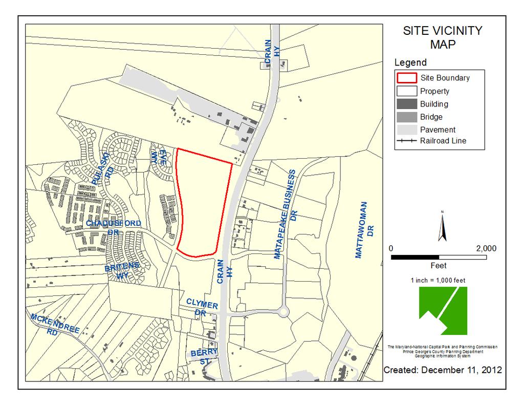
3 THE MARYLAND-NATIONAL CAPITAL PARK AND PLANNING COMMISSION PRINCE GEORGE S COUNTY PLANNING BOARD STAFF REPORT SUBJECT: Preliminary Plan of Subdivision Brandywine Village Lots 1 191, Parcels 1 6, and Parcels A-S OVERVIEW The subject site is located on Tax Map 154 in Grid F-3 and is known Outlot 2. The property consists of acres and is within the Local Activity Center (L-A-C) Zone. The site is currently undeveloped and wooded. Outlot 2 was recorded in Plat Book VJ on December 3, 1998, and is the subject of approved Preliminary Plan of Subdivision (PGCPB Resolution No ). Preliminary Plan of Subdivision was for Brandywine Village and was approved by Planning Board on January 30, 1997 for four outlots (212 acres). The applicant is proposing to resubdivide Outlot 2 into 191 lots, and 24 parcels for a mixed-use development which includes 243,048 square feet of retail, medical, and general office space. The acres of the site, the eastern portion that fronts on Robert Crain Highway (US 301), was rezoned from the Planned Industrial/Employment Park (E-I-A) Zone to the L-A-C Zone by Zoning Map Amendment A-9997-C, which was approved by the District Council on January 12, 2009 (Zoning Ordinance No ). The resolution contains seven conditions and two considerations which is further discussed in the Previous Approval finding of this report. The acres of the site, the western portion that fronts on General Layette Boulevard, was rezoned from the Residential Medium Development (R-M) Zone to the L-A-C Zone by Zoning Map Amendment A-9996-C, which was approved by the District Council on January 12, 2009 (Zoning Ordinance No ). The resolution contains six conditions and two considerations which are further discussed in the Previous Approval finding of this report. The L-A-C Zone requires approval of a comprehensive design plan (CDP) and a specific design plan (SDP) for all uses and improvements. Comprehensive Design Plan CDP-1201 for the subject site is scheduled to be heard by the Planning Board on May 30, Pursuant to the Zoning Ordinance, Section Order of Approval, CDP-1201 should be heard and approved by the Planning Board before the preliminary plan of subdivision (PPS). The applicant has requested two variances with the CDP application; a variance request from Section (b) for the minimum lot size and Section (b)(7)(Footnote 29) for the maximum percentage of townhouses. If the applicant obtains approval of the variances, the PPS will conform to the current CDP. If the variances are not approved, the PPS must be revised to conform to the standards of the CDP. Staff is recommending approval of the variances with the CDP. The site is bounded by three public rights-of-way: Robert Crain Highway (US 301), a freeway, is abutting to the east; Chadds Ford Drive is abutting to the south; and General Lafayette Boulevard, a major collector, is abutting to the west. The property contains over 11.7 acres of 100-year floodplain, wetlands, and its buffers that extends north and south through the property, essentially dividing the property into
4 two distinctive land bays. The portion of the property to the east of the 100-year floodplain fronts on US 301 to the east and Chadds Ford Drive to the south and is proposed for commercial development. The portion of the property to the west of the floodplain fronts on General Lafayette Boulevard to the west and Chadds Ford Drive to the south and is proposed for residential development. The PPS proposes a trail connecter from Parcel A on the residential development to Parcel 4 on the commercial development to allow pedestrian and bike access between these two land bays as recommended by conditions of zoning. At the time of SDP, the trail connector will be evaluated for design, layout, and the establishment of a use easement and triggers for construction, including the bonding requirements for the trail connector construction. The site has frontage on Crain Highway (US 301) to the east, Chadds Ford Drive to the south, and General Lafayette Boulevard to west. A master plan roadway (A-55) is located nearby to the north. The PPS proposes several access locations via private streets onto General Lafayette Boulevard for the townhouse units. The PPS shows all streets and alleys as being private. Section (b)(7)(A) of the Subdivision Regulations requires that townhouse lots may utilize alleys provided that the lot has frontage on a public right-of-way. The plan shows townhouse lots having frontage on private streets and access onto private alleys, therefore, the applicant has filed a variation request from Section (b)(7)(A) as discussed further in the Variation to Section (b)(7)(A) finding, which staff supports. The PPS proposes one direct access onto US 301 for the commercial development. Section (a)(3) of the Subdivision Regulations requires that lots adjacent to an existing arterial or higher road should be designed to have frontage and direct vehicular access on an interior street or service road. The applicant has filed a variation request from Section (a)(3) as discussed further in the Transportation finding. The State Highway Administration (SHA) has indicated that they will not approve the direct vehicular access requested by the applicant onto US 301. Staff is recommending disapproval of the variation from Section (a)(3). The PPS proposes commercial Parcels 1 6 to utilize a private access easement to serve as an inter-parcel connection for the commercial development pursuant to Section (b)(9) of the Subdivision Regulations. The access easement will connect from Chadds Ford Drive and will stub at the northern property line of Parcel 1 to ensure that the site will have future access to A-55 to the north pursuant to Zoning Map Amendment A-9997-C, Condition 6, and is discussed further in the Transportation finding. The property contains regulated environmental features that are required to be protected pursuant to Section of the Subdivision Regulations. The on-site regulated environmental features (primary management area (PMA)) include a stream, 100-year floodplain, and wetland system running north and south through the property Section (b)(5) requires that the PMA be preserved in a natural state to the fullest extent possible. This application proposes three impacts to the PMA. A statement of justification was received and is supported with conditions as discussed further in the Primary Management Area finding. There are three specimen trees show on the tree conservation plan and all are to be preserved. SETTING The subject property is located in the northwest quadrant of the intersection of Robert Crain Highway (US 301) and Chadds Ford Drive, east of General Lafayette Boulevard in Brandywine. The site is bounded to the north by undeveloped land in the Rural Residential (R-R) Zone and a master plan arterial roadway, A-55. To the east of the site is US 301 and east across US 301 is the Brandywine Shopping Center in the Commercial Shopping Center (C-S-C) Zone. South of the site is Chadds Ford Drive and south across Chadds Ford Drive are properties in the Residential Medium Development (R-M) Zone. West of the site is Lafayette Boulevard and west across Lafayette Boulevard are subdivisions in the R-M Zone, developed with townhouses and small-lot single-family detached dwellings
5 FINDINGS AND REASONS FOR STAFF RECOMMENDATION 1. Development Data Summary The following information relates to the subject preliminary plan application and the proposed development. EXISTING PROPOSED Zone L-A-C L-A-C Use(s) Undeveloped and wood Residential (191 townhouse units) Commercial (243,048 sq. ft.) Acreage Lots Outlots 1 0 Parcels 0 24 Dwelling Units Public Safety No No Variance No No Variation No Yes (a)(3) (b)(7)(A) Pursuant to Section (d)(2) of the Subdivision Regulations, this case was heard before the Subdivision and Development Review Committee (SDRC) on February 1, The requested variation to Section (b)(7)(A) of the Subdivision Regulations, which requires that townhouse lots which are served by alleys shall front on a public street, was accepted on January 17, 2013, as discussed further in the Variation to Section (b)(7)(A) finding of this report, and was heard on February 1, 2013 at SDRC as required by Section (b). The requested variation to Section (a)(3) of the Subdivision Regulations for lots that are adjacent to an existing arterial road to be designed to have frontage and direct access onto an interior street or service road was accepted on April 23, 2013, as discussed further in the Variation to Section (a)(3) finding of this report, and was heard on May 10, 2013 at SDRC as required by Section (b) of the Subdivision Regulations. 2. Community Planning The 2002 Prince George s County Approved General Plan (General Plan) designates the subject property within the Developing Tier. The vision for the Developing Tier is to maintain a pattern of low- to moderate-density suburban residential communities, distinct commercial centers, and employment areas that are increasingly transit serviceable. Development within corridors should integrate a multimodal pedestrian-friendly transportation system with the desired development pattern and to plan and provide public facilities to support the development. This preliminary plan of subdivision (PPS) is consistent with the 2002 General Plan Development Pattern policies for centers in the Developed Tier by proposing a low -to moderate-density of residential and commercial development. Approval of this application does not violate the General Plan s growth goals for the year 2025, upon review of Prince George s County s current General Plan Growth Policy Update. The subject site is located within the 1993 the Approved Master Plan and Sectional Map Amendment for Subregion V, Planning Areas 81A, 81B, 83, 84, 85A, 85B (Subregion V Master Plan and SMA) and the master plan reclassified this property from the M-A-C Zone to the E-I-A
6 Zone (46 acres). The master plan recommends a variety of land uses for the greater Brandywine Special Study Areas (BSSA): Employment-Office/Light Manufacturing/Business Park. For Brandywine Village, the master plan recommends employment land use. The 2009 Preliminary Subregion 5 Master Plan recommends commercial land use along MD 5/US 301 and medium-high residential land use along General Lafayette Boulevard. Development should be walkable to encourage non-vehicular access to a future transit stop or station identified on the east side of MD 5/US 301. Subsequently, the subject property was rezoned by the District Council to the L-A-C (Local Activity Center) Zone via approval of Basic Plans A-9997-C and A-9998-C, Chaddsford Center. The site is located within the Joint Base Andrews (JBA) Interim Land Use Control (ILUC) area. The property is within Imaginary Surface C, establishing a height limit of 500 feet above the runway surface. The property is not in an accident potential zone, so no control on use or density is required. These categories will not impact the proposed development. Plan Review This 44-acre proposal was part of a larger project known as Brandywine Village, which encompasses approximately 277 acres of land that has been classified in a variety of comprehensive design zones (R-M, E-I-A, and L-A-C). For the subject property, the L-A-C Zone was approved, in large part, to increase the developer s flexibility to design a more integrated mix of residential and commercial, including office employment uses, as advocated by General Plan policies. General Plan policy recommends diversifying the housing stock in the Developing Tier. The Chaddsford development, of which Brandywine Village was originally a part of, consists of townhouses and single-family detached dwellings. In approving the L-A-C Zone for this property, the importance of providing different housing types was stressed, and was addressed in the recommendations of CDP Previous Approvals The subject property was originally part of a larger development known as Mattawoman, which consisted of a total land area of 277 acres. On November 29, 1977, the District Council adopted County Council Resolution CR for the entire 277-acre Mattawoman property, placing 212 acres in the Major Activity Center (M-A-C) Zone and 65 acres in the R-M Zone (A-8865). In 1987, a zoning map amendment was filed to rezone the 212-acre M-A-C-zoned portion, but it was unsuccessful. In 1992, another application (A-9878) was filed to rezone the 212 acres of M-A-C. The property, now referred to as Brandywine Village, was rezoned on September 14, 1993 by the Approved Master Plan and Sectional Map Amendment for Subregion V, Planning Areas 81A, 81B, 83, 84, 85A, 85B (Subregion V Master Plan and SMA). Of the 212 acres, 46 acres were zoned Employment and Institutional Area (E-I-A), 16.4 acres were zoned Local Activity Center (L-A-C), and 149 acres were zoned R-M (via CR ). The property subject to this application was in the E-I-A Zone, although portions were placed in the R-M and L-A-C Zones based upon proposed road networks that were later revised. A CDP was approved in January 1993 for 65 acres in the R-M Zone for 316 dwelling units. This section was located on McKendree Road and retained the name of Brandywine Village, and is not adjacent to the subject property. On February 20, 1997, the Planning Board approved Preliminary Plan of Subdivision to dedicate Chadds Ford Drive and General Lafayette Boulevard (adjacent to the property) to public use. Comprehensive Design Plan CDP-0102 was approved by the Planning Board for the entire 212-acre parcel on October 11, 2001 (PGCPB Resolution No ). This CDP predominantly focused on the residential development in the R-M Zone and the remaining acreage, including the property included in this application, was intended for future development. On January 12, 2009, the
7 District Council approved Zoning Map Amendments (Basic Plans) A-9996-C and A-9997-C to rezone the property, consisting of two distinct parts, from the E-I-A, R-M, and L-A-C Zones to the L-A-C Zone, subject to the conditions and considerations contained therein. With the approval of the two zoning map amendments covering the two parts of the subject site, previous approved zoning map amendments and CDPs are no longer valid. A CDP was filed in accordance with the requirements of the comprehensive design zones and is currently pending. Zoning Map Amendment A-9996-C rezoned acres of the site, the western portion that fronts on General Layette Boulevard, from R-M to L-A-C, and the resolution contains six conditions and two considerations. The following conditions in [bold] are applicable to this preliminary plan of subdivision (PPS): 1. Land Use Types and Quantities: single-family attached and two-family attached (two-over-two) dwelling units Open space Homeowner Recreation facilities Trails Single-family attached and two-family attached (tow-over-tow) dwelling units are based and conditioned on the following density breakdown: GROSS TRACT: FLOODPLAIN: NET TRACT AREA: Base Density at 8.0 du/acre Maximum Density at 12.1 du/acre acres 0.82 acre acres 162 units 245 units The preliminary plan is proposing a mixed-use development of 191 townhouse dwellings and 243,048 square feet of retail, medical, and general office space. The applicant has requested two variances with the CDP application; a variance request from Section (b) for the minimum lot size and Section (b)(7)(Footnote 29) for the maximum percentage of townhouses. The proposed density and intensity of residential and commercial space with this PPS is consistent with proposed Comprehensive Design Plan CDP-1201 for the subject site. 2. At the time of comprehensive design plan, the transportation planning staff shall make master plan transportation facility recommendations consistent with the Subregion V master plan. Conformance to Condition 2 was evaluated at the time of comprehensive design plan, and is further discussed in the Transportation finding. 3. At the time of comprehensive design plan and preliminary plan of subdivision, the transportation planning staff shall review a traffic impact study as a means of making findings of the adequacy of transportation facilities. The traffic study shall, at a minimum, include the following as critical intersections:
8 a. US 301/MD 5 and Matapeake Business Drive/Clymer Drive (signalized) b. US 301/MD 5 and Chadds Ford Drive (signalized) c. US 301/MD 5 and Cedarville Road/McKendree Road (signalized) d. Chadds Ford Drive and General Lafayette Boulevard (unsignalized) 4. Following the connection of C-502 to A-55 (and a planned partial interchange at US 301/MD 5 and A-55) on the north and to McKendree Road on the south, the applicant, the applicant s heirs, successors and/or assignees shall close the US 301/MD 5/Chadds Ford Drive at-grade intersection to traffic. Such closure shall include removal of the signal as directed by SHA following closure of the intersection. All closures, modifications and removals shall be at the sole expense of the applicant, the applicant s heirs, successors and/or assignees. 5. Vehicular access from the eastern portion of the site to the property to the north is supported and shall be demonstrated at the time of specific design plan. Conformance to Conditions 3 through 5 is evaluated with this preliminary plan and is further discussed in the Transportation finding. 6. At time of comprehensive design plan ( CDP ), the applicant shall: a. Submit design standards that establish design and review parameters, including setbacks, lot coverage, and other bulk standard for development, standards for the materials and design of architecture, and standards for design of signage for the entire site. b. Provide an analysis of maximum density allowed per dwelling unit/acre and the proposed du/acre for the L-A-C Zone. c. Provide pedestrian connectivity to the proposed L-A-C Zone commercial area. d. Provide a valid stormwater management concept approval letter and plan. Conformance to Condition 6 was evaluated at the time of comprehensive design plan, and will further be reviewed with the specific design plan. An approved stormwater management (SWM) concept plan was submitted with the PPS, however the SWM plan expired as of May 4, Prior to signature approval of the PPS, the valid stormwater management concept plan should be submitted and should be in substantial conformance with the approved PPS
9 Considerations: 1. The applicant, the applicant s heirs, successors and/or assignees shall designate all master plan trails, plus feeder connections to all development pods on the comprehensive design plan. Evaluation of Consideration 1 was reviewed at the time of comprehensive design plan, and is further discussed in the Trail finding. 2. If approved, at the time of CDP the plan should be modified to move access along Chadds Ford Drive westward to be consistent with the access shown on SDP-0519 for Brandywine Village. If placement of the access at that location is not possible due to environmental features by determination of the Environmental Planning Section, access to the eastern portion of the site should be achieved from C-502 (General Lafayette Boulevard) at a location determined to be of least environmental impact. Evaluation of Consideration 2 was reviewed at the time of comprehensive design plan, and is further discussed in the Transportation finding. Zoning Map Amendment A-9997-C rezoned acres of the site, the eastern portion that fronts on US 301, from E-I-A to L-A-C, and the resolution contains seven conditions and two considerations, The following conditions in [bold] are applicable to this preliminary plan of subdivision: 1. Land Use Types and Quantities: 189,000 square feet of office space 14,657 square feet of retail commercial Open space Homeowner Recreation Facilities Trails GROSS TRACT: FLOODPLAIN: NET TRACT AREA acres acres acres Base intensity of zone acres at 0.16 FAR : 167,619 sq. ft. Maximum intensity acres at 0.31 FAR: 324,761 sq. ft. The preliminary plan is proposing a mixed-use development of 191 townhouse dwellings and 243,048 square feet of retail, medical, and general office space. The proposed density and intensity of residential and commercial space with this PPS is consistent with proposed Comprehensive Design Plan CDP-1201 for the subject site. 2. All commercial structures should be fully equipped with an automatic fire suppression system in accordance with National Fire Protection Association (NFPA) Standard
10 This preliminary plan has been evaluated for fire and rescue and is discussed further in the Fire and Rescue finding of this report. A condition of an automatic fire suppression system is carried forward with this PPS to be implemented at the time of building permit. 3. At the time of CDP, the applicant shall: a. Submit design standards that establish design and review parameters, including setbacks, lot coverage, and other bulk standard for development, standards for the materials and design of architecture, and standards for design of signage for the entire site. b. Provide an analysis of maximum density allowed per FAR and the proposed FAR for the L-A-C Zone. c. Provide pedestrian connectivity to the proposed L-A-C Zone residential area. d. Provide a valid stormwater management concept approval letter and plan. Conformance to Condition 3 was evaluated at the time of conceptual site plan, and will further be reviewed with the specific design plan. An approved SWM concept plan was submitted with the PPS, however, the SWM plan expired as of May 4, Prior to signature approval of the PPS, the valid stormwater management concept plan should be submitted and should be in substantial conformance with the approved PPS, and list all design standards applicable with the PPS and conform to the standards. 4. At the time of CDP, the transportation planning staff shall make master plan transportation facility recommendations consistent with the Subregion V master plan. Conformance to Condition 4 was evaluated at the time of comprehensive design plan, and is further discussed in the Transportation finding. 5. At the time of CDP and preliminary plan of subdivision, the transportation planning staff shall review a traffic impact study as a means of making findings of the adequacy of transportation facilities. The traffic study shall, at a minimum, include the following as critical intersections: a. US 301/MD 5 and Matapeake Business Drive/Clymer Drive (signalized) b. US 301/MD 5 and Chadds Ford Drive (signalized) c. US 301/MD 5 and Cedarville Road/McKendree Road (signalized) d. Chadds Ford Drive and General Lafayette Boulevard (unsignalized) 6. Following the connection of C-502 to A-55 (and a planned partial interchange at US 301/MD 5 and A-55) on the north and to McKendree Road on the south, the applicant, the applicant s heirs, successors and/or
11 assignees shall close the US 301/MD 5/Chadds Ford Drive at-grade intersection to traffic. Such closure shall include removal of the signal as directed by SHA following closure of the intersection. All closures, modifications, and removals shall be at the sole expense of the applicant, the applicant s heirs, successors and/or assignees. 7. Vehicular access from the eastern portion of the site to the property to the north is supported and shall be demonstrated at the time of specific design plan. Conformance to Conditions 5 through 7 is evaluated with this preliminary plan and is further discussed in the Transportation finding. Considerations: 1. The applicant, the applicant s heirs, successors and/or assignees, shall designate all master plan trails, plus feeder connections to all development pods on the comprehensive design plan. Evaluation of Consideration 1 was reviewed at the time of comprehensive design plan, and is further discussed in the Trail finding. 2. If approved, at the time of CDP the plan should be modified to move access along Chadds Ford Drive westward to be consistent with the access shown on SDP-0519 for Brandywine Village. If placement of the access at that location is not possible due to environmental features by determination of the Environmental Planning Section, access to the eastern portion of the site should be achieved from C-502 (General Lafayette Boulevard) at a location determined to be of least environmental impact. Evaluation of Consideration 2 was reviewed at the time of comprehensive design plan, and is further discussed in the Transportation finding. The PPS conforms to Zoning Map Amendments A-9996-C and A-9997-C and the pending Comprehensive Design Plan, CDP-1201, if the application is approved with conditions. Comprehensive Design Plan CDP-1201 for the subject site is scheduled to be heard by the Planning Board on May 30, Pursuant to the Zoning Ordinance, Section Order of Approval, CDP-1201 should heard and approved by the Planning Board before the PPS. 4. Urban Design The 2010 Prince George s County Landscape Manual (Landscape Manual) and the Zoning Ordinance contain the site design guidelines and requirements that are applicable to the review of this preliminary plan of subdivision (PPS). Conformance with the Zoning Ordinance Section , Review Process: A three-phase plan review procedure is required in the comprehensive design zones. The initial phase is the review of a basic plan. The second phase is the review of a comprehensive design plan (CDP), and the third phase is the review of a specific design plan (SDP). This property has two previously approved zoning map amendment applications (basic plans) for the residential and commercial development
12 Currently, CDP-1201 is pending with the Urban Design Section, Development Review Division, and has been scheduled to be heard by the Planning Board on May 30, Comprehensive Design Plan CDP-1201 must be acted upon prior to any action on Preliminary Plan of Subdivision Section (a), Regulations: The approved densities on the subject site categorize it as a Neighborhood Center. The general standards for development within a Neighborhood Center are as follows: Neighborhood Center (1) Minimum size of zone 4 adjoining gross acres (except as provided in Section ) (2) Base residential density 8 dwelling units per gross residential acre (3) Maximum residential density 12.1 dwelling units per gross residential (4) Base commercial intensity 0.16 FAR per gross commercial acre (5) Maximum commercial density 0.31 FAR per gross commercial acre (6) Maximum mixed retirement development density 8 units per gross acre The subject site proposes a base residential density of 9.47 dwelling units per acre and a base commercial density of 0.21 floor area ratio (FAR), which are above the minimum Neighborhood Center densities, but are within the density ranges approved in the basic plans. Any densities above the minimum densities require the use of public benefit features. The use of public benefit features has been specified in the CDP application. Additional regulations governing the development of this site must be established at the time of CDP approval. There are two variance applications included in CDP-1201, and the subject PPS is based upon their approval. One variance application is a request for 100 percent of townhouse (as required by Section (b)(7)(Footnote 29) of the Zoning Ordinance) in the development and the other requests a minimum lot size of the townhouse to be reduced to 1,500 square feet (as required by Section (b) of the Zoning Ordinance) from the standard 1,800 square feet. The staff recommendation in CDP-1201 is for approval of the proposed two variances. If the variances are not approved by the Planning Board, it would significantly impact the general layout and lotting pattern of the subdivision. It was the applicant s option to track the CDP and PPS so closely. A significant revision to the layout of the PPS based on the Planning Board s action on the CDP could result in a recommendation for disapproval due to substantial changes. Conformance with Previous Approvals The District Council provided the following applicable condition in its approval of Basic Plan A-9996-C for the residential portion of development as follows: 6. At time of comprehensive design plan ( CDP ), the applicant shall: a. Submit design standards that establish design and review parameters, including setbacks, lot coverage, and other bulk standard for development, standards for the materials and design of architecture, and standards for design of signage for the entire site
13 b. Provide an analysis of maximum density allowed per dwelling unit/acre and the proposed du/acre for the L-A-C Zone. This condition was reviewed at the time of CDP approval. The District Council provided the following applicable condition in its approval of Basic Plan A-9997-C for the commercial portion of the development as follows: 3. At the time of CDP, the applicant shall: a. Submit design standards that establish design and review parameters, including setbacks, lot coverage, and other bulk standard for development, standards for the materials and design of architecture, and standards for design of signage for the entire site. b. Provide an analysis of maximum density allowed per FAR and the proposed FAR for the L-A-C Zone. This condition was reviewed at the time of CDP approval. Comprehensive Design Plan CDP-1201 recommends the following development standards that will govern the proposed development: RESIDENTIAL USES Minimum Lot size: Rear Garage Townhouses 1,500 s.f.ǂ Non-Garage Townhouses 1,500 s.f.ǂ Minimum frontage at street R.O.W: 20 feet 20 feet Minimum frontage at Front B.R.L. 20 feet 20 feet Maximum Lot Coverage 60% 60% Minimum front setback from R.O.W. 13 feet* 15 feet Minimum side setback between buildings: 20 feet 20 feet Minimum rear setback: 18 feet** 16 feet** Parking Spaces 2.04 per du*** 2.04 per du*** Minimum distance between lot lines of Townhouses 10 feet 10 feet Minimum Density 8.0 du/ac.**** 8.0 du/ac.**** Maximum Density 12.1 du/ac.**** 12.1 du/ac.**** Minimum Width of Alleys 18 feet***** 18 feet***** Notes: ǂ No more than 40 percent (74 Units) of the total townhouse lots shall be smaller than 1,550 square feet. No townhouse lot shall be smaller than 1,500 square feet. The minimum lot width of any townhouse within this development shall be 20 feet
14 * Stoops and/or steps may encroach into the front setback, but shall not encroach more than five feet into the yard. **Decks and patios can intrude 50% (9 feet for 18-foot setback and 8 feet for 16-foot setback) into the rear setback areas. ***Parking: The Zoning Ordinance requires 2.04 parking spaces per townhouse dwelling unit. The proposed CDP has 191 townhouses and therefore requires a total of 390 parking spaces. The code takes into account visitor parking by requiring two spaces per townhouse, plus an additional 0.04 spaces per unit for visitor parking. Each of the 98 garage townhouses includes two garage spaces. Along the streets, 198 parking spaces are provided mostly in front of or adjacent to non-garage units. In total, the townhouse portion of the development has 394 parking spaces. While this exceeds the required 390, it also does not count driveways in both the garage and the non-garage lots that are capable of providing additional legal parking spaces. Sufficient parking is provided for both residents and guests. **** Does not apply specifically to garage and non-garage units, but is the overall density of the residential component of the property. ***** Alleys provide adequate turnaround space for normal traffic. However, typical hammerhead turnarounds, in accordance with DPW&T standards, may be required in appropriate locations on alleys as determined at the time of SDP. Turnaround facilities may not be necessary or appropriate in all alley locations. COMMERCIAL USES Minimum Lot Coverage 60% Minimum front Building setback from R.O.W. Minimum front Building setback from US 301 Minimum side setback between buildings: Minimum rear setback: Minimum corner setback to side street R-O-W. 10 feet 30 feet 100 feet 10 feet 10 feet Maximum building height: 7 stories Minimum FAR 0.16 Maximum FAR 0.31 **CDP-1201 also recommends that the width of pavement of the spine in the commercial section be a minimum of 26 feet, with a possible expansion near Chadds Ford Drive to accommodate the traffic capacity proposed. Prior to signature approval of the PPS, the applicant shall revise the plan to conform to the approved design standards as contained in CDP Specifically, the minimum distance between the lot lines of the end units of townhouses should be a minimum of ten feet, and the minimum distance between townhouse buildings should be a minimum of 20 feet
15 Conformance with the 2010 Prince George s County Landscape Manual The property is subject to the requirements of the 2010 Prince George s County Landscape Manual (Landscape Manual). Specifically, the site is subject to Section 4.1, Residential Requirements; Section 4.2, Landscape Strips along Streets; Section 4.3, Parking Lot Requirements; Section 4. 7, Buffering Incompatible Uses; Section 4.9, Sustainable Landscape Requirements; and Section 4.10, Street Trees along Private Streets. Compliance with these regulations will be evaluated at the time of SDP review. Other Design Issues Nearly all of the buildable land within the residential section of the development appears lotted-out with little consideration for open space between townhome sticks and outdoor amenities. Small isolated tot lots should be avoided. The subject PPS should be revised to demonstrate one central location for on-site recreational amenities. Staff recommends that Lots 51 through 56 be eliminated or relocated in order to make space for a centrally-located recreational amenity. Due to the limited time between the CDP and PPS applications, the applicant submitted Applicant Exhibit A to address this recommendation, as discussed further in the Applicant Exhibit A finding. Parking for visitors in the attached dwelling neighborhoods has been an issue in the county. Provision of additional parking spaces for visitors should be reviewed and evaluated at the time of SDP review. Sufficient pedestrian connection and circulation between the residential and commercial sections has been the focus of previous approvals. Additional analysis of the pedestrian connection, including future maintenance of the connection, is reviewed with this PPS and should also be further reviewed with the SDP as recommended. The PPS includes a variation from Section (a) for private roads and easements. The Urban Design Section supports this variation to implement the proposed design. The PPS includes a variation from Section (a)(3) for direct access to a roadway of arterial or higher classification, which is analyzed in the Transportation finding. The PPS conforms to the recommendations of CDP-1201, with conditions. 5. Environmental A Type 1 Tree Conservation Plan, TCP /01, and an approved Natural Resources Inventory, NRI/038/12, are required and have been reviewed. With regard to the environmental regulations that became effective on September 1, 2010, the subject application is not grandfathered under Subtitles 24 and 25 of the County Code with respect to the delineation of regulated environmental features, woodland conservation, and applicable submittal requirements because the current application is a new preliminary plan of subdivision (PPS). General Plan Conformance The 2002 Prince George s County Approved General Plan (General Plan) contains tier-specific and countywide-specific goals, objectives, and policies with regard to the protection of natural features, noise pollution, stormwater management, light pollution, and woodland conservation. Many of these policies have been implemented through updates to the Woodland Conservation Ordinance, zoning requirements, and applicable master plans that will be discussed further
16 The applicable tier-specific policy is as follows: POLICY 2: Preserve, restore and enhance environmental features and green Infrastructure elements. The entire site is located in regulated areas, evaluation areas, and network gaps of the 2005 Approved Countywide Green Infrastructure Plan. Preservation and retention of the primary management area (PMA) to the greatest extent possible and woodland conservation will be discussed further under conformance with the Master Plan, Development Plan, and Green Infrastructure Plan, and also within the Environmental Review section below. The applicable countywide-specific policies are as follows: POLICY 1: Preserve, protect, and enhance the designated green infrastructure elements. See Conformance with the Countywide Green Infrastructure Plan below. POLICY 2: Preserve, protect and enhance surface and ground water features and restore lost ecological functions. Based on the NRI for the subject site, the site contains streams, wetlands and wetland buffers, and 100-year floodplain which comprises the PMA, and are regulated environmental features located on-site. The preservation and protection of groundwater features will be addressed during the review of the stormwater management concept plan by the Department of Public Works and Transportation (DPW&T). POLICY 3: Preserve existing woodland resources and replant woodland, where possible, while implementing the desired development pattern. Strategy V. Meet the requirements of the Woodland Conservation Ordinance on-site to the fullest extent possible within the Mattawoman watershed. If off-site mitigation is required, it shall be provided within the Mattawoman watershed. The entire site is currently wooded. Woodland conservation is discussed in the following sections, as well as the Environmental Review section. POLICY 5: Reduce overall sky glow, minimize the spill-over of light from one property to the next, and reduce glare from light fixtures. Light pollution is discussed in the Environmental Review section below. POLICY 7: Minimize impacts of noise on residential uses during the land development process. Noise impacts are discussed in the Environmental Review section below
17 Master Plan Conformance The subject property is located within the 1993 Approved Master Plan and Sectional Map Amendment for Subregion V Planning Areas 81A, 81B, 83, 84, 85A and 85B. The protection of the regulated environmental features proposed on the PPS and associated Type 1 tree conservation plan (TCP1) is in general conformance with the guidance provided by the master plan. A possible revision to the comprehensive design plan (CDP) and TCP1 was previously identified as necessary to show the ultimate public rights-of-way associated with the subject property (both state and county) in conformance with the transportation improvements approved with the Subregion V Master Plan, the 2009 Approved Countywide Master Plan of Transportation (MPOT), and the US 301 Upgrade Option. Conformance with the Countywide Green Infrastructure Plan The Countywide Green Infrastructure Plan indicates that the site contains regulated areas, evaluation areas, and network gaps, which are consolidated along the stream corridor located along the eastern border of this site. The submitted application shows preservation of the regulated areas and areas adjacent to all regulated areas in general conformance with the Green Infrastructure Plan. Reviews during future development phases will provide more detailed evaluations of conformance with the Green Infrastructure Plan. The Mattawoman Creek Stream Valley was designated as a special conservation area in the Green Infrastructure Plan because its associated stream basin is among the most productive finfish spawning and nursery streams in the entire Chesapeake Bay region. The quality of the water entering the stream systems in the watershed is of particular concern, and when evaluation areas occur within the watershed, woodlands present should be preserved adjacent to streams to widen the corridors adjacent to regulated areas and protect water quality. This will be evaluated further in the Environmental Review section below. The following policies are applicable to the review of the subject application: POLICY 1: Preserve, protect, enhance or restore the green infrastructure network and its ecological functions while supporting the desired development pattern of the 2002 General Plan. The subject property contains regulated areas, evaluation areas, and network gap areas as identified in the Countywide Green Infrastructure Plan located within the Mattawoman Creek Watershed, which is a primary corridor and a special conservation area. As noted above, the submitted application shows preservation of the regulated areas and some adjacent evaluation areas in general conformance with the Green Infrastructure Plan. Reviews during this and future development phases will provide more detailed evaluations of conformance with the Green Infrastructure Plan and will explore opportunities to expand the riparian buffers area located in the evaluation area. POLICY 2: Preserve, protect and enhance surface and ground water features and restore lost ecological functions
18 Preservation of water quality in this area will be provided through the protection of the expanded stream buffers and the application of best SWM practices. It is recommended that environmental site design techniques be applied throughout this site to the fullest extent practicable. Stormwater management will be further discussed in the Environmental Review section below. POLICY 3: Preserve existing woodland resources and replant woodland, where possible, while implementing the desired development pattern of the 2002 General Plan. This policy is superseded by the General Plan policy and strategy to meet the requirements of the woodland conservation on-site to the fullest extent possible within the Mattawoman watershed, or if off-site mitigation is required, to provide it within the Mattawoman watershed. The TCP1 for the subject property should demonstrate that the requirements of the Woodland and Wildlife Habitat Conservation Ordinance (WCO) are provided on-site through preservation or afforestation to the fullest extent possible, consistent with the desired pattern of development and densities indicated in the General Plan. If off-site mitigation is required, it should be provided within the Mattawoman watershed. Woodland conservation will be further discussed in the Environmental Review section below. Previous Zoning Approvals for A-9997-C Basic Plan A-9996-C was approved by the District Council on January 19, 2009 subject to the following condition which is environmental in nature: 6. At time of comprehensive design plan ( CDP ), the applicant shall: d. Provide a valid stormwater management concept approval letter and plan. A valid SWM concept approval letter and associated plans ( ) was submitted with the current application, and will be discussed in the Stormwater Management finding. Environmental Review The NRI shows that the site is bifurcated by a stream, 100-year floodplain, and wetland system running north to south through the property. The principal stream on the site is a tributary of Mattawoman Creek in the Potomac River Watershed. According to the Web Soil Survey, the principal soils on the site are in the Aquasco, Beltsville, Bibb, Grosstown, Hoghole-Grosstown, Leonardtown and Potobac-Issue soil series. Aquasco and Beltsville soils are highly erodible, and may have perched watertables and impeded drainage. Grosstown and Hoghole-Grosstown pose few problems to development. Leonardtown and Potobac-Issue complex soils are hydric or partially hydric and poor drainage. High groundwater and poor drainage is problematic for both foundations and basements. This information is provided for the applicant s benefit, and may affect the architectural design of structures, grading requirements, and SWM elements of the site. DPW&T may require a soils report in conformance with County Council Bill CB during the permit process review. There are no Marlboro clays or scenic or historic roads located on or adjacent to the subject property. Current air photos indicate that the site is predominantly wooded and not developed. Based on information obtained from the Maryland Department of Natural Resources, Natural Heritage Program, there are no rare, threatened, or endangered species found to occur in the vicinity of this site
19 The property is subject to the provisions of the WCO because the gross tract area is in excess of 40,000 square feet and there are more than 10,000 square feet of existing woodland on-site. A TCP1 (TCP ) has been submitted for review. The current zoning (L-A-C) of the subject property has a woodland conservation threshold of 15 percent or 5.10 acres, which is correctly reflected in the TCP1 worksheet. The TCP1 proposes to clear acres of on-site net tract woodland and 0.49 acre of wooded floodplain, resulting in a woodland conservation requirement of acres. The requirement is proposed to be met with 1.74 acres of on-site preservation, 1.07 acres of on-site afforestation/reforestation, and acres of off-site woodland conservation credits. The Mattawoman Creek Stream Valley was designated as a special conservation area in the Green Infrastructure Plan because its associated stream basin is among the most productive finfish spawning and nursery streams in the entire Chesapeake Bay region. The quality of the water entering the stream systems in the watershed is of particular concern, and when evaluation areas occur within the watershed, woodlands present should be preserved adjacent to streams to widen the corridors adjacent to regulated areas and protect water quality. The on-site woodland conservation proposed on the TCP1 falls below the woodland conservation threshold of 5.10 acres, although there is opportunity for expansion of the wooded stream buffer running through the development. The TCP1 plan also required technical revisions to be in conformance with the requirements of the Environmental Technical Manual. After September 1, 2010, pursuant to Section (d)(1)(B) of the County Code, woodland preserved, planted, or regenerated on-site shall be placed in a woodland conservation easement recorded in land records and the liber and folio of the easement indicated on all plans of development. A woodland conservation easement will be required when a Type 2 tree conservation plan (TCP2) is prepared with the SDP. When a TCP2 is prepared, prior to signature approval, recording of a woodland conservation easement in land records will be required, and the liber and folio of the easement will be placed on the TCP2 in a required note. Policies contained in the General Plan call for the reduction of adverse noise impacts to meet State of Maryland noise standards. Transportation-related noise impacts associated with Robert Crain Highway (US 301) and A-55, a master-planned roadway running slightly north of the subject application, needs to be evaluated with the current application relative to State of Maryland noise standards for residential uses. Residential uses or residential outdoor activity areas that are proposed within the 65 dba Ldn noise contour or higher may require mitigation. Robert Crain Highway is an existing source of traffic-generated noise, and a master-planned freeway. The modeled location of the 65 dba Ldn noise contour was generated for this site using the Environmental Planning Section s noise model at 792 feet from the centerline of US 301. The location of this noise contour has been delineated on the coversheets of both the PPS and TCP1, but should also be reflected on all plan sheets for evaluation purposes. Chadds Ford Drive (A-55) is a master-planned arterial running east to west just north of the subject application. The location of the 65 dba Ldn noise contour was generated for this site using the Environmental Planning Section s noise model at 212 feet from the centerline of the roadway. Chadds Ford Drive (A-55) has been delineated on the PPS, CDP, and TCP1, as well as the location of noise contours needed for evaluation purposes. The applicant has submitted a Phase I noise contour evaluating noise impacts on the proposed site development titled Brandywine Village Acoustical Analysis dated March 19, 2013 and
188 townhouses Informational Mailing: 07/30/13
 The Maryland-National Capital Park and Planning Commission Prince George s County Planning Department Development Review Division 301-952-3530 Note: Staff reports can be accessed at www.mncppc.org/pgco/planning/plan.htm.
Preliminary Plan
 The Maryland-National Capital Park and Planning Commission Prince George's County Planning Department Development Review Division 301-952-3530 Note: Staff reports can be accessed at www.mncppc.org/pgco/planning/plan.htm.
Note: Staff reports can be accessed at
 The Maryland-National Capital Park and Planning Commission Prince George's County Planning Department Development Review Division 301-952-3530 Note: Staff reports can be accessed at www.mncppc.org/pgco/planning/plan.htm.
WHEREAS, the staff of The Maryland-National Capital Park and Planning Commission recommended APPROVAL of the application with conditions; and
 R E S O L U T I O N WHEREAS, Redeemed Christian Church of God is the owner of a 2.83-acre parcel of land known as Lot 9, Lot 19, P/O Lot 1 and P/O Lot 18, Block B, Plat Book A, Plat 5, said property being
PGCPB No File No R E S O L U T I O N
 R E S O L U T I O N WHEREAS, Cambridge Place at Westphalia LLC is the owner of a 52.27-acre parcel of land known as Parcel 2, said property being in the 15th Election District of Prince George s County,
PGCPB No File No R E S O L U T I O N
 R E S O L U T I O N WHEREAS, Cambridge Place at Westphalia is the owner of a 68.94-acre parcel of land known as Tax Map 90 in Grid C-1 and is also known as Parcel C, said property being in the 15th Election
WHEREAS, the staff of The Maryland-National Capital Park and Planning Commission recommended APPROVAL of the application with conditions; and
 R E S O L U T I O N WHEREAS, Faison-Brandywine, LLC. is the owner of a 31.28-acre parcel of land known as Outparcels 6 and 8, and a residue parcel recorded in land records in November 2007 (PM 224@54);
Preliminary Plan
 The Maryland-National Capital Park and Planning Commission Prince George s County Planning Department Development Review Division 301-952-3530 Note: Staff reports can be accessed at www.mncppc.org/pgco/planning/plan.htm.
Preliminary Plan
 The Maryland-National Capital Park and Planning Commission Prince George's County Planning Department Development Review Division 301-952-3530 Note: Staff reports can be accessed at www.mncppc.org/pgco/planning/plan.htm.
COUNTY COUNCIL OF PRINCE GEORGE'S COUNTY, MARYLAND, SITTING AS THE DISTRICT COUNCIL ZONING ORDINANCE NO
 Case No.: A-9987-C and A-9988-C Applicant: Timothy Brandywine One, LLC & Timothy Brandywine Investments Two, LLC (Project Name Villages at Timothy Branch) COUNTY COUNCIL OF PRINCE GEORGE'S COUNTY, MARYLAND,
The Maryland-National Capital Park and Planning Commission Prince George s County Planning Department Development Review Division
 The Maryland-National Capital Park and Planning Commission Prince George s County Planning Department Development Review Division 301-952-3530 Note: Staff reports can be accessed at www.mncppc.org/pgco/planning/plan.htm.
PGCPB No File No R E S O L U T I O N
 R E S O L U T I O N WHEREAS, Camp Springs Allentown, LLC is the owner of a 13.03-acre parcel of land known as Parcels 52 55 and Parcel 164, said property being in the 6th Election District of Prince George
R E S O L U T I O N. a. Remove Table B from the plan.
 R E S O L U T I O N WHEREAS, Werrlein Property is the owner of a 0.3902-acre parcel of land in the 5th Election District of Prince George s County, Maryland, being zoned One-Family Detached Residential
PGCPB No File No R E S O L U T I O N
 R E S O L U T I O N WHEREAS, Quad Construction Corp. is the owner of a 167.70-acre parcel of land known as Forest Hills (Parcel 38), located on Tax Map 92 and Grid E-3, said property being in the 3rd Election
R E S O L U T I O N. 2. Development Data Summary:
 R E S O L U T I O N WHEREAS, the Prince George s County Planning Board has reviewed Special Permit Application No. SP-170001, Mama s Care Assisted Living Facility, requesting to expand an existing congregate
PGCPB No File No R E S O L U T I O N
 R E S O L U T I O N WHEREAS, American Resource Management Group Limited Partnership is the owner of a 38.17-acre parcel of land known as Parcel A, said property being in the 18th Election District of Prince
WHEREAS, the staff of The Maryland-National Capital Park and Planning Commission recommended APPROVAL of the application with conditions; and
 R E S O L U T I O N WHEREAS, Elizabeth J. Buck is the owner of a 210.73-acre parcel of land located on Tax Map 93A and Grids B 2 and 3 and C 2 and 3, said property being in the 3rd Election District of
COUNTY COUNCIL OF PRINCE GEORGE S COUNTY, MARYLAND, SITTING AS THE DISTRICT COUNCIL ORDER AFFIRMING PLANNING BOARD DECISION, WITH CONDITIONS
 Case No.: Applicant: SDP-0607 Acton Park, Inc. COUNTY COUNCIL OF PRINCE GEORGE S COUNTY, MARYLAND, SITTING AS THE DISTRICT COUNCIL ORDER AFFIRMING PLANNING BOARD DECISION, WITH CONDITIONS IT IS HEREBY
Chesapeake Bay Critical Area Conservation Plan
 The Maryland-National Capital Park and Planning Commission Prince George s County Planning Department Development Review Division 301-952-3530 Note: Staff reports can be accessed at www.mncppc.org/pgco/planning/plan.htm.
MONTGOMERY COUNTY PLANNING DEPARTMENT THE MARYLAND-NATIONAL CAPITAL PARK AND PLANNING COMMISSION
 MONTGOMERY COUNTY PLANNING DEPARTMENT THE MARYLAND-NATIONAL CAPITAL PARK AND PLANNING COMMISSION MCPB Item No.: Date: 06-21-12 The Plantations, Preliminary Plan -120090240 Benjamin Berbert, Senior Planner,
PGCPB No File No R E S O L U T I O N
 R E S O L U T I O N WHEREAS, Jemal s Calvert II, LLC is the owner of a 1.69-acre parcel of land known as Greenhorne & O Mara s Addition to Riverdale Gardens, Parcel 1, said property being in the 19th Election
WHEREAS, the staff of The Maryland-National Capital Park and Planning Commission recommended APPROVAL of the application with conditions; and
 R E S O L U T I O N WHEREAS, a 9.13-acre parcel of land known as Parcel 92 and Parcel 35, said property being in the 9th Election District of Prince George's County, Maryland, and being zoned R-R; and
WHEREAS, the staff of The Maryland-National Capital Park and Planning Commission recommended APPROVAL of the application with conditions; and
 R E S O L U T I O N WHEREAS, Joseph Rodgers is the owner of a 125.70-acre parcel of land known as Parcel 29, being located on Tax Map 77 and Grid F-3, said property being in the 3rd Election District of
Implementation. Approved Master Plan and SMA for Henson Creek-South Potomac 103
 Implementation Approved Master Plan and SMA for Henson Creek-South Potomac 103 104 Approved Master Plan and SMA for Henson Creek-South Potomac Sectional Map Amendment The land use recommendations in the
WHEREAS, the staff of The Maryland-National Capital Park and Planning Commission recommended APPROVAL of the application with conditions; and
 R E S O L U T I O N WHEREAS, J.W. Barker is the owner of a 4.69-acre parcel of land known as Parcel 176, Tax Map 37, Grid B-3, said property being in the 14th Election District of Prince George's County,
Appendix A: Guide to Zoning Categories Prince George's County, Maryland
 Appendix A: Guide to Zoning Categories Prince George's County, Maryland RESIDENTIAL ZONES 1 Updated November 2010 R-O-S: Reserved Open Space - Provides for permanent maintenance of certain areas of land
WHEREAS, the staff of The Maryland-National Capital Park and Planning Commission recommended APPROVAL of the application with conditions; and
 R E S O L U T I O N WHEREAS, Domenic V. Ferrero is the owner of a 6.99-acre parcel of land known as P39 and P139, Parcel A and Outlot A said property being in the 9th Election District of Prince George's
Bowie Marketplace Residential Detailed Site Plan Statement of Justification January 13, 2017 Revised February 2, 1017
 Bowie Marketplace Residential Detailed Site Plan Statement of Justification January 13, 2017 Revised February 2, 1017 Submitted on behalf of: BE Bowie LLC 5410 Edson Lane, Suite 220 Rockville, MD 20852
R E S O L U T I O N. 2. Development Data Summary:
 R E S O L U T I O N WHEREAS, the Prince George s County Planning Board is charged with the approval of Detailed Site Plans pursuant to Part 3, Division 9 of the Zoning Ordinance of the Prince George s
WHEREAS, the staff of The Maryland-National Capital Park and Planning Commission recommended APPROVAL of the application with conditions; and
 R E S O L U T I O N WHEREAS, Day Homes, LLC is the owner of a 6.22-acre parcel of land known as Parcel 72, Tax Map 56 in Grid D-4, said property being in the 2nd Election District of Prince George's County,
PGCPB No File No R E S O L U T I O N
 R E S O L U T I O N WHEREAS, Saint Paul Senior Living Suitland LP is the owner of a 4.72-acre parcel of land known as Parcel 119, said property being in the 6th Election District of Prince George s County,
COUNTY COUNCIL OF PRINCE GEORGE S COUNTY, MARYLAND, SITTING AS THE DISTRICT COUNCIL FINAL DECISION ORDER AFFIRMING PLANNING BOARD
 Case No.: Applicant: Smith Home Farm (Reconsideration) SHF Project Owner, LLC COUNTY COUNCIL OF PRINCE GEORGE S COUNTY, MARYLAND, SITTING AS THE DISTRICT COUNCIL FINAL DECISION ORDER AFFIRMING PLANNING
The Maryland-National Capital Park and Planning Commission Prince George's County Planning Department Development Review Division
 The Maryland-National Capital Park and Planning Commission Prince George's County Planning Department Development Review Division 301-952-3530 Note: Staff reports can be accessed at www.mncppc.org/pgco/planning/plan.htm.
WHEREAS, the staff of The Maryland-National Capital Park and Planning Commission recommended APPROVAL of the application with conditions; and
 R E S O L U T I O N WHEREAS, F.M. and M.B. Hall are the owners of a 17.60-acre parcel of land known as Lots 1-3, Block O; Lots 1-11, Block P; and Parcel B and part of Parcel A, being located on Tax Map
R E S O L U T I O N. 2. Development Data Summary
 R E S O L U T I O N WHEREAS, the Prince George's County Planning Board is charged with the approval of Conceptual Site Plans pursuant to Part 3, Division 9 of the Zoning Ordinance of the Prince George's
PLANNED UNIT DEVELOPMENT & SUBDIVISION STAFF REPORT Date: April 18, 2019
 PLANNED UNIT DEVELOPMENT & SUBDIVISION STAFF REPORT Date: April 18, 2019 DEVELOPMENT NAME SUBDIVISION NAME Springhill Village Subdivision Springhill Village Subdivision LOCATION 4350, 4354, 4356, 4358,
ARTICLE FIVE FINAL DRAFT
 ARTICLE FIVE 021218 FINAL DRAFT Sec. 503.6 Open Space Preservation Option Open Space Preservation Option Open Space Preservation developments may be approved in the AR, R-1, R-2 and R-3 zoning districts,
R E S O L U T I O N. 2. Development Data Summary:
 R E S O L U T I O N WHEREAS, the Prince George s County Planning Board is charged with the approval of Detailed Site Plans pursuant to Part 3, Division 9 of the Zoning Ordinance of the Prince George s
The Maryland-National Capital Park and Planning Commission Prince George s County Planning Department Development Review Division
 The Maryland-National Capital Park and Planning Commission Prince George s County Planning Department Development Review Division 301-952-3530 Note: Staff reports can be accessed at www.mncppc.org/pgco/planning/plan.htm.
R E S O L U T I O N. 2. Development Data Summary:
 R E S O L U T I O N WHEREAS, the Prince George s County Planning Board is charged with the approval of Detailed Site Plans pursuant to Part 3, Division 9 of the Zoning Ordinance of the Prince George s
R E S O L U T I O N PUBLIC HEARING
 R E S O L U T I O N WHEREAS, the Prince George s County Planning Board is charged with the approval of Comprehensive Design Plans pursuant to Part 8, Division 4 of the Zoning Ordinance of the Prince George
1. Request: The subject application is for 165 single-family attached metropolitan dwelling units in the R-T Zone.
 R E S O L U T I O N WHEREAS, the Prince George's County Planning Board is charged with the approval of Detailed Site Plans pursuant to Part 3, Division 9 of the Zoning Ordinance of the Prince George's
PGCPB No File No R E S O L U T I O N
 R E S O L U T I O N WHEREAS, Reaching Hearts International Church is the owner of a 17.08-acre parcel of land known as Tax Map 2 in Grid B-3 and is also known as Parcels 11 and 28, said property being
R E S O L U T I O N. 1. Request: A Departure from Parking and Loading Standards (DPLS-449) for 32 parking spaces.
 for 32 parking spaces.") R E S O L U T I O N WHEREAS, the Prince George s County Planning Board has reviewed Departure from Parking and Loading Standards No. DPLS-449 requesting a departure to allow a reduction of 32 parking spaces
R E S O L U T I O N WHEREAS, the Prince George s County Planning Board has reviewed Departure from Parking and Loading Standards No. DPLS-449 requesting a departure to allow a reduction of 32 parking spaces
The entire Fairwood project is staged into two phases, Phase I and Phase II:
 R E S O L U T I O N WHEREAS, the Prince George's County Planning Board is charged with approval of Final Development Plans pursuant to Part 10, Division 2 of the Zoning Ordinance of the Prince George's
DISTRICT COUNCIL FOR PRINCE GEORGE S COUNTY, MARYLAND OFFICE OF ZONING HEARING EXAMINER SPECIAL EXCEPTION 4658 DECISION
 DISTRICT COUNCIL FOR PRINCE GEORGE S COUNTY, MARYLAND OFFICE OF ZONING HEARING EXAMINER SPECIAL EXCEPTION 4658 DECISION Application: Three Chair Barber Shop Applicants: Danta L. & Felicia B. Wright/Fort
Staff Report: Date: Applicant: Property Identification: Acreage of Request: Current Zoning of Requested Area: Requested Action: Attached:
 Staff Report: Completed by Jeff Palmer Director of Planning & Zoning Date: November 7, 2018, Updated November 20, 2018 Applicant: Greg Smith, Oberer Land Developer agent for Ronald Montgomery ET AL Property
MONTGOMERY COUNTY PLANNING DEPARTMENT THE MARYLAND-NATIONAL CAPITAL PARK AND PLANNING COMMISSION
 MONTGOMERY COUNTY PLANNING DEPARTMENT THE MARYLAND-NATIONAL CAPITAL PARK AND PLANNING COMMISSION MCPB Item No. 8 Date: 03-07-13 Sonoma, Preliminary Plan, 120130040 Melissa Williams, Senior Planner, Melissa.williams@montgomeryplanning.org,
R E S O L U T I O N. 2. Development Data Summary
 R E S O L U T I O N WHEREAS, the Prince George's County Planning Board is charged with the approval of Detailed Site Plans pursuant to Part 3, Division 9 of the Zoning Ordinance of the Prince George's
Conditional Use Permit case no. CU 14-06: Bristol Village Partners, LLC
 PLANNING AND ZONING COMMISSION STAFF REPORT August 7, 2014 Conditional Use Permit case no. CU 14-06: Bristol Village Partners, LLC CASE DESCRIPTION: LOCATION: LEGAL DESCRIPTION: EXISTING LAND USE: ZONING:
O-I (Office-Institutional) and AG-1(Agricultural)
 and AG-1(Agricultural)") PROPERTY INFORMATION ADDRESS 3503 and 3505 Bethany Bend DISTRICT, LAND LOTS 2/1 973 and 974 OVERLAY DISTRICT State Route 9 PETITION NUMBERS EXISTING ZONING O-I (Office-Institutional) and AG-1(Agricultural)
PROPERTY INFORMATION ADDRESS 3503 and 3505 Bethany Bend DISTRICT, LAND LOTS 2/1 973 and 974 OVERLAY DISTRICT State Route 9 PETITION NUMBERS EXISTING ZONING O-I (Office-Institutional) and AG-1(Agricultural)
VARIANCE APPLICATION. Note: Staff reports can be accessed at Project Name: New Carrollton Town Center
 The Maryland-National Capital Park and Planning Commission Prince George s County Planning Department Development Review Division 301-952-3530 Note: Staff reports can be accessed at www.mncppc.org/pgco/planning/plan.htm.
R E S O L U T I O N. 2. Development Data Summary: Zones R-M/M-I-O R-M/M-I-O Uses. Residential (single-family attached and two-family)
") R E S O L U T I O N WHEREAS, the Prince George s County Planning Board is charged with approval of Specific Design Plans pursuant to Part 8, Division 4 of the Zoning Ordinance of the Prince George s County
R E S O L U T I O N WHEREAS, the Prince George s County Planning Board is charged with approval of Specific Design Plans pursuant to Part 8, Division 4 of the Zoning Ordinance of the Prince George s County
Community Development
 Land Use Petition RZ-16-002 Date of Staff Recommendation Preparation: April 15, 2016 (CEL) Date of Planning Commission Recommendation: May 3, 2016 PROJECT LOCATION: DISTRICT/SECTION/LANDLOT(S): ACREAGE
WHEREAS, the staff of The Maryland-National Capital Park and Planning Commission recommended APPROVAL of the application with conditions; and
 R E S O L U T I O N WHEREAS, C.B. Lanham-Severn, LLC, is the owner of a 18.44-acre parcel of land known as Lots 1-5 and P.A. [WWW 26@22] and Parcel 32, being located on Tax Map 36 and Grid D-1, said property
WHEREAS, the staff of The Maryland-National Capital Park and Planning Commission recommended APPROVAL of the application with conditions; and
 R E S O L U T I O N WHEREAS, Endless Horizons is the owner of a 6.55-acre parcel of land known as Parcels 105, 107 and 152, located on Tax Map 45 in Grid E-3, said property being in the 20th Election District
MONTGOMERY COUNTY PLANNING DEPARTMENT THE MARYLAND-NATIONAL CAPITAL PARK AND PLANNING COMMISSION
 MONTGOMERY COUNTY PLANNING DEPARTMENT THE MARYLAND-NATIONAL CAPITAL PARK AND PLANNING COMMISSION MCPB Item No. Date: 12/6/12 Limited Site Plan Amendment, 82000018D, DANAC Stiles Property, Lot 6 of Block
DEPARTURE OF PARKING & LOADING STANDARDS DPLS-333
 The Maryland-National Capital Park and Planning Commission Prince George's County Planning Department Development Review Division 301-952-3530 Note: Staff reports can be accessed at www.mncppc.org/pgco/planning/plan.htm.
Staff Report: Date: Applicant: Property Identification: Acreage of Request: Current Zoning of Requested Area: Requested Action: Attached:
 Staff Report: Completed by Jeff Palmer Director of Planning & Zoning Date: November 7, 2018 Applicant: Greg Smith, Oberer Land Developer agent for Ronald Montgomery ET AL Property Identification: Frontage
Chapter Planned Residential Development Overlay
 Chapter 19.29 Planned Residential Development Overlay Sections 010 Purpose 020 Scope 030 Definitions 030 Minimum Size 040 Allowable Uses 050 Minimum Development Standards 060 Density Bonus 070 Open Space
WHEREAS, the staff of The Maryland-National Capital Park and Planning Commission recommended APPROVAL of the application with conditions; and
 R E S O L U T I O N WHEREAS, Wendell Hawkins is the owners of a 6.21-acre parcel of land known as Parcel 187, Tax Map 73, Grid A-3, said property being in the 18th Election District of Prince George's
1.94 acres. Gwinnett Prado, L.P. c/o Brogdon Consulting Duluth, GA Contact: Ted Sandler
 Land Use Petition RZ-15-006 Date of Staff Recommendation Preparation: April 21, 2015 Revised to Incorporate Planning Commission Recommendations: 5/6/15 PROJECT LOCATION: 10800 Block of State Bridge Road
Town of Cary, North Carolina Rezoning Staff Report 14-REZ-31 Cary Park PDD Amendment (Waterford II) Town Council Meeting January 15, 2015
 Town Council Meeting January 15, 2015") Town of Cary, North Carolina Rezoning Staff Report 14-REZ-31 Cary Park PDD Amendment (Waterford II) Town Council Meeting January 15, 2015 REQUEST To amend the Town of Cary Official Zoning Map by amending
Town of Cary, North Carolina Rezoning Staff Report 14-REZ-31 Cary Park PDD Amendment (Waterford II) Town Council Meeting January 15, 2015 REQUEST To amend the Town of Cary Official Zoning Map by amending
Draft Model Access Management Overlay Ordinance
 Draft Model Access Management Overlay Ordinance This model was developed using the City of Hutchinson and the Trunk Highway 7 corridor. The basic provisions of this model may be adopted by any jurisdiction
DRAFT FOR PUBLIC HEARING (rev. March, 2016)
") Chapter 200. ZONING Article VI. Conservation/Cluster Subdivisions 200-45. Intent and Purpose These provisions are intended to: A. Guide the future growth and development of the community consistent with
Chapter 200. ZONING Article VI. Conservation/Cluster Subdivisions 200-45. Intent and Purpose These provisions are intended to: A. Guide the future growth and development of the community consistent with
FINAL DRAFT 12/1/16, Rev. to 7/18/17
 FINAL DRAFT 12/1/16, Rev. to 7/18/17 (As Adopted 8/8/17 Effective 9/1/17) SHELTON PLANNING AND ZONING COMMISSION Proposed Amendments to Zoning Regulations I. Amend Section 23 PERMITTED USES by inserting
PGCPB No File No R E S O L U T I O N
 R E S O L U T I O N WHEREAS, Hyattsville Route One Partners LLC is the owner of a 24,305-square-foot parcel of land known as Parcels 60 and 130, said property being in the 16th Election District of Prince
13 Sectional Map Amendment
 13 Sectional Map Amendment Introduction This chapter reviews land use and zoning policies and practices in Prince George s County and presents the proposed zoning in the sectional map amendment (SMA) to
Bylaw No , being "Official Community Plan Bylaw, 2016" Schedule "A" DRAFT
 Bylaw No. 2600-2016, being "Official Community Plan Bylaw, 2016" Schedule "A" Urban Structure + Growth Plan Urban Structure Land use and growth management are among the most powerful policy tools at the
Draft Zoning Changes for the 2nd Planning Board Public Hearing, January 22, 2018.
 Draft Zoning Changes for the 2nd Planning Board Public Hearing, January 22, 2018. No changes were made at the 1st Public Hearing. Proposed wording for the 1 st Public Hearing in red, eliminated text in
WHEREAS, the staff of The Maryland-National Capital Park and Planning Commission recommended APPROVAL of the application with conditions; and
 R E S O L U T I O N WHEREAS, Next Clinton, LLC is the owner of a 27.74-acre parcel of land known as Lots 11-14 and 11A, 12A, 13A, 14A, part of 15A, and 16A, B8@24, Lots 6 and 7, and B8@16, Tax Map 116,
Cover Letter with Narrative Statement
 Cover Letter with Narrative Statement March 31, 2017 rev July 27, 2017 RE: Rushton Pointe Residential Planned Unit Development Application for Public Hearing for RPUD Rezone PL2015 000 0306 Mr. Eric Johnson,
SUBDIVISION DESIGN PRINCIPLES AND STANDARDS
 SECTION 15-200 SUBDIVISION DESIGN PRINCIPLES AND STANDARDS 15-201 STREET DESIGN PRINCIPLES 15-201.01 Streets shall generally conform to the collector and major street plan adopted by the Planning Commission
Article Optional Method Requirements
 Article 59-6. Optional Method Requirements [DIV. 6.1. MPDU DEVELOPMENT IN RURAL RESIDENTIAL AND RESIDENTIAL ZONES Sec. 6.1.1. General Requirements... 6 2 Sec. 6.1.2. General Site and Building Type Mix...
9. C-S-C to R-R. Approved SMA/ZAPS/SE 200' Scale Change Number Zoning Change Area of Change. 9 C-S-C to R-R 0.80± acres SMA 7/24/84 210SE04
 9 C-S-C to R-R 0.80± acres SMA 7/24/84 210SE04 Use and Location: Undeveloped land on the southeast side of Allentown Road, approximately three-quarters of a mile southwest of its intersection with Temple
ZRTD , Glenn Drive. M. Tyler Klein, AICP, Project Manager, Planning and Zoning John Merrithew, Acting Director, Planning and Zoning
 DEPARTMENT OF PLANNING Date of Hearing: AND ZONING STAFF REPORT # 4 BOARD OF SUPERVISORS PUBLIC HEARING SUBJECT: ELECTION DISTRICT: ZRTD-2014-0003, 22675 Glenn Drive Broad Run CRITICAL ACTION DATE: September
THE SUBDIVISION AND LAND DEVELOPMENT REVIEW PROCESS
 THE SUBDIVISION AND LAND DEVELOPMENT REVIEW PROCESS INTRODUCTION: Howard County Subdivision and Land Development Regulations are intended to promote the health, safety and general welfare of County residents.
TOWN OF ORO VALLEY PLANNING & ZONING COMMISSION MEETING DATE: December 6, 2011
 PLANNING & ZONING COMMISSION MEETING DATE: December 6, 2011 TO: FROM: SUBJECT: PLANNING & ZONING COMMISSION Matt Michels, Senior Planner mmichels@orovalleyaz.gov; tel. 229-4822 Public Hearing: Rancho de
MONTGOMERY COUNTY PLANNING DEPARTMENT THE MARYLAND-NATIONAL CAPITAL PARK AND PLANNING COMMISSION
 MONTGOMERY COUNTY PLANNING DEPARTMENT THE MARYLAND-NATIONAL CAPITAL PARK AND PLANNING COMMISSION MCPB Item No. Hearing Date: 10/8/15 Howard Hughes Medical Institute, Limited Amendment of the Preliminary
The Maryland-National Capital Park and Planning Commission Prince George's County Planning Department Development Review Division
 The Maryland-National Capital Park and Planning Commission Prince George's County Planning Department Development Review Division 301-952-3530 Note: Staff reports can be accessed at www.mncppc.org/pgco/planning/plan.htm.
Open Space Model Ordinance
 Open Space Model Ordinance Section I. Background Open space development has numerous environmental and community benefits, including: 1) Reduces the impervious cover in a development. Impervious cover
APPLICATION REVIEW CHECKLISTS
 APPLICATION REVIEW CHECKLISTS The following must be submitted with and are part of each application. No application is complete until all required documentation has been submitted to the Community Development
Town of Cary, North Carolina Rezoning Staff Report 14-REZ-20 Habitat for Humanity Evans Road Town Council Meeting October 16, 2014
 Town of Cary, North Carolina Rezoning Staff Report 14-REZ-20 Habitat for Humanity Evans Road Town Council Meeting October 16, 2014 REQUEST To amend the Town of Cary Official Zoning Map by rezoning 0.53
2030 General Plan. December 6, 7 pm
 2030 General Plan GPAC Meeting #9 GPAC Meeting #9 December 6, 7 pm City Council Input on Working Draft Land Use Map Council discussed GPAC & PC versions of the working draft land use map 11/28 Council
SUBJECT PARCEL(S) Property Owner(s) TMS Number Approximate Acreage Carolina Park Development, LLC
 Property Owner(s) TMS Number Approximate Acreage Carolina Park Development, LLC") Staff Report Special Planning Commission Meeting November 19, 2014 For reference, the Zoning Code and Land Development Regulations are available online. AGENDA ITEM 5c. SKETCH PLAN APPROVAL REQUEST: Request
Staff Report Special Planning Commission Meeting November 19, 2014 For reference, the Zoning Code and Land Development Regulations are available online. AGENDA ITEM 5c. SKETCH PLAN APPROVAL REQUEST: Request
CREEKSIDE TOWNHOMES Chevy Chase, Maryland Site Plan No Preliminary Plan No
 +1 (301) 656 5901 info@nova-habitat.com CREEKSIDE TOWNHOMES Chevy Chase, Maryland Site Plan No. 820160050 Preliminary Plan No. 120160130 Application Statement of Justification October 28, 2015 Nova-Habitat,
PALM BEACH COUNTY PLANNING, ZONING AND BUILDING DEPARTMENT ZONING DIVISION
 PALM BEACH COUNTY PLANNING, ZONING AND BUILDING DEPARTMENT ZONING DIVISION Application No.: DOA-2014-01111 Application Name: World Class Academy Control No.: 1998-00052 Applicant: World Class Academy Inc
XI. APPENDICIES APPENDIX 1: SMA 4 - TAX ACCOUNT NUMBERS
 XI. APPENDICIES APPENDIX 1: SMA 4 - TAX ACCOUNT NUMBERS Tax Account Acreage Plan Area Change 4 PAZ Lot Block Section Parcel Plat Property Description 3499894 1.65 84 273C 18 05195093 152C3 220SE02 3500212
COUNTY COUNCIL OF PRINCE GEORGE'S COUNTY, MARYLAND, SITTING AS THE DISTRICT COUNCIL ORDER OF DENIAL
 Case No.: CDP 1001 Applicant: Zimmer Development Company COUNTY COUNCIL OF PRINCE GEORGE'S COUNTY, MARYLAND, SITTING AS THE DISTRICT COUNCIL ORDER OF DENIAL IT IS HEREBY ORDERED, after review of the administrative
ARTICLE 23 CONDOMINIUM STANDARDS
 ARTICLE 23 CONDOMINIUM STANDARDS Section 23.01 Intent. The intent of this Article is to provide regulatory standards for condominiums and site condominiums similar to those required for projects developed
The Maryland-National Capital Park and Planning Commission Prince George's County Planning Department Development Review Division
 The Maryland-National Capital Park and Planning Commission Prince George's County Planning Department Development Review Division 301-952-3530 Note: Staff reports can be accessed at www.mncppc.org/pgco/planning/plan.htm.
Cobb County Community Development Agency Zoning Division 1150 Powder Springs St. Marietta, Georgia 30064
 Cobb County Community Development Agency Zoning Division 1150 Powder Springs St. Marietta, Georgia 30064 Case # Z-63 Public Hearing Dates: PC: 11-06-18 BOC: 11-20-18 SITE BACKGROUND Applicant: Loyd Development
GWINNETT COUNTY CSO CONSERVATION SUBDIVISION OVERLAY DISTRICT REQUIREMENTS
 GWINNETT COUNTY CSO CONSERVATION SUBDIVISION OVERLAY DISTRICT REQUIREMENTS Section 1316. CSO Conservation Subdivision Overlay District. 1. Purposes. The purposes of this overlay district are as follows:
Subtitle 24 Revision to incorporate SGT SB 236 8/3/2012 STAFF DRAFT 2
 Subtitle 24 Revisions DRAFT 2 Definitions: Section 24-101 Remainder Agricultural Parcel-On or after October 1, 2012 pursuant to Section 9-206 of the Environment Article a remainder parcel is created by
GROSVENOR-STRATHMORE METRO STATION MANDATORY REFERRAL APPLICATION NORTH BETHESDA, MD
 GROSVENOR-STRATHMORE METRO STATION MANDATORY REFERRAL APPLICATION NORTH BETHESDA, MD Submission by: Fivesquares JDA at Grosvenor Metro, LLC On behalf of Washington Metropolitan Area Transit Authority 1
Request Modification of Proffers Modification of Conditions (Bulk Storage Yard) Staff Recommendation Approval. Staff Planner Marchelle Coleman
 Staff Recommendation Approval. Staff Planner Marchelle Coleman") Applicant & Property Owner Public Hearing October 10, 2018 City Council Election District Princess Anne Agenda Item 6 Request Modification of Proffers Modification of Conditions (Bulk Storage Yard) Staff
Applicant & Property Owner Public Hearing October 10, 2018 City Council Election District Princess Anne Agenda Item 6 Request Modification of Proffers Modification of Conditions (Bulk Storage Yard) Staff
Chapter 100 Planned Unit Development in Corvallis Urban Fringe
 100.100 Scope and Purpose. Chapter 100 Planned Unit Development in Corvallis Urban Fringe (1) All applications for land divisions in the Urban Residential (UR) and Flood Plain Agriculture (FPA) zones within
Washington County, Minnesota Ordinances
 Washington County, Minnesota Ordinances Ordinance No. 153 Text Amendment to the Washington County Development Code - Chapter One, Section 2 and Chapter Two, Part 1, Part 2, Part 3, of the Development Code
4. facilitate the construction of streets, utilities and public services in a more economical and efficient manner;
 PVPC MODEL BYLAW BY-RIGHT CLUSTER ZONING BYLAW Prepared by Pioneer Valley Planning Commission Revised: October 2001 1.00 Development 1.01 Development Allowed By Right Development in accordance with this
WESTMINSTER PARK SUBDIVISION
 WESTMINSTER PARK SUBDIVISION Engineering Comments: FINAL PLAT COMMENTS (should be addressed prior to submitting the FINAL PLAT for review and/or signature by the City Engineer): A. Provide all of the required