RURAL MUNICIPALITY OF McKILLOP NO. 220 OFFICIAL COMMUNITY PLAN BYLAW NO. 233/11
|
|
|
- Brittany Walton
- 6 years ago
- Views:
Transcription
1 RURAL MUNICIPALITY OF McKILLOP NO. 220 OFFICIAL COMMUNITY PLAN BYLAW NO. 233/11 0
2 TABLE OF CONTENTS PAGE 1 INTRODUCTION (Purpose and Effect) DEVELOPMENT ISSUES OCP PREMISE, GOAL and OBJECTIVES COMMUNITY SERVICES POLICIES RESIDENTIAL POLICIES AGRICULTURAL POLICIES BUSINESS (Commercial and Industrial) POLICIES ENVIRONMENTAL MANAGEMENT POLICIES IMPLEMENTATION BYLAW APPROVAL
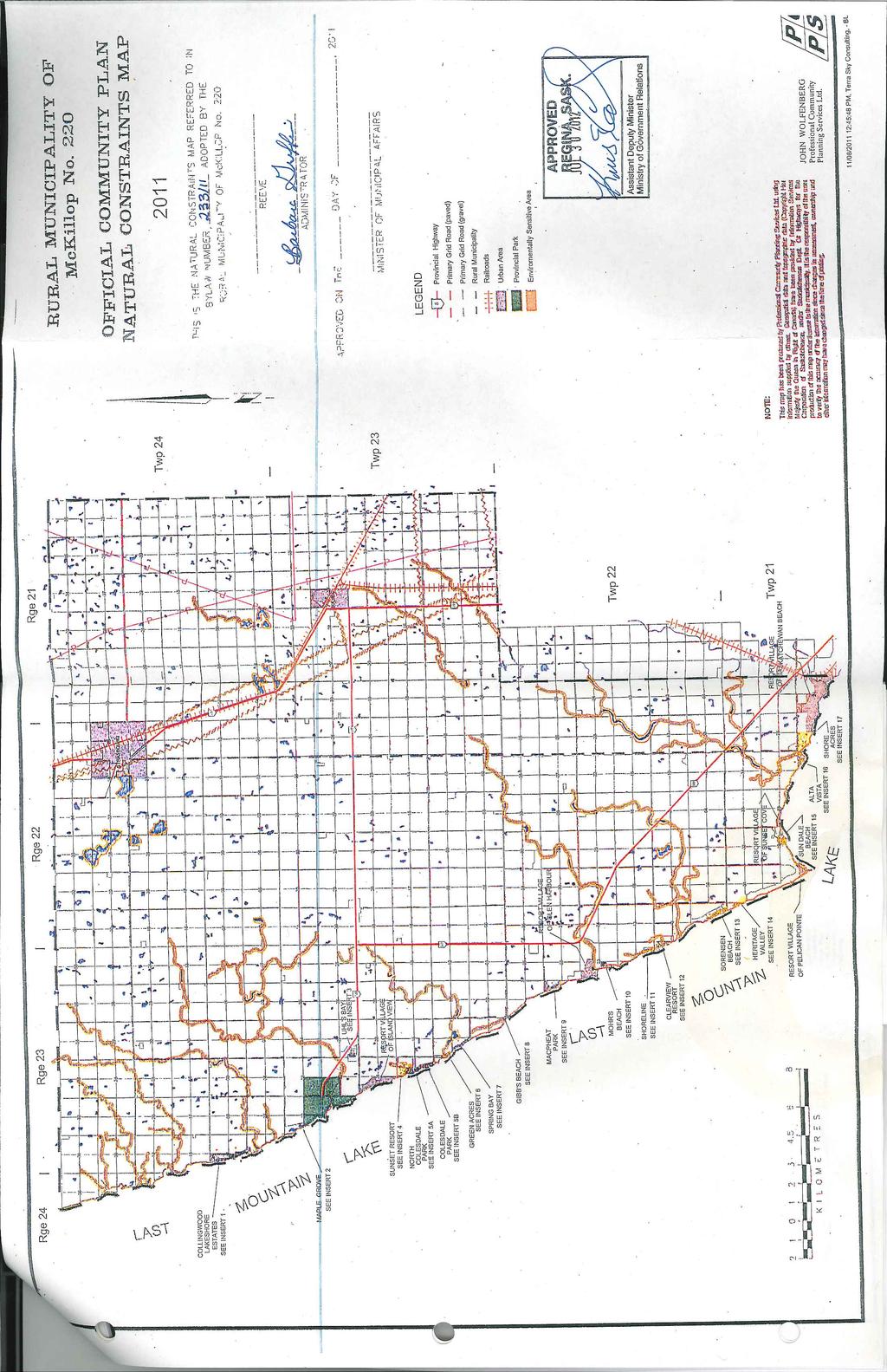
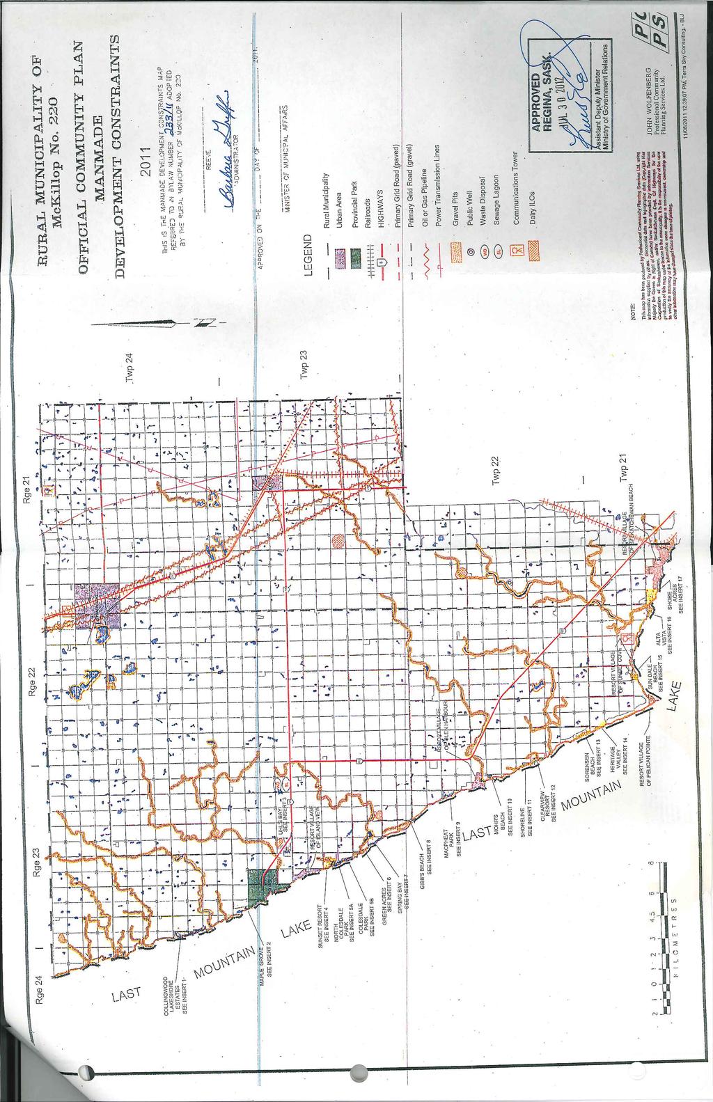
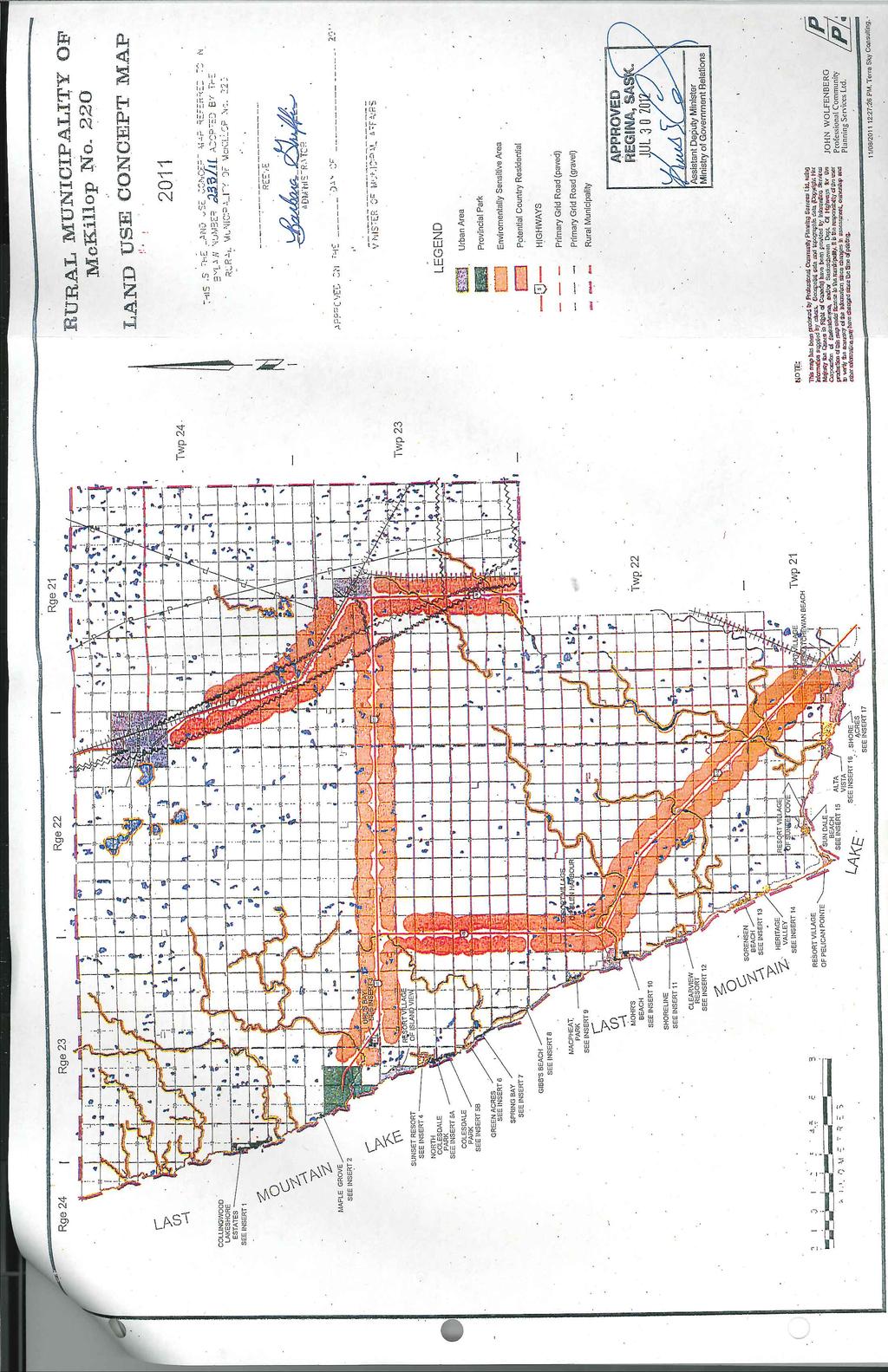
3 1.0 Introduction, Purpose and Effect 1.1 Authority Pursuant to The Planning and Development Act, 2007 (the Act), the Council hereby enacts this bylaw adopting an Official Community Plan (OCP). 1.2 Title This bylaw shall be known as the OCP of the Rural Municipality of McKillop No. 220 (RM). 1.3 Scope The OCP shall: Assist Council, landowners and developers in making resource management, development, land use, subdivision, municipal servicing, public utility and environmental-related decisions; and Apply to the whole of the RM. 1.4 Purpose The purpose of the OCP shall be: To establish a decision-making framework by which Council can co-ordinate various public and private development, social, economic, municipal servicing, environmental and related interests within the RM; To assist Council, as a custodian of the municipal public interest, by helping to protect the health, safety and welfare of the residents; To address current and potential development issues, opportunities, trends and landuse changes, their timing and pattern, within the municipality; To identify beneficial municipal development goals, objectives and standards which Council, the residents and developers can jointly achieve; and To form the policy basis for the Zoning Bylaw and other legal and financial tools available to Council in implementing the OCP. 1.5 Effect of OCP Adoption The OCP shall be binding on the RM, the Crown and all other persons, associations and organizations; and no development shall be carried out that is contrary to the OCP. Section 40(2) of the Act states that the adoption of a Plan does not commit the municipality or any person, association or organization or any department or agency of the Government of Saskatchewan to undertake any of the projects outlined or proposed in that OCP. 1.6 Documents Text and Maps: This bylaw shall consist of this text, appendices, the OCP map and, where Council deems appropriate, other background reports, maps, tables and charts; Map Designations: The purpose of the OCP Map and its accompanying symbols, district boundaries and other notations shall be to spatially indicate the long-term development objectives of the RM. The OCP map shall also be used in conjunction with the text of the OCP to implement its goals, objectives and policies to achieve beneficial growth and avoid or minimize land use conflict; All map notations shall indicate general locations, unless otherwise specified; and 2
4 Council shall make the final decision regarding any unclear map notation or development district boundary location. 1.7 Definitions and Interpretation The Zoning Bylaw definitions shall apply to this bylaw. When a question arises regarding the correct interpretation of the text or map, which is applicable to a specific site, Council shall make the final decision based on their interpretation. Metric measurements take precedence since Imperial measurements are shown only for ease of interpretation. 1.8 Amendment of Bylaw Council may amend this bylaw, at any time, upon its own initiative, or upon request, in order to improve the OCP goal, objectives and policies. 1.9 Bylaw Review Council shall review and if necessary, consolidate this bylaw either when the Council considers it necessary, or five (5) years from the effective date of this bylaw, or five (5) years from the last bylaw consolidation, as the case may be Flood Hazard Liability Disclaimer The OCP and Zoning Bylaw provide a reasonable degree of flood protection which is based on historical, engineering and scientific data and assumptions Council assumes that floods larger than the 1:500-year flood freeboard elevation may occur due to man-made and natural causes (e.g. excessive precipitation, ice ridges) The reliance on this bylaw or the Zoning Bylaw shall not create a liability for, or cause an action against, Council, the development officer or any municipal employee, as a result of any flood damages. 2.0 Development Issues Background This chapter outlines the issues that were identified by Council in the context of administering the existing Development Plan and Zoning Bylaw, which were originally prepared for the RM by Saskatchewan Municipal Government in All of the issues identified in this chapter are reflected in the content of both the OCP and the Zoning Bylaw. Council has examined new issues or made changes to the Goals, Objectives and Policies of the existing Development Plan to reflect Council s current interpretation and attitude toward specific issues. 2.1 Demand for Development Council requires OCP policies to assist in co-ordinating the increased demand for residential, commercial, industrial and agricultural development. 2.2 Population Trends Proper management of land use patterns and population growth is essential to provide efficient municipal services. For smaller municipalities with slow population growth (or decline), it is likely that forecasting methods which track births, deaths and net migration will be less accurate than simpler techniques. 3
5 The selected method of analysing and predicting the future population of the RM is called a Constant Numeric Change Model (see Item in the Appendices, References and Maps section). In the following calculation, it is assumed that the local population (p) in the next five (5) year time period (t+1) is equal to the population in the previous period plus the average of population changes over the past n periods (the six (6) census periods from 1981 to 2006). The Statistics Canada population for RM 220 for those periods is: people people people people people people The formula is as follows: p(t+1) = p(t) + [ p(t) - p(t-n) ] /n (pop. in (today s (average change (total of the the next pop.) over the total five (5) time time period) number of census periods between periods used) the six (6) census dates) The projected population for RM 220 is 566 people in This is a very basic estimate, which does not include calculations such as cohort survival (births or deaths) in relation to the age of the RM s current population. The model is more accurate in assessing population change due to the effects of employment growth or decline. Left unchanged, the forces which now affect the local economy will mean a continuation of the RM s slow population decline. By using the policies of this OCP and other features of The Municipalities Act (e.g. tax tools or other incentives) Council will attempt to attract more residents and employers to benefit the entire municipality. 2.3 Resource Management Agricultural, sand, gravel, archaeological, ground water and critical wildlife resources all require sound management to ensure long-term, viable, economic development, conservation, minimal land-use conflict and compatibility with non-agricultural development. 2.4 Conversion of Agricultural Land The conversion of agricultural land to non-agricultural uses must be managed to ensure long-term stability of agricultural development. In large part, Council will use Right-to-Farm policies to guide their decisions in dealing with the impact of proposed non-agricultural uses on agricultural activities. 2.5 Residential Subdivisions Various high and low-density residential subdivision proposals are still being proposed throughout the lakeshore portion of the municipality. If not properly managed, such proposals may conflict with viable agricultural, industrial, commercial and gravel operations, and generate excessive municipal road and servicing costs Some landowners have expressed their desire to allow subdivision of existing yard sites, new single sites for non-farm residences or small cut-off areas (isolated from the balance of a farm operation by a railway, road, etc.) which can be used for agricultural land consolidation or non-farm residences. 4
6 2.5.3 There has been limited interest expressed for larger country residential sites in the Agricultural zoning district. 2.6 Public Utilities and Municipal Services Public utilities and municipal services should be co-ordinated to ensure efficient, responsible and equitable servicing of development subdivisions. 2.7 Inter-Municipal Co-ordination Concerns have been raised as to whether the municipality allows for adequate input from adjacent municipalities prior to making a decision on certain types of development applications. 2.8 Housing Most lakeshore residential development still is used on a seasonal basis only. However there are increased signs that such dwellings will be converted or redeveloped for year-round dwellings. The RM will monitor the impact of such conversions on roads and other municipal facilities Garden Suites: (formerly called granny flats ), the garden suite has been identified as an alternative, subordinate residential use for some landowners for the following reasons: the desire to provide shelter for relatives and/or hired help, but in a separate dwelling unit; the need to provide home care for relatives, and to keep the cost of housing to a minimum. In other RMs, there have been problems with requests for conversion or subdivision of the suites, after the original occupant of the suite no longer used it. Council wants to ensure that the policies for garden suites should prevent such problems and to ensure that these uses are possible for a limited time only, and only in agricultural areas at the present time Other types of new residential uses and accessory uses in existing dwellings are also issues facing Council today. These include proposals for bed and breakfast operations, tent trailers or small vacation trailers as temporary accessory uses, guest cottages as permanent accessory uses and new modular home dwellings. 2.9 Land Use Compatibility Concerns have been expressed that proper separation distances between incompatible land uses should be maintained, particularly between residential development and business or agricultural development The principle of continuity of development should be included as part of all new development proposals The enforcement of non-permitted accessory buildings should be carried out, especially in the Lakeshore district, where previously-unauthorized guest cottages have been constructed. Such uses are only now being allowed as Discretionary Uses in that district Environmental Management Hazardous materials and burning of materials is a concern Soil disruption, including topsoil or gravel removal and changes in grade during any development, should be minimized Proper reclamation of gravel pits should be required Ground water is a precious resource and should be protected. Where groundwater is to be a source of potable water for a development, or the development may affect the groundwater supply used for potable water by other landowners. Council may require a 5
7 developer to provide a detailed hydrogeological study to prove that the development can proceed as proposed without negatively affecting the quality or quantity of the water source Lakeshore Development Lakeshore development issues will include several aspects of development review to ensure a balance between the viability of the development and its impact on environmental and infrastructure servicing factors. If not properly managed, such proposals may place additional pressures on municipal services such as roads, fire fighting, police, ambulance services, and waste disposal needs of day users, seasonal cottages and permanent dwellings. 3.0 Premise, Goal and Objectives of the OCP 3.1 Basic Premise and Goal The underlying premise of the OCP is that agriculture exists as a natural right (i.e. the Right to Farm ) in the municipality. The basic goal of the OCP shall be to work towards an attractive, safe and viable RM in which: - agriculture continues to be the primary economic activity and land use; - a choice of both dispersed rural and clustered residential lifestyles is available; - limited highway commercial and industrial uses are allowed in appropriate areas; and - the quality of life of the residents is both protected and enhanced. 3.2 Basic Objectives The OCP goal shall be implemented by achieving the development objectives found in this section. 3.3 General Development Objectives To protect and enhance the municipality s natural resources, agricultural lands and activities, residential areas and related development. The Right to Farm shall include all generally accepted agricultural practices as may be outlined in the policies of the OCP, unless such polices or practices conflict with The Agricultural Operations Act, or are clearly invalidated by a decision of the Agricultural Operations Review Board established by that Act. Unless required by law to amend this OCP or the Zoning Bylaw to conform to provincial acts or regulations, the municipality shall not be required to enforce a decision of the Board through these land use polices or regulations To work within our goals and objectives to encourage a variety of economic development programs, projects, opportunities and facilities for the benefit of the residents of the municipality To identify suitable agricultural, resource development and higher density development opportunities within and for the municipality To avoid unplanned or sprawled urban development (including residential, highway commercial and light industrial uses) and to achieve an orderly, efficient and rational land use pattern which is possible to develop and service in appropriate phases, based on records of vacant site inventories compared to recent trends in demand To prevent land use conflicts and to ensure incompatible agricultural related developments do not locate in proximity to areas designated for other development purposes (e.g. an Intensive Livestock Operation (ILO) should not be located too near a residential site) To assist in providing a buffer between urban municipalities and non-farm communities, and potentially incompatible agricultural (e.g. ILO), mineral extraction development and similar uses. 6
8 3.4 Financial Objectives To maintain and enhance the municipal assessment base by ensuring quality development and a diversified local economy To provide municipal services and public utilities appropriate to a rural context in a financially responsible manner. 3.5 Community Servicing Objectives To ensure that developments with similar servicing requirements are suitably located and phased to achieve uniform, efficient and cost-effective services To provide an adequate level of public utilities (includes municipal services appropriate to a rural context) and programs to meet the development and domestic needs of the residents of the municipality To explore the potential of sharing municipal services with adjacent municipalities where it is of mutual benefit and equity to the residents and ratepayers of each jurisdiction. 3.6 Residential Development Objectives To manage population growth and development in a proper manner and balance the protection required by high quality agricultural land with the increasing demand for low-density residential developments, by creating specific Resource Management Areas for these and other uses as part of the OCP policies, and by limiting the number of new residences allowed in those districts (see OCP Maps) To ensure that all lakeshore development occurs at densities and locations which are appropriate, both to the neighbouring land uses and the type of shoreline and natural environment at the sites in question, by prohibiting encroachment on municipal, public and environmental reserves, and by protecting and enhancing water quality and fishing resources. 3.7 Agricultural Development Objectives To protect high quality agricultural land (defined as any quarter section in which the majority (50 per cent or more) of agricultural land is Class 1 to 3 based on the Canada Land Inventory (CLI) for agricultural operations and grain farming (see Appendix A) To encourage and protect a wide range of viable agricultural and agriculturally supportive development to maintain and enhance agricultural resources, holdings, operations and the agricultural community To encourage developments and subdivisions which: (1) do not remove high quality agricultural land from agricultural production; (2) do not require an expensive high level of municipal services; and, (3) do not needlessly reduce the viability of agricultural holdings To recognize the Right to Farm in the policies of this OCP. This will be implemented through OCP policies which support: - current agricultural operations, including those which may have been recognized by the Agricultural Operations Review Board for Saskatchewan; and - new proposed agricultural operations, which in Council s opinion conform to the intent of Sections 31 and 45 of The Planning and Development Act, Business (Commercial and Industrial) Development Objectives To encourage a variety of highway commercial development that is well planned, provides for the amenity of urban centres and higher density developments by providing larger commercial sites (with limited infrastructure services) for occupancy by highway commercial uses which serve the agricultural or transportation sectors or the traveling public. 7
9 3.8.2 To encourage a variety of industrial development which is non-polluting and is agriculturally supportive by providing larger sites (with limited infrastructure services) than are usually feasible in urban areas for industrial uses which serve the agricultural, resource extraction or transportation sectors. 3.9 Environmental and Resource Management Objectives To avoid and minimize flooding, flood damage to new development and to allow such development only in areas which are not subject to slumping or erosion To assist in the protection of ground water supplies from overuse and pollution To protect and assist landowners in managing critical wildlife land and resources from negative effects due to development or subdivision To assist in protecting known heritage resources. 4.0 Community Service Policies 4.1 Management The purpose of the policies is to recognize that not all types of urban community services are required in a RM, and that Council will decide which services are appropriate dependent on the use and intensity of development and financial resources which are available to Council Council shall endeavor to encourage, develop, protect and maintain the following community services: Public Facilities: Public facilities such as schools, hospitals, municipal buildings, recreational facilities, heritage sites and similar uses Linear Utilities: Linear public utilities such as roads, railways, communication lines, distribution lines for potable water, power and natural gas and similar uses Major or Sensitive Utilities: Potentially harmful public utilities or those which must be protected from encroachment to avoid land use conflict or ensure public safety, such as public wells, major power or natural gas transmission lines, airports, water reservoirs, sewage lagoons, solid waste and chemical can disposal facilities and similar uses Public Services: Administrative services, police services, fire suppression services, weed and rodent control. 4.2 Location New public utility facilities and linear works shall be located in consultation with Council so as to achieve the following: Maximum public benefit; Minimum municipal construction and maintenance costs; Minimal disruption to existing and proposed developments and pubic utility properties and the natural environment; and The OCP policies and zoning development standards. 4.3 Determining Development Priorities The protection, efficiency and cost-effectiveness of existing public utilities and municipal public utility priorities shall be major determinants of development and subdivision locations and patterns (e.g. development adjacent to highways and pipelines). 8
10 4.4 Financing Municipal Financing for community services Council shall provide municipal public utilities in accordance with its financial capability and priorities Council shall give preference to developments and public utilities which maximize service and efficiency and minimize costs and maintenance Developer cost-sharing To ensure that all applicants for new developments and subdivisions requiring services from the RM pay for the full cost of installing, and if necessary, supplying such services. If in Council s opinion, there will be significant public benefit provided by the development or subdivision to the RM and its residents, Council may choose to negotiate a cost-sharing agreement with the developer for the installation (and if necessary, the supply) of those services Where the cost of providing or facilitating public utilities is, in Council s opinion, prohibitively expensive to construct or maintain, Council may, to protect its interests: (a) require a developer to enter into a development agreement, which may include, but is not limited to, payment by the developer of all charges incurred by the RM for professional and administrative services either on a site-by-site basis or other criteria as may be adopted or altered by a separate bylaw of Council; (b) require a developer to enter into a subdivision servicing agreement; (c) request proposal modifications; (d) refuse to rezone land, issue development permits or recommend subdivision approval; (e) specify appropriate development permit standards, conditions and requirements; and (f) require the developer to pay for all or part of the cost of providing the service or public utility, as deemed necessary by Council Timing of Public Utilities: Developers may be required to provide public utilities, either prior to or within a defined period after development or subdivision is authorized Performance Security: Performance bonds, interests filed on land titles and liability insurance may be required from a developer as part of a servicing or development agreement, or as a development permit requirement, to avoid unnecessary municipal administration, inconvenience and expenditures, to protect the public interest and to notify future landowners of municipal servicing considerations or environmental limitations for the subject land. 4.5 Water Supplies and Services Water Requirements: All developments which require water shall be adequately serviced with a potable and sufficient water supply, either on-site, or by a central water system. Developments which involve water haulage shall not be encouraged Central Water: Pipelines owned and operated by public utility boards, which may be authorized by Council under The Municipalities Act, shall be allowed on road allowances subject to any terms and conditions that Council may impose, but shall not be owned or maintained by the municipality Council may require developers to provide professional, certified, hydrogeological and servicing reports regarding: The availability of a potable, sufficient and regular water supply to service development; How the water (including options) is to be made available to service the development; Evidence that the proposed water service and development will not deplete or pollute existing water supplies and the ground water; and Evidence that no adverse effects will occur regarding adjacent land uses; 9
11 The mitigation of any adverse effects by special construction techniques; Conformity with the Saskatchewan Ministry of Health (MOH), the Ministry of Environment (MOE) and SaskWater regulations and guidelines; and The proposal s effect on municipal finances. 4.6 Sewage Services All development requiring sewage facilities shall be adequately serviced with an approved, on-site or central sewage system (e.g. septic tank, sewage lagoons, spray (jet) disposal), in accordance with provincial and municipal requirements. Self-contained, on-site facilities shall be preferred in the Agricultural Development district. The required separation distances between such facilities and other uses are shown in Table 1 below. 4.7 Solid Waste Disposal Services All development requiring solid waste removal shall be adequately serviced by approved solid waste disposal facilities in the municipality or an adjacent urban or RM in accordance with provincial and municipal requirements All domestic, industrial and toxic wastes shall be collected and disposed of according to federal, provincial and municipal requirements and guidelines Council shall support the development of a public landfill site to be cost-shared among several municipalities in the area Council shall prohibit the development of facilities for disposal of private, commercial, industrial and toxic wastes Council shall encourage the continued use of solid waste collection by private contractors The required separation distances between such facilities and other uses are shown in Table 1 below. 4.8 Separation Distances For Solid and Liquid Waste Disposal Facilities In order to minimize conflict between proposed solid or liquid waste disposal facilities (public and private) and surrounding development or vice versa, the following separation distances shall be adhered to unless altered by Council as a condition of a permitted or Discretionary Use permit where authorized by the Zoning Bylaw. Council may approve a separation of no more than 20 per cent less than the relevant separation shown in Table 1 where the applicant submits a copy of an agreement between the operator of the facilities and the owner of the development, organized hamlet board or urban council, agreeing to such lesser separation. Such agreements between an operator and an owner of another development must contain the provision that the parties to the agreement will caveat the agreement to the titles to the affected land. Where such agreements are made, Council shall be a party to the agreement and may use Section 238 of the Act to attach the agreement as an Interest on the title of the affected lands. (Table 1) Other Uses Solid Waste Facility Liquid Waste Facility Single residence, tourist accommodation 800 m 300 m Intensive country residential subdivision or hamlet or urban municipality 1.6 km 600 m Commercial or industrial use 300 m 300 m (Distances are measured between the fence, berm or edge of the facility (as the case may be) and nearby development) 10
12 4.9 Roads All new residential, commercial (including recreational) and industrial (including a public utility) development and proposed subdivision sites shall be serviced by an all weather municipal road of sufficient standard, which may be defined in the Zoning Bylaw. Subject to Section 9.9, Council may require a developer to pay for all or part of the cost of on or off-site road upgrades to service such developments. Council may outline the municipality s requirements and standards for all public roads and, if necessary, private roads owned by a condominium corporation in a road policy manual which may be adopted and amended as necessary by resolution of Council Service roads may be required to be dedicated by developers to ensure functional and safe vehicular access, particularly along highways and high traffic volume roads The demand for country residential sites is likely to continue because the RM is within easy commuting distance of Regina. Council now intends to establish a policy of allowing limited numbers of non-farm subdivisions in the agricultural area but avoid the potential for land use conflict between agriculture and non-farm uses Council prefers to allow more strictly-limited non-farm residential development while taking advantage of the good quality provincial highways in the RM that offer better access to more employment opportunities than exist locally Dedicated Lands Dedicated lands (e.g. public, municipal and environmental reserves, buffer strips and walkways) shall be managed in accordance with the Act Dedicated Lands Account: A separate municipal Dedicated Lands Account shall be established to manage money received in lieu of dedicated land Sale and Lease of Dedicated Lands: Council may sell and lease dedicated lands, where Council determines that it is in the public interest, in conformity with the Act and The Dedicated Lands Regulations Other Services An appropriate level of public utilities for all development and subdivisions, particularly for high-density developments, shall be required. Such public utilities may include, but are not limited to, roads, culverts, ditches, sewers, sidewalks, street lighting, street signs, recreation facilities, parking and unloading facilities, and similar amenities and services Major Pipeline Development This section refers to development of, and development adjacent to, pipeline easements and rights-of-way which are owned by companies regulated by the National Energy Board All permanent structures and excavations shall be located at least 12 metres (40 feet) from the limits of a pipeline easement or right-of-way which is regulated by the National Energy Board or the Saskatchewan Ministry of Industry and Resources (MIR) Pipeline rights-of-way may be zoned as passive open space that could be used for pedestrian and bicycle pathways, subject to all easement rights and any other conditions required by national or provincial acts or regulations. 11
13 5.0 Residential Development Policies 5.1 General Generally, residential development shall be permitted in order to achieve a pleasant living environment which maintains its value, where land use conflicts can be avoided and where efficient, cost-effective, uniform municipal services can be provided Conversion of existing non-residential buildings to residential use shall not be allowed Existing, undeveloped abandoned school sites shall be encouraged to amalgamate with the adjacent quarter sections In addition to any single parcel residential subdivision which may be allowed by Sections 5.2 or 5.3, one additional residential subdivision may occur on that part of a quarter section or equivalent, which is physically isolated or cut off from the bulk of a quarter section in accordance with the following: - the property is cut-off by a highway, road, railway or any combination thereof; and - the subject property must be rezoned to an appropriate zoning district prior to being subdivided Existing vacant registered sites (registered by a separate title, before the effective date of this OCP): all existing vacant sites which are below nine (9) hectares (22 acres) in size shall be rezoned to an appropriate residential zoning district before a development permit for a new residence may be granted. At Council s discretion, existing vacant sites which are less than one (1) hectare (2.5 acres) are not eligible for residential zoning or development permits unless they have access to central water or central sewer. 5.2 Residences on Farms A maximum of two single-detached or dormitory dwellings shall be permitted on each agricultural farmyard. A Garden Suite as may be allowed by Council as a discretionary use (under Section 2.8.2), shall not be considered as exceeding the maximum number of allowable dwellings specified in this subsection Council may, at their discretion, allow a mobile home as an alternative to a single-detached dwelling on a farmyard where Council is fully satisfied the dwelling is required as an accessory to the principal agricultural use: Additional single-detached or dormitory dwellings shall conform to the following: All dwellings shall locate in or immediately adjacent to, the same yard site; Additional dwellings shall be allowed only as accessory uses to the viability of the agricultural operation; All development, servicing and environmental concerns shall be appropriately addressed; Development permits for dwellings shall not imply the right to subdivide the property to obtain a residential site; and A separate subdivision will be allowed for only one of the dwellings allowed above. The remaining dwellings must not be subdivided from the quarter section or equivalent. 5.3 Low-Density Non-Farm Residential Development Council may accommodate low-density, non-farm residential development in two basic ways: Low-density single parcel residential development and subdivision; or Low-density multi-parcel residential development and subdivision; 12
14 5.3.2 Low-density single parcel residential development may occur in the Agricultural zoning district in accordance with the following: Low-density single parcel residential development shall be serviced with on-site water and sewage facilities; For the Country Residential (CR) district, only one residential site per quarter section or equivalent is allowed. Except for minor alterations of existing site lines, re-subdivision of properties zoned as CR or CR1 shall be prohibited; Low-density single parcel residential development shall not be encouraged to locate adjacent to urban municipal boundaries; Rezoning shall be required prior to subdivision approval; and Council may establish one or more low-density single parcel residential zoning districts in the Zoning Bylaw to manage this type of residential development Medium-density multi-parcel residential development may occur in the CR2 zoning district in accordance with the following: Except for minor adjustments to site lines, applications for low-density multi-parcel residential development shall be subject to the following conditions: (a) a maximum of 50 per cent of the total number of sites in the proposed development shall be at the minimum size allowable for the approved zoning district. All other sites shall be a least 40 per cent larger than the minimum allowable site sizes for new subdivisions in the zoning district; and (b) re-subdivision of properties shall be prohibited Medium-density multi-parcel residential development shall meet the following management criteria: (a) such uses may be developed on lands with a CLI agricultural soil capability rating of primarily Class 4-7, and shall be prohibited on land which is mainly 50 per cent or more Class 1, 2 and 3. (b) such uses may locate in the CR2 development district regardless of soil class. (c) Council shall give preference to development and subdivision proposals which are in close proximity to paved roads and provincial highways. (d) multi-parcel residential development shall be serviced with on-site water and sewage facilities. (e) rezoning shall be required prior to subdivision approval. (f) Council may establish one or more low-density multi-parcel residential zoning districts in the Zoning Bylaw to manage this type of residential development. 5.4 Low-Density Country Residential Development For the purposes of this section of the OCP, Low-Density shall mean any subdivision or condominium proposal which has a density of no greater than 16 sites per 64 hectares or less depending on the total land area (i.e. including all roads, parks, public or communal land etc.) being subdivided. Council may accommodate such development by choosing to rezone land which has been proven to be safe for such uses by favourable engineering studies which: (a) either show that land is free from all geotechnical, slumping and flooding problems; or (b) that any of those problems which are identified by such studies can be remediated (at no cost to the municipality) by the developer and/or the subsequent owner of each proposed site to be created; and 13
15 (c) that all proposed sites being subdivided will be serviced (at no cost to the municipality) with communal, on-site sewer and water services unless Council negotiates other servicing options and responsibilities by means of Contract Zoning; and (d) Council also intends to minimize the effect of non-farm development on RM finances, agricultural activities and environmentally sensitive areas. 5.5 Medium-Density Country Residential Development For the purposes of this section of the OCP, Medium-Density shall mean any subdivision or condominium proposal which has a density of more than 16 sites per 64 hectares or less depending on the total land area (i.e. including all roads, parks, public or communal land etc.) being subdivided. Council may accommodate such development by choosing to rezone land which has been proven to be safe for such uses by favourable engineering studies which: (a) either show that land is free from all geotechnical, slumping and flooding problems; or (b) that any of those problems which are identified by such studies can be remediated (at no cost to the municipality) by the developer and/or the subsequent owner of each proposed site to be created; and (c) that all proposed sites being subdivided will be serviced (at no cost to the municipality) with communal, on-site sewer and water services unless Council negotiates other servicing options and responsibilities by means of Contract Zoning Rezoning to allow these types of new residential clusters will only be allowed if they are within approximately.8 km. (1/2 mile) of a paved provincial highway and conform to all other plan policies. The intended areas for these Medium-Density CR subdivisions are shown on the Land use Concept Map, which forms part of this Plan. 5.6 Mobile Homes General: Mobile homes shall be allowed as discretionary uses in the A and CR districts, but shall be prohibited uses in the CR1, CR2, H, LS and R/R districts Mobile Home Parks: New mobile home parks shall not be allowed in the municipality. 5.7 Hamlet Development Hamlet shall mean the Hamlet of Uhl s Bay Hamlets shall be managed as follows: Except for mobile homes, all existing uses as of the effective date of this bylaw shall be conforming uses; The subdivision of land to create new sites shall be prohibited; and New development shall be restricted to public utilities, recreation uses, and limited residential development New residential development shall be limited to specific sites as identified in the Zoning Bylaw Zoning Implementation: Council may establish a hamlet zoning district in the Zoning Bylaw; and Hamlet development standards and requirements may be further specified in the Zoning Bylaw. 14
16 5.8 Recreational Resort Development The intent of this type of residential development is to allow a compatible mix of medium to high-density residential and resort uses at appropriate locations. Higher density may be required in some areas to support the extra services and sustainable features that make the development more sustainable, without requiring the RM to supply or operate those services. Council may consider allowing suitable proposals to allow medium to high-density residential and resort uses provided the applicant agrees to ensure conformity to this Plan by planning for piped services, land use compatibility, and protection of the environment. Contract Zoning may also be used in such areas, subject to Section 9.7 of this Plan. 6.0 Agricultural Development Policies 6.1 General Agricultural development within the municipality shall: Retain and enhance the agricultural land resource by allowing limited numbers of subdivisions per quarter section, or equivalent, and setting a minimum size for the remaining portion of that land after such subdivisions occur; Enhance economic resource development; Support the agricultural community and economy, primarily by including policies to protect the Right to Farm ; Require minimal municipal services; and Minimize potential nuisances and land use conflicts through proper separation of uses. 6.2 Development Priorities The following lands shall be given a high priority for farming and agricultural production within the municipality: Lands within the Agricultural Development district; Lands with a CLI rating composed of more than 50 per cent of Class 1, 2 and 3; and Lands which are in active agricultural production. 6.3 Other Land Uses Lands within the Agricultural Development district may be developed for other land uses provided that: Agricultural production is limited due to actual site conditions including poor drainage, high salinity, excessive slopes, stoniness and similar conditions (as documented in assessment records or in a report prepared by a professional agrologist); No conflict with agriculture occurs; and The site conforms to the provisions of the Zoning Bylaw Other development in the Agricultural Development district may include: Recreation (e.g. campgrounds); Low-density residential (e.g. single parcel only); Low-density dispersed commercial which must be agriculture-related (e.g. livestock auction marts, animal clinics); Low-density dispersed industrial which must be agriculture-related (e.g grain storage, abattoirs); Mineral extraction operations; and Heritage recognition and preservation. 15
17 6.4 Development Pattern Generally, land uses apart from agricultural which are to be established within the Agricultural Development district shall be encouraged to locate in proximity to: Existing agricultural-related commercial and industrial development; High standard roads; and Subject to Sections 5.7 and 9.6, the Hamlet of Uhl s Bay. 6.5 Zoning Implementation Generally, land within the Agricultural Development district shall be zoned Agricultural Any use of land, an existing building or any building lawfully under construction at the date of approval of this bylaw, although such use or building does not conform to the regulations of this bylaw, shall be carried on in accordance with the provisions of Sections 88 to 93 inclusive, of the Act Council may classify agricultural developments, and establish development standards for specific agricultural uses in the Zoning Bylaw, to ensure effective land use management and compatibility, servicing and environmental protection The Agricultural Zoning district may accommodate uses which help to promote agricultural development or that do not conflict with agricultural development. 6.6 Intensive Livestock Operations Provincial regulations under The Agricultural Operations Act require permits for most ILOs. The approval process under those regulations also considers whether ground and surface water supplies are adequate to serve new ILOs and can be protected from contamination by the increased manure produced in the proposed facilities. The regulations do not extend to deal with any problems caused by ILOs in respect to odour or nuisance (e.g. flies, rodents). Council shall support the development of ILOs provided the development does not create a conflict with adjacent properties in respect to odour or nuisance problems associated with either the core ILO facilities or which is near land used for manure treatment or disposal ILOs shall be discretionary uses in the Zoning Bylaw. Any expansion of an operation to provide for a greater number of animal units as defined in the Zoning Bylaw, or any change in an operation which alters the species of animal, shall be discretionary, and shall require a new development permit application Unless a permit is required by the Ministry of Agriculture (MOA) due to the area of animal confinement for a specific operation being classed as an ILO by the Ministry, the Zoning Bylaw may provide for the temporary confinement of cattle or other species listed in the definition of animal units on a farmstead during winter months as part of a permitted use in a general mixed farm operation. The bylaw may also provide for other temporary holding and loading facilities as discretionary uses subject to discretionary conditions, including maximum number and time confinement Council may advertise any proposal that will result in an ILO, and may hold a public hearing on the proposal. The applicant shall be required to pay for the cost of advertising the hearing In order to minimize conflict between ILO and surrounding development, Council will consider applications for development of an ILO as a discretionary use in the Zoning Bylaw and apply the following criteria: 16
18 No new ILO will be considered if the operation will be less than 300 metres from a dwelling not located on the site, unless that dwelling is directly associated with the proposed ILO; The applicant must demonstrate, to the satisfaction of SWA, MOA and Council that the water supply is sufficient for the development, and that the supply for neighboring developments will not be adversely affected by the proposed operation; The minimum separation distances in Table 2 will be applied to determine acceptable locations; A greater separation may be needed from any liquid manure storage lagoon involved in the operation, to residential and other developments. The criteria of a separation distance to the lagoon from a dwelling of 1.5 times the distance in Table 2 will be considered adequate; Council may consider lesser separation distances in Table 2 where: (a) written notice approved by Council has been given to the owner of any dwelling, tourist, commercial or industrial use within the distance provided in Table 2, and to the hamlet board of an organized hamlet or Council of an urban municipality with the specified distance, and (b) a public hearing has been held. Council may approve (with or without conditions) or refuse a proposal based on any problems identified As a condition of approval, Council shall specify the maximum number of animal units for which the approval is made; and may impose standards to reduce the potential for conflict with neighboring uses which specify the location of holding areas, buildings or manure storage facilities on the site As a condition of approval, Council may specify requirements based on development standards in the Zoning Bylaw regarding the disposal of manure produced by the ILO, or other measures intended to reduce odour, environmental problems, or conflict with neighboring uses from an ILO. Table 2 Location Separation Criteria for ILOs from Specific Uses Development Number of Animal Units ,000 > 2,000 Dwellings in an Agricultural or CR1 300 metres 800 metres 1200 metres district, public wells, tourist accommodations, campgrounds, commercial or industrial uses Multi-parcel residential subdivisions in a CR2, H, LS or R/R district, vacant residentially zoned land, villages or towns 1600 metres 2400 metres 3200 metres Distances are measured between livestock facilities (barns, corrals, earthen manure storage facility or other approved manure stockpile/treatment facility) and any dwelling, which is not owned by the ILO operator, or is in a village or town, or is any other development type shown in the above Table To minimize conflict between proposed ILOs and surrounding development or vice versa, the preceding separation distances shall be adhered to unless altered by Council as a condition of a permitted or discretionary use permit where authorized by the Zoning Bylaw. Council may approve a lesser separation of up to 10 per cent variance from the relevant separation shown in Table 2 where the applicant submits a copy of a signed agreement between the operator of the ILO and the owner of the dwelling, organized hamlet board, or 17
19 urban council, agreeing to such lesser separation. Such agreements between an operator and an owner of another development must contain the provision that the parties to the agreement will register the agreement on the titles of all affected land owned or under the jurisdiction of all parties. Where such agreements are made, Council shall be a party to the agreement and may use section 235 of The Planning and Development Act, 2007 to register the agreement to the title of the affected lands Manure Treatment and Application activities: Facilities to treat ILO manure and areas proposed for disposal of manure from an ILO will be considered as part of the specific conditions for ILOs, which will be discretionary uses in the Zoning Bylaw; and Such disposal will be subject to special standards or location requirements specified in the Zoning Bylaw that are intended to reduce the potential for land use conflicts. 6.7 Right To Farm Policies Subject to Sections 3.3 and 3.7, farmers shall be encouraged to follow generally accepted farming practices as may be determined by the Agricultural Operations Review Board to achieve efficient operations, sound resource management and environmental quality The purpose of this section shall be to support the preservation of traditional agricultural operations and farming within the municipality and to manage the long-term development in this district in that context The Right to Farm in the municipality is hereby recognized to exist as a natural right. Most types of traditional agriculture will be permitted uses in the Zoning Bylaw, except for certain uses which may generate excessive odour or nuisance including, but not limited to, ILOs. These types may be classed as discretionary uses, or prohibited at certain locations. The Right to Farm shall include all generally accepted agricultural practices including, but not limited to, the spraying of herbicides and insecticides subject to provincial or federal regulations governing the use of approved chemicals for that purpose. As well, it is understood that the traditional agricultural activities associated with the Right to Farm may occur on holidays, Sundays, weekends, at night and during the day; and the noise, odours, fumes and dust that are caused by these activities are specifically permitted as part of this right. Council does not intend to adopt policies or regulations affecting these activities. The only exception to control of these activities may be if a conflict with The Agricultural Operations Act, or a clear invalidation by a decision of the Agricultural Operations Review Board established by that Act occurs. In either case, Council shall not be required to amend this OCP to affect or regulate such activity since it is not within the municipality s jurisdiction under the Act. Unless required by law to amend this OCP or the Zoning Bylaw to conform to provincial acts or regulations, the municipality shall not be required to enforce a decision of the Board through these land use policies or regulations Developments which are predominantly agricultural in nature or are supportive of the agricultural industry shall be encouraged throughout the Agricultural district. Any conflict between an agricultural use and another use shall be resolved in favour of the agricultural use unless, in Council s opinion, such a decision would threaten the health, safety and general welfare of the inhabitants of the municipality, as outlined in Section 45 of the Act. 18
20 7.0 Business (Commercial and Industrial) Policies 7.1 General Council shall encourage a variety of commercial and industrial developments within the municipality Development Criteria: All commercial and industrial development shall adhere to the following criteria: Minimize conflict with agriculture, critical wildlife and mineral extraction areas, and avoid/protect heritage and ground water resources and water supplies; Minimize disruption to environmentally sensitive land and vegetation, and avoid pollution; Minimize conflicts with urban municipalities, adjacent land uses, agricultural operations and residences. The production of noise, odour, vibration, dust, traffic, fumes or other noxious emissions from certain commercial or industrial uses may be prohibited or controlled in the Zoning Bylaw if not already regulated by provincial or national acts or regulations; Minimize negative effects to lands which have a CLI agricultural capability rating of Classes 2 and 3 for the majority of the locale in question; Locate adjacent to highways, paved roads, and developed municipal roads; Compliment preferred traffic patterns and maximize the use of internal roads; and Site Size and Use: Generally, large sites are required to accommodate truck traffic and higher parking needs for industrial or commercial uses not suitable in concentrated urban areas The Zoning Bylaw shall contain requirements for on-site parking facilities and loading areas in districts which allow commercial and industrial uses. 7.2 Management of Commercial Development Council shall manage commercial development in two basic ways: (a) as concentrated commercial development; and (b) as dispersed commercial development. 7.3 Concentrated Commercial Development Concentrated commercial development includes, but shall not be limited to, highway commercial uses, business uses, retail uses, office uses, administration uses and recreational uses Concentrated commercial development and zoning shall be accommodated in the Highway Commercial Development district. Concentrated commercial development and zoning may be accommodated in other areas of the municipality at the discretion of Council in other districts Council may require existing vacant commercial sites to be developed prior to approving additional concentrated commercial sites by subdivision or rezoning New concentrated commercial development may be required to locate in close proximity to urban centres, highways, or existing commercial development. 7.4 Dispersed Commercial Development Dispersed commercial development includes, but shall not be limited to, commercial development which involves agricultural related commercial uses, recreational uses or retail uses. 19
21 7.4.2 The intent of dispersed commercial development is to accommodate appropriate commercial uses that require access to a highway and a certain degree of separation from other uses due to potential for noise and pollution Dispersed commercial development shall not locate in the R/R, LS, CR2 or Hamlet district. 7.5 Zoning Commercial development may be managed by establishing one or more zoning districts in the Zoning Bylaw, in accordance with the two basic forms of commercial development described above. 7.6 Management of Industrial Development Council shall manage industrial development in two basic ways: (a) as concentrated light industrial development; and (b) as dispersed light or medium industrial development Both types of industrial development mentioned above shall generally require large sites to accommodate truck traffic, higher parking needs or industrial uses not suitable in concentrated urban areas Facilities and sites which are designed or intended for the storage or disposal of private, commercial, industrial, toxic or contaminated waste or garbage shall be prohibited within the municipality Oil and gas exploration and drilling shall be permitted uses throughout the Agricultural Development district. No drilling shall be allowed within the setbacks from any dwelling (currently 75 metres) allowed by the provincial regulations administered by Saskatchewan MIR. 7.7 Concentrated Light Industrial Development Concentrated light industrial development includes, but is not limited to, industrial development involving light manufacturing and mechanical repair uses, central services, highway access, paved internal roads (preferred), rail service (optional), storm sewers, small sites; and minimal pollution, noise, odour, dust, vibration, fumes and other nuisance factors Concentrated light industrial development shall be encouraged to locate in approved industrial parks in order to maximize resource management, municipal services, land use compatibility and environmental protection. Heavy industrial development shall be prohibited. 7.8 Dispersed Light or Medium Industrial Development Dispersed light or medium industrial development includes, but is not limited to, industrial developments involving light or medium manufacturing, salvage yards, agricultural related uses, sand and gravel storage, aggregate mixing sites, landscaping and supply yards, potentially hazardous uses, on site services, rail service (optional), potential noise, odour, vibration, fumes, other nuisance factors and pollution Dispersed light or medium industrial development may occur throughout the municipality but shall not occur in any commercial, or residential district. Heavy industrial development shall be prohibited. 20
22 7.9 Zoning Industrial development may be managed by establishing one or more zoning districts in the Zoning Bylaw, in accordance with the two basic forms of industrial development described above. 8.0 Environmental Management Policies 8.1 General General: This chapter establishes priorities and policies to protect and manage specific natural resources in the municipality The purpose of the priority listing is to identify environmentally sensitive lands and resources and establish policies which recognize the various constraints which may exist in different situations Environmentally sensitive lands shall be shown as an ES Overlay district on the OCP and Zoning maps. Recognizing the scale limitations of those maps, the ES Overlay district is meant to include lands with the following characteristics: - steep slopes - known ground water supplies - high water tables - marshes - areas adjacent to water courses - flooding - water or wind erosion - aquifer recharge capability - slope instability or slumping - expansive soils involving shrinking, swelling, frost heaves, etc. - lands sensitive to aquifer pollution and rapid vegetative destruction. 8.2 Intent Environmentally sensitive lands shall be protected and carefully managed - in recognition of their respective limitations and opportunities; - to achieve resource protection; - to avoid excessive development and maintenance costs; and - to minimize environmental disruption and pollution 8.3 Policy Developments which generate pollution or have the potential to generate pollution shall be prohibited on environmentally sensitive lands Council shall encourage landowners and developers to utilize conservation practices to reduce environmental hazards to structures and residents Performance bonds, Interests filed on land titles, and liability insurance may be required from a developer, as part of a servicing or development agreement or as a development permit condition, to avoid unnecessary municipal administration, inconvenience and expenditures, to protect the public interest, and to notify future landowners of municipal servicing considerations or environmental limitations for the subject land. 21
23 8.4 Surface Water Council shall encourage and require adequate surface water drainage throughout the municipality and on new development sites to avoid flooding, erosion and pollution. Consideration shall be given to the ecological, wildlife habitat and drainage effects of development, including the upstream and downstream implications Water courses shall not be filled or altered without the prior approval of the SWA and Council Management: Water courses shall be managed as follows: - natural vegetation shall be preserved to prevent bank erosion; - unauthorized water course dredging and filling shall be prohibited; - periodic cleaning of man-made drains shall be encouraged; - channel improvements shall be carefully designed and constructed; and - water control structures shall be designed to a 1:500 flood design, or other standards approved by the SWA and Council New developments and subdivisions which are adjacent to water courses shall be developed to retain on-site drainage where feasible, minimize erosion and maximize water quality Unauthorized drainage of surface water from any land throughout the municipality shall be prohibited. Individuals shall be required to obtain authorization from SWA prior to taking any measures to drain surface water from their land. 8.5 Ground Water Development shall not deplete or pollute ground water resources within the RM. Council shall cooperate with the SWA, the MOA, MOE, MOH and adjacent municipalities in this regard Where insufficient information exists regarding the suitability or capacity of an aquifer for a proposed development, Council may require the developer to provide the necessary report, at his/her cost. 8.6 Flooding Council shall co-operate with SWA to minimize and prevent flooding within the RM Intensive development, construction of buildings and other structures, and the subdivision of land in identified flood hazard areas or on lands within the 1:500 design flood freeboard elevation level shall be prohibited, unless Council is satisfied the site, or sites, have an area with a safe building elevation Council shall manage development and subdivision proposals in consideration of SWA and the MOE flood hazard prevention recommendations Where sufficient information exists regarding the potential for flooding in a proposed development, Council may require the developer to provide the necessary report, at his/her cost. 8.7 Slumping and Erosion Council shall manage development and subdivision proposals in consideration of any existing slump or erosion hazard prevention reports Where sufficient information exists regarding the potential for erosion or slumping in a proposed development, Council may require the developer to provide the necessary report, at his/her cost. 22
24 8.8 Soil Disruption Developments shall minimize soil erosion and topsoil disruption in order to avoid pollution, slope instability, silting and the undesirable alteration of surface drainage and ground water Council shall use the regulations of the Zoning Bylaw to prevent or minimize soil erosion and the unauthorized permanent removal of topsoil due to new development. The Zoning Bylaw may require landscaping plans to be submitted for RM review and approval for specifies types of development. 8.9 Vegetation Protection: Development shall not needlessly destroy existing trees, vegetation and unique flora Planting: The planting of new vegetation and the implementation of protective vegetation measures shall be encouraged in conjunction with new development throughout the RM. Landscaping plans for certain developments may be required for certain development as outlined in the Regulations of the Zoning Bylaw Natural Habitat Wildlife, vegetation and unique ecological habitats shall be preserved Development in unique ecological habitats shall be subject to protective development standards Development and cultivation of low grade and undeveloped road allowances shall be limited to protect nesting areas for song and game birds by Council attaching conditions to any agricultural lease it may approve for road allowance areas. Such road allowances will only be maintained by the municipality to the extent necessary, in Council s opinion, for access to agricultural land Environmentally Sensitive Land: Council shall work with provincial agencies to protect any significant heritage resources, critical wildlife habitat, wetlands and rare or endangered species located on land proposed for development. Where significant potential for such has been found, Council may defer issuing a permit for any development until such time as the requirements of the relevant provincial agencies to protect such resources have been obtained. 9.0 Implementation 9.1 Development Review Criteria and Application Review Council shall consider the following when making decisions on applications to rezone, subdivide and develop land: Conformity with the OCP premise, goal, objectives and policies and the Zoning Bylaw development standards; The viability and necessity of the proposed use; The degree of prematurity (e.g. time, location, servicing, costs, municipal capabilities) including the consideration by Council of the number of unsold and undeveloped sites in previous phases of the area being subdivided/rezoned or similar sites in adjoining developments; The availability of alternative sites and buildings to accommodate the proposed development; 23
25 9.1.5 The costs and benefits of the proposed development with respect to municipal finances and expenditures; The suitability of the proposed development with respect to established and preferred development patterns, phasing and sites in the area; The ability of the RM to secure the required municipal services and public utilities; The compatibility of the proposed use with nearby land uses, existing and preferred public utilities, the character of the area, the environmental protection goals, objectives and policies; and the ability to avoid problems regarding access, servicing, noise, odour, vibration, inconvenience and property values; The effect of the proposed development on proposed municipal projects identified in this bylaw, including municipal reserve and recreational policies; Any additional reports, studies, development issues, resident concerns, provincial comments and public hearing submissions; The need to establish or allow physical development, land use and road and servicing patterns which are compatible with existing development; The need to prevent or minimize water (ground and surface) and air pollution; The need to create an attractive, functional traffic corridor along highways within the municipality s boundaries; Achieving an efficient land use pattern adjacent to highway interchanges and road intersections; Maximizing traffic safety and pedestrian movement; Achieving a high quality, visually attractive environment regarding signs, landscaping, buffers, vegetation, building design, outdoor storage and parking areas; and Maximizing the efficiency and cost effectiveness of existing municipal services and public utilities, including, but not limited to: water supplies dedicated lands pipelines fire protection schools ambulance services public lands public safety recreation emergency measures storm drainage electrical services sewage facilities natural gas services solid waste facilities telecommunications roads police protection railways postal services community facilities others, as determined by Council (e.g. maintenance) 9.2 Residential, Commercial and Industrial Development Approval Council may undertake a periodic review of residential, commercial and industrial development within the municipality to assist in making decisions on applications for new proposals for development and subdivision of the relevant type. The review may include information on the following: (a) population levels based on census and Saskatchewan Health data and projected populations; (b) an inventory of existing undeveloped sites categorized by zoning district; (c) recent subdivision activity and the number of unsold and undeveloped sites in previous phases of the area or similar sites in adjoining developments; (d) history of new residential, commercial and industrial starts; (e) demand for development applications for the proposed use; and (f) historical population growth patterns and trends. 24
26 9.2.2 Applicants for residential development shall also take into consideration the following: (a) demand for residential development; (b) costs and benefits to the municipality; and (c) conformity to the OCP and Zoning Bylaw. 9.3 Reasons to Recommend Refusal Council may recommend subdivision refusal, or they may refuse to rezone for development proposals where, in Council s opinion, the development does not meet the criteria outlined in sections 9.1 or 9.2 above Council may refuse a development application, or recommend subdivision refusal, where a developer refuses to enter into a servicing or development agreement or to provide additional information as requested by Council. 9.4 Zoning Bylaw The Zoning Bylaw shall be the primary means used to implement the Goal, Objectives and Policies of the OCP. The Zoning Bylaw shall provide for the creation of zoning districts, the identification of permitted and discretionary uses within those zoning districts, and the establishment of both general and specific development standards to carry out the intent of the OCP Generally, the zoning on land shall reflect its current use. 9.5 Zoning Amendments Council may consider applications to rezone land, or to amend the Zoning Bylaw, in order to accommodate specific development proposals Undeveloped land which is 48.5 hectares (120 acres) in size or larger, and is intended for long-term development, shall either be zoned agricultural or assigned a holding designation until it is ready for development When development is proposed on undeveloped lands, and the proposal conforms to the OCP and the Zoning Bylaw, the land may be rezoned to an appropriate zoning district. 9.6 Phasing Proposed developments may be approved and managed in phases to avoid prematurity of development, to ensure environmental protection and to achieve efficient municipal servicing. Council may choose not to approve or rezone additional phases for a subdivision in any district excluding the Agricultural district, if at least 75 per cent of the sites in previous phases of the same overall development have not yet been sold and developed. 9.7 Contract Zoning Contract Zoning may be used by Council on a case-by case basis to deal more effectively with the development of individual sites, blocks or other small areas with servicing, site or access limitations, unique features or opportunities which could not be accommodated by the current Zoning Bylaw. Currently, this type of zoning shall only be used by Council within the CR2 and R/R districts) Subject to the following guidelines, the Council may rezone an area to a Contract Zone pursuant to the Act in order to allow a specific development which would benefit the RM but which is not currently compatible with the current zoning uses or regulations affecting the subject area: 25
27 - Council shall consider the nature and intensity of the surrounding uses to avoid or minimize land use conflict when investigating a rezoning proposal for a new Contract Zoning area; - Prior to approving a rezoning for a new Contract Zone, Council shall consider whether any environmental, servicing, or public safety problems would result due to the intended uses anticipated in the Contract; - Council shall also ensure that the land use in a proposed Contract Zone benefits the RM and is consistent with the other policies of the OCP; - Council shall outline criteria for the creation of all new Contract Zones in the General Purpose of the Contract Zone in the Zoning Bylaw. These criteria will be based on, but not limited to Council s consideration of the unique physical nature of the land which may be included in the Contract Zone, the possibility of developing a mix of compatible land uses in the area, and the potential for introducing new types or forms of development which may not be possible under the current Zoning Bylaw. - All proposals for a new Contract Zoning area shall be circulated to obtain the comments of any agency or group identified by Council as having a potential interest in the matter. 9.8 Minor Variances At the present time, Council has not yet included the authority for this procedure in the Zoning Bylaw. Pursuant to section 60 of the Act, Council may in future amend the Zoning Bylaw to authorize applications for minor variances. 9.9 Cost Recovery for Services Council may adopt a Service Cost Recovery Bylaw to ensure that the cost of installing appropriate services is wholly or partly the developer s responsibility, either in the case of a new subdivision (see Section 172 of the Act for an outline of Council s authority to include the cost of services in a subdivision servicing agreement), or for a new or expanding development (see Section 69 of the Act for an outline of what items a Council may include in a separate Development Levy Bylaw) to cover the cost of servicing that development where no subdivision is required. In deciding whether to share the cost of such services with a developer, Council will ensure that the principle of such sharing will benefit the RM. Agreements for cost-recovery shall also conform to Section 4 of this bylaw First Nations Where land within the municipality has been purchased by a First Nations Band and it has attained reserve status through either the Treaty Land Entitlement (TLE) process or the Specific Claims process, Council shall encourage the Band Council to enter into an agreement with the municipality to: - achieve complimentary band bylaws by adopting a Land Use Code or other land use bylaws similar to the provisions of the municipality s Development OCP and Zoning Bylaw; and - achieve continuity or sharing of public services, such as road management, weed control, stray animal control, fire suppression services and building inspection List of Appendices, References and Maps Appendices Appendix A Canada Land Inventory Map for Agriculture, Queen s Printer, Ottawa 26
28 References Reference A The population trends on p.1 were calculated using the Constant Numeric Change Model described in An Empirical Comparison of Simple Techniques for 5 - Year Municipal Population Projections, published in September, 1986 by H.C. Davis, U.B.C. Planning Papers, Canadian Planning Issues, #19, University of British Columbia, School of Community and Regional Planning, Vancouver, B.C Maps Map A - Man-Made Constraints to Development Map B - Natural Constraints to Development Map C - The Official Community Plan Map (Land Use Concept Map) 10.0 Bylaw Approval 10.1 Repeal and Transitional Development Plan Bylaw No. 145/94 and all subsequent amendments, are hereby repealed upon the effective date of this bylaw Effective Date This Bylaw, including all Appendices and Maps, shall come into force on the date of final approval by the Minister of Municipal Affairs Council Readings and Adoption Read a first time this day of, Read a second time this day of, Read a third time this day of, Reeve Rural Municipal Administrator (SEAL) 10.4 Provincial Approval Date (SEAL) 27
29
30
31
North Qu Appelle No. 187 Bylaw Basic Planning Statement - Table of Contents
 - Table of Contents Section1 Introduction 2 Section 2 - The Rural Municipality of North Qu Appelle No. 187 3 Section 3 Municipal Goals.... 3 Section 4 Agriculture and Natural Resources.. 4 Section 5 Residential
Corman Park - Saskatoon Planning District Official Community Plan
 1 Corman Park - Saskatoon Planning District Official Community Plan CONSOLIDATED: October, 2017 2 Table of Contents Bylaw Amendments... 3 Section 1: Foundations... 4 Section 2: Future Growth Sector Objectives
Rural Municipality of Kellross No Official Community Plan. Bylaw No
 Rural Municipality of Kellross No. 247 Official Community Plan Bylaw No. 2009-03 2 BYLAW NO. 2009-03 THE RURAL MUNICIPALITY OF KELLROSS NO. 247 LEROSS, SASKATCHEWAN A Bylaw of the Rural Municipality of
Bylaw No The Corman Park Saskatoon Planning District Official Community Plan Bylaw, 2010
 Bylaw No. 8844 The Corman Park Saskatoon Planning District Official Community Plan Bylaw, 2010 Codified to Bylaw No. 9446 May 23, 2017 BYLAW NO. 8844 The Corman Park Saskatoon Planning District Official
Sample Interim Development Control Bylaw For a Rural Municipality
 Sample Interim Development Control Bylaw For a Rural Municipality Note: This document provides a sample of an Interim Development Control (IDC) Bylaw for use by a Rural Municipality. This sample may be
A Guide to the Municipal Planning Process in Saskatchewan
 A Guide to the Municipal Planning Process in Saskatchewan A look at the municipal development permit and the subdivision approval process in Saskatchewan May 2008 Prepared By: Community Planning Branch
R.M. OF ESTEVAN NO. 5 ZONING BYLAW NO. 96-Z1
 R.M. OF ESTEVAN NO. 5 ZONING BYLAW NO. 96-Z1 Prepared for the R.M. of Estevan No. 5 and Saskatchewan Municipal Government by UMA Engineering Ltd. Engineers, Planners and Surveyors September 1996 PLANNING
TOTTENHAM SECONDARY PLAN
 TOTTENHAM SECONDARY PLAN AMENDMENT NO. 11 TO THE OFFICIAL PLAN OF THE TOWN OF NEW TECUMSETH The following text and schedules to the Official Plan of the Town of New Tecumseth constitute Amendment No. 11
OFFICIAL COMMUNITY PLAN Rural Municipality of Willner No. 253
 OFFICIAL COMMUNITY PLAN Rural Municipality of Willner No. 253 Official Community Plan prepared by: Autumn Dawson MCIP, PPS S.A.R.M Planning Services Page 2 of 28 RURAL MUNICIPALITY OF WILLNER NO. 253 BYLAW
ARTICLE 7. SPECIFIC USE STANDARDS
 ARTICLE 7. SPECIFIC USE STANDARDS Section 7.1 Applicability The following standards apply to specified uses in all zoning districts in which such uses are allowed. Section 7.2 Accessory Apartments (A)
Chapter 210 CONDITIONAL USES
 Chapter 210 CONDITIONAL USES 210.01 Purpose 210.02 Authorization 210.03 Process Type 210.04 Determination of Major or Minor Conditional Use Review 210.05 Approval Criteria 210.06 Conditions of Approval
Rural Municipality of Estevan #5
 h Rural Municipality of Estevan #5 Official Community Plan Bylaw No. 4-2014 RM of Estevan No. 5 Official Community Plan A Way to the Future Bylaw No.4-2014 TABLE OF CONTENTS 1 Introduction... 4 1.1 AREA
PLANNING REPORT. Lot 5, SDR Lot 6 and 7 Concession 3 Township of Normanby Municipality of West Grey County of Grey
 PLANNING REPORT Dwelling Surplus to a Farm Operation Official Plan and Zoning By-law Amendment and Consent to Sever Lot 5, SDR Lot 6 and 7 Concession 3 Township of Normanby Municipality of West Grey County
RURAL GENERAL RG 1. PERMITTED USES DISCRETIONARY USES
 RURAL GENERAL RG PURPOSE: To protect the agricultural land base of the municipality while allowing nonagricultural developments which complement the area's economy. 1. PERMITTED USES DISCRETIONARY USES
Mohave County General Plan
 63 64 65 66 67 68 69 70 71 The Land Use Diagram is not the County's zoning map. 13 It is a guide to future land use patterns. Zoning and area plan designations may be more restrictive than the land use
BYLAW NO THE RURAL MUNICIPALITY OF KELLROSS NO. 247 LEROSS, SASKATCHEWAN
 BYLAW NO. 2009-02 THE RURAL MUNICIPALITY OF KELLROSS NO. 247 LEROSS, SASKATCHEWAN A Bylaw of the Rural Municipality of Kellross No. 247 to adopt a Zoning Bylaw. Whereas the Council of the Rural Municipality
RESIDENTIAL AND RECREATIONAL
 Energy, Mines & Resources Land Management Branch 320-300 Main Street Whitehorse, Yukon Y1A 2B5 667-5215 Fax 667-3214 www.emr.gov.yk.ca RESIDENTIAL AND RECREATIONAL Lot Enlargement Policy OBJECTIVE To facilitate
COMMUNITY PLAN PLANNING & URBAN DESIGN
 WHALE COVE COMMUNITY PLAN PLANNING & URBAN DESIGN WHALE COVE COMMUNITY PLAN Prepared for: Department of Community and Government Services Government of Nunavut Rankin Inlet, Nunavut Prepared by: FoTenn
Section 2: Land Use Designations
 Section 2: Land Use Designations Introduction The purpose of a land use designation is to match the lands in a Plan Area to the goals, objectives and policies set out in the Official Community Plan. The
ALC Bylaw Reviews. A Guide for Local Governments
 2018 ALC Bylaw Reviews A Guide for Local Governments ALC Bylaw Reviews A Guide for Local Governments This version published on: August 14, 2018 Published by: Agricultural Land Commission #201-4940 Canada
Residential Project Convenience Facilities
 Standards for Specific Land Uses 35.42.220 E. Findings. The review authority shall approve a Land Use Permit in compliance with Subsection 35.82.110.E (Findings required for approval) or a Conditional
Prt. NE W5. Prepared for: Municipal District of Foothills #31. Prepared by:
 Prt. NE 22-22-3-W5 Prepared for: Municipal District of Foothills #31 Prepared by: Bowwood Land Services Inc. R.R. 1, Dewinton, Alberta T0L 0X0 Tel: 403-995-2225 Fax: 403-938-4787 " OFFICIAL COPY " ADOPTED
Moose Range No Zoning Bylaw. May 2013
 Moose Range No. 486 Zoning Bylaw May 2013 CONFIDENTIALITY AND COPYRIGHT This report was prepared by Associated Engineering (Sask.) Ltd. for the account of The Twin Lakes Planning District. The material
For Vintages of Four Mile Creek Town of Niagara on the Lake, Ontario
 Planning Impact Analysis For Vintages of Four Mile Creek Town of Niagara on the Lake, Ontario Prepared by: Upper Canada Consultants 261 Martindale Road Unit #1 St. Catharines, Ontario L2W 1A1 Prepared
MUNICIPAL DISTRICT OF WAINWRIGHT MUNICIPAL DEVELOPMENT PLAN. BYLAW NO As amended to May 15, 2007
 MUNICIPAL DISTRICT OF WAINWRIGHT MUNICIPAL DEVELOPMENT PLAN BYLAW NO. 1319 As amended to May 15, 2007 May 2007 Note: This document has been prepared for convenience only. The official Municipal Development
LAND USE AND ZONING OVERVIEW
 OVERVIEW OF PLANNING POLICIES LAND USE AND ZONING OVERVIEW The Minneapolis Plan for Sustainable Growth and Other Adopted Plans Community Planning and Economic Development Development Services Division
a) Prime Agricultural Areas are designated Agricultural on the Land Use Schedules and may be used for a variety of agricultural activities.
 Prime Agricultural Areas are designated Agricultural on the Land Use Schedules and may be used for a variety of agricultural activities.") 4.0 LAND USE This Section contains the policies to guide land use development for all land within Central Elgin. The policies set out the range of permitted uses and land use policies to guide physical
4.0 LAND USE This Section contains the policies to guide land use development for all land within Central Elgin. The policies set out the range of permitted uses and land use policies to guide physical
EXCERPTS FROM HALIFAX REGIONAL MUNICIPALITY CHARTER
 EXCERPTS FROM HALIFAX REGIONAL MUNICIPALITY CHARTER Municipal planning strategy 227 The Council may adopt a municipal planning strategy for all, or part, of the Municipality and there may be separate strategies
APC REPORT. Peter Bernacki, Richard Mickle, and Melinda Bell
 APC REPORT TO: APC 'B' and Referral Agencies File No: TUP850-4 FROM: Jennifer Sham Date: July 12, 2016 Planner SUBJECT: Temporary Use Permit Peter Bernacki, Richard Mickle, and Melinda Bell (Agent) SHORT
MUNICIPAL DEVELOPMENT PLAN
 MUNICIPAL DEVELOPMENT PLAN Prepared by: The Council and Planning and Development Services Bylaw No. 1414-09 adopted August 12, 2009 Amending Bylaw - 1480-12 adopted June 12, 2013 Amending Bylaw 1529-14
A STEP-BY-STEP GUIDE TO SUBDIVISION
 A STEP-BY-STEP GUIDE TO SUBDIVISION This guide applies to anyone subdividing land where the Province of Saskatchewan is the subdivision approving authority. In this situation, subdivisions are reviewed
ARTICLE 24 SITE PLAN REVIEW
 ARTICLE 24 SITE PLAN REVIEW 24.1 PURPOSE: The intent of these Ordinance provisions is to provide for consultation and cooperation between the land developer and the Township Planning Commission in order
ZONE TITLE: RESIDENTIAL MEDIUM DENSITY (RMD)
") ZONE TITLE: RESIDENTIAL MEDIUM DENSITY (RMD) RMD USE CLASSIFICATIONS Permitted Use Classes (see Regulation 101) Single Dwelling, Recreational Open Space, Conservation (see Schedules A and B for definitions
ZONE TITLE: RESIDENTIAL MEDIUM DENSITY (RMD) RMD USE CLASSIFICATIONS Permitted Use Classes (see Regulation 101) Single Dwelling, Recreational Open Space, Conservation (see Schedules A and B for definitions
STAFF REPORT. Financial Impact Statement There are no immediate financial impacts associated with the adoption of this report.
 STAFF REPORT Planning and Development Department Subject: Cottage Country Unsubstantial Amendment to Development Agreement To: CAO for Planning Advisory Committee, December 13, 2016 Date Prepared: December
Town of Niagara-on-the-Lake Official Plan Review. Discussion Paper: Second Residential Units. Prepared for: The Town of Niagara-on-the-Lake
 Town of Niagara-on-the-Lake Official Plan Review Discussion Paper: Second Residential Units Prepared for: The Town of Niagara-on-the-Lake October 15, 2015 PLANSCAPE Inc. Building Community through Planning
DIVISION 1 PURPOSE OF DISTRICTS
 ARTICLE 2 ZONING DISTRICTS AND MAP DIVISION 1 PURPOSE OF DISTRICTS Section 2.101 Zoning Districts. For the purpose of this Ordinance, the City of Richmond is hereby divided into districts as follows: DISTRICT
ZONING BYLAW NO OF THE RURAL MUNICIPALITY OF MERVIN NO. 499
 ZONING BYLAW NO. 94-4 OF THE RURAL MUNICIPALITY OF MERVIN NO. 499 Being Schedule B to Bylaw No. 94-4 of the Rural Municipality of Mervin No. 499 Consolidated version including the following Amendments
ARTICLE PERMISSIVE USES. A building or premises shall be permitted to be used for the following purposes in the A-1 Agricultural District:
 ARTICLE 3.00 A-1 AGRICULTURAL SECTIONS: 3.01 Intent 3.02 Permissive Uses 3.03 Permitted Special Uses 3.04 Conditional Uses 3.05 Accessory Uses 3.06 Parking Regulations 3.07 Sign Regulations 3.08 Density,
Planning Justification Report
 Planning Justification Report, Township of Puslinch FARHI HOLDINGS CORPORATION Updated January 27, 2017 Zelinka Priamo Ltd. Page i TABLE OF CONTENTS Page No. 1.0 1.1 1.2 1.3 2.0 2.1 2.2 2.3 2.4 2.5 3.0
ARTICLE 2 ZONING DISTRICTS AND MAPS
 ARTICLE 2 ZONING DISTRICTS AND MAPS SECTION 2.100 PURPOSE OF DISTRICTS Section 2.101. For the purpose of this Ordinance, Billings Township is hereby divided into districts as follows: DISTRICT NAME SYMBOL
ZONING BYLAW NO OF THE RURAL MUNICIPALITY OF MERVIN NO. 499
 ZONING BYLAW NO. 94-4 OF THE RURAL MUNICIPALITY OF MERVIN NO. 499 Being Schedule B to Bylaw No. 94-4 of the Rural Municipality of Mervin No. 499 Consolidated version including the following Amendments:
Implementation TOWN OF LEON COMPREHENSIVE PLAN 9-1
 9 Implementation 9.1 Implementation Chapter Purpose and Contents This element includes a compilation of regulatory and non-regulatory measures to implement the objectives of this comprehensive plan. The
Wapiti Ridge Estates Area Structure Plan SE W5M. December Prepared For:
 SE 13-20-1 W5M December 2000 Prepared For: 393494 Alberta Limited, and The Municipal District of Foothills No. 31 Prepared By: Kristi Beunder Professional Planning Services Calgary, Alberta Ph: 201-3309
CHAPTER 352 COUNTY LAND PRESERVATION AND USE COMMISSIONS
 CHAPTER 352 COUNTY LAND PRESERVATION AND USE COMMISSIONS Referred to in 6B.3, 15E.111, 159.6, 173.3, 455B.275 Chapter does not invalidate ordinances existing on July 1, 1982, or require adoption of zoning
Township of Tay Official Plan
 Township of Tay Official Plan Draft for Consultation (v.3) March 2016 Contents 1. INTRODUCTION... 1 1.1 Content, Title and Scope... 1 1.2 Basis and Purpose of this Plan... 1 1.3 Plan Structure... 2 2.
Special Use Permit - Planned Unit Development Checklist. Property Address:
 Special Use Permit - Planned Unit Development Checklist Special Use Permit Number. Parcel Code/s #28-11- - - Property Address: Applicant: ARTICLE VIII Ordinance Reference - Section 8.1.2 Permit Procedures:
891941, , : COMPREHENSIVE PLAN AMENDMENT, COMMUNITY PLAN AMENDMENT, AND AREA-WIDE MAP AMENDMENT
 Application Nos. 891941, 891909, 891940: COMPREHENSIVE PLAN AMENDMENT, COMMUNITY PLAN AMENDMENT, AND AREA-WIDE MAP AMENDMENT Amendments to designate five parcels as Rural Industrial Center in the Alderton
ARVIAT COMMUNITY PLAN - TABLE OF CONTENTS -
 ARVIAT COMMUNITY PLAN - TABLE OF CONTENTS - Page Arviat Community Plan By-law No. 206 SECTION 1 - INTRODUCTION...1 1.1 Purpose of the Plan...1 1.2 Goals of the Community Plan...1 1.3 Administration of
Explanatory Notes. for. The Planning and Development Act, 2007
 Explanatory Notes for The Planning and Development Act, 2007 Introduction The purpose of these notes is to explain the provisions of The Planning and Development Act, 2007 (the Act). The explanatory notes
CHAPTER Committee Substitute for Committee Substitute for Senate Bill No. 2188
 CHAPTER 2004-372 Committee Substitute for Committee Substitute for Senate Bill No. 2188 An act relating to land development; amending s. 197.502, F.S.; providing for the issuance of an escheatment tax
PLANNING PROCEDURES AND FEES BYLAW
 PLANNING PROCEDURES AND FEES BYLAW The following is a consolidated copy of the planning procedures and fees bylaw and includes the following bylaws: Bylaw No. Bylaw Name Adopted Purpose 328 Comox Valley
BYLAW No A BYLAW OF THE R.M. OF SHELLBROOK No. 493 TO AMEND BYLAW No KNOWN AS THE ZONING BYLAW
 BYLAW No. 2018-10 A BYLAW OF THE R.M. OF SHELLBROOK No. 493 TO AMEND BYLAW No. 08-1981 KNOWN AS THE ZONING BYLAW The Council of the Rural Municipality of Shellbrook No. 493, in the Province of Saskatchewan,
APPLICATION FOR CONSENT NEW LOT (SEVERANCE)
") The Corporation of the County Of Wellington APPLICATION FOR CONSENT NEW LOT (SEVERANCE) PLEASE REVIEW THE FOLLOWING APPLICATION GUIDELINES (Instruction Page 2 must be signed and returned with application
The Corporation of the County Of Wellington APPLICATION FOR CONSENT NEW LOT (SEVERANCE) PLEASE REVIEW THE FOLLOWING APPLICATION GUIDELINES (Instruction Page 2 must be signed and returned with application
SERVICING AGREEMENT. THIS AGREEMENT MADE this day of A. D. 2004
 SERVICING AGREEMENT THIS AGREEMENT MADE this day of A. D. 2004 BETWEEN: THE RURAL MUNICIPALITY OF LUMSDEN No. 189, a municipal corporation, (hereinafter referred to as the Municipality ), OF THE FIRST
APPLICATION FOR APPROVAL OF A PLAN OF SUBDIVISION or CONDOMINIUM DESCRIPTION Under Section 51 of the Planning Act
 APPLICATION FOR APPROVAL OF A PLAN OF SUBDIVISION or CONDOMINIUM DESCRIPTION Under Section 51 of the Planning Act NOTE TO APPLICANTS: This application form is to be used if applying for approval of a proposed
Village of Queen Charlotte OCP and Bylaw Review Open House April 29, 2017 Highlights, Policy Directions, and Choices
 Village of Queen Charlotte OCP and Bylaw Review Open House April 29, 2017 Highlights, Policy Directions, and Choices Purpose The purposes of the open house were: 1) to receive community input on topics
PLANNING REPORT. Prepared for: John Spaleta 159 Delatre Street Woodstock Ontario N4S 6C2
 PLANNING REPORT County Official Plan Amendment and Zoning By-law Amendment to Permit a Seasonal Dwelling on an Existing Lot of Record with Access onto a Seasonally Maintained Road Parts of Lot 29, Concession
HOUSING ELEMENT GOALS, OBJECTIVES, AND POLICIES
 HOUSING ELEMENT GOALS, OBJECTIVES, AND POLICIES GOAL 1: To promote the preservation and development of high-quality, balanced, and diverse housing options for persons of all income levels throughout the
BYLAW a) To impose and provide for the payment of Off-site development levies;
 To impose and provide for the payment of Off-site development levies;") BYLAW 2018-3388 A Bylaw of the City of Weyburn, in the Province of Saskatchewan to establish an Off-Site Development Levy in respect of land that is to be subdivided, developed or redeveloped within the
BYLAW 2018-3388 A Bylaw of the City of Weyburn, in the Province of Saskatchewan to establish an Off-Site Development Levy in respect of land that is to be subdivided, developed or redeveloped within the
CITY OF FORT COLLINS NATURAL AREAS AND CONSERVED LANDS EASEMENT POLICY
 CITY OF FORT COLLINS NATURAL AREAS AND CONSERVED LANDS EASEMENT POLICY Adopted January 3, 2012 PURPOSE: The purpose of the policy statement is to clarify the policies and procedures of the City of Fort
YELLOWSTONE COUNTY BOARD OF PLANNING FINDINGS OF FACT
 YELLOWSTONE COUNTY BOARD OF PLANNING FINDINGS OF FACT The City-County Planning staff has prepared the Findings of Fact for the Aspen Ridge Subdivision, 2 nd Filing. These findings are based on the preliminary
Date Received: Application Complete? YES / NO
 OFFICE USE ONLY Section 22 (Official Plan Amendment) Section 34 (Zoning Amendment), Section 36 (Holding Zone Removal), Section 41 (Site Plan Approval) and Section 45 (Minor Variance) of the Planning Act
5.0 Specific Use Regulations
 5.0 Specific Use Regulations SPECIFIC 5.1 Application 5.1.1 In addition to the Regulations for the specific zones where the specific uses are allowed, the Specific Use Regulation shall apply to all development
WOODLAND AREA GENERAL PLAN URBAN DEVELOPMENT POLICY
 APPENDIX A WOODLAND AREA GENERAL PLAN URBAN DEVELOPMENT POLICY The following text indicates proposed amendments to the Woodland Area General Plan Urban Development Policy currently adopted and included
TOWNSHIP OF WILMOT OFFICIAL PLAN November 2006 Consolidation
 TOWNSHIP OF WILMOT OFFICIAL PLAN November 2006 Consolidation Township of Wilmot Development Services 60 Snyder s Road West Baden, ON N3A 1A1 p. 519.634.8444 f. 519.634.5044 www.wilmot.ca info@wilmot.ca
Paul D. Ralph, BES, RPP, MCIP, Commissioner, Development Services Department
 Public Report To: From: Report Number: Development Services Committee Paul D. Ralph, BES, RPP, MCIP, Commissioner, Development Services Department DS-16-50 Date of Report: April 14, 2016 Date of Meeting:
Midwest City, Oklahoma Zoning Ordinance
 2010 Midwest City, Oklahoma Zoning Ordinance 9/2/2010 Table of Contents Section 1. General Provisions... 5 1.1. Citation... 5 1.2. Authority... 5 1.3. Purpose... 5 1.4. Nature and Application... 5 1.5.
GUIDE TO USING THE LAC LA BICHE COUNTY LAND USE BYLAW
 GUIDE TO USING THE LAC LA BICHE COUNTY LAND USE BYLAW The Land Use Bylaw establishes regulations to control the type, location and intensity of land use and buildings within Lac La Biche County. It also
ZONING BYLAW NO OF THE RURAL MUNICIPALITY OF MERVIN NO. 499
 - 1 - ZONING BYLAW NO. 94-4 OF THE RURAL MUNICIPALITY OF MERVIN NO. 499 Being Schedule B to Bylaw No. 94-4 of the Rural Municipality of Mervin No. 499 Consolidated version including the following Amendments:
Multiple Use Forest District (MUF)
") This district is defined as Multiple Use Forest District with a minimum lot size of 20 acres. 11.15.2162 Purposes The purposes of the Multiple Use Forest District are to conserve and encourage the use
This district is defined as Multiple Use Forest District with a minimum lot size of 20 acres. 11.15.2162 Purposes The purposes of the Multiple Use Forest District are to conserve and encourage the use
CHAPTER 50 LAND USE ZONES ARTICLE 50 BASIC PROVISIONS
 CHAPTER 50 LAND USE ZONES ARTICLE 50 BASIC PROVISIONS 50.010 - PURPOSE The purposes of this chapter are to establish land use zones required to implement the goals and policies of the Klamath County Comprehensive
1. Future Land Use FLU6.6.8 Land uses within the Rural Service Area portion of the Wekiva Study Area shall be limited to very low and low intensity
 1. Future Land Use FLU6.6.8 Land uses within the Rural Service Area portion of the Wekiva Study Area shall be limited to very low and low intensity uses to the greatest extent possible. Existing land uses
To achieve growth, property development, redevelopment and an improved tax base in the cities and boroughs in the Lehigh Valley.
 Most growth in property valuation is in townships. Between 1991 and 2004, the assessed valuation of the townships in the Lehigh Valley increased by more than $2.8 billion, an increase of 41%. At the same
UPPER MOUNT BETHEL TOWNSHIP NORTHAMPTON COUNTY, PENNSYLVANIA
 UPPER MOUNT BETHEL TOWNSHIP NORTHAMPTON COUNTY, PENNSYLVANIA JOINDER DEED / LOT CONSOLIDATION TOWNSHIP REVIEW PROCESS When accepting proposed Joinder Deeds / Lot Consolidations, review the Joinder Deed
Financial Impact Statement There are no immediate financial impacts associated with the adoption of this report.
 STAFF REPORT Planning and Development Department Subject: Application by RYC Property to rezone a portion of lands on John Murray Dr. and Megan Lynn Dr. from R2 to R3 and to enter into a Development Agreement
Division 4 Large Lot Residential Zone: Assessment Criteria and Assessment Tables
 Division 4 Large Lot Residential Zone: Assessment Criteria and Assessment Tables 4.4.1 Large Lot Residential Zone The provisions in this division relate to the Large Lot Residential Zone as follows overall
SUMMIT COUNTY DEVELOPMENT CODE CHAPTER 3: Zoning Regulations : Accessory Apartments
 3809.03: Accessory Apartments A. Where Permitted: Accessory apartments are allowed as a permitted use only in single-family dwelling units in County zoning districts as specified in Figure 3-2, and may
CITY PLANNING COMMISSION COMPREHENSIVE PLAN AND REVIEW CRITERIA
 Page 3 CITY PLANNING COMMISSION COMPREHENSIVE PLAN AND REVIEW CRITERIA COMPREHENSIVE PLAN: The City Planning Commission uses the Comprehensive Plan as a guide in all land use matters. The Plan is available
Section 12A Purpose of Subdivision Provisions
 Section 12A 12A Purpose of Subdivision Provisions Subdivision is primarily about creating land parcels that define and redefine property rights and, in most instances, the creation of new parcels of land
Title 6 - Local Government Provisions Applicable to Special Purpose Districts and Other Political Subdivisions
 Title 6 - Local Government Provisions Applicable to Special Purpose Districts and Other Political Subdivisions CHAPTER 29. SOUTH CAROLINA LOCAL GOVERNMENT COMPREHENSIVE PLANNING ENABLING ACT OF 1994 1994
Municipal Development Plan Bylaw County of Athabasca No. 12
 TABLE OF CONTENTS PART ONE - INTRODUCTION 1 1. PLAN PURPOSE 1 2. PLAN FORMAT 1 PART TWO - PLAN GOAL 2 1. PLAN GOAL 2 2. BASIS 2 PART THREE - PLAN OBJECTIVES 3 1.0 - AGRICULTURE 3 2.0 - COUNTRY RESIDENTIAL
MUNICIPAL DISTRICT OF ROCKY VIEW NO. 44 ELBOW VALLEY WEST DIRECT CONTROL DISTRICT BYLAW C
 This document has been consolidated for convenience only. A current listing of any and all amendments can be obtained from the Municpal District Office Bylaw No. Date of Approval Amendment Type Bylaw C-6042-2005
MINUTES OF THE MUNICIPAL PLANNING COMMISSION Tuesday, May 5, 2015 Red Deer County Council Chambers, Red Deer County Centre
 MINUTES OF THE MUNICIPAL PLANNING COMMISSION Tuesday, May 5, 2015 Red Deer County Council Chambers, Red Deer County Centre Present: Absent: Chairman Councillor P.J.R. Massier, Mayor J.J. Wood, Councillors
Box Elder County Land Use Management & Development Code Article 3: Zoning Districts
 Chapter 3-6 Mobile Homes, Mobile Home Subdivisions, & Recreational Vehicle Parks Box Elder Zoning Ordinance as Adopted October 2007 Sections. 3-6-010. Purpose and Intent. 3-6-020. Conditional Use Permit
Chapter 100 Planned Unit Development in Corvallis Urban Fringe
 100.100 Scope and Purpose. Chapter 100 Planned Unit Development in Corvallis Urban Fringe (1) All applications for land divisions in the Urban Residential (UR) and Flood Plain Agriculture (FPA) zones within
PIN , Part 1, Plan SR-713 in Lot 2, Concession 5, Township of McKim (1096 Dublin Street, Sudbury)
") STAFF REPORT Applicant: Dalron Construction Limited Location: PIN 02124-0103, Part 1, Plan SR-713 in Lot 2, Concession 5, Township of McKim (1096 Dublin Street, Sudbury) Official Plan and Zoning By-law:
STAFF REPORT Applicant: Dalron Construction Limited Location: PIN 02124-0103, Part 1, Plan SR-713 in Lot 2, Concession 5, Township of McKim (1096 Dublin Street, Sudbury) Official Plan and Zoning By-law:
Public Facilities and Finance Element
 This Element of the General Plan addresses the following public facilities issues: Water Service, including both potable (drinkable) and non-potable water delivery. Sewer Service, and Financing and construction
3.1. OBJECTIVES FOR RESIDENTIAL LAND USE DESIGNATIONS GENERAL OBJECTIVES FOR ALL RESIDENTIAL DESIGNATIONS
 3. RESIDENTIAL LAND USE DESIGNATIONS INTRODUCTION The Residential land use designations provide for housing and other land uses that are integral to, and supportive of, a residential environment. Housing
Larimer County Planning Dept. Procedural Guide for 1041 PERMITS
 - Larimer County Planning Dept. Procedural Guide for 1041 PERMITS PLEASE NOTE: A PRE-APPLICATION CONFERENCE IS REQUIRED PRIOR TO SUBMITTING THIS APPLICATION. PURPOSE: State Statutes allow local governments
APPENDIX 2 PROCEDURES AND SUPPLEMENTARY INFORMATION
 APPENDIX 2 PROCEDURES AND SUPPLEMENTARY INFORMATION APPENDIX 2 - PROCEDURES AND SUPPLEMENTARY INFORMATION 1. Building Code Act 1.1 General The Building Code Act provides the enabling authority for Councils
GENERAL PURPOSES OF ZONES
 9-7-1 9-7-2 CHAPTER 7 GENERAL PURPOSES OF ZONES SECTION: 9-7-1: Residential Agricultural Zone (RA) 9-7-2: Agricultural Residential Zone (AR) 9-7-3: Agricultural Prime Zone (AP) 9-7-4: Multiple Use Zone
ACCESSORY DWELLING UNITS
 ACCESSORY DWELLING UNITS LAND USE BYLAW C-4841-97 ACCESSORY DWELLING UNIT (ADU): means a subordinate dwelling unit attached to, created within or detached from the principal dwelling, single detached,
DEVELOPMENT PERMIT APPLICATION REQUIREMENTS
 DEVELOPMENT PERMIT APPLICATION REQUIREMENTS Where a parcel is designated within a development permit area (DPA) by an official community plan and a proposed development is not exempt from the DPA guidelines,
LAND USE BYLAW NO SEPTEMBER 2017
 LAND USE BYLAW NO. 397 17 SEPTEMBER 2017 Prepared by TABLE OF CONTENTS ADMINISTRATION GENERAL Section 1 Title... Administration 1 Section 2 Purpose... Administration 1 Section 3 Effective Date... Administration
Highland Green Estates Neighbourhood Area Structure Plan
 Highland Green Estates Neighbourhood Area Structure Plan Original Outline Plan approved by Council: March 10, 1997 Outline Plan amended by Council: March 24, 1997 Converted to a Neighbourhood Area Structure
To ensure a smooth transition from the County to City jurisdiction for planning and development regulation
 City of Grande Prairie Municipal Development Plan and Land Use Bylaw Concept for transitioning Short Term Annexation Area lands into the City s policy framework and land use development control regime.
Conditional Use Permit / Standard Subdivision Application
 Conditional Use Permit / Standard Subdivision Application Name of Proposed Subdivision: Total Area (Acres) Is Proposed Subdivision to be built in phases? Number of Lots If yes, how many phases? Applicant/Owner
CYPRESS COUNTY MUNICIPAL DEVELOPMENT PLAN
 CYPRESS COUNTY MUNICIPAL DEVELOPMENT PLAN Bylaw 2015/26 Adopted July, 2015 Cypress County Municipal Development Plan Adopted July 2015 PREFACE This document is a statement of goals, objectives and policies
BYLAW 5781 ****************
 BYLAW 5781 **************** A BYLAW OF THE CITY OF LETHBRIDGE PROVIDING FOR THE IMPOSITION OF AN OFF-SITE LEVY IN RESPECT OF LAND TO BE DEVELOPED OR SUBDIVIDED FOR THE YEARS 2013, 2014, 2015 and 2016 ************************************************************
OFFICIAL COMMUNITY PLAN
 RURAL MUNICIPALITY O F R U DY NO. 284 OFFICIAL COMMUNITY PLAN S EPTEMBER 2014 RURAL MUNICIPALITY OF RUDY No. 284 OFFICIAL COMMUNITY PLAN Prepared for: THE R.M. OF RUDY NO. 284 Prepared by: CROSBY HANNA