TO IMPROVE LIVESTOCK BOREHOLE DATABASE IN KGALAGADI DISTRICT COMMUNAL GRAZING AREA
|
|
|
- Sara Jennings
- 6 years ago
- Views:
Transcription


1 TO IMPROVE LIVESTOCK BOREHOLE DATABASE IN KGALAGADI DISTRICT COMMUNAL GRAZING AREA 1 P a g e
2 2 P a g e
3 ACKNOWLEDGEMENTS The team would like to thank the staff and board members of the Main and Sub Land Boards for the guidance and support they provided, especially the technical officers and office of the Board Secretary. The team enlisted the assistance of the district leaders which included the Full Council, DDC, DLUPU, and other committees which contributed and helped provide feedback to update the report. The village leaders especially Dikgosi, VDC members and the general public who attended meetings and even responded to questionnaires to provide information. The whole district was really happy with the project and is hopeful for improved service delivery and good land management in their district. 3 P a g e
4 BOARD SECRETARY FOREWORD The Ministry of Lands and Housing has embarked on a national project called Improvement of Land Administration, Procedures, Capacity and Systems (LAPCAS). The main problem identified by the project is that land administration processes and systems are not providing the service and information that society needs. This is considered to contribute to the general problem of poor service delivery as concerns raised by Cabinet through the ten point agenda principles. The Land Board therefore decided to improve management of land information and create a centralised database intended to bring efficiency in the land management processes and enhance service provision. Land management is a mandate of the Ministry of Lands and Housing administered by amongst others, Land Boards, who derive their mandates from the Tribal Land Act. Major land management problems have effects such as delayed allocations, double allocations resulting in land conflicts, difficulty to access information and incomplete information in land records. This affects the socio economic development of the country. In Kgalagadi District, economy is reliant on livestock and small stock development. These activities rely heavily of land and access to water. As the land boards do not provide efficient services it directly affects the peoples livelihood. Availability of up to date and well managed land information will greatly contribute to the social uplifment of Batswana and improve the delivery of services. The Board decided to focus of improving land information for boreholes as this is basis for socio economic development of district. It is expected that the project will provide the board with the necessary information needed to make quality and expedient decisions. Thank you Neo Penny Mothobi Board Secretary 4 P a g e
5 1.0 THE WITS CONCEPT The Government of Botswana approved the strategy for productivity related issues in the Public Service by introducing Work Improvement Teams (WITS) in This was introduced to facilitate problem solving through the use of specially trained teams. In 2014, Kgalagadi Land Board (KGLB) established several WITS in which selected employees were provided with skills on team building, management, problem solving techniques, innovation and continuous improvement processes. One of the teams was set up to help the board improve its service delivery focused on livestock development in the district, which is the main economic factor for the people. The project intends to demonstrate efficient use and management of land information. The project is aligned to the 2015 public service convention theme INNOVATING PUBLIC SERVICE DELIVERY TO IMPLEMENT THE POST 2016 DEVELOPMENT AGENDA and it shows that availability of land information will contribute to improved Government serviced delivery and help achieve socio economic development and enhanced lives. 2.0 TEAM MEMBERS This particular team was to improve the borehole database since the Board was having the difficulty to make informed decisions regarding borehole allocations. It is made up of officers from all Departments of the Kgalagadi Land Board comprising of 10 members: 1. Mrs B Mwogezi, Internal Auditor - Team Leader 2. Ms O Solomon, Senior Typist - Secretary 3. Ms G Mafatlha, Technical Officer (Lands) - Member 4. Mrs L Mooki, Records Manager - Member 5. Ms N Botiloeng, Driver - Member 6. Ms K Hlabangaan, Assistant Lands Officer - Member 7. Mr B Senthu, Principal Techinical Officer (Surveys) - Member 8. Mr N Rietz, Field Assistant (Surveys) - Member 9. Mr K Molelowatladi, Adjudication Officer - Member 10. Mr T Tsimako, Estate Officer - Project Facilitator 5 P a g e

6 3.0 BRAINSTORMING OF TEAM NAME The members brainstormed the name of the team of which ten names were suggested. Out of these, four names were shortlisted being; Sand Dune, Merabeng, Kolagano and Salt Pan. Each individual was then given the chance to rate the names according to order preference and the name Merabeng got the highest votes. Photo 1: Brainstorming session of Merabeng team. 4.0 PROJECT MANAGEMENT The project was managed through the proposed project schedule. Table 1: Activity Plan Plan Activities Achievement dates Identify improvement Areas March April 2014 Priorities & Select the Project March 2014 Plan project milestones April 2014 PLAN Collect facts and Data on the present Status April 2014 Analyse Facts and data May 2014 Set target for improvement May 2014 DO Determine all Possible causes May 2014 Determine the Vital Causes June 2014 Develop Alternative solutions for each vital cause September 2014 Select the best Solution(s) October 2014 Check Improve the Selected Solution(s) December P a g e
7 Act Plan the solution(s) implementation February 2015 The Team met on rotational basis in the Kgalagadi Land Board Chamber (Main Land Board) 5.0 PROBLEM SATEMENT The allocation of land within communal areas has for a long time been done in an unplanned manner but also in total isolation to other allocations. As interest in livestock development grew and Government funding schemes such as the CEDA Young Farmers Fund were introduced, there was an increase in applications for livestock boreholes. The Board realised they were making fewer allocations, and more rejections or deferrals. This was due to the incomplete database as a result of failure to update information on maps and attribute tables and non-compliance to database protocols. It was also difficult to clearly ascertain available pockets of land to allocate other land uses. Another problem was that of operating in silos by the technical officers leading to disintegration of information. In addition, there was poor record keeping as most of the files were not opened after allocations. Due to disintegrated database, the land Board seemed to be ineffective and inefficient as they failed to conclude on most borehole applications and disputes. As a result of increased deferrals the principle of first come first serve was also compromised. 6.0 PROBLEM DEFINITION With the increase of population, demand for land has increased and needed a proper recording of land rights. To a large extent, Land Boards in Botswana do not have up to date land information concerning the land they manage. In the Kgalagadi District, the economy is based on livestock development hence the need to have good land policies and information in order to assist the public. In order to focus on improving service delivery, the Land Board developed the first Kgalagadi borehole database in 1991 following the water point survey whose main objective was to record all rights of ownership and development status of water points in Kgalagadi district. The result was an electronic database accompanied by printed maps and these were used as reference material for allocation of new water points. Over time the database was not consistently updated and there was need to work on it. In 2004 the borehole database was improved and the board captured water points, dams, livestock and game ranches and other land uses such as ploughing fields. This has been used 7 P a g e
8 as the basis for the decision making with regards to granting of land rights especially water points. A new policy on borehole allocations was introduced in 2006 where the Land Board revised the distance between water points from 8km to 6km. The requirement was that range assessment report be prepared for points between 6km and 8km and anything else below the 6km will be rejected straight away. The Board also introduced a concept of shifting the proposed points up to 3km with a view to assist the applicants to find water points. It was at this meeting in 2009 that a tasked force team was formed and assigned by Board to audit the borehole in the district with intention to know the locations, ownership, and development status of all water points. This resulted in a new database which assisted the board to make decisions. As more applications were received and continually rejected, and as the board realised some instances of double allocations, a decision was made to freeze receipt of applications for boreholes in order to carry out a thorough investigation to establish the correct information on borehole allocations and usage. In March 2014, the project had not progressed much and management revived the project and recommended Merabeng team to the Board to revive the project. The team was assigned to audit the borehole database using WITS principles and concepts. There were many challenges which the team identified as having impact on the service delivery by the board. Some of these are listed below Poor land use planning by land Boards due to lack of updated land information Conflicting allocations and land disputes Poor land use monitoring Delayed resolution of disputes Failure to meet service standards Double allocations Incomplete land records (individual files) Certificates not printed Delayed responses to applicants after board meetings Lack of skilled technical staff Working in silos of technical staff Separate databases for livestock boreholes 8 P a g e
9 The team then assessed the main issue as that of conducting a thorough audit of the existing database. It was however subjected to detailed analysis in order to ascertain its importance and relevance to the organisation. The team used the decision matrix technique to assess if the project met the following principles: Organisational objectives, within the team s control, sense of urgency, improvement of customer service and cost effectiveness. Table 2 matrix table Project title customer cost effective sense of organizational service urgency objectives Livestock borehole audit The rate ranged from 1-5 (1-Poor, 2-satisfactory 3-good 4-very good 5- excellent) In conclusion it was decided that the team will go ahead and conduct an audit of the district database for livestock boreholes which was adapted as the heading of the project. 7.0 PROBABLE CAUSES The team held brainstorming session and came with the following possible causes of the problem and the following were identified. These will be the bases of the study findings to determine the extent of the hypothesis. Poor Management of Records as allocation records were not kept in individual files Failure to monitor the development status Coordinates errors on certificates No filed sketch plans Failure to update maps after allocations Lack of Knowledge of vacant spaces to allocate other uses Relief boreholes not clearly specified on maps or attribute tables Lack of information on borehole ownership Lack of information on exploration, Government and Department of Water Affairs boreholes No action taken on undeveloped or un-used boreholes including blank ones Lack of knowledge on Land Board policy by applicants No proper database management protocols 9 P a g e
10 Lack of skills of technical staff 8.0 PROJECT OBJECTIVES The WITS team was assigned to address the following: 1. To establish the number of allocated boreholes in communal area within the district 2. To investigate the development status of the boreholes 3. To identify available pockets of land in the communal area 4. To verify the records with the existing physical allocation of boreholes. 9.0 TARGET SETTING FOR IMPROVEMENT The project involves several aspects of land information and it is not possible to achieve complete information for all the issues studied. The main focus will be on the following: 9.1 Database Attribute data tables The team will focus on updating the important aspect of records which are coordinates (100%) Spatial data (maps) The main target is to correctly map 100% of all drilled boreholes, and those not drilled but their locations shown by the public. Records availability Completeness: attributes of records will focus on updating the following aspects: application form (90%), certificates (75%), and sketch plans (60%) Development status To ascertain status of all identified boreholes (100%) 10.0 METHODOLOGY The team used various methods to collect data for the project which included the following: 10 P a g e
11 Desktop study (analysis of old reports) to determine the number of boreholes mapped and their correct locations and also the status of the attribute table. To collect all records on existing boreholes from Organisations such as Department of Surveys and Mapping, Water Affairs and Geological Surveys and from the previous studies such as the Kgalagadi Communal Area Land Management plan. Interviews of the public through kgotla meetings in all villages and also for targeted stakeholders like Board members and land overseers. To use land overseers and village elders to confirm some boreholes which could be missing on maps and help find the owners. Information was disseminated to the public through interviews of staff and Board members on Botswana television Breakfast show and radio Botswana (Lefatshe Boswa show). Use of questionnaire to collect data from the members of the public 11.0 FINDINGS AND DATA ANALYSIS 11.1 SPATIAL INFORMATION The existing map database was examined to determine the amount of boreholes and other land uses it has. This established the location of boreholes and other land uses and assessed the status of the existing database in terms of completeness and accuracy. Table 3: The statistics of existing database. TYPE OF BOREHOLE NUMBER IN DATABASE Livestock boreholes 678 Government Borehole and Prospecting 2170 Borehole within the ploughing fields 62 Wells and Dams 238 Total 3148 The following boreholes attributes were confirmed; Date of application- this will help to know when the applicants applied. Date of allocation- it is useful in the resolution of disputes, and identifying allocation whose development covenant has lapsed, thus leading to further actions such as repossessions. 11 P a g e

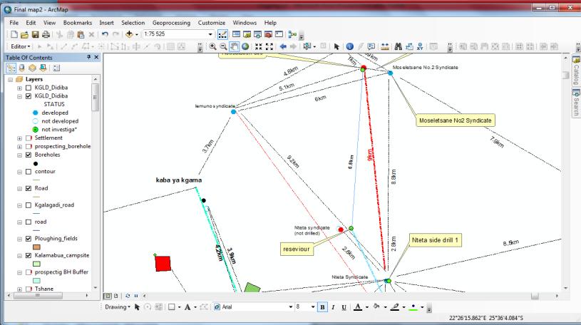
12 File Number- it will help to reconcile the spatial data to the transactional information and for ease of retrieval of manual records. Village area- although livestock boreholes are situated far from villages the project tried as much as possible to record the nearest village to the boreholes. Address- it will help in terms of corresponding to the allotees. Borehole number (BH No)- this was done mainly for department.(water Affairs, Geological, Falconbridge). It also indicates if water rights is obtained for private boreholes Development status- this will help in cases of repossession and monitoring the development status of boreholes. Type- this information is mainly used to differentiated between different types of water sources i.e boreholes, pit wells dams etc. ID Number- every borehole that appears in the database has been identified by its own ID. Photo 2. CURRENT BOREHOLE MAP (UN-UPDATED) 12 P a g e
13 The map data was not accurate in some instances showing a total number of 46 boreholes along the Molopo river basin near Mc Cathy s Rust appearing in South Africa due to wrong coordinates. Some boreholes were not captured in the maps and yet some members of the public and former board members knew their existence. According to Kgalagadi Land Board Allocation Policy the allowable distance between boreholes is 6 kilometres. Due to some missing points on maps, the board sometimes allocated new points close to each other like in the case of Nteta and Moseletsane boreholes which were located just below 3km from each other. Both Kgalagadi Land Board and Kgalagadi District approved the Kgalagadi land Use Map in The two also agreed to revise the WMA boundaries and the proposal was submitted as part of the national land use map revision and it was not approved. The 2001 draft Kgalagadi Land Use Plan recognized 6 RAD ranches and 6 CFDA ranches and suggestions were made to dezone 4 RAD ranches and 6 CFDA ranches for rezoning into more sustainable and economically viable uses WELLS & BOREHOLES WITHIN THE VILLAGES Some boreholes and wells have been allocated right in the middle of the villages across the district. The reasons are that these are areas where potable water can be found. For examples, in Tsabong there is a cluster of wells in Matlhatlaganyane ward behind the Barclays bank. According to the 1991 water point survey report a good number of these wells were excavated around the 1930s. They are using windlass and bucket for pumping water and some of these wells are still in use. As cattle go to these boreholes, because they go through/next to the commercial places where they are a lot of people and this creates conflict between the cattle, people and also disrupt traffic. 13 P a g e
14 Another example is that of Maralaleng Syndicate borehole located at Boiteko ward in Maralaleng village. The borehole is some few meters from existing residential plots, most of which were allocated after this borehole. There is also a reticulation line from this borehole traversing the village to their watering point outside the village. Way leaves for prospecting/departmental boreholes A lot of Departmental boreholes are drilled without having approved wayleaves or consent of the Land Board. Institutions like the BPC and BTC s applications are always subjected to wayleaves but the same is not extended to the drilling of boreholes by DWA. It has emerged that a good number of boreholes are drilled inside peoples properties and some are drilled where other people have applied. Example 1 Land Tribunal Case Number of Titus Mokhwanye vs Kgalagadi Land Board In this instance the DWA drilled a borehole number bh 8089 inside a ploughing field that belonged to Titus Mokhwanye s father in Maleshe village. When Mokhwanye jnr. applied to regularize the ploughing field, the land board resolved to regularize and leave the borehole outside to the dissatisfaction of the ploughing field owner UNREGISTERED LAND A lot of pitwells in use are not registered or certificated. The rights in most cases were inherited from the grandparents and the heirs never registered them. In most cases the pitwells are clustered together and the 236m distances between boreholes as stipulated in Water Act is not observed ATTRIBUTE TABLE ACCURACY AND COMPLETENESS SNAPSHOT OF THE EXISTING DATABASE Photo 3 14 P a g e
15 According to the analysis of the aforementioned database it was observed that there were 110 boreholes of the 678 (16%) records on the attribute table that did not have coordinates recorded. Out of the 646 records, 468 (69%) boreholes in the attribute table did not have the application and allocation dates. The team also observed that from attribute table there were 38 boreholes that had been double entered into the system and that increased the number of boreholes. The database was also incomplete as it had missing information such as file numbers. The issue noted was that when the new file classification scheme was introduced, the records in the database were not updated to align their file numbers with the ones in the physical files. This creates a danger of some officers concluding that a borehole does not have a file just because information is not aligned leading to delay in assisting customers. 15 P a g e
16 11.6 AVAILABLE SPACES There are large numbers of undeveloped allocations, which are occupying land unproductively and preventing new applications from being allocated and developing water points. There are very few unallocated spaces left in the communal areas. At the same time, The problem in many instances is that applicants, lack funds to drill, or that they reasonably believe that the water in the area is very saline, or that they have drilled and struck very salty water (or a blank) DEVELOPMENT STATUS The development status for the boreholes on the map was not indicted as the map shows only the blue colour for all the 678 mapped all boreholes. This confirms the issue that the board has not been conducting monitoring exercises to determine the development status of boreholes. This is contrary to the provisions of the Tribal Land Act that development status should be monitored so that enforcement of covenants can be instituted. The attribute table however showed the 20 % development status as at 2009 when the database was last updated. The development status was however worded differently but intending to reflect the same development status. For instance, in some cases, development was stated as developed, in use or operating. The best wording is to show development status as either developed or not developed. Developed will include boreholes that are drilled and equipped and operating or just drilled and not operating or collapsed or not yet equipped. Some not operating are either have saline water or are blanks RECORDS MANAGEMENT The team carried out some investigations to check the current status of the records (files) to authenticate if files were opened for all the boreholes and to know their completeness and quality of the records. According to Records Management Unit 2014/15 database reveals a total number of 678 borehole files had been opened and in the register. During the physical counting of files, 646 files were found and 32 files were missing. This was done in comparison with the RMU file registers 16 P a g e
17 A borehole file must possess the following attributes: Application form Resolution letter Sketch plan Minutes Certificate All the 646 files were examined to verify if there have the aforementioned attributes. The following table shows the number of files possessing those attributes: Certificates 402 (62%), Application forms 403 (62%), Resolution Letters 150 (54%), Coordinates 363 (56%), Sketch Plan 155(23%), Minutes 144(22%). Chart before update & verification % 56 before update & verification % certificates application form cordinates sketch plan minutes Livestock boreholes that have been allocated around 1970 s to 1990 s did not contain lot of information regarding resolution letters and sketch plan LACK OF A CENTRALISED ENTERPRISE SYSTEM The study has indeed established that the Land Board had database which was over the years been duplicated and distributed to the Technical officers. As each one assessed an application, they will update their copy and others will not have knowledge of that update. This has led to allocations not synchronised and creating possibilities of fraud and double allocations. 17 P a g e
18 This was confirmed by the officers themselves and such databases were collected for further analysis and It was concluded that the problem was caused by lack of a centralised enterprise management system database. The security of borehole information was also compromised since it is scattered and there is no backup system. Poor Management of Records as allocation records were not kept in individual files No filed sketch plans Failure to update maps after allocations Lack of Knowledge of vacant spaces to allocate other uses Relief boreholes not clearly specified on maps or attribute tables Lack of information on borehole ownership No action taken on undeveloped or un-used boreholes including blank ones No proper database management protocols When these issues are addressed the Board will fulfil its mandate of allocation. PROPOSED SOLUTIONS AND IMPLEMENTATION PLAN NO. ISSUES ACTION REQUIRED RESULTS 1 - Misplotted boreholes -Consult communities the and WITS team May 2014 to July stakeholders about the project Missing boreholes -Display all maps in every village kgotla for public input -Pick and plot the missing boreholes using hand held Global Position System (GPS) equipment. December 2014 Consulted village leadership, district committees as scheduled 66 boreholes were identified missing in the database, making a total of 744 including 38 relief boreholes 2. Use of different Collect data from sub land Board WITS September 2014 Databases were merged with 18 P a g e
19 database by Sub Land Board officers technical officers and update new database the Main land Board databases. 3. Spatial information - 46 boreholes appeared in South Africa. 4. Un updated Attribute Table 5. Noncomplianc e to development covenants The team to investigate why boreholes are in South Africa. The team to add missing records such as coordinates, addresses, file names. Update development status of livestock boreholes WITS team December 2014 New coordinate system was used to plot the boreholes to Botswana. WITS team January boreholes coordinates were added. All file numbers have been changed to the new files numbers. WITS team December developed, and 250 undeveloped. 6. Un updated Records - Completene ss of records To update records of files by placing all the necessary attributes need in each file. WITS team January files were updated (619 certificates and coordinates,661 allocation minutes, 203 sketch plan and 561 Application forms) - Missing files To look for missing files January files has been found and added to the list making total of P a g e
20 7. Security of data Purchase new server to store new database Managemen t February 2015 Server bought march develop guidelines for database management determining new data protocols 8. Consultation Sensitize technical staff about the development of the new centralized database BS WITS team November 2014 done Guidelines developed 12.0 PHYSICAL VERIFICATION (FIELD WORK) The team went for site investigation to pick the right coordinates of all 46 boreholes that were appearing in South Africa as according to the plan above. The borehole owners were engaged to identify the real sites of their boreholes where the Technical Officers were able to pick the right coordinates and placed them correctly in the database. The team did the same exercise for the boreholes that were missing in the database. On the attributes table, 38 boreholes that were double entered were removed from the database and missing boreholes were added making the total number of boreholes to be 744. Below is the coordinate system that was used by the team. 20 P a g e

 13.")
21 Photo 4. NEW COORDINATE SYSTEM USED: Geographic Coordinate System (LatY/LongX) 13.0 RECORDS MANAGEMENT 21 P a g e
22 The records were assessed in order to determine the overall quality as per Records Management regulations. The team comes up with categories of files as follows: Category 1: field with the name of the applicant Category 2: whether the applicant was issued with certificate Category 3: whether the file have an application form Category 4: letter of resolution Category 5: coordinates Category 6: sketch plan provided Category 7: allocation minutes Table 8 - sample of the table used no name certificate Application form Resolution letter Coordinates Sketch plan Allocation minutes 1 Freeland syndicate KGLB/6/4/3-14/12 I 14.0 ACHIEVEMENTS 14.1 CONSOLIDATED DATABASE After the consolidation of all the livestock boreholes from Sub Land Boards and Main Land Board the project identified a total number of 678. The 66 missing boreholes were also added in the database making a total of 744 records. Table 9: Statistics of Borehole 22 P a g e
23 Before After Type Number Type Number Borehole allocated by 678 the Land Board Government boreholes 2170 and Prospecting Wells and Dams 238 Small stocks 83 Borehole allocated by 744 the Land Board Government boreholes 2170 and Prospecting Wells and Dams 238 Small stocks 83 The 46 boreholes that appeared in South Africa were relocated to Botswana as shown in the map below. The maps below shows a sample of coordinate (boreholes) that were misplotted in South Africa and were corrected. The boreholes were relocated back to Botswana using a Geographic Coordinate System (GCS), as shown in a map below. As a result there are no boreholes in South Africa. This is one of the team s achievements to update the database and correct its anomalies. Photo 5. Map showing misplaced points 23 P a g e


24 Photo 6. Map showing corrected points Photo 7. Map showing all boreholes in Kgalagadi Communal area 24 P a g e

25 The map above shows all the boreholes in Kgalagadi district depicting the developing status of the boreholes clearly. Blue colour shows developed boreholes whilst white circles show undeveloped boreholes. When you click on the borehole the name ATTRIBUTE TABLES 25 P a g e
26 THE ATTRIBUTE TABLE BEFORE UPDATE The attribute table was not complete, it had many empty fields and other fields like the coordinates field contained only series of zeros. Dates of allocation were not captured and file numbers were captured using the old system. Photo 7 The highlighted figure shows the zeros recorded in the database, showing that the information is not complete REALITY AFTER IMPROVEMENT (SNAP SHOT) 26 P a g e

27 The table below is an update version of the new database which has all information updated and coordinates correctly entered. Address of applicant s fields has been updated as well making it easy to have all information of applicants at hand. This is what a customer oriented organisation should deliver. Photo 8. The attributes table have been updated accordingly. All the 110 boreholes that did not have coordinates were recorded and 468 boreholes that did not have the allocation dates were also recorded DEVELOPMENT OF A CENTRALISED SYSTEM After consolidating and updating the attributes table. The database of both Sub Land Boards were put together into a centralised system and placed into a server to be accessed from one station by authorised technical officers. The server is connected to both Sub Land Boards and is placed at the Main Land Board. 27 P a g e

28 The diagram below depicts the sharing of information Photo 9. The Principal Technical officer has been given the rights to update the database and Technical officers are given rights to access the database only. The database is now secured in the server unlike before. The following pictures show how secure the database is: 28 P a g e

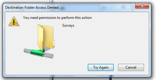
29 Photo 10. Limitation of Permissions for Data Accessibility and Updating to the Server 29 P a g e

30 14.4 IDENTIFICATION OF POSSIBLE VACANT SPACES Unallocated spaces have been identified which will be planned to create new land uses such as for tourism, small stock and boreholes to fulfil requirements for the Government that the district be explored mainly for small stock and tourism opportunities. The team identified the available pocket of land in the following areas. AREA NO. OF AVAILABLE POCKETS IN COMMUNAL AREA Kgalagadi North 21 Kgalagadi South 15 TOTAL 36 The following maps show examples of proposed possible available pockets of land. The numbers placed in the map shows possible pockets of land. Photo P a g e

31 14.5 IMPROVED RECORDS MANAGEMENT SYSTEM To ensure verification and completeness of records the team requested the affected Department such as Land registration Unit to provide Boreholes Certificates, Recording Department to provide minutes concerning the allocation of Boreholes, Technical Office to provide sketch plans with coordinates. All these documents were place in each individual file. The bar chart below shows how the records have improved. The blue colour records low percentages of records before been updated as compared to the red colour which shows percentage of records after updates. Certificates (91.3%), application forms (82.3%)coordinates (91.3) and minutes (80.7%) improvement as compared to sketch plans recorded 30% because years back sketch plans were not produced during allocations hence difficult for the team to produce them. 31 P a g e
32 before update & verification % after update & verification % 0 certificates application form cordinates sketch plan minutes 14.6 DEVELOPMENT STATUS OF BOREHOLES The team went for site investigation to check the development status of allocated boreholes. It was observed that the development status of boreholes has grown from 20% to 66.4% (494/744 boreholes are developed). The Pie chart below shows development status of boreholes and 34% are undeveloped whilst 66% are developed. It must be noted here that, a lot are areas shown as undeveloped are actually drilled and holes are blank. Some have struck saline water and the sites are not used. The problem is then to determine what to do with the sites, whether to repossess or rezone into new uses. The Pie chart below shows development status of kgalagadi District boreholes allocated by the land board 32 P a g e

33 Development Status in % 33.6 Developed undeveloped 66.4 Photo12: example of a developed Borehole with saline water 33 P a g e

34 Photo 13: example of developed borehole in use The development status of boreholes have been verified and will guide the Board to make informed decisions regarding repossession of undeveloped land and to effectively resolve issues of double allocation disputes. The project fulfils the LAPCAS project intent to register land and know who owns What, Where IMPACT FOR ACHIEVEMENTS The achievements above have brought a very positive change in the performance of the organisation in order to provide quality service to the community. The Board has extended the monitoring of development status to be done on other land uses such as residential, commercial plots etc. The Board Members has been allocated with plots to report on quarterly basis regarding the development status of land uses in different villages. Risks of double allocations are minimal since database is updated, Land Board has recorded less than 30% of double allocations because they are aware of who own what and where. 34 P a g e
35 The turn-around time of processes has improved by 80%, immediately after allocation the file is opened, certificate issued and filed and minutes filed. There is a decreased number of disputes since year 2015, the Land Board has recorded zero cases of borehole disputes mainly because of efficient database The Land Board borehole records are now 95% reliable since they have been updated and secured CHALLENGES The team faced lot of challenges concerning the old information of boreholes from 1970 s to the 1990 s as some minutes were not in our records system. Before the introduction of the new classification scheme for records the board used to file boreholes information in one arch lever files and that made difficult for the team to trace information regarding all needed attributes STANDARDIZATION The following guidelines have been developed to standardize the management of the new database and to ensure continuous up to date land information. Additional information to the system will be prohibited unless authorised No duplication of the database will be created by the users One centralised system will be used by Technical officers Users of the system will log into the database using passwords Quarterly update of the database will be monitored by the Principal Technical Officer Quarterly in house training of the system to users will be done in the spirit of Change management Monthly update of database both spatial and attribute by Technical officers and Land Registration officers 35 P a g e
36 A memo was written by the Board Secretary to all Technical Officers instructing them to comply with the aforementioned guidelines IMPLEMENTATION Project helped the Board to solve dispute between Nteta and Moseletsane boreholes syndicates which were located just below 3km from each other was resolved which answers the 10 Point agenda of inconvenience and delays in service delivery. Dispute between Setshadao syndicate and Sxadao was resolved which has long been pending it has now been solved because information was reliable. Application for a borehole by Brown Gasejewe which has long been submitted in 2004 was resolved in May Management implemented Guidelines of database. Passwords created and used to access the system. Setshubake syndicate was allocated borehole March 2015 and was added to the database by the authorising officer. Good management of land has helped the Board to do transfers. Land Registration Officer to file every record immediately after allocation. e.g certificate. Pending application; Bogogobo Syndicate of Ncaang applied in May 2007 and was approved in May 2014, Amogelang Gaboitsewe of Ncaang applied in May 2007 and was approved in May 2014 and lastly Hiler Motshabise applied in 2009 and was allocated in September 2014 after Court ruling WAY FORWARD Both Sub Land Boards to open 28 individual files for the remaining boreholes. 36 P a g e
37 DLUPU to further assess the possible available pockets of land for other land uses such as location of tourism and small stocks. Principal Technical Officer( PTO) to always update the database in the server. Management to establish a task force to assist pit well owners to register them. The team to continuously monitor development status of the boreholes and to check if PTO updates the database after allocations CONCLUSION The areas of improvement that were identified by the team, Land Board to encourage people reticulating to adhere to the requirements, Land Board to address the issue of water bowsing and consider these points as water rights hence the policy should be implemented on such, undeveloped borehole contravening the development covenant be taken for action and finally Land Board to monitor unallocated kraal as they create watering points around those areas REFERENCE (Water Point Survey, 1991) R.White. (1991). Water Point Survey. Tsabong: Land Use Office. (Technical, 2004) Technical, L. B. (2004). Borehole Audit. Tsabong: Kgalagadi Land Board. (Team, 2008/2009) Team, T. F. (2008/2009). Report on Borehole Audit in Kgalagadi District. Tsabong: Kgalagadi Land Board. (committee, 1989) committee, D. (1989). Kgalagadi Land Use Plan. Tsabong: Kgalagadi Land Board. (DDC, 1996) DDC. (1996). Wildlife Managemnt Area Boundaries. Tsabong: Kgalagadi District and Kgalagadi Land Board. 37 P a g e
 Allocated by the Land Board, (b) inheritance/transfer (c) Bought from Water Affairs 6. Allocation date: BH Number: 8. Allocated coordinates:... 9.")
38 1. Name/Syndicate Name:.. 2. Syndicate Members:.. 3. Address: Contacts (TEL/CELL) 4. Location of water points:.. 5. How did you acquire the water point? (a) Allocated by the Land Board, (b) inheritance/transfer (c) Bought from Water Affairs 6. Allocation date: BH Number: 8. Allocated coordinates: How many relief boreholes have you drilled around your allocated points? Does your water points exist on the map provided? Yes/No 11. If YES, do you believe it has been placed correctly on the map? If NO, name 3 boreholes which are close to yours and the name of the area you have allocated, and 13. In the map provided are there any other points that you believe have been omitted or plotted incorrectly? 14. Information provided by Contacts: Date: 38 P a g e
39 TSHEKATSHEKO YA DIDIBA TSA KGALAGADI Leina:. 2. Maloko: 3. Aterese: Mogala:.. 4. Lefelo la sediba:.. 5. Tsela e o filweng sediba ka yone (a) Ke beilwe ke ba LandBoard (b) Ke boswa (c) Ke se rekile ko Water Affairs (d) Ke se rekile mo go 6) Letsatsi le e o beilweng ka lone:... 7) Nomoro ya sediba (BH Number):... 8) Dinomoro tsa sediba sa gago: (Coordinates) 9. O epile didiba tse kae go bapa le se o se filweng?. 10. A sediba sa gago se tlhagelela mo moalong? Ee /Nnya 11. A o rurifatsa gore se supilwe sentle mo moalong(map)? 12. Nankola didiba tse tharo tse di bapileng le sa gago, le. 13. Mo moalong o, a gona le didiba dingwe tse o dumelang di sa bewa/kwalwa sentle? 14. Ke le moemedi.. Mogala.. 39 P a g e
GLOBAL GEOSPATIAL MANAGEMENT INFORMATION
 GLOBAL GEOSPATIAL MANAGEMENT INFORMATION SEOUL, KOREA 24 th to 26 th October 2011 COUNTRY REPORT - REPUBLIC OF BOTSWANA 1. INTRODUCTION 1.1. SOCIAL, ECONOMIC AND POLITICAL BACKGROUND Botswana attained
Valuation Methodology of Unregistered Properties in East Africa
 FIG KL 2014 Valuation Methodology of Unregistered Properties in East Africa James Kavanagh MRICS John Tracey-White FRICS Valuation Methodology of Unregistered Properties in East Africa Origin of the Study
JOB DESCRIPTION MANAGEMENT EXCLUSION
 1. Position No. Various 2. Descriptive Working Title SENIOR DEVELOPMENT MANAGER JOB DESCRIPTION MANAGEMENT EXCLUSION 3. Present Classification Excluded Mgmt 4. Branch DEVELOPMENT AND ASSET 5. Department
How to implement a mandatory inspection in accordance with European directives: The example of certified workshops
 How to implement a mandatory inspection in accordance with European directives: The example of certified workshops Polvêche, V. GIP Pulves, 341 Montpellier, France DOI 10.5073/jka.2012.439.007 Introduction
PART 2.7 DEPARTMENT OF GOVERNMENT SERVICES REAL ESTATE REGULATION
 PART 2.7 DEPARTMENT OF GOVERNMENT SERVICES REAL ESTATE REGULATION Executive Summary The Financial Services Regulation Division (the Division) within the Consumer and Commercial Affairs Branch of the Department
PROJECT INITIATION DOCUMENT
 Project Name: Housing Futures Phase Two Project Sponsor: Steve Hampson Project Manager: Denise Lewis Date Issued: 15 February 2008 Version No: 1 Background: At Full Council on 31 January 2008 the following
Information contained
 Cadastral Integrity Unit Audit Survey Procedures August 2012 Table of Contents Introduction... 2 2. Objectives... 3 3. Roles, responsibilities and delegations... 4 3.1 Ethical conduct... 4 3.2 Workplace
R E Q U E S T F O R P R O P O S A L S
 P.O. Box 3209, Houghton, 2041 Block A, Riviera Office Park, 6-10 Riviera Road, Riviera R E Q U E S T F O R P R O P O S A L S M A R K E T S U R V E Y T O I N F O R M R E S I D E N T I A L H O U S I N G
Ownership Data in Cadastral Information System of Sofia (CIS Sofia) from the Available Cadastral Map
 from the Available Cadastral Map") Ownership Data in Cadastral Information System of Sofia (CIS Sofia) from the Available Cadastral Map Key words: ABSTRACT Lydmila LAZAROVA, Bulgaria CIS Sofia is created and maintained by GIS Sofia ltd,
Ownership Data in Cadastral Information System of Sofia (CIS Sofia) from the Available Cadastral Map Key words: ABSTRACT Lydmila LAZAROVA, Bulgaria CIS Sofia is created and maintained by GIS Sofia ltd,
SCOTTISH GOVERNMENT RESPONSE TO PRIVATE RENTED HOUSING (SCOTLAND) BILL STAGE 1 REPORT
 BILL STAGE 1 REPORT") SCOTTISH GOVERNMENT RESPONSE TO PRIVATE RENTED HOUSING (SCOTLAND) BILL STAGE 1 REPORT I am writing in response to the Local Government and Communities Committee s Stage 1 Report on the Private Rented Housing
SCOTTISH GOVERNMENT RESPONSE TO PRIVATE RENTED HOUSING (SCOTLAND) BILL STAGE 1 REPORT I am writing in response to the Local Government and Communities Committee s Stage 1 Report on the Private Rented Housing
Highlights Highlights of a review of Newfoundland and Labrador Housing Corporation s Rental Housing Program from January 2007 to December 2007.
 Office of the Auditor General Newfoundland and Labrador Highlights Highlights of a review of Newfoundland and Labrador Housing Corporation s Rental Housing Program from January 2007 to December 2007. Why
Reformation of Land Administration in Botswana
 Reformation of Land Administration in Botswana Bareng MALATSI, Botswana and Åke FINNSTRÖM, Sweden Key words: Reformation, Land administration, Tribal land, Adjudication, Economic development SUMMARY In
Consulted With Individual/Body Date Head of Finance Financial
 Equipment Disposal Policy Developed in response to: Policy Register No: 12037 Status: Public Internal Audit Report for Fixed Assets Contributes to CQC Regulation 17 Consulted With Individual/Body Date
Real Estate Acquisitions Audit (Green Line LRT Stage 1)
") Real Estate Acquisitions Audit (Green Line LRT Stage 1) October 10, 2018 ISC: Unrestricted THIS PAGE LEFT INTENTIONALLY BLANK ISC: Unrestricted Table of Contents Executive Summary... 5 1.0 Background...
Real Estate Acquisitions Audit (Green Line LRT Stage 1) October 10, 2018 ISC: Unrestricted THIS PAGE LEFT INTENTIONALLY BLANK ISC: Unrestricted Table of Contents Executive Summary... 5 1.0 Background...
ENHANCING LAND TITLING AND REGISTRATION IN NIGERIA
 ENHANCING LAND TITLING AND REGISTRATION IN NIGERIA BY Muhammad Bashar NUHU, ANIVS, RSV, MNIM DEPARTMENT OF ESTATE MANAGEMENT FEDERAL UNIVERSITY OF TECHNOLOGY MINNA mbnuhu@futminna.edu.ng, nuhutachi@yahoo.com,
PROPERTY ASSESSMENT KNOWLEDGE
 A P E N DE UM NOUN A COLLECTION OF CONCISE BUT DETAILED INFORMATION ABOUT APPRAISAL AND APPRAISAL MANAGEMENT, ESPECIALLY IN THE PROPERTY ASSESSMENT INDUSTRY. PROPERTY ASSESSMENT KNOWLEDGE KNOWLEDGE AREAS
IMPLEMENTATION OF FLEXICADASTRE IN ZAMBIA
 IMPLEMENTATION OF FLEXICADASTRE IN ZAMBIA Presented by: Simon M. Mwalimu Head of Mining Cadastre and Secretary of The Mining Advisory Committee Mining Cadastre Office-Zambia 16 th February 2009 Part A
Internal Audit Report
 Internal Audit Report TxDOT Internal Audit Division Objective To determine if objectives are being met and are in compliance with current regulations. Opinion Based on the audit scope areas reviewed, control
Arlington County, Virginia. Internal Audit of the Real Estate Assessment Appeals Process Calendar Year Ended December 31, 2014
 Arlington County, Virginia Internal Audit of the Real Estate Assessment Appeals Process Calendar Year Ended December 31, 2014 Table of Contents Transmittal Letter... 1 Executive Summary... 2-9 Background...
HEATING SERVICES PROCEDURES SOLID FUEL SERVICING
 HEATING SERVICES PROCEDURES SOLID FUEL SERVICING 13 th October, 2016 CUSTOMER CONSULTATION Introduction The consultation processes with regard to the service and safety check of the solid fuel appliances
Asset valuation. Advancing Methodology on Measuring Asset Ownership from a Gender Perspective
 Advancing Methodology on Measuring Asset Ownership from a Gender Perspective Asset valuation Workshop on the Production of Statistics on Asset Ownership from a Gender Perspective through Household Surveys
A Conveyancer s Lot Post P&P Property and Dreamvar
 A Conveyancer s Lot Post P&P Property and Dreamvar June 2018 Jason Nash Partner, BLM T +44 (0)161 838 6953 E Jason.nash@blmlaw.com The spotlight has never been so bright on the world of conveyancing as
INVESTIGATION INTO DELAYS IN ISSUING TITLE DEEDS TO BENEFICIARIES OF HOUSING PROJECTS FUNDED BY THE CAPITAL SUBSIDY. 13 April 2012
 INVESTIGATION INTO DELAYS IN ISSUING TITLE DEEDS TO BENEFICIARIES OF HOUSING PROJECTS FUNDED BY THE CAPITAL SUBSIDY 13 April 2012 Contents Introduction Process of registering land in South Africa Factors
CLACKMANNANSHIRE TENANTS AND RESIDENTS ASSOCIATION WRITTEN SUBMISSION
 CLACKMANNANSHIRE TENANTS AND RESIDENTS ASSOCIATION Introduction WRITTEN SUBMISSION In order to respond to the Scottish Government s Housing (Scotland) Bill Clackmannanshire Tenants and Residents Federation
WHAT IS AN APPROPRIATE CADASTRAL SYSTEM IN AFRICA?
 WHAT IS AN APPROPRIATE CADASTRAL SYSTEM IN AFRICA? Tommy ÖSTERBERG, Sweden Key words: ABSTRACT The following discussion is based on my experiences from working with cadastral issues in some African countries
VIRGINIA CENTRAL REGION ITS ARCHITECTURE MAINTENANCE PLAN
 VIRGINIA CENTRAL REGION ITS ARCHITECTURE MAINTENANCE PLAN Prepared for: Prepared by: June 30, 2009 Table of Contents 1 INTRODUCTION... 1 2 ARCHITECTURE MAINTENANCE DECISIONS... 1 2.1 Architecture Maintainer...
Demonstration Properties for the TAUREAN Residential Valuation System
 Demonstration Properties for the TAUREAN Residential Valuation System Taurean has provided a set of four sample subject properties to demonstrate many of the valuation system s features and capabilities.
Auditor General s Office
 Auditor General s Office Parks, Forestry and Recreation Division - Concession Agreements Review Transmittal Report Audit Report Management s Response Jeffrey Griffiths, C.A., C.F.E Auditor General, City
Extending the Right to Buy
 Memorandum for the House of Commons Committee of Public Accounts Department for Communities and Local Government Extending the Right to Buy MARCH 2016 4 Key facts Extending the Right to Buy Key facts 1.8m
In light of this objective, Global Witness is providing feedback on key sections of the 6 th draft of the national land policy:
 Summary Global Witness submission on the 6 th draft of Myanmar s draft national land policy June 2015 After a welcome extension to public participation on the 5 th draft of the national land policy, in
EXECUTIVE SUMMARY. Land Use Management and Democratic Governance in the City of Johannesburg. Case Study: Diepkloof
 EXECUTIVE SUMMARY Land Use Management and Democratic Governance in the City of Johannesburg Case Study: Diepkloof Authors: Fazeela Hoosen & Jonathan Mafukidze This study was funded by Ford and Urban Landmark,
NATIONAL PLANNING AUTHORITY. The Role of Surveyors in Achieving Uganda Vision 2040
 NATIONAL PLANNING AUTHORITY The Role of Surveyors in Achieving Uganda Vision 2040 Key Note Address By Dr. Joseph Muvawala Executive Director National Planning Authority At the Annual General Meeting and
The Multi-Purpose Information System of Real Estates in the Czech Republic. Vladimíra ŽUFANOVÁ, Czech Republic
 The Multi-Purpose Information System of Real Estates in the Czech Republic Vladimíra ŽUFANOVÁ, Czech Republic Key words: Cadastre; Land management SUMMARY The Cadastre of Real Estate and Land administration,
Stockton Port District Job Description
 Stockton Port District Job Description JOB TITLE: Real Estate and Property Development Manager Department: Property Management Reports to: Deputy Port Director, Real Estate and Port Development FLSA Status:
Evaluating your co-op manager
 June 17, 2013 Evaluating your co-op manager When co-ops sign a contract with a person to be their co-op manager, the contract usually includes a provision to conduct an evaluation of the service. This
Monitoring of Grantees by HUD
 U.S. Department of Housing and Urban Development Monitoring of Grantees by HUD Tuesday, May 3, 2011 2:00 PM 4:00 PM Community Planning and Development Introductions Jessie Handforth Kome, HUD John Laswick,
10 SIGNS YOU NEED TO CHANGE YOUR PROPERTY MANAGER. How to identify a poor Property Manager
 10 SIGNS YOU NEED TO CHANGE YOUR PROPERTY MANAGER How to identify a poor Property Manager 101 INTRODUCTION Successful property investing starts when you buy a sound property that is well managed so it
Reference: SO/SRR/DW Approved: 4/4/17. Shared Ownership Staircasing Reverse Staircasing, and Remortgaging. Author: Deborah White Approved by:
 Shared Ownership Staircasing Policy Reference: SO/SRR/DW Approved: 4/4/17 Scope: Shared Ownership Staircasing Reverse Staircasing, and Remortgaging Related Policies: Shared Ownership Sales, Resales and
ALC Bylaw Reviews. A Guide for Local Governments
 2018 ALC Bylaw Reviews A Guide for Local Governments ALC Bylaw Reviews A Guide for Local Governments This version published on: August 14, 2018 Published by: Agricultural Land Commission #201-4940 Canada
Terms of Reference for Town of Caledon Housing Study
 1.0 Introduction Terms of Reference for Town of Caledon Housing Study The Town of Caledon is soliciting proposals for a comprehensive Housing Study. Results of this Housing Study will serve as a guiding
Assets, Regeneration & Growth Committee 17 March Development of new affordable homes by Barnet Homes Registered Provider ( Opendoor Homes )
") Assets, Regeneration & Growth Committee 17 March 2016 Title Report of Wards Status Urgent Key Enclosures Officer Contact Details Development of new affordable homes by Barnet Homes Registered Provider
Assets, Regeneration & Growth Committee 17 March 2016 Title Report of Wards Status Urgent Key Enclosures Officer Contact Details Development of new affordable homes by Barnet Homes Registered Provider
Proposals for Best Practice
 WPLA Fees & Charges in Cadastre and Registration Proposals for Best Practice Neil King United Kingdom WPLA Fees and Charges Study Best Practice This presentation offers an overview of a draft report that
Appendix 1: Gisborne District Quarterly Market Indicators Report April National Policy Statement on Urban Development Capacity
 Appendix 1: Gisborne District Quarterly Market Indicators Report April 2018 National Policy Statement on Urban Development Capacity Quarterly Market Indicators Report April 2018 1 Executive Summary This
Recognition of Prior Learning (RPL) Application NSW
 Application NSW") NSW Real Estate Training College PO Box 601, Hornsby NSW 2077 Phone: 02 9987 2322 Fax 02 9479 9720 rpl@realestatetraining.com.au www.realestatetraining.com.au Recognition of Prior Learning (RPL) Application
NSW Real Estate Training College PO Box 601, Hornsby NSW 2077 Phone: 02 9987 2322 Fax 02 9479 9720 rpl@realestatetraining.com.au www.realestatetraining.com.au Recognition of Prior Learning (RPL) Application
Chapter 3: A Framework for a National Land Information Infrastructure
 Chapter 3: A Framework for a National Land Information Infrastructure Brian Marwick Overview As a federated county, Australia s land administration systems are state and territory based. These systems,
CONCEPT NOTE EFFECTIVE LAND ADMINISTRATION IN AFRICA TRAINING WORKSHOP
 CONCEPT NOTE EFFECTIVE LAND ADMINISTRATION IN AFRICA TRAINING WORKSHOP Innovative Concepts, Tools and Practices for Effective Land Administration Land Conference Pre-Conference Workshop Advocating & Implementing
1
 THE DUE DILIGENCE STANDARD LAND RIGHTS AND SHELTER THE DUE DILIGENCE STANDARD December 2013 This checklist aims to assist shelter actors to ensure that they respect existing rights over plots of land on
Difficulties in Creating a Notice filing System for Immovable Property
 Difficulties in Creating a Notice filing System for Immovable Property Professor Tom Johnson, Osgoode Hall Law School EBRD Secured Lending in Commercial Transactions: Trends and Perspectives 4 5 November
Chapter 14 Technical Safety Authority of Saskatchewan Inspecting Elevating Devices 1.0 MAIN POINTS
 Chapter 14 Technical Safety Authority of Saskatchewan Inspecting Elevating Devices 1.0 MAIN POINTS The Technical Safety Authority of Saskatchewan (TSASK) administers Saskatchewan s safety programs for
The Characteristics of Land Readjustment Systems in Japan, Thailand, and Mongolia and an Evaluation of the Applicability to Developing Countries
 ISCP2014 Hanoi, Vietnam Proceedings of International Symposium on City Planning 2014 The Characteristics of Land Readjustment Systems in Japan, Thailand, and Mongolia and an Evaluation of the Applicability
Regulatory Impact Statement
 Regulatory Impact Statement Establishing one new special housing area in Queenstown under the Housing Accords and Special Housing Areas Act 2013. Agency Disclosure Statement 1 This Regulatory Impact Statement
Ludgvan Parish HOUSING NEED SURVEY. Report Date: 21 st January Version: 1.2 Document Status: Final Report
 Ludgvan Parish HOUSING NEED SURVEY Report Date: 21 st January 2019 Version: 1.2 Document Status: Author: Final Report Andrew Prendergast Rural Housing Enabler Affordable Housing Team, Cornwall Council
TECHNICAL INFORMATION PAPER - VALUATIONS OF REAL PROPERTY, PLANT & EQUIPMENT FOR USE IN AUSTRALIAN FINANCIAL REPORTS
 TECHNICAL INFORMATION PAPER - VALUATIONS OF REAL PROPERTY, PLANT & EQUIPMENT FOR USE IN AUSTRALIAN FINANCIAL REPORTS Reference ANZVTIP 8 Valuations of Real Property, Plant & Equipment for Use in Australian
DMS Authority Online. User s Manual
 Illinois Housing Development Authority DMS Authority Online User s Manual for Property Owners and Agents Revised 4/1/2018 DMS Authority Online User Guide Table of Contents Overview What is DMS How Owners
Cadastral Information System of Sofia
 Alexander LAZAROV and Hristo DECHEV, Bulgaria Key words: ABSTRACT A new Cadastre and Property Register Act (CPRA) was passed in April 2000, setting up rules for the maintenance of these two registers.
Lanteglos by Fowey HOUSING NEED SURVEY. Report Date: 1 st March Version: 1.1 Document Status: Final Report
 Lanteglos by Fowey HOUSING NEED SURVEY Report Date: Version: 1.1 Document Status: Author: Final Report Victoria Regan Senior Development Officer Affordable Housing Team, Cornwall Council 1. Introduction
Key findings from an investigation into low- and medium-value property sales. National Audit Office September 2017 DP
 from an investigation into low- and medium-value property sales National Audit Office September 207 DP 557-00 from an investigation into low- and medium-value property sales Contents 3 4 5 6 7 8 9 0 2
Registering Property
 Registering Property Delhi 1. Description of Reform: For procedure 3 Conduct charges search at the Registrar of Companies, Doing Business 2018 records that the buyer must conduct a search in office of
REVENUE RECOGNITION AND LEASE ACCOUNTING
 REVENUE RECOGNITION AND LEASE ACCOUNTING DALLAS INSTITUTE OF INTERNAL AUDITORS CONFERENCE October 2017 TABLE OF CONTENTS I. REVENUE RECOGNITION OVERVIEW II. III. IV. LEASE ACCOUNTING OVERVIEW IMPLEMENTATION
Designing for transparency and participation in the Hellenic Cadastral Project
 Designing for transparency and participation in the Hellenic Cadastral Project Dr. Dimitris Rokos Director of Planning and Investments, Hellenic National Cadastre and Mapping Agency S.A. Table of Contents
A Diagnostic Checklist for Business Inspection
 A Diagnostic Checklist for Business Inspection Government inspections are essential and welfare improving if carried out efficiently and with accountability and transparency. However they often impose
GLTN Tools and Approaches in Support of Land Policy Implementation in Africa
 GLTN Tools and Approaches in Support of Land Policy Implementation in Africa Jamal Browne (UN-Habitat), Jaap Zevenbergen (ITC), Danilo Antonio (UN-Habitat), Solomon Haile (UN-Habitat) Land Policy Development
RE: Proposed Accounting Standards Update, Leases (Topic 842): Targeted Improvements (File Reference No )
: Targeted Improvements (File Reference No )") KPMG LLP Telephone +1 212 758 9700 345 Park Avenue Fax +1 212 758 9819 New York, N.Y. 10154-0102 Internet www.us.kpmg.com 401 Merritt 7 PO Box 5116 Norwalk, CT 06856-5116 RE: Proposed Accounting Standards
KPMG LLP Telephone +1 212 758 9700 345 Park Avenue Fax +1 212 758 9819 New York, N.Y. 10154-0102 Internet www.us.kpmg.com 401 Merritt 7 PO Box 5116 Norwalk, CT 06856-5116 RE: Proposed Accounting Standards
PROJECT INFORMATION DOCUMENT (PID) CONCEPT STAGE Report No.: AB3229 Project Name. Land Registry and Cadastre Modernization Project Region
 CONCEPT STAGE Report No.: AB3229 Project Name. Land Registry and Cadastre Modernization Project Region") PROJECT INFORMATION DOCUMENT (PID) CONCEPT STAGE Report No.: AB3229 Project Name Land Registry and Cadastre Modernization Project Region EUROPE AND CENTRAL ASIA Sector Central government administration
PROJECT INFORMATION DOCUMENT (PID) CONCEPT STAGE Report No.: AB3229 Project Name Land Registry and Cadastre Modernization Project Region EUROPE AND CENTRAL ASIA Sector Central government administration
The South Australian Housing Trust Triennial Review to
 The South Australian Housing Trust Triennial Review 2013-14 to 2016-17 Purpose of the review The review of the South Australian Housing Trust (SAHT) reflects on the activities and performance of the SAHT
ROLE OF SOUTH AFRICAN GOVERNMENT IN SOCIAL HOUSING. Section 26 of the Constitution enshrines the right to housing as follows:
 1 ROLE OF SOUTH AFRICAN GOVERNMENT IN SOCIAL HOUSING Constitution Section 26 of the Constitution enshrines the right to housing as follows: Everyone has the right to have access to adequate housing The
GAUSSCAD A WEBGIS APPLICATION FOR COLLECTING CADASTRAL DATA
 M.M. Moise GaussCAD a WebGIS Application for Collecting Cadastral Data GAUSSCAD A WEBGIS APPLICATION FOR COLLECTING CADASTRAL DATA Mihai-Mircea MOISE, S.C. GAUSS S.R.L., mihai.moise@gauss.ro Abstract:
MARS User Guide Appraisers https://gp.marswales.org https://medical.marswales.org. Guide Index
 1 MARS User Guide Appraisers https://gp.marswales.org https://medical.marswales.org This guide is intended to walk you through the Appraisal Process using the online MARS system. Primarily for Appraisers
Acquisition and accessioning
 Acquisition and accessioning PRIMARY PROCEDURE Definition Taking legal ownership of objects, especially (but not always) to add to your longterm collection through the process of accessioning: the formal
A FIRST ATTEMPT FOR USING VOLUNTEERED GEOGRAPHIC INFORMATION AND CROWD SOURCING TECHNIQUES IN CADASTRE
 A FIRST ATTEMPT FOR USING VOLUNTEERED GEOGRAPHIC INFORMATION AND CROWD SOURCING TECHNIQUES IN CADASTRE Sofia Basiouka National Technical University of Athens PhD student s.basiouka@gmail.com Chryssy Potsiou
Working with residents and communities to tackle ASB
 Working with residents and communities to tackle ASB Baseline findings 2011 www.cih.org 1 Introduction Over the last two decades tackling anti-social behaviour (ASB) and its underlying causes has become
Tenant Participation Strategy
 Tenant Participation Strategy 2014 2017 Introduction Link has a strong commitment and tradition of involving tenants across the organisation in a variety of ways. Tenant participation is about sharing
Affordable Homes Service Plan 2016/17 and 2017/18
 Report To: Housing Portfolio Holder 15 March 2017 Lead Officer: Director of Housing Purpose Affordable Homes Service Plan 2016/17 and 2017/18 1. To provide the Housing Portfolio Holder with an update on
Housing Reset :: Creative Advisory Accelerating Non-Profit / City Partnerships What We Heard
 Final Version Date: Feb 8, 2017 Housing Reset :: Creative Advisory Accelerating Non-Profit / City Partnerships What We Heard Purpose This Creative Advisory was formed as part of the Housing Reset to generate
THE APPLICATION OF GIS AND LIS Solutions and Experiences in East Africa. Lenny Kivuti
 Using GIS and LIS for Planning Sustainable Development Bepic Group CHOGM, Malta 2005 THE APPLICATION OF GIS AND LIS Solutions and Experiences in East Africa Lenny Kivuti 21 November, 2005 Presented by
EARLY LEARNING COALITION OF OSCEOLA COUNTY
 Page of 1 of 9 POLICY STATEMENT The Coalition shall adhere to Federal and state laws, regulations, and rules requiring the implementation of proper controls related to the management, maintenance, reporting,
Implementation of a PPP Transaction in the Rural Water Sector in Uganda. IFC - PPP Transaction Advisory Dakar, June 4, 2012
 Implementation of a PPP Transaction in the Rural Water Sector in Uganda IFC - PPP Transaction Advisory Dakar, June 4, 2012 Outline What is a small scale PPP and What are the Main characteristics? Main
Tax Credit Management Abilities
 Web-Based, ASP Hosted, Enterprise Class Property Management Software Tax Credit Management Abilities Dear Property Manager, Property management software is becoming more and more complicated and loaded
IDENTITY VALIDATION GUIDELINES
 IDENTITY VALIDATION GUIDELINES Version 1.0 May 25 2015 Contents 1 General Guidelines for all Class...3 2 For Class 2 & Class 3 DSC:...6 3 For Government Officers:...6 4 For Foreign Nationals:...7 5 Guidelines
Securing Land Rights for Broadband Land Acquisition for Utilities in Sweden
 Securing Land Rights for Broadband Land Acquisition for Utilities in Sweden Marija JURIC and Kristin LAND, Sweden Key words: broadband, land acquisition, cadastral procedure, Sweden SUMMARY The European
CONTACT(S) Raghava Tirumala +44 (0) Woung Hee Lee +44 (0)
 Raghava Tirumala +44 (0) Woung Hee Lee +44 (0)") IASB Agenda ref 18A STAFF PAPER IASB Meeting Project Paper topic Goodwill and Impairment research project Summary of discussions to date CONTACT(S) Raghava Tirumala rtirumala@ifrs.org +44 (0)20 7246 6953
IASB Agenda ref 18A STAFF PAPER IASB Meeting Project Paper topic Goodwill and Impairment research project Summary of discussions to date CONTACT(S) Raghava Tirumala rtirumala@ifrs.org +44 (0)20 7246 6953
Strata Titles Act Reform Consultation Summary
 Strata Titles Act Reform Consultation Summary landgate.wa.gov.au Strata Titles Act Reform - Consultation Summary Overview The State Government has set strata reform as a key priority and Landgate has been
We hope the trends provide additional perspective on your county s work. We know it provided valuable insight on the work we do here at Revenue.
 Date: March 6, 2018 To: County Assessors, Auditors, and Treasurers From: Jon Klockziem, Acting Director Subject: Property Tax Services Report The Property Tax Division of the is pleased to provide the
Report. Property Leases Audit Report. Internal Audit Report for August 2010
 Report Office of the General Auditor Summary Three reports were issued during the month: Property Leases Audit Report Skinner East Bypass Screening Structure Rehabilitation Audit Report Yuba Accord Dry
Ontario Rental Market Study:
 Ontario Rental Market Study: Renovation Investment and the Role of Vacancy Decontrol October 2017 Prepared for the Federation of Rental-housing Providers of Ontario by URBANATION Inc. Page 1 of 11 TABLE
PROPERTY TAX IS A PRINCIPAL REVENUE SOURCE
 TAXABLE PROPERTY VALUES: EXPLORING THE FEASIBILITY OF DATA COLLECTION METHODS Brian Zamperini, Jennifer Charles, and Peter Schilling U.S. Census Bureau* INTRODUCTION PROPERTY TAX IS A PRINCIPAL REVENUE
ICP/IDNO Land Rights Guide
 ICP/ID Land Rights Guide Our guide about land rights for connections involving Independent Connection Providers (ICPs) and Independent Distribution Network Operators (IDs) Welcome We hope this guide will
Earls Barton. Rural Housing Survey. Authors: A Miles & S Butterworth Date: October 2012
 Earls Barton Rural Housing Survey Authors: A Miles & S Butterworth Date: October 2012 Swanspool House, Doddington Road, Wellingborough, Northamptonshire, NN8 1BP Tel: 01933 229777 DX 12865 www.wellingborough.gov.uk
MARCH GUIDE TO BUILDING CONDITION ASSESSMENTS and RESERVE FUND STUDIES
 MARCH 2018 GUIDE TO BUILDING CONDITION ASSESSMENTS and RESERVE FUND STUDIES Contents What This Guide Covers... 3 Why Your Co-op Needs a BCA and RFS... 3 The BCA and RFS... 4 What is a building condition
INSTRUCTIONS AND WORKSHEET FOR CONDUCTING A SELF-ASSESSMENT STANDARD 4 TRAINED REGULATORY STAFF
 INSTRUCTIONS AND WORKSHEET FOR CONDUCTING A SELF-ASSESSMENT STANDARD 4 TRAINED REGULATORY STAFF Using the Standard 4 Self-Assessment Worksheet Criterion three on the Standard 4: Self-Assessment and Verification
D DAVID PUBLISHING. Mass Valuation and the Implementation Necessity of GIS (Geographic Information System) in Albania
 in Albania") Journal of Civil Engineering and Architecture 9 (2015) 1506-1512 doi: 10.17265/1934-7359/2015.12.012 D DAVID PUBLISHING Mass Valuation and the Implementation Necessity of GIS (Geographic Elfrida Shehu
Journal of Civil Engineering and Architecture 9 (2015) 1506-1512 doi: 10.17265/1934-7359/2015.12.012 D DAVID PUBLISHING Mass Valuation and the Implementation Necessity of GIS (Geographic Elfrida Shehu
Alberta Aggregate (Sand and Gravel) Allocation Directive for Commericial Use on Public Lands
 Allocation Directive for Commericial Use on Public Lands") Title: Alberta Aggregate (Sand and Gravel) Allocation Directive for Commercial Use on Public Land Number: Program Name: Public Land Management Effective Date: September 1, 2017 This document was updated
Title: Alberta Aggregate (Sand and Gravel) Allocation Directive for Commercial Use on Public Land Number: Program Name: Public Land Management Effective Date: September 1, 2017 This document was updated
Expropriation. Recommended Policy Wordings (full): Lao National Land Policy. Context. Policy. Standard of Public Purpose
: Lao National Land Policy. Context. Policy. Standard of Public Purpose") Expropriation Context Following from the goal of the National Land Policy, to promote and ensure a secure land tenure system that is transparent, effective, non-discriminative, equitable and just ; it
Expropriation Context Following from the goal of the National Land Policy, to promote and ensure a secure land tenure system that is transparent, effective, non-discriminative, equitable and just ; it
Upstate New York Real Estate Information Services LLC (UNYREIS) NYSAMLS S MULTIPLE LISTING RULES and REGULATIONS SUMMARY
 NYSAMLS S MULTIPLE LISTING RULES and REGULATIONS SUMMARY") Upstate New York Real Estate Information Services LLC (UNYREIS) NYSAMLS S MULTIPLE LISTING RULES and REGULATIONS SUMMARY Please review these policies to make sure you are fully aware of them and that your
Upstate New York Real Estate Information Services LLC (UNYREIS) NYSAMLS S MULTIPLE LISTING RULES and REGULATIONS SUMMARY Please review these policies to make sure you are fully aware of them and that your
Advancing Methodology on Measuring Asset Ownership from a Gender Perspective
 Advancing Methodology on Measuring Asset Ownership from a Gender Perspective Seminar on the UN Methodological Guidelines on the Production of Statistics on Asset Ownership from a Gender Perspective Rome,
City of New York OFFICE OF THE COMPTROLLER. Scott M. Stringer COMPTROLLER AUDIT AND SPECIAL REPORTS
 City of New York OFFICE OF THE COMPTROLLER Scott M. Stringer COMPTROLLER AUDIT AND SPECIAL REPORTS Marjorie Landa Deputy Comptroller for Audit Audit Report on the Tax Classification of Real Property in
ENVIRONMENT CANTERBURY S WEB-BASED CONTAMINATED LAND INFORMATION TRANSFER SYSTEM
 ENVIRONMENT CANTERBURY S WEB-BASED CONTAMINATED LAND INFORMATION TRANSFER SYSTEM Davina McNickel 1, Helen Davies 2, Vincent Salomon 2 1 Environment Canterbury, PO Box 345, Christchurch. Telephone: 03 365
Institutional Analysis of Condominium Management System in Amhara Region: the Case of Bahir Dar City
 Institutional Analysis of Condominium Management System in Amhara Region: the Case of Bahir Dar City Zelalem Yirga Institute of Land Administration Bahir Dar University, Ethiopia Session agenda: Construction
Annual Report to South Cambridgeshire District Council Tenants [DRAFT TEXT]
![Annual Report to South Cambridgeshire District Council Tenants [DRAFT TEXT]](/thumbs/93/112843468.jpg "Annual Report to South Cambridgeshire District Council Tenants [DRAFT TEXT]") APPENDIX A Annual Report to South Cambridgeshire District Council Tenants [DRAFT TEXT] Welcome Welcome to our first annual report to tenants that sets out our performance as a landlord and the commitments
APPENDIX A Annual Report to South Cambridgeshire District Council Tenants [DRAFT TEXT] Welcome Welcome to our first annual report to tenants that sets out our performance as a landlord and the commitments
QUEENSTOWN-LAKES DISTRICT HOUSING ACCORD
 QUEENSTOWN-LAKES DISTRICT HOUSING ACCORD Queenstown-Lakes Housing Accord 1. The Queenstown-Lakes Housing Accord (the Accord) between Queenstown-Lakes District Council (the Council) and the Government is