Country Report. The Netherlands. I. Country Report. A. Country Context
|
|
|
- Brenda Boyd
- 6 years ago
- Views:
Transcription
1 Country Report (Based on the PCGIAP-Cadastral Template 2003) The Netherlands Country/state for which the indications are valid: Name of contact person Affiliation, Organization: Function, Position: Address: address: The Netherlands Paul van der Molen Kadaster International Director PO Box 9046, NL-7300 GH APELDOORN I. Country Report A. Country Context Geographical Context The Netherlands is a country located in Western Europe, bordering the North Sea, between Belgium and Germany. It is located at the delta of three major European rivers (Rhine, Maas, Schelde). The area of land is 33,883 km2 and of water 7,643 km2. The geographical coordinates are N, and 5 45 E. The terrain consists of mostly coastal lowland and reclaimed land (polders), with some hills in the southeast. The lowest point is -7 m (Zuidplaspolder) and the highest point +322 m (Vaalserberg). It is estimated that 8 % is urban land, 58% is agricultural land, 7 % is forest, 3% is natural reserve, and the rest is various. There are 6.6 million buildings. The population of the Netherlands is 16,067,754 people (1 July 2002). The GDP is 434 bill $, the growth rate 0.3 % (2002). The GDP by composition is agriculture 3%, industry 26% and services 71%. Historical Context The Republic of the Netherlands was formed after defeat of the Spanish occupancy in 1648, with the Peace Treaty of Münster. In 1795 the Republic was occupied by the French Napoleon, and during it was annexed and became part of France. In 1815, after the defeat of Napoleon in the Waterloo battle, the Kingdom of the Netherlands was formed. The territory included southern parts, now Belgium. In 1830 Belgium seceded and formed a separate kingdom. The Netherlands remained neutral during World War I, but suffered invasion and occupation by Germany in World War II. After World War II it lost its major colony Indonesia. The Netherlands was a founding member of NATO and EC, and participates in the EMU. Current Political and Administrative Structures The Netherlands is a constitutional monarchy and a parliamentary democracy with free elections every 4 years. The Government is formed by the Queen and Council of Ministers. The Queen is privileged (can do 'no wrong'), the ministers are responsible. The Queen is head of State (Kingdom of the Netherlands, including overseas territories). Overseas territories have a kind of separate status with a governor and local parliament and reporting to the 'minister of Netherlands-9Jun2006.doc Page 1
2 home and overseas affairs'; as such the Kingdom occurs to be a kind of federation. The Prime Minister is chair of the cabinet and has a primus inter pares status. The Government is verifiable by the Parliament at any time and at any matter. The Parliament consists of a Second (Lower) Chamber and a First Chamber (Senate). The second chamber has most political power. The First Chamber has limited powers; its main task is to perform a second opinion on bills before becoming law. The members of the Second Chamber are directly elected by popular vote to serve four-year term. The members of the First Chamber are indirectly elected by the country's 12 provincial councils for four-years term. At national level there are about 15 ministries, headed by a minister and (occasionally) a vice minister, responsible for a specific mandate (e.g. 'environment', 'European affairs'). The second level of administration are the 12 provinces, which have certain mandates on regional policies (e.g. planning, economy, environment), and regional implementation of national policy. Third and lowest level are about 400 municipalities, with extensive powers regarding local matters (zoning, social welfare, development control) and implementation of all kinds of national and regional regulations and relevant subsidy schemes. The system of provinces and municipalities are considered as territorial decentralisation. A special case are the about 30 waterboards, which have extensive powers pertaining to water management, both quantity and quality. The waterboards are considered as functional decentralisation, with specific general elections for board members, and an own tax regime. Historical Outline of Cadastre In 1810 the introduction of a fiscal cadastre became actual after the earlier mentioned annexation of the Kingdom of the Netherlands by France. The French legislation came into power. Some years before, in 1808, Napoleon Bonaparte, who needed money to finance his activities, decided to establish a system of land taxation, based on a accurate inventory of land use and land ownership, with precise land survey of land parcels: a fiscal cadastre. In 1811 it was decided that also in the occupied Netherlands such a system of land taxation should be introduced. As a consequence, in 1812 the work started to survey the land, and to list users and owners of the land parcels. The administrative structure in the cadastre was as follows. The country was divided in municipalities, and these were divided into cadastral sections, and these on their turn into cadastral land parcels. First the land surveyors, together with the municipal executives, determined the precise boundary of a municipality. Then he surveyed the parcels. In the archives are still present: the official minutes of the boundaries of the municipalities; - an overview map of the triangulation points; - the original cadastral maps; - the original land register. After the fall of Napoleon, when the Netherlands became independent again, King William I adopted the system of land and building taxation based on a fiscal cadastre, and the work was continued. In 1838 the work was finally done and a country covering fiscal cadastre was ready. Tax was levied on the value of land and buildings in terms of the revenue one could gain with it (the rental value). This rental value was assessed during the process of land surveying. The rental value was registered in the land registers and was fixed. The regulations didn't have any provisions for updating rental values. Only if land parcels were divided or joined together, the rental values were divided and joined together according to the extent of the new surface area. With this respect the cadastre always showed a more or less actual situation. New erected buildings were appraised by comparing them with similar existing buildings, so they were put on the original scale. The amount of the tax itself was based on a so-called repartition-system. First it was decided by the national government which part of the national budget should be provided by the land and building tax (at that time this tax was a state level tax). The resulting amount was split up to the provinces, then to the municipalities and finally to the individual land parcels. It could hap- Netherlands-9Jun2006.doc Page 2
3 pen that the amount of tax was different from one province to another. Anyway, at that time the rate was about 10% to 12% of the rental value. The updating of the cadastre was based on changes in the legal situation of land and buildings. It was a major effort to have knowledge of these changes. Legal documents could be recorded at the local courts. The clerk of the court acted as a kind of land registrar. However, as another Napoleonic rule, in 1811 it was decided that these legal documents, mainly deeds of transfer and of mortgage, should be recorded at the local office of the national tax department, in order to levy transfer taxes. Such a recording became compulsory in Thus there were some sources for investigating the changes in the legal status of land. It became much easier however, when in 1825 it was decided to join together the legal land registers and the cadastre as a special department within the national tax department, the Ministry of Finance. It was a decision by the King himself, aiming at efficiency reasons only. Actually there was quite an oppositional movement by lawyers at that time, however without result. Here lie the roots of the Netherlands Cadastre and Land Registry Agency, in which - unlike many other countries - the land registration and the cadastre are combined in one organisation. The cadastre became a key to the public registers, even more when in 1838 a new Civil Code came into power that ordered the inclusion of the cadastral land parcel number in notarial deeds of transfer and deeds of mortgage. The fiscal cadastre also became a juridical or legal cadastre, a situation, which is still a benefit at date. A major revision of the Civil Code came in power in 1992 (symbolically called the 'new Civil Code), together with the Cadastre Act as a specific elaboration of the parts pertaining to the system of property rights (to a thing), and its aspects of registration and cadastre. This constituted the land registers and cadastral maps as a multi purpose system aimed at providing legal security of tenure, facilitating the land market, and supporting many government activities like physical planning, development control, public acquisition of land, land taxation, management of natural resources. Per 1 January 2004 the Cadastre Act was adapted in support of the merger with the Topographical Service of the Ministry of Defence, establishing the Cadastre, Land Registry and Mapping Agency. B. Institutional Framework Government Organizations Land registration and cadastral mapping are tasks at national level, assigned by mandate (Civil Code and Cadastre Act) to the Cadastre, Land Registry and Mapping Agency. As said earlier, this organisation formed since its establishment in 1838 a department of the Ministry of Finance. However, under the political expectation that land information played more and more a role in many other government activities (especially in planning and environment) the Council of Ministers decided to shift the department to the Ministry of Housing, Physical Planning and Environment in In the same period it was decided to move the land taxation from the national to municipal level, which is still is. In 1994 the Council of Ministers decided to transfer the department into a so-called independent public body, recognising land registration and cadastre as a public task but to be executed in a business like way. The Agency was constituted by special law, the 'Cadastre Organisation Act', precisely prescribing the mandate, and the division of tasks and competencies of the Agency, the Minister, a Supervisory Council, and a User Board. Today, the Agency comprises a head office and 15 regional offices. In these offices the registers are kept, the boundaries surveyed, maps maintained and information disseminated. Since the merger with the Topographical Service of the Ministry of Defence, now called 'Topographical Service Kadaster', also their offices in Emmen are part of the organisation. Private Sector Involvement In the Netherlands a system of licensed private surveyors mandated to do the cadastral survey, does not exist. All boundary surveys are performed by land surveyors employed by the Agency. As such there is no involvement of the private sector. However the private sector plays a role in Netherlands-9Jun2006.doc Page 3
4 the sense of being contracted to do specific jobs under the supervision and responsibility of the Agency. This counts for some tens of millions $ a year. There exists a lively private sector, comprising many firms working on a commercial basis. Professional Organization or Association At date various levels of surveyors have their own association. Senior staff members of the Agency (surveyors, land registrars, managers etc.) are normally member of the Association for Cadastre, which is mainly a labour union type of association. Since the merger of various professional geodesy associations with other existing associations (for photogrammetry, remote sensing, cartography, GIS etc.) into a new Association called 'Geoinformation the Netherlands' the Netherlands knows only one professional organisation, since February 2003, a learned society of about 4000 members. Licensing There is no licensing system in place. All cadastral surveying is performed by employees of the Agency (civil servants). Education At university level the Delft University of Technology offers education in geodesy in a full programme. In 2002 it was decided to cancel the BSc level course. Now 1 MSc course remained, in higher geodesy. Main reason for this decision was the still lower application of new students (some 5 last year, while this has been about average. The International Institute for Geoinformation Science and Earth Observation ITC offers MSc degree courses a.o. for geo-information management, urban planning and land administration. As the ITC since 2005 is an associated institute of the United Nations University, short and long courses are offered dedicated to land management and land administration. At college level the Hogeschool Utrecht (Utrecht College) offers a 4 years BSc programme (about 40 students each year). At middle level land surveying is offered by quite a few Middle level schools as a post programme after civil engineering (few students). At technician level private institutes offer special vocational courses, which are officially recognised by the Government (few students). A general opinion amongst land management and land surveying organisations is that there soon will be a shortage of well trained and educated land surveyors and geodesists. In 2005 representatives organised a meeting in Amsterdam, to share and express their concern. Since then, awareness seems growing that 'something should be done'. C. Cadastral System Purpose of Cadastral System The land registers and cadastre serve a multi purpose aim. First of all the Civil Code prescribes 4 requirements for a legal transfer of rights 'in rem', namely right of disposal of the seller, agreement between buyer and seller, obligatory title, and recording in the public registers hold by the Agency. The system of delivery is causal, which means that right holders have to secure their ownership right ('title') from a theoretical legal point of view in the chain of transfers. Because of the latin notariat, in practice information from the most recent notarial deed suffices and gives substantial evidence of ownership. The registers and cadastral maps therefore guarantee in practice legal land tenure security, and security in the land market. The same is valid for securing loans by mortgages. Secondly information on taxable persons, taxable objects, and taxable values, are derived from the files of the Agency, and are on a regular basis supplied to the municipalities as main source data for their land taxation. Netherlands-9Jun2006.doc Page 4
5 Furthermore land information from the files of the Agency is used by many government bodies, basically providing source data in order to support the government (all levels) in the interference in private property rights justified by the general interest. Types of Cadastral System In the Netherlands there exists one single land registry and cadastre. It comprises all lands, and all territorial waters, whoever is the owner. The State owns land, of course, however from a point of view of the civil code the State is an owner like anybody else. Also the rules for transfer etc. apply to the State, except for paying land taxes. There does not exist something as 'state lands'. There are no problems with informal and illegal settlements. Cadastral Concept The main concept of the system of land registry and cadastre is the recording of the relationship between men and land, through a formal right. The concept includes the principles of specialty and publicity. The specialty principle results in a proper identification of the right holders through personal identification at the notary office and the recording of ID numbers, or in case of a legal body (e.g. a company) identification of ID number Chamber of Commerce and the legal representatives of the company. Furthermore it impacts on the object of exercise of rights: the land parcel, that should be uniquely identified by parcel number and boundary survey. The right as such should be legally recognised, namely belonging to the closed system of real rights as mentioned in the Civil Code. The right should therefore precisely be identified in the deed. The recording of the relationship men-right-land is based on the recording of notarial deeds. Acceptance of a submitted deed, by the land registrar, does not imply investigation and review of the legal validity of the transfer. The check is done on some precisely described formal requirements only. Unlike a title registration system, the system in the Netherlands does not provide state guaranteed proof of title. The publicity principle however, results in the compulsory recording of all deeds pertaining to land, which are open for inspection without any restriction, and provide the base for knowledge about the status of tenure. The combination of Latin Notariat and land registers and cadastre provide de facto title security. According to the legal rules of accession, buildings belong to the land, as are subsurface features and above surface air column. Buildings and minerals can be separated from the landownership through e.g. rights of superficies. As multi use of space is official national policy, such constructions are getting common both at sub-surface, surface and above surface level, which brings along a debate currently about a 3D registry and cadastre. Content of Cadastral System Public registers are registers in which notarial deeds are recorded as they come in. Public registers are comparable with the land registers kept by the courts in other countries. The reason for filing in this order is the importance of the ranking of real rights. The Civil Code (Roman- French law family) assigns two important characteristics to real rights, namely a real right follows the thing, and older real rights have priority over younger real rights. With respect to the latter, the moment of recording can therefore be of crucial importance, e.g. by legal foreclosure and execution. The public registers by consequence are not easy accessible. The employees of the Agency extract the essential elements from the deed; these form on their turn the input for the cadastral registers and maps, providing registers on name, parcel (both administration and cartography), and street address. In essence the cadastral registers and maps are auxiliary registers to provide access to the public registers. The public registers are kept in analogue format: books with paper deeds, copied to microfiche. Both cadastral registers and cadastral maps are 100 % in digital format. In addition to the basic relationship men-right-parcel there are many attributes: land use, purchase prices, various legal essentialia, parcel surface area etc. Netherlands-9Jun2006.doc Page 5
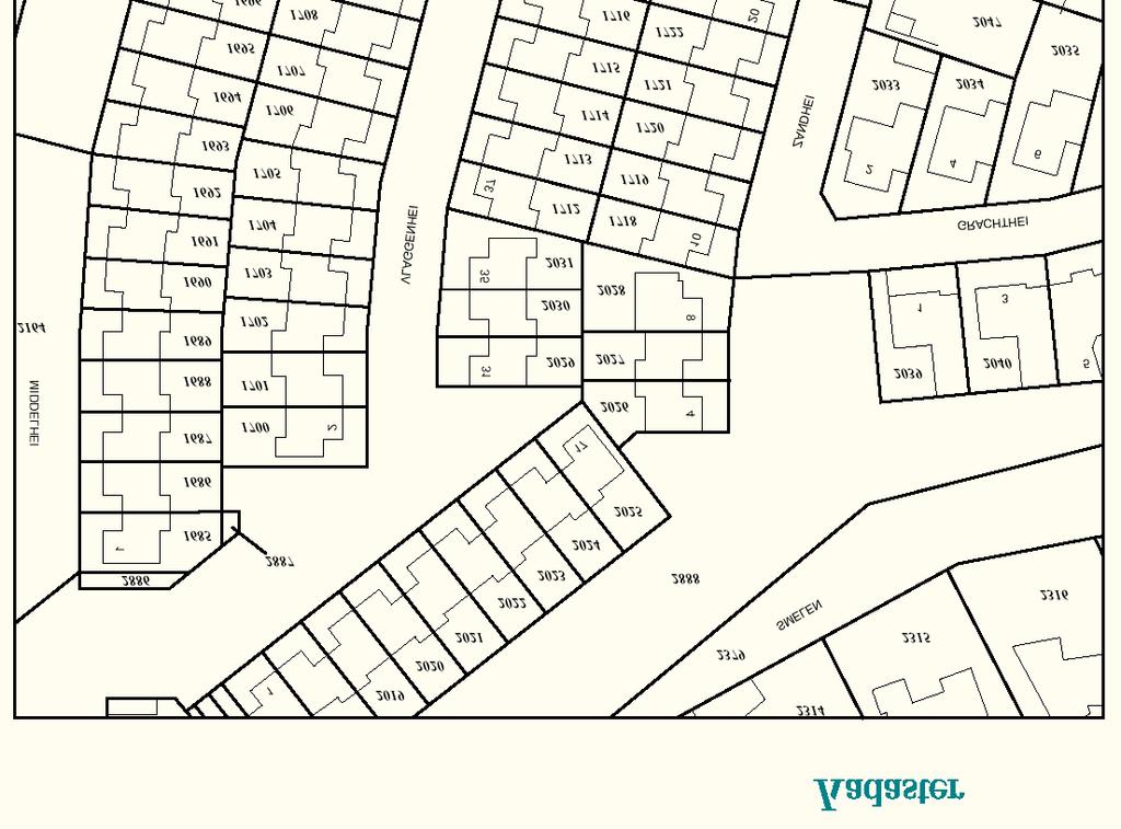
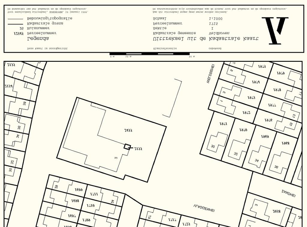
6 D. Cadastral Mapping Cadastral Map The cadastral maps reveal the national grid, cadastral boundaries, parcel-identifiers, street addresses, buildings, house numbers, and geodetic control points. Parcel related attributes can be visualised on the cadastral map. Altogether about 300 million co-ordinate pairs are represented in the spatial cadastral database. Cadastral parcel data are stored in one layer as described below, buildings are included in a separate layer. The spatial data are represented in the database using geometric data types such as point, line and box. In addition to the use of these data types, some important capabilities in the data model are storage of explicit topology and historic information. Furthermore, nation-wide unique identifiers have been introduced for all geographic objects, e.g. boundaries, topographic lines (buildings) and unified surveying and mapping attributes. The most important tables are boundary (cadastral boundaries), parcel (parcel identifiers), symbol (cartographic symbols), GCP (Geodetic Control Point), line (topographic lines) and text. The spatial extension of the objects in the tables boundary, parcel and line is indicated with a minimal bounding rectangle of type box. The box covers a boundary or a topographic line or a complete parcel. The box can be spatially indexed and is useful for efficient retrieval purposes based on rectangle selections. There is no need for the geometric data type polygon, because the area features are stored topologically in the parcel table and boundary table using the so-called CHAIN-method. The edges in boundary table contain references to other edges according to the winged edge structure, which are used to form the complete boundary chains. From this data structure polygons can be generated on demand. Currently, topology is only maintained for the cadastral data and is being introduced for the topographic data, based on demand. This approach allows calculations on correctness of topology after adjustment of the surveyed new boundaries to the cadastral data. Furthermore it opens the possibility to relate attributes to the boundaries between parcels, e.g. relation to the source documents of surveying, date of survey, names of persons locating the boundary, etc. If each parcel would be represented in the database by a closed polygon, it would be complicated to represent the basic object of cadastral surveying: one boundary between two neighbour parcels. Closed polygon representation would lead to double (or triple or even more) storage of all co-ordinates (except the territorial boundary), which complicates the data management in a substantial way. Closed polygon representation can result in the introduction of gaps and overlaps between parcels, which has no relation to reality. One more reason for the boundary based approach is in the classification of boundaries: the administrative cadastral and political subdivision in sections (cadastral zones), municipalities and provinces is possible by classifying boundaries as section-boundary, municipal-boundary, province-boundary or national boundary. A national boundary is by definition a province boundary and a municipal-boundary and a section-boundary and a parcel-boundary ; etc. Netherlands-9Jun2006.doc Page 6
7 shapes (polyline, point) : metric information topological view: node, edge (chain) and face references: - face to first edge - edge to edge - edge to face ll_line_id fl_line_id l_obj_id r_obj_id lr_line_id fr_line_id Fig. 1: Topology model in the spatial database of the Kadaster. The following attributes are included in the data model for all spatial features: object_id a nation-wide unique feature identifier for all objects represented in the database, classif classification code of the object, e.g. parcel boundary, parcel identifier, road (type), water, etc., location (of data type point) or shape is of data type line(50), a polyline up to 50 points, representing the cadastral boundaries, stored in a variable length way in the (object)/relational database, sel_code a selection code which indicates to which type(s) a geographic object belongs, e.g. cadastral data and/or large scale topographic data, source of data, which is a reference to the field documents and files from total stations, or to the id of the photogrammetric project for large scale topographic mapping, etc, quality which is the mode of data collection, e.g. terrestrial, photogrammetric and includes an accuracy code which denotes the deviation from the 'true' position, vis_code visibility code to classify less visible objects during photogrammetric data collection, e.g. because of trees, l_area official legal area, which is included in the official legal documents or deeds describing the transaction, in general this area is not equal to calculated area from the spatial cadastral boundary data; this attribute is introduced only for the parcel table. Example of a Cadastral Map ( see next page) Role of Cadastral Layer in SDI The cadastral map and the Large Scale Topo Base Map of the Netherlands (both country covering and digital) are fully co-ordinated. After a map-renovation process the cadastral map is fully reconciliated with the topo map at boundary level. The map series share building-data. Both maps (databases) are extensively used by governments, utility companies, and private companies for their own activities. Netherlands-9Jun2006.doc Page 7
8 Netherlands-9Jun2006.doc Page 8
9 The Large Scale Topo Map is produced and maintained by a consortium of the Agency and many utility companies, later added by municipalities and waterboards. As such both map series are a de facto standard for large scale map-use. Another development is the co-ordination between the cadastral map, the Large Scale Topo Map and the map series 1: of the Topographic Service Kadaster. Investigations are carried out to identify to which extent the three map series can share the updating activities. E. Reform Issues Cadastral Issues The main problem of the Agency is the ICT renewal of legacy systems that currently is going on in order to meet the current and future customer requirements on one hand, and to adopt modern ICT opportunities on the other hand. This is a complicated and expensive process, because the renewal should take place within a growing concern environment. Currently this process I well controlled. As a result all databases are centralised now, with decentralised information management, and excellent facilities for e-access. Especially for the easy internet-access, the Agency was awarded the European e-award Current Initiatives 1. Recording of all public encumbrances on land. There are about 80 of this kind of public rights to land, of which 20 are indeed recorded yet. Law is endorsed by the Parliament to impose recording of public encumbrances, issued by whatever body of government, either in the registers of the Agency or at the municipalities, per 1 January Law is endorsed in the Parliament pertaining to electronic submission of deeds. This opened the opportunity for the notary public to submit notarial deeds as a digital file per 1 September The concept is that notary public keeps a paper deed in his/her office as the authentic one, sends a certified true copy electronically to the Agency, which records the document in a digital work process. This allows for the creation of a single national digital public registers replacing the registers per regional office. 3. ICT renewal programme is currently running (-> 2010). This concerns reduction of complexity (of different platforms, databases and protocols), centralisation of databases and database management, integration of spatial databases (cadastral map and large scale topo map) and legal/administrative data) into one database for (on line) information supply purposes, full renewal of cadastral systems, digital public registers, electronic conveyancing and includes data cleaning (quality improvement, e.g. of subject names) etc. 4. As a result of the ICT renewal programme, the rationale for the existence of regional offices is getting less and less. Since September 2005 is it possible to lodge deeds electronically. Already the first months over 30,000 deeds were submitted through Internet. At the output side, in 2005 over 18 million information products were sold via Internet, almost 100%of all output. Unlike former times, clients and citizens do not need to visit the regional offices to do their business. This leads to a restructuring ('organisational development'). In the period the number of regional offices will be brought back from 16 to 8, and on the long run may be only 1. Also the organisational overhead will be reduced, as is the operational staff. Electronic deeds make electronic updating of register possible, the use of GPS allows 1 man-field parties, as we have 2-man parties now, etc. Staff will go back from 2200 to about 1500 in the next years. References Many relevant articles on < Netherlands-9Jun2006.doc Page 9
10 II. Questionnaire 1. Cadastral Principles Deed or title registration 1.1 Is your cadastral system based on deeds registration or on title registration? deeds registration title registration other: Registration of land ownership 1.2 By law, is registration of land ownership compulsory or optional? compulsory optional other: 1.3 If felt necessary, please, comment on the actual practice and the legal consequences. Approach for the establishment of the cadastral records 1.4 Are landowners required to register their properties systematically during the initial establishment of the cadastre or is registration sporadic, i.e. triggered only by specific actions (such as for example sale)? systematic sporadic both all properties are already registered other: Netherlands-9Jun2006.doc Page 10
11 2. Cadastral Statistics Population 2.1 What is the population of your country? (July 2002) 2.2 Please, estimate the population distribution between urban and rural areas. urban: 60 % rural: 40 % total: 100 % Number and distribution of land parcels 2.3 Please, estimate the approximate total number of the smallest uniquely identified land units, often called "land parcels" in your country, including urban and rural areas? The total number would include all freehold and state owned land, regardless of registered, non-registered or informal holding. 2.4 What is the approximate total number of registered strata or condominium units? This number would be in addition to the number of land parcels indicated in 2.3? in addition to 2.5 For URBAN areas, please, estimate the distribution between the smallest uniquely identified land units, often called "land parcels" (i) that are legally registered and surveyed, (ii) that are legally occupied but not registered or surveyed, and (iii) that are informally occupied without any legal title (this may include illegal occupation or squatting). If the estimation is too difficult or complex using land parcels, you may base your estimation alternatively on the number of people occupying these forms of land parcels. legally registered and surveyed: 100 % legally occupied, but not registered or surveyed: 0 % informally occupied without legal title: 0 % total: 100 % 2.6 For RURAL areas, please, estimate the distribution between the smallest uniquely identified land units, often called "land parcels" (i) that are legally registered and surveyed, (ii) that are legally occupied but not registered or surveyed, and (iii) that are informally occupied without any legal title (this may include illegal occupation or squatting). If the estimation is too difficult or complex using land parcels, you may base your estimation alternatively on the number of people occupying these forms of land parcels. legally registered and surveyed: 100 % legally occupied, but not registered or surveyed: 0 % informally occupied without legal title: 0 % total: 100 % Netherlands-9Jun2006.doc Page 11
12 Number of professionals Please estimate the total number of academic professionals that are active within the cadastral system and the proportion of the time that they actually commit for cadastral matters (as opposed to work outside of the cadastral system)? 2.7 Total number of professional land surveyors, such as licensed surveyors active within the cadastral system: Proportion of the time that these land surveyors commit for cadastral matters: 100% all at senior level 2.9 Total number of lawyers/solicitors or equivalent active within the cadastral system or land market: 6 registrars / 1800 notaries 2.10 Proportion of time that these lawyers/solicitors commit for cadastral matters or land market: 100% / 60% Remarks and Comments Please, identify the best aspect of this questionnaire? Please, suggest the area in the questionnaire that could be improved? Netherlands-9Jun2006.doc Page 12
Cadastral Template 2003
 PCGIAP-Working Group 3 "Cadastre" FIG-Commission 7 "Cadastre and Land Management" Cadastral Template 2003 The establishment of a cadastral template is one of the objectives of Working Group 3 "Cadastre"
ABSTRACT Land Administration System in Lithuania
 ABSTRACT Land Administration System in Lithuania 1. General introduction to the Lithuanian Land Administration System and State Enterprise Centre of Registers ( shortly SECR) Lithuania has established
BULGARIAN CADASTRE A GUARANTEE FOR THE OWNERSHIP RIGHTS IN IMMOVABLE PROPERTIES
 4 TH INTERNATIONAL CONFERENCE RECENT PROBLEMS IN GEODESY AND RELATED FIELDS WITH INTERNATIONAL IMPORTANCE February 28 - March 2, 2007, Inter Expo Centre, Sofia, Bulgaria BULGARIAN CADASTRE A GUARANTEE
Building Integrated Land Information Systems and Development of NSDI
 Stig JÖNSSON, Sweden Key words: Land administration, land information systems, property formation, spatial data infrastructure, Inspire, institutional cooperation SUMMARY Lantmäteriet the Swedish agency
REGISTRATION OF PROPERTIES IN STRATA
 REGISTRATION OF PROPERTIES IN STRATA REPORT ON THE WORKING SESSIONS INTRODUCTION A cadastre is usually, and in most countries, a parcel-based, and up-to-date land information system containing records
The Multipurpose Hungarian Unified Land Registry System
 The Multipurpose Hungarian Unified Land Registry System András Osskó FIG Working Week Integrating Generation Stockholm, Sweden 14-19 June 2008 Republic of Hungary is located in Central Europe Neighbouring
The Digital Cadastral Database and the Role of the Private Licensed Surveyors in Denmark
 IRISH INSTITUTE OF SURVEYORS, DUBLIN INSTITUTE OF TECHNOLOGY, 23 NOVEMBER 2005 PUBLISHED IN IIS NEWS, WINTHER 2006. The Digital Cadastral Database and the Role of the Private Licensed Surveyors in Denmark
Quality Improvement of the Real Estate Cadastre in Serbia
 , Serbia Key words: quality improvement, real estate information, quality assurance, Serbia SUMMARY The concept of cadastral modernization in the Republic of Serbia was defined in 1992, and it is being
Hungary is a landlocked, Central European country in the Carpathian Basin
 Brief Overview on Hungarian Land Administration MSc. György Domokos Hungarian Geodetic Surveying Liaison Group CLGE GA Hannover 12 13 October 2012 Hungary is a landlocked, Central European country in the
REFORM OF LAND CADASTRE IN LITHUANIA
 REFORM OF LAND CADASTRE IN LITHUANIA Romualdas KASPERAVICIUS, Lithuania Key words: ABSTRACT Main aim for every Government is to create legal, financial and organisational circumstances for real property.
Ownership Data in Cadastral Information System of Sofia (CIS Sofia) from the Available Cadastral Map
 from the Available Cadastral Map") Ownership Data in Cadastral Information System of Sofia (CIS Sofia) from the Available Cadastral Map Key words: ABSTRACT Lydmila LAZAROVA, Bulgaria CIS Sofia is created and maintained by GIS Sofia ltd,
Ownership Data in Cadastral Information System of Sofia (CIS Sofia) from the Available Cadastral Map Key words: ABSTRACT Lydmila LAZAROVA, Bulgaria CIS Sofia is created and maintained by GIS Sofia ltd,
Land Cadastre Act. Chapter 1. Passed RT I 1994, 74, 1324 Entry into force (except 3 which entered into force on 1.01.
 Issuer: Riigikogu Type: act In force from: 01.01.2011 In force until: 31.12.2014 Translation published: 24.10.2014 Passed 12.10.1994 RT I 1994, 74, 1324 Entry into force 08.11.1994 (except 3 which entered
Securing Land Rights for Broadband Land Acquisition for Utilities in Sweden
 Securing Land Rights for Broadband Land Acquisition for Utilities in Sweden Marija JURIC and Kristin LAND, Sweden Key words: broadband, land acquisition, cadastral procedure, Sweden SUMMARY The European
Republic of Bulgaria
 Geodesy, Cartography and Cadastre Agency Republic of Bulgaria www.cadastre.bg 24. 01. 2018 г., гр. София The Cadastre Legislation in Bulgaria - historical reference 1908 г. The Cadastre Act The objective
ELECTRONIC DEEDS REGISTRATION SYSTEMS BILL
 REPUBLIC OF SOUTH AFRICA ELECTRONIC DEEDS REGISTRATION SYSTEMS BILL (As introduced in the National Assembly (proposed section 75); explanatory summary of Bill published in Government Gazette No. 41308
PROBLEMS IN REGISTRATION IN THE THIRD VERTICAL DIMENSION IN THE UNIFIED LAND REGISTRY IN HUNGARY, AND POSSIBLE SOLUTION
 3D Cadastres Technical and Legal Aspects II PROBLEMS IN REGISTRATION IN THE THIRD VERTICAL DIMENSION IN THE UNIFIED LAND REGISTRY IN HUNGARY, AND POSSIBLE SOLUTION ANDRÁS Osskó Budapest Land Office Hungary
Creation Land Administration in Formal and Informal Environment. FIG Commission 7 Working Group 1
 Creation Land Administration in Formal and Informal Environment András OSSKÓ, Hungary Key words: land administration, informal land tenure, customary tenure, sustainable Development. SUMMARY FIG Commission
Land Reform Act. Passed RT 1991, 34, 426 Entry into force
 Issuer: Riigikogu Type: act In force from: 01.07.2015 In force until: 31.08.2015 Translation published: 17.06.2015 Amended by the following acts Passed 17.10.1991 RT 1991, 34, 426 Entry into force 01.11.1991
Land Administration Developments in Rwanda
 Land Administration Developments in Rwanda Eugène RURANGWA Expert Group Meeting on secure land tenure new legal frameworks and tools UN-Gigiri, Nairobi, 10-12 November, 2004 Contents Somme figures about
DIRECTORATE DEEDS REGISTRATION SUB-SECTOR PROGRAMME. Title security of tenure to real property. Description
 DIRECTORATE DEEDS REGISTRATION SUB-SECTOR PROGRAMME Title security of tenure to real property Description Throughout the world and from early times, countries have endeavoured to have a system of land
The Challenge to Implement International Cadastral Models Case Finland 1
 The Challenge to Implement International Cadastral Models Case Finland 1 Tarja MYLLYMÄKI and Tarja PYKÄLÄ, Finland Key words: cadastre, modelling, LADM, INSPIRE SUMMARY Efforts are currently made to develop
LAUNCH OF CADASTRAL TEMPLATE 2.0
 LAUNCH OF CADASTRAL TEMPLATE 2.0 Dr. Daniel Steudler Scientific Associate, swisstopo Prof. Abbas Rajabifard Director Centre for SDIs and Land Administration, Melbourne University FIG-Commission 7, Annual
Test and Implementation of DATR System in Hungary
 Test and Implementation of DATR System in Hungary, Hungary Key words: unified land registry, cadastral map, Hungary SUMMARY During the last years there has been an important development in the Hungarian
Incorporating Sustainable Development Objectives into ICT Enabled Land Administration Systems - Case Study Switzerland
 EXPERT GROUP MEETING ON INCORPORATING SUSTAINABLE DEVELOPMENT OBJECTIVES INTO ICT ENABLED LAND ADMINISTRATION SYSTEMS 9-11 November 2005, Centre for Spatial Data Infrastructures and Land Administration
Surveying in Austria. Congress Maanmittauspäivät Seinäjoki, 20 th March 2014
 Surveying in Austria Congress Maanmittauspäivät Seinäjoki, 20 th March 2014 Topics Facts, figures Organisational issues of surveying Role of the BEV Products, services The Cadastre Surveying Education
Geoinformation Technologies in Land Management and Beyond: Case of Georgia
 Geoinformation Technologies in Land Management and Beyond: Case of Georgia Joseph SALUKVADZE Professor, Department of Human Geography, Co-team Leader, Cadastre and Land Register Project, Co-financed by
Cadastre: definitions
 Introduction New vision towards a multipurpose cadastral system to support land management in Morocco Moha EL-AYACHI, El Hassane SEMLALI, Mohamed ETTARID, Driss TAHIRI, Institut Agronomique et Vétérinaire
Use of data in Ukraine for sustainable economic growth. Oleksandr Maliuk State Service of Ukraine for Geodesy, Cartography and Cadastre
 Use of data in Ukraine for sustainable economic growth Oleksandr Maliuk State Service of Ukraine for Geodesy, Cartography and Cadastre Kehl, 2017 Content of the presentation Ukraine & StateGeoCadastre:
The Development Strategy for Cadastre and Land Register in Finland
 1 2 The Development Strategy for and Land in Finland Arvo Kokkonen Ministry of Agriculture and Forestry Facts and figures of Finland - land area 304 530 km² - water area 33 615 km² - total area 338 195
Cadastre and Other Public Registers: Multipurpose Cadastre or Distributed Land Information System?
 Cadastre and Other Public Registers: Multipurpose Cadastre or Distributed Land Information System? Ivan PESL, Czech Republic Key words: Cadastre, Land Registry, Property, Taxes, Land Use, Territorial Planning,
The importance of changes in land surveyors education
 András OSSKÓ Key words: land administration, roles of land surveyors, extended education, lifelong learning SUMMARY It s a world wide experience, especially in developed countries that the interest in
Australia no longer down under - Official German Surveying and Mapping - Cooperation between the public and the private sector - The German Way
 Official German Surveying and Mapping - Cooperation between the public and the private sector - The German Way Australia no longer down under - Sydney, Australia, 11 16 April 2010 1 Australia no longer
Preprint.
 http://www.diva-portal.org Preprint This is the submitted version of a paper presented at 10th EC GI & GIS Workshop, ESDI State of the Art, Warsaw, Poland, 23-25 June 2004. Citation for the original published
A Geocoded Cadastral Fabric as a Precondition for a Sustainable Land Management System
 A Geocoded Fabric as a Precondition for a Sustainable Land Management System Gottfried KONECNY, Germany; J.P. LAUZON, Canada; Abdul Salam MOHAMMED, India Key words: SDI,, Parcel Boundaries, GPS-GNSS, Land
The Contribution of Forest Owners Associations for the Forest Cadastre Implementation. João Gaspar Ana Navarro Ferreira PORTUGAL
 The Contribution of Forest Owners Associations for the Forest Cadastre Implementation João Gaspar Ana Navarro Ferreira PORTUGAL Motivation Lack of forestry cadastre; Unify all FOAs databases with common
Cadastral Template. FIG-Commission 7 Annual Meeting, Verona, Italia, 12 Sept Daniel Steudler
 armasuisse Bundesamt für Landestopografie swisstopo Cadastral Template FIG-Commission 7 Annual Meeting, Verona, Italia, 12 Sept. 2008 Design Principles for the Template keep it simple in order to attract
Challenges for the multi purpose cadastre
 Jens RIECKEN, Markus SEIFERT, Germany Key words: Multi purpose cadastre, 3d-cadastre, land use, SDI, solar cadastre SUMMARY Over the past 30 years, with the progress of information technologies the development
Cadastre and Land Registration in Europe
 Annex A: Questionnaire 2007 for Information Resource Cadastre and Land Registration in Europe Introduction This questionnaire is based on the EuroGeographics vision document 'Cadastre and Land Registration
COMMISSION 7 CADASTRE AND LAND MANAGEMENT WORK PLAN
 Appendix to item 34.7 FIG Congress in Washington, 19-26 April 2002 COMMISSION 7 CADASTRE AND LAND MANAGEMENT WORK PLAN 2002 2006 1. Title Cadastre and Land Management 2. Terms of Reference Commission 7
Topographic Signs Important Context of 3D Cadastre
 STATE GEODETIC ADMINISTRATION Gruška 20,10 000 Zagreb, Croatia Delft University of Technology Faculty of Architecture and the Built Environment Department OTB GIS Technology Section Topographic Signs Important
On the Rights of Landowners to Compensation for Restrictions on Economic Activities in Specially Protected Nature Territories and Microreserves
 Disclaimer: The English language text below is provided by the Translation and Terminology Centre for information only; it confers no rights and imposes no obligations separate from those conferred or
PROJECT INFORMATION DOCUMENT (PID) APPRAISAL STAGE Report No.: PIDA Project Name. Region Country Sector(s) Theme(s)
 APPRAISAL STAGE Report No.: PIDA Project Name. Region Country Sector(s) Theme(s)") Public Disclosure Authorized Public Disclosure Authorized Public Disclosure Authorized Public Disclosure Authorized Project Name Region Country Sector(s) Theme(s) Lending Instrument Project ID Borrower(s)
Public Disclosure Authorized Public Disclosure Authorized Public Disclosure Authorized Public Disclosure Authorized Project Name Region Country Sector(s) Theme(s) Lending Instrument Project ID Borrower(s)
Cadastral Development in Norway and Need for Improvements
 Cadastral Development in Norway and Need for Improvements Leiv Bjarte MJØS, Norway Key words: Cadastre, Cadastral Surveying, Cadastral Development, Land Register, Land Registration, Boundary Disputes SUMMARY
South African Council for Town and Regional Planners
 TARIFF OF FEES South African Council for Town and Regional Planners PLEASE NOTE : THE TARIFF OF FEES WAS APPROVED BY THE COUNCIL CHAPTER 10 : TARIFF OF FEES 10.1 INTRODUCTION 10.1.1 General This tariff
Classification of Licensed Surveyors
 Classification of Licensed Surveyors Joseph FORRAI, Gili KIRSCHNER, Michael KLEBANOV and Rozet SHAKED, Israel Key words: Survey of Israel, licensed surveyor, classification, cadastre, mutation plan SUMMARY
From Parcel to Global Cadastre: Challenges and Issues of the Post-Reform Quebec Cadastre. Elisabetta Genovese, Francis Roy
 From Parcel to Global Cadastre: Challenges and Issues of the Post-Reform Quebec Cadastre Elisabetta Genovese, Francis Roy Department of Geomatic Sciences, Laval University, Québec, Canada elisabetta.genovese@scg.ulaval.ca
Establishment of a land market in Ukraine: current state and prospects
 Establishment of a land market in Ukraine: current state and prospects More than 25 years have passed since the adoption of the first resolution of the Verkhovna Rada On Land Reform. Despite such a long
Designing for transparency and participation in the Hellenic Cadastral Project
 Designing for transparency and participation in the Hellenic Cadastral Project Dr. Dimitris Rokos Director of Planning and Investments, Hellenic National Cadastre and Mapping Agency S.A. Table of Contents
TERMS OF REFERENCE FOR CONSULTANCY SERVICES TO PREPARE PROJECT DOCUMENT FOR CADASTRAL MAPPING IN THE GAMBIA
 Ministry of Lands and Regional Government United Nations Development Program UNDP April 2017 TERMS OF REFERENCE FOR CONSULTANCY SERVICES TO PREPARE PROJECT DOCUMENT FOR CADASTRAL MAPPING IN THE GAMBIA
Croatian SDI: a Tool for Accelerated Development of the Geo-Conscious Society
 STATE GEODETIC ADMINISTRATION Croatian SDI: a Tool for Accelerated Development of the Geo-Conscious Society Prof.Dr.Sc. Željko Bačić, Mr.Sc. Ljerka Rašić FIG Working Week 2009 - Surveyors Key Role in Accelerated
The Danish Digital Cadastral Map A Tool for Land Management
 The Danish Digital Cadastral Map A Tool for Land Management Søren CHRISTENSEN, Denmark Key words: Digital cadastre, restrictions pertaining to public law, land management. ABSTRACT The establishments of
The Multi Purpose Cadastre, a network approach
 The Multi Purpose Cadastre, a network approach Peter Laarakker, Kadaster NL 1 Content 1. Introduction 2. Multi purpose cadastre 3. Definitions 4. Cadastral boundaries 5. Real property right 6. Conclusions
CLGE Working for a Profession
 CLGE Working for a Profession 15. November 2017 Tallinn (ES) The public-private partnership in cadastre in Switzerland SWITZERLAND 41'290 km 2 8 million people 26 cantons ~2600 municipalities ~4.0 million
Ordinance on Official Cadastral Surveying
 English is not an official language of the Swiss Confederation. This translation is provided for information purposes only and has no legal force. Ordinance on Official Cadastral Surveying 211.432.2 of
Egyptian Nationwide Title Cadastre System
 Kholoud SAAD, Egypt Key words: Cadastre, Registration, Urban, Rural, National Cadastre, Automation, reengineering. SUMMARY With growing need for integrated information, Enterprise Solutions has become
Cadastre 2020 a Vision for a Future Cadastral System in Poland
 Cadastre 2020 a Vision for a Future Cadastral System in Poland Wojciech Wilkowski, Marcin Karabin, Poland Key words: model of cadastre, cadastral system, land register SUMMARY The paper presents results
Aspect of preliminary activities in the function of supporting NSDI
 Sonja DIMOVA, Republic of Macedonia Key words: e-governance, geospatial data, NSDI, INSPIRE, metadata SUMMARY The successful establishment of the NSDI in the true sense of the word cannot be performed
The New Technology of a Survey Data Model and Cadastral Fabric as the Foundation for a Future Land Administration System.
 The New Technology of a Survey Data Model and Cadastral Fabric as the Foundation for a Future Land Ian HARPER, Australia Key words: cadastral modelling, survey data model, Survey Accuracy, Cadastre 2014
ON IMMOVABLE PROPERTY REGISTRATION. Pursuant to Articles 78 and 83 paragraph 1 of the Constitution, on proposal by the Council of Ministers,
 DISCLAIMER Please note that the translation provided below is only provisional translation and therefore does NOT represent an official document of Republic of Albania. It confers no rights and imposes
LAND ADMINISTRATION IN CANADA HISTORICAL WISDOM AND MODERN CHALLENGES IN QUEBEC LAND ADMINISTRATION: FROM PAPER CADASTRAL MAPS TO ON-LINE SERVICES
 HISTORICAL WISDOM AND MODERN CHALLENGES IN QUEBEC LAND ADMINISTRATION: FROM PAPER CADASTRAL MAPS TO ON-LINE SERVICES Francis ROY P rof e s s or D é p. Sciences g é omatiques FIG Working Week Sofia, Bulgaria
(UNECE) John Manthorpel
 John Manthorpel") Lanc Registration and Land Valuation in the United Kingdom and in the countries of the United Nations Economic Commission for Europe (UNECE) John Manthorpel Introduction This paper is in two parts and
Lanc Registration and Land Valuation in the United Kingdom and in the countries of the United Nations Economic Commission for Europe (UNECE) John Manthorpel Introduction This paper is in two parts and
NOVEMBER 2017 PHASE II: PRIVATE LAND OWNERSHIP BY RACE, GENDER AND NATIONALITY
 NOVEMBER 2017 PHASE II: PRIVATE LAND OWNERSHIP BY RACE, GENDER AND NATIONALITY South Africa belongs to all who live in it, united in our diversity. Constitution of the Republic of South Africa Act, 1996
The Cadastral Template 2.0, From Design to Implementation
 Abbas RAJABIFARD (Australia), Daniel Steudler (Switzerland), Ali AIEN, and Mohsen KALANTARI, Australia Key words: Cadastral Template 2.0, Cadastral Template Project, Land Administration, PCGIAP SUMMARY
ASSESSMENT OF STATE AGENCIES WITH RESPONSIBILITIES FOR LANDS AND OTHER REAL PROPERTIES
 ASSESSMENT OF STATE AGENCIES WITH RESPONSIBILITIES FOR LANDS AND OTHER REAL PROPERTIES LAND ADMINISTRATION DIVISION MINISTRY OF AGRICULTURE, LAND AND MARINE RESOURCES Prepared for LAND USE POLICY AND ADMINISTRATION
LAND ADMINISTRATION DEVELOPMENTS IN RWANDA
 LAND ADMINISTRATION DEVELOPMENTS IN RWANDA, Rwanda Key words : Land tenure security, land registration, land rights, land commissions. SUMMARY : The new Rwandan land policy consider appropriate land administration
TERMS AND CONDITIONS OF PUBLIC ONLINE AUCTION
 TERMS AND CONDITIONS OF PUBLIC ONLINE AUCTION Pursuant to the State Assets Act and the Regulation no 14 of 28 April 2010 of the Minister of the Environment Procedure for the Grant of Use and Selling of
Progress Report on Green Paper. Dr. Paddy Prendergast. on behalf of the. IIS Commission on Land Registration
 Progress Report on Green Paper By Dr. Paddy Prendergast on behalf of the IIS Commission on Land Registration Paddy Prendergast - Chair Brendan Sweeny - Hempenstall Surveys Paul Corrigan - P Corrigan Associates
The Multi-Purpose Information System of Real Estates in the Czech Republic. Vladimíra ŽUFANOVÁ, Czech Republic
 The Multi-Purpose Information System of Real Estates in the Czech Republic Vladimíra ŽUFANOVÁ, Czech Republic Key words: Cadastre; Land management SUMMARY The Cadastre of Real Estate and Land administration,
Results of Central European Land Knowledge Center (CELK) Activities
 Activities") Results of Central European Land Knowledge Center (CELK) Activities András OSSKÓ, Hungary Key words :CELK Center, Property Rights and Land Market Development, Networking, direct knowledge transfer SUMMARY
Results of Central European Land Knowledge Center (CELK) Activities András OSSKÓ, Hungary Key words :CELK Center, Property Rights and Land Market Development, Networking, direct knowledge transfer SUMMARY
COUNTRY REPORT ON CADASTRE AND LAND REGISTRAION IN IRAN. By: Hamid Berenjkar, IRAN
 COUNTRY REPORT ON CADASTRE AND LAND REGISTRAION IN IRAN By: Hamid Berenjkar, IRAN Key words: Comprehensive Cadastre, Cadastre System, Cadastral Survey, Land Book, Iran ABSTRACT Land registration and cadastral
Opportunities for foreign buyers of Spanish real estate
 Opportunities for foreign buyers of Spanish real estate London, 2014/12/01 DIEGO DE LEÓN, 21 28006 MADRID STATISTICS Current situation: signs of stabilization Prices rose by 1,15% in the Q3 of 2014. Second
The Necessity for Interdisciplinary Cooperation as a Part of FIG Activity
 The Necessity for Interdisciplinary Cooperation as a Part of FIG Activity Joseph KRAUS, Joseph FORRAI, Israel Key words: interdisciplinary cooperation, surveyor s key role, surveyor s position SUMMARY
Annual Meeting 2006 SLOVENIA, BLED RASAS GOFMANAS JAUNIUS GRIGAS RIMANTAS RAMANAUSKAS KESTUTIS TRECIOKAS
 Annual Meeting 2006 SLOVENIA, BLED LAND ADMINISTRATION IN LITHUANIA RASAS GOFMANAS JAUNIUS GRIGAS RIMANTAS RAMANAUSKAS KESTUTIS TRECIOKAS ADMINISTRATIVE STRUCTURE OF LITHUANIA HISTORY OF LAND ADMINISTRATION
LAND REFORM IN MALAWI
 LAND REFORM IN MALAWI Presented at the Annual Meeting for FIG Commission 7 In Pretoria, South Africa, Held From 4 th 8 th November, 2002 by Daniel O. C. Gondwe 1.0 BACKGROUND Malawi is a landlocked country
Surveyors Qualifications
 Surveyors Qualifications Præludium Surveyors Qualifications Lars Jansson, Director Lantmäteriet Henning Elmstrøm, President DdL 1 Agenda 1. Introduction 2. Basic framework conditions for cadastral systems
Parcel Boundaries in the Czech Republic
 Parcel Boundaries in the Czech Republic CZECH REPUBLIC Jiri Rydval, Libor Tomandl Czech Office for Surveying, Mapping and Cadastre inhabitants - 10.3 million territory 78,865 km 2 2 Contents: 1. A parcel
INTERNATIONAL JOURNAL OF GEOMATICS AND GEOSCIENCES Volume 2, No 2, 2011
 INTERNATIONAL JOURNAL OF GEOMATICS AND GEOSCIENCES Volume 2, No 2, 2011 Copyright 2010 All rights reserved Integrated Publishing services Case study ISSN 0976 4380 Property formation-change in land related
SCOTTISH GOVERNMENT RESPONSE TO PRIVATE RENTED HOUSING (SCOTLAND) BILL STAGE 1 REPORT
 BILL STAGE 1 REPORT") SCOTTISH GOVERNMENT RESPONSE TO PRIVATE RENTED HOUSING (SCOTLAND) BILL STAGE 1 REPORT I am writing in response to the Local Government and Communities Committee s Stage 1 Report on the Private Rented Housing
SCOTTISH GOVERNMENT RESPONSE TO PRIVATE RENTED HOUSING (SCOTLAND) BILL STAGE 1 REPORT I am writing in response to the Local Government and Communities Committee s Stage 1 Report on the Private Rented Housing
FIRM ARTICLE ITALIAN LAW ON REAL ESTATE. Real estate matters are fundamentally regulated by the Civil Code.
 FIRM ARTICLE May 9, 2012 ITALIAN LAW ON REAL ESTATE 1.1 Laws governing real estate in Italy. Real estate matters are fundamentally regulated by the Civil Code. 2.1 Legal restrictions on ownership of real
e-land Administration in Hungary
 e-land Administration in Hungary Piroska Zalaba senior counsellor, project manager Ministry of Agriculture and Rural Development Department of Lands and Mapping FIG SEMINAR Innsbruck, 2-4 June 2004 Land
Cadastral Development - Introduction
 Cadastral Development - Introduction Erik Stubkjær Department of Development and Planning, Aalborg University, DK A Theoretical Base for Cadastral Development KTH, Stockholm, 2003 Overview 1. 2. 3. 4.
FIG/FAO International Seminar on State and Public Land Management
 FIG/FAO International Seminar on State and Public Land Management State Land Distribution for the Poor: State Land Identification, Mapping, Classification and Registration By Dr. Sareth Boramy Deputy General
Danish Multipurpose Cadastre Experiences so Far
 Danish Multipurpose Cadastre Experiences so Far Jørgen SKRUBBELTRANG, Denmark Key words: Multipurpose cadastre, restrictions pertaining to public law, new users, top down implementation, quality of the
UNECE Working Party on Land Administration. Report on the Activities Carried Out by the UNECE WPLA Since the Committee's 72nd Session
 UNECE Working Party on Land Administration Report on the Activities Carried Out by the UNECE WPLA Since the Committee's 72nd Session Damir Pahic, dipl.ing. UNECE WPLA Chair 73rd Session 25th September
ASSESSMENT OF CONSEQUENCES RESULTING FROM ABOLISHING THE OBSTACLES ON LAND TRANSACTIONS 1 SUMMARY
 ASSESSMENT OF CONSEQUENCES RESULTING FROM ABOLISHING THE OBSTACLES ON LAND TRANSACTIONS 1 SUMMARY I. Foreign practice in regulation of land market and the EU legal provisions Having analysed the existing
FIG-WB Forum on Land Administration and reform in Sub-Sahara Africa
 FIG-WB Forum on Land Administration and reform in Sub-Sahara Africa Chris Mnyanga Ministry of Lands UNITED REPUBLIC OF TANZANIA] FIG WORKING WEEK, Abuja, NIGERIA 2013-6-10 MAY 2013 Country at Glance UNITED
E-Government and E-Land Administration As an example: The Netherlands.
 E-Government and E-Land Administration As an example: The Netherlands. Paul VAN DER MOLEN and Martin WUBBE Key words: e-governance and e-land administration SUMMARY NO E-GOVERNMENT WITHOUT LAND INFORMATION
The Development of the Austrian Cadastre from Documentation to an Integrated Planning and Decision Support System
 The Development of the Austrian Cadastre from Documentation to an Integrated Planning and Decision Support System WPLA - Working Party on Land Administration 15-17 October 2014, Vienna, Austria Wernher
PCC Conference and Plenary Meeting "Data as a basis of the digital society March 2018, Sofia. Activity of the geodetic NGOs in Bulgaria
 PCC Conference and Plenary Meeting "Data as a basis of the digital society 13-15 March 2018, Sofia Activity of the geodetic NGOs in Bulgaria Union of Surveyors and Land Managers in Bulgaria Chamber of
How to implement a mandatory inspection in accordance with European directives: The example of certified workshops
 How to implement a mandatory inspection in accordance with European directives: The example of certified workshops Polvêche, V. GIP Pulves, 341 Montpellier, France DOI 10.5073/jka.2012.439.007 Introduction
HOUSING AND PROPERTY MARKET IN LITHUANIA CONTENTS
 HOUSING AND PROPERTY MARKET IN LITHUANIA Kęstutis Sabaliauskas, Director General State Enterprise Centre of Registers, Lithuania Kestutis.Sabaliauskas@registrucentras.lt CONTENTS Legal environment Real
New Developments in the Hellenic Cadastre
 New Developments in the Hellenic Cadastre Prof. M. Kavouras Vice-president Ktimatologio S.A. (Hellenic Cadastre) The Hellenic Cadastre Background The Hellenic National Cadastre Organizational and institutional
Integrating Electronic Platform (IPE) as a Basic Component of Cadastral System in Poland
 as a Basic Component of Cadastral System in Poland") Integrating Electronic Platform (IPE) as a Basic Component of Cadastral System in Poland Hans KNOOP, Germany and Wojciech WILKOWSKI, Poland Key words: cadastal system, cadastral objects, computerisation
Integrating Electronic Platform (IPE) as a Basic Component of Cadastral System in Poland Hans KNOOP, Germany and Wojciech WILKOWSKI, Poland Key words: cadastal system, cadastral objects, computerisation
Fiscal Cadastral Reform and the Implementation of CAMA in Cape Town: financing transformation
 Fiscal Cadastral Reform and the Implementation of CAMA in Cape Town: financing transformation Jennifer WHITTAL, South Africa Mike BARRY, Canada Policies and Innovations Expert Group Meeting on Secure Land
Improvement of Effectiveness Present Developments in Hungarian Land Administration
 Improvement of Effectiveness Present Developments in Hungarian Land Administration Gyula IVÁN and András OSSKÓ, Hungary Key words: Land Administration, Cadastre, Land Registry SUMMARY New Act on Surveying
SECTOR PUBLIC CADASTRES AND REGISTERS MARKET PARTICIPANTS
 E-SERVICES TO CITIZENS, GOVERNMENT AND BUSINESSES. LITHUANIA EXPERIENCE Arvydas Bagdonavičius State Enterprise Centre of Registers Arvydas.Bagdonavicius@registrucentras.lt REGISTERS AND IS MANAGED BY THE
Section I General Information
 General Information Table of Contents A. Introduction... I-2 1. Purpose... I-2 2. Scope... I-2 3. Maintenance... I-3 4. Units... I-3 B. Public Relations... I-3 1. General Public... I-3 2. Property Owners...
LAND REGISTRATION SYSTEM OF THE REPUBLIC OF CROATIA
 "On the last day of the Creation God desired to crown His work, and thus created Kornati Islands out of tears, stars and breath." (George Bernard Shaw) LAND REGISTRATION SYSTEM OF THE REPUBLIC OF CROATIA
Trinidad and Tobago Land Governance Assessment. Charisse Griffith-Charles
 Trinidad and Tobago Land Governance Assessment Charisse Griffith-Charles 2 Land Characteristics of Trinidad and Tobago Land Area 5,528 sq km. Internal waters 7,134 sq. km. Territorial sea 9,337 sq. km.
Reliability of the Italian cadastral system data quality and improvement prospects
 Reliability of the Italian cadastral system data quality and improvement prospects Eng. Franco MAGGIO (Central Director for Cadastral, Cartographic and Land Registration Services) Eng. Arturo ANGELINI