PLANNING COMMISSION REPORT Regular Agenda Public Hearing Item
|
|
|
- Osborn Hood
- 6 years ago
- Views:
Transcription
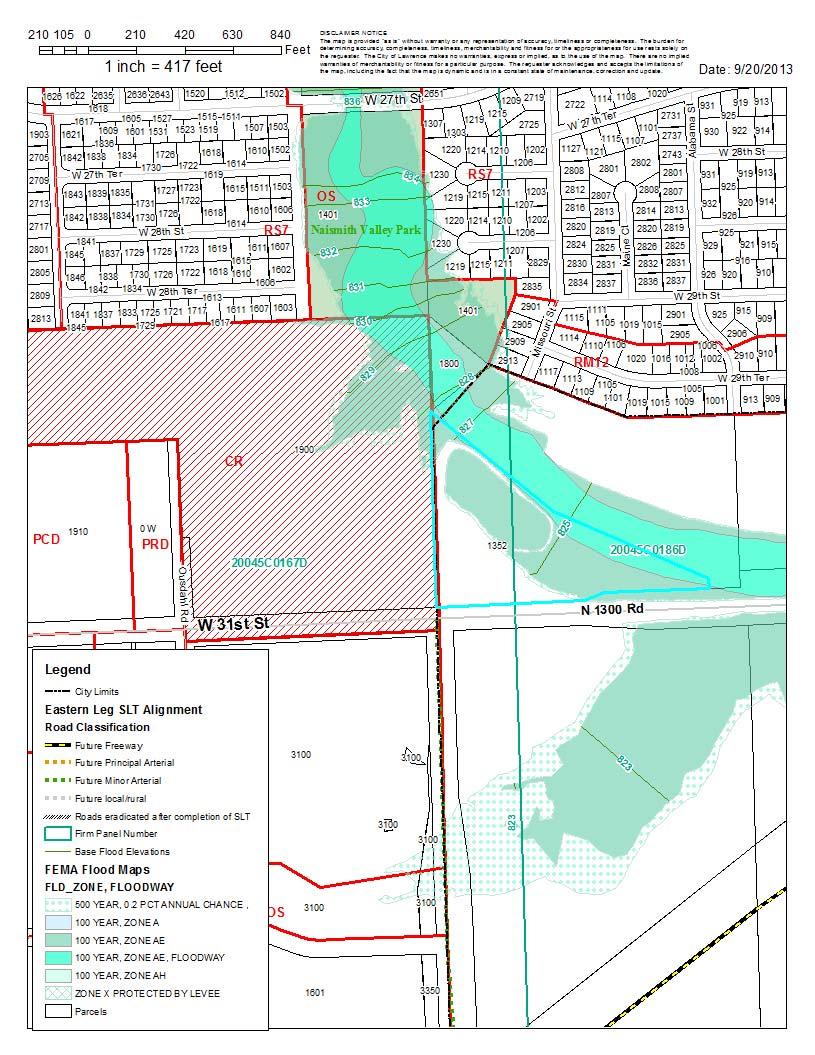
1 PC Staff Report 10/21/2013 Item No. 3B - 1 PC Staff Report 10/21/2013 ITEM NO. 3B: PLANNING COMMISSION REPORT Regular Agenda Public Hearing Item A TO CR- FP; 8.4 ACRES; 1900 W. 31 st STREET (SLD) : Consider a request to rezone approximately 8.4 acres from County A (Agricultural) District to CR (Regional Commercial) and FP (Flood Plain Overlay) District, located at 1352 N 1300 Rd. Submitted by Menard, Inc. for Bruce Snodgrass, property owner of record. STAFF RECOMMENDATION: Staff recommends approval of the rezoning request for approximately 8.45 acres from A (Agricultural) District to CR (Regional Commercial) District and FP (Floodplain Overlay) District and forwarding it to the City Commission with a recommendation for approval based on the findings of fact found in the body of the staff report subject to the following conditions: 1. Applicant shall provide a revised legal description of the property describing that portion of the property within the regulatory floodplain for inclusion in the ordinance for the CR-FP portion of the property and a legal description for the remainder of the property for inclusion of an ordinance for the CR portion of the property. 2. Uses shall be prohibited in this CR (Community Regional) District: a. Animal Services: Livestock Sales b. Eating and Drinking Establishments: Bar or Lounge c. Sexually Oriented Business: Sexually Oriented Theater d. Vehicle Sales and Service: Truck Stop, Heavy Equipment Repair, Inoperable Vehicles Storage; and e. Industrial Facilities: Laundry Service ATTACHMENTS A. Reason for Request B. Revised Southern Development Plan Map C. Table of Restricted Uses D. Floodplain Map E. Concept Plan F. CR ordinance 8870 including use restrictions for existing CR district. G. General Boundary of CR and CR-FP PROPERTY OWNER S REASON FOR REQUEST Development of a Menards store in Lawrence. Refer to attached letter. KEY POINTS This is a request to accommodate a Menards home improvement store, as well as additional commercial retail space, at the northeast corner of W. 31 st St. and Ousdahl Rd. Proposed request will extend commercial zoning east along W. 31 st Street. Request is consistent with land use recommendations for this area noted in the Revised Southern Development Plan. Property is encumbered by AE and AH special flood hazard zones. Therefore, the FP Overlay is required as part of the Zoning action for properties annexed into the City Limits after March 1, The FP is an Overlay District to the proposed base-zoning CR District.

2 PC Staff Report 10/21/2013 Item No. 3B - 2 The report focuses on the CR base-zoning district. Existing CR (area to the west of subject property) was approved with use restrictions. A copy of the ordinance is attached for reference. ASSOCIATED CASES/OTHER ACTION REQUIRED ASSOCIATED ITEMS BEING CONSIDERED AT THE OCTOBER PLANNING COMMISSION MEETING: A ; annexation of 8.4 acres ; A to CR-FP PP ; preliminary plat OTHER ACTION REQUIRED: City Commission approval of rezoning and adoption of ordinance. Publication of rezoning ordinance. OTHER ACTIONS REQUIRED PRIOR TO DEVELOPMENT Platting of the property through the Major Subdivision process. Site plan approved prior to release of building permits. Local Floodplain Development Permit approved prior to release of the site plan for issuance of a building permit. PLANS AND STUDIES REQUIRED See Preliminary Plat Staff Report for comment on related studies. PUBLIC COMMENT Letter from Dan Watkins on behalf of First National Development, Ltd. Response letter from Tyler Edwards on behalf of Menards. GENERAL INFORMATION: Request includes 8.4 acres 1.33 acres is existing floodway 3.09 acres is existing floodway fringe [CR-FP] 3.98 acres is developable area including 500-year floodplain area. [CR] Note: Staff estimated the acreage of the CR and CR-FP area using GIS. The applicant will be required to provide a more detailed legal description of each area. Project Summary
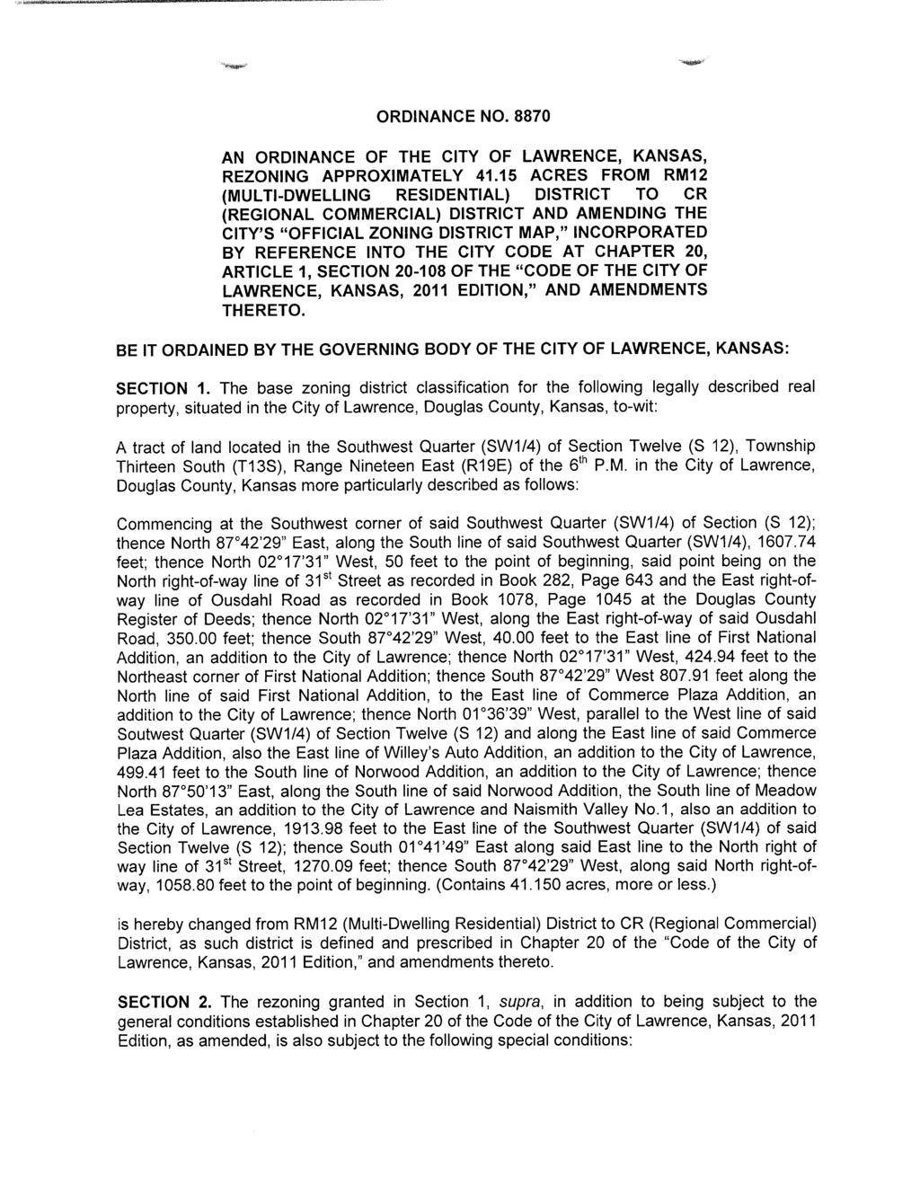
3 PC Staff Report 10/21/2013 Item No. 3B - 3 This property is located on the north side of 31 st Street. This application is an extension of the recent consideration of the adjacent property to the west Z (Ordinance No. 8870). The application for rezoning includes floodplain and therefore requires the FP overlay designation per section of the Land Development Code. This request extends the commercial development along 31 st Street to an eastern boundary terminating at Naismith Creek. This application was submitted concurrently with annexation and preliminary plat applications. The applicant has submitted a concept plan for the Menards store that identifies several commercial pad sites, including this property as a future commercial pad site. The preliminary plat identifies this property as Lot 2. A copy of the concept plan is attached to this report as a reference. An application for site plan approval for the Menards Lot was received on October 1, 2013 and is being processed. There is no specific site plan application for this property at this time. This property was discussed in detail with the previous rezoning application [Z ] as it pertained to the designation of commercial land use within the Revised Southern Development Plan and in the Planning Commission minutes from the May 2013 Meeting. The addition of the Floodplain Overlay District designation (-FP) applies to only that portion that is encumbered by the regulatory floodplain plus the area that includes 2 above the base flood elevation of the site. This property slopes from the northwest to the southeast. REVIEW & DECISION-MAKING CRITERIA 1. CONFORMANCE WITH THE COMPREHENSIVE PLAN Property Owner s Response: The property does conform with H2020 and is currently designated commercial in the comprehensive [plan]. We went through lengthy discussions with staff, elected officials, and appointed officials earlier this year regarding the property. The property also conforms with the Southern Development Plan s future designation of commercial. The City Commission approved an amendment to Horizon 2020, as part of the recent approval for CR zoning to the west, expanding commercial development along W. 31 st Street to include this area [CPA ]. This request is consistent with the previous land use decisions anticipating the incorporation of this property as part of the commercial development at Iowa and 31 st Street. The design standards ensure that a new regional commercial center is capable of development with a critical mass of uses including multiple big box buildings, parking, and other physical development considerations. S. Iowa (23 rd Street to K-10) is an existing commercial center. Map 6-1 of Horizon 2020 shows the existing and future commercial land use locations. Horizon 2020 notes commercial uses exist both east and west of S. Iowa along W. 31st Street. Horizon 2020 identifies commercial development goals in Chapter 6. Goals for established commercial areas include the retention, redevelopment and expansion of established commercial areas in the community. (Page 6-24)
4 PC Staff Report 10/21/2013 Item No. 3B - 4 Other comprehensive plan goals include appropriate land use transition between commercial and residential neighborhood areas. These goals are applicable to the north and east sides of the proposed request. Staff Finding The request for CR zoning in this location is consistent with recently approved changes to Horizon 2020 goals and policies and specific land use recommendations included in the Revised Southern Development Plan per CPA ZONING AND LAND USES OF NEARBY PROPERTY, INCLUDING OVERLAY ZONING Current Zoning and Land Use: A (County-Agricultural) and F-F (Floodway Fringe Overlay) Districts; existing residential use and pond. Surrounding Zoning and Land Use: To the north/northeast: OS (Open Space) City Zoning District and A (Agricultural) County Zoning District; Existing open space. To the west: CR (Regional Commercial) District; Planned Menards store; existing vacant land, former mobile home park. To the south: A (County-Agricultural) and F-F (Floodway Fringe Overlay) Districts; agriculture. Note: See A for additional detail. The predominate use of nearby property to the north of this property and the recently approved CR District to the west is open space and residential. The property immediately adjacent to the north and east of this property is currently owned by the Snodgrass family and is vacant. The area to the south, along the south side of 31 st Street, is existing agricultural land. This property is surrounded by a variety of both urban and rural zoning and land uses. The property to the north and east is included in several development plans including a future utility pump station, extension of the Naismith Park, and future residential development. The development pattern along the north side of the entire Snodgrass property, including this 8.4 acre parcel, is medium-density residential zoned RM12 (along W. 29 th Terrace). The property to the southwest is zoned RM15 and is developed with an apartment complex (The Connection). This property including the remaining parcels owned by the Snodgrass family represents an interface of urban and rural uses. The regulatory floodplain encumbers a portion of the property along the northeast side. This area is subject to the Floodplain Overlay District standards of the City of Lawrence upon annexation. Staff Finding The existing zoning and land use in this immediate area includes both city and county zoning and a significant area both north and south that is vacant or used for agricultural purposes. 3. CHARACTER OF THE AREA Property Owner s Response:


5 PC Staff Report 10/21/2013 Item No. 3B - 5 Today the neighborhood is very vacant. The 40 acres to the west is a vacant trailer park and the 40 acres to the east is vacant floodway. This floodway also exists north of the property. To the south is 31 st Street and there is vacant agricultural land south of that. This property and house is very isolated in its current location. The future character of the neighborhood is a little different. In spring of 2014, construction will begin on the new Menards store and development to the west. It is our goal that this lot is part of that commercial development. This property is located within the Indian Hills Neighborhood. The area to the west is part of the South Iowa Street Commercial Corridor. This property is isolated from the adjacent residential uses to the north because of the lack of pedestrian and vehicular connectivity. A drainage course along the north property line contributes to the disconnected street patterns in this part of the neighborhood. W. 31 st Street, a major arterial street, bounds the south part of the neighborhood. Expanding the definition of neighborhood to encompass the area bounded by Iowa Street to the west, Louisiana Street to the east, W. 31st Street to the south and 23 rd Street on the north, the property is located on the edge of a mixed-use neighborhood. Intensive uses are generally located along the arterial streets and low intensity uses are located interior to the larger neighborhood boundary. Recent land use approvals for the Menards project to the west expanded the commercial limits to include this specific parcel of land as the terminating commercial boundary along this segment of W. 31 st Street. Indian Hills Neighborhood Neighborhood Expanded Red outline highlights subject property Brown area denotes Indian Hills Neighborhood Blue outline highlights expanded neighborhood Red outline highlights subject property The Naismith Creek and the Bell Haven Tributary floodplain encumber the Indian Hills Neighborhood. This neighborhood is entirely within the city limits other than the existing acres known as the Snodgrass property. Property annexed after 2003 requires the FP Overlay zoning and therefore is applicable to this request.

6 PC Staff Report 10/21/2013 Item No. 3B - 6 The graphic above shows the boundary of the neighborhood area and the existing regulatory floodplain. The FP Overlay District will apply only to that area of the request that includes the boundary of the floodplain plus the 2 of freeboard above the base flood elevation as required in section (c) of the Development Code. Staff Finding The vicinity surrounding the subject property includes an established lowdensity traditional neighborhood within the central portion of the area. The area along Iowa Street between W. 23 rd Street and W. 31st Street, west of the subject property is an existing commercial area known as the S. Iowa Commercial Corridor. The area on the south side of W. 31 st Street is developing commercially west of Ousdahl Road and residentially east of Ousdahl Road. 4. PLANS FOR THE AREA OR NEIGHBORHOOD, AS REFLECTED IN ADOPTED AREA AND/OR SECTOR PLANS INCLUDING THE PROPERTY OR ADJOINING PROPERTY This property is included within the plan boundary of the Revised Southern Development Plan adopted in June 2013 anticipating commercial development of this property. This plan identifies the area located to the east of Ousdahl Road as suitable for commercial uses. The plan identifies existing floodplain areas as appropriate for open space and as a boundary to the commercial land use.


7 PC Staff Report 10/21/2013 Item No. 3B - 7 Revised Southern Development Plan Land Use Map Subject property Future commercial development identified in the Revised Southern Development Plan is located along the S. Iowa Street Corridor. An Auto-Related commercial area is identified south of K-10 Highway along the S. Iowa Street Corridor. Rezoning the subject property CR terminates the commercial node along W. 31 st Street in this area. The proposed FP Overlay reflects the existing floodplain encumbrance of this property as a recognized land use within the plan. The property owner donated land to the City of Lawrence that encompasses the floodplain. Additionally, the City has acquired property at the corner of Louisiana Street and W. 31 st Street for a future pump station. Land being dedicated to City as open space Land acquired by the City for pump station. These uses along with the proposed commercial use will implement the land use recommendations of the Revised Southern Development Plan.
8 PC Staff Report 10/21/2013 Item No. 3B - 8 Staff Finding The proposed commercial rezoning conforms with land use recommendations in the Revised Southern Development Plan. The recent land acquisitions by the City provide a boundary to the commercial development along the north side of W. 31 st Street. 5. SUITABILITY OF SUBJECT PROPERTY FOR THE USES TO WHICH IT HAS BEEN RESTRICTED UNDER THE EXISTING ZONING REGULATIONS Property Owner s Response: The property is suited just fine for a residential house as it has been for the past 30+ years. However, that is for the current property owners. In the future after the existing property owners move out the house will be situated next to a large commercial development. I have seen this situation occur many times and the end result is almost always the same. When the original owners move out, someone purchases the property and develops it into commercial space. Menards is bypassing that waiting period and including the property in our development plans for next year. Upon annexation, the existing A (Agricultural) County District designation will no longer be suitable for this property. This property is planned to be incorporated into the Menards commercial development to the west. Approval of the CR District is consistent with planned land use for this property. Since this property is encumbered by regulatory floodplain and it is being annexed after March 1, 2003, it is appropriate to zone the property as part of the Floodplain Overlay District. The boundary of the FP (Floodplain) Overlay District is established as the base flood elevation plus an area of 2 of freeboard. For reference, floodplain terms used in this report are defined in Article 12 of the Land Development Code. Attached to this report is a list of specific terms and definitions. Staff Finding Upon annexation, the existing County designation is no longer suitable. The property is suitable for the commercial zoning consistent with recent land use approvals relating to the Menards development request to the west and the recent changes to Horizon 2020 and the Revised Southern Development Plan discussed earlier in this report. The CR District is the base-zoning district. The portion of the property encumbered by the regulatory floodplain will be zoned with the CR base district and the FP Overlay District. 6. LENGTH OF TIME SUBJECT PROPERTY HAS REMAINED VACANT AS ZONED Property Owner s Response: The subject property is currently occupied by the Snodgrass family; however they have agreed to our deal terms and will be moving to a new location. This parcel is not vacant. This property developed with an existing residence, detached garage, and pond. The current driveway is located within the alignment of Michigan Street to be extended to accommodate access to this property and the commercial development to the west. This property is currently zoned A (Agricultural) District. It has been zoned A since Staff Finding This property is developed with an existing residence. The current zoning has been in place since 1966.

9 PC Staff Report 10/21/2013 Item No. 3B EXTENT TO WHICH REMOVAL OF RESTRICTIONS WILL DETRIMENTALLY AFFECT NEARBY PROPERTIES Property Owner s response: The rezoning would have no detrimental effects on the neighborhood or surrounding properties. The property to the west is designated CR for the Menards project. We are requesting that the CR designation be extended to this property. The property is currently zoned residential but it is alone in that designation as the surrounding properties are either commercial or floodway. The nearest residential property is over 200 feet away. The property owner, the Snodgrass family, is working with the City to convey the floodplain portion to the City as an extension of Naismith Park. The City has recently acquired a parcel along Louisiana Street for a City Utility project. The remaining portion of the land owned by the Snodgrass family is anticipated for future residential development adjacent to the lots along W. 29 th Terrace. Proposed Uses for Snodgrass property This commercial property is intended to be incorporated with the planned development to the west and is included as Lot 2 of the Menards Addition preliminary plat. Water line improvements are anticipated along the north side of W. 31 st Street. Other significant area improvements are related to the South Lawrence Trafficway and re-alignment of W. 31 st Street within this corridor. Significant changes are anticipated in the next several years for this area. Significant planning regarding land use expectations for this area were completed by KDOT for the traffic and highway circulation and the community in the Revised Southern Development Plan. Impacts on adjanct properties are mitigated through these planning efforts. Commercial zoning, with use restrictions, was recently approved to the west. These use restrictions should be applied to this request. This provides a uniform application of the zoning district for this property, intended to be incorporated in the Menards development project to the west. Staff Finding Approval of the request facilitates redevelopment of the site consistent with recently approved land use plans for this immediate area. Impacts to adjacent
10 PC Staff Report 10/21/2013 Item No. 3B - 10 residential uses to the north along 29 th Street are mitigated by dedication of land for open space. The new public open space will separate the residential and commercial uses. If approved, uses should be restricted in the zoning ordinance to mitigate incompatible land uses previously identified for the CR zoning to the west. 8. THE GAIN, IF ANY, TO THE PUBLIC HEALTH, SAFETY AND WELFARE DUE TO THE DENIAL OF THE APPLICATION, AS COMPARED TO THE HARDSHIP IMPOSED UPON THE LANDOWNER, IF ANY, AS A RESULT OF DENIAL OF THE APPLICATION Property Owner s Response: The largest gain to the public would be through the redevelopment of an aging residential property into a new first class retail location and the sales tax generation that is part of the future use. The public is also getting a connection to the Menards development off of Michigan Ave. Without this property, the access to the development would be much more restricted and potentially unsafe. There would be a hardship on the owner as they have agreed to the financial compensation for the property and will be building a new house at a different location that will suitetheir needs. Evaluation of these criteria includes weighing the benefits to the public versus the benefits of the owner of the subject property. Benefits are measured based on the anticipated impacts of the rezoning request on the public health, safety and welfare. Based on past land use actions including plan approval expanding commercial development to Naismith Creek, staff concurs with the applicant that the existing property is underutilized and should be appropriately rezoned to accommodate redevelopment. If the rezoning request were denied, the property could remain as a residence; however, upon annexation an applicable city-zoning district is needed. If the rezoning were approved, the uses allowed change from residential to commercial with a wide variety of commercial uses allowed. Limiting uses would serve to create a more compatible development with the adjacent low-density residential development to the north and provide consistency with the approved commercial uses to the west. Approval of the request will facilitate redevelopment and reinvestment in existing property. Denial of the request would prohibit the ability to redevelop the property as a commercial extension of the existing node at Iowa and W. 31st Street. Staff Finding Benefits to the community include the investment in property within existing utility, transportation and service corridors. Denial of the request prohibits the applicant from redeveloping the property as a commercial use. If approved, staff believes the zoning should be restricted with conditional zoning. PROFESSIONAL STAFF RECOMMENDATION The focus of this report is the specific land use request for CR zoning. This application was made with a concept plan for a specific end user for the property to the west. Negotiations regarding this property began during the review of the original CR request to the west. Other development pressures on the Snodgrass property included the planned utility pump station on the far eastern portion of the property and the planned improvements for the SLT and 31 st Street Corridor. These actions together with the revision to the Revised Southern Development
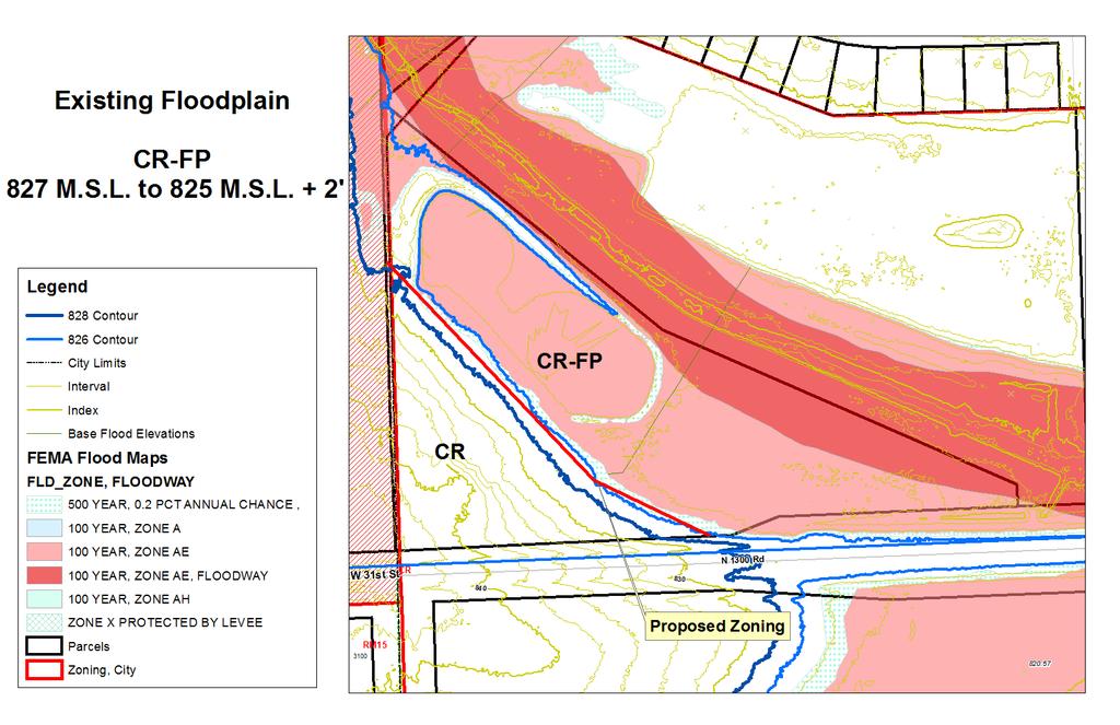
11 PC Staff Report 10/21/2013 Item No. 3B - 11 Plan resulted in a land use recommendation for the property west of Naismith Creek to be included in the commercial area along W. 31 st Street east of Iowa Street. This request is consistent with these recent land use actions. As discussed above a portion of this property is encumbered by the regulatory floodplain. The area being rezoned is slightly smaller than the parcel boundary that includes the residence. This difference in area between the parcel boundary and the proposed CR boundary is equal to the area that is within the floodway and is not part of this rezoning application. The floodway portion of the parcel is included in a dedication of land to the City for open space use. The FP designation will be applied to that part of the overall CR zoning request that includes regulatory floodplain (fringe area). Attached to this report is a map showing the general area to be zoned CR and CR-FP. The impact of this zoning designation is that: 1. A local floodplain development permit is required for development of the site. Such permit is typically submitted concurrently with a site plan or applicable development plan. 2. New development requires an approved Hydrologic and Hydraulic Study at the time of platting demonstrating there will be no rise in the Base Flood Elevation and no increase in the flood velocities at any point resulting from the proposed development. 3. Fill may not be placed in a setback. 4. Structural design of buildings and improvements must meet minimum flood proofing standards, including elevating 1 above the base flood elevation. 5. Exterior storage of material is required to be adequately flood proofed including being raised 1 above Base Flood Elevation. 6. Maximum impervious surface cover within the FP District is 60%. The applicant s engineer has provided a Hydrologic and Hydraulic Study. The City s Stormwater Engineer approved this study. This study anticipates development of both this property and the Menards site to the west. Staff recommends approval of the proposed CR with conditions limiting uses to those approved for the CR District to the west. CONCLUSION Upon annexation the existing County A (Agricultural), zoning designation is no longer appropriate or applicable. The request completes the expected delineation of the commercial node along 31 st Street east of Iowa Street.
12

13 Revised Southern Development Plan Page 21
14 PC Staff Report 10/23/13 Item No. 3B- 1 Attachment C Permitted Uses Recommended Uses Residential Retail Sales and Services (continued) Not permitted in the CR district with the exception of Group Homes approved with a Special Use Permit. Business Support Construction Sales and Service Food and Beverage Community Facilities Mixed Media College/University Personal Convenience Cultural Center/Library Personal Improvement Day Care Center Retail Sales, General (65,000 sq ft limit) Lodge, Fraternal and Civic Assembly Retail Establishment, Large Postal and Parcel Service Retail Establishment, specialty Public Safety Sexually Oriented Business [would not be allowed on Social Service Agency W. 31st Street] but is allowed in the CR District] Utility Minor (P or SUP) Utility Major (SUP) Medical Facilities Health Care Office/Clinic Outpatient Care Facility Recreational Facilities Active Recreation Entertainment and Spectator Sports (General and Limited) Participant Sports and Recreation (Indoor and Outdoor) Passive Recreation Nature Preserve / Undeveloped Private Recreation Religious Assembly Religious Institution (Community or Neighborhood) Animal Services Kennel Livestock Sales [Use not recommended] Sales and Grooming Veterinary Eating and Drinking Establishments Accessory Bar Bar or Lounge Brewpub Fast Order Food Fast Order Food with Drive-In Private Dining Establishments Quality Restaurant Offices Administrative and Professional Financial, Insurance and Real Estate Other Parking Accessory Commercial Retail Sales and Services Building Maintenance Business Equipment Sex Shop Sexually Oriented Theater Transient Accommodations Campground Hotel Motel, Extended Stay Vehicle Sales & Service Cleaning (car wash) Fleet Storage Gas and Fuel Sales Truck Stop [undesirable use in this location because of proximity to residential neighborhood] Heavy Equipment Repair - [undesirable use in this location because of proximity to residential neighborhood] Heavy Equipment Sales/ Rental Inoperable Vehicles Storage [undesirable use in this location because of proximity to residential neighborhood] Light Equipment Repair Light Equipment Sales/Rental RV and Boats Storage Industrial Facilities Laundry Service [undesirable use in this location because of proximity to residential neighborhood] Manufacturing and Production Ltd (SUP) Manufacturing and Production Tech Research Service Wholesale Storage and Distribution Heavy (SUP) Light Mini Warehouse Agriculture Agricultural Sales Crop Agriculture Communications Facilities Amateur and Receive Only (accessory) Communications Service Establishment Telecommunication Antennae (accessory) Telecommunication Tower (SUP) Satellite Dish (accessory) Recycling Large Collection Small Collection
15
16
17
18
19
20
21 Ousdahl Rd E 1400 Rd Alabama St Ousdahl Rd W 2 5th Ct W 26th St Arkansas St Bardith Ct Alabama St Belle Crest Dr Seabrook Pl Park Hill Ter Naismith Valley Park Belle Haven Dr W 27th St Knollbrook Ct Manor Ter Belle Haven Dr W 27th Pl Missouri St W 27th Ter Ousdahl Rd W 27th Ter W 28th Ct Alabama St W 28th St W 28th Pl W 28th St W 29th Ct Maine Ct W 28th Ter W 29th Pl Ridge Ct W 28th Ter Naismith Valley Park W 29th St Broken Arrow Park W 29th Ter Louisiana St W 31st St N 1300 Rd N 1293 Rd W 33rd St A : Annexation of approximately 8.4 acres : Rezone 8.4 acres from A District to CR-FP District Located at 1352 N 1300 Road Lawrence-Douglas County Planning Office October 2013 A µ
PLANNING COMMISSION REPORT Regular Agenda Public Hearing Item
 PC Staff Report 11/12/12 Item No. 2B- 1 PLANNING COMMISSION REPORT Regular Agenda Public Hearing Item ITEM NO. 2B: A TO GPI; 110 ACRES; E OF K-10 & N OF W 6 TH ST (MKM) : Consider a request to rezone approximately
PLANNING COMMISSION REPORT Regular Agenda - Public Hearing Item
 Z-15-00469 Item No. 6A- 1 PLANNING COMMISSION REPORT Regular Agenda - Public Hearing Item PC Staff Report 11/16/15 ITEM NO. 6A GPI, RM12, & RS40 TO RM12; 14.756 ACRES; 5200 & 5300 CLINTON PKWY (SLD) Z-15-00469:
PC Staff Report 11/18/2013 Z Item No. 1-1
 Z-13-00401 Item No. 1-1 PLANNING COMMISSION REPORT Regular Agenda - Public Hearing Item PC Staff Report 11/18/2013 ITEM NO. 1: Z-13-00401 IG (General Industrial) District TO CS (Strip Commercial) District;
PLANNING COMMISSION REPORT Regular Agenda Public Hearing Item CONDITIONAL USE PERMIT FOR VERIZON WIRELESS; 1287 E 1200 RD (SLD)
") PC Staff Report 9/26/2016 CUP-16-00312 Item No. 5-1 PC Staff Report 9/26/2016 ITEM NO. 5 PLANNING COMMISSION REPORT Regular Agenda Public Hearing Item CONDITIONAL USE PERMIT FOR VERIZON WIRELESS; 1287
PC Staff Report 9/26/2016 CUP-16-00312 Item No. 5-1 PC Staff Report 9/26/2016 ITEM NO. 5 PLANNING COMMISSION REPORT Regular Agenda Public Hearing Item CONDITIONAL USE PERMIT FOR VERIZON WIRELESS; 1287
PLANNING COMMISSION REPORT Regular Agenda Public Hearing Item
 PC Staff Report 6/20/16 Item No. 4-1 PLANNING COMMISSION REPORT Regular Agenda Public Hearing Item PC Staff Report 06/20/16 ITEM NO. 4: IG to CS 1.56 ACRES; 706 E 23 RD STREET (MKM) : Consider a request
Allow continued use of existing grass runway for personal use by landowner.
 CUP-13-00193 Item No. 4-1 PLANNING COMMISSION REPORT Regular Agenda PC Staff Report 7/22/13 ITEM NO. 4: CONDITIONAL USE PERMIT; PRIVATE LANDING STRIP; 2215 N 500 (MKM) CUP-13-00193: Consider a Conditional
PLANNING COMMISSION REPORT Regular Agenda - Public Hearing Item
 Z-11-25-09; Z-11-26-09; Z-11-28-09 Item No. 2-1 PC Staff Report 3/28/11 PLANNING COMMISSION REPORT Regular Agenda - Public Hearing Item ITEM NO. 2A RM32 TO MU;.19 ACRES; 1340 TENNESSEE ST (MJL) Z-1-1-11:
PLANNING COMMISSION REPORT Regular Agenda - Public Hearing Item
 Z-14-00056 Item No. 1-1 PLANNING COMMISSION REPORT Regular Agenda - Public Hearing Item PC Staff Report 4/21/2014 ITEM NO. 1: RSO TO CN1;.126 ACRES; 512 & 514 LOCUST ST (DRG) Z-14-00056: Consider a request
PLANNING COMMISSION REPORT Regular Agenda Public Hearing Item
 PC Staff Report 2/22/16 Z-15-00640 Item No. 1-1 PLANNING COMMISSION REPORT Regular Agenda Public Hearing Item PC Staff Report 2/22/16 ITEM NO. 1 Villa 26 Apartments Rezoning from (Commercial Strip) to
PLANNING COMMISSION REPORT Regular Agenda Public Hearing Item
 CUP-15-00474 Item No. 5-1 PC Staff Report 11/16/15 ITEM NO. 5 PLANNING COMMISSION REPORT Regular Agenda Public Hearing Item CONDITIONAL USE PERMIT FOR PUBLIC WHOLESALE WATER SUPPLY DISTRICT NO. 25; E 1300
PLANNING COMMISSION REPORT Regular Agenda Public Hearing Item PRD TO RM15; ACRES; 2101 EXCHANGE CT (KES)
") PC Staff Report 7/22/15 Z-14-00515 Item No. 3-1 PLANNING COMMISSION REPORT Regular Agenda Public Hearing Item PC Staff Report 7/22/15 ITEM NO. 3 PRD TO RM15; 9.818 ACRES; 2101 EXCHANGE CT (KES) Z-14-00515:
PC Staff Report 7/22/15 Z-14-00515 Item No. 3-1 PLANNING COMMISSION REPORT Regular Agenda Public Hearing Item PC Staff Report 7/22/15 ITEM NO. 3 PRD TO RM15; 9.818 ACRES; 2101 EXCHANGE CT (KES) Z-14-00515:
PLANNING COMMISSION REPORT Regular Agenda - Public Hearing Item
 Z-12-29, 30, 32, 33, 34, 35, 36-11 to Item No. 5A 5G- 1 PLANNING COMMISSION REPORT Regular Agenda - Public Hearing Item PC Staff Report 02/27/2012 ITEM NO. 5A-5G Z-12-29, 30, 32, 33, 34, 35, 36-11 from
PLANNING COMMISSION REPORT Regular Agenda Public Hearing Item
 PC Staff Report 06/22/2015 Item No. 3A - 1 PC Staff Report 6/22/2015 ITEM NO. 3A: PLANNING COMMISSION REPORT Regular Agenda Public Hearing Item RSO TO CN2; 10 ACRES; 4300 W 24 th Place (SLD) : Consider
PLANNING COMMISSION REPORT Regular Agenda -Public Hearing Item
 PDP-13-00518 Item No. 3B- 1 PLANNING COMMISSION REPORT Regular Agenda -Public Hearing Item PC Staff Report 2/24/14 ITEM NO. 3B PRELIMINARY DEVELOPMENT PLAN FOR HERE @ KANSAS; 1101 INDIANA ST (SLD) PDP-13-00518:
PLANNING COMMISSION REPORT Regular Agenda Public Hearing Item
 PC Staff Report 06/21/10 Item No. 4-1 PLANNING COMMISSION REPORT Regular Agenda Public Hearing Item ITEM NO. 4: PD-[TANGER PCD-1] TO CS; 1025 N. 3 rd STREET (SLD) : Consider a request to rezone approximately
PLANNING COMMISSION REPORT Regular Agenda Public Hearing Item. IG TO IL;.972 ACRES; 1021 E 31st (KES)
") PC Staff Report 11/16/15 Z-15-00471 Item No. 7-1 PLANNING COMMISSION REPORT Regular Agenda Public Hearing Item PC Staff Report 11/16/15 ITEM NO. 7 IG TO IL;.972 ACRES; 1021 E 31st (KES) Z-15-00471: Consider
PC Staff Report 11/16/15 Z-15-00471 Item No. 7-1 PLANNING COMMISSION REPORT Regular Agenda Public Hearing Item PC Staff Report 11/16/15 ITEM NO. 7 IG TO IL;.972 ACRES; 1021 E 31st (KES) Z-15-00471: Consider
PLANNING & DEVELOPMENT
 PLANNING & DEVELOPMENT STAFF REPORT Rezoning PETITION: APPLICANT: PROPERTY OWNER: TYPE OF REQUEST: SIZE OF TRACT: LOCATION: (#17-22) Rezone from A-PUD (Agri-Business Planned Unit Development) to A-PUD
Appendix A: Guide to Zoning Categories Prince George's County, Maryland
 Appendix A: Guide to Zoning Categories Prince George's County, Maryland RESIDENTIAL ZONES 1 Updated November 2010 R-O-S: Reserved Open Space - Provides for permanent maintenance of certain areas of land
PLANNING COMMISSION REPORT REGULAR AGENDA. PC Staff Report 08/25/10 ITEM NO 6: PRELIMINARY PLAT; HALLMARK ADDITION; ACRES; 151 MCDONALD DR (MKM)
") PP-6-6-10 Item No. 6-1 PLANNING COMMISSION REPORT REGULAR AGENDA PC Staff Report 08/25/10 ITEM NO 6: PRELIMINARY PLAT; HALLMARK ADDITION; 5.252 ACRES; 151 MCDONALD DR (MKM) PP-6-6-10: Consider a Preliminary
PP-6-6-10 Item No. 6-1 PLANNING COMMISSION REPORT REGULAR AGENDA PC Staff Report 08/25/10 ITEM NO 6: PRELIMINARY PLAT; HALLMARK ADDITION; 5.252 ACRES; 151 MCDONALD DR (MKM) PP-6-6-10: Consider a Preliminary
Prince Edward County Zoning Ordinance. Effective October 1, 2007
 Prince Edward County Zoning Ordinance Effective October 1, 2007 ARTICLE I GENERAL PROVISIONS...6 SEC. 1-100 TITLE AND AUTHORITY...6 SEC. 1-102 JURISDICTION...6 SEC. 1-104 PURPOSE...6 SEC. 1-106 EFFECTIVE
Farming & Livestock related activities Y Y Y Y Y Y. Commercial Type Animal Facility Y Y Y
 ( = Permitted) TABLE A PERMITTED USES B DISTRICT MU MU2 CC MH/ RV Agricultural Uses (Light) Agricultural Uses (Heavy) Residential Uses Recreational and Institutional Uses RM R C LI MI HI A Farming & Livestock
CHAPTER 50 LAND USE ZONES ARTICLE 50 BASIC PROVISIONS
 CHAPTER 50 LAND USE ZONES ARTICLE 50 BASIC PROVISIONS 50.010 - PURPOSE The purposes of this chapter are to establish land use zones required to implement the goals and policies of the Klamath County Comprehensive
RE: 6. GILL/GREEN COMPREHENSIVE PLAN AMENDMENT, REZONING AND PRELIMINARY PLAT
 commission memo DATE: Thursday - August 9, 2018 TO: Marion Planning & Zoning Commission FROM: David N. Hockett, AICP Principal Planner RE: 6. GILL/GREEN COMPREHENSIVE PLAN AMENDMENT, REZONING AND PRELIMINARY
PLANNING COMMISSION REPORT REGULAR AGENDA
 PP-4-4-11 Item No. 9-1 PLANNING COMMISSION REPORT REGULAR AGENDA PC Staff Report 06/22/11 ITEM NO 9: PRELIMINARY PLAT; KASOLD WATER TOWER ADDITION; SE OF TAM O SHANTER & KASOLD DR (MKM) PP-4-4-11: Consider
Planning Department Oconee County, Georgia
 Planning Department Oconee County, Georgia STAFF REPORT REZONE CASE #: 6985 DATE: October 31, 2016 STAFF REPORT BY: Andrew C. Stern, Planner APPLICANT NAME: Williams & Associates, Land Planners PC PROPERTY
PROPOSED AMENDMENTS TO THE DERBY ZONING REGULATIONS AUGUST 12, 2008
 ARTICLE II Definitions and word usage 195-7. Definitions and word usage. Modify the following: HOUSING FOR THE ELDERLY OLDER PERSONS Housing in accordance with and as defined in the United States Fair
THE CITY OF RAYMORE, MISSOURI Single-Family Residential Zoning Districts
 THE CITY OF RAYMORE, MISSOURI Single-Family Residential Zoning Districts REGULATIONS COMMON TO ALL DISTRICTS: Uses permitted in each district include detached single-family dwellings, manufactured homes
COMMERCIAL ZONING DISTRICTS (Amended 11/13/14) Part I. C-1 Restricted Commercial District
 Part I. C-1 Restricted Commercial District") ARTICLE XI. COMMERCIAL ZONING DISTRICTS (Amended 11/13/14) Part I. C-1 Restricted Commercial District Section 152: Purpose This district is designed to accommodate commercial uses which act as a transition
ARTICLE XI. COMMERCIAL ZONING DISTRICTS (Amended 11/13/14) Part I. C-1 Restricted Commercial District Section 152: Purpose This district is designed to accommodate commercial uses which act as a transition
ARTICLE 9 C-B - COMMERCIAL-BUSINESS DISTRICT
 Section 901. PURPOSE ARTICLE 9 C-B - COMMERCIAL-BUSINESS DISTRICT The Commercial-Business (C-B) District is established to provide development opportunities for mixed use business and highway oriented
Subchapter 5 Zoning Districts and Limitations
 Subchapter 5 Zoning Districts and Limitations 35.5.1 Rural Districts Sections: 35.5.1.1 Purpose. 35.5.1.2 Permitted Uses. 35.5.1.3 General Regulations. 35.5.1.1 Purpose. The purpose of a Rural District
Planning & Zoning Commission
 Planning & Zoning Commission Planning & Development Department August 14, 01 Zoning Map Amendment MAP-1-0001 (Bay View Section 4) Request Rezone approximately 1.19 acres from OS (Open Space) to RSF- (Residential
Staff Report: Date: Applicant: Property Identification: Acreage of Request: Current Zoning of Requested Area: Requested Action: Attached:
 Staff Report: Completed by Jeff Palmer Director of Planning & Zoning Date: November 7, 2018, Updated November 20, 2018 Applicant: Greg Smith, Oberer Land Developer agent for Ronald Montgomery ET AL Property
INDIAN RIVER COUNTY, FLORIDA. The Honorable Members of the Planning and Zoning Commission DEPARTMENT HEAD CONCURRENCE
 Public Hearing Legislative INDIAN RIVER COUNTY, FLORIDA M E M O R A N D U M TO: The Honorable Members of the Planning and Zoning Commission DEPARTMENT HEAD CONCURRENCE Robert M. Keating, AICP; Community
United States Post Office and Multi-Family Residential; and, Single- Family Residence with an Apartment
 Planning Commission File No.: AME2013 0009 January 9, 2014 Page 2 of 9 Existing Land Use: United States Post Office and Multi-Family Residential; and, Single- Family Residence with an Apartment Surrounding
Chapter 100 Planned Unit Development in Corvallis Urban Fringe
 100.100 Scope and Purpose. Chapter 100 Planned Unit Development in Corvallis Urban Fringe (1) All applications for land divisions in the Urban Residential (UR) and Flood Plain Agriculture (FPA) zones within
410 Land Use Trends Comprehensive Plan Section 410
 411 410 Comprehensive Plan Section 410 In order to plan future land use, we must know how the land is used today. This section includes the following: Definition of analyzed land-use categories Summary
WESTMINSTER PARK SUBDIVISION
 WESTMINSTER PARK SUBDIVISION Engineering Comments: FINAL PLAT COMMENTS (should be addressed prior to submitting the FINAL PLAT for review and/or signature by the City Engineer): A. Provide all of the required
HENDRY COUNTY PLANNING & ZONING DEPARTMENT POST OFFICE BOX S. MAIN STREET LABELLE, FLORIDA (863) FAX: (863)
 FAX: (863)") HENDRY COUNTY PLANNING & ZONING DEPARTMENT POST OFFICE BOX 2340 640 S. MAIN STREET LABELLE, FLORIDA 33975 (863) 675-5240 FAX: (863) 674-4194 STAFF REPORT CPA19-0001 Comprehensive Plan Map Amendment Local
HENDRY COUNTY PLANNING & ZONING DEPARTMENT POST OFFICE BOX 2340 640 S. MAIN STREET LABELLE, FLORIDA 33975 (863) 675-5240 FAX: (863) 674-4194 STAFF REPORT CPA19-0001 Comprehensive Plan Map Amendment Local
CHAPTER COMMERCIAL ZONING DISTRICTS
 CHAPTER 27.10 - COMMERCIAL ZONING DISTRICTS 27.10.010 - Purpose of Chapter This Chapter lists the land uses that may be allowed within the commercial zoning districts established by Section 27.04.020 (Zoning
Implementation. Approved Master Plan and SMA for Henson Creek-South Potomac 103
 Implementation Approved Master Plan and SMA for Henson Creek-South Potomac 103 104 Approved Master Plan and SMA for Henson Creek-South Potomac Sectional Map Amendment The land use recommendations in the
CITY OF BONITA SPRINGS ZONING ORDINANCE NO
 CITY OF BONITA SPRINGS ZONING ORDINANCE NO. 04-16 A ZONING ORDINANCE OF THE CITY OF BONITA SPRINGS, FLORIDA; APPROVING A REQUEST BY CUSSON S CPD TO REZONE FROM AGRICULTURE (AG-2) AND COMMERCIAL PLANNED
Glades County Staff Report and Recommendation REZONING
 Glades County Staff Report and Recommendation REZONING CASE NUMBER: RZ15-01 DATE: October 2, 2015 CASE TYPE: Application for Rezoning REQUEST: J.J. Wiggins Memorial Trust is requesting a rezoning of 22.1±
8Land Use. The Land Use Plan consists of the following elements:
 8Land Use 1. Introduction The Land Use Plan consists of the following elements: 1. Introduction 2. Existing Conditions 3. Opportunities for Redevelopment 4. Land Use Projections 5. Future Land Use Policies
Report to the Plan Commission December 19, 2011
 Report to the Plan Commission Legistar I.D. #24825, Extraterritorial Certified Survey Map Requested Action: Consideration of a two-lot Certified Survey Map (CSM) of the Keryluk-Wee property located at,,
PUD Zoning Framework
 PUD Zoning Framework PUD Zoning Framework Purpose Development Review Process Site Plan Review Process Planned Unit Developments (PUD) are tools for dealing with special situations or accomplishing certain
Memorandum City of Lawrence Planning Department
 Memorandum City of Lawrence Planning Department TO: FROM: CC: Lawrence Douglas County Planning Commission Sandra Day, AICP, Planning Staff Applicant Date: January 14, 2013 RE: Item No. 3: Langston Heights
Board of County Commissioners Agenda Request
 Board of County Commissioners Agenda Request Date of Meeting: March 26, 2019 Date Submitted: March 19, 2019 To: From: Agenda Location: Subject: Honorable Chairman and Members of the Board Margaret Emblidge,
Planning Department Oconee County, Georgia STAFF REPORT
 Planning Department Oconee County, Georgia STAFF REPORT REZONE CASE #: 7332 DATE: November 28, 2017 STAFF REPORT BY: Gabriel Quintas, Planner APPLICANT NAME: Smith Planning Group PROPERTY OWNER: John Hadden
STAFF REPORT. Permit Number: Lee. Kitsap County Board of Commissioners; Kitsap County Planning Commission
 STAFF REPORT Permit Number: 15 00689 Lee DATE: March 2, 2016 TO: FROM: Kitsap County Board of Commissioners; Kitsap County Planning Commission Katrina Knutson, AICP, Senior Planner, DCD and Jeff Arango,
City of Valdosta Land Development Regulations
 Chapter 206 Section 206-1 Base Zoning Districts Standards for Uses, Structures, and Property Development (B) (C) Principal Uses and Structures. Principal uses and structures permitted in each base zoning
Staff Report: Date: Applicant: Property Identification: Acreage of Request: Current Zoning of Requested Area: Requested Action: Attached:
 Staff Report: Completed by Jeff Palmer Director of Planning & Zoning Date: November 7, 2018 Applicant: Greg Smith, Oberer Land Developer agent for Ronald Montgomery ET AL Property Identification: Frontage
To ensure a smooth transition from the County to City jurisdiction for planning and development regulation
 City of Grande Prairie Municipal Development Plan and Land Use Bylaw Concept for transitioning Short Term Annexation Area lands into the City s policy framework and land use development control regime.
Mohave County General Plan
 63 64 65 66 67 68 69 70 71 The Land Use Diagram is not the County's zoning map. 13 It is a guide to future land use patterns. Zoning and area plan designations may be more restrictive than the land use
O-I (Office-Institutional) and AG-1(Agricultural)
 and AG-1(Agricultural)") PROPERTY INFORMATION ADDRESS 3503 and 3505 Bethany Bend DISTRICT, LAND LOTS 2/1 973 and 974 OVERLAY DISTRICT State Route 9 PETITION NUMBERS EXISTING ZONING O-I (Office-Institutional) and AG-1(Agricultural)
PROPERTY INFORMATION ADDRESS 3503 and 3505 Bethany Bend DISTRICT, LAND LOTS 2/1 973 and 974 OVERLAY DISTRICT State Route 9 PETITION NUMBERS EXISTING ZONING O-I (Office-Institutional) and AG-1(Agricultural)
ARTICLE 6. GREER ZONES
 ARTICLE 6. GREER ZONES Section 601. Definitions and application of Greer Zones A. In this Article, unless otherwise specified: GA-2 means Greer Agricultural Zone GR-1 means Greer Residential Zone GC means
RAE EXCLUSIVE RESIDENTIAL ZONE A residential district exclusively for low density single family housing and accessory uses.
 KNOX COUNTY ZONING ORDINANCE DISTRICT SUMMARY REQUIREMENTS 2/11/2009 RAE EXCLUSIVE RESIDENTIAL ZONE A residential district exclusively for low density single family housing and accessory uses. 10,000 sq.
ARTICLE 15 - PLANNED UNIT DEVELOPMENT
 Section 15.1 - Intent. ARTICLE 15 - PLANNED UNIT DEVELOPMENT A PUD, or Planned Unit Development, is not a District per se, but rather a set of standards that may be applied to a development type. The Planned
COUNCIL ACTION FORM. 1. The City Council can approve the Preliminary Plat for Menards Ames Subdivision
 ITEM #: 49 DATE: 03-27-18 COUNCIL ACTION FORM SUBJECT: PRELIMINARY PLAT FOR MENARDS BACKGROUND: Menards Ames Subdivision is a proposed 41-acre development on SE 16 th Street just west of the Skunk River.
CHAPTER COMMERCIAL AND INDUSTRIAL ZONING DISTRICTS
 Commercial and Industrial Zoning Districts 106.26.010 CHAPTER 106.26 - COMMERCIAL AND INDUSTRIAL ZONING DISTRICTS COMMERCIAL AND INDUSTRIAL ZONING DISTRICTS Sections: 106.26.010 - Purpose 106.26.020 -
Memorandum City of Lawrence Planning & Development Services
 Memorandum City of Lawrence Planning & Development Services TO: City Commission FROM: Planning Staff Date: July 11, 2017 RE: Industrial District Review Attachments: 1. Existing Industrial Zoning Map 2.
Conditional Use Permit case no. CU 14-06: Bristol Village Partners, LLC
 PLANNING AND ZONING COMMISSION STAFF REPORT August 7, 2014 Conditional Use Permit case no. CU 14-06: Bristol Village Partners, LLC CASE DESCRIPTION: LOCATION: LEGAL DESCRIPTION: EXISTING LAND USE: ZONING:
SUBDIVISION, PLANNED UNIT DEVELOPMENT, ZONING AMENDMENT, & SIDEWALK WAIVER STAFF REPORT Date: July 19, 2018
 SUBDIVISION, PLANNED UNIT DEVELOPMENT, ZONING AMENDMENT, & SIDEWALK WAIVER STAFF REPORT Date: July 19, 2018 NAME SUBDIVISION NAME LOCATION West Mobile Properties, LLC U.S. Machine Subdivision 556, 566,
PALM BEACH COUNTY PLANNING, ZONING AND BUILDING DEPARTMENT ZONING DIVISION
 PALM BEACH COUNTY PLANNING, ZONING AND BUILDING DEPARTMENT ZONING DIVISION Application No.: Z/CA-2013-00493 Application Name: Trails Charter School Control No.: 2013-00085 Applicant: MG3 ALF Military LLC
Glades County Staff Report and Recommendation Unified Staff Report for Small Scale Plan Amendment and Rezoning
 Glades County Staff Report and Recommendation Unified Staff Report for Small Scale Plan Amendment and Rezoning CASE NUMBERS: COMP17-02 and RZ17-02 DATE of STAFF REPORT: May 1, 2017 CASE TYPE: Application
PLANNING COMMISSION REPORT Regular Agenda Public Hearing Item. PC Staff Report 12/14/15 A (County) TO RS10; 3 ACRES; 1041 N 1700 Road (KES)
 TO RS10; 3 ACRES; 1041 N 1700 Road (KES)") PC Staff Report 12/14/15 Z-15-00524 Item No. 3-1 PLNNING COMMISSION REPORT Regular genda Public Hearing Item PC Staff Report 12/14/15 ITEM NO. 3 (County) TO RS10; 3 CRES; 1041 N 1700 Road (KES) Z-15-00524:
PC Staff Report 12/14/15 Z-15-00524 Item No. 3-1 PLNNING COMMISSION REPORT Regular genda Public Hearing Item PC Staff Report 12/14/15 ITEM NO. 3 (County) TO RS10; 3 CRES; 1041 N 1700 Road (KES) Z-15-00524:
Chapter CC COMMUNITY COMMERCIAL ZONES REGULATIONS
 Effective April 14, 2011 Chapter 17.35 CC COMMUNITY COMMERCIAL ZONES REGULATIONS SECTIONS: 17.35.010 Title, Intent, and Description 17.35.020 Required Design Review Process 17.35.030 Permitted and Conditionally
Draft Model Access Management Overlay Ordinance
 Draft Model Access Management Overlay Ordinance This model was developed using the City of Hutchinson and the Trunk Highway 7 corridor. The basic provisions of this model may be adopted by any jurisdiction
13 Sectional Map Amendment
 13 Sectional Map Amendment Introduction This chapter reviews land use and zoning policies and practices in Prince George s County and presents the proposed zoning in the sectional map amendment (SMA) to
PLANNING DIVISION COMMUNITY & ECONOMIC DEVELOPMENT. To: Salt Lake City Planning Commission. PLNPCM John Glenn Road Zoning Map Amendments
 Staff Report PLANNING DIVISION COMMUNITY & ECONOMIC DEVELOPMENT To: Salt Lake City Planning Commission From: John Anderson, 801-535-7214, john.anderson@slcgov.com Date: March 22, 2017 Re: PLNPCM2017-00063
DIVISION 1 PURPOSE OF DISTRICTS
 ARTICLE 2 ZONING DISTRICTS AND MAP DIVISION 1 PURPOSE OF DISTRICTS Section 2.101 Zoning Districts. For the purpose of this Ordinance, the City of Richmond is hereby divided into districts as follows: DISTRICT
Planning Justification Report
 Planning Justification Report Kellogg s Lands City of London E&E McLaughlin Ltd. June 14, 2017 Zelinka Priamo Ltd. Page i TABLE OF CONTENTS Page No. 1.0 2.0 2.1 2.2 3.0 4.0 5.0 5.1 5.2 5.3 5.4 5.5 5.6
RESIDENTIAL DISTRICTS
 RESIDENTIAL DISTRICTS RESIDENTIAL DISTRICTS The residential district standards have been revised to reflect on-the-ground development conditions, while continuing to respect the use patterns established
East Cesar Chavez, Austin TX 78702
 2714-2730 East Cesar Chavez, Austin TX 78702 Size:.3880 acres= 16,901 sf Price: $125/sf = $2,112,625 Zoning: CS-CO-MU-NP Buyer s Agent Fee= 2% Food Trailer Income As Well: Provided Upon Request Materials
PLANNED UNIT DEVELOPMENT & SUBDIVISION STAFF REPORT Date: April 18, 2019
 PLANNED UNIT DEVELOPMENT & SUBDIVISION STAFF REPORT Date: April 18, 2019 DEVELOPMENT NAME SUBDIVISION NAME Springhill Village Subdivision Springhill Village Subdivision LOCATION 4350, 4354, 4356, 4358,
GC General Commercial District
 Section 712. GC General Commercial District 712.1 Intent of District. It is the intent of this section that the GC Zoning District be developed and reserved for general business purposes. The regulations
PALM BEACH COUNTY PLANNING, ZONING AND BUILDING DEPARTMENT ZONING DIVISION ZONING COMMISSION VARIANCE STAFF REPORT 06/05/2014
 PALM BEACH COUNTY PLANNING, ZONING AND BUILDING DEPARTMENT ZONING DIVISION ZONING COMMISSION VARIANCE STAFF REPORT 06/05/2014 APPLICATION NO. ZV-2013-03120 CODE SECTION REQUIRED PROPOSED VARIANCE (V1)
STAFF REPORT. Permit Number: Porter. Kitsap County Board of Commissioners; Kitsap County Planning Commission
 STAFF REPORT Permit Number: 15 00461 Porter DATE: November 9, 2015 TO: FROM: Kitsap County Board of Commissioners; Kitsap County Planning Commission Katrina Knutson, AICP, Senior Planner, DCD and Jeff
MEMORANDUM. DATE: November 9, 2016 PC Agenda Item 3.B. Planning Commission Chair Thompson and Commissioners
 MEMORANDUM DATE: November 9, 2016 PC Agenda Item 3.B TO: FROM: SUBJECT: Planning Commission Chair Thompson and Commissioners Matthew Bachler, Senior Planner Planning Case #16-028 Public Hearing Required
AGENDA ITEM SUMMARY GLADES COUNTY BOARD OF COUNTY COMMISSIONERS
 AGENDA ITEM SUMMARY GLADES COUNTY BOARD OF COUNTY COMMISSIONERS SUBJECT: Case Number COMP17-01, Legend Moto LLC This is a Legislative Hearing. DEPARTMENT REQUEST: The Community Development Department requests
ARTICLE 3: Zone Districts
 ARTICLE 3: Zone Districts... 3-1 17.3.1: General...3-1 17.3.1.1: Purpose and Intent... 3-1 17.3.2: Districts and Maps...3-1 17.3.2.1: Applicability... 3-1 17.3.2.2: Creation of Districts... 3-1 17.3.2.3:
AGENDA PLANNING COMMISSION Tuesday, April 18, :00 PM City Council Chambers 125 East Avenue B, Hutchinson, Kansas
 AGENDA PLANNING COMMISSION Tuesday, April 18, 2017 5:00 PM City Council Chambers 125 East Avenue B, Hutchinson, Kansas 1. ROLL CALL Macklin Woleslagel Bisbee (Chair) Hamilton Peirce Vacant Carr Hornbeck
Midwest City, Oklahoma Zoning Ordinance
 2010 Midwest City, Oklahoma Zoning Ordinance 9/2/2010 Table of Contents Section 1. General Provisions... 5 1.1. Citation... 5 1.2. Authority... 5 1.3. Purpose... 5 1.4. Nature and Application... 5 1.5.
Sec Tier 2 principal uses and structures. The principal uses of land and structures allowed in Tier 2 are provided below subject to the
 Sec. 27-730.4.9. Tier 2 principal uses and structures. The principal uses of land and structures allowed in Tier 2 are provided below subject to the standards and limitations contained within this division.
Division 8 General Urban (T4) Zone: Assessment Criteria and Assessment Tables
 Zone: Assessment Criteria and Assessment Tables") Division 8 General Urban (T4) Zone: Assessment Criteria and Assessment Tables 15.8.1 General Urban (T4) Zone The provisions in this division relate to the General Urban (T4) Zone as follows overall outcomes
Division 8 General Urban (T4) Zone: Assessment Criteria and Assessment Tables 15.8.1 General Urban (T4) Zone The provisions in this division relate to the General Urban (T4) Zone as follows overall outcomes
This is a conditional use permit request to establish a commercial wind energy conversion system.
 Public Works 600 Scott Boulevard South Hutchinson, Kansas 67505 620-694-2976 Road & Bridge Planning & Zoning Noxious Weed Utilities Date: March 28, 2019 To: From: Reno County Planning Commission Russ Ewy,
REZONING GUIDE. Zone Map Amendment (Rezoning) - Application. Rezoning Application Page 1 of 3. Return completed form to
 - Application. Rezoning Application Page 1 of 3. Return completed form to") COMMUNITY PLANNING & DEVELOPMENT REZONING GUIDE Rezoning Application Page 1 of 3 Zone Map Amendment (Rezoning) - Application PROPERTY OWNER INFORMATION* PROPERTY OWNER(S) REPRESENTATIVE** CHECK IF POINT
COMMUNITY PLANNING & DEVELOPMENT REZONING GUIDE Rezoning Application Page 1 of 3 Zone Map Amendment (Rezoning) - Application PROPERTY OWNER INFORMATION* PROPERTY OWNER(S) REPRESENTATIVE** CHECK IF POINT
CITY OF SARATOGA SPRINGS ZONING ORDINANCE TABLE 1: 2.0 BASE ZONING DISTRICTS
 2.0 BASE S 2.1 INTENT To fulfill the intent and purpose of this Chapter, the following tables identify zoning districts and district intents (Table 1), districts use schedule (Table 2), and districts area
REQUEST STAFF RECOMMENDATION. On April 26, 2012, Signature Books Inc., represented by Dave Richards, submitted petitions for the following amendments:
 PLANNING COMMISSION STAFF REPORT Signature Books Zoning Map Amendment and an Amendment to the North Temple Area Plan Petitions PLNPCM2012-00254 PLNPCM2012-00255 July 11, 2012 Planning Division Department
Legal Description Part of the Western Half of the Eastern Half of the Northwest Quarter of Section 30, Le Ray Township
 Owner and Applicant s 20448 State Highway 83 Mankato, MN 56001 Request and Location Request for review and approval of a Conditional Use Permit to allow an Elder Care Residential Unit to be constructed
4 LAND USE 4.1 OBJECTIVES
 4 LAND USE The Land Use Element of the Specific Plan establishes objectives, policies, and standards for the distribution, location and extent of land uses to be permitted in the Central Larkspur Specific
Tuss and Lisa Taylor. Agriculture
 ZONE CHANGE STAFF REPORT CCPC City-County Planning Commission warrenpc.org (270) 842-1953 1141 State Street Bowling Green, KY 42101 DOCKET/CASE/APPLICATION NUMBER 2018-29-Z-CO PUBLIC HEARING DATE July
ARTICLE Encourage well planned, efficient development.
 ARTICLE 14.00 PD PLANNED SECTIONS: 14.01 Intent 14.02 Procedure 14.03 Initial Development Plan 14.04 Final Development Plan 14.05 Amendments 14.06 Planned Development Districts PD-1 Willow Run PD PD-2
STAFF REPORT. Community Development Director PO Box 4755 Beaverton, OR 97076
 STAFF REPORT HEARING DATE: July 7, 2010 TO: Planning Commission STAFF: Jana Fox, Assistant Planner PROPOSAL: Southeast Beaverton Office Commercial Zoning Map Amendment (ZMA2010-0006) LOCATION: The subject
Site Selection and Acquisition
 Site Selection and Acquisition School site selection and acquisition involve a diligent team effort by District staff, appropriate facility planning individuals and real property professionals in cooperation
ARTICLE C. ZONING TEXT, DISTRICT CLASSIFICATIONS AND BOUNDARIES
 ARTICLE C. ZONING TEXT, DISTRICT CLASSIFICATIONS AND BOUNDARIES Sec. 10-2054. ZONING TEXT, DISTRICT CLASSIFICATIONS AND BOUNDARIES. In order to regulate the location of structures, the height and bulk
LAND USE AND ZONING OVERVIEW
 OVERVIEW OF PLANNING POLICIES LAND USE AND ZONING OVERVIEW The Minneapolis Plan for Sustainable Growth and Other Adopted Plans Community Planning and Economic Development Development Services Division
ORDINANCE NO. 15,060
 ORDINANCE NO. 15,060 AN ORDINANCE to amend the Municipal Code of the City of Des Moines, Iowa, 2000, adopted by Ordinance No. 13,827, passed June 5, 2000, as heretofore amended, is hereby amended by adding
SITE PLAN REVIEW ADMINISTRATIVE REVIEW. Please Note: Once submitted to the County, all application materials become a matter of public record.
 200 W. Oak Street, 3rd Floor Fort Collins, CO 80521 (970) 498-7683 / larimer.org/planning SITE PLAN REVIEW ADMINISTRATIVE REVIEW The submittal requirements listed in this packet are intended to collect
Chapter RESIDENTIAL ZONING DISTRICTS
 Chapter 18.16 RESIDENTIAL ZONING DISTRICTS Sections: 18.16.010 Purpose of Chapter 18.16.020 Purpose of Residential Zoning Districts 18.16.030 Regulations for Residential Zoning Districts 18.16.040 Residential
Marion County Board of County Commissioners
 Marion County Board of County Commissioners Date: 12/2/2015 P&Z: 11/30/2015 BCC: 12/16/2015 Item Number 151210SU Type of Application Special Use Permit Request To establish a Clay Electric Co-Operative