Sound Transit Capitol Hill Station TOD Sites Baseline Report
|
|
|
- Scott Dawson
- 6 years ago
- Views:
Transcription

1 Sound Transit Capitol Hill Station TOD Sites Baseline Report December 2008
2
3 CAPITOL HILL STATION TOD SITES BASELINE REPORT TABLE OF CONTENTS 1. EXECUTIVE SUMMARY BACKGROUND SOUND TRANSIT BUSINESS & PROJECT OBJECTIVES STATION PHYSICAL, OPERATIONS AND MAINTENANCE CONSIDERATIONS TOD SITE CONSTRAINTS AND OPPORTUNITIES TOD SITE ISSUES A. Green Building B. Parking Alternatives C. Nagle Extension BEVAA ISSUES A. Best Practices B. Parking: Critical Need and Opportunity C. Station Location/Entrances to Create Quality Retail D. Encourage Development of Affordable Housing at the Station Site NEXT STEPS APPENDICES Appendix 1 Capitol Hill Station Context Appendix 2 Capitol Hill TOD Work Program Schedule ( ) Appendix 3 TOD Site Programmatic Constraints & Opportunities Appendix 4 TOD Best Practices Appendix 5 Green Building Appendix 6 Business District Parking Appendix 7 TOD Retail Uses Appendix 8 Affordable Housing Appendix 9 Capitol Hill Station TOD Community Involvement Process Appendix 10 Technical Research and TOD Charrette Participants... 46
4 1. EXECUTIVE SUMMARY The Capitol Hill community has long anticipated the arrival of light rail, and has actively planned accordingly. Adopted neighborhood and station area plans provide explicit issue identification and guidance, followed more recently by the City of Seattle and Capitol Hill Chamber of Commerce-sponsored Broadway Economic Vitality Action Agenda (BEVAA), issued in June BEVAA addresses specific station design and integration issues, several of which influenced final station design, and all of which contribute to the current TOD planning and its further discussion, analysis and eventual outcomes. The community s preceding work provides context, orientation and priorities for a variety of participants and stakeholders who will coalesce around the redevelopment vision of the four Capitol Hill Station TOD sites (see site map on following page). Also contributing to the context and vision are Sound Transit s station program and operational requirements, its TOD business and project objectives, and the response of the commercial real estate community. A Capitol Hill TOD work program has been developed to carefully consider the opportunities and constraints at work for the four commercial real estate parcels to be redeveloped following construction of the Capitol Hill Light Rail Station. This report summarizes the work completed to date and is intended to help inform and facilitate future discussion around these TOD issues. TOD Work Program The purpose of Sound Transit s Capitol Hill TOD work program is to carefully consider the opportunities and constraints at work for the four commercial real estate parcels to be redeveloped following construction of the Capitol Hill Light Rail Station. Three phases of work program (see Appendix 2) will take place prior to the issuance of Requests for Qualifications/Proposals in The first phase, as represented in this report, focused on the following elements individually and as they interrelate at the TOD sites: 1) Sound Transit business and project objectives, 2) The station s physical and operational requirements, 3) TOD site constraints and opportunities, 4) TOD site issues (including Nagle Extension, developer alternative parking options, green building) 5) The Broadway Economic Vitality Action Agenda issues addressing the TOD sites (including business district parking, retail uses, urban design and affordable housing). Technical Analysis and Internal Charrette Technical memoranda were prepared on the above elements with topics ranging from the Chamber s Action Agenda to architectural, engineering, and urban design prerequisites that must be understood to make the most of the TOD redevelopment opportunities. The memos identified the extent of givens and choices, considering the significant internal and external interest that exists in the future redevelopment. Fact-based information was developed to the greatest extent possible, as much to inform as to define probable outcomes. 1
5 2
6 An internal charrette review process involving Sound Transit staff and consultants helped to clarify technical issues and approaches for the four sites. The technical memos also provided a better understanding of several issues that require further work to identify conflicts and compatibilities between the station, the sites and the immediate station area. Technical information was then refined or revised based on discussions at the charrette and included in this report. Conclusions The technical analysis and charrette conclusions provide the context for beginning discussions with City staff and the Capitol Hill Chamber and community about future Capitol Hill Station TOD site development. Those discussions are the next phase of the TOD process, leading to a potential third work phase that allows time for desired changes to City policies, if needed. Some of the key technical discussions and associated conclusions resulting from the charette process include the following: Confirmation of Business Objectives: Creating business and project objectives for each surplus property transaction is part of Sound Transit s process of evaluating how best to meet agency real property and TOD policy guidance. The objectives range from how Sound Transit selects, negotiates and awards development agreements to guidelines and requirements for implementing TOD principles. The Capitol Hill TOD business objectives are found in Section 3 of this report. Sound Transit confirmed the business and project objectives. There was also agreement to consider and further research the options of long term leases vs. sale of some property in the future developments. Station Physical, Operations and Maintenance Considerations: The Capitol Hill Station includes three entrances, surface operational requirements and various underground features including the station, pedestrian tunnel and station vents. All of these necessary station features in some way impact the potential for future development adjacent to and above the station. The technical analysis to date identified key station design features that have already been addressed to help accommodate future development (such as the reconfiguration of station entrances) to other design and operational issues that will need to be addressed further as development opportunities and work proceed (such as waterproofing protection, station operational access, structural requirements and station overbuilding). TOD Site Constraints and Opportunities: The areas around the Capitol Hill Station available for TOD vary by parcel size, location, physical constraints and regulatory considerations such as zoning, development regulations and design review processes. In addition, potential construction phasing options and possible RFQ/RFP approaches were analyzed. The technical analysis documented these issues and their associated constraints and opportunities. Sound Transit confirmed that the 4 (or possibly 5) separate TOD sites work well with proposed RFQ/RFP approach, construction phasing and likely developer specializations. TOD Site Issues: A number of other TOD topics at the Capitol Hill Station have also been explored to date. Two innovative development practices; green building, and providing developer incentive/requirements for vehicle parking alternatives will be explored further through the TOD process. Another issue includes the future use and configuration of the socalled Nagle Extension between Sites A and B. The design and expected use of a Nagle Extension have not been fully determined; however a variety of station and TOD needs will need to be met there including station maintenance and operational access as well as TOD site delivery vehicle and underground parking access. 3
7 Sound Transit concluded that: consideration should be given for this roadway to be built as a private street to address security concerns (greater enforcement authority); and also consider Sound Transit designing the street, and having developer(s) build it to Sound Transit s standards. Three roadway sketches were prepared as range of options for further City/Chamber discussion/input (see Section 6 of this report). BEVAA Issues: A number of TOD issues were identified in previous Capitol Hill neighborhood planning efforts, in BEVAA and other discussions with the Capitol Hill Community Chamber and other community stakeholders. These issues include parking, retail and affordable housing. The community has identified a desire for additional business district retail parking at the station area, large and deep retail spaces and inclusion of significant affordable housing goals at the TOD sites. Sound Transit has completed initial technical analyses on all three topics with consultant experts in these fields, and has concluded the following (while acknowledging that additional study and discussions will be needed): Sound Transit involvement in the development of public parking (as part of a TOD project) is inconsistent with its transit mission and is not financially feasible. However, the TOD sites will include tenant parking and developer incentives for alternatives to car parking. While retail will be a significant element at TOD sites, the Chamber/BEVAA s desire for deep retail spaces on Site A probably won t be matched by expected market demand. Affordable housing issues are complex, change with funding sources, and will need to be further addressed by Sound Transit (with continued strong City/community interest). - Site B could be divided to create a separate affordable housing site ( units desirable development size). - Sound Transit should consider exploring student (affordable) housing on Site D with Seattle Central Community College. Next Steps This report serves as documentation of Sound Transit baseline analysis of Capitol Hill Station TOD issues and is intended to be a resource document and starting point for further public dialogue on station TOD issues. Sound Transit will soon begin additional work and discussions with the City of Seattle, Capitol Hill Chamber of Commerce and other Capitol Hill community participants on these issues to continue progress towards the successful implementation of TOD projects. A public outreach process is planned to involve the public and other stakeholders in further refinement of the TOD issues outlined in this report, as the next step in this effort (see Appendix 9). 4
8 2. BACKGROUND The Capitol Hill community is a unique and significant place, noted for assertive involvement in civic and cultural affairs. The community has long anticipated the arrival of light rail, and has actively planned accordingly. Adopted neighborhood and station area plans provide explicit issue identification and guidance, followed more recently by the City of Seattle and Capitol Hill Chamber of Commerce-sponsored Broadway Economic Vitality Action Agenda, (BEVAA), issued in June This section will generally identify the goals of various Capitol Hill plans. More detail on these plans/goals and adjacent development projects can be found in Appendix 1. The BEVAA addresses specific station design and integration issues, several of which influenced final station design, and all of which contribute to the current TOD planning and its further discussion, analysis and eventual outcomes. The community s preceding work provides context, orientation and priorities for a variety of participants and stakeholders who will coalesce around the redevelopment vision of the four TOD sites. Also contributing to the context and vision are Sound Transit s station program and operational requirements, its TOD business and project objectives, and the response of the commercial real estate community. A Capitol Hill TOD work program has been developed to carefully consider the opportunities and constraints at work for the four commercial real estate parcels to be redeveloped following construction of the Capitol Hill Light Rail Station. The major tasks and schedule of the work plan can be found in Appendix 2. The initial work involved preparation of technical memoranda on various TOD elements with topics ranging from the Chamber s Action Agenda to architectural, engineering, and urban design prerequisites that must be understood to make the most of the TOD redevelopment opportunities. An internal charrette review process followed, involving Sound Transit staff and consultants, which helped to clarify technical issues and approaches for the four sites. The participants in preparation of the technical memoranda and the internal charrette can be found in Appendix 10. This baseline report summarizes the Sound Transit TOD-related work completed to date and is intended to help inform and facilitate future community discussion around the TOD issues associated with the Capitol Hill Station. 5
9 3. SOUND TRANSIT BUSINESS & PROJECT OBJECTIVES Creating business and project objectives for each surplus property transaction is part of Sound Transit s process of evaluating how best to meet agency real property and TOD policy guidance. The objectives help determine the approach staff will use in negotiating with parties interested in developing the TOD sites. Sound Transit will award development agreements for the Capitol Hill sites consistent with its real property disposition policies, procedures, and guidelines (adopted 1/13/2000) and FTA policies. Sound Transit will award development agreements for the sites using long term Fair Market Value ground leases or sale transactions, as appropriate. Sound Transit will review development projects to ensure that no adverse impacts will be caused to operations, systems, and facilities and to assure the safe operation of the Link system. All projects must be developed consistent with applicable local, state, and federal development regulations and community design review approvals. All projects should be completed on schedules that will allow Certificates of Occupancies to be issued by no later than first quarter 2017, if possible. Site A (parcel along Broadway between E. John and Denny Way) is the first priority for development. All projects designed and programmed to implement transit-oriented development principles to increase transit ridership (increased density, reduced on-site parking and personal vehicle trips). All projects incorporate reasonable green building elements and sustainable lifecycle practices in accordance with industry best practices and applicable laws. All projects must reflect market factors to produce a long-term fair market return to Sound Transit. All projects will include a public selection process and contribute to the vibrancy and economic vitality of the community. Negotiations regarding terms and conditions of any ground lease or property sale will proceed as determined by the Sound Transit Board. Sale vs. Leasing of Sites The consensus of the charrette participants was that additional technical work was needed to better understand the advantages and disadvantages of offering the TOD sites for long-term lease or sale. The operating assumption had been that leasehold tenancies would best protect Sound Transit s station and operations interests. The charrette analysis of some sites seemed to indicate that there may be no conflict between above and below grade uses. Sound Transit s Real Estate group will conduct further financial modeling to explore this issue. 6

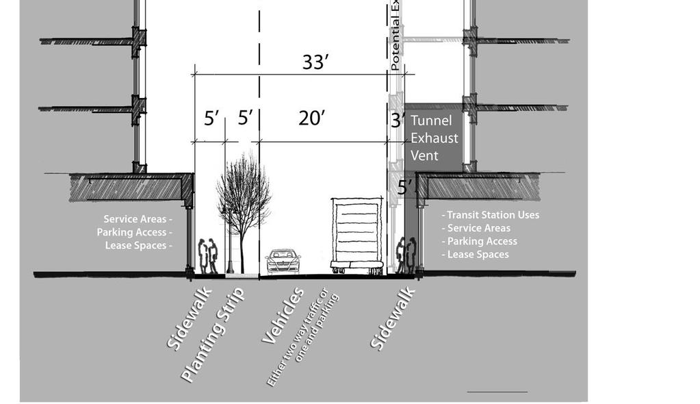
10 4. STATION PHYSICAL, OPERATIONS AND MAINTENANCE CONSIDERATIONS Capitol Hill s underground station will be built just east of Broadway Avenue and south of East John Street, beneath Nagle Place and adjoining properties. This station will serve the densely populated neighborhood and the Broadway business district, as well as Seattle Central Community College, Group Health Medical Center and other nearby employers. The Capitol Hill Station includes three at-grade station entrances: a north entrance on the east side of Broadway at the corner of East John Street, a west entrance on the west side of Broadway just south of East Denny Way, and a south entrance at the corner of East Denny Way and Nagle Place. An emergency vent is located at-grade at the center of the station. The three station entrances lead to an underground station mezzanine, basement and platform levels. A pedestrian tunnel connects the west entrance to the station under Broadway. The following graphic shows the plan view of the location of the station, entrances and functional areas at 90% design completion. Station Site Plan The following graphic is a longitudinal section though the station and illustrates the below ground and above ground features of the Capitol Hill Station at 90% design completion. 7
.")

 from the surface entrances")
11 Station Longitudinal Section Four sites have been identified as potential future TOD sites (A-D). The following site plan shows the TOD sites in relation to the station and above ground structures. Capitol Hill Station TOD Sites BELOW GRADE The below grade features of the station include vertical circulation (stairs, escalators, elevators) from the surface entrances to the station platform, the pedestrian tunnel from the west entrance under Broadway to the station mezzanine, and the actual station box and its functional and 8
12 equipment components. The base of the station box is approximately 65 feet below the surface. There are approximately 12 feet of cover between the surface grade and top of the station box. BELOW GRADE STATION CONSIDERATIONS FOR TOD The following controlling factors must be integrated into, or avoided when designing redevelopment structures and activities for the four TOD sites. Pedestrian Tunnel: The pedestrian tunnel under Broadway is designed as a direct connection from the west entrance to the station under Broadway and under a portion of Site C. Any underground parking or other feature at Site C will need to accommodate this tunnel. Station/TOD Walls: Sound Transit will build 3-hour fire-rated walls as the station walls adjacent to future development. Sound Transit will give direction to developers for construction of TOD walls adjacent to station. Waterproofing: Waterproofing protection of the station and other under ground facilities will be an important factor as to where and under what conditions development structures and construction would be allowed adjacent to the station. ABOVE GRADE The above grade features of the station include the north, south and west station entrances (and associated utility, maintenance and emergency exit spaces) and the station vent. It is assumed that TOD will be developed adjacent to the three station entrances. ABOVE GRADE STATION CONSIDERATIONS FOR TOD The following controlling factors must be integrated into, or avoided when designing redevelopment structures and activities for the four TOD sites: Station/TOD Walls: Sound Transit will build 3-hour fire-rated walls as the station walls adjacent to future development. Sound Transit will give direction to developers for construction of TOD walls adjacent to station. Vent access The main station vent extends above grade from the center area of the station box. This vent requires unblocked ventilation for 10 feet above and around its opening. Vents are also included in the north and south station entrance structures. The vent structures and functional requirements will require careful consideration when determining what type of development structure could be built adjacent to it. Maintenance access requirements: Sound Transit s station service vehicle and other maintenance access requirements must be accommodated on the east side of the north entrance in the Nagle Extension design. A curb cut or roadway entrance off John Street will provide this access. Waterproofing: Waterproofing protection of the station entrances and other above ground facilities will be an important factor as to where and under what conditions development structures and construction would be allowed adjacent to the station. 9
13 OVERBUILDING STATION BOX FOR TOD In 2007 Sound Transit analyzed what type of structures could be built directly above the station box. After initial Sound Transit analysis, the City of Seattle Office of Economic Development hired its own independent structural engineer to assess the feasibility of building over the Capitol Hill Station box. The conclusion of Sound Transit and City analyses is that overbuilding of the station box with five floors of wood frame construction over one level of concrete is feasible without changing the station structural design. However, waterproofing, structural and underground utility issues will need to be addressed more fully at a later date in order to accommodate overbuilding by Sound Transit. Alternatively, higher TOD structures with heavier loads could be accommodated over the station box by an independent bridging structure that could be built at the option (and cost) of the future developer after completion of the station. The current zoning height limits makes this option unlikely. At the time of the TOD project RFQ/RFP process, ST will provide to potential developers the station structural load limitation criteria, water-proofing protection, liability bonding, and other requirements for any proposed overbuilding of below-grade station structures. The final TOD project designs for each site will be subject to Sound Transit requirements and compliance with City codes. The current station design includes several required vertical structures that penetrate up through the station box roof plane including the north entrance headhouse, emergency fan vents, and emergency stair structures. The ultimate design of the remaining station box roof, including the Nagle Extension, will be determined in concert with the development proposed for TOD Sites A and B as part of the Sound Transit s design review process. OVERBUILDING STATION ENTRANCES FOR TOD Sound Transit worked throughout the early design process to minimize the size and placement of each of the three station entrances, where possible, to ensure the maximum potential for future development around them. The west entrance was reconfigured to allow for more Broadway street frontage for future development. The south entrance was moved off Broadway to Nagle Place to preserve Broadway frontage for development. The north entrance was also redesigned with a much smaller entrance width on Broadway. Sound Transit s station design assumes that no development would be directly built above the entrances to achieve Sound Transit s design and maintenance requirements. The station entrance designs also incorporate the use of window clerestories above the entrances, to allow as much natural light as possible into the entrances and to provide a common recognizable design feature for all three entrances. Development over the entrances would likely limit the benefits of this design feature. It is possible that a future developer might consider building cantilevered structures off the development structure (balconies, etc), above but not connected to the station entrance roof. Sound Transit will examine this potential issue further to more fully consider its design implications. 10

14 5. TOD SITE CONSTRAINTS AND OPPORTUNITIES In this section and Appendix 3, parcel locations and sizes are identified, along with regulatory and physical constraints, easements and potential legal encumbrances on the station block sites. Also identified are the general implications of these constraints, along with potential Sound Transit encumbrances and retained rights necessary or desirable prior to parcel transfers for redevelopment. Besides examining these site programming requirements, the role of the community Design Review process and examples are provided of recent Broadway-area buildings constructed to the same code requirements. STATION ZONING OVERVIEW For the station area parcels, base Neighborhood Commercial 3 (NC3) designation is modified by varying height limits, a Pedestrian designation, the Station Area Overlay and the Seattle Central Community College Major Institution Overlay. Detail on these zoning elements can be found in Appendix 3. The four sites include one full block with two sites and two partial blocks as shown on the parcel map below. The TOD sites are referred to A, B, C, and D. The TOD site zoning designations and approximate redevelopment site footprint areas are as follows: Station Blocks Site Zoning Designation Total Footprint Area North Block West A NC3P-40(65) 37,090 SF North Block East B NC3P-40 30,700 SF South Block C NC3P-40(65) 17,420 SF West Block D NC3P-40(65) & 11,120 SF MIO-105 TOTAL 96,330 SF Forty foot high limits are increased to 65 feet if residential units are built along Broadway. Block D, adjacent to the Community College has a height limit of 105 feet. 11
15 IMPLICATIONS FOR TOD SITES Site A: Site A will be developed as a mixed use building, most likely taking advantage of the additional 25 available for upper story residential. The form of the building will be affected by four obvious factors: the location and orientation of the north station entrance; the P1 designation; application of design guidelines (city-wide and neighborhood); and Link station operations requirements. Below-grade parking will likely be accessed off Denny Way. Design review will place strong emphasis on an expectation of character-defining design elements from corner to corner along the Broadway façade. Site B: Due to the eastern half of the block having split zoning, the 10th Ave side of the station block will be a lower height than Site A. A single plate of underground parking at Site B may be sufficient for demand from the residential units above. The proximity of Cal Anderson Park will have a strong influence on the orientation of the southern portion of this half block, and the station entry on Site A will influence the northern portion. Design review will likely focus on relationship to Cal Anderson, private open space, green elements, the quality of materials, and the relationship to the pattern of residential development on the east side of 10th Ave E. Site B may be sufficiently large to allow it to be split north to south to create two building parcels. Site C: This site will be developed as a mixed use building, most likely taking advantage of the additional 25 available for upper story residential. The south entrance structures, station mechanical systems, and parking access will eliminate any Nagle Place ground floor relationship to the street or Cal Anderson Park. The above-ground station elements add complexity, reducing depth and rear access to Broadway frontage retail. The pedestrian tunnel from the south end of the station box to the West Entrance constrains underground parking for Site C. The residential orientation to the east overlooking the Park will make this site attractive to market rate builders. Site D: Given the west station entrance, this site within the Community College MIO creates both opportunities and challenges. No underground parking will occur here, but the site may be planned to accommodate commuter bicycle storage. Adjacent the above-grade headhouse, a small commercial space may benefit more from student/station traffic. The site creates the potential of a joint development with the College s campus expansion plans. Student housing combined with classrooms or college offices may be the best fit for a site. ROLE OF THE CAPITOL HILL DESIGN REVIEW BOARD Design Review is a component of a Master Use Permit (MUP) application and is administered by the Department of Planning and Development (DPD). Design Review uses both the citywide and neighborhood design guidelines that provide guidance on issues unique to a neighborhood. Development proposed for the TOD sites will be reviewed by the Capitol Hill Design Review Boards for public comment and recommendations to the DPD Director. Appeals are made to a Hearing Examiner. The Capitol Hill guidelines are found at: 9.pdf 12
16 POTENTIAL FOR CITY CHANGES TO DEVELOPMENT REGULATIONS The Department of Planning and Development recently sponsored new development to allowing 65' heights (from 40 ), adopted by the City Council in Additionally the Station Area Overlay and commercial code updates create TOD-supportive regulations. Sound Transit s timeline for redevelopment of the four sites allows for sufficient time between 2009 and the end of 2011 for any new policy issues to receive sufficient consideration, should regulatory changes be desired. COMPARABLE PROJECT EXAMPLES See Appendix 3 for comparable development project examples in the Capitol Hill area. 13
17 6. TOD SITE ISSUES A number of TOD topics at the Capitol Hill Station site have been explored to date. While several of these respond to BEVAA guidelines and are addressed in Section 7, several other topics have evolved that will have a role in TOD development at the Capitol Hill station site. Two innovative development industry practices: green building, and providing developer incentive/requirements for vehicle parking alternatives will be explored further through the TOD process. Also not directly addressed in BEVAA, the future use and configuration of the socalled Nagle Extension is of major importance for the future uses on Sites A and B. These three issues are discussed below. A. Green Building Sound Transit has adopted a green building requirement to be applied to its surplus real estate parcels in Seattle. Details of Sound Transit s green building requirements can be found in Appendix 5, and improved methods, systems, and requirements can be expected by the issuance of the RFQ/RFPs. B. Parking Alternatives One result of the charette discussion on business district parking was to further explore alternative parking scenarios for development tenant needs. Sound Transit will encourage or require the TOD developer to provide alternatives to car parking such as additional bicycle parking, use of flex cars to reduce tenant parking needs, reducing total parking provided to meet minimum development needs, and encouraging transit pass use by tenants and customers. Sound Transit is preparing a technical memo identifying potential TOD parking alternatives in further detail. C. Nagle Extension The current design of the Capitol Hill Station includes a north-south access road on Sound Transit property between Denny Way and John Street. It would be built over the station box to provide maintenance vehicle access to the east side of the north entrance and mid-block remote vent. This access road also divides the two large TOD sites (A and B) and would likely provide delivery vehicle and underground parking garage access to one or both development sites. Because it appears to be a northward extension of Nagle Place, it is often referred to as Nagle Extension. The design and expected use of Nagle Extension has been the subject of much community and City staff discussion in the earlier stages of station design. ST direction to the design team to date has been to minimize (generalize) design detail of the Nagle Extension roadway and sidewalks and maximize future design flexibility since the ultimate function and design would be determined as part of the adjacent future TOD site development plans. The internal TOD charrette reviewed Nagle Extension design and functional issues and suggested 3 design concepts as depicted in sketch form below. These alternatives are within a range of potential solutions to better understand the access and design relationships between the TOD sites and station functional requirements. In addition, these design concepts help visualize/illustrate design opportunities that the access road could create, in response to expected community and City staff interest in design questions. These design concepts will eventually be used to inform future RFQ/RFP design requirements. 14
18 15
19 16
20 17
21 7. BEVAA ISSUES The following sections address topics specifically identified in the June 2006 Broadway Economic Vitality Action Agenda (BEVAA) as relating to Sound Transit s development of a Capitol Hill Light Rail Station. The topics are business district parking, retail uses at stations and affordable housing. Sound Transit staff and consultants drafted technical memoranda on these issues to better understand choices and implications. Summary information is provided here, with more detailed information referenced in the appendices. A. Best Practices The BEVAA includes a reference encouraging that best practices be applied to the TOD redevelopment sites. Sound Transit does this as a matter of course, using nationally-supported principles of design and density, as well as its adopted transit-oriented policy base. The BEVAA contains other statements which invoke TOD best practices concepts, and the essence of those will be included with similar language in the Request for Qualifications and Request for Proposals when they are created in 2012 and See Appendix 4 for more information on best practices for successful TOD. B. Parking: Critical Need and Opportunity BEVAA Guidelines: Incorporate parking for the business district in redevelopment plan o Access from Broadway should not be permitted o Provide permanent, predictable, affordable parking supply for customers (not commuters) o Use the less desirable areas of the site (especially below grade) for parking Consider creative ways to construct parking as part of site development o Sound Transit could concurrently build the station and underground parking, saving significant construction costs for an incoming developer o Sound Transit could also construct and lease back the garage According to the Capitol Hill Chamber, the business district lacks sufficient business and retail parking. In addition, Sound Transit is removing several public pay parking lots (approximately 113 stalls) to construct the Capitol Hill station. The Capitol Hill Chamber has expressed concerns that light rail riders may utilize remaining public parking for commuter parking; thereby further decreasing retail parking supply. CODE AND POLICY REQUIREMENTS AND CONSTRAINTS Code and policy requirements and constraints are a consideration to including business district parking at the TOD sites. Detail regarding the physical and financial issues associated with funding, owning and operating publicly available paid parking provided by Sound Transit can be found in Appendix 6. 18
22 The City s code eliminated minimum parking requirements for development within the Station Area Overlay (SAO). Due to the P designation and SAO, access to parking would not be allowed from Broadway. The SAO prohibits single-purpose parking structures however it would allow communityserving short-term parking. There are no parking maximums in the code. Sound Transit policy is to not provide new commuter parking at Link stations in urban areas. The Station Area Plans specifically proposed actions that created station areas predicated on transit oriented development and urban design that was supportive of non-auto access to Link. Although short-term parking could be operated so that it is not used by commuters, attracting large numbers of cars to garages at station entries would compromise the desired pedestrian orientation of the sites and station areas. The City has not financially supported the development of community parking garages. Neither Sound Transit nor the City can contribute toward a parking facility that could be defined as a gifting of public funds. Chapter 35.87A RCW authorizes Parking and Business Improvement Associations (PBIAs). Finally, use of federal funds is not eligible for construction of commercial parking. FTA guidance lists as Ineligible Activities at 72 FR 5792, III. a.: Eligible costs do not include construction of commercial revenue producing facilities (other than intercity bus station or terminal) or part of a public facility not related to public transportation. Sound Transit may not use federal funds for or allow developer to create parking that is incidental to TOD project purposes (short term convenience retail, long term segregated residential parking). SOUND TRANSIT RESPONSE Sound Transit has maintained its position that as a regional transit agency, increasing community parking supply is inconsistent with its mission of providing transit service. Construction of a light rail station in this area will in fact mitigate loss of parking. Sound Transit s business and policy positions to date have been: TOD site developers will likely provide some level of parking for tenants and retail customers (short-term) of TOD businesses Developers will not provide commuter parking or additional parking to serve business district (contrary to mission and not financially feasible) ST will not build parking concurrent with station construction, construct parking and lease back garage, or subsidize parking for developers CHARRETTE CONCLUSIONS The TOD charrette participants concurred with Sound Transit s position to date regarding business district parking. Providing additional short term parking for the greater business district by the TOD developers does not appear to be financially feasible and providing it as part of station construction is not within Sound Transit s mission. However, should the community 19
23 wish to increase the short term parking stock on Capitol Hill at other sites, other options such as a PBIA could be pursued. C. Station Location/Entrances to Create Quality Retail BEVAA Guidelines: Continuous Broadway frontage Corners should be used for retail Retail depth space should be feet Allow mixed use with intentional retail spaces Past discussions with the Capitol Hill Chamber have included the desire to have a large anchor tenant along Broadway, as well as the notion that future retail space could be reserved for certain tenants or uses. RETAIL USES AT STATIONS Market and financial determinants guide developer decisions as to attracting and leasing creditworthy tenants in new Class A buildings. Current conditions will be assumed to exist as the future basis for when the TOD properties become available. The Capitol Hill Station presents opportunities for retail space users. Information on Market and demographic factors, and the physical and financial determinants that will attract retail tenants to the Capitol Hill Station are presented in Appendix 7. POTENTIAL RETAIL MARKETS FOR EACH SITE Sites A and C, with their exposure to Broadway are well suited for retail uses. Site C may be challenged due to depth and having no back door service opportunity. Site B, with its limited exposure to pedestrian and automobile traffic, is not a likely candidate for retail uses. Site D, adjacent the College presents a good storefront option, although the future use of the property adjacent to the West Entrance is not yet clear. Sites A and C are well suited to serve smaller retail tenants, ranging in size from 800 to 4,000 square feet, with 1,200 SF being typical. Second floor retail should not be considered and all space entries must be at grade. All spaces should face Broadway and have minimum of 20 feet of street frontage. Typical space depth should not exceed 60 feet, with shallower spaces being acceptable in this market. Ceiling height minimum are 12 feet with 18 to 20 feet preferable. Each space needs to have access from the rear of the building for service purposes, delivery, garbage, etc. PROJECT DELIVERY AND RISK By design, the retail elements of the proposed buildings are integrated into larger structures and are best delivered in a monolithic fashion by the entity that is the master developer of the site. The development and leasing of retail space is a speculative undertaking exposed to construction and leasing risks. To mitigate these risks the developer needs to be responsive to the market at the time the development is completed. Flexibility should be maintained to allow the developer to respond to market conditions. Overly prescriptive restrictions on the developer will increase risk and drive costs upward. 20
24 SOUND TRANSIT RESPONSE During final design, Sound Transit staff worked with the Chamber to position the main (north) entrance to allow for retail on the northwest corner of Site A. Code requirements and market demand are expected to ensure the inclusion of retail which will contribute to Broadway s economic, cultural, and social vitality. Sound Transit s view is that retail tenancy choices are best made by the developers obtaining the development rights through the RFQ/RFP process. These risk and reward decisions are best borne by the developer and investors. Any attempt by Sound Transit to dictate tenancy would have a financial effect on the land value, likely compromising the Fair Market Value standard the agency is required to meet. CHARRETTE CONCLUSIONS Sound Transit s real estate consultant explained issues related to retail potential at the TOD sites. A retail specialist had been interviewed about the several site s retail potential and concluded that the market will support smaller retail tenants, averaging about 1200 SF, with an ideal space depth of 60 feet. It is possible a tenant could want a deeper depth, but that would not be typical for this market. A large retail anchor tenant will require significantly more parking than smaller tenants. Increased parking is counter to the principles of transit-oriented development. Expert opinion at the charrette was that the community may want a large anchor tenant, but the market is unlikely to support it. Charrette attendees confirmed that the future TOD developer, responding to market conditions and factors, should determine the retail composition of the development sites. D. Encourage Development of Affordable Housing at the Station Site BEVAA Guidelines: Work together to set a significant goal for affordable housing on the station site Identify land disposition and development strategies and financing strategies to implement Consider Seattle Central Community College s interest in student housing The Capitol Hill community has a history of addressing housing needs, including the formation of Capitol Hill Housing Improvement Program, a City Public Development Authority, chartered to build and operate affordable housing projects. Other not-for-profit providers serve the Capitol Hill market with a variety of product and clients. CODE AND POLICY REQUIREMENTS AND CONSTRAINTS City of Seattle zoning encourages housing at the station sites by allowing a 25 foot height bonus for the inclusion of residential units. The City is currently discussing adopting a city-wide incentive for including affordable housing units in market rate buildings. Currently, no Citysponsored program or regulation directly incentivizes the creation of affordable units. The Federal Transit Administration requires permission to allow uses other than transit on federally-assisted real estate. While approval is not difficult to obtain, guidance is given that use by others must be at fair market value and typically requires a broadly competitive process for making surplus properties available. The FTA does not include regulations or guidance that create preferential treatment of any specific use of surplus property over any other use, except as regards highest and best transit use ; physical and functional relationship to transit ; private investment; and, economic development. 21
25 Sound Transit s policies for transit-oriented and joint development also include the requirement of obtaining fair market value for surplus uses. The agency s Property Disposition Policy and Goals include: Encourage TOD/Joint Development to build ridership, enhance communities, and aid economic development Allow flexibility to realize the greatest possible return on the public investment in surplus real property Utilization of surplus property for housing, commercial, mixed use, industrial and other appropriate uses State transportation and growth management laws encourage pursuit of land use transit connectivity in order to create density, increase efficiency, and preserve rural lands. SOUND TRANSIT RESPONSE Sound Transit could pursue any of three options (or variations): 1. Sound Transit Neutral - Sound Transit could be neutral about affordable housing goals. The TOD RFP will work within the regulatory process as it stands in 2012, and respond to market conditions at the time. 2. Sound Transit Advocate Sound Transit could display interest in accommodating affordable housing goals, identify regulatory changes that would need to take place for these goals to be achieved, and then leave the actually regulatory changes to the City of Seattle to implement. Sound Transit would advocate for inclusion of goals, but the City would be responsible for making them possible. Sound Transit s position would be influenced through discussions with the community and housing providers. 3. Sound Transit Proactive - Sound Transit could lead the effort to change regulatory environment in favor of affordable housing goals it wishes to require of developers. This approach would require policy support from the Sound Transit Board and additional technical expertise and to pursue this option. Further discussion with Sound Transit management and the Sound Transit Board on affordable housing policy direction is anticipated. CHARRETTE CONCLUSIONS At the TOD charrette, resolution of affordable housing issues at the station sites was best categorized as a developing and ongoing discussion. The group concluded that affordable housing is market-driven and will be an issue that the community will pursue. It was clarified that affordable housing can be built on land acquired at fair market value. What constitutes a significant goal also needs to be defined. In general, the group felt that it is impossible to know now what level of interest and funding in affordable housing will be available at the time the RFQ/RFP is developed. The regulatory and housing delivery environment will help to shape any potential affordable housing position on Sound Transit s part. Sound Transit will need to make policy decisions in regards to its level of involvement in shaping the regulatory process that affects the creation of affordable housing at the Capitol Hill Station TOD sites. It is clear that whether or not Sound Transit decides to encourage affordable housing in some way, that there will continue to be strong interest from the community on this topic. 22
26 Specific affordable housing ideas discussed at the charrette included: Consider partitioning Site B to create a separate site specifically available for affordable housing ( units is desirable development size). Work with the Seattle Central Community College to explore the feasibility of developing Site D with a project that includes student (affordable) housing. See Appendix 8 for general information about affordable housing definitions, resources and delivery methods. 23
27 8. NEXT STEPS Continued guidance from Sound Transit management and the Sound Transit Board is expected as Sound Transit s TOD policies and guidelines are carried out within the context of the impending Capitol Hill station construction, assuring that the University Link project budget, scope and schedule requirements are met. Sound Transit s TOD work program is designed to fully engage the stakeholders to create redevelopment opportunities responsive to the marketplace, the Broadway community, and the agency s mission. This report serves as documentation of Sound Transit s baseline analysis of Capitol Hill Station TOD issues and is intended to be a resource document and starting point for further public dialogue on station TOD issues. Sound Transit will soon begin additional work and discussions with the City of Seattle and Capitol Hill Chamber of Commerce and other community participants on these issues to continue progress towards the successful implementation of TOD projects. A public outreach process is planned to involve the public and other stakeholders in further refinement of the TOD issues outlined in this report, as the next step in this effort (see Appendix 9). 24
28 APPENDICES 25
29 Appendix 1 Capitol Hill Station Context OVERVIEW The Capitol Hill community is a unique and significant place; noted for assertive involvement in civic and cultural affairs. This appendix reviews formal and informal plans in order to provide context beyond the redevelopment site. It assesses the following: Regional Growth assumptions City Goals as an Urban Center Current neighborhood issues within the station area Development plans/projects by adjacent property owners GROWTH FORECASTS Forecast Analysis Zone (FAZ) 6113 covers much of Capitol Hill and First Hill, indicating projected strong residential growth in the area following 2010 and continued employment growth. Year Households % HH Growth Employment % Emp. Growth ,675 37, , , , , , ,494 2 URBAN CENTER GOALS Neighborhood Plan Excerpts A key goal of the Capitol Hill Neighborhood Plan is to enhance the vibrancy of the Broadway business district. At 1.6 miles long, Broadway is the longest continuous pedestrian commercial street in Seattle. The Plan recommends a number of actions. Parking: Implement an integrated strategy of public and private actions to better use and increase supplies, to balance interests, and to reduce auto dependence. Maximize on-street parking opportunities. Institute design guidelines that minimize the impacts of parking on pedestrians. Promote joint-use of existing parking facilities. Improve advertising and accessibility of available parking resources. Discourage commuter and employee parking. Affordable Housing: Implement strategies to encourage affordable housing: Support the nonprofit housing organizations. Development incentives to encourage private construction of affordable housing. Encourage public and private joint-use affordable housing development projects. Provide more flexible development standards. Development: Continue economic vitality of the Broadway business district by reinforcing its special character and pedestrian-orientation. The Plan recommended a complete zoning analysis 26
30 of areas around the Broadway Sound Transit stations, and district design guidelines for Capitol Hill. CAPITOL HILL STATION AREA PLAN The Plan s vision includes expanding the mix of businesses, adding new housing, and improving the environment for pedestrians. Light rail is seen as bringing new customers and visitors to the business district and providing increased access to jobs. Parking Strategies: Implement strategies that: promote transit; enable TOD; and protect residential parking. Consider parking requirements that promote light rail and bus use and manage on and off street parking supplies. Establish policies that prioritize parking for residents and retail and discourage commuter parking, allow shared parking, separate parking costs from building rent costs, and implement transportation demand management. Secure replacement parking and implement parking management strategies. Housing: Increase opportunities for new housing and home ownership in the station area. Support CHHIP and other nonprofit efforts to provide affordable housing. Consider creation of housing Transfer of Development Rights/Bonus program and the Multifamily Property Tax Exemption to facilitate affordable housing. Work with Sound Transit to identify housing opportunity sites. Increase housing for homebuyers as well as renters in multifamily projects. Promote mixed-use, mixed-income TOD on public and privately-owned sites. Develop a housing program and financing mechanisms that enable affordable housing to be included in housing development. Promote greater use of Property Tax Exemption and Location Efficient Mortgage. Work with SCCC to explore opportunities for student housing. Land Use Code: Encourage development that achieves the neighborhood plan vision, supports transit ridership, discourages auto use, and promotes pedestrian and bicycle use. Establish a Station Area Overlay. Establish zoning for that meets neighborhood plan and City development goals. Adopt Capitol Hill neighborhood specific design guidelines. Design Guidance: Ensure that the station, surrounding development, and streetscape reinforce the neighborhood character and support the community's vision and goals. Develop design criteria with Sound Transit staff and the community to influence projects developed on Sound Transit properties. Finalize Capitol Hill's neighborhood specific design guidelines. Public Safety: Create a safe, lively environment throughout the station area. Provide good lighting and clear lines of sight in public spaces and new development to promote pedestrian activity and "eyes on the street." Joint Development: Maximize TOD opportunities on Sound Transit, KC/Metro, and other publicly-owned properties that are in keeping with the vision for the station area. Maximize development opportunities at both station entrances. Coordinate with Sound Transit and SCCC to ensure station design that is integrated with the anticipated SCCC technology learning center. 27
31 CURRENT NEIGHBORHOOD STATION AREA ISSUES BEVAA PRINCIPLES Excerpts from the June 2006 Broadway Economic Vitality Action Agenda (BEVAA): Parking is a critical need and opportunity Incorporate parking for the business district in the redevelopment plan Access from Broadway should not be permitted Provide a permanent, predictable, affordable parking supply for customers Use less desirable areas of the site (especially below grade) for parking Consider creative ways to construct parking as part of the site development Sound Transit could concurrently build the station and underground parking saving significant construction costs for an incoming developer Sound Transit could also construct and lease back the garage Encourage development of affordable housing on the station site Work with the City, the Chamber of Commerce and CHIP to: Set a significant goal for affordable housing for the Sound Transit site Identify effective land disposition and redevelopment strategies along with financing tools to implement the goal Consider SCCC s interest in additional housing Incorporate developers early in the planning and design process to ensure the site s highest and best redevelopment potential Work with the City and the community to create land disposition and redevelopment mechanisms to facilitate the City/community affordable housing goals Make best use of existing mixed-use zoning in station design Tunnel location and station design decisions made by Sound Transit will drive the feasibility of quality redevelopment above and adjacent to station Excavation depth and parking provisions will determine height and development potential of future construction Evaluate relocation of the post office into the new development Design station locations and entrances to create successful, quality retail spaces Continuous retail frontage is critical for Broadway Station entrances should not interrupt retail traffic and continuity of movement Station entrances should be on side streets and definitely not on corners Entrance design and the right number of station entrances are important Corner parcels attract the best retailers and should be reserved for retail use Depth of retail spaces is key to attracting quality retail 60 to 100 depth is needed. Design the station to support desirable private and public sector development Preserve and facilitate redevelopment opportunities above and adjacent to the station Consider the station design in context with the neighborhood The Broadway station should encourage dense, attractive commercial activity Open space around the station is not a desired feature, vital retail activity is Stations and adjacent developments must fit the design of the neighborhood Ensure effective property management before and during construction Land disposition should be controlled in a way that ensures community plans are implemented 28
32 ADJACENT DEVELOPMENT PLANS Several recent Capitol Hill development projects are discussed in Appendix 3. There have been several significant changes of property use with the conversion of two grocery store sites on Broadway to mixed use residential/commercial buildings under the recently adopted NC3-65 zoning. US Post Office In May 2008, the USPO held a community meeting to discuss its intention to replace the Broadway Post Office located on the northwest corner of Broadway and Denny Way. Sound Transit staff attended the meeting with USPO and community representatives to discuss siting requirements and potential sites. Relocation of the Broadway Post Office may not take place for four or five years; firm plans by USPO are not yet known. OTHER COMMUNITY IDEAS In addition to neighborhood goals and plans, recent community discussions have evolved around additional ideas for development on Capitol Hill. Specifically, recent discussions include consideration of a cultural district overlay zone for Capitol Hill, and suggested TOD site uses including a performance hall, space for a permanent farmers market (using Nagle Extension) and a community meeting space. These ideas and others will continue to be explored in the context of the Capitol Hill station TOD as well as with other development projects taking place around Capitol Hill in the future. 29
33 Appendix 2 Capitol Hill TOD Work Program Schedule ( ) 1. Internal Definition of Project Objectives & Outcomes Confirm agency position on project/business objectives Internal Charrette August 2008 ST management briefings September Addressing redevelopment issues and concepts Coordination with City of Seattle Fall 2008 Begin work with Chamber and community Fall Addressing public policy review Making sites available for redevelopment Issue RFP/RFQ(s) 2012/2013 Select developer(s) Monitor design approval/permit process & construction progress Developer(s) take projects through community design review process Initial site availability for redevelopment* 2015 TOD project construction Certificate of Occupancy* 2017 * For priority Site A, at a minimum 30
34 Appendix 3 TOD Site Programmatic Constraints & Opportunities TOD ZONING OVERVIEW Site A NC3P-40(65) Site B NC3P-40 Site C NC3P-40(65) Site D NC3P-40(65) & MIO-105 NC3 Designation: The NC3 designation promotes larger pedestrian-oriented shopping districts serving the surrounding neighborhood and larger community by allowing comparison-shopping among a range of retail businesses. The base height limit is 40, however 65 is allowed provided the additional height is residential use. Building types include single purpose commercial structures, but are usually mixed-use / residential. Commercial uses are required at street-level on arterial streets. There are no size limits for most uses. Residential uses are limited to 20% of the facade on an arterial street, but may occupy 100% of the facade on non-arterials. Commercial uses at street level must have an average depth of 30, and have a minimum height of 13. Residential entries must be visually prominent at street level and at least 4 above, or 10 back, from a sidewalk. Parking must be located at the rear or side of a building, within a structure, or off-site. Parking between a building and a street is not allowed. Parking between buildings along the street is limited to 60. Parking access must be from the alley if feasible. P1 Designation: P1 designation modifies the underlying requirements of NC zones along pedestrian-oriented streets. The designation encourages an intensely pedestrian-oriented, retail shopping district. Street-level uses are limited to pedestrian-oriented nonresidential uses such as retail, entertainment, restaurants, and personal services. Drive-in or drive-thru businesses are prohibited. No parking is required for the first 4,000 to 5,000 SF of retail businesses. Parking is prohibited inside a structure at street-level facing a designated pedestrian street. Unless infeasible, access to parking must be from alley or side-street. Three of the four subject TOD sites (A, B and C) are within the general NC (neighborhood commercial) category intended to implement a pedestrian oriented shopping district. Along Broadway, commercial uses are required on the street level. Specifically, the sites are all designated NC3-40. The southernmost site (D) is controlled by a combination of designations, including the NC3 category described above, and also the MIO-105. The MIO category reflects the presence of Seattle Central Community College, which is classified as a major institution by the zoning code. MIO is the acronym for Major Institutional Overlay. Three of the four subject sites are also within a Pedestrian designated zone or overlay. The P designation is intended to create an intensely pedestrian-oriented, retail shopping district. The four subject sites are also within the Station Area overlay District (SAOD). The SAOD modifies the underlying zoning for the subject sites by: prohibiting uses that are not supportive of walkable neighborhood business areas or uses that are automobile related; 31
35 providing more opportunity for housing development in Neighborhood Commercial (NC) zones (without large scale changes to height limits) by allowing single purpose residential (SPR) development to be permitted outright, without density limits, outside of the pedestrian designations; and by removing the 64% upper-level coverage limit that would otherwise apply when residential use is proposed; modifying restrictions to the location of parking in NC zones by not allowing parking to the side of a structure if that side faces a side lot line. The Major Institutional Overlay (MIO) designation was created in response to community concerns about the expansion of educational and hospital institutions into residential neighborhoods. MIO regulates institutional growth by defining boundaries to expansion and requiring the creation of a major institutional master plan to guide growth. Seattle Central Community College development is regulated through the Major Institution Overlay (MIO). This requires preparation of a Major Institution Master Plan (MIMP) that when adopted provides the basis for development regulations that supersede the underlying zoning. The MIO allows 105 for site D. Seattle Central Community College is in the process of modifying its master plan. Physical Implications: The development standards in the NC3P-40(65) designate height, bulk and coverage on the site. The base zoning of NC3-40 provides for a building of 40 in height (the measurement of height is based on the topography of the sites, requiring all four corners of these sites to be considered when determining maximum height). Number of floors in NC3-40: Mixed Use - Given the requirement for non-residential uses on the street level means the first floor must be at least 13 from floor to ceiling to be a viable retail space, after accounting for the structural depth between the first and second floors, the remaining residential upper floors would be less than 9 from floor to floor (f/f). Given the structural depth requirements, the floor to ceiling height would be less than 8. These are minimum depths for all uses and a four floor mixed use development within this zone will be disadvantaged when compared to development that has higher f/f dimensions. Commercial Uses If commercial uses are on the upper floors, then three floors could be established in this zone the first floor at 15 (14 clear) and the two upper (office) floors could be built at 12.5 (11.5 clear) Number of floors in NC3-40(65): If uses above 40 are dedicated to residential activity, this zone designation provides for an additional 25 of height. In this mixed use configuration, the first (commercial) floor could be 15 f/f and the upper 5 levels could be 10 f/f. These are more generous dimensions for ceiling heights and thus, more easily leasable. NC3-40(65) Setbacks above 40 The SAOD eliminates building setbacks above 40 in the NC3 zone. Maximum height for Sites A, B and C are affected by sloping parcels, west to east. Use Disposition Implications: The development standards in the NC3 designation and the requirements of the Pedestrian Overlay will influence the placement of uses on these sites. In general, non residential uses must be installed along Broadway, with residential entrances 32
 have taken advantage of the additional 25 height allowed in the SAOD.")
36 allowed, but minimized so the commercial activity predominate the street. Service and parking activities must be on side streets, of preferably behind the building. Construction Type: Most previously developed and current projects under construction in the NC3-40(65) have taken advantage of the additional 25 height allowed in the SAOD. Construction technology in these projects typically have the first (commercial) floor built of concrete, and the upper 5 floors constructed of wood framing. The concrete slab above the commercial uses provides a fire separation between uses. The 65 height allows hydraulic elevators to be used for vertical circulation. Encumbrances: Transit oriented development on Sound Transit parcels occurs with property and use encumbrances as part of the transaction. Encumbrances could include below market ratios of parking stalls to residential units; developer-provided transit passes for tenants; green building requirements; and minimum duration for maintaining affordable housing subsidies, for example. Easements: Air rights easements for over-station box construction, waterproofing, station entrance overbuild, and common areas are examples of easements that will be granted if in Sound Transit s best interests. OTHER RECENT DEVELOPMENT PROJECTS ON CAPITOL HILL Brix The Brix provides 141 residential units and 7,765 SF of retail on Broadway. Due to the split zoning, the Broadway frontage is 65 and the 10 th Ave side is 40. Approximately 150 parking stalls are provided below grade. The Broadway frontage is simple, spare, blond brick and metal. The building houses six floors of flats, lofts, and open one-bedrooms, and shops at ground level. The 10 th Ave E side is red brick and with small garden courtyards. 33


37 QFC Site The QFC site development creates 295 residences and 30,000 SF of Broadway retail at the ground floor. There are 357 parking spaces at and below grade. The Harvard façade features ground level residences. Press Building This site, on Pine Street west of Broadway, is cited by the Design Review Board as an exemplary project. The roll-up storefronts, tile accents, canopies and high quality exterior materials reflect the urban character of the neighborhood. A large canopy, a tapered and tilecovered column, and a rooftop trellis emphasize the corner. Open space at the street-level courtyard, second-level terrace and mews allows for connection to the streetscape and community room while breaking down the building's scale. A rooftop deck provides greenery, views and an attractive outdoor area. Parking access garage is located on Belmont Avenue, avoiding interference with the pedestrian experience in Pine. Bank of America Site Design review, early design guidance meeting for two buildings in two phases. Phase 1 will include construction of a 4-story mixed-use building on the eastern portion of the site (currently a parking lot). Phase 2 will include demolition of the existing 1-story bank building and replace it with a new 6-story mixed-use building. This development began the early design guidance process with the Design Review Board in September
38 Appendix 4 TOD Best Practices The following summary description and listing of best practices comes from the recently published Final Draft of TCRP Report 128 Effects of TOD on Housing, Parking, and Travel ( ). The summary includes these characteristics in the context of Broadway on Capitol Hill. CHARACTERISTICS OF SUCCESSFUL TRANSIT ORIENTED DEVELOPMENT Supportive Land Uses are Typified Concentrations and mixtures of uses provide best opportunity to generate multi-trip high pedestrian volumes and transit riders, extended activity hours are an additional benefit of supportive land uses in that retail follows rooftops. New development will enhance the overall retail mix on Capitol Hill. Broadway currently has a wide variety of uses, is increasingly dense with mixed uses, and approaches an all hours activity venue. Adequate Densities to Provide Ridership Base/Compact Development Traditional urban residential densities in excess of 50 units/acre; employment centers in lieu of or in combination with residential units help provide jobs/housing balance. In general, the best practices for densities around station recommend the maximum densities in the immediate location of the station, with diminishing density further from the transit access. This is the pattern prescribed by the zoning and SAOD in the Capitol Hill situation. Convenient, Attractive Pedestrian Facilities/ Transitfinding Features Linkages, Transitfinding, and transit service all contribute to pedestrian amenity as all transit trips involve walking to some degree, thus the provision of safe, efficient, and comfortable-feeling walking corridors between transit stations and surrounding communities is an essential attribute of successful TODs; scale and amenity are important to attracting residents and visitors who will walk and ride transit; the variety and quality of retail is a contributor to pedestrian activity and amenity. Broadway is known for its high level of pedestrian traffic and frequency of transit service, generally has good sightlines and some views, adding to the overall amenity of the place. Urban Design: Placemaking and Streetscape Mixed uses (e.g., local restaurants) and urban design treatments (e.g., pedestrian pathways) are important for their amenity and design value in attracting residents and visitors/customers; residents highly value good neighborhood design in addition to transit access to work; quality urban design and local land use mix may influence TOD as a residential and destination choice. Broadway is a regional draw for restaurants, shops and entertainment. As the new zoning takes affect, the physical character of the neighborhood will change accordingly. Managed Parking The availability of free or low-cost parking is a major deterrent to transit ridership, and antithetical to transit-oriented land uses; high parking charges and/or constrained parking 35
39 supply contribute to a station area s success in reducing auto-dependency and allowing consumer choice to consider a lifestyle without a personal automobile; shared parking or exclusive use parking requires active management to forestall abuses. Broadway, while being parking-challenged due to a shortage of parking lots or spaces due to current automobile dependency, may see even greater pressure resulting from competition over pay-for-parking for longer durations. Managed parking schemes require control of land or some other leverage affecting supply. Broadway will benefit in the long run from reduced automobile dependency brought about by new residents dependent on improved transit and transit-oriented development. 36
40 Appendix 5 Green Building The purpose of this section is to provide an overview of the policy basis and technical considerations of applying green building standards and best practices to future transit-oriented development (TOD) at University Link Capitol Hill Station. Agency practices for green building/demolition as applied to Capitol Hill Station prior to redevelopment will also be discussed. Sound Transit is addressing these practices in concert with the Broadway Economic Vitality Action Agenda (BEVAA) desire that redevelopment at the station adhere to best practices design. OVERVIEW In 2007 Sound Transit adopted a Sustainability Initiative that includes the policy goal to integrate sustainable practices into the planning, design, construction and operations of new and existing transit systems and facilities. This goal is implemented through setting annual targets designed to make progress toward greater sustainability in the following general areas: Fuels, Vehicles and Emissions Ecosystem Protection Sustainable Design & Building Green Purchasing Recycling and Waste Prevention Energy and Water Conservation Education and Awareness One target identified during that applies future TOD work at Capitol Hill Station includes: Revise TOD RFP template to encourage green design/green building The following section will briefly discuss the applicability of the TOD green building recommendations. Applicability of Green Building Standards In the June 27, 2008 transmittal to Sound Transit, the planning/design firm Mithun provided criteria and recommendations on green building standards that could best fit with potential redevelopment on three Sound Transit TOD sites: Mt Baker Station, Mt Baker Triangle, and Othello Station (see Sound Transit TOD/JD Policy Recommendations, 6/27/08). The main assumptions used for that recommendation included: likely redevelopment type (market rate multi-family; either condominium ownership or rental apartments; existing zoning height of 65 ; wood frame over concrete base construction; and current market conditions and acceptance of sustainability metrics. These criteria appear applicable to the Capitol Hill Station sites, based on current zoning and development practices, and the market. Therefore, it may be assumed that Sound Transit will 37
41 require a green building baseline compliance metric as well as suggest an incentive program in the RFP for redevelopment at Capitol Hill, as follows*: 1) Baseline Compliance Metric: Built Green for Multi-family, 4-star minimum Or LEED-NC, Silver 2) Incentive Program: Built Smart program participation (City of Seattle) Sound Transit will apply this standard in concert with the Broadway Economic Vitality Action Agenda (BEVAA) desire that redevelopment at the station adhere to best practices design. *An additional key consideration is that market and applicable programs are constantly changing; this recommendation should be revisited annually and/or confirmed prior to issuance of the RFPs. 38
42 Appendix 6 Business District Parking MARKET/LENDER INFLUENCE ON PARKING SUPPLY AND ADDITIONAL COMMUNITY SERVING PARKING Amount of Parking In the recent developments identified in Appendix 3, developers are typically providing between 1 and 1.2 parking stalls per unit. Physical/Functional Requirements The parking component would typically be comprised of 3 independent underground parking garages following the footprint of the residential/retail buildings located above. Building A & C would have two levels of parking and building B have one level of parking. All of the underground parking plates would be accessed via a speed ramp system. Building A & C would likely be single modules of double loaded 90 degree parking. Building B would contain one single loaded module and a double loaded module of 90 degree parking. The basic intended users would be residents living in the apartments above as well as a small amount of spaces for the retail customers and visitors. The parking garages structural system will most likely be configured around a short span structural grid, where two to three vehicles will be parked between columns and or shear walls. This is a typical structural system when another building function is located above the parking. Building A s parking configuration of one double loaded module of parking with a speed ramp for access to the second underground level of parking would function less than optimally. The speed ramp and parallel two way drive aisle accessing the second level of parking would not have sufficient turning radii for vehicles to pass each other. This is due to the narrow width of the site which hinders the proper orientation of the ramp and parking plate. Building B s parking layout would be configured around a single loaded and doubled loaded module of 90 degree parking of only one level with access via an express ramp. This parking should function adequately. The single loaded bay of parking may be slightly inefficient but would function for traffic circulation properly. Building C s parking layout would likely be configured around a single, double loaded module of parking that is bent at a 90 degree angle to form an L shape. As with Building A s issue with access to the second level of parking, it too would be impacted by the narrow site and ramp orientation. The ramp would function less than optimally for two way traffic flow. Building A & C would function adequately as single levels of underground parking rather than two level of underground parking due to the narrow site constraint. Building B would be the better choice to add additional levels of underground parking. Build B s footprint is of sufficient length for the utilization of a sloping floor parked on ramp located in the single loaded module of the garage. Even though building B is less efficient with the single loaded module, it has the proper geometrics for adequate vehicular circulation and ramping configurations. Building B would likely contain 107 spaces. Below is a chart outlining the capacities if it were expanded for additional levels. 39
43 LEVELS BELOW GRADE CAPACITY One level 107 Two levels 192 Three levels 298 Four levels 406 Financial Implications The cost of underground parking is impacted by many variables such as soil conditions, the depth of the structure to special sheeting/shoring conditions. The ballpark estimate for the parking is in the range of $40,000 to $50,000 per space for this size of garage. Smaller parking garage projects are more expensive on a per stall basis given the reduced economies of scale. The cost could even be higher depending on soil issues or unforeseen conditions. Building B is the better choice for additional levels underground due to the larger footprint and ability to utilize a parked on ramp system. It is not advisable to go down more than 4 levels due to the extremely high cost of construction. More than four levels below grade results in complications in work due to the depth of the hole. Construction equipment needs to be conveyed in and out of the excavated pit. At four levels maximum, an earthen ramp can allow vehicles and equipment to be driven in and out. The elements of the TOD could include a number of uses: residential, office, and/or retail. To be competitive in the market each of these elements will need to be supported by some amount of parking. The number of parking spaces needed to compete with other space in the market in 2015 is unknown at this time; however, today the ratios in the table below provide some indication of market demand. Residential Office Retail.75 to 1.0 spaces per unit 1 to 2 spaces per 1,000 square feet None necessary more is better The cost to provide spaces for the elements of the TOD are paid as part of the overall project financing and are off-set by revenue that is collected in a number of ways. The revenue can come from apartment unit rent proceeds, separate monthly parking rental agreements, or from the outright sale of the parking spaces to space occupants. If additional parking is required for other non-project purposes it must be funded from outside sources. The table below shows a range of costs for additional parking spaces and the required revenue to cover debt service. The analysis assumes conventional financing with a 25 year term, monthly amortization, with the cost of funds equal to six percent. Parking Stall Cost $40,000 $50,000 Required Monthly Payment $258 $322 Required Annual Payment $3,100 $3,900 Revenue required to off-set the debt can be generated from the market. The sources of funds are dependent upon the goals or intended use of the parking. These goals might include: 1. More daily or monthly off-street parking to serve general purposes, 2. Hourly parking to serve retail customers in the neighborhood. Parking spaces can be rented on a daily or monthly basis for between $100 and $150 per month, net of expenses and vacancy. Net revenue from hourly parking also falls into this range. A funding gap equal to roughly half the required debt service would need to be filled. 40

44 Appendix 7 TOD Retail Uses MARKET AND DEMOGRAPHIC FACTORS The demographics that provide the foundation for retail on Broadway are summarized in the table below and represent areas within a ½ mile and 1 mile radius of the property. The standout statistics include the higher median age, lower than average household income, lower disposable income, and high number of renter occupied housing units. ½ Mile 1 Mile Seattle Population 20,442 55, ,784 Sex 55% Male 55% Male 49.8% Male Population by Race 72.7% White 9.5% Asian 66.5% White 14.4% Black 66.2% White 15.7% Asian Population By Age % % % Median Age Households 14,303 31, ,507 Median Household Income $47,837 $48,217 $66,314 Household Disposable Income $39,122 $39,386 $52,898 Median Household Disposable Income $51,774 $55,030 $72,914 Average Renter Occupied Housing 80.3% 74.9% $46.1% The demographics explain one of the reasons why the success of retail on Broadway has been inconsistent over the years. With the increased density coming to the area, the prosperity of retail establishments should improve. New buildings in the area will attract retail tenants that generate enough revenue to justify the cost of new construction. The cost to build new retail space that is integrated into a larger building is currently $300 to $400 per square foot. The rental income required to off-set the cost to construct new space and provide the developer with a return on investment is in the 41
MOTION NO. M Capitol Hill Transit-Oriented Development Purchase and Sale Agreement and Ground Lease
 MOTION NO. M2015-34 Capitol Hill Transit-Oriented Development Purchase and Sale Agreement and Ground Lease MEETING: DATE: TYPE OF ACTION: STAFF CONTACT: Board 04/23/2015 Final Action Ric Ilgenfritz, Executive
MOTION NO. M Capitol Hill Site D Agreement with Seattle Central College and Capitol Hill Housing
 MOTION NO. M2017-145 Capitol Hill Site D Agreement with Seattle Central College and Capitol Hill Housing MEETING: DATE: TYPE OF ACTION: STAFF CONTACT: Board 11/16/2017 Final Action Don Billen, Acting Deputy
Sound Transit s Office of Land Use Planning & Development Transit Oriented Development Quarterly Status Report Q2 2018
 Sound Transit s Office of Land Use Planning & Development Transit Oriented Development Quarterly Status Report Q2 2018 Background RCW 81.112.350 requires Sound Transit to provide quarterly reports of any
PROPOSED METRO JOINT DEVELOPMENT PROGRAM: POLICIES AND PROCESS July 2015 ATTACHMENT B
 PROPOSED METRO JOINT DEVELOPMENT PROGRAM: POLICIES AND PROCESS ATTACHMENT B TABLE OF CONTENTS I. INTRODUCTION / PURPOSE............................ 3 II. OBJECTIVES / GOALS..................................
Adopts a revised Real Property Excess, Surplus, and Disposition Policy and supersedes Resolution No. R99-35.
 RESOLUTION NO. R2013-30 Real Property Excess, Surplus, and Disposition Policy MEETING: DATE: TYPE OF ACTION: STAFF CONTACT: PHONE: Board Board 11/21/13 12/19/13 PROPOSED ACTION Introduction to Board Final
Transfers of Property Q Sound Transit did not transfer any properties subject to RCW (1)(b) during the first quarter of 2018.
(b) during the first quarter of 2018.") Sound Transit s Office of Land Use Planning & Development Transit Oriented Development Quarterly Status Report Q1 2018 Background RCW 81.112.350 requires Sound Transit to provide quarterly reports of any
Sound Transit s Office of Land Use Planning & Development Transit Oriented Development Quarterly Status Report Q1 2018 Background RCW 81.112.350 requires Sound Transit to provide quarterly reports of any
Transit Oriented Development (TOD) Progress Report
 Progress Report") Transit Oriented Development (TOD) Progress Report SFMTA, Mayor s Office of Economic Development, Mayor s Office of Housing and Community Development, Planning Policy and Governance Committee September
Transit Oriented Development (TOD) Progress Report SFMTA, Mayor s Office of Economic Development, Mayor s Office of Housing and Community Development, Planning Policy and Governance Committee September
Streamlining the Entitlement Process for Transit-Oriented Development
 October 2012 Streamlining the Entitlement Process for Transit-Oriented Development Best Practices Summary Setting Ideas in Motion Introduction and Overview Entitlement Process: The legal method of obtaining
Staff recommends the City Council hold a public hearing, listen to all pertinent testimony, and introduce on first reading:
 CITY COUNCIL PUBLIC HEARING JANUARY 16, 2018 SUBJECT: INITIATED BY: MULTI-FAMILY NEIGHBORHOODS ZONE TEXT AMENDMENTS: AMEND MINIMUM DENSITY REQUIREMENTS FOR R3 AND R4 DISTRICTS; AMEND THE DENSITY BONUS
Draft for Public Review. The Market and Octavia Neighborhood Plan
 Draft for Public Review The Market and Octavia Neighborhood Plan San Francisco Planning Department As Part of the Better Neighborhoods Program December 00 . Housing People OBJECTIVE.1 MIXED-USE RESIDENTIAL
12. STAFF REPORT ACTION REQUIRED SUMMARY. Date: September 21, Toronto Public Library Board. To: City Librarian. From:
 STAFF REPORT ACTION REQUIRED 12. Property Redevelopment Feasibility Date: September 21, 2015 To: From: Toronto Public Library Board City Librarian SUMMARY At the meeting on May 25 2015, the Toronto Public
LITTLE MOUNTAIN ADJACENT AREA REZONING POLICY
 LITTLE MOUNTAIN ADJACENT AREA REZONING POLICY JANUARY 2013 CONTENTS 1.0 INTENT & PRINCIPLES...1 2.0 APPLICATION...2 3.0 HOUSING TYPES, HEIGHT & DENSITY POLICIES...3 3.1 LOW TO MID-RISE APARTMENT POLICIES...4
City of Coral Gables Planning and Zoning Staff Report
 City of Coral Gables Planning and Zoning Staff Report Applicant: Application: Public Hearing: Date & Time: Location: City of Coral Gables Zoning Code Text Amendment Giralda Plaza Overlay District Planning
ARLINGTON COUNTY, VIRGINIA
 ARLINGTON COUNTY, VIRGINIA County Board Agenda Item Meeting of April 19, 2008 DATE: April 2, 2008 SUBJECT: ORDINANCE TO AMEND, REENACT, AND RECODIFY Section 20 CP- FBC, Columbia Pike Form Based Code Districts
TO MEMBERS OF THE FINANCE AND CAPITAL STRATEGIES COMMITTEE: DISCUSSION ITEM
 F13 Office of the President TO MEMBERS OF THE FINANCE AND CAPITAL STRATEGIES : For Meeting of DISCUSSION ITEM ORCHARD PARK FAMILY HOUSING AND GRADUATE STUDENT HOUSING REDEVELOPMENT PROJECT AND WEST VILLAGE
MOTION NO. M Roosevelt Station Central TOD Site Property Transaction Agreements PROPOSED ACTION
 MOTION NO. M2017-143 Roosevelt Station Central TOD Site Property Transaction Agreements MEETING: DATE: TYPE OF ACTION: STAFF CONTACT: Board 11/16/2017 Final Action Don Billen, Acting Executive Director,
LAKE MERRITT STATION AREA PLAN
 LAKE MERRITT STATION AREA PLAN Emerging Plan Open House Summary October 2011 2 1 Introduction The City of Oakland, Bay Area Rapid Transit (BART), and the Peralta Community College District, through a grant
Update on the Avenues and Mid-Rise Buildings Action Plan
 STAFF REPORT INFORMATION ONLY Update on the Avenues and Mid-Rise Buildings Action Plan Date: May 15, 2009 To: From: Wards: Reference Number: Planning and Growth Management Committee Chief Planner and Executive
Washington Boulevard + Kirkwood Road Special General Land Use Plan (GLUP) Study "Plus"
 Study Plus") Washington Boulevard + Kirkwood Road Special General Land Use Plan (GLUP) Study "Plus" Long Range Committee of the Planning Commission Meeting #4 May 18, 2017 Department of Community Planning, Housing
Washington Boulevard + Kirkwood Road Special General Land Use Plan (GLUP) Study "Plus" Long Range Committee of the Planning Commission Meeting #4 May 18, 2017 Department of Community Planning, Housing
Approval of Takoma Amended Joint Development Agreement and Compact Public Hearing
 Planning, Program Development and Real Estate Committee Item IV - B March 13, 2014 Approval of Takoma Amended Joint Development Agreement and Compact Public Hearing Washington Metropolitan Area Transit
CITY OF COLD SPRING ORDINANCE NO. 304
 CITY OF COLD SPRING ORDINANCE NO. 304 AN ORDINANCE AMENDING THE CITY CODE OF COLD SPRING BY ADDING SECTIONS 555 AND 510 PERTAINING TO PAYMENT-IN-LIEU-OF-PARKING THE CITY COUNCIL OF THE CITY OF COLD SPRING,
TRANSIT-ORIENTED DEVELOPMENT PLAN EXISTING CONDITIONS REPORT LAWRENCE TO BRYN MAWR MODERNIZATION
 TRANSIT-ORIENTED DEVELOPMENT PLAN EXISTING CONDITIONS REPORT LAWRENCE TO BRYN MAWR MODERNIZATION March 2018- FINAL DRAFT SITE SPECIFIC DEVELOPMENT CONCEPTS SITE SPECIFIC DEVELOPMENT CONCEPTS This report
Goal 1 - Retain and enhance Cherry Creek North s unique physical character.
 Introduction This document summarizes the proposed new zoning for the area of roughly bordered by University Boulevard, Steele Street, 3rd Avenue, and 1st Avenue. It provides a high-level review of the
AGENDA SLOT HOME EVALUATION & TEXT AMENDMENT. 5:30 - Welcome
 AGENDA 5:30 - Welcome Please sign-in, put a sticker on the map, grab snacks, materials and a seat 5:45 - Staff Presentation 6:15 - Open House Stations Background Information Mixed Use Districts Multi Unit
Approval of Takoma Amended Joint Development Agreement
 Planning, Program Development and Real Estate Committee Item IV- A October 10, 2013 Approval of Takoma Amended Joint Development Agreement Washington Metropolitan Area Transit Authority Board Action/Information
HOUSING ELEMENT GOALS, OBJECTIVES, & POLICIES
 HOUSING ELEMENT GOALS, OBJECTIVES, & POLICIES GOAL H-1: ENSURE THE PROVISION OF SAFE, AFFORDABLE, AND ADEQUATE HOUSING FOR ALL CURRENT AND FUTURE RESIDENTS OF WALTON COUNTY. Objective H-1.1: Develop a
PART ONE - GENERAL INFORMATION
 Corrected Date: Page 7 Date of Submittal Changed to Coincide with Submittal Date on Page 5 PART ONE - GENERAL INFORMATION A. INTRODUCTION B. Background Miami Shores Village is soliciting responses to this
TASK 2 INITIAL REVIEW AND ANALYSIS U.S. 301/GALL BOULEVARD CORRIDOR FORM-BASED CODE
 TASK 2 INITIAL REVIEW AND ANALYSIS U.S. 301/GALL BOULEVARD CORRIDOR FORM-BASED CODE INTRODUCTION Using the framework established by the U.S. 301/Gall Boulevard Corridor Regulating Plan (Regulating Plan),
Riverside County Transportation Commission Rail Station Joint Development Guidelines June 2005
 Riverside County Transportation Commission Rail Station Joint Development Guidelines June 2005 PURPOSE These guidelines are issued under the authority of the Riverside County Transportation Commission
JOB DESCRIPTION MANAGEMENT EXCLUSION
 1. Position No. Various 2. Descriptive Working Title SENIOR DEVELOPMENT MANAGER JOB DESCRIPTION MANAGEMENT EXCLUSION 3. Present Classification Excluded Mgmt 4. Branch DEVELOPMENT AND ASSET 5. Department
DRAFT FOR DISCUSSION PURPOSES ONLY. Port Credit Local Area Plan Built Form Guidelines and Standards DRAFT For Discussion Purposes
 Port Credit Local Area Plan Built Form Guidelines and Standards DRAFT For Discussion Purposes 1 Local Area Plan - Project Alignment Overview Directions Report, October 2008 (General Summary Of Selected
C Secondary Suite Process Reform
 2018 March 12 Page 1 of 9 EXECUTIVE SUMMARY On 2017 December 11, through Notice of Motion C2017-1249 (Secondary Suite Process Reform) Council directed Administration to implement several items: 1. Land
7. IMPLEMENTATION STRATEGIES
 7. IMPLEMENTATION STRATEGIES A. GENERAL APPROACH FOR IMPLEMENTATION Implementing the plan will engage many players, including the Municipality of Anchorage (MOA), the Government Hill Community Council,
SUBJECT: AMENDMENTS TO TITLE 13 DATE: June 5, 2017 OF THE SAN JOSE MUNICIPAL CODE
 COUNCIL AGENDA: 06/27/17 ITEM: 4.5 CITY OF cr SAN JOSE CAPITAL OF SILICON VALLEY Memorandum TO: HONORABLE MAYOR AND CITY COUNCIL FROM: Barry Ng Rosalynn Hughey SUBJECT: AMENDMENTS TO TITLE 13 DATE: June
METRO JOINT DEVELOPMENT PROGRAM: POLICY Updated January 2017
 METRO JOINT DEVELOPMENT PROGRAM: POLICY TABLE OF CONTENTS I. INTRODUCTION / PURPOSE............................ 3 II. OBJECTIVES / GOALS.................................. 4 III. POLICIES............................................
DEVELOPMENT AGREEMENT. Between THE CITY OF SEATTLE. And THE CENTRAL PUGET SOUND REGIONAL TRANSIT AUTHORITY. Regarding
 DEVELOPMENT AGREEMENT Between THE CITY OF SEATTLE And THE CENTRAL PUGET SOUND REGIONAL TRANSIT AUTHORITY Regarding CAPITOL HILL STATION TRANSIT ORIENTED DEVELOPMENT This Development Agreement ( Agreement
Land Use Code Streamlining 2012
 City of Tacoma Planning Commission Land Use Code Streamlining 2012 FINDINGS AND RECOMMENDATIONS TACOMA PLANNING COMMISSION August 1, 2012 A. SUBJECT: Streamlining the Land Use Regulatory Code to reduce
Puyallup Downtown Planned Action & Code Changes. January 10, 2017
 Puyallup Downtown Planned Action & Code Changes January 10, 2017 Purpose & Location Purpose Promote economic development and downtown revitalization Tools: Municipal Code amendments Change development
Robert Street Gateway, West St. Paul, Minnesota. A Premier Development Opportunity at the Gateway to West St. Paul and Dakota County
 Robert Street Gateway, West St. Paul, Minnesota A Premier Development Opportunity at the Gateway to West St. Paul and Dakota County Robert Street Gateway, West St. Paul, Minnesota A Premier Development
CONNECTING ARLINGTON S POLICY FRAMEWORK TO THE RESIDENTIAL PARKING WORKING GROUP
 CONNECTING ARLINGTON S POLICY FRAMEWORK TO THE RESIDENTIAL PARKING WORKING GROUP Contents Arlington County Development and Growth Goals... 1 Master Transportation Plan Policies Related to Multi Family
Terms of Reference for the Regional Housing Affordability Strategy
 Terms of Reference for the Regional Housing Affordability Strategy Prepared by: CRD Regional Planning Services September, 2001 Purpose The Capital Region is one of the most expensive housing markets in
The Cannery Marketplace Narrative. Purpose: Site Design Approach: Cannery Commerce District 10/18/2017
 The Cannery Marketplace Narrative Cannery Commerce District 10/18/2017 Purpose: A number of entitlements are being requested for the Cannery Marketplace inclusive of a Master Conditional Use Permit (Master
b. providing adequate sites for new residential development
 DIVISION 2.200 SECTION 2.201 INTRODUCTION A. Purpose The purpose of the Housing Element is to establish the goal, objectives, and policies to guide housing development within Polk County over the next
DEPARTMENT OF COMMUNITY PLANNING, HOUSING AND DEVELOPMENT Planning Division
 DEPARTMENT OF COMMUNITY PLANNING, HOUSING AND DEVELOPMENT Planning Division #1 Courthouse Plaza, 2100 Clarendon Boulevard, Suite 700 Arlington, VA 22201 TEL 703.228.3525 FAX 703.228.3543 www.arlingtonva.us
Provide a diversity of housing types, responsive to household size, income and age needs.
 8 The City of San Mateo is a highly desirable place to live. Housing costs are comparably high. For these reasons, there is a strong and growing need for affordable housing. This chapter addresses the
Summary of Findings & Recommendations
 Summary of Findings & Recommendations Minneapolis/St. Paul Region Mixed Income Housing Feasibility, Education and Action Project Background In 2015 and 2016, the Family Housing Fund and the Urban Land
2011 AICP Review Course
 2011 AICP Review Course March 2011 Alex Dambach, AICP, PP Director of Policy, Planning, and Development City of East Orange Exam Content A. Strategic planning/visioning B. Goal setting C. Research methods
174 North King Street Workforce Housing Development Downtown Jackson, Wyoming
 174 North King Street Workforce Housing Development Downtown Jackson, Wyoming Request for Proposals Release Date November 7, 2017 Information Session December 4, 2017 Submission Deadline February 9, 2018
Housing Commission Report
 Housing Commission Report To: From: Subject: Housing Commission Meeting: July 21, 2016 Agenda Item: 4-B Chair and Housing Commission Barbara Collins, Housing Manager Draft Request for Proposals for Mountain
Staff Report PLANNING DIVISION COMMUNITY & ECONOMIC DEVELOPMENT. Alley Closure
 Staff Report PLANNING DIVISION COMMUNITY & ECONOMIC DEVELOPMENT To: From: Salt Lake City Planning Commission Doug Dansie, 801-535-6182, doug.dansie@slcgov.com Date: March 23, 2016 Re: PLNPCM2015-00941
Charlottesville Planning Commission, Neighborhood Associations & News Media
 CITY OF CHARLOTTESVILLE A World Class City Department of Neighborhood Development Services City Hall Post Office Box 911 Charlottesville, Virginia 22902 Telephone 434-970-3182 Fax 434-970-3359 www.charlottesville.org
ARLINGTON COUNTY, VIRGINIA
 ARLINGTON COUNTY, VIRGINIA County Board Agenda Item Meeting of November 15, 2005 DATE: November 8, 2005 SUBJECTS: A. Adoption of Proposed Amendments to Section 20 (Appendix A) CP-FBC Columbia Pike - Form
Pierce County Comprehensive Plan Review
 2015-2016 Pierce County Comprehensive Plan Review March 16, 2016 Introduction Planning and Management Policies Some of the policies governing both the planning and management of growth and change within
RE: Proposed Accounting Standards Update, Leases (Topic 842): Targeted Improvements (File Reference No )
: Targeted Improvements (File Reference No )") KPMG LLP Telephone +1 212 758 9700 345 Park Avenue Fax +1 212 758 9819 New York, N.Y. 10154-0102 Internet www.us.kpmg.com 401 Merritt 7 PO Box 5116 Norwalk, CT 06856-5116 RE: Proposed Accounting Standards
KPMG LLP Telephone +1 212 758 9700 345 Park Avenue Fax +1 212 758 9819 New York, N.Y. 10154-0102 Internet www.us.kpmg.com 401 Merritt 7 PO Box 5116 Norwalk, CT 06856-5116 RE: Proposed Accounting Standards
Article 3. SUBURBAN (S-) NEIGHBORHOOD CONTEXT
 NEIGHBORHOOD CONTEXT") Article 3. SUBURBAN (S-) NEIGHBORHOOD CONTEXT this page left intentionally blank Contents ARTICLE 3. SUBURBAN (S-) NEIGHBORHOOD CONTEXT DIVISION 3.1 NEIGHBORHOOD CONTEXT DESCRIPTION...3.1-1 Section 3.1.1
Article 3. SUBURBAN (S-) NEIGHBORHOOD CONTEXT this page left intentionally blank Contents ARTICLE 3. SUBURBAN (S-) NEIGHBORHOOD CONTEXT DIVISION 3.1 NEIGHBORHOOD CONTEXT DESCRIPTION...3.1-1 Section 3.1.1
TOD and Equity. TOD Working Group. James Carras Carras Community Investment, Inc. August 7, 2015
 TOD and Equity TOD Working Group James Carras Carras Community Investment, Inc. August 7, 2015 What is Equitable TOD? Equity is fair and just inclusion. Equitable TOD is the precept that investments in
MEMORANDUM Planning Commission Travis Parker, Planning Director DATE: April 4, 2018 Lakewood Zoning Amendments Housing and Mixed Use
 MEMORANDUM TO: FROM: Travis Parker, Planning Director DATE: April 4, 2018 SUBJECT: Lakewood Zoning Amendments Housing and Mixed Use In August 2017, the Lakewood Development Dialogue process began with
Townhouse and Low-Rise Apartment Guidelines Project. Planning and Growth Management Committee. Chief Planner and Executive Director, City Planning
 PG8.12 STAFF REPORT ACTION REQUIRED Townhouse and Low-Rise Apartment Guidelines Project Date: October 20, 2015 To: From: Wards: Reference Number: Planning and Growth Management Committee Chief Planner
Truax Park Apartments
 Truax Park Apartments Master Planning and Site Development Study Prepared by The Community Development Authority of the City of Madison In association with SMITH & SMITH ASSOCIATES, Inc CONSTRUCTION COST
Barbara County Housing Element. Table 5.1 Proposed Draft Housing Element Goals, Policies and Programs
 Table 5.1 Proposed Draft Housing Element Goals, Policies and Programs Goal 1: Enhance the Diversity, Quantity, and Quality of the Housing Supply Policy 1.1: Promote new housing opportunities adjacent to
THE TOWN OF BANCROFT REQUEST FOR PROPOSAL (RFP) COMMERCIAL REAL ESTATE BROKERAGE SERVICES
 COMMERCIAL REAL ESTATE BROKERAGE SERVICES") THE TOWN OF BANCROFT REQUEST FOR PROPOSAL (RFP) 2016-02 COMMERCIAL REAL ESTATE BROKERAGE SERVICES Proposals will be received at the Town of Bancroft Municipal Office, 24 Flint Ave., Bancroft, Ontario,
THE TOWN OF BANCROFT REQUEST FOR PROPOSAL (RFP) 2016-02 COMMERCIAL REAL ESTATE BROKERAGE SERVICES Proposals will be received at the Town of Bancroft Municipal Office, 24 Flint Ave., Bancroft, Ontario,
2.2 72ND STREET STATION ENTRANCE ALTERNATIVES
 Chapter 2: Entrance Alternatives 2.1 INTRODUCTION This chapter describes the alternatives that are evaluated in this Supplemental Environmental Assessment (EA) for the 72nd Street Station and 86th Street
CITY OF FARMERSVILLE CITIZEN ADVISORY COMMITTEE AGENDA November 17, :30 P.M. 1, COUNCIL CHAMBERS, CITY HALL
 I. PRELIMINARY MATTERS CITY OF FARMERSVILLE CITIZEN ADVISORY COMMITTEE AGENDA November 17, 2014 6:30 P.M. 1, COUNCIL CHAMBERS, CITY HALL Call to Order, Roll Call, Prayer and Pledge of Allegiance Welcome
Reviewing Mixed Use Proposals
 MIXED USE ZONING Citizens Guide Supplement 1 Things to Consider in Reviewing Mixed Use Proposals Using an Overlay District vs. Changing Underlying Zoning To achieve well-planned mixed use development,
EVALUATION AND APPRAISAL REPORT OF THE CITY OF FELLSMERE COMPREHENSIVE PLAN APPENDIX D HOUSING ELEMENT
 OBJECTIVE H-A-1: ALLOW AFFORDABLE HOUSING AND ADEQUATE SITES FOR VERY LOW, LOW, AND MODERATE INCOME HOUSING. The City projects the total need for very low, low, and moderate income-housing units for the
How to Read a Real Estate Appraisal Report
 How to Read a Real Estate Appraisal Report Much of the private, corporate and public wealth of the world consists of real estate. The magnitude of this fundamental resource creates a need for informed
Land Use Planning Analysis. Phase 2 Drayton Valley Annexation Proposal
 Land Use Planning Analysis Phase 2 Drayton Valley Annexation Proposal Prepared for Town of Drayton Valley Prepared by Mackenzie Associates Consulting Group Limited March, 2011 TABLE OF CONTENTS 1.0 INTRODUCTION...
Transit-Oriented Development Specialized Real Estate Services
 COLLIERS INTERNATIONAL Transit-Oriented Development Specialized Real Estate Services Accelerating success. Colliers International transit-oriented development GROUP P. 1 2 transit-oriented development
OFFICE OF THE CITY ADMINISTRATIVE OFFICER
 REPORT FROM OFFICE OF THE CITY ADMINISTRATIVE OFFICER Date: To: From: Reference: October 28, 2014 The Honorable Members of the City Council Miguel A. Santana, City Administrative Officer Chair Municipal
MARKET & REAL ESTATE RESEARCH STUDIES
 MARKET & REAL ESTATE RESEARCH STUDIES MARKET ASSESSMENT AND ANALYSIS FOR HISTORIC ARCADE BUILDING RETAIL MALL AND VACANT DEPARTMENT STORE Bridgeport Economic Development Corporation AMS analyzed the market
Planning Commission Report
 Planning Commission Report To: From: Subject: Planning Commission Planning Commission Meeting: February 18, 2015 Tony Kim, Acting Special Projects Manager Beth Rolandson, AICP, Principal Transportation
Chapter 10: Implementation
 Chapter 10: Introduction Once the Comprehensive Plan has been adopted by the City of Oakdale, the City can begin to implement the goals and strategies to make this vision a reality. This chapter will set
REZONING GUIDE. Zone Map Amendment (Rezoning) - Application. Rezoning Application Page 1 of 3. Return completed form to
 - Application. Rezoning Application Page 1 of 3. Return completed form to") COMMUNITY PLANNING & DEVELOPMENT REZONING GUIDE Rezoning Application Page 1 of 3 Zone Map Amendment (Rezoning) - Application PROPERTY OWNER INFORMATION* PROPERTY OWNER(S) REPRESENTATIVE** CHECK IF POINT
COMMUNITY PLANNING & DEVELOPMENT REZONING GUIDE Rezoning Application Page 1 of 3 Zone Map Amendment (Rezoning) - Application PROPERTY OWNER INFORMATION* PROPERTY OWNER(S) REPRESENTATIVE** CHECK IF POINT
Recommendation: That the February 3, 2015, Sustainable Development report CR_1871, be received for information.
 Finding Common Ground Project Update 6. 7 Recommendation: That the February 3, 2015, Sustainable Development report CR_1871, be received for information. Report Summary This report presents initiatives
Salem HNA and EOA Advisory Committee Meeting #6
 Salem HNA and EOA Advisory Committee Meeting #6 Residential Land Policies Employment Land Policies Policy Discussions with the Committee Outcome of today s meeting Direction from this Committee on proposed
SUBJECT: Character Area Studies and Site Plan Approval for Low Density Residential Areas. Community and Corporate Services Committee
 Page 1 of Report PB-70-16 SUBJECT: Character Area Studies and Site Plan Approval for Low Density Residential Areas TO: FROM: Community and Corporate Services Committee Planning and Building Department
City of Philadelphia POLICIES FOR THE SALE AND REUSE OF CITY OWNED PROPERTY. Approved By Philadelphia City Council on December 11, 2014
 City of Philadelphia POLICIES FOR THE SALE AND REUSE OF CITY OWNED PROPERTY Approved By Philadelphia City Council on December 11, 2014 City of Philadelphia Disposition Policies December 2014 1 Table of
Town of Clinton, Connecticut Action Plan for the Historic Unilever Property and Area. Steering Committee Meeting #5 Implementation Strategies
 Town of Clinton, Connecticut Action Plan for the Historic Unilever Property and Area Steering Committee Meeting #5 Implementation Strategies Wednesday, March 19, 2014 6:30pm Steering Committee Meeting
File Reference No Re: Proposed Accounting Standards Update, Leases (Topic 842): Targeted Improvements
: Targeted Improvements") Deloitte & Touche LLP 695 East Main Street Stamford, CT 06901-2141 Tel: + 1 203 708 4000 Fax: + 1 203 708 4797 www.deloitte.com Ms. Susan M. Cosper Technical Director Financial Accounting Standards Board
Deloitte & Touche LLP 695 East Main Street Stamford, CT 06901-2141 Tel: + 1 203 708 4000 Fax: + 1 203 708 4797 www.deloitte.com Ms. Susan M. Cosper Technical Director Financial Accounting Standards Board
MOTION NO. M Property Exchange Agreement with the University of Washington for the Northgate Link Extension
 MOTION NO. M2012-93 Property Exchange Agreement with the University of Washington for the Northgate Link Extension MEETING: DATE: TYPE OF ACTION: STAFF CONTACT: PHONE: Board 12/20/12 Final Action Ahmad
COMMISSION ACTION FORM SUBJECT: ZONING TEXT AMENDMENT FOR LINCOLN WAY CORRIDOR PLAN DOWNTOWN GATEWAY COMMERCIAL ZONING DISTRICT STANDARDS
 ITEM #: 7 DATE: _02-07-18 COMMISSION ACTION FORM SUBJECT: ZONING TEXT AMENDMENT FOR LINCOLN WAY CORRIDOR PLAN DOWNTOWN GATEWAY COMMERCIAL ZONING DISTRICT STANDARDS BACKGROUND: The Downtown Gateway area
Subject. Date: 2016/10/25. Originator s file: CD.06.AFF. Chair and Members of Planning and Development Committee
 Date: 2016/10/25 Originator s file: To: Chair and Members of Planning and Development Committee CD.06.AFF From: Edward R. Sajecki, Commissioner of Planning and Building Meeting date: 2016/11/14 Subject
Report by Planning, Program Development and Real Estate Committee (B)
") Report by Planning, Program Development and Real Estate Committee (B) 03-26-2015 Washington Metropolitan Area Transit Authority Board Action/Information Summary Action Information MEAD Number: 201316 Resolution:
Report by Planning, Program Development and Real Estate Committee (B) 03-26-2015 Washington Metropolitan Area Transit Authority Board Action/Information Summary Action Information MEAD Number: 201316 Resolution:
Downtown Development Focus Area: I. Existing Conditions
 Downtown Development Focus Area: I. Existing Conditions The Downtown Development Focus Area is situated along Route 1, south of the train tracks, except for the existing Unilever property. It extends west
REQUEST FOR PROPOSALS (A )
") CITY OF TUSCALOOSA ) STATE OF ALABAMA ) REQUEST FOR PROPOSALS (A18-1471) TO: FROM: RE: Qualified Firms The City of Tuscaloosa, Alabama Request for Proposals for Development of Analysis of Impediment to
CITY OF TUSCALOOSA ) STATE OF ALABAMA ) REQUEST FOR PROPOSALS (A18-1471) TO: FROM: RE: Qualified Firms The City of Tuscaloosa, Alabama Request for Proposals for Development of Analysis of Impediment to
MEMORANDUM. Mr. Sean Tabibian, Esq. Dana A. Sayles, AICP, three6ixty Olivia Joncich, three6ixty. DATE May 26, 2017
 MEMORANDUM TO FROM Dana A. Sayles, AICP, three6ixty Olivia Joncich, three6ixty DATE VIA Email RE 3409 W. Temple Street, Los Angeles, CA 90026 Zoning Analysis and Entitlement Strategy three6ixty (the Consultant
PLANNING COMMISSION REPORT Regular Agenda -Public Hearing Item
 PDP-13-00518 Item No. 3B- 1 PLANNING COMMISSION REPORT Regular Agenda -Public Hearing Item PC Staff Report 2/24/14 ITEM NO. 3B PRELIMINARY DEVELOPMENT PLAN FOR HERE @ KANSAS; 1101 INDIANA ST (SLD) PDP-13-00518:
Denver Comprehensive Housing Plan. Housing Advisory Committee Denver, CO August 3, 2017
 Denver Comprehensive Housing Plan Housing Advisory Committee Denver, CO August 3, 2017 Overview 1. Review of Comprehensive Housing Plan process 2. Overview of legislative and regulatory priorities 3. Overview
ARLINGTON COUNTY, VIRGINIA. County Board Agenda Item Meeting of September 19, 2015
 ARLINGTON COUNTY, VIRGINIA County Board Agenda Item Meeting of September 19, 2015 DATE: August 28, 2015 SUBJECT: Request to authorize advertisement of public hearings by the Planning Commission and the
ROLE OF SOUTH AFRICAN GOVERNMENT IN SOCIAL HOUSING. Section 26 of the Constitution enshrines the right to housing as follows:
 1 ROLE OF SOUTH AFRICAN GOVERNMENT IN SOCIAL HOUSING Constitution Section 26 of the Constitution enshrines the right to housing as follows: Everyone has the right to have access to adequate housing The
FROM: CITY MANAGER DEPARTMENT: PLANNING AND COMMUNITY ENVIRONMENT DATE: JULY 22, 2002 CMR:352:02
 TO: HONORABLE CITY COUNCIL FROM: CITY MANAGER DEPARTMENT: PLANNING AND COMMUNITY ENVIRONMENT DATE: JULY 22, 2002 CMR:352:02 SUBJECT: COUNCIL APPROVAL OF AN AGREEMENT AMONG THE CITY OF PALO ALTO, THE HOUSING
Richardson s TOD Experience From ULI Panel Report to Breaking Ground. September 8, 2011
 Richardson s TOD Experience From ULI Panel Report to Breaking Ground Presented to ULI Minnesota District Council Presented By: Gary Slagel President and CEO CapitalSoft Former Mayor, City of Richardson,
Chapter 5: Testing the Vision. Where is residential growth most likely to occur in the District? Chapter 5: Testing the Vision
 Chapter 5: Testing the Vision The East Anchorage Vision, and the subsequent strategies and actions set forth by the Plan are not merely conceptual. They are based on critical analyses that considered how
The Forecaster Building Notice of Project Change
 The Forecaster Building June 13, 2013 Mr. Peter Meade, Director Boston Redevelopment Authority One City Hall Plaza, 9 th Floor Boston, MA 02201 Attn: Heather Campisano, Deputy Director for Development
Course Number Course Title Course Description
 Johns Hopkins Carey Business School Edward St. John Real Estate Program Master of Science in Real Estate and Course Descriptions AY 2015-2016 Course Number Course Title Course Description BU.120.601 (Carey
FLAG LOT PILOT
 FLAG LOT PILOT 2017 1 BACKGROUND Action 10 in Edmonton s Infill Roadmap (2014) is to Identify and support a range of pilot projects that explore creative and new forms of infill in order to provide learning
INCLUSIONARY HOUSING PROGRAM IMPLEMENTATION GUIDELINES
 INCLUSIONARY HOUSING PROGRAM IMPLEMENTATION GUIDELINES JULY 2005 Department of Grants & Community Investment 1110 West Capitol Avenue West Sacramento, CA 95691 Phone: (916) 617-4555 Fax: (916) 372-1584
The New Starts Grant and Affordable Housing A Roadmap for Austin s Project Connect
 The New Starts Grant and Affordable Housing A Roadmap for Austin s Project Connect Created for Housing Works by the Entrepreneurship and Community Development Clinic at the University of Texas School of
City of Coral Gables Planning and Zoning Staff Report
 City of Coral Gables Planning and Zoning Staff Report Applicant: Application: Public Hearing: Date & Time: Location: City of Coral Gables Giralda Restaurant Row Overlay Zoning Code Text Amendment Planning
HOUSING ELEMENT TABLE OF CONTENTS INTRODUCTION...HO- 1 BAINBRIDGE ISLAND SNAPSHOT: PEOPLE AND HOUSING.. HO-1
 HOUSING ELEMENT TABLE OF CONTENTS PAGE INTRODUCTION...HO- 1 BAINBRIDGE ISLAND SNAPSHOT: PEOPLE AND HOUSING.. HO-1 GMA GOAL AND REQUIREMENTS FOR HOUSING. HO-1 HOUSING NEEDS..HO-2 HOUSING ELEMENT VISION...HO-3