Draft, Sept 22, 2009 DEERFIELD TOWN FORESTS AND CONSERVATION LANDS A LEGACY OF LAND
|
|
|
- Silvia Logan
- 6 years ago
- Views:
Transcription
1 Draft, Sept 22, 2009 DEERFIELD TOWN FORESTS AND CONSERVATION LANDS A LEGACY OF LAND Deerfield enjoys eight town major forest and town-owned conservation properties with an area of over 650 acres, or one square mile (a bit less than 2 % of the town)* These Town Forests and Conservation Lands are key parts of the town s network of conserved and publicly owned open space lands. Deerfield voters designated the Town Forests as such by town meeting votes. The Town Forests and Conservation Lands came to public ownership in a variety of ways, some taken years ago for unpaid taxes, some given for conservation purposes (Lindsay, McNeil) and some by purchase. The most recently acquired Town Forest property is the Freese Town Forest on Mt. Delight Rd. With one exception (Freese Town Forest), the Town Forests and Conservation Lands are not permanently conserved, unlike many of the private conservation lands in town that are protected with conservation easements. Towns Forests and public conservation lands are havens for wildlife. They help produce clean water, they purify the air and store carbon from the atmosphere. They provide places for people to enjoy and they contribute to the town s character. Town Forests and Conservation Lands can also serve as demonstration sites for long-term land management designed to sustain the lands forests, waters, wildlife and the many benefits they give. The Deerfield Conservation Commission wants to assure that these town forests and town conservation lands remain a permanent living legacy. Toward this goal, the Conservation Commission is taking two actions. First, the Conservation Commission and the Deerfield Forestry Committee are currently working with a professional forester to create management plans for the Town Forest lands, to guide their conservation and sustainable use in the coming decades and beyond. The two groups have joint responsibility for managing the Town Forests. Second, the Conservation Commission is investigating permanent conservation of the Town Forest and Conservation Area properties, an action they feel is consistent with the long-term view that land ownership and sustainable management requires. Their goal is to permanently conserve the public lands with conservation easements like those used to conserve many private lands in town. The newly acquired Freese Town Forest is currently the only town forest or conservation area protected with a conservation easement. Conservation easements would keep these lands as forests, wetlands and wildlands and protect their integrity over the long run. The lands could continue to be managed and used as they are today. What would change is their level of protection - from temporary to permanent. Long-term protection of these properties will also honor the wishes of the donors of some of the properties, who gave land to the town for conservation purposes. In the coming weeks, the Conservation Commission will be offering more details on this project, including the financial aspects of the project.. *For the Deerfield Open Space Plan, a list of the town forests map showing their location and a town trail map, see Drafted by F. Mitchell, Sept 22, 2009 Suggested additions: Map with locations of properties, photo of at least one scenic area or wildlife at a town forest and a description of what a conservation easement is (sidebar?).
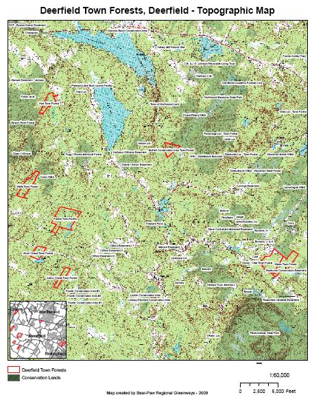
2 Draft, Dec. 24, 2009 DEERFIELD S NATURAL LEGACY TOWN FORESTS AND CONSERVATION AREAS Deerfield s Town Forests and Conservation Areas are treasures of natural beauty, homes for wildlife and places where townspeople can enjoy the outdoors. As owners of these public properties, citizens of Deerfield jointly enjoy them and share the responsibility for managing them. The Town Forests and Conservation Areas are found throughout town. Here is a brief description of each: Alvah Chase Town Forest This town forest, near Thurston Pond, was never surveyed and the Conservation Commission is presently investigating its boundaries. Arthur Chase Town Forest 40 acres This wooded Town Forest, located on an unpaved part of Ridge Rd, features mixed forest and two branches of Hartford Brook. It borders the beaver pond visible on Range Rd. and another at the back of the property. The north end of the property is flatter and the south end is hilly with an older forest with many older trees, including beech, which are important nut sources for wildlife. The land also includes a vernal pool that offers important breeding habitat for frogs and salamanders. This area of the property is designated in the forest management plan as a natural area, to be left undisturbed. Dowst-Cate Town Forest 100 acres The Dowst-Cate Town Forest was given to the town in 1983 by Gilbert Knowles, for use as a town forest and park. The town soon designated it a Town Forest at town meeting. The property has a fine mix of forest types, scenic floodplain wetlands along Back Creek and portions of a large complex of beaver ponds and other wetlands. The variety of habitats makes this property particularly important for wildlife conservation. The Dowst-Cate Town Forest also contains remains of a mill dam and old stone bridge abutment where Nottingham Road once crossed the brook. This Town Forest is linked to the Great Brook Conservation Area to the west (private lands protected with conservation easements.) Freese Town Forest 175 acres The Freese Town Forest with frontage on Mt. Delight Rd., was purchased by the town in At the same time, the land was permanently protected with a conservation easement administered by Bear-Paw Regional Greenways, a private, non-profit land trust. The property features especially significant water features, including several marshes, beaver ponds, and forested wetlands, most of which are far from roads, which protects their biological integrity. The Hartford Brook and several of its tributaries converge in the center of the property. This, combined with the location of this property within an unfragmented (by roads or development) forest block of over 8,000 acres, makes this property a very important one for wildlife. Hart Town Forest 72 acres This property on Griffin Rd. was given to the town by Lloyd Hart in Lloyd had lived on the land all his life and wanted the land to remain intact and managed by the town for conservation purposes. The land has mixed forest and includes the beaver dam at the outlet of the large wetland west of Griffin Rd. It abuts the Epsom Town Forest and is within the same forest block of over 8,000 acres as the Freese Town Forest.
3 Lindsay-Flanders Conservation Area 58 acres Located behind the Bicentennial Field and the Post Office, this town Conservation Area is the result of land donated to the town by Madeline Lindsay in 1974 and in the 1980s Lois Flanders. Shortly after, David and Karen Linden donated a 10 acre conservation easement to the town, to further protect the area. The land is mostly forested, with much white pine, but it also includes a beaver pond and part of Nichol s Brook. It supports a variety of wildlife and its location makes it an important community recreational asset. McNeil Conservation Area 65 acres The McNeil family gave the town the McNeil Conservation Area in 1968 in honor of Burton and Agnes McNeil. The property, on the Northwood town line on Blake s Hill Rd., is all wooded, with older oak in some sections and hemlock in the low areas near the Lamprey River, which runs just to the east of this Town Forest. This property is part of a connected and vast conservation area that includes the Peters Wildlife Management Area (owned by NH Fish and Game?? and abuts the McNeil CA), Northwood Meadows State Park and a Northwood Town Forest, magnifying its importance to the ecological health of the region. Weiss Town Forest 93 acres In 1998, Bernard and Annelou Weiss sold this parcel abutting the Dowst-Cate Town Forest to the town at a reduced price, wanting to see the land conserved under public ownership. This property shares some of the same important features as the Dowst-Cate Town Forest. For example, Back Creek and its associated wetlands span the parcel boundary between the two Town Forests as does a large beaver pond. In addition, The Dowst-Cate and Weiss Town Forests are functionally one unit and are treated that way for management purposes. Wells Town Forest 80 acres This Town Forest, located off Mt. Delight and Swamp Roads, is on the Epsom town line. It was heavily cut prior to town ownership several decades ago, and is mostly covered with young regrowing forest. An exception is some of the back and edges of the property, where older trees remain. The highlight of the Wells Town Forest is Pease Brook, which runs through the property s several open wetlands on it s way to the Suncook River. This Town Forest has no active road frontage and is not easily accessed.
4
5 Draft, Feb 4, 2010 CONSERVATION COMMISSION NEWS CONSERVATION OF DEERFIELD S TOWN FORESTS AND CONSERVATION AREAS - WHAT DOES IT MEAN? The Deerfield Conservation Commission and Select Board have introduced a warrant article for town voting on Tuesday, March 9, to gage public support for permanent conservation of seven Town Forest and Conservation Area properties (one was inadvertently omitted from the Town Deliberative Session article but, at that meeting, the article was amended to include the seventh property). The Conservation Commission advocates permanent conservation of these public lands, using conservation easements like those used to conserve many private lands in town. The newly acquired Freese Town Forest is currently the only town forest or conservation area in Deerfield protected with a conservation easement. Conservation easements would keep these lands as forests, wetlands and wildlands and protect their integrity over the long run. The lands could continue to be managed and used as they are today. What would change is their level of protection - from temporary to permanent. Here are some questions and answers about this project: Why would the town permanently conserve our Town Forests and Conservation Areas? The Deerfield Conservation Commission feels there are several reasons to take this action: - Our Town Forests and Conservation Areas are key parts of the town s network of conserved and publicly owned open space lands. - Deerfield s Town Forest properties were designated as such by town meeting votes with strong public support, but the designations could be reversed by future votes. - The fundamental purpose of establishing conservation easements for our Town Forests and Conservation Areas is to assure that these town forests and town conservation areas remain a permanent living legacy, so they continue to provide open space, productive forests, wildlife habitat, clean water and air and places people can visit for recreation, education or just peace, quiet and natural beauty. - Permanent conservation of Deerfield s Town Forests and Conservation Areas is consistent with the long-term view that land ownership and sustainable management requires and will allow us to protect their integrity over the long run. Have other towns done this? Other nearby towns that have public land protected by conservation easements include Candia, Epsom, Raymond and Strafford, A current project in Nottingham will add them to the list when completed. What are conservation easements and how do they work? According to the Society for the Protection of New Hampshire Forests, our state s largest land conservation group, A conservation easement deed is a permanent, legally binding agreement between a landowner and a qualified conservation organization or public agency that restricts use of the land to protect its significant natural features. In New Hampshire this is authorized by RSA 477: A conservation easement separates the rights to exercise more intensive uses such as commercial or residential construction, subdivision, and mining from other rights of ownership. These development rights are then effectively extinguished when a conservation easement is completed. A second party, a conservation organization (as qualified by the IRS) or public
6 agency becomes the easement holder. They are responsible for assuring through annual monitoring of the property that uses forbidden by the conservation easement do not occur on the property. Conservation easements apply to the land regardless of who may own it in the future. Land under a conservation easement continues to be managed by its owner. Typically, the land is used for forestry, wildlife habitat, scenic views, watershed protection, agriculture, recreation and education. Who would be responsible for administering and monitoring of the conservation easement? There are several options for easement holders for the Town Forest and Conservation Areas. The Conservation Commission will select a conservation partner for this project after considering the interest, experience and suitability of potential partner organizations. An easement holder must be a non-profit organization or public agency that has the conservation of land as its one of its purposes. It is unlikely that a public agency would be part of this project. Private non-profit groups that cover this region include Bear-Paw Regional Greenways, Southeast Land Trust of NH and the Society for the Protection of NH Forests. Will this cost the taxpayers? This project will have no impact on the tax rate and there will be no request for additional town funds to cover project costs. Because they are legal real estate transactions, there are costs associated with establishing conservation easements. They include surveying (if needed), legal aspects, title review and recording fees, professional staff time (easement holder) and, typically, a stewardship fee to the easement holder, used to support monitoring and administration of the conservation easement. The Conservation Commission intends to use the Conservation Fund to cover the cost of completing the technical steps needed to complete the conservation easements. The Conservation Fund is supplied by the Land Use Change Tax, paid by a landowner when land is taken out of an open space category under current use assessment and converted to a residential, commercial or industrial use. In addition to the Conservation Fund, grants may cover some of the costs. The cost of this project, then, will be covered by the tax on open space lands that were converted to other uses in Deerfield in recent years. What will happen if we don t conserve the Town Forests and Conservation Areas? In the short term, probably little or nothing would happen. The areas are well managed, and their designations and uses are supported by town leaders and citizens. The purpose of the conservation easements, however, is to assure the long term protection of the Town Forest and Conservation Areas. The conservation easements will ensure that the Town Forest and Conservation Areas will remain over time and that future generations will enjoy the land s full benefits as we have during our time here. Conservation easements will prevent the temptation to see the Town Forest and Conservation Areas as expendable and converted to other uses at some future time. What if we want the land for something else later? (Will the conservation easements limit the owner s future use of the properties?) Limiting future uses to open space activities is the purpose of a conservation easement. The current uses of the Town Forest and Conservation Areas, however, would not be affected because they are already within the range of land uses that would be allowable with a conservation easement in place. The lands could continue to be managed and used just as they are today.
7 What s the next step? Article 17 on the 2010 Town Warrant asks voters if they support permanent conservation of the Town Forest and Conservation Area properties. This is an advisory, non-binding article. The Conservation Commission and the Select Board included it in the Warrant to give citizens a chance to express themselves on this issue. Voting is on Tuesday, March 9 from 7 am to 7 pm at the Town Hall, 10 Church St. The Warrant article is on the Town web site at CopyPublish.pdf.
8 DEERFIELD S TOWN FORESTS and CONSERVATION AREAS TO BE PROTECTED FROM DEVELOPMENT FOREVER For many years, the Deerfield Conservation Commission (DCC) has had a goal of permanent protection of Town Forests and Conservation Areas. In 2008, the Town voted to purchase the Freese property on Mount Delight Road as a Town Forest. It was the first such Town property to be put in conservation easement, so that it never can be developed. In 2010, 76% of the voters supported the DCC and Select Board warrant article to permanently protect the other seven Town Forest/Conservation Area properties. DCC wants to assure these Town lands remain as open space, providing productive forests, wildlife habitat, clean water and air, and places people can visit for recreation, education or just peace, quiet and natural beauty forever. As owners of these public properties, citizens of Deerfield can continue to enjoy them and share the responsibility for management. The DCC will use the Conservation Fund and seek grants to cover the survey, legal, and monitoring costs of permanent protection using conservation easements, just like Freese Town Forest. No other Town funding has been or will be requested. Here s more information about Freese Town Forest and the seven additional Town properties that the DCC is working to put conservation easements on: Name Acreage/From Location Resources 175 acres, purchased in Mt. Delight Rd with conservation within forest block easement of over 8,000 acres Freese Town Forest Arthur Chase Town Forest Dowst-Cate Town Forest Hart Town Forest Lindsay- Flanders Conservation Area McNeil Conservation Area Weiss Town Forest 40 acres w/blazed foot trail by Eagle Scout 100 acres given by Gilbert Knowles in 1983, for use as a town forest and park. 72 acres given by lifetime resident Lloyd Hart in 1993; wanted it to remain intact & managed for conservation 58 acres donated by Madeline Lindsay in 1974; and Lois Flanders in 1980s. 65 acres given by McNeil in 1968 in honor of Burton and Agnes McNeil 93 acres sold at reduced price by Bernard and Annelou unpaved Ridge Rd off Range Nottingham Road Griffin Rd, within the same forest block of over 8,000 acres as the Freese Town Forest behind Bicentennial Field and the Post Office Blake s Hill Rd. Nottingham Rd wildlife; significant water features, marshes, beaver ponds, forested wetlands older beech nut forest; wildlife; vernal pool frog & salamander breeding fine mix of forests, scenic floodplain wetlands, large complex of beaver ponds; wildlife habitat mixed forest and beaver dam at the outlet of a large wetland Wildlife; location makes it an important community recreational asset. in vast conservation area of Peters WMA, Northwood Meadows State Park and Town Forest The Dowst-Cate and Weiss Town Forests are managed as one unit
9 Wells Town Forest Weiss in 1998, for public conservation 80 acres (no road frontage; not easily accessed) off Mt. Delight and Swamp Roads on Epsom town line Pease Brook, with several open wetlands. Next to NH Fish & Game Corey WMA. So, why is it important to permanently protect our Town Forests and Conservation Areas? The DCC believes that getting all Town properties into permanent conservation easement is important for Deerfield because: Our Town Forests and Conservation Areas are key parts of the town s network of conserved and publicly owned open space lands. The new Open Space Plan soon to be adopted by the Planning Board provides more information on this important green infrastructure. The many landowners who donated land or sold it to the Town at reduced price believed the land would remain in conservation for public use and benefit. Except for Freese Town Forest, no others currently are protected from future development. Deerfield s Town Forest properties were designated as such by town meeting votes with strong public support, but the designations could be reversed by future votes. Putting conservation easements on our Town Forests and Conservation Areas guarantees that these lands remain a permanent living legacy, providing open space, productive forests, wildlife habitat, clean water and air, and places people can visit for recreation, education or just peace, quiet and natural beauty. Permanent conservation of Deerfield s Town Forests and Conservation Areas allows the Town to protect their integrity by sustainable management over the long run. Have other towns done this? Other nearby towns that have public land protected by conservation easements include Candia, Epsom, Raymond and Strafford. Nottingham also is working on a project right now. What is conservation easement and how does it work? Most simply, a conservation easement removes the right to develop from other rights of land ownership. A qualified second party, such as a conservation organization or public agency becomes the easement holder. That party must inspect the property annually to be sure that only uses allowed by the conservation easement are happening on the land, and file a report. If any violation is found, the second party is responsible for ensuring that it is stopped or corrected. Conservation easements run with the land, regardless of who may own it in the future. The land continues to be managed by its owner, most often for forestry, wildlife habitat, scenic views, watershed protection, agriculture, recreation, and education. What if we want the land for something else later? (Will the conservation easements limit the Town s future use of the properties?) The purpose of a conservation easement is to keep land natural and undeveloped. These lands then can continue to be managed and used just as they are today. For more information, please contact any member of the Deerfield Conservation Commission. And thanks for your support.
10 have been paid during Town ownership. This conveyance is to correct an erroneous but inadvertent division of property that had been previously merged by the Deerfield Planning Board. A portion of the home and septic system located on Map 208 Lot 46 by the Anibals or their predecessors extends onto Lots 47.1 and Recommended by the Board of Selectmen 5-0 Article moved as written by Chairman Barry, seconded by Selectmen Reagan Selectman O Neal stated that the Warrant is self-explanatory and that the land should never have been split up. Seeing no discussion, the Moderator instructed the Clerk to place the Article on the ballot as written. Article 10 To see if the Town will vote, pursuant to RSA 231:45-a(I), to discontinue subject to gates and bars that portion of Swett Road, aka Sidmores Road, which is currently a Class V, Town maintained highway. Recommended by the Board of Selectmen 4-0 Article moved as written by Chairman Barry, seconded by Selectmen Reagan Chairman Barry stated that the road in question is really a driveway for two homes. The Highway agent has made the recommendation that we discontinue maintenance on this dirt road. The Board of selectmen have decided to bring this issue forward for the towns people to vote on the matter. There was much discussion as to how other roads in town have been discontinued by town votes in the past. Chairman Barry stated that per legal counsel they have the ability to continue with this practice. Seeing no discussion on the Article, the Moderator instructed the Clerk to place the Article on the ballot as written. Article 11 To see if the Town shall vote to convey conservation easements to one or more qualified conservation organizations for the following Town-owned Town Forests and Conservation Areas, which will permanently restrict their use to open space purposes, including wildlife habitat conservation, forestry, and recreation: Arthur Chase Town Forest Tax Map 414 Lot acres Dowst-Cate Town Forest Tax Map 416 Lot acres Hart Town Forest Tax Map 403 Lot 2 71 acres Lindsay Conservation Area Tax Map 415 Lot acres McNeil Conservation Area Tax Map 406 Lot acres Weiss Town Forest Tax Map 416 Lot acres Wells Town Forest Tax Map 411 Lot acres Recommended by the Board of Selectmen
11 Article moved as written by Chairman Barry, seconded by Selectmen Reagan Chairman Barry deferred the discussion to Conservation Commission Chair Serita Frey. Ms. Frey stated that this article is the same as last years article which received a 76% approval rating except that it is binding this year. The article will provide for a permanent conservation easement on the properties to protect them and make them open for recreation and wildlife habitation. Joanne Wasson stated she had an interest in several of the parcels but particularly in the Dowst-Cate Town Forest. She had been a member of the Select Board in 1993 when the town received this wonderful piece of land from a descendant of the family which had owned the land for two centuries. Why can we not as a town take care of the land? she asked. Why turn it over to organizations to manage and lose control? She gave the example of Bear Paw Regional Greenways, a private organization which, she claimed, would have the right to sell, exchange, lease or otherwise dispose of property they control. We should take care of it for ourselves, she concluded. The meeting, now far from over, spent the next hour and one-half debating her contentions and the powers and rights of the Select Board, Conservation Commission and third-party monitoring organizations. Erick Berglund of the Conservation Commission then spoke, saying there are many qualified organizations such as the Society for the Preservation of NH Forests or Audubon which could manage the forests in addition to Bear Paw. The management of the easements would go out to bid. He pointed out that the town would still own the forests and it was incorrect to say that land would leave town control. Select Board Chair Barry asked Erick Berglund if the Conservation Commission is qualified to monitor the easements. Erick Berglund said the Commission is not, as the members are volunteers and there are not funds budgeted to do it. MBC Chair Spillane countered that the town did not have to give up the easements (to a third-party monitor). He said the Conservation Commission is charged with protection and management of land and should not pass on town rights. Harriet Cady said she was appalled that people charged with conservation said they could not monitor the land. She suggested the Select Board appoint better people. She countered Frey s contention that there would be no additional costs to the town as the Conservation Fund receives one half of current use charges. She further stated that her reading of the bylaws of the potential monitoring groups gave them the right to sell conservation easement land and that if members of the Conservation Commission felt it was acceptable to pay money each year to a monitoring group for one inspection per year, the Select Board should appoint people who can do the job. She went on to say that some members of the Conservation Commission are also members of Bear Paw, which is a conflict of interest, and she was further appalled that the town would turn over land for our children's future to an out-of-town organization. She finished by saying she wanted an amendment to have the Select Board do their duty and oversee the easements, although she did not have specific wording for the amendment. Selectman Robertson said he felt the discussion was getting emotional and personal and that third-party conservation organizations typically have been used by the town. He added that there seemed to be some confusion about ownership and conveyance. The intent of the Article, he explained, was to conserve the land which is already owned by the town, and which Harriet Cady now wants to convey to the Select Board as representatives of the town. This would have the effect of the town monitoring itself. 14
12 Chairman Barry stated that the Select Board had received thousands of dollars of legal advice about the Article. Town counsel had been involved in wording Article Eleven which was attempting to establish conservation easements on land already owned by the town. Harriet Cady then contended that other town easements had been deeded to Bear Paw which could then sell or lease the land. Chairman Barry responded that the Board did not agree with Harriet Cady s interpretation. She later reiterated that she had seen the deeds which conveyed the easements. John Dubiansky asked if residents, by voting no, would accomplish Cady s goal as there would be no outside management. Chairman Barry agreed that it would eliminate the third party, but it would also mean there would be no conservation easements on the forests, thus allowing the town to change the use or sell the properties. Sandra Fox stated that she feels that the discrepancy between the Board s interpretation and Harriet Cady s interpretation of a third-party s right to deed away easements should be investigated and the Board should admit their mistake when found to be wrong. Robertson explained that deeds do exist, as conservation easements involving two or more parties are recorded at the Registry of Deeds. A discussion of the Clifford Property, upon which a conservation easement had been purchased by the town, ensued. It did not serve to clarify the issue. Moderator Hutchinson then announced that he was ruling Harriet Cady s amendment out of order as the town cannot hold an easement on itself. He did remind those in attendance that the body could vote to overrule the Moderator. The body chose not to do so. Seeing no further discussion on the article, the Moderator instructed the Clerk to place the Article on the ballot as written. Respectfully submitted Kevin J. Barry Town Clerk 15
13 Please return to: Bear-Paw Regional Greenways P.O. Box 19 Deerfield, NH CONSERVATION EASEMENT DEED Town of Deerfield, a municipal corporation situated in the County of Rockingham and State of New Hampshire, with a mailing address 8 Raymond Road, Town of Deerfield, County of Rockingham, State of New Hampshire (hereinafter referred to as the Grantor ), for consideration paid, with quitclaim covenants, grants in perpetuity to Bear-Paw Regional Greenways, a New Hampshire not-for-profit corporation, situated in the County of Rockingham, State of New Hampshire, with a mailing address of Post Office Box 19, Deerfield, New Hampshire (hereinafter referred to as the Grantee, which shall, unless the context clearly indicates otherwise, include the Grantee's successors and assigns), a conservation easement (referred to as the "Easement") encumbering the following tracts of land: the Arthur Chase Town Forest, the Dowst-Cate Town Forest and Park, the Hart Town Forest, the Lindsay/Flanders Conservation Area, the Agnes B. McNeil Conservation Area, the Weiss Town Forest, and the Wells Town Forest (referred to collectively as the "Property" or Properties ), all located in the Town of Deerfield, and more particularly bounded and described in Appendix A. 1. CONSERVATION PURPOSES The Easement hereby granted is pursuant to NH RSA 477:45-47, exclusively for the following conservation purposes (referred to as Purposes ) for the public benefit: A. The protection of natural plant and wildlife habitat and natural communities and systems found on the Property and as referenced in the New Hampshire Wildlife Action Plan; B. The fostering of a healthy and sustaining forestland whose continued management is according to current and widely accepted scientific and ecological knowledge and practices as embodied in the publication Good Forestry in the Granite State: Recommended Voluntary Forest Management Practices for New Hampshire (Karen P. Bennett, editor Second Edition, University of New Hampshire Cooperative Extension) or its successor publications. C. The preservation of the quantity and quality of groundwater and surface water resources on and under the Property; 1
14 D. The prevention of any use or activity on the Property which would be detrimental to drainage, flood control, water conservation, water quality, soil stability or erosion control, carbon sequestration, or the unique and significant qualities of public benefit and the conservation and preservation values of the Property; E. The protection of land within contiguous blocks of unfragmented land; F. The scenic enjoyment of the general public, including undeveloped road frontage on Blake s Hill, Candia, Cole, Griffin, Mount Delight, Nottingham, Raymond, and Ridge Roads; G. The preservation of the Property for outdoor educational or recreational use by the general public. The above Purposes are consistent with New Hampshire RSA Chapter 79-A:1, which states: It is hereby declared to be in the public interest to encourage the preservation of open space, thus providing a healthful and attractive outdoor environment for work and recreation of the state's citizens, maintaining the character of the state's landscape, and conserving the land, water, forest, agricultural and wildlife resources. The above Purposes are also consistent with the clearly delineated open space conservation goals as stated in the 2009 Master Plan of the Town of Deerfield, as well as the 2010 Deerfield Open Space chapter of the Master Plan, and the Deerfield Conservation Commission 2009 Strategic Plan that prioritized creating conservation easements for all Town forests. The above Purposes and the characteristics of the Property are also consistent with the conservation goals of the Grantee, including: the protection of land within large contiguous blocks of unfragmented forest; the protection of forestland; the protection of surface waters, groundwater and wetlands; and the protection of habitat for native plant and animal species. A baseline documentation report on file with the Grantee inventories the conservation attributes of the Property that support these conservation purposes. 2. PROPERTY STEWARDSHIP A. The Grantor has full responsibility for managing the Property in accordance with the limitations imposed by and rights reserved under this Easement. No activity or use shall be undertaken in a manner that is not consistent with the Purposes and conservation goals of this Easement as outlined in Section 1. 2
15 B. Activities on the Property shall be performed in accordance with a written Management Plan approved by the Grantee, with the long-term protection of the above-described Purposes for which this Easement is granted, and prepared by a natural resources professional (a forester licensed by the State of New Hampshire, a certified wildlife biologist, or by another similarly qualified person approved in writing by the Grantee). A Management Plan shall be consistent with the following goals: Maintenance of soil productivity; Protection of water quality, wetlands and riparian areas; Maintenance or enhancement of wildlife habitat; Maintenance of a healthy and sustaining forestland through prudent forest management; Maintenance or enhancement of the overall quality of forest products; Conservation of native plant and animal species and natural communities Protection of unique or fragile natural areas; Protection of unique historic or cultural features; and Maintenance or enhancement of scenic quality. C. The Management Plan shall include: A summary of the Town s management objectives consistent with the Purposes for which this Easement is granted and the goals specified in Section 1 above; Property-specific management goals and objectives, for any activities allowed on the Property, developed in cooperation with the Grantor represented by the Conservation Commission; A boundary map with access roads and natural land cover types; A description of the natural features of the Property, including land cover, topography, geology, soils, wetlands, streams and ponds, and wildlife habitat features; Identification of plant and wildlife species and natural communities of conservation concern; Recommended management practices for any activity allowed on the Property; Property-specific commercial forest management and timber harvesting plans and proposed activities; Identification of how specific management practices shall enhance or avoid detrimental impacts to said plants, wildlife, and natural communities; Recommended schedule for implementation and inspection of management practices. D. For commercial forestry, the Management Plan shall have been prepared not more than ten (10) years prior to the date that any related management activities are expected to commence or shall have been reviewed and updated to specifically describe activities and management practices at least thirty (30) days prior to said date. i. At least thirty (30) days prior to the commencement of timber harvesting activities, the Grantor shall submit a written certification to the Grantee that a forest management plan has been prepared in compliance with the terms of this Easement (prepared as part of the Management Plan or separately). This certification shall be signed by a licensed professional 3
16 forester or other qualified person approved in advance and in writing by the Grantee. The Grantee may request the Grantor to submit the forest management plan itself to the Grantee for the Grantee s approval within ten (10) days of such request, but acknowledges that the forest management plan s purpose is to guide forestry activities in compliance with this Easement and that the actual activities on the Property will determine compliance therewith. ii. Forestry shall be supervised by a licensed professional forester or other qualified person approved in advance and in writing by the Grantee. iii. Forestry shall be carried out in accordance with all applicable local, state, and federal laws and regulations. iv. Forestry shall be carried out in accordance with the recommendations contained in Good Forestry in the Granite State: Recommended Voluntary Forest Management Practices for New Hampshire (Karen P. Bennett, editor. 2010, Second Edition, University of New Hampshire Cooperative Extension) or its successor publications. 3. USE LIMITATIONS The following Property use limitations are specified, with the exception of the Reserved Rights as specified in Section 4: A. The Property shall be maintained in perpetuity as open space without any industrial or commercial activities, except forestry, being conducted thereon. B. No Subdivision: None of the seven tracts (see Appendix A) shall be subdivided; however, the tracts described in the Appendix may be conveyed separately by the Grantor. C. No Structures or Improvements: No structures or improvements, including, but not limited to a dwelling (permanent, seasonal or temporary), any portion of a septic system, tennis court, swimming pool, dock, aircraft landing strip, telecommunications and/or wireless communications facility, tower, windmill, or mobile home, shall be constructed, placed, or introduced onto the Property, except as specified in Section 4. D. No Disturbance: No removal, filling or other disturbances of the soil surface, nor any changes in topography, surface or subsurface water systems, wetlands, or natural habitat shall be allowed, except as incidental to forestry or other activities addressed in the Management Plan. E. No motorized vehicles. F. No Advertising: No outdoor advertising structures such as signs and billboards shall be displayed on the Property. 4
17 G. No Mining: No mining, quarrying, excavation, or removal of rocks, minerals, gravel, sand, topsoil, water, or other similar materials from the Property. H. No Hazardous Materials: No dumping, injection, burning, or burial of manmade materials or materials known to be environmentally hazardous. I. No Roads: Except those of record, and as otherwise allowed within this Easement, there shall be no rights-of-way, easements of ingress or egress, driveways or roads constructed or developed into, on, over, under, or across the Property, except as specified in Section RESERVED RIGHTS The reserved rights below, if exercised, shall be consistent with the Purposes and Property Stewardship responsibilities of this easement. A. Non-commercial Forest Management: The Grantor reserves the right to conduct noncommercial forest management activities on the Property without prior notice to or the written approval of the Grantee for the improvement of the forest, wildlife habitat, or outdoor educational/recreational resources of the Property. Such activities shall be consistent with the Management Plan and supervised by a licensed professional forester, a certified wildlife biologist, or other qualified person approved in advance and in writing by the Grantee. B. Access Roads and Landings: The Grantor reserves the right to construct access roads, landings, or other access ways to allow uses permitted by this Easement. Such activity shall be described in detail in the Management Plan as outlined in Section 2 and shall be consistent with the Purposes and Goals of this Easement. Such activities shall be supervised by a licensed professional forester, a certified wildlife biologist, or other qualified person approved in advance and in writing by the Grantee. C. Education and recreational activities: The Grantor reserves the right to use the Property for non-commercial, low-impact, outdoor educational and recreational purposes, including the right to clear, construct and maintain trails for walking, nature observation, cross-country skiing, and other non-intensive outdoor educational or recreational activities. Such activities shall be consistent with the Management Plan and supervised by a licensed professional forester, a certified wildlife biologist, or other qualified person approved in advance and in writing by the Grantee. D. Trails: Trails may be cleared, constructed, and maintained, provided these trails are consistent with the Purposes of this Easement, conform to best practices recommended by the Appalachian Mountain Club or similar trail-maintaining organization (for reference, see The Complete Guide to Trail Building and Maintenance, C. Demrow, D. Salisbury, Appalachian Mountain Club, or similar successor publication), and are constructed and maintained consistent with requirements of the Management Plan. Trail making and management activities shall be carried out in accordance with all applicable local, state and 5
18 federal laws and regulations, and in accordance with current, generally accepted best management practices for the sites, soils and terrain of the Property. Trail design and construction shall be supervised by a licensed professional forester, a certified wildlife biologist, or other qualified person approved in advance and in writing by the Grantee. E. Parking Areas: The Grantor reserves the right to make, construct, maintain, repair, replace and relocate, at the Grantor s sole expense, a single parking area on each tract described in Appendix A within 250 feet of the public road on which it fronts, with a maximum surface area, excluding access driveway thereto, of 3,000 square feet in size, which shall consist of permeable surface and shall be constructed with the minimum disturbance necessary. Actual size of the parking area will be determined by agreement between Grantor and Grantee. In the case of Wells Town Forest, which has no road frontage, the parking area must be within 250 feet of the Wells Town Forest boundary line across which access will be made. Design principles and construction activities for each parking area must demonstrate stewardship for the conservation attributes and natural resources present on the affected tract. F. Structures: The Grantor reserves the right to construct and maintain a kiosk or similar structure, in the vicinity of the parking area for each tract intended to further the accomplishment of the outdoor educational or recreational uses of the Property, provided that the footprint of the structure is no larger than 100 square feet and its construction and required maintenance is consistent with the Purposes of this Easement. The Grantor also reserves the right to construct forest access structures such as gates or stream crossings (e.g., culverts and bridges), as necessary in the accomplishment of the forestry, conservation, habitat management, or non-commercial outdoor recreational uses of the Property, consistent with the Management Plan, and provided that they are consistent with the Purposes of this Easement.. The design principles and construction of each structure must demonstrate stewardship for the conservation attributes and natural resources present on the affected tract. Such activities shall be supervised by a licensed professional forester, a certified wildlife biologist, or other qualified person approved in advance and in writing by the Grantee. G. Vehicles: The Grantor reserves the right to use motorized, wheeled vehicles to conduct activities on the Property consistent with the required Management Plan outlined above; to allow access by persons with disabilities for activities consistent with the outdoor educational and recreational uses outlined in this easement; and to conduct activities related to the exercise of public safety by the police or other emergency personnel. H. Posting: The Grantor reserves the right to post against vehicles, motorized or otherwise, and against access to forest land during timber harvesting or if required to prevent any use of or activity on the Property which is inconsistent with the Purposes of this Easement. I. Scientific research: The Grantor reserves the right to have scientific activities conducted on the Property, including sample removal (e.g., vegetation, soil) and the installation of scientific equipment, following submission of a research plan to, and its approval in writing by, the Deerfield Conservation Commission. Any such scientific investigations shall be 6
19 conducted by qualified individuals and will be conducted in a manner that is consistent with the Purposes of this Easement. J. Fees for use or service: The Grantor reserves the right to charge reasonable fees for use or services provided to cover the costs of said use or service. NOTE: These provisions may be exceptions to the Use Limitations set forth in Section 3 above. 5. STEWARDSHIP RESPONSIBILITIES OF THE GRANTEE To facilitate the fulfillment of its responsibilities under this Easement, the Grantee shall be responsible for the following (which shall include, but not be limited to): A. Provide an annual on-ground monitoring inspection that confirms that the interests acquired are being protected and maintained according to the terms of the Conservation Easement; B. Prepare an annual monitoring report which shall contain the following: i. Description of the inspection conducted; ii. Description of the nature and source of any physical changes to the Property; iii. Description of any contacts made with Grantor; iv. Description of any conditions or activities found on the Property; v. Explanation of the current status of any previously identified violations and any remedial steps taken; and vi. Any steps to be taken by Grantor to bring Property into compliance with the terms of the Conservation Easement (if necessary). C. Upon any sale of the Property, or any portion thereof, the Grantee shall contact the successor Grantor and inform them of the provisions of this Conservation Easement. The foregoing conveyance is made subject to all rights, easements, restrictions, encumbrances and other matters of record, to the extent in force and applicable, including, without limitation, (i) current use taxation, (ii) matters of record in the Rockingham County Registry of Deeds, and (iii) matters shown on the Plans recorded in the Rockingham County Registry of Deeds. The transfer of this easement by the Town of Deerfield was approved at the Town Meeting held on March 8, The Grantee, by accepting and recording this Easement, agrees to be bound by and to observe and enforce the provisions hereof and assumes the rights and responsibilities herein granted to and incumbent upon the Grantee, all in the furtherance of the conservation purposes for which this Easement is delivered. 7
20 6. DISCRETIONARY CONSENT A. The Grantee s consent for activities otherwise prohibited herein may be given under the following conditions and circumstances: If, owing to unforeseen or changed circumstances, any proposed activity is deemed desirable by the Grantor and the Grantee, the Grantee may give permission for such activities, subject to the limitations herein. Such requests for permission shall be in writing and shall describe the proposed activity in sufficient detail to allow the Grantee to judge the consistency of the proposed activity with the purposes of this Easement. The Grantee may give its permission only if it determines that such activities (i) do not violate the Purposes and Stewardship Responsibilities of this Easement and (ii) either enhance or do not impair any significant conservation interests associated with the Property. Such consent may not be unreasonably withheld or delayed. B. Notwithstanding the foregoing, the Grantor and the Grantee shall have no right or power to agree to any activities that would result in the termination of this Easement or to allow any structures or activities not provided for above. 7. ADDITIONAL EASEMENT Should the Grantor determine that the expressed purposes of this Easement could better be effectuated by the conveyance of an additional easement, the Grantor may execute an additional instrument to that effect, provided that the Conservation Purposes of this Easement are not diminished thereby and that a public agency or qualified organization described in Section 8.B.i. above, accepts and records the additional easement. 8. AMENDMENT If, owing to unforeseen or changed circumstances, Grantor and Grantee agree that an amendment to, or modification of, this Easement would be appropriate and desirable, Grantor and Grantee may jointly amend this Easement. Any amendment shall be consistent with: (a) the Purposes of this Easement; (b) the provisions and limitations of this section; (c) the current amendment policies of the Grantee; and (d) any applicable state or federal law. Any amendment shall not impair the conservation attributes of the Property protected by this Easement. Any amendment shall be executed by both the Grantor and the Grantee, and shall be recorded in the Rockingham County Registry of Deeds. Nothing in this paragraph shall require Grantor or Grantee to agree to any amendment or to consult or negotiate regarding any amendment. 9. ADMINISTRATION A. Notification of Transfer, Taxes, Maintenance i. The Grantor agrees to notify the Grantee in writing no later than ten (10) days before the transfer of title to the Property, or any portion thereof. 8
CONSERVATION EASEMENT DEED
 Return to: CONSERVATION EASEMENT DEED (Riparian Buffer/Wildlife Habitat Model) WHEREAS,, with a mailing address of (hereinafter referred to as the Grantor, which word where the context requires includes
THIS DECLARATION OF RESTRICTIVE COVENANTS is made this day of, 20, by ("Covenantor"). RECITALS
. RECITALS") Model for Use with Permits Without Mitigation Plans STATE OF COUNTY OF DECLARATION OF RESTRICTIVE COVENANTS THIS DECLARATION OF RESTRICTIVE COVENANTS is made this day of, 20, by ("Covenantor"). RECITALS
Model for Use with Permits Without Mitigation Plans STATE OF COUNTY OF DECLARATION OF RESTRICTIVE COVENANTS THIS DECLARATION OF RESTRICTIVE COVENANTS is made this day of, 20, by ("Covenantor"). RECITALS
WEST VIRGINIA DIVISION OF FORESTRY Cooperative Forest Legacy Program. Sample Conservation Easement
 WEST VIRGINIA DIVISION OF FORESTRY Cooperative Forest Legacy Program Sample Conservation Easement This document is included in the forest legacy kit as an example for information and possible guidance
Stormwater Ordinance Appendix APPENDIX K EXAMPLE TAR-PAM CONVERSATION EASEMENT
 APPENDIX K EXAMPLE TAR-PAM CONVERSATION EASEMENT Tax Parcel ID # NORTH CAROLINA FRANKLIN COUNTY CONSERVATION EASEMENT Franklin County, North Carolina THIS CONSERVATION EASEMENT (this "Conservation Easement")
Submittal of the Minutes from the March 9, 2011, April 5, 2011, and April 19, 2011 Cabinet Meetings.
 AGENDA BOARD OF TRUSTEES OF THE INTERNAL IMPROVEMENT TRUST FUND JUNE 16, 2011 Attachments to the items below can be viewed at the following link: http://www.dep.state.fl.us/secretary/cab/public_notices.htm
CITY OF FORT COLLINS NATURAL AREAS AND CONSERVED LANDS EASEMENT POLICY
 CITY OF FORT COLLINS NATURAL AREAS AND CONSERVED LANDS EASEMENT POLICY Adopted January 3, 2012 PURPOSE: The purpose of the policy statement is to clarify the policies and procedures of the City of Fort
DEED TO DEVELOPMENT RIGHTS CONSERVATION RESTRICTIONS
 DOC s 00000246 Bk5 319 Pss 29 DEED TO DEVELOPMENT RIGHTS A N D CONSERVATION RESTRICTIONS THIS WARRANTY DEED made this day of ^XP/'f ( 2018, by and between CATHERINE CONTE, hereinafter referred to as the
MODEL DEED RESTRICTION FOR THE PENNSYLVANIA STATE PROGRAMMATIC GENERAL PERMIT-3 (PASPGP-3) DECLARATION OF RESTRICTIVE COVENANTS FOR CONSERVATION
 DECLARATION OF RESTRICTIVE COVENANTS FOR CONSERVATION") MODEL DEED RESTRICTION FOR THE PENNSYLVANIA STATE PROGRAMMATIC GENERAL PERMIT-3 (PASPGP-3) DECLARATION OF RESTRICTIVE COVENANTS FOR CONSERVATION THIS DECLARATION OF RESTRICTIVE COVENANTS FOR CONSERVATION
MODEL DEED RESTRICTION FOR THE PENNSYLVANIA STATE PROGRAMMATIC GENERAL PERMIT-3 (PASPGP-3) DECLARATION OF RESTRICTIVE COVENANTS FOR CONSERVATION THIS DECLARATION OF RESTRICTIVE COVENANTS FOR CONSERVATION
Climate Change and Conservation Easement Clause Databank
 Photograph by Alice Kubler of the Archer Taylor Preserve Climate Change and Conservation Easement Clause Databank (May 15, 2009, last edited June 3, 2009) This Databank is a work in progress assembled
GRANT OF TRAIL ACCESS EASEMENT, COVENANTS AND RESTRICTIONS
 This is a sample easement provided for discussion and illustrative purposes only. Easements for each property will be customized based upon the needs of each landowner and the Path. GRANT OF TRAIL ACCESS
DECLARATION OF RESTRICTIVE COVENANTS
 STATE OF MARYLAND COUNTY OF DECLARATION OF RESTRICTIVE COVENANTS THIS DECLARATION OF RESTRICTIVE COVENANTS is made this day of, 20, by ( Declarant(s) ). RECITALS WHEREAS, Declarant(s) is/are the owner(s)
RECITALS. B. WHEREAS, Ranch, its successors and assigns, are referred to in the Easement as the Grantor ; and
 Basic Components of Management Plans Associated with Conservation Easement Acquisitions Where A Land Trust Or other third party Is the Grantee April 17, 2012 Key: Text in normal font, without highlight,
Some Points Re Perpetuity - Code and Regulations
 College of William & Mary Law School William & Mary Law School Scholarship Repository William & Mary Annual Tax Conference Conferences, Events, and Lectures 2010 Some Points Re Perpetuity - Code and Regulations
Draft Zoning Changes for the 2nd Planning Board Public Hearing, January 22, 2018.
 Draft Zoning Changes for the 2nd Planning Board Public Hearing, January 22, 2018. No changes were made at the 1st Public Hearing. Proposed wording for the 1 st Public Hearing in red, eliminated text in
Central Pennsylvania Conservancy Project Selection Criteria Form
 Central Pennsylvania Conservancy Project Selection Criteria Form The following criteria guide the actions of the Central Pennsylvania Conservancy s Land Protection Committee and Board of Directors in selecting
APPLICATION FOR SUBDIVISION APPROVAL OF A SKETCH PLAN with checklist
 Prior to filing any application for SUBDIVISION approval, the applicant shall request in writing that the zoning administrator schedule a pre-submission conference. APPLICATION TO THE PLANNING BOARD TOWN
CONSERVATION EASEMENT INCLUDING MITIGATION
 After recording return to: GRANTOR: GRANTEE: GRANTEE (Trustee): LEGAL DESCRIPTION: TAX PARCEL I.D. #: REFERENCE # s: WHATCOM COUNTY N/A CONSERVATION EASEMENT INCLUDING MITIGATION This grant of a conservation
DEERFIELD CONSERVATION COMMISSION FIFTY YEARS AND COUNTING Meeting Minutes & Public Hearing March 12, 2018
 Members Present: Haley Andreozzi, Erick Berglund, Kate Hartnett, Ben Minerd Members Absent: Serita Frey, Wes Golomb Guests: Dan Kern Hearing Attendees: Jeanne Menard, Irene Cruikshank, Helen (Holly) Tomilson,
IRS FORM 8283 SUPPLEMENTAL STATEMENT DONATION OF CONSERVATION EASEMENT
 Name(s) shown on income tax return Identifying Number Robert T. Landowner 021-34-1234 Susan B. Landowner 083-23-5555 IRS FORM 8283 SUPPLEMENTAL STATEMENT DONATION OF CONSERVATION EASEMENT On November 12,
HIGHLANDS TRANSFER OF DEVELOPMENT RIGHTS PROGRAM DEED OF EASEMENT (For Non-Agricultural Property with Bonus Highlands Development Credit Allocation)
") SAMPLE DRAFT EASEMENT PREPARED BY Signature Typed or Printed Name HIGHLANDS TRANSFER OF DEVELOPMENT RIGHTS PROGRAM DEED OF EASEMENT (For Non-Agricultural Property with Bonus Highlands Development Credit
SAMPLE DRAFT EASEMENT PREPARED BY Signature Typed or Printed Name HIGHLANDS TRANSFER OF DEVELOPMENT RIGHTS PROGRAM DEED OF EASEMENT (For Non-Agricultural Property with Bonus Highlands Development Credit
About Conservation Easements
 Section Three: Farm Transfer Tools About Conservation Easements Editor s note: One question that our education collaborative has fielded consistently throughout the years is about conservation easements.
GeorGe F. Frame, CF easement steward
 George F. Frame, CF Easement Steward A Forester sguide to conservation ease- Table of Contents Introduction 1 Part 1: The Basics 2 What is a conservation easement? 2 Do Easements allow forest management?
Georgia Conservation Tax Credit Program Frequently Asked Questions
 Georgia Conservation Tax Credit Program Frequently Asked Questions What are the minimum requirements for eligibility under the Georgia Conservation Tax Credit Program (GCTCP)? Individual and corporate
Conservation Easement Donations
 Landowner Information Series: Conservation Easement Donations Conservation Easement Donations Thousands of acres of farm and forestland that contribute to the unique, rural character of Vermont have been
Interpretation of Conservation Purpose INTERNAL REVENUE GUIDANCE AS TO WHAT CONSTITUES A CONSERVATION PURPOSE
 Interpretation of Conservation Purpose INTERNAL REVENUE GUIDANCE AS TO WHAT CONSTITUES A CONSERVATION PURPOSE 170(h)(4)(A) of Title 26, Internal Revenue Code, Subtitle A of the United States Code gives
Town of Lisbon, Maine SUBDIVISION REVIEW APPLICATION
 Date Received: Fee Paid (amount): Applicant: Town of Lisbon, Maine SUBDIVISION REVIEW APPLICATION Subdivision Name/Title: This application must be received at the Town Office by close of business on the
THIS DEED OF CONSERVATION EASEMENT
 NOTICE TO TITLE EXAMINERS: THIS DEED OF CONSERVATION EASEMENT CONTAINS COVENANTS THAT INCLUDE RESTRICTIONS ON THE USE, SUBDIVISION AND OFF-CONVEYANCE OF LAND. THIS DEED OF CONSERVATION EASEMENT ("Conservation
County of Sonoma Agenda Item Summary Report
 Revision No. 20170501-1 County of Sonoma Agenda Item Summary Report Agenda Item Number: 4 (This Section for use by Clerk of the Board Only.) Clerk of the Board 575 Administration Drive Santa Rosa, CA 95403
WARRANTY DEED With Conservation Restrictions
 WARRANTY DEED With Conservation Restrictions KNOW ALL PERSONS BY THESE PRESENTS, that FRYE ISLAND, INC., a Maine corporation, for consideration paid, GRANTS TO the TOWN OF FRYE ISLAND, MAINE, a Maine municipal
Conservation Easement Stewardship
 Conservation Easements are effective tools to preserve significant natural, historical or cultural resources. Conservation Easement Stewardship Level of Service Standards March 2013 The mission of the
THIRD AMENDED DECLARATION OF COVENANTS, CONDITIONS AND RESTRICTIONS FOR TIMBER RIDGE
 THIRD AMENDED DECLARATION OF COVENANTS, CONDITIONS AND RESTRICTIONS FOR TIMBER RIDGE THE STATE OF TEXAS KNOW ALL MEN BY THESE PRESENTS: COUNTY OF BURNET WHEREAS, TIMBER RIDGE is an unrecorded subdivision
Forested Buffer Water Resource Easement Carroll County, Maryland
 Forested Buffer Water Resource Easement Carroll County, Maryland FORESTED BUFFER WATER RESOURCE EASEMENT THIS DEED OF EASEMENT, made this day of, in the year nineteen hundred and ninety-five, by and between,
DEED OF EASEMENT STATE OF NEW JERSEY AGRICULTURE RETENTION AND DEVELOPMENT PROGRAM. This Deed is made, 20. BETWEEN, and is referred to as the Grantor;
 DEED OF EASEMENT E3E Page 1 of 7 STATE OF NEW JERSEY AGRICULTURE RETENTION AND DEVELOPMENT PROGRAM This Deed is made, 20 BETWEEN whose address is, and is referred to as the Grantor; AND the State Agriculture
WESTERLY MUNICIPAL LAND TRUST RULES AND REGULATIONS
 Trustees; Les Crandall, Chairman James Federico III Giorgio Gencarelli Gail Mallard, Secretary Nancy Martin Lise Mayers Richard Silva WESTERLY MUNICIPAL LAND TRUST WESTERLY MUNICIPAL LAND TRUST RULES AND
PENINSULA TOWNSHIP DONATION of DEVELOPMENT RIGHTS ORDINANCE (DDR, No. 45)
") PENINSULA TOWNSHIP DONATION of DEVELOPMENT RIGHTS ORDINANCE (DDR, No. 45) THE TOWNSHIP OF PENINSULA, GRAND TRAVERSE COUNTY, MICHIGAN ORDAINS: Section 101 General Provisions A. Title: This Ordinance shall
PENINSULA TOWNSHIP DONATION of DEVELOPMENT RIGHTS ORDINANCE (DDR, No. 45) THE TOWNSHIP OF PENINSULA, GRAND TRAVERSE COUNTY, MICHIGAN ORDAINS: Section 101 General Provisions A. Title: This Ordinance shall
OPEN SPACE & RECREATION PLAN
 OPEN SPACE & RECREATION PLAN HOPEWELL TOWNSHIP Cumberland County, New Jersey Prepared by: Hopewell Township Environmental Commission Final October 2011 (THIS PAGE INTENTIONALLY LEFT BLANK) PUBLIC MEETINGS
GRANT OF CONSERVATION EASEMENT
 Prepared by: Return to: Mississippi Land Trust Mississippi Land Trust Attn: Brian W. Ballinger Attn: Brian W. Ballinger Post Office Box 23 Post Office Box 23 Stoneville, MS 38776 Stoneville, MS 38776 (662)
Staying Connected in the Northern Appalachians
 Staying Connected in the Northern Appalachians Potential Conservation Easement Provisions Designed to Explicitly Address Connectivity in the Northern Appalachians Updated and Revised May 2012 In this document,
PROJECT SCORING GUIDANCE. Introduction: National Proiect Selection:
 FOREST LEGACY PROGRAM PROJECT SCORING GUIDANCE Introduction: This document provides guidance to the National Review Panel on how to score individual Forest Legacy Program (FLP) projects, including additional
RYE CONSERVATION COMMISSION TRAIL MANAGEMENT SUBCOMMITTEE Monday, April 25, :00 p.m. Rye Town Hall
 RYE CONSERVATION COMMISSION TRAIL MANAGEMENT SUBCOMMITTEE Monday, April 25, 2016 4:00 p.m. Rye Town Hall Members Present: Chairman Mike Garvan, Susan Shepcaro, Shawn Joyce and Ritchie White I. CALL TO
DEED OF EASEMENT STATE OF NEW JERSEY AGRICULTURE RETENTION AND DEVELOPMENT PROGRAM. BETWEEN, whose address is and is referred to as the Grantor;
 Page 1 of 8 E3-E DEED OF EASEMENT STATE OF NEW JERSEY AGRICULTURE RETENTION AND DEVELOPMENT PROGRAM This Deed is made, 20. BETWEEN, whose address is and is referred to as the Grantor; AND, whose address
Your Land. Your Legacy.
 Your Land. Your Legacy. Protect Your Land with a Conservation Easement Conserving our land and water resources; making an environmentally healthy and economically prosperous region; and creating a high
GRANT OF CONSERVATION RESTRICTION (Wetland Mitigation/Riparian Zone Mitigation) WITNESSETH:
 WITNESSETH:") NJDEP File No.: Prepared by: GRANT OF CONSERVATION RESTRICTION (Wetland Mitigation/Riparian Zone Mitigation) THIS GRANT OF CONSERVATION RESTRICTION is made this day of 20, by, its heirs, successors and
NJDEP File No.: Prepared by: GRANT OF CONSERVATION RESTRICTION (Wetland Mitigation/Riparian Zone Mitigation) THIS GRANT OF CONSERVATION RESTRICTION is made this day of 20, by, its heirs, successors and
AMENDED DEED OF CONSERVATION EASEMENT
 Prepared by: Wayne E. Flowers Lewis, Longman & Walker, P.A. 245 Riverside Ave. Suite 150 Jacksonville, FL 32202 Return recorded original to: Mitigation Marketing 1091 W. Morse Blvd. Suite 101 Winter Park,
Chapter VIII. Conservation Easements: Valuing Property Subject to a Qualified Conservation Contribution
 A. Overview and Purpose Chap. VIII Conservation Easements: Valuing... Jacobson & Becker 91 Chapter VIII Conservation Easements: Valuing Property Subject to a Qualified Conservation Contribution Forest
DRAFT FORM OF EASEMENT-PARCEL 3
 DRAFT FORM OF EASEMENT-PARCEL 3 GRANT OF CONSERVATION EASEMENT AND DEVELOPMENT RESTRICTIONS WHEREAS, Moose Mountain Forestry, LLC, a Vermont limited liability company ("MMF") with its principal place of
TRANSFER OF DEVELOPMENT RIGHTS CONSERVATION EASEMENT
 After Recording Return to: Kitsap County Department of Community Development TDR Program Manager 614 Division St., MS-36 Port Orchard, Washington 98366 TRANSFER OF DEVELOPMENT RIGHTS CONSERVATION EASEMENT
APPLICATION PROCEDURE
 ANTRIM PLANNING BOARD P. O. Box 517 Antrim, New Hampshire 03440 Phone: 603-588-6785 FAX: 603-588-2969 APPLICATION FORM AND CHECKLIST FOR MINOR OR MAJOR SITE PLAN REVIEW File Date Received By APPLICATION
GWINNETT COUNTY CSO CONSERVATION SUBDIVISION OVERLAY DISTRICT REQUIREMENTS
 GWINNETT COUNTY CSO CONSERVATION SUBDIVISION OVERLAY DISTRICT REQUIREMENTS Section 1316. CSO Conservation Subdivision Overlay District. 1. Purposes. The purposes of this overlay district are as follows:
CONSERVATION EASEMENT AND RESTRICTION
 CONSERVATION EASEMENT AND RESTRICTION The purpose of a Conservation Easement is to protect in perpetuity significant natural features and to minimize the environmental impact of activities associated with
Town of Falmouth s Four Step Design Process for Subdivisions in the Resource Conservation Zoning Overlay District
 Town of Falmouth s Four Step Design Process for Subdivisions in the Resource Conservation Zoning Overlay District All subdivisions shall be designed in accordance with the following four-step process.
This Deed is Exempt from Taxation under Virginia Code (A)(3) and (C)(4) [no retention of dwelling unit rights] PIN DEED OF EASEMENT
![This Deed is Exempt from Taxation under Virginia Code (A)(3) and (C)(4) [no retention of dwelling unit rights] PIN DEED OF EASEMENT](/thumbs/84/89690785.jpg "This Deed is Exempt from Taxation under Virginia Code (A)(3) and (C)(4) [no retention of dwelling unit rights] PIN DEED OF EASEMENT") This Deed is Exempt from Taxation under Virginia Code 58.1-811(A)(3) and 58.1-811(C)(4) [no retention of dwelling unit rights] PIN DEED OF EASEMENT THIS DEED OF EASEMENT made this day of, 2007, by and
This Deed is Exempt from Taxation under Virginia Code 58.1-811(A)(3) and 58.1-811(C)(4) [no retention of dwelling unit rights] PIN DEED OF EASEMENT THIS DEED OF EASEMENT made this day of, 2007, by and
DEED OF CONSERVATION EASEMENT WITNESS THAT:
 DEED OF CONSERVATION EASEMENT THIS DEED OF CONSERVATION EASEMENT is made on this day of, 20, by, having an address of, ( Grantor ), and Compatible Lands Foundation. an Oklahoma nonprofit public benefit
EXHIBIT A ENVIRONMENTAL COVENANT AND ACCESS AGREEMENT
 ENVIRONMENTAL COVENANT AND ACCESS AGREEMENT AFTER RECORDING RETURN TO: Laura Wishik, Esq. Director, Environmental Protection Section P. O. Box 94769 Seattle, WA 98124-4769 GRANTOR AND OWNER: City of Seattle
Chapter XX Purchase of Development Rights Program
 Chapter XX Purchase of Development Rights Program Short Title. This ordinance is to be known and may be cited as the Purchase of Development Rights ( PDR ) Program. Purpose Pursuant to the authority granted
Town of Prairie du Sac Sauk County, WI. Land Division Ordinance 07-3
 Town of Prairie du Sac Sauk County, WI Land Division Ordinance 07-3 1.01 DISCLAIMER (1) Multiple Jurisdictions. All persons reviewing the provisions of this Ordinance should be aware that the Town of Prairie
Proposed Offset Easement Provisions: Concerns/Recommendations of Natural Resources Council of Maine and Maine Audubon
 Proposed Offset Easement Provisions: Concerns/Recommendations of Natural Resources Council of Maine and Maine Audubon In Re: Amended Petition for Rezoning and Revised Concept Plan for Plum Creek s Lands
Conservation Easements: Amendments &Violations
 Conservation Easements: Amendments &Violations New Jersey Land Conservation Rally March 16, 2016 James Wyse, Coughlin Duffy LLP Judeth Yeany, Green Acres Program, DEP Session Outline Introduction and overview
RESTRICTED USE EASEMENT
 RESTRICTED USE EASEMENT THIS CONSERVATION EASEMENT ("Easement") is made this day of, 2014, by, Individually and Trustee of the Trust (the "Grantor"), and the Compatible Lands Foundation, 1305 East 15 th
Sample Baseline Documentation Report (BDR) Annotated Template for Environmentally Important Land
 Annotated Template for Environmentally Important Land") Sample Baseline Documentation Report (BDR) Annotated Template for Environmentally Important Land The baseline documentation report (BDR) provides a snap shot of the biophysical condition of a property
Sample Baseline Documentation Report (BDR) Annotated Template for Environmentally Important Land The baseline documentation report (BDR) provides a snap shot of the biophysical condition of a property
DRAFT FOR PUBLIC HEARING (rev. March, 2016)
") Chapter 200. ZONING Article VI. Conservation/Cluster Subdivisions 200-45. Intent and Purpose These provisions are intended to: A. Guide the future growth and development of the community consistent with
Chapter 200. ZONING Article VI. Conservation/Cluster Subdivisions 200-45. Intent and Purpose These provisions are intended to: A. Guide the future growth and development of the community consistent with
It is necessary for the Board to adopt the attached resolution accepting the dedication of the easement.
 SOUTHAMPTON COUNTY BOARD OF SUPERVISORS Regular Session i May 28, 2013 11. ACCEPTANCE OF A SANITARY SEWER EASEMENT FROM THE COMMONWEALTH OF VIRGINIA, DEPARTMENT OF TRANSPORTATION Attached for your review
EBMUD PROPERTY PURCHASE AGREEMENT AND JOINT ESCROW INSTRUCTIONS (PPA-JEI)
") PROPERTY LOCATION South Camanche Parkway, Wallace, CA 95254 COUNTY Calaveras County APN 048-001-001 (portion) TITLE COMPANY Old Republic Title Company PROJECT Calaveras County West Sale EBMUD PROPERTY
PROPERTY LOCATION South Camanche Parkway, Wallace, CA 95254 COUNTY Calaveras County APN 048-001-001 (portion) TITLE COMPANY Old Republic Title Company PROJECT Calaveras County West Sale EBMUD PROPERTY
DECLARATION OF RESTRICTIVE COVENANTS. THIS DECLARATION OF RESTRICTIVE COVENANTS made this day of, 200_, by ( Declarant ). RECITALS
. RECITALS") DECLARATION OF RESTRICTIVE COVENANTS THIS DECLARATION OF RESTRICTIVE COVENANTS made this day of, 200_, by ( Declarant ). RECITALS WHEREAS, Declarant is the owner of the surface of certain real property
DECLARATION OF RESTRICTIVE COVENANTS THIS DECLARATION OF RESTRICTIVE COVENANTS made this day of, 200_, by ( Declarant ). RECITALS WHEREAS, Declarant is the owner of the surface of certain real property
FINAL DRAFT 12/1/16, Rev. to 7/18/17
 FINAL DRAFT 12/1/16, Rev. to 7/18/17 (As Adopted 8/8/17 Effective 9/1/17) SHELTON PLANNING AND ZONING COMMISSION Proposed Amendments to Zoning Regulations I. Amend Section 23 PERMITTED USES by inserting
BEAR CREEK TOWNSHIP EMMET COUNTY, MICHIGAN. PRIVATE ROAD ORDINANCE Ordinance No. 11A-99. (to replace prior Private Road Ordinance No.
 BEAR CREEK TOWNSHIP EMMET COUNTY, MICHIGAN PRIVATE ROAD ORDINANCE Ordinance No. 11A-99 (to replace prior Private Road Ordinance No. 11-99) An Ordinance to protect the health, safety, and general welfare
To achieve the conservation purposes, the following conditions and restrictions are set forth:
 DEED OF CONSERVATION EASEMENT (Conservation Subdivision District) STATE OF GEORGIA COUNTY OF COBB THIS DEED OF CONSERVATION EASEMENT (herein "Conservation Easement") is made this day of, 20, by and between
Preserving Forested Lands
 Preserving Forested Lands Maryland Woodland Stewards October 3, 2014 Megan Benjamin, Western & Central Region Planner Forestlands in Maryland Forests cover 41% of the State 2.6 million acres Ownership
FIFTH AMENDMENT OF DECLARATION OF COVENANTS, CONDITIONS AND RESTRICTIONS FOR HICKS AIRFIELD, TARRANT COUNTY, TEXAS
 STATE OF TEXAS COUNTY OF TARRANT FIFTH AMENDMENT OF DECLARATION OF COVENANTS, CONDITIONS AND RESTRICTIONS FOR HICKS AIRFIELD, TARRANT COUNTY, TEXAS Hicks Airfield Pilots Association, a Texas non-profit
Chapter 100 Planned Unit Development in Corvallis Urban Fringe
 100.100 Scope and Purpose. Chapter 100 Planned Unit Development in Corvallis Urban Fringe (1) All applications for land divisions in the Urban Residential (UR) and Flood Plain Agriculture (FPA) zones within
Marin County Agricultural Land Conservation Program March 1, 2014
 Marin County Agricultural Land Conservation Program March 1, 2014 I. Purpose of this Document This document describes the Marin County Agricultural Land Conservation Program (County Program). The Marin
TOWN OF EPPING, NEW HAMPSHIRE PLANNING BOARD MEETING. THURSDAY October 28, 2010
 TOWN OF EPPING, NEW HAMPSHIRE PLANNING BOARD MEETING THURSDAY October 28, 2010 PRESENT Mike Morasco, Steve Colby, Selectmen s Representative Karen Falcone; Alternates Brian Reed & Dave Reinhold; Planner
BY BOARD OF COUNTY COMMISSIONERS AN ACT TO BE ENTITLED
 BY BOARD OF COUNTY COMMISSIONERS ORDINANCE NO. AN ACT TO BE ENTITLED AN ORDINANCE AMENDING THE PASCO COUNTY LAND DEVELOPMENT CODE, ARTICLE 700, BY REPEALING EXISTING SECTION 702, ENVIRONMENTALLY SENSITIVE
Chapter 136. SOIL EROSION
 1 of 8 12/19/2011 4:17 PM Township of Andover, NJ Monday, December 19, 2011 Chapter 136. SOIL EROSION [HISTORY: Adopted by the Township Committee of the Township of Andover by Ord. No. 77-11 (Ch. XVII
TRENDS IN QUALIFIED CONSERVATION EASEMENTS. By: Melinda M. Beck, Esq.
 TRENDS IN QUALIFIED CONSERVATION EASEMENTS By: Melinda M. Beck, Esq. What is a Conservation Easement? An easement interest granted by a landowner to a land trust or governmental entity that voluntarily
ORDINANCE NO. 41. PRIVATE ROAD ORDINANCE As Amended Through April 10, 2008
 ORDINANCE NO. 41 PRIVATE ROAD ORDINANCE As Amended Through April 10, 2008 An Ordinance to protect the health, safety, and general welfare of the inhabitants of Port Sheldon Township. The Township of Port
UNIFORM RULE 5. Administration of Williamson Act Contracts
 UNIFORM RULE 5 Administration of Williamson Act Contracts I. PROCEDURE TO ESTABLISH AN AGRICULTURAL PRESERVE AND WILLIAMSON ACT CONTRACT See Appendices 1 and 2 for the following forms: Application Form
Working Together to Conserve Land
 Working Together to Conserve Land A Resource for Landowners Protecting land for future generations About Loon Echo was formed as a 501(c)(3)nonprofit organization in 1987 to preserve land in the northern
ALBEMARLE COUNTY CODE APPENDIX A.1 ACQUISITION OF CONSERVATION EASEMENTS PROGRAM
 APPENDIX A.1 ACQUISITION OF CONSERVATION EASEMENTS PROGRAM Sections: A.1-100 A.1-101 A.1-102 A.1-103 A.1-104 A.1-105 A.1-106 A.1-107 A.1-108 A.1-109 A.1-110 A.1-111 A.1-112 A.1-113 Short title. Purpose.
Guidelines for Construction of Recreational Buildings and Improvements Greater than 1000 Square Feet Outside Acceptable Development Areas
 Guidelines for Construction of Recreational Buildings and Improvements Greater than 1000 Square Feet Outside Acceptable Development Areas The following guidelines are established by the Easement Committee
Easement Grant of Easement for Habitat Protection
 Date: Grantor(s): XXXXXXXXXX Grantee: Tri-Basin Natural Resources District, (hereinafter referred to as Tri-Basin NRD)1308 2 nd St., Holdrege NE 68949 Protected Property: See Exhibit A attached for legal
DECLARATION OF RESTRICTIVE COVENANTS
 DECLARATION OF RESTRICTIVE COVENANTS The Declarant,, is the fee simple owner of the certain real property located in County, Kansas, as described on Exhibit A, which is attached hereto and incorporated
CONSERVATION EASEMENTS FREQUENTLY ASKED QUESTIONS
 CONSERVATION EASEMENTS FREQUENTLY ASKED QUESTIONS CCALT Founder and Steamboat rancher, Jay Fetcher notes, You shouldn t even be considering a conservation easement unless two things have happened: (1)
Tools for Conservation: Land Trusts & Easements
 Tools for Conservation: Land Trusts & s CSS 235 Dr. Ed Krumpe 2 4 Basic Ways to Protect Land Acquisition the only permanent solution? Regulation Protect sensitive areas Control development patterns Address
***** Subchapter A. GENERAL PROVISIONS ***** PERMIT APPLICATIONS
 105.11. Permit requirements. 105.12. Waiver of permit requirements. Title 25 Environmental Protection Part I. Department of Environmental Protection Subpart C. Protection of Natural Resources Article I.
THE COMMONWEALTH OF MASSACHUSETTS DEPARTMENT OF FISH AND GAME CONSENSUAL ORDER OF TAKING CONSERVATION EASEMENT A/K/A CONSERVATION RESTRICTION
 THE COMMONWEALTH OF MASSACHUSETTS DEPARTMENT OF FISH AND GAME CONSENSUAL ORDER OF TAKING OF CONSERVATION EASEMENT A/K/A CONSERVATION RESTRICTION Draft 4/06/06 The Commonwealth of Massachusetts, acting
Open Space Taxation Act
 Open Space Taxation Act WASHINGTON STATE DEPARTMENT OF REVENUE JUNE 2007 The information and instructions in this brochure are to be used when applying for assessment on the basis of current use under
CONSERVATION EASEMENTS FREQUENTLY ASKED QUESTIONS
 CONSERVATION EASEMENTS FREQUENTLY ASKED QUESTIONS CCALT Founder and Steamboat rancher, Jay Fetcher notes, You shouldn t even be considering a conservation easement unless two things have happened: (1)
TOWN OF WATERVILLE VALLEY NEW HAMPSHIRE SITE PLAN REVIEW REGULATIONS
 TOWN OF WATERVILLE VALLEY NEW HAMPSHIRE Effective date March 17, 1981 Revised March 16, 1982 Revised March 13, 1986 Revised March 10, 1987 Revised March 14, 2013 Revised March 8, 2016 TOWN OF WATERVILLE
Certificates and Statements
 CITY OF NAPERVILLE Certificates and Statements Development Review Team Updated: 10/29/2015 Please use the decision matrix found in the Plat Review Checklist to determine which certificates and statements
BROCHURE # 37 OPEN SPACE
 BROCHURE # 37 OPEN SPACE The information and instructions in this publication are to be used when applying for assessment on the basis of current use under the open space laws, chapter 84.34 RCW and chapter
DESCRIPTION OF A LAND TRUST
 DESCRIPTION OF A LAND TRUST What is a land trust? Land trusts are non-profit organizations that work hand-in-hand with landowners to protect our valuable natural resources. Land trusts have become increasingly
IOWA SOLID WASTE PROGRAM ENVIRONMENTAL COVENANT
 IOWA SOLID WASTE PROGRAM ENVIRONMENTAL COVENANT This environmental covenant is established pursuant to Iowa Code (IC) chapter 455I entitled Uniform Environmental Covenants Act. {INSERT name(s) of fee title
Baseline Documentation and Inventory Protocol, Version 2
 Rhode Island Conservation Stewardship Collaborative Baseline Documentation and Inventory Protocol, Version 2 September 2014 Carol Lynn Trocki Conservation Biologist Scott Ruhren, Ph.D. Senior Director
Chestnut Street and Eliot Street
 BASELINE DOCUMENTATION REPORT and LAND MANAGEMENT PLAN Massachusetts Executive Office of Energy and Environmental Affairs Local Acquisitions for Natural Diversity (LAND) Grant Program Property name: Warren
ARTICLE 2: General Provisions
 ARTICLE 2: General Provisions 2-10 Intent The basic intent of the Town of Orange s Zoning Ordinance is to implement the goals and objectives of the adopted Town of Orange Comprehensive Plan, hereafter
MINOR & MAJOR SUBDIVISION APPLICATION
 TOW OF HOOKSETT APPLICATIO # DATE MIOR & MAJOR SUBDIVISIO APPLICATIO Application for: Completeness Map and Lot o. Public Hearing o. of Lots LOCATIO: (Specify Street Address) OWER: APPLICAT: ADDRESS: ADDRESS:
Multiple Use Forest District (MUF)
") This district is defined as Multiple Use Forest District with a minimum lot size of 20 acres. 11.15.2162 Purposes The purposes of the Multiple Use Forest District are to conserve and encourage the use
This district is defined as Multiple Use Forest District with a minimum lot size of 20 acres. 11.15.2162 Purposes The purposes of the Multiple Use Forest District are to conserve and encourage the use
Conservation Easement Baseline Documentation Report
 Conservation Easement Baseline Documentation Report Grantors: Kelly Family Partnership, LLC Grantee: Land Trust of Virginia Property: 81 acres south of Round Hill, Virginia Baseline Documentation Report
PLANNED RESIDENTIAL DEVELOPMENT (PRD)
") PLANNED RESIDENTIAL DEVELOPMENT SECTION 10. PLANNED RESIDENTIAL DEVELOPMENT (PRD) 10.1 Purpose Planned Residential Development allows by special permit from the Board an alternative pattern of residential
PLANNED RESIDENTIAL DEVELOPMENT SECTION 10. PLANNED RESIDENTIAL DEVELOPMENT (PRD) 10.1 Purpose Planned Residential Development allows by special permit from the Board an alternative pattern of residential