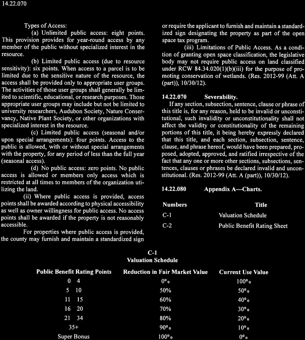
Open Space Public Benefit Rating System (PBRS)
|
|
|
- Hubert Paul
- 6 years ago
- Views:
Transcription
 Congratulations on your decision to purchase land that is currently classified as Open Space PBRS Land.")
1 Deanna Walter CHELAN COUNTY ASSESSOR 350 Orondo Ave, Suite 6 Wenatchee, WA PHONE: FAX: WEBSITE: Open Space Public Benefit Rating System (PBRS) Congratulations on your decision to purchase land that is currently classified as Open Space PBRS Land. The property was placed in the Open Space PBRS classification by the existing or prior owner so that present and future generations can enjoy the many benefits that healthy forests provide. Lands that are classified as Open Space PBRS are assessed for property values based on their current use instead of best or highest use. The reduction in assessed value is calculated by using a percent reduction off of the fair market value that was approved by the Board of County Commissioners. The current use assessed values are generally significantly lower than those lands not classified which is reflected in the property tax payments. This packet has been compiled to provide you with the necessary information to help you better understand what the Open Space PBRS classification means, what the requirements are to maintain the property and your options to continue or remove the classification. Enclosed in this packet you will find the following: Washington State Department of Revenue Open Space Taxation Act publication Chelan County Public Benefit Rating System Example Notice of Continuance form Example Notice of Removal form When purchasing lands that are currently classified as Open Space PBRS the new owner will have the option to either continue the classification or to remove the classification and pay compensating taxes. Continuation of the Open Space PBRS Classification: If choosing to continue the classification the purchaser must submit the following to our office for approval and signature prior to recording the sale: The Real Estate Excise Tax Affidavit (REET) with the purchaser s signature in section 6 that they wish to continue the Open Space PBRS Classification. The Notice of Continuance which will need to be recorded with the County Auditor at the same time as the Deed(s) or other conveyance documents. Recording fees will apply and we request that all five (5) pages are recorded.
2 Removal of Classification: If the purchaser chooses not to continue the classification and would like to remove the property our office requires that a Notice of Removal be signed by our office prior to recording the sale with the County Auditor. Recording fees will apply and in most cases the removal form consists of three (3) pages that will need to be recorded with the County Auditor at the same time as the Deed(s) or other conveyance documents. Compensating taxes and any penalties will need to be paid prior to recording. The amount of compensating taxes due is based on the sale closing date and the difference between the fair market value of the land and the current use value. This amount is then multiplied by the levy rates for each of the last seven years that the land was designated plus the current year. If you choose to remove the property our office asks that you notify us as soon as possible so that we calculate the amount due at closing. If you have any questions or concerns about the Open Space PBRS classification, please contact me at or erin.fonville@co.chelan.wa.us Best regards, Erin Fonville Assessment Administrative Manager

3 WASHINGTON STATE DEPARTMENT OF REVENUE Open Space Taxation Act JULY 2017 The information and instructions in this publication are to be used when applying for assessment on the basis of current use under the open space laws, chapter RCW and chapter WAC. What is the Open Space Taxation Act? The Open Space Taxation Act, enacted in 1970, allows property owners to have their open space, farm and agricultural, and timber lands valued at their current use rather than at their highest and best use. The Act states that it is in the best interest of the state to maintain, preserve, conserve, and otherwise continue in existence adequate open space lands for the production of food, fiber, and forest crops and to assure the use and enjoyment of natural resources and scenic beauty for the economic and social well-being of the state and its citizens. Lands qualifying for current use classification The law provides three classifications: Open space land Farm and agricultural land Timber land Open space land is defined as any of the following: 1. Any land area zoned for open space by a comprehensive official land use plan adopted by any city or county. 2. Any land area in which the preservation in its present use would: a. Conserve and enhance natural or scenic resources. b. Protect streams or water supply. c. Promote conservation of soils, wetlands, beaches or tidal marshes. (As a condition of granting open space classification, the legislative body may not require public access on land classified for the purpose of promoting conservation of wetlands.) d. Enhance the value to the public of neighbouring parks, forests, wildlife preserves, nature reservations or sanctuaries or other open space. e. Enhance recreation opportunities. f. Preserve historic sites. g. Preserve visual quality along highway, road, and street corridors or scenic vistas. h. Retain in its natural state tracts of land not less than one acre situated in an urban area and open to public use on such conditions as may be reasonably required by the legislative authority granting the open space classification. 3. Any land meeting the definition of farm and agricultural conservation land, which means either: a. Land previously classified under the farm and agricultural classification that no longer meets the criteria and is reclassified under open space land; or b. Traditional farmland, not classified, that has not been irrevocably devoted to a use inconsistent with agricultural uses, and that has a high potential for returning to commercial agriculture. This fact sheet provides general information regarding the Open Space Taxation Act. The information is current at the date of publication. Please note subsequent law changes may supersede or invalidate some of this information. 1

 or its successor administered by the United States Department of Agriculture. c. Other commercial agricultural activities established under chapter 458-30 WAC.")
4 WASHINGTON STATE DEPARTMENT OF REVENUE Farm and agricultural land is defined as any of the following: 1. Any parcel of land that is 20 or more acres, or multiple parcels of land that are contiguous and total 20 or more acres, and are: a. Devoted primarily to the production of livestock or agricultural commodities for commercial purposes. b. Enrolled in the federal conservation reserve program (CRP) or its successor administered by the United States Department of Agriculture. c. Other commercial agricultural activities established under chapter WAC. 2. Any parcel of land that is five acres or more but less than 20 acres, is devoted primarily to agricultural uses, and has produced a gross income equivalent to: a. Prior to January 1, 1993, $100 or more per acre per year for three of the five calendar years preceding the date of application for classification. b. On or after January 1, 1993, $200 or more per acre per year for three of the five calendar years preceding the date of application for classification. 3. Any parcel of land that is five acres or more but less than 20 acres, is devoted primarily to agricultural uses, and has standing crops with an expectation of harvest within: a. Seven years and a demonstrable investment in the production of those crops equivalent to $100 or more per acre in the current or previous calendar year. b. Fifteen years for short rotation hardwoods and a demonstrable investment in the production of those crops equivalent to $100 or more per acre in the current or previous calendar year. 4. For parcels of land five acres or more but less than 20 acres, gross income from agricultural uses includes, but is not limited to, the wholesale value of agricultural products donated to nonprofit food banks or feeding programs. 5. Any parcel of land less than five acres devoted primarily to agricultural uses and has produced a gross income of: a. Prior to January 1, 1993, $1,000 or more per year for three of the five calendar years preceding the date of application for classification. b. On or after January 1, 1993, $1,500 or more per year for three of the five calendar years preceding the date of application for classification. 6. Farm and agricultural land also includes any of the following: a. Incidental uses compatible with agricultural purposes, including wetland preservation, provided such use does not exceed 20 percent of the classified land. b. Land on which appurtenances necessary for production, preparation, or sale of agricultural products exist in conjunction with the lands producing such products. c. Any non-contiguous parcel one to five acres, that is an integral part of the farming operations. d. Land on which housing for employees or the principal place of residence of the farm operator or owner is sited provided the use of the housing or residence is integral to the use of the classified land for agricultural purposes, the housing or residence is on or contiguous to the classified land, and the classified land is 20 or more acres. e. Land that is used primarily for equestrian-related activities for which a charge is made, including, but not limited to, stabling, training, riding, clinics, schooling, shows, or grazing for feed. Depending on the number of classified acres, the land may be subject to minimum gross income requirements. f. Land that is primarily used for commercial horticultural purposes, including growing seedlings, trees, shrubs, vines, fruits, vegetables, flowers, herbs, and other plants in containers, whether under a structure or not. For additional criteria regarding this use, please refer to RCW (2)(h). 2

5 WASHINGTON STATE DEPARTMENT OF REVENUE Timber land is defined as the following: Any parcel of land five or more acresor multiple parcels of land that are contiguous and total five or more acres which is or are devoted primarily to the growth and harvest of timber for commercial purposes. Timber land means the land only and does not include a residential homesite. The term includes land used for incidental uses that are compatible with the growing and harvesting of timber but no more than 10 percent of the land may be used for such incidental uses. It also includes the land which appurtenances necessary for the production, preparation, or sale of the timber products exist in conjunction with land producing these products. The timber land classification may be unavailable in some counties. As a result of the passage of Senate Bill 6180 in 2014, counties have the option to merge their timber land classification into their designated forest land program under chapter RCW. To determine whether your county offers the timber land classification, you may contact the county assessor or visit the Department of Revenue s website at: Who may apply? An owner or contract vendee may apply for current use assessment. However, all owners or contract vendees must sign the application for classification, and any resulting agreement. When may I apply? Applications may be made for classification at any time during the year from January 1 through December 31. If approved, current use assessment will begin on January 1 following the year the application was submitted. Where do I get the application? Application forms for the farm and agricultural land classification are available from the county assessor's office. Application forms for the open space and timber land classifications are available from either the county assessor's office or by contacting the county legislative authority. Where do I file the application? An application for open space classification is filed with the county legislative authority. An application for farm and agricultural land classification is filed with the county assessor. An application for timber land classification is filed with the county legislative authority. Timber land applications require that a timber management plan also be filed. Is there an application fee? The city or county legislative authority may, at their discretion, establish a processing fee to accompany each application. This fee must be in an amount that reasonably covers the processing costs of the application. What happens after I file my application for open space classification? Applications for classification or reclassification as open space land are made to the appropriate agency or official called the granting authority. If the land is located in the county s unincorporated area, the county legislative authority is the granting authority on the application. If the land is located within an incorporated area of the county, the application is acted upon by both the county and city legislative authorities. If the application is subject to a comprehensive plan that has been adopted by any city or county it will be processed in the same manner in which an amendment to the comprehensive plan is processed. If the application is not subject to a comprehensive land use plan, a public hearing on the application will be conducted, but a notice announcing the hearing must be published at least 10 days prior to the hearing. The granting authority must approve or reject the application within six months of receiving the application. In determining whether an application made for classification or reclassification should be approved or denied, the granting authority may consider the benefits to the general welfare of preserving the current use of the property. 3
6 WASHINGTON STATE DEPARTMENT OF REVENUE They may require that certain conditions be met including but not limited to the granting of easements. If the application is approved, the granting authority will, within five calendar days of the approval date, send an agreement to the applicant for signature showing the land classification and conditions imposed. The applicant may accept or reject the agreement. If the applicant accepts, he or she must sign and return the agreement to the granting authority within 30 days after receipt. The approval or denial of the application for classification or reclassification is a legislative determination and is reviewable only for arbitrary and capricious actions. Appeal can be made only to the superior court of the county where the application was filed. Within 10 days of receiving notice of classification of the land from the granting authority, the assessor submits the notice to the county auditor for recording in the place and manner provided for the public recording of state tax liens on real property. If approved, current use assessment will begin on January 1 following the year the application was submitted. The criteria for classification continue to apply after classification has been granted. How does a public benefit rating system work? If the county legislative authority has established a public benefit rating system (PBRS) for the open space classification, the criteria contained within the rating system governs the eligibility and valuation of the land subject to the application. When a county creates or amends a PBRS, all classified open space land will be rated under the new PBRS. Land that no longer qualifies for classification will not be removed from classification, but will be rated according to the PBRS. Within 30 days of receiving notification of the new assessed value established by the PBRS, the owner may request removal of classification of the land without imposition of additional tax, interest, and penalty. What happens after I file my application for farm and agricultural land classification? Upon application for classification or reclassification, the assessor may require applicants to provide data regarding the use of the land, including, but not limited to, the productivity of typical crops, sales receipts, federal income tax returns, other related income and expense data, and any other information relevant to the application. The application will be considered approved unless the assessor notifies the applicant in writing prior to May 1 of the year after the application was submitted. The criteria for classification continue to apply after classification has been granted. What is an advisory committee? The county legislative authority must appoint a five member committee representing the active farming community within the county. This committee will serve in an advisory capacity to the assessor in implementing assessment guidelines as established by the Department of Revenue for the assessment of open space lands, farm and agricultural lands, and timber lands. How do I appeal a denial of my farm and agricultural land application? The owner may appeal the assessor s denial to the board of equalization in the county where the land is located. The appeal must be filed with the board on or before July 1 of the year of the determination or within 30 days after the mailing of the notice of denial, or within a time limit of up to 60 days adopted by the county legislative authority, whichever is later. What happens after I file my application for timber land classification? Applications for timber land classification or reclassification are made to the county legislative authority. A timber management plan is required at the time of application or when a sale or transfer of timber land occurs and a notice of continuance is signed. The application form requests information about forest management, restocking, fire protection, insect and disease control, weed control, and any other summary of experience and activity that supports the growth and harvest of timber for commercial purposes. 4


7 WASHINGTON STATE DEPARTMENT OF REVENUE The application is acted upon in a manner similar to open space land applications and within six months of receiving the application. Approval or denial of a timber land application is a legislative determination and is reviewable only for arbitrary and capricious action. Appeal can be made only to the superior court of the county where the application was filed. Within 10 days of receiving notice of classification of the land from the granting authority, the assessor submits the notice to the county auditor for recording in the place and manner provided for the public recording of state tax liens on real property. If approved, current use assessment will begin on January 1 following the year the application was submitted. The criteria for classification continue to apply after classification has been granted. How is the value of classified land determined? The assessor is required to maintain two values for each parcel that is classified. The first is the value that would be placed on the land if it was not classified. This is commonly referred to as the fair market value. The second is the current use land value based on its current use, not highest and best use, as classified by the granting authority. Open space land located within a county that has adopted a public benefit rating system will be valued according to the criteria of the rating system. In the absence of a rating system, the per acre value can be no less than the lowest per acre value of classified farm and agricultural land in the county. In determining the current use value of farm and agricultural land, the assessor considers the earning or productive capacity of comparable lands from crops grown most typically in the area averaged over not less than five years. This earning or productive capacity is the net cash rental and is capitalized by a rate of interest charged on long term loans secured by a mortgage on farm or agricultural land plus a component for property taxes. Timber land is valued according to a schedule prepared by the Department of Revenue according to chapter RCW. The Department of Revenue annually adjusts and certifies timber land values to be used by county assessors in preparing assessment rolls. The assessors assign the timber land values to the property based upon land grades and operability classes. When are taxes due on classified lands? Land classified as open space, farm and agricultural, or timber land is assessed at its current use value and placed on the assessment rolls the year after the application was submitted. Taxes on classified land are due and payable the year after the current use value was placed on the assessment rolls. How long does the classification last? The land continues in its classification until a request for removal is made by the owner, the use of land no longer complies, a sale or transfer to an owner that causes land to be exempt from property taxes, or the ownership has changed and the new owner has not signed a Notice of Continuance. The notice of removal is recorded with the county auditor in the same manner as the recording of state tax liens on real property. Additional tax, interest, and penalties will apply if the land is removed and the removal does not meet one of the exceptions listed in RCW (6). How do I withdraw from classification? If intending to withdraw all or a portion of the land from classification after 10 years of classification, the owner must complete a withdrawal form with the county assessor. If a portion of the land is removed from classification, the remaining portion must meet the requirements of original classification unless the remaining land has different income or investment criteria. 5

 signs the Notice of")
8 WASHINGTON STATE DEPARTMENT OF REVENUE What happens after I file a request to withdraw? Upon receipt of a request for withdrawal, the assessor notifies the granting authority that originally approved the classification, and, the assessor withdraws the land from classification. The land withdrawn from classification is subject to seven years of additional tax and interest, but not a 20 percent penalty. What happens if the classified land is sold or transferred? When classified land is sold or transferred, the seller or transferor becomes liable at the time of sale for the additional tax, interest, and penalty unless the new owner(s) signs the Notice of Continuance which is attached to or shown on the real estate excise tax affidavit. The county auditor cannot accept an instrument of conveyance on any classified land unless the Notice of Continuance has been signed or the additional tax, interest, and penalty has been paid. The assessor determines if the land qualifies for continued classification What if I want to change the use of my classified property? An owner changing the use of land from a classified use must notify the county assessor within 60 days of this action. The assessor will remove the land from classified status and impose an additional tax equal to the difference between the tax paid on the current use value and the tax that would have been paid on the land had it not been classified. The additional tax is payable for the last seven tax years, plus interest at the same rate as charged on delinquent property taxes, plus a penalty of 20 percent of the total amount. If the assessor removes my land from classification, may I appeal? Yes, the owner may file an appeal of the removal from classification to the county board of equalization on or before July 1 of the year of the determination, or within 30 days of the date the notice was mailed by the assessor, or within a time limit of up to 60 days adopted by the county legislative authority, whichever is later. Upon removal from classification, what taxes are due? At the time the land is removed from classification, any taxes owing from January 1 of the removal year through the removal date, and any additional tax, applicable interest, and penalty owing are due and payable to the county treasurer within 30 days of the owner being notified. What if the additional taxes are not paid? Any additional tax, applicable interest, and penalty become a lien on the land at the time the land is removed from classification. This lien has priority over any other encumbrance on the land. Such a lien may be foreclosed upon expiration of the same period after delinquency in the same manner as delinquent real property taxes. If unpaid, interest is charged on the total amount due at the same rate that is applied by law to delinquent property taxes. Interest accrues from the date of the delinquency until the date the total amount is paid in full. What is done with the additional tax, interest, and penalty paid when land is removed from classification? Upon collection, the additional tax is distributed by the county treasurer in the same manner in which current taxes applicable to the subject land are distributed. The applicable interest and penalties are distributed to the county s current expense fund. 6
9 WASHINGTON STATE DEPARTMENT OF REVENUE How do I change the classification of my property? Land may be reclassified, upon request by the owner, subject toall applicable qualifications for each classification, without additional tax, interest, and penalty for the following: 1. Land classified as farm and agricultural land may be reclassified to timber land; timber land may be reclassified to farm and agricultural land. 2. Land classified as either farm and agricultural land or timber land under chapter RCW, or forest land under chapter RCW may be reclassified to open space land. 3. Land classified as farm and agricultural land or timber land may be reclassified to forest land under chapter RCW. 4. Land previously classified as farm and agricultural land may be reclassified to open space land as farm and agricultural conservation land and subsequently be reclassified back to farm and agricultural land. Is supporting information required to change classifications? The assessor may require an owner of classified land to submit data regarding the use of the land, productivity of typical crops, income and expense data, and similar information regarding continued eligibility. Laws and Rules It is helpful to read the complete laws, Revised Code of Washington, chapters and (RCW) and rules, Washington Administrative Code, chapter (WAC) to understand requirements of the classifications and the tax liabilities incurred. Need More Information? Requirements for making application for current use classification are available at the county assessor s office or by contacting the county legislative authority. For general information contact: Department of Revenue, Property Tax Division P. O. Box Olympia, Washington (360) Website dor.wa.gov Telephone Information Center For tax assistance or to request this document in an alternate format, visit or call Teletype (TTY) users may use the Washington Relay Service by calling 711. Applications for reclassification are acted upon in the same manner as approvals for initial classification. The county assessor approves all applications for farm and agricultural classifications and reclassifications. The county legislative authority (and in some cases, the city legislative authority)approves all land classifications or reclassifications for timber land and open space land, including farm and agricultural conservation land. 7 PTFS /17
10
11
12
13
14
15
16

17
18 When Recorded Return to: Chelan County Assessor 350 Orondo Ave., Suite 206 Wenatchee, WA Notice of Continuance Land Classified as Current Use or Forest Land Chapter and Revised Code of Washington Grantor(s)/Sellers: MR. & MRS. JONES Grantee(s)/Buyers: JOHN SMITH Mailing Address: 123 ABC STREET City, State, Zip: WENATCHEE, WA Phone No: Assessor s Parcel No: Address: NNA MNOP AVE EXAMPLE Legal Description: Date of Sale or Transfer: Date Notice of Continuance Received by Assessor: Reference numbers of documents assigned or released: Interest in property: Fee Owner Contract Purchaser Other If the new owner(s) of land classified as current use or designated as forest land wishes to continue the classification or designation, the new owner(s) must sign the last page of this form. A signature is not required if land is transferred to an owner who is an heir or devisee of a deceased owner or transferred by a transfer on death deed and the new owner wants to continue classification or designation. The county assessor must then determine if the land continues to qualify. The county assessor has 15 calendar days, from the date all documentation is received, to determine whether the land will continue to qualify. All new owners must sign before the conveyance is recorded or filed. If the new owner(s) do(es) not desire to continue the classification or designation, all additional tax, interest, and penalty or compensating tax calculated pursuant to RCW or RCW , will be due and payable by the seller or transferor at the time of sale. Payment in full is required before the conveyance can be recorded or filed. Transfer Document For Official Office Use Only Real Estate Excise Tax No: To ask about the availability of this publication in an alternate format for the visually impaired, please call Teletype (TTY) users may use the Washington Relay Service by calling 711. For tax assistance, call (360) REV e (w) (6/3/14) 1
19 A. CLASSIFICATION UNDER CHAPTER RCW. I/we request that this land retain the current use classification as Open Space Land Farm & Agricultural Land Timber Land and I am/we are aware of the following land use classifications; 1. OPEN SPACE LAND MEANS EITHER: a. any land area so designated by an official comprehensive land use plan adopted by any city or county and zoned accordingly; or b. any land area, the preservation of which in its present use would: (i) conserve and enhance natural or scenic resources; (ii) protect streams or water supply; (iii) promote conservation of soils, wetland, beaches, or tidal marshes; (iv) enhance the value to the public of abutting or neighboring parks, forests, wildlife preserves, nature reservations or sanctuaries or other open space; (v) enhance recreation opportunities; (vi) preserve historic sites; (vii) preserve visual quality along highway, road, and street corridors or scenic vistas; or (viii) retain in its natural state tracts of land not less than one acre situated in an urban area and open to public use on such conditions as may be reasonably required by the legislative body granting the open space classification; or c. any land that meets the definition of farm and agricultural conservation land. Farm and agricultural conservation land is either; (i) land that was previously classified as farm and agricultural land under RCW (2) that no longer meets the criteria and is reclassified as open space under RCW (1); or (ii) land that is traditional farmland that is not classified under chapter or RCW, that has not been irrevocably devoted to a use inconsistent with agricultural uses, and has a high potential for returning to commercial agriculture. 2. FARM AND AGRICULTURAL LAND MEANS EITHER: a. any parcel of land or contiguous parcels of land that are twenty or more acres: (i) devoted primarily to the production of livestock or agricultural commodities, for commercial purposes; or (ii) enrolled in the federal conservation reserve program or its successor administered by the United States Department of Agriculture; or (iii) other similar commercial activities as may be established by rule; or b. any parcel of land or contiguous parcels of land that are at least five acres but less than twenty acres devoted primarily to agricultural uses which has: Produced a gross income equal to two hundred dollars or more per acre per year for three out of the five calendar years preceding the date of application for classification under chapter RCW; Standing crops with an expectation of harvest within seven years and a demonstrable investment in the production of those crops equivalent to one hundred dollars or more per acre in the current or previous year; or Standing crops of short rotation hardwoods with an expectation of harvest within fifteen years and a demonstrable investment in the production of those crops equivalent to one hundred dollars or more per acre in the current or previous year; For the purposes listed above, gross income from agricultural uses includes, but is not limited to, the wholesale value of agricultural products donated to nonprofit food banks or feeding programs; c. any parcel of land less than five acres devoted primarily to agricultural uses which has produced a gross income equal to fifteen hundred dollars or more per year for three out of the five calendar years preceding the date of application for classification under chapter RCW; "Commercial agricultural purposes" means the use of land on a continuous and regular basis, prior to and subsequent to application for classification or reclassification, that demonstrates that the owner or lessee is engaged in and intends to obtain through lawful means, a monetary profit from cash income by producing an agricultural product. In addition, commercial agricultural purposes include the following uses of agricultural land: REV e (w) (6/3/14) 2
20 Land, one to five acres which is not contiguous (in this context, means non adjoining/touching) to a classified parcel, that constitutes an integral part of the farming operation being conducted on the land qualifying as farm and agricultural land. Land, not to exceed twenty percent of classified land, that has incidental uses compatible with agricultural purposes, and also the land on which appurtenances necessary to the production, preparation or sale of the agricultural products exist in conjunction with the lands producing such products. Land used primarily for equestrian-related activities, for which a charge is made, including, but not limited to, stabling, training, riding, clinics, schooling, shows, or grazing for feed. Land on which the principal place of residence of the farm operator or owner of land or housing for employees is sited if the farm and agricultural land is classified pursuant to RCW (2)(a), if the residence or housing is on or contiguous to the classified parcel, and the use of the residence or housing is integral to the use of the classified land for agricultural purposes. Any land primarily used for commercial horticultural purposes, whether under a structure or not. Land cannot be primarily used for the storage, care, or selling of plants purchased from other growers for retail sale or covered by more than 20 percent pavement if the primary use is growing plants in containers. If the primary use of the land is growing plants in containers and the land used for this purpose is less than five acres, the land will not qualify for classification if more than 25 percent is open to the general public for on-site retail sales. 3. TIMBER LAND MEANS any parcel or contiguous parcels of land five or more acres devoted primarily to the growing and harvesting of forest crops for commercial purposes. Timber land means the land only and does not include a residential home site. The term includes land used for incidental uses that are compatible with the growing and harvesting of timber but no more than ten percent of the land may be used for such incidental uses. It also includes the land on which appurtenances necessary for the production, preparation, or sale of the timber products exist in conjunction with land producing these products. I/we declare that I am/we are aware of the liability of withdrawal or removal of this land from classification to the following extent: 1. If the owner has filed the proper two year notice to withdraw the classified land and the land has been classified for a minimum of ten years he/she will pay an amount equal to the difference between the tax computed on the basis of current use and the tax computed on the basis of true and fair value plus interest at the same statutory rate charged on delinquent property taxes. The additional tax and interest must be paid for the preceding seven tax years. This provision will not apply if there is a pending merger of a county s timber land classification and designated forest land program and the merger will occur prior to the date of withdrawal. If this occurs, the owner can choose to: (1) request immediate removal of the land from the timber land classification, (2) request immediate removal, after the merger, of the land from the designated forest land program, or (3) request the assessor to remove the land from the designated forest land program once two assessment years have passed following the receipt of the notice to withdraw. These removals will still be subject to the additional tax, interest, and penalty, or compensating tax. 2. If land is removed from classification and the removal does not meet one of the exceptions listed in (3) below, the additional tax and interest described in 1 above plus a penalty of twenty percent on the sum of the additional tax and interest will be imposed on the owner. The additional tax, interest, and penalty must be paid for the preceding seven tax years and from January 1 of the year of removal up to the date of removal. 3. The additional tax, interest, and penalty will not be imposed if the withdrawal or removal from classification resulted solely from: a. transfer to a government entity in exchange for other land located within the state of Washington; b. a taking through the exercise of the power of eminent domain, or sale or transfer to an entity having the power of eminent domain in anticipation of the exercise of this power, said entity having manifested its intent in writing or by other official action; REV e (w) (6/3/14) 3
21 c. a natural disaster such as a flood, windstorm, earthquake, or other calamity rather than by virtue of the act of the landowner changing the use of the classified land; d. official action by an agency of the state of Washington or by the county or city within which the land is located that disallows the present classified use of the land; e. transfer of land to a church when the land would qualify for exemption pursuant to RCW ; f. acquisition of property interests by a state agencies or agencies or organizations qualified under RCW and RCW for the purposes enumerated in those sections; g. removal of classified farm and agricultural land under RCW (2)(f) on which the principal residence of the farm operator or owner or housing for employees is located; h. removal of land from classification after enactment of a statutory exemption that qualifies the land for exemption and receipt of notice from the owner to remove the land from classification; i. the creation, sale, or transfer of forestry riparian easements under RCW ; j. the creation, sale, or transfer of a conservation easement of private forest lands within unconfined channel migration zones or containing critical habitat for threatened or endangered species under RCW ; k. The sale or transfer within two years after the death of an owner with at least a fifty percent interest in the land if the land has been continuously assessed and valued as designated forest land under chapter RCW or classified under chapter RCW since 1993 and the individual(s) or entity(ies) receiving the land from the deceased owner is selling or transferring the land. The date of death shown on a death certificate is the date used; or l. The discovery that the land was classified in error through no fault of the owner. B. CLASSIFICATION UNDER CHAPTER RCW. I/we request that this land retains its designation as forest land and I am/we are aware of the following definition of forest land. FOREST LAND is synonymous with designated forest land and means any parcel of land or contiguous parcels of land at least five acres that is primarily devoted to and used for growing and harvesting timber and means the land only. I/we declare that I am/we are aware of the liability of removal of this land from designated forest land and upon removal a compensating tax will be imposed that is equal to the difference between the amount of tax last levied on the land as forest land and an amount equal to the new assessed valuation of the land as of January 1 of the year of removal, multiplied by the dollar rate of the last levy extended against the land, multiplied by a number, not greater than nine, equal to the number of years the land was designated as forest land. Compensating tax will also be due on the land from January 1 of the year the designation is removed up to the removal date. The compensating tax will not be imposed if the removal of designation resulted solely from: a. transfer to a government entity in exchange for other forest land located within the state of Washington; b. a taking through the exercise of the power of eminent domain, or sale or transfer to an entity having the power of eminent domain in anticipation of the exercise of this power based on official action taken by the entity and confirmed in writing; c. a donation of fee title, development rights, or the right to harvest timber, to a government agency or organization qualified under RCW and for the purposes enumerated in those sections; d. the sale or transfer of fee title to a governmental entity or a nonprofit nature conservancy corporation, as defined in RCW , exclusively for the protection and conservation of lands recommended for state natural area preserve purposes by the natural heritage council and natural heritage plan as defined in chapter RCW or approved for state natural resources conservation area purposes as defined in chapter RCW, or for acquisition and management as a community forest trust as defined in chapter RCW. At such time as the land is not used for the purposes enumerated, the compensating tax will be imposed upon the current owner; e. the sale or transfer of fee title to the parks and recreation commission for park and recreation purposes; f. the creation, sale, or transfer of forestry riparian easements under RCW ; REV e (w) (6/3/14) 4
22 g. the creation, sale, or transfer of a conservation easement of private forest lands within unconfined channel migration zones or containing critical habitat for threatened or endangered species under RCW ; h. the sale or transfer within two years after the death of an owner with at least a fifty percent interest in the land if the land has been continuously assessed and valued as designated forest land under chapter RCW or classified under chapter RCW since 1993 and the individual(s) or entity(ies) receiving the land from the deceased owner is selling or transferring the land. The date of death shown on a death certificate is the date used; i. the discovery that the land was designated in error through no fault of the owner; or j. a transfer of a property interest, in a county with a population of more than six hundred thousand inhabitants or in a county with a population of at least two hundred forty-five thousand inhabitants that borders Puget Sound as defined in RCW , to a government entity, or to a nonprofit historic preservation corporation or nonprofit nature conservancy corporation, as defined in RCW , to protect or enhance public resources, or to preserve, maintain improve, restore, limit the future use of, or otherwise to conserve for public use or enjoyment, the property interest being transferred. At such time as the land is not used for the purposes enumerated, the compensating tax will be imposed upon the current owner. The agreement to tax according to use of the property is not a contract and can be annulled or canceled at any time by the Legislature (RCW ). Please describe how you intend to use the land for continued classification or designation:* PLEASE PUT SOMETHING HERE *The assessor may require additional information from the seller(s) and/or Buyer(s) to determine whether the land will continue to qualify for classification or designation. *The assessor may require additional information from the seller(s) and/or buyer(s) to determine whether the land will continue to qualify for classification or designation. Is there a reclassification pending for this parcel(s)? Yes No If yes, have you notified the granting authority, in writing, that you wish to continue with the reclassification process? Yes No If yes, do you understand your rights and responsibilities if the reclassification is approved or denied? Yes No Buyer s Signature 123 ABC STREET, WENATCHEE, WA Address Date Buyer s Signature Date Address Assessor Use Only Does the parcel(s) subject to this document meet the qualifications for classification/designation continuance? Yes No Assessor Signature If the parcel(s) subject to this document is/are considered contiguous, as defined in RCW (4) or RCW (6), with other parcels having different ownerships, then verify the following information with the purchaser: The parcel(s) subject to this document will be managed as part of a single operation with the other parcels having different ownerships. The new purchaser meets the definition of family as defined in RCW (6)(b)(ii) with the owner of an adjoining parcel. REV e (w) (6/3/14) 5 Date
23 When recorded return to: Chelan County Assessor 350 Orondo Ave., Suite 206 Wenatchee, WA Notice of Removal of Current Use Classification and Additional Tax Calculations Chapter RCW EXAMPLE County Grantor or County: CHELAN Grantee or Property Owner: JOHN SMITH Mailing Address: 123 ABC STREET WENATCHEE WA City State Zip Legal Description: EXAMPLE Assessor's Parcel/Account Number: CHELAN Reference Numbers of Documents Assigned or Released: You are hereby notified that the current use classification for the above described property which has been classified as: Open Space Land Timber Land Farm and Agricultural Land is being removed for the following reason: Owner's request Change in use/no longer qualifies Sale/transfer to government entity Notice of continuance not signed Classified in error Other (specific reason) Is removal subject to additional tax, interest, and penalty? Yes If yes, go to page two and complete the rest of form. If no, complete questions 1-4 below. 1. Date of removal: No 2. Calculate amount due in #8 (recording fee) and #10 (calculation of tax for remainder of current year.) 3. Reason for exception (see page 4 for exceptions.) 4. Provide a brief explanation on why removal meets the exception listed in #3. County Assessor or Deputy Date (See next page for current use assessment additional tax statement.) e (w) (6/13/14)
24 Current Use Assessment Additional Tax Statement RCW (4) The assessor shall revalue the affected land with reference to the true and fair value on January 1 of year of removal from classification. Both the assessed valuation before and after removal of classification shall be listed and taxes shall be allocated according to that part of the year to which each assessed valuation applies. NOTE: No 20% penalty is due on the current year tax. Parcel No: Date of Removal: 1. Calculation of Current Year's Taxes to Date of Removal. 365 = No. of days in No. of days in year Current Use Proration Factor (apply to 1a and 1b) a. x 1,000 x = Levy Rate Proration Factor True & Fair Value (Jan 1 of year removed) b. x ,000 x = Levy Rate Proration Factor Current Use Value (Jan 1 of year removed) c. Amount of additional tax for current year to date of removal (1a minus 1b) = 2. Calculation of Current Year Interest. (Interest is calculated from April 30 of each tax year through the month of removal at the rate 1% per month.) x 100 = Amount of tax from 1c Number of Months 3. Calculation of Prior Year's Additional Tax and Interest. (Interest is calculated from April 30 of each tax year through the month of removal at the rate of 1% per month.) Tax Year 1 will be the year preceding the year of removal. Col's (1) (2) (3) (4) (5) (6) (7) No. of Yrs Tax Year True & Fair Value Current Use Value Difference 1-2 Levy Rate EXAMPLE (8) Additional Tax Due 3 x 4 Interest 1% per mo. Total Interest 5 x 6 Total Tax & Interest $0 $0 $0 $0 $0 $0 $0 Totals e (w) (6/13/14)
25 4. Total Additional Tax and Interest (Total of entries in item 3, column 8) = 5. 20% Penalty (Does not apply if owner complied with two year withdrawal notice) 6. Total Additional Tax, Interest, and Penalty (Total of entries in items 4 and 5) = = 7. Prorated Tax and Interest for Current Year (Items 1c and 2) = 8. Recording Fee for Removal = 9. Total of Tax, Interest, Penalty, and Recording Fee (Add lines 6, 7, and 8) = (Payable in full 30 days after the date the treasurer's statement is received. Any amount unpaid on its due date is considered delinquent. From the date of delinquency until paid, interest will be charged at the same rate applied by law to delinquent ad valorem property taxes.) 10. Calculation of Tax for Remainder of Current Year. No. of days from date of removal to end of year 365 = No. of days in year Proration Factor a. $0 x ,000 x = Levy Rate Proration Factor True & Fair Value (Jan 1 of year removed) b. $0 x ,000 x = Levy Rate Proration Factor Current Use Value (Jan 1 of year removed) c. Amount of tax due for remainder of current year (10a minus 10b) = EXAMPLE d. Taxes are payable on regular due dates and may be paid in half payments under provisions of RCW Assessors Use Only If the parcel subject to this removal document is considered contiguous, as defined in RCW (6), with other parcels having different ownerships, verify all remaining classified parcels with different ownerships are still: Adjoining Being managed as part of a single operation Meeting the definition of "family" as defined in RCW (6)(b)(ii) with the owner of an adjoining parcel To ask about the availability of this publication in an alternate format for the visually impaired, please call Teletype (TTY) users, please call (360) For tax assistance, call (360) e (w) (6/13/14)
Open Space Taxation Act JULY 2017
 Open Space Taxation Act JULY 2017 The information and instructions in this publication are to be used when applying for assessment on the basis of current use under the open space laws, chapter 84.34 RCW
Notice of Continuance Land Classified as Current Use or Forest Land RCW Chapter and 84.33
 When Recorded Return to: Notice of Continuance Land Classified as Current Use or Forest Land RCW Chapter 84.34 and 84.33 Grantor(s)/Sellers: Grantee(s)/Buyers: Mailing Address: City, State, Zip: Assessor
BROCHURE # 37 OPEN SPACE
 BROCHURE # 37 OPEN SPACE The information and instructions in this publication are to be used when applying for assessment on the basis of current use under the open space laws, chapter 84.34 RCW and chapter
Notice of Continuance Land Classified as Current Use or Forest Land Chapter and Revised Code of Washington
 When Recorded Return to: Cowlitz County Assessor s Office Attn: Forest Land / Current Use Dept 207 N 4 th Avenue Kelso WA 98626 Notice of Continuance Land Classified as Current Use or Forest Land Chapter
Open Space Farm & Ag Program
 Deanna Walter CHELAN COUNTY ASSESSOR 350 Orondo Ave, Suite 6 Wenatchee, WA 98801-2885 PHONE: 509-667-6365 FAX: 509-667-6664 WEBSITE: http://www.co.chelan.wa.us/assessor Open Space Farm & Ag Program We
Open Space Taxation Act
 Open Space Taxation Act WASHINGTON STATE DEPARTMENT OF REVENUE JUNE 2007 The information and instructions in this brochure are to be used when applying for assessment on the basis of current use under
OPEN SPACE TIMBER PROGRAM OKANOGAN COUNTY CODE, CHAPTER 14.09
 OPEN SPACE TIMBER PROGRAM OKANOGAN COUNTY CODE, CHAPTER 14.09 14.09.010 - Short Title 14.09.020 - Purpose 14.09.030 - Administration 14.09.040 - Compliance with Regulations 14.09.050 - Scope 14.09.060
Short Title This Chapter shall be known and cited as the Open Space Open Space Program and Public Benefit Rating System.
 CHAPTER 14.08 OPEN SPACE OPEN SPACE PROGRAM AND PUBLIC BENEFIT RATING SYSTEM SECTIONS: 14.08.0 10 - Short Title 14.08.020 - Purpose 14.08.030 - Administration 14.08.040 - Compliance with Regulations 14.08.050
PROPERTY TAX BULLETIN NO. 20 (Published under Appropriation No ) Issued February 4, 2008; Replaces January 5, 2005
 Issued February 4, 2008; Replaces January 5, 2005") JOHN ELIAS BALDACCI GOVERNOR STATE OF MAINE MAINE REVENUE SERVICES PROPERTY TAX DIVISION PO BOX 9106 AUGUSTA, MAINE 04332-9106 ADMINISTRATIVE & FINANCIAL SERVICES RYAN LOW COMMISSIONER MAINE REVENUE SERVICES
JOHN ELIAS BALDACCI GOVERNOR STATE OF MAINE MAINE REVENUE SERVICES PROPERTY TAX DIVISION PO BOX 9106 AUGUSTA, MAINE 04332-9106 ADMINISTRATIVE & FINANCIAL SERVICES RYAN LOW COMMISSIONER MAINE REVENUE SERVICES
MAINE REVENUE SERVICES PROPERTY TAX DIVISION PROPERTY TAX BULLETIN NO. 19
 MAINE REVENUE SERVICES PROPERTY TAX DIVISION PROPERTY TAX BULLETIN NO. 19 MAINE TREE GROWTH TAX LAW REFERENCE: 36 M.R.S.A. 571-584-A. Issued May 2013; Replaces September, 2012 FOR RECENT CHANGES TO THE
480-a. Taxation of forest land. 1. As used in this section:
 480-a. Taxation of forest land. 1. As used in this section: (a) " Approved management plan " shall mean a plan approved by the department for the management of an eligible tract which shall contain requirements
A. Owner s Name: Owner s Address: Description of Land as Shown on Property Tax Statement: Location of Property:,
 ODA - Ag. Adm. Form 11 Rev. - 12/2006 New Application Renewal Application APPLICATION FOR PLACEMENT OF FARMLAND IN AN AGRICULTURAL DISTRICT (O.R.C. Section 929.02) (See pages 5 & 6 for General Information
APPLICATION TO THE ASSESSOR FOR CLASSIFICATION OF LAND AS FOREST LAND
 STATE OF CONNECTICUT FORM M-39, REVISED 6/2016 APPROVED BY THE COMMISSIONER DEPARTMENT OF ENERGY & ENVIRONMENTAL PROTECTION APPLICATION TO THE ASSESSOR FOR CLASSIFICATION OF LAND AS FOREST LAND Declaration
*SB0046* S.B. 46 S.B AGRICULTURE SUSTAINABILITY ACT. LEGISLATIVE GENERAL COUNSEL 6 Approved for Filing: V. Ashby :38 AM 6
 LEGISLATIVE GENERAL COUNSEL 6 Approved for Filing: V. Ashby 6 6 01-27-12 10:38 AM 6 S.B. 46 1 AGRICULTURE SUSTAINABILITY ACT 2 2012 GENERAL SESSION 3 STATE OF UTAH 4 Chief Sponsor: Scott K. Jenkins 5 House
LEGISLATIVE PURPOSES. 2. Provide sources of agricultural products within the state for the citizens of the state
 LEGISLATIVE PURPOSES 1. Assist in sustaining the farming community 2. Provide sources of agricultural products within the state for the citizens of the state 3. Control the urban expansion which is consuming
NORTH CAROLINA GENERAL STATUTES PERTAINING TO PRESENT USE VALUE ASSESSMENT AND TAXATION OF AGRICULTURAL, HORTICULTURAL, AND FORESTLANDS
 NORTH CAROLINA GENERAL STATUTES PERTAINING TO PRESENT USE VALUE ASSESSMENT AND TAXATION OF AGRICULTURAL, HORTICULTURAL, AND FORESTLANDS 105-277.2. Agricultural, horticultural, and forestland Definitions.
LOCAL REVENUE SOURCES. Local Revenue Sources. Sources of Local Revenue: County 02/15/ County Revenue by Source
 LOCAL REVENUE SOURCES Martha Walston, Fiscal Research Division February 16, 2011 Local Revenue Sources Property Tax Deed Stamp tax Sales tax: occupancy tax and meals tax Privilege tax Other local taxes
STATE TAX COMMISSION QUALIFIED AGRICULTURAL PROPERTY EXEMPTION GUIDELINES
 STATE TAX COMMISSION QUALIFIED AGRICULTURAL PROPERTY EXEMPTION GUIDELINES Issued by the State Tax Commission August 2018 Table of Contents What is the Qualified Agricultural Exemption?... 2 How does Property
CONSERVATION USE LAWS AND REGULATIONS OFFICIAL CODE OF GEORGIA O.C.G.A DEPARTMENT OF REVENUE RULES AND REGULATIONS
 CONSERVATION USE LAWS AND REGULATIONS OFFICIAL CODE OF GEORGIA O.C.G.A. 48-5-7.4 DEPARTMENT OF REVENUE RULES AND REGULATIONS 560-11-6 Georgia Codes and the Department of Revenue s Rules and Regulations
BLAIR COUNTY. UNDERSTANDING THE Clean and Green PROGRAM. COUNTY OF BLAIR Blair County Courthouse 423 Allegheny Street Hollidaysburg, PA
 BLAIR COUNTY UNDERSTANDING THE Clean and Green PROGRAM When a county implements a Clean and Green program, it places two values on each parcel of land that qualifies. These values are known as the Fair
04.08 SPECIAL VALUATIONS AND DEFERRALS
 04.08 SPECIAL VALUATIONS AND DEFERRALS Deferral programs recognize that market value of certain types of property may exceed the value that would be determined if the property were limited to its current
54TH LEGISLATURE - STATE OF NEW MEXICO - FIRST SESSION, 2019
 HOUSE BILL TH LEGISLATURE - STATE OF NEW MEXICO - FIRST SESSION, 0 INTRODUCED BY Roberto "Bobby J. Gonzales and Jim R. Trujillo and Susan K. Herrera and Carlos R. Cisneros and Peter Wirth 0 AN ACT RELATING
Clean and Green LEBANON COUNTY UNDERSTANDING THE PROGRAM
 LEBANON COUNTY UNDERSTANDING THE Clean and Green PROGRAM When a county implements a Clean and Green program, it places two values on each parcel of land that qualifies. These values are known as the Fair
Application for 1-d-1 (Open-Space) Agricultural Use Appraisal
 Agricultural Use Appraisal") HUNT COUNTY APPRAISAL DISTRICT 4801 King Street PO Box 1339 Greenville, Texas 75403 1339 Phone: 903 454 3510 Fax: 903 454 4160 Application for 1-d-1 (Open-Space) Agricultural Use Appraisal State the Year
HUNT COUNTY APPRAISAL DISTRICT 4801 King Street PO Box 1339 Greenville, Texas 75403 1339 Phone: 903 454 3510 Fax: 903 454 4160 Application for 1-d-1 (Open-Space) Agricultural Use Appraisal State the Year
Understanding the Clean and Green Program
 Understanding the Clean and Green Program Perry County, Pennsylvania DISCLAIMER: The material contained in this document is intended to provide only general information concerning the Pennsylvania Farmland
COMMERCIAL REHABILITATION ACT Act 210 of The People of the State of Michigan enact:
 COMMERCIAL REHABILITATION ACT Act 210 of 2005 AN ACT to provide for the establishment of commercial rehabilitation districts in certain local governmental units; to provide for the exemption from certain
Answers to Frequently Asked Questions about Conservation Use Valuation and Preferential Agricultural Assessment
 Answers to Frequently Asked Questions about Conservation Use Valuation and Preferential Agricultural Assessment ` A presentation of the most frequently asked questions and answers collected over the past
Contact Us. Forms for these credits and exemptions are included with the descriptions. Ag Land Credit. Low-Rent Housing Exemption
 1 of 12 12/5/2017 2:01 PM Contact Us Home» Iowa Tax / Fee Descriptions and Rates Forms for these credits and exemptions are included with the descriptions. Ag Land Credit Barn and One-Room School House
Torch Lake Township Antrim County, Michigan
 Torch Lake Township Antrim County, Michigan Farmland and Open Space Development Rights Ordinance Ordinance No. 04-01 Effective September 3, 2004 AN ORDINANCE creating a farmland and open space protection
OFFICE OF REAL ESTATE
 OFFICE OF REAL ESTATE DATE: October 25, 2017 TO: FROM: RE: Users of the Real Estate Manual Wayne Pace, Manager Acquisition Unit Changes and Updates to the Real Estate Manual The only current and accurate
PENINSULA TOWNSHIP LAND DIVISION ORDINANCE TOWNSHIP OF PENINSULA COUNTY OF GRAND TRAVERSE, STATE OF MICHIGAN ORDINANCE NO OF 2012
 PENINSULA TOWNSHIP LAND DIVISION ORDINANCE TOWNSHIP OF PENINSULA COUNTY OF GRAND TRAVERSE, STATE OF MICHIGAN ORDINANCE NO OF 2012 AN ORDINANCE TO REGULATE THE DIVISION OF EXISTING PARCELS OF LAND PURSUANT
EXECUTIVE/COUNCIL APPROVAL FORM
 BGT.. /2 /'tc8] EXECUTIVE/COUNCIL APPROVAL FORM MANAGEMENT ROUTING: TO: COUNCIL CHAIRPERSON: EXECUTIVE John Lovick SNOHOMISIL COUNTY COUNCIL IEC.DIR. Peter Camo DIRECTOR/ELECTED Cindy Portmann 8, ^ oby/lk
11 c/o U.S. Bank National Association Mailing Address 500 Union Street, Suite 620
 LEGAL DESCRIPTION LOT 24, BLOCK 18, NETTLETON'S SECOND ADDITION; AS PER PLAT RECORDED IN VOLUME "A" OF PLATS, PAGE 118, RECORDS OF SPOKANE COUNTY: SITUATE IN THE CITY OF SPOKANE, COUNTY OF SPOKANE, STATE
Rules and Regulations for Enforcement of the Farm, Forest, and Open Space Act
 STATE OF RHODE ISLAND AND PROVIDENCE PLANTATIONS DEPARTMENT OF ENVIRONMENTAL MANAGEMENT Rules and Regulations for Enforcement of the Farm, Forest, and Open Space Act July, 2002 AUTHORITY: These regulations
WILLIAMSON ACT CONTRACTS GUIDELINES
 NEVADA COUNTY COMMUNITY DEVELOPMENT AGENCY PLANNING DEPARTMENT ERIC ROOD ADMINISTRATION BUILDING 950 Maidu Avenue Nevada City, California 95959-8617 Phone: (530) 265-1222 FAX : (530) 265-9851 WILLIAMSON
Understanding the Clean and Green Program
 Understanding the Clean and Green Program Venango County, Pennsylvania DISCLAIMER: The material contained in this booklet is intended to provide only general information concerning the Pennsylvania Farmland
TRENDS IN QUALIFIED CONSERVATION EASEMENTS. By: Melinda M. Beck, Esq.
 TRENDS IN QUALIFIED CONSERVATION EASEMENTS By: Melinda M. Beck, Esq. What is a Conservation Easement? An easement interest granted by a landowner to a land trust or governmental entity that voluntarily
TOWN OF EASTOVER VOLUNTARY AGRICULTURAL DISTRICT ORDINANCE
 TOWN OF EASTOVER VOLUNTARY AGRICULTURAL DISTRICT ORDINANCE ARTICLE I AUTHORITY The articles and sections of this ordinance are adopted pursuant to authority conferred by N.C.G.S. Sections 106-735 through
Q. How is Agricultural property valued? A. GENERAL INFORMATION Many states have laws regarding the preferential assessment of agricultural land.
 Q. How is Agricultural property valued? A. GENERAL INFORMATION Many states have laws regarding the preferential assessment of agricultural land. This means that farm and ranch assessments are usually based
Wildlife Habitat Conservation and Management Program
 EXHIBIT 1 PC-2015-4106 ODFW Guide Wildlife Habitat Conservation and Management Program Manual for Counties and Cities Oregon Department of Fish and Wildlife March 2006 Table of Contents 1. Introduction
CHAPTER SIX VOLUNTARY AGRICULTURAL DEVELOPMENT AND FARMLAND PRESERVATION ORDINANCE
 CHAPTER SIX VOLUNTARY AGRICULTURAL DEVELOPMENT AND FARMLAND PRESERVATION ORDINANCE ARTICLE I TITLE An ordinance of the Town of Wentworth Town Council, North Carolina, entitled, "VOLUNTARY AGRICULTURAL
NEIGHBORHOOD ENTERPRISE ZONE ACT Act 147 of The People of the State of Michigan enact:
 NEIGHBORHOOD ENTERPRISE ZONE ACT Act 147 of 1992 AN ACT to provide for the development and rehabilitation of residential housing; to provide for the creation of neighborhood enterprise zones; to provide
CONSERVATION EASEMENTS
 CONSERVATION EASEMENTS Prepared for the Colorado Cattlemen's Agricultural Land Trust January 2007 By Lawrence R. Kueter, Esq. Isaacson, Rosenbaum, Woods & Levy, P.C. Suite 2200 633 17th Street Denver,
Administrative Penalty Order (APO) Plan for Buffer Law Implementation
 Plan for Buffer Law Implementation") Administrative Penalty Order (APO) Plan for Buffer Law Implementation June 28, 2017 This document was adopted by the Board of Water and Soil Resources (BWSR) pursuant to Minn. Stat. 103B.101, subd. 12(a)
Administrative Penalty Order (APO) Plan for Buffer Law Implementation June 28, 2017 This document was adopted by the Board of Water and Soil Resources (BWSR) pursuant to Minn. Stat. 103B.101, subd. 12(a)
[First Reprint] SENATE, No STATE OF NEW JERSEY. 218th LEGISLATURE INTRODUCED SEPTEMBER 17, 2018
![[First Reprint] SENATE, No STATE OF NEW JERSEY. 218th LEGISLATURE INTRODUCED SEPTEMBER 17, 2018](/thumbs/95/123516904.jpg "[First Reprint] SENATE, No STATE OF NEW JERSEY. 218th LEGISLATURE INTRODUCED SEPTEMBER 17, 2018") [First Reprint] SENATE, No. 0 STATE OF NEW JERSEY th LEGISLATURE INTRODUCED SEPTEMBER, 0 Sponsored by: Senator BOB SMITH District (Middlesex and Somerset) Senator CHRISTOPHER "KIP" BATEMAN District (Hunterdon,
[First Reprint] SENATE, No. 0 STATE OF NEW JERSEY th LEGISLATURE INTRODUCED SEPTEMBER, 0 Sponsored by: Senator BOB SMITH District (Middlesex and Somerset) Senator CHRISTOPHER "KIP" BATEMAN District (Hunterdon,
TRANSFER OF DEVELOPMENT RIGHTS (TDR) ORDINANCE Revised November 2013
 ORDINANCE Revised November 2013") ARTICLE III Transfer of Development Rights (TDR) Program Part 301 Establishment and Purpose. 165-301.01. Purpose. Pursuant to the authority granted by 15.2-2316.1 and 2316.2 of the Code of Virginia, there
ARTICLE III Transfer of Development Rights (TDR) Program Part 301 Establishment and Purpose. 165-301.01. Purpose. Pursuant to the authority granted by 15.2-2316.1 and 2316.2 of the Code of Virginia, there
Agricultural, Forest and Open Space Act of 1976 "Greenbelt"
 Page 1 of 6 Greenbelt Agricultural, Forest and Open Space Act of 1976 "Greenbelt" The Agricultural, Forest, and Open Space Act of 1976, as amended (commonly referred to as the Greenbelt Law ) 67-5-1001
RATE AND METHOD OF APPORTIONMENT FOR CASITAS MUNICIPAL WATER DISTRICT COMMUNITY FACILITIES DISTRICT NO (OJAI)
") RATE AND METHOD OF APPORTIONMENT FOR CASITAS MUNICIPAL WATER DISTRICT COMMUNITY FACILITIES DISTRICT NO. 2013-1 (OJAI) A Special Tax shall be levied on all Assessor s Parcels of Taxable Property in Casitas
RATE AND METHOD OF APPORTIONMENT FOR CASITAS MUNICIPAL WATER DISTRICT COMMUNITY FACILITIES DISTRICT NO. 2013-1 (OJAI) A Special Tax shall be levied on all Assessor s Parcels of Taxable Property in Casitas
Answers to Frequently Asked Questions about Conservation Use Valuation and Preferential Agricultural Assessment
 Answers to Frequently Asked Questions about Conservation Use Valuation and Preferential Agricultural Assessment A presentation of the most frequently asked questions and answers collected over the past
CHAPTER 12. BE IT ENACTED by the Senate and General Assembly of the State of New Jersey:
 CHAPTER 12 AN ACT concerning the constitutional dedication of corporation business tax revenues for certain environmental purposes, supplementing Title 13 of the Revised Statutes, and amending P.L.1999,
Transfer of Development Rights
 Ordinance Transfer of Development Rights King County s (WA) 2008 ordinance establishes a transfer of development rights program. The ordinance: Sets eligibility criteria for sending and receiving sites
CHAPTER 352 COUNTY LAND PRESERVATION AND USE COMMISSIONS
 CHAPTER 352 COUNTY LAND PRESERVATION AND USE COMMISSIONS Referred to in 6B.3, 15E.111, 159.6, 173.3, 455B.275 Chapter does not invalidate ordinances existing on July 1, 1982, or require adoption of zoning
Application for 1-d-1 (Open-Space) Agricultural Use Appraisal
 Agricultural Use Appraisal") Application for 1-d-1 (Open-Space) Agricultural Use Appraisal Texas Comptroller of Public Accounts Travis Central Appraisal District (512) 834-9138 Appraisal District s Name Phone (area code and number)
Application for 1-d-1 (Open-Space) Agricultural Use Appraisal Texas Comptroller of Public Accounts Travis Central Appraisal District (512) 834-9138 Appraisal District s Name Phone (area code and number)
Subtitle H Agricultural Conservation Easement Program
 1 1 1 1 1 1 0 1 0 1 0 Subtitle H Agricultural Conservation Easement Program SEC.. [1 U.S.C. ] ESTABLISHMENT AND PURPOSES. (a) Establishment. The Secretary shall establish an agricultural conservation easement
Changes to the SFIA Program:
 Changes to the SFIA Program: What it means for landowners and service providers SFEC U of MN Extension Webinar January 16, 2018 John Carlson MN DNR Forestry Private Forest Management/SFIA Program Coordinator
Buffer and Soil Loss Statutes, as amended in 2017 by Laws of Minnesota 2017, Chapter 93 (S.F. 844)
") Buffer and Soil Loss Statutes, as amended in 2017 by Laws of Minnesota 2017, Chapter 93 (S.F. 844) May 30, 2017 103B.101 BOARD OF WATER AND SOIL RESOURCES Subd. 12. Authority to issue penalty orders. (a)
Buffer and Soil Loss Statutes, as amended in 2017 by Laws of Minnesota 2017, Chapter 93 (S.F. 844) May 30, 2017 103B.101 BOARD OF WATER AND SOIL RESOURCES Subd. 12. Authority to issue penalty orders. (a)
Bulletin No. 4, January 24, 1997, Qualified Agricultural Property
 Bulletin No. 4, January 24, 1997, Qualified Agricultural Property The following letterhead is reproduced for your information without the logo. STATE OF MICHIGAN John Engler, Governor DEPARTMENT OF TREASURY
Table of Contents. Sections. Tables. Appendices
 - Table of Contents Sections Section 1. Bond Profile 1 Section 2. Fund Information 2 Section 3. Special Tax Information 3 Section 4. Owner and Development Status Information 4 Section 5. Payment History
Chapter VIII. Conservation Easements: Valuing Property Subject to a Qualified Conservation Contribution
 A. Overview and Purpose Chap. VIII Conservation Easements: Valuing... Jacobson & Becker 91 Chapter VIII Conservation Easements: Valuing Property Subject to a Qualified Conservation Contribution Forest
April 1, 2015 to March 31, 2016
 State Of New Hampshire Current Use Criteria Booklet for April 1, 2015 to March 31, 2016 Current Use Law (RSA 79-A) Pages 1 12 Current Use Rules (Cub 300) Pages 13 25 Current Use Handbook Pages 26 31 Supplemental
IS THE CLEAN AND GREEN PROGRAM FOR YOU? POTTER COUNTY COMMISSIONERS. Douglas C. Morley, Chairman Paul W. Heimel Susan S. Kefover CHIEF ASSESSOR
 IS THE CLEAN AND GREEN PROGRAM FOR YOU? POTTER COUNTY COMMISSIONERS Douglas C. Morley, Chairman Paul W. Heimel Susan S. Kefover CHIEF ASSESSOR Jacob W. Ostrom, CPE Potter County Assessment Office 1 GUIDELINES
Application for 1-d-1 (Open-Space) Agricultural Appraisal For 2017
 Agricultural Appraisal For 2017") Walker County Appraisal District P.O. Box 1798 1819 Sycamore Avenue Huntsville, TX 77342-1798 Phone: Fax: 936-295-0402 936-295-3061 Granted: Date: / / Denied: Date: / / Application for 1-d-1 (Open-Space)
Walker County Appraisal District P.O. Box 1798 1819 Sycamore Avenue Huntsville, TX 77342-1798 Phone: Fax: 936-295-0402 936-295-3061 Granted: Date: / / Denied: Date: / / Application for 1-d-1 (Open-Space)
Application for 1-d-1 (Open-Space) Agricultural Use Appraisal Property Tax LCAD Form
 Agricultural Use Appraisal Property Tax LCAD Form") Application for 1-d-1 (Open-Space) Agricultural Use Appraisal Property Tax LCAD Form 1-2013 Limestone County Appraisal District 254-729-3009 Appraisal District s Name P. O. Drawer 831, Groesbeck, Texas
Application for 1-d-1 (Open-Space) Agricultural Use Appraisal Property Tax LCAD Form 1-2013 Limestone County Appraisal District 254-729-3009 Appraisal District s Name P. O. Drawer 831, Groesbeck, Texas
Clean and Green ADAMS COUNTY UNDERSTANDING THE PROGRAM. COUNTY OF ADAMS Adams County Courthouse Baltimore Street Gettysburg, PA 17325
 ADAMS COUNTY UNDERSTANDING THE Clean and Green PROGRAM When a county implements a Clean and Green program, it places two values on each parcel of land that qualifies. These values are known as the Fair
LEGISLATIVE COUNSEL'S DIGEST
 Senate Bill No. 209 CHAPTER 8 An act to amend Sections 607, 2207, and 2714 of, and to add Sections 2006.5, 2770.1, and 2773.1.5 to, the Public Resources Code, relating to surface mining. [ Approved by
A BILL TO BE ENTITLED AN ACT
 12 LC 34 3484S/AP House Bill 386 (AS PASSED HOUSE AND SENATE) By: Representatives Channell of the 116th, O`Neal of the 146th, Jones of the 46th, and Peake of the 137th A BILL TO BE ENTITLED AN ACT To amend
O.C.G.A GEORGIA CODE Copyright 2014 by The State of Georgia All rights reserved. *** Current Through the 2014 Regular Session ***
 O.C.G.A. 48 5 7.4 GEORGIA CODE Copyright 2014 by The State of Georgia All rights reserved. *** Current Through the 2014 Regular Session *** TITLE 48. REVENUE AND TAXATION CHAPTER 5. AD VALOREM TAXATION
Chapter 26. Open-Space and Conservation Easements, Land Use Valuation, and Other Laws Related to the Use of Land
 26-100 Introduction Chapter 26 Open-Space and Conservation Easements, Land Use Valuation, and Other Laws Related to the Use of Land A locality s comprehensive plan, zoning ordinance, and subdivision ordinance
TRANSFER OF DEVELOPMENT RIGHTS CONSERVATION EASEMENT
 After Recording Return to: Kitsap County Department of Community Development TDR Program Manager 614 Division St., MS-36 Port Orchard, Washington 98366 TRANSFER OF DEVELOPMENT RIGHTS CONSERVATION EASEMENT
IC Chapter 15. Public Safety Communications Systems and Computer Facilities Districts
 IC 36-8-15 Chapter 15. Public Safety Communications Systems and Computer Facilities Districts IC 36-8-15-1 Application of chapter Sec. 1. This chapter applies to the following counties: (1) A county having
The following information is furnished in response to your request regarding the Agricultural Preserve Program: CALIFORNIA LAND CONSERVATION PROGRAM
 KERN COUNTY AGRICULTURAL PROPERTY OWNER Re: Agricultural Preserve Program The following information is furnished in response to your request regarding the Agricultural Preserve Program: CALIFORNIA LAND
TITLE 7. WATERSHED PROTECTION AND RESTORATION PROGRAM
 Print Anne Arundel County Code, 2005 TITLE 7. WATERSHED PROTECTION AND RESTORATION PROGRAM Section 13 7 101. Definitions. 13 7 102. Watershed Protection and Restoration Program. 13 7 103. Stormwater remediation
Chapter 142 TAXATION ARTICLE I. ARTICLE II Exemption on Improvements for Physically Disabled. ARTICLE III Veterans Exemption
 Chapter 142 TAXATION Senior Citizens Tax Exemption ARTICLE I 142-1. Exemption granted; application; qualifications. 142-2. Exemption granted. 142-3. Statutory authority. ARTICLE II Exemption on Improvements
ALBEMARLE COUNTY CODE APPENDIX A.1 ACQUISITION OF CONSERVATION EASEMENTS PROGRAM
 APPENDIX A.1 ACQUISITION OF CONSERVATION EASEMENTS PROGRAM Sections: A.1-100 A.1-101 A.1-102 A.1-103 A.1-104 A.1-105 A.1-106 A.1-107 A.1-108 A.1-109 A.1-110 A.1-111 A.1-112 A.1-113 Short title. Purpose.
CHAPTER 156: FARMLAND PRESERVATION. General Provisions. Qualifications and Certification of Farmland. Voluntary Agricultural Districts
 CHAPTER 156: FARMLAND PRESERVATION Section General Provisions 156.001 Definitions 156.002 Title 156.003 Authority 156.004 Purpose 156.005 Jurisdiction 156.020 Requirements 156.021 Certification Qualifications
located in the 14. City/Township of CLEARWATER, County of WRIGHT, 15. State of Minnesota, PID # (s) 16.
 16.") 2. BUYER (S): 3. 4. Buyer's earnest money in the amount of COMMERCIAL PURCHASE AGREEMENT This form approved by the Minnesota Association of REALTORS and the Minnesota Commercial Association of REALTORS,
2. BUYER (S): 3. 4. Buyer's earnest money in the amount of COMMERCIAL PURCHASE AGREEMENT This form approved by the Minnesota Association of REALTORS and the Minnesota Commercial Association of REALTORS,
Kent/MSU Extension Attn: Stacy Byers 775 Ball Ave NE Grand Rapids, MI Tel: (616)
") 2017 KENT COUNTY PURCHASE OF DEVELOPMENT RIGHTS (PDR) PROGRAM Kent/MSU Extension Attn: Stacy Byers 775 Ball Ave NE Grand Rapids, MI 49503 Email: stacy@sheridanland.com Tel: (616) 632-7878 FOR OFFICIAL
2017 KENT COUNTY PURCHASE OF DEVELOPMENT RIGHTS (PDR) PROGRAM Kent/MSU Extension Attn: Stacy Byers 775 Ball Ave NE Grand Rapids, MI 49503 Email: stacy@sheridanland.com Tel: (616) 632-7878 FOR OFFICIAL
Chapter 52 FARMLAND AND OPEN SPACE PRESERVATION
 Chapter 52 FARMLAND AND OPEN SPACE PRESERVATION [HISTORY: Adopted by the Town Board of the Town of Troy 10-11-1999 by Ord. No. 99-2. Amendments noted where applicable.] GENERAL REFERENCES Building construction
ORDINANCE NUMBER 1154
 ORDINANCE NUMBER 1154 AN ORDINANCE OF THE CITY COUNCIL OF THE CITY OF PERRIS ACTING AS THE LEGISLATIVE BODY OF COMMUNITY FACILITIES DISTRICT NO. 2005-1 (PERRIS VALLEY VISTAS) OF THE CITY OF PERRIS AUTHORIZING
CHAPTER Senate Bill No. 1830
 CHAPTER 2013-72 Senate Bill No. 1830 An act relating to ad valorem taxation; amending s. 192.047, F.S.; providing that the postmark date of commercial mail delivery service is considered the date of filing
78th OREGON LEGISLATIVE ASSEMBLY Regular Session. Enrolled
 78th OREGON LEGISLATIVE ASSEMBLY--2015 Regular Session Enrolled House Bill 2457 Introduced printed pursuant to House Rule 12.00. Presession filed (at the request of Governor John A. Kitzhaber, M.D., for
OAKLAND CITY COUNCIL
 REVISED 7/23/2002 APPROVED AS TO FORM AND LEGALITY: DEPUTY CITY ATTORNEY OAKLAND CITY COUNCIL ORDINANCE NO. 12442 C.M.S. AN ORDINANCE AMENDING THE OAKLAND MUNICIPAL CODE TO ESTABLISH A JOBS/HOUSING IMPACT
ESCROW INSTRUCTIONS. Stewart Title Company, Anne Taylor, Escrow Officer
 stewart title Stewart Title Company 12500 SE 2nd Circle, Suite 125 Vancouver, WA 98684 Phone: (360) 254 7892 Fax: (866) 704-3370 Anne.Taylor@stewart.com ESCROW INSTRUCTIONS TO: RE: PROPERTY: Stewart Title
Title 5: ADMINISTRATIVE PROCEDURES AND SERVICES
 Title 5: ADMINISTRATIVE PROCEDURES AND SERVICES Chapter 353: LAND FOR MAINE'S FUTURE Table of Contents Part 15-A. LAND FOR MAINE'S FUTURE... Section 6200. FINDINGS... 3 Section 6201. DEFINITIONS... 3 Section
Central Pennsylvania Conservancy Project Selection Criteria Form
 Central Pennsylvania Conservancy Project Selection Criteria Form The following criteria guide the actions of the Central Pennsylvania Conservancy s Land Protection Committee and Board of Directors in selecting
ORDINANCE NO AN ORDINANCE AMENDING THE CODE OF ORDINANCES OF THE CITY OF PORT ARANSAS, TEXAS, BY ADOPTING A NEW CHAPTER
 ORDINANCE NO. 2008-09 AN ORDINANCE AMENDING THE CODE OF ORDINANCES OF THE CITY OF PORT ARANSAS, TEXAS, BY ADOPTING A NEW CHAPTER TWENTY-SIX CONCERNING IMPACT FEES FOR ROADWAY FACILITIES; INCORPORATING
 ALLEGHANY COUNTY VOLUNTARY FARMLAND PRESERVATION PROGRAM APPLICATION Page 1 A. APPLICANT INFORMATION Applicant Name(s) Farm Name Mailing Address Phone (day) (evening) B. PROPERTY INFORMATION (Please see
Understanding. Clean and Green
 Understanding Clean and Green Lycoming County Assessment Office 48 West Third Street Williamsport PA 17701 (570) 327-2301 DISCLAIMER: The material contained in this booklet is intended to provide only
ORDINANCE WHEREAS, this title is intended to implement and be consistent with the county comprehensive plan; and
 ORDINANCE 2005-015 AN ORDINANCE OF THE BOARD OF COUNTY COMMISSIONERS OF INDIAN RIVER COUNTY, FLORIDA, ADOPTING TITLE X, IMPACT FEES, AND AMENDING CODE SECTION 953, FAIR SHARE ROADWAY IMPROVEMENTS, OF THE
S 2613 S T A T E O F R H O D E I S L A N D
 LC00 01 -- S 1 S T A T E O F R H O D E I S L A N D IN GENERAL ASSEMBLY JANUARY SESSION, A.D. 01 A N A C T RELATING TO TAXATION -- REAL ESTATE CONVEYANCE Introduced By: Senator Gayle L. Goldin Date Introduced:
APPLICATION FOR AGRICULTURAL USE ASSESSMENT
 _ WHEN RECORDED MAIL TO: APPLICATION FOR AGRICULTURAL USE ASSESSMENT THIS PROPERTY MAY BE SUBJECT TO LIENS FOR UNDETERMINED AMOUNTS Pursuant to Nevada Revised Statues, Chapter 361A, I/We, (Please print
1 SB By Senators Hightower, Glover and Albritton. 4 RFD: County and Municipal Government. 5 First Read: 12-MAR-15.
 1 SB220 2 168824-6 3 By Senators Hightower, Glover and Albritton 4 RFD: County and Municipal Government 5 First Read: 12-MAR-15 Page 0 1 SB220 2 3 4 ENROLLED, An Act, 5 To allow a county, municipality,
Short Title: Performance Guarantees/Subdivision Streets. (Public) April 28, 2016
 April 28, 2016") GENERAL ASSEMBLY OF NORTH CAROLINA SESSION S SENATE BILL Transportation Committee Substitute Adopted // House Committee Substitute Favorable // Fourth Edition Engrossed // Short Title: Performance Guarantees/Subdivision
GENERAL ASSEMBLY OF NORTH CAROLINA SESSION S SENATE BILL Transportation Committee Substitute Adopted // House Committee Substitute Favorable // Fourth Edition Engrossed // Short Title: Performance Guarantees/Subdivision
PROPERTY REASSESSMENT AND TAXATION. State Tax Commission Jefferson City, Missouri
 PROPERTY REASSESSMENT AND TAXATION State Tax Commission Jefferson City, Missouri Revised January, 2017 INTRODUCTION Some aspects of the property tax system are confusing to many taxpayers. It is important
TULSA DEVELOPMENT AUTHORITY (A Component Unit of the City of Tulsa, Oklahoma) FINANCIAL REPORTS June 30, 2018 and 2017
 FINANCIAL REPORTS June 30, 2018 and 2017") FINANCIAL REPORTS June 30, 2018 and 2017 Index Page Independent Auditor s Report 1 Management s Discussion and Analysis 3 Basic Financial Statements: Statements of Net Position 9 Statements of Revenues,
FINANCIAL REPORTS June 30, 2018 and 2017 Index Page Independent Auditor s Report 1 Management s Discussion and Analysis 3 Basic Financial Statements: Statements of Net Position 9 Statements of Revenues,
Special Valuation: A Local Tax Incentive Program
 Special Valuation: A Local Tax Incentive Program BACKGROUND During its 1985 session, the Washington State Legislature determined that as the state approached its centennial year, the preservation of a
Application for 1-d-1 (Open-Space) Agricultural Use Appraisal
 Agricultural Use Appraisal") Application for 1-d-1 (Open-Space) Agricultural Use Appraisal Property Tax Bastrop Central Appraisal District Appraisal District s Name 512-303-1930 Phone (area code and number) P.O. Drawer 578, Bastrop,
Application for 1-d-1 (Open-Space) Agricultural Use Appraisal Property Tax Bastrop Central Appraisal District Appraisal District s Name 512-303-1930 Phone (area code and number) P.O. Drawer 578, Bastrop,
GOVERNMENT CODE - GOV
 GOVERNMENT CODE - GOV TITLE 7. PLANNING AND LAND USE [65000 66499.58] ( Heading of Title 7 amended by Stats. 1974, Ch. 1536. ) DIVISION 2. SUBDIVISIONS [66410 66499.38] ( Division 2 added by Stats. 1974,
CTAS e-li. Published on e-li (https://eli.ctas.tennessee.edu) January 21, 2018 Greenbelt
 January 21, 2018 Greenbelt") Published on e-li (https://eli.ctas.tennessee.edu) January 21, 2018 Greenbelt Dear Reader: The following document was created from the CTAS electronic library known as e-li. This online library is maintained
Published on e-li (https://eli.ctas.tennessee.edu) January 21, 2018 Greenbelt Dear Reader: The following document was created from the CTAS electronic library known as e-li. This online library is maintained
WALLER COUNTY APPRAISAL DISTRICT
 900 13 TH STREET WALLER COUNTY APPRAISAL DISTRICT PO BOX 887 HEMPSTEAD, TEXAS 77445 (979)921 0060 (979)921 0377(FAX) www.waller cad.org Property Owner: In accordance to Section 23.54(e) of the Texas Property