ZONING RESOLUTION OF THE CITY OF JACKSON,TENNESSEE PLANNING REGION
|
|
|
- Silvia Garrison
- 6 years ago
- Views:
Transcription
 425-8286 FAX: (731) 425-8281 SPILANT@CITYOFJACKSON.")
1 ZONING RESOLUTION OF THE CITY OF JACKSON,TENNESSEE PLANNING REGION CITY OF JACKSON PLANNING DEPARTMENT 111 EAST MAIN STREET SUITE 201 JACKSON, TENNESSEE (731) FAX: (731)
2 TABLE OF CONTENTS PAGE AUTHORITY. 3 ARTICLE I. TITLE... 3 ARTICLE II. PURPOSE 3 ARTICLE III. GENERAL PROVISIONS 4 A. Zoning Affects Every Structure and Use 4 B. Construction Only On Lots of Record 4 C. Reduction in Lot Area.. 4 D. Only One Principal Building on Any Lot 5 E. Location of Accessory Buildings.. 5 F. Buildings Prohibited in Flood Plains 5 G. Future Street Lines 6 H. Continuance of Nonconforming Uses.. 6 I. Conformance to Minimum Off-Street Parking Requirements. 7 J. Obstruction to Vision at Street Intersections Prohibited.. 9 K. Advertising Signs 9 L. Access Control 9 M. Approval of Water Supply and Sewage Disposal System.. 10 N. Projections Into Required Yard O. Permit Required for Excavation, Extraction and Cut and Fill Activities 11 P. Commercial Mobile Communication (CMSC) 13 Q. Accessory Dwelling Units (ADU).. 16 ARTICLE IV. DEFINITIONS 17 ARTICLE V. PROVISIONS GOVERNING ZONING DISTRICTS. 22 A. Classification of Use Districts.. 22 B. Boundaries of Districts C. District Regulations FAR (Forestry-Agriculture-Recreation) SR (Suburban Residential) FR (Fringe Residential) BR (Border Residential) R (Residential) MR (Multifamily Residential) B-1 (Neighborhood Business) B-2 (General Business) B-3 (Highway Business) B-4 (Planned Shopping Center) O (Office)
3 12. I-1 (Planned Industrial Parks) I-2 (Manufacturing and Warehousing) I-3 (General Industrial) H-C (Historical and Cultural) F-H (Special Flood Hazard).. 81 Flood Definitions 82 ARTICLE VI. EXCEPTIONS AND MODIFICATIONS A. Lot of Record. 104 B. Front Yards 104 C. Exceptions on Height Limits. 105 D. Supplementary Regulations Applicable to Mobile Home Parks E. Supplementary Regulations Applicable to Travel Trailer Parks F. Airport Zoning Ordinance 112 Airport Zoning Definitions 112 G. Rustic Restaurant H. Single Family Attached Houses 127 I. Mini-Warehouses J. Adult Entertainment Establishments ARTICLE VII AMENDMENT 134 A. Procedure 134 B. Approval of Planning Commission C. Public Hearing 134 ARTICLE VIII. BOARD OF ZONING APPEALS A. Creation and Appointment 136 B. Procedure 136 C. Appeals, How Taken..136 D. Powers.137 ARTICLE IX. ENFORCEMENT 137 A. Enforcing Officer 139 B. Building Permits and Certificates of Occupancy.139 C. Penalties D. Remedies..140 ARTICLE X. LEGAL STATUS PROVISIONS 142 A. Conflict With Other Resolutions B. Validity..142 C. Effective Date
4 ZONING RESOLUTION MADISON COUNTY, TENNESSEE AUTHORITY A resolution in pursuance of the authority granted by Sections through of the Tennessee Code Annotated, to promote the health, safety, convenience, order, prosperity and general welfare within the area designated as the Jackson Planning Regional created on March 15, 1950; to provide for the establishment of zoning districts within the defined planning region; to regulate the uses of land and the construction of buildings and other structures with a view to encouraging the most appropriate use of land; to provide for future expansion of the roadways within the planning region by regulating the location of buildings and structures, and required open spaces; to provide for a Board of Zoning Appeals; to provide methods of administration of this resolution and to prescribe penalties for the violation thereof. BE IT RESOLVED BY THE QUARTERLY COURT OF MADISON COUNTY, TENNESSEE AS FOLLOWS: ARTICLE I. TITLE This resolution shall be known and may be cited as the "Zoning Resolution of Jackson, Tennessee Planning Region", and the map therein referred to which is identified by the title, "Zoning Map Jackson, Tennessee Planning Region and dated September, 1962" and all explanatory matters thereon are hereby adopted and made a part of this resolution. ARTICLE II. PURPOSE The zoning regulations and districts set forth in this resolution have been made in accordance with general planning proposals for the purpose of promoting the public health, safety, convenience, order, prosperity and general welfare of the people of Jackson, Tennessee, Planning Region. They have been designed to lessen congestion, to secure safety from fires, panic, and other dangers, to provide adequate light and air, to prevent the overcrowding and blighting of land, to avoid undue concentration of population, to facilitate the adequate provision of transportation, water, sewerage, schools, parks and other public requirements. They have made with reasonable consideration as to the character of each district and its suitability for particular uses and with a view of conserving the value of buildings and encouraging the most appropriate use of land throughout the region so that Jackson and Madison County, Tennessee may become a better area in which to live. 3
5 ARTICLE III. GENERAL PROVISIONS For the purpose of this resolution there shall be certain general provisions which shall apply to the region as a whole. Terms and special words are defined in Article IV. A. Zoning Affects Every Structure and Use No structure or land shall hereafter be used and no structure or part thereof shall be erected, moved or altered unless for use expressly permitted by and in conformity with the provisions specified in this resolution for the zone district in which is located. However, this shall not be construed as authorizing the requirements of building permits or any regulation of any building or other structure, other than setback requirements from the centerline of the roadway, on lands devoted to agricultural uses. Nothing in this resolution is intended to conflict with the Airport Zoning Ordinance which shall take precedence within the area defined on the McKellar Airport Zoning Map. 1. A building permit will not be required for the erection of structures designed for the sheltering of children who are waiting for school buses, subject to the following provisions: No such structure may be constructed of masonry materials or erected on a masonry foundation; but shall follow the specifications on file with the Building Inspector. No such structure may be erected within the existing rights-ofway, or in line of vision at any intersection as provided in Article III, Section J. Any such structure must be well maintained. Excessive uncut weeds and grass, excessive litter, poor structural repair, or badly peeled or faded paint shall be cause for removal upon order of the Building Inspector unless corrected within thirty (30) days after notification. Advertising of the sponsors attached to the sides of such building shall not exceed thirty-two (32) square feet in area on each side of the structure, and shall be subject to the same standards of maintenance as the structure. No such structure shall be erected or continued except on an existing school bus route. B. Construction Only On Lots of Record 1. A building permit shall be issued for construction only on a parcel of land which was an official lot of record at the time of passage of this resolution or which has been developed as a lot of record in an approved subdivision under the Subdivision Regulations for the Jackson Planning Region. *2. No building shall be erected on a lot which does not abut at least one street or travel easement as herein defined for at least fifty (50) feet. However, building permits issued for lots served by travel easements shall be restricted to existing lots of record, as herein defined. This shall not be construed to apply to properties abutting a cul-de-sac type turnaround; a minimum street abutment distance of twenty-five (25) feet shall apply to cul-de-sac turnarounds, provided, however, that the minimum building line distance is provided at the building setback line. C. Reduction in Lot Area No lot, even though it may consist of one or more adjacent lots of record, shall be reduced in area unless this proposed subdivision of land is approved by the Jackson Regional Planning Commission under its Subdivision Regulations. *Revised: 4/20/92 4
6 D. Only one Principal Building on Any Lot *1. Only one principal building and the customary accessory buildings may hereafter be erected on any lot. In any residential district any dwelling shall be deemed to the principal building: In the FAR zone a mobile home and a conventional single family residence may be placed on the same lot if area, side yard, and rear yard requirements of the zone can be met. If one dwelling is in back of the other, the dwelling must be separated by a distance equal to the combined depths of the front and rear yards required in the zone. Board of Zoning Appeals approval is necessary. 2. The provision that only one principal building and its customary accessory buildings may hereafter be erected on any lot is not intended to prohibit group housing, groupings of commercial buildings, or groupings of industrial buildings provided, however, that no building permit shall be issued for any such development until a site plan of the proposed development has received approval by the Jackson Regional Planning Commission. E. Location of Accessory Buildings Accessory buildings may be erected on any lot except as governed as follows: 1. No accessory building shall be erected in any required front or side yard. Accessory buildings shall not cover more than thirty (30) percent of any required rear yard and shall be at least five (5) feet from all lot lines and from any other building on the same lot; nor shall it be located nearer than twenty-five (25) feet to the principal building on an adjacent lot. 2. Accessory buildings where the first story is used as a garage may have a second use for residential purposes by domestic employees of the occupant of the principal building, and their immediate family, provided, that such accessory building be located no closer to the principal building than thirty (30) feet and that such accessory building shall have a side yard on each side of not less than ten (10) feet. 3. No accessory building shall exceed two (2) stories in height. 4. On any corner lot adjoining in the rear another lot which is a residence district, accessory structures within the rear yard shall conform to the side yard setback on corner lots as indicated. F. Buildings Prohibited in Flood Plains No building permit shall be issued for the construction of any building for any residential, business, industrial, or public use which would be within the flood plain of any creek, ditch, or stream, or which is subject to periodic or occasional inundation, as determined by the Jackson Regional Planning Commission. This shall be construed to include the storage of any materials which may float and cause drainage obstructions. *Revised: 3/16/81 5
7 G. Future Street Lines For the purpose of providing adequate space for widening major streets in the future, the required building setback shall be determined in accordance with the rights-of-way width as shown on the Official Major Street and Road Plan for the Jackson Planning Region recorded in the Recorder's Office of Madison County, Tennessee as follows: One half the distance of the designated rights-of-way plus a front yard of at least twenty-five (25) feet in width. This setback including front yard shall be open, unoccupied and unobstructed by buildings from the ground to the sky and shall extend across the entire width of the lot between the centerline of the street and the nearest part of the structure. H. Continuance of Nonconforming Uses It is the intent of this resolution to recognize that the gradual elimination of existing buildings or structures or land uses that are not in conformity with the provisions of this resolution is as much a subject of health, safety and welfare as is the prevention of the establishment of new uses that would violate the provisions of this resolution. It is also the intent of this resolution to so administer the elimination of nonconforming uses, buildings and structures as to avoid any unreasonable invasion of private property rights. 1. Lawful nonconforming uses, buildings and structures existing at the time of the passage of this resolution or any amendment thereto shall be allowed to remain subject to the following provisions: *a. Change of Use A nonconforming use shall not be changed to another nonconforming use which would be more detrimental to the district in which it is located as determined by the Board of Zoning Appeals. When a nonconforming use has been changed to a conforming use, it shall not be changed again to any nonconforming use. b. Extension (1) A nonconforming use of land shall be restricted to the lot occupied by such use as of the effective date of this resolution. A nonconforming use of a building or buildings shall not be enlarged to include either additional land or buildings after the effective date of this resolution. (2) A nonconforming building shall not be extended unless such extension shall comply with all requirements of this resolution for the district in which it is located. c. Structural Alteration A nonconforming building or buildings housing a nonconforming use shall not be structurally altered. This provision shall not be construed to prevent normal maintenance and repairs or alterations required for structural safety. *Approved: 9/20/82 6
8 d. Destruction A nonconforming building or nonconforming use which is damaged by fire, flood, wind, or other act of God or man to more than seventy-five (75) percent of the fair sales values of the building immediately prior to damage shall not be rebuilt or repaired. *e. Discontinuance When a nonconforming use of any land or building has been discontinued for a period of one (1) year it shall not be reestablished or changed to any use not in conformity with the provisions of the district in which it is located. Condemnation of a structure shall constitute complete discontinuance waiving the one (1) year period. In cases where a nonconforming mobile home on an individual lot is removed, said removal shall constitute discontinuance waiving the one (1) year requirement. Any removal of a nonconforming mobile home from an individual lot shall eliminate its nonconforming status and said mobile home shall not be replaced. I. Conformance to Minimum Off-Street Parking Requirements 1. Existing land uses not in conformity with the following minimum off-street parking requirements but otherwise a conforming use as stated in this resolution shall use any available land which is a part of any use to conform to these minimum off-street parking requirements. Available land existing as part of any use requiring off-street parking may be used for building purposes only after the off-street parking requirements have been complied with. 2. There shall be provided, at the time of the erection of any building or structure, or at the time any main building or structure is enlarged or increased in capacity by adding dwelling units, guest rooms, seats or floor area; or before conversion from one zoning use or occupancy to specified below. Such space shall be provided with vehicular access to a street. 3. The off-street parking spaces required shall be permanent open space and shall not be used for any other purposes. a. Required off-street parking spaces assigned to one use may not be assigned to another use at the same time, except that one half of the parking space required for churches, theaters or assembly halls whose peak attendance will be at nights or Sundays may be assigned to a use which will be closed at nights or on Sundays. b. No portion of any street rights-of-way shall be considered as fulfilling or partially fulfilling area requirements for off-street parking required by the terms of this resolution. 4. Parking spaces maintained in connection with an existing and continuing main building or structure on the effective date of this resolution up to the number required by this resolution shall be continued and may not be counted as serving a new structure or addition. *Revised: 9/21/92 7
9 5. The number of off-street parking spaces required by this resolution shall be considered as the absolute minimum and the property owner should evaluate his own needs to determine if his needs will require more than the specified minimum; such space shall be provided with vehicular access to a street and shall be equal in area to at least the minimum requirements for the specific uses as set forth below: a. One parking space shall be equal to an area of two hundred (200) square feet, with minimum dimensions of ten (10) feet by twenty (20) feet. A minimum of four hundred (400) square feet per parking space shall be used when computing parking area to include maneuvering space. b. Residential and related uses: Single Family Residence Multifamily Residence 2 spaces. 1. space for each dwelling unit. Hotel, Rooming or Boarding House 1 space for each two (2) rooms or unit to be rented. Motel, Tourist Rooms or Tourist Courts 1 space for each unit to be rented. Doctor's or Dentist's Office in his residence 3 spaces for doctor or dentist in addition to residence requirements. c. Places of Public Assembly, Public and Semi-Public Uses: Hospital - One (1) space for each three beds intended for patient use, exclusive of bassinets. Elementary School and Junior High School - One (1) space for each classroom and administrative office. Senior High School - One (1) space for each classroom and administrative office plus one space for each twenty (20) students for which the building was designed. Stadium - One (1) space for each ten (10) spectator seats. Any Theater, Auditorium, Church or other place of public assembly - At least one space for each five (5) seats provided in such place of assembly. In places where seating is not a measure of capacity, such as funeral parlors, club houses, etc., at least one space for each one hundred (100) square feet of floor space devoted to the particular use. 8
10 Public Utility Building - One (1) space for each employee. d. Offices and Retail Uses: Banks and Office Buildings - One (1) space for each one hundred and fifty (150) square feet of total floor space. Bus and Railroad Terminals - One (1) space for each employee, plus one space for each two hundred (200) square feet in waiting room. Clinic - Three (3) spaces for each doctor plus one (1) space for every two (2) employees. Filling Station - Eight (8) spaces for each grease rack with rack or similar facility plus one (1) space for each gasoline pump. Outdoor or Indoor Retail Business Uses not Listed - One (1) space for each one hundred (100) square feet of total sales area, plus one space for each two (2) employees. e. Wholesale Uses and Warehouses: One (1) space for each employee. f. Industrial Uses: One (1) space for each employee at maximum employment on a single shift. J. Obstruction to Vision at Street Intersections Prohibited On a corner lot, within the area formed by the centerline of intersecting or intercepting streets or railroads and the line adjoining points on such centerlines at a distance from the intersection of one hundred (100) feet, there shall be no fence or wall higher than three and one half (3 1/2) feet, except in the case of retaining wall, or any obstruction to vision to the height of three and one half (3 1/2) feet and a height of ten (10) feet above the average elevation of the centerline thereof. K. Advertising Signs When permitted, no advertising signs, structures, or lights for illuminating signs on buildings shall be placed within the street right-of-way. L. Access Control In order to promote the safety of the pedestrian and motorists and to minimize traffic congestion and conflict by reducing the magnitude and points of contact, the following regulations shall apply: 1. A point of access, i.e., a driveway or other opening for vehicles onto a public street, shall not exceed thirty (30) feet in width for one-way, one lane ingress or egress shall not exceed thirty-five (35) feet in width for two-way ingress and/or egress. The Building Commissioner may issue permits for a point of access up to fifty (50) feet in width for businesses engaged primarily in the 9
11 servicing of automobile vehicles. The applicant shall submit upon application for a permits, a scale drawing, not less than one inch equals twenty (20) feet, showing a workable plan relative to openings for ingress and egress, maneuvering, parking and loading spaces. 2. There shall be no more than two points of access to any one public street on a lot of less than three hundred (300) feet but more than one hundred (100) feet in width. Lots in excess of three hundred (300) feet may have two points of access to any one public street for each three hundred (300) feet of frontage. Lots less than one hundred (100) feet in width shall have no more than one point of access to any one public street. 3. No point of access shall be allowed within ten (10) feet of right-of-way lines of any public street intersection. 4. No curbs shall be cut or altered or drainage ditches covered for the purpose of access without written approval of the Building Commissioner. 5. All properties existing as a conforming use shall comply with these provisions within two (2) years from the effected date of the adoption of this resolution. 6. Cases requiring variances and special exceptions relative to this action, and hardships not caused by the property owner shall be heard and acted upon by the Board of Zoning Appeals. M. Approval of Water Supply and Sewage Disposal System No building permit shall be issued in any B (Business) zone or any I (Industrial) zone, or for any use permitted on appeal under Section C 1 b of Article V, Section C 2 b of Article V, or Section C 3 b of Article V, until the Building Inspector receives written approval of the proposed water supply and sewage disposal systems for the proposed use from the Madison County Health Department. *N. Projections Into Required Yards A. Every part of a required yard shall be open to the sky and unobstructed except for the ordinary projections of sills, belt courses, cornices, eaves, chimneys, stoops, buttresses and other ornamental architectural features, provided however, that such features do not project more than three (3) feet into any required yard. B. An open, unroofed porch or deck may project into a required front yard for a distance not to exceed ten (10) feet and into the side yard to a point not closer than five (5) feet from any side lot line. **C. On lots located within a cul-de-sac turnaround, a principal residential dwelling may extend into a required front yard in order to allow it to line up with the prevailing yard pattern of other dwellings on the same street. However, the required front yard may only be reduced by no more than twenty-five percent (25) for this purpose. *Revised: 10/15/84 **Approved: 3/20/06 10
12 *O. Permit Required for Excavation, Extraction, and Cut and Fill Activities Prior to commencing with any excavation, extraction, or cut and fill activity involving sand, earth, clay, or similar materials, a permit shall be required. However, the Building Commissioner may waive said permit in the following instances: 1. Site preparation for a residential development where a schematic plat has been submitted to and approved by the Jackson Municipal Regional Planning commission and a construction plat has received approval by the Planning Staff; or 2. Site preparation where plans have been reviewed and have received approval by the Building Commissioner and a building permit issued. The permit shall be issued by the Building Commissioner upon approval of the proposed activity by the Madison County Board of Zoning Appeals. Upon making application to the Madison County Board of Zoning Appeals, the following shall be submitted to the Board of Zoning Appeals for consideration and review: A. A site plan of the proposed operation at a 1"=100' scale including the following: 1. North point, scale and date. 2. Extent of the area to be excavated. 3. Location, width, and grade of all easements or rights-of-way on or abutting the property. 4. Location of all structures on the property. 5. Location of all areas on the property subject to inundation or flood hazard, and the location, width, and directions of flow of all water courses and flood control channel that may be affected by the excavation. 6. Existing topographic elevations of the total property at vertical intervals of not more than five (5) feet and existing topographic elevations of abutting properties at vertical intervals of not more that 5 feet around the perimeter of the property and extending a minimum of 100 feet beyond the property lines. This requirement can be modified if the size of the site and the uniformity of the grade is such that this information is not necessary in the review process of the application. 7. A grading plan indicating: the final grade of the excavation, areas of landscaping or vegetative planting; and areas of cut or fill. In any instance where a slope is proposed to exceed a grade of 3:1, special treatment is required. This special treatment must be outlined in detail, and must demonstrate the ability to mediate any erosion potential caused by the greater slope. *Revised: 4/20/92 11
13 8. A location map showing the proposed site and access routes. 9. The name, address and signature of the property owners and applicant. B. A storm water management and erosion control plan prepared by a licensed Engineer or licensed Surveyor outlining methods to be used in dealing with storm water runoff and potential erosion. C. An Operational Statement, which shall include: 1. The approximate date of commencement of the excavation and the duration of the operation. 2. Proposed hours and days of operation. 3. Estimated type and volume of excavation. 4. Operating practices proposed to be used to minimize noise, dust, air contaminants, vibration, and pollution of surface and/or underground water. D. Except in instances where the applicant successfully demonstrates to the Board of Zoning Appeals that a proposed operation will not adversely impact environmental and aesthetic considerations, adjoining land uses, and potential growth centers, a Rehabilitation Plan is required, and shall include as a minimum: 1. A statement of planned rehabilitation, including methods of accomplishment, phasing, and timing. 2. A phasing plan, if the excavation of the site is to be accomplished in phases. This plan shall indicate the area and extent of each phase and the approximate timing of each phase. 3. A performance bond in an amount determined appropriate by the Madison County Board of Zoning Appeals based on cost information gathered from expert and reliable sources shall be submitted to the Building Commissioner prior to the issuance of a permit. The amount of the performance bond will be based on the extent and method(s) of the rehabilitation, topographical considerations, and soil types, and may vary from site to site. The bond shall consist of a performance bond as issued by a bonding company, an irrevocable letter of credit from an approved (FDIC insured) lending institution, a certificate of deposit, or other means of surety as may be deemed satisfactory to the Board of Zoning Appeals. The performance bond shall be good for a period not to exceed twelve (12) months beyond the date of the proposed completion of the operation as identified in the operational statement. During this period the rehabilitation must be completed to the satisfaction of the Building Commissioner and the Planning Staff or the performance bond will be redeemed to cover the proposed rehabilitation. If for some unforeseen reason the operation extends beyond the proposed duration period identified in the operational statement, the applicant can request in writing an extended duration period; however, a new operational statement must be submitted to the Building 12
14 Commissioner and this extension may require the submission of a new performance bond. E. Any other requirements which in the opinion of the Board of Zoning Appeals should be required to protect the health, safety, and welfare of the surrounding area. *P. Commercial Mobile Communication Services (CMCS) CMCS facilities shall be subject to the following standards: (1) Any application for a new CMCS tower shall not be approved nor shall any building permit for a new CMCS tower be issued unless the applicant certifies that the CMCS equipment planned for the proposed tower cannot be accommodated on an existing or approved tower or other structure due to one or more of the following reasons: a. The planned equipment would exceed the capacity of existing and approved structures, considering existing and planned use of those structures. b. The planned equipment would result in technical or physical interference with or from other existing or planned equipment. c. There are no appropriate existing or pending structures to accommodate the planned equipment, taking into account, among other factors, the applicant s system requirements. (2) Any proposed tower shall be structurally designed to accommodate at least one additional CMCS sectorized antenna array if under 120 feet in height, at least two additional CMCS sectorized antennas if over 130 feet in height, or at least three additional CMCS sectorized antennas if over 180 feet in height. Co-located CMCS antennas shall be placed on a structure in such a manner as to avoid interference with or impairment of operations of existing antennas or other uses. (3) Nothing in these rules and regulations shall obligate the owner of an existing tower to co-locate additional antennas on such tower or be construed to interfere with or limit the rights of parties to set rent or establish other terms and conditions of the shared use of a CMCS tower or facility. However, the owner shall not charge rent above the fair market value or set other unreasonable terms and conditions as a means to limit the feasibility for co-locating opportunities on the tower. (4) The maximum CMCS tower height shall be two hundred (200) feet unless the applicant can demonstrate that higher heights are needed for its intended purpose. However, in no case shall a CMCS tower exceed a height of 150 feet in a residential zoning district or within 500 feet of a residential district. **Revised: 4/20/92 13
15 (5) Accessory facilities shall be permitted but may not include offices, long-term vehicle storage, other outdoor storage, or broadcast studios, except for emergency purposes or other uses that are not needed to send or receive transmissions. (6) Existing on-site vegetation shall be preserved to the maximum extend practicable. The Board of Zoning Appeals may require additional landscaping, as necessary to promote the aesthetic quality of the site or for buffering purposes. However, at a minimum, where the site abuts residentially developed land or zoning districts, the site perimeter shall be landscaped with at least one row of deciduous trees, not less than two inches in diameter measured three feet above the grade, spaced not more than 20 feet apart within 25 feet of the site boundary, as well as at least one row of evergreen trees and shrubs, at least 5 feet high when planted and spaced not more than 5 feet apart to form a solid shrub screen and within 40 feet of the site boundary. Alternatives such as walls or fences may be permitted based on security or other reasons. (7) Security fencing shall be required around the base and guy anchors of any towers. (8) Towers shall not be artificially lighted unless: a. required by the Federal Aviation Administration or other governmental authority; b. circumstances make lighting appropriate for safety or other reasons unique to a specific application that are set forth in that application, but in no case shall any lighting shine into adjacent residential structures. (9) The application for a special exception approved by the Board of Zoning Appeals shall include the following: a. A site plan drawn showing the property boundaries, tower, guy wire anchors (if any), existing structures, proposed transmission buildings and/or other accessory uses, access, parking, fences, a landscaping plan and existing abutting land uses around the site. b. A study from a professional licensed engineer which specifies the tower height and design, including a cross-section of the structure, demonstrating the tower s compliance with applicable structural standards, including a certification that the tower will withstand, at a minimum, sustained winds in accordance with the appropriate building code, and a description of the tower s capacity, including the number and type of antennas which it can accommodate. c. Written statements that the proposed tower will comply with regulations administered by the Federal Aviation Administration, Federal 14
16 Communications Commission, and all applicable governmental bodies or that the tower is exempt from those regulations. d. A letter of intent committing the tower owner and his or her successors to allow shared use of the tower, if capacity exists based on existing and planned use, and if a future applicant agrees in writing to pay any reasonable charge of shared use, the potential use is technically compatible and the future applicant is in good standing. (10) The minimum setback requirements of the district in which the tower will be located shall apply to the equipment, structures, and other buildings, which are auxiliary to functions of the CMCS tower. At the discretion of the Board of Zoning Appeals, a greater setback for the tower may be required. (11) In any residential district, CMCS shall be setback a minimum of 500 feet from any property line. *(12) All CMCS towers within 500 feet of any property zoned or used for residential purposes shall be of monopole design only. (13) All CMCS towers must be spaced a minimum distance of five thousand (5,000) feet apart, as measured from lease line to lease line. (14) Any CMCS tower and equipment shall be removed no later than 180 days after ceasing operations. (15) CMCS roof antennas and related equipment may be permitted on any existing structure as accessory to the principal structure or use and does not require special exception approval by the Board of Zoning Appeals. However, they shall not exceed the minimum required height to accomplish their intended function, but in no circumstances can they extend more than thirty-five (35) feet above the height of the supporting structure upon which the roof antenna is attached or affixed. In addition the antenna and equipment are required to be finished to be as closely compatible as reasonable with the color of the supporting structure upon which the antenna and equipment is attached or affixed, and in such a manner to make the roof antenna as visually unobtrusive as possible. (16) The Board of Zoning Appeals may invoke other requirements, as it deems necessary to protect public health, safety, and welfare interests. Approved: 5/21/07 15
17 *Q. Accessory Dwelling Units (ADU) A self sufficient house keeping unit shall be considered accessory to a single family residential use of property, subject to the following conditions: 1. The property owner must occupy either the principal residential unit or the ADU as their permanent and principal residence. 2. A maximum of twenty-five (25%) percent of the gross floor area, excluding garage/carports and utility space my be used for the ADU, not to exceed eight hundred (800) square feet in area, unless in the opinion of the Board of Zoning Appeals, a greater amount of floor area is warranted by the circumstances of a particular building. 3. Both the single family residential dwelling and the ADU must be occupied by persons that are family members related by blood, marriage, or legal adoption. 4. Only one (1) ADU shall be allowed on any lot zoned for residential purposes. 5. There is free and clear access between the single family residence and the ADU without going outdoors. However an accessory dwelling unit that is located above a detached garage is exempt from this requirement. 6. Both the single family home and the ADU shall be served by the same utility meter, for each type of utility service provided, excluding any services for telephone or television. 7. No entrance, which would be visible from the street, may be located on the ADU, in order to maintain the single family residential appearance of the property. 8. An ADU shall be designed to maintain the architectural design, style, appearance and character of the single family residence. An instrument shall be recorded with the Madison County Register s Office covenanting that the ADU is being established as an accessory use and may only be used under the conditions listed above. *Approved: 05/21/01 16
18 ARTICLE IV. DEFINITIONS Unless otherwise stated, the following words and terms, shall for the purpose of this Resolution, have the meaning herein indicated. Words and terms not herein defined shall have the meaning customarily assigned to them. Words used in the present tense include the future. The singular number includes the plural, and the plural includes the singular. The word "shall" is mandatory, not directory. AGRICULTURAL USE: This includes all forms of agriculture, the growing of crops in the open, dairying, grazing, horticulture, verticulture, floriculture, forests, and woods, provided however, that feed lots, the raising of fur-bearing animals, fish and minnow hatcheries, riding academy, livery or boarding stables or dog kennels of a commercial nature shall not be deemed an agriculture use. AGRICULTURE USE, ACCESSORY: Those structures or equipment which are normally required in the operation of agricultural uses. No more than two (2) dwellings on each farm shall be classed as agricultural accessory uses except by specific approval of the Board of Zoning Appeals. The Board of Zoning Appeals shall determine all questions of fact in such instances. ACCESSORY USE OR STRUCTURE: A use or structure on the same lot with and of a nature customarily incidental and subordinate to, the principal use of structure. BUILDING: Any structure constructed or used for residence, business, industry or other public or private purpose, or accessory thereto and including tents, lunch wagons, dining cars, trailers, mobile homes, sheds, garages, carports, animal kennels, or structures, store rooms, billboards, signs, gasoline pumps or similar structures whether stationary or movable. BUILDING, PRINCIPAL: A building in which is conducted the main or principal use of the lot on which said building is situated. An attached carport, shed, garage or any other structure with one or more walls (or a part of one wall) being a part of the principal building and structurally dependent (totally or in part) on the principal building, shall comprise a part of the principal building and be subject to all regulations applied to the principal building. A detached and structurally independent carport, garage or other structure shall conform to the requirements of an accessory building. A detached and structurally independent garage, carport or other structure conforming as an accessory building may be attached to the principal building by an open breezeway not to exceed six (6) feet in width. A connecting breezeway in excess of six (6) feet and/or enclosed on one or both sides, including louvers, lattice or screening shall cause the entire structure to be considered as the principal building and shall be subject to the regulations applicable to the principal building. *COMMERCIAL MOBILE COMMUNICATION SERVICES (CMCS): Common carriers authorized to offer and provide mobile and fixed wireless telecommunications services for hire to the public, including, without limitation, cellular radio telephone and similar services, paging, air to ground, personal communications systems (PCS), specialized mobile radio, enhanced specialized mobile radio services and other such communications providers. These services shall include towers, equipment, and other accessory uses needed to provide the hardware needs of CMCS. Approved: 8/16/99 17
19 DWELLING: A house, apartment building or other building designed or used primarily for human habitation. The word dwelling shall not include boarding or rooming houses, hotels, motels, or other structures for transient residents. DWELLING UNIT: One or more rooms (including kitchen and bath) designed for living quarters for one (1) family only. *EASEMENT: The right given by the owner of land to another party (either public or private) for a specific limited use of that land. *EASEMENT, TRAVEL: The right granted by the owner of land to another party, by deed or prescription, to allow access across one parcel of land to another. Any easement thus created shall establish and maintain a width of fifty (50) feet in its entirety, have access to a public street or road, serve as access to only one legally recorded lot of record and be permanently recorded in perpetuity. For the purposes of these Subdivision Regulations any travel easement shall be considered a street whenever: 1) it serves more than one (1) lot; or 2) it serves any lot created through the subdivision process. All streets shall be required to be improved in accordance with specifications outlined in the Jackson Municipal Regional Subdivision Regulations and shall be submitted for review and approved by the Jackson Municipal Regional Planning Commission as specified herein. *EASEMENT, UTILITY: The right granted by the owner of land to the public, in the form of dedication, to allow utility facilities to be constructed, installed, maintained, or preserved. Any easement thus created shall be recorded by deed or plat in the Madison County Register's Office. The term utility easement shall include, but is not limited to, easements for drainage, water, sewer, electric power lines, gas lines, pipelines, cable television lines of their public utility systems. **HOMES FOR THE AGED: A home represented and held out to the general public as a home which accepts aged persons for relatively permanent, domiciliary care. It provides room, board and personal services to one (1) or more non-related persons. The term includes any building, section of a building, or distinct part of a building, a residence, a private home, a boarding home for the aged, or other place, whether operated for profit or not, which undertakes to provide, for a period exceeding twenty-four (24) hours, housing, food services and one (1) or more personal services for one (1) or more aged persons who are not related to the owner or administrator by blood or marriage. A facility may be a "home for the aged" without regard to its size or to its licensed bed capacity. HEIGHT OF BUILDING: The vertical distance from the established average sidewalk grade and street grade, or finished grade at the building line, whichever is the highest, to the highest point of the building. INDUSTRIAL PARK: A planned or organized industrial complex which is designed to insure compatibility between the industrial operations therein and the existing activities and character of the community in which the park is located. The plan must provide for streets designed to facilitate truck and other traffic, proper setbacks, lot size minimums, land use ratio minimums, architectural provisions, landscaping requirements, and specific use requirements, all for the purpose of promoting the degree of openness and park-like character which are appropriate to a harmonious assimilation into the neighborhood. *Revised: 4/20/92 **Revised: 8/21/95 18
20 LANDSCAPING TREATMENT: The site treatment needed to adjust and ameliorate conditions of climate, environmental factors, and to provide aesthetic values in keeping with the character of the districts. Landscape treatment includes but is not limited to, the use of walkways, screening, terraces, fountains, pools, and the provision of "green space" in the development of land. LOAD AND UNLOADING SPACE: Area reserved specifically for loading and unloading trucks or vehicles. A loading space for a truck-trailer shall not be less than 770 square feet; a loading space for local delivery vehicles, other than a truck-trailer, shall not be less than 300 square feet. Space utilized for loading and unloading and maneuvering space shall be in addition to the required yards and parking requirements. LOT: A piece, parcel or plot of land occupied or to be occupied by one (1) principal building and its accessory buildings and including the open spaces required under this Resolution. A lot may include one or more adjacent lots of record, which were assembled from separate acquisitions. LOT OF RECORD: A lot whose existence, location and dimensions have been legally recorded or registered in a deed or plat prior to the enactment of this Resolution. *MOBILE HOME: A detached residential dwelling unit built and designed for transportation, after fabrication, on streets on its own wheels or on a flatbed truck or other trailers, and arriving at the site where it is to be occupied as a dwelling complete and ready for occupancy except for minor or incidental unpacking and assembly operations, location, jacks, and other temporary or permanent foundations, connections to utilities and the like. The character of a mobile home shall not be changed in view of this Resolution by removal of the wheels and/or carriage or placement on a permanent foundation. A travel trailer is not considered a mobile home. *MOBILE HOME LOT: A plot of ground within a mobile home park which is designed for and designated as the location for only one mobile home and not used for any other purpose whatsoever other than the customary accessory uses thereof. *MOBILE HOME PARKS: Any area, tract, site or plot of land under single ownership whereupon more than one mobile home as herein defined is placed, located or maintained, or intended to be placed, located or maintained, and shall include all accessory buildings used or intended to be used as part of the equipment thereof. NONCONFORMING USE: A use of a building or of land lawful at the time of the enactment of this Resolution that does not conform with the provisions of this Resolution for the district in which it is located. NONCONFORMING BUILDING: A building as defined; lawfully constructed prior to the passage of this Resolution, or a subsequent amendment thereto, which does not conform to the yard, height, lot area, off-street parking, lot area per family or lot coverage, or other requirement of this Resolution for the district in which it is situated. PET SHOP: A retail store for the sale only of domesticated animals which are purchased for pleasure rather than utility. A pet shop is not to be construed as being a kennel or a veterinary office. *Approved 2/17/86 19
21 PLANNED SITES: Sites planned for occupancy by a single industry, usually a large site adjacent to a major thoroughfare. SIGN: Any structure or part thereof attached thereto or painted or represented thereon, which shall display or include any letter, word, model, banner, flag, pennant, insignia, device or representation used as, or which is in the nature of an announcement, direction or advertisement. The word "sign" includes the work "billboard", but does not include the flag, pennant or insignia of any nation, state, city, or other political unit, or of any political, educational, charitable, philanthropic, civic, professional, religious or like campaign, drive, movement, or event. SPECIAL EXCEPTION: A special exception is a use that would not be appropriate generally or without restriction throughout the zoning district but which, is controlled as to number, area, location, or relation to the neighborhood, would promote the public health, safety, welfare, morals, order, comfort, convenience, appearance, prosperity, or general welfare. Such uses may be permitted in such zoning district as special exceptions, if specific provisions for such special exception is made in the zoning resolution. STORY: That portion of a building included between the upper surface of any floor and the upper surface of the floor next above; or any portion of a building used for human occupancy between the top most floor and the roof. A basement not used for human occupancy shall not be counted as a story. STORY, HALF: A story under a sloping roof, the finished floor area which does not exceed one half the floor area of the floor immediately below it, or a basement used for human occupancy, the floor area of that part of the basement thus used not to exceed fifty percent (50%) of the floor area of the floor immediately above. STREET: Any public or private way set aside for public travel forty (40) feet or more in width, provided, however, that any existing way generally known as a street at the time of the passage of this Resolution shall be considered a street for the purpose of this Resolution. The word "street" shall include the words "road", "highway", and "thoroughfare". STREET RIGHT-OF-WAY LINE: The property line which abuts the right-of-way set aside for use as a street. Where sidewalks exist and the exact location of the right-of-way or property line is unknown, the side of the sidewalk farthest from the center line of the traveled street shall be considered as the right-of-way line. CENTER LINE OF A STREET: That line surveyed and monumented by the Madison County Engineer or his designee as the center of the street. If such line has not been surveyed, it shall be the center of the surface roadway and running midway between the outside curbs or ditches of such street. *TRAVEL TRAILER: A travel trailer, pickup camper, converted bus, tend-trailer, tent, or similar device used for temporary portable housing or a unit which can operate independent of connections to external water storage facilities and may contain lavatory, kitchen sink and/or bath facilities; and/or is identified by the manufacturer as a travel trailer. *Revised: 2/17/86 20
22 TOTAL FLOOR AREA: The area of all floors of a building, including finished attics, finished basements, and enclosed porches. VARIANCE: A variance is a relaxation of the terms of the Zoning Resolution where such variance will not be contrary to the public interest and where owing to conditions peculiar to the property and not the result of the actions of the applicant, a literal enforcement of the Resolution would result in unnecessary and undue hardship. As used in this Resolution, a variance is authorized only for height, area, and size of structure or size of yards and open spaces; establishment or expansion of a use otherwise prohibited shall not be allowed by variance, nor shall a variance be granted because of the presence of non-conformities in the zoning district or adjoining districts. YARDS: An open space on the same lot with a principal building, open, unoccupied and unobstructed by buildings from the ground to the sky except as otherwise provided in this Resolution. FRONT YARD: The yard extending across the entire width of the lot between the "street right-of-way line" and the nearest part of the principal building, including covered porches, sheds and carports. REAR YARD: The yard extending across the rear of the lot between the inner side yard lines, from the rear lot lines to the nearest part of the principal building, including covered porches, sheds, and carports. In the case of through lots and corner lots, there will be no rear yard. SIDE YARD: A yard extending from the rear line of the required front yard to the rear lot line and lying between the side lot line and the nearest part of the principal building, including covered porches. In the case of corner lots, there will be one continuous side yard, along the adjacent lots. *SIDE YARDS ON CORNER LOTS: The minimum width of side yard facing along an intersection street shall be one half (1/2) the depth of the required front yard in that particular residential zone. *Approved 2/17/86 21
23 ARTICLE V. PROVISIONS GOVERNING ZONING DISTRICTS A. Classification of Use Districts *1. For the purpose of this Resolution, the Jackson, Tennessee Planning Region is hereby divided into fourteen (14) districts, designated as follows: FAR Forestry-Agriculture-Recreation District *SR Suburban Residential District FR Fringe Residential District BR Border Residential R Residential District **MR Multi-family Residential District B-1 Neighborhood Business District B-2 General Business District B-3 Highway Business District B-4 *****O Planned Shopping Center District Office District I-1 Planned Industrial Parks District I-2 Manufacturing and Warehousing District I-3 General Industrial District ***H-C Historical and Cultural District ****F-H Flood Hazard District 2. The provisions governing the above named districts shall apply except in such instances where, by resolution, special restrictions may be imposed. B. Boundaries of Districts 1. The boundaries of the zone districts are hereby established, as shown on the map entitled, "Regional Zoning Map, Jackson, Tennessee" dated January 13, 1961, and adopted on June 20, 1961, which is a part of this Resolution and which is on file in the office of the Recorder of Madison County, Tennessee. 2. Unless otherwise indicated on the zoning map, the boundaries of zoning districts are lot lines, the centerline of streets, railroad rights-of-way, or the regional boundary line as they exist at the time of enactment of this Resolution, or other natural geographical or topographical features. Questions concerning the exact location of district boundaries shall be determined by the Board of Zoning Appeals. 3. Where a district boundary line divides a lot, appearing on the zoning map and existing at the time this Resolution takes effect, and the major portion of said lot is in the less restricted district, the regulations relative to that distract may extend as well to such portion of said lot as is not more than twenty (20) feet within the more restricted district. *Approved: 9/16/74; 6/30/83; 8/20/90 **Approved: 8/20/90 ***Approved: 9/18/78 ****Approved: 6/30/83 *****Approved: 4/19/99 22
24 C. District Regulations *1. FAR District (Forestry-Agriculture-Recreation) Within the Forestry-Agriculture-Recreation District the following regulations shall apply: **a. General Description This district is intended to provide space for agricultural uses and to maintain as permanent open land certain areas subject to periodic inundation. The intent is to permit lands best suited for agricultural purposes to be used for agricultural purposes and to impose only minimum restrictions. This district also will allow residential development of the lowest density designed to work without public water or sanitary sewer. ***b. Uses Permitted 1. Forestry and Agricultural Uses - Forestry and agricultural uses; small roadside stands for the sale of farm products raised on the same property; and customary accessory buildings for these uses. 2. Residential Uses - Single family homes, mobile homes, and customary accessory buildings for these uses. c. Uses Permitted on Appeal - Following public notice and hearing and subject to appropriate conditions and safeguards, the Board of Zoning Appeals may permit: 1. Residential Uses - Mobile home parks which meet the requirements of Article VI, Section D; travel trailer parks subject to the requirements as set forth in Article VI, Section E; and customary accessory buildings for these uses. 2. Public and Semi-Public Uses - Churches, schools, other suitable public and semi-public uses; and customary accessory buildings for these uses. ****3. Home Occupations - Home occupations, provided that no building permit or certificate of occupancy for such use shall be issued without the written approval of the Board of Zoning Appeals and subject to such conditions as the Board of Zoning Appeals may require in order to preserve and protect the character of the area in which the proposed use is located; and provided further that: a. The home occupation shall be limited in employment to residents of the property. b. The home occupation shall be clearly incidental and secondary to the use of the site for dwelling purposes and shall not change the residential character thereof. *Revised: 11/15/76 **Revised: 8/18/78 ***Revised: 6/15/92 ****Revised: 2/16/93 23
25 c. The home occupation may be conducted within the dwelling and/or within an accessory building provided that all structures used shall be harmonious in appearance with the residential area. d. Unless otherwise determined by the Board of Zoning Appeals, there shall be no sale of products or services not produced on the premises. e. There shall be no external alteration of the appearance of the property, the dwelling, or accessory building in which the home occupation is conducted which would reflect the existence of said home occupation. There shall be no outdoor advertising display signs permitted. f. The home occupation shall not be the primary or incidental storage facilities for a business, industrial, or agricultural activity conducted elsewhere. Also, all storage of materials associated with the home occupation shall not be openly visible and the display of materials, implements, and/or end products shall be prohibited. g. No additional points of access to any street, road, or highway shall be permitted, unless necessary to provide safe and proper access to the proposed use. h. The use has not been found likely to become a nuisance by reason or odor, dust, smoke, gas, vibrations, excessive vehicular or pedestrian traffic or to impose a hazard to health or property. 4. Other Uses - Greenhouses, nurseries, commercial riding stables, and kennels. *5. Private Landing Strips for Fixed Wing Single Engine Aircraft - provided the following minimum requirements are met: (a) A site plan of the proposed landing strip shall be presented at the time of the appeal. (b) A minimum of twenty-five (25) acres of land is required. (b) The landing strip shall be a minimum of one hundred (100) feet wide and two thousand (2,000) feet long. (d) No landing strip shall be located any closer than two hundred (200) feet from any residence. (e) No landing strip shall be situated in such a manner that under no circumstances, shall an approach or departure be over a residence, provided that the residence be located a minimum of two hundred (200) feet beyond the end of the required two thousand (2,000) feet for the landing strip. (f) Any other requirement which in the opinion of the Board of Zoning Appeals should be required to protect the safety and welfare of the surrounding area. 24
26 *6. Rustic Restaurant - As defined and regulated in Article VI, Section G. **7. Day Care Centers - meeting or exceeding the requirements and standards set forth by the Department of Human Services. The Board of Zoning Appeals may attach reasonable conditions that in its opinion are needed to protect the integrity of the area. These conditions may include, but may not be limited to: screening requirements, access and parking requirements, and distance requirements (as it relates to adjoining property). ***8. Homes for the Aged - provided that no building permit or certificate of occupancy for such use shall be issued without the written approval of the Board of Zoning Appeals and subject to such conditions as the Board of Zoning Appeals may require in order to preserve and protect the character of the neighborhood in which the proposed use is located, and provided further that: *Revised: 7/19/90 **Revised: 2/16/93 ***Revised: 8/21/95 1. Size - There is a minimum lot size of five (5) acres or more as required by the Madison County Health Department for sewage disposal, which ever is greater. 2. Fire Protection - The proposed use is located within a five (5) minute response time from a fire station as certified by the Madison County Fire Chief. 3. Public Water - The proposed use is served by a minimum six (6) inch water line with a fire hydrant located within two hundred and fifty (250) feet as certified by the appropriate utility district. 4. Licensing - That any local, state or federal license be secured by the applicant prior to approval. 4. Sewage disposal - That the site is served by public sewer or that approval for private sewage disposal has been secured from the Madison County Health Department. 5. Zoning provisions - That all provisions of the Zoning Resolution be met. 6. Screening and buffering - That the proposed use be adequately screened and buffered from adjoining properties as determined by the Board of Zoning Appeals. 25
27 8. Undesirable effects - The proposed use shall not generate noise, odor, fumes, smoke, or nuisance of any kind which would tend to depreciate the residential character of the neighborhood in which the proposed use is located. 9. Access - That the proposed use is located on a collector or arterial status street. *9. Commercial Mobile Communication Services (CMSC), as regulated by Article III, P. **10. Accessory Dwelling Units as regulated in Article III, Section Q. ***11. Winery, as regulated in Tennessee Code Annotated, Title 57, Chapter 3, Parts 207 and 208. ****12. Bed and Breakfast. *****13. Bar-B-Que Pits provided the following minimum requirements are met: 1. The facility can operate for three consecutive days not more than six times in one year. 2. The facility is to be on a lot separate from any residence. 3. The facility is located on a minimum lot size of ½ acre. 4. A site plan will be presented showing lot dimensions, location of the pit on the site, parking area, ingress/egress onto adjacent public roads and any other information the Board feels is appropriate. ******14. Distillery, as regulated in Tennessee Code Annotated. d. Uses Prohibited All uses not specifically permitted herein. e. Minimum Lot Size One (1) acre with a minimum lot width of one hundred (100)) feet. f. Minimum Yard Size Front: Forty (40) feet. This is in addition to one-half the designated street rights-of-way width as shown on the Major Street and Road Plan. Side: Fifteen (15) feet each side. *Approved: 8/16/99 **Approved: 5/21/01 *** Approved: 8/15/05 ****Approved: 11/20/06 *****Approved: 6/16/08; ******Approved: 3/17/14 26
28 Rear: Thirty (30) feet. g. Building Area On any lot the total area occupied by all buildings, including accessory buildings, shall not exceed twenty-five (25) percent of the total area of such lot. h. Maximum Height Two and one-half (2 1/2) stories of thirty-five (35) feet. 27
29 *2. SR District (Surburban Residential) Within the Suburban Residential District the following regulations shall apply: a. General Description The SR (Suburban Residential) District is intended to provide suitable areas for low-density residential developments in areas of the County beyond urban service areas. It is designed to accommodate residential opportunities for those who desire suburban, or exurban low-density, estate living and are willing to live in remote areas and assume a major portion of the cost of services and amenities. Generally, these areas are not served by public water or sanitary sewer. The use of private wells and septic tanks necessitate low density development. The district is characterized by large lot, single family estate or "mini farm" residential development. These districts are appropriate for built up residential area situated in areas of marginal agriculture suitability and beyond the City's suburban fringe. b. Uses Permitted 1. Residential Uses - Single family homes excluding mobile homes. 2. Accessory Uses and Buildings - Customarily incidental to residential uses. 3. Utilities and Communication Uses c. Uses Permitted on Appeal - Following public notice and hearing and subject to appropriate conditions and safeguards, the Board of Zoning Appeals may permit: 1. Public and Semi Public Uses - Churches, schools and other suitable public and semi-public uses and their appropriate accessory buildings and uses. 2. Country Clubs, Parks and open recreation uses. 3. Golf Courses. 4. Riding Stables. **5. Home Occupations - Home occupations, provided that no building permit or certificate of occupancy for such use shall be issued without the written approval of the Board of Zoning Appeals and subject to such conditions as the Board of Zoning Appeals may require in order to preserve and protect the character of the area in which the proposed use is located; and provided further that: *Approved: 8/20/90 **Approved: 2/16/93 28
30 a. The home occupation shall be limited in employment to residents of the property. b. The home occupation shall be clearly incidental and secondary to the use of the site for dwelling purposes and shall not change the residential character thereof. c. The home occupation may be conducted within the dwelling and/or within an accessory building provided that all structures used shall be harmonious in appearance with the residential area. d. Unless otherwise determined by the Board of Zoning Appeals, there shall be no sale of products or services not produced on the premises. e. There shall be no external alteration of the appearance of the property, the dwelling, or accessory building in which the home occupation is conducted which would reflect the existence of said home occupation. There shall be no outdoor advertising display signs permitted. f. The home occupation shall not be the primary or incidental storage facilities for a business, industrial, or agricultural activity conducted elsewhere. Also, all storage of materials associated with the home occupation shall not be openly visible and the display of materials, implements, and/or end products shall be prohibited. g. No additional points of access to any street, road, or highway shall be permitted, unless necessary to provide safe and proper access to the proposed use. h. The use has not been found likely to become a nuisance by reason or odor, dust, smoke, gas, vibrations, excessive vehicular or pedestrian traffic or to impose a hazard to health or property. 6. Other Uses - Greenhouses, nurseries, commercial riding stables, and kennels. *7.Day Care Centers meeting or exceeding the requirements and standards set forth by the Department of Human Services. The Board of Zoning Appeals may attach reasonable conditions that in its opinion are needed to protect the integrity of the area. These conditions may include, but may not be limited to: screening requirements, access and parking requirements, and distance requirements (as it relates to adjoining property). **8. Commercial Mobile Communication Services (CMCS), as regulated by Article III, P. ***9. Accessory Dwelling Units as regulated in Article III, Section Q. *Revised: 2/16/93 **Revised: 8/16/99 ***Approved: 5/21/01 29
31 d. Uses Prohibited - All uses, including mobile homes, not specifically ermitted herein. e. Minimum Lot Size 1. Residential - One (1) acre 2. Utilities & Communications - No minimum 3. Other uses - Five (5) acres or more as determined appropriate by the Board of Zoning Appeals based on acceptable standards. f. Minimum Yard Requirements 1. Single Family Residential Front Yard - 40 feet Side Yard - 15 feet Rear Yard - 30 feet Lot Width feet 2. Utilities and Communications - no minimum. 3. Other Uses Front Yard - 50 feet Side Yard - 30 feet Rear Yard - 50 feet Lot Width -200 feet g. Building Area On any lot the total area occupied by all buildings, including accessory buildings, shall not exceed twenty-five (25) percent of the total area of such lot. h. Maximum Height Two and one-half (2 1/2) stories or thirty-five (35) feet. END OF SR DISTRICT REGULATIONS. 30
32 *3. FR (Fringe Residential District) **a. General Description This district is composed of certain lands and structures in the County having low-density single family residential character and designed to develop without sanitary sewer, but with public water available. The nature of the district is rural in character and is located on the fringe of the urbanizing area. b. Uses Permitted ***1. Residential Uses - Single family homes and mobile homes. c. Uses Permitted on Appeal - Following public notice and hearing and subject to appropriate conditions and safeguards, the Board of Zoning Appeals may permit: 1. Residential Uses - Mobile Home Parks which meet the requirements of Article VI, Section D; travel trailer parks subject to the requirements as set forth in Article VI, Section E; and customary accessory buildings for these uses. 2. Public and Semi Public Uses - Churches, schools, other suitable public and semi-public uses; and customary buildings for these uses. Private Golf Course Clubs. ****3. Home Occupations - Home occupations, provided that no building permit or certificate of occupancy for such use shall be issued without the written approval of the Board of Zoning Appeals and subject to such conditions as the Board of Zoning Appeals may require in order to preserve and protect the character of the area in which the proposed use is located; and provided further that: a. The home occupation shall be limited in employment to residents of the property. b. The home occupation shall be clearly incidental and secondary to the use of the site for dwelling purposes and shall not change the residential character thereof. *Approved 11/15/76 **Approved 9/18/78 ***Approved 9/18/78; 7/16/79; 1/19/81 ****Approved 2/16/93 31
33 c. The home occupation may be conducted within the dwelling and/or within an accessory building provided that all structures used shall be harmonious in appearance with the residential area. d. Unless otherwise determined by the Board of Zoning Appeals, there shall be no sale of products or services not produced on the premises. e. There shall be no external alteration of the appearance of the property, the dwelling, or accessory building in which the home occupation is conducted which would reflect the existence of said home occupation. There shall be no outdoor advertising display signs permitted. f. The home occupation shall not be the primary or incidental storage facilities for a business, industrial, or agricultural activity conducted elsewhere. Also, all storage of materials associated with the home occupation shall not be openly visible and the display of materials, implements, and/or end products shall be prohibited. g. No additional points of access to any street, road, or highway shall be permitted, unless necessary to provide safe and proper access to the proposed use. h. The use has not been found likely to become a nuisance by reason or odor, dust, smoke, gas, vibrations, excessive vehicular or pedestrian traffic or to impose a hazard to health or property. *4. Day Care Centers meeting or exceeding the requirements and standards set forth by the Department of Human Services. The Board of Zoning Appeals may attach reasonable conditions that in its opinion are needed to protect the integrity of the area. These conditions may include, but may not be limited to: screening requirements, access and parking requirements, and distance requirements (as it relates to adjoining property). **5. Homes for the Aged - provided that no building permit or certificate of occupancy for such use shall be issued without the written approval of the Board of Zoning Appeals and subject to such conditions as the Board of Zoning Appeals may require in order to preserve and protect the character of the neighborhood in which the proposed use is located, and provided further that: *Revised: 12/16/93 **Revised: 8/21/95 32
34 1. Size - There is a minimum lot size of five (5) acres or more as required by the Madison County Health Department for sewage disposal, which ever is greater. 2. Fire Protection - The proposed use is located within a five (5) minute response time from a fire station as certified by the Madison County Fire Chief. 3. Public Water - The proposed use is served by a minimum six (6) inch water line with a fire hydrant located within two hundred and fifty (250) feet as certified by the appropriate utility district. 4. Licensing - That any local, state or federal license be secured by the applicant prior to approval. 5. Sewage disposal - That the site is served by public sewer or that approval for private sewage disposal has been secured from the Madison County Health Department. 6. Zoning provisions - That all provisions of the Zoning Resolution be met. 7. Screening and buffering - That the proposed use be adequately screened and buffered from adjoining properties as determined by the Board of Zoning Appeals. 8. Undesirable effects - The proposed use shall not generate noise, odor, fumes, smoke, or nuisance of any kind which would tend to depreciate the residential character of the neighborhood in which the proposed use is located. 9. Access - That the proposed use is located on a collector or arterial status street. *6. Commercial Mobile Communication Services (CMCS), as regulated by Article III, P. **7. Accessory Dwelling Units as regulated in Article III, Section Q. d. Uses Prohibited *Revised: 8/16/99 **Approved: 5/21/01 All uses not specifically permitted herein. 33
35 e. Minimum Lot Size Single family - 20,000 square feet Minimum lot width of feet f. Minimum Yard Size Front: Thirty (30) feet. This is in addition to one-half the designated rightof-way width specified on the Major Road and Street Plan. Side: Rear: Twelve (12) feet each side. Twenty (20) feet. g. Building Area On any lot the total area occupied by all buildings, including accessory buildings, shall not exceed thirty (30) percent of the total area of such lot. h. Maximum Height Two and one half (2 1/2) stories or thirty-five (35) feet. END OF FR DISTRICT REGULATIONS 34
36 *4. BR (Border Residential District) a. General Description This district is composed of certain lands and structures in the County having a single family residential character and designed to develop with sanitary sewer and public water available. The district is predominantly located on the fringe of the urbanizing area. b. Uses Permitted 1. Residential Uses - Single family homes and mobile homes. c. Uses Permitted on Appeal - Following public notice and hearing and subject to appropriate conditions and safeguards, the Board of Zoning Appeals may permit: 1. Residential Uses - Mobile Home Parks which meet the requirements of Article VI, Section D; travel trailer parks subject to the requirements as set forth in Article VI, Section E; and customary accessory buildings for these uses. 2. Public and Semi Public Uses - Churches, schools, other suitable public and semi-public uses; and customary buildings for these uses. Private Golf Course Clubs. 3. Home Occupations - Home occupations, provided that no building permit or certificate of occupancy for such use shall be issued without the written approval of the Board of Zoning Appeals and subject to such conditions as the Board of Zoning Appeals may require in order to preserve and protect the character of the area in which the proposed use is located; and provided further that: a. The home occupation shall be limited in employment to residents of the property. b. The home occupation shall be clearly incidental and secondary to the use of the site for dwelling purposes and shall not change the residential character thereof. c. The home occupation may be conducted within the dwelling and/or within an accessory building provided that all structures used shall be harmonious in appearance with the residential area. d. Unless otherwise determined by the Board of Zoning Appeals, there shall be no sale of products or services not produced on the premises. 35
37 e. here shall be no external alteration of the appearance of the property, the dwelling, or accessory building in which the home occupation is conducted which would reflect the existence of said home occupation. There shall be no outdoor advertising display signs permitted. f. The home occupation shall not be the primary or incidental storage facilities for a business, industrial, or agricultural activity conducted elsewhere. Also, all storage of materials associated with the home occupation shall not be openly visible and the display of materials, implements, and/or end products shall be prohibited. g. No additional points of access to any street, road, or highway shall be permitted, unless necessary to provide safe and proper access to the proposed use. i. The use has not been found likely to become a nuisance by reason or odor, dust, smoke, gas, vibrations, excessive vehicular or pedestrian traffic or to impose a hazard to health or property. 4. Day Care Centers meeting or exceeding the requirements and standards set forth by the Department of Human Services. The Board of Zoning Appeals may attach reasonable conditions that in its opinion are needed to protect the integrity of the area. These conditions may include, but may not be limited to: screening requirements, access and parking requirements, and distance requirements (as it relates to adjoining property). 5. Homes for the Aged - provided that no building permit or certificate of occupancy for such use shall be issued without the written approval of the Board of Zoning Appeals and subject to such conditions as the Board of Zoning Appeals may require in order to preserve and protect the character of the neighborhood in which the proposed use is located, and provided further that: 1. Size - There is a minimum lot size of five (5) acres or more as required by the Madison County Health Department for sewage disposal, which ever is greater. 2. Fire Protection - The proposed use is located within a five (5) minute response time from a fire station as certified by the Madison County Fire Chief. 3. Public Water - The proposed use is served by a minimum six (6) inch water line with a fire hydrant located within two hundred and fifty (250) feet as certified by the appropriate utility district. 36
38 4. Licensing - That any local, state or federal license be secured by the applicant prior to approval. 5. Sewage disposal - That the site is served by public sewer or that approval for private sewage disposal has been secured from the Madison County Health Department. 6. Zoning provisions - That all provisions of the Zoning Resolution be met. 7. Screening and buffering - That the proposed use be adequately screened and buffered from adjoining properties as determined by the Board of Zoning Appeals. 8. Undesirable effects - The proposed use shall not generate noise, odor, fumes, smoke, or nuisance of any kind which would tend to depreciate the residential character of the neighborhood in which the proposed use is located. 9. Access - That the proposed use is located on a collector or arterial status street. *6. Commercial Mobile Communication Services (CMCS), as regulated by Article III, P. **7. Accessory Dwelling Units as regulated in Article III, Section Q. d. Uses Prohibited All uses not specifically permitted herein. e. Minimum Lot Size Single family - 15,000 square feet Minimum lot width of feet f. Minimum Yard Size Front: Thirty (30) feet. This is in addition to one-half the designated rightof-way width specified on the Major Road and Street Plan. Side: Rear: Twelve (12) feet each side. Twenty (20) feet. 37
39 g. Building Area On any lot the total area occupied by all buildings, including accessory buildings, shall not exceed thirty (30) percent of the total area of such lot. h. Maximum Height Two and one half (2 1/2) stories or thirty-five (35) feet. END OF BR DISTRICT REGULATIONS 38
40 *5. R (Residential) District Within the residential district the following regulations shall apply: a. General Description This district is intended primarily as single family residential for those areas of the County that have a full compliment of utilities, public water and sanitary sewer. It is urban in nature and therefore precludes residential development in areas that do not have both public water and sanitary sewer available. b. Uses Permitted 1. Residential Uses - Single family residential dwellings. c. Uses Permitted On Appeal - Following public notice and hearing and subject to appropriate conditions and safeguards, the Board of Zoning Appeals may permit: 1. Residential Uses - Mobile home parks which meet the requirements of Article VI, Section D; travel trailer parks subject to the requirements set forth in Article VI, Section E; and customary accessory buildings for these uses. 2. Public and Semi-Public Uses - Churches, schools, other suitable public and semi-public uses; and customary accessory buildings for these uses. **3. Home Occupations - Home occupations, provided that no building permit or certificate of occupancy for such use shall be issued without the written approval of the Board of Zoning Appeals and subject to such conditions as the Board of Zoning Appeals may require in order to preserve and protect the character of the area in which the proposed use is located and provided further that: a. The home occupation shall be limited in employment to residents of the property. b. The home occupation shall be clearly incidental and secondary to the use of the site for dwelling purposes and shall not change the residential character thereof. c. The home occupation may be conducted within the dwelling and/o within an accessory building provided that all structures used shall be harmonious in appearance with the residential area. d. Unless otherwise determined by the Board of Zoning Appeals, there shall be no sale of products or services not produced on the premises. *Revised: 9/18/78 & 7/16/79 & **Revised: 2/16/93 39
41 e. There shall be no external alteration of the appearance of the property, the dwelling, or accessory building in which the home occupation is conducted which would reflect the existence of said home occupation. There shall be no outdoor advertising display signs permitted. f. The home occupation shall not be the primary or incidental storage facilities for a business, industrial, or agricultural activity conducted elsewhere. Also, all storage of materials associated with the home occupation shall not be openly visible and the display of materials, implements, and/or end products shall be prohibited. g. No additional points of access to any street, road, or highway shall be permitted, unless necessary to provide safe and proper access to the proposed use. h. The use has not been found likely to become a nuisance by reason or odor, dust, smoke, gas, vibrations, excessive vehicular or pedestrian traffic or to impose a hazard to health or property. *4. Day Care Centers - Day Care Centers meeting or exceeding the requirements and standards set forth by the Department of Human Services. The Board of Zoning Appeals are needed to protect the integrity of the area. These conditions may include, but may not be limited to: screening requirements, access and parking requirements, and distance requirements (as it relates to adjoining property). **5. Commercial Mobile Communication Services (CMCS), as regulated by Article III, P. ***6. Accessory Dwelling Units as regulated in Article III, Section Q. d. Uses Prohibited All uses not specifically permitted herein. e. Minimum Lot Size 1. Lots with sanitary sewer and water. Single family residential - 9,000 square feet. 2. Lots with septic tanks. Single family residential - 20,000 square feet. A minimum width of seventy (70) feet. f. Minimum Yard Size Front: Thirty (30) feet. This is in addition to one-half the designated rights-of-way width as specified on the Major Road and Street Plan. *Revised: 2/16/93; **Revised: 8/16/99;***Approved: 5/21/01 40
42 Side: Ten (10) feet on each side. Rear: Twenty (20) feet. g. Building Area On any lot the total area occupied by all buildings, including accessory buildings, shall not exceed thirty (30) percent of the total area of such lot. h. Maximum Height Two and one-half (2 1/2) stories or thirty-five (35) feet. END OF R DISTRICT REGULATIONS. 41
43 6. MR (Multifamily Residential) District Within the Multifamily residential district the following regulations shall apply: *a. General Description This district is intended to provide for a wide range of housing types with a residential density of medium to high. This district is intended to be located in areas which are served by a full range of utilities, public water and sanitary sewer. Given the permissible density allowed, availability of suitable fire protection should be of prime importance in establishment of the MR district. As this district is urban in nature it generally precludes areas which do not have access to both public water and sanitary sewer. b. Uses Permitted 1. Residential Uses - Residential buildings for any number of dwelling units, provided that a minimum lot area per dwelling unit meets the requirements set forth in this section, but not including trailers and mobile homes. c. Uses Permitted on Appeal - Following a public notice and hearing, and subject to appropriate conditions and safeguards, the Board of Zoning Appeals may permit: 1. Residential Uses - Mobile Home Parks which meet the requirements of Article VI, Section D; travel trailer parks subject to the requirements as set forth in Article VI, Section E; and customary accessory buildings for these uses. 2. Public and Semi-Public Uses - Churches, schools, etc., and customary accessory buildings for these uses. **3. Single Attached Housing as regulated in Article VI, Section H. ***4. Home Occupations - Home Occupations, provided that no building permit or certificate of occupancy for such use shall be issued without the written approval of the Board of Zoning Appeals and subject to such conditions as the Board of Zoning Appeals may require in order to preserve and protect the character of the area in which the proposed use is located; and provided further that: *Revised: 11/21/88 **Revised: 9/19/83 ***Revised: 2/16/93 a. The home occupation shall be limited in employment to residents of the property. b. The home occupation shall be clearly incidental and secondary to the use of the site for dwelling purposes and shall not change the residential character thereof. 42
44 c. The home occupation may be conducted within the dwelling and/or within an accessory building provided that all structures used shall be harmonious in appearance with the residential area. d. Unless otherwise determined by the Board of Zoning Appeals, there shall be no sale of products or services not produced on the premises. e. There shall be no external alteration of the appearance of the property, the dwelling, or accessory building in which the home occupation is conducted which would reflect the existence of said home occupation. There shall be no outdoor advertising display signs permitted. f. The home occupation shall not be the primary or incidental storage facilities for a business, industrial, or agricultural activity conducted elsewhere. Also, all storage of materials associated with the home occupation shall not be openly visible and the display of materials, implements, and/or end products shall be prohibited. g. No additional points of access to any street, road, or highway shall be permitted, unless necessary to provide safe and proper access to the proposed use. h. The use has not been found likely to become a nuisance by reason or odor, dust, smoke, gas, vibrations, excessive vehicular or pedestrian traffic or to impose a hazard to health or property. *5. Day Care Centers meeting or exceeding the requirements and standards set forth by the Department of Human Services. The Board of Zoning Appeals may attach reasonable conditions that in its opinion are needed to protect the integrity of the area. These conditions may include, but may not be limited to: screening requirements, access and parking requirements, and distance requirements (as it relates to adjoining property). **6. Homes for the Aged - provided that no building permit or certificate of occupancy for such use shall be issued without the written approval of the Board of Zoning Appeals and subject to such conditions as the Board of Zoning Appeals may require in order to preserve and protect the character of the neighborhood in which the proposed use is located, and provided further that: *Revised: 2/16/93 **Revised: 8/21/95 1. Size - There is a minimum lot size of five (5) acres or more as required by the Madison County Health Department for sewage disposal, which ever is greater. 2. Fire Protection - The proposed use is located within a five (5) minute response time from a fire station as certified by the Madison County Fire Chief. 43
45 3. Public Water - The proposed use is served by a minimum six (6) inch water line with a fire hydrant located within two hundred and fifty (250) feet as certified by the appropriate utility district. 4. Licensing - That any local, state or federal license be secured by the applicant prior to approval. 5. Sewage disposal - That the site is served by public sewer or that approval for private sewage disposal has been secured from the Madison County Health Department. 6. Zoning provisions - That all provisions of the Zoning Resolution be met. 7. Screening and buffering - That the proposed use be adequately screened and buffered from adjoining properties as determined by the Board of Zoning Appeals. 8. Undesirable effects - The proposed use shall not generate noise, odor, fumes, smoke, or nuisance of any kind which would tend to depreciate the residential character of the neighborhood in which the proposed use is located. 9. Access - That the proposed use is located on a collector or arterial status street. **7. Commercial Mobile Communication Services (CMCS), as regulated by Article III, P. ***8. Accessory Dwelling Units as regulated in Article III, Section Q. d. Uses Prohibited All uses not specifically permitted herein. *e. Minimum Lot Size 1. Residential Uses a. Lots with sanitary sewer (1) Single family dwellings - 8,000 sq. ft. (2) Two family dwellings - 9,000 sq. ft. *Approved 9/19/93 **Approved: 8/16/99 ***Approved: 5/21/01 44
46 (3) Other Residential Uses - There shall be a lot area of not less than 9,000 square feet for the first unit, plus 2,000 square feet for each additional unit. Where proposed development has sufficient land area to meet the requirements of an odd number of dwelling units, but would not meet the requirements of the next even number, the Board of Zoning Appeals may permit the addition of the next even unit, provided all other requirements of this section have been met. b. Lots with a septic tank system Each residential dwelling unit will have a minimum lot size of 20,000 square feet or conform to the standards of the Madison County Health Department, which ever is greater. **2. Public and Semi-Public Uses There shall be a minimum lot area of one (1) acre. *f. Minimum lot Width 1. Residential Uses a. Lots with sanitary sewer (1) Single family dwellings - 60 ft. (2) Two family dwellings - 70 ft. (3) Three family dwellings - 80 ft. (4) Four family dwellings - 90 ft. (5) Multiple family dwellings ft. b. Lots with septic tank system There shall be a minimum lot width of 100 feet. *2. Public and Semi-Public Uses There shall be a minimum lot width of 150 feet. g. Minimum Yard Size Front: Thirty (30) feet. This is in addition to one-half the designated rightsof-way width as specified in the Major Road and Street Plan. Side: Ten (10) feet. Rear: Twenty (20) feet. h. Building Area On any lot the total area occupied by all buildings, including accessory buildings, shall not exceed thirty (30) percent of the total area of such lot. 45
47 i. Maximum Height Two and one-half (2 1/2) stories or thirty-five (35) feet in height. 46
48 7. B-1 (Neighborhood Business) District a. General Description This district is established to provide areas in which to meet the needs of the immediate neighborhood. This is a restricted district limited to a narrow range of retail services and convenience goods. This district is designated for neighborhoods where large commercial operations are undesirable but where individual proprietary stores are useful and desirable. b. Uses Permitted Property and buildings in a B-1 Neighborhood Business District shall be used only for the following purposes: (1) No living and/or sleeping quarters shall be permitted in any detached accessory building or structure on the same lot to the rear of any other building. (2) Food market including specialty foods such as: (a) Bakery goods (b) Delicatessen goods (c) Meats (3) Drug stores including: (a) Fountain service (b) Book and reading matter (c) Tobacco (d) Vanity goods (e) Pharmacy (4) Barber shop and Beauty shop (5) Laundry and dry cleaning collection stations (6) Self-service laundry, provided only home-type automatic washing machines are utilized in the operation. (7) Gift shop - Pet shop (8) Gasoline service station, provided, however, that there shall be no major repair work undertaken, nor shall any motor vehicle be kept on the premises that cannot be removed by its own power. (9) Shoe repair service (10) Professional and business offices (11) Accessory buildings and uses customarily incidental to the above uses. 47
49 *(12) Signs - off premise signs as regulated by this and other chapters and provided the Rules and Regulations for the Control of Outdoor Advertising Tennessee Department of Transportation Bureau of Operations, Highway Beautification Section, are complied with. c. Uses Permitted on Appeal **1. Commercial Mobile Communication Services (CMSC), as regulated by Article III, P. d. Prohibited Uses and Structures All uses and structures not specifically noted. Any additional uses or structures shall be permitted only after this section has been amended as provided in Article VII. e. Area Regulations The following requirements shall apply to all uses permitted in this district. (1) Front Yard All buildings shall be set back from the street right-of-way lines not less than twenty-five (25) feet. (2) Side Yard On the side of a lot adjoining a residential district there shall be a side yard of not less than twenty-five (25) feet. There shall be a side yard setback from an intersection street of not less than twenty-five (25) feet. In all other cases, a side yard for a commercial building shall not be required. (3) Rear Yard Where a commercial building is to be serviced from the rear, there shall be provided an alley way, service court, rear yard or combination thereof of not less than thirty (30) feet in depth. The depth of a rear yard which abuts a residential district shall not be less than ten (10) feet. f. Height Regulations No building shall exceed one (1) story in height, except as provided in Article VI, Section C. g. Off-Street Parking As regulated in Article III, Section I. *Revised: 6/15/92 **Revised: 8/16/99 48
50 8. B-2 (General Business) District a. General Description This district is for the personal and business services and general retail business. Regulations are designed to guide future change so as to discourage formation of future commercial slums, to preserve the carrying capacity of the streets, and to provide for off-street parking and loading. It is not the intent of this district to encourage the extension of existing strip commercial area, but rather, to provide concentration of general commercial activities. b. Uses Permitted The following uses shall be permitted in the B-2 (General Business) District: (1) Retail establishments including incidental manufacturing of goods for sale at retail on the premises provided, however, that the space devoted to manufacturing does not exceed twenty (20) percent of the gross floor area of the establishment; sales and display rooms and lots; not including yards for storage of new or used building materials or yards for any scrap or salvage operations, or for storage or display of any scrap, salvage, or second-hand materials. (2) Eating and drinking establishments. (2) Automobile service and repair establishment, including gasoline service stations, repair garages, and automatic washing establishments. (4) Personal service establishments, including barber and beauty shops, show repair shops, funeral homes; dying and laundry; provided only home type automatic washing machines are utilized in the operation; coin-operated self-service dry cleaners approved by the State of Tennessee Health Department. (5) Hotels, motels, rooming and boarding houses. (6) Commercial, recreational structures and uses, such as theaters, and pool rooms. (7) Commercial parking lots and garages. (8) Offices, studios, clinics, and laboratories. (9) Financial Institutions. (10) Private clubs and lodges. (11) Public buildings. (12) Churches. (13) Business and vocational schools not involving operations of an industrial character. 49
51 (14) Wholesale and distributing center not involving over five thousand (5,000) square feet for storage or wares to be wholesaled or distributed. *(15) Signs - off premise signs as regulated by this and other chapters and provided the Rules and Regulations for the Control of Outdoor Advertising, Tennessee Department of Transportation Bureau of Operations, Highway Beautification Section, are complied with. **(16) Nursing Homes, Assisted Living Facilities and similar uses. c. Uses Permitted on Appeal ***1. Commercial Mobile Communication Services (CMSC), as regulated by Article III, P. d. Prohibited Uses and Structures The following uses are prohibited in the B-2 (General Business) District: (1) All residential uses. (2) Manufacturing of goods except as provided under Section b. above. (3) Public or private elementary schools. (3) Yards for storage of new or used building materials, or for any scrap or salvage operations, or for storage or display of any scrap, salvage, or second-hand materials. (5) Wholesale and storage warehouses containing over five thousand (5,000) square feet. (6) Bulk petroleum products storage and distribution. (7) Any use which the board of Zoning Appeals, upon appeal and after investigating similar uses elsewhere, shall find to be potentially noxious, dangerous or offensive to adjacent occupancies in the same of neighboring districts or to those who pass on public ways, by reason of odor, smoke, noise, glare, fumes, gas, vibration, threat of fire or explosion, or likely for any other reasons to be incompatible with the character of the district. e. Area Regulations The following requirements shall apply to all uses permitted in this district: **Revised 12/15/97 *Revised: 6/15/92 ***Revised: 8/16/99 50
52 (1) Front Yard All buildings shall set back from the street right-of-way lines to provide a front yard having not less than twenty-five (25) feet in depth. (2) Side Yard No side yard is required except that the width of a side yard which abuts a residential district shall not be less than twenty (20) feet. (3) Rear Yard Where a commercial building is to be serviced from the rear, there shall be provided an alley way, service court, rear yard, or combination thereof of not less than thirty (30) feet in depth. The depth of a rear yard which abuts a residential district shall not be less than ten (10) feet. In all other cases no rear yard if required. (4) Maximum Lot Coverage Main and accessory buildings shall cover not more than sixty (60) percent of the lot area. f. Height Regulations No building or structure shall exceed four (4) stories in height except as provided in Article VI, Section C. g. Off-Street Parking As regulated in Article III, Section I. END OF B-2 DISTRICT REGULATIONS. 51
53 9. B-3 (Highway Business) District a. General Description This highway commercial district is established to provide areas in which the principal use of land is devoted to commercial establishments which cater specifically to the needs of motor vehicle oriented trade. b. Uses Permitted The following uses shall be permitted in the B-3 (Highway Business) District: (1) Any use permitted in the B-2 General Business District; (2) Drive-in commercial uses; (3) Souvenir shops, roadside stand and curio shops; (4) Garden center, greenhouse and nursery; (5) New and used car and truck sales; (6) Farm implement and machinery, new and uses sales; (7) Animal hospital, kennel, and pet shop; (8) Mobile home sales and services, facilities for transient trailer/mobile home and other camping vehicles may be provided, subject to the approval of the site development. Transient occupancy shall be limited to a five (5) day duration. (9) Prefabricated and shell house sales; (10) Recreational uses such as amusement parks, bowling alleys and roller skating rinks. (11) Archery range, miniature golf, golf driving range, and other similar outdoor recreational uses. (12) Open storage uses shall comply with the following provisions: a. All open storage and display of merchandise, material and equipment shall be screened by adequate fencing or evergreen planting at the side and rear of the lot on which open storage or display occurs. b. All servicing of vehicles carried on as an incidental part of the sales operation shall be conducted within a completely enclosed building. c. Outdoor lighting, when provided, shall have an arrangement of reflectors and an intensity of lighting which will not interfere with 52
54 adjacent land uses of the use of adjacent streets, and shall not be of a flashing or intermittent type. *(13) Signs - off premise signs as regulated by this and other chapters and provided the Rules and Regulations for the Control of Advertising, Tennessee Department of Transportation Bureau of Operations, Highway Beautification Section, are complied with. **c. Uses Permitted on Appeal Following public notice and hearing and subject to appropriate conditions and safeguards, the Board of Zoning Appeals may permit as special exceptions: 1. Mini-warehouses as regulated in Article VI, Section I. ***2. Wholesale and distribution establishments involving over 5,000 square feet of storage of wares to be wholesaled or distributed; ****3. Commercial Mobile Communication Services (CMCS), as regulated by Article III, P. *****4. Adult Entertainment establishments as regulated by Article VI, Section J. d. Prohibited Uses and Structures The following uses are prohibited in the B-3 Highway Business District: (1) Single family, two-family or multiple-family dwellings; (2) Bulk storage or inflammable materials; (3) Junk yards, salvage yards; (4) Elementary schools, public or private; (5) All uses and structures not of a nature specifically permitted herein. (6) Any use which the Board of Zoning Appeals, upon appeal and after investigating similar uses elsewhere, shall find to be potentially noxious, dangerous or offensive to adjacent occupancies in the same or neighboring district or to those who pass on public ways, by reasons of odor, smoke, glare, fumes, gas, vibration, threat of fire or explosion, or likely for any other reasons to be incompatible with the character of the districts. *Revised: 12/15/85; *Revised: 6/15/92 ***Revised: 4/19/99; ****Revised: 8/16/99; *****Revised: 2/22/00 53
55 e. Area Regulations The following requirements shall apply to all uses permitted in this district: (1) Lot Area (a) For those areas served by a sanitary sewer system, there shall be a minimum lot area of not less than ten thousand (10,000) square feet. (b) For those areas not served by a sanitary sewer system the lot area requirements shall be determined by the Board of Zoning Appeals based on recommendations by the Health Department, but in no case less than ten thousand (10,000) square feet. (2) Front Yard (a) All lots fronting on an arterial street shall have a building setback of not less than fifty (50) feet. (b) All other lots shall have a building setback of not less than thirtyfive (35) feet. (3) Side Yard The width of any side yard which abuts a residential district, shall be not less than twenty-five (25) feet. In all other cases each side yard shall be not less than twelve (12) feet. (4) Rear Yard Each lot shall have a rear yard of not less than ten (10) feet; where a commercial building is serviced from the rear there shall be a rear yard of not less than thirty (30) feet; the depth of a rear yard which abuts a residential district shall be not less than thirty (30) feet. (5) Lot Width Each lot shall have a width at the front building line of not less than seventy-five (75) feet. (6) Maximum Lot Coverage The maximum lot area which may be covered by any principle and accessory building shall not exceed forty (40) percent. f. Height Regulations No building or structure shall exceed four (4) stories in height except as provided in Article VI, Section C. 54
56 g. Off-Street Parking As regulated in Article III, Section I. 55
57 10. B-4 (Planned Shopping Center) District a. General Description This district is intended for a unified grouping, in one or more buildings, of retail shops and stores that provide goods and services for people residing within the Jackson Planning region and its hinterland. It is intended that this district be developed as a unit and be of such size, shape and location as to enable development of well organized facilities with proper access streets, ingress and egress, off-street parking and loading space, and other requirements and amenities. b. Uses Permitted Property and buildings in a B-4 Planned Shopping Center District shall be used only for the uses enumerated below: provided, however, that these uses shall be located in a unified shopping center and shall be located on a tract of land of not less than four (4) acres. (1) Any of the following uses shall be permitted: Appliance Store Apparel Store Bank Barber Shop Beauty Shop Book Store Camera Shop Drug Store Dry Good Store Delicatessen Florist Shop Furniture Store Gift Shop Grocery Store Hardware Store Hobby Store Jewelry Store Meat Market Music Store Office Supply Store Photographic Store Radio & TV Sales Restaurant Self Service Laundry Sporting Goods Sales Specialty Shop Variety Store (2) Office uses; (3) Gasoline service station provided that is designed as an integral part of the shopping center development. (4) Accessory building and uses customarily incidental to the above uses. (5) Any other store or shop for retail trade or for providing personal, or professional service which in the opinion of the Planning Commission will not be injurious to the district. *(6) Signs - Off premise signs as regulated by this and other chapters and provided the Rules and Regulations for the Control of Outdoor Advertising, Tennessee Department of Transportation Bureau of Operations, Highway Beautification Section, are complied with. *Revised: 6/15/92 56
58 c. Uses Permitted on Appeal Following public notice and hearing and subject to appropriate conditions and safeguards, the Board of Zoning Appeals may permit as special exceptions: *1. Commercial Mobile Communication Services (CMCS), as regulated by Article III, P. d. Area Regulations (1) Minimum Areas The tract of land on which a planned shopping center is located shall not b less than four (4) acres. (2) Yards It is intended that the grouping of buildings and parking areas be designed to protect, in so far as possible, residential areas, and the screening from noise and light be provided where necessary; provided, however, that in no case shall the design of the shopping center provide less than the following standards: (a) All buildings shall bet back from all street right-of-way lines not less than seventy-five (75) feet. (b) Where the shopping center abuts a residential district, no building shall be constructed less than fifty (50) feet from such district line. (c) Where gas stations, drive-in-banks, and similar businesses are an integral park of the overall development, building setbacks from all street rights-of-way shall be no less than forty-five (45) feet. This is not construed to include gas pumps, canopies, sidewalks, and other similar accessories, but in no case shall these accessories be closer than twenty-five (25) feet to any right-of-way. (3) Maximum Lot Coverage Buildings shall not cover more than twenty-five (25) percent of the site, except that with Planning Commission approval of design, and an assurance of adequate parking, such as through ground-level, multilevel, or under-building storage is provided; a greater land coverage may be provided as long as other provisions of this section are complied with. e. Height Regulations No building shall exceed four (4) stories, except as provided in Article VI, Section C. *Approved: 8/16/99 57
59 f. Off-Street Parking Off-street parking shall be provided at a ratio of 3 to 1, three (3) square feet of parking area to one (1) square foot of gross leasable floor area for the first floor and the second floor or basement and a 2 to 1 ratio, two (2) square feet of parking area to one (1) square foot of gross leasable floor area for such third or more level of leasable space. This includes area for driveways, turning movements, etc. g. Screening and Landscaping The shopping center shall be permanently screened from adjoining residential districts by a wall, fence, evergreen hedge and/or other suitable enclosure of a maximum height of seven (7) feet. A landscaped area at least ten (10) feet in depth must be provided along street frontage, and must be located parallel to and inside the property line. The Planning Commission may waive the requirements for a screening enclosure and/or landscaped area if equivalent screening is provided by existing parks, parkway areas or by topography or other natural conditions. h. Administrative Procedures In all cases applications for rezoning to B-4 Planned Shopping Center shall include the following: (1) The developer shall submit site plans of the proposed development to the Planning Commission which shall be of sufficient detail to determine compliance with the provisions of this section; and which shall show the arrangement of buildings, types of shops and stores, design and circulation pattern of the off-street parking area, screening, service areas, and utility and drainage easements and facilities; and the relationship of the shopping center development to adjacent areas which it may affect. (2) The Planning Commission shall take into consideration the function of the proposed development-neighborhood Center, Community Center, Regional Center in evaluation of need and be guided by the following principals: Neighborhood Center: A minimum of four (4) acres; located on an intersection of collector street and/or secondary road; 5-20 store complex; 1/2 mile service area; minimum population 4,000. Community Center: A minimum of ten (10) acres; located on an intersection of major roads and/or expressway; store complex; 2 mile service area; minimum population 10,
60 Regional Center: A minimum of forty (40) acres; located at the intersection of expressway and/or freeway; store complex; 4 mile service area; minimum population 30,000. The Planning Commission may request a marketing analysis of the proposed development to assist them in the evaluation of rezoning proposal. (2) Within thirty (30) days after an application has been filed, the Planning Commission shall review it for compliance with the requirements of this section, shall determine whether there is adequate justification for the requested zoning change in terms of public necessity and convenience and shall make a finding as to whether the proposed development is in accordance with the objectives of the Community Development Plan. (4) The Planning Commission shall then transmit the application to the Quarterly County Court, with its recommendations as to approval, disapproval, desirable changes, and special conditions and safeguards, which recommendations may include suggested time limits within which all or specified stages of construction (or both) shall be started or completed (or both). (4) The Quarterly County Court shall then act upon the petition for rezoning as provided in Article VII. i. The Planning Commission shall review and approve all site plans within the B-4 District before the issuance of a building permit. END OF B-4 DISTRICT REGULATIONS. 59
61 *11. O (OFFICE) DISTRICT A. GENERAL DESCRIPTION This district is intended to create areas that are primarily limited to offices and service uses. Unlike other commercial and office districts, retail trade and residential uses are prohibited. This is a restricted district that is designed to limit impacts normally associated with commercial development, on surrounding residential areas. B. USES PERMITTED Property and buildings in the O (Office) District shall be used only for the following purposes: 1. Business, administrative, research, professional, medical, health and governmental offices; 2. Banks, financial and investment services; 3. Business service including advertising services, customer and mercantile credit reporting services, adjustment and collection services, stenographic services, news syndication services, employment services; 4. Real estate and insurance offices; 5. Business and management consultant services; 6. Planning, surveying, engineering and architectural offices; 7. Accounting, auditing and bookkeeping offices; 8. Building contractor's office, excluding storage of contractors building materials or equipment; 9. Detective and protective services; 10. Business associations, professional membership associations, labor organizations, and other civic, social and fraternal organizations; C. USES PERMITTED ON APPEAL Following public notice and hearing and subject to appropriate conditions and safeguards, the Board of Zoning Appeals may permit, as special exceptions: 1. Churches, schools and other public and semi-public uses; 2. Funeral and crematory services; 3. Telecommunications and utility services excluding open storage of equipment for said services; 4. Other offices deemed similar in nature as determined by the Board of Zoning Appeals. 60
62 D. PROHIBITED USES AND STRUCTURES 1. Retail trade, residential uses and other uses not of a nature specifically permitted herein. E. AREA REGULATIONS The following requirements shall apply to all uses permitted in the Office District. 1. Front Yard All buildings shall be set back from street right-of-way lines not less than thirty-five (35) feet. There shall be a setback from street right-of-way lines of at least ten (10) feet for any parking lot. 2. Side Yard There shall be a side yard setback of at least twenty (20) feet. 3. Rear Yard There shall be a rear yard setback of at least twenty (20) feet. 4. Maximum Lot Coverage No building or buildings shall cover more than thirty-five percent (35%) of the lot area. F. HEIGHT REGULATIONS No building shall exceed four (4) stories except as provided in Article VI, Section C. G. OFF-STREET PARKING As regulated in Article III, Section I. H. LANDSCAPING AND SCREENING 1. A landscape area of at least ten (10) feet in width will be required along all street frontage, located parallel to and inside the property line. 3. Where any part of this district abuts a residential district the following shall be required: a. A landscaped buffer area with a minimum width of fifteen (15) feet. b. A fence with a minimum height of six (6) feet, the type and design to be approved by the planning commission or its authorized agent. 3. All required yards as indicated and other existing open space shall be landscaped and maintained in such a manner as to provide a park-like setting for the district. 61
63 I. ADMINISTRATIVE PROCEDURES FOR OFFICE DISTRICTS 1. When petitioning rezoning for an Office district, the petitioner shall submit to the Planning Commission a preliminary site plan of the proposed development that shall be in adequate detail to determine compliance with the provisions of this section. An Office District shall be of such size, shape, and location as to enable development of well-organized commercial facilities with proper access to streets, ingress and egress, off-street parking and loading space, and other requirements and amenities. 2. In those instances where an office development is designated as an integrated unit, to be developed based on a predetermined plan, a final site plan must be submitted to and be approved by the Planning Commission prior to the issuance of a building permit. It is recognized that an office district may also develop as subdivision with uses being on separate lots rather than as an integrated unit. In this instance it is also required that prior to the issuance of any building permit, a final site plan must be submitted to and be approved by the Planning Commission. Both the site plan for an integrated unit and those for individual lots shall conform to the requirements of this section and show as a minimum: a. The proposed development's name and location, the name(s) and address(es) of the owner (s) and the name of the designer of the plot plan. b. Date, north point and scale. c. The location of existing and platted property lines and any existing streets, buildings, public utility easements or lines, etc. d. The locations and dimensions of proposed streets, easements and lot lines. e. The proposed types of uses and their locations in the development, heights of buildings, arrangements of structures, proposed lot coverage, yards and open spaces. f. A drainage plan with maps showing the proposed drainage of the development site and adjacent area. g. Proposed off-street parking with landscaped islands and parking tiers shown. h. Landscaping and screening. i. Location, size, design and type of sign (s) to be used in the development. j. Exterior architectural design of buildings. k. Other information as may be required by the Planning Commission. Approval may be granted to the entire development for construction purposes or approval may be granted by phases. Following rezoning and prior to the 62
64 submission of final development plans, the Planning Commission may authorize the granting of a permit for site preparation. Any unauthorized deviation from the final site plan as approved by the Planning Commission shall constitute a violation of the building permit. In such cases where revisions would constitute a minor change in the final site plan, the Planning Director shall have the authority to authorize such changes. In all instances where a substantial change is requested or where there is any question of magnitude or consequence of the proposed revision, the final site plan shall be submitted to the Planning Commission for approval. END OF O OFFICE DISTRICT 63
65 12. I-1 (Planned Industrial Parks) District a. General Description This district is intended to be located between light or heavy industrial areas and residential areas, or in locations which are served by major roads but are not feasible for light or heavy industrial developments because of proximity to residential uses. The regulations for this district are intended to encourage development compatible with surrounding or abutting residential districts, with suitable open spaces, landscaping, and parking areas. To these ends, development is limited to a low concentration. External effects are limited; and permitted uses are confined to these administrative, wholesaling, and manufacturing activities that can be carried on in an unobstrusive manner, and to certain facilities that are necessary to serve the employees of the district. b. Uses Permitted Property and buildings in the I-1 (Planned Industrial Parks) District shall be used only for the following purposes: (1) A retail or service use only when it directly serves or is auxiliary to the needs of industrial plants or employees thereof. Non-residential use, except sleeping facilities required by caretakers or night watchmen employed on the premises shall be permitted in the I-1 (Planned Industrial Parks) District. (2) Any of the following uses shall be permitted: (a) (b) (c) (d) (e) Assembly of electrical appliances, electronic instruments and devices, radios and phonographs, including the manufacturing of small parts only, such a coils, condensers, transformers and crystal holders. Research, experimental, or testing laboratories. The manufacturing, compounding, processing, packaging, treatment, or fabrication of, ceramics, cosmetics, clothing, jewelry, instruments, optical goods, pharmaceuticals and toiletries. The manufacturing, compounding, assembling, or treatment of articles of merchandise from the following prepared materials: Aluminum, bond, cellophane, canvas, cloths, cork, feather, felt, fiber, fur, glass, hair, horn, iron, leather, paper, plastics, precious semi-precious metals or stones, shells, steel, rubber, textiles, tin, tobacco, wood (except planning mill), and yarns. Utility sub-stations, and transportation and utility easements, alleys and rights-of-way. (3) Other assembly or limited manufacturing uses, of a similar 64
66 nature, when located and arranged according to a plan provided for aesthetic or other conditions in harmony with the neighborhood, and approved by the Planning Commission. (4) Buildings, structures, and uses accessory and customarily incidental to any of the above uses. All of the uses permitted under this section shall have their primary operations conducted entirely within enclosed buildings, and shall not emit any obnoxious dust or smoke, or noxious odor or fumes outside of the building housing and operation, or product any noise level occurring on the adjacent street. All storage shall be confined to the interior of buildings. *(5) Signs - Off premise signs as regulated by this and other chapters and provided the Rules and Regulations for the Control of Outdoor Advertising, Tennessee Department of Transportation Bureau of Operations, Highway Beautification Section, are complied with. c. Uses Permitted on Appeal *1. Commercial Mobile Communication Services (CMCS), as regulated by Article III, P. d. Prohibited Uses and Structures Dwelling units, including hotels, motels, except as provided under "Uses Permitted"; elementary or high schools, public or private; churches; yards of lots for scrap, salvage, or second-hand automobile parts; salvage yards or junk yards; all uses or structures not of a nature specifically permitted herein. (1) Temporary Structure Any building, shed, tent or structure constructed or erected for temporary storage or other purposes and used as an auxiliary to the principal use shall be allowed, but must be removed, torn down, or demolished within six months and permanent accessory structures erected for the continuance of storage or use thereof. e. Area Regulations Industrial Park Districts shall have a minimum area of at least eighty (80) acres. The following requirements shall apply to all uses permitted in this district: (1) Lot Area *Revised: 6/15/92 **Approved: 8/16/99 Individual building sites shall be of such size that the development will have architectural unity and flexibility in arrangements and be of such 65
67 size that all space requirements provided in this ordinance are satisfied. (2) Front Yard All buildings shall set back from all street right-of-way lines not less than one hundred (100) feet. (3) Side Yard No building shall be located closer than fifty (50) feet to a side yard lot line. (4) Rear Yard No building shall be located closer than fifty (50) feet to the rear lot line. The depth of any rear yard which abuts a residential district shall be not less than one hundred (100) feet. *(5) Maximum Lot Coverage Generally, main and accessory buildings shall not cover more than forty (40) percent of the lot area. However, when the principal operation of the facility is devoted to wholesale and/or warehousing distribution activity, the main and accessory buildings shall not exceed sixty (60) percent lot coverage. f. Height Regulations No building or structure shall exceed three (3) stories or thirty-five (35) feet in height, except as hereinafter provided in Article VI, Section C. g. Minimum Off-street Parking and Locating Requirements Dust proofed and properly drained off-street parking and loading facilities shall be provided in amounts sufficient to meet the needs of all persons associated with the development, either as employees, customers, suppliers, or visitors and as regulated in Article III, Section I. h. Screening and Landscaping All yard areas required, under this section and other yards and open spaces existing around buildings shall be landscaped and maintained in such a manner as to provide a park-like setting for the district. i. Administration Procedures for Planned Industrial Park Development Within the I-1 Industrial Park District no building or structure shall be erected or altered until and unless the following conditions have been complied with: *Revised: 2/16/93 66
68 (1) There shall have been filed with and approved by the Planning Commission a written application for approval of a contemplated use within said district. The application shall be accompanied with the following information: (a) A plot plan indicating the location of present and proposed buildings, driveways, parking lots, and other necessary uses. (b) Preliminary architectural plans for the proposed building or buildings. (c) An estimate of the maximum number of employees contemplated for the proposed development and the number of shifts during which they would work. Also, a description of the industrial operations proposed in sufficient detail to indicate the effects of those operations in producing glare, odor, sewage, air pollution, water pollution, fire or safety, and welfare of the area. (d) Engineering and architectural plans for the handling of any problems of the type outlined in Item (c) above, including a designation of sewers to be used and necessary plans for controlling of smoke or other nuisances such as those enumerated under Item (c) above. (e) Any other information the Planning Commission may need to adequately consider the effect that the proposed uses may have upon the environment and on the cost of providing public services to the area all sewage disposal systems and land requirements for such systems must be approved before a building permit is issued. (f) A public hearing shall be held by the Planning Commission when an application for approval of initial location of contemplated use in a district is to be considered, having first given fifteen (15) days notice. Such notice of the time and place of such hearing shall be published in a daily paper of general circulation. END OF I-1 DISTRICT REGULATIONS. 67
69 13. I-2 (Manufacturing and Warehousing) District a. General Description This industrial district is established to provide areas in which the principal use of land is for light manufacturing and assembly plants, processing, storage, warehousing, wholesaling and distribution. It is the intent that permitted uses are conducted so that noise, odor, dust, and glare of each operation is completely confined within an enclosed building. These industries may require direct access to rail, air, or street transportation routes; however, the size and volume of the raw materials and finished product involved should not produce the volume of freight generated by the uses of the general and heavy industrial district. Regulations are intended to prevent friction between uses within the district and also to protect nearby residential districts. b. Uses Permitted Property and buildings in the I-2 Manufacturing and Warehousing District shall be used only for the following purposes: (1) Any use permitted in the I-1 Planned Industrial Park District, except that no new residential structures shall be permitted unless it replaces a residence destroyed by fire, explosion, or the act of God or the public enemy. (2) Agricultural uses and their accessory structures. (3) A retail or service use only where it directly serves or is auxiliary to the needs of industrial plants or employees thereof. (4) Any of the following uses shall be permitted: (a) Book Bindery; (b) Bottling or packaging work; (c) Creamery; (d) Electrical appliance and equipment assembly; (e) Electronic equipment assembly and manufacturing; (f) Engraving and/or printing plant; (g) Furniture manufacturing; (h) Instrument and meter manufacturing; (i) Laundry and cleaning establishments; (j) Leather goods fabrication; (k) Optical goods manufacturing; (l) Paper products fabrication; (m) Public utility service yard or electrical receiving and transforming station; (n) Sporting goods and manufacturing; (o) The manufacturing, compounding, processing, packaging, and treatment of bakery goods, candy, and food products; (p) Wholesale or warehousing enterprise; (q) Cotton Gin; *(r) Freighting or trucking yard or terminal. *Revised: 3/16/92 68
70 (5) Other issues of the same general character as those listed above deemed appropriate by the Planning Commission. (6) Buildings, structures and uses accessory to customarily incidental to any of the above uses. *(7) Signs - Off premise signs as regulated by this and other chapters and provided the Rules and Regulations for the Control of Outdoor Advertising, Tennessee Department of Transportation Bureau of Operations, Highway Beautification Section, are complied with. All of the uses permitted under this section shall have their primary operations conducted entirely within enclosed buildings. Any article of material stored temporarily outside of an enclosed building as an incidental part of the primary operation shall be screened by ornamental walls and fences or evergreen plantings, and in no case shall materials be stacked or stored so as to exceed the height of the screen. (1) Temporary Structures Any building, shed, tent or structure constructed or erected for temporary storage in other purposes and used as an auxiliary to the principal use shall be allowed, but must be removed, torn down, or demolished within six (6) months and permanent accessory structures erected for the continuance of storage or used thereof. **c. Uses Permitted on Appeal 1. Commercial Mobile Communication Services (CMSC), as regulated by Article III, P. ***2. Electric Generating Facilities Definition. As used in this section, an electric generating facility is defined as a structure, apparatus or feature incorporating machinery or equipment, designed to produce electricity for power consumption. This section does not apply to portable electric generators for personal or commercial use as a temporary power source, or facilities utilizing standby electric generators as a backup power source in the event of a power failure. d. Prohibited Uses and Structures Dwelling units, including hotels and motels, elementary or high schools, public or private; churches, yards or lots for scrap or salvage operations or for processing, storage, display, or sales or any scrap, salvage, or secondhand building materials, wrecked automobiles, secondhand automobile parts; salvage yards or junk yards; all uses or structures not of a nature specifically permitted herein. *Approved: 6/15/92 **Approved: 8/16/99 ***Approved: 4/15/02 69
71 e. Area Regulations The following requirements shall apply to all uses permitted in this district: (1) Lot Area Any principal uses together with all accessory uses shall be located on a lot having a minimum area of thirty thousand (30,000) square feet. (2) Front Yard All buildings shall set back from all street right-of-way lines not less than fifty (50) feet. (3) Side Yard No building shall be located closer than twenty-five (25) feet to a side yard lot line, except that a building may be located ten (10) feet from the side yard property line for purposes of loading and unloading directly from an established rail facility. (4) Rear Yard No building shall be located closer than twenty-five (25) feet to the rear lot line, except that a building may be located ten feet from the rear yard property line for the purposes of loading and unloading directly from an established rail facility. (5) Maximum Lot Coverage Main and accessory buildings shall not cover more than forty (40) percent of the lot area. f. Height Regulations No building or structure shall exceed four (4) stories or sixty (60) feet in height, except as hereinafter provided in Article VII, Section C. g. Minimum Off-Street Parking and Loading Requirements As regulated in Article III, Section I. h. Screening and Landscaping All yard areas required under this section and other yards and open spaces existing around buildings shall be landscaped and maintained in a near condition. END OF I-2 DISTRICT REGULATIONS. 70
72 *14. I-3 (General Industrial) District a. General Description This industrial district is established to provide areas in which the principal use of land is for manufacturing, and other heavy uses with which there are associated adverse effects on surrounding property. These uses do not depend primarily on frequent personal visits of customers or clients but usually require good accessibility to rail or street transportation routes. Such uses are not properly associated with nor compatible with residential, institutional, retail business, or light industrial uses. **b. Uses Permitted *Revised: 9/16/74 **Revised: 3/16/92 ***Revised: 6/16/92 Property and buildings in the I-3 General Industrial District shall be used only for the following purposes: (1) Any use permitted in the I-2 Manufacturing and Warehousing District. (2) Any of the following uses: (a) Acetylene gas manufacture or bulk storage; (b) Asphalt manufacture or refining; (c) Boiler works; (d) Brick, tile or terra cotta manufacture; (e) Building material sales yard and lumber yards; (f) Chemical manufacture; (g) Concrete or cement products manufacture; (h) Contractor's equipment storage yard or plant, or rental or equipment commonly used by contractors; (i) Iron, steel, brass or cooper foundry or fabrication plant; (j) Outdoor storage facilities for coak, coke, building lumber; materials, sand, gravel, stone and (k) Tank storage of bulk oil and gasoline and the mixture of bulk storage of illuminating or heating gas; (l) Railroad repair shops. ***(3) Signs - Off premise signs as regulated by this and other chapters and provided the Rules and Regulations for the Control of Outdoor Advertising, Tennessee Department of Transportation Bureau of Operations, Highway Beautification Section, are complied with. 71
73 (4) In general those uses which may be obnoxious or offensive by the reason of emission of odor, dust, smoke, gas, noise, provided however, that any use not specified herein shall be approved by the Planning Commission. *c. Uses Permitted on Appeal After public notice and hearing and subject to appropriate conditions and safeguards, the Board of Zoning Appeals may permit as special exceptions: (1) Automobile junk and storage yard, provided: (a) Total area shall not be less than two (2) acres. (b) Entire site must be located in such a manner that adequate drainage is assured. (c) Area to be used for storage of junk vehicles must be entirely enclosed by a metal chain fence to a height of not less than six (6) feet. (d) No portion of the fenced storage area shall be closer than one hundred (100) feet to any residential district nor closer than seventy-five (75) feet to any street right-of-way, nor closer than twenty (20) feet to any other property lines. (e) Such yards shall be so maintained that they will not be a menace to the public health or safety. (f) There shall be no burning of wrecked automobiles or other products. (g) Three (3) staggered rows of pine trees shall be planted between the chain fence and the property line, except that an evergreen hedge not less than four (4) feet in height shall be planted adjacent to the chain fence along the front property line. For the purpose of this section automobile junk, storage yards and junk yards are defined as an establishment or place of business which is maintained, operated, or used for storing, keeping, buying, or selling junk or for the maintenance or operation of an automobile graveyard. This definition includes scrap metal processors, used auto parts yards, yards providing temporary storage of automobile bodies or parts awaiting disposal as a normal part of the business operation, when the business will continually have like materials located on the premises. For the purpose of this section automobile graveyards are defined as any lot or place which is exposed to the weather and upon which more *Revised: 8/18/97 72
74 than five (5) motor vehicles of any kind, incapable of being operated, and which it would not be economically practical to make operative, are placed, located or found. *(2) Commercial Mobile Communication Services (CMCS), as regulated by Article III, P. d. Prohibited Uses and Structures Dwelling units, including hotels and motels; elementary or high schools, public or private; churches, and any retail use of service unless it serves or is auxiliary to the needs of the industrial plants or employees thereof. e. Area Regulations The following requirements shall apply to all uses permitted in this district: (1) Lot Area Any principal use together with all accessory uses shall be located on a lot having a minimum area of one (1) acre. (2) Front Yard All buildings except offices shall set back from all street right-of-way lines not less than seventy-five (75) feet. Offices shall set back from all street right-of-way lines not less than fifty (50) feet. (3) Side Yard No building shall be located closer than fifty (50) feet to a side lot line, except that a building may be located ten (10) feet from the side yard property line for purposes of loading and unloading directly from an established rail facility. (4) Rear Yard No building shall be closer than thirty (30) feet to the rear lot line. The depth of any rear yard which abuts a residential district shall not be less than seventy-five (75) feet, except that a building may be located ten (10) feet, from the rear yard property line for purposes of loading and unloading directly from an established rail. (5) Maximum Lot Coverage Main and accessory buildings and off-street parking and loading facilities shall not cover more than eighty (80) percent of the lot area. 73
75 f. Height Regulations No building or structure shall exceed four stories or sixty (60) feet, except as hereinafter provided in Article VI, Section C. g. Minimum Off-Street Parking and Loading Requirements As regulated in Article III, Section I. h. Screening and Landscaping All yard areas required under this section and other yards and open spaces existing around buildings shall be landscaped and maintained in a neat condition. END OF I-3 DISTRICT REGULATIONS. 74
76 *15. H-C (Historical and Cultural) District a. General Purpose The Historical and Cultural District shall be overlaid on existing districts to designate areas, sites, and structures of sufficient historical and cultural significance to warrant public protection. The historic district provisions are established in order that appropriate measures may be taken to ensure preservation of structures of historic value to Jackson and Madison County pursuant to the authority contained in Section of the Tennessee Code Annotated. The general intent includes, among others, the following specific purposes: 1. To preserve and protect the historical and/or architectural value of buildings, other structures, or historically significant areas. 2. To regulate exterior design, arrangement, texture, and materials, proposed to be used within the historic district to ensure compatibility. 3. To create an aesthetic appearance which compliments the historic buildings or other structures. 4. To stabilize and improve property values. 5. To foster civic beauty. 6. To strengthen the local economy. 7. To promote the use of historic districts for the education, pleasure and welfare of the present and future citizens of Jackson and Madison County. b. How Zoning Maps Are Amended to Designate Historical and Cultural Districts Any amendment to the Zoning Map of the Jackson Planning Region designating historical and cultural districts shall be subject to the following: 1) Article VII, of the Official Zoning Ordinance; and 2) Review by the Historic Zoning Commission. The Historical/Cultural District, whose boundaries shall be shown on the zoning map or on special overlays thereto which are made a part of this Ordinance and noted by name on said maps, in which, no structure shall be constructed, altered, repaired, relocated or demolished in this district unless the action complies with the requirements set forth in this Code. A historic district shall be defined as a geographically definable area which possesses a significant concentration, linkage or continuity of sites, buildings, structures or objects which are united by past events or aesthetically by plan or physical development, and which meets one or more of the following criteria: *Revised: 5/19/86 75
77 *Revised: 10/21/96 1. That it is associated with an event which has made a significant contribution to local, state or national history; or 2. That it includes structures associated with the lives of persons significant in local, state, or national history; or 3. That it contains structures or groups of structures which embody the distinctive characteristics of a type, period, or method of construction, or that represent the work of a master, or that posses high artistic values, or that represents a significant and distinguishable entity whose components may lack individual distinction; or 4. That has yielded or may be likely to yield archaeological information important in history or prehistory; or 5. That it is listed in the National Register of Historic Places. c. Uses Permitted The uses permitted in the use regulations of the district in which the site, structure or area is located shall govern. d. Uses Permitted As Special Exceptions Following public notice and hearing and subject to appropriate conditions and safeguards, the Board of Zoning Appeals, may permit as special exceptions: 1. Any use permitted in the use regulations of the district being overlaid. 2. The following uses may be permitted as special exceptions after review and recommendation by the Historic Zoning Commission and approval by the Board of Zoning Appeals: a. Museums; b. Offices; c. Business and professional services; d. Standard restaurants; e. Such other uses as may be in keeping with the intent of this section and are not incompatible with other uses in the district. *e. Appointment of Historic Zoning Commission The Jackson-Madison County Historic Zoning Commission shall have nine (9) members which shall consist of a representative of a local patriotic or historical organization; an architect, if appropriate; a person who is a member of the Jackson Municipal Regional Planning Commission, at the time of such person's appointment; one (1) member 76
78 from the Jackson City Council; one (1) member from the Madison County Commission; and the remainder shall be from the community in general. An equal number of representatives shall be appointed by the Mayor of the City of Jackson and the Mayor of Madison County, subject to the confirmation by the City Council and the County Commission, except the Jackson Municipal Regional Planning Commission shall nominate the member of that commission who shall serve on the Jackson-Madison County Historic Zoning Commission and that member shall be confirmed by the City Council and the County Commission. The terms of the members of the Jackson-Madison County Historic Zoning Commission shall be five (5) years, except that members appointed initially shall be appointed for staggered terms so that the terms of at least one (1) member, but no more than two (2) members, shall expire each year. The term of the member nominated from the Jackson Municipal Regional Planning Commission shall be concurrent with the term on the Planning Commission, and the term of the members from the City Council and County Commission shall be concurrent with the terms on the City Council and the County Commission. All members shall serve without compensation. The Jackson-Madison County Historic Zoning Commission may adopt rules and regulations consistent with the provisions outlined in Tennessee Code Annotated Section (b). f. Powers and Duties of the Historic Zoning Commission 1. The Historic Zoning Commission shall review applications regarding the creation of Historic Districts. The review of such applications shall be in accordance with the criteria set forth in Item B of this Section. The Commission shall furnish to the Planning Commission, in writing, its recommendations regarding the creation of any historic district. 2. Prior to the establishment of a historic district, and subsequent to County Commission adoption of the district, the Historic Zoning Commission shall adopt, for each such proposed district, a set of review guidelines, which it will apply in ruling upon the granting or denial of a Certificate of Appropriateness as provided for in this Article. Such review guidelines shall be consistent with the purposes of this Article and with regulations and standards adopted by the Secretary of the Interior pursuant to the National Historic Preservation Act of 1966, as amended, applicable to the construction, alteration, rehabilitation, relocation or demolition of any building, structure, or other improvements situated within a historic district which has been certified by the Secretary of the Interior as a registered historic district. Reasonable public notice and opportunity for public comment, by public hearing or otherwise, shall be required before the adoption of any such review guidelines. 3. It shall be the duty of the Historic Zoning Commission to make the following determinations with respect to the historic districts when applicable. a. Appropriateness of altering or demolishing any building or structure within the Historic District. The Commission may require interior and exterior, or other notations of 77
79 architectural features to be used for historical documentation as a condition of any permission to demolish a building or structure, such photographs, drawings, etc. shall be at the expense of the applicant. b. Appropriateness of exterior architectural features, including signs and other exterior fixtures, of any new buildings and structures to be constructed within the historic district. Appropriateness of exterior design of any new extension of any existing building or structure within the historic district. c. Appropriateness of front yards, side yards, rear yards, offstreet parking spaces, location of entrance drives into the property, sidewalks along the public right-of-way, which might affect the character of any building or structure within the historic district. d. Appropriateness of the general exterior design, arrangement, texture, material, of the building or other structure in question and the relation of such factors to similar features of the buildings in the immediate surroundings and entire district. However, the Historic Zoning Commission shall not consider arrangement or design. e. That all work to be undertaken in the Historic District complies with the applicable review guidelines, with primary consideration to be given to: 1. historical or architectural value of the present structure; 2. the relationship of the exterior architectural features of such structure to the rest of the structures, to the surrounding area, and to the character of the district; 4. the general compatibility of exterior design, arrangements, texture, and materials proposed to be used; and 5. to any other factor, including aesthetic, which is reasonably related to the purpose of this section. g. RIGHT TO ENTRY UPON LAND The Commission, its members and employees, in the performance of its work, may enter upon any land within its jurisdiction and make examinations and surveys and place or remove public notices as required by this Ordinance, but there shall be no right of entry into any building without the consent of the owner. h. LIABILITY OF HISTORIC ZONING COMMISSION MEMBERS 78
80 Any Historic Zoning Commission member acting within the power granted by this chapter is relieved from all personal liability for any damage and shall be held harmless by the County Commission. Any suit brought against any member of the Commission shall be defended by a legal representative furnished by the County Commission until the final termination of the procedure. i. SUBMITTAL OF ZONING PERMIT TO THE HISTORIC ZONING COMMISSION The Zoning Administrator and/or Building Official shall not issue permits for the construction, alteration, repair, demolition, or relocation of a building or structure within any Historical/Cultural district, without first submitting the request for such permit together with all plans, elevations, or other information as may be required to determine the appropriateness of the features to be passed upon by the Historic Zoning Commission. j. APPROVAL BY THE HISTORIC ZONING COMMISSION Upon approval of any application, the Historic Zoning Commission shall forthwith transmit a report to the Zoning Administrator and/or Building Official stating the basis upon which such approval was made, and cause a Certificate of Appropriateness (COA) to be issued to the applicant. Upon failure of the Historic Zoning Commission to take final action within thirty (30) days after receipt of the application, the case shall be deemed approved, except when mutual agreement has been made for an extension of the time limit. When a COA has been issued, a copy thereof shall be transmitted to the Zoning Administrator, and/or Building Official, who shall, from time to time, inspect the construction or alteration of the exterior approved by such certificate, and report to the Historic Zoning Commission any work not in accordance with such certificate before issuing an Occupancy Permit. k. DISAPPROVAL BY THE HISTORIC ZONING COMMISSION In the case of disapproval of any application, the Historic Zoning Commission shall state the reasons therefore in a written statement to the applicant, in terms of the design, arrangements, texture, color, material, and the like of the property involved. Notice of such disapproval and a copy of the written statement of reasons therefore shall also be transmitted to the Zoning Administrator and/or Building Official. l. APPROVAL OF REMOVAL OR DEMOLITION In the event a request to remove or demolish a building or structure within a Historical/Cultural district is submitted or 79
81 such demolition is required, the governmental agency receiving such request or initiating such action shall transmit a copy thereof to the Historic Zoning Commission and said Commission shall have a period of thirty (30) days after the filing of an application, the case shall be deemed approved, except when mutual agreement has been made for an extension of the time limit. m. APPEALS FROM DECISIONS OF THE HISTORIC ZONING COMMISSION END OF HC DISTRICT REGULATIONS Appeals from any decision of the Historic Zoning Commission may be taken to a court of competent jurisdiction as provided by law. 80
82 *16. PROVISIONS GOVERNING F-H (SPECIAL FLOOD HAZARD) DISTRICTS ARTICLE I. STATUTORY AUTHORIZATION, FINDINGS OF FACT, PURPOSE AND OBJECTIVES Section A. Statutory Authorization The Legislature of the State of Tennessee has in Sections through , Tennessee Code Annotated delegated the responsibility to the county legislative body to adopt regulations designed to promote the public health, safety, and general welfare of its citizenry. Therefore, the Madison County, Tennessee, Mayor and Commissioners, do resolve as follows: Section B. Findings of Fact 1. The Madison County, Tennessee, Mayor and its Legislative Body wish to maintain eligibility in the National Flood Insurance Program (NFIP) and in order to do so must meet the NFIP regulations found in Title 44 of the Code of Federal Regulations (CFR), Ch. 1, Section Areas of Madison County, Tennessee are subject to periodic inundation which could result in loss of life and property, health and safety hazards, disruption of commerce and governmental services, extraordinary public expenditures for flood protection and relief, and impairment of the tax base, all of which adversely affect the public health, safety and general welfare. 3. Flood losses are caused by the cumulative effect of obstructions in floodplains, causing increases in flood heights and velocities; by uses in flood hazard areas which are vulnerable to floods; or construction which is inadequately elevated, flood proofed, or otherwise unprotected from flood damages. Section C. Statement of Purpose It is the purpose of this Resolution to promote the public health, safety and general welfare and to minimize public and private losses due to flood conditions in specific areas. This Resolution is designed to: 1. Restrict or prohibit uses which are vulnerable to flooding or erosion hazards, or which result in damaging increases in erosion, flood heights, or velocities; 2. Require that uses vulnerable to floods, including community facilities, be protected against flood damage at the time of initial construction; 3. Control the alteration of natural floodplains, stream channels, and natural protective barriers which are involved in the accommodation of floodwaters; *Approved: 9/20/10 81
83 4. Control filling, grading, dredging and other development which may increase flood damage or erosion; 5. Prevent or regulate the construction of flood barriers which will unnaturally divert flood waters or which may increase flood hazards to other lands. Section D. Objectives The objectives of this Resolution are: 1. To protect human life, health, safety and property; 2. To minimize expenditure of public funds for costly flood control projects; 3. To minimize the need for rescue and relief efforts associated with flooding and generally undertaken at the expense of the general public; 4. To minimize prolonged business interruptions; 5. To minimize damage to public facilities and utilities such as water and gas mains, electric, telephone and sewer lines, streets and bridges located in floodprone areas; 6. To help maintain a stable tax base by providing for the sound use and development of floodprone areas to minimize blight in flood areas; 7. To ensure that potential homebuyers are notified that property is in a floodprone area; 8. To maintain eligibility for participation in the NFIP. ARTICLE II. DEFINITIONS Unless specifically defined below, words or phrases used in this Resolution shall be interpreted as to give them the meaning they have in common usage and to give this Resolution its most reasonable application given its stated purpose and objectives. "Accessory Structure" means a subordinate structure to the principal structure on the same lot and, for the purpose of this Resolution, shall conform to the following: 1. Accessory structures shall only be used for parking of vehicles and storage. 2. Accessory structures shall be designed to have low flood damage potential. 3. Accessory structures shall be constructed and placed on the building site so as to offer the minimum resistance to the flow of floodwaters. 4. Accessory structures shall be firmly anchored to prevent flotation, collapse, and lateral movement, which otherwise may result in damage to other structures. 82
84 5. Utilities and service facilities such as electrical and heating equipment shall be elevated or otherwise protected from intrusion of floodwaters. Act means the statutes authorizing the National Flood Insurance Program that are incorporated in 42 U.S.C "Addition (to an existing building)" means any walled and roofed expansion to the perimeter or height of a building. "Appeal" means a request for a review of the local enforcement officer s interpretation of any provision of this Resolution or a request for a variance. "Area of Shallow Flooding" means a designated AO or AH Zone on a community's Flood Insurance Rate Map (FIRM) with one percent or greater annual chance of flooding to an average depth of one to three feet where a clearly defined channel does not exist, where the path of flooding is unpredictable and indeterminate; and where velocity flow may be evident. Such flooding is characterized by ponding or sheet flow. "Area of Special Flood-related Erosion Hazard" is the land within a community which is most likely to be subject to severe flood-related erosion losses. The area may be designated as Zone E on the Flood Hazard Boundary Map (FHBM). After the detailed evaluation of the special flood-related erosion hazard area in preparation for publication of the FIRM, Zone E may be further refined. "Area of Special Flood Hazard" see Special Flood Hazard Area. "Base Flood" means the flood having a one percent chance of being equaled or exceeded in any given year. This term is also referred to as the 100-year flood or the one (1)- percent annual chance flood. "Basement" means any portion of a building having its floor subgrade (below ground level) on all sides. "Building" see Structure. "Development" means any man-made change to improved or unimproved real estate, including, but not limited to, buildings or other structures, mining, dredging, filling, grading, paving, excavating, drilling operations, or storage of equipment or materials. "Elevated Building" means a non-basement building built to have the lowest floor of the lowest enclosed area elevated above the ground level by means of solid foundation perimeter walls with openings sufficient to facilitate the unimpeded movement of floodwater, pilings, columns, piers, or shear walls adequately anchored so as not to impair the structural integrity of the building during a base flood event. "Emergency Flood Insurance Program" or "Emergency Program" means the program as implemented on an emergency basis in accordance with Section 1336 of the Act. It is intended as a program to provide a first layer amount of insurance on all insurable structures before the effective date of the initial FIRM. "Erosion" means the process of the gradual wearing away of land masses. This peril is not per se covered under the Program. 83
85 "Exception means a waiver from the provisions of this Resolution which relieves the applicant from the requirements of a rule, regulation, order or other determination made or issued pursuant to this Resolution. "Existing Construction" means any structure for which the "start of construction" commenced before the effective date of the initial floodplain management code or resolution adopted by the community as a basis for that community s participation in the NFIP. "Existing Manufactured Home Park or Subdivision" means a manufactured home park or subdivision for which the construction of facilities for servicing the lots on which the manufactured homes are to be affixed (including, at a minimum, the installation of utilities, the construction of streets, final site grading or the pouring of concrete pads) is completed before the effective date of the first floodplain management code or resolution adopted by the community as a basis for that community s participation in the NFIP. "Existing Structures" see "Existing Construction". "Expansion to an Existing Manufactured Home Park or Subdivision" means the preparation of additional sites by the construction of facilities for servicing the lots on which the manufactured homes are to be affixed (including the installation of utilities, the construction of streets, and either final site grading or the pouring of concrete pads). "Flood" or "Flooding" means a general and temporary condition of partial or complete inundation of normally dry land areas from: 1. The overflow of inland or tidal waters. 2. The unusual and rapid accumulation or runoff of surface waters from any source. "Flood Elevation Determination" means a determination by the Federal Emergency Management Agency (FEMA) of the water surface elevations of the base flood, that is, the flood level that has a one percent or greater chance of occurrence in any given year. "Flood Elevation Study means an examination, evaluation and determination of flood hazards and, if appropriate, corresponding water surface elevations, or an examination, evaluation and determination of mudslide (i.e., mudflow) or flood-related erosion hazards. "Flood Hazard Boundary Map (FHBM)" means an official map of a community, issued by FEMA, where the boundaries of areas of special flood hazard have been designated as Zone A. "Flood Insurance Rate Map (FIRM)" means an official map of a community, issued by FEMA, delineating the areas of special flood hazard or the risk premium zones applicable to the community. "Flood Insurance Study" is the official report provided by FEMA, evaluating flood hazards and containing flood profiles and water surface elevation of the base flood. "Floodplain" or "Floodprone Area" means any land area susceptible to being inundated by water from any source (see definition of "flooding"). 84
86 "Floodplain Management means the operation of an overall program of corrective and preventive measures for reducing flood damage, including but not limited to emergency preparedness plans, flood control works and floodplain management regulations. "Flood Protection System means those physical structural works for which funds have been authorized, appropriated, and expended and which have been constructed specifically to modify flooding in order to reduce the extent of the area within a community subject to a "special flood hazard" and the extent of the depths of associated flooding. Such a system typically includes hurricane tidal barriers, dams, reservoirs, levees or dikes. These specialized flood modifying works are those constructed in conformance with sound engineering standards. "Floodproofing" means any combination of structural and nonstructural additions, changes, or adjustments to structures which reduce or eliminate flood damage to real estate or improved real property, water and sanitary facilities and structures and their contents. "Flood-related Erosion" means the collapse or subsidence of land along the shore of a lake or other body of water as a result of undermining caused by waves or currents of water exceeding anticipated cyclical levels or suddenly caused by an unusually high water level in a natural body of water, accompanied by a severe storm, or by an unanticipated force of nature, such as a flash flood, or by some similarly unusual and unforeseeable event which results in flooding. "Flood-related Erosion Area" or "Flood-related Erosion Prone Area" means a land area adjoining the shore of a lake or other body of water, which due to the composition of the shoreline or bank and high water levels or wind-driven currents, is likely to suffer flood-related erosion damage. "Flood-related Erosion Area Management" means the operation of an overall program of corrective and preventive measures for reducing flood-related erosion damage, including but not limited to emergency preparedness plans, flood-related erosion control works and floodplain management regulations. "Floodway" means the channel of a river or other watercourse and the adjacent land areas that must be reserved in order to discharge the base flood without cumulatively increasing the water surface elevation more than a designated height. "Freeboard" means a factor of safety usually expressed in feet above a flood level for purposes of floodplain management. "Freeboard" tends to compensate for the many unknown factors that could contribute to flood heights greater than the height calculated for a selected size flood and floodway conditions, such as wave action, blockage of bridge or culvert openings, and the hydrological effect of urbanization of the watershed. "Functionally Dependent Use" means a use which cannot perform its intended purpose unless it is located or carried out in close proximity to water. The term includes only docking facilities, port facilities that are necessary for the loading and unloading of cargo or passengers, and ship building and ship repair facilities, but does not include long-term storage or related manufacturing facilities. "Highest Adjacent Grade" means the highest natural elevation of the ground surface, prior to construction, adjacent to the proposed walls of a structure. 85
87 "Historic Structure" means any structure that is: 1. Listed individually in the National Register of Historic Places (a listing maintained by the U.S. Department of Interior) or preliminarily determined by the Secretary of the Interior as meeting the requirements for individual listing on the National Register; 2. Certified or preliminarily determined by the Secretary of the Interior as contributing to the historical significance of a registered historic district or a district preliminarily determined by the Secretary to qualify as a registered historic district; 3. Individually listed on the Tennessee inventory of historic places and determined as eligible by states with historic preservation programs which have been approved by the Secretary of the Interior; or 4. Individually listed on the Madison County, Tennessee inventory of historic places and determined as eligible by communities with historic preservation programs that have been certified either: a. By the approved Tennessee program as determined by the Secretary of the Interior or b. Directly by the Secretary of the Interior. "Levee" means a man-made structure, usually an earthen embankment, designed and constructed in accordance with sound engineering practices to contain, control or divert the flow of water so as to provide protection from temporary flooding. "Levee System" means a flood protection system which consists of a levee, or levees, and associated structures, such as closure and drainage devices, which are constructed and operated in accordance with sound engineering practices. "Lowest Floor" means the lowest floor of the lowest enclosed area, including a basement. An unfinished or flood resistant enclosure used solely for parking of vehicles, building access or storage in an area other than a basement area is not considered a building's lowest floor; provided, that such enclosure is not built so as to render the structure in violation of the applicable non-elevation design requirements of this Resolution. "Manufactured Home" means a structure, transportable in one or more sections, which is built on a permanent chassis and designed for use with or without a permanent foundation when attached to the required utilities. The term "Manufactured Home" does not include a "Recreational Vehicle". "Manufactured Home Park or Subdivision" means a parcel (or contiguous parcels) of land divided into two or more manufactured home lots for rent or sale. "Map" means the Flood Hazard Boundary Map (FHBM) or the Flood Insurance Rate Map (FIRM) for a community issued by FEMA. "Mean Sea Level" means the average height of the sea for all stages of the tide. It is used as a reference for establishing various elevations within the floodplain. For the purposes of this Resolution, the term is synonymous with the National Geodetic Vertical 86
88 Datum (NGVD) of 1929, the North American Vertical Datum (NAVD) of 1988, or other datum, to which Base Flood Elevations shown on a community's Flood Insurance Rate Map are referenced. "National Geodetic Vertical Datum (NGVD)" means, as corrected in 1929, a vertical control used as a reference for establishing varying elevations within the floodplain. "New Construction" means any structure for which the "start of construction" commenced on or after the effective date of the initial floodplain management Resolution and includes any subsequent improvements to such structure. "New Manufactured Home Park or Subdivision" means a manufactured home park or subdivision for which the construction of facilities for servicing the lots on which the manufactured homes are to be affixed (including at a minimum, the installation of utilities, the construction of streets, and either final site grading or the pouring of concrete pads) is completed on or after the effective date of this resolution or the effective date of the initial floodplain management resolution and includes any subsequent improvements to such structure. "North American Vertical Datum (NAVD)" means, as corrected in 1988, a vertical control used as a reference for establishing varying elevations within the floodplain. "100-year Flood" see "Base Flood". "Person" includes any individual or group of individuals, corporation, partnership, association, or any other entity, including State and local governments and agencies. Reasonably Safe from Flooding means base flood waters will not inundate the land or damage structures to be removed from the Special Flood Hazard Area and that any subsurface waters related to the base flood will not damage existing or proposed structures. "Recreational Vehicle" means a vehicle which is: 1. Built on a single chassis; square feet or less when measured at the largest horizontal projection; 3. Designed to be self-propelled or permanently towable by a light duty truck; 4. Designed primarily not for use as a permanent dwelling but as temporary living quarters for recreational, camping, travel, or seasonal use. "Regulatory Floodway" means the channel of a river or other watercourse and the adjacent land areas that must be reserved in order to discharge the base flood without cumulatively increasing the water surface elevation more than a designated height. "Riverine" means relating to, formed by, or resembling a river (including tributaries), stream, brook, etc. Special Flood Hazard Area is the land in the floodplain within a community subject to a one percent or greater chance of flooding in any given year. The area may be designated as Zone A on the FHBM. After detailed ratemaking has been completed in 87
89 preparation for publication of the FIRM, Zone A usually is refined into Zones A, AO, AH, A1-30, AE or A99. "Special Hazard Area" means an area having special flood, mudslide (i.e., mudflow) and/or flood-related erosion hazards, and shown on an FHBM or FIRM as Zone A, AO, A1-30, AE, A99, or AH. "Start of Construction" includes substantial improvement, and means the date the building permit was issued, provided the actual start of construction, repair, reconstruction, rehabilitation, addition, placement, or other improvement was within 180 days of the permit date. The actual start means either the first placement of permanent construction of a structure (including a manufactured home) on a site, such as the pouring of slabs or footings, the installation of piles, the construction of columns, or any work beyond the stage of excavation; and includes the placement of a manufactured home on a foundation. Permanent construction does not include initial land preparation, such as clearing, grading and filling; nor does it include the installation of streets and/or walkways; nor does it include excavation for a basement, footings, piers, or foundations or the erection of temporary forms; nor does it include the installation on the property of accessory buildings, such as garages or sheds, not occupied as dwelling units or not part of the main structure. For a substantial improvement, the actual start of construction means the first alteration of any wall, ceiling, floor, or other structural part of a building, whether or not that alteration affects the external dimensions of the building. "State Coordinating Agency" the Tennessee Department of Economic and Community Development s, Local Planning Assistance Office, as designated by the Governor of the State of Tennessee at the request of FEMA to assist in the implementation of the NFIP for the State. "Structure" for purposes of this Resolution, means a walled and roofed building, including a gas or liquid storage tank, that is principally above ground, as well as a manufactured home. "Substantial Damage" means damage of any origin sustained by a structure whereby the cost of restoring the structure to its before damaged condition would equal or exceed fifty percent (50%) of the market value of the structure before the damage occurred. "Substantial Improvement" means any reconstruction, rehabilitation, addition, alteration or other improvement of a structure in which the cost equals or exceeds fifty percent (50%) of the market value of the structure before the "start of construction" of the initial improvement. This term includes structures which have incurred "substantial damage", regardless of the actual repair work performed. The market value of the structure should be (1) the appraised value of the structure prior to the start of the initial improvement, or (2) in the case of substantial damage, the value of the structure prior to the damage occurring. The term does not, however, include either: (1) Any project for improvement of a structure to correct existing violations of State or local health, sanitary, or safety code specifications which have been pre-identified by the local code enforcement official and which are the minimum necessary to assure safe living conditions and not solely triggered by an improvement or repair project or; (2) Any alteration of a "historic structure", provided that the alteration will not preclude the structure's continued designation as a "historic structure". 88
90 "Substantially Improved Existing Manufactured Home Parks or Subdivisions" is where the repair, reconstruction, rehabilitation or improvement of the streets, utilities and pads equals or exceeds fifty percent (50%) of the value of the streets, utilities and pads before the repair, reconstruction or improvement commenced. "Variance" is a grant of relief from the requirements of this Resolution. "Violation" means the failure of a structure or other development to be fully compliant with the community's floodplain management regulations. A structure or other development without the elevation certificate, other certification, or other evidence of compliance required in this Resolution is presumed to be in violation until such time as that documentation is provided. "Water Surface Elevation" means the height, in relation to the National Geodetic Vertical Datum (NGVD) of 1929, the North American Vertical Datum (NAVD) of 1988, or other datum, where specified, of floods of various magnitudes and frequencies in the floodplains of riverine areas. ARTICLE III. GENERAL PROVISIONS Section A. Application This Resolution shall apply to all areas within the unincorporated area of Madison County, Tennessee. Section B. Basis for Establishing the Areas of Special Flood Hazard The Areas of Special Flood Hazard identified on the Madison County, Tennessee and Incorporated Areas, as identified by FEMA, and in its Flood Insurance Study (FIS) 47113CV000A dated August 3, 2009 and Flood Insurance Rate Map (FIRM), Community Panel Numbers 47113C0020E, 47113C0038E, 47113C0039E, 47113C0040E, 47113C0045E, 47113C0065E, 47113C0070E, 47113C0090E, 47113C0120E, 47113C0125E, 47113C0130E, 47113C0133E, 47113C0134E, 47113C0135E, 47113C0140E, 47113C0143E, 47113C0144E, 47113C0145E, 47113C0151E, 47113C0152E, 47113C0153E, 47113C0154E, 47113C0156E, 47113C0157E, 47113C0158E, 47113C0159E, 47113C0161E, 47113C0163E, 47113C0166E, 47113C0167E, 47113C0168E, 47113C0169E, 47113C0177E, 47113C0179E, 47113C0180E, 47113C0185E, 47113C0190E, 47113C0195E, 47113C0225E, 47113C0255E, 47113C0230E, 47113C0260E, 47113C0235E, 47113C0265E, 47113C0240E, 47113C0270E, 47113C0245E, 47113C0276E, 47113C0277E, 47113C0278E, 47113C0279E, 47113C0281E, 47113C0282E, 47113C0283E, 47113C0284E, 47113C0286E, 47113C0287E, 47113C0288E, 47113C0289E, 47113C0291E, 47113C0295E, 47113C0301E, 47113C0305E, 47113C0310E, 47113C0315E, 47113C0320E, 47113C0330E, 47113C0350E, 47113C0375E, 47113C0384E, 47113C0385E, 47113C0392E, 47113C0395E, 47113C0400E, 47113C0401E, 47113C0403E, 47113C0405E, 47113C0425E, 47113C0430E, 47113C0435E dated August 3,2009 along with all supporting technical data, are adopted by reference and declared to be a part of this Resolution. Section C. Requirement for Development Permit A development permit shall be required in conformity with this Resolution prior to the commencement of any development activities. Section D. Compliance 89
91 No land, structure or use shall hereafter be located, extended, converted or structurally altered without full compliance with the terms of this Resolution and other applicable regulations. Section E. Abrogation and Greater Restrictions This Resolution is not intended to repeal, abrogate, or impair any existing easements, covenants or deed restrictions. However, where this Resolution conflicts or overlaps with another regulatory instrument, whichever imposes the more stringent restrictions shall prevail. Section F. Interpretation In the interpretation and application of this Resolution, all provisions shall be: (1) considered as minimum requirements; (2) liberally construed in favor of the governing body and; (3) deemed neither to limit nor repeal any other powers granted under Tennessee statutes. Section G. Warning and Disclaimer of Liability The degree of flood protection required by this Resolution is considered reasonable for regulatory purposes and is based on scientific and engineering considerations. Larger floods can and will occur on rare occasions. Flood heights may be increased by manmade or natural causes. This Resolution does not imply that land outside the Areas of Special Flood Hazard or uses permitted within such areas will be free from flooding or flood damages. This Resolution shall not create liability on the part of Madison County, Tennessee or by any officer or employee thereof for any flood damages that result from reliance on this Resolution or any administrative decision lawfully made hereunder. Section H. Penalties for Violation Violation of the provisions of this Resolution or failure to comply with any of its requirements, including violation of conditions and safeguards established in connection with grants of variance shall constitute a misdemeanor punishable as other misdemeanors as provided by law. Any person who violates this resolution or fails to comply with any of its requirements shall, upon adjudication therefore, be fined as prescribed by Tennessee statutes, and in addition, shall pay all costs and expenses involved in the case. Each day such violation continues shall be considered a separate offense. Nothing herein contained shall prevent Madison County, Tennessee from taking such other lawful actions to prevent or remedy any violation. ARTICLE IV. ADMINISTRATION Section A. Designation of Resolution Administrator The Building Official is hereby appointed as the Administrator to implement the provisions of this Resolution. Section B. Permit Procedures Application for a development permit shall be made to the Administrator on forms furnished by the community prior to any development activities. The development 90
92 permit may include, but is not limited to the following: plans in duplicate drawn to scale and showing the nature, location, dimensions, and elevations of the area in question; existing or proposed structures, earthen fill placement, storage of materials or equipment, and drainage facilities. Specifically, the following information is required: 1. Application stage a. Elevation in relation to mean sea level of the proposed lowest floor, including basement, of all buildings where Base Flood Elevations are available, or to certain height above the highest adjacent grade when applicable under this Resolution. b. Elevation in relation to mean sea level to which any non-residential building will be floodproofed where Base Flood Elevations are available, or to certain height above the highest adjacent grade when applicable under this Resolution. c. A FEMA Floodproofing Certificate from a Tennessee registered professional engineer or architect that the proposed non-residential floodproofed building will meet the floodproofing criteria in Article V, Sections A and B. d. Description of the extent to which any watercourse will be altered or relocated as a result of proposed development. 2. Construction Stage Within AE Zones, where Base Flood Elevation data is available, any lowest floor certification made relative to mean sea level shall be prepared by or under the direct supervision of, a Tennessee registered land surveyor and certified by same. The Administrator shall record the elevation of the lowest floor on the development permit. When floodproofing is utilized for a non-residential building, said certification shall be prepared by, or under the direct supervision of, a Tennessee registered professional engineer or architect and certified by same. Within approximate A Zones, where Base Flood Elevation data is not available, the elevation of the lowest floor shall be determined as the measurement of the lowest floor of the building relative to the highest adjacent grade. The Administrator shall record the elevation of the lowest floor on the development permit. When floodproofing is utilized for a non-residential building, said certification shall be prepared by, or under the direct supervision of, a Tennessee registered professional engineer or architect and certified by same. For all new construction and substantial improvements, the permit holder shall provide to the Administrator an as-built certification of the lowest floor elevation or floodproofing level upon the completion of the lowest floor or floodproofing. Any work undertaken prior to submission of the certification shall be at the permit holder's risk. The Administrator shall review the abovereferenced certification data. Deficiencies detected by such review shall be corrected by the permit holder immediately and prior to further work being allowed to proceed. Failure to submit the certification or failure to 91
93 make said corrections required hereby, shall be cause to issue a stop-work order for the project. Section C. Duties and Responsibilities of the Administrator Duties of the Administrator shall include, but not be limited to, the following: 1. Review all development permits to assure that the permit requirements of this Resolution have been satisfied, and that proposed building sites will be reasonably safe from flooding. 2. Review proposed development to assure that all necessary permits have been received from those governmental agencies from which approval is required by Federal or State law, including Section 404 of the Federal Water Pollution Control Act Amendments of 1972, 33 U.S.C Notify adjacent communities and the Tennessee Department of Economic and Community Development, Local Planning Assistance Office, prior to any alteration or relocation of a watercourse and submit evidence of such notification to FEMA. 4. For any altered or relocated watercourse, submit engineering data/analysis within six (6) months to FEMA to ensure accuracy of community FIRM s through the Letter of Map Revision process. 5. Assure that the flood carrying capacity within an altered or relocated portion of any watercourse is maintained. 6. Record the elevation, in relation to mean sea level or the highest adjacent grade, where applicable, of the lowest floor (including basement) of all new and substantially improved buildings, in accordance with Article IV, Section B. 7. Record the actual elevation, in relation to mean sea level or the highest adjacent grade, where applicable to which the new and substantially improved buildings have been floodproofed, in accordance with Article IV, Section B. 8. When floodproofing is utilized for a nonresidential structure, obtain certification of design criteria from a Tennessee registered professional engineer or architect, in accordance with Article IV, Section B. 9. Where interpretation is needed as to the exact location of boundaries of the Areas of Special Flood Hazard (for example, where there appears to be a conflict between a mapped boundary and actual field conditions), make the necessary interpretation. Any person contesting the location of the boundary shall be given a reasonable opportunity to appeal the interpretation as provided in this Resolution. 10. When Base Flood Elevation data and floodway data have not been provided by FEMA, obtain, review, and reasonably utilize any Base Flood Elevation and floodway data available from a Federal, State, or other sources, including data developed as a result of these regulations, as criteria for requiring that new construction, substantial improvements, or 92
94 other development in Zone A on the Madison County, Tennessee FIRM meet the requirements of this Resolution. 11. Maintain all records pertaining to the provisions of this Resolution in the office of the Administrator and shall be open for public inspection. Permits issued under the provisions of this Resolution shall be maintained in a separate file or marked for expedited retrieval within combined files. ARTICLE V. PROVISIONS FOR FLOOD HAZARD REDUCTION Section A. General Standards In all areas of special flood hazard, the following provisions are required: 1. New construction and substantial improvements shall be anchored to prevent flotation, collapse and lateral movement of the structure; 2. Manufactured homes shall be installed using methods and practices that minimize flood damage. They must be elevated and anchored to prevent flotation, collapse and lateral movement. Methods of anchoring may include, but are not limited to, use of over-the-top or frame ties to ground anchors. This requirement is in addition to applicable State of Tennessee and local anchoring requirements for resisting wind forces. 3. New construction and substantial improvements shall be constructed with materials and utility equipment resistant to flood damage; 4. New construction and substantial improvements shall be constructed by methods and practices that minimize flood damage; 5. All electrical, heating, ventilation, plumbing, air conditioning equipment, and other service facilities shall be designed and/or located so as to prevent water from entering or accumulating within the components during conditions of flooding; 6. New and replacement water supply systems shall be designed to minimize or eliminate infiltration of flood waters into the system; 7. New and replacement sanitary sewage systems shall be designed to minimize or eliminate infiltration of flood waters into the systems and discharges from the systems into flood waters; 8. On-site waste disposal systems shall be located and constructed to avoid impairment to them or contamination from them during flooding; 9. Any alteration, repair, reconstruction or improvements to a building that is in compliance with the provisions of this Resolution, shall meet the requirements of "new construction" as contained in this Resolution; 93
95 10. Any alteration, repair, reconstruction or improvements to a building that is not in compliance with the provision of this Resolution, shall be undertaken only if said non-conformity is not further extended or replaced; 11. All new construction and substantial improvement proposals shall provide copies of all necessary Federal and State permits, including Section 404 of the Federal Water Pollution Control Act amendments of 1972, 33 U.S.C. 1334; 12. All subdivision proposals and other proposed new development proposals shall meet the standards of Article V, Section B; 13. When proposed new construction and substantial improvements are partially located in an area of special flood hazard, the entire structure shall meet the standards for new construction; 14. When proposed new construction and substantial improvements are located in multiple flood hazard risk zones or in a flood hazard risk zone with multiple Base Flood Elevations, the entire structure shall meet the standards for the most hazardous flood hazard risk zone and the highest Base Flood Elevation. Section B. Specific Standards In all Areas of Special Flood Hazard, the following provisions, in addition to those set forth in Article V, Section A, are required: 1. Residential Structures In AE Zones where Base Flood Elevation data is available, new construction and substantial improvement of any residential building (or manufactured home) shall have the lowest floor, including basement, elevated to no lower than one (1) foot above the Base Flood Elevation. Should solid foundation perimeter walls be used to elevate a structure, openings sufficient to facilitate equalization of flood hydrostatic forces on both sides of exterior walls shall be provided in accordance with the standards of this section: Enclosures. Within approximate A Zones where Base Flood Elevations have not been established and where alternative data is not available, the administrator shall require the lowest floor of a building to be elevated to a level of at least three (3) feet above the highest adjacent grade (as defined in Article II). Should solid foundation perimeter walls be used to elevate a structure, openings sufficient to facilitate equalization of flood hydrostatic forces on both sides of exterior walls shall be provided in accordance with the standards of this section: Enclosures 2. Non-Residential Structures In AE Zones, where Base Flood Elevation data is available, new construction and substantial improvement of any commercial, industrial, or non-residential building, shall have the lowest floor, including basement, elevated or floodproofed to no lower than one (1) foot above the level of the Base Flood Elevation. Should solid foundation perimeter 94
96 walls be used to elevate a structure, openings sufficient to facilitate equalization of flood hydrostatic forces on both sides of exterior walls shall be provided in accordance with the standards of this section: Enclosures In approximate A Zones, where Base Flood Elevations have not been established and where alternative data is not available, new construction and substantial improvement of any commercial, industrial, or nonresidential building, shall have the lowest floor, including basement, elevated or floodproofed to no lower than three (3) feet above the highest adjacent grade (as defined in Article II). Should solid foundation perimeter walls be used to elevate a structure, openings sufficient to facilitate equalization of flood hydrostatic forces on both sides of exterior walls shall be provided in accordance with the standards of this section: Enclosures Non-Residential buildings located in all A Zones may be floodproofed, in lieu of being elevated, provided that all areas of the building below the required elevation are watertight, with walls substantially impermeable to the passage of water, and are built with structural components having the capability of resisting hydrostatic and hydrodynamic loads and the effects of buoyancy. A Tennessee registered professional engineer or architect shall certify that the design and methods of construction are in accordance with accepted standards of practice for meeting the provisions above, and shall provide such certification to the Administrator as set forth in Article IV, Section B. 3. Enclosures All new construction and substantial improvements that include fully enclosed areas formed by foundation and other exterior walls below the lowest floor that are subject to flooding, shall be designed to preclude finished living space and designed to allow for the entry and exit of flood waters to automatically equalize hydrostatic flood forces on exterior walls. a. Designs for complying with this requirement must either be certified by a Tennessee professional engineer or architect or meet or exceed the following minimum criteria. 1) Provide a minimum of two openings having a total net area of not less than one (1) square inch for every square foot of enclosed area subject to flooding; 2) The bottom of all openings shall be no higher than one (1) foot above the finished grade; 3) Openings may be equipped with screens, louvers, valves or other coverings or devices provided they permit the automatic flow of floodwaters in both directions. b. The enclosed area shall be the minimum necessary to allow for parking of vehicles, storage or building access. 95
97 c. The interior portion of such enclosed area shall not be finished or partitioned into separate rooms in such a way as to impede the movement of floodwaters and all such partitions shall comply with the provisions of Article V, Section B. 4. Standards for Manufactured Homes and Recreational Vehicles a. All manufactured homes placed, or substantially improved, on: (1) individual lots or parcels, (2) in expansions to existing manufactured home parks or subdivisions, or (3) in new or substantially improved manufactured home parks or subdivisions, must meet all the requirements of new construction. b. All manufactured homes placed or substantially improved in an existing manufactured home park or subdivision must be elevated so that either: 1) In AE Zones, with Base Flood Elevations, the lowest floor of the manufactured home is elevated on a permanent foundation to no lower than one (1) foot above the level of the Base Flood Elevation or 2) In approximate A Zones, without Base Flood Elevations, the manufactured home chassis is elevated and supported by reinforced piers (or other foundation elements of at least equivalent strength) that are at least three (3) feet in height above the highest adjacent grade (as defined in Article II). c. Any manufactured home, which has incurred substantial damage as the result of a flood, must meet the standards of Article V, Sections A and B. d. All manufactured homes must be securely anchored to an adequately anchored foundation system to resist flotation, collapse and lateral movement. e. All recreational vehicles placed in an identified Special Flood Hazard Area must either: 1) Be on the site for fewer than 180 consecutive days; 2) Be fully licensed and ready for highway use (a recreational vehicle is ready for highway use if it is licensed, on its wheels or jacking system, attached to the site only by quick disconnect type utilities and security devices, and has no permanently attached structures or additions), or; 3) The recreational vehicle must meet all the requirements for new construction. 5. Standards for Subdivisions and Other Proposed New Development Proposals 96
98 Subdivisions and other proposed new developments, including manufactured home parks, shall be reviewed to determine whether such proposals will be reasonably safe from flooding. a. All subdivision and other proposed new development proposals shall be consistent with the need to minimize flood damage. b. All subdivision and other proposed new development proposals shall have public utilities and facilities such as sewer, gas, electrical and water systems located and constructed to minimize or eliminate flood damage. c. All subdivision and other proposed new development proposals shall have adequate drainage provided to reduce exposure to flood hazards. d. In all approximate A Zones require that all new subdivision proposals and other proposed developments (including proposals for manufactured home parks and subdivisions) greater than 50 lots or 5 acres, whichever is the lesser, include within such proposals Base Flood Elevation data (See Article V, Section E). Section C. Standards for Special Flood Hazard Areas with Established Base Flood Elevations and With Floodways Designated Located within the Special Flood Hazard Areas established in Article III, Section B, are areas designated as floodways. A floodway may be an extremely hazardous area due to the velocity of floodwaters, debris or erosion potential. In addition, the area must remain free of encroachment in order to allow for the discharge of the base flood without increased flood heights and velocities. Therefore, the following provisions shall apply: 1. Encroachments are prohibited, including earthen fill material, new construction, substantial improvements or other development within the regulatory floodway. Development may be permitted however, provided it is demonstrated through hydrologic and hydraulic analyses performed in accordance with standard engineering practices that the cumulative effect of the proposed encroachments or new development shall not result in any increase in the water surface elevation of the Base Flood Elevation, velocities, or floodway widths during the occurrence of a base flood discharge at any point within the community. A Tennessee registered professional engineer must provide supporting technical data, using the same methodologies as in the effective Flood Insurance Study for Madison County, Tennessee and certification, thereof. 2. New construction and substantial improvements of buildings, where permitted, shall comply with all applicable flood hazard reduction provisions of Article V, Sections A and B. Section D. Standards for Areas of Special Flood Hazard Zones AE with Established Base Flood Elevations but Without Floodways Designated Located within the Special Flood Hazard Areas established in Article III, Section B, where streams exist with base flood data provided but where no floodways have been designated (Zones AE), the following provisions apply: 97
99 1. No encroachments, including fill material, new construction and substantial improvements shall be located within areas of special flood hazard, unless certification by a Tennessee registered professional engineer is provided demonstrating that the cumulative effect of the proposed development, when combined with all other existing and anticipated development, will not increase the water surface elevation of the base flood more than one (1) foot at any point within the community. The engineering certification should be supported by technical data that conforms to standard hydraulic engineering principles. 2. New construction and substantial improvements of buildings, where permitted, shall comply with all applicable flood hazard reduction provisions of Article V, Sections A and B. Section E. Standards for Streams without Established Base Flood Elevations and Floodways (A Zones) Located within the Special Flood Hazard Areas established in Article III, Section B, where streams exist, but no base flood data has been provided and where a Floodway has not been delineated, the following provisions shall apply: 1. The Administrator shall obtain, review, and reasonably utilize any Base Flood Elevation and floodway data available from any Federal, State, or other sources, including data developed as a result of these regulations (see 2 below), as criteria for requiring that new construction, substantial improvements, or other development in approximate A Zones meet the requirements of Article V, Sections A and B. 2. Require that all new subdivision proposals and other proposed developments (including proposals for manufactured home parks and subdivisions) greater than 50 lots or 5 acres, whichever is the lesser, include within such proposals Base Flood Elevation data. 3. Within approximate A Zones, where Base Flood Elevations have not been established and where such data is not available from other sources, require the lowest floor of a building to be elevated or floodproofed to a level of at least three (3) feet above the highest adjacent grade (as defined in Article II). All applicable data including elevations or floodproofing certifications shall be recorded as set forth in Article IV, Section B. Openings sufficient to facilitate automatic equalization of hydrostatic flood forces on exterior walls shall be provided in accordance with the standards of Article V, Section B. 4. Within approximate A Zones, where Base Flood Elevations have not been established and where such data is not available from other sources, no encroachments, including structures or fill material, shall be located within an area equal to the width of the stream or twenty feet (20), whichever is greater, measured from the top of the stream bank, unless certification by a Tennessee registered professional engineer is provided demonstrating that the cumulative effect of the proposed development, when combined with all other existing and anticipated development, will not increase the water 98
100 surface elevation of the base flood more than one (1) foot at any point within Madison County, Tennessee. The engineering certification should be supported by technical data that conforms to standard hydraulic engineering principles. 5. New construction and substantial improvements of buildings, where permitted, shall comply with all applicable flood hazard reduction provisions of Article V, Sections A and B. Within approximate A Zones, require that those subsections of Article V Section B dealing with the alteration or relocation of a watercourse, assuring watercourse carrying capacities are maintained and manufactured homes provisions are complied with as required. Section F. Standards For Areas of Shallow Flooding (AO and AH Zones) Located within the Special Flood Hazard Areas established in Article III, Section B, are areas designated as shallow flooding areas. These areas have special flood hazards associated with base flood depths of one (1) to three (3) feet where a clearly defined channel does not exist and where the path of flooding is unpredictable and indeterminate; therefore, the following provisions, in addition to those set forth in Article V, Sections A and B, apply: 1. All new construction and substantial improvements of residential and nonresidential buildings shall have the lowest floor, including basement, elevated to at least one (1) foot above as many feet as the depth number specified on the FIRM s, in feet, above the highest adjacent grade. If no flood depth number is specified on the FIRM, the lowest floor, including basement, shall be elevated to at least three (3) feet above the highest adjacent grade. Openings sufficient to facilitate automatic equalization of hydrostatic flood forces on exterior walls shall be provided in accordance with standards of Article V, Section B. 2. All new construction and substantial improvements of non-residential buildings may be floodproofed in lieu of elevation. The structure together with attendant utility and sanitary facilities must be floodproofed and designed watertight to be completely floodproofed to at least one (1) foot above the flood depth number specified on the FIRM, with walls substantially impermeable to the passage of water and with structural components having the capability of resisting hydrostatic and hydrodynamic loads and the effects of buoyancy. If no depth number is specified on the FIRM, the structure shall be floodproofed to at least three (3) feet above the highest adjacent grade. A Tennessee registered professional engineer or architect shall certify that the design and methods of construction are in accordance with accepted standards of practice for meeting the provisions of this Resolution and shall provide such certification to the Administrator as set forth above and as required in accordance with Article IV, Section B. 3. Adequate drainage paths shall be provided around slopes to guide floodwaters around and away from proposed structures. 99
101 Section G. Standards For Areas Protected by Flood Protection System (A-99 Zones) Located within the Areas of Special Flood Hazard established in Article III, Section B, are areas of the 100-year floodplain protected by a flood protection system but where Base Flood Elevations have not been determined. Within these areas (A-99 Zones) all provisions of Article IV and Article V shall apply. Section H. Standards for Unmapped Streams Located within Madison County, Tennessee, are unmapped streams where areas of special flood hazard are neither indicated nor identified. Adjacent to such streams, the following provisions shall apply: 1. No encroachments including fill material or other development including structures shall be located within an area of at least equal to twice the width of the stream, measured from the top of each stream bank, unless certification by a Tennessee registered professional engineer is provided demonstrating that the cumulative effect of the proposed development, when combined with all other existing and anticipated development, will not increase the water surface elevation of the base flood more than one (1) foot at any point within the locality. 2. When a new flood hazard risk zone, and Base Flood Elevation and floodway data is available, new construction and substantial improvements shall meet the standards established in accordance with Articles IV and V. ARTICLE VI. VARIANCE PROCEDURES Section A. Board of Zoning Appeals 1. Authority The Madison County, Tennessee Board of Zoning Appeals shall hear and decide appeals and requests for variances from the requirements of this Resolution. 2. Procedure Meetings of the Board of Zoning Appeals shall be held at such times, as the Board shall determine. All meetings of the Board of Zoning Appeals shall be open to the public. The Board of Zoning Appeals shall adopt rules of procedure and shall keep records of applications and actions thereof, which shall be a public record. Compensation of the members of the Board of Zoning Appeals shall be set by the Legislative Body. 3. Appeals: How Taken An appeal to the Board of Zoning Appeals may be taken by any person, firm or corporation aggrieved or by any governmental officer, department, or bureau affected by any decision of the Administrator based in whole or 100
102 in part upon the provisions of this Resolution. Such appeal shall be taken by filing with the Board of Zoning Appeals a notice of appeal, specifying the grounds thereof. In all cases where an appeal is made by a property owner or other interested party, a fee of $ dollars for the cost of publishing a notice of such hearings shall be paid by the appellant. The Administrator shall transmit to the Board of Zoning Appeals all papers constituting the record upon which the appeal action was taken. The Board of Zoning Appeals shall fix a reasonable time for the hearing of the appeal, give public notice thereof, as well as due notice to parties in interest and decide the same within a reasonable time which shall not be more than 30 days from the date of the hearing. At the hearing, any person or party may appear and be heard in person or by agent or by attorney. 4. Powers The Board of Zoning Appeals shall have the following powers: a. Administrative Review To hear and decide appeals where it is alleged by the applicant that there is error in any order, requirement, permit, decision, determination, or refusal made by the Administrator or other administrative official in carrying out or enforcement of any provisions of this Resolution. b. Variance Procedures In the case of a request for a variance the following shall apply: 1) The Madison County, Tennessee Board of Zoning Appeals shall hear and decide appeals and requests for variances from the requirements of this Resolution. 2) Variances may be issued for the repair or rehabilitation of historic structures as defined, herein, upon a determination that the proposed repair or rehabilitation will not preclude the structure's continued designation as a historic structure and the variance is the minimum necessary deviation from the requirements of this Resolution to preserve the historic character and design of the structure. 3) In passing upon such applications, the Board of Zoning Appeals shall consider all technical evaluations, all relevant factors, all standards specified in other sections of this Resolution, and: a) The danger that materials may be swept onto other property to the injury of others; b) The danger to life and property due to flooding or erosion; 101
103 c) The susceptibility of the proposed facility and its contents to flood damage; d) The importance of the services provided by the proposed facility to the community; e) The necessity of the facility to a waterfront location, in the case of a functionally dependent use; f) The availability of alternative locations, not subject to flooding or erosion damage, for the proposed use; g) The relationship of the proposed use to the comprehensive plan and floodplain management program for that area; h) The safety of access to the property in times of flood for ordinary and emergency vehicles; i) The expected heights, velocity, duration, rate of rise and sediment transport of the flood waters and the effects of wave action, if applicable, expected at the site; j) The costs of providing governmental services during and after flood conditions including maintenance and repair of public utilities and facilities such as sewer, gas, electrical, water systems, and streets and bridges. 4) Upon consideration of the factors listed above, and the purposes of this Resolution, the Board of Zoning Appeals may attach such conditions to the granting of variances, as it deems necessary to effectuate the purposes of this Resolution. 5) Variances shall not be issued within any designated floodway if any increase in flood levels during the base flood discharge would result. Section B. Conditions for Variances 1. Variances shall be issued upon a determination that the variance is the minimum relief necessary, considering the flood hazard and the factors listed in Article VI, Section A. 2. Variances shall only be issued upon: a showing of good and sufficient cause, a determination that failure to grant the variance would result in exceptional hardship; or a determination that the granting of a variance will not result in increased flood heights, additional threats to public safety, extraordinary public expense, create nuisance, cause fraud on or victimization of the public, or conflict with existing local laws or Resolutions. 102
104 3. Any applicant to whom a variance is granted shall be given written notice that the issuance of a variance to construct a structure below the Base Flood Elevation will result in increased premium rates for flood insurance (as high as $25 for $100) coverage, and that such construction below the Base Flood Elevation increases risks to life and property. 4. The Administrator shall maintain the records of all appeal actions and report any variances to FEMA upon request. ARTICLE VII. LEGAL STATUS PROVISIONS Section A. Conflict with Other Resolutions In case of conflict between this Resolution or any part thereof, and the whole or part of any existing or future Resolution of Madison County, Tennessee, the most restrictive shall in all cases apply. Section B. Severability If any section, clause, provision, or portion of this Resolution shall be held to be invalid or unconstitutional by any court of competent jurisdiction, such holding shall not affect any other section, clause, provision, or portion of this Resolution which is not of itself invalid or unconstitutional. Section C. Effective Date This Resolution shall become effective immediately after its passage, the public welfare demanding it. 103
105 A. Lot of Record ARTICLE VI. EXCEPTIONS AND MODIFICATIONS 1. On a lot, which was a lot of record on or before June 20, 1961, which is less than the minimum required size for the zone in which it is located and which contains 10,000 square feet or more of lot area, a building permit may be issued upon receipt of a letter by the County Building Commissioner from the County health Officer certifying approval of the proposed water and sewer facilities and subject to the provisions of Sub-section A-2 of this article. 2. On a lot, which was a lot of record on or before June 20, 1961, which is less than the minimum required width for the zone in which it is located, a building permit may be issued subject to the following side yard requirements: FAR ZONE Lot Width Minimum Side Yard feet 14 feet feet 13 feet feet 12 feet FR ZONE feet 11 feet feet 10 feet R ZONE feet 9 feet feet 8 feet 3. Where the owner of a lot, consisting of one or more adjacent lots of official record at the time of the adoption of this resolution does not own sufficient land to enable him to conform to the yard or other requirements of this resolution, an application may be submitted to the Board of Zoning Appeals for a variance from the terms of this resolution in accordance with Article VIII, Subsection D-2. Such lot may be used as a building site, provided, however, that the yard and other requirements of the district are complied with as closely as is possible in the opinion of the Board of Zoning Appeals. B. Front Yards The front yard requirements of this resolution for dwellings shall not apply to any lot where the average depth of existing front yard on developed lots, located within one hundred (100) feet on each side of such lot and within the same block and zoning district and fronting on the same street as such lot, are less than the minimum required front yard setback. In such case, the minimum front yard shall be the average of the existing front yards on these developed lots. 104
106 C. Exception on Height Limits With the approval of the Board of Zoning Appeals the height limitations of this resolution shall not apply to church spires, belfries, water towers, observation towers, transmission towers, chimneys, smokestacks, flag poles, radio towers, masts and aerials, cupolas and domes not intended for human occupancy. D. Supplementary Regulations Applicable to Mobile Home Parks The purpose of this section is to give recognition to the fact that mobile homes can provide satisfactory living conditions provided certain maximum standards are developed and maintained within an approved mobile home park. 1. General Provisions a. Each mobile home park shall be provided with a management office and such service buildings as are necessary to provide facilities for mail distribution, storage space for supplies, maintenance materials and equipment. b. Mobile homes shall not be used for commercial, industrial, or other nonresidential uses within the mobile home park. c. It shall be unlawful for any person to rent, or hold out for rent, any mobile home for living purposes within a mobile home park. d. Axes and wheel drums, or similar devices, shall not be removed from mobile homes. Mobile home shall be attached to or placed upon the ground in a manner that would prevent or obstruct their ready movement. e. There shall be established and maintained within each park an automobile parking area for the use of guests. The number of spaces within this area, conveniently arranged, shall be equal to one (1) for every three (3) mobile home sites. f. Access roads within a mobile home park shall be paved to a width of not less than twenty-two (22) feet. Where access roads are paved to a width of thirty (30) feet or more, the required guest parking area shall be waived. g. In order to provide practical placement on and removal from the lot and retention of the mobile home on the lot in a stable condition and in a satisfactory relationship to its surroundings, there shall be provided a mobile home stand (pad) for each individual lot. The size of mobile home stands shall fit dimensions of mobile homes anticipated. As a minimum there shall be four (4) inches of appropriate material (chert, limestone), properly graded, placed and compacted, so as to be durable and adequate for the support of the maximum anticipated loads during all seasons. h. Each mobile home lot shall be equipped with at least a three (3) inch sewer connection so located as to provide a suitable connection from the mobile home with a continuous grade and not subject to surface drainage. Should a mobile home park be located outside the service area of the JUD the park shall be equipped with a package sewage treatment plant, or a sewage lagoon, as approved by the County Health Department. 105
107 i. A portable water supply, with an acceptable distribution system approved by the County Health Department shall be utilized in each mobile home park. j. A mobile home park must have direct access to an improved, all weather, hard surfaced road. k. Recreation areas and facilities, such as playgrounds, swimming pools, and community buildings should be provided to meet the anticipated needs of the clientele the park is designed to serve. 2. General Development Standards a. Site planning and improvements shall provide for: (1) Facilities and amenities appropriate to the needs of the occupants. (2) Safe, comfortable and sanitary use by the occupants under all weather conditions. (3) Practical and efficient operation and maintenance of all facilities at reasonable costs. b. The site, including mobile home stands, patios, structures, and all site improvements shall be harmoniously and efficiently organized in relation to topography, the shape of the plot, and the shape, size, and position of structures and common facilities and with full regard to use, appearance and livability. c. Minimum site area for a mobile home park shall be four (4) acres. d. Yards: (1) Each mobile home park shall be set back a minimum of twentyfive (25) feet from all street or road right-of-ways. (2) There shall be a minimum setback of ten (10) feet from other property lines. All yards shall be landscaped and maintained as permanent open space. e. Individual mobile home spaces (lot) shall be of sufficient size that the following requirements can be provided: (1) Each mobile home space shall be at least twenty-five (25) feet wide and such space shall be clearly defined. (2) There shall be a front yard setback of ten (10) feet from all access roads within the mobile home park. (3) Mobile homes shall be so harbored on each space so that there shall be at least a fifteen (15) foot clearance between mobile homes. 106
108 3. Application Procedure No application for a permit to develop a Mobile Home Park shall be considered for approval by the Board of Zoning Appeals until the following information has been submitted by the applicant. a. Four (4) copies of a plot plan prepared at a scale of one (1) inch to one hundred (100) feet showing: (1) Property lines with dimensions. (2) Total acreage to the nearest 10th of an acre. (3) Topography at two (2) foot contour intervals. (4) Utilities existing and proposed: water, sewer, electric, gas, and storm drainage. (5) Building locations and dimensions. (6) Mobile home space locations. (7) Recreation areas plan. (8) Landscape plan showing walks, open areas, walls, fences and screening. (9) Parking spaces and access drives. b. A location map and the names and addresses of all property owners within five hundred (500) feet of the proposed park. c. The plot plan (4 copies) shall be submitted to the Planning Commission. One copy of the plans be retained for review by the Planning Commission, one copy forwarded to the County Health Department and when applicable, one copy to the Jackson Utility Division or to the Utility District in which the proposed park would receive service. The Planning Commission, Health Department, and Utility Division or District will review the plot plan for conformance to this section and in accordance with recognized standards of development. These groups will submit within thirty (30) days, in writing, their recommendations to the Board of Zoning Appeals. 4. Review Procedure The Board of Zoning Appeals will review the applications in accordance with the procedures noted in Article VIII, Section 3. During their review of the application the Board of Zoning Appeals shall consider, as a minimum for approval, the following factors: a. Have the requirements of this section been complied with in every respect? b. Would the development of a mobile home park be in conflict with existing and future land uses? c. Would the development of a mobile home park materially effect the adjacent properties? 107
109 d. Has the applicant(s) demonstrated the ability to carry out the proposed development in a manner that would insure proper development and not create a blighting effect within the area? In granting approval for a mobile home park the Board shall impose such conditions as necessary to insure good development. Approval shall be denied to any applicant who fails to comply fully with the requirements stated herein, or fails to meet any other conditions the Board may impose. *E. Supplementary Regulations Applicable to Travel Trailer Parks 1. General Provisions a. All requests for camping and recreational unit construction must first be submitted to the planning commission for review of the development plans and any other exhibits deemed necessary by the planning commission. b. Each parcel of land to be used for a travel trailer park shall have a minimum of ten (10) acres. c. Spaces in travel trailer parks may be used by travel trailers, or equivalent facilities constructed in or on automotive vehicles, tents, or other short term housing devices. Occupancy in a travel trailer park shall be limited to sixty (60) consecutive days. d. Permitted accessory activities designed for the convenience of guests only include: bottled gas sales; grocery store, laundry facilities, playground and picnic areas, recreational hall and game courts, and swimming pools. **e. **f. It is the intent of this section that all travel trailer parks should be developed in locations that would best serve the needs of the tourist. Therefore, each parcel of land to be used for a travel trailer park should have direct access from a State or Federal Highway, or be adjacent to and have exposure from the Interstate system. Further, all parks should be located in predominantly rural areas. A permanent residence for a park manager is a permitted use. 2. Development Standards for Travel Trailer Parks a. General (1) The number and type of travel trailer sites per acre shall be based on the type of facility and use planned, provided all applicable state regulations have been met. (2) Direct vehicular access to the travel trailer park shall be only from an approved street. Access to the park shall be located so as to *Revised: 10/20/72 **Revised: 3/19/79 108
110 provide minimum congestion on the public street and provide unobstructed view of the oncoming traffic from both directions for at least the minimum sight stopping distance as determined by the design and speed limit of the public street. (3) The administrative facility of the travel trailer park shall be so located as to insure the complete removal of trailer units from the public right-of-way during the check-in process. b. Streets (1) Streets in a travel trailer park shall be private and shall have a minimum paved width of: c. Parking One-way with no on-street parking ft. Two-way with on on-street parking ft. (1) Each travel trailer or tent site shall have off-street parking pads for both travel trailer and touring vehicle. (2) The pads shall either be paved or constructed of other stabilized material. Pad dimension shall be designed to accommodate the various modes of camping vehicles anticipated. (3) The remainder of each travel trailer site shall be well-drained, grassed and landscaped. d. Utilities (1) Water Supply An adequate, safe, potable supply of water shall be available at all times in a travel trailer park. All water facilities must be approved by the Madison County Health Department and Tennessee State Health Department. (2) Sewage Disposal All travel trailer parks shall be served by a sewer system approved by the Madison County Health Department and the Tennessee State Health Department. At least one (1) sanitary dumping station shall be provided in every travel trailer park. 109
111 e. Sanitary Facilities All sanitary facilities shall be installed in accordance with the Tennessee Camp Sanitation Act. f. Fire Prevention (1) All facilities shall be used and maintained in accordance with the provisions and any limitations of the State Fire Marshall. (2) All electrical installations and wiring shall be maintained in good repair and shall comply with all applicable codes. g. Buffer Strips (1) There shall be a suitably landscaped perimeter buffer strip not less than twenty-five (25) feet in depth between trailer sites and all public streets abutting the travel trailer park. (2) There shall be a suitable landscaped buffer strip of not less fifteen (15) feet in depth between travel trailer sites and all other boundaries of the park. h. Tent Camping (1) There shall be a stabilized pad on the site for parking of the transportation vehicle. (2) Tent camping may be permitted on a travel trailer site. 3. Design Requirements For Travel Trailer Site a. Minimum Size (1) Each site shall be of sufficient size to accommodate the needs of the camping vehicle assigned to that site. (2) Each site shall be designed so that any two camping units will have a minimum distance of fifteen (15) feet between them. b. Access Each travel trailer site abut at least one street within the boundaries of the travel trailer park and access to the site shall be only from an internal street. c. Water Facilities (1) There shall be at least one (1) water hydrant for every five (5) camp sites. 110
112 (2) All hydrants shall have a drain or a sump. d. Refuse Storage, Collection and Disposal The collection, storage and disposal of garbage and refuse shall be in accordance with the Tennessee Camp Sanitation Act. 4. Administrative Procedures a. Application Procedures (1) Submission of a plot plan in duplicate drawn at a scale of not less that 1 inch = 50 feet for the entire parcel; and in addition, a detailed plan for each type of site within the park drawn to a scale of 1 inch = 20 feet. The plot plan shall show the following: (a) Total acreage of the tract of land. (b) Location, plans, and specification of all existing and proposed streets. (c) The number, location, and dimensions of all travel trailer spaces, truck coach or camper spaces, tent camper spaces, and tent sites. (d) The location, plans and specifications of all proposed service buildings, and recreation areas. (e) A utility plan showing the location and sizes of the water and sewer lines, electrical service and related facilities. (f) Landscaping and drainage plan. (2) A letter or certification from the Madison County Health Department and/or Tennessee Health Department stating that all plans for water, sewer, and sanitary facilities have been reviewed and approved. (3) A location map and the names and addresses of all property owners within five hundred (500) feet of the development. b. Review Procedure (1) Planning Commission Review: The Planning Commission shall review the proposed development for conformance to this section and shall submit their recommendation, in writing, to the Board of Zoning Appeals. (2) Board of Zoning Appeals: The Board of Zoning Appeals shall review the proposed development under the procedures set forth in Article VIII, Section 111
113 C. In granting approval for a travel trailer park the Board may impose such conditions as necessary to insure good development. Approval shall be denied to any applicant who fails to comply fully with the requirements stated herein, or, when in the opinion of the Board the development would not be in the best interest of the surrounding area as determined by the public hearing. (3) Building Commissioner: The Building Commissioner, in cooperation with the Madison County Health Department, will be responsible for seeing that the provisions of this section, and any condition imposed by the Board of Zoning Appeals, have been met. *F. AIRPORT HEIGHT REGULATIONS A. GENERAL DESCRIPTION Pursuant to the authority conferred by Chapter 49 of the Statues of the State of Tennessee, the purpose of this Section is to regulate and restrict the height of structures and objects of natural growth, and otherwise regulate the use of property, in the vicinity of the McKellar-Sipes Regional Airport by creating the appropriate zones and establishing the boundaries thereof; providing for changes in the restrictions and boundaries of such zones; defining certain terms used herein; referring to the McKellar-Sipes Regional Airport Zoning Map, which is incorporated and made a part of this section; providing for enforcement; establishing a Board of Adjustment; and imposing penalties. B. DEFINITIONS As used in this Section, unless the context otherwise requires: 1. AIRPORT McKellar-Sipes Regional Airport 2. AIRPORT ELEVATION - The highest point of an airport's usable landing area measured in feet from sea level. 3. APPROACH SURFACE - A surface longitudinally centered on the extended runway centerline, extending outward and upward from the end of the primary surface and at the same slope as the approach zone height limitation slope set forth in C. of this Section. The perimeter of the approach surface coincides with the perimeter of the approach zone. Revised: *2/21/06 112
114 4. APPROACH, TRANSITIONAL, HORIZONTAL, AND CONICAL ZONES These zones are set forth in C. of this Section. 5. BOARD OF ZONING APPEALS - A board authorized to approve zoning variances appointed by the Madison County Commission. 6. CONICAL SURFACE - A surface extending outward and upward from the periphery of the horizontal surface at a slope of 20 to 1 for a horizontal distance of 4,000 feet. 7. HAZARD TO AIR NAVIGATION - an obstruction determined to have a substantial adverse effect on the safe and efficient utilization of the navigable airspace. 8. HEIGHT - For the purpose of determining the height limits in all zones set forth in this Section and shown on the zoning map, the datum shall be mean sea level elevation unless otherwise specified. 9. HELIPORT PRIMARY SURFACE - The area of the primary surface coincides in size and shape with the designated takeoff and landing area of a heliport. This surface is a horizontal plane at the elevation of the established heliport elevation. 10. HORIZONTAL SURFACE - A horizontal plane 150 feet above the established airport elevation, the perimeter of which in plan coincides with the perimeter of the horizontal zone. 11. LARGER THAN UTILITY RUNWAY - A runway that is constructed for and intended to be used by propeller driven aircraft of greater than 12,500 pounds maximum gross weight and jet powered aircraft. 12. NONCONFORMING USE - Any pre-existing structure, object of natural growth, or use of land that is inconsistent with the provisions of this Section or an amendment thereto. 13. NONPRECISION INSTRUMENT RUNWAY - A runway having an existing instrument approach procedure utilizing air navigation facilities with only horizontal guidance, or area type navigation equipment, for which a straight-in non-precision instrument approach procedure has been approved or planned. 14. OBSTRUCTION - Any structure, growth, or other object, including a mobile object, which exceeds a limiting height set forth in D. of this Section. 15. PERSON - An individual, firm, partnership, corporation, company, association, joint stock association, or governmental entity; includes a trustee, a receiver, an assignee, or a similar representative of any of them. 113
115 16. PRECISION INSTRUMENT RUNWAY - A runway having an existing instrument approach procedure utilizing an Instrument Landing System (ILS) or a Precision Approach Radar (PAR). It also means a runway for which a precision approach system is planned and is so indicated on an approved airport layout plan or any other planning document. 17. PRIMARY SURFACE - A surface longitudinally centered on a runway. When the runway has a specially prepared hard surface, the primary surface extends 200 feet beyond each end of that runway. The width of the primary surface is set forth in C. of this Section. The elevation of any point on the primary surface is the same as the elevation of the nearest point on the runway centerline. 18. RUNWAY - A defined area on an airport prepared for landing and takeoff of aircraft along its length. 19. STRUCTURE - An object, including a mobile object, constructed or installed by man, including but without limitation, buildings, towers, cranes, smokestacks, earth formation, and overhead transmission lines. 20. TRANSITIONAL SURFACES - These surfaces extend outward at 90 degree angles to the runway centerline and the runway centerline extended at a slope of seven (7) feet horizontally for each foot vertically from the sides of the primary and approach surfaces to where they intersect the horizontal and conical surfaces. Transitional surfaces for those portions of the precision approach surfaces, which project through and beyond the limits of the conical Surface, extend a distance of 5,000 feet measured horizontally from the edge of the approach surface and at 90 degree angles to the extended runway centerline. 21. TREE - Any object of natural growth. 22. UTILITY RUNWAY - A runway that is constructed for and intended to be used by propeller driven aircraft of 12,500 pounds maximum gross weight or less. 23. VISUAL RUNWAY - A runway intended solely for the operation of aircraft using visual approach procedures. C. AIRPORT ZONES In order to carry out the provisions of this Section, there are hereby created and established certain zones, which include all of the land lying beneath the approach surfaces, transitional surfaces, horizontal surfaces, and conical surfaces as they apply to McKellar-Sipes Regional Airport. Such zones are shown on Figures 6.4 and 6.5 in the McKellar-Sipes Regional Airport Master Plan, prepared by Barge Waggoner Sumner & Cannon, Inc., and approved by the Jackson-Madison County Airport Authority in April 2005, and such 114
116 zones are hereby created and made a part of the Official Zoning Map for Madison County, Tennessee. A copy of which is attached for reference. An area located in more than one (1) of the following zones is considered to be only in the zone with the more restrictive height limitation. The various zones are hereby established and defined as follows: a. Runway Larger Than Utility With A Visibility Minimum Greater Than ¾ Mile Nonprecision Instrument Approach Zone - The inner edge of this approach zone coincides with the width of the primary surface and is 500 feet wide. The approach zone expands outward uniformly to a width-of 3,500 feet at a horizontal distance of 10,000 feet from the primary surface. Its centerline is the continuation of the centerline of the runway. b. Precision Instrument Runway Approach Zone - The inner edge of this approach zone coincides with the width of the primary surface and is 1,000 feet wide. The approach zone expands outward uniformly to a width of 16,000 feet at a horizontal distance of 50,000 feet from the primary surface. Its centerline is the continuation of the centerline of the runway. c. Transitional Zones- The transitional zones are the areas beneath the transitional surfaces. d. Horizontal Zone - The horizontal zone is established by swinging arcs of 5,000 feet radii for all runways designated utility or visual and 10,000 feet radii from the center of each end of the primary surface of each runway and connecting the adjacent arcs by drawing lines tangent to those arcs. The horizontal zone does not include the approach and transitional zones. e. Conical Zone - The conical zone is established as the area that commences at the periphery of the horizontal zone and extends outward there from a horizontal distance of 4,000 feet. D. AIRPORT ZONE HEIGHT LIMITATIONS Except as otherwise provided in this Section, no structure shall be erected, altered, or maintained, and no tree shall be allowed to grow in any zone created by this Section to a height in excess of the application height limit herein established for such zone. Such applicable height limitations are hereby established for each of the zones in question as follows: a. Utility Runway Visual Approach Zone - Slopes twenty (20) feet outward for each foot upward beginning at the end of and at the same elevation as the primary surface and extending to a horizontal distance of 5,000 feet along the extended runway centerline. b. Utility Runway Nonprecision Instrument Approach Zone Slopes twenty (20) feet outward for each for upward beginning 115
117 at the end of and at the same elevation as the primary surface and extending to a horizontal distance of 5,000 feet along the extended runway centerline. c. Runway Larger Than Utility With A Visibility Minimum Greater Than ¾ Mile Nonprecision Instrument Approach Zone Slopes thirty-four (34) feet outward for each foot upward beginning at the end of and at the same elevation as the primary surface and extending to a horizontal distance of 10,000 feet along the extended runway centerline. d. Precision Instrument Runway Approach Zone - Slopes fifty (50) feet outward for each foot upward beginning at the end of and at the same elevation as the primary surface and extending to a horizontal distance of 10,000 feet along the extended runway centerline; thence slopes upward forty (40) feet horizontally for each foot vertically to an additional horizontal distance of 40,000 feet along the extended runway centerline. e. Transitional Zones - Slope seven (7) feet outward for each foot upward beginning at the sides of and at the same elevation as the primary surface and the approach surface, and extending to a height of 150 feet above the airport elevation, which is 433 feet above, mean sea level. In addition to the foregoing, there are established height limits sloping seven (7) feet outward for each foot upward beginning at the sides of and at the same elevation as the approach surface, and extending to where they intersect the conical surface. Where the precision instrument runway approach zone projects beyond the conical zone, there are established height limits sloping seven (7) feet outward for each foot upward beginning at the sides of and the same elevation as the approach surface, a horizontal distance of 5,000 feet measured at 90 degree angles to the extended runway centerline. f. Horizontal Zone - Established at 150 feet above the airport elevation or at a height of 583 feet above mean sea level. g. Conical Zone - Slopes twenty (20) feet outward for each foot upward beginning at the periphery of the horizontal zone and at 150 feet above the airport elevation and extending to a height of 350 feet above the airport elevation. h. Excepted Height Limitations - Nothing in this Section shall be construed as prohibiting the construction or maintenance of any structure, or growth of any tree to a height up to 50 feet above the surface of the land. E. USE RESTRICTIONS a. Notwithstanding any other provisions of this Section, no use may be made of land or water within any zone established by this Section in such a manner as to create electrical interference with navigational signals or radio communication between the airport 116
118 and aircraft, make it difficult for pilots to distinguish between airport lights and others, result in glare in the eyes of pilots using the airport, impair visibility in the vicinity of the airport, create bird strike hazards, or otherwise in any way endanger or interfere with the landing, takeoff, or maneuvering of aircraft intending to use the airport. b. In order to regulate development and uses of land of parcels of property that are projected in the future to be exposed to high levels of noise created by aircraft landings, take-offs, or other airport operations at the McKellar-Sipes Regional Airport, there are hereby created and established certain noise exposure contours, which are those areas identified to be subject to aircraft generated noise of 65 Day/Night Average Sound Level (DNL) or greater, as they apply to the McKellar-Sipes Regional Airport. Such noise contours are shown on Figure 5.2 in the McKellar- Sipes Regional Airport Master Plan, prepared by Barge Waggoner Sumner & Cannon, Inc., and approved by the Jackson- Madison County Airport Authority in April 2005, and such noise contours are hereby created and made a part of the Official Zoning Map for Madison County, Tennessee. A copy of which is attached for reference. The noise exposure contours are as follows: DNL the area within the 65 DNL contour is exposed to significant levels of aircraft noise that renders these areas normally unacceptable for single-family residential, service commercial, and cultural and entertainment uses DNL the area within the 70 DNL contour is exposed to significant levels of aircraft that renders these areas normally unacceptable for any residential use, service commercial, and cultural and entertainment uses DNL the area within the 75 DNL contour is exposed to severe levels of aircraft noise that renders these areas clearly unacceptable for any residential, service commercial, cultural and entertainment, retail trade, and some manufacturing uses. c. The Land Use Guidance Chart as published by the Federal Aviation Administration (FAA) is appended to this Section and shall be used by the zoning administrator to determine the procedure for all permitted uses within the designated noise exposure contour areas. d. All uses which are classified as uses permitted in the underlying zoning districts as defined by the zoning administrator and also classified in the Land Use Guidance Chart as acceptable in the noise exposure area in which the site is located shall be uses permitted by right. 117
119 F. NONCONFORMING USES G. PERMITS a. Regulations Not Retroactive - The regulations prescribed by this Section shall not be construed to require the removal, lowering, or other change or alteration of any structure or tree not conforming to the regulations as of the effective date of this Section, or otherwise interfere with the continuance of nonconforming use. Nothing contained herein shall require any change in the construction, alteration, or intended use of any structure, the construction or alteration of which was begun prior to the effective date of this Section, and is diligently prosecuted. b. Marking and Lighting - Notwithstanding the preceding provision of this Section, the owner of any existing nonconforming structure or tree is hereby required to permit the installation, operation, and maintenance thereon of such markers and lights as shall be deemed necessary upon the recommendation of the Airport Manager to indicate to the operators of aircraft in the vicinity of the airport the presence of such airport obstruction. Such markers and lights shall be installed, operated, and maintained at the expense of the McKellar-Sipes Regional Airport. a. Future Uses - Except as specifically provided in a, b, and c hereunder, no material change shall be made in the use of land, no structure shall be erected or otherwise established, and no tree shall be planted in any zone hereby created unless a permit therefore shall have been applied for and granted. Each application for a permit shall indicate the purpose for which the permit is desired, with sufficient particularity to permit it to be determined whether the resulting use, structure, or tree would conform to the regulations herein prescribed. If such determination is in the affirmative, the permit shall be granted. No permit for a use inconsistent with the provisions of this Section shall be granted unless a variance has been approved in accordance with the Section. 1. In the area lying within the limits of the horizontal zone and conical zone, no permit shall be required for any tree or structure less than seventy-five feet of vertical height above the ground, except when, because of terrain, land contour, or topographic features, such tree or structure would extend above the height limits prescribed for such zones. 2. In areas lying within the limits of the approach zones, but at a horizontal distance of not less than 4,200 feet from each end of the runway, no permit shall be required for any tree or structure less than seventy-five feet of vertical height above the ground, except when such tree or structure would extend above the height limit prescribed for such approach zones. 118
120 3. In the areas lying within the limits of the transitional zones beyond the perimeter of the horizontal zone, no permit shall be required for any tree or structure less than seventy-five feet of vertical height above the ground, except when such tree or structure, because of terrain, land contour, or topographic features, would extend above the height limit prescribed for such transition zones. Nothing contained in any of the foregoing exceptions shall be construed as permitting or intending to permit any construction, or alteration of any structure, or growth of any tree in excess of any of the height limits established by this Section, except as set forth in D. of this Section. b. Existing Uses - No permit shall be granted that would allow the establishment or creation of an obstruction or permit a nonconforming use, structure, or tree to become a greater hazard to air navigation than it was on the effective date of this Section or any amendments thereto or than it is when the application for a permit is made. Except as indicated, all applications for such a permit shall be granted. c. Nonconforming Uses Abandoned or Destroyed - Whenever the Airport Manager determines that a nonconforming tree or structure has been abandoned or more than 80 percent torn down, physically deteriorated, or decayed, no permit shall be granted that would allow such structure or tree to exceed the applicable height limit or otherwise deviate from the zoning regulations. d. Variances - Any person desiring to erect or increase the height of any structure, or permit the growth of any tree, or use property, not in accordance with the regulations prescribed in this Section, may apply to the Board of Zoning Appeals for a variance from such regulations. The application for variance shall be accompanied by a determination from the Federal Aviation Administration as to the effect of the proposal on the operation of air navigation facilities and the safe, efficient use of navigable airspace. Such variances shall be allowed where it is duly found that a literal application or enforcement of the regulations will result in unnecessary hardship and relief granted, will not be contrary to the public interest, will not create a hazard to air navigation, will do substantial justice, and will be in accordance with the spirit of this Section. Additionally, no application for variance to the requirements of this Section may be considered by the Board of Zoning Appeals unless a copy of the application has been furnished to the McKellar-Sipes Regional Airport Commission for advice as to the aeronautical effects of the variance. If the Airport Manager does not respond to the application within fifteen (15) days after receipt, the Board of Zoning Appeals may act on its own to grant or deny said application. The appeal of any decision or recommendation of the Airport Manager in the administration of this Section may be 119
121 appealed to the Airport Board of Adjustments, as outlined in J. of this Section. e. Obstruction Marking and Lighting - Any permit or variance granted may, if such action is deemed advisable to effectuate the purpose of this Section and be reasonable in the circumstances, be so conditioned as to require the owner of the structure or tree in question to install, operate, and maintain, at the owner's expense, such markings and lights as may be necessary. If deemed proper by the Board of Zoning Appeals, this condition may be modified to require the owner to permit the McKellar- Sipes Regional Airport Commission at its own expense, to install, operate, and maintain the necessary markings and lights. H. ENFORCEMENT It shall be the duty of the County Building Commissioner to administer and enforce the regulations prescribed herein. Applications for permits and variances shall be made to the County Building Commissioner upon a form published for that purpose. Applications required by the Section to be submitted to the Planning Commission shall be promptly considered and granted or denied. Application for action by the Board of Zoning Appeals shall be forthwith transmitted by the County Building Commissioner. I. BOARD OF ZONING APPEALS The Madison County Board of Zoning Appeals as provided in Article VIII, D. of the Official Zoning Resolution for the Jackson, Tennessee Planning Region is given the following powers: (1) To hear and decide appeals where it is alleged by the appellant that there is an error in any order, requirement, permit, decision, or refusal made by the County Building Commissioner or any other administrative official in the carrying out or enforcement of this Section. (2) To hear and decide, in accordance with this Section, requests for interpretation of the map and for review and issuance of permits for Uses Permitted on Review as provided in this Section. (3) Where by reason of exceptional narrowness, shallowness or shape of specific piece of property at the time of the enactment of the zoning regulations, or by reason of exceptional situation or condition of such piece of property, the strict application of any regulation enacted under this Section would result in peculiar and exceptional practical difficulties to or exception or undue hardship upon the owner of such property, to authorize, upon an appeal relating to said property, a variance from such strict application so as to relieve such difficulties or hardships, provided such relief may be granted without substantial detriment to the public good and without substantially impairing the intent and purpose of this Section. 120
122 The Board of Zoning Appeals shall make written findings of facts and conclusions of law giving the facts upon which it acted and its legal conclusions from such facts in reversing, affirming, or modifying any order, requirement, decision, or determination which comes before it under the provisions of this Section. The concurring vote of a majority of the members of the Board of Zoning Appeals shall be sufficient to reverse any order, requirement, decision, or determination of the County Building Commissioner or decide in favor of the applicant on any matter upon which it is required to pass under this Section or to effect variation to this Section. J. AIRPORT BOARD OF ADJUSTMENT 1. Any person aggrieved, or any taxpayer affected, by any decision of the Airport Manager, made in the administration of the Section, may appeal to the Airport Board of Adjustment. 2. All appeals hereunder must be taken within a reasonable time as provided by the rules of the Airport Board of Adjustment, by filing with the Airport Manager a notice of appeal specifying the ground thereof. The Airport Manager shall forthwith transmit to the Airport Board of Adjustment all the papers constituting the record upon which the action appealed from was taken. 3. An appeal shall stay all proceeding in furtherance of the action appealed from unless the Airport Manager certifies to the Airport Board of Adjustment, after the notice of appeal has been filed with it, that by reason of the facts stated in the certificate, a stay would, in the opinion of the Airport Manager, cause imminent peril to life or property. In such case, proceedings shall not be stayed except by order of the Airport Board of Adjustment or notice to the Airport Manager and on due cause shown. 4. The Airport Board of Adjustment shall fix a reasonable time for hearing appeals, give public notice and due notice to the parties in interest, and decide the same within a reasonable time. Upon the hearing, any party may appear in person or by agent or by attorney. 5. The Airport Board of Adjustment may, in conformity with the provisions of this Section, reverse or affirm, in whole or part, or modify the order, requirement, decision, or determination as may be appropriate under the circumstances. 121
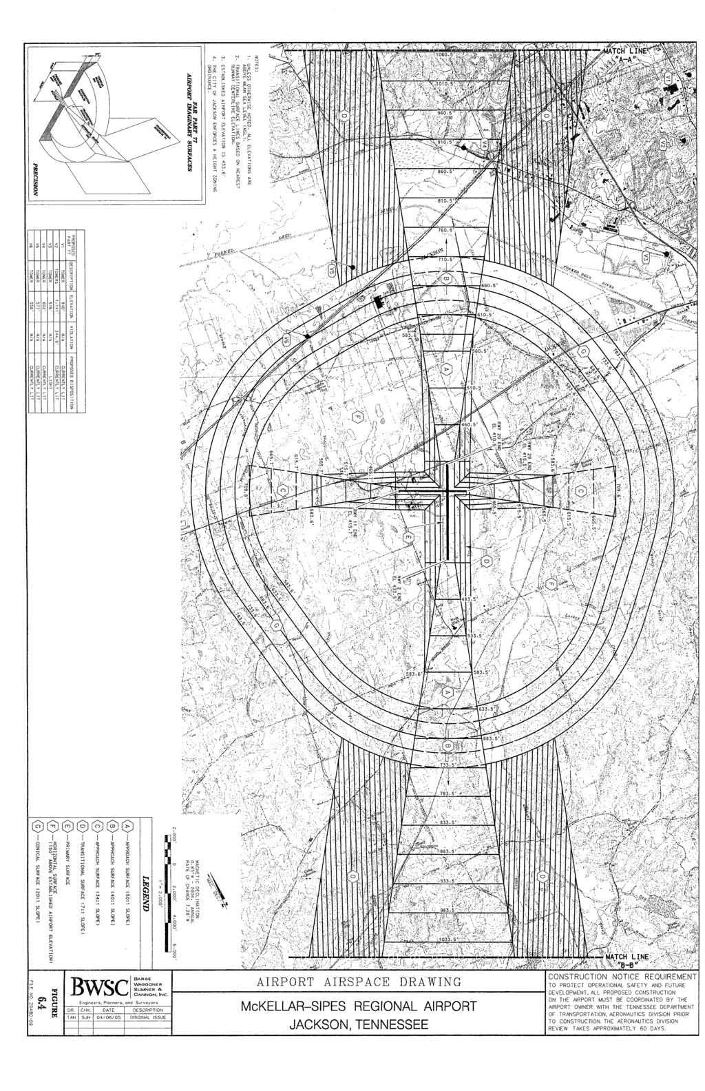
123 122
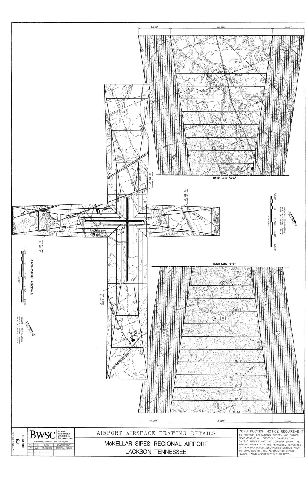
124 123
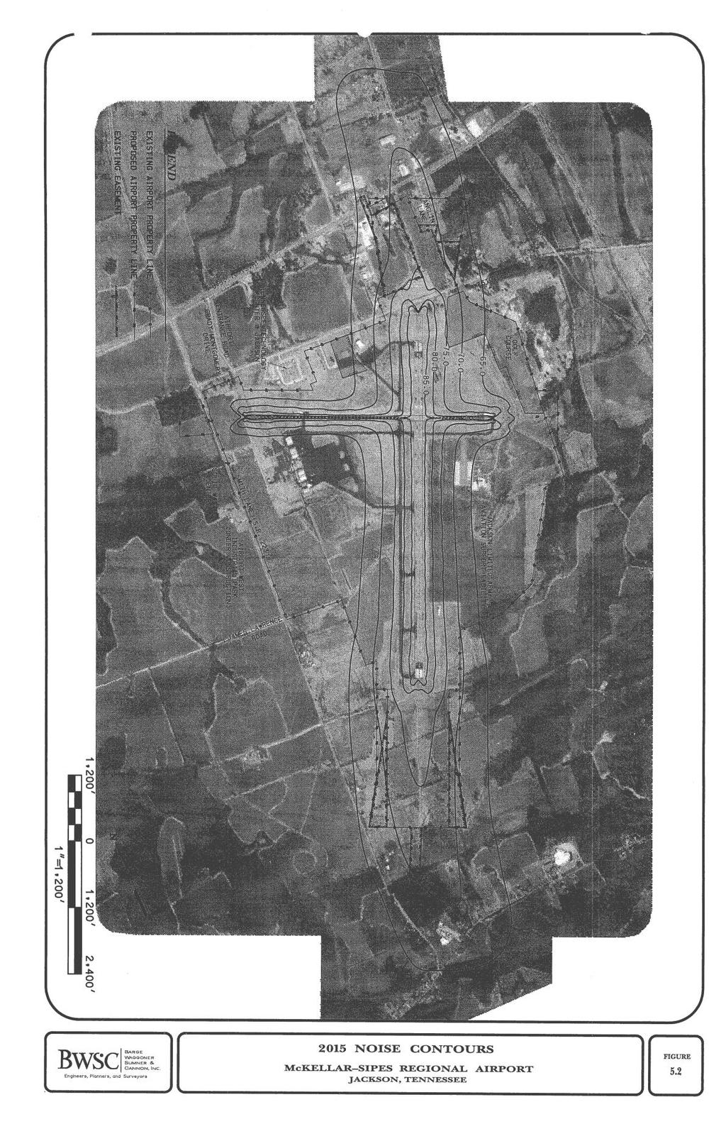
125 124
ARTICLE 15. RULES, REGULATIONS AND DEFINITIONS
 ARTICLE 15. RULES, REGULATIONS AND DEFINITIONS Section 1. Interpretation and Construction: The following rules and regulations regarding interpretation and construction of the Ulysses-Grant County, Kansas,
ARTICLE 3 DEFINITIONS
 Sections: 3-1 Rules of Construction 3-2 Definitions ARTICLE 3 DEFINITIONS SECTION 3-1 RULES OF CONSTRUCTION 3-101. a. The language set forth in these regulations shall be interpreted in accordance with
SECTION 822 "R-1-A" AND "R-1-AH" - SINGLE FAMILY RESIDENTIAL DISTRICTS
 SECTION 822 "R-1-A" AND "R-1-AH" - SINGLE FAMILY RESIDENTIAL DISTRICTS The "R-1-A" and "R-1-AH" Districts are intended to provide for the development of single family residential homes at urban standards
ZONING ORDINANCE TOWN OF MOUNTAIN CITY
 ZONING ORDINANCE TOWN OF MOUNTAIN CITY AMENDED THROUGH JUNE 2009 ZONING ORDINANCE OFTHE TOWN OF MOUNTAIN CITY An ordinance, in pursuance of the authority granted by Sections 13-7-201 through 13-7- 210
SECTION CLASSIFICATION OF ZONES For the purpose of this Code the following primary land use zoning districts are hereby established:
 ARTICLE 4 ZONING DISTRICTS SECTION 4.010 CLASSIFICATION OF ZONES For the purpose of this Code the following primary land use zoning districts are hereby established: Primary Zones Abbreviated Designation
Chapter CC COMMUNITY COMMERCIAL ZONES REGULATIONS
 Effective April 14, 2011 Chapter 17.35 CC COMMUNITY COMMERCIAL ZONES REGULATIONS SECTIONS: 17.35.010 Title, Intent, and Description 17.35.020 Required Design Review Process 17.35.030 Permitted and Conditionally
CHAPTER 11 GENERAL REQUIREMENTS AND PROPERTY DEVELOPMENT STANDARDS
 CHAPTER 11 GENERAL REQUIREMENTS AND PROPERTY DEVELOPMENT STANDARDS Section 1101 Establishment of Development Standards: The purpose of development standards is to protect the general health, safety and
-MENDOCINO COUNTY PLANNING AND BUILDING SERVICES- DIVISION OF LAND REGULATIONS TITLE 17
 ARTICLE VI -- GENERAL REGULATIONS AND PROVISIONS Sec. 17-50. Sec. 17-51 General Plan. Sec. 17-52 Lot and Block Design and Configuration. Sec. 17-53 Lot Access. Sec. 17-54 Private Roads. Sec. 17-55 Water
ARTICLE 20 SIGN REGULATIONS
 ARTICLE 20 SIGN REGULATIONS Section 20.01 Purpose The purpose of this Article is to regulate the size, placement, and general appearance of all privately owned signs and billboards in order to promote
Title 17 MOBILE HOMES AND RECREATIONAL VEHICLES
 17.04 General Provisions Title 17 MOBILE HOMES AND RECREATIONAL VEHICLES 17.04.010 General provisions 17.04.020 Application 17.04.030 Interpretation 17.04.040 Mobile homes and recreational vehicles--location
UPPER MOUNT BETHEL TOWNSHIP NORTHAMPTON COUNTY, PENNSYLVANIA
 UPPER MOUNT BETHEL TOWNSHIP NORTHAMPTON COUNTY, PENNSYLVANIA JOINDER DEED / LOT CONSOLIDATION TOWNSHIP REVIEW PROCESS When accepting proposed Joinder Deeds / Lot Consolidations, review the Joinder Deed
ARTICLE VI. SPECIAL EXCEPTION REGULATIONS
 ARTICLE VI. SPECIAL EXCEPTION REGULATIONS SECTION 601. GENERAL DESCRIPTION Special exceptions are deemed to be permitted uses in their respective districts, subject to the satisfaction of the requirements
SECTION 821 "R-A" - SINGLE FAMILY RESIDENTIAL-AGRICULTURAL DISTRICT
 SECTION 821 "R-A" - SINGLE FAMILY RESIDENTIAL-AGRICULTURAL DISTRICT The "R-A" District is intended to provide for the development of single family residential estate homes in a semi-rural environment on
ARTICLE III: LAND USE DISTRICTS 304 R 9 DISTRICT
 ARTICLE III: LAND USE DISTRICTS III 23 304 R 9 DISTRICT (RESIDENTIAL 9 UNITS PER ACRE) 304 1 Intent and Purpose The R 9 District is intended to implement the policies of the Comprehensive Plan for areas
LAURENS COUNTY MOBILE HOME PARK ORDINANCE ARTICLE 1 GENERAL
 LAURENS COUNTY MOBILE HOME PARK ORDINANCE ARTICLE 1 GENERAL 1.1 AUTHORITY AND JURISDICTION. The 1983 Georgia Constitution grants authority to the governing authority of the county to regulate land development
SECTION 820 "R-R" - RURAL RESIDENTIAL DISTRICT
 SECTION 820 "R-R" - RURAL RESIDENTIAL DISTRICT The "R-R" District is intended to create or preserve rural or very large lot residential homesites where a limited range of agricultural activities may be
CHAPTER 2 RELATIONSHIP WITH OTHER LAWS.
 CHAPTER 2 General Provisions 12-2-1 Minimum Requirements 12-2-2 Relationship with Other Laws 12-2-3 Effect on Existing Agreements 12-2-4 Scope of Regulations 12-2-5 Building Permit 12-2-6 Nonconforming
ARTICLE 7 R-1 ONE FAMILY RESIDENTIAL DISTRICT
 ARTICLE 7 R-1 ONE FAMILY RESIDENTIAL DISTRICT SECTION 700 STATEMENT OF PURPOSE This district classification is designed to be the most restrictive of the residential districts intended to encourage an
ORDINANCE SAVANNAH, TENNESSEE
 ZONING ORDINANCE SAVANNAH, TENNESSEE ZONING ORDINANCE SAVANNAH, TENNESSEE As Amended December 2008 T A B L E O F C O N T E N T S Z O N I N G O R D I N A N C E CHAPTER PAGE MUNICIPAL PLANNING COMMISSION...
CUDAHY MUNICIPAL CODE
 CUDAHY MUNICIPAL CODE 20.80.010 Accessory uses may be developed as permitted in this zoning code provided such uses are located on the same lot or parcel of land and are incidental to, and do not substantially
CHAPTER 2 GENERAL PROVISIONS
 CHAPTER 2 GENERAL PROVISIONS 200 ZONING DISTRICTS ESTABLISHED 201 SUPPLEMENTAL DISTRICTS ESTABLISHED 202 OFFICIAL ZONING MAP ESTABLISHED 203 DISTRICT BOUNDARY DESCRIPTION and INTERPRETATION 204 LIMITATION
Chapter CN NEIGHBORHOOD CENTER COMMERCIAL ZONES REGULATIONS
 Chapter 17.33 - CN NEIGHBORHOOD CENTER COMMERCIAL ZONES REGULATIONS Sections: 17.33.010 - Title, intent, and description. 17.33.020 - Required design review process. 17.33.030 - Permitted and conditionally
a. To insure compatible relationships between land use activities;
 PART B SECTION VIII INSTITUTIONAL DISTRICTS Article 1 Planned Institutional District 1. Purpose and Intent: It is the purpose and intent of this district to permit and encourage the orderly, cooperative
MOBILE HOME PARKS. MOBILE HOME: A manufactured, relocatable dwelling unit which may not meet the minimum requirements of the Uniform Building Code.
 Title 10 Zoning Ordinance Definitions: MOBILE HOME PARKS MOBILE HOME: A manufactured, relocatable dwelling unit which may not meet the minimum requirements of the Uniform Building Code. MOBILE HOME COURT:
4-1 TITLE 6 MOBILE HOME AND RECREATIONAL VEHICLE PARKS 4-3
 4-1 TITLE 6 MOBILE HOME AND RECREATIONAL VEHICLE PARKS 4-3 Chapter 4 RECREATIONAL VEHICLE PARKS Sec. 4-1: Sec. 4-2: Sec. 4-3: Sec. 4-4: Sec. 4-5: Sec. 4-6: Sec. 4-7: Sec. 4-8: Sec. 4-9: Sec. 4-10: Sec.
ML-4 MULTIFAMILY RESIDENTIAL ZONE. [Added by Ord. No ]
![ML-4 MULTIFAMILY RESIDENTIAL ZONE. [Added by Ord. No ]](/thumbs/90/103301433.jpg "ML-4 MULTIFAMILY RESIDENTIAL ZONE. [Added by Ord. No ]") 55-26. ML-4 MULTIFAMILY RESIDENTIAL ZONE. [Added 2-2-98 by Ord. No. 1998-1 2] The following regulations apply in the ML-4 Zone. A. Permitted Uses. (1) Garden apartments, together with accessory structures
55-26. ML-4 MULTIFAMILY RESIDENTIAL ZONE. [Added 2-2-98 by Ord. No. 1998-1 2] The following regulations apply in the ML-4 Zone. A. Permitted Uses. (1) Garden apartments, together with accessory structures
ARTICLE 11. NAMEPLATES AND SIGNS Signs in all districts.
 //Culpeper County, Virginia/CODE OF ORDINANCES COUNTY OF CULPEPER, VIRGINIA Codified through Ordinance of November 7, 2007. (Supplement No. 3)/APPENDIX A ZONING ORDINANCE*/ARTICLE 11. NAMEPLATES AND SIGNS
City of Fraser Residential Zoning District
 City of Fraser Residential Zoning District The one-family districts are established to provide principally for one-family dwellings at varying densities. The specific interest of these districts is to
ZONING ORDINANCE BAXTER, TENNESSEE PREPARED BY THE BAXTER MUNICIPAL PLANNING COMMISSION
 ZONING ORDINANCE BAXTER, TENNESSEE PREPARED BY THE BAXTER MUNICIPAL PLANNING COMMISSION Jeff Wilhite, Mayor Harmon Garris Ernest Burgess Richard Waller Cris Austin Jeff Herald Sue Neal AUGUST, 1995 Amended
May 12, Chapter RH HILLSIDE RESIDENTIAL ZONES REGULATIONS Sections:
 May 12, 2017 Chapter 17.13 RH HILLSIDE RESIDENTIAL ZONES REGULATIONS Sections: 17.13.010 Title, intent, and description. 17.13.020 Required design review process. 17.13.030 Permitted and conditionally
ARTICLE VII - RESIDENTIAL DISTRICT R-2. be for one or more of the following uses:
 ARTICLE VII - RESIDENTIAL DISTRICT R-2 7-1 USE REGULATIONS In Residential District R-2, structures to be erected or land to be used shall be for one or more of the following uses: 7-1.1 Single-family dwellings.
17.13 RH HILLSIDE RESIDENTIAL ZONES REGULATIONS SECTIONS:
 Effective April 14, 2011 Chapter 17.13 RH HILLSIDE RESIDENTIAL ZONES REGULATIONS SECTIONS: 17.13.010 Title, Intent, and Description 17.13.020 Required Design Review Process 17.13.030 Permitted and Conditionally
ARTICLE 8 R-2 MULTIPLE FAMILY RESIDENTIAL DISTRICT
 ARTICLE 8 R-2 MULTIPLE FAMILY RESIDENTIAL DISTRICT SECTION 800 STATEMENT OF PURPOSE This district classification is designed to permit the greatest density of residential uses allowed within the Township,
CHAPTER 6 RESIDENTIAL DISTRICTS LOW DENSITY RESIDENTIAL DISTRICT (R-1)
") TYPE OF DISTRICT: TRADITIONAL CHAPTER 6 RESIDENTIAL DISTRICTS LOW DENSITY RESIDENTIAL DISTRICT (R-1) ARTICLE 1: LOW DENSITY RESIDENTIAL DISTRICT (R-1) SECTION 6-1.01: PURPOSE The regulations of the R-1
TYPE OF DISTRICT: TRADITIONAL CHAPTER 6 RESIDENTIAL DISTRICTS LOW DENSITY RESIDENTIAL DISTRICT (R-1) ARTICLE 1: LOW DENSITY RESIDENTIAL DISTRICT (R-1) SECTION 6-1.01: PURPOSE The regulations of the R-1
ARTICLE VII-A - RESIDENTIAL DISTRICT R-2 FH 9. be for one or more of the following uses:
 ARTICLE VII-A - RESIDENTIAL DISTRICT R-2 FH 9 7-1A USE REGULATIONS In Residential District R-2 F, structures to be erected or land to be used shall be for one or more of the following uses: 7-1.1A Single-family
Part 4, C-D Conservation District
 The Township is divided into the districts set forth by this chapter and as shown by the district boundaries on the Official Zoning District Map. The zoning districts are: C-D Conservation District A-1
ARTICLE VIII DEVELOPMENT STANDARDS
 ARTICLE VIII Section 1. Section 2. COMPLIANCE WITH REGULATIONS MATRIX Section 3. FOOTNOTES TO MATRIX Section 1. COMPLIANCE WITH REGULATIONS Except as hereinafter provided: 1. No building or land shall
ARTICLE 14 BUILDINGS, STRUCTURES, AND USES ACCESSORY TO SINGLE-FAMILY RESIDENTIAL DWELLINGS
 ARTICLE 14 BUILDINGS, STRUCTURES, AND USES ACCESSORY TO SINGLE-FAMILY RESIDENTIAL DWELLINGS Sec. 14.1. Sec. 14.2. Sec. 14.3. Sec. 14.4. Sec. 14.5. Sec. 14.6. Sec. 14.7. Sec. 14.8. Sec. 14.9. Sec. 14.10.
ARTICLE IV DISTRICT REGULATIONS
 PART 1. RESIDENTIAL DISTRICTS 4-101. RS. Single-Family Residential Suburban District. The RS District is designed for single-family dwellings, and compatible uses, at a density no greater than one dwelling
STATE OF MICHIGAN COUNTY OF MARQUETTE, TOWNSHIP OF NEGAUNEE LAND DIVISION, SUBDIVISION AND CONDOMINIUM ORDINANCE
 STATE OF MICHIGAN COUNTY OF MARQUETTE, TOWNSHIP OF NEGAUNEE LAND DIVISION, SUBDIVISION AND CONDOMINIUM ORDINANCE Adopted: August 8 th, 2008 Effective: August 28 th, 2008 Sec.100. Title ARTICLE I GENERAL
15.02 PERMITTED USES: The following uses and no other shall be deemed Residential, R-1, uses and permitted in all R-1 districts:
 Amended October 3, 1994, Effective November 3, 1994 Revised effective November 16, 1995, Revised effective 12/1/04, Revised effective 7/06/06, Revised effective 7/18/07, Revised effective 9/03/09, Revised
DECLARATION OF RESTRICTIONS AND EASEMENTS OF OAKWOOD MEADOWS SUBDIVISION
 DECLARATION OF RESTRICTIONS AND EASEMENTS OF OAKWOOD MEADOWS SUBDIVISION WHEREAS, OAKWOOD MEADOWS, a subdivision of part of the Southwest quarter of Section 24, Town 1 North, Range 6 East, Green Oak Township,
ARTICLE 9 - ACCESSORY AND TEMPORARY USES AND STRUCTURES
 ARTICLE 9 - ACCESSORY AND TEMPORARY PART A - ACCESSORY 9-1 AUTHORIZATION Subject to the limitations of this Part A, accessory uses and structures are permitted in any Zoning District in connection with
The following regulations shall apply in the R-E District:
 "R-E" RESIDENTIAL ESTATE DISTRICT (8/06) The following regulations shall apply in the R-E District: 1. Uses Permitted: The following uses are permitted. A Zoning Certificate may be required as provided
 Page 1 of 9 Escondido Municipal Code Up Previous Next Main Collapse Search Print No Frames Chapter 33 ZONING ARTICLE 8. RESIDENTIAL ESTATES (R-E) ZONE Sec. 33-120. Purpose. The purpose of the residential
Spring City Municipal Corporation
 Spring City Municipal Corporation (435) 462-2244 FAX: (435) 462-2654 www.springcityutah.org 150 East Center Street P.O. Box 189 Spring City, Utah 84662 For Your Information All appointments with Public
HUERFANO COUNTY SIGN REGULATIONS SECTION 14.00
 TABLE OF CONTENTS Section Title Page 14.01 SIGN CODE... 14-1 14.01.01 Intent and Purpose... 14-1 14.02 GENERAL PROVISIONS... 14-1 14.02.01 Title... 14-1 14.02.02 Repeal... 14-1 14.02.03 Scope and Applicability
ARTICLE 5 GENERAL REQUIREMENTS
 5.1 SUITABILITY OF THE LAND ARTICLE 5 GENERAL REQUIREMENTS 5.1.1 Land subject to flooding, improper drainage or erosion, and land deemed to be unsuitable for development due to steep slope, unsuitable
CITY OF HENDERSON TABLE OF CONTENTS. Section 101: Purpose... 1 Section 102: Authority... 1 GENERAL REGULATIONS APPLIED TO ALL DISTRICTS
 TABLE OF CONTENTS ARTICLE 100: PURPOSE AND AUTHORITY Section 101: Purpose... 1 Section 102: Authority... 1 ARTICLE 200: GENERAL REGULATIONS APPLIED TO ALL DISTRICTS Section 201: Jurisdiction and Zoning
the conditions contained in their respective Orders until January 1, 2025, at the discretion of the Director of Planning, Property and Development.
 Part 4: Use Regulations Temporary Uses and Structures Purpose the conditions contained in their respective Orders until January 1, 2025, at the discretion of the Director of Planning, Property and Development.
ARTICLE 15 - PLANNED UNIT DEVELOPMENT
 Section 15.1 - Intent. ARTICLE 15 - PLANNED UNIT DEVELOPMENT A PUD, or Planned Unit Development, is not a District per se, but rather a set of standards that may be applied to a development type. The Planned
ARTICLE XXVIII. SPECIAL CONDITIONS AND DEVELOPMENT STANDARDS (Ord. No. 2835, 07/01/0; Ord. No. 2938, 10/19/04; Ord. No. 09/06/16))
)") ARTICLE XXVIII. SPECIAL CONDITIONS AND DEVELOPMENT STANDARDS (Ord. No. 2835, 07/01/0; Ord. No. 2938, 10/19/04; Ord. No. 09/06/16)) SECTION A. SPECIAL YARD REGULATIONS. 1. SPECIAL FRONT YARD REGULATIONS:
ARTICLE XXVIII. SPECIAL CONDITIONS AND DEVELOPMENT STANDARDS (Ord. No. 2835, 07/01/0; Ord. No. 2938, 10/19/04; Ord. No. 09/06/16)) SECTION A. SPECIAL YARD REGULATIONS. 1. SPECIAL FRONT YARD REGULATIONS:
COVENANTS AND RESTRICTIONS ON AND FOR THE WOODS RESIDENTIAL SUBDIVISION
 COVENANTS AND RESTRICTIONS ON AND FOR THE WOODS RESIDENTIAL SUBDIVISION WHEREAS; The Woods Property Owners Association, Inc., hereinafter referred to as Association, is a non-profit entity incorporated
DECLARATION OF PROTECTIVE COVENANTS, RESTRICTIONS, LIMITATIONS, CONDITIONS AND AGREEME1NTS WITH RESPECT TO THE PLAT OF SOMERSET # 8
 Auditors File #5499481 Dated: October 16, 1962 Auditor's File No. 5499481 Recorded: October 30, 1962 DECLARATION OF PROTECTIVE COVENANTS, RESTRICTIONS, LIMITATIONS, CONDITIONS AND AGREEME1NTS WITH RESPECT
Day care centers: Such uses shall require a Special Permit under the terms of Article VIII of this chapter.
 Page 1 of 12 DIVISION 1. - R-1 RESIDENTIAL ZONE Sec. 38-41. - Permitted uses. Single-family dwellings, excluding factory manufactured homes constructed as a single selfcontained unit and mounted on a single
Box Elder County Land Use Management & Development Code Article 3: Zoning Districts
 Chapter 3-6 Mobile Homes, Mobile Home Subdivisions, & Recreational Vehicle Parks Box Elder Zoning Ordinance as Adopted October 2007 Sections. 3-6-010. Purpose and Intent. 3-6-020. Conditional Use Permit
ARTICLE III Section BUSINESS A GENERAL BUSINESS DISTRICT
 ARTICLE III Section 3-110 BUSINESS A GENERAL BUSINESS DISTRICT Section 3-110.1 - Intent General Business Districts provide for the appropriate development and special requirements for the major business
TOWN OF EPPING, NH ZONING ORDINANCES
 TOWN OF EPPING, NH ZONING ORDINANCES 2017 Contents ARTICLE 1: Preamble, Title & Purpose 3 ARTICLE 2: Zoning 4 1. Highway-Commercial 7 2.Residential-Commercial 11 3. West Epping Commercial Business Zone
Ridge Road Elverson, PA
 2578 Ridge Road Elverson, PA Partnership. Performance. PERFECT OPPORTUNITY FOR COMMERCIAL OWNER OCCUPIER > 8.26 acre development site in Warwick Township > 8.321 VPD > Zoning: R2/B2 - Residential/Business
GC General Commercial District
 Section 712. GC General Commercial District 712.1 Intent of District. It is the intent of this section that the GC Zoning District be developed and reserved for general business purposes. The regulations
Town of Windham Land Use Ordinance Sec. 400 Zoning Districts SECTION 400 ZONING DISTRICTS
 Town of Windham Land Use Ordinance Sec. 400 Zoning Districts Sections SECTION 400 ZONING DISTRICTS SECTION 400 ZONING DISTRICTS 4-1 401 Districts Enumerated 4-2 402 Location of districts; Zoning Map 4-2
I. Requirements for All Applications. C D W
 108-16.1. Application checklists. Checklist for Required Submissions to the Planning Board or Zoning Board of Adjustment of Monroe Township All required submissions are to be made to the Administrative
ARTICLE V SUPPLEMENT REGULATIONS
 ARTICLE V SUPPLEMENT REGULATIONS SECTION 5.1 PURPOSE It is the purpose of this article of this ordinance to provide regulations and requirements that supplement the provisions contained under the respective
CHAPTER 154: SIGNS. Section
 CHAPTER 154: SIGNS Section 154.01 Permit required 154.02 Where prohibited 154.03 Street decorations 154.04 Approval by state 154.05 Purpose 154.06 Definitions 154.07 General sign and street graphics regulations
ARTICLE III: LAND USE DISTRICTS 302 R 5 DISTRICT
 ARTICLE III: LAND USE DISTRICTS III 7 302 R 5 DISTRICT (RESIDENTIAL 5 UNITS PER ACRE) 302 1 Intent and Purpose The R 5 District is intended to implement the policies of the Comprehensive Plan for areas
CHARLOTTE CODE. PART 1: PURPOSE AND PART 2: MIXED USE DISTRICTS (MX-1, MX-2, and MX-3) CHAPTER 11:
 CHAPTER 11:") PART 1: PURPOSE AND PART 2: MIXED USE DISTRICTS (MX-1, MX-2, and MX-3) Section 11.101. Purpose. CHAPTER 11: CONDITIONAL ZONING DISTRICTS PART 1: PURPOSE The Conditional Zoning Districts allow for the establishment
PART 1: PURPOSE AND PART 2: MIXED USE DISTRICTS (MX-1, MX-2, and MX-3) Section 11.101. Purpose. CHAPTER 11: CONDITIONAL ZONING DISTRICTS PART 1: PURPOSE The Conditional Zoning Districts allow for the establishment
TOWN OF WATERVILLE VALLEY NEW HAMPSHIRE SITE PLAN REVIEW REGULATIONS
 TOWN OF WATERVILLE VALLEY NEW HAMPSHIRE Effective date March 17, 1981 Revised March 16, 1982 Revised March 13, 1986 Revised March 10, 1987 Revised March 14, 2013 Revised March 8, 2016 TOWN OF WATERVILLE
90+/-Acres D-19 Southwest corner of I-96 & D-19 Marion Township, Michigan
 90+/- Acres of Commercial Land 90+/-Acres D-19 Southwest corner of I-96 & D-19 Marion Township, Michigan F O R S A L E Exclusively listed by Mark W. Szerlag, CCIM Partner T: 248.476.3700 F: 248.476.3560
Town of Brookeville Zoning Ordinance
 Town of Brookeville Zoning Ordinance Article I. In General Section 10-101. Purpose: The Town of Brookeville has been included on the National Register of Historic Places since 1979 and designated as an
ARTICLE XI SIGNS Shelbyville Zoning Regulations 1994
 ARTICLE XI SIGNS Shelbyville Zoning Regulations 1994 Section 1100 Section 1110 Section 1120 Section 1130 Section 1140 Section 1150 Section 1160 Intent General Sign Regulations Residential Districts Business
THE COUNTY BOARD OF SUPERVISORS OF THE COUNTY OF DOUGLAS DOES ORDAIN AS FOLLOWS:
 8.1 SUBDIVISION CONTROL ORDINANCE THE COUNTY BOARD OF SUPERVISORS OF THE COUNTY OF DOUGLAS DOES ORDAIN AS FOLLOWS: SECTION I. GENERAL INTERPRETATION This ordinance shall not repeal, impair or modify private
ARTICLE SCHEDULE OF REGULATIONS
 ARTICLE 21.00 SCHEDULE OF REGULATIONS FOOTNOTES TO ARTICLE 21.00 SCHEDULE OF REGULATIONS a. If one or both public sanitary sewers and/or public water supply are not available minimum lot size shall be
IOSCO TOWNSHIP ZONING ARTICLE 11 SIGNS
 IOSCO TOWNSHIP ZONING ARTICLE 11 SIGNS INDEX Section 11.1 Section 11.2 Section 11.3 Section 11.4 Section 11.5 Section 11.6 Section 11.7 Section 11.8 Section 11.9 Intent and Purpose Definitions General
TITLE 14 ZONING AND LAND USE CONTROL CHAPTER 1 MUNICIPAL PLANNING COMMISSION
 14-1 TITLE 14 ZONING AND LAND USE CONTROL CHAPTER 1. MUNICIPAL PLANNING COMMISSION. 2. ZONING ORDINANCE. 3. MOBILE HOMES (TRAILERS). CHAPTER 1 MUNICIPAL PLANNING COMMISSION SECTION 14-101. Creation and
Charter Township of Plymouth Zoning Ordinance No. 99 Page 35 Article 7: R-M Mobile Home Residential Districts Amendments:
 Charter Township of Plymouth Zoning Ordinance No. 99 Page 35 PURPOSE ARTICLE VII R-M MOBILE HOME RESIDENTIAL DISTRICTS This District is designed primarily to provide locations for mobile home parks thus
ARTICLE 5 AG AGRICULTURAL AND RURAL DISTRICT Updated
 ARTICLE 5 AG AGRICULTURAL AND RURAL DISTRICT Updated 2-24-14 Sec. 5.01 DESCRIPTION AND PURPOSE. This zone is intended for tracts of land within the township that are best suited and located for agricultural
Midwest City, Oklahoma Zoning Ordinance
 2010 Midwest City, Oklahoma Zoning Ordinance 9/2/2010 Table of Contents Section 1. General Provisions... 5 1.1. Citation... 5 1.2. Authority... 5 1.3. Purpose... 5 1.4. Nature and Application... 5 1.5.
ELK RAPIDS TOWNSHIP ANTRIM COUNTY, MICHIGAN ORDINANCE NO
 ELK RAPIDS TOWNSHIP ANTRIM COUNTY, MICHIGAN ORDINANCE NO. 3-2011 AN ORDINANCE TO REPLACE THE SUBDIVISION CONTROL ORDINANCE WITH A NEW SUBDIVISION DEVELOPMENT ORDINANCE, IN ACCORD WITH THE LAND DIVISION
ARTICLE 7. SPECIFIC USE STANDARDS
 ARTICLE 7. SPECIFIC USE STANDARDS Section 7.1 Applicability The following standards apply to specified uses in all zoning districts in which such uses are allowed. Section 7.2 Accessory Apartments (A)
AN ORDINANCE OF THE CITY OF MINNEAPOLIS. By Palmisano
 AN ORDINANCE OF THE CITY OF MINNEAPOLIS By Palmisano Amending Title 20, Chapter 520 of the Minneapolis Code of Ordinances relating to Zoning Code: Introductory Provisions. The City Council of the City
Chapter 21 MOBILE HOME PARK REGULATIONS.
 Chapter 21 MOBILE HOME PARK REGULATIONS. Sec. 21.1 SCOPE. For the preservation of the interests of various types of residential developments which should be permitted in every community and for the protection
Signs along highways shall meet all of the requirements of the zoning districts in which they are located.
 SECTION 39 SIGNS 39.1 INTENT 39.1.1 The intent of this section is to regulate signs as defined hereinafter, to protect the safety of users of the streets and highways, to assure compatibility with uses
ARTICLE XI CONDITIONAL USE PERMITS
 ARTICLE XI CONDITIONAL USE PERMITS 11.1 Purpose. The City of Hailey recognizes that certain uses possess unique and special characteristics with respect to their location, design, size, method of operation,
Sec Building Permits Issuance
 ARTICLE III GENERAL PROVISIONS Sec. 20-300 Building Permits Issuance A building permit shall be obtained from the building inspector before any construction, erection, alteration, or addition to any structure
SECTION 819 "A-2" - GENERAL AGRICULTURAL DISTRICT
 SECTION 819 "A-2" - GENERAL AGRICULTURAL DISTRICT The "A-2" District is intended to be a district which will protect those areas desiring more protection than the "A-1" District provides and which do not
Land Use Determination Procedures
 Article 9 Land Use Determination Procedures Section 9.1 Section 9.2 Section 9.3 Section 9.4 Section 9.5 Section 9.6 Section 9.7 Zoning Amendment Applications Procedures for Public Hearings Planning Commission
NONCONFORMITIES ARTICLE 39. Charter Township of Commerce Page 39-1 Zoning Ordinance. Article 39 Nonconformities
 ARTICLE 39 NONCONFORMITIES SECTION 39.01. Intent and Purpose It is recognized that there exists within the districts established by this Ordinance lots, structures, sites and uses which were lawful prior
AGENDA. a. Carol Crews Special Exception Hair Salon (Continued from February) b. James Barber Special Exception Horse
 b. James Barber Special Exception Horse") Baker County Land Planning Agency (LPA) Thursday, April 23, 2015 Baker County Administration Building 55 North Third Street Macclenny, FL 32063 (904) 259-3354 AGENDA 5:OO P.M. LDR Mining Workshop A. Draft
Baker County Land Planning Agency (LPA) Thursday, April 23, 2015 Baker County Administration Building 55 North Third Street Macclenny, FL 32063 (904) 259-3354 AGENDA 5:OO P.M. LDR Mining Workshop A. Draft
BONNER COUNTY PLANNING DEPARTMENT
 BONNER COUNTY PLANNING DEPARTMENT 1500 HIGHWAY 2, SUITE 208, SANDPOINT, ID 83864 (208) 265-1458 (208) 265-1463 (FAX) planning@bonnercountyid.gov (email) www.bonnercounty.us (web page) INFORMATION SHEET
SECTION 827 "R-2" AND "R-2-A" - LOW DENSITY MULTIPLE FAMILY RESIDENTIAL DISTRICTS
 SECTION 827 "R-2" AND "R-2-A" - LOW DENSITY MULTIPLE FAMILY RESIDENTIAL DISTRICTS The "R-2" and "R-2-A" Districts are intended to provide for the development of low density multiple family residential
ZONING ORDINANCE: OPEN SPACE COMMUNITY. Hamburg Township, MI
 ZONING ORDINANCE: OPEN SPACE COMMUNITY Hamburg Township, MI ARTICLE 14.00 OPEN SPACE COMMUNITY (Adopted 1/16/92) Section 14.1. Intent It is the intent of this Article to offer an alternative to traditional
SECTION 817 "AL" - LIMITED AGRICULTURAL DISTRICT
 SECTION 817 "AL" - LIMITED AGRICULTURAL DISTRICT The "AL" District is a limited agricultural district. It is intended to protect the general welfare of the agricultural community by limiting intensive
Hopkins City Code (Zoning) (Revised ) Section Zoning; general provisions
 (Revised ) Section Zoning; general provisions") Hopkins City Code (Zoning) 520.01 (Revised 12-28-06) Section 520 - Zoning; general provisions 520.01. Application. Subdivision 1. Minimum standards. The provisions of this code are the minimum requirements
Hopkins City Code (Zoning) 520.01 (Revised 12-28-06) Section 520 - Zoning; general provisions 520.01. Application. Subdivision 1. Minimum standards. The provisions of this code are the minimum requirements
4.2 RESIDENTIAL ZONING DISTRICTS
 4.2 RESIDENTIAL ZONING DISTRICTS A. Purpose: To define regulations and standards for each residential zoning district in the City. The following sections identify uses, regulations, and performance standards
301. Zoning Districts. C-D A-1 R-1 R-V B-1 I-1
 301. Zoning Districts. The Township is divided into the districts set forth by this chapter and as shown by the district boundaries on the Official Zoning District Map. The zoning districts are: C-D Conservation
Proposed Overland Park Kansas Ordinance RE-1 Residential Estates Community
 18.171 RE-1 Residential Estate Community 18.171.010 Statement of intent. The zoning of property as RE-1, (Residential Estates Community, 1 dwelling unit per Gross acre density), is intended to provide
ORDINANCE NO. Be it ordained by the City Council of the City of Abilene, Texas:
 ORDINANCE NO. An ordinance repealing Chapter 23, Subpart B of the Code of the City of Abilene, Texas, entitled Mobile Homes and Vacation Travel Trailers; stating the authority; setting forth the scope
BEAR CREEK TOWNSHIP EMMET COUNTY, MICHIGAN. PRIVATE ROAD ORDINANCE Ordinance No. 11A-99. (to replace prior Private Road Ordinance No.
 BEAR CREEK TOWNSHIP EMMET COUNTY, MICHIGAN PRIVATE ROAD ORDINANCE Ordinance No. 11A-99 (to replace prior Private Road Ordinance No. 11-99) An Ordinance to protect the health, safety, and general welfare
DISTRICT COUNCIL FOR PRINCE GEORGE S COUNTY, MARYLAND OFFICE OF ZONING HEARING EXAMINER SPECIAL EXCEPTION 4658 DECISION
 DISTRICT COUNCIL FOR PRINCE GEORGE S COUNTY, MARYLAND OFFICE OF ZONING HEARING EXAMINER SPECIAL EXCEPTION 4658 DECISION Application: Three Chair Barber Shop Applicants: Danta L. & Felicia B. Wright/Fort
ARTICLE III: LAND USE DISTRICTS AGRICULTURE AND FOREST DISTRICT (AF-10)
") ARTICLE III: LAND USE DISTRICTS III-153 346 AGRICULTURE AND FOREST DISTRICT (AF-10) 346-1 Intent and Purpose The AF-10 District is intended to retain an area s rural character and conserve the natural
ARTICLE III: LAND USE DISTRICTS III-153 346 AGRICULTURE AND FOREST DISTRICT (AF-10) 346-1 Intent and Purpose The AF-10 District is intended to retain an area s rural character and conserve the natural