Special Meeting Amended Agenda
|
|
|
- Louise Fox
- 6 years ago
- Views:
Transcription
1 AGENDA DEVELOPMENT IMPACT FEE ADVISORY COMMITTEE/IMPROVEMENT REIMBURSEMENT COMMISSION MEMBERS: Nathan Ross Chad Andrew Jennifer Gerald Susan Colby Brad Bishop Conlin DeBie DiPietro Jensen Martens Petruzzelli Ricks Wills COUNCIL LIAISON: Chris Talkington CITY OF TWIN FALLS DEVELOPMENT IMPACT FEE ADVISORY COMMITTEE & IMPROVEMENT REIMBURSEMENT COMMISSION April 26, :00 PM Special Meeting City Council Chambers rd Avenue East Twin Falls, Idaho Vice-Chair Chair I. Call Meeting to Order Special Meeting Amended Agenda II. III. Introduction of new Committee Members & Term Review Election of Committee Officers IV. Consideration of the Minutes: October 22, 2016 V. Discussion of Impact Fee Financial Report VI. VII. Discussion of Street Impact Fee Expenditures Improvement Reimbursement Committee Items a. Federation Road_Twin Falls School District b. Cheney Drive West_Fieldstone Professional VIII. IX. Resolution #1816 Amendment Proposal Next Committee meeting X. Adjourn Meeting Si desea esta información en español, llame Leila Sanches al (208) Any person(s) needing special accommodations to participate in the above noticed meeting should contact Lisa A. Strickland at (208) at least two (2) working days before the meeting.
2 I. Call Meeting to Order II. Introduction of new Committee Members & Term Review Susan Pet was also reappointed to a second term. Welcome Andrew, and welcome back Brad. Everyone s terms are listed below. Note that we again have a vacancy. We are also heavy on the industry committee members right now, so a non-industry committee member would be a good addition. Let us know if you have any ideas of someone who d like to join the committee. Name Term P/F Started Expires Brad Wills 2 F 3/2016 3/2019 bradwills2007@gmail.com Susan Petruzzelli 1 F 02/ /2020 petz@cableone.net Gerald Martens 1 F 02/ /2020 gmartens@ehminc.com Colby Ricks 1 F 06/ /2018 colby.ricks@gmail.com Nathan Bishop 1 F 06/ /2018 2creativeguys@gmail.com Chad Debie 1 F 06/ /2020 chad@tkohomes.com Jennifer Jensen 1 F 06/ /2018 jjensen@farmersagent.com Andrew DiPietro 1 F 4/ /2019 andrewd@pbcbuilds.com Ross Conlin 1 F 4/2017 4/2020 dutchoven1@msn.com III. Election of Committee Officers Brad Wills is the current Chairman with Gerald Martens as the Vice-Chairman. We ll need a motion to select new officers, or reaffirm the current officers. IV. Consideration of the Minutes See attached minutes from the October 20, 2016 meeting. V. Discussion of Impact Fee Financial Report Please refer to the financial report for details (Attachment #1). The report includes data collected through the end of March. Our adjusted fee table is also provided below. At our last meeting, we reported the MCI was showing a 0.84% increase. Between the September MCI report and the January report, the MCI increased up to 3.4%. On March 27 th, DCM Mitch Humble reported this increase to the City Council. They elected allow the automatic increase to take place. As a result, an increase in fee amounts has occurred as shown below. A full breakdown of fees can be found in Attachment #2. Total Fees Old New Single Family (per dwelling unit) $1994 $2075 Multifamily (per dwelling unit) $1822 $1897 Retail (per square foot) $2.86 $2.96 Office (per square foot) $1.20 $1.24 Industrial (per square foot) $0.99 $1.03 Institutional (per square foot) $0.61 $0.63
3 V-1. Parks Summary The Parks Impact Fee Account totals $870,759 at this time. However, we previously budgeted $800,000 for construction of the trail section across the Storrer property. We have spent a portion of those funds on construction plans for the trail. The remaining portion of the budgeted amount will be spent after the contract is awarded and construction begins in May. V-2. Fire Summary The Fire Impact Fee Account totals $1,609,497 at this time. The Dispatch Expansion Project is taking place this year. That project cost shows a total of $375,548 within the CIP. This cost is shared between the Fire and Police accounts on a 34% - 66% split. Additionally, we are seeking a recommendation to use funds for a Land Acquisition to the amount of $68,000. This land acquisition will facilitate Fire Station #5 identified within the Capital Improvement Plan. This land acquisition is a result of the new Fire Department Station and Response Study showing a need for an additional station. Although we have not begun collecting fees for Fire Station #5, it is a legitimate request to use available Impact Fees for property acquisition. We currently have a purchase sale agreement for the property and request a recommendation to use the available funds. V-3 Police Summary The Police Impact Fee account totals $643,683 at this time. The entirety of this fund is currently budgeted as part of the Police Station Expansion Project. This project includes expansion of the Police Operations Center, Admin Building and Dispatch Center. As these projects move forward with construction, the cost of the projects will exceed the available amounts within the respective accounts. In order to finish the projects, the City will cover the remaining amounts with Reserve Funds. As we continue to collect Impact Fees on these projects over the next few years of the CIP cycle, the impact fee accounts will pay back the City Reserve Fund. At the end of this CIP cycle, these projects will drop off the list and we will no longer collect funds for them. V-4 Streets Summary The Streets Impact Fee account totals $1,390,432. This fund splits money between traffic signals and roadway expansion projects. The CIP lists possible signal locations and roadway projects. The City Engineer determines the timing of signal placement and which roadway project to undertake. VI: VI. Street Expenditure and CIP Addition Discussion - Presented by City Engineer Jackie Fields. (See attachment #3) Improvement Reimbursement Committee Items VI-1: Federation Road Extension (See attachment #4) VI-2: Cheney Drive West (see attachment #5) VII. Resolution #1816 Amendment Proposal (See attachment #6) VIII. Next Committee meeting The tentative date for our next meeting is October 26, IX. Adjourn Meeting
4 Attachments: 1. Financial Report 2. Current Impact Fee Rates 3. Street Expenditure and CIP Addition Report 4. Federation Road Reimbursement Report/ Packet 5. Cheney Drive West Reimbursement Report/ Packet 6. Resolution #1816 Amendment
5 City of Twin Falls Summary of Impact Fee Activity 4/20/2017 3/31/ Total Totals Residential Impact Fees-Police $ 2,820 $ 20,924 $ 16,726 $ 25,748 $ 36,926 $ 43,378 $ 56,211 $ 59,706 $ 262,440 $ 32,643 $ 295,083 Non-resid. Impact Fees-Police $ - $ 1,644 $ 5,412 $ 57,916 $ 64,520 $ 32,194 $ 100,738 $ 68,989 $ 331,412 $ 17,189 $ 348,600 Revenue Subtotal-Police $ 2,820 $ 22,567 $ 22,138 $ 83,665 $ 101,445 $ 75,572 $ 156,949 $ 128,695 $ 593,851 $ 49,832 $ 643,683 Residential Impact Fees-Fire $ 8,055 $ 60,063 $ 47,776 $ 73,520 $ 105,271 $ 123,712 $ 126,097 $ 132,894 $ 677,388 $ 72,657 $ 750,045 Non-resid. Impact Fees-Fire $ - $ 4,602 $ 15,150 $ 155,071 $ 181,642 $ 68,153 $ 236,016 $ 159,529 $ 820,163 $ 39,288 $ 859,451 Revenue Subtotal-Fire $ 8,055 $ 64,664 $ 62,927 $ 228,591 $ 286,913 $ 191,866 $ 362,113 $ 292,423 $ 1,497,552 $ 111,945 $ 1,609,497 Residential Impact Fees-Streets $ 4,065 $ 30,545 $ 23,734 $ 42,530 $ 51,288 $ 57,803 $ 99,244 $ 106,698 $ 415,907 $ 58,445 $ 474,352 Non-resid. Impact Fees-Streets $ - $ 21,773 $ 46,497 $ 173,666 $ 192,210 $ 143,034 $ 474,376 $ 186,984 $ 1,238,541 $ 88,281 $ 1,326,822 Revenue Subtotal-Streets $ 4,065 $ 52,319 $ 70,231 $ 216,196 $ 243,498 $ 200,837 $ 573,620 $ 293,682 $ 1,654,448 $ 146,726 $ 1,801,174 Street light project - Expenditures $ - $ - $ - $ - $ (37,260) $ (373,482) $ - $ - $ (410,742) $ - $ (410,742) Net Revenue-Streets $ 4,065 $ 52,319 $ 70,231 $ 216,196 $ 206,238 $ (172,644) $ 573,620 $ 293,682 $ 1,243,707 $ 146,726 $ 1,390,432 Residential Impact Fees-Parks $ 9,150 $ 67,402 $ 54,270 $ 82,022 $ 119,510 $ 140,432 $ 159,464 $ 126,902 $ 759,153 $ 69,381 $ 828,534 Transfer from the CI Fund $ - $ - $ - $ - $ - $ - $ - $ 280,000 $ 280,000 $ - $ 280,000 Revenue Subtotal-Parks $ 9,150 $ 67,402 $ 54,270 $ 82,022 $ 119,510 $ 140,432 $ 159,464 $ 406,902 $ 1,039,153 $ 69,381 $ 1,108,534 Parks - Equipment storage bldg $ - $ - $ - $ - $ - $ - $ (50,874) $ (117,492) $ (168,366) $ - $ (168,366) Parks - Trails $ - $ - $ - $ - $ - $ - $ - $ - $ - $ (69,409) $ (69,409) Net Revenue-Parks $ 9,150 $ 67,402 $ 54,270 $ 82,022 $ 119,510 $ 140,432 $ 108,590 $ 289,410 $ 870,787 $ (28) $ 870,759 FY 2017 budget includes: Trails-Parks Reserves-$400,000 Trails-Parks new $-$120,000 $800,000 Trails-CI Transfers-$280,000 $ - $ - $ - $ - $ - $ - $ - $ 108,590 $ 289,410 $ 870,787 $ (28) $ 870,759 Interest Income-Adj for Unrealized Gain or Loss $ - $ 2,137 $ 1,846 $ 8,778 $ (4,411) $ 32,327 $ 50,029 $ 67,391 $ 158,097 $ 52,233 $ 210,330 TOTALS $ 24,090 $ 209,089 $ 211,412 $ 619,252 $ 709,695 $ 267,553 $ 1,251,301 $ 1,071,601 $ 4,363,994 $ 360,707 $ 4,724,700
6 Impact Fee Rates effective April 1, Police fees Residential (per dwelling unit) $ Nonresidential (per square foot) $ 0.15 Fire Fees Residential (per dwelling unit) $ Nonresidential (per square foot) $ 0.33 Street Single Family (per dwelling unit) $ Multifamily (per dwelling unit) $ Retail (per square foot) $ 2.48 Office (per square foot) $ 0.76 Industrial (per square foot) $ 0.55 Institutional (per square foot) $ 0.15 Parks and Recreation Fees Residential (per dwelling unit) $ Nonresidential (per square foot) n/a Total Fees Single Family (per dwelling unit) $ 2, Multifamily (per dwelling unit) $ 1, Retail (per square foot) $ 2.96 Office (per square foot) $ 1.24 Industrial (per square foot) $ 1.03 Institutional (per square foot) $ 0.63
7 Date: Wednesday, March 26, 2017 To: From: Impact Fee Commission Jacqueline D Fields, City Engineer Request: Consideration of request to recommend modification of the Capital Improvement Program (CIP) to include project for 2 additional signal locations: the Intersection of Harrison Street S. and 3600 N. and the Intersection of Meadowview and Poleline Road E. Background: When the Impact Fee CIP was developed, Staff included all of the reasonably foreseeable signals into the program. None of the signals are specifically funded because growth determines the most imminent and appropriate location for a new signal. Intersection of Harrison Street S. and 3600 N. At the time, the entire area around Harrison St. S & 3600 N was residential and the development south of 3600 N. had offsite infrastructure issues that were substantial, namely a large diameter water line, limited Wills booster station capacity and inadequate sewer in Rock Creek. Now, a new middle school is located ¼ north of the intersection and the infrastructure issues are in the process of being resolved. Intersection of Meadowview and Poleline Road E Initially this location was not included in the CIP because the city Engineer believed that the safer location for the signal would be at the intersection of Cheney Dr. E and Eastland Dr. N. However, a signal could be designed with additional features to address the issues. In addition, there is some citizen pressure to facilitate a pedestrian crossing at this location instead of at Cheney and Eastland. Approval Process: A majority vote approves recommendation to modify the CIP. This recommendation is then forwarded to the City Council for adoption as an element of the Comprehensive Plan (per page of the Amended final report for Chapter 11: Development Impact Fee Capital Improvement Plans). Recommendation: Recommend modification of the Capital Improvement Program (CIP) to include project for 2 additional signal locations: the Intersection of Harrison Street S. and 3600 N. and the Intersection of Meadowview and Poleline Road E. Attachments:
8 Date: Wednesday, March 26, 2017 To: From: Impact Fee Commission Jacqueline D Fields, City Engineer Request: Consideration of a request to budget for the design of an extension of North College Rd. West from Creekside Way to Sunway. Background: The Impact Fee Commission approved inclusion of a roadway project on North College Rd. from Creekside Way to Sunway. This project impacts some large irrigation facilities. The request today is to budget for design in FY and develop an estimate for formal bidding and construction in FY Staff will return to the spring meeting in 2018 to seek consensus for budgeting the construction in the next fiscal year. The current estimate for the project is $1 million. There has been no preliminary design at all so the estimate has a large margin for deviation. Selection of an Engineering consultant is done on a qualifications basis however staff expects the design fees to be limited to less than $200,000. Approval Process: A majority vote approves recommendation to budget the design of the project. The City Council reviews and approves the expenditure as part of the regular budgeting cycle. Recommendation: Include the design costs for development of a roadway project on North College Rd from Creekside Way to Sunway in the budget cycle for FY Attachments:
9 To: City of Twin Falls Engineering Department Improvement Reimbursement Committee Reference: Amended Application for Correction for eligible improvements Federation Road Extension Rock Creek Elementary School Twin Falls School District Please find enclosed the necessary completed forms and information required for this Amended Application for Correction for eligible improvements by the Improvement Reimbursement Committee. Listed below are the forms and exhibits explaining the requested reimbursements. Project Name 4/1/2017 Federation Road Extension Documents & Exhibits 1 R Amended Application 3 R Amended Narrative 8 2 R Master Payback Worksheet 8 4 R Deduct Worksheet

10 1 R Amended Application IMPROVEMENT REIMBURSEMENT APPLICATION April 1, 2017 OFF SITE SEWER PROJECT Subdivision Name: Northern Passage Subdivision 3 and 5 Acres/Lots: Acres/ 38 Lots +/- Subdivision Locations S1/2 NW1/4, 9 South, Range 17 East, Boise Meridian Cross Streets: Federation Road and Columbia Drive Initial Developer: Twin Falls School District Contact: Brady Dickinson Address/phone #: 201 Main St. West, Twin Falls, Idaho Current Contact: Twin Falls School District Contact: Brady Dickinson Address/phone #: 201 Main St. West, Twin Falls, Idaho Local Agent for Owner: Brad Wills, 222 Shoshone St. West, Twin Falls Idaho Property Owner: Twin Falls School District Contact: Brady Dickinson Address/phone #: 201 Main St. West, Twin Falls, Idaho Engineering Firm: EHM Engineering Contact: Tim Vawser Address/phone #: 621 North College Road Suite 100 Twin Falls, Idaho, This is an amended application to correct an existing Improvement Reimbursement. An error was discovered reducing the amount of eligible reimbursement and this amended application will replace the existing reimbursement. The City of Twin Falls adopted Ordinance Number 2974 and Resolution 1816 which allows developers to submit an application to the Improvement Reimbursement Committee (I.R.C.) of the City of Twin Falls if they wish to seek reimbursement for improvements for previously developed and accepted utilities and roadways that benefit future development. More specifically; whenever any extension is made by a private developer (initial developer) to the City of Twin Falls (City) water distribution system, wastewater collection system, transportation system, pressure irrigation pump stations and distribution systems, in such a manner as to enable a subsequent private developer or property owner to connect to or extend the previously extended water distribution system, wastewater collection system, transportation system, pressure irrigation pump stations and distribution systems, the subsequent private developer or property owner (subsequent developers) shall first make proper compensation to the initial developer for the costs of the water distribution system, wastewater collection system, transportation system, pressure irrigation pump stations and distribution systems (improvements). The initial developer must maintain proper identity and current address with the City Engineer in order to be eligible for proper compensation in the future. The lists below identify the items that are required for submittal of the Improvement Reimbursement application. Incomplete submittals will not be accepted or reviewed. It is the responsibility of Engineering firm and/or Developer/ Owner to see that all the required information is submitted to the City in the proper form. Include the following information: 1. Improvement Reimbursement Application
11 2. A Narrative describing the project overview, the initial improvements, the surrounding areas that will benefit from the improvements, the boundary of the affected area, any known developers/owners that will be included in this application and any other information that would be supportive to the commission. 3. Vicinity Map 4. Proof of past ownership of the real property included in this application. 5. AS-BUILT drawing on file with the City of Twin Falls Engineering Department of improvement. 6. The letter from the City Engineering Department approving the completion of the improvements and accepting the project for maintenance. 7. If required, an electronic GIS file indicating items subject to reimbursement. 8. A plan identifying all improvements proposed for compensation. a. A separate plan for each of the individual reimbursement areas. i. Include all four system for that area: 1. water distribution system 2. wastewater collection system 3. transportation system 4. pressure irrigation pump stations and distribution systems ii. Identify the surrounding area that benefits from the improvements. 9. Each individual reimbursement area should include the following information; i. Improvements for consideration ii. The estimated boundary that will benefit from those improvements. iii. Actual cost of installation 1. Attach copy of original cost documents 2. If costs are unavailable, other documentation per Ordinance guidelines iv. Estimated proposed reimbursement Filing Fee: $ Date Submitted: April 1, 2017 Fee per Lot, tract or parcel impacted $ Fee to be calculated after I. R. C. Approval Application received by the City Engineering Department. Date Reviewed by City Staff: Date of Boundary Verification by Engineer Dept.: Date of Notification to Improvement Reimbursement Commission: Date Scheduled for Commission meeting: Note: In the case of an agreement between the Initial Developer and Subsequence Developer, item #10 iii and iv will not be required and a lump sum will be included. Additional Notes: There will be no consideration for depreciation or inflation. Improvements must be accepted by the City of Twin Falls to be eligible for reimbursement. The period of compensation to the initial developer shall be terminated at the earliest of any of the following conditions: o Full compensation for the determined eligible reimbursement amount based on the actual cost plus 15% to address costs for engineering, management, fees, interest and inspection. o Failure on the part of the initial developer or their assigns to maintain proper identity and address on file with the Improvement Reimbursement Commission. o A date twenty years after the acceptance of the improvement by the City. Disclaimer: City of Twin Falls and Improvement Reimbursement Committee approvals determines eligibility and benefit. All quantities and calculations are the responsibility of the applicant therefore any errors are not the liability of the City of Twin Falls or the Improvement Reimbursement Committee.
12 Exhibit 3 R Amended Federation Road Extension Twin Falls School District 201 Main Avenue West Twin Falls, Idaho To: City of Twin Falls April 1, 2017 Engineering Department Twin Falls, Idaho Reference: Improvement Reimbursement Narrative Project: Federation Road Extension Amended Application The Improvement Reimbursement Commission approved the original application on October 20, 2016 as presented. The owners of the Northern Passage Subdivision contacted the Twin Falls School District concerning the approved improvement reimbursement and in the process of communicating with the owners, an error was discovered by the original applicant Brad Wills. In the original application, Sheet 8-4 Deductions included the items in the change order between the ESI contractor and the School District that were not eligible for reimbursement. In our review, an additional item that was not eligible was included in the change order was not deducted from the overall cost. The item was the upgrade from a single ADA ramp on the Arterial Approaches to a double ADA ramp. There were 5 location where this applied at a cost of $1,500 per location. The amount of $7,500 will be added on Sheet 8-4 R as a deduction reducing the cost of the improvements to $130, plus the reimbursement fee of 15% for a total improvement reimbursement of $150, Attached is the Amended Application, the Amended Narrative and Amended Sheets 8-2 R Worksheet and 8-4 R Deduction. All other information on the original Improvement Reimbursement is unchanged. Original Application details below: The Twin Falls School District (TFSD) as part of their Rock Creek Elementary School Project within the Northern Passage Subdivision 5 completed the extension of Federation Road located in Northern Passage Subdivision 3 and 5 connecting the new school project to the future Canyon Trails Subdivision 6 phase #2 to provide access to this area of development from the east. Their project is located east of Grandview Drive North on Federation Road. The TFSD contracted with ESI Contractors, Inc. to complete this section of roadway in addition to the improvement of Grandview Drive North and Federation adjacent to the TFSD new school. The cost of these improvements was covered by a change order under the main contract for the Rock Creek Elementary School project. This change order covered the entire cost of the Federation Extension. A portion of the change order was complete on the roadway south of the center line or property boundary of the Northern Passage Subdivision. This portion on the Grandview Estates Subdivision is not included in this application due to the fact Grandview Estates
13 Subdivision had already completed other improvements benefitting the TFSD project previously. The roadway project was completed in the fall of The City of Twin Falls has approved and accepted the Federation Road Extension project for maintenance on June 14, We have reviewed the City Ordinance Number 2974 to determine which of these improvements would be eligible for future reimbursement. Water Distribution System The extension required an extension of the Water Distribution system to the outside of the roadway project and was capped for future connection. The portion to the south of the center line of Federation Road is deducted from the contract amount. Wastewater Collection System The extension required an extension of the Wastewater Collection system to the outside of the roadway project and was capped for future connection. The portion to the south of the center line of Federation Road is deducted from the contract amount. Transportation System Federation Road was built starting at east boundary of the Elementary School project located on Lot 59 Northern Passage 5 along the south frontage of Federation Road and proceeding approximately 700 lf east to the intersection of Columbia Drive and Federation Road. A full ½ street with curb, gutter and sidewalk was constructed on the north side of the right of way. This will benefit the property on the north side of Federation Road. Pressurized Irrigation Pump Station and Distribution System No Pressurized Irrigation system was included in this project. Gravity Irrigation Distribution System Gravity Irrigation is not eligible for reimbursement within Twin Falls City Code. The entire cost of the gravity irrigation work was deducted from the contract amount. Additional Note Twin Falls City Code states the actual cost of the improvements are eligible for reimbursement so the soft cost such as Engineering, Overhead and Profit and Bond Cost are deducted from the contract amount. These soft code as to be covered by the 15% reimbursement fee.
14 Improvement Reimbursement Worksheet Reference # FR 1 Federation Road Extension Corrected 8-2 R 4/1/2017 Contact Information Shaded Areas are Changes Name Brad Wills Project Information Phone Cross Streets Federation Road and Columbia Drive bradwills@cox.net RPT # If Available Multiple RPT #s Date of City's Approval 14-Jun-16 Date of Application: Drawing Sheet # Description of Improvements Description of Boundary Status of Property Method to determine Payback Undeveloped Platted Land 1-Apr-17 Exhibit 9 Half Width Federation Road Extension Roadway Project 1/8th mile rule to North of Federation along frontage Percentage of Benefit based on area of platted lots to North Engineering Department Notes Only Date Submitted Boundary Reviewed GIS Notes 3rd Party Review Commission Approval Description Item Quantity EA Unit Price Amount Percentage Balance Per Contract Roadway Per Contract $ 174, Deduct from Sht 8-4 R $ (43,722.01) Subtotal $ 130, Reimbursement Fee of 15 % 15% $ 19, Total $ 150, Support Information Description Reference # Contractor Notes Per Contract Method of Percentage of Benefit Acreage within the 1/8 Mile Rule Multiple Lots Eligible Payback Description Acreage within the 1/8 Mile Rule RPT # See RPT List Owner Amount of Payback Northern Passage, Inc. $ 150, Total $ 150, Owner Information RPT # Owner Address Phone # Contacted See RPT List Northern Passage, Inc. Box 2138, McCall, Idaho 83638
15 Federation Road Extension Worksheet 8 4 R Revised 4/1/2017 Deduct for Non Benefitting Work and Storm Water. Shaded Area are Changes and ADA Approaches Soft Cost such as Engineering, OH and P, Bond Cost are included in the 15% Deduct $ 4, OH & P $ 6, Bond $ 1, $ 12, Storm Water 120 LF of 16" C 900 Irrigation Main, Realignment of the Ditch to the south and 300 feet of Reconstruction of the ditch to the north. 2 Irrigation Boxes C " Pipe 130 $ $ 4, Irrigation Boxes 2 $ 2, $ 5, Realignment Minor 50 $ $ Reconstruction of Ditch Excavation 300 $ 4.00 $ 1, Roadway $ 11, Station 1 $ $ See Sheet 9 2 3" Asphalt 186 $ $ 2, " 3/4" Gravel 10 $ $ *12*2/ " Base Course 47 $ $ 1, *12*9/ Valley gutter 21 $ $ 2, $ 7, Water Line 8" Water Line 20 $ $ $ Sewer/Manholes Manhole 1 $ 2, $ 2, " Sewer Line 63 $ $ 1, $ 4, Additional Ramp on ADA Change from Original Approaches Change from single 5 $ 1, $ 7, ADA Ramp to double $ 7, $ 43,722.01
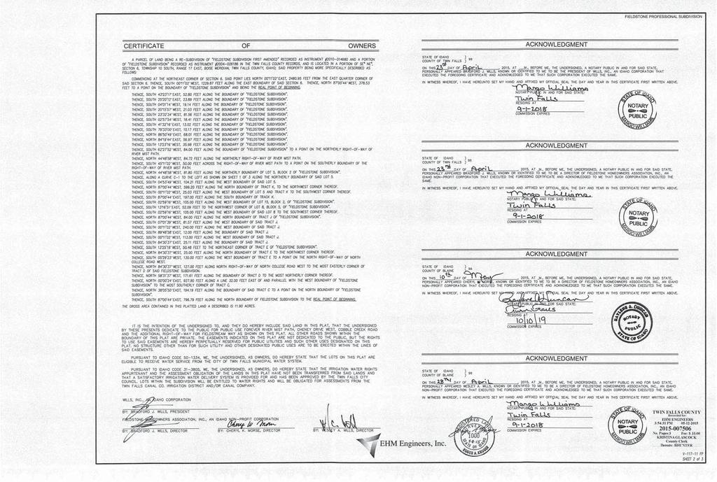
16 To: City of Twin Falls Engineering Department Improvement Reimbursement Committee Reference: Application for eligible improvements Cheney Drive West Extension Fieldstone Professional Subdivision Please find enclosed the necessary completed forms and information required for this Application for consideration by the Improvement Reimbursement Committee. Listed below are the forms and exhibits explaining the requested reimbursements. Project Name 4/1/2017 Cheney Drive West Documents & Exhibits 0 3rd Party Review 1 Application 2 Vicinity Map 3 Narrative 4 Boundary of Project 5 Area of Benefit 6 Current Ownership 7 Recorded Final Plat NP3 8 1 Contract Document for Actual Cost 2 Master Payback Worksheet 3 Worksheet on Quantities 9 1 As Built Construction Plan 2 As Built Expanded View Construction Plan 3 Utility Plan Fieldstream and Cheney Drive West 4 Utility Plan Sheet 2 5 Roadway Section 6 Twin Falls Reformed Church Right of Way Dedication 10 1 Ownership Certification 11 1 City of Twin Falls Approval Letter
17
18 IMPROVEMENT REIMBURSEMENT APPLICATION April 1, 2017 OFF SITE SEWER PROJECT Subdivision Name: Fieldstone Professional Sub Acres/Lots: 12.5 Acres/ 30 Lots Subdivision Location: SE1/4 NE1/4, Section 6, Township 10 South, Range 17 East, Boise Meridian Cross Streets: Cheney Drive West and Field Stream Way Initial Developer: Wills, Inc. Contact Bradford J. Wills Address/phone #: 222 Shoshone St. West, Twin Falls, Idaho Current Contact: Wills, Inc. Contact Bradford J. Wills Address/phone #: 222 Shoshone St. West, Twin Falls, Idaho Property Owner: Wills, Inc. Contact Bradford J. Wills Address/phone #: 222 Shoshone St. West, Twin Falls, Idaho Engineering Firm: EHM Engineering Contact: Tim Vawser Address/phone #: 621 North College Road Suite 100 Twin Falls, Idaho, The City of Twin Falls adopted Ordinance Number 2974 and Resolution 1816 which allows developers to submit an application to the Improvement Reimbursement Committee (I.R.C.) of the City of Twin Falls if they wish to seek reimbursement for improvements for previously developed and accepted utilities and roadways that benefit future development. More specifically; whenever any extension is made by a private developer (initial developer) to the City of Twin Falls (City) water distribution system, wastewater collection system, transportation system, pressure irrigation pump stations and distribution systems, in such a manner as to enable a subsequent private developer or property owner to connect to or extend the previously extended water distribution system, wastewater collection system, transportation system, pressure irrigation pump stations and distribution systems, the subsequent private developer or property owner (subsequent developers) shall first make proper compensation to the initial developer for the costs of the water distribution system, wastewater collection system, transportation system, pressure irrigation pump stations and distribution systems (improvements). The initial developer must maintain proper identity and current address with the City Engineer in order to be eligible for proper compensation in the future. The lists below identify the items that are required for submittal of the Improvement Reimbursement application. Incomplete submittals will not be accepted or reviewed. It is the responsibility of Engineering firm and/or Developer/ Owner to see that all the required information is submitted to the City in the proper form. Include the following information: 1. Improvement Reimbursement Application 2. A Narrative describing the project overview, the initial improvements, the surrounding areas that will benefit from the improvements, the boundary of the affected area, any known developers/owners that will be included in this application and any other information that would be supportive to the commission. 3. Vicinity Map
19 4. Proof of past ownership of the real property included in this application. 5. AS-BUILT drawing on file with the City of Twin Falls Engineering Department of improvement. 6. The letter from the City Engineering Department approving the completion of the improvements and accepting the project for maintenance. 7. If required, an electronic GIS file indicating items subject to reimbursement. 8. A plan identifying all improvements proposed for compensation. a. A separate plan for each of the individual reimbursement areas. i. Include all four system for that area: 1. water distribution system 2. wastewater collection system 3. transportation system 4. pressure irrigation pump stations and distribution systems ii. Identify the surrounding area that benefits from the improvements. 9. Each individual reimbursement area should include the following information; i. Improvements for consideration ii. The estimated boundary that will benefit from those improvements. iii. Actual cost of installation 1. Attach copy of original cost documents 2. If costs are unavailable, other documentation per Ordinance guidelines iv. Estimated proposed reimbursement Filing Fee: $ Date Submitted: April 1, 2017 Fee per Lot, tract or parcel impacted $ Fee to be calculated after I. R. C. Approval Application received by the City Engineering Department. Date Reviewed by City Staff: Date of Boundary Verification by Engineer Dept.: Date of Notification to Improvement Reimbursement Commission: Date Scheduled for Commission meeting: Note: In the case of an agreement between the Initial Developer and Subsequence Developer, item #10 iii and iv will not be required and a lump sum will be included. Additional Notes: There will be no consideration for depreciation or inflation. Improvements must be accepted by the City of Twin Falls to be eligible for reimbursement. The period of compensation to the initial developer shall be terminated at the earliest of any of the following conditions: o Full compensation for the determined eligible reimbursement amount based on the actual cost plus 15% to address costs for engineering, management, fees, interest and inspection. o Failure on the part of the initial developer or their assigns to maintain proper identity and address on file with the Improvement Reimbursement Commission. o A date twenty years after the acceptance of the improvement by the City. Disclaimer: City of Twin Falls and Improvement Reimbursement Committee approvals determines eligibility and benefit. All quantities and calculations are the responsibility of the applicant therefore any errors are not the liability of the City of Twin Falls or the Improvement Reimbursement Committee.
20 Cheney Drive West Extension Fieldstone Professional Subdivision
21 Cheney Drive West Extension Fieldstone Professional Subdivision Wills, Inc 222 Shoshone St. West Twin Falls, Idaho To: City of Twin Falls Engineering Department Twin Falls, Idaho Reference: Improvement Reimbursement Narrative Project: Cheney Dr. West Extension Fieldstone Professional Subdivision Wills, Inc as part of their Fieldstone Professional Subdivision Project Phase # 2 completed the extension of Cheney Dr. West to provide access to this area of development from the east. This project is located west of Grandview Drive North on Cheney Dr. West. The roadway project was completed in the fall of The City of Twin Falls has approved and accepted the Federation Road Extension project for maintenance on January 1, We have reviewed the City Ordinance Number 2974 to determine which of these improvements would be eligible for future reimbursement. Water Distribution System Located within Fieldstone Professional Subdivision Phase # 2, an 8-inch water line was installed along Cheney Drive West beginning at the existing line near the Fieldstone regional PI pump station running west to connect to the 10 water line on Field Stream Way. There is 664 linear feet of 8-inch water line running along the south boundary of the Twin Falls Reformed Church (TFRC) property to the north within Cheney Drive West. There are 1 Fire Hydrants on this section of water line. This water line and fire hydrants will benefit the property owner (TFRC) to the north of Cheney Drive West. Wastewater Collection System No Wastewater Collection system was included in this project that would be eligible for future reimbursement. Transportation System Cheney Drive West was completed starting at the T-shaped intersection of Grandview Drive North running west to the T-shaped intersection of Field Stream Way. A full ½ street with curb and gutter was constructed on the south boundary of the TFRC property to the north within Cheney Drive West. The roadway swings south as it nears the east side of the south boundary of the TFRC property. There was 664 linear feet of curb and gutter along with a 19 wide asphalt roadway. This will benefit the TFRC property on the north side of Cheney Drive West. Pressurized Irrigation Pump Station and Distribution System No Pressurized Irrigation system was included in this project that would be eligible for future reimbursement.

22 Cheney Drive West Extension Fieldstone Professional Subdivision Exhibit 4 - Boundary Map Exhibit 5 - Area of Benefit 1/8 Mile Rule NTS

23 Cheney Drive West Extension Fieldstone Professional Subdivision Exhibit 6 - Current Ownership NTS

24
25
26
27 EXHIBIT 8-1 Unit Costs
28
29
30
31
32

33 EXHIBIT 9-1 As-Builts

34 EXHIBIT 9-2 Property Line Expanded Copy of As-Built Sheet Twin Falls Reformed Church Property Fieldstone Professional Subdivision Cheney Drive West
35 Start of 8" Water Line: Station Start of Roadway at Field Stream & Cheney Dr. W Station Roadway Center Line to FOC 19' No Sidewalk EXHIBIT 9-3 Plans C-204 Fire Hydrant TFRC Property Line
36 28 EXHIBIT 9-4 Plans C-205 End of 8" Water Line: Station End of Roadway at Cheney Dr. W Station Station is determined by south property dimension on Recorded Right of Way See Exhibit 9-6 TFRC Property Line
37 EXHIBIT 9-5 Road Section Cheney Dr. W Sheet C-501
38 EXHIBIT 9-6 Right of Way
39 South Boundary Dimension

40 EXHIBIT 10-1 Certificate of Owners
41 Purpose: RESOLUTION NO. A RESOLUTION OF THE CITY COUNCIL OF THE CITY OF TWIN FALLS, IDAHO, AMENDING THE CITY S IMPROVEMENT REIMBURSEMENT RESOLUTION BY PROVIDING CHANGES TO THE TERMINATION OF RIGHT TO REIMBURSEMENT SECTION RELATING TO MAJOR WATER DISTRIBUTION LINES, THE EXTENSION OF THE TERM OF ELIBILITY AND ADDITION OF REIMBURSEMENT FOR THE COSTS OF PRIVATE AND PUBLIC IMPROVEMENTS RELATING TO TWIN FALLS CANAL COMPANY WATER DELIVERY SYSTEM. BE IT RESOLVED BY THE MAYOR AND COUNCIL OF THE CITY OF TWIN FALLS, IDAHO: Whenever any extension is made by a developer (initial developer) to the City of Twin Falls (City) water distribution system, wastewater collection system, transportation system, pressure irrigation pump stations and distribution systems, in such a manner as to enable a subsequent private developer or property owner to connect to or extend the previously extended water distribution system, wastewater collection system, transportation system, pressure irrigation pump stations and distribution systems, the subsequent private developer or property owner (subsequent developers) shall first make proper compensation to the initial developer for the costs of the water distribution system, wastewater collection system, transportation system, pressure irrigation pump stations and distribution systems (improvements). The following information is for reimbursement standards only and does not establish development standards for the City of Twin Falls. Application By Initial Developer for Participation in Reimbursement Program: The initial developer, who installs the improvements, must make an application for reimbursement to the Improvement Reimbursement Commission (Commission) thru the City Engineering Department within ninety (90) calendar days of acceptance of the system by the City. If the improvements were installed by the initial developer and accepted by the City prior to this Resolution, the developer shall have 90 days from the adoption of this Resolution to make an application for reimbursement. The initial developer s application shall identify all improvements proposed for compensation and shall include actual costs and all other requested data as required by the Commission to determine proper compensation. Also, Applicant will estimate the improvement boundaries per this Resolution. The Engineering Department will verify the improvements are located according to the Application and that they have been accepted by the City. The Engineering Department will not be responsible to verify the value of the improvements. The Engineering Department will review the GIS system for any previous Commission agreements. The City Engineer will review the proposed boundaries and confirm or adjust them. In the case that the City Engineer adjusts the boundaries, the initial developer will be notified by mail of the change. The initial developer can make a request to the Engineering Department to discuss this adjustment. The City Engineer has the final authority to determine the boundaries of all improvements. The Engineering Department will create a staff report including the pertaining information regarding the improvement reimbursement request and provide a copy to the initial developer prior to the Commission meeting. The Commission will review the application at their next public meeting and make a determination if the information in the application is correct by a vote of the members of the Commission. Besides 2017 REIMBURSEMENT RESOLUTION - 1
42 approving the application, the commission can also vote to approve the application with adjustments or vote to deny the application and request the Initial Developer correct the application and reapply for consideration. Once the Improvement Reimbursement request is approved by the Commission, the Engineering Department will enter the appropriate information into their system. The purpose of the Commission is to determine if a reimbursement is fair and equitable to the subsequent developers and qualifies for a future reimbursement. The initial developer must maintain proper identity and current address with the City Engineer in order to be eligible for proper compensation. Initial Developer is hereby defined as any entity, individual, corporation, quasi-public corporation, non-profit organization, district, housing agency, partnership, firm, association, limited liability partnership or other such entities as recognized by the state of Idaho. This definition is intended to exclude the City of Twin Falls, the State of Idaho, and other governmental entities that fund or construct public improvements (as defined herein) in the ordinary course of their business. Improvement is hereby defined as one or more of the following: The completed improvement of water distribution system, wastewater collection system, transportation system, pressure irrigation pump stations and distribution systems, i.e. any public works improvement(s) that has been approved and accepted by the City. It is the completed improvement where the subsequent developer or property owner desires to connect, or the total or upgraded portion of any pump or unitized facility installed by the previous developer that will serve the subsequent development or property owner. Cost is hereby defined as the following: (1) Receipted actual amounts for the installation of the public works improvement; (2) If unable to substantiate then: The average of actual costs of public improvements installed by other private contractors within the past five (5) years, or, The estimated costs documented by a nationally recognized estimating system. (3) Estimate constructed from the Improvement Reimbursement Commission Agreements on file with the City of Twin Falls. Improvements must be accepted by the City of Twin Falls to be eligible for reimbursement. Responsibilities of the City: The City Engineer will incorporate all as-built drawings into the City s GIS program, so that the name of the initial developer that installed the existing system and the date it was as-built can be quickly retrieved. The City Engineer will not issue a connection permit, sign a final plat, accept any improvement, or sign off on any certificate of occupancy without first checking the as-built drawings or the geographical information system (GIS) to determine if the improvement that is being connected to is less than 20 years old and whether the initial developer has applied for participation in the reimbursement program. If the improvement is less than 20 years old and if the initial developer has applied for participation in the reimbursement program, the City Engineer will inform the applicant (subsequent developer) that they must complete the financial obligations for reimbursement. The application will be thru the Engineering Department to the Commission for verification that the reimbursement has been made and be provided with a receipt of proper compensation from the 2017 REIMBURSEMENT RESOLUTION - 2
43 Commission, and receive approval by that commission. The City Engineer reserves the right to allow connections for emergency or other health and safety circumstances without receipt of proper compensation from the Commission. This does not satisfy the proper compensation requirement and the liability for payment will remain in place. If the improvements required herein are a City requirement when a building or structure is constructed, placed, erected or enlarged or when there is a change of use of a building, structure or parcel of land, unless otherwise provided, all required improvements shall be a condition of any building permit and they shall be completed prior to final inspection and occupancy of the building. However, a reimbursement is not required for the City to approve minor modifications or additions to existing buildings or structures when the modifications and improvements do not constitute more than a twenty five percent (25%) increase over the square footage of the existing buildings or a total increase in square footage over ten thousand (10,000) square feet whichever is less, within any three (3) year period from date of completion of other expansion or modification. Application for Verification of Payment of Proper Compensation: The applicant for a connection permit, final plat approval, acceptance of any improvement, or any certificate of occupancy that desires to connect to existing public improvements eligible for reimbursement, shall make application to the Engineering Department to determine the Reimbursement obligation related to those improvements. The applicant can pay the required reimbursements and provide a receipt of proper compensation to the Commission or request the Commission reevaluate the required reimbursement by appealing the reimbursement amount and providing additional information to the Commission to make a new determination of proper compensation. The Commission reserves the right to request additional documentation of proper compensation. The Initial Developer will be given a reasonable time and opportunity to respond to the appeal before the hearing, and to appear and defend the determination at the hearing. If the initial developer and subsequent developer agree on the proper compensation, the subsequent developer may file a notarized and agreed amount between the initial developer who installed the existing system and the subsequent developer or property owner who desires to connect to the existing system. The amount may be based upon any agreed portion of the cost, such as frontage, acreage or number of lots, but shall not exceed the total cost of the system. The agreement must accompany the receipt of proper compensation when presented to the Commission. All applications shall include: 1. An application, including a complete explanation, documentation and calculations for the determination of proper compensation. 2. A fee for City administration of the Reimbursement system will be added to proper compensation. These fees will be adopted by separate resolution. 3. There will be no consideration for depreciation or inflation. The Twin Falls City Code, Zoning Ordinances and Engineering Standards are subject to revision. In the case that a current City Code, Zoning Ordinance or Engineering Standard requires a different improvement than the completed improvement and the completed improvement no longer meets the current City Code, Zoning Ordinance or Engineering Standard, either an adjusted reimbursement or no reimbursement may be possible. Reimbursement can also be in the form of an agreement between two or more developers granting access easements in exchange for monetary compensation as long as the Original Developer releases the reimbursement liability REIMBURSEMENT RESOLUTION - 3
44 The City of Twin Falls shall be exempt from all reimbursement requirements. All individual service connections, engineering and surveying cost, and all City of Twin Falls fees including but not limited to: application fee, review fee, connection fee, water tap fee, water meters, and any capacity fees are not eligible for reimbursement. In the case that either the applicant or the initial developer does not agree with the proper compensation determined by the Commission and chooses to appeal to the City Council, the applicant or the initial developer may appeal the decision to the City Council within fourteen (14) days of receipt of the written determination by filing an appeal with the City Council through the City Manager. If the applicant requests to proceed with their development, they shall provide a deposit in the form of a cash payment or an enforceable financial guarantee, equal to the amount of the approved determined proper compensation, to a title company to be put in escrow account authorized by the Commission. This will fulfill the subsequent developer s proper compensation receipt requirement and the Commission shall provide approval to the City Engineer. If the City Council rules in favor of the initial developer, the full deposit for proper compensation shall be provided to the initial developer. If it is determined that the proper compensation amount is to be a lesser amount, then the subsequent developer would only be responsible for the revised amount. If cash payment was made, the Commission would authorize the title company to pay the revised amount to the initial developer and the balance will be refunded to the subsequent developer. If an enforceable financial guarantee is used, the Commission would authorize the title company to pay the revised amount to the initial developer from the financial guarantee. Termination of Right to Reimbursement: The period of compensation to the initial developer shall be terminated at the earliest of any of the following conditions: (1) For all reimbursements except for water distribution systems of lines greater than 12- inch that provide additional water capacity for a service area greater than 160 acres, ffull compensation for the determined eligible reimbursement amount based on the actual cost plus 15% to address costs for engineering, management, fees, interest and inspection.; or, (2) For all reimbursements for water distribution systems of lines greater than 12-inch that provide additional water capacity for a service area greater than 160 acres, full compensation for the determined eligible reimbursement amount based on the actual cost of the entire project cost including engineering, management, fees, and inspection plus 25% to address costs for the longer reimbursement period; or, (3) (2) Failure on the part of the initial developer or their assigns to maintain proper identity and address on file with the Improvement Reimbursement Commission; or, (4) (3) A date twenty twenty-five (25) years after the acceptance of the improvement by the City REIMBURSEMENT RESOLUTION - 4
45 Water Distribution System Reimbursement Standards: Proper compensation for reimbursement of costs of water distribution systems shall be the proportion of frontage footage of the proposed development, up to one half (1/2) of the actual cost, plus 15% to address costs for engineering, management, fees, interest and inspection, for any public works improvement(s) for properties that shares a common property boundary. Private developers are required to provide a water distribution system within its development. The water distribution system is a looped or connected system and multiple water lines benefit many other properties over long distances. The minimum requirements the developer is responsible for are construction of 12 water mains on Arterial streets, 10 water mains in Collector streets, and 6 or 8 water mains on interior streets that are located within the boundary of their development depending on the water model results. If these water mains are located within the right of way on a common property line, the improvement costs of these water mains are eligible for reimbursement and would be based on the amount of frontage feet along the water main. The cost of the water line would be split in half with each side of the Right of Way and each adjacent property owner would pay 50 % of the improvement cost. If there are multiple properties along the water line, the owners of those properties would be responsible for their frontage feet along the water main. If a parcel is located within the 1/8 mile rule of an Arterial or Collector water main but does not border along the right of way the water line is located in, that parcel may be responsible for a portion of the cost of that water main. (See 1/8 Mile Rule Standard) If the private developer constructs any of the water distribution system improvements outside the boundaries of their development, those items may be eligible for reimbursement. The reimbursement amount shall be the percentage of benefit to the other property in which the water distribution system improvement was completed. In cases where the water distribution system requires upsizing or other additional items, the difference in cost of material would be eligible for reimbursement from properties served by the upsizing or additional items. For developments that extend the water line from a source point not directly adjacent to their property, the entire offsite line is subject to reimbursement either from the properties it crosses, or the properties adjacent to the water line at time of tie in, or the properties that benefit within a defined area. Off site adjacent properties shall be responsible for 50% of the cost of the water line if bordered on one side, or 100% of the cost of the water line if property borders the water line on both sides., or for developments that the water distribution system requires the installation of a major distribution line larger than a 12-inch that provides sufficient water supply for an entire defined area that is greater than 160 acres, all undeveloped properties within that defined area shall be responsible for their share of the cost of the water line. The boundaries shall be based on the following: All water lines on Arterial streets, Collector streets and interior streets are consider part of the overall water distribution system and may not necessary benefit every development but are the responsibility of the original development. The original development is responsible for all of its boundaries where future main water lines will be required. These boundary water mains are eligible for future reimbursement. The boundary for main water lines on Arterial and Collector Street is based on the percentage of frontage that is up to +/- 1/8 th of a mile deep. (See 1/8 Mile Rule Standard) All required interior lines are not eligible for reimbursement unless they required upsizing or extension of the Water distribution system. Eligible cost for upsizing (not for extensions) would include the increase expenditure of the material only (pipe, valves, and fittings). Future reimbursement will be based on a pro rata per acre basis REIMBURSEMENT RESOLUTION - 5
46 The water distribution system costs would include the installation cost and additional unusual conditions like rock removal or fill requirements and all materials including piping, valves, and all required fittings. Additional items like thrust blocking and assemblies including back flow prevention assembly and reduced pressure assembly are eligible for reimbursement. The fire hydrants must benefit the subsequent development to be eligible for reimbursement. Line extensions or additional unusual conditions including additional depth that only benefit future development are eligible as reimbursement cost. If the main water line runs parallel to the boundary of the property and is within dedicated city right of way for any type of street, it shall be considered bordered on one side. If a pump station is required, the cost to complete the facility would include the pump and all required fittings and parts, the structure and related expenses; any City required landscaping and fencing, and any Special electrical power requirements. Future reimbursement will be based on a pro rata per acre basis. Areas that would not qualify for reimbursement are interior water lines that only provide service to the original development. Examples: A developer is required to install a 12 main water line on a shared Arterial street; the adjacent property owner would pay one half or 50 % of the cost of that water line. If there are multiply owners along the shared Arterial Street, each owner would be responsible for their frontage along the water line. If a parcel is within the 1/8 mile rule of the 12 main water line, they would be responsible to reimburse the original developer per the 1/8 mile rule guideline before they would be permitted to connect to that line. If the developer of parcel B crosses the shared boundary of parcel A and C to access its development, 100 % of the water distribution system improvement cost is eligible for reimbursement. If the water main is the standard size, 100 % of the cost would be paid by the owners of parcel A and C to the developer of parcel B. The amount would depend on the percentage of benefit to each parcel so in this case each parcel would reimburse parcel B for their 50% of the cost. On Arterial and Collector streets, if a future development does not border any designated street, reimbursement still may be required. The original development is responsible for installing the required improvements on its boundaries on the water distribution system. There are future reimbursements for the cost of these completed improvements by subsequent developments. The following drawing will help to illustrate the proper compensation to be paid to an initial developer under the rules set forth above. If there is any conflict between the text and the illustration, the rules contained in the text shall prevail REIMBURSEMENT RESOLUTION - 6

47 2017 REIMBURSEMENT RESOLUTION - 7
48 Waste Water (Sewer) Collection Reimbursement Standards Proper compensation for waste water (sewer) collection systems shall use equivalent residential units (ERU) in determining the improved capacity of the waste water collection system as determined by the Improvement Reimbursement Commission, times the actual cost of the subject existing improvements, plus 15% to address costs for (engineering, management, fees, interest and inspection). The waste water collection system is not a looped grid type system and it is easier to determine the connection point to the existing system. Because developers are required to install minimum 8 sewer mains in all developments to provide individual sewer services and City development standards require developments to extend sewer mains to property lines with no reserve strips, the cost of reimbursements are more difficult to calculate. The other issues with sewer mains is that the design does not follow Arterial or Collector right of ways and are usually located within the boundaries of the development. For this reason all 8 sewer lines located in the interior of a development shall not be entitled to reimbursement unless the line only extends service for future connections. The cost of upsizing of a sewer main above 8 or to attain necessary depth to service adjacent subdivision from the stub extension to the property line shall be subject to reimbursement in the future from the adjacent parcel or parcels. Only the extra excavation and/or rock removal cost for additional depth would be eligible for reimbursement. The eligible cost for upsizing would include the increase expenditure for the material only (pipe, larger manholes or cleanouts, and fittings) except for improvements required for Major Sewer Trunk Lines or Line Replacements. If the original developer chooses to upsize the sewer main to provide additional depth for their subdivision, the upsizing is not subject to reimbursement. The reimbursement for upsizing shall be based on an ERU (equivalent residential unit) basis. If the new development is bounded on either side by an existing sewer lines but does not connect to or benefit from that line, the new development may be responsible for reimbursement of the cost of the existing sewer lines depending on other factors. A developer installs a 8 sewer main in a Collector right of way and the property that is located on the opposite side of the right of way plans to connect into sewer main or immediately downstream of that sewer main, that property would be responsible for 50% of the reimbursement for the lineal footage of sewer main including manholes, cleanouts, misc fittings and installation costs. Major off-site improvements such as major trunk lines or lift stations that are required by the City of Twin Falls will be entitled to reimbursement. The reimbursement will be based on a parcel s ERU requirement divided by pro rata share of ERU s available upon completion of the improvement. See examples below. The original development is responsible for all of its boundaries where future sewer lines will be required. All minimum sewer lines on Arterial and Collector streets are consider part of the overall sewer collection system and may not necessary benefit every development but are the responsibility of the original development. However, reimbursement may be possible on sewer lines that provide future benefit to other parcels but do not benefit the original development. The boundary for sewer lines on Arterial and Collector street is based on the percentage of area that is up to +/- 1/8 th of a mile deep (See 1/8 Mile Rule). All required interior lines are not eligible for reimbursement unless they required upsizing or extension of the sewer collection system. Replacement of an existing City-wide collection system trunk line or pump station would be eligible for future reimbursement based on the equivalent residential unit (ERU) increased capacity of the new line or pump station REIMBURSEMENT RESOLUTION - 8
49 The waste water collection system costs would include installation cost and additional unusual conditions like rock removal or fill requirements and all materials including piping, manholes, cleanouts, and all required fittings. Line extensions or additional unusual conditions including additional depth that only benefit future development are eligible as reimbursement cost. If a sewer pump station is required, the cost to design and complete the facility would include the pump and all required fittings and parts, the structure and related expenses; any City required landscaping and fencing, and any special electrical power requirements. Pre-development market value of the land dedicated for the pump location would be included in the overall cost of the pump station. Future reimbursement will be on an ERU basis. Areas that would not qualify for reimbursement are interior sewer lines that only provide service to the original development and all individual sewer service connections Examples: If the current sewer main is capable of delivering 500 ERU s but there is no more capacity and a developer improves the system to carry 1000 ERU s. The additional 500 ERU s will be entitled to reimbursement from any future development upstream of the improved area. Therefore a 10 ERU development will be responsible for 2% of the cost of improvements. A developer is required to install a minimum of a 8 sewer line on a shared Arterial street; the adjacent property owner would pay one half or 50 % of the cost of that sewer line based on their lot or parcel frontage. If there are multiple owners along the shared Arterial Street, each owner would be responsible for their frontage along the sewer line. If a parcel is within the 1/8 mile rule of the said sewer line, they would be responsible to reimburse the original developer per the 1/8 mile rule guideline before they would be permitted to connect to that line. If the developer of Parcel B installs an 8 sewer main across the shared boundary of Parcel A and C to access its development, 100 % of the waste water collection system improvement cost is eligible for reimbursement. The amount would depend on the percentage of benefit to each parcel. If the sewer line crossed the shared boundary, each parcel would reimburse Parcel B for 50% of the cost for a total of 100 %. The original development is responsible for installation of its required improvements on its boundaries on the waste water collection. The following drawing will help to illustrate the proper compensation to be paid to an initial developer under the rules set forth above. If there is any conflict between the text and the illustration, the rules contained in the text shall prevail REIMBURSEMENT RESOLUTION - 9

50 2017 REIMBURSEMENT RESOLUTION - 10
51 Transportation Reimbursement Standards Proper compensation for reimbursement of costs of transportation systems shall be the proportion of frontage footage of the proposed development, up to one half (1/2) of the actual cost, plus 15% to address costs for engineering, management, fees, interest and inspection, for any public works improvement(s) for properties that shares a common property boundary. Developers are required to provide transportation improvements like curb, gutter, sidewalk or bike paths, landscape strips between curb and sidewalk or bike path, and asphalt roadway to centerline of the various types of approved streets per City of Twin Falls standards and specifications as part of development of the property. In certain cases a median may be also required. When the original developer constructs any of the transportation improvements outside the boundaries of their development, those items may be eligible for reimbursement. The reimbursement amount shall be the percentage of benefit to the other property in which the transportation improvement was completed. The boundaries shall be based on the following; the original development is responsible for all of its boundaries where future roadways will be required. If the improvements are required to be placed on the adjacent right of way owned by another party, the original development is eligible for future reimbursement. If a parcel is located within the 1/8 mile rule of an Arterial or Collector roadway but does not border along the right of way the improvements are located in, that parcel may be responsible for a portion of the cost of the transportation improvements. (See 1/8 Mile Rule Standard) The following types of roadways are eligible for reimbursement: Arterial streets, Collector streets, local streets, and alleyways: Reimbursement is based on a roadway that is sized to be the narrowest approved width required. The improvements eligible for reimbursement would be excavation, compaction, gravel road base and leveling course, asphalt pavement, concrete pavement, parking striping, asphalt/concrete cutting, removal and patching, curb and gutter, roll curb, standard curb, curb ramp, curb scupper, catch basins, sidewalks (the size to be the narrowest approved width required), sidewalk scupper, sidewalk catch basins, sidewalks requiring retaining walls, concrete sign post pads, standard or monolithic extruded curb- gutter and sidewalk, medians and traffic islands which included curb and/or curb and gutter, gravel, concrete sign post pads, interior improvements like: concrete/asphalt/gravel, and/or landscaping including sprinkler system with controls, parkways (the size to be the narrowest approved width required) including interior concrete, asphalt, gravel and landscaping includes a sprinkler system with controls, approaches including Arterial approaches, standard approaches, valley gutters, wheel-chair ramps, and driveway approaches, transportation ramps including public ramps with hand rails, bike paths that are either asphalt paths, concrete paths, gravel paths, metal guardrail, signage such as required public safety signs, utility sleeves that are installed for natural gas, electrical, and cablevision, telephone or any future non-city of Twin Falls utilities, and saw cutting for both expansion joints and standard joints, and saw cutting of asphalt at new street patch back. Traffic Signals are eligible for reimbursement using the 1/8 mile rule standard. The following areas that would not qualify for reimbursement are buried non-city of Twin Falls utilities, interior transportation improvements that only provide service to the original development, and mail box pads REIMBURSEMENT RESOLUTION - 11
52 Examples: A developer of parcel B is required to improve an additional width of twelve (12) feet of roadway on the adjacent property of parcel A to meet the road width requirement for its development, that improvement is eligible for 100 % reimbursement from the owner of parcel A. If the developer of parcel B crosses the shared boundary of parcel A and C to access its development, 100 % of the improvement cost is eligible for reimbursement. The amount paid by the owners of parcel A and C would be the pro rata share of the improvements located on parcel A and C. A parcel is responsible for the cost for all of its required improvements on its boundaries on the transportation system to the edge of its property including the roadway improvement within the future public right of way. The following drawing will help to illustrate the proper compensation to be paid to an initial developer under the rules set forth above. If there is any conflict between the text and the illustration, the rules contained in the text shall prevail REIMBURSEMENT RESOLUTION - 12

53 2017 REIMBURSEMENT RESOLUTION - 13
54 Pressurized Irrigation (PI) Pump Station Reimbursement Standards Proper compensation for reimbursement of costs of pressure irrigation (PI) pump station reimbursement standards shall be the proportion of the total acreage, including impervious areas, of the proposed development or property owner desiring to connect to the existing system, installed by the initial developer, within the boundaries served by the improvements, as determined by the City Engineer and verified by the Commission, times the actual pro rata cost of the existing improvements, plus 15% to address costs for (engineering, management, fees, interest and inspection). Developers have many options available regarding the type of Irrigation System they utilize for their development but all new developments will be required to comply with the City s pressurized irrigation system requirements. This plan requires the use of PI pump stations to supply irrigation water to their development. When possible, the use of regional PI pump stations will be incorporated into the larger area surrounding the development. There will be both public and private systems. However, for regional PI pump stations, they will be designed and sized sufficiently for the acreage to be served. As properties connect to the station, they will be subject to a pro rata share of acres requesting service divided by the design capacity of acres available. For example: The capacity of a PI pump station is 1000 acres of service and the property requesting to be connected to the station is 40 acres, the reimbursement will be 4% of the cost of the station in addition to 40 shares of Twin Falls Canal Company water being able to be transferred from said property to the City of Twin Falls. The design and boundary of the PI pump station will vary according to location of available water and the requirements of the region. The design and boundary of the service area will be determined by the City Engineer and the percentage of benefit will determine the amount of future reimbursement. Subdivisions that are completely developed and fully accepted by the City of Twin Falls are not subject to any reimbursement requirements unless the subdivision is connected to the regional pump station in the future. The PI pump station costs would include the installation cost and unusual conditions like rock removal or fill requirements and all materials including piping, valves, and all required fittings. Also included are additional costs for the assemblies including back flow valves, pressure reducing valve, blow off valves, diversion and overflow structures, and overflow piping, structure and related expenses, any City required landscaping and fencing, and any special electrical power requirements. The total cost shall include land costs based on pre development appraisal per acre market value of the land dedicated for the pump location. Future reimbursement will be based on acres served and not water shares. It is the same for residential, commercial, institutional and industrial uses. Areas that would not qualify for reimbursement are PI pump stations that only provide service to the original development and all individual PI service connections. Examples: If a PI pump station is designed and completed to service 640 acres, and a 20 acre development is required to connect to the pump station to provide PI to their development. The 20 Acres development would be responsible for % of the total cost of the pump station. Ex. 20 Acres divided by 640 Acres would be 3.125%. If a PI pump station is designed and completed to service 1000 acres, and a 40 Acre development is required to connect to the pump station to provide PI to their development. The REIMBURSEMENT RESOLUTION - 14
55 Acres development would be responsible for 4.00 % of the total cost of the pump station. Ex. 40 Acres divided by 1000 Acres would be 4.00%. The following drawing will help to illustrate the proper compensation to be paid to an initial developer under the rules set forth above. If there is any conflict between the text and the illustration, the rules contained in the text shall prevail REIMBURSEMENT RESOLUTION - 15

56 2017 REIMBURSEMENT RESOLUTION - 16
57 Pressurized Irrigation (PI) Distribution Reimbursement Standards Proper compensation for reimbursement of costs of pressure irrigation distribution systems shall be the proportion of frontage footage of the proposed development, up to one half (1/2) of the actual cost, plus 15% to address costs for engineering, management, fees, interest and inspection, for any public works improvement(s) for properties that shares a common property boundary. Private developers are required to provide a pressurized irrigation (PI) distribution system within its development. The PI distribution system is a looped or connected system and multiple PI lines benefit many other properties over long distances. The developer is responsible for construction of PI mains on Arterial streets, Collector streets, interior streets that are located within the boundary of their development. If these PI mains are located within the right of way on a shared property line, the improvement costs of these PI mains are eligible for reimbursement and would be based on the amount of frontage along the PI main. The cost of the PI line would be split in half with each side of the right of way and each property owner would pay 50 % of the improvement cost. If there are multiple properties along the PI line, the owners of those properties would be responsible for their frontage along the PI main. If a parcel is located within +/- 1/8 of a mile of an Arterial or Collector PI main but does not border along the right of way the line is located in, that parcel may be responsible for a portion of the cost of that PI main. (See 1/8 Mile Rule Standard) If the initial developer constructs any of the PI distribution system improvements outside the boundaries of their development, those items may be eligible for reimbursement. The reimbursement amount shall be the percentage of benefit to the other property in which the PI distribution system improvement was completed. In cases where the PI distribution system requires upsizing or other additional items, the difference in cost of material would be eligible for reimbursement from properties served by the upsizing or additional items. For developments that extend the PI line from a source point not directly adjacent to their property, the entire offsite line is subject to reimbursement from the properties it crosses or the properties adjacent to the PI line at time of tie in. Offsite adjacent properties shall be responsible for 50% of the cost of the PI line if bordered on one side or 100% of the cost of the PI line if property borders the PI line on both sides. All PI lines on Arterial streets, Collector streets and interior streets are consider part of the overall PI distribution system and may not necessary benefit every development but are the responsibility of the original development. The original development is responsible for all of its boundaries where future main PI lines will be required and may be eligible for future reimbursement. The boundary for main PI lines on Arterial and Collector Street is based on the percentage of frontage that is up to +/- 1/8 th of a mile deep. (See 1/8 Mile Rule Standard) All required interior lines are not eligible for reimbursement unless they required upsizing or extension of the PI distribution system to benefit adjacent properties. Eligible cost for upsizing (not for extensions) would include the increase expenditure of the material only (pipe, valves and fittings, etc.). Future reimbursement will be based on a pro rata per acre basis. If the main PI line runs parallel to the boundary of the property and is within dedicated city right of way for any type of street, it shall be considered bordered on one side. The PI distribution system costs include the installation cost and additional unusual conditions like rock removal or fill requirements and all materials including piping, valves, and all required fittings. Also additional items like thrust blocking and assemblies including back flow 2017 REIMBURSEMENT RESOLUTION - 17
58 prevention assembly, reduced pressure assembly, blow off assembly, air injection assembly and air release/vacuum assembly. Line extensions or additional unusual conditions including additional depth that only benefit the new development are eligible as reimbursement cost. If a pump station is required, see the pressurized irrigation pump station standards. Areas that would not qualify for reimbursement are interior PI lines that only provide service to the original development and all individual PI service connections. Examples: A developer is required to install an 8 main PI line on a shared Arterial street; the adjacent property owner would pay one half or 50 % of the cost of that PI line. If there are multiply owners along the shared Arterial Street, each owner would be responsible for their frontage along the PI line. If a parcel is within the 1/8 mile rule of the 8 main PI line, they would be responsible to reimburse the original developer per the 1/8 mile rule guideline before they would be permitted to connect to that line. If the developer of parcel B crosses the shared boundary of parcel A and C to access its development, 100 % of the PI distribution system improvement cost is eligible for reimbursement. If the PI main is the standard size, 100 % of the cost would be paid by the owners of parcel A and C to the developer of parcel B. The amount would depend on the percentage of benefit to each parcel. The amount would depend on the percentage of benefit to each parcel so in this case each parcel would reimburse parcel B for their 50% of the cost. On Arterial and Collector Streets, if a future development does not border any designated street, reimbursement still may be required should the PI system provides service to the parcel. The original development is responsible for the installation for all of its required improvements on its boundaries on the PI distribution system. There are future reimbursements for the cost of these completed improvements by subsequent developments. The following drawing will help to illustrate the proper compensation to be paid to an initial developer under the rules set forth above. If there is any conflict between the text and the illustration, the rules contained in the text shall prevail REIMBURSEMENT RESOLUTION - 18
59 2017 REIMBURSEMENT RESOLUTION - 19
60 1/8 Mile Rule Standards: Proper compensation for reimbursement of costs under the 1/8 mile rule standards shall be the percentage of benefit to the proposed development times the actual cost, plus 15% to address costs for (engineering, management, fees, interest and inspection) that improves any property that connects to any public works improvement(s). The Area of Impact and the area within the City of Twin Falls City Limits are laid out in tracts of land on a Meridian, Township and Section system of survey. A section is an area nominally one mile square containing 640 acres. Each Section is further divided into sixteen ¼ mile sections (or 1/16 th sections of approximately 40 acres each) parcels that are approximately 1320 by The City standards specify right of ways on these mile section boundaries for Arterial roadways, the ¼ mile increments between the Arterial right of ways are for Collector roadways. The City s water distribution system, wastewater collection system, transportation system, pressure irrigation pump stations and distribution utilize this right of way to locate future improvements and create certain boundaries. When these improvements work as a whole system, some of the improvements benefit all the developments within the 1/4 mile section and possibly other ¼ mile sections as well. Any parcel, regardless of the location within 660 +/- linear feet of the center line of the right of way of said utility would be responsible for a portion of the cost of the improvements located on the Collector or Arterial right of ways. To determine this benefit, any parcel that is located within approximately 1/8 of a mile or 660 +/- lineal feet of a Collector or Arterial right of way measuring perpendicular from the center line of the right of way, a percentage of the improvement cost would be paid by this parcel. The method of calculating this percentage with based on the following formula: since a 40 acre parcel will be bounded on 4 sides by either a Collector or Arterial right of way, the 40 acre parcel will be reduced to four equal square areas of 10 acres. The parcel in question in that 10 acres will pay a reimbursement amount based on the amount of area no matter where it is located or arranged in those 10 acres. I.E. 3 acre parcel will pay 3/10ths of the cost of the improvements located within either the Arterial or Collector right of way or both.) This method would apply to water distribution system, transportation, pressurized irrigation distribution system, and waste water collection system. This method would not apply to the pressured irrigation pump station systems. Examples: The initial developer improves a 5 acre parcel that is 660 by 330 that runs east to west and is parallel along an Arterial right of way located on the development s south property line and a Collector right of way on the development s west property line. The developer installs a 12 water main line in the Arterial right of way at a cost of $30, and a 10 water main line in the Collector right of way at a cost of $20, The developer also installs an 8 PI line in the Arterial right of way at a cost of $10, and a 6 PI line in the Collector right of way at a cost of $5, for a total improvement cost of $65, This cost would be shared by the property or properties (see 1/8 mile rule) south of the Arterial right of way and west of the Collector right of way on a 50/50 basis. These parcels would reimburse the original developer for 50 % of the total cost of $65, or $32, plus an additional 15 % (See Resolution for explanation) REIMBURSEMENT RESOLUTION - 20
61 A 3 acre Parcel is located directly north of the original developer s property and part of the property is within 1/8 of a mile from the center line of the Arterial right of way with the water and PI improvements. This parcel would be responsible for the amount of acreage that is within 660 +/- linear feet or in this case the 3 acres would be 3/10 th of the 10 acre grid method. The cost for the water main line and the PI line on the Arterial right of way was $40, The parcels located south of the Arterial right of way would reimburse the original developer for half of the improvement cost or $20, plus the 15 % which is $23, Since the 3 Acre parcel is located perpendicular to the right of way, that parcel would reimburse the original developer for 3/10 th of the remaining half of the cost of $20, or $6, plus the 15% which is $6, for the Water and PI improvements located on the Arterial right of way However, because the 3 acre parcel is not located within the 660 +/- linear feet measuring perpendicular from the Collector right of way, there would be not be any reimbursement by the 3 acre parcel for the cost of the water and PI improvements located on the Collector right of way. The following drawing will help to illustrate the proper compensation to be paid to an initial developer under the rules set forth above. If there is any conflict between the text and the illustration, the rules contained in the text shall prevail REIMBURSEMENT RESOLUTION - 21

62 2017 REIMBURSEMENT RESOLUTION - 22
63 Twin Falls Canal Company Water Delivery System Reimbursement Standards The Twin Falls Canal Company, known as TFCC in this section, owns and operates the irrigation water delivery system consisting of irrigation structures and head gates, canals and laterals, known as Irrigation Improvements in this section, located in easements and right of ways throughout the City of Twin Falls. The City of Twin Falls aids the TFCC in the design, maintenance and oversight of their water delivery system. All TFCC Irrigation Improvements become part of the overall design of any subdivision and requires approval by the City of Twin Falls Engineering Department. Proper compensation for reimbursement of costs of the TFCC water delivery systems shall use the degree of benefit as determined by the Improvement Reimbursement Commission, times the actual cost of the subject improvements, plus 15% to address costs for engineering, management, fees, interest and inspection. The TFCC water delivery system is not a looped grid type system and per a State Agreement, the TFCC has recorded and unrecorded rights-of-ways along the sides of its main canals (50 feet), major laterals (30 feet), and smaller laterals (15 feet or a proportionate width) by a 1903 Agreement with the State of Idaho. These measurements are from the toe of the bank. The Irrigation Improvements follow a gravity path and are not located per property boundaries. Irrigation Improvements can be located partially on two different properties and the cost of reimbursements are more difficult to calculate. The 1/8th mile rule will not apply to Irrigation Improvements reimbursement. Degree of benefit is determined by the location of the Irrigation Improvements. All reimbursements will be determined per the historical location and right of way of any Irrigation Improvement. Benefit is determined by the location of the center of the Irrigation Improvement, the toe of the bank and the TFCC right of way. The Irrigation Improvements cannot be relocated on an adjacent property to create benefit where benefit did not previously exist. To qualify as an Irrigation Improvement eligible reimbursement, the improvement must involve replacing a canal or lateral with approved TFCC pipe using an underground installation and/or the improvement or replacement of existing or new irrigation structures and head gates; and is required as a condition of approval by the TFCC and the City of Twin Falls. The Irrigation Improvements costs would include installation cost and additional unusual conditions like rock removal or fill requirements and all materials including piping, irrigation structures and head gates, cleanouts, and all required fittings. If the Irrigation Improvement is required to cross an adjacent property, the adjacent property owner is responsible for 100 % of the cost of the Irrigation Improvement for that portion located on their property. If the Irrigation Improvement is located on two adjacent properties, both property owners are responsible for 50% of the cost of the Irrigation Improvement when one toe of the bank of the canal or lateral is located within their property boundary or any part of the irrigation structure is located on their property. Where a portion of the right of way is located on a property but the Irrigation Improvement is not, there is no benefit and the cost of the Irrigation Improvement is not eligible for reimbursement REIMBURSEMENT RESOLUTION - 23
64 Examples: A developer of Parcel A is required to install Irrigation Improvements as part of the development of their subdivision and the Irrigation Improvements are located parallel to Parcel B and where any toe of the bank of the canal or lateral or an irrigation structure crosses Parcel B for any length those improvements are eligible for reimbursement. There is benefit to Parcel B therefore 50% of the cost of the Irrigation Improvement for the length of one toe of the bank crosses the boundary between Parcel A and B or if any portion of the irrigation structure is located on both properties are eligible for reimbursement. When both toes of the bank of the canal or lateral or all the irrigation structure is located on Parcel B, 100% of the cost of the Irrigation Improvements are eligible for reimbursement for that portion. See Example 1. A developer of Parcel C is required to install Irrigation Improvements as part of the development of their subdivision and the Irrigation Improvements are located parallel to Parcel D. If the irrigation structure or the toe of the bank of the canal or lateral does not cross Parcel D at any point although the right of way does, there is no benefit to Parcel D therefore the Irrigation Improvement are not eligible for reimbursement. See Example 2 A developer of Parcel E is required to install Irrigation Improvements as part of the development of their subdivision and there is a canal or lateral delivering TFCC water to the subdivision on Parcel F that the TFCC requires to be improved. The developer of Parcel E will complete the required Irrigation Improvement within the TFCC right of way on Parcel F and the owner of Parcel E will be eligible for 100 % of the cost from Parcel F as an improvement reimbursement. See Example 3 The following drawing will help to illustrate the proper compensation to be paid to an initial developer under the rules set forth above. If there is any conflict between the text and the illustration, the rules contained in the text shall prevail REIMBURSEMENT RESOLUTION - 24

65 2017 REIMBURSEMENT RESOLUTION - 25
Lee DeVore Steve Woods Suzanne Hawkins Rebecca Mills Sojka Vice-Chairman
 NOTICE OF AGENDA -- PUBLIC MEETING Twin Falls City Planning & Zoning Commission OCTOBER 8, 2013 City Council Chambers 305 3 rd Avenue East Twin Falls, ID 83301 Amended Agenda 10-07-13 PLANNING & ZONING
REPORT OF SPECIAL TAX LEVY FOR THE CITY OF LAKE ELSINORE. CITY OF LAKE ELSINORE CFD (Rosetta Canyon Public Improvements) Fiscal Year
 Fiscal Year") REPORT OF SPECIAL TAX LEVY FOR THE CITY OF LAKE ELSINORE CITY OF LAKE ELSINORE CFD 2004-3 (Rosetta Canyon Public Improvements) Fiscal Year 2006-07 Submitted to: City of Lake Elsinore Riverside County,
REPORT OF SPECIAL TAX LEVY FOR THE CITY OF LAKE ELSINORE CITY OF LAKE ELSINORE CFD 2004-3 (Rosetta Canyon Public Improvements) Fiscal Year 2006-07 Submitted to: City of Lake Elsinore Riverside County,
4. Itemized cost data for cost of construction certified by a Professional Engineer.
 LATECOMER CONTRACTS Under the authority of the Bellingham Municipal Code (Ch. 14.02) property owners who construct public improvements may be partially reimbursed by benefiting owners if a contract, facilitated
Section Preliminary Plat Checklist and Application Forms
 Section 201 - Preliminary Plat Checklist and Application Forms PRELIMINARY SUBDIVISION PLAT REVIEW PROCESS CHART PRELIMINARY SUBDIVISION PLAT APPLICATION PRELIMINARY PLAT REVIEW CHECKLIST CITY OF NAMPA
ORDINANCE NO AN ORDINANCE AMENDING THE CODE OF ORDINANCES OF THE CITY OF PORT ARANSAS, TEXAS, BY ADOPTING A NEW CHAPTER
 ORDINANCE NO. 2008-09 AN ORDINANCE AMENDING THE CODE OF ORDINANCES OF THE CITY OF PORT ARANSAS, TEXAS, BY ADOPTING A NEW CHAPTER TWENTY-SIX CONCERNING IMPACT FEES FOR ROADWAY FACILITIES; INCORPORATING
Residential Minor Subdivision Review Checklist
 Residential Minor Subdivision Review Checklist Plan Submittal Requirements: 2 full sets of stamped plans Electric submittal - all plans contained in a single PDF 3 full sets if commercial kitchen or dining
BRIDGETON SUBDIVISION APPLICATION CHECKLIST
 APPLICATION NAME AND # CHECKLIST COMPLETED BY: DATE: Signature and printed name BRIDGETON SUBDIVISION APPLICATION CHECKLIST TO SUBDIVISION APPLICANTS: The attached checklist is to assist you in the submission
Time Extension Staff Report
 Time Extension Staff Report Subdivision Name Lunara Subdivision File Number SUB07-00019 Approval Time Extension for Lead Agency Boise City Certification Signature of Boise City Engineer Annexation Date
CHAPTER IV IMPLEMENTATION
 CHAPTER IV IMPLEMENTATION Chapter Outline IV. Implementation Page A. Public Works Projects/Public Infrastructure IV-1 1. Facilities Master Plan Overview IV-1 2. Facilities Master Plan Service Standards
UPPER ALLEN TOWNSHIP PLANNING COMMISSION REGULAR MEETING August 27, :00 P.M.
 UPPER ALLEN TOWNSHIP PLANNING COMMISSION REGULAR MEETING August 27, 2018 7:00 P.M. PC MEMBERS TOWNSHIP OFFICIALS - PRESENT R. Wayne Willey, Chairperson Jennifer Boyer, Comm. Dev. Director Philip Cerveny,
COMMERCIAL SITE PLAN & CONDITIONAL USE PERMIT REVIEW PROCESS & CHECKLIST
 Community Development 110 South Main Street Springville, UT 84663 COMMERCIAL SITE PLAN & CONDITIONAL USE PERMIT REVIEW PROCESS & CHECKLIST 801.491.7861 www.springville.org Prior to the issuance of a building
13-2 SUBDIVISION PLANS AND PLATS REQUIRED EXCEPTIONS Subdivision Plats Required To be Recorded
 ARTICLE XIII SUBDIVISIONS 13-1 INTENT AND PURPOSE 13-1-1 Intent: It is the intent of the County Commission through the adoption of this Article to more fully avail itself of the power granted under 17-27-601
To provide for the review of the final engineering plans, the subdivision improvement agreement, public dedications, and other legal agreements.
 ARTICLE 5 FINAL PLAT 501 Intent DOUGLAS COUNTY SUBDIVISION RESOLUTION To provide for the review of the final engineering plans, the subdivision improvement agreement, public dedications, and other legal
SECTION 7000 LAND DEVELOPMENT REQUIREMENTS
 SECTION 7000 LAND DEVELOPMENT REQUIREMENTS 7000 LAND DEVELOPMENT REQUIREMENTS... 1 7001 LEGISLATIVE AUTHORITY... 1 7001.1 LAND DEVELOPMENT... 1 7001.1.1 Title 40, Idaho Code... 1 7001.1.2 Idaho Code 40-1415
DRAFT PARK COUNTY US HIGHWAY 89 SOUTH EAST RIVER ROAD OLD YELLOWSTONE TRAIL ZONING DISTRICT REGULATIONS
 Formatting: Changes recommended by the Board and accepted by the County Commission are formatted in RED: Changes made by the Park County Commission are formatted in YELLOW highlight: and changes made by
these areas are compatible with such conditions. [Section (6) (c) C. R. S.]
![these areas are compatible with such conditions. [Section (6) (c) C. R. S.]](/thumbs/83/88180230.jpg "these areas are compatible with such conditions. [Section (6) (c) C. R. S.]") SECTION 14-200 PRELIMINARY PLAT 14-201 INTENT A Preliminary Plat is one of the first documents utilized when owners of a property wish to subdivide their property in accordance with State Statutes and
SECTION 14-200 PRELIMINARY PLAT 14-201 INTENT A Preliminary Plat is one of the first documents utilized when owners of a property wish to subdivide their property in accordance with State Statutes and
TOWN OF ROXBURY PLANNING BOARD
 UPDATED: APRIL 2011 TOWN OF ROXBURY PLANNING BOARD Applicant s Guide for Subdivision Review The Town Planning Board administers the subdivision review process. This guide has been prepared in order to
PLANNING & ZONING DEPARTMENT 401 South Rogers Street Waxahachie, Texas (469)
") ZONING APPLICATION Select Application Type: Zoning Change Specific Use Permit (SUP) PD Concept Plan PD Detailed Plan PD Amendment Site Plan The following items shall be included in the application submittal:
ZONING APPLICATION Select Application Type: Zoning Change Specific Use Permit (SUP) PD Concept Plan PD Detailed Plan PD Amendment Site Plan The following items shall be included in the application submittal:
Residential Major Subdivision Review Checklist
 Residential Major Subdivision Review Checklist Plan Submittal Requirements: 2 full sets of stamped plans Electric submittal - all plans contained in a single PDF 3 full sets if commercial kitchen or dining
MEMORANDUM. Procedures for Review and Approval of Projects Affecting District Facilities
 MEMORANDUM FROM: RE: DATE: Nampa & Meridian Irrigation District Procedures for Review and Approval of Projects Affecting District Facilities 2 January 2013 - updated This memorandum outlines procedures
I. Requirements for All Applications. C D W
 108-16.1. Application checklists. Checklist for Required Submissions to the Planning Board or Zoning Board of Adjustment of Monroe Township All required submissions are to be made to the Administrative
Table of Contents. Sections. Tables. Appendices
 - Table of Contents Sections Section 1. Bond Profile 1 Section 2. Fund Information 2 Section 3. Special Tax Information 3 Section 4. Owner and Development Status Information 4 Section 5. Payment History
LAND USE APPLICATION
 LAND USE APPLICATION File Name: File No(s).: Receipt No.: Receipt Date: Received By: Amount.: $ Instructions for Applicants Please read and follow all instructions on your application carefully. If you
$28,145,000 THE COUNTY COMMISSION OF HARRISON COUNTY (WEST VIRGINIA) TAX INCREMENT REVENUE AND REFUNDING BONDS (CHARLES POINTE PROJECT NO
 TAX INCREMENT REVENUE AND REFUNDING BONDS (CHARLES POINTE PROJECT NO") $28,145,000 THE COUNTY COMMISSION OF HARRISON COUNTY (WEST VIRGINIA) TAX INCREMENT REVENUE AND REFUNDING BONDS (CHARLES POINTE PROJECT NO. 2 - SOUTH LAND BAY IMPROVEMENTS) AMENDED AND RESTATED SERIES 2008B
$28,145,000 THE COUNTY COMMISSION OF HARRISON COUNTY (WEST VIRGINIA) TAX INCREMENT REVENUE AND REFUNDING BONDS (CHARLES POINTE PROJECT NO. 2 - SOUTH LAND BAY IMPROVEMENTS) AMENDED AND RESTATED SERIES 2008B
NOTICE OF SPECIAL TAX LIEN CITY OF ALAMEDA COMMUNITY FACILITIES DISTRICT NO (ALAMEDA LANDING MUNICIPAL SERVICES DISTRICT)
") Quint & Thimmig LLP 12/9/13 RECORDING REQUESTED BY AND RETURN TO: CITY CLERK CITY OF ALAMEDA 2263 Santa Clara Avenue, Room 380 Alameda, CA 94501 EXEMPT FROM RECORDER S FEES Pursuant to Government Code
Quint & Thimmig LLP 12/9/13 RECORDING REQUESTED BY AND RETURN TO: CITY CLERK CITY OF ALAMEDA 2263 Santa Clara Avenue, Room 380 Alameda, CA 94501 EXEMPT FROM RECORDER S FEES Pursuant to Government Code
CHAPTER 26 PLANNING AND ZONING ARTICLE VII. MOBILE HOMES AND RECREATIONAL VEHICLE (RV) PARKS. Recreational Vehicle (RV) Park Development Standards
 PARKS. Recreational Vehicle (RV) Park Development Standards") CHAPTER 26 PLANNING AND ZONING ARTICLE VII. MOBILE HOMES AND RECREATIONAL VEHICLE (RV) PARKS. Section 26-VII-1. Section 26-VII-2. Section 26-VII-3. Section 26-VII-4. Section 26-VII-5. Purpose Permitted
CHAPTER 26 PLANNING AND ZONING ARTICLE VII. MOBILE HOMES AND RECREATIONAL VEHICLE (RV) PARKS. Section 26-VII-1. Section 26-VII-2. Section 26-VII-3. Section 26-VII-4. Section 26-VII-5. Purpose Permitted
ARTICLE 15 - PLANNED UNIT DEVELOPMENT
 Section 15.1 - Intent. ARTICLE 15 - PLANNED UNIT DEVELOPMENT A PUD, or Planned Unit Development, is not a District per se, but rather a set of standards that may be applied to a development type. The Planned
NOTICE TO ALL PERSONS SUBMITTING ACCESS APPLICATIONS OBTAINED FROM THE INTERNET.
 NOTICE TO ALL PERSONS SUBMITTING ACCESS APPLICATIONS OBTAINED FROM THE INTERNET. For access location and addressing purposes, you are required to post a green flag at the exact location of your proposed
Time Extension Staff Report
 Time Extension Staff Report Subdivision Name Therrin Subdivision File Number SUB06-00020 Approval Time Extension for Lead Agency Boise City Certification Signature of Boise City Engineer Annexation Date
DRAFT. Development Impact Fee Model Ordinance. Mount Pleasant, SC. Draft Document. City Explained, Inc. J. R. Wilburn and Associates, Inc.
 City Explained, Inc. J. R. Wilburn and Associates, Inc. Development Impact Fee Model Ordinance Mount Pleasant, SC Draft Document January 11, 2017 ARTICLE I. TITLE This ordinance shall be referred to as
Guide to Minor Developments
 Guide to Minor Developments Introduction The Douglas County (DCD) is committed to providing open, transparent application processes to the public. This Guide is provided to assist anyone interested in
Guide to Combined Preliminary and Final Plats
 Guide to Combined Preliminary and Final Plats Introduction The Douglas County is committed to providing open, transparent application processes to the public. This Guide is provided to assist anyone interested
INFORMATION & PROCEDURES FOR CHANGE OF ZONING REQUESTS AND CONDITIONAL USE PERMITS
 INFORMATION & PROCEDURES FOR CHANGE OF ZONING REQUESTS AND CONDITIONAL USE PERMITS The applicant is strongly encouraged to attend a pre-application meeting for the project prior to submittal of a zoning
Guide to Preliminary Plans
 Guide to Preliminary Plans Introduction The Douglas County is committed to providing open, transparent application processes to the public. This Guide is provided to assist anyone interested in the procedures
SUBDIVISION REGULATIONS
 CHAPTER 14 SUBDIVISION REGULATIONS 14-100 Provisions 14-200 Preliminary Plat 14-300 Final Plat 14-400 Replat 14-500 Minor Subdivision 14-600 Administrative Replat 14-700 Vacation of Roadways, Public Easements,
Preliminary Plat Information & Application Packet
 Introduction Preliminary Plat Information & Application Packet This information packet was created to assist anyone who is considering applying for a preliminary plat of subdivision that is not a part
SUBDIVISION AND / OR LAND DEVELOPMENT SUBMITTAL REQUIREMENTS
 SUBDIVISION AND / OR LAND DEVELOPMENT SUBMITTAL REQUIREMENTS Please review checklist prior to submittal. Incomplete submittals will delay the review process. Township 90-day time clock begins upon submission
APPLICATION PROCESS FOR PROJECT REVIEW
 APPLICATION PROCESS FOR PROJECT REVIEW 290 NORTH 100 WEST, LOGAN UT 84321 PHONE (435) 716-9021 FAX (435) 716-9001 www.loganutah.org THE PROJECT REVIEW PROCESS The application must be complete and submitted
DEVELOPMENT ACTIVITY AND DISCLOSURE REPORT
 DEVELOPMENT ACTIVITY AND DISCLOSURE REPORT For the Year Ending December 31, 2007 $9,440,000 H2O Community Development Authority Special Assessment Bonds Series 2007 (City of Hampton, Virginia) Prepared
Committed to Service. License Agreement Application Form
 Committed to Service License Agreement Application Form PLEASE NOTE: Effective February 16, 2010 - License Agreements within the downtown Boise area for public structures, objects and uses on ACHD sidewalks
Lincolnton, NC Code of Ordinances CHAPTER 53: WATER AND SEWER EXTENSIONS AND AVAILABILITY CHARGES
 Lincolnton, NC Code of Ordinances CHAPTER 53: WATER AND SEWER EXTENSIONS AND AVAILABILITY CHARGES Section 53.01 General principles of water and sewer line extension 53.02 Explanation of terms and requirements
AGENDA OF THE COUNCIL OF THE CITY OF FORT COLLINS, COLORADO
 AGENDA OF THE COUNCIL OF THE CITY OF FORT COLLINS, COLORADO April 2, 2002 Proclamations and Presentations 5:30 p.m A. Proclamation Proclaiming the Month of April as Strategic Information Management Month.
Guide to Replats. Step 1. Step 2. Step 3. Step 4. Step 5. Step 6. Step 7. Step 8. Step 9. Step 10
 Guide to Replats Introduction Douglas County is committed to providing open, transparent application processes to the public. This Guide is provided to assist anyone interested in the procedures and expectations
CHAPTER 32 SUBDIVISIONS SECTION TITLE PAGE NO.
 Page 1 of 46 CHAPTER 32 SUBDIVISIONS SECTION TITLE PAGE NO. SECTION 32-1 Purpose of Ordinance 3 SECTION 32-2 Definitions 3 SECTION 32-3 Staff Sketch Review 4 SECTION 32-4 Subdivision and PUD Plats Required
MOBILEHOME PARK RENT STABILIZATION PROGRAM
 CITY OF YUCAIPA MOBILEHOME PARK RENT STABILIZATION PROGRAM CAPITAL IMPROVEMENT AND EMERGENCY CAPITAL IMPROVEMENT RENT ADJUSTMENT APPLICATION (Revised 06/2017) Reference Yucaipa Municipal Code (YMC) Ch.
Article 6: Planned Unit Developments
 LUDC 2013 GARFIELD COUNTY, COLORADO Article 6: Planned Unit Developments ARTICLE 6 PLANNED UNIT DEVELOPMENTS TABLE OF CONTENTS DIVISION 1. GENERAL.... 1 6-101. GENERAL PROVISIONS.... 1 A. Purpose....
Town of Bristol Rhode Island
 Town of Bristol Rhode Island Subdivision & Development Review Regulations Adopted by the Planning Board September 27, 1995 (March 2017) Formatted: Highlight Formatted: Font: 12 pt Table of Contents TABLE
CHAPTER SHORT SUBDIVISIONS
 CITY OF MOSES LAKE MUNICIPAL CODE CHAPTER 17.09 SHORT SUBDIVISIONS Sections: 17.09.010 Purpose 17.09.020 Scope 17.09.030 Preliminary Short Subdivision Conditions and Requirements 17.09.040 Referral to
Committed to Service
 Committed to Service Paul Woods, President Rebecca W. Arnold, Vice President Sara M. Baker, Commissioner Jim D. Hansen, Commissioner Kent Goldthorpe, Commissioner August 25, 2017 Development Services TO:
PUD Preliminary Plan/Plat Information & Application Packet
 Village of Lemont 418 Main Street Lemont, Illinois 60439 phone 630-257-1595 fax 630-257-1598 PUD Preliminary Plan/Plat Information & Application Packet Introduction This information packet was created
ARLINGTON COUNTY, VIRGINIA. County Board Agenda Item Meeting of June 17, 2017
 ARLINGTON COUNTY, VIRGINIA County Board Agenda Item Meeting of June 17, 2017 DATE: June 7, 2017 SUBJECT: Deed of Easement, Temporary Construction Easement and Construction Agreement For Parcel "A," Hurley's
DRAFT PARK COUNTY US HIGHWAY 89 SOUTH EAST RIVER ROAD OLD YELLOWSTONE TRAIL ZONING DISTRICT REGULATIONS
 DRAFT PARK COUNTY US HIGHWAY 89 SOUTH EAST RIVER ROAD OLD YELLOWSTONE TRAIL ZONING DISTRICT REGULATIONS I. TITLE These regulations and the accompanying map(s) shall be known as, and shall be cited and
Peters Township Planning Department Fee Schedule
 Peters Township Planning Department Fee Schedule Permits: Single-family (SF) and multi-family (MF) dwelling accessory buildings 500 square feet or larger, and alterations up to $5,000.00: $60.00 SF & MF
Chapter 3 FINANCE, TAXATION, AND PUBLIC RECORDS
 Chapter 3 FINANCE, TAXATION, AND PUBLIC RECORDS 3.01 Preparation of Tax Roll and Receipts 3.02 Fiscal Year 3.03 Allowance of Claims 3.04 Budget 3.05 Village Borrowing 3.06 Monthly Reports of Receipts 3.07
AGENDA ITEM SUMMARY BUSINESS OF THE CITY COUNCIL CITY OF GOLDEN, COLORADO. Quasi Judicial Matter
 AGENDA ITEM SUMMARY BUSINESS OF THE CITY COUNCIL CITY OF GOLDEN, COLORADO Quasi Judicial Matter MEETING DATE: July 10, 2014 REPORT DATE: June 30, 2014 CASE NO: PC 14-26 DEPT. OF ORIGIN: Community and Economic
ENGINEERING SERVICES DEPARTMENT PROCEDURAL GUIDE FOR THE PREPARATION OF ASSURANCES OF COMPLETION AND MAINTENANCE OF IMPROVEMENTS
 ENGINEERING SERVICES DEPARTMENT PROCEDURAL GUIDE FOR THE PREPARATION OF ASSURANCES OF COMPLETION AND MAINTENANCE OF IMPROVEMENTS TABLE OF CONTENTS I. ASSURANCES FOR COMPLETION OF PLATTED IMPROVEMENTS GENERALLY
ZONING & LAND USE APPLICATION
 City of Maple Plain 5050 Independence St P.O. Box 97 Maple Plain, MN 55359 Office: (763) 479-0515 Fax: (763) 479-0519 ZONING & LAND USE APPLICATION APPLICANT INFORMATION Applicant Name Company, if applicable
Water System Master Operating Agreement. for the. Marion, Howell, Oceola and Genoa. Sewer and Water Authority
 Water System Master Operating Agreement for the Marion, Howell, Oceola and Genoa Sewer and Water Authority Dated as of February 1, 2011 TABLE OF CONTENTS Page ARTICLE I DEFINITIONS Section 1.1 Definitions...2
ARTICLE III GENERAL PROCEDURES, MINOR PLANS AND FEE SCHEDULES
 ARTICLE III GENERAL PROCEDURES, MINOR PLANS AND FEE SCHEDULES 301. Prior to Submission a. Copies of this Ordinance shall be available on request, at cost, for the use of any person who desires information
DEVELOPMENT POLICY INFRASTRUCTURE GUIDELINES FOR NEW DEVELOPMENT
 CITY OF HAYS SUBJECT DEVELOPMENT POLICY INFRASTRUCTURE GUIDELINES FOR NEW DEVELOPMENT ISSUED BY LAST REVISION DATE POLICY MANUAL REVISION DATE City Commission 3-13-08 10-22-09 POLICY STATEMENT: The City
CHARTER TOWNSHIP OF LYON APPLICATION FOR LAND DIVISION (LOT SPLIT)
") File #: Date Submitted: CHARTER TOWNSHIP OF LYON APPLICATION FOR LAND DIVISION (LOT SPLIT) NOTICE TO APPLICANT: Applications for land divisions (also called lot splits ) are reviewed in accordance with
File #: Date Submitted: CHARTER TOWNSHIP OF LYON APPLICATION FOR LAND DIVISION (LOT SPLIT) NOTICE TO APPLICANT: Applications for land divisions (also called lot splits ) are reviewed in accordance with
Development Related Fee Schedule Effective May 1, Plan Reviews. Remodeling, Alterations, Additions Residential and Commercial
 Plan Reviews Plan Review Payable at the time a permit application is submitted. Per hour fee for reviews exceeding standard review times payable prior to the issuance of a permit. Remodeling, Alterations,
CONCEPT PLAN APPLICATION Meeting with Staff Commercial Projects
 COMMUNITY DEVELOPMENT City of South Salt Lake Community Development Department 220 E. Morris Avenue South Salt Lake City, Utah 84115 Phone (801) 483-6011 Fax (801) 483-6060 CONCEPT PLAN APPLICATION Meeting
Development Related Fee Schedule Effective May 1, Plan Reviews. Remodeling, Alterations, Additions Residential and Commercial
 Plan Reviews Plan Review Payable at the time a permit application is submitted. Per hour fee for reviews exceeding the standard review times are payable prior to the issuance of a permit. Remodeling, Alterations,
COMMUNITY DEVELOPMENT DEPARTMENT 333 Broadalbin Street SW, P.O. Box 490 Albany OR 97321
 COMMUNITY DEVELOPMENT DEPARTMENT 333 Broadalbin Street SW, P.O. Box 490 Albany OR 97321 NOTICE OF DECISION DATE OF NOTICE: August 16, 2016 FILE: TYPE OF APPLICATION: REVIEW BODY: SD-01-16 Ph: 541-917-7550
Public Improvement District (PID) Policy
 Policy") Public Improvement District (PID) Policy OVERVIEW Public Improvement Districts ( PIDs ), per the Texas Local Government Code Chapter 372 ( the code or PID Act ), provide the City of Marble Falls ( the
Public Improvement District (PID) Policy OVERVIEW Public Improvement Districts ( PIDs ), per the Texas Local Government Code Chapter 372 ( the code or PID Act ), provide the City of Marble Falls ( the
2018 EASEMENT DEDICATION PACKET
 2018 EASEMENT DEDICATION PACKET (INCLUDES PARCELS OF LAND, EASEMENTS, AND RIGHTS-OF-WAY FOR PUBLIC USE) Information Packet There are various situations in which easements, rights-of-way, and parcels of
CITY COUNCIL REGULAR AMENDED MEETING AGENDA
 1. CITY COUNCIL REGULAR AMENDED MEETING AGENDA 1. Roll-Call Attendance City Council Chambers 33 East Broadway Avenue Meridian, Idaho Tuesday, February 7, 2017 at 6:00 PM 6:02PM X Anne Little Roberts X
EXHIBIT A. City of Corpus Christi Annexation Guidelines
 City of Corpus Christi Annexation Guidelines Purpose: The purpose of this document is to describe the City of Corpus Christi s Annexation Guidelines. The Annexation Guidelines provide the guidance and
Amending Chapter 9 Establishment of Fees, Section 9.04 Ambulance Service Fees. (Second Reading)
") DATE: July 20, 2016 TO: FROM: SUBJECT: Honorable Mayor John Rey City Council Anne Marie Gaura, City Manager Cathy Haley, Finance Director Amending Chapter 9 Establishment of, Section 9.04 Ambulance Service.
DATE: July 20, 2016 TO: FROM: SUBJECT: Honorable Mayor John Rey City Council Anne Marie Gaura, City Manager Cathy Haley, Finance Director Amending Chapter 9 Establishment of, Section 9.04 Ambulance Service.
Request for Action form is also defined as an application to be considered by the Planning Commission.
 CITY OF NORTH RIDGEVILLE INSTRUCTIONS FOR FILING REQUEST FOR ACTION APPLICATIONS WITH THE PLANNING COMMISSION (Please read the full instruction as it will help in providing a full complete application)
MINOR PLAT AMENDMENT APPLICATION CHECK APPLICABLE PERMIT ATTACHMENT:
 240 East Gammon Road Vineyard, Utah 84058 (801) 226-1929 MINOR PLAT AMMENDMENT APPLICATION Please Note: Attachment of request specific documents is required prior to processing your application. APPLICATION
GUIDE TO THE CITY OF ANN ARBOR ANNEXATION PROCESS
 GUIDE TO THE CITY OF ANN ARBOR ANNEXATION PROCESS FOR SINGLE-FAMILY AND TWO-FAMILY PROPERTIES GENERAL INFORMATION Annexation is a process by which a parcel is released from the jurisdiction of Ann Arbor,
MAJOR RESIDENTIAL AND NONRESIDENTIAL SUBDIVISIONS
 Lawrence-Douglas County MAJOR RESIDENTIAL AND NONRESIDENTIAL SUBDIVISIONS Preliminary Plats The applicant shall schedule a Pre-Application meeting with Planning Staff at least seven (7) working days prior
INFORMATIONAL STATEMENT FOR FAMILIES AND INDIVIDUALS
 INFORMATIONAL STATEMENT FOR FAMILIES AND INDIVIDUALS I. GENERAL INFORMATION II. ASSISTANCE IN LOCATING A REPLACEMENT DWELLING III. MOVING BENEFITS IV. REPLACEMENT HOUSING PAYMENT - TENANTS AND CERTAIN
Section SKETCH PLAN REVIEW
 Section 210 - SKETCH PLAN REVIEW 1. Within 30 days of receiving a complete application for a subdivision involving three or more lots, the Zoning Administrator shall refer the matter to the first available
PERMIT AND SUBMITTAL REQUIREMENTS (PR)
") SECTION 2 PERMIT AND SUBMITTAL REQUIREMENTS (PR) 2-1 GENERAL - No work of any type shall be performed within the City right-of-way and easements without approved plans and an encroachment permit. No grading
SECTION 2 PERMIT AND SUBMITTAL REQUIREMENTS (PR) 2-1 GENERAL - No work of any type shall be performed within the City right-of-way and easements without approved plans and an encroachment permit. No grading
SUBMISSION REQUIREMENTS AND INSTRUCTIONS FOR MINOR REVISIONS TO PUD PLANS
 WEST CHESTER TOWNSHIP, BUTLER COUNTY, OHIO COMMUNITY DEVELOPMENT DEPARTMENT 9577 Beckett Road, Suite 100, West Chester, Ohio 45069 TELEPHONE: (513) 777-4214 www.westchesteroh.org SUBMISSION REQUIREMENTS
ARTICLE IX - SIDEWALK REGULATIONS
 ARTICLE IX - SIDEWALK REGULATIONS 9.1 - PURPOSE The purpose of this Article is to provide a comprehensive system of sidewalk regulation that will implement the policies of the city of Johnson City as identified
LOT LINE ADJUSTMENT GENERAL INFORMATION AND
 LOT LINE ADJUSTMENT GENERAL INFORMATION AND APPLICATION Mariposa County Planning Department 5100 Bullion Street, P.O. Box 2039 Mariposa, CA 95338 Telephone (209) 966-5151 FAX (209) 742-5024 www.mariposacounty.org
MAPLETON CITY CORPORATION. Step 7: Upon final approval and prior to plat recording the applicant shall provide the following:
 MAPLETON CITY CORPORATION Subdivision Process The City s subdivision requirements are designed to facilitate orderly, safe and efficient development and to implement the adopted General Plan. Below is
APPLICATION PROCEDURES FOR A MAJOR SUBDIVISION PRELIMINARY PLAT
 APPLICATION PROCEDURES FOR A DEFINITION: The subdivision of a tract of land into at least three (3) residential, commercial, or industrial parcels, including the remainder of the original parcel, fronting
STATE OF NEW JERSEY. SENATE, No th LEGISLATURE. Sponsored by: Senator JEFF VAN DREW District 1 (Atlantic, Cape May and Cumberland)
") SENATE, No. STATE OF NEW JERSEY th LEGISLATURE INTRODUCED MAY, 0 Sponsored by: Senator JEFF VAN DREW District (Atlantic, Cape May and Cumberland) SYNOPSIS Modifies performance and maintenance guarantee
SENATE, No. STATE OF NEW JERSEY th LEGISLATURE INTRODUCED MAY, 0 Sponsored by: Senator JEFF VAN DREW District (Atlantic, Cape May and Cumberland) SYNOPSIS Modifies performance and maintenance guarantee
SUBDIVISION APPLICATION
 SUBDIVISION APPLICATION Preliminary Plat Minor Plat Final Plat Amended Plat Applicant Name: Owner (if different from applicant) Name: Company: Company: Address: Address: City, State, Zip City, State, Zip
FINAL SITE PLAN PLAT APPLICATION Town of Apex, North Carolina
 FINAL SITE PLAN PLAT APPLICATION Town of Apex, North Carolina This document is a public record under the North Carolina Public Records Act and may be published on the Town s website or disclosed to third
CHAPTER 6 SERVICE CONNECTIONS
 Chapter 6 Service Connections 26 CHAPTER 6 SERVICE CONNECTIONS 6.1 General Provisions and Conditions. The intention of the Rules is that all water delivered through a service connection will be metered
CHECKLIST FOR DEVELOPMENT REVIEW
 CHECKLIST FOR DEVELOPMENT REVIEW Petitions and related documents and plans for land development or other proposals regulated by Title 16 of the Municipal Code (Development Ordinance) and Title 17 of the
DIVISION 2 - CONSTRUCTION PLAN AND MISCELLANEOUS REQUIREMENTS
 DIVISION 2 - CONSTRUCTION PLAN AND MISCELLANEOUS REQUIREMENTS 2.1 Required Plan Sheets 2.2 Drawing Requirements 2.3 Graphic Standards 2.4 Easements 2.5 Utility Locations 2.6 Private Facility Locations
STAFF REPORT Administrative Subdivision Hearing West 150 South Street, Parcel # , and
 Petition Number: 490-06-24 STAFF REPORT Administrative Subdivision Hearing Project Name: Project Location: Project Type: Applicant: Planning Staff: Haight Industrial Subdivision 5550 West 150 South Street,
ENGINEERING DEPARTMENT
 PUBLIC IMPROVEMENT DISTRICT CUSTOMER ASSISTANCE PACKET ENGINEERING DEPARTMENT 970-668-4200 Fax 970-668-4225 Post Office Box 5660 0037 SCR 1005 Frisco, Colorado 8044 APPICATION FEE: $250 WHO SHOULD USE
APPLICATION PACKET SUBDIVISION PLAT REVIEW TENTATIVE PRELIMINARY PLAT
 APPLICATION PACKET SUBDIVISION PLAT REVIEW TENTATIVE PRELIMINARY PLAT COMMUNITY DEVELOPMENT DEPARTMENT CHARTER TOWNSHIP OF PLYMOUTH 9955 N. Haggerty Road Plymouth, MI 48170 Fees Revised 7/01/2012 APPLICATION
CITY OF PITTSBURG, KANSAS COMMUNITY IMPROVEMENT DISTRICT POLICY I. PURPOSE
 CITY OF PITTSBURG, KANSAS COMMUNITY IMPROVEMENT DISTRICT POLICY I. PURPOSE The Governing Body of the City of Pittsburg, Kansas (" The Governing Body") is authorized by the Community Improvement District
WEST BOUNTIFUL PLANNING COMMISSION
 Mayor Kenneth Romney City Engineer/ Zoning Administrator Ben White City Recorder Cathy Brightwell WEST BOUNTIFUL PLANNING COMMISSION 550 North 800 West West Bountiful, Utah 84087 Phone (801) 292-4486 FAX
PUD, HPUD, OSC Rezoning & Conceptual Plan Application (Planned Unit Development, Haggerty Road Planned Unit Development, Open Space Community)
") Township Use Only RZ #: Date: Hearing Date: Fee Paid: PUD, HPUD, OSC Rezoning & Conceptual Plan Application (Planned Unit Development, Haggerty Road Planned Unit Development, Open Space Community) Project
Township Use Only RZ #: Date: Hearing Date: Fee Paid: PUD, HPUD, OSC Rezoning & Conceptual Plan Application (Planned Unit Development, Haggerty Road Planned Unit Development, Open Space Community) Project
The purpose of this Chapter is to establish rules, regulations, standards and procedures for approval of subdivisions of land to promote and ensure:
 CHAPTER 7 SUBDIVISION SECTION 7.1 PURPOSE The purpose of this Chapter is to establish rules, regulations, standards and procedures for approval of subdivisions of land to promote and ensure: A. Conformity
SUBMITTAL REQUIREMENTS
 PRELIMINARY PLAT APPLICATION ***A PRE-APPLICATION MEETING WITH CITY STAFF IS REQUIRED FOR THIS APPLICATION*** DATE STAMP FOR CITY USE ONLY PROJECT NAME (if any): TO BE FILLED OUT BY APPLICANT PROJECT STREET
ELMORE COUNTY LAND USE & BUILDING DEPARTMENT 520 E 2 nd South Mountain Home, ID (208) Preliminary Plat Application
 Preliminary Plat Application") ELMORE COUNTY LAND USE & BUILDING DEPARTMENT 520 E 2 nd South Mountain Home, ID 83647 (208) 587-2142 www.elmorecounty.org Preliminary Plat Application We are unable to accept facsimile copies. (Subdivisions
ELMORE COUNTY LAND USE & BUILDING DEPARTMENT 520 E 2 nd South Mountain Home, ID 83647 (208) 587-2142 www.elmorecounty.org Preliminary Plat Application We are unable to accept facsimile copies. (Subdivisions
TEMPORARY USE PERMIT APPLICATION TEMPORARY TOWERS
 1. Project Name: TEMPORARY USE PERMIT APPLICATION TEMPORARY TOWERS 2. Applicant: Address: City: State: Zip Code: Telephone #: Facsimile #: email: 3. Owner: Address: City: State: Zip Code: Telephone #:
Application for Preliminary Plat Checklist
 Application for Preliminary Plat Checklist Note: No portion of an existing parcel may be sold or transferred to another party without first legally subdividing the property according to the City of Richmond
CLAYTON COUNTY WATER AUTHORITY. Sewer System Evaluation Surveys
 Dated: September 22, 2017 Acknowledgment of receipt of this addendum MUST BE SIGNED AND INCLUDED IN YOUR RESPONSE TO THE RFP. QUESTIONS: 1. Will CCWA be answering questions periodically or will responses